Utah BLM Bonneville cutthroat trout and Colorado River cutthroat
50
Transcript of Utah BLM Bonneville cutthroat trout and Colorado River cutthroat
Utah BLM Bonneville cutthroat trout and Colorado River cutthroat trout accomplishments for 200 1.
Bonneville cutthroat
Cedar City FO -Maintained 2 miles of fence at the two Birch Creek exclosures for Bonneville cutthroats.
Kanab FO -Macroinvertebrate monitoring in Three Mile Creek.
-Grazing permit renewal for the allotments along Three Mile Creek.
Filmore FO -Deep Creek Allotment grazing permit renewal in progress.
Colorado River cutthroat
\
Price FO -The Rock Creek Allotment grazing decision is under appeal. Rock Creek is to have CRCT reintroduced in 2002.
Moab FO -Assisted DWR in CCT collection for genetic sampling on Beaver Creek (Dolores Drainage).
-Maintaining trails and putting in erosion prevention on Mill Creek.
Vernal FO -Assisted DWR with Survey & Design and archeological clearance on Little Davenport Creek for a three mile riparian fence this year.
Bonneville Cutthroat Trout Reintroduction Project Great Basin National Park
During the 2001 field season, the fish crew at Great Basin NP focused on three streams. In the South Fork of Big Wash, Bonneville cutthroat trout that had been placed there in 2000 were visually monitored; they appear to have adapted to their new home. In Strawberry Creek, monthly post-chemical treatment monitoring was conducted to determine if enough of the food base has returned so that fish can be reintroduced. The Buglab at Utah State University is identifying the macroinvertebrates and is expected to return results in December. Our visual estimates indicate that at least 75% of the number and diversity of pre-treatment macroinvertebrates have returned, thus we are anticipating reintroducing Bonneville cutthroat there in the summer of 2002. In Snake Creek, pre- treatment monitoring was continued, including intensive surveys for macroinvertebrates, mollusks, water quality and fish.
In order to prepare for the Snake Creek treatment in August of 2002, Resource Management staff held an interagency meeting outlining the plan in July. Attendees included personnel from the Nevada Division of Wildlife, Humboldt National Forest, the U.S. Fish and Wildlife Service, and Trout Unlimited. Information was shared about the antibiotic antimycin that will be used for the treatment and concerns were addressed. Meetings for the local community will be held in the spring and summer of 2002. To get hands on experience with antimycin, Great Basin NP staff spent two weeks in Great Smoky Mountain NP assisting with their stream treatment.
Additional work this summer included genetics sampling in Mill, Pine and Ridge Creeks. Results showed that these populations are pure. Other work involved developing a recreational fisheries brochure, improving data collection and data entry, and conducting fire rehabilitation work on the Granite Fire in the South Fork of Big Wash.

I. Progress Summary for BCT Restoration West Slope of Deep Creek Mountains 11/14/2001 (Con federated Tribes of the Goshute Reservation), Novem ber, 2001. (Period March to November 2001).
Cooperative work by US FWS Larry Zeigenhss; Buck Douglass, Deep Creek Mountain Ranch (DCMR)/TU & Goshute Natural Resources Commission (GNRC); Milton Hooper, GNRC; Don Wiley, UDWR, Don Duff, USFSITU; and Dr. Amy Harig, TU BBN. The TU National Embrace-a-Stream Program (Utah Council & Great Basin Chapter, NV) provided source of grant h d s ($1 OK) while TU BBNINFWF provided major grant ($200K+) nationally for four large scale western watershed restoration projects for native fish, one of which was the Goshute Project for the BCT. TU continues to manage the Fifteenmile Riparian Conservation Area for the Tribe. Dr. Harig has started a fish introduction and monitoring study, as part of the national grant, to assess BCT recruitment into the fishless Fifteenmile Creek subbasin. TU will continue stream temperature monitoring with Hobo recorders. Buck Douglass (GNRCIDCMlUTU) will continue water quality sampling in conjunction with the Utah Bureau of Water Quality & EPA.
Stream
K d ' s Creek
Dad's Creek
Fifteenmile Creek
Sam's Creek
South Fork of Johnson
Spring Creek
Miles of Suitable Habitat 5 miles
1 mile
12 miles
5 miles
2.5 miles
3 miles
FY2001 Implemented Conservation Actions Stream channel and riparian plantings were visually inspected. Several large trout (-14") were observed. No fish were found during initial 1995 survey. Triploid rainbow trout were hatched (5,000 @ 92%) in 1997 using streamside incubators Tributary to Fifteenmile Creek. All actions for Fifteenmile apply to Dad's Creek Sixteen adult BCT were transplanted liom Spring Creek into the brbod pond. Livestock fence around Fifteenmile and Dad's Creek was completed. Cattleguards were installed. Marked and tagged BCT were transplanted into Dad's Creek (20) & Fifteenmile Creek (upper 20), midreach (24), & lower reach (8). No action taken
Treated with rotenone in August 2000. Nine BCT salvaged and transplanted above barrier prior to treatment. Spot .
checked using backpack shocker and no rainbow trout nor hybrids found. Fifty four BCT were transplanted from headwaters of Birch Creek to crrek below barriers. Fish were marked using VI tags, fin clips, and pit tags. Cattleguards were installed in fence
Status
Triploid Rainbow Trout - reproducing Renovation for BCT re-introduction to be scheduled.
Bonneville Cutthroat stocked - not yet established; monitoring in 2002.
Bonneville Cutthroat stocked - not yet established; spawning occurred in spawning channel with recruitment into the pond; continued subbasin monitoring in 2002.
Rainbowlhybrid; renovation for BCT re-introduction to be scheduled Bonneville cutthroat stocked - not yet established in lower reach. Four of the salvaged nine fish located above barrier falls and marked using VI tags, fin clip, & pit tags. YOY from spring 2001 spawn noted in reach above barrier falls from the nine transplants.
Bonneville cutthroat established; monitoring and stream habitat
cottonwood, & bank stabilization with "xmas trees". Main channel habitat enhanced using large boulders for rock vortex weirs to increase pool habitat in areas of high gradient. In May, 17 adult fish were collected for spawning but all were males. No ripe females were caught. Natural spawning occurred in both spawning channels and creek.
around upper mile and spring head. Spawning channels were enhanced by adding 3 cu.yds. spawning gravel, clearing out aquatic vegetation, planting riparian vegetati0n.i.e. willow,
improvements in 2002.
SUMMARY OF 2001 BONNEVILLE CUTTHROAT TROUT FIELD ACTIVITIES NEVADA DIVISION OF WILDLIFEWHITE PINE COUNTY, NEVADA
Submitted by:Chris A. Crookshanks
Fisheries BiologistNevada Division of Wildlife
Ely Field Office1218 N. Alpha Street
Ely, NV 89301Phone: (775) 289 - 1655 Fax: (775) 289 - 1649
E-mail: [email protected]
A. Smith Creek Temperature Monitoring Three temperature recording thermographs (Optic Stowaway Temp) were placedin Smith Creek (North Snake Range - White Pine County, Nevada) in June andretrieved in October of 2001. A summertime temperature profile was generated toaid in the delineation of suitable habitat. Smith Creek was eradicated in 1996 andreintroduction of BCT is currently in progress. NDOW and U.S. Forest Servicepersonnel participated.
B. Strawberry Creek Eradication Evaluation The entire length of Strawberry Creek (South Snake Range - Great Basin NationalPark) was surveyed using backpack electroshockers subsequent to its eradicationin the fall of 2000. No fish were contacted. NDOW and Great Basin National Parkpersonnel participated.
C. Pine Creek Fin CollectionA total of 30 fin clips were taken from BCT inhabiting Pine Creek (South SnakeRange) for future genetic evaluation by Great Basin National Park. Pine Creek islocated outside of historic range and contains a self-sustaining population of BCTwhose origin is unknown. NDOW and Great Basin National Park personnelparticipated.
D. Goshute Creek Investigation A number of investigations were made into the possible loss of the BCT populationinhabiting Goshute Creek (Cherry Creek Range - White Pine County, Nevada).Goshute Creek is located outside of historic range and represents a population thatwas introduced from Pine Creek in 1960. A population survey conducted in the fallof 2000 showed approximately 5 miles of occupied habitat containing BCT atdensities greater than 1200 fish / mile. Severe flash flooding in the basin as a resultof a series of intense rain storms in the summer of 2001 is believed to be the causeof the dramatic decline in the population. To date, two BCT have been contactedin Goshute Creek with investigations continuing. NDOW and BLM personnelparticipated.

E. Big Wash Creek EradicationAn eradication project was completed on Big Wash Creek (South Snake Range) inan effort to remove non-native salmonids and allow the future reintroduction of BCT.Rotenone (liquid emulsified and sand/powder formulation) was used to eradicateapproximately 5 miles of habitat occupied by brook trout. NDOW and Great BasinNational Park personnel participated.
F. Conservation Strategy and Agreement for BCT in the State of NevadaThis document will be completed in the winter of 2001-2002.
CENTRAL REGION BONNEVILLE CUTTHROAT TROUT REPORT
Review of 2000 field activities and proposed 2001 activities for Bonneville cutthroat trout inNorther Bonneville GMU: Utah Lake/Provo River Subunit and West Desert GMU: East SlopeSubunit.
Planned activities and accomplishments:
Northern Bonneville GMUUtah Lake/Provo River Subunit:
Water Name Scope of Work: Little Dell Res Fish Population survey
Continue disease certification
Accomplishments: We did not attempt to complete populationestimates of fish in the reservoir. We collected cutthroat inMountain Dell Creek as they were migrating from the reservoir to spawn. Ovarian fluid was collected from 60 spawning adultcutthroat to test for IHN Virus and 60 brook trout were collectedfor inspection of prohibited pathogens. No prohibited pathogenswere detected. This is the second consecutive pathogen freeinspection of fish from this site. This would allow fish to betransferred from this site to other waters without the need for ahardship plan in 2000. Nearly every reservoir cutthroat spawner inthe stream was caught and tested indicating that the population ofspawning adults in Little Dell Reservoir may be no larger than 60-70 fish. We plan to move fish and eggs from this population toother streams in the future.
Red Butte Creek Scope of Work: Collect eggs from Red Butte Reservoir fish andrear them in one of the hatcheries for stocking into Red ButteCreek, Granite Creek, Red Cedar Creek. If there are excess fishstocking may occur in Sixth Water Creek and the Provo RiverSection 7. Continue disease certification of Red Butte fish. Prepare fish movement requests
Accomplishments: 60 cutthroat trout were collected from RedButte Creek and no prohibited pathogens were detected. Wecollected ovarian fluid from only 24 fish to test for IHN Virus. Since a 60 fish sample is required Red Butte was not given a fishhealth approval for 2000. Eggs from these fish were taken to theFisheries Experiment station for hatching and rearing. The FESpresently has about 5,000 fingerling cutthroat trout from theseeggs. We plan to hold them until spring (2001) and then stock
them into Red Butte Creek and Sixth Water Creek.
We do not plan to stock any fish from this Red Butte group intoGranite or Red Cedar Creeks.
We will be preparing a fish movement request to allow stocking ofthese fish back into Red Butte Creek to improve that populationand also to stock into Sixth Water Creek. The upper 0.5 miles ofSixth Water Creek remains fishless and provides an excellentopportunity for introduction of Bonneville cutthroat trout. We donot have enough fish to stock into the Provo River.
West Desert GMU:East Slope Subunit
Water Name Scope of WorkTom’s Creek Population monitoringTrout Creek Population monitoringBirch Creek Population monitoringDouglas’s Pond Collect and incubate eggs from fish in this pond system, rear them in one
of the ponds and stock them into Red Cedar and Granite Creeks.
Accomplishments: Toms Creek was monitored; a good cutthroatpopulation was found in the upper sections above the first cabin and up toa short distance above the second cabin. No cutthroat trout have beenlocated below the first cabin. The lower area of Toms Creek where fishwere stocked in 1996 was checked and no fish were found in this area.
Trout Creek was monitored as fish were collected for transfer to GraniteCreek. We collected 50 fish at the second creek crossing and another 50fish at the third creek crossing. Fish were more numerous at the secondcreek crossing. No fish were taken from the stream reach above the rockslide. An additional 50 fish were collected below the gauging station justabove the Bobcat ranch. There were no fish located in the Bobcat Ranchproperty. Fish were very sparse in the area above Bobcat Ranch, but therewas evidence of reproduction based on the number of juvenile fishobserved.
Birch Creek: Buck Douglas with the assistance of the Ibapah Tribalmembers and FWS sampled Birch Creek in the upper end. Buck felt thepopulation of cutthroat below the north and south forks had increasedsince last sampled. The population in lower Birch Creek remains small.
Douglas Pond: There was successful reproduction in Buck’s pond this
spring and juveniles are being held in his rearing pond. We don’t knowhow many fish are there. These fish will be held through the winter andstocked into Granite and Red Cedar Creek next spring following runoff.
Granite Creek: Granite Creek was inspected to insure a complete kill wasachieved last year and no fish were found, however campers reportedseeing fish in the upper end of the stream near — camp, to Buck . Wesubsequently electro-fished the entire stream. We located cutthroat fromthe November 1999 plant below the first creek crossing and above thesecond creek crossing and located the hybrids that had been missed by thetreatment.
The section containing hybrids was treated again using one ppm ofrotenone. A detoxification station was established below the section. Thehybrid fish were killed. and the detoxification was successful as thecutthroat down stream were preserved. Following this treatment 150cutthroat trout were moved from Trout Creek into Granite Creek withstockings at the first, second and third creek crossings.
Red Cedar Creek was inspected from near the head end to the bottom. Nofish were detected in the stream. No fish have been stocked back into RedCedar.
Plans for 2001:
Northern Bonneville GMUUtah Lake/Provo River Subunit:
Water Name Scope of Work: Little Dell Res Continue disease certification, most disease pathogens can be
checked using brook trout. Ovarian fluid samples will be takenfrom spawning adults.Collect eggs for incubation at FES and subsequent stocking intoSixth Water Creek and possibly the Provo River Section 7.
Red Butte Creek Continue to collect eggs for restocking into Red Butte Creek. Incubate and rear these eggs at FES. We plan to discontinue thecertification of this population. Certification is resulting inremoval of too many cutthroat from the population. We need toincrease the population size in the stream and reservoir.
Lambs Creek Monitor the population in this stream.
N Fk Deaf Smith Creek Monitor the population in this stream
All streams, review status of genetic analysis and population size. Place emphasis on those areaswhere gaps still exist.
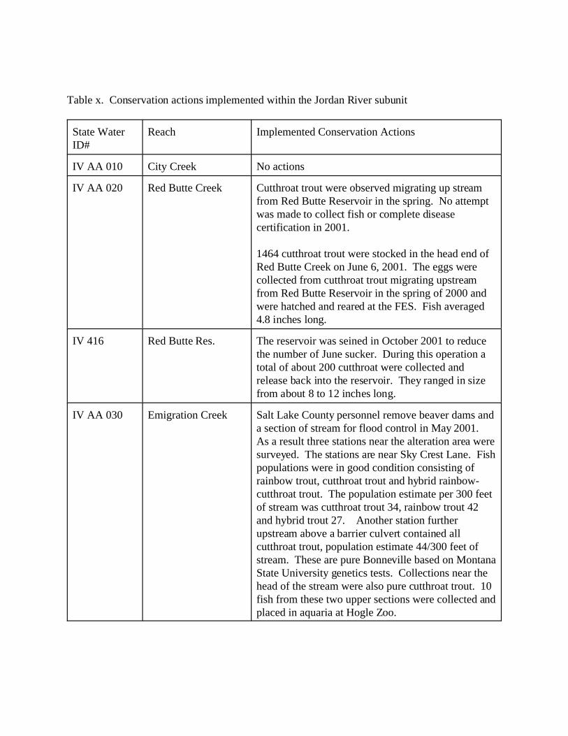
Table x. Conservation actions implemented within the Jordan River subunit
State WaterID#
Reach Implemented Conservation Actions
IV AA 010 City Creek No actions
IV AA 020 Red Butte Creek Cutthroat trout were observed migrating up streamfrom Red Butte Reservoir in the spring. No attemptwas made to collect fish or complete diseasecertification in 2001.
1464 cutthroat trout were stocked in the head end ofRed Butte Creek on June 6, 2001. The eggs werecollected from cutthroat trout migrating upstreamfrom Red Butte Reservoir in the spring of 2000 andwere hatched and reared at the FES. Fish averaged4.8 inches long.
IV 416 Red Butte Res. The reservoir was seined in October 2001 to reducethe number of June sucker. During this operation atotal of about 200 cutthroat were collected andrelease back into the reservoir. They ranged in sizefrom about 8 to 12 inches long.
IV AA 030 Emigration Creek Salt Lake County personnel remove beaver dams anda section of stream for flood control in May 2001. As a result three stations near the alteration area weresurveyed. The stations are near Sky Crest Lane. Fishpopulations were in good condition consisting ofrainbow trout, cutthroat trout and hybrid rainbow-cutthroat trout. The population estimate per 300 feetof stream was cutthroat trout 34, rainbow trout 42and hybrid trout 27. Another station furtherupstream above a barrier culvert contained allcutthroat trout, population estimate 44/300 feet ofstream. These are pure Bonneville based on MontanaState University genetics tests. Collections near thehead of the stream were also pure cutthroat trout. 10fish from these two upper sections were collected andplaced in aquaria at Hogle Zoo.
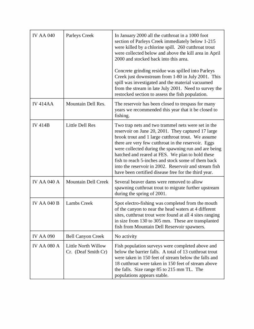
IV AA 040 Parleys Creek In January 2000 all the cutthroat in a 1000 footsection of Parleys Creek immediately below 1-215were killed by a chlorine spill. 260 cutthroat troutwere collected below and above the kill area in April2000 and stocked back into this area.
Concrete grinding residue was spilled into ParleysCreek just downstream from 1-80 in July 2001. Thisspill was investigated and the material vacuumedfrom the stream in late July 2001. Need to survey therestocked section to assess the fish population.
IV 414AA Mountain Dell Res. The reservoir has been closed to trespass for manyyears we recommended this year that it be closed tofishing.
IV 414B Little Dell Res Two trap nets and two trammel nets were set in thereservoir on June 20, 2001. They captured 17 largebrook trout and 1 large cutthroat trout. We assumethere are very few cutthroat in the reservoir. Eggswere collected during the spawning run and are beinghatched and reared at FES. We plan to hold thesefish to reach 5-inches and stock some of them backinto the reservoir in 2002. Reservoir and stream fishhave been certified disease free for the third year.
IV AA 040 A Mountain Dell Creek Several beaver dams were removed to allowspawning cutthroat trout to migrate further upstreamduring the spring of 2001.
IV AA 040 B Lambs Creek Spot electro-fishing was completed from the mouthof the canyon to near the head waters at 4 differentsites, cutthroat trout were found at all 4 sites rangingin size from 130 to 305 mm. These are transplantedfish from Mountain Dell Reservoir spawners.
IV AA 090 Bell Canyon Creek No activity
IV AA 080 A Little North WillowCr. (Deaf Smith Cr)
Fish population surveys were completed above andbelow the barrier falls. A total of 13 cutthroat troutwere taken in 150 feet of stream below the falls and18 cutthroat were taken in 150 feet of stream abovethe falls. Size range 85 to 215 mm TL. Thepopulations appears stable.
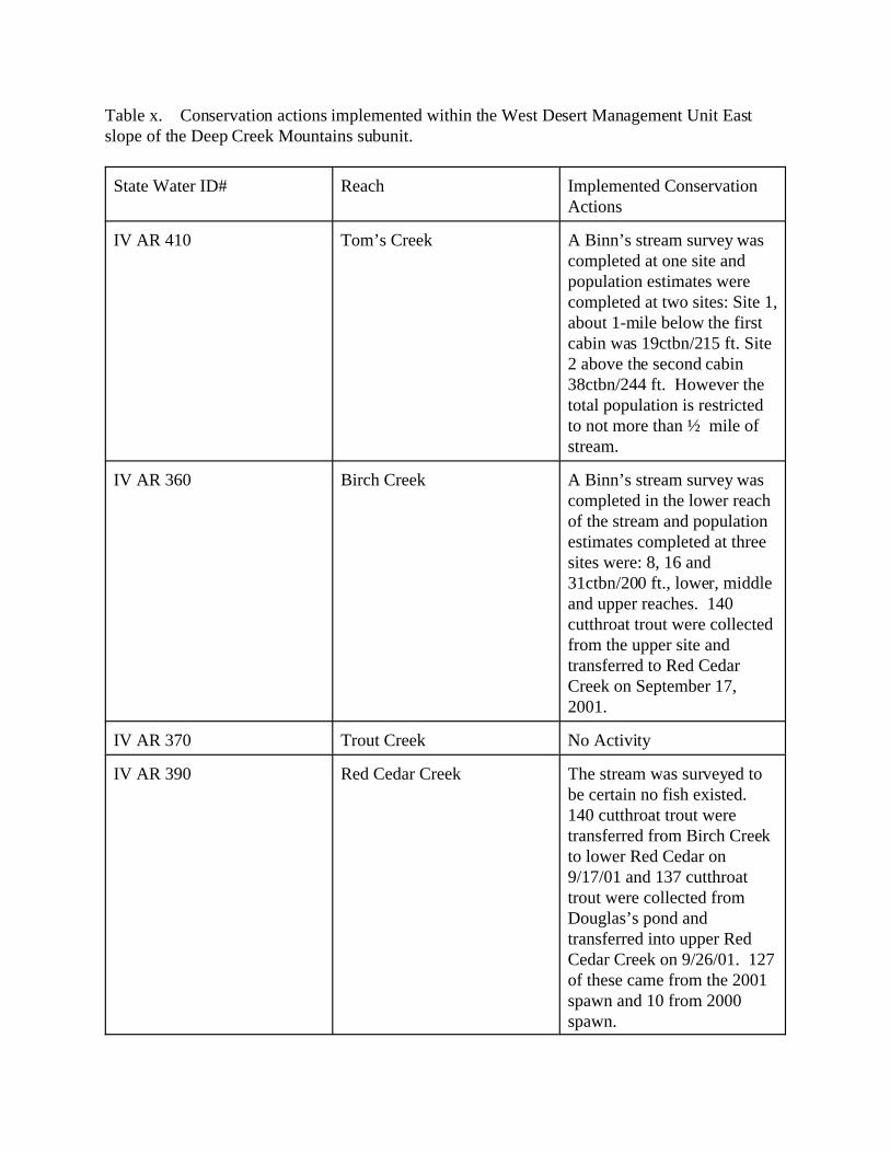
Table x. Conservation actions implemented within the West Desert Management Unit Eastslope of the Deep Creek Mountains subunit.
State Water ID# Reach Implemented ConservationActions
IV AR 410 Tom’s Creek A Binn’s stream survey wascompleted at one site andpopulation estimates werecompleted at two sites: Site 1,about 1-mile below the firstcabin was 19ctbn/215 ft. Site2 above the second cabin38ctbn/244 ft. However thetotal population is restrictedto not more than ½ mile ofstream.
IV AR 360 Birch Creek A Binn’s stream survey wascompleted in the lower reachof the stream and populationestimates completed at threesites were: 8, 16 and31ctbn/200 ft., lower, middleand upper reaches. 140cutthroat trout were collectedfrom the upper site andtransferred to Red CedarCreek on September 17,2001.
IV AR 370 Trout Creek No Activity
IV AR 390 Red Cedar Creek The stream was surveyed tobe certain no fish existed. 140 cutthroat trout weretransferred from Birch Creekto lower Red Cedar on9/17/01 and 137 cutthroattrout were collected fromDouglas’s pond andtransferred into upper RedCedar Creek on 9/26/01. 127of these came from the 2001spawn and 10 from 2000spawn.

IV AR 380 Granite Creek 6-cutthroat trout from the1999 spawn at Douglas’spond and 38 from the 2000spawn were transferred toGranite Creek. Cutthroatfrom previous stockings werelocated at all three creekcrossing.
IV AR 420 Basin Creek No activity
IV AR 400 Indian Farms Creek No activity
Table x. Conservation actions implemented within the Utah Lake/Provo River Subunit.
State Water ID# Reach Implemented ConservationActions
V AF 190 Provo R. Upper S Fk No Activity
V AF 150A Web Hollow Creek Stream survey completed. 4-brook trout found nocutthroat were found.
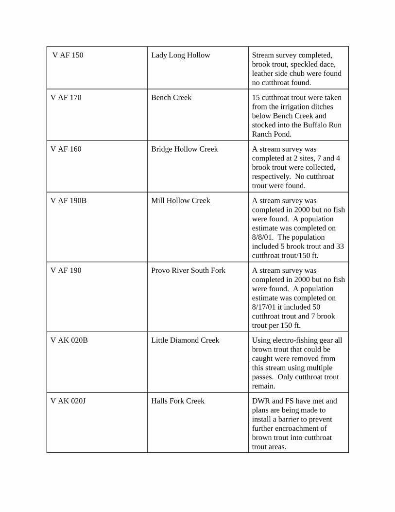
V AF 150 Lady Long Hollow Stream survey completed,brook trout, speckled dace, leather side chub were foundno cutthroat found.
V AF 170 Bench Creek 15 cutthroat trout were takenfrom the irrigation ditchesbelow Bench Creek andstocked into the Buffalo RunRanch Pond.
V AF 160 Bridge Hollow Creek A stream survey wascompleted at 2 sites, 7 and 4brook trout were collected,respectively. No cutthroattrout were found.
V AF 190B Mill Hollow Creek A stream survey wascompleted in 2000 but no fishwere found. A populationestimate was completed on8/8/01. The populationincluded 5 brook trout and 33cutthroat trout/150 ft.
V AF 190 Provo River South Fork A stream survey wascompleted in 2000 but no fishwere found. A populationestimate was completed on8/17/01 it included 50cutthroat trout and 7 brooktrout per 150 ft.
V AK 020B Little Diamond Creek Using electro-fishing gear allbrown trout that could becaught were removed fromthis stream using multiplepasses. Only cutthroat troutremain.
V AK 020J Halls Fork Creek DWR and FS have met andplans are being made toinstall a barrier to preventfurther encroachment ofbrown trout into cutthroattrout areas.

V AK 020H Sixth Water Creek 2927 cutthroat trout werestocked into the upper end ofSixth Water Creek on 6/6/01. These fish came from eggscollected from Red ButteReservoir in 2000 and rearedat the FES.
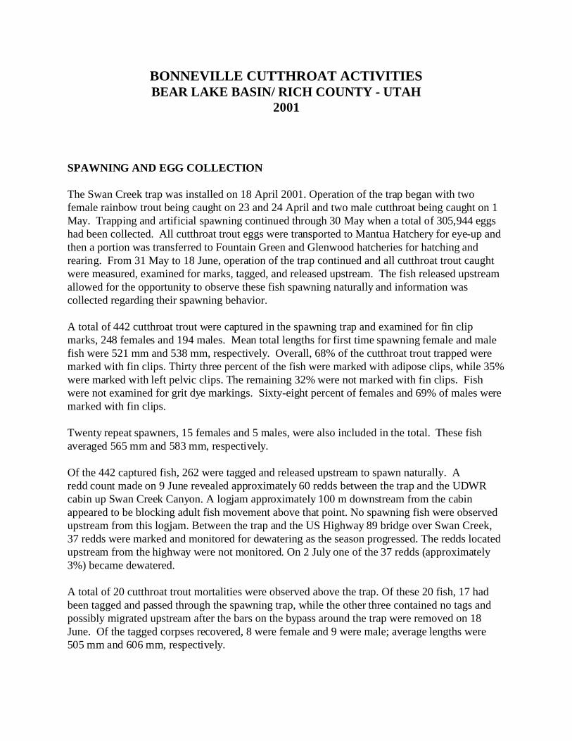
BONNEVILLE CUTTHROAT ACTIVITIESBEAR LAKE BASIN/ RICH COUNTY - UTAH
2001
SPAWNING AND EGG COLLECTION
The Swan Creek trap was installed on 18 April 2001. Operation of the trap began with twofemale rainbow trout being caught on 23 and 24 April and two male cutthroat being caught on 1May. Trapping and artificial spawning continued through 30 May when a total of 305,944 eggshad been collected. All cutthroat trout eggs were transported to Mantua Hatchery for eye-up andthen a portion was transferred to Fountain Green and Glenwood hatcheries for hatching andrearing. From 31 May to 18 June, operation of the trap continued and all cutthroat trout caughtwere measured, examined for marks, tagged, and released upstream. The fish released upstreamallowed for the opportunity to observe these fish spawning naturally and information wascollected regarding their spawning behavior.
A total of 442 cutthroat trout were captured in the spawning trap and examined for fin clipmarks, 248 females and 194 males. Mean total lengths for first time spawning female and malefish were 521 mm and 538 mm, respectively. Overall, 68% of the cutthroat trout trapped weremarked with fin clips. Thirty three percent of the fish were marked with adipose clips, while 35%were marked with left pelvic clips. The remaining 32% were not marked with fin clips. Fishwere not examined for grit dye markings. Sixty-eight percent of females and 69% of males weremarked with fin clips. Twenty repeat spawners, 15 females and 5 males, were also included in the total. These fishaveraged 565 mm and 583 mm, respectively.
Of the 442 captured fish, 262 were tagged and released upstream to spawn naturally. Aredd count made on 9 June revealed approximately 60 redds between the trap and the UDWRcabin up Swan Creek Canyon. A logjam approximately 100 m downstream from the cabinappeared to be blocking adult fish movement above that point. No spawning fish were observedupstream from this logjam. Between the trap and the US Highway 89 bridge over Swan Creek,37 redds were marked and monitored for dewatering as the season progressed. The redds locatedupstream from the highway were not monitored. On 2 July one of the 37 redds (approximately3%) became dewatered.
A total of 20 cutthroat trout mortalities were observed above the trap. Of these 20 fish, 17 hadbeen tagged and passed through the spawning trap, while the other three contained no tags andpossibly migrated upstream after the bars on the bypass around the trap were removed on 18June. Of the tagged corpses recovered, 8 were female and 9 were male; average lengths were505 mm and 606 mm, respectively.
Observations have indicated that some fish were also likely “lost” down the lowest irrigationdiversion from Swan Creek. On 3 July, while measuring the lower Swan Creek diversion, atagged cutthroat was observed in the ditch below the diversion. This fish was observed andproceeded down the irrigation ditch and was not see again. It is unknown exactly how many fishwere “lost” down this diversion.
On 30 July, two known redd sites were excavated. No eggs or alevins were found in either of theexcavations. It is uncertain if the eggs had already hatched. By continuing to monitor thenumber of marked and unmarked fish captured in the trap in the future it may be possible todetermine if the fish that spawned naturally in Swan Creek in 2001 had a noticeable impact onthe overall adult Bear Lake cutthroat population in Swan Creek.
Coordination between UDWR and Idaho Department of Fish and Game and Utah StateUniversity graduate student work on adult cutthroat trout trapping and movement on St. CharlesCreek was continued. Adult fish were trapped, check for marks, fin clipped and passed above thetrap to spawn naturally on the Little Fork. Upstream migrating adult fish were also monitored onthe Big Fork. Up to 15 adult cutthroat trout on each of the forks were surgically implanted withradio transmitters and movement was monitored. The results of that study will be completed inanother document.
BONNEVILLE CUTTHROAT TROUT STOCKING - BEAR LAKE
Progress:
A total of 219,616 yearling cutthroat trout were stocked into Bear Lake in 2001. These fishaveraged 27.66 fish/kg (12.57/lb) and 162 mm TL (6.38 inches). The fish were comprised of98% fish originating from wild strain fish eggs and 2% originating from captive brood fish eggs. All fish were marked with an adipose fin clip prior to stocking. Inspection of fish at thehatcheries prior to stocking indicated that approximately 99% of the fish received fin clips. Stocking sites included Rainbow Cove, First Point, North Beach Jetty, Sweetwater Beachauxiliary boat ramp, and at the mouth of Swan Creek. All fish were stocked directly fromdistribution trucks. Receiving water temperatures were suitable and tempering was notnecessary.
A total of 64,719 fish from Glenwood hatchery were stocked from 20-26 April. A total of64,719 wild strain fish from Glenwood hatchery averaged 15.70 fish/kg (7.14/lb) and 197 mmTL (7.75 inches), while a total of 5,325 brood stock origin fish averaged 10.19 fish/kg (4.63/lb)and 228 mm TL (8.96 inches).
A total of 143,921 fish from Fountain Green hatchery were stocked from 6-20 April. All fishwere from wild strain eggs. These fish averaged 32.61 fish/kg (14.82/lb) and 151 mm TL (5.94inches).
A total of 65,273 young of the year cutthroat trout were stocked into Bear Lake tributaries
between 29 November and 1 December 2000. These fish averaged 510 fish/kg (232/lb). Thefish originated from captive brood fish eggs that were raised at Mantua hatchery. Marking wasnot possible on these fish. Stocking sites included Swan Creek (20,965 fish), Big Spring Creek(223,958 fish), and Fish Haven Creek (20,350 fish). Fish were either netted from the tank on thetruck and into buckets then stocked into the stream or stocked directly from distribution trucks. Receiving water temperatures were suitable and tempering was not necessary.
BONNEVILLE CUTTHROAT SURVEYS - RICH COUNTY, UTAH
Progress:
On 11 July Cottonwood Creek was spot electrofished from a point just below the source pondwhere we judged the stream contained enough water to support fish downstream until the lastirrigation diversion dewatered the stream. We did not observe any fish in the entire stream. Thehabitat is composed of dense riparian zone and there are beaver ponds throughout. The channeltype is a C4 or C5 and if stream flows are sufficient could possibly support a cutthroat troutpopulation.
On 16 July Laketown Creek was spot electrofished from the spring source downstream to thelast irrigation reservoir above Laketown. The channel type was a C4 or C5. We observed bothbrook trout and cutthroat trout in the stream. All fish that were captured were plump andappeared to be in very good condition. We captured 31brook trout and 10 cutthroat trout(approximately 3:1 ratio) in the area from the spring source downstream approximately one mileto where the canyon becomes narrow and the riparian zone is very dense. We did not observeany young-of-the-year (YOY) fish of either species in this area. Almost all of the fish that wereelectrofished from this section were >150 mm TL and were likely adults.
From the narrow canyon area downstream to the BLM fence we captured 14 cutthroat trout and 6 brook trout (approximately 2:1 ratio). We observed one YOY cutthroat trout but no YOYbrook trout in this area. We did note more juvenile fish in this area (fish from 100-150 mm TL)and some adults.
From the BLM fence downstream to just above the reservoir we captured 7 cutthroat trout and just one brook trout in this area. No YOY fish of either species were caught in this area.
The reintroductions of cutthroat trout to Laketown Creek from North Eden Creek during the mid-1990's have been successful. Cutthroat trout now inhabit the entire length of the stream andshow signs of being a self-sustaining population.
On 17 July 17 North Eden Creek was electrofished in sections 3 and 4 (Bear Lake office files). Water temperature in these areas was 9oC (48oF). The channel type was a C4 or C5.
In section 3 both brook trout and cutthroat trout were present. Approximately 200 m of streamwas electrofished and 1 cutthroat trout and 15 brook trout were captured. Current cattle grazing
in this area appears to have had an impact to the stream. There appeared to be more aquaticmacrophytes in the stream in this section. The stream had very little gravel and the gravel thatwas present was silted in. All fish that were captured were plump and appeared to be in verygood condition. We did not observe any young-of-the-year (YOY) fish of either species in thisarea. Almost all of the fish that were electrofished from this section were >150 mm TL and werelikely adults.
In section 4 approximatelyl 200m of stream was electrofished and 5 cutthroat trout and 11 brooktrout were captured. Noticeably less grazing in this area, less aquatic macrophytes, and a denserriparian growth zone have contributed to a less silty stream bed. One YOY cutthroat trout wascaptured indicating some limited natural reproduction. The remainder of the captured fish wereadults and >150 mm TL. On 21 June six gillnets were set in Woodruff Creek Reservoir to assess overwinter survival ofthe fish assemblage since Woodruff Creek Reservoir was drawn down to less than conservationpool for dam repairs in January of 2001. We captured 62 cutthroat trout, 29 mountain suckers,and 162 mountain whitefish. The cutthroat trout ranged in size from 108 - 423 mm TL, themountain suckers from 108 - 185 mm TL, and the mountain whitefish from 157 - 473 mm TL. These numbers are comparable in both size and catch rates to those from surveys conducted 1992and 1997. No noticeable negative effects from the reservoir being drawn down weredocumented.
SUMMARY
Bonneville cutthroat trout persisted and flourished in Bear Lake/Rich County despite droughtconditions and cohabitation with brook trout. The strength of the spawning run in Swan Creekand the resultant natural spawning after the egg quota was collected was gratifying. The survivalof BCT in Woodruff Creek Reservoir through a minimal dead storage draw down was surprising. The resiliency of this indigenous fish is becoming well documented.
Bryce NielsonUtah Wildlife ResourcesBear Lake ProjectGarden City, UT 84028(435) 946-8501
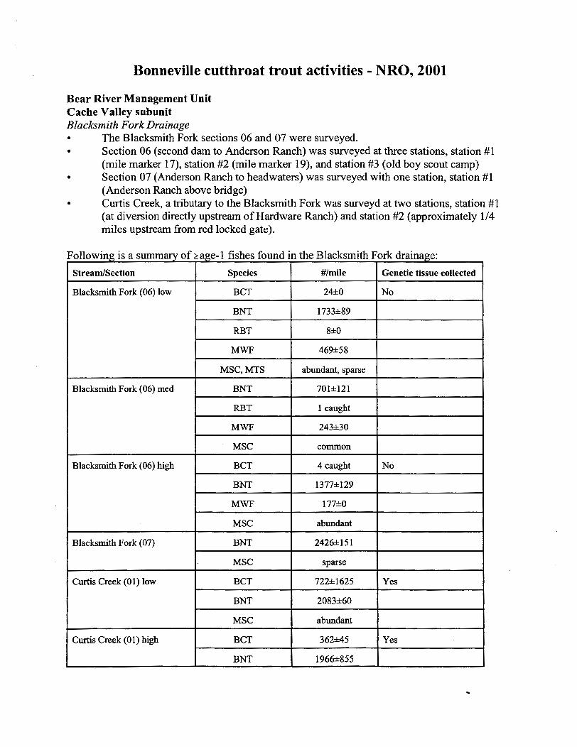
Bonneville cutthroat trout activities - NRO, 2001
Bear River Management Unit Cache Valley subunit Blacksm ith Fork Drainage
The Blacksmith Fork sections 06 and 07 were surveyed. . Section 06 (second dam to Anderson Ranch) was surveyed at three stations, station #1 (mile marker 17), station #2 (mile marker 19), and station #3 (old boy scout camp) . Section 07 (Anderson Ranch to headwaters) was surveyed with one station, station #1 (Anderson Ranch above bridge) Curtis Creek, a tributruy to the Blacksmith Fork was surveyd at two stations, station #1 (at diversion directly upstream of Hardware Ranch) and station #2 (approximately 1/4 miles upstream from red locked gate).
Following is a summary of >age- 1 fishes found in the Blacksmith Fork drainage:
Stream/Section I Species I #/mile Genetic tissue collected
I Blacksmith Fork (06) low
BNT
RBT
- --- - - --
Blacksmith Fork (06) rned I BNT 1 701h121 1 1
BCT
1733h89
8hO
MWF
MSC, MTS
I - - - -- - -
RBT
24hO
469h58
abundant, sparse
- --- r 1 caught I
pp -- - pp-p
Blacksmith Fork (06) high
MWF
I MSC
- - - - - - - -- - -
MWF
MSC
Blacksmith Fork (07) I BNT
- --
243h30
common
1- MSC
- -
4 caught
-- -
l77hO
abundant
2426h 1 5 1
sparse
Curtis Creek (0 1) low
I BNT 1 2083h60
Curtis Creek (0 1) high I BCT 1 362k45 1 Yes I MSC
I BNT I 1966h855 I I
abundant
1
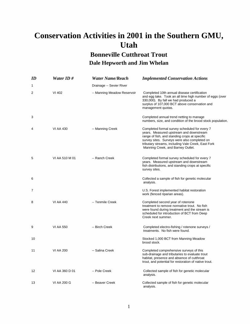
Conservation Activities in 2001 in the Southern GMU, Utah
Bonneville Cutthroat Trout Dale Hepworth and Jim Whelan
ID Water ID # Water Name/Reach Implemented Conservation Actions 1 Drainage -- Sevier River
2 VI 402 -- Manning Meadow Reservoir Completed 10th annual disease certification and egg take. Took an all time high number of eggs (over 330,000). By fall we had produced a
surplus of 107,000 BCT above conservation and management quotas.
3 Completed annual trend netting to manage numbers, size, and condition of the brood stock population.
4 VI AA 430 -- Manning Creek Completed formal survey scheduled for every 7 years. Measured upstream and downstream range of fish, and standing crops at specific survey sites. Surveys were also completed on tributary streams, including Vale Creek, East Fork Manning Creek, and Barney Outlet.
5 VI AA 510 M 01 -- Ranch Creek Completed formal survey scheduled for every 7 years. Measured upstream and downstream fish distributions, and standing crops at specific survey sites.
6 Collected a sample of fish for genetic molecular analysis.
7 U.S. Forest implemented habitat restoration work (fenced riparian areas).
8 VI AA 440 -- Tenmile Creek Completed second year of rotenone treatment to remove nonnative trout. No fish were found during treatment and the stream is scheduled for introduction of BCT from Deep Creek next summer.
9 VI AA 550 -- Birch Creek Completed electro-fishing / rotenone surveys / treatments. No fish were found.
10 Stocked 1,000 BCT from Manning Meadow brood stock.
11 VI AA 200 -- Salina Creek Completed comprehensive surveys of this sub-drainage and tributaries to evaluate trout habitat, presence and absence of cutthroat trout, and potential for restoration of native trout.
12 VI AA 360 D 01 -- Pole Creek Collected sample of fish for genetic molecular analysis.
13 VI AA 200 G -- Beaver Creek Collected sample of fish for genetic molecular analysis.
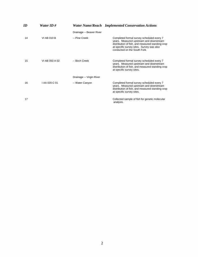
2
ID Water ID # Water Name/Reach Implemented Conservation Actions
Drainage -- Beaver River
14 VI AB 010 B -- Pine Creek Completed formal survey scheduled every 7 years. Measured upstream and downstream distribution of fish, and measured standing crop at specific survey sites. Survey was also conducted on the South Fork.
15 VI AB 050 A 02 -- Birch Creek Completed formal survey scheduled every 7 years. Measured upstream and downstream distribution of fish, and measured standing crop at specific survey sites.
Drainage -- Virgin River
16 I AA 020 C 01 -- Water Canyon Completed formal survey scheduled every 7 years. Measured upstream and downstream distribution of fish, and measured standing crop at specific survey sites.
17 Collected sample of fish for genetic molecular analysis.
Region Four Accomplishments FY2001
Ashley NF Project/Activity Name: West Fork Little Brush Creek Stream and Riparian Habitat Improvement Project The focus of the work was conducted on a 1-mile reach directly below East Park Reservoir. In this area stream banks were stabilized using cobble and boulder rocks along with willow planting, native grass seeding, and biodegradable bank matting. Instream habitat was improved by increasing structure and pool habitat. One mile of log worm fence was erected to eliminate cattle impacts on the riparian and protect the improvements. In addition, two - 8’x16’ gravel filled honeycomb road crossings were installed to reduce sediment loading. Lastly, large boulders were inserted into a small tributary to stop a major head cut. The Utah Division of Wildlife Resources and the National Fish and Wildlife Foundation are funding this project, which is planned for CRCT reintroduction in 2005. The project is approximately 90% completed and will be completed in FY02. Bridger-Teton NF Bridger – Teton Natonal Forest
Project/Activity Name: Finespotted Snake River Cutthroat Trout and Yellowstone Cutthroat Trout Subspecies Distribution Inventory and Mapping. This project is documenting the geographic distributions of finespotted Snake River cutthroat trout (Oncorhynchus clarki ssp.) and Yellowstone cutthroat trout (O. clarki bouvieri) in the Snake River headwaters of Wyoming. To date, comprehensive sampling has not been completed throughout the upper Snake River basin. Surveys are completed throughout the occupied length of named streams. 2001 was the fourth of a planned five-year inventory.
In total, distribution surveys were completed on 69 named streams, and 1 unnamed tributary, with 350.4 km of survey completed by electrofishing; and 44 km of survey completed by hook-and-line (total 394.4 km). Completed stream summaries for fish sampling, species sampled and distribution, habitat condition, management influences, and habitat improvement opportunities. These summaries are now complete for all streams surveyed from 1998 to 2000 in the Gros Ventre River and Greys River drainages, and all named tributaries to the Snake River and named streams in the Hoback River drainage surveyed in 2001. Snake River cutthroat trout (SRC) or Yellowstone cutthroat trout (YSC) were observed in 96% of streams surveyed and inhabited by trout; 21 of 69 streams were either dry or fishless. SRC occupied 197 km (51% of surveyed length) of 41 streams, and YSC occupied 27 km (7%) in 16; apparent SRCxYSC hybrids were observed as well.
Introduced game fish included brook trout (BKT), and were present in 35 km (9%) of 9 streams. These fish were sympatric with SRC or YSC in most streams where they were captured; two streams were occupied only by brook trout. One previously unknown introduced non-game species, fathead minnow (Pimephalus promelas; FHM) was captured in Pritchard Creek, a tributary to the Snake River. Additional species sampled included mottled sculpin (common), mountain whitefish (abundant), Paiute sculpin (abundant), longnose dace (common), and mountain sucker (rare). Fin clips were collected from SRC and YSC (>145 mm TL) for genetic analysis. Fin clips are being archived until funding is obtained for genetic analysis. Distribution maps of all fish species observed were completed for the Gros Ventre River and Greys River drainages, and those portions of the Hoback River drainage and Snake River Canyon tributaries surveyed, and annual reports. This information will be used in development of subbasin assessments to be used in Forest Landscape Scale Analyses (i.e., NFMA), and a conservation strategy for YSC on the BTNF, as well as provide information for affects and cumulative effects analyses in project level environmental documents (i.e., NEPA).
Surveys were conducted in cooperation with the Wyoming Game and Fish Department (WGFD); the department provided one crew-person July through September. Jackson Hole Trout Unlimited provided support, as in most years, by sponsoring a crew-person (fisheries internship position) June through August. The Jackson Hole One Fly Foundation provided monetary support.
Project/Activity Name: Hoback River drainage Fish and Fish Habitat Inventory. Completed 21 km of R1/R4 basin wide stream inventory on 7 tributaries of the Hoback River. Streams in the Hoback Landscape Scale Assessment area were selected for fish and fish habitat inventory as either management affected or reference streams. This inventory was conducted to acquire existing fish habitat, fish species occurrence and distribution data, in conjunction with riparian vegetation inventories. The inventory will provide baseline fish and fish habitat condition information, and assist with developing long-term objectives following changes in management activities for the assessment area. This information will be used in development of subbasin assessments to be used in Forest Landscape Scale Analyses (i.e., NFMA), and a conservation strategy for YSC on the BTNF, as well as provide information for affects and cumulative effects analyses in project level environmental documents (i.e., NEPA).
Jackson Hole Trout Unlimited provided support, as in most years, by sponsoring a crew-person (fisheries internship position) June through August. One crew member was provided by the WGFD.
Project/Activity Name: SRC/YSC Abundance Sampling. Knowledge of cutthroat trout distribution and abundance is required for assessing population status and
persistence of cutthroat trout subspecies occupying a drainage. Initial analysis of distribution surveys suggests present occupancy greater than 90% in the Gros Ventre and Greys River drainages. This effort will address relative abundance of these fishes in various streams within a drainage. In streams and watersheds with low densities of cutthroat trout, catchability derived from depletion estimates in a relatively few streams can be used to assess relative abundance among several streams or watersheds across a drainage. This information will be used in development of subbasin assessments to be used in Forest Landscape Scale Analyses (i.e., NFMA), and a conservation strategy for YSC on the BTNF, as well as provide information for affects and cumulative effects analyses in project level environmental documents (i.e., NEPA). The Finespotted Snake River Cutthroat Trout and Yellowstone Cutthroat Trout Subspecies Distribution Inventory and Mapping effort provided the background information for stream selection, species present, and occupied length to be sampled. Project/Activity Name: SRC/YSC Telemetry. Pilot work was conducted using radio telemetry to track SRC in the Gros Ventre River and Little Greys River drainages. This was intended to determine the efficacy of receivers and transmitters, logistics, costs, and effort to monitor cutthroat trout movement in BTNF streams within the Snake River drainage. The success of the 2001 pilot work suggests movement and mobility information (telemetry) can be collected with a very good success, and reasonable effort and cost. Results of 2001 suggest largely resident fish were monitored. It is believed that because tagged fish were captured approximately a month after the main 2001 spawning period, mainly resident fish were captured. Further work should attempt capture fluvial or migrant fish. This information will be used in development of subbasin assessments to be used in Forest Landscape Scale Analyses (i.e., NFMA), and a conservation strategy for YSC on the BTNF. The Finespotted Snake River Cutthroat Trout and Yellowstone Cutthroat Trout Subspecies Distribution Inventory and Mapping effort provided the background information for species occurrence, location of capture, and river kilometer descriptions.
Project/Activity Name: LaBarge Creek Drainage Stream Habitat Inventory and Assessment LaBarge Creek watershed contains remnant Colorado River cutthroat trout populations and is the focus of a non-native removal and re-introduction program by Wyoming Game and Fish Department. As part of this project, the Forest Service is evaluating the livestock grazing administration and aquatic habitat conditions throughout the watershed. First step in the evaluations were the completion on stream and habitat condition evaluations on LaBarge Creek and its tributaries. Over 50 miles of survey and evaluation were completed in 2001.

Project/Activity Name: Lake Alice Habitat Inventory and Assessment Bonneville cutthroat trout inhabit a 230 acre landlocked Lake Alice; within the Smiths Fork watershed. Water quality and aquatic invertebrates samples, bathymetry, and shoreline surveys were completed in 2001 to assess the habitat quality and potential risks to this unique cutthroat trout population. Data from these evaluations will help guide future land management decisions and provide a comprehensive description of aquatic resources for future Forest Planning. Project/Activity Name: Hobble Creek Habitat Restoration Assessment Seven locations along Hobble Creek were evaluated in 2001 for future Bonneville cutthroat trout stream restoration projects. Each potential restoration location was associated with disturbance to Hobble Creek from road encroachments on the stream channel. Control of road generated sediment entering Hobble Creek and restoring habitat complexity is the goal of the project. By working interdisciplinary with recreation and engineering groups, the natural disturbance regime of Hobble Creek may be restored to near natural condition. Project/Activity Name: Stream Road Crossing Assessment Road and stream crossing assessment is a multi-year effort to evaluate the potential fish migration barriers and sediment sources forest-wide. In the projects’ third year, accomplishments include cataloging over 95% of all forest road crossings in an operational database available for reporting in spreadsheets and GIS. Crossing inventory data (over 300 point locations) provides the baseline for cumulative impact assessment in environmental analysis documents and subbasin assessments. In addition, the crossing inventory data assists engineering program managers by providing detailed information on each stream crossing structure along with a priority list for replacement with a “fish friendly” design. Project/Activity Name: Investment Maintenance, Monitoring and Evaluations Many thousands of taxpayer’s dollars have been invested on the Bridger-Teton National Forest under the “Fisheries Habitat Improvement/Restoration Program” since the early 1970’s. Many of these stream structures were built and forgotten. Since 1999 the Green River and Bear River stream structures were located, cataloged, and evaluated to determine effectiveness and future maintenance needs. This three-year effort was completed in 2001. Data from structure survey and evaluation will assist fisheries managers with protecting past investments by establishing a maintenance schedule, help determine best structures for future stream restoration projects, and help display cumulative impacts of restoration activities. Project/Activity Name: Forest-Wide Subbasin Assessment Landscape scale (forest-wide) assessment of ground disturbance by 6th code HUC is being conducted in coordination with the Rocky Mountain Research Station. Purpose of the assessment is to validate the Inland West Watershed Reconnaissance ratings for native cutthroat trout population status. Expected product is a relationship between landscape disturbance factors and the strength of native cutthroat trout populations.
Caribou-Targhee NF’s
FY 2001
Narrative Sheet
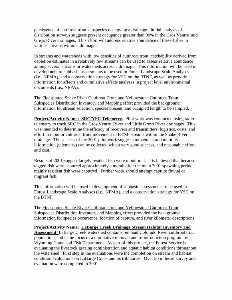
Project/Activity Name: Caribou-Targhee National Forest Fish Distribution Surveys
Fish Distribution surveys were conducted on 81 streams (approximately 200 miles) in the Palisades, Soda Springs, Montpelier, and Westside Ranger Districts. The Caribou-Targhee Forest Fish Distribution Survey Methodology was used. Fish were sampled using a backpack electroshocker and nonlethal genetic samples were collected. Genetic samples were analyzed by University of Idaho. Survey reports were written for each stream. Partners included US Bureau of Reclamation, Idaho Department of Environmental Quality, US Fish and Wildlife Service, Idaho Department of Fish & Game, and Greater Yellowstone Coordinating Committee. Fish distribution surveys in the range of Bonneville cutthroat trout on the Forest were completed. Of the 36 streams surveyed in the range of Bonneville cutthroat trout, we identified 13 stronghold streams. Of the 45 streams visited in the range of Yellowstone cutthroat trout, we identified 24 stronghold streams.
The C-T Forest Fisheries Crew sampling Cub River
Project/Activity Name: Caribou-Targhee National Forest Lake Surveys
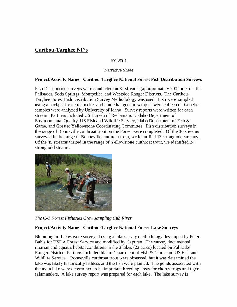
Bloomington Lakes were surveyed using a lake survey methodology developed by Peter Bahls for USDA Forest Service and modified by Capurso. The survey documented riparian and aquatic habitat conditions in the 3 lakes (23 acres) located on Palisades Ranger District. Partners included Idaho Department of Fish & Game and US Fish and Wildlife Service. Bonneville cutthroat trout were observed, but it was determined the lake was likely historically fishless and the fish were planted. The ponds associated with the main lake were determined to be important breeding areas for chorus frogs and tiger salamanders. A lake survey report was prepared for each lake. The lake survey is
currently being used on the District in the preparation of the Bloomington Recreation Plan.
Bloomington Lake on the Montpelier Ranger District
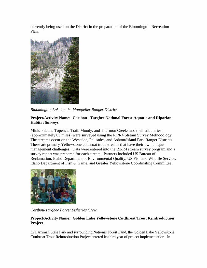
Project/Activity Name: Caribou –Targhee National Forest Aquatic and Riparian Habitat Surveys
Mink, Pebble, Topence, Trail, Moody, and Thurmon Creeks and their tributaries (approximately 83 miles) were surveyed using the R1/R4 Stream Survey Methodology. The streams occur on the Westside, Palisades, and Ashton/Island Park Ranger Districts. These are primary Yellowstone cutthroat trout streams that have their own unique management challenges. Data were entered into the R1/R4 stream survey program and a survey report was prepared for each stream. Partners included US Bureau of Reclamation, Idaho Department of Environmental Quality, US Fish and Wildlife Service, Idaho Department of Fish & Game, and Greater Yellowstone Coordinating Committee.
Caribou-Targhee Forest Fisheries Crew
Project/Activity Name: Golden Lake Yellowstone Cutthroat Trout Reintroduction Project In Harriman State Park and surrounding National Forest Land, the Golden Lake Yellowstone Cutthroat Trout Reintroduction Project entered its third year of project implementation. In
Spring 2001, the Forest Fisheries Crew and Idaho Department of Fish & Game used electroshockers to determine the effectiveness of the eradication component of the project. When we sampled all 3 inlet streams, we determined all of the brook trout were eradicated, but at least 5 rainbow trout were collected. The interagency team agreed to initiate Yellowstone cutthroat trout reintroduction and in June, Yellowstone cutthroat trout were returned to Golden Lake and its tributaries. This project is an extensive cooperative effort between Idaho Department of Fish & Game, Idaho State Parks, The Nature Conservancy, Bureau of Land Management, C-T National Forest, and other partners in the Henry’s Fork Cutthroat Trout Subcommittee.
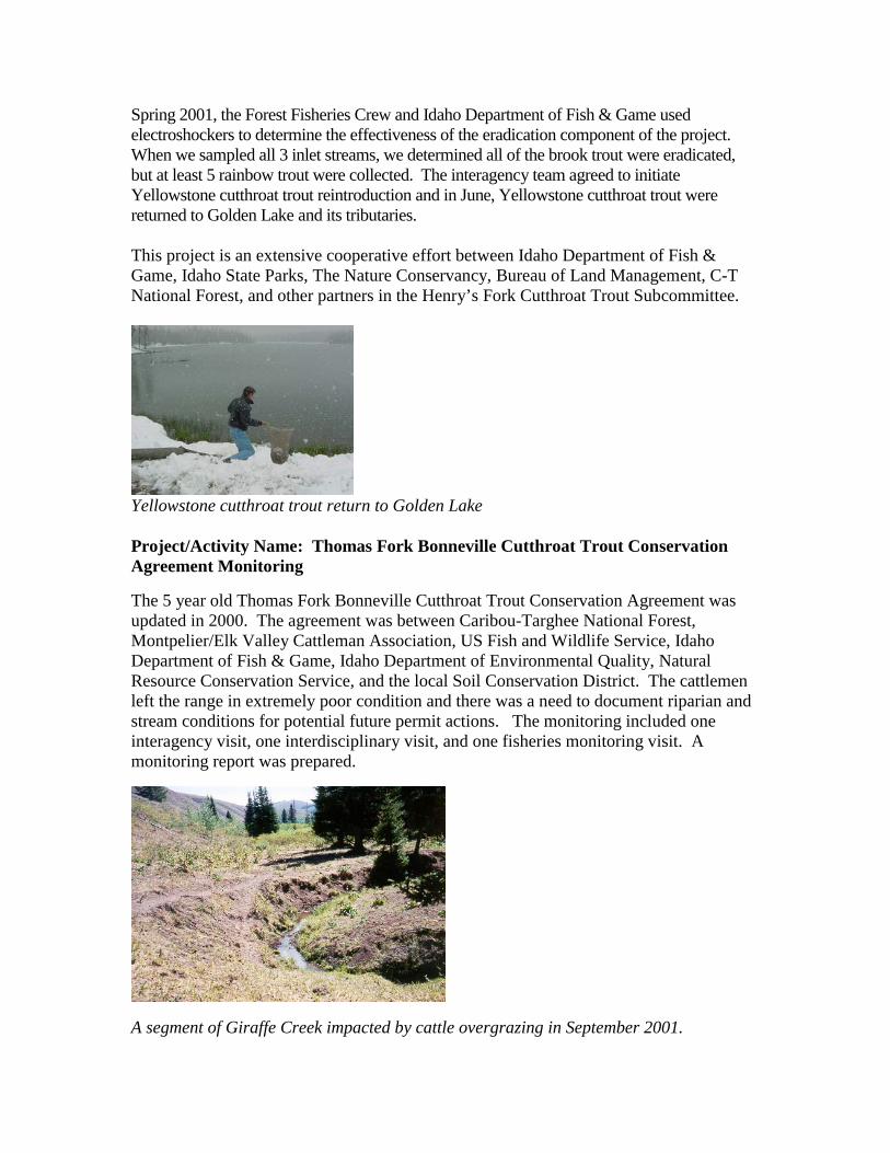
Yellowstone cutthroat trout return to Golden Lake Project/Activity Name: Thomas Fork Bonneville Cutthroat Trout Conservation Agreement Monitoring
The 5 year old Thomas Fork Bonneville Cutthroat Trout Conservation Agreement was updated in 2000. The agreement was between Caribou-Targhee National Forest, Montpelier/Elk Valley Cattleman Association, US Fish and Wildlife Service, Idaho Department of Fish & Game, Idaho Department of Environmental Quality, Natural Resource Conservation Service, and the local Soil Conservation District. The cattlemen left the range in extremely poor condition and there was a need to document riparian and stream conditions for potential future permit actions. The monitoring included one interagency visit, one interdisciplinary visit, and one fisheries monitoring visit. A monitoring report was prepared.
A segment of Giraffe Creek impacted by cattle overgrazing in September 2001.
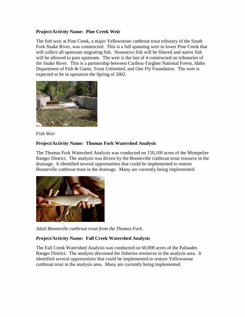
Project/Activity Name: Pine Creek Weir
The fish weir at Pine Creek, a major Yellowstone cutthroat trout tributary of the South Fork Snake River, was constructed. This is a full spanning weir in lower Pine Creek that will collect all upstream migrating fish. Nonnative fish will be filtered and native fish will be allowed to pass upstream. The weir is the last of 4 constructed on tributaries of the Snake River. This is a partnership between Caribou-Targhee National Forest, Idaho Department of Fish & Game, Trout Unlimited, and One Fly Foundation. The weir is expected to be in operation the Spring of 2002.
Fish Weir
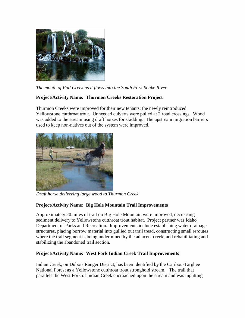
Project/Activity Name: Thomas Fork Watershed Analysis
The Thomas Fork Watershed Analysis was conducted on 150,100 acres of the Montpelier Ranger District. The analysis was driven by the Bonneville cutthroat trout resource in the drainage. It identified several opportunities that could be implemented to restore Bonneville cutthroat trout in the drainage. Many are currently being implemented.
Adult Bonneville cutthroat trout from the Thomas Fork.
Project/Activity Name: Fall Creek Watershed Analysis
The Fall Creek Watershed Analysis was conducted on 60,000 acres of the Palisades Ranger District. The analysis discussed the fisheries resources in the analysis area. It identified several opportunities that could be implemented to restore Yellowstone cutthroat trout in the analysis area. Many are currently being implemented.
The mouth of Fall Creek as it flows into the South Fork Snake River
Project/Activity Name: Thurmon Creeks Restoration Project Thurmon Creeks were improved for their new tenants; the newly reintroduced Yellowstone cutthroat trout. Unneeded culverts were pulled at 2 road crossings. Wood was added to the stream using draft horses for skidding. The upstream migration barriers used to keep non-natives out of the system were improved.
Draft horse delivering large wood to Thurmon Creek Project/Activity Name: Big Hole Mountain Trail Improvements
Approximately 20 miles of trail on Big Hole Mountain were improved, decreasing sediment delivery to Yellowstone cutthroat trout habitat. Project partner was Idaho Department of Parks and Recreation. Improvements include establishing water drainage structures, placing borrow material into gullied out trail tread, constructing small reroutes where the trail segment is being undermined by the adjacent creek, and rehabilitating and stabilizing the abandoned trail section. Project/Activity Name: West Fork Indian Creek Trail Improvements Indian Creek, on Dubois Ranger District, has been identified by the Caribou-Targhee National Forest as a Yellowstone cutthroat trout stronghold stream. The trail that parallels the West Fork of Indian Creek encroached upon the stream and was inputting
sediment to cutthroat habitat. ATV’s and trucks were excluded from the trail, a trail crossing was improved, and segments of the trail were relocated from the riparian area.
Strategically placed boulders along West Fork Indian Creek Project/Activity Name: Blackfoot River Road Improvement
Ten percent funds were used to surface the Blackfoot River Road within the narrows area with magnesium chloride. Approximately 4.5 miles of the road was treated to decrease sediment delivery to the Blackfoot River, an important Yellowstone cutthroat trout fisheries. In addition, an impassable culvert at the road’s crossing of Mill Creek was replaced to facilitate the upstream passage of Yellowstone cutthroat trout into this nursery stream.
Project/Activity Name: Pole Creek Crossing Improvement
A culvert at the FS Road 20077 crossing of Pole Creek has been a regular threat to Yellowstone cutthroat trout habitat. The culvert was replaced and road drainage improved to decrease sediment input to Pole Creek, a Yellowstone cutthroat trout stronghold stream. Project/Activity Name: Tablerock Road Improvements During a 2000 C-T National Forest Fish Distribution Survey, Tablerock Creek was identified as a Yellowstone cutthroat trout stronghold stream. One of the recommendations listed in the survey report was to decrease road related sediment by relocating or narrowing segments of this road away from the riparian area. Ten percent funds were used to fund sediment reduction efforts on 5 miles of this road by moving road segments away from the stream and surfacing with gravel and magnesium chloride. This was a partnership with Bonneville County. Project/Activity Name: Horseshoe Creek Channel Correction Project
Horseshoe Creek was captured by an abandoned road and was beginning to downcut. Ashton/Island Ranger District diverted the stream back into its original stream channel.
An excavator on Horseshoe Creek returns water to the original stream channel
Project/Activity Name: Preuss Creek Cattle Driveway Crossing Project
Preuss Creek, a Bonneville cutthroat trout stronghold stream, was being impacted by a historic cattle crossing. The Montpelier Ranger District fenced the area and hardened the crossing to decrease future impacts. This was a cooperative project between range and fish on the District.
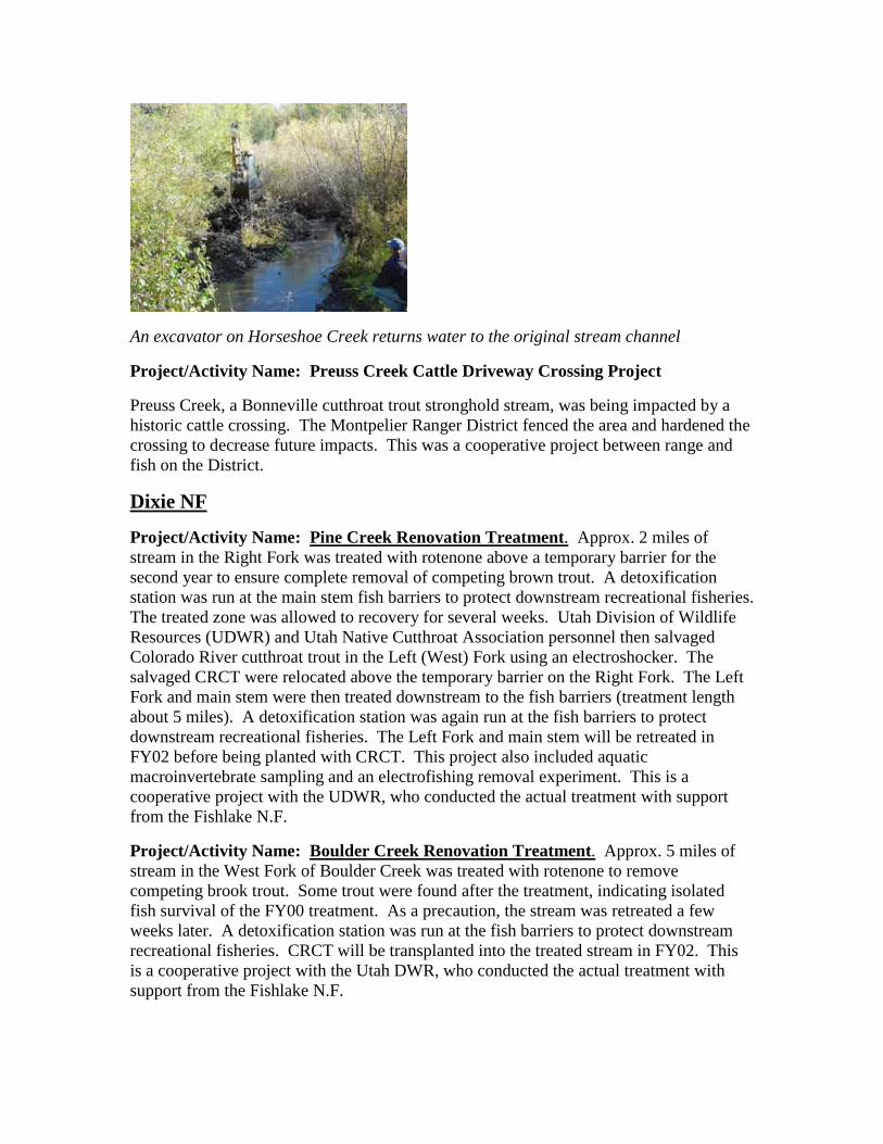
Dixie NF
Project/Activity Name: Pine Creek Renovation Treatment. Approx. 2 miles of stream in the Right Fork was treated with rotenone above a temporary barrier for the second year to ensure complete removal of competing brown trout. A detoxification station was run at the main stem fish barriers to protect downstream recreational fisheries. The treated zone was allowed to recovery for several weeks. Utah Division of Wildlife Resources (UDWR) and Utah Native Cutthroat Association personnel then salvaged Colorado River cutthroat trout in the Left (West) Fork using an electroshocker. The salvaged CRCT were relocated above the temporary barrier on the Right Fork. The Left Fork and main stem were then treated downstream to the fish barriers (treatment length about 5 miles). A detoxification station was again run at the fish barriers to protect downstream recreational fisheries. The Left Fork and main stem will be retreated in FY02 before being planted with CRCT. This project also included aquatic macroinvertebrate sampling and an electrofishing removal experiment. This is a cooperative project with the UDWR, who conducted the actual treatment with support from the Fishlake N.F.
Project/Activity Name: Boulder Creek Renovation Treatment. Approx. 5 miles of stream in the West Fork of Boulder Creek was treated with rotenone to remove competing brook trout. Some trout were found after the treatment, indicating isolated fish survival of the FY00 treatment. As a precaution, the stream was retreated a few weeks later. A detoxification station was run at the fish barriers to protect downstream recreational fisheries. CRCT will be transplanted into the treated stream in FY02. This is a cooperative project with the Utah DWR, who conducted the actual treatment with support from the Fishlake N.F.
Project/Activity Name: White Creek Renovation Treatment. Approx. 1 mile of stream was treated with rotenone to ensure complete removal of competing non-native trout. A detoxification station was run at the fish barriers to protect downstream recreational fisheries. This completes the treatments on White Creek. CRCT will be transplanted into the treated stream in the future. This is a cooperative project with the Utah DWR, who conducted the actual treatment.
Project/Activity Name: Twitchell Creek and Willow Bottom Reservoirs Renovation Treatment. A fish barrier was built by the Utah Division of Wildlife Resources at the confluence of Twitchell Creek and North Creek to protect upstream habitat from non-native trout. In early fall Long Willow Bottom and Round Willow Bottom Reservoirs were treated to remove non-native trout, primarily with powdered rotenone but using minor amounts of liquid rotenone along the shore and on inlet streams. The day after the reservoirs were treated, Twitchell Creek downstream of the reservoirs was treated with liquid rotenone to remove competing non-native trout. Approx. 5 miles of stream was treated. A detoxification station was run at the fish barrier to protect downstream recreational fisheries. The lakes and stream will be retreated in 2002, and CRCT will be transplanted into the treated waters in the future. Project included a pre-treatment aquatic macroinvertebrate sample. This is a cooperative project with the Utah DWR, who conducted the actual treatment with support from the Fishlake N.F.
Project/Activity Name: Dougherty Canal Renovation Treatment. Approx. .25 miles of canal and associated marshy areas between Dougherty Basin Lake and Tall Four Lake was treated with rotenone to remove competing brook trout. This treatment will be repeated in 2002. Detoxification was run at the inlet to Tall Four Lake to protect the fisheries in the lake. Detoxification was successful and no fish in Tall Four Lake were killed. This is a cooperative project with the Utah DWR, who conducted the actual treatment.
Project/Activity Name: Ranch Creek Environmental Analysis. An Environmental Analysis was written for habitat improvement projects on Ranch Creek. This creek was damaged in the past by unauthorized work to improve water passage/yield to a ranch. Habitat improvement projects authorized by the EA will be implemented in future years as a cooperative project with the Utah DWR.
Project/Activity Name: Boulder Mountain Environmental Analysis. An Environmental Analysis was written for renovation treatments on Boulder Mt. While primarily a sportfishing enhancement project by treating lakes with severely stunted brook trout, it will provide an opportunity to restore CRCT to 11 miles of streams and about 10 acres of lakes, and BCT to 5 miles of streams and 5 acres of lakes. This is a cooperative project with the Utah DWR. Completion of the EA and Decision document in FY01 allowed the startup of several new cutthroat recovery projects near the end of the fiscal year.
Fishlake NF
Project/Activity Name: Bonneville Cutthroat Trout Exclosure Maintenance. Extensive maintenance of old exclosures on Pine Creek and Birch Creek (W) was conducted on the Beaver R.D. in order to reduce livestock grazing impacts to these two creeks. The existing exclosures were not fully functional and were allowing livestock access. This was a cooperative project with the Utah Division of Wildlife Resources (UDWR). In addition, volunteer labor was provided by approx. 40 hunters via the UDWR Dedicated Hunter program. Volunteer in-kind labor value estimated at $3,200. Fencelines were cleared of brush and trees, posts and wires were replaced, old fence wires re-stretched, and one water gap modified and rebuilt. Work will benefit 4 miles of stream habitat. Project also funded fence supplies that will be used for future maintenance and new exclosures.
Project/Activity Name: Bonneville Cutthroat Trout Stream Surveys. Approx. 19 miles on three streams were surveyed to determine BCT upstream and downstream distribution limits, population size, productivity (biomass), important habitat features such as barriers, and general habitat condition. This was a cooperative project with the Utah Division of Wildlife Resources (UDWR). In addition to funding for the cooperative Aquatic Biologist position, UDWR contributed $1,000 of in-kind survey work. The remaining BCT streams on the Fishlake N.F. will be monitored in 2002. Part of the project cost was for equipment such as an electroshocker, block nets, scales, etc.
Project/Activity Name: Manning Creek Aquatic Macroinvertebrate Monitoring. The project purpose is to evaluate impacts of the use of rotenone for the 1995 and 1996 renovation treatments of Manning Creek to aquatic macroinvertebrates. Laboratory results were further compiled and the draft document further edited and prepared. A summary of the monitoring was posted on the Forest web page. A Power Point presentation was developed and presented at the Bonneville chapter of the American Fisheries Society meetings in St. George, UT in Feb. 2001. The final report will be printed in 2002. This is a cooperative project with the Utah Division of Wildlife Resources.
Project/Activity Name: Native Cutthroat Trout Restoration Projects. The project purpose is to restore healthy populations of native cutthroat trout subspecies on the Fishlake N.F. This is a cooperative project with the Utah Division of Wildlife Resources (UDWR). In addition to funding for the cooperative Aquatic Biologist position, UDWR contributed $2,000 of in-kind renovation treatment work (in-kind costs for the extensive UDWR brood stock program work was not tallied). Forest personnel assisted the UDWR with the Manning Meadow Reservoir brood stock program spawning work. The egg take exceeded all past levels. Birch Creek (E) was evaluated with an electroshocker, and then treated with rotenone to prepare it for reintroduction with BCT. An interagency renovation treatment was also conducted on Ten mile Creek. An additional treatment will be required in FY02 on Ten mile Creek. Both Birch Creek (E) and Ten mile Creek will likely have BCT reintroduced in FY02. Note that some of the project costs were for support of renovation treatments on the Dixie N.F.
Project/Activity Name: Salina Creek Stream Survey. Project objectives were to locate potentially pure remnant stocks of BCT, further evaluate the potential to reintroduce BCT to portions or all of Salina Creek, determine salmonid abundance and biomass, determine native non-game species distribution, and determine basic habitat parameters. The main stem was surveyed in FY00. Survey work in FY01 focused on tributaries. Portions of an adjacent creek, Willow Creek, were also surveyed. This was a cooperative project with the Utah Division of Wildlife Resources (UDWR). The Forest helicopter was used to first aerially survey the tributaries to see which warranted ground checking. Tributary streams that warranted ground surveys were then walked, checking general habitat characteristics, and spot-shocked to determine fish species presence. All tributaries with potential fish habitat were identified and surveyed. No new potential remnant stocks were identified. Temperature monitors were placed in the main stem of Salina Creek during the summer. Information useful for planning potential renovation projects was obtained. Approx. 40 miles of streams was surveyed.
Project/Activity Name: UM Creek CRCT Whirling Disease Study. Project is a multi-year study being conducted by the Utah Division of Wildlife Resources (UDWR) in cooperation with the Fishlake N.F. Study objectives are to determine habitat potential for salmonids using the Binns habitat survey method, reintroduce CRCT to UM Creek, evaluate CRCT population establishment in a stream infected with whirling disease, and evaluate the ability of CRCT to withstand competition from sterile Tiger trout which were stocked to satisfy the recreational fishing demand. In May approx. 1,400 additional CRCT were planted in UM Creek. These were trout raised in a state hatchery from eggs taken from a pure brood stock. In late summer several additional stations had habitat inventoried using the Binns methodology. In early fall the populations of CRCT and sterile hybrid tiger trout were monitored. Temperature monitors were placed at several stations during the summer.
Project/Activity Name: Fishlake N.F. Aquatic NatureWatch Programs. About half of the Fishlake Aquatic NatureWatch Programs content was aimed at increasing public awareness of the native fish on the Fishlake N.F. and the current recovery work being conducted for native cutthroat trout. One campground evening program given at Fishlake was on the native cutthroat trout restoration program. In addition, native cutthroat trout information was included at a Natural Resource Festival booth, a 3rd-grade environmental education camp, and in a limited extent, at local fishing derbies. This was a cooperative project with the Utah Division of Wildlife Resources.
Humboldt-Toiyabe NF’s
Austin/Tonopah Ranger Districts LCT Accomplishments
Washington and Marysville Creek. Promoted, completed NEPA, financed and coordinated the contruction of livestock exclosures to protect important LCT habitat areas in Washington and Marysville Creeks in the north Toiyabe Mountain Range. Both

areas were being severely degraded by cattle. Together, they encompass approximately 10 acres. Significantly, they protect the largest spring complexes in each system which in turn protects and insures dounstream water quantity and quality to approximately seven miles of potential and occupied LCT habitat. The Marysville exclosure protects the most degraded area in the entire watershed and as such will greatly reduce the movement of fine sediments into downstream spawning gravels.
Tierney Creek. Promoted, financed and coordinated the repair of two existing livestock exclosures in the upper forks of Tierney Creek in the north Toiyabe Mountain Range. The exclosures protect the largest meadow/spring complexes located in the upper basins of the south and north forks of Tierney Creek and as such protect water quality and quanity to apprximatley 10 miles of downstream occupied LCT habitat. Together they enclose approximately 20 acres and/or one mile of occupied habitat. Prior to contruction these areas were severely degraded by cattle which caused accellerated movement of fine sediments into downstream spawning gravels. Tierney Creek supports the largest population of LCT in central Nevada and as such, may constitute a doner population for transplants to other habitat areas as per the revised LCT Recovery Plan.
LCT Population Surveys. As per the LCT Recovery Plan, supported and coordinated with NDOW to conduct population surveys in 23 miles of habitat occupied by LCT in Crane Canyon, San Juan and Cottonwood Creeks in the north Toiyabe Mountain Range. Population trends were stable in all three watersheds.
LCT Genetics. As per the LCT Recovery Plan, supported research conducted by Dr. Mary Peacock of UNR to determine the genetic status of LCT in the Reese River watershed in the Toiyabe Mountain Range.
Ruby Mountains, Santa Rosa, Jarbidge and Mountain City Ranger Districts LCT Accomplishments
Northeast Fisheries Habitat Surveys. A general aquatic wildlife system (GAWS) level III survey was conducted on a total of 18 miles of LCT streams. Data was collected on streams located on three different districts: Ruby Mountains (Mitchell, Pearl, Long Canyon, 2nd Boulder, Segunda, Furlong, and Kleckner Creeks), Jarbidge (Wildcat Creek), and Mountain City (Foreman Creek). These surveys were to evaluate trend, impact of land uses, and to replicate data that was collected in the early 1980’s at these same locations.
Upper Humboldt LCT DPS Team. The Upper Humboldt LCT Distinct Population Segment (DPS) Team is an interagency team formed to implement and coordinate recovery actions and to research and monitor LCT habitat and populations. This team covers the Ruby Mountain, Jarbidge, and Mountian City Ranger Districts. Partners on the team include: Nevada Division of Wildlife, BLM, US Fish and Wildlife Service, and University of Nevada-Reno.
Quinn/Black Rock DPS Team. The Quinn/Black Rock LCT Distinct Population Segment (DPS) Team is an interagency team formed to implement and coordinate recovery actions and to research and monitor LCT habitat and populations. This team
covers the Santa Rosa Ranger District. Partners on the team include: Nevada Division of Wildlife, BLM, US Fish and Wildlife Service, University of Nevada-Reno, and Summit Lake Paiute Tribe.
Green Mountian Creek Temporary Fish Barrier. Preliminary work was done on this project within the Upper Humboldt DPS Team to create partnership and agreement. This project will be a recovery action to establish a metapopulation for LCT in the Green Mountian/Toyn/Corral watershed. Project description, location, and design were completed. NEPA and construction will be completed FY 2001.
Bridgeport Ranger District
Grazing Monitoring. Monitoring of livestock utilization and stream bank disturbance was conducted, documented, and a report sent to the Reno Office of the US F&WS. Recommendations to the Line Officer were made for permit actions on three (3) grazing permits. Streams that were monitored include By-Day, Mill, and Murphy. District range staff professionals are planning to install two miles of fence on an allotment adjacent to Murphy Creek to prevent use by cattle drifting from the allotment into the Murphy Creek drainage.
Walker River Basin Recovery Implementation Team. The district Wildlife Biologist and Resource Staff Officer participated in meetings with the Recovery Implementation Team established by the Fish and Wildlife Service. A draft recovery plan is moving toward completion and review.
LCT Population Surveys. California Fish and Game conducted visual population surveys on Mill Creek, By-Day Creek, Silver Creek and Wolf Creek. Approximately 8 miles of stream were surveyed.
Spring Mountains National Recreation Area
Carpenter Canyon genetic testing and population survey. The purpose of this project was to reevaluate the extent of the habitat occupied by cutthroat trout and formulate a population estimate of the trout. Each fish caught was weighted, measured, and fin clipped before being released back into the stream.
Carson Ranger District
LCT Population Surveys. California Fish and Game conducted electrofishing surveys on the East Fork of the Carson River and Murray Canyon. Approximately 3 miles of stream were surveyed.
Carson Ranger District PCT Accomplishments
PCT Population Surveys. The district biologist participated with the California Fish and Game on electrofishing surveys in the Silver King Drainage. Approximately 8 miles of stream were surveyed.

Ely Ranger District BCT Accomplishments
Pine and Ridge Creek Genetics Sampling, South Snake Range. Personnel from the Ely R.D. assisted Great Basin National Park and Nevada Division of Wildlife personnel in electroshocking and fin clipping 30 individual Bonneville cutthroat trout. Samples were sent for genetic testing to try to determine the origin of these fish and compare with other known genetics of the species in Nevada.
Big Wash Rotenone Eradication, South Snake Range. Rotenone was applied in a controlled manner to approximately 5 miles of the Big Wash drainage to eradicate non-native salmonids in order to reintroduce native Bonneville Cutthroat trout at a future date. Aproximately 1 mile of treated stream was on National Forest Lands, other treated miles were located on private land downstream of the Forest.
Hydrographic and Thermographic sampling in Smith Creek, North Snake Range. The Nevada Division of Wildlife fisheries biologist placed hydrographs and thermometers in strategic locations in the Smith Creek Drainage. Smith Creek was chemically treated to eradicate non-native salmonids in 1997 and BCT were reintroduced in 1999. District personnel assisted NDOW with retrieval of these units in the Fall of 2001. Information resulting from this data will be used in developing future habitat projects within the drainage.
Manti LaSal NF
Project/Activity Name: Huntington Creek Fish Barriers Four tributaries to Huntington Creek have isolated and unique populations of native Colorado River Cutthroat Trout. These populations are small and are at high risk of extinction due to fragmentation and introduction of non-native trout in the main-stem of Huntington Creek downstream of each tributary. Migration barriers where installed near the mouth of each one of these tributaries to prevent further hybridization and competition with non-native fish. This work also allows opportunities for the short-term maintenance and persistence of these populations while long-term strategies are developed for future relocation or expansion projects. By installing these barriers, future options remain open that may have been easily lost if nothing was done. These barriers were constructed from large rocks to create a 6 foot drop in the channel. The base of each drop was armored with large flat boulders embedded into the stream bottom to prevent plunge pools from forming. The project was funded from 2 sources; private industry mitigation money (Genwal Inc.) and federal funds specifically earmarked for native cutthroat trout recovery. A total of 19 miles of stream habitat and native cutthroat trout populations were protected as a result of this project.
Payette NF
Project/Activity Name : Grouse Creek road rehabilitation. This BAER funded action surfaced a road within an RHCA, relocated part of the road, and replaced undersized culverts with open bottom structures. Improvements for westslope cutthroat
trout inluded reduced sedimentation, and improved fish passge over about 4 miles of stream. The watershed is tributary to the Secesh River basin.
Project/Activity Name : Stibnite mine rehabilitation. This mine reclamation project recontoured about 2 miles of old stream channel diversion after reconstruction of the stream. Improvements for westslope cutthroat trout include reduced risk of catastrophic channel failure & reduced sedimentation. The area is tributary to the East Fork South Fork Salmon River basin.
Project/Activity Name : Monitoring fire effects to aquatic ecosystems. This cooperative project with Idaho Sate University monitors fire effects in the Big Creek (Middle Fork Salmon River) and South Fork sallmon River basins. Data is used to manage fire suppression and prescribed fire programs to avoid adverse effects to westslope cutthroat habitat over at least 10 miles of stream.
Project/Activity Name : South Fork Salmon River stream bank restoration. This project removed decades of research station debris from 2 miles of river banks. Improvements for westslope cutthroat trout included increased stream bank stability, reduced impalement hazard, and improved aesthetics.
Salmon-Challis NF’s
Project/Activity Name Wild Salmonid Population Survey Partnership Trend Monitoring Program This was a partnership effort with IDF&G and involved 3 USFS seasonal employees 40 days electro-fishing streams in October, pre runoff late April-May, and post runoff July-September monitoring 48 stations on 26 streams. These are permanent monitoring stations that along with monitoring the streams fish population trends will help with population viability analyses. Project/Activity Name Stream Sediment Trend Monitoring Program Because of logistics, cost, and lack of suitable spawning habitat some streams are not part of the forest’s long-term trend monitoring core-sampling program. In the absence of core sampling the North Fork Ranger District, started July 1999, stream sediment monitoring of % fines by depth using an established shovel methodology. This technique first requires the identification of potential salmonid spawning habitat. This stream sediment-monitoring program is implemented in combination with our permanent trend monitoring electro-fishing stations. Each salmonid stream receives at least one reach sampled with each reach measuring at least 100 meters and collecting up to 10 samples. The samples are then taken back to the office dried and separated by particle size. Results of all assessments are expressed as percent fines less than l/4 inch in diameter. This methodology use dried weight to determine percent fines. In FY2001, we sampled 37 stations on 31 streams. These are permanent monitoring stations used in trend analyses.
Project/Activity Name Stream Temperature Trend Monitoring Program The stream temperature-monitoring program collects stream temperature data using a continuous monitoring thermograph that is programmed to take readings at least every 2.0 hours. This data is then downloaded into Microsoft excel where graphs are made and an analyses completed to see if a given stream meets all the cold water salmonid temperature
requirements. In FY2001, we sampled 75 stations on 60 streams. These are permanent monitoring stations used in trend analyses. Project/Activity Name Stream Water Chemistry Trend Monitoring Program The stream water chemistry-monitoring program collects water chemistry data using a WTW Multiline P4 Water Chemistry Meter. The stream water chemistry-monitoring program is implemented in combination with our permanent trend monitoring electro-fishing stations. The data collected includes pH measurement, dissolved oxygen measurement, conductivity, and turbidity measurements using a LaMotte Model 2020 Turbidimeter. In FY2001, we sampled 44 stations on 35 streams. These are permanent monitoring stations used in trend analyses. Project/Activity Name North Fork Salmon River R1/R4 Stream Habitat Inventory This work involved almost 9 miles of R1/R4 stream habitat inventory to define the structure (pool/riffle, forming features), patterns (sequence and spacing), and dimensions (length, width, depth, area, volume, and so forth) of fish habitat. These data will help to identify factors limiting fish populations, to define current and potential status of fish and fish habitat, to complete local and regional population viability assessments (extinction risks), and to correlate fish and fish habitat distributions and conditions with environmental parameters, past and current land uses, and natural disturbance. An analysis of the R1/R4 data is completed by first entering the raw data into the FBASE program. This FBASE program is then used to create a habitat summary of a stream reach or stream. This summary is then compared to the streams Desired Future Condition (DFC) and PACFISH/INFISH Riparian Management Objectives to identify a stream reach or stream’s habitat limiting factors. The DFC is based on the US Forest Service General Technical Report "Users' Guide to Fish Habitat: Descriptions that Represent Natural Conditions in the Salmon River Basin, Idaho" (INT-GTR 322, 1995).
Project/Activity Name Stream Restoration Maintenance and Monitoring Program This work involves monitoring and maintaining past stream restoration activities, i.e. Log and rock drop structures. Along with the project implementation there is an end of year report and photo documentation in a Microsoft Presentation slide show on a CD Rom. In FY2001, this work involved structures on 5 different streams all of which support westslope cutthroat trout populations.
Project/Activity Name North Fork Salmon River Restoration Partnership Project This was a stream restoration partnership with the Upper Snake River Chapter of Trout Unlimited. The project involved the hand installation of two log drop structures to restore degraded coldwater salmonid spawning and rearing habitat. This was the 12th consecutive year volunteers from the Upper Snake River Chapter of Trout Unlimited have traveled over 160 miles one way to help assist the North Fork Ranger District with an annual stream restoration workday. This year’s volunteer numbers totaled 38 with ten local volunteers from the Salmon area.
Project/Activity Name Pine Creek Culverts Replacement Project This project involved the replacement of the last two, of four previously identified, fish barrier culverts with bridges on Pine Creek. This project restored fish passage to over 3 miles of coldwater salmonid spawning and rearing habitat. Project/Activity Name Allan Lake Survey This survey followed Idaho Fish and Game Lake Monitoring protocols including fish identification, length, and catch per hour angling success. Along with fish data collected, we also walked completely around the lake surveying for amphibians. This was a partnership with IDF&G. This project surveyed 9 acres of a westslope cutthroat trout High Mountain Lake.
Project/Activity Name Challis Ranger District Fish Population Assessment This is a two-year project designed to assess the status of fish populations on the Challis Ranger District. The project involves systematically 1) mapping perennial streams, 2) identifying potential fish habitat, 3) determing fish distribution within potential fish habiat, and 4) and collecting density and species composition data from selected sites. This project will benefit westslope cutthroat by documenting their current distribution and status on the ranger district. Other species benifited include bull trout, rainbow trout, brook trout, and sculpin. The American Fisheries Society provided one person to this project for 25 days through the Hutton Junior Fish Biologist program.
Project/Activity Name: Stream survey on the Yankee Fork of the Salmon River. Eleven miles of stream survey was completed within the Yankee Fork drainage. This information will provide a basis upon which to base westslope cutthroat conservation efforts.
Project/Activity Name: Stream Temperature Monitoring on the Yankee Fork Ranger District, Salmon-Challis NF. Temperature monitoring was undertaken on 50 sites forest wide. This information will provide a basis upon which to base westslope cutthroat conservation efforts.
Sawtooth NF
Project/Activity Name: Biological Assessment of Federal Actions. Analysis of 30 proposed actions in “subpopulation” assessments was conducted at the “may effect” threshold for westslope cutthroat trout, in anticipation of ESA listing. Management consistency and/or necessary changes in regards to westslope cutthroat protection and conservation were evaluated.
Project/Activity Name: Fish and Fish Habitat Investigations. Fish habitat inventories, including snorkeling for species presence and density, at the habitat unit scale, were completed on 17 miles of stream in two drainages containing habitat for westslope cutthroat trout. Project/Activity Name: Water Temperature Characterization. Determine the effects to water temperature in westslope cutthroat trout habitats from the withdrawal of water
for agriculture irrigation purposes within the Sawtooth NRA. Water temperatures throughout the summer season were characterized at 40 locations within the headwaters of the Salmon River and tributaries, primarily above and below irrigation diversions. Project/Activity Name: Non-Classified Road Inventory. The extent and condition of non-classified roads located within the Beaver and Smiley Creek watersheds, in the headwaters of the Salmon River, was determined. The results of such inventories provide a much more accurate understanding of possible effects to streams and aquatic habitats from the road network. Both drainages contain habitat for westslope cutthroat trout.
Project/Activity Name: Yellowbelly Rough Fish Barrier Removal. A concrete barrier was removed from the outlet of Yellowbelly Lake. The structure, five feet high and 50 feet long, was constructed by the Idaho Department of Fish and Game nearly 40 years ago to prevent the re-colonization of the lake by “rough fish” following chemical eradication of the lake. This treatment proved ineffective and the original purpose of the barrier was abandoned. However, the barrier remained and prevented the upstream migration of all fish species, including westslope cutthroat trout. IDFG officially abandoned the structure in 2000. Project/Activity Name: Alturas Lake Creek Restoration. Alturas Lake Creek was returned to it’s natural channel where captured by Road 205 during the mid 1990s. When captured, Alturas Lake Creek had scoured an 5-8 foot gully into the former roadway for ¼ mile, and abandoned the meandering habitats of its historic channel. Thousands of cubic yards of sediment resulted. The project reversed the outcome, and prevented further degradation in this important westslope cutthroat trout habitat. Project/Activity Name: Harriman Trail Cross-roads. Four miles of non-classified road, and associated dispersed camping sites, were closed and rehabilitated using an excavator to break compaction, reestablish natural drainage and topography, and incorporate organic material onto the former routes. Some routes were located in streamside or seasonally wet meadow areas adjacent to the Wood River or its tributaries. Westslope cutthroat trout are not native to the Wood River, but constitute an important introduced fishery. Project/Activity Name: Rough Creek Road Reconstruction. Approximately 4.5 miles of the Rough Creek Road, containing habitat for westslope cutthroat trout, was reconstructed to reduce surface and crossdrain erosion and sediment production. Many of the culverts crossings under the Rough Creek Road were replaced and enlarged, and most of the road drainage facilities were redesigned and improved throughout the length. Project/Activity Name: Trail Realignments. Short segments of four classified trials were rerouted out of wet, deterioriating segments to more suitable upland routes. Once established, the former routes were closed and rehabilitated by breaking compaction, reestablishing natural drainage and topography, and incorporating organic material onto the former treads. These projects occurred in the Smiley Creek, Johnson Creek, North Fork Boise River, and South Fork Payette River drainages, all containing habitat for
westslope cutthroat trout. Project/Activity Name: Dry Creek Roads Rehabilitation. Three miles of classified road, aligned in two adjacent drainage bottoms, was consolidated and relocated to a single ridgetop location between them. The former routes were poorly located in the bottoms of Dry Creek and Park Creek headwaters. The former routes were closed and rehabilitated with a tracked excavator to break compaction, reestablish natural drainage and topography, and incorporate organic material onto the former routes. Westslope cutthroat trout habitat exists downstream. Project/Activity Name: Stanley Sewer Reclamation. The site formerly occupied by the two-cell, 12.3 million gallon sewer lagoons for the City of Stanley on National Forest was closed and rehabilitated. The facility was adjacent to Valley Creek, important habitat for westslope cutthroat trout, and completely within its floodplain. The City’s sewer system had been relocated a year earlier. The classified road, which had been relocated adjacent to Valley Creek when the ponds were constructed, was moved back to the margin of the floodplain, at the toe of the slope. The project was implemented by the Stanley Sewer Association. Project/Activity Name: Hanna Creek Fence. One-quarter mile of the newly restored natural channel of Hanna Creek was fenced to exclude grazing livestock. The historic channel of Hanna Creek was reestablished in 1999, and attempts to protect the channel with a temporary electric fence failed in 2000. Valley Creek and Hanna Creek contain important habitat for westslope cutthroat trout. Labor for the project was provided by Landmark Volunteers. Project/Activity Name: Elk Creek 2 Diversion Fish Screen. An antiquated fixed plate screen at the head of the Elk Creek 2 Diversion was replaced with a state of the art rotary drum screen which meets current NMFS criteria. Elk Creek contains important habitat for westslope cutthroat trout. Juvenile cutthroat, migrating downstream, will see less hazard, delay, and mortality at the Elk Creek 2 Diversion. The project was implemented on National Forest by Idaho Department of Fish and Game. Uinta NF Project/Activity Name : Upper watershed reconnaissance survey to validate the presence / absence of Bonneville cutthroat trout in tributaries to Upper Diamond Fork, Nebo Creek, American Fork River above Tibble Fork Reservoir, and Upper South Fork Provo River. Occular estimates were made of available trout habitat in small headwater tributaries in known occupied cutthroat trout streams that are identified in the Conservation Agreement.
Project/Activity Name:Upper watershed reconnaissance survey to validate the presence / absence of Colorado cutthroat trout in tributaries to West Fork Duchesne River, White River, Willow Creek, Tie Fork and Tabbyune Creek. Occular estimates were made of
available trout habitat in small headwater tributaries in known occupied cutthroat trout streams that are identified in the Conservation Agreement.
Project/Activity Name Trout habitat improvement structures on the West Fork of the Duchesne River (CCTT) and Upper Diamond Fork (BCTT) were repaired or modified to extend the life of the structures.
Project/Activity NameDistrict biologist worked with Pleasant Grove Ranger District and UP&L to retain large woody debris in lower reaches of American Fork River.
Wasatch-Cache NF
Project/Activity Name: Beaver Creek Road Rehabilitation, Logan Ranger District, Wasatch-Cache National Forest, USDA Forest Service, Intermountain Region Forest Development Road (FDR) 011 starts at Highway 89 and parallels Beaver Creek for 2.5 miles to the Idaho-Utah state line. Several dispersed campsites were located between the road and the stream. Habitat surveys conducted by the USDA Forest Service in 1995 on Beaver Creek indicated that FDR 011 and the dispersed campsites were the main contributers of sediment into Beaver Creek. This sediment had the potential to negatively impact native Bonneville cutthroat trout (Oncorhynchus clarki utah) by reducing spawning and over-wintering habitat. This project was designed to reduce these impacts. In 2001, FDR 011 was rehabilitated. The road was out-sloped whenever possible and rolling dips were installed to improve drainage from the road. Inside ditches were installed and existing culverts were cleaned where necessary. Four dispersed campsites located adjacent to Beaver creek were ripped and seeded. Barrier rock was then placed to prevent motorized access. Another four very large campsites were reduced in size to provide a buffer to the stream. Educational signs were developed and installed by Cache Anglers and SITLA, explaining the project and the benefits to the fisheries. In the spring of 2002, native shrubs and willows will be planted by Cache Anglers, SITLA, and hte USDA Forest Service. The monitoring of sediment imputs into the stream, and fish population changes will continue.
Contact: Paul Chase 435-755-3620
Project/Activity Name: Gilbert Creek Treatment, Mountain View Ranger District, Wasatch-Cache National Forest, USDA Forest Service, Intermountain Region The objective of the project was to remove non-native fish from the Little Gilbert Creek Drainage and the upper end of the Gilbert Creek Drainage. Electrofishing was initially used to remove native and non-native fish. Native fish were held for restocking after treatment. The non-native fish were moved to a more desirable location. The waters were then treated with rotenone and anamycin. Over 8 miles of stream were treated and non-native fish were removed. Native fish have been restocked in the area. Two barriers have been improved to prevent non-native fish from migrating back up the drainage. The USFS was a partners in the project to Wyoming Game and Fish Commission and Utah Division of Wildlife Resources.
Contact Person: Paul Cowley (801) 524-3942
Project/Activity Name: Forest Wide Fishery Analysis for Forest Planning, Supervisor's Office, Wasatch-Cache National Forest, USDA Forest Service, Intermountain Region To analysis the risks and threats to native fish species on the Wasatach-Cache National Forest as part of Forest Planning. A full writeup is found at “http://www.fs.fed.us/wcnf/deis/fish_viability_analysis.pdf “. Contact Person: Paul Cowley (801) 524-3942
Project/Activity Name: Habitat Survey of Hayden Fork, Evanston Ranger District, Wasatch-Cache National Forest, USDA Forest Service, Intermountain Region This project was to describe the habitat that is currently being used by Bonneville cutthroat and brook trout, whitefish, mountain sucker and sculpin found in the Hayden Fork. The R1/R4 habitat inventory methodology was used for this survey.
Contact Person: Paul Cowley (801) 524-3942
Project/Activity Name: Logan River Habitat Survey, Logan Ranger District, Wasatch-Cache National Forest, USDA Forest Service, Intermountain Region The objective of this project was to complete the R1/R4 habitat survey of the Logan River. The R1/R4 habitat survey was utilized. Additionally, snorkeling surveys were used to estimate fish species composition and population sizes. This project was started in 1995 and completed in 2001. In 2001, a total of 10,522 m (6.5 miles) of stream were surveyed. Overall, nine reaches were surveyed covering 45,732 m (28.4 miles). Contact Person: Paul Chase 435-755-3620 Project/Activity Name: Cutthroat Trout Surveys, Supervisor's Office, Wasatch-Cache National Forest, USDA Forest Service, Intermountain Region Conduct initial surveys of some of the streams located on the Wasatch-Cache National Forest. These include the Middle Fork of the Weber, Duchesne River, West Fork Bear River, East Fork Bear River Canals, Stillwater Fork, and Hayden Fork. Two pass electrofishing surveys were conducted on these streams. Contact Person: Paul Cowley (801) 524-3942 Project/Activity Name: Road Closures on the Wasatch-Cache N. F., Supervisor's Office, Wasatch-Cache National Forest, USDA Forest Service, Intermountain Region During 2001, the Wasatch-Cache National Forest closed a number of miles of ghost and unnecessary roads on the forest. With the closure these roads were rehabilitated to reduce sedimentation into about 10 miles of stream in the Woodruff, Mill and West Fork of the Bear River drainages. Contact Person: Paul Cowley (801) 524-3942


WYOMING
Bonneville Cutthroat Conservation Actions - 2001 Conservation action completed during the calendar year 2001 included assistance with two University of Wyoming studies. The University of Wyoming, through funding from the Wyoming Game and Fish Department is finalizing a 3 year study to determine BRCT movement patterns throughout the Thomas Fork drainage in Wyoming. This included work to determine ages and growth rates of the fish moving long distances versus those with localized movement. Another on-going study in the drainage is determining the extent of fry survival in different watersheds within the Thomas Fork drainage and what habitat characteristics may help influence that survival. The Wyoming Game and Fish Department gave initial approval to fund a study to assess BRCT losses at water diversion structures and evaluate mitigation options. The proposed study area on the lower Smith's Fork River was visited to determine the different diversion structures in the area and meet with local landowner interested in this study. The other primary activity in the region was to continue working with the BLM and local landowners in developing grazing strategies to begin recover of the riparian and upland areas. Fencing did occur in the upper Raymond Creek watershed and some instream structures were placed in the upper reach of Raymond Creek where significant downcutting is occurring. Planning work is ongoing for Coal Creek (Howland Cr) with grazing permittee on state land to rest a significant portion of the riparian area. Coal Creek is an important spawning tributary to the Smiths Fork River. An instream flow right for Hobble Creek was approved by the Wyoming State Engineer's office late this summer. Hobble Creek is a relatively large drainage and tributary of the Smiths Fork River. This was the first instream flow right approved by the State Engineer's office since the early 1990's. We anticipate there will be a number of other rights approved in the next upcoming year's since the new State Engineer has a more positive attitude about these filings.
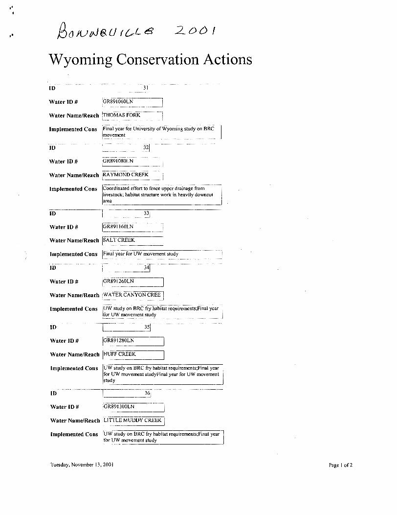
Wyoming Conservation Actions
Water ID # 1 ~ ~ 8 9 1 O ~ O L N I . --
Water NameIReach [THOMAS FORK I Implemented Cons for University of Wyoming study on BRC
Water ID #
area 1 -A
....... - GR89 1 080LN
Implemented Cons
Water ID # ( ~ R 8 9 1 160LN I-
Water NameIReach ~SALT CREEK-] . - -- - - -
Coordinated effort to fence upper drainage from livestock; habitat structure work in heavily downcut
Water ID # GR891260LN I- _I Water NameIReach WATER CANYON CREE I
Water ID # l ~ z l 2 8 0 ~ ~ -1
implemented Cons
Implemented Cons u w s t u d y on BRC for UW movement studyFina1 year for UW movement study
---
UW study on BRC fry habitat requirements;Final year I for UW movement study
Water ID # l d ~ 8 9 i 3 0 0 ~ ~ I - - - - - - -- --7 -
Water NameIReach [L~TTLE MUDDY CREEK - -- - . -- 2
Implemented Cons requi&ments;~inal
. -. - - - -- _I
Tuesday, November 1 3,200 1 Page 1 of 2
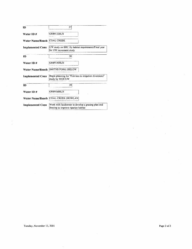
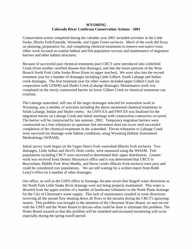
WYOMING Colorado River Cutthroat Conservation Actions - 2001
Conservation action completed during the calendar year 2001 included activities in the Little Snake, Blacks Fork/Eastside, Westside, and Upper Green enclaves. Much of the work did focus on planning, preparation for, and completing chemical treatments to remove non-native trout. Other work focused on routine habitat and fish population surveys and maintenance of migration barriers and other habitat structures. Because of successful past chemical treatments pure CRCT were introduced into Littlefield Creek (from another certified disease-free drainage), and into the lower portions of the West Branch North Fork Little Snake River (from its upper reaches). We were also into the second treatment year for a number of drainages including Little Gilbert, South Labarge and Indian creek drainages. The first treatment year for other waters included upper Gilbert Creek (in cooperation with UDWR) and Shafer Creek (Labarge drainage). Maintenance work was completed on the newly constructed barrier on lower Gilbert Creek so chemical treatments can continue. The Labarge watershed, still one of the larger drainages selected for restoration work in Wyoming, saw a number of activities including the above mentioned chemical treatments in South Labarge, Indian and Shafer creeks. An USFS EA and FWS ES was finalized for the migration barrier on Labarge Creek and initial meetings with construction contractors occurred. The barrier will be constructed by late summer, 2002. Temporary migration barriers were constructed on a four tributaries so upstream fish movement does not occur until successful completion of the chemical treatments in the watershed. Eleven tributaries to Labarge Creek were surveyed for drainage-wide habitat conditions, using Wyoming Habitat Assessment Methodology (WHAM). Initial survey work began on the Upper Ham's Fork watershed (Blacks Fork enclave). Two drainages, Little Indian and Devil's Hole creeks, were measured using the WHAM. Fish populations including CRCT were surveyed to determined their upper distribution. Genetic work was received from Dennis Shiozawa's office and it was determined that CRCT in Beaverdam, Middle Fork West Muddy, and Horse creeks (Blacks Fork enclave) were pure and could be considered core populations. We are still waiting for a written report from Robb Leary's office on a number of other drainages. Our office, as well as the USFS office in Saratoga, became aware that StageII water diversions in the North Fork Little Snake River drainage were not being properly maintained. This water is diverted from the upper reaches of a number of headwater tributaries to the North Platte drainage for the City of Cheyenne's water supply. This lack of maintenance resulted in some diversions receiving all the stream flow shutting down all flows to the streams during the CRCT's spawning season. This problem was brought to the attention of the Cheyenne Water Board, we met on-site with the USFS and the Water Board to discuss what could be done to eliminate this problem. The Water Board assured us that this problem will be remedied and increased monitoring will occur especially during the spring runoff period.