Using NASA Earth Observati,on Data in ArcGIS
19
Using NASA Earth Observati, on Data in ArcGIS Jennifer Wei, Peisheng Zhao•, WenH Yang, Michae·1 ,..- Beron., Long Pham, Binita KC, and Dave Meyer _/f··· > ~9'. I_ NASA Goddard Earth Science Data and Information ,- J Services Center A .A* I'
Transcript of Using NASA Earth Observati,on Data in ArcGIS

Using NASA Earth Observati,on Data in ArcGIS
Jennifer Wei, Peisheng Zhao•, WenH Yang, Michae·1 ,..-Beron., Long Pham, Binita KC, and Dave Meyer_/f··· >
~9'. I_ NASA Goddard Earth Science Data and Information ,- J Services Center
A .A* I'
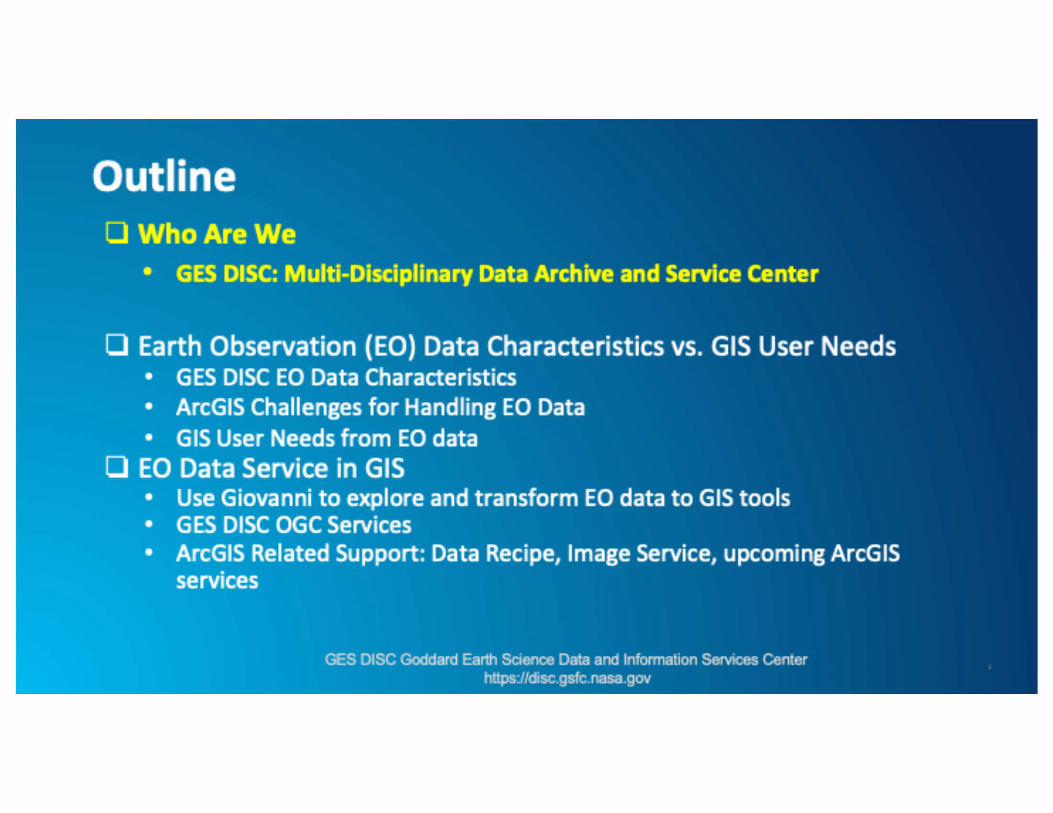
Outline 0 Who Are We
• GES DISC: Multi-Disciplinary Data Archive and Service Center
D Earth Observation (EO) Data Characteristics vs. GIS User Needs • G ES DISC EO Data Characteristics • ArcGIS Challenges for Hand ling EO Data
• G IS User Needs from EO data
• EO Data Service in GIS • Use Giovanni to explore and transform EO data to GIS tools • G ES DISC OGC Services • ArcGIS Related Support: Data Recipe, Image Service, upcoming ArcG IS
services
GES DISC Goddard Earth Science Data and lnfonnation Services Center httpsJ/disc.gsfc.nasa.gov
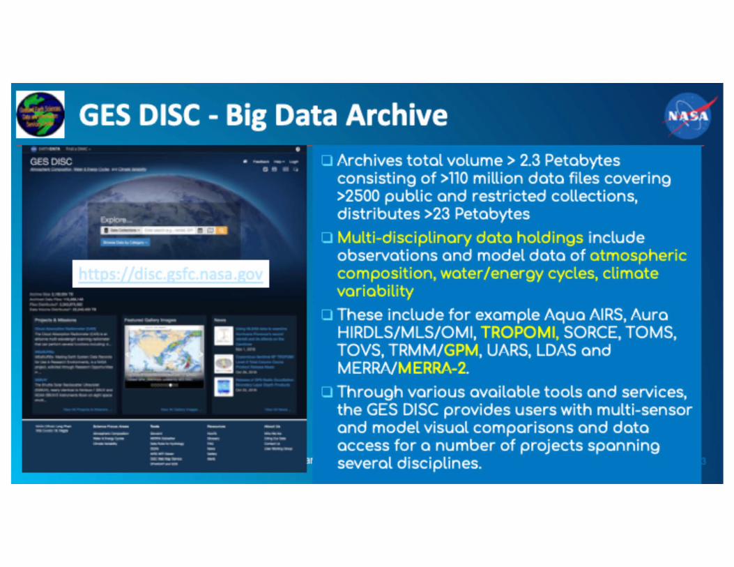
GES DISC - Big Data Archive
-- - ---· - ·-
O Archives total volume > 2.3 Petabytes consisting of > 110 million data files covering >2S00 public and restricted collections, distributes >23 Petabytes
o Multi-disciplinary data holdings include observations and model data of atmospheric composition, water /energy cycles, climate variability
o These include for example Aqua AIRS, Aura HIRDLS/MLS/OMI, TROPOMI, SORCE, TOMS, TOVS, TRMM/GPM, UARS, LDAS and M ERRNM ERRA-2.
o Through various available tools and services, the GES DISC provides users with multi-sensor and model visual comparisons and data access for a number of projects spanning several disciplines.
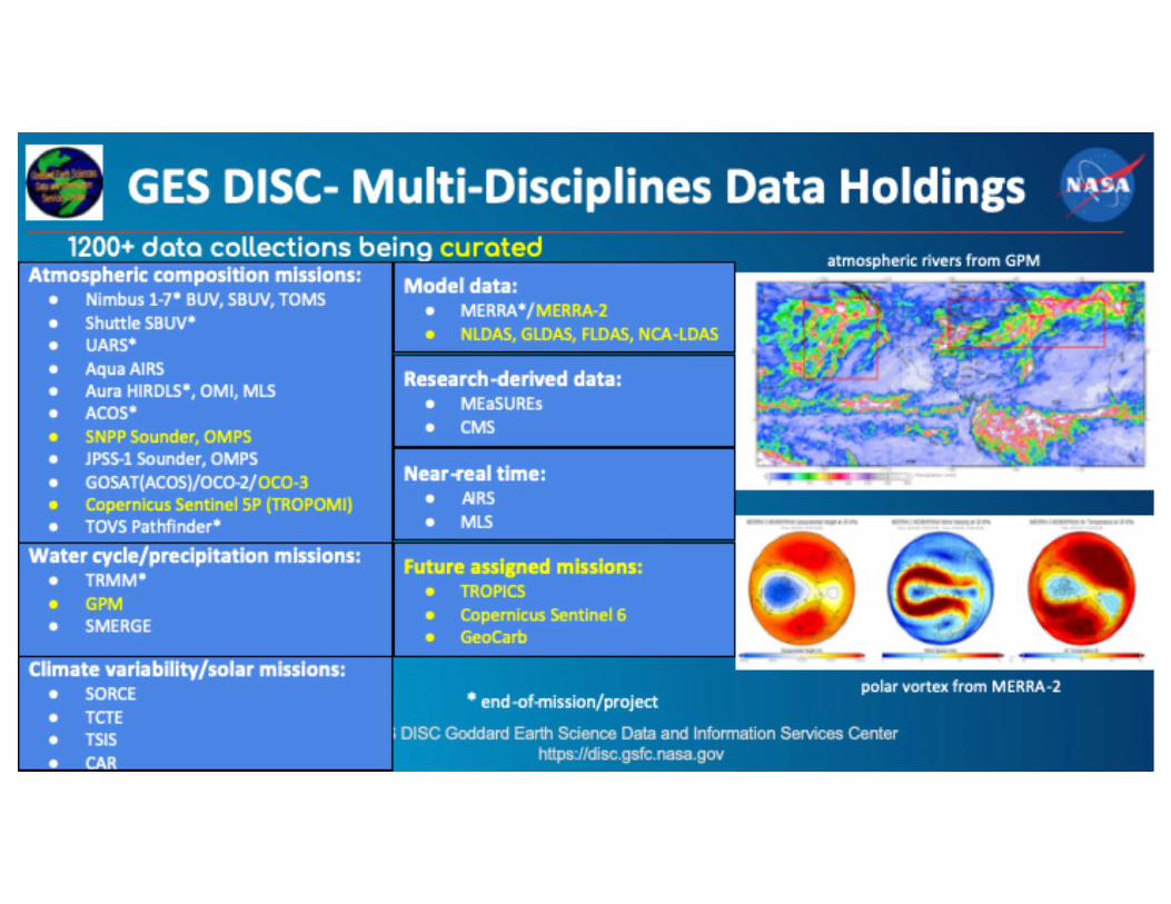
GES DISC- Multi-Disciplines Data Holdings 1200+ data collections being curated
Atmos,p-hetk 1comp-osition 1mlssions: ii\ilodel 1data: atmospheric rivers from GPM
• 1Nimbusl•7• 1BUJ~, .SBUV, 'TOMS • ;Shuttle,.sew• • IUARS* • A.qua .A:IRS' • Aura IHIRDLS•,, OMl, IMLS • Aces• 1• :SNPP SQunde~, QMP.S • .~PS~ l Sounder, 1OMPS • 1GOSAT(ACOS)/OC0~21oco~9 1• 1C0,pemicus :Sentinel SP 1(TROP.OMI,) • TOVS !Pathfinder•
1Watet ,cycleh>tecipitation rn'issions: • TRMM,• I. 1GP,M • SMERGE
1Cflmate 'varfa'bfllty/solar 1mlsslons: • ;SORCE • TCTE • TSIS
• ICAR
1• MERRA~/ MERRA~2 ,e NLDAS ·GlDAS IFlDAS NCA~UOAS - - - ., .. - - ., - - - ., - - · .. - - -
iResearch-dedved 1data: MEaSl!IREs CMS
IFutute 1asslped 1m'issions; ,. 'JROP.ICS
Copernicus Sentinel 6 GeoCarb
• end-offflission/ proje-ct polar vor tex from MERRA-2
I DISC Goddard Earth Science Data and Information Serw:es Center https://disc.gsfc.nasa.gov

Outline • Who Are We
• GES DISC: Mult i-Disciplinary Data Archive and Service Center
• Earth Observation (EO) Data Characteristics vs. GIS User Needs • GES DISC EO, Data Characteristics • ArcGIS Challenaes for Handlin1 EO Data • GIS User Needs from EO data
• EO Data Service in GIS • Use Giovanni to explore and transform EO data to GIS tools • G ES DISC OGC Services • ArcGIS Related Support: Data Recipe, Image Service, upcoming ArcG IS
services
GES DISC Goddard Earth Science Data and lnfonnation Services Center httpsJ/disc.gsfc.nasa.gov

GES DISC Earth Observation (EO) Data Characteristics: Multi-spatiotemporal Datasets • Instrument type: Remote sensing, in-situ, modeling • Measurement Resolutions:
• Spatially: o Global grids (raster) with spatial resolution up to 4-km o Higher resolution swath (feature points) data (e.g., 2.2-km)
• Temporally: o Half-hourly, 3-hourly, daily, monthly satellite measurements o Hourly, 3-hourly, daily and monthly modeled products o Monthly ground observation archives o Composite Climatology (yearly, monthly) o Near-real-time (NRT) products
GES DISC Goddard Earth Science Data and lnfonnation Services Center httpsJ/disc.gsfc.nasa.gov

ArcGIS Challenges for Handling EO Data
1. Complex Data Format HDF, HDF-EOS, netCDF
2. Non-ArcGIS ready format swath data
3. Need additional analytics for long data records
-
TMMII
0
4. Multitude of B applications 0 , 5. Cross--"1> disciplinary .,
~ applications

Can I plug in ArcGIS with your EO data?
Which spatial and temporal resolution should use?
'
model data or satellite data? Which
GES DISC Goddard Earth Science Data and Information Serw:es Center https://disc.gsfc.nasa.gov

Potential GIS Applications from GES DISC Data (Extreme Weather Events, Climatic Anomaly, Public Health ... etc)
• Precipitation (TRMM/GPM) • Hydrology {Land Data Assimilation System data (LDAS) with
numerous land parameters) • Modern Era Retrospective-Analysis for Research and Applications
data assimilation data {MERRA/2), with numerous land, ocean and atmospheric parameters
• Atmospheric Compositions o Volcano Eruption {S02: AIRS/OMI/TROPOMI/OMPS/MEaSURES) o Air Quality/Public Health (AOD/ AI/N02/PM:
TOMS/OMI/OMPS/MERRA-2/TROPOMl ... etc) GES DISC Goddard Earth Science Data and lnfonnation Services Center
httpsJ/disc.gsfc.nasa.gov

Outline D Who Are We
• GES DISC: Multi-Disciplinary Data Archive and Service Center D Earth Observation (EO) Data Characteristics vs. GIS User Needs
• G ES DISC EO Data Characteristics • ArcGIS Challenges for Hand ling EO Data • G IS User Needs from EO data
D EO Data Service for Gl1S • Use Giovanni to explore and transfonn EO data to GIS tools • GES DISC OGC Services • ArcGIS Related Support: Data Recipe, Image Service, upcoming ArcGIS
services
GES DISC Goddard Earth Science Data and lnfonnation Services Center httpsJ/disc.gsfc.nasa.gov
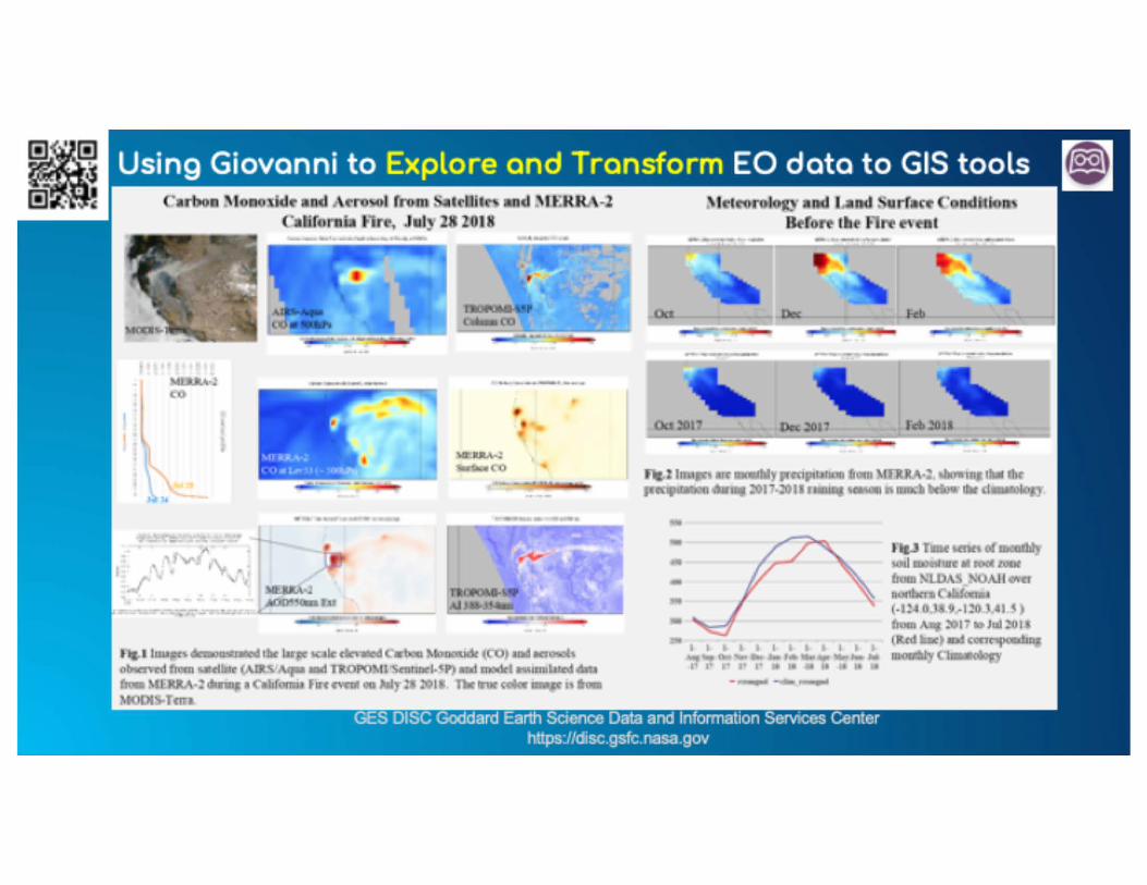

GES DISC OGC Services Transform EO data to be GIS interoperable using OGC services (WCS/WMS)
• NASA GES DISC AIRS NRT DatDVicwcr
• Contain GES DISC's AJRS NRT L 1/l.2 data
• NASA LaRC Power Data v1.11,..,_
• Contain GES DISC's MERRA-2 dzrtn
---~-
• NASA GS!ransbaundmy • NASA DI.! Prognim Wntcr Man-,_nt Data Rcsponsa Viewer
Explorer • Contain GES DISC's • Contain GES DISC's TRMM GPM, GPM_ OMI/TROPOMJ
GLOAS, FLDAS, NI.DAS datn
GES DISC Goddard Earth Science Data and Information Serw:es Center https://disc.gsfc.nasa.gov

GES DISC ArcGIS Data Recipe
................. -
- ----•-----
--
rds=arcGIS& a e=l
. .. -•·-
Step-byStep Instruction
,_..,3<1.:!t!H-'!L•--g --GES DISC Goddard Earth Science Data and Information Serw:es Center
https://disc.gsfc.nasa.gov
Click .. Feed back .. to tell us what you need!

Setting up ArcGIS Image Service for long term data record
• Long term data analysis through image service o GES DISC data usually contain long time data records, e.g., 40
years of hourly data o A single mosaic is not feasible for long time series o Hierarchical mosaics: daily, monthly, yearly, multi-year o Services can be set up at different hierarchical levels
• Top level service may be very slow to respond when first connected
GES DISC Goddard Earth Science Data and lnfonnation Services Center httpsJ/disc.gsfc.nasa.gov

TRMM/GPM Precipitation Missions
• GES DISC is the official TRMM/GPM data archive and distribution center • Complex mission datasets: 178 Products through data holdings
htt s: disc. fc.nasa. ov datasets? ro·ect=GPM)
GES DISC Goddard Earth Science Data and Information Serw:es Center https://disc.gsfc.nasa.gov

Image Services for Precipitation Data
.... .

11.11un.-
\ h
- f •
Use GPM Half-hourly
Precipitation Rate Data to Track
Cyclone ldai
.... '
I ' I • I• a
~----:~ .--

Upcoming GIS Data Support • Add data layers products based on users demand • Experiment ArcGIS Feature Service (for non-gridded swath data) • User community/theme/event portals
o Perform hotspot mapping to identify hots pots of extreme events
o Identify the Spatial and temporal shift
• Experiment ArcGIS Geoprocessing Service O Spatial auto correlation or clustering to identify climate regions and spatial
dependency
o Zonal statistics which can summarize data at specific administrative level
o Time series ana lysis and rate of change of tem perat -~
--- -·-- ------- ----· --·-··- - - - --- -· -
https://disc.gsfc.nasa.gov

Please help us to help youl
• Videos on Tu~~ subscribe ·NASAGESDISCD
• Twitter I! @NAS~GESDISC, @NAS~Giovanni
• How-To's
Download
• Feedback: Feedback
• IHelp Desk: [email protected]
GES DISC Goddard Earth Science Data and Information Serw:es Center https://disc.gsfc.nasa.gov


![[Arcgis] Riset ArcGIS JS & Flex](https://static.fdocuments.in/doc/165x107/55cf96d7550346d0338e2017/arcgis-riset-arcgis-js-flex.jpg)