Using Hazus Loss Estimations for Mitigation...
22
Using Hazus Loss Estimations for Mitigation Planning Jamie Caplan Jamie Caplan Consulting LLC Northeast Arc Users Group Smith College, May 17, 2011
-
Upload
nguyendang -
Category
Documents
-
view
219 -
download
0
Transcript of Using Hazus Loss Estimations for Mitigation...

Using Hazus Loss Estimations for Mitigation Planning Jamie Caplan Jamie Caplan Consulting LLC Northeast Arc Users Group Smith College, May 17, 2011

What is Hazus? � Hazus is a powerful risk assessment methodology for
analyzing potential losses from floods, hurricanes and earthquakes.
� In Hazus, current scientific and engineering knowledge is coupled with the latest geographic information systems (GIS) technology to produce estimates of hazard-related damage before, or after, a disaster occurs.
� Potential loss estimates analyzed in Hazus include: � Physical damage to residential and commercial buildings,
schools, critical facilities, and infrastructure; � Economic loss, including lost jobs, business interruptions, repair
and reconstruction costs; and � Social impacts, including estimates of shelter requirements,
displaced households, and population exposed to scenario floods, earthquakes, and hurricanes.
May 17, 2011 2

Supported Hazards
May 17, 2011 3
Supported Hazards
Hurricane Winds
Riverine and Coastal Floods
Earthquakes

Hazus 2.0 � CDMS Integrated. � Visual Basic for Applications (VBA) ArcGIS extension is no longer required. � User Defined or Essential Facilities now import the latitude / longitude with full
precision (no truncation). � Riverine Velocity has been added to the Flood module as a What-if in both
Hazard and Analysis. � Flood Shelter analysis has been optimized to run faster for large regions. � The 200-year Return Period has been removed and a 25-year Return Period
has been added to the Suite of Return Periods in the Flood module. � A Hazus Packaged Region (HPR) extract utility has been added that allows
users to extract specific tables and data from exported Hazus study regions. � The terrain roughness and tree coverage data sets have been updated in the
Hurricane module to use the latest available data from the Multi-Resolution Land-Use Consortium (MRLC) at both the census block and census tract levels.
� Updates to the historical storms data for the Northeast U.S. region have been made to the Hurricane module.
May 17, 2011 4

Hardware and Software Requirements � Computer Speed: 2.2 GHz dual core or higher � Memory: 2 GB or higher � Disk space:10GB for one multi-hazard large urban
study region, plus inventory data size varies by state, or 30 GB to store entire U.S. inventory data
� Graphics Adaptor: 24-bit capable video card with at least 128 MB of video memory, resolution of 1078 x 768 or higher
� Operating System: Windows XP SP3 or Windows 7 Professional/Enterprise, English*
� Supporting Software: Appropriate version of Esri ArcGIS and Spatial Analyst extension for flood model
May 17, 2011 5

How Does Hazus Estimate Losses?
May 17, 2011 6
How does HAZUS-MH estimate losses?
Earthquake HurricaneFlood
Understand theenvironment
Describe thehazard
Determine what is at risk
Analyze the impact
Describe theimpact

User Levels May 17, 2011 7
� Level 3
� �
�
� Level 1
Combinations of local and default hazard, building, and damage data
Default hazard, inventory, and damage
information
Input hazard specific
data Required User Effort and Sophistication

Hazus Allows Users To: � Identify vulnerable areas � Assess level of readiness and
preparedness � Estimate potential losses from specific
hazard events � Decide on how to allocate resources � Prioritize mitigation measures
May 17, 2011 8

Hazus Output
May 17, 2011 9
HAZUS-MH Output
Direct Damage
Induced Damage
Direct Losses
Indirect Losses
General Building StockEssential Facilities
High Potential Loss FacilitiesTransportation Systems
Utility Systems
Fire FollowingHazardous Materials Release
Debris Generation
Cost of RepairIncome Loss
Crop DamageCasualties
Shelter NeedsGeneric Output
EarthquakeGround ShakingGround Failure
FloodFrequency Depth
Discharge Velocity
Hurricane WindPressure | Missile | Rain
Supply ShortagesSales Decline
Opportunity CostsEconomic Loss

Hazus in Emergency Management and Mitigation Planning � Mitigation Assessment
� Identify “at-risk” communities
� Mitigation Measures � Strengthen existing structures
� Mitigation Programs � Adopt and enforce hazard-resistant
building codes � Land use planning
May 17, 2011 10

Hazus for Mitigation Planning Earthquake � Assess potential earthquake losses for
buildings both in their existing condition and after some amount of seismic rehabilitation.
� This might be used to advise a local jurisdiction regarding the merits of adopting an ordinance to require wall strengthening of older wood- frame residences.
May 17, 2011 11

Hazus for Mitigation Planning Flood
May 17, 2011 12
� Use the What-If Scenarios in the Flood Model to examine levee and flow regulation structures.
� Examine the impact to the damages and losses by creating scenarios where inventory is removed to simulate mitigation ‘buy out’ programs.
� Change the basement types and first floor elevations to simulate mitigation measures.
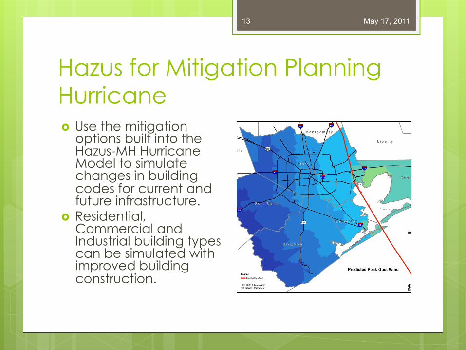
Hazus for Mitigation Planning Hurricane
May 17, 2011 13
� Use the mitigation options built into the Hazus-MH Hurricane Model to simulate changes in building codes for current and future infrastructure.
� Residential, Commercial and Industrial building types can be simulated with improved building construction.

Hazus for Response Planning Debris Management � Use Hazus-MH debris estimates to examine
current debris management strategies for a jurisdiction. Do plans need to be created or updated?
� Use Hazus-MH to examine the potential issues from sheltering, displaced households, and casualties
� Create mitigation actions centered around these issues as well as determine if the communities are properly prepared for these social impacts.
May 17, 2011 14
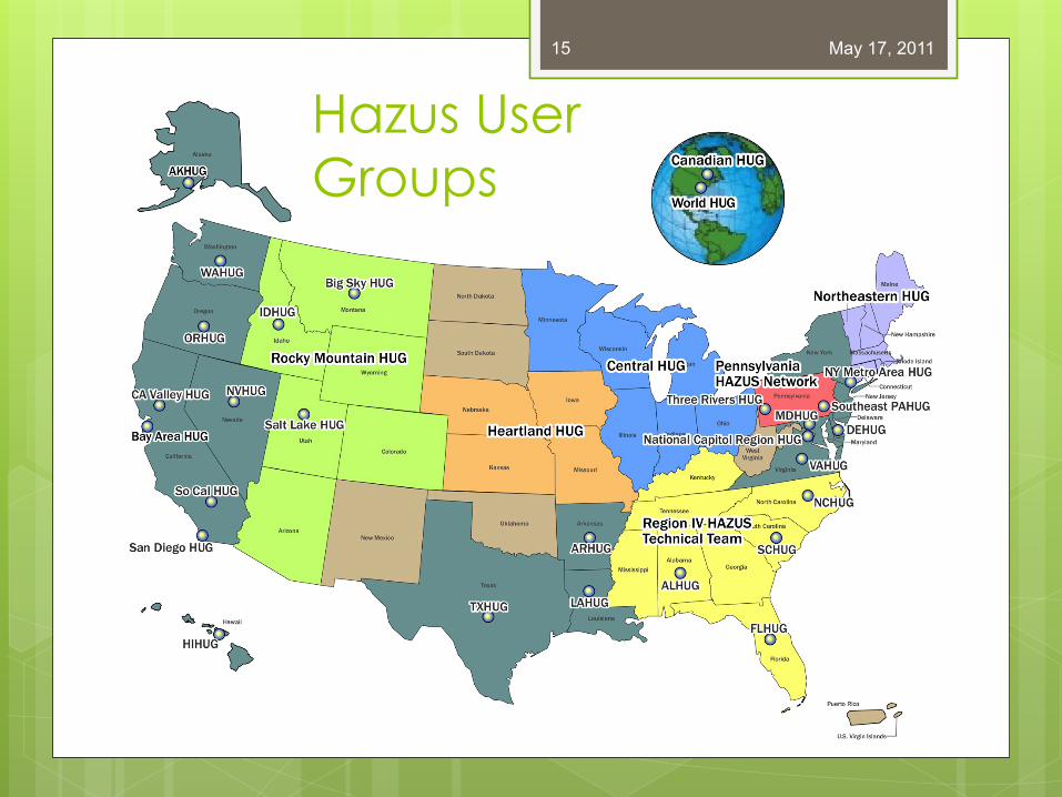
May 17, 2011 15
Hazus User Groups

Hazus User Group Opportunities
May 17, 2011 16
� Hazus Hot Zone � Hazus User of the
Year � Hazus Success
Stories � Hazus Technical
Compendium � Annual Hazus
Conference !!!"#$%&"'()*+,&-*+.$)$-/*#0%*.%1%&2-"30/%454678997:;<=4<=>4
!
!"#" $%& '()* +,--$.,/$01 0,(23$%& '-,,& )$334%5 $%& 6478*7717791%0 ":41%:1*-.$%;< #1,/54$ '-,,& =%>%&$04,% )$334%5 $%& 6478*7717791%0 ?/,@1:0
Background
Floods are the leading cause of natural-disaster losses in the United States. The U.S. Geological Survey (USGS) is actively involved in the development of flood inundation mapping across the nation. This work is pursuant to its major science strategy goal of reducing the vulnerability of the people and areas most at risk from natural hazards. Working with partners including the National Weather Service (NWS), U.S. Army Corps of Engineers (USACE), the Federal Emergency Management Agency (FEMA), state agencies, local agencies, and universities, the USGS is providing flood inundation mapping science resources to build more resilient communities.
Introducing RT-FIM Collaboration involving a powerful new tool, called real-time flood inundation mapping (RT-FIM) and the USGS was created to assist with the Survey Flood Inundation Mapping Science Project. This tool, developed for flood response and mitigation, provides digital geospatial flood-inundation maps that show flood water extent and depth on the land surface. Flood inundation maps that are tied to USGS, real-time stream gage data and NWS flood forecast sites enable officials to make timely operational and public safety decisions during floods, and to better plan for and mitigate the effects of future flood events. USGS pilot projects to evaluate this new technology are currently underway in nine different states.
FEMA and USGS Collaborate for Advanced Loss Estimation
FEMA and the USGS are developing a Web-based module that incorporates Hazus flood loss estimates to the RT-FIM site in Albany, Georgia. Albany was affected by a major flood due to Hurricane Alberto in July, 1994.
References Musser, Jonathan W., and Dyar, Thomas R., 2007, Two-dimensional flood-inundation model of the Flint River at Albany, Georgia: Atlanta, Georgia, U.S. Geological Survey Scientific Investigations Report 2007-5107, 49 p., Web-only publication at http://pubs.usgs.gov/sir/2007/5107 Online Resources
http://lcat.usgs.gov/albany/ http://lcat.usgs.gov/albany/
Albany_Intro_text.pdf http://pubs.usgs.gov/sir/200
7/5107 http://water.usgs.gov/osw/fl
ood_inundation/ Authors/Points of Contact
Paul Hearn, USGS Eastern Geographic Science Center; [email protected]
H.E. "Gene" Longenecker, III, FEMA Region IV MT-Risk Analysis Branch; [email protected]

Hazus Higher Education Resources Consortium � The Hazus HERC is a vibrant networking and
information sharing user group serving as the leading Hazus resource for participants in higher education and academia.
� Research: stimulate work in higher education � Service Learning: give students with Hazus
training a chance to work with state and local governments
� Education: expand Hazus education and curriculum
May 17, 2011 17

Hazus in New England � The Northeastern HUG is a forum for
Hazus-MH users in public, private, and academic organizations in New England to develop, collaborate, and coordinate on disaster-related GIS projects.
� NEHUG is a forum for Hazus users to offer technological, academic, and strategic assistance to each other in our collective efforts to build disaster-resistant communities in New England.
May 17, 2011 18
http://www.usehazus.com/nehug/

Technical Resources � FEMA Map Service Center (MSC) Web
Store at msc.fema.gov � Hazus Help Desk
� e-mail [email protected] � https://support.hazus.us � 24/7 technical assistance
May 17, 2011 19

Hazus Education
Training Options � FEMA’s Emergency
Management Institute (EMI)
� Virtual Courses www.esri.com/hazusmhtraining
� Regional Training � May be offered in
New England soon
Expert Certification � Hazus Trained
Professional � Foundation of basic skills
plus focused instruction for 1 hazard
� Hazus Practitioner � Further training with
specialized instruction in topic areas such as data management or ArcGIS for Emergency Managers.
May 17, 2011 20

Online Resources � FEMA
� www.fema.gov/plan/prevent/hazus
� USEHAZUS � www.usehazus.com � Follow USEHAZUS on FB and Twitter
� Podcasts on iTunes � Search for hazus
� GovDelivery
May 17, 2011 21

Thank you Jamie Caplan
413-586-0867 [email protected] www.jamiecaplan.com
www.usehazus.com
May 17, 2011 22