Using Google Earth for Historical Aerial Photo Analysis ... Overlaying Historical Aerials in Google...
37
These materials were developed by CalRecycle staff to address specific technical training areas and are posted f d tf th l l t d as reference documents for the local government and CalRecycle staff who work on closed, illegal and abandoned disposal sites. They are for reference only and not intended as regulatory guidance. If you require assistance in obtaining access to the presentations or have questions regarding the if ti ll th P bli Aff i Offi t( 6) information, call the Public Affairs Office at(916) 341‐ 6300 or Glenn Young at (916) 341‐6696.
Transcript of Using Google Earth for Historical Aerial Photo Analysis ... Overlaying Historical Aerials in Google...

These materials were developed by CalRecycle staff to address specific technical training areas and are posted f d t f th l l t d as reference documents for the local government and
CalRecycle staff who work on closed, illegal and abandoned disposal sites. They are for reference only p y yand not intended as regulatory guidance.
If you require assistance in obtaining access to the presentations or have questions regarding the i f ti ll th P bli Aff i Offi t ( 6) information, call the Public Affairs Office at (916) 341‐6300 or Glenn Young at (916) 341‐6696.
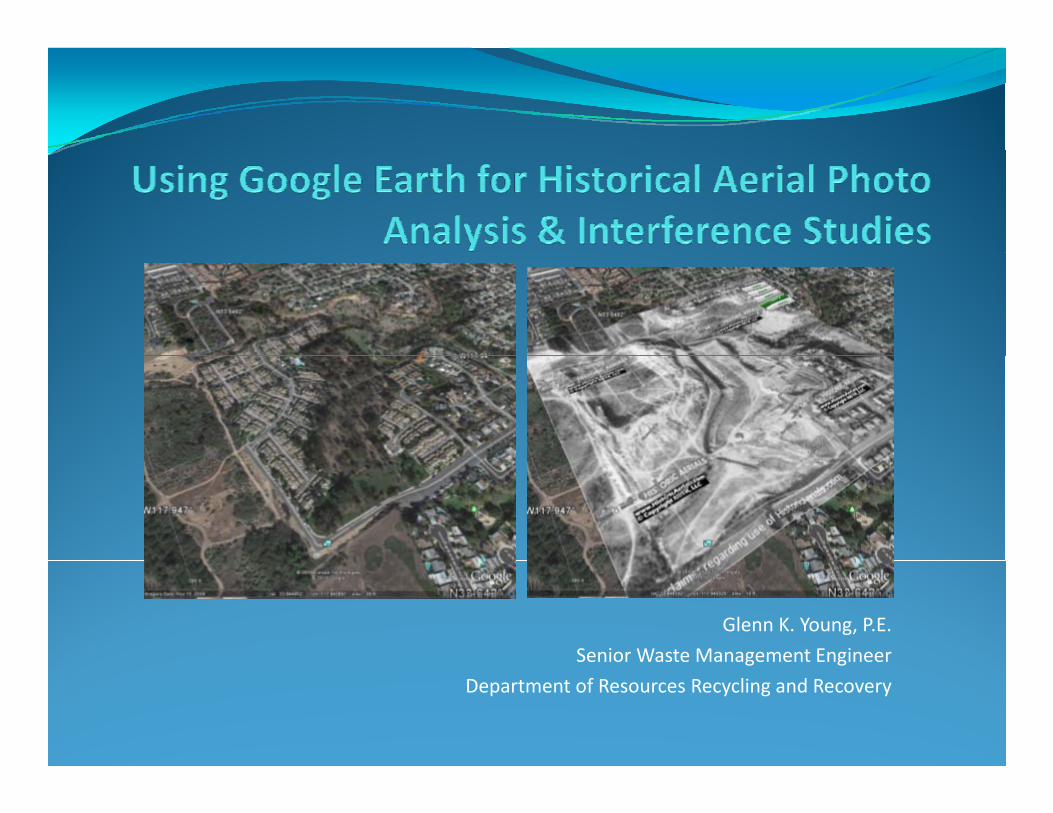
Glenn K. Young, P.E. Senior Waste Management Engineer g g
Department of Resources Recycling and Recovery

Overlaying Historical Aerials in Google Earth
Overview/IntroductionUsing Google Earth Overlay ToolImporting Historical Aerial PhotographScaling and Orienting Historical Aerial PhotographGoogle Earth Features to Analyze Historical AerialsCase Examples

Overview/Background
Overlaying Historical Aerials in Google Earth
Historical aerial photographs can be used to support landfill and disposal site investigations (particularly investigation of the areal or lateral extents of the site).Historical aerial photos provide “snapshot” in time of potential areal boundaries of former landfills and disposal sites.Using Google Earth and “Overlay Tool” can allow user to scale historic aerial photograph and locate or “geo‐reference” (reference to latitude and longitude) site features such as waste operations boundaries, pit boundaries, or former topographic features (excavations, ravines, canyons, etc.).For landfill investigations, historic aerials should be obtained for pre‐disposal conditions, during disposal operations period and post disposal periodoperations period and post‐disposal period.Many repositories of historical aerial photographs exist within federal and state government agencies such as USGS (mapping), Federal Highway Administration, Depart of Forestry, Department of Interior, US Army Corps of Engineers, California Department of Transportation, California Department of Water Resources, California UC Library System (Berkeley, Santa Barbara, Santa Cruz, etc.). Private collections are another y y ( y, , , )source for historical aerials.Online historic aerial photographs are also available, such as www.historicaerials.com.Most historic aerials taken for mapping purposes should be of adequate resolution and quality to use with Google Earth to compare past and present conditions of the site.Overlaying historical aerial photographs in Google Earth can allow user to determine the location of landfill boundaries with respect to current site features such as homes, buildings, roads, utilities, etc.

Overlaying Historical Aerials in Google EarthExample of Historic Aerial Photograph of Disposal Site Overlaid in Google Earth
1972 historical aerial photograph of former disposal site overlain on current Google Earth Aerial Image MapImage Map.
Opaqueness slide bar allows user to transition f t i tfrom current view to historical view to compare landfill horizontal areal boundary location and current structures, land‐uses, development, etc.

Overlaying Historical Aerials in Google EarthImporting Aerial Images Into Google Earth
Addi I O l
Into Google Earth
Click on Add > Image Overlay
Adding an Image Overlay

Overlaying Historical Aerials in Google EarthImporting Aerial Images Into Google Earth
Browse forHistorical Aerial
Into Google Earth
Photograph image file, e.g. JPEG, BMP file etc.

Overlaying Historical Aerials in Google EarthImporting Aerial Images Into Google Earth
Open HistoricalAerial PhotographFile in example:
Into Google Earth
File, in example:<Duarte Aerial 1976.bmp > fileFrom Drop Down Menu Folder

l l l l hOverlaying Historical Aerials in Google EarthScaling and Orienting Imported Aerial Images
Ensure that the historical aerial image file is oriented
Into Google Earth
aerial image file is oriented north prior to importing into Google Earth (which should already be in northoriented view), also currenti i G l E th h ldview in Google Earth shouldhave location and resolution similar to historical aerial photo location andresolution – this will reducesome of the effort in adjusting the scale and orientation of the imported historical aerialImage to match the Google Earth aerial map imageEarth aerial map image.

Overlaying Historical Aerials in Google EarthOverlaying Historical Aerials in Google EarthScaling and Orienting Imported Aerial Images Into Google Earth
Use green cross‐hair to move & reposition entire overlaid image.
g
Use green diamond to rotate historical aerial image.
Use green side indicatorUse green side indicator to increase or decrease the scale of the historical aerial image in N‐S or E‐W direction.
Use green corner indicator with shift key to proportionately increase or decrease theincrease or decrease the scale of the historical aerial image.

Overlaying Historical Aerials in Google EarthOverlaying Historical Aerials in Google EarthScaling and Orienting Imported Aerial Images
Use benchmarks such as homes and
Into Google Earth
streets to adjust historical aerial photo scale to thecurrent Google Earthaerial image view.aerial image view.
Use the zoom function to increaseresolution and checkalignment of streets,buildings, trees or other benchmarkscommon to historicalaerial image andaerial image and current aerial image.

Overlaying Historical Aerials in Google EarthOverlaying Historical Aerials in Google EarthScaling and Orienting Imported Aerial Images Into Google Earth
Use the zoom function to increase resolution and check alignment of streets, buildings trees or other
g
buildings, trees or other benchmarks common to historical aerial image and current aerial image.
The Google Earth aerialThe Google Earth aerial map image will show white lines representing streets and street names.
Using the opaqueness slide bar while adjusting the historical aerial image size will allow user to scale historical image to current image.

Overlaying Historical Aerials in Google EarthExample for moving imported image
To move (translational) imported historical aerial photo image, click on green cross‐hair and move to coinciding location in the current Google Earth aerial map view.e

l i i i l i l i l hOverlaying Historical Aerials in Google EarthExample for adjusting scale/size of imported image
To adjust the scale/size of image, relative to the current Google Earth Aerial Map view click on
image
Aerial Map view, click on the green corner indicator and press the shift key to proportionally increase or decrease the size of the imported historical aerial photograph.
f h d dIf the image is distorted, e.g. in north‐south or east‐west directions – use the green side indicator to increase or decrease the scale in the N‐S or E‐W orientation.

Overlaying Historical Aerials in Google EarthOverlaying Historical Aerials in Google EarthExample for rotating imported image
To rotate the imported historical aerial photograph image, click on the green diamondon the green diamond and rotate the image to match current Google Earth aerial image view orientation.

Overlaying Historical Aerials in Google EarthOverlaying Historical Aerials in Google EarthGoogle Earth features for analyzing landfill & disposal site boundaries
Measurement Tool;
Polygon Tool; measure bounded areas.
measure boundary distances.
Transparency – Opaqueness Slide Bar; compare historic &
Street Names and Road indication lines; reference
current boundary features.
indication lines; reference boundary locations.
Latitude & Longitude Grid Lines; locating position of b d i k Gboundaries, a.k.a Geo‐Referencing.

Overlaying Historical Aerials in Google EarthOverlaying Historical Aerials in Google EarthGoogle Earth features for analyzing landfill & disposal site boundaries
E‐mail Overlaid Image
Google Earth Aerial Photograph Map Imagery; shows relatively current land uses (residentialland‐uses (residential, commercial), streets, roads, railroads, waterways, structures, etc.
Elevation relative to sea level – show approximate elevation of landfill boundary locations.

Overlaying Historical Aerials in Google EarthGoogle Earth features for analyzing landfill & disposal site
Resolution (zoom) function, oblique angle views, and
boundaries
view orientation dial, allow user to perform “virtual” site walk around historical landfill and disposal site boundary to study currentboundary to study current location of structures, streets and other development with respect to landfill.

Overlaying Historical Aerials in Google Earth
Google Earth Historical Aerial Overlay Case Studies:Google Earth Historical Aerial Overlay Case Studies:• Newport Terrace Condominiums – Newport Beach• Hellyer‐Eastside Landfill – Santa Claray• 14th Avenue Landfill ‐ Sacramento• La Veta Disposal Station (344 Jennifer Lane) – Orange• Valley Brick Disposal Site – City of Los Angeles• City of Roseville Landfill – PG&E Substation

l i i i l i l i l hOverlaying Historical Aerials in Google Earth“Rubble Fill Area”; Condominiums constructed on 10 ft of engineered fill over 10‐15 feet of rubble fill. Case Study: Newport Terrace Condominiums
City of Newport Dump Main Disposal Area; Developed into Park Area

Overlaying Historical Aerials in Google EarthCase Study: Newport Terrace Condominiums
Oblique view of Newport Terrace Condominiums looking northwest; ImageOblique view of Newport Terrace Condominiums looking northwest; Image can be rotated and oblique angle increased and decreased; zoom‐in and out allow viewing of specific boundary/development details.

Overlaying Historical Aerials in Google EarthCase Study: Newport Terrace Condominiums
By using opaqueness or transparency function, and view orientations, the boundaries of former disposal sites can be studied in relation to current development.

Overlaying Historical Aerials in Google EarthLandfill Area; Area of Excavation & Land DisturbanceCase Study: Hellyer‐Eastside Landfill
Note excavation and mining operation locations; g p ;Velodrome constructed on portion of former mining area and landfill.

Overlaying Historical Aerials in Google EarthOverlaying Historical Aerials in Google EarthCase Study: Hellyer‐Eastside Landfill
Oblique view of Hellyer‐Eastside Landfill looking northwest; di b d d l dNote disturbed areas compared to current land use.

Overlaying Historical Aerials in Google EarthCase Study: 14th Avenue Landfill
Former Gravel Mining Pit and Landfill; Commercial Building Developments.

Overlaying Historical Aerials in Google EarthCase Study: 14th Avenue Landfill
hOblique view of 14th Avenue Landfill looking northeast; Note excavation pit boundaries with respect to commercial development.

Overlaying Historical Aerials in Google EarthCase Study: 14th Avenue Landfill
By observing oblique and enhanced view (looking NW) with transparency function of 14th Avenue East Pit three14 Avenue East Pit, three buildings are seen constructed over the former pit area (that was filled with solid waste); the large building (on the right) was constructed on pilings. A worker was killed by asphyxiation from methane gas (landfill gas) during piling construction.
Parking lot adjacent to commercial warehouse located over waste fill; note settlement and ponding.

Overlaying Historical Aerials in Google EarthCase Study: Noah Webster Elementary School/Burn Site
Former burn dump in the City of San Diego was located in a ravine area that was later reconfigured (consolidated and covered) and an elementary school constructed on the site.

Overlaying Historical Aerials in Google EarthOverlaying Historical Aerials in Google EarthResidences and Streets (Brookline Avenue) at site used as scaling referenceCase Study: Noah Webster
A topographic drawing provided by the school district, depicting the “cut‐and‐cover” sequence of the disposal site and native fill was overlaid and scaled in Google Earth and compared to the historic aerial photograph; the
Note Southern Ravine Boundary Feature
and native fill was overlaid and scaled in Google Earth and compared to the historic aerial photograph; the reconfigured boundaries of the waste approximated the ravine shown in the historic aerial. The investigation work plan incorporated this information into the sample location map to verify the extents of the reconfigured waste areas.

Overlaying Historical Aerials in Google EarthCase Study: La Veta Disposal Station, Orange County, CA
Former aggregate mining operation excavated banks of Santiago Creek; Later used for disposal at La Veta Disposal Station. Site was developed into residential in the 1970s. The residence at 344 Jennifer Lane was discovered to be over a portion of the former disposal site. The use of the Google Earth Overlay Tool assisted in locating the portion of the disposal site under the 344 Jennifer Lane residence.

Overlaying Historical Aerials in Google EarthCase Study: La Veta Disposal Station
By using opaqueness or transparency function the boundary of historical features can be compared to current land‐uses; in this picture the boundaryuses; in this picture, the boundary of the excavation can be compared to the location of 344 Jennifer Lane.
Oblique view looking southwest along Santiago Creek; Note edge of excavation and location of street and residences (344 Jennifer Lane first house on right ).

l i i i l i l i l hOverlaying Historical Aerials in Google Earth344 Jennifer Lane
During landfill gas well construction, landfilled material
Note alignment of wall
During landfill gas well construction, landfilled material was encountered down to 30 feet below ground surface adjacent to 344 Jennifer Lane residence.
A damaged cinder block fence was observed to be adjacent to the gas well being constructed
N ki dNote cracking and separation of wall

l i i i l i l i l hOverlaying Historical Aerials in Google EarthCase Study: Valley Brick Disposal Site, City of Los Angeles
Note structures common to historic and current conditions to scale historical aerial
Note pit excavation boundaries and current building structures

l i i i l i l i l hOverlaying Historical Aerials in Google EarthCase Study: Valley Brick Disposal Site, City of Los Angeles

l i i i l i l i l hOverlaying Historical Aerials in Google EarthCase Study: Valley Brick Disposal Site, City of Los Angeles
By using opaqueness or transparency function the boundary of historical features
, y g
ycan be compared to current land‐uses; in this picture, the boundary of the excavation can be compared to a building constructed over the disposal fill
Note pit excavation boundaries and current building structures.
constructed over the disposal fill area.

l i i i l i l i l hOverlaying Historical Aerials in Google EarthCase Study: Former City of Roseville Landfill, PG&E Atlantic Street Substation
Former City of Roseville landfill operations identified in historical aerial photograph (right); proposed trenching plan to delineate and sample fill with respect to Harding Boulevard (runs through the site) and commercial development to the north.

Overlaying Historical Aerials in Google Earth
Obtaining Historical Aerial PhotographsHistoric Aerials Online Website with Map Browser:
See: http://www.historicaerials.com/?poi=7958University of California Library System:
UC BerkeleyUC Santa CruzUC Santa BarbaraUC Santa Barbara
CalRecycle CIA Office Investigations – Historic Aerials:http://www calrecycle ca gov/SWFacilities/CIA/Office/Aeriahttp://www.calrecycle.ca.gov/SWFacilities/CIA/Office/AerialPhotos/