Using Geodesign for Land Planning: Examples from a...
32
Using Geodesign for Land Planning: Examples from a Landscape Architecture Studio NC GIS Conference 2015 | February 26, 2015 Author/Presenter: Alfie Vick | Co-Author: Alison Smith University of Georgia | College of Environment & Design
-
Upload
phungduong -
Category
Documents
-
view
225 -
download
0
Transcript of Using Geodesign for Land Planning: Examples from a...

U s i n g G e o d e s i g n f o r L a n d P l a n n i n g : E x a m p l e s f r o m
a L a n d s c a p e A r c h i t e c t u r e S t u d i o
N C G I S C o n f e r e n c e 2 0 1 5 | F e b r u a r y 2 6 , 2 0 1 5
A u t h o r / P r e s e n t e r : A l f i e V i c k | C o - A u t h o r : A l i s o n S m i t h
U n i v e r s i t y o f G e o r g i a | C o l l e g e o f E n v i r o n m e n t & D e s i g n

Geodesign is a method which tightly couples the creation of proposals for change with impact
simulations informed by geographic contexts and systems thinking, and normally supported by
digital technology.
—Michael Flaxman and Stephen Ervin, 2010
W h a t i s G e o d e s i g n ?
PEOPLE OF THE
PLACE
GEOGRAPHIC
SCIENCES
INFORMATION
TECHNOLOGIES
DESIGN
PROFESSIONS
Adapted from Steinitz, 2012

E S R I G e o d e s i g n S u m m i t

U n i v e r s i t y o f G e o r g i a
L A N D 6 0 3 0 | F a l l 2 0 1 3
N a t u r e a n d S u s t a i n a b i l i t y S t u d i o
M a s t e r i n L a n d s c a p e A r c h i t e c t u r e ( M L A ) P r o g r a m
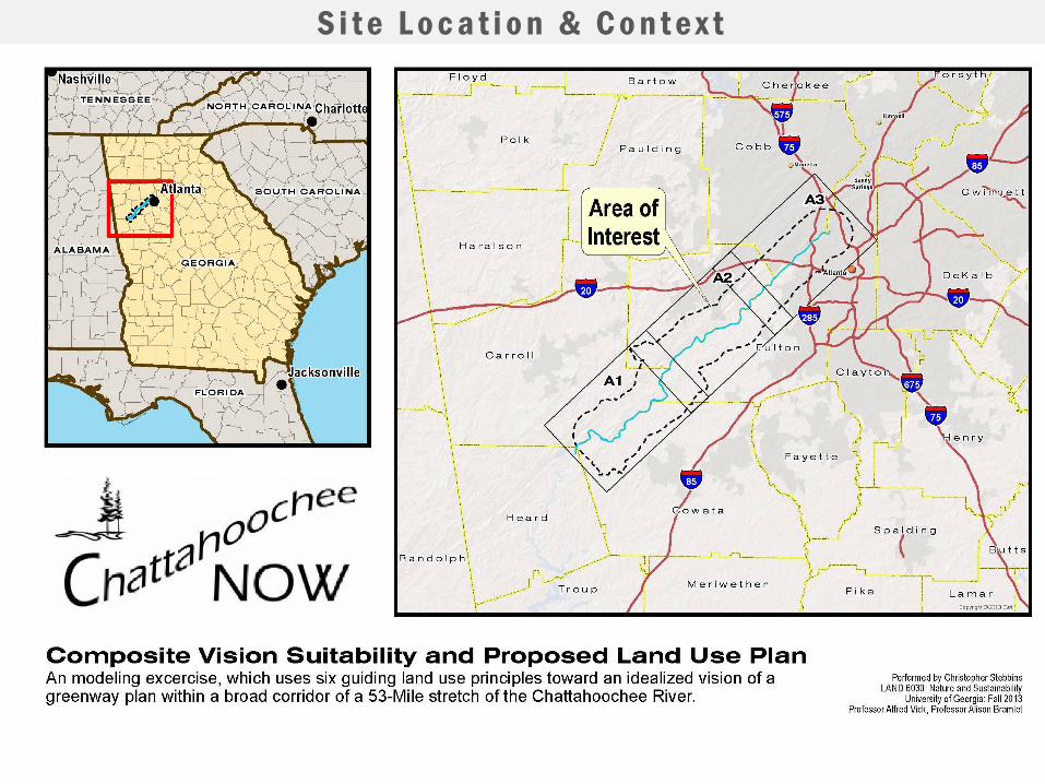
S i t e L o c a t i o n & C o n t e x t

W h o ’ s I n v o l v e d
Studio/Design Team
• Studio Instructors
• Alfie Vick, Associate Professor
• Alison Smith Bramlet, Assistant Professor
• 36 MLA II Students
• Undergraduate studies include:
• Architecture, Landscape Architecture, Engineering, Sustainable Development,
GIS, Anthropology, Horticulture, Others…
• 50% international students
• Chattahoochee NOW
• EPA, Region 4
• National Park Service
• US ACOE
• Trust for Public Land
• Chattahoochee Riverkeeper
• Environment Georgia
• River Walk Atlanta
• The Conservation Fund
• The PATH Foundation
• Jamestown Properties
• Carroll County
• Cobb County
• Coweta County
• Douglas County
• Fulton County
• City of Atlanta
• City of Chattahoochee Hillls
• City of Douglasville
• City of Smyrna
• Atlanta Beltline, Inc.
• Atlanta Regional
Commission
• And many more…
Client/Stakeholders

P r o j e c t P u r p o s e & O b j e c t i v e
To generate a land use plan for the Chattahoochee NOW study area that
seeks to create a sustainable site – one that balances conservation,
recreation and development.
• Meet the vision and goals of Chattahoochee NOW
• Be informed by previous studies and suitability analysis
• Acknowledge and enhance the existing resources and
stakeholders that will interact with the site.
• Meet the learning objectives of the LAND 6030 course, as
described in the syllabus.
Chattahoochee National Recreation Area. Image provided by EPA.
Team work
Individual
I. Inventory
Project Research
Case Study Investigation
Data Collection
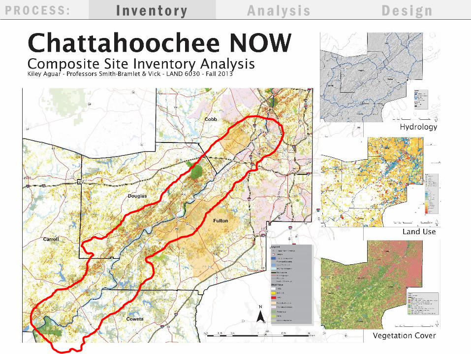
Finalize Site Inventory
Composite Site Inventory
Define Project Study Area
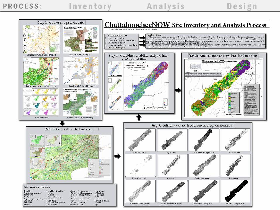
P R O C E S S : I n v e n t o r y A n a l y s i s D e s i g n+ +
II. Analysis
Define Program Elements
Research suitability criteria
Suitability Analysis Maps
for each Program Element
Stakeholder Feedback
III. Design
Develop Guiding
Principles
Create Composite
Suitability Analysis
Develop Concept
Plans
Develop Proposed
Land Use Plan
Present Design to
Client / Stakeholder
Feedback
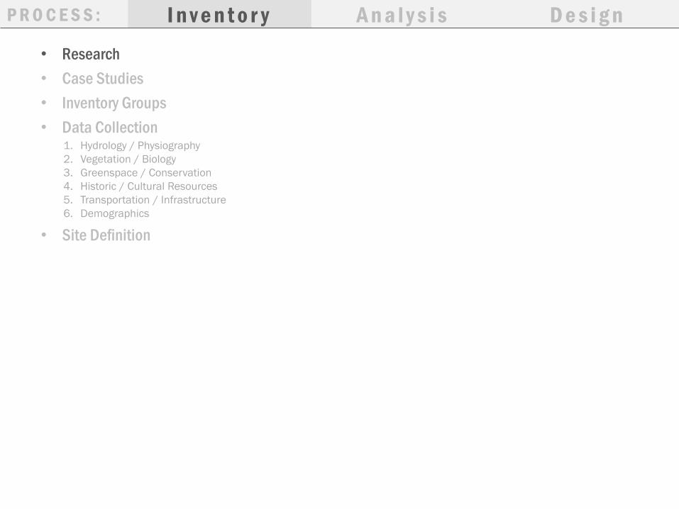
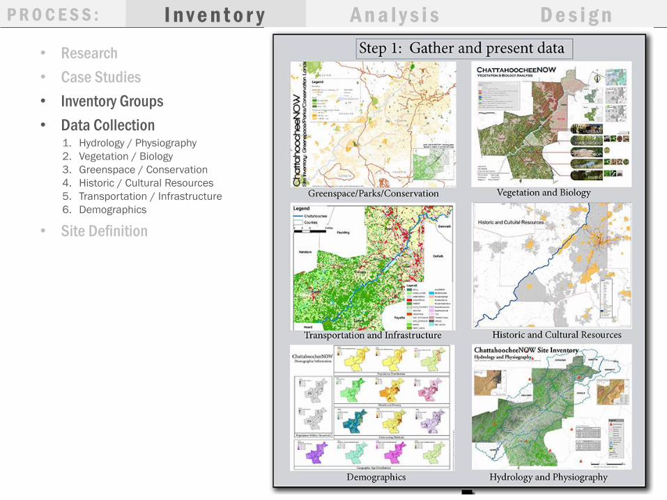
• Research
• Case Studies
• Inventory Groups
• Data Collection
I n v e n t o r y A n a l y s i s D e s i g nP R O C E S S :
1. Hydrology / Physiography
2. Vegetation / Biology
3. Greenspace / Conservation
4. Historic / Cultural Resources
5. Transportation / Infrastructure
6. Demographics
• Site Definition
I n v e n t o r y A n a l y s i s D e s i g nP R O C E S S :

P R O C E S S : I n v e n t o r y A n a l y s i s D e s i g n
• Discussion with Client & Studio to identify site Program Elements
• Research suitability criteria rankings; rank each criteria high, medium or
low
• Create suitability maps for each program element
Program Elements
• Active Recreation
• Agriculture
• Commercial Development
• Conservation
• Cultural Resource Interpretation
• Ecological Restoration
• Industrial Development
• Multi-Use Trail Development
• Passive Recreation
• Residential Development
• Riverfront Development
• Transportation Enhancements
1. Active Recreation 2. Agriculture 3. Commercial Development 4. Conservation
P R O C E S S : I n v e n t o r y A n a l y s i s D e s i g n
5. Cultural Resource
Interpretation
6. Ecological Restoration 7. Industrial Development 8. Multi-Use Trail Development
9. Passive Recreation 10.Residential Development 11.Riverfront Development 12.Transportation Enhancements

P R O C E S S : I n v e n t o r y A n a l y s i s D e s i g n
S t a k e h o l d e r F e e d b a c k
P R O C E S S : I n v e n t o r y A n a l y s i s D e s i g n
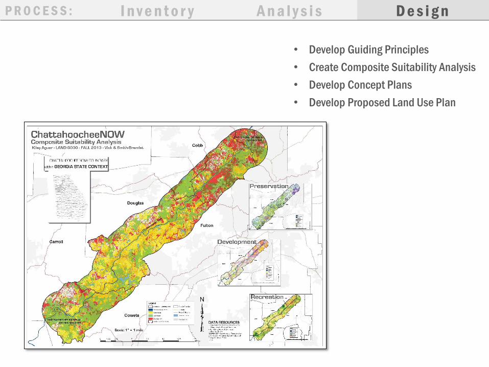
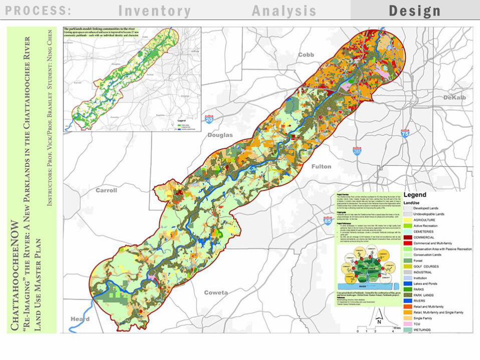
• Develop Guiding Principles
• Create Composite Suitability Analysis
• Develop Concept Plans
• Develop Proposed Land Use Plan

P R O C E S S : I n v e n t o r y A n a l y s i s D e s i g n

P R O C E S S : I n v e n t o r y A n a l y s i s D e s i g n
P R O C E S S : I n v e n t o r y A n a l y s i s D e s i g n

P R O C E S S : I n v e n t o r y
S t a k e h o l d e r F e e d b a c k
A n a l y s i s D e s i g n
36 Individual Student Designs
(Alternative Scenarios)
• Conservation
• Development
• Recreation
• Balanced Approach
P R O C E S S : I n v e n t o r y A n a l y s i s D e s i g n
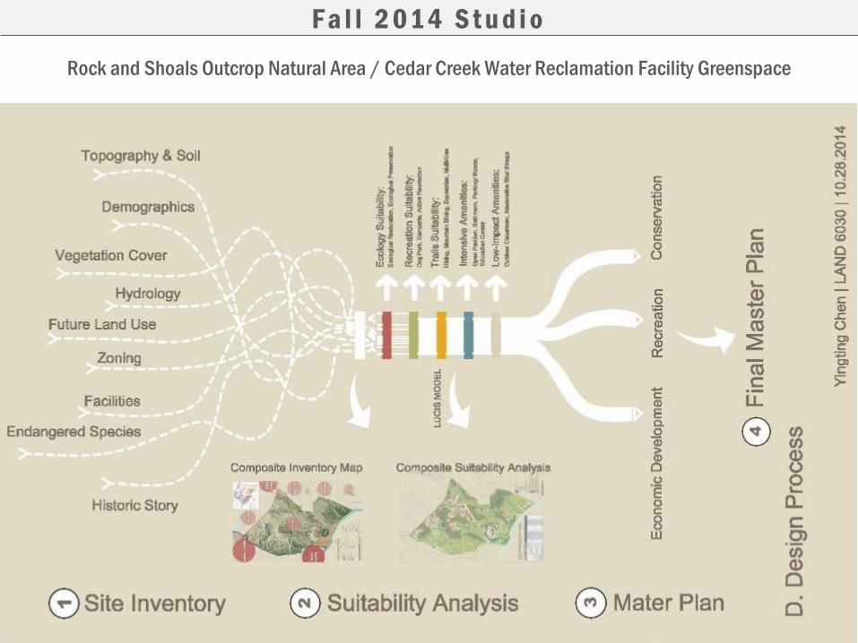
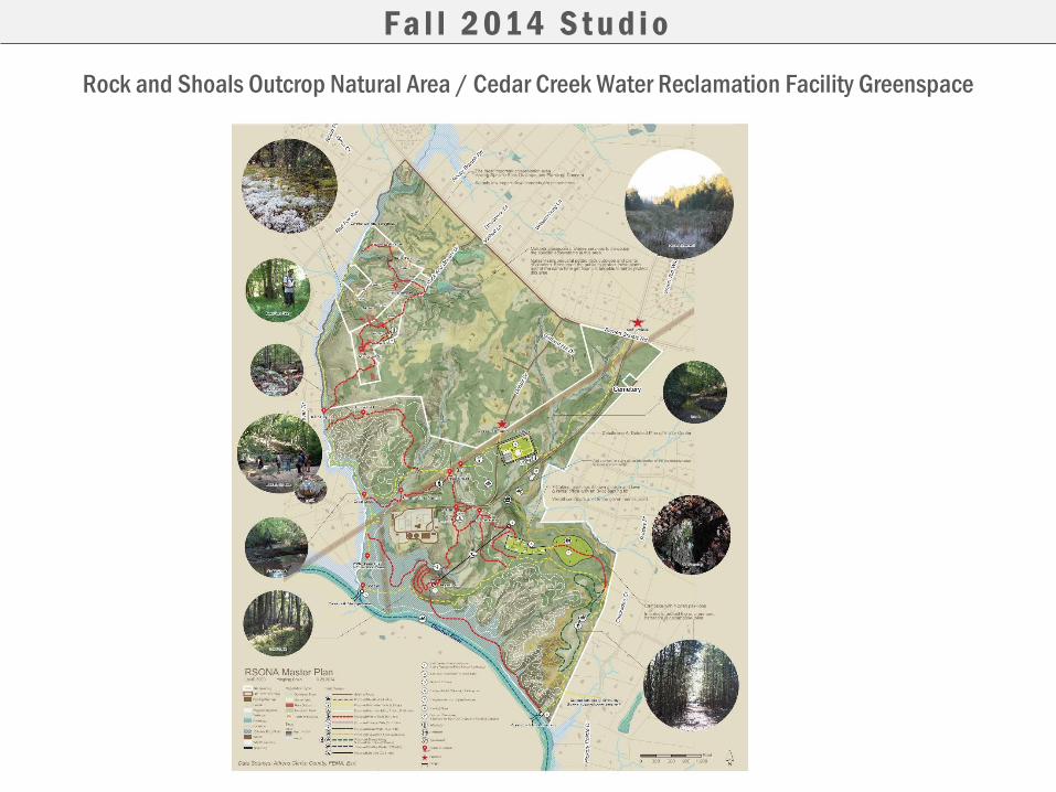
Rock and Shoals Outcrop Natural Area / Cedar Creek Water Reclamation Facility Greenspace
F a l l 2 01 4 S t u d i o

Rock and Shoals Outcrop Natural Area / Cedar Creek Water Reclamation Facility Greenspace
F a l l 2 01 4 S t u d i o

Rock and Shoals Outcrop Natural Area / Cedar Creek Water Reclamation Facility Greenspace
F a l l 2 01 4 S t u d i o

Rock and Shoals Outcrop Natural Area / Cedar Creek Water Reclamation Facility Greenspace
F a l l 2 01 4 S t u d i o
Rock and Shoals Outcrop Natural Area / Cedar Creek Water Reclamation Facility Greenspace
F a l l 2 01 4 S t u d i o

Rock and Shoals Outcrop Natural Area / Cedar Creek Water Reclamation Facility Greenspace
F a l l 2 01 4 S t u d i o
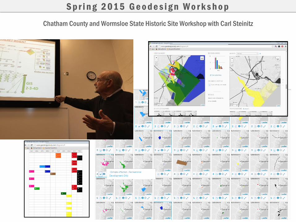
Chatham County and Wormsloe State Historic Site Workshop with Carl Steinitz
S p r i n g 2 01 5 G e o d e s i g n W o r k s h o p

Using ESRI Geoplanner App
F a l l 2 01 6 S t u d i o
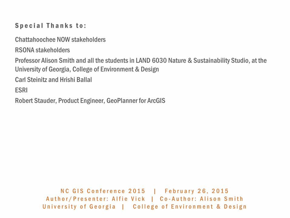
S p e c i a l T h a n k s t o :
Chattahoochee NOW stakeholders
RSONA stakeholders
Professor Alison Smith and all the students in LAND 6030 Nature & Sustainability Studio, at the
University of Georgia, College of Environment & Design
Carl Steinitz and Hrishi Ballal
ESRI
Robert Stauder, Product Engineer, GeoPlanner for ArcGIS
N C G I S C o n f e r e n c e 2 0 1 5 | F e b r u a r y 2 6 , 2 0 1 5
A u t h o r / P r e s e n t e r : A l f i e V i c k | C o - A u t h o r : A l i s o n S m i t h
U n i v e r s i t y o f G e o r g i a | C o l l e g e o f E n v i r o n m e n t & D e s i g n