Using and Understanding OPUS€¦ · Y: -3802821.159(m) 0.007(m) -3802819.941(m) 0.007(m) Z:...
64
Using and Understanding OPUS New York State Association of Professional Land Surveyors Saratoga Springs, NY January 09, 2013 Dan Martin NGS Vermont State Geodetic Advisor [email protected] 802-828-2952 www.aot.state.vt.us/geodetic/Advisor/advisorpresent.htm
Transcript of Using and Understanding OPUS€¦ · Y: -3802821.159(m) 0.007(m) -3802819.941(m) 0.007(m) Z:...

Using and Understanding OPUS
New York State Association of Professional Land Surveyors Saratoga Springs, NY
January 09, 2013
Dan Martin NGS Vermont State Geodetic Advisor
[email protected] 802-828-2952
www.aot.state.vt.us/geodetic/Advisor/advisorpresent.htm
• OPUS, the On-line Positioning User Service, is a growing set of applications offering web-based access to the tools and resources provided by the NGS.
• Currently, OPUS is composed of – OPUS-S………….static processing – OPUS-RS…………rapid-static processing – Publishing…………database of solutions
What is OPUS?
Reviewing each of these individually… 2

What is OPUS?
• On-line Positioning User Service – Submit dual frequency (GPS) Data – 15 min - 2 hours data OPUS_RS (Rapid Static) – 2 hours - 48 hours data OPUS_S (Static) – Processed by NGS computers relative to CORS – Results received in minutes via e-mail – Provides consistent access to NSRS
3

The OPUS-S Interface
Beautiful in its simplicity, the user need only provide:
• Their email address. • The antenna type. • The offset to the antenna reference point
(ARP). • 2- to 48-hours of GPS L1 + L2 data.
In turn, the user receives:
• Coordinates accurate to a few centimeters.
4
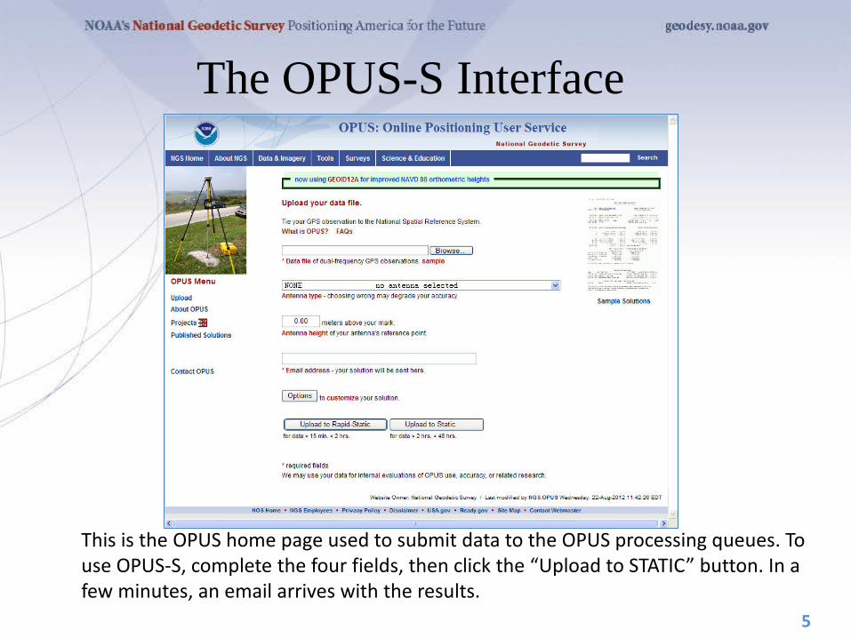
The OPUS-S Interface
5
This is the OPUS home page used to submit data to the OPUS processing queues. To use OPUS-S, complete the four fields, then click the “Upload to STATIC” button. In a few minutes, an email arrives with the results.
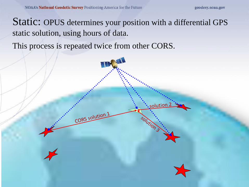
Static: OPUS determines your position with a differential GPS static solution, using hours of data. This process is repeated twice from other CORS.

How Does OPUS-S Work? The primary steps of OPUS-S processing are: 1. Prepare and quality control the submitted data. 2. Estimate a crude point-position using TEQC. 3. Compute distances to every available CORS. 4. Select the three “best” CORS based upon:
• Being closest to the user’s site. • Having common satellite visibility with the user data. • Having more than 80% of the possible data available. • Having low multipath measures.
5. Complete the single-baseline processing using PAGES. 6. Check the solution quality and replace a CORS if needed. 7. Generate and email the report to the user.
7
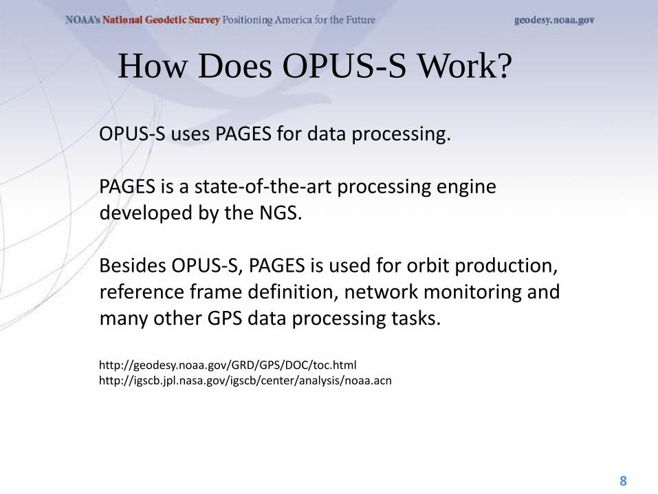
How Does OPUS-S Work?
OPUS-S uses PAGES for data processing. PAGES is a state-of-the-art processing engine developed by the NGS. Besides OPUS-S, PAGES is used for orbit production, reference frame definition, network monitoring and many other GPS data processing tasks. http://geodesy.noaa.gov/GRD/GPS/DOC/toc.html http://igscb.jpl.nasa.gov/igscb/center/analysis/noaa.acn
8
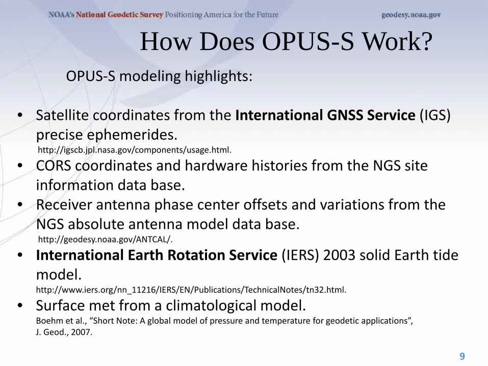
How Does OPUS-S Work? OPUS-S modeling highlights: • Satellite coordinates from the International GNSS Service (IGS)
precise ephemerides. http://igscb.jpl.nasa.gov/components/usage.html.
• CORS coordinates and hardware histories from the NGS site information data base.
• Receiver antenna phase center offsets and variations from the NGS absolute antenna model data base. http://geodesy.noaa.gov/ANTCAL/.
• International Earth Rotation Service (IERS) 2003 solid Earth tide model. http://www.iers.org/nn_11216/IERS/EN/Publications/TechnicalNotes/tn32.html.
• Surface met from a climatological model. Boehm et al., “Short Note: A global model of pressure and temperature for geodetic applications”, J. Geod., 2007.
9

How Does OPUS-S Work? OPUS-S processing highlights: • Everything is “done” in the IGS08 Reference Frame. • SV coordinates are held rigidly fixed. • CORS coordinates are heavily constrained. • Neutral atmosphere (tropo) dry component modeled. • Neutral atmosphere (tropo) wet component estimated. • Double-differenced, ion-free carrier phase observable. • Carrier phase ambiguities are fixed to their integer values where
possible; float ambiguities are estimated otherwise. • Individual baselines are processed and the results combined
generating mean coordinates and peak-to-peak uncertainties.
10
How Does OPUS-S Work?
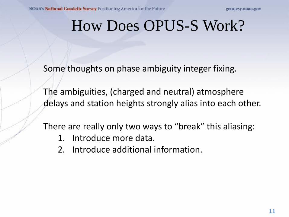
Some thoughts on phase ambiguity integer fixing. The ambiguities, (charged and neutral) atmosphere delays and station heights strongly alias into each other. There are really only two ways to “break” this aliasing:
1. Introduce more data. 2. Introduce additional information.
11

How Does OPUS-S Work? OPUS-S uses the former strategy. Depending upon the circumstances, 1- to 2-hours of observations are sufficient to decorrelate the ambiguities, atmosphere and heights allowing reliable estimation of all. Thus the requirement for a minimum of 2-hours in OPUS-S. As an aside, be aware that while simply having more data helps, it is actually the change in orientation of the satellites over the data span that forces the decorrelation.
12

GPS file
antenna
antenna height
OPTIONS
in/exclude CORS
extended solution
SPC zone geoid model – transition
project profile
publish
OPUS-RS or OPUS-Static (15 min-2 hr) (2-48 hr)
Antenna Type, height – easy, right?
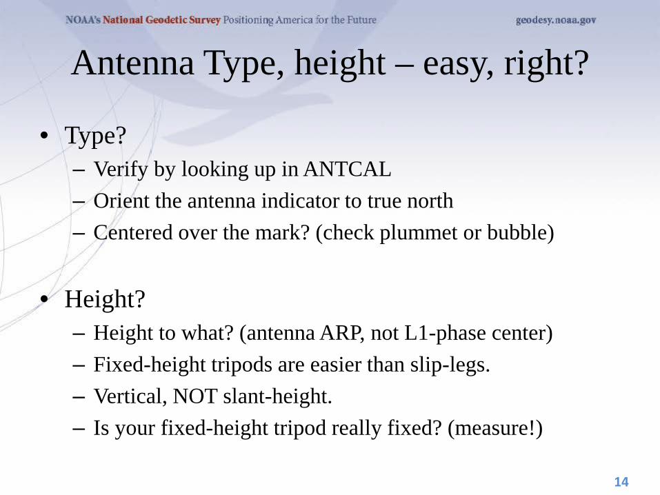
• Type? – Verify by looking up in ANTCAL – Orient the antenna indicator to true north – Centered over the mark? (check plummet or bubble)
• Height?
– Height to what? (antenna ARP, not L1-phase center) – Fixed-height tripods are easier than slip-legs. – Vertical, NOT slant-height. – Is your fixed-height tripod really fixed? (measure!)
14

HOW IS THE ANTENNA HEIGHT MEASURED?
ARP
MARK
The height is measured vertically (NOT the slant height) from the mark to the ARP of the antenna. The height is measured in meters. The ARP is almost always the center of the bottom-most, permanently attached, surface of the antenna. See GPS Antenna Calibration for photo’s and diagrams that show where the ARP is on most antennas:
http://geodesy.noaa.gov/ANTCAL/ If the default height of 0.0000 is entered, OPUS will return the position of the ARP.
15

WHY DO I NEED THE ANTENNA TYPE? The antenna phase centers are
located somewhere around here.
The Antenna Reference Point (ARP) is almost always located in the
center of the bottom surface of the antenna.
The antenna offsets are the distance between the phase centers and
the ARP
You do not need to know these offsets. They are
passed to the processing software through the
antenna type
Incorrect or missing antenna type → big vertical errors
ARP
phase ctr.
16

What else can go wrong?
• Site – instability, multi-path – mark ID (search database, check stamping)
• Weather – wild, local troposphere issues? – space weather: ionospheric issues?
• “Truth” (orbits, CORS, etc.) – Rapid (next-day) orbits required for publishing
17

How Good Can I Do With OPUS-S? OPUS-S reliably addresses the more historically conventional requirements for GPS data processing. It typically yields accuracies of:
1 – 2 cm horizontally 2 – 4 cm vertically
However, there is no guarantee that this stated accuracy will result from any given data set. Confirming the quality of the OPUS solution remains the user’s responsibility. That’s the “price” for automated processing.
18
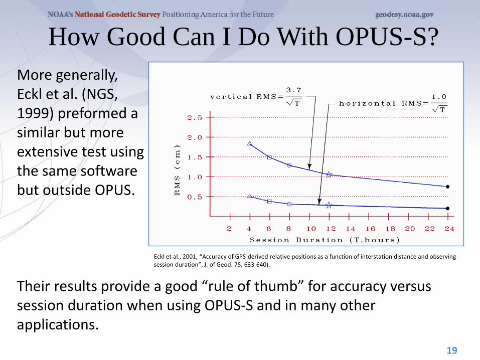
How Good Can I Do With OPUS-S? More generally, Eckl et al. (NGS, 1999) preformed a similar but more extensive test using the same software but outside OPUS.
19
Eckl et al., 2001, “Accuracy of GPS-derived relative positions as a function of interstation distance and observing-session duration”, J. of Geod. 75, 633-640).
Their results provide a good “rule of thumb” for accuracy versus session duration when using OPUS-S and in many other applications.
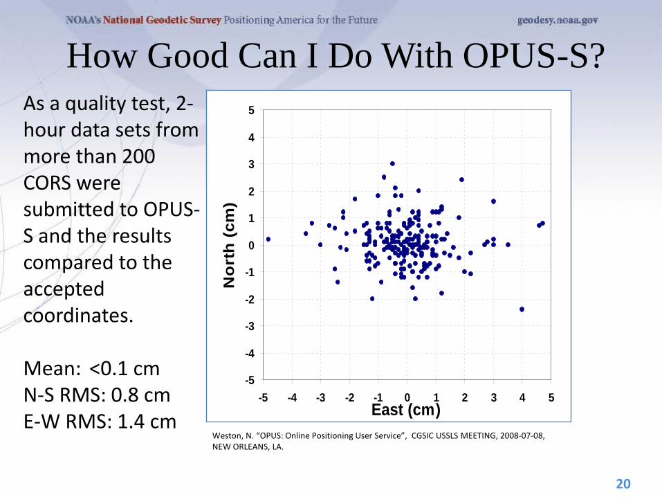
How Good Can I Do With OPUS-S? As a quality test, 2-hour data sets from more than 200 CORS were submitted to OPUS-S and the results compared to the accepted coordinates. Mean: <0.1 cm N-S RMS: 0.8 cm E-W RMS: 1.4 cm
20
-5
-4
-3
-2
-1
0
1
2
3
4
5
-5 -4 -3 -2 -1 0 1 2 3 4 5East (cm)
No
rth
(cm
)
Weston, N. “OPUS: Online Positioning User Service”, CGSIC USSLS MEETING, 2008-07-08, NEW ORLEANS, LA.
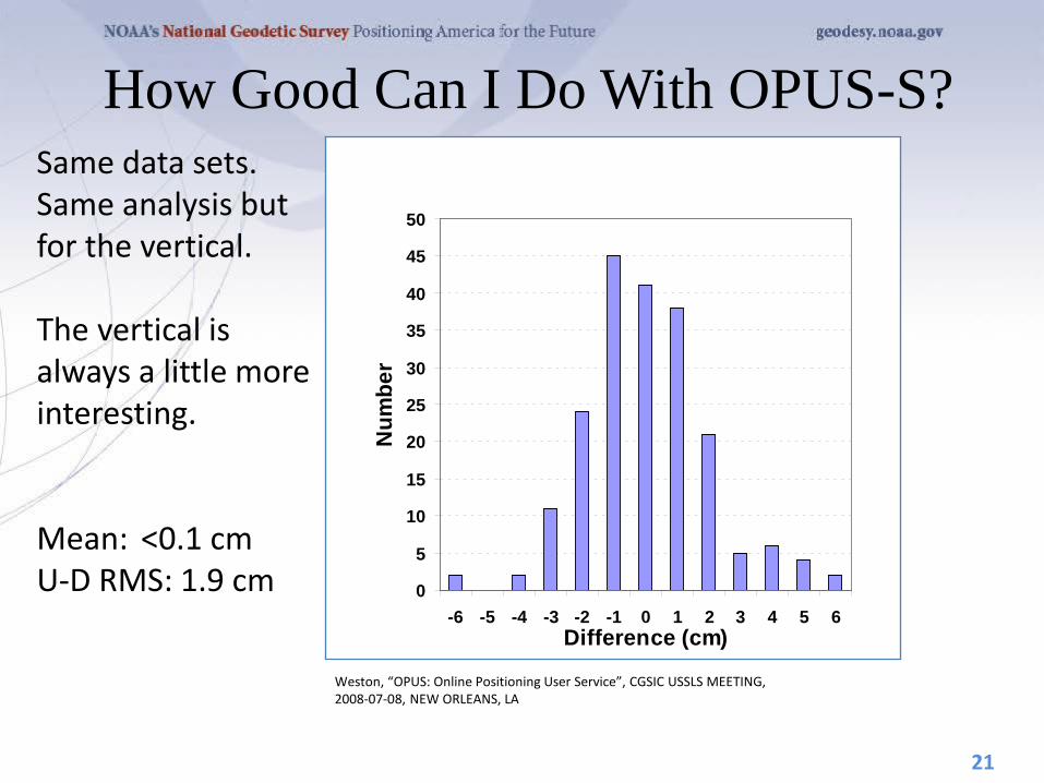
How Good Can I Do With OPUS-S? Same data sets. Same analysis but for the vertical. The vertical is always a little more interesting. Mean: <0.1 cm U-D RMS: 1.9 cm
21
0
5
10
15
20
25
30
35
40
45
50
-6 -5 -4 -3 -2 -1 0 1 2 3 4 5 6Difference (cm)
Num
ber
Weston, “OPUS: Online Positioning User Service”, CGSIC USSLS MEETING, 2008-07-08, NEW ORLEANS, LA

A Quick Example
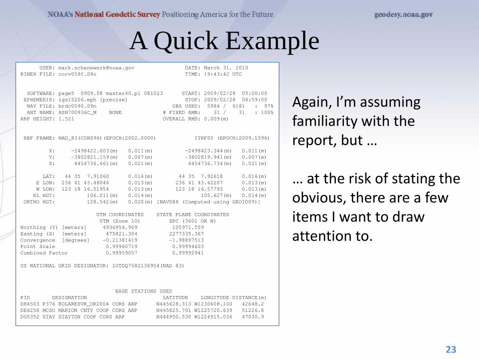
Here is part of the report for this submission. FYI, these results differ 2.1 cm horizontally and 1.6 cm vertically from the accepted position projected to the epoch of the data.
22
USER: [email protected] DATE: March 31, 2010 RINEX FILE: corv059f.09o TIME: 19:43:42 UTC SOFTWARE: page5 0909.08 master40.pl 081023 START: 2009/02/28 05:00:00 EPHEMERIS: igs15206.eph [precise] STOP: 2009/02/28 06:59:00 NAV FILE: brdc0590.09n OBS USED: 5984 / 6181 : 97% ANT NAME: ASH700936C_M NONE # FIXED AMB: 31 / 31 : 100% ARP HEIGHT: 1.521 OVERALL RMS: 0.009(m) REF FRAME: NAD_83(CORS96)(EPOCH:2002.0000) ITRF00 (EPOCH:2009.1596) X: -2498422.603(m) 0.011(m) -2498423.344(m) 0.011(m) Y: -3802821.159(m) 0.007(m) -3802819.941(m) 0.007(m) Z: 4454736.661(m) 0.021(m) 4454736.734(m) 0.021(m) LAT: 44 35 7.91060 0.016(m) 44 35 7.92618 0.016(m) E LON: 236 41 43.48046 0.013(m) 236 41 43.42207 0.013(m) W LON: 123 18 16.51954 0.013(m) 123 18 16.57793 0.013(m) EL HGT: 106.011(m) 0.014(m) 105.627(m) 0.014(m) ORTHO HGT: 128.542(m) 0.020(m) [NAVD88 (Computed using GEOID09)] UTM COORDINATES STATE PLANE COORDINATES UTM (Zone 10) SPC (3601 OR N) Northing (Y) [meters] 4936954.909 105971.559 Easting (X) [meters] 475821.304 2277335.367 Convergence [degrees] -0.21381419 -1.98897513 Point Scale 0.99960719 0.99994603 Combined Factor 0.99959057 0.99992941 US NATIONAL GRID DESIGNATOR: 10TDQ7582136954(NAD 83) BASE STATIONS USED PID DESIGNATION LATITUDE LONGITUDE DISTANCE(m) DH4503 P376 EOLARESVR_OR2004 CORS ARP N445628.313 W1230608.100 42648.2 DE6258 MCSO MARION CNTY COOP CORS ARP N445825.701 W1225720.639 51226.8 DG5352 STAY STAYTON COOP CORS ARP N444950.530 W1224915.036 47030.9
A Quick Example
Again, I’m assuming familiarity with the report, but … … at the risk of stating the obvious, there are a few items I want to draw attention to.
23
USER: [email protected] DATE: March 31, 2010 RINEX FILE: corv059f.09o TIME: 19:43:42 UTC SOFTWARE: page5 0909.08 master40.pl 081023 START: 2009/02/28 05:00:00 EPHEMERIS: igs15206.eph [precise] STOP: 2009/02/28 06:59:00 NAV FILE: brdc0590.09n OBS USED: 5984 / 6181 : 97% ANT NAME: ASH700936C_M NONE # FIXED AMB: 31 / 31 : 100% ARP HEIGHT: 1.521 OVERALL RMS: 0.009(m) REF FRAME: NAD_83(CORS96)(EPOCH:2002.0000) ITRF00 (EPOCH:2009.1596) X: -2498422.603(m) 0.011(m) -2498423.344(m) 0.011(m) Y: -3802821.159(m) 0.007(m) -3802819.941(m) 0.007(m) Z: 4454736.661(m) 0.021(m) 4454736.734(m) 0.021(m) LAT: 44 35 7.91060 0.016(m) 44 35 7.92618 0.016(m) E LON: 236 41 43.48046 0.013(m) 236 41 43.42207 0.013(m) W LON: 123 18 16.51954 0.013(m) 123 18 16.57793 0.013(m) EL HGT: 106.011(m) 0.014(m) 105.627(m) 0.014(m) ORTHO HGT: 128.542(m) 0.020(m) [NAVD88 (Computed using GEOID09)] UTM COORDINATES STATE PLANE COORDINATES UTM (Zone 10) SPC (3601 OR N) Northing (Y) [meters] 4936954.909 105971.559 Easting (X) [meters] 475821.304 2277335.367 Convergence [degrees] -0.21381419 -1.98897513 Point Scale 0.99960719 0.99994603 Combined Factor 0.99959057 0.99992941 US NATIONAL GRID DESIGNATOR: 10TDQ7582136954(NAD 83) BASE STATIONS USED PID DESIGNATION LATITUDE LONGITUDE DISTANCE(m) DH4503 P376 EOLARESVR_OR2004 CORS ARP N445628.313 W1230608.100 42648.2 DE6258 MCSO MARION CNTY COOP CORS ARP N445825.701 W1225720.639 51226.8 DG5352 STAY STAYTON COOP CORS ARP N444950.530 W1224915.036 47030.9
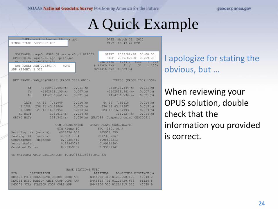
A Quick Example
I apologize for stating the obvious, but … When reviewing your OPUS solution, double check that the information you provided is correct.
24
USER: [email protected] DATE: March 31, 2010 RINEX FILE: corv059f.09o TIME: 19:43:42 UTC SOFTWARE: page5 0909.08 master40.pl 081023 START: 2009/02/28 05:00:00 EPHEMERIS: igs15206.eph [precise] STOP: 2009/02/28 06:59:00 NAV FILE: brdc0590.09n OBS USED: 5984 / 6181 : 97% ANT NAME: ASH700936C_M NONE # FIXED AMB: 31 / 31 : 100% ARP HEIGHT: 1.521 OVERALL RMS: 0.009(m) REF FRAME: NAD_83(CORS96)(EPOCH:2002.0000) ITRF00 (EPOCH:2009.1596) X: -2498422.603(m) 0.011(m) -2498423.344(m) 0.011(m) Y: -3802821.159(m) 0.007(m) -3802819.941(m) 0.007(m) Z: 4454736.661(m) 0.021(m) 4454736.734(m) 0.021(m) LAT: 44 35 7.91060 0.016(m) 44 35 7.92618 0.016(m) E LON: 236 41 43.48046 0.013(m) 236 41 43.42207 0.013(m) W LON: 123 18 16.51954 0.013(m) 123 18 16.57793 0.013(m) EL HGT: 106.011(m) 0.014(m) 105.627(m) 0.014(m) ORTHO HGT: 128.542(m) 0.020(m) [NAVD88 (Computed using GEOID09)] UTM COORDINATES STATE PLANE COORDINATES UTM (Zone 10) SPC (3601 OR N) Northing (Y) [meters] 4936954.909 105971.559 Easting (X) [meters] 475821.304 2277335.367 Convergence [degrees] -0.21381419 -1.98897513 Point Scale 0.99960719 0.99994603 Combined Factor 0.99959057 0.99992941 US NATIONAL GRID DESIGNATOR: 10TDQ7582136954(NAD 83) BASE STATIONS USED PID DESIGNATION LATITUDE LONGITUDE DISTANCE(m) DH4503 P376 EOLARESVR_OR2004 CORS ARP N445628.313 W1230608.100 42648.2 DE6258 MCSO MARION CNTY COOP CORS ARP N445825.701 W1225720.639 51226.8 DG5352 STAY STAYTON COOP CORS ARP N444950.530 W1224915.036 47030.9
START: 2009/02/28 05:00:00 STOP: 2009/02/28 06:59:00
RINEX FILE: corv059f.09o
ANT NAME: ASH700936C_M NONE ARP HEIGHT: 1.521
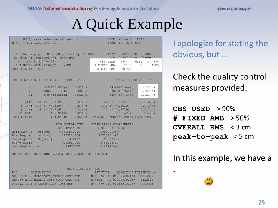
A Quick Example I apologize for stating the obvious, but … Check the quality control measures provided: OBS USED > 90% # FIXED AMB > 50% OVERALL RMS < 3 cm peak-to-peak < 5 cm In this example, we have a .
25
USER: [email protected] DATE: March 31, 2010 RINEX FILE: corv059f.09o TIME: 19:43:42 UTC SOFTWARE: page5 0909.08 master40.pl 081023 START: 2009/02/28 05:00:00 EPHEMERIS: igs15206.eph [precise] STOP: 2009/02/28 06:59:00 NAV FILE: brdc0590.09n OBS USED: 5984 / 6181 : 97% ANT NAME: ASH700936C_M NONE # FIXED AMB: 31 / 31 : 100% ARP HEIGHT: 1.521 OVERALL RMS: 0.009(m) REF FRAME: NAD_83(CORS96)(EPOCH:2002.0000) ITRF00 (EPOCH:2009.1596) X: -2498422.603(m) 0.011(m) -2498423.344(m) 0.011(m) Y: -3802821.159(m) 0.007(m) -3802819.941(m) 0.007(m) Z: 4454736.661(m) 0.021(m) 4454736.734(m) 0.021(m) LAT: 44 35 7.91060 0.016(m) 44 35 7.92618 0.016(m) E LON: 236 41 43.48046 0.013(m) 236 41 43.42207 0.013(m) W LON: 123 18 16.51954 0.013(m) 123 18 16.57793 0.013(m) EL HGT: 106.011(m) 0.014(m) 105.627(m) 0.014(m) ORTHO HGT: 128.542(m) 0.020(m) [NAVD88 (Computed using GEOID09)] UTM COORDINATES STATE PLANE COORDINATES UTM (Zone 10) SPC (3601 OR N) Northing (Y) [meters] 4936954.909 105971.559 Easting (X) [meters] 475821.304 2277335.367 Convergence [degrees] -0.21381419 -1.98897513 Point Scale 0.99960719 0.99994603 Combined Factor 0.99959057 0.99992941 US NATIONAL GRID DESIGNATOR: 10TDQ7582136954(NAD 83) BASE STATIONS USED PID DESIGNATION LATITUDE LONGITUDE DISTANCE(m) DH4503 P376 EOLARESVR_OR2004 CORS ARP N445628.313 W1230608.100 42648.2 DE6258 MCSO MARION CNTY COOP CORS ARP N445825.701 W1225720.639 51226.8 DG5352 STAY STAYTON COOP CORS ARP N444950.530 W1224915.036 47030.9
OBS USED: 5984 / 6181 : 97% # FIXED AMB: 31 / 31 : 100% OVERALL RMS: 0.009(m)
0.011(m) 0.007(m) 0.021(m)

φ
your position: averaged from the 3
CORS solutions
λ
h
your peak-to-peaks: scaled from the spread of the
3 CORS solutions

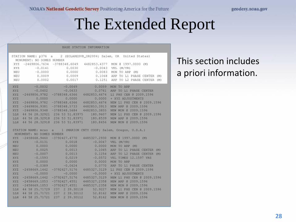
The Extended Report If the extended report option was selected, next you’ll see the BASE STATION section. Here, the components contributing to the base stations’ coordinates are shown in detail. These and the following information are expressed in the ITRF currently in use.
27
BASE STATION INFORMATION STATION NAME: p376 a 2 (EOLARESVR_OR2004; Salem, OR United States) MONUMENT: NO DOMES NUMBER XYZ -2469806.7634 -3788348.6049 4482853.4377 MON @ 1997.0000 (M) XYZ -0.0141 0.0030 -0.0043 VEL (M/YR) NEU -0.0000 0.0000 0.0083 MON TO ARP (M) NEU 0.0009 0.0009 0.1068 ARP TO L1 PHASE CENTER (M) NEU 0.0002 0.0017 0.1251 ARP TO L2 PHASE CENTER (M) XYZ -0.1715 0.0365 -0.0523 VEL TIMES 12.1597 YRS XYZ -0.0032 -0.0049 0.0059 MON TO ARP XYZ -0.0402 -0.0633 0.0761 ARP TO L1 PHASE CENTER XYZ -2469806.9782 -3788348.6366 4482853.4674 L1 PHS CEN @ 2009.1596 XYZ 0.0000 0.0000 0.0000 + XYZ ADJUSTMENTS XYZ -2469806.9782 -3788348.6366 4482853.4674 NEW L1 PHS CEN @ 2009.1596 XYZ -2469806.9381 -3788348.5733 4482853.3913 NEW ARP @ 2009.1596 XYZ -2469806.9348 -3788348.5684 4482853.3855 NEW MON @ 2009.1596 LLH 44 56 28.32921 236 53 51.83975 180.9607 NEW L1 PHS CEN @ 2009.1596 LLH 44 56 28.32918 236 53 51.83971 180.8539 NEW ARP @ 2009.1596 LLH 44 56 28.32918 236 53 51.83971 180.8456 NEW MON @ 2009.1596 STATION NAME: mcso a 1 (MARION CNTY COOP; Salem, Oregon, U.S.A.) MONUMENT: NO DOMES NUMBER XYZ -2458668.9460 -3792427.4770 4485327.2930 MON @ 1997.0000 (M) XYZ -0.0131 0.0018 -0.0047 VEL (M/YR) NEU 0.0000 0.0000 0.0000 MON TO ARP (M) NEU 0.0025 0.0013 0.1065 ARP TO L1 PHASE CENTER (M) NEU -0.0007 0.0013 0.1254 ARP TO L2 PHASE CENTER (M) XYZ -0.1593 0.0219 -0.0572 VEL TIMES 12.1597 YRS XYZ 0.0000 0.0000 0.0000 MON TO ARP XYZ -0.0389 -0.0624 0.0770 ARP TO L1 PHASE CENTER XYZ -2458669.1442 -3792427.5176 4485327.3129 L1 PHS CEN @ 2009.1596 XYZ -0.0000 -0.0000 -0.0000 + XYZ ADJUSTMENTS XYZ -2458669.1442 -3792427.5176 4485327.3129 NEW L1 PHS CEN @ 2009.1596 XYZ -2458669.1053 -3792427.4551 4485327.2358 NEW ARP @ 2009.1596 XYZ -2458669.1053 -3792427.4551 4485327.2358 NEW MON @ 2009.1596 LLH 44 58 25.71729 237 2 39.30118 52.9227 NEW L1 PHS CEN @ 2009.1596 LLH 44 58 25.71721 237 2 39.30112 52.8162 NEW ARP @ 2009.1596 LLH 44 58 25.71721 237 2 39.30112 52.8162 NEW MON @ 2009.1596
The Extended Report
This section includes a priori information.
28
BASE STATION INFORMATION STATION NAME: p376 a 2 (EOLARESVR_OR2004; Salem, OR United States) MONUMENT: NO DOMES NUMBER XYZ -2469806.7634 -3788348.6049 4482853.4377 MON @ 1997.0000 (M) XYZ -0.0141 0.0030 -0.0043 VEL (M/YR) NEU -0.0000 0.0000 0.0083 MON TO ARP (M) NEU 0.0009 0.0009 0.1068 ARP TO L1 PHASE CENTER (M) NEU 0.0002 0.0017 0.1251 ARP TO L2 PHASE CENTER (M) XYZ -0.1715 0.0365 -0.0523 VEL TIMES 12.1597 YRS XYZ -0.0032 -0.0049 0.0059 MON TO ARP XYZ -0.0402 -0.0633 0.0761 ARP TO L1 PHASE CENTER XYZ -2469806.9782 -3788348.6366 4482853.4674 L1 PHS CEN @ 2009.1596 XYZ 0.0000 0.0000 0.0000 + XYZ ADJUSTMENTS XYZ -2469806.9782 -3788348.6366 4482853.4674 NEW L1 PHS CEN @ 2009.1596 XYZ -2469806.9381 -3788348.5733 4482853.3913 NEW ARP @ 2009.1596 XYZ -2469806.9348 -3788348.5684 4482853.3855 NEW MON @ 2009.1596 LLH 44 56 28.32921 236 53 51.83975 180.9607 NEW L1 PHS CEN @ 2009.1596 LLH 44 56 28.32918 236 53 51.83971 180.8539 NEW ARP @ 2009.1596 LLH 44 56 28.32918 236 53 51.83971 180.8456 NEW MON @ 2009.1596 STATION NAME: mcso a 1 (MARION CNTY COOP; Salem, Oregon, U.S.A.) MONUMENT: NO DOMES NUMBER XYZ -2458668.9460 -3792427.4770 4485327.2930 MON @ 1997.0000 (M) XYZ -0.0131 0.0018 -0.0047 VEL (M/YR) NEU 0.0000 0.0000 0.0000 MON TO ARP (M) NEU 0.0025 0.0013 0.1065 ARP TO L1 PHASE CENTER (M) NEU -0.0007 0.0013 0.1254 ARP TO L2 PHASE CENTER (M) XYZ -0.1593 0.0219 -0.0572 VEL TIMES 12.1597 YRS XYZ 0.0000 0.0000 0.0000 MON TO ARP XYZ -0.0389 -0.0624 0.0770 ARP TO L1 PHASE CENTER XYZ -2458669.1442 -3792427.5176 4485327.3129 L1 PHS CEN @ 2009.1596 XYZ -0.0000 -0.0000 -0.0000 + XYZ ADJUSTMENTS XYZ -2458669.1442 -3792427.5176 4485327.3129 NEW L1 PHS CEN @ 2009.1596 XYZ -2458669.1053 -3792427.4551 4485327.2358 NEW ARP @ 2009.1596 XYZ -2458669.1053 -3792427.4551 4485327.2358 NEW MON @ 2009.1596 LLH 44 58 25.71729 237 2 39.30118 52.9227 NEW L1 PHS CEN @ 2009.1596 LLH 44 58 25.71721 237 2 39.30112 52.8162 NEW ARP @ 2009.1596 LLH 44 58 25.71721 237 2 39.30112 52.8162 NEW MON @ 2009.1596
STATION NAME: p376 a 2 (EOLARESVR_OR2004; Salem, OR United States) MONUMENT: NO DOMES NUMBER XYZ -2469806.7634 -3788348.6049 4482853.4377 MON @ 1997.0000 (M) XYZ -0.0141 0.0030 -0.0043 VEL (M/YR) NEU -0.0000 0.0000 0.0083 MON TO ARP (M) NEU 0.0009 0.0009 0.1068 ARP TO L1 PHASE CENTER (M) NEU 0.0002 0.0017 0.1251 ARP TO L2 PHASE CENTER (M)
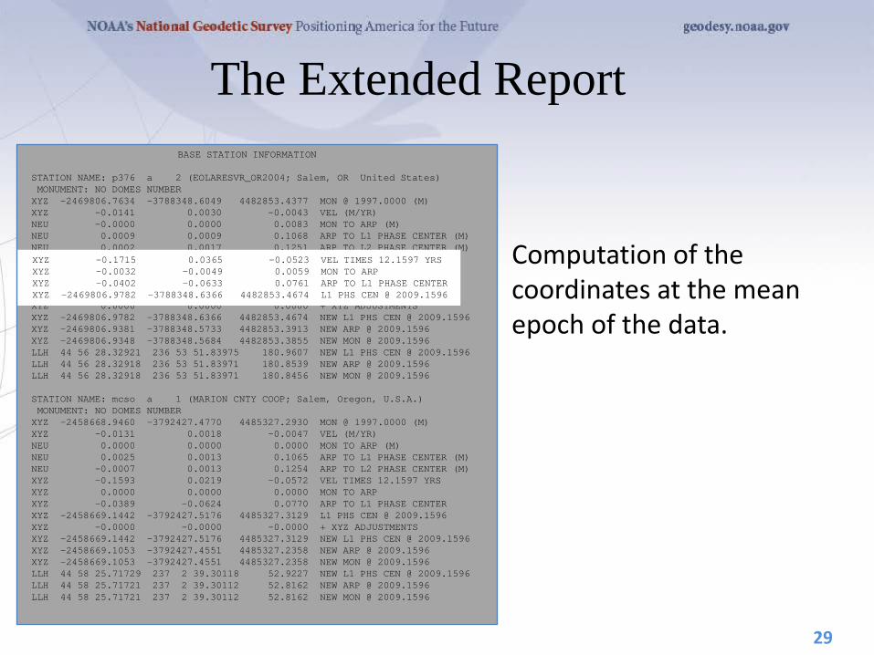
The Extended Report
Computation of the coordinates at the mean epoch of the data.
29
BASE STATION INFORMATION STATION NAME: p376 a 2 (EOLARESVR_OR2004; Salem, OR United States) MONUMENT: NO DOMES NUMBER XYZ -2469806.7634 -3788348.6049 4482853.4377 MON @ 1997.0000 (M) XYZ -0.0141 0.0030 -0.0043 VEL (M/YR) NEU -0.0000 0.0000 0.0083 MON TO ARP (M) NEU 0.0009 0.0009 0.1068 ARP TO L1 PHASE CENTER (M) NEU 0.0002 0.0017 0.1251 ARP TO L2 PHASE CENTER (M) XYZ -0.1715 0.0365 -0.0523 VEL TIMES 12.1597 YRS XYZ -0.0032 -0.0049 0.0059 MON TO ARP XYZ -0.0402 -0.0633 0.0761 ARP TO L1 PHASE CENTER XYZ -2469806.9782 -3788348.6366 4482853.4674 L1 PHS CEN @ 2009.1596 XYZ 0.0000 0.0000 0.0000 + XYZ ADJUSTMENTS XYZ -2469806.9782 -3788348.6366 4482853.4674 NEW L1 PHS CEN @ 2009.1596 XYZ -2469806.9381 -3788348.5733 4482853.3913 NEW ARP @ 2009.1596 XYZ -2469806.9348 -3788348.5684 4482853.3855 NEW MON @ 2009.1596 LLH 44 56 28.32921 236 53 51.83975 180.9607 NEW L1 PHS CEN @ 2009.1596 LLH 44 56 28.32918 236 53 51.83971 180.8539 NEW ARP @ 2009.1596 LLH 44 56 28.32918 236 53 51.83971 180.8456 NEW MON @ 2009.1596 STATION NAME: mcso a 1 (MARION CNTY COOP; Salem, Oregon, U.S.A.) MONUMENT: NO DOMES NUMBER XYZ -2458668.9460 -3792427.4770 4485327.2930 MON @ 1997.0000 (M) XYZ -0.0131 0.0018 -0.0047 VEL (M/YR) NEU 0.0000 0.0000 0.0000 MON TO ARP (M) NEU 0.0025 0.0013 0.1065 ARP TO L1 PHASE CENTER (M) NEU -0.0007 0.0013 0.1254 ARP TO L2 PHASE CENTER (M) XYZ -0.1593 0.0219 -0.0572 VEL TIMES 12.1597 YRS XYZ 0.0000 0.0000 0.0000 MON TO ARP XYZ -0.0389 -0.0624 0.0770 ARP TO L1 PHASE CENTER XYZ -2458669.1442 -3792427.5176 4485327.3129 L1 PHS CEN @ 2009.1596 XYZ -0.0000 -0.0000 -0.0000 + XYZ ADJUSTMENTS XYZ -2458669.1442 -3792427.5176 4485327.3129 NEW L1 PHS CEN @ 2009.1596 XYZ -2458669.1053 -3792427.4551 4485327.2358 NEW ARP @ 2009.1596 XYZ -2458669.1053 -3792427.4551 4485327.2358 NEW MON @ 2009.1596 LLH 44 58 25.71729 237 2 39.30118 52.9227 NEW L1 PHS CEN @ 2009.1596 LLH 44 58 25.71721 237 2 39.30112 52.8162 NEW ARP @ 2009.1596 LLH 44 58 25.71721 237 2 39.30112 52.8162 NEW MON @ 2009.1596
XYZ -0.1715 0.0365 -0.0523 VEL TIMES 12.1597 YRS XYZ -0.0032 -0.0049 0.0059 MON TO ARP XYZ -0.0402 -0.0633 0.0761 ARP TO L1 PHASE CENTER XYZ -2469806.9782 -3788348.6366 4482853.4674 L1 PHS CEN @ 2009.1596

The Extended Report
And the coordinates at the mean epoch of the data.
30
BASE STATION INFORMATION STATION NAME: p376 a 2 (EOLARESVR_OR2004; Salem, OR United States) MONUMENT: NO DOMES NUMBER XYZ -2469806.7634 -3788348.6049 4482853.4377 MON @ 1997.0000 (M) XYZ -0.0141 0.0030 -0.0043 VEL (M/YR) NEU -0.0000 0.0000 0.0083 MON TO ARP (M) NEU 0.0009 0.0009 0.1068 ARP TO L1 PHASE CENTER (M) NEU 0.0002 0.0017 0.1251 ARP TO L2 PHASE CENTER (M) XYZ -0.1715 0.0365 -0.0523 VEL TIMES 12.1597 YRS XYZ -0.0032 -0.0049 0.0059 MON TO ARP XYZ -0.0402 -0.0633 0.0761 ARP TO L1 PHASE CENTER XYZ -2469806.9782 -3788348.6366 4482853.4674 L1 PHS CEN @ 2009.1596 XYZ 0.0000 0.0000 0.0000 + XYZ ADJUSTMENTS XYZ -2469806.9782 -3788348.6366 4482853.4674 NEW L1 PHS CEN @ 2009.1596 XYZ -2469806.9381 -3788348.5733 4482853.3913 NEW ARP @ 2009.1596 XYZ -2469806.9348 -3788348.5684 4482853.3855 NEW MON @ 2009.1596 LLH 44 56 28.32921 236 53 51.83975 180.9607 NEW L1 PHS CEN @ 2009.1596 LLH 44 56 28.32918 236 53 51.83971 180.8539 NEW ARP @ 2009.1596 LLH 44 56 28.32918 236 53 51.83971 180.8456 NEW MON @ 2009.1596 STATION NAME: mcso a 1 (MARION CNTY COOP; Salem, Oregon, U.S.A.) MONUMENT: NO DOMES NUMBER XYZ -2458668.9460 -3792427.4770 4485327.2930 MON @ 1997.0000 (M) XYZ -0.0131 0.0018 -0.0047 VEL (M/YR) NEU 0.0000 0.0000 0.0000 MON TO ARP (M) NEU 0.0025 0.0013 0.1065 ARP TO L1 PHASE CENTER (M) NEU -0.0007 0.0013 0.1254 ARP TO L2 PHASE CENTER (M) XYZ -0.1593 0.0219 -0.0572 VEL TIMES 12.1597 YRS XYZ 0.0000 0.0000 0.0000 MON TO ARP XYZ -0.0389 -0.0624 0.0770 ARP TO L1 PHASE CENTER XYZ -2458669.1442 -3792427.5176 4485327.3129 L1 PHS CEN @ 2009.1596 XYZ -0.0000 -0.0000 -0.0000 + XYZ ADJUSTMENTS XYZ -2458669.1442 -3792427.5176 4485327.3129 NEW L1 PHS CEN @ 2009.1596 XYZ -2458669.1053 -3792427.4551 4485327.2358 NEW ARP @ 2009.1596 XYZ -2458669.1053 -3792427.4551 4485327.2358 NEW MON @ 2009.1596 LLH 44 58 25.71729 237 2 39.30118 52.9227 NEW L1 PHS CEN @ 2009.1596 LLH 44 58 25.71721 237 2 39.30112 52.8162 NEW ARP @ 2009.1596 LLH 44 58 25.71721 237 2 39.30112 52.8162 NEW MON @ 2009.1596
XYZ -2469806.9782 -3788348.6366 4482853.4674 NEW L1 PHS CEN @ 2009.1596 XYZ -2469806.9381 -3788348.5733 4482853.3913 NEW ARP @ 2009.1596 XYZ -2469806.9348 -3788348.5684 4482853.3855 NEW MON @ 2009.1596 LLH 44 56 28.32921 236 53 51.83975 180.9607 NEW L1 PHS CEN @ 2009.1596 LLH 44 56 28.32918 236 53 51.83971 180.8539 NEW ARP @ 2009.1596 LLH 44 56 28.32918 236 53 51.83971 180.8456 NEW MON @ 2009.1596
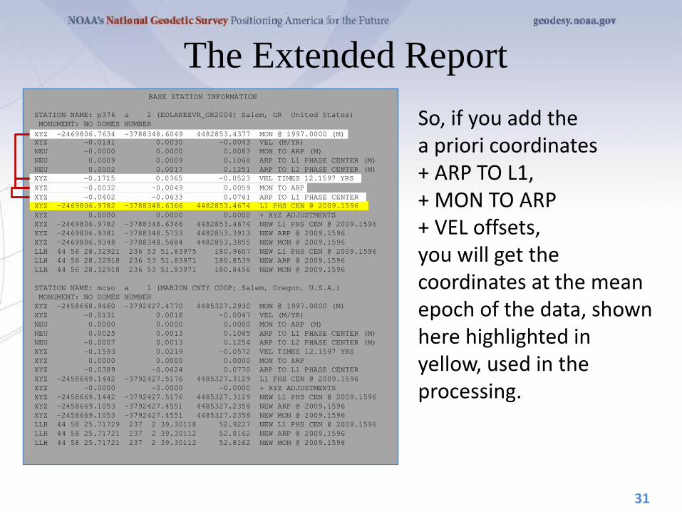
The Extended Report So, if you add the a priori coordinates + ARP TO L1, + MON TO ARP + VEL offsets, you will get the coordinates at the mean epoch of the data, shown here highlighted in yellow, used in the processing.
31
BASE STATION INFORMATION STATION NAME: p376 a 2 (EOLARESVR_OR2004; Salem, OR United States) MONUMENT: NO DOMES NUMBER XYZ -2469806.7634 -3788348.6049 4482853.4377 MON @ 1997.0000 (M) XYZ -0.0141 0.0030 -0.0043 VEL (M/YR) NEU -0.0000 0.0000 0.0083 MON TO ARP (M) NEU 0.0009 0.0009 0.1068 ARP TO L1 PHASE CENTER (M) NEU 0.0002 0.0017 0.1251 ARP TO L2 PHASE CENTER (M) XYZ -0.1715 0.0365 -0.0523 VEL TIMES 12.1597 YRS XYZ -0.0032 -0.0049 0.0059 MON TO ARP XYZ -0.0402 -0.0633 0.0761 ARP TO L1 PHASE CENTER XYZ -2469806.9782 -3788348.6366 4482853.4674 L1 PHS CEN @ 2009.1596 XYZ 0.0000 0.0000 0.0000 + XYZ ADJUSTMENTS XYZ -2469806.9782 -3788348.6366 4482853.4674 NEW L1 PHS CEN @ 2009.1596 XYZ -2469806.9381 -3788348.5733 4482853.3913 NEW ARP @ 2009.1596 XYZ -2469806.9348 -3788348.5684 4482853.3855 NEW MON @ 2009.1596 LLH 44 56 28.32921 236 53 51.83975 180.9607 NEW L1 PHS CEN @ 2009.1596 LLH 44 56 28.32918 236 53 51.83971 180.8539 NEW ARP @ 2009.1596 LLH 44 56 28.32918 236 53 51.83971 180.8456 NEW MON @ 2009.1596 STATION NAME: mcso a 1 (MARION CNTY COOP; Salem, Oregon, U.S.A.) MONUMENT: NO DOMES NUMBER XYZ -2458668.9460 -3792427.4770 4485327.2930 MON @ 1997.0000 (M) XYZ -0.0131 0.0018 -0.0047 VEL (M/YR) NEU 0.0000 0.0000 0.0000 MON TO ARP (M) NEU 0.0025 0.0013 0.1065 ARP TO L1 PHASE CENTER (M) NEU -0.0007 0.0013 0.1254 ARP TO L2 PHASE CENTER (M) XYZ -0.1593 0.0219 -0.0572 VEL TIMES 12.1597 YRS XYZ 0.0000 0.0000 0.0000 MON TO ARP XYZ -0.0389 -0.0624 0.0770 ARP TO L1 PHASE CENTER XYZ -2458669.1442 -3792427.5176 4485327.3129 L1 PHS CEN @ 2009.1596 XYZ -0.0000 -0.0000 -0.0000 + XYZ ADJUSTMENTS XYZ -2458669.1442 -3792427.5176 4485327.3129 NEW L1 PHS CEN @ 2009.1596 XYZ -2458669.1053 -3792427.4551 4485327.2358 NEW ARP @ 2009.1596 XYZ -2458669.1053 -3792427.4551 4485327.2358 NEW MON @ 2009.1596 LLH 44 58 25.71729 237 2 39.30118 52.9227 NEW L1 PHS CEN @ 2009.1596 LLH 44 58 25.71721 237 2 39.30112 52.8162 NEW ARP @ 2009.1596 LLH 44 58 25.71721 237 2 39.30112 52.8162 NEW MON @ 2009.1596
XYZ -2469806.7634 -3788348.6049 4482853.4377 MON @ 1997.0000 (M)
XYZ -2469806.9782 -3788348.6366 4482853.4674 L1 PHS CEN @ 2009.1596
XYZ -0.1715 0.0365 -0.0523 VEL TIMES 12.1597 YRS XYZ -0.0032 -0.0049 0.0059 MON TO ARP XYZ -0.0402 -0.0633 0.0761 ARP TO L1 PHASE CENTER

The Extended Report Next are summaries of the solutions relative to each base station. We’ll discuss this a few minutes, but, for now, simply be aware that OPUS “solves” each baseline separately, then compares and averages these results to create the report.
32
REMOTE STATION INFORMATION STATION NAME: corv 1 MONUMENT: NO DOMES NUMBER XYZ -2498423.7849 -3802820.9571 4454737.7025 MON @ 2009.1595 (M) NEU -0.0014 0.0010 1.5210 MON TO ARP (M) NEU 0.0014 -0.0010 0.1089 ARP TO L1 PHASE CENTER (M) NEU 0.0010 0.0005 0.1274 ARP TO L2 PHASE CENTER (M) XYZ -0.5945 -0.9067 1.0667 MON TO ARP XYZ -0.0429 -0.0635 0.0774 ARP TO L1 PHASE CENTER XYZ -2498424.4223 -3802821.9273 4454738.8466 L1 PHS CEN @ 2009.1596 BASELINE NAME: p376 corv XYZ 0.4450 1.0132 -0.9754 + XYZ ADJUSTMENTS XYZ -2498423.9773 -3802820.9141 4454737.8713 NEW L1 PHS CEN @ 2009.1596 XYZ -2498423.9344 -3802820.8506 4454737.7938 NEW ARP @ 2009.1596 XYZ -2498423.3399 -3802819.9439 4454736.7271 NEW MON @ 2009.1596 LLH 44 35 7.92601 236 41 43.42229 107.2518 NEW L1 PHS CEN @ 2009.1596 LLH 44 35 7.92597 236 41 43.42234 107.1429 NEW ARP @ 2009.1596 LLH 44 35 7.92601 236 41 43.42229 105.6219 NEW MON @ 2009.1596 BASELINE NAME: mcso corv XYZ 0.4343 1.0202 -0.9746 + XYZ ADJUSTMENTS XYZ -2498423.9880 -3802820.9071 4454737.8721 NEW L1 PHS CEN @ 2009.1596 XYZ -2498423.9451 -3802820.8436 4454737.7946 NEW ARP @ 2009.1596 XYZ -2498423.3506 -3802819.9369 4454736.7279 NEW MON @ 2009.1596 LLH 44 35 7.92603 236 41 43.42171 107.2523 NEW L1 PHS CEN @ 2009.1596 LLH 44 35 7.92599 236 41 43.42176 107.1434 NEW ARP @ 2009.1596 LLH 44 35 7.92603 236 41 43.42171 105.6224 NEW MON @ 2009.1596 BASELINE NAME: stay corv XYZ 0.4437 1.0153 -0.9543 + XYZ ADJUSTMENTS XYZ -2498423.9786 -3802820.9120 4454737.8923 NEW L1 PHS CEN @ 2009.1596 XYZ -2498423.9357 -3802820.8485 4454737.8149 NEW ARP @ 2009.1596 XYZ -2498423.3412 -3802819.9418 4454736.7482 NEW MON @ 2009.1596 LLH 44 35 7.92653 236 41 43.42219 107.2658 NEW L1 PHS CEN @ 2009.1596 LLH 44 35 7.92648 236 41 43.42224 107.1569 NEW ARP @ 2009.1596 LLH 44 35 7.92653 236 41 43.42219 105.6359 NEW MON @ 2009.1596

The Extended Report
Here we see the best guess for “my” site’s a priori information. This is based upon the information I provided when I uploaded the data file to OPUS-S and a crude point position solution. Remember that these are also in the IGS08.
33
REMOTE STATION INFORMATION STATION NAME: corv 1 MONUMENT: NO DOMES NUMBER XYZ -2498423.7849 -3802820.9571 4454737.7025 MON @ 2009.1595 (M) NEU -0.0014 0.0010 1.5210 MON TO ARP (M) NEU 0.0014 -0.0010 0.1089 ARP TO L1 PHASE CENTER (M) NEU 0.0010 0.0005 0.1274 ARP TO L2 PHASE CENTER (M) XYZ -0.5945 -0.9067 1.0667 MON TO ARP XYZ -0.0429 -0.0635 0.0774 ARP TO L1 PHASE CENTER XYZ -2498424.4223 -3802821.9273 4454738.8466 L1 PHS CEN @ 2009.1596 BASELINE NAME: p376 corv XYZ 0.4450 1.0132 -0.9754 + XYZ ADJUSTMENTS XYZ -2498423.9773 -3802820.9141 4454737.8713 NEW L1 PHS CEN @ 2009.1596 XYZ -2498423.9344 -3802820.8506 4454737.7938 NEW ARP @ 2009.1596 XYZ -2498423.3399 -3802819.9439 4454736.7271 NEW MON @ 2009.1596 LLH 44 35 7.92601 236 41 43.42229 107.2518 NEW L1 PHS CEN @ 2009.1596 LLH 44 35 7.92597 236 41 43.42234 107.1429 NEW ARP @ 2009.1596 LLH 44 35 7.92601 236 41 43.42229 105.6219 NEW MON @ 2009.1596 BASELINE NAME: mcso corv XYZ 0.4343 1.0202 -0.9746 + XYZ ADJUSTMENTS XYZ -2498423.9880 -3802820.9071 4454737.8721 NEW L1 PHS CEN @ 2009.1596 XYZ -2498423.9451 -3802820.8436 4454737.7946 NEW ARP @ 2009.1596 XYZ -2498423.3506 -3802819.9369 4454736.7279 NEW MON @ 2009.1596 LLH 44 35 7.92603 236 41 43.42171 107.2523 NEW L1 PHS CEN @ 2009.1596 LLH 44 35 7.92599 236 41 43.42176 107.1434 NEW ARP @ 2009.1596 LLH 44 35 7.92603 236 41 43.42171 105.6224 NEW MON @ 2009.1596 BASELINE NAME: stay corv XYZ 0.4437 1.0153 -0.9543 + XYZ ADJUSTMENTS XYZ -2498423.9786 -3802820.9120 4454737.8923 NEW L1 PHS CEN @ 2009.1596 XYZ -2498423.9357 -3802820.8485 4454737.8149 NEW ARP @ 2009.1596 XYZ -2498423.3412 -3802819.9418 4454736.7482 NEW MON @ 2009.1596 LLH 44 35 7.92653 236 41 43.42219 107.2658 NEW L1 PHS CEN @ 2009.1596 LLH 44 35 7.92648 236 41 43.42224 107.1569 NEW ARP @ 2009.1596 LLH 44 35 7.92653 236 41 43.42219 105.6359 NEW MON @ 2009.1596
STATION NAME: corv 1 MONUMENT: NO DOMES NUMBER XYZ -2498423.7849 -3802820.9571 4454737.7025 MON @ 2009.1595 (M) NEU -0.0014 0.0010 1.5210 MON TO ARP (M) NEU 0.0014 -0.0010 0.1089 ARP TO L1 PHASE CENTER (M) NEU 0.0010 0.0005 0.1274 ARP TO L2 PHASE CENTER (M) XYZ -0.5945 -0.9067 1.0667 MON TO ARP XYZ -0.0429 -0.0635 0.0774 ARP TO L1 PHASE CENTER XYZ -2498424.4223 -3802821.9273 4454738.8466 L1 PHS CEN @ 2009.1596

The Extended Report
In the associated “blocks”, the estimated adjustment and resulting coordinates from each baseline solution are shown.
34
REMOTE STATION INFORMATION STATION NAME: corv 1 MONUMENT: NO DOMES NUMBER XYZ -2498423.7849 -3802820.9571 4454737.7025 MON @ 2009.1595 (M) NEU -0.0014 0.0010 1.5210 MON TO ARP (M) NEU 0.0014 -0.0010 0.1089 ARP TO L1 PHASE CENTER (M) NEU 0.0010 0.0005 0.1274 ARP TO L2 PHASE CENTER (M) XYZ -0.5945 -0.9067 1.0667 MON TO ARP XYZ -0.0429 -0.0635 0.0774 ARP TO L1 PHASE CENTER XYZ -2498424.4223 -3802821.9273 4454738.8466 L1 PHS CEN @ 2009.1596 BASELINE NAME: p376 corv XYZ 0.4450 1.0132 -0.9754 + XYZ ADJUSTMENTS XYZ -2498423.9773 -3802820.9141 4454737.8713 NEW L1 PHS CEN @ 2009.1596 XYZ -2498423.9344 -3802820.8506 4454737.7938 NEW ARP @ 2009.1596 XYZ -2498423.3399 -3802819.9439 4454736.7271 NEW MON @ 2009.1596 LLH 44 35 7.92601 236 41 43.42229 107.2518 NEW L1 PHS CEN @ 2009.1596 LLH 44 35 7.92597 236 41 43.42234 107.1429 NEW ARP @ 2009.1596 LLH 44 35 7.92601 236 41 43.42229 105.6219 NEW MON @ 2009.1596 BASELINE NAME: mcso corv XYZ 0.4343 1.0202 -0.9746 + XYZ ADJUSTMENTS XYZ -2498423.9880 -3802820.9071 4454737.8721 NEW L1 PHS CEN @ 2009.1596 XYZ -2498423.9451 -3802820.8436 4454737.7946 NEW ARP @ 2009.1596 XYZ -2498423.3506 -3802819.9369 4454736.7279 NEW MON @ 2009.1596 LLH 44 35 7.92603 236 41 43.42171 107.2523 NEW L1 PHS CEN @ 2009.1596 LLH 44 35 7.92599 236 41 43.42176 107.1434 NEW ARP @ 2009.1596 LLH 44 35 7.92603 236 41 43.42171 105.6224 NEW MON @ 2009.1596 BASELINE NAME: stay corv XYZ 0.4437 1.0153 -0.9543 + XYZ ADJUSTMENTS XYZ -2498423.9786 -3802820.9120 4454737.8923 NEW L1 PHS CEN @ 2009.1596 XYZ -2498423.9357 -3802820.8485 4454737.8149 NEW ARP @ 2009.1596 XYZ -2498423.3412 -3802819.9418 4454736.7482 NEW MON @ 2009.1596 LLH 44 35 7.92653 236 41 43.42219 107.2658 NEW L1 PHS CEN @ 2009.1596 LLH 44 35 7.92648 236 41 43.42224 107.1569 NEW ARP @ 2009.1596 LLH 44 35 7.92653 236 41 43.42219 105.6359 NEW MON @ 2009.1596
BASELINE NAME: p376 corv XYZ 0.4450 1.0132 -0.9754 + XYZ ADJUSTMENTS XYZ -2498423.9773 -3802820.9141 4454737.8713 NEW L1 PHS CEN @ 2009.1596 XYZ -2498423.9344 -3802820.8506 4454737.7938 NEW ARP @ 2009.1596 XYZ -2498423.3399 -3802819.9439 4454736.7271 NEW MON @ 2009.1596 LLH 44 35 7.92601 236 41 43.42229 107.2518 NEW L1 PHS CEN @ 2009.1596 LLH 44 35 7.92597 236 41 43.42234 107.1429 NEW ARP @ 2009.1596 LLH 44 35 7.92601 236 41 43.42229 105.6219 NEW MON @ 2009.1596
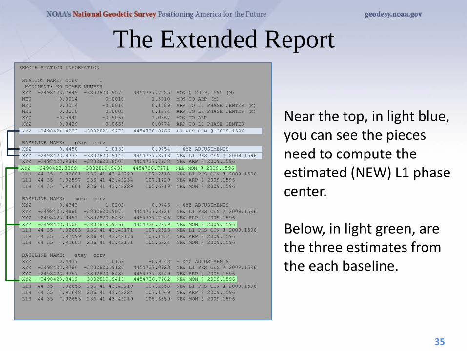
The Extended Report
Near the top, in light blue, you can see the pieces need to compute the estimated (NEW) L1 phase center. Below, in light green, are the three estimates from the each baseline.
35
REMOTE STATION INFORMATION STATION NAME: corv 1 MONUMENT: NO DOMES NUMBER XYZ -2498423.7849 -3802820.9571 4454737.7025 MON @ 2009.1595 (M) NEU -0.0014 0.0010 1.5210 MON TO ARP (M) NEU 0.0014 -0.0010 0.1089 ARP TO L1 PHASE CENTER (M) NEU 0.0010 0.0005 0.1274 ARP TO L2 PHASE CENTER (M) XYZ -0.5945 -0.9067 1.0667 MON TO ARP XYZ -0.0429 -0.0635 0.0774 ARP TO L1 PHASE CENTER XYZ -2498424.4223 -3802821.9273 4454738.8466 L1 PHS CEN @ 2009.1596 BASELINE NAME: p376 corv XYZ 0.4450 1.0132 -0.9754 + XYZ ADJUSTMENTS XYZ -2498423.9773 -3802820.9141 4454737.8713 NEW L1 PHS CEN @ 2009.1596 XYZ -2498423.9344 -3802820.8506 4454737.7938 NEW ARP @ 2009.1596 XYZ -2498423.3399 -3802819.9439 4454736.7271 NEW MON @ 2009.1596 LLH 44 35 7.92601 236 41 43.42229 107.2518 NEW L1 PHS CEN @ 2009.1596 LLH 44 35 7.92597 236 41 43.42234 107.1429 NEW ARP @ 2009.1596 LLH 44 35 7.92601 236 41 43.42229 105.6219 NEW MON @ 2009.1596 BASELINE NAME: mcso corv XYZ 0.4343 1.0202 -0.9746 + XYZ ADJUSTMENTS XYZ -2498423.9880 -3802820.9071 4454737.8721 NEW L1 PHS CEN @ 2009.1596 XYZ -2498423.9451 -3802820.8436 4454737.7946 NEW ARP @ 2009.1596 XYZ -2498423.3506 -3802819.9369 4454736.7279 NEW MON @ 2009.1596 LLH 44 35 7.92603 236 41 43.42171 107.2523 NEW L1 PHS CEN @ 2009.1596 LLH 44 35 7.92599 236 41 43.42176 107.1434 NEW ARP @ 2009.1596 LLH 44 35 7.92603 236 41 43.42171 105.6224 NEW MON @ 2009.1596 BASELINE NAME: stay corv XYZ 0.4437 1.0153 -0.9543 + XYZ ADJUSTMENTS XYZ -2498423.9786 -3802820.9120 4454737.8923 NEW L1 PHS CEN @ 2009.1596 XYZ -2498423.9357 -3802820.8485 4454737.8149 NEW ARP @ 2009.1596 XYZ -2498423.3412 -3802819.9418 4454736.7482 NEW MON @ 2009.1596 LLH 44 35 7.92653 236 41 43.42219 107.2658 NEW L1 PHS CEN @ 2009.1596 LLH 44 35 7.92648 236 41 43.42224 107.1569 NEW ARP @ 2009.1596 LLH 44 35 7.92653 236 41 43.42219 105.6359 NEW MON @ 2009.1596
XYZ -2498423.9773 -3802820.9141 4454737.8713 NEW L1 PHS CEN @ 2009.1596 XYZ 0.4450 1.0132 -0.9754 + XYZ ADJUSTMENTS
XYZ -2498424.4223 -3802821.9273 4454738.8466 L1 PHS CEN @ 2009.1596
XYZ -2498423.3399 -3802819.9439 4454736.7271 NEW MON @ 2009.1596
XYZ -2498423.3506 -3802819.9369 4454736.7279 NEW MON @ 2009.1596
XYZ -2498423.3412 -3802819.9418 4454736.7482 NEW MON @ 2009.1596

The Extended Report
Following the baseline information are some Bluebook records…
36
G-FILES Axx2009 228 9 228 B2009 228 5 0 9 228 659 1 page5 v0909.08IGS 226 1 2 27NGS 2010 7 9IFDDFX Iant_info.003 NGS 20100616 C00090001 286164051 30 144713755 32 281166583 28 X0599ACORVX0599AP376 D 1 2 9032521 1 3 -2281991 2 3 -5618980 Axx2009 228 9 228 B2009 228 5 0 9 228 659 1 page5 v0909.08IGS 226 1 2 27NGS 2010 7 9IFDDFX Iant_info.003 NGS 20100616 C00090002 397542453 32 103924818 30 305905079 27 X0599ACORVX0599AMCSO D 1 2 8318045 1 3 -1709106 2 3 -6334467 Axx2009 228 9 228 B2009 228 5 0 9 228 659 1 page5 v0909.08IGS 226 1 2 27NGS 2010 7 9IFDDFX Iant_info.003 NGS 20100616 C00090003 425824609 35 -48539879 22 193670380 18 X0599ACORVX0599ASTAY D 1 2 6847311 1 3 -1553171 2 3 -7047523
The Extended Report
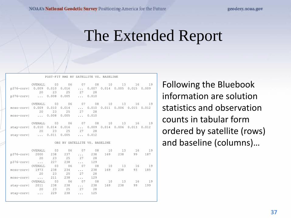
Following the Bluebook information are solution statistics and observation counts in tabular form ordered by satellite (rows) and baseline (columns)…
37
POST-FIT RMS BY SATELLITE VS. BASELINE OVERALL 03 06 07 08 10 13 16 19 p376-corv| 0.009 0.010 0.016 ... 0.007 0.014 0.005 0.015 0.009 20 23 25 27 28 p376-corv| ... 0.008 0.005 ... 0.010 OVERALL 03 06 07 08 10 13 16 19 mcso-corv| 0.009 0.010 0.014 ... 0.010 0.011 0.006 0.015 0.012 20 23 25 27 28 mcso-corv| ... 0.008 0.005 ... 0.010 OVERALL 03 06 07 08 10 13 16 19 stay-corv| 0.010 0.014 0.016 ... 0.009 0.014 0.006 0.013 0.012 20 23 25 27 28 stay-corv| ... 0.011 0.005 ... 0.012 OBS BY SATELLITE VS. BASELINE OVERALL 03 06 07 08 10 13 16 19 p376-corv| 2000 238 237 ... 238 169 238 99 187 20 23 25 27 28 p376-corv| ... 227 238 ... 129 OVERALL 03 06 07 08 10 13 16 19 mcso-corv| 1973 238 234 ... 238 169 238 93 185 20 23 25 27 28 mcso-corv| ... 211 238 ... 129 OVERALL 03 06 07 08 10 13 16 19 stay-corv| 2011 238 238 ... 238 169 238 99 199 20 23 25 27 28 stay-corv| ... 229 238 ... 125

The Extended Report These tables can be a challenge to read, especially for longer data spans, because the lines wrap in the standard 80-column format. Here’s the same table without line-wrapping and with the extra header lines removed.
38
POST-FIT RMS BY SATELLITE VS. BASELINE OVERALL 03 06 07 08 10 13 16 19 20 23 25 27 28 p376-corv| 0.009 0.010 0.016 ... 0.007 0.014 0.005 0.015 0.009 ... 0.008 0.005 ... 0.010 mcso-corv| 0.009 0.010 0.014 ... 0.010 0.011 0.006 0.015 0.012 ... 0.008 0.005 ... 0.010 stay-corv| 0.010 0.014 0.016 ... 0.009 0.014 0.006 0.013 0.01 ... 0.011 0.005 ... 0.012 OBS BY SATELLITE VS. BASELINE OVERALL 03 06 07 08 10 13 16 19 20 23 25 27 28 p376-corv| 2000 238 237 ... 238 169 238 99 187 ... 227 238 ... 129 mcso-corv| 1973 238 234 ... 238 169 238 93 185 ... 211 238 ... 129 stay-corv| 2011 238 238 ... 238 169 238 99 199 ... 229 238 ... 125
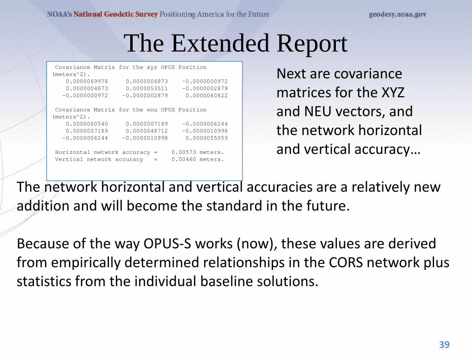
The Extended Report Next are covariance matrices for the XYZ and NEU vectors, and the network horizontal and vertical accuracy… The network horizontal and vertical accuracies are a relatively new addition and will become the standard in the future. Because of the way OPUS-S works (now), these values are derived from empirically determined relationships in the CORS network plus statistics from the individual baseline solutions.
39
Covariance Matrix for the xyz OPUS Position (meters^2). 0.0000069978 0.0000004873 -0.0000000972 0.0000004873 0.0000053511 -0.0000002879 -0.0000000972 -0.0000002879 0.0000040822 Covariance Matrix for the enu OPUS Position (meters^2). 0.0000060540 0.0000007189 -0.0000006244 0.0000007189 0.0000048712 -0.0000010998 -0.0000006244 -0.0000010998 0.0000055059 Horizontal network accuracy = 0.00573 meters. Vertical network accuracy = 0.00460 meters.

The Extended Report. Additional information related to the derivation of NAD 83(2011) vector components… You’ll see four “blocks”: the reference sites’ ARP and MON coordinates, their velocities and the solution vector components all expressed in the NAD 83(2011) frame.
40
Derivation of NAD 83 vector components Position of reference station ARP in NAD_83(CORS96)(EPOCH:2002.0000). Xa(m) Ya(m) Za(m) P376 -2469806.16816 -3788349.79220 4482853.31622 2002.00 MCSO -2458668.34414 -3792428.66602 4485327.16392 2002.00 STAY -2455840.11392 -3807675.15002 4474103.71103 2002.00 Position of reference station monument in NAD_83(CORS96)(EPOCH:2002.0000). Xr(m) Yr(m) Zr(m) P376 -2469806.16496 -3788349.78730 4482853.31032 2002.00 MCSO -2458668.34414 -3792428.66602 4485327.16392 2002.00 STAY -2455840.11392 -3807675.15002 4474103.71103 2002.00 Velocity of reference station monument in NAD_83(CORS96)(EPOCH:2002.0000). Vx (m/yr) Vy (m/yr) Vz (m/yr) P376 0.00440 0.00380 0.00560 MCSO 0.00550 0.00260 0.00520 STAY 0.00460 0.00290 0.00490 Vectors from unknown station monument to reference station monument in NAD_83(CORS96)(EPOCH:2002.0000). Xr-X= DX(m) Yr-Y= DY(m) Zr-Z= DZ(m) P376 28616.43804 14471.37170 28116.64932 2002.00 MCSO 39754.25886 10392.49298 30590.50292 2002.00 STAY 42582.48908 -4853.99102 19367.05003 2002.00

The Extended Report The state plane coordinates expressed using the international foot or US Survey foot (depending on state legislation) rather than meters …
41
STATE PLANE COORDINATES - International Foot SPC (3601 OR N) Northing (Y) [feet] 347675.719 Easting (X) [feet] 7471572.725 Convergence [degrees] -1.98897513 Point Scale 0.99994603 Combined Factor 0.99992941

FILE: corv0590.05o 000416827 1008 NOTE: Antenna offsets supplied by the user were zero. Coordinates 1008 returned will be for the antenna reference point (ARP). 1008 NGS OPUS SOLUTION REPORT ======================== USER: [email protected] DATE: January 13, 2006 RINEX FILE: corv059f.05o TIME: 19:08:14 UTC SOFTWARE: page5 0601.10 master3.pl START: 2005/02/28 05:00:00 EPHEMERIS: igs13121.eph [precise] STOP: 2005/02/28 06:59:30 NAV FILE: brdc0590.05n OBS USED: 4228 / 4314 : 98% ANT NAME: ASH700936B_M NONE # FIXED AMB: 25 / 29 : 86% ARP HEIGHT: 0.0 OVERALL RMS: 0.013(m) REF FRAME: NAD_83(CORS96)(EPOCH:2002.0000) ITRF00 (EPOCH:2005.1596) X: -2498423.165(m) 0.018(m) -2498423.872(m) 0.018(m) Y: -3802822.048(m) 0.021(m) -3802820.836(m) 0.021(m) Z: 4454737.695(m) 0.024(m) 4454737.792(m) 0.024(m) LAT: 44 35 7.91054 0.002(m) 44 35 7.92698 0.002(m) E LON: 236 41 43.48129 0.014(m) 236 41 43.42434 0.014(m) W LON: 123 18 16.51871 0.014(m) 123 18 16.57566 0.014(m) EL HGT: 107.485(m) 0.034(m) 107.108(m) 0.034(m) ORTHO HGT: 130.010(m) 0.043(m) [Geoid03 NAVD88] UTM COORDINATES STATE PLANE COORDINATES UTM (Zone 10) SPC (3601 OR N) Northing (Y) [meters] 4936954.907 105971.557 Easting (X) [meters] 475821.322 2277335.385 Convergence [degrees] -0.21381402 -1.98897497 Point Scale 0.99960719 0.99994603 Combined Factor 0.99959034 0.99992918 US NATIONAL GRID DESIGNATOR: 10TDQ7582136955(NAD 83) BASE STATIONS USED PID DESIGNATION LATITUDE LONGITUDE DISTANCE(m) AH2489 NEWP NEWPORT CORS ARP N443506.072 W1240342.736 60138.7 AJ6959 CHZZ CAPE MEARS CORS ARP N452911.437 W1235841.187 113322.4 DH4503 P376 EOLARESVR_OR2004 CORS ARP N445628.313 W1230608.100 42648.2 NEAREST NGS PUBLISHED CONTROL POINT AH2486 CORVALLIS CORS ARP N443507.910 W1231816.519 0.0
OPUS Output - Standard FILE: corv0590.05o 000416827 1008 NOTE: Antenna offsets supplied by the user were zero. Coordinates 1008 returned will be for the antenna reference point (ARP). 1008 NGS OPUS SOLUTION REPORT ======================== USER: [email protected] DATE: January 13, 2006 RINEX FILE: corv059f.05o TIME: 19:08:14 UTC SOFTWARE: page5 0601.10 master3.pl START: 2005/02/28 05:00:00 EPHEMERIS: igs13121.eph [precise] STOP: 2005/02/28 06:59:30 NAV FILE: brdc0590.05n OBS USED: 4228 / 4314 : 98% ANT NAME: ASH700936B_M NONE # FIXED AMB: 25 / 29 : 86% ARP HEIGHT: 0.0 OVERALL RMS: 0.013(m) REF FRAME: NAD_83(CORS96)(EPOCH:2002.0000) ITRF00 (EPOCH:2005.1596) X: -2498423.165(m) 0.018(m) -2498423.872(m) 0.018(m) Y: -3802822.048(m) 0.021(m) -3802820.836(m) 0.021(m) Z: 4454737.695(m) 0.024(m) 4454737.792(m) 0.024(m) LAT: 44 35 7.91054 0.002(m) 44 35 7.92698 0.002(m) E LON: 236 41 43.48129 0.014(m) 236 41 43.42434 0.014(m) W LON: 123 18 16.51871 0.014(m) 123 18 16.57566 0.014(m) EL HGT: 107.485(m) 0.034(m) 107.108(m) 0.034(m) ORTHO HGT: 130.010(m) 0.043(m) [Geoid03 NAVD88] UTM COORDINATES STATE PLANE COORDINATES UTM (Zone 10) SPC (3601 OR N) Northing (Y) [meters] 4936954.907 105971.557 Easting (X) [meters] 475821.322 2277335.385 Convergence [degrees] -0.21381402 -1.98897497 Point Scale 0.99960719 0.99994603 Combined Factor 0.99959034 0.99992918 US NATIONAL GRID DESIGNATOR: 10TDQ7582136955(NAD 83) BASE STATIONS USED PID DESIGNATION LATITUDE LONGITUDE DISTANCE(m) AH2489 NEWP NEWPORT CORS ARP N443506.072 W1240342.736 60138.7 AJ6959 CHZZ CAPE MEARS CORS ARP N452911.437 W1235841.187 113322.4 DH4503 P376 EOLARESVR_OR2004 CORS ARP N445628.313 W1230608.100 42648.2 NEAREST NGS PUBLISHED CONTROL POINT AH2486 CORVALLIS CORS ARP N443507.910 W1231816.519 0.0
<?xml version="1.0" encoding="UTF-8"?> <OPUS_SOLUTION> <USER_INFORMATION> <USER_EMAIL> [email protected] </USER_EMAIL> <SOLUTION_DATE> February 19, 2008 </SOLUTION_DATE> <SOLUTION_TIME> 01:16:22 UTC </SOLUTION_TIME> <RINEX_FILE_NAME> zzyy1500.07o </RINEX_FILE_NAME> </USER_INFORMATION> <DATA_INFORMATION> <SOFTWARE> <PAGES_VERSION> page5 0612.06 </PAGES_VERSION> <OPUS_VERSION> master3.pl </OPUS_VERSION> </SOFTWARE> <EMPHEMERIS> igs14293.eph [precise] </EMPHEMERIS> <NAV_FILE> brdc1500.07n </NAV_FILE> <ANTENNA_NAME> TRM41249.00 NONE </ANTENNA_NAME> <ARP_HEIGHT> 0.0 </ARP_HEIGHT> <START_TIME> 2007/05/30 00:00:00 </START_TIME> <END_TIME> 2007/05/30 23:59:00 </END_TIME> <OBS_USED> <NUMBER_USED> 52955 </NUMBER_USED> <TOTAL_OBS> 55069 </TOTAL_OBS> <PERCENTAGE> 96 </PERCENTAGE> </OBS_USED> <FIXED_AMB> <NUMBER_FIXED> 218 </NUMBER_FIXED> <NUMBER_AMB> 242 </NUMBER_AMB> <PERCENTAGE> 90 </PERCENTAGE> </FIXED_AMB> <OVERALL_RMS UNIT="m"> 0.021 </OVERALL_RMS> </DATA_INFORMATION> <POSITION> <REF_FRAME> NAD_83(CORS96) </REF_FRAME> <EPOCH> 2002.0000 </EPOCH> <COORD_SET> <RECT_COORD> <COORDINATE AXIS="X" UNIT="m" UNCERTAINTY="0.003"> -496255.901 </COORDINATE> <COORDINATE AXIS="Y" UNIT="m" UNCERTAINTY="0.022"> -5510741.494 </COORDINATE> <COORDINATE AXIS="Z" UNIT="m" UNCERTAINTY="0.017"> 3162058.243 </COORDINATE> </RECT_COORD> <ELLIP_COORD> <LAT> <DEGREES> 29 </DEGREES> <MINUTES> 54 </MINUTES> <SECONDS> 48.44070 </SECONDS> <UNCERTAINTY> 0 003 </UNCERTAINTY>
OPUS Output - XML

OPUS-RS. . .rapid-static processing
• A Little OPUS-RS History. • The OPUS-RS Interface. • How Good Can I Do With OPUS-RS? • A Quick Example (cont.). • The Extended Report (cont.). • How Does OPUS-RS Work? • OPUS-S and OPUS-RS Uploads By Month.
43

A Little OPUS-RS History
Although successful, OPUS obviously does not satisfy the needs of all users. Discussions with the user community about future development began almost immediately after OPUS was made public. These early discussions clearly indicated that the most desired enhancement would be a tool capable of producing a similar quality result from a shorter data span.
44

A Little OPUS-RS History Work by several groups demonstrated that reliably producing results of similar quality to OPUS from shorter data spans was possible. Collaboration between the NGS and the Satellite Positioning and Inertial Navigation (SPIN) group at The Ohio State University enabled Schwarz (DST) to implement a new processing engine capable of generating those results. In early 2007, OPUS-RS was made publically available after its own trial period. To better delineate uses, the original OPUS processing stream was renamed OPUS-S.
45
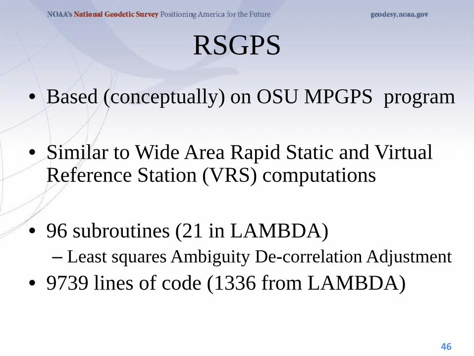
RSGPS
• Based (conceptually) on OSU MPGPS program
• Similar to Wide Area Rapid Static and Virtual Reference Station (VRS) computations
• 96 subroutines (21 in LAMBDA) – Least squares Ambiguity De-correlation Adjustment
• 9739 lines of code (1336 from LAMBDA)
46
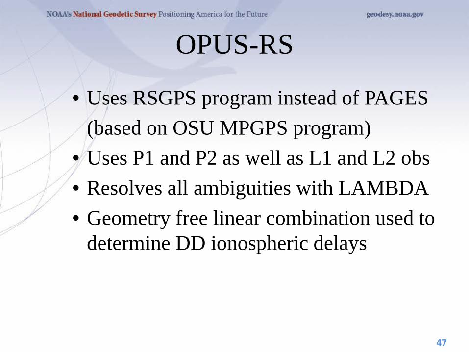
OPUS-RS
• Uses RSGPS program instead of PAGES (based on OSU MPGPS program) • Uses P1 and P2 as well as L1 and L2 obs • Resolves all ambiguities with LAMBDA • Geometry free linear combination used to
determine DD ionospheric delays
47
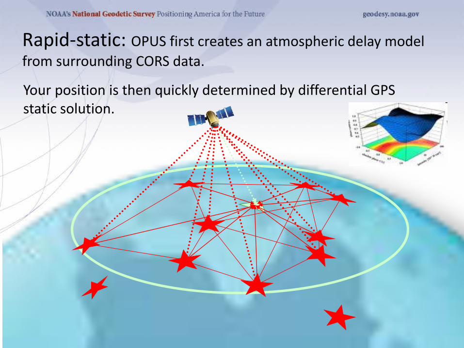
Rapid-static: OPUS first creates an atmospheric delay model from surrounding CORS data.
Your position is then quickly determined by differential GPS static solution.
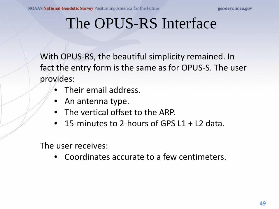
The OPUS-RS Interface
With OPUS-RS, the beautiful simplicity remained. In fact the entry form is the same as for OPUS-S. The user provides:
• Their email address. • An antenna type. • The vertical offset to the ARP. • 15-minutes to 2-hours of GPS L1 + L2 data.
The user receives:
• Coordinates accurate to a few centimeters.
49

The same interface is used except one clicks the “Upload to RAPID-STATIC” button instead.
The OPUS-RS Interface
50
http://geodesy.noaa.gov/OPUS/

A Quick Example
Shown here is part of the OPUS-RS report for the same CORV data discussed earlier. The results differ by 2.4 cm horizontally and 0.2 cm vertically from the accepted position projected to the epoch of the data.
51
USER: [email protected] DATE: April 01, 2010 RINEX FILE: corv059f.09o TIME: 16:17:51 UTC SOFTWARE: rsgps 1.35 RS11.prl 1.57 START: 2009/02/28 05:00:00 EPHEMERIS: igs15206.eph [precise] STOP: 2009/02/28 06:59:30 NAV FILE: brdc0590.09n OBS USED: 5652 / 11169 : 51% ANT NAME: ASH700936C_M QUALITY IND. 48.23/108.85 ARP HEIGHT: 1.521 NORMALIZED RMS: 0.280 REF FRAME: NAD_83(CORS96)(EPOCH:2002.0000) ITRF00 (EPOCH:2009.15959) X: -2498422.589(m) 0.015(m) -2498423.330(m) 0.015(m) Y: -3802821.147(m) 0.012(m) -3802819.929(m) 0.012(m) Z: 4454736.644(m) 0.021(m) 4454736.717(m) 0.021(m) LAT: 44 35 7.91061 0.004(m) 44 35 7.92619 0.004(m) E LON: 236 41 43.48069 0.011(m) 236 41 43.42230 0.011(m) W LON: 123 18 16.51931 0.011(m) 123 18 16.57770 0.011(m) EL HGT: 105.986(m) 0.026(m) 105.602(m) 0.026(m) ORTHO HGT: 128.517(m) 0.030(m) [NAVD88 (Computed using GEOID09)] UTM COORDINATES STATE PLANE COORDINATES UTM (Zone 10) SPC (3601 OR N) Northing (Y) [meters] 4936954.909 105971.559 Easting (X) [meters] 475821.309 2277335.372 Convergence [degrees] -0.21381414 -1.98897509 Point Scale 0.99960719 0.99994603 Combined Factor 0.99959058 0.99992942 US NATIONAL GRID DESIGNATOR: 10TDQ7582136954(NAD 83) BASE STATIONS USED PID DESIGNATION LATITUDE LONGITUDE DISTANCE(m) DH4503 P376 EOLARESVR_OR2004 CORS ARP N445628.313 W1230608.100 42648.2 DG5352 STAY STAYTON COOP CORS ARP N444950.530 W1224915.036 47030.9 DE6258 MCSO MARION CNTY COOP CORS ARP N445825.701 W1225720.639 51226.8 DI7529 P367 NEWPRTAIR_OR2007 CORS ARP N443506.870 W1240341.598 60113.5
⁞
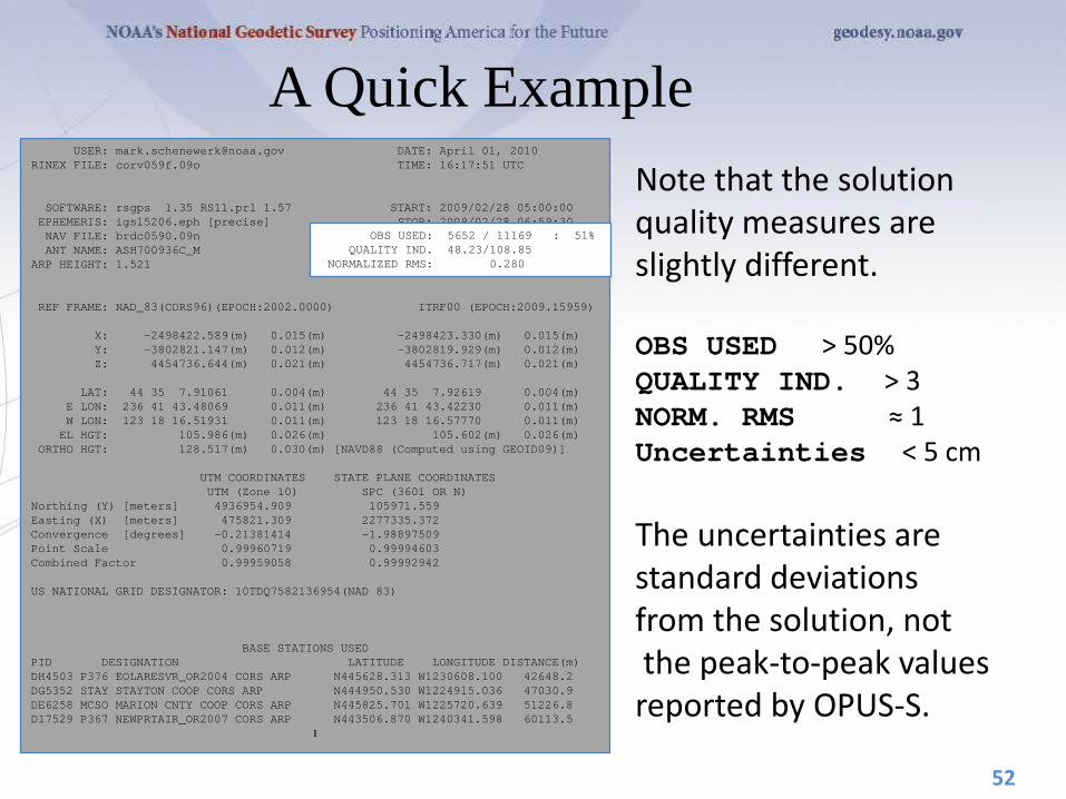
A Quick Example Note that the solution quality measures are slightly different. OBS USED > 50% QUALITY IND. > 3 NORM. RMS ≈ 1 Uncertainties < 5 cm The uncertainties are standard deviations from the solution, not the peak-to-peak values reported by OPUS-S.
52
USER: [email protected] DATE: April 01, 2010 RINEX FILE: corv059f.09o TIME: 16:17:51 UTC SOFTWARE: rsgps 1.35 RS11.prl 1.57 START: 2009/02/28 05:00:00 EPHEMERIS: igs15206.eph [precise] STOP: 2009/02/28 06:59:30 NAV FILE: brdc0590.09n OBS USED: 5652 / 11169 : 51% ANT NAME: ASH700936C_M QUALITY IND. 48.23/108.85 ARP HEIGHT: 1.521 NORMALIZED RMS: 0.280 REF FRAME: NAD_83(CORS96)(EPOCH:2002.0000) ITRF00 (EPOCH:2009.15959) X: -2498422.589(m) 0.015(m) -2498423.330(m) 0.015(m) Y: -3802821.147(m) 0.012(m) -3802819.929(m) 0.012(m) Z: 4454736.644(m) 0.021(m) 4454736.717(m) 0.021(m) LAT: 44 35 7.91061 0.004(m) 44 35 7.92619 0.004(m) E LON: 236 41 43.48069 0.011(m) 236 41 43.42230 0.011(m) W LON: 123 18 16.51931 0.011(m) 123 18 16.57770 0.011(m) EL HGT: 105.986(m) 0.026(m) 105.602(m) 0.026(m) ORTHO HGT: 128.517(m) 0.030(m) [NAVD88 (Computed using GEOID09)] UTM COORDINATES STATE PLANE COORDINATES UTM (Zone 10) SPC (3601 OR N) Northing (Y) [meters] 4936954.909 105971.559 Easting (X) [meters] 475821.309 2277335.372 Convergence [degrees] -0.21381414 -1.98897509 Point Scale 0.99960719 0.99994603 Combined Factor 0.99959058 0.99992942 US NATIONAL GRID DESIGNATOR: 10TDQ7582136954(NAD 83) BASE STATIONS USED PID DESIGNATION LATITUDE LONGITUDE DISTANCE(m) DH4503 P376 EOLARESVR_OR2004 CORS ARP N445628.313 W1230608.100 42648.2 DG5352 STAY STAYTON COOP CORS ARP N444950.530 W1224915.036 47030.9 DE6258 MCSO MARION CNTY COOP CORS ARP N445825.701 W1225720.639 51226.8 DI7529 P367 NEWPRTAIR_OR2007 CORS ARP N443506.870 W1240341.598 60113.5
⁞
OBS USED: 5652 / 11169 : 51% QUALITY IND. 48.23/108.85 NORMALIZED RMS: 0.280

A Quick Example Although the quality indices, normalized RMS and uncertainties are OK, the percentage of observations used gives this solution a . If you are uncomfortable with your solution, the same diagnostic steps discussed for OPUS-S can be applied here too.
53
USER: [email protected] DATE: April 01, 2010 RINEX FILE: corv059f.09o TIME: 16:17:51 UTC SOFTWARE: rsgps 1.35 RS11.prl 1.57 START: 2009/02/28 05:00:00 EPHEMERIS: igs15206.eph [precise] STOP: 2009/02/28 06:59:30 NAV FILE: brdc0590.09n OBS USED: 5652 / 11169 : 51% ANT NAME: ASH700936C_M QUALITY IND. 48.23/108.85 ARP HEIGHT: 1.521 NORMALIZED RMS: 0.280 REF FRAME: NAD_83(CORS96)(EPOCH:2002.0000) ITRF00 (EPOCH:2009.15959) X: -2498422.589(m) 0.015(m) -2498423.330(m) 0.015(m) Y: -3802821.147(m) 0.012(m) -3802819.929(m) 0.012(m) Z: 4454736.644(m) 0.021(m) 4454736.717(m) 0.021(m) LAT: 44 35 7.91061 0.004(m) 44 35 7.92619 0.004(m) E LON: 236 41 43.48069 0.011(m) 236 41 43.42230 0.011(m) W LON: 123 18 16.51931 0.011(m) 123 18 16.57770 0.011(m) EL HGT: 105.986(m) 0.026(m) 105.602(m) 0.026(m) ORTHO HGT: 128.517(m) 0.030(m) [NAVD88 (Computed using GEOID09)] UTM COORDINATES STATE PLANE COORDINATES UTM (Zone 10) SPC (3601 OR N) Northing (Y) [meters] 4936954.909 105971.559 Easting (X) [meters] 475821.309 2277335.372 Convergence [degrees] -0.21381414 -1.98897509 Point Scale 0.99960719 0.99994603 Combined Factor 0.99959058 0.99992942 US NATIONAL GRID DESIGNATOR: 10TDQ7582136954(NAD 83) BASE STATIONS USED PID DESIGNATION LATITUDE LONGITUDE DISTANCE(m) DH4503 P376 EOLARESVR_OR2004 CORS ARP N445628.313 W1230608.100 42648.2 DG5352 STAY STAYTON COOP CORS ARP N444950.530 W1224915.036 47030.9 DE6258 MCSO MARION CNTY COOP CORS ARP N445825.701 W1225720.639 51226.8 DI7529 P367 NEWPRTAIR_OR2007 CORS ARP N443506.870 W1240341.598 60113.5
⁞

The Extended Report Of necessity, the OPUS-RS extended report is larger than the corresponding OPUS-S solution. Too large to be conveniently shown here. But while seemingly intimidating, the OPUS-RS extended report sections are basically the same as those in the OPUS-S extended report. Some additional sections include:
• A covariance matrix for the reference-station-only solution.
• A correlation as well as a covariance matrix. • Various Dilutions Of Precision (DOPs).
54
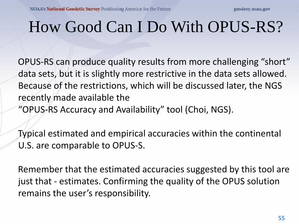
How Good Can I Do With OPUS-RS?
OPUS-RS can produce quality results from more challenging “short” data sets, but it is slightly more restrictive in the data sets allowed. Because of the restrictions, which will be discussed later, the NGS recently made available the “OPUS-RS Accuracy and Availability” tool (Choi, NGS). Typical estimated and empirical accuracies within the continental U.S. are comparable to OPUS-S. Remember that the estimated accuracies suggested by this tool are just that - estimates. Confirming the quality of the OPUS solution remains the user’s responsibility.
55

Snay, R., K. Choi, G. Mader, C. Schwarz, T. Soler, and N. Weston (2011). How precise is OPUS? Part 1: Experimental results, The American Surveyor, 8(5), 49-50, 52, 53-54.

How Good Can I Do With OPUS-RS?
http://www.ngs.noaa.gov/OPUSI/Plots/Gmap/OPUSRS_sigmap.shtml
57
The OPUS-RS Accuracy and Availability Tool.

How Good Can I Do With OPUS-RS? • 1 σ for each 0.2 degree grid. • Horizontal and vertical standard
errors for 15 minutes and 1-hour length data.
• Inverse Distance Weighting method to interpolate the sigmas.
• Areas outside the color overlay are where there are less than three active CORS sites within 250 km range. OPUS-RS will usually fail at these locations.
• Automated Weekly update o Use updated CORS list and observation data
availability • Global coverage including non-US territories.
58

How Does OPUS-RS Work?
OPUS-RS uses the RSGPS program which was developed specifically for this purpose. Like OPUS-S, OPUS-RS uses state-of-the-art models, but the strategy to fix phase ambiguities to their integer values differs. To fix integers, OPUS-RS introduces more information:
• Pseudorange and carrier phase. • More reference stations if possible.
60

How Does OPUS-RS Work? OPUS-RS selects three to nine “best” CORS based upon:
• Having common satellite visibility with the user data. • Having distances from the user’s site <250 km.
This is shown here graphically. The star represents the user’s site. The triangles are CORS. No CORS farther than 250 km from the user’s site will be included. The three CORS minimum is shown. No more than nine are used.
61
s 250km
Choi, 2010, personal communication.
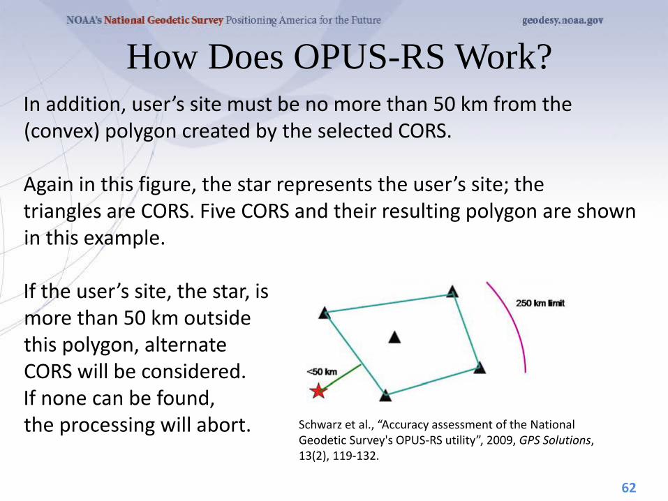
How Does OPUS-RS Work? In addition, user’s site must be no more than 50 km from the (convex) polygon created by the selected CORS. Again in this figure, the star represents the user’s site; the triangles are CORS. Five CORS and their resulting polygon are shown in this example. If the user’s site, the star, is more than 50 km outside this polygon, alternate CORS will be considered. If none can be found, the processing will abort.
62
Schwarz et al., “Accuracy assessment of the National Geodetic Survey's OPUS-RS utility”, 2009, GPS Solutions, 13(2), 119-132.
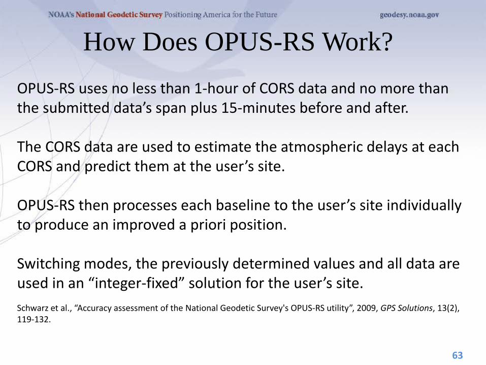
How Does OPUS-RS Work? OPUS-RS uses no less than 1-hour of CORS data and no more than the submitted data’s span plus 15-minutes before and after. The CORS data are used to estimate the atmospheric delays at each CORS and predict them at the user’s site. OPUS-RS then processes each baseline to the user’s site individually to produce an improved a priori position. Switching modes, the previously determined values and all data are used in an “integer-fixed” solution for the user’s site. Schwarz et al., “Accuracy assessment of the National Geodetic Survey's OPUS-RS utility”, 2009, GPS Solutions, 13(2), 119-132.
63
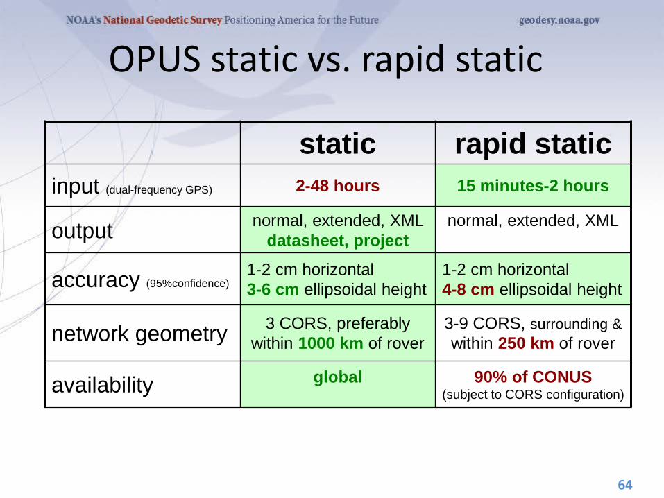
OPUS static vs. rapid static
static rapid static input (dual-frequency GPS) 2-48 hours 15 minutes-2 hours
output normal, extended, XML datasheet, project
normal, extended, XML
accuracy (95%confidence) 1-2 cm horizontal 3-6 cm ellipsoidal height
1-2 cm horizontal 4-8 cm ellipsoidal height
network geometry 3 CORS, preferably within 1000 km of rover
3-9 CORS, surrounding & within 250 km of rover
availability global
90% of CONUS (subject to CORS configuration)
64