
The Mineral Industries of Africa in 2000 - USGS Mineral Resources
USGS Research on Mineral Resources-1991 Program and Abstracts
Edited by ELIZABETH E. GOOD, JOHN F. SLACK, and WMA K. KOTRA
Seventh Annual V.E. McKelvey Forum on Mineral and Energy Resources, held in Reno, Nevada, February 17-14,lWl
U.S. CEOLOGICAL~SURVEV CIRCULAR 1062

U.S. DEPARTMENT OF THE INTERIOR
MANUEL LUJAN, Jr., Secretary
U,S. GEOLOGICAL SURVEY
Dallas L. Peck, Director
ORGANIZING COMMITTEE FOR 7T-E 1991 MCKELVEY FORUM
Rama K. Kotra, Chairman Robert A. Ayuso Harvey E. Belkin James P. Calzia Richard J. Gddfarb William F. Hanna Richard F. H d y m a n Thelma P, Harms Carroll Ann HDdges Thomas D. Light Melvin H. hdwysocki William 1. Ridley Michael G. Sawlan John F. Slack Bruce D. Smith Holly J. Stein Gary R. Winkler
UNITED STATES GOVERNMENT PRINTING OFFICE: 1991
Free on application to the Books and Open-File Reports Section U 5 . Geological Survey Federal Center, Box 25425 Denver, C O 80225
Librav of Congress Cataloging in Publication Data
ISSN 105L3899
Any use of trade. product, or firm names in this publication is for descriptive purposes only and does not constitute endorsement by the U. S. Government.
Applications of Gravity Data to Studies of Framework Geology, Evaluation of Mineral Deposits, and Mineral Prospecting in Northwestern Alaska
By David F. Barnes and John S . Kelley
More than 5,000 gravity measurements in the western Brooks Range, Alaska, aid in the interpretation af thrust- belt structures, estimation of the mass of two known mineral deposits, and possible identification of other undis- covered mineral deposits. The data set includes reconnais- sance measurements that use river gradients and altimetry for elevation control and have an accuracy of about 15 m, very detailed traverses over two ore deposits, where sur- veyed elevations are accurate to about 0.3 m, and 3,500 measurements with similar surveyed elevation control along seismic lines in the National Petroleum Reserve in Alaska (PIPRA) .
Geologic structures are reflected in an arcuate band of strongly positive isostatic anomalies that strike norlheast- ward approximately parallel to geologic grain across the western end of the Brooks Range. These anomalies are
Barnes and ~ e l l h 3
measurements with surveyed elevation control and \tation sepa~~t inns of ahout 400 m. Anomalies similar to those at Nirniuktuk and Red Dog appear in this data set as s i n ~ l e - station spikeq having amplitudes of 2-4 rnyal: initially. ~ u c h spikes were delered from the data set because they were
! considered either errors or anomalies loci narrow to repre- sent deep structure<. However. in 158 I . the entire data set
" w a ~ reviewed. and 12 sinple-station anornalie~ in areas geolc3gically favorable for mineralization and having ;aw-
j ciaied geochemical anomdie\ iverc selected for po\,ihle verificmion and reexamination. In the enwing 9 yr. only nne anomaly ha\ been reinve.;tjgatcd. Here the gravity and
. . . - :- ,,-,;, .= . L- ., 7J,* . ' elevation d:ita were verified. hut an adjacent bedrock
: 2 -k:, .. . , outcrop indicated that baqenlent topography beneath Qua-
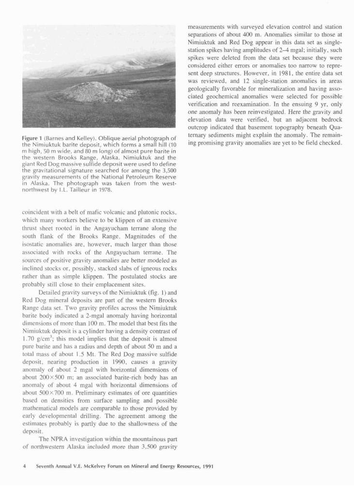
F i p r e 7 (Ramp5 and Kelley). Oblique aerial photograph of ternary sediments might explain the anomaly. The remain-
thl* Wimluktuk harirp denosit, which forms a .;mall hill (10 illg prorniqing ~ravit!, anomalies are yet to he held checked. m high, 50 m widc, ancl ti0 rn inng) of almost pure barite in the t V P c t P T R R ~ Q O ~ S Kan~e, Alaska. Nimiuktuk and the ghant Red Dog massive st~ltide depo5it were used to define the grav~tational qipnatwre s ~ a r c h e d for among the 3,F;Ofl grav~tv measurement$ o l t h ~ Nat~onal Petrol~urn Reqew~ In Alaska. The photograph was taken from the west- n n r l h i v ~ ~ t bv T.L. TailLeur in 1978.
c n i n c ~ ~ l e n ~ w ~ t h n belt nl- matic volcanic and plutonic mocks, which m:iny wnrkcrz believe to he klippen of an exrensive thn~<t sheet roatcd in the .4ngayucham terrane along the south fl;~nk 171' the R r n o k h Range. Magnitodes of the lvl\ti+tic ;~nclmalie.; :ire. however, much larger than thorr :~\\nci;ltell with rochr of the Angayucham terrane. The source6 of pnqirrve r a z . i t y anarn:ilj~s are better nodel led as inclincd \tc>ckh or. poqcihly. u;t~cked vlahq of igneous rocks rather thi~n \implc kllppen. Thc po\tulnted blockl; are prnhnhly rtill clcwe tn their emplncement \itel;.
Dct~~ilcd gravity surbcy of the Yimiuktuk (Ag. I ) and Red Dnc mineral drpncits are part o f the weqtern Rroclks R:inrc ~ l i ~ t i ~ ct ' l . Twn gr;lvily profile\ acnbs\ the Nilniuktuk hnrile bod! indic:~ted a 7-my1 anomaly hairin_c hnrirnnta! ~lirncn\~cbn< nf rr~ore lhan LOO n ~ . The model that hea t i rk the Piim~iiktuk dep~ci l is a cylinder havin? A Jenqity conrrast of 1.70 f/crn': thix model implies that the depmit i \ ;llrnoqt pUrt' barite :!nd hnc 3 T ; L ~ ~ I I F :~nd depth of a h u t 50 rn and a total m a w of ahnot 1.5 Mt. Tht. Red Dng rna5rit.c sulfide drpnuit. ncariny production In 1990, caukcc n pravitv rlnt~m:ll? of nhout 2 m p F with hori7nntal d i rncn~ion~ of ahou~ Inn SOfl n?; sn a~~c lc in led bari te-rich hod? ha\ an :tnomaly c)T i3hOt1t 4 rr~gal trrith hori7ontal dEmcn\icms of ahnut fiOnr7W m. Prel~minan, estirn;tfes r l f ore quantities b e d on cEen%itfe\ from surface sampling and pclssitrll: m:~rhcrnn!iual rnndels are cnrnparflhle 1t1 thrl.ce prrwiclcd by c:~rly cleirloprnent;il drilling. The agreetncnt among rhe c\tirn;~rei prnhahly i \ partly due to I ~ C ~hnllnwnew of thc dcpc~rit.
The NPR:"\nveqtigatinn within the rnountainou\ Fan of nc~rthu.ectcrn Alackn incltrded more than 3.5M _cmvit~.
4 Ser rnth Annual V.E. McKelvev Forum on Mineral and Fnergv Resources, 1491

Assessment bf Undiscovered Mineral Resources, Tongass National Forest, Southeastern Alaska
By David A. Brew, Lawrence J. Drew, Jeanine M. Schmidt, David H. Root, and Donald F. Huber
The Tongass Natimd Fmst is the Nation's largest natIonaI forest; it covers about 70,000 km2, which is more than 80 percent of southeastern Alaska (fig. 1). The U.S. Forest Service, which is revising the Tongass Land Man- agement Plan, has requested remum information from many sources. has analyzed and interpreted the infoma- tion. and has prepared a h f t Environmental Impact Statement. It is now reviewing the comments thereon and revising the alternatives prior to releasing the Final Envi- ronmental Impact Statement. The Forest Service is atternpt- ing to include mineral-resource data in the plan.
The U.S. Geological Survey (USGS) has been con- tinuously active in southeastern Alaska since 1956 and is cwrently conducting a probabilistic assessment of the undiscovered mineral resonrces of lthe region. This regional assessment is based largely on previously completed assess- ments of individual Wilderness Areas, Wilderness Study Areas, and quadrangIes that make up aImost all of south- eastern Alaska and that have been mapped at the scale of 1:251),000 as part of the Alaska Mineral Resources Assess- ment Project. These previously completed assessments w m based on USGS reconnaissance geologic, gemhemi- cal, and gebphysical mapping that has been reponed in USGS publications. A few assessments were joint WSGS- U.S. Bureau of Mines (USBM) efforts, and one is primarily a joint effort by the USBM and the State of Alaska Division of Geological and Geophysical Surveys. Only 4 of the 15 quadrangles in southeastern Alaska are not included in a preexisting assessment; however, 2 of the 4 are already studied.
The available data on regional geology, economic geology, stream-sediment and panaedconcentmte geo-
'Figure 1 (Brew and others). Location of the Tongass National Forest in southeastern Alaska.
chemistty , bedrock geochemistry, and mineral resources were reviewed at the 1:250,000 scale along with aemmag- netic, gravity, aeroradiometric. and telegeologic in fma- tion. One hundred twenty-seven mineral-resource tracts, ranging in area from 16 to 2,920 km? were identified as likely to contain undiscovered metallic minerd resources in 34 different types of deposits. Each tract was judged to contain one or more different types of mineral deposits. The number of as-yet-undiscovered deposits of each type dis- coverable by conventional mineral exploration rnethds was estimated for each tract at the 0.95, 0.90, 0.50, 0.10, and 0.05 probability levels. Many small tracts were combined to allow probabilistic assessment, but, because such assess- ments were not made of the smallest tracts or of tracts judged to be already well explored, we made final proba- bilistic assessments of 96 tracts containing 21 different types of deposits. Areas not assigned to tracts are inter- preted to lack undiscovered mineral deposits of the types specified.
Estimates of the number of deposits in each tract were used in combination with the worldwide tonnage and grade distributions for each deposit type to calculate a probabilis- tic undiscovered mineral-resource endowment for each tracf by means of the USGS MARK3 rnineral-resource- endowment simulator (Root and Scon, 1988). By Monte Carlo simulation, this computer program produces a distri- bution of tonnages for each metal contained in each deposit type in a given mct. When aggregated over aH deposit types. these distributions yield a probabilistic estimate of the undiscovered mineral resources in each tract. The estimates of mineral-resource endowment for all the indi- vidual tracts are combined to provide an aggregated esti- mate of the undiscovered mineral-resource endowment af the Tongass National Fotest and adjacent lands in south- eastern Alaska,
REFERENCE CSTED
Rmx. D.H., and Scott, W.A.. 1988, User manual for mineral simulation program: U.S. hiugtcacal Survey Open-File Repofi SR-15. 63 p.
6 Sewnth A n m t V.E. McKelwy FWVRE om Mineral and Energy R m r c e s , 1-1

REFERENCE CITED
Lipman, P.W., and Fridrich, C.J., 1990, Cretaceous caldera systems: Tucson and Sierrita .Mountains, in Gehrels, G.E., and Spencer, J.E., eds.. Geologic excursions through the Sonoran =sen region, Arizona and Sonora: Arizona Geological Survey Special Paper 7 , p. 5 1 4 5 .
laser-Microprobe Studies of Sulfur Isotopes in Stockwork and Massive Sulfide Ores, Rua Cove Mine, South-Central Alaska
By Douglas E. Crowe, Wayne C. Shanks Ill, and john W. Valley
Many of the massive sulfide deposits in h e Prince William Sound district of south-central Alaska (fig. I), which historically were interpreted as epigenetic vein and replacement deposits, recently have been reinterpreted as volcanogenic massive sulfide (VMS) deposits formed syn- genetically on or near the sea floor (Wiltse, 1973; Koski and others, 1985; Crowt and others, 1988). Understanding the origin of the deposits is critical for defining this region as a potential exploration target for VMS deposits. The mor- phologies and geologic settings of the deposits are consis- tent with Cyprus- and Besshi-type VMS models. The host rocks are predominantly flysch and dismembered ophiolite ofthe Chugach (Late Cretaceous) and Prince William (early Tertiary) temnes, which constitute the bulk of the rocks exposed in southern Alaska. Conventional analyses of stable sulfur isotopes show 6 3 4 ~ ranging from + 3.5 to +4.5 per mil; these values are consistent with a VMS model for the deposits but are not definitive. The major limitation to obtaining meaningful isotope data i s the fine-grained, inter- grown nature of the sulfide ores that typify the deposits.
A new laser-microprobe technique for performing micro-scale stable-isotope analyses (Crowe and others,
Figure 1 (Crowe and others). Tectonostratigraphic terranes and locations of mines in selected historically significant massive sulfide deposits in south-central Ataska. 1, Rua Cove mine; 2, Lynx Creek mine; 3, Standard Copper mine; 4, Ellamar mine; 5, Port Fidalgo mine; 6, Beatson mine.
1990) allows us to measure sulfur-isotope ratios of individ- ual minerals in fine-grained slabbed samples. Sulfur-isotope data were collected at the University of Wisconsin, Madi- son, by using a Nd-YAG (yttrium-duminum-garnet) laser connected to an isotope-ratio mass spectrometer. A similar system (which uses a CO, laser) at the U.S. Geological Survey in Reston, Va., is shown in figure 2, Laser- microprobe sulfur-isotope data for samples from the Rua Cove mine, Prince William Sound, provide new evidence that many of these deposits are syngenetic.
Conventional combustion-extraction measurements of S 3 4 ~ from hand-picked coexisting chalcopyrite-pyrrhotite (cp-pa) pairs (fig. 3) from both the massive sulfide blanket and the underlying stockwork feeder zone indicate isotopic disequilibrium; pyrrhotite is slightly depleted in in contrast to the expected equilibrium enrichment with respect to chalcopyrite. The conventional data are inconsis- tent with ore formatian by epigenetic replacement and vein mineralization or by syngenetic precipitation in the stock- work zone of a YMS deposit, Physical separation of the cp-po pairs is difficuIt because the samples are fine grained; thus, the results obtained conventionally are suspect.
Laser-microprobe analyses of the same samples (fig. 3) reveal that the stockwork sulfide pairs are in isotopic equilibrium if A,,, = 1.4 per mil at the 300 "C tempera- ture indicated by fluid-inclusion homogenization data. However, the massive sulfide sample analyzed by laser microprobe shows an average A,,, = 2.1 per mil: this value suggests either lower temperature precipitation or rapid quenching. These data are inconsistent with epige-
Cmwe and others 13

Figure 2 (Crowe and others). COZ laser microprobe connected to an isotope-ratio mass spectrometer at the U.S. Geological Survey in Reston, Va. The equipment i s used to determine sulfur-isotope ratios for individual minerals in fine-grained slabbed rocks, Photograph by W.C. Shanks 111 in 1990.
Figure 3 (Crowe and others). Conventionat and taser- microprohe data for sulfur isotopes from the Rua Cove mine. The fine-grained, intergrown nature of the chalcopy rite-py rrhotite (cp-pol pairs made conventional mineral separation difficult; this difficulty is reflected in the nearly identical 8 3 4 ~ values for these sulfides, The laser-microprobe data indicate equilibrium d45 values for the stockwork pairs and lower temperature or disequilib- rium 6"s values for the massive sulfide pairs.
nerir vein or replacement fonation under equilibrium conditions at ~imitar temperatures, where spatial variations in tempemure requited to produce & variations of this magnitude are uncommon, The laser-microprobe data are consistent with the predicted isotopic values for sulfide mineral pairs from the physicochemically distinct stock- work and massive sulfide environments,
REFERENCES QTED
Crowe, D.E., Nelson. S.W., Brown, P.E.. and Shrinks, W.C.. 111, 1988. Shhlc isorow nnd fluid inclusion investigation of rnaqsive sulfide dcposit~, Owir and Vnldez Groups, Alnskn-Evldsncc for synge- neiic suifide dcplsition [ah.]: Geologicel Society of Amcr~ca A b s m 9 w11b h)g%am. v. 20, no. 7, p. 153.
&we, D.F.. Valley. J.W.. and Bnker. K.B.. 1990. Micro-analysis of sulfur-isotop ntios and mnatiun by l a m micropoprube: Geochirnia e! Cosmoch~mica Acra. v. 54. p. 2075-2092.
Koski, R., Silbcrninn, M.L., Nelson, S . W . , and hnoul in . J.A., 1985. Run Cove -Anatomy of volcanogcnic Fe-Cu sulfide d c p ~ i t in ophiolitc on Knight Island, Alaska Inhs.1: American As.~oci~tion nf Petrolcum GcoIogists Bulletin, v , 69, p, 667.
W i l e , M.A.. 1973. Fc-Cu massive sullidc dqmirs in ancient oum-arc ridge-mnch slop envimnmnts tabs.]: Gtological Society of Amer- ica Abtracls with Pmgmrns, v. 5 , no, 1 , p. 1?2-127,
14 Seventh Annual V.E. McKelvey Forum on Mineral and Energy Resources, 1991

Lithologic and Tectonic Controls on Mercury Mineralization in the Bethel 1" x 3' Quadrangle, Southwestern Alaska
By Thomas P. Frost and Stephen E, Box
As part of the Alaska Mineral Resources Assessment Project (AMRAP), 1,486 stream-sediment and 1,104 heavy-mineral-concentrate samples were collected from first- and second-order streams from 1987 to 1989 in the Bethel l o X 3' quadrangle and in the southern part of the Russian Mission quadrangle in southwestern Alaska. In addition, 1,375 bedrock samples were analyzed. Mercury and, to a lesser extent, arsenic contents are closely linked to locally subtle variations in bedrock lithology and to major structural elements in the area.
The region is underlain by at least five pre-rnid- Cretaceous tectonostratigraphic terranes (fig. 1). Protero- zoic orthogneisses and granitic rocks make up the Kilbuck terrane; Paleozoic and Mesozoic arc- and oceanic-affini~ rnetabasalts, metacherts, clastic rocks, and minor marble are present in the Goodnews, Togiak, and Tikchik terranes; and Mesozoic arc volcanic rucks make up the Nyac temne. Unconformably overlying all but the Nyac terrane is the b w e r and Upper Cretaceous Kuskokwim Group, which consists predominantly of marine turbidites. Shallow- marine to deep-marine conglomerates and sandstones are present above a basal unconformity in the central part of the Kuskokwim basin.
The Kuskokwim Group can be divided into three belts, each having a distinct provenance. The wefitern k l t consists of an eastward-prograding deltaic sequence derived from an enigmatic chert-rich source area not presently exposed in the Bethel region, The basement on which the westernmost chert-rich facics was deposited is also not exposed. The eastern belt rests unconformably on the Togiak terrane and consists of turbiditic base-of-slope deposits derived from an eroded volcanic source. The central belt was deposited in a northeastward-flowing sub- marine fan system, which received sediment from both flanks and from a southern high-grade metamorphic source. The Kuskokwim Group was complexly deformed prior to the Late Cretaceous to early Tertiary magmatic episode.
Frost and Box 29

Granitic to granodioritic rocks of Early Cretaceous
EXPLANARON
-."' Fault - Dashd w h m n p ~ k m . 1 e . kited whpe i n f m d /--- -A ~ h r u s t fault - ~ c e t h on upperplalc
Overlap wqueucw
Surfiaal -1s (Qomary)
Volcanic locks (early Twrimy and Inte C r a w l -- Basalt R, rhvolis flows and domes includes m e hypbyssal'mcb.
TKg + Grnnitic to ginnodi~lic plutons (early Tatlary and Lab
Kwkokwim Caoup (Law and Early Cremcewr) -- Consists of:
T o w terrare Ewly Ckcacbous o Lace Wassic) -- Andepitic V & ~ P mcks, vokaniclastic rocks. ~ l l d
Nyw: -t HM Mlddle J d ) -- Andesiric wlcanic rock and rninorvolcaniclasiic
i m m e (MSOW=K: and Pa!&&) -- Tuffms arglUi% chctt, b d t , merabasite, metachen. and wrble
Kilbuck tprant IRwmmic) -- Amphibolite f a c k wtbgneiss with minm arnphibolile and quw&micrt schist
Figure 1 (Frost and Box). Regional geology of the Bethel quadrangle and parts of the Russian Mission and Good- news quadrangles, southwestern Alaska. The Rainy Creek locality is indicated by a star.
age were emplaced only in the Nyac terrane. Similar plutons (73-55 Ma) were emplaced in the older terranes to the east and in the overlying Kuskokwim Group. Wall rocks generally are metamorphosed to biotite and cordierite horn- fels within a kilometer of the intrusive contacts.
Latest Cretaceous and early Tertiary intermediate to silicic volcanic fields and hypabyssal intrusions were erupted through both the eastern volcaniclastic and western chert-rich facies of the Kuskokwim Group. Rhyolite domes and ash-flow tuffs, which may be part of the western volcanic field, also were erupted through the andesitic volcanic rocks of the Nyac terrane, the westernmost of the exposed basement terranes. Dikes of andesitic to dacitic composition are common throughout the Kuskokwim Group and older rocks, although their relationship to the volcanic fields i s uncertain.
Anomalous mercury contents are present in sedimen- tary rocks of the Kuskokwim Group (0.5-1.1 ppm Hg), in overlying volcanic rocks (0.5-11 ppm Hg), and in stream sediments (1->36 pprn Hg) wherever the eastern volcani- clastic facies of the Kuskokwim Group i s exposed in the region. The epithermal Rainy Creek mercury prospa (Sainsbury and MacKevett, 1965) at the southern edge of the Bethel quadrangle is hosted by the eastern vo~canicIastic facies of the Kuskokwim Group. Anoinalous mercury concentrations 11-10 ppm) also are present in stream- sediment samples from just west of the eastern volcaniclas- tic facies of the Kuskokwim Group, where it is strongly deformed by east-dipping thrust faults in the southern part of the map area.
Despite similarities in age, lithology, and bulk chem- istry, the western and eastern Late Cretaceous to early Tertiary volcanic fields have significant differences in their potential for mercury mineralization. The volcanic rocks ernplaced through the eastern voIcaniclastic facies of the Kuskokwim contain anomalous mercury, whereas those emplaced through the western chert-rich facies contain significantly less mercury. In addition to many stream- sediment samples that have anomalous mercury concentra- tions and to heavy-mineral concentrates that contain cinna- bar, some rhyolite samples from the eastern field contain more than 34, ppm mercury. The western volcanic field has few mercury anomalies in any sample media that are clear1 y relared to the volcanic rocks or to underlying Kuskokwim sedimentary rocks. Arsenic anomalies show some overlap with the mercury anomalies but are more heavily concen- trated in the Togiak terrane beneath the eastern edge of the Kuskokwim Group. The difference in mercury content between the eastern and western volcanic fields appears to reflect variations in the composition of the underlying Kuskokwim Group and its basement.
Mercury anomalies also are present in sediments from streams that drain serpentinite having silica-carbonate alter- ation along the Golden Gate and related faults that form the
30 Seventh Annual V.E, McKdvey Forum on Mineral and Energy Res~lrces, 1991

western boundary between the Kuskokwim Group and the Jurassic volcanic rocks of the Nyac terrane. Samples collected near the active Togiak fauIt in the southeastern corner of the area also contain anomalous mercury. Sedi- ment samples from streams draining several of the Creta- ceous granitic plutons also have anomalous mercury con- centrations, which suggest that the plutons may have mobilized mercury from the Kuskokwirn Group or the underlying basement.
Rocks having the greatest potential for undiscavered mercury deposits in the Bethel region are the eastern volcaniclastic facies of the Kuskokwim Group and volcanic rocks that were emplaced through the eastern volcaniclastic facies. Additional mercury deposits may be found in rocks associated with the major fault zones that form terrane boundaries.
UEYERENCE CITED
Sainsbury, C.L., and MacKevett, E.M., Jr., 1965, Quicksilver deposits of southwestern Alaska: U.S. Geological Survey Bulletin 1184, 89 p.

Synorogenic Auriferous Fluids of the Juneau Gold Belt, Southeast Alaska-Stable-Isotope Evidence for a Weep Crustal Origin
By R.J. Coldfarb and W.J. Pickthorn
Mesothermal gold deposits of the Juneau gold belt exknd for 200 km along both sides of the Coast Range megalineament, a major steeply dipping shear zone about 125 krn inland of the continental margin. Gold-bearing fissure veins, stockworks, and stringers were deposited in a variety of igneous and metasedimentary host rocks at 55 Ma; deposition took place at depths of at least 5-8 km during the late stages of activity in the mid-Cretaceous to Eocene southeast Alaska-British Columbia orogen. Fluid migration and vein emplacement were coeval with rapid uplift of host rocks along the western edge of the orogen. The source of the fluids responsible for mesothermal gold veins throughout the accreted terranes of the northern part of the cordillera is controversial. New stable-isotope data for minerals from auriferous veins and country rocks along the Juneau gold belt provide new information on the source of these ore fluids.
The &"0 values of gold-bearing quartz from mines of the gold belt range from + 15.2 to +20.8 per mil and thus indicate ore fluid values of -t 10.0k2.8 per mil at about 300 "C, as determined From fluid-inclusion studies. Similar 6180 values for quartz veins hosted by igneous and meta- sedimentary mks indicate little local wall-rock control on oxygen-isotope compositions. The also values are best interpreted as representative of a fluid in isotopic equilib- rium with pelitic metasedimentary rocks. The narrow range in oxygen-isotope comp~sitions precludes the use of any fluid-mixing model for gold deposition along the gold belt. Calculated A'80,,,,, values of -0.2 to + 1.1 per mil for igneous rocks in the vicinity of the gold belt are suggestive of postcrystallization exchange between an isotopically heavy metamorphic fluid and the igneous rocks.
HydmthermaI micas from many of the gold deposits are characterized by ED values of -75 to -53 per mil. Ore fluids calculated to be in equilibrium with the micas have values of -35 to - 15 per mil. These data, as well as the gas gemhemistry of the fluids determined by fluid-inclusion investigations, are most consistent with a metamorphically derived ore fluid (fig. 1). Extracted fluid-inclusion waters from gold-bearing quartz have a broader range of ED, from -48 per mil in relatively undeformed veins to about - 1 10 per mil for more deformed veins. This range of greater than 60 per mil reflects various mixtures of fluids from inclu- sions containing isotopically heavy primary ore solurions
Figure 1 (Coldfarb and Pickthorn). Plot of 6''O versus SD showing the composition for the ore fluids calculated on the basis of isotopic measurements of quartz and micas. The field for 6D values determined from fluid-inclusion waters in quartz is significantly lighter. Specific deposits: I, lualin; K, Kensington; S,,, glassy quartz in calc-silicates at Sumdurn Chief-figure shows a shift to an anomalously heavy oxygen value because of low water:rock ratios in calc-silicates; C, Crystal; R, Reagan; E, EPU; A, Alaska- Juneau; T, Treadwell; 5, Sumdurn Chief. A meteoric water evolution path, calculated for Tertiary waters at 300 "C, indicates water:rock ratios required to reach various iso- topic compositions. In the calculations for the path, rneta- sedimentary rocks are assumed to have an average 6'*0 value of +I6 per mil and 6D of -60 per mil.
32 Seventh Annual V.E. McKeivey Forum on Mineral and Energy Resources, 1991

and those containing isotopically light meteoric waters lrapped during uplift of the veins to shallow crustal levels.
The large isotopic shifts from the meteoric water line required to attain the S180 and SD values of the ore fluids preclude significant contributions from meteoric sources in the ore-forming process. Required oxygen shifts of about 20 p r mil would necessitate water:mk ratios of less than 0.1; required hydrogen shifts demand ratios of even less than 0.01 (fig. 1). Such rock-dominated conditions are unlikely for any type of channelized, downward flow of meteoric waters into the deep crust. Rather, isotopically heavy fluids produced through prograde metamorphic reactions are more likely to have migrated upward during periods of failure along the Coast Range megalineamen t.

Geochemical Exploration Criteria for Epithermal Cinnabar and Stibnite Deposits, Southwestern Alaska
By J.E. Gray, D.E. Detra, R.J. Goldfarb, and K,E. Slaughter
Epithermal cinnabar- and stibnite-bearing vein sys- tems are scattered over several thousand square kilometers in southwestern Alaska. More than 40,000 flasks of mer- cury have been produced in the region. mostly from the Red Devil mine. Mineralized quartz-carbonate veins and stwk- works are found within Cretaceous basin-fill sedimentary m k s of the Kuskokwim Group and adjacent accretionary terranes. Many of the deposits are in or adjacent to brittle rocks, largely rnafic dikes, rhyolite dikes and sills, and

inremediate to felsic stscks, that intrude sedimentary rock. trations deeper in some of these cinnabar- and stibnite- Mineralized veins are commonly localized where bedding- bearing deposits. plane faults in surrounding sedimentary rocks intersect these more competent units. Cinnabar is the dominant ore mineral; it typically is accompanied by stibnite. Realgar, orpiment, pyrite, limonite, hematite, and native mercury are less common. Dickite is a typical alteration mineral at many of these occurrences.
In 1989, a geochemical orientation survey was con- ducted around several cinnabar and stibnite vein deposits. Stream-sediment, heavy-mineral-concentrate, stream-water and vegetation samples were collected in drainages surrounding the Red Devil, Cinnabar Creek, White Moun- tain, Rhyolite, and Mountain Top deposits. Three size fractions of the stream-sediment samples were selected for analysis. The heav y-mineral-concentrate samples were split into nonmagnetic, paramagnetic, and magnetic fractions. These samples and the stream-water and vegetation samples were analyzed for multielement suites by different chemi- cal procedures. Nonmagnetic heavy-mineral concentrates were also examined microscopically to identify their mineralogy.
Results confirm that Rg, Sb, and As in minus- I SO-mesh stream sediments are effective pathfinder elements 1 in exploration for epithermal cinnabar and stibnite occur-
rences. Concenrrxions greater than 3 pprn Hg, 1 pprn Sb, and 15 ppm As in the minus-80-mesh stream sediments, regardless of the host lithology. are indicative of upstream cinnabar and stibnite wcurrences in the Kuskokwim River region. Stream sediments coarser grained than minus- 80-mesh are less useful in the exploration for these mineral occurrences. Base metals in stream sediments and heavy- mineral concentrates are ineffective pathfinders for this eplthermal type of occurrence.
Heavy-mineral concentrates provide little additional advantage in the exploration for these mineral systems. Sb and As dispersion patterns downstream from mineralized areas are generally more restricted in heavy-mineral con- centrates than they are in the stream sediments. Distribution patterns of placer cinnabar observed in heavy-mineral concentrates are similar to those of anomalous Hg and Sb in corresponding stream sediments. Stream waters are a less effective geochemical sample medium than stream sedi- ments OT heavy-mineral concentrates, and vegetation sam- ples are ineffective geochemical sample media in explora- tion for this type of mineral occurrence.
Several of the epithermal cinnabar and stibnite vein deposits in the Kuskokwim River region contain anomalous gold concentrations. Gold contents in vein samples contain- ing cinnabar and stibnite range from 0.05 to 6.9 ppm. These concentrations indicate that gold may be a byproduct of some of these epithermal systems, which were previously recognized only for their Hg and Sb contents. The gold anomalies suggest the potential for significant gold concen-
Crimes and others 35

Comparative Metallogeny of the Soviet Far East and Alaska
By Donald I. Crybeck, Warren I . Nokleberg, and Thomas K. Bundtzen
For the last year and a half, we have been engaged in a systematic study with Soviet geologists from the Academy of Science and the Ministry of Geology of the rnetallogeny of the Soviet Far East and Alaska. In 1989, we spent more than a month visiting mineral depasi ts throughout the Soviet Far East and participated in extended discussions with Saviet geologists at numerous mines and research institutes. la rerum, last summer, two groups of Soviet geologists visited Alaska to examine important mineral deposits and to participate in workshops with American geologists.
The work to date has been productive. Numerous maps, pubIications , and data have already Been exchanged and are in the process of being integrated into a consistent description of the geology and metallageny of the Soviet Far East and Alaska. Differences remain, partly because of our different approaches to geology, but more often because both sides of the exchange have been introduced to new facets of the geology of the northern Pacific and to new types of mineral deposits. Fur instance, we visited the "Bor" deposit at Dalnegorsk in Primorye, which is a unique skam deposit that is the major source of boron in the Soviet Union. It was certainly unknown to us and apparently was unmentioned in the Western literature. As the work has progressed, we feel that there has been marked convergence in our thinking. We are confident that the result will be a joint publication (in English and Russian versions) describ- ing the mineral deposits of Alaska and the Soviet Far East in mutually agreeable terms and relating them to the geologic history of the two areas. Plans are underway to extend the work to the Canadian Cordillera.
This study is useful to both Soviet and American geologists because new knowledge and ideas are k i n g exchanged across the northern Pacific. In addition, it is particularly germane at this time because of the opportuni- ties that seem to be opening up for foreign investment in Soviet mineral deposits.

; Low-Level Cold Determinations by Use of Flow 1 Injection Analysis-Atomic Absorption Spectra-
photometry - An Application to Precious-Metal- Resource Assessment in the lditarod 1" x 3" Quadrangle, Southwestern Alaska
I By D.M. Hopkins, J .E . Gray, and K.E. Slaughter
I Low-level gold determinations were performed by the
U.S. Geologi~al Survey (USGS) to assess the precious- metal resources in the Iditarod lo X 3" quadrangle, Alaska, as part of the ongoing Alaska Mineral Resources Assess- ment Project, Flow injection analysis-atomic absorprion spectrophotometry (FIA-AAS) was used to determine gold concentrations in stream-sediment samples collected during a reconnaissance geochemical survey of the quadrangle.
The most common method for gold determination is separation from hydrochloric or hydrobromic acid solution with methyl isobutyl ketone (MIBK) and detection by
:means of flame atomic-absorption spectrophotornetry
(FAAS) or graphite-furnace atomic-absorption spectropho- tometry (GFAAS). Although FAAS i s less sensitive than GFAAS, some advantages of FAAS are ( 1) fewer problems with interference, (2) continuous monitoring of the analyte in a liquid stream, (3) suitability for online automated analysis, and (4') m m rapid determinations. Furthermore, FAAS procedures can be transformed conveniently into a FIA-AAS technique that uses solvent extraction and a 10-fold analyte precmcentration to produce a lower limit of determination, one that approaches the crustal abundance of gold (3-5 ppb). Thus, the analysis of gold at concentrations that formerly required GFAAS is accomplished more effec- tively with the FIA-AAS technique.
The FIA-AAS technique uses a sample weight of 10 g for digestion with a hydrobromic acid-bromine solution. Gold is extracted from the acid mixture with 1 mL of MIRR; a 20-fold preconcentration and a detection limit of 5 ppb can be achieved. The flow injection device introduces 0.1 mL of MIBK extractant per determination into the spectrometer; more than 50 determinations per hour can be completed by this technique. Precision of the technique at the 100-ppb level is 14.3 percent relative standard deviation based on a 5-g aliquot of USGS reference GXR-2 in 1 rnL MIBK. Results for reference standards by this FlA-AAS technique agree well with values reported in the literature.
Approximately 12 percent of the stream-sediment samples from the Iditarod quadrangle contain greater than 5 ppb gold. Most of these samples cluster into 13 distinct areas, Five of these areas are associated spatially with Cretaceous-Tertiary volcano-plutonic complexes that intrude sedimentary rocks of the Cretaceous Kuskokwirn Group. Six other anomalous areas are near Cretaceous- Tertiary dikes or small stwks that intrude rocks of the Kuskokwim Group. One gold anomaly i s found in an area underlain by Cretaceous-Tertiary volcanic rocks of the Yetna field; another occurs in an area underlain by rocks of the Kuskokwim Group.
Samples that contain anomalous gold cluster in areas of known placer districts such as Flat, Moore Creek, and Donlin Creek. Gold anomalies are observed also in areas in which little or no gold had been reported previously, such as the Beaver Mountains, Mount Joaquin , and Granire Moun- tain. These anomalies probably are related to (1) vein deposits containing quartz, carbonate, fluorite, stibnite, cinnabar, gold, scheelite, and arsenopyrite similar to those near Flat or (2) veins containing chiilcopyrite, galena, sphalerite, cassiterite, tourmaline, and fluorite such as those in the Beaver Mountains. These gold anomalies cwrelate well with anomalous concentrations of Ag, Sb, As, CU, Pb, Zn, Sn, or W in stream-sediment or heavy-rnineml- concentrate samples. However, the low-level gold concen- trations in the stream-sediment samples most effectively define areas of precious-metal favorability in the I d i W quadrangle.
Hopkins and others 39

Mineral-Resource Potential of the Sitka 1" x 3" Quadrangle, Southeastern Alaska
By S.M. Karl, R.J. Goldfarb, K.D. Kelley, D.M. Sutphin, C.A. Finn, A.B. Ford, and D.A. Brew
The Sitka la X 3" quadrangle encompasses roughly 11,000 km2 in southeastern Alaska and contains sedimen- tary, volcanic, and plutonic rocks derived from Paleozoic and Mesozoic arc settings. Paleozoic rocks are assigned to the Alexander and Wrangellia terranes; three different Mesozoic arc assemblages are assigned to the Wrangellia, Alexander, and Chugach terrancs, respectively.
In ~e Sitka quadrangle, the Chichagof mining dis- trict, which has a history of activity that dates to the 1800's, was a leading producer of gold in Alaska until 1945. The opening of the Greens Creek mine, only a few kilometers north of the quadrangle, has renewed interest in the base- and precious-metal potential of the region.
Nine tracts havc been identified a$ having potential for certain types of mineral deposits because of the presence of known deposits, specific lithologic types, and geochem- ical and geophysical anomalies: (1 ) mafic-ultramafic synorogenic-synvolcanic Ni-Cu de-
posits in Tertiary norites on western Chichagof Island and eastern Yakobi Island;
(2) polymecaIIic veins and porphyry Mo-Cu deposits in Jurassic to Tertiary intermediate to felsic plutons on Chichagof and Baranof Islands;
(3) low-sulfide goldquartz veins within major fault zones on western Chichagof Island and Baranof Island and along Lisianski Inlet-Hoonah Sound;
(4) U, Th, and rate-earth elements in Paleozoic alkalic plutms on eastern Chichagof Island;
(5) marine evaporite gypsum and hydrothermal gypsum in Mississippian limestone on eastern Chichagof Island;
(6) volcanogenic massive sulfide deposits in Permian and Triassic volcanic and sedimentary rocks on central and eastern Admiralty Island;
(7) epithermal vein and hot-spring Au and Ag deposits in Tertiary volcanic rocks on southern Admiralty Island;
(8) skam, replacement, and polymetallic rein deposits in Paleozoic carbonate rocks intruded by late orogenic plutons on eastern Chichagof Island and Admiralty Island; and
(9) coal and sandstone U deposits in Tertiary nonrnarine clastic rocks on southern Admiralty Island.
In addition, scattered Iow-temperature geothermal systems are active on Baranof and Chichagof Islands.
The greatest resource potential for the area lies in tracts 3 (gold-quartz veins) and 6 (volcanogenic massive sulfide deposits). The gold-quartz veins, identified in 59 deposits in the western Chichagof gold belt, have yielded 800,000 oz of gold, mostly from the Chichagof and Hirst-Chichagof deposits. These deposits consist of ribbon
Karl and others 45

quartz filling northwest-trending shears. Gold is accornpa- nied by minor amounts of pyrite, usenopyrite, galena, sphalerite, pyrrhotite, and chalcopyrite. Fluid-inclusion analyses indicate that ore-forming fluids were low-salinity, aqueous-dominant solutions having trapping temperatures between 190 and 238 "C and trapping pressures in excess of 500 bars; these characteristics suggest a metamorphic ori- gin. The S " 0 values of quartz are 15.7-16.0 pw mil, which are typical of mesothermal hydrothermal systems. The SD values of fluid inclusions are equivocal; they range from -55 to - 110 per mil.
The main volcanogenic massive sulfide (VMS) deposits are Pyrola and several deposits near Pybus and Gambier Bays. They occur within the Retreat Group in a setting similar to that ofthe Greens Creek and other Triassic VMS deposits in a 350-km-long belt in southeastern Alaska. At Pyrola, massive basalt with chlorite-carbonate alteration overprinted by s e r i c i t e u - p i e alteration is in contact with fine-grained clastic and chemical sedimen- tary rocks. At this contact, p d s of massive pyrite, sphal- erite, and Ag-rich barite contain minor associated galena, chalcopyrite, jamesonite, and boulangerite. The deposit is underlain by a siliceous stockwork containing auriferous pyrite, and remobilized mineralization is present in later quartz veins.
Au, Bi, Cr, Cu, Mo, Pb, Sn, W, or Zn (Cieutat and others, 1988).
During the summer of 1990, additional rock samples were collected from several of the areas having geochemical anomal iea. In all the revisited drainage basins, strongly oxidized Cretaceous-Tertiary stocks of intermediate com- position and associated hornfels zones were observed, During the followup study, geochemical anomalies were identified in the following areas: (1) the Mt. Waskey-Rainbow basin region-samples of
quartz-arsenopyrite-pyrite veins and stockworks in granite and silicified argillite collectively contain max- . imum concentrations of 1.5 pprn Ag , > 1 0,000 pprn As,
1.4 ppm Au, 1,000 pprn Bi, 2,000 pprn Cu, 15 percent R, 50 pprn Mo, 200 pprn Sb, 20 pprn Sn, and 500 pprn Zn:
(2) a drainage basin south of Atshichlut Mountain-sam- ples of silicified, bleached, and Fe-stained argillite with minor pyrite veinlets collectively contain maximum concentrations of 100 pprn Ag, 0.40 ppm Au, >5,000 pprn Ba, 200 pprn Cu, 10 percent Fe, 1.8 pprn Hg, 50 pprn Ma, 300 pprn Pb, and 1,000 ppm Zn;
(3) the Trail Creek-Mt. Oratia area-samples of silicified quartz vein breccia, Ee-stained hornfels containing quartz-tourmaline stockworks, and silicified grayw acke with minor quartz veins contain maximum concentra-
Mineral-Resource Assessment of the Goodnews tions of 0.7 pprn Ag, 2,000 pprn As, 0.15 pprn Au, >2,000 ppm B , >5,000 pprn Mn, and 150 ppm Sb: and
I" 30 Quadrangle and Parts of the Hagemeis- (4) rhe west bank of the Togiak River-samples from an ter Island and Nushagak Bay Quadrangles, oxidized sohalerite-rich vein hosted in villow basalt Southwestern Alaska contain maximum concentrations of 5 ppm Ag, 0.35
By J.E. Kilburn, S.E. Box, R.j. Goldfarb, J.E. Gray, and J.L. Jones
pprn Au, 500 ppm Cd, 700 pprn Cu, 5 percent Fe, 10.4 pprn Hg , >5,000 pprn Mn, and > 10,000 pprn Zn.
Mineral resources were assessed id the Goodnews l o X 3" quadrangle and in parts of the Hagemeister 'Island and
REFERENCE CITED
Nushagak Bay quadrangles, which are of Bristol Bay Cieutat, B.A., Goldfarb, R.I.. and Speckman, W.S., 1988, Analytical in southwestern Alaska. The region is underlain largely by results and sample ltxality map of stream-sediment, hcavy-mineral- volcanic and sedimentary racks of the northeast-trending concentrate. and organic material fiamples rmm the Goodnews.
Togiak and Goodnews tectonostratigraphic temnes. Juras- Hagemeister Island. and Nushqak Bay quadrangles, southwest
sic ultrarnafic rocks and associated gabbros m most com- Alaska: U.S. Geological Survey Open-File Repwt Rg591, I88 p., 1 oversize sheet, scale 1:250,000. mon in the west near Goodnews Bay and Island Mountain.
Late Cretaceous to early Tertiary granitic stocks am wide spread, though they are more prevalent in the central and eastern parts of the study area. The ultrarnafic rocks south of Goodnews Bay have yielded high-grade platinum placers in the Salmon River and its tributaries. A few minor gold placers, an isolated sphalerite-rich vein, and an epithermal cinnabar lode are the only other documented mineral occurrences in the study area.
During the mineral assessment of the region in 1975-77, sweeam-sediment and heavy-mineral-concentrate samples were collected and analyzed. Geochemical data from these media delineate areas characterized by large elemental anomalies. The samples are enriched in Ag, As,
46 Swenth Annual V.E. McKelwy Forum on Mineral and Energy Resources, 1991

of Late Cretaceous and Palmene age. Paleocene and younger nonmarine volcanic and coal-bearing sedimentaq m k s overlap both the Peninsular terrane and the Chugach
Areas of Mineral-Resource Favorability (with Emphasis on Cold and Chromite) in the Anchorage I" x 3" Quadrangle, Southern Alaska
By D.J. Madden-McGuire and G,R. Winkler
The U. S. Geological Survey conducted geologic, geochemical, and geophysical investigations to determine areas of mineral-resource favorability in the Anchorage l o X 3" quadrangle. The quadrangle contains three major fault-bounded terranes that were acmted between mid- Cretaceous and early Tertiary time. The Peninsular terrane, hunded on the south by the Border Ranges fault system, comprises intrusive and extrusive phases of an early Mes- ozoic intsaoceanic magmatic arc and late Mesozoic marine sedimentary rocks deposited in forearc basins. The Penin- sular tesane i s intruded by voluminous composite plutons
terrane to the south. The Chugach terrane consists of Mesazoic polygenetic melange and accreted wedge.s of Upper Cretaceous flysch and minor metatuff, South of the Contact fault, the Prince William terrane consists of an accreted Paleugene deep-sea fan complex interbedded with minor tholeiitic basalt.
Gold. which is currently the commodity of greatest economic interest, has been produced from gold-quartz veins and related placer deposits in the Peninsular and Chugach terranes, primarily in the Willow Creek and Girdwood mining districts (fig. 1). The two areas that include the historic mining districn are assigned the highest and most certain levels of potential for gold-quartz veins and gold-placer deposits in the quad~angle.
In the Willow Creek district, high-sulfide gold- quartz-carbonate veins cut a pluton dated at 79-72 Ma (recording multiple stages of alteration) and adjacent pelitic schist. A fault contact between these host rocks might have served as a conduit for mineralizing fluids (mineralization occurred at 66 Ma and at 57-55 Ma). The extent of the high-potential area is defined by mineral deposits, geologic contacts, and panned concentrates that contain gold and are enriched in As, Ag, Sb, and Pb: stream sediments have anomalous As contents.
In the Girdwood district, Au and Ag are concentrated in quartz-carbonate veins within joints and shears in greenschist-facies metasedimentary rocks of Cretaceous age and Eocene quartz diorite (53 Ma). Mineralization is younger than 53 Ma. Elsewhere in the Valdez Group (in adjacent quadrangles), gold-quartz veins are younger than 34 Ma. Panned concenrrates from Crow Creek and sur- rounding drainages contain gold and locally are enriched in Ag, As, and Sb.
In Prince William Sound, areas around Rarriman Fiord and the Coghill River have been assigned a moderate resource potential because gold-quartz veins are exposed in a mine, in prospects, and in outcrop. Additional areas of moderate potential for gold-quam veins in the Chugach m a n e have been identified on the basis of the presence of gold in panned cwcentrates and, locally, in mineralized outcrops, A particularly large area of moderate potential for gold-quartz veins is between Mount Marcus Baker and the Border Ranges fault.
Podifom chromite occurs in the Peninsular terrane within two fault-bounded uItramafic compIexes neat Eklutna and in the upper part of Wolverine Creek on the north side of the Border Ranges fault (fig. 1 ) . Cumulate chromitite, having a moderate potential for Cr,O,, occurs within deformed cumulate dunite and wchrlite. Adjacent outcrops of uItrarnafic rocks have a moderate potential for Cr,O, but a lower level of certainty. Chromitite has not been observed in the serpentinized ultramafic rocks that
50 Seventh Annual V.E. McKelvey Forum on Mineral and Energy Resources, 1991

Gold m!n;lmg distrtcts
Moderate Low
Ftre t (Madden-McG~~ire and Winkler). Areas of favorability for goldquark veins and pocllform chromlte in the Anchorage 1" x 3" quadran~le, soul hern Alaska. Wolverine and Eklutna Complexes of Burns (19135).
Bccur within pclitic .whist in the Willow Creek district. and nearby stream wdimcnts are not enriched in chmmium; the m a of exposed wrpentinite il; therefom assigned a low potential for Cr,O,.
The: Peninsular remane includes ascnq that have low potential for porphyry -copper depl)uirs. copper-silver skarns, volcanic-mck-hosted sttatifom and srratahnd mineralization. and umnium minesati;r.arion asswiated with pnit ic rocks. Coal has been mined from the Chickaloon and Tyonek Formarions noflh of the Rorder Ranges fautt. The Chupach and Prince William remnes includtb arras of moderate and Inw potcnti:11 for haw-metal veins. massive
sulfide deposits, and uranium mintralization. A moderate potential for base merals has h e n assigned to a prospected area in the wutheastern corner of the quadrangle between Kadin and Miners Lakes, where veins and mas5ive sulfide occurrences in the Wnct William tcmne are Incally enriched in Zn. Cu. Ph. and As. and panned concentrates contain chalcopyrire and sphaletite.
REFERENCE CITED
Bum>. L.E.. 1985, T k &ndcr R a n p marc and ullramafic mmpkrt, wulb-cmml Alrtsko -Cumulnlc fract~onntrs of inFand-srr volcsnicr: C.~ndran Jouml of Erhtth Sc~cmm. v. ?I, nn. 7, p. lo?& SOIN.
i Madden-MeCuire and Winklet 51

Resource Assessment of the Mount Katmai 1" x 2' Quadrangle and Adjacent Parts of the Naknek and Afognak Quadrangles, Alaska Peninsula
By J.R. Riehle, S.E. Church, and L.B. Magoon
Geologic and geochemical field studies have been completed in 15,000 km2 of the Mount Katmai 1 X 2' quadrangle and adjoining parts of the Naknek and Afognak quadrangles on the Alaska Peninsula as part of the Alaska Mineral Resources Assessment Pmject (AMRAP). Nearly the entire study area is within either the Katmai National Park and Preserve or the Becharof National Wildlife Ref- uge. The area is , in some ways, a geologic frontier: gravity data comprise on1 y a few profiles or isolated measurements, aeromagnetic data are restricted to the Naknek quadrangle, and here are neither drill-hole data nor published reports on the several unpatented lode and placer claims.
The study area i s within the Peninsular terrane. The Bruin Bay reverse fault (fig. I ) separates Middle Jurassic plutonic rocks and roof pendants in the northwest part of the area from Upper Jurassic sandstones and siltstones of the Naknek Formation to the southeast. Upper Cretaceous flysch occurs near Cape Douglas. Early to middle Tertiary volcanic rocks of the Aleutian arc are exposed northwest of the Bruin Bay fault, and middle Tertiary plutonic rocks are intruded along and adjacent to the fault in the north-central part of the study area. Late Tertiary volcanic and hypa- byssal rocks occur in the central and eastern parts of the area. Quaternary volcanues (fig. 2) of the active part of the Aleutian arc are constructed on some of the late Tertiary hypabyssal and volcanic rocks along the crest of the Aleutian Range.
Contributions of the Katmai AR4IIAP study to a fuller understanding of the geology and mineral potential of the AIaska Peninsula are ( 1 ) a better definition of the age and distribution of volcanic and plutonic rocks in the western, north-central, and northeastern pms of the area, (2) subdi- vision of the Naknek Formation, (3) discovery of a 50- km-long belt of hypabyssal rmks adjacent to the Valley of Ten Thousand Smokes (fig. l), (4) systematic reconnais- sance geochemical coverage throughout the area, and (5) a mineral-resource assessment.
Bedrmk and stream-sediment geochemical data out- line areas of anomalous concentrations of base and precious metals. The most important are (1) around Tertiary plutons in the north-central part of the study area; (2) within late Tertiary plutonic rocks and Tertiary sedimentary wall rocks near Cape Douglas; (3) in late Tertiary volcanic and hypabyssaI intrusive rocks in the eastern part of the study
Figure 1 (Riehle and others). The Katmai AMRAP (Alaska Mineral Resources Assessment Project) study area on the Alaska Peninsula. The study area consists of the Mount Katmai 1" x 2" quadrangle and adjacent parts of the Naknek I" x 2" and Afognak 1" X 2.5" quadrangles. The trace of the Bruin Bay fault (BBf), the major structural feature of the Alaska Peninsula, is interrupted by middle Tertiary plutons. VTTS, the Valley of Ten Thousand Smokes.
Riehle and others 65

\
' t . k - L.\\ .
* % 4?
Figure 2 [Riehle and otllpr5). View ro thp north r3lGriggs (f!il* "Katmai eruptinn"), i r ; in the n~irldlp foreground. Volcano, a Quaternary ~lratnvolcann o l !hr Alrutian arc. Tbut3 t:lac~ers are v i ~ ~ h l r in the lowrr ril;lit, and thick C;r~gg-$ Vrllcano 1s I ~ ~ r ~ l l t on Uppet lurasqlr \andstones I,illr>irt rlepositq of l h ~ , 1'112 eruption ran t ~ c seen man- and s~rtcrones of the Naknek formation rln;ll have heen tl~ns the lower SI{IPP+ 11f G r ~ g ~ s Volcano. G r l g p Yol- rntrudcd I-rv Tertiarv s i l l \ , r l~heq, and 5 h a ' f l o ~ pnrp!ivrit~c ran13 is abnu! A km dcross ar tts base. Photograph hv 1.R plutnns. The head nl t h t ~ ValZev of Trln lhoucand Kjrhlt* in lulv Iclnt. 5 r n n k r s . qite of Ihr Ic)l? rrupfron of Nnvarupta d o m ~
area: r 4) in ?iTerotnic \c~lirncntap \t;ill rrrc.l\ ;~nrl Tml;ir! hyp:ihy\<al r r ~ k \ in r h t ccn!r;bl p:kn or ~ h c k l t ~ ~ l ! ;~rr:i: :md (5) In volcanic mcks hi* Aleuliiln ;~rc ilnd ~~ndcrl! ing Naknek Eormn~irw near thc \rathem rnaryir~ nr ~ h r arcn. On the hasic of element kui~cc, l'i)llowup \ t t lC l i~ .~ C I ~ sc.lrc-ted area<. :bnd pcrnicsi~r gcolngic :atriburer. rvc tnfcr, at the to percent Ic\cI ot confidcncc. the cuiktencc. I\! llnr or mart p r p h p Cu %ysrernS;. Grnchernicnl ant! gct~lrrsiv Jat:~ suegcrt that p l y r n e t ~ l t ~ c Icin itnd epithem~al ?[)Id .;yctrm\ arc UIFO present: howcvcr. rht lock nf sithci~rl:tc.c data and the 3ozv clcn~ily nf our surf i~cr d a ~ a precltltlc our ~naking ;I
quantitittive estimate- 111' ~ h c r i ~ ~ n ~ h r r o f such Jcpo>itc pre3ent where ~ h c s c deposit\ occur within no arm ol , I km'. 'Thew infi.mc.d dt.po\~t type\ arc. 51rnilar tcl pcirph! p Jt -pakr tq nr
oecurrcncc\ and to vein rxctlmnce\ >c~uth of rhc Katmn~
:W:I itnd t(1 \ eirr r ~clli-renczc 3\soci:\trCI wir h T ~ r t ~:ln p l u ~ r r n ~ ~ rocks in rhc Ilismna quadrnnglc 2 0 ~ h c nnrth. Oilier i lcl~o<it t y p s kntrwn cl<ewhcre in soiilhcrn Alaska !!'or cu:~mple, tin-bcnrinr _cr:initeh. sknm deposits. qyngenetic ~c; i - i lc~or prjlcl in Ju~:~ccic volcanic rijck5) :lrc uiilikcly to br prChtbn? in the Ko~msi ;Err%. W ~ C E thc p~'t'ohyy i\ ~nVd\rlr- ahlr for heir wcllncnce.
nfie potential f o r prrldouiblr hydrrwnrhc~n.; in I hr hruily arm 15 crn:~! I. prilnnril y becaucc thc nlost Favnr:thlr rrm\crvnir rtrk\ ~:ILC' hcen uplifrcd anti dircccled by ernwnn. 'I'hcrnlal hpringq near Qun~ernary volcancwh in the eaqtern p:m of the area intticntc wrne I c l \ ~ - ~ e n t r e gea~herrnal p,tc.ntisl. Susfici;tl \:~nd and g n v r l dcpakitr ;ire abundant i n
~ l w w q e m half nf thc ~ r u d y area.
66 Scvcnth Annual Y.F. McKclvpy Forum on Min~rai and Energy Rr<ourcfr, lY91


![SALT [ADVANCE RELEASE] - USGS Mineral Resources Program](https://static.fdocuments.in/doc/165x107/61fb449f2e268c58cd5c283a/salt-advance-release-usgs-mineral-resources-program.jpg)

