USGS EROS Data Access and Availability January 11, 2007 · U.S. Department of the Interior U.S....
22
U.S. Department of the Interior U.S. Geological Survey USGS EROS Data Access and Availability January 11, 2007 Presented by: Linda Jonescheit, SAIC* USGS EROS Data and Application Support Sioux Falls, South Dakota * Work performed under U.S. Geological Survey contract 03CRCN0001
Transcript of USGS EROS Data Access and Availability January 11, 2007 · U.S. Department of the Interior U.S....

U.S. Department of the InteriorU.S. Geological Survey
USGS EROS Data Access and AvailabilityJanuary 11, 2007
Presented by:Linda Jonescheit, SAIC*USGS EROS Data and Application SupportSioux Falls, South Dakota
*Work performed under U.S. Geological Survey contract 03CRCN0001

Aqua MODIS Direct Broadcast, Sept. 13 – 19, 2005
Introduction of USGS EROS and NASA Land Processes DAAC User Services
Overview of USGS EROS Data Products
Overview of Online Data Search, Browse and Order ToolsEarth ExplorerGloVisLP DAAC Data PoolEOS Data GatewaySeamless Data Distribution System
Earth Explorer Profiles for Landsat Science Team
Time for Questions
Topics:

Introduction of USGS EROS and NASA Land Processes DAAC User Services
Supporting our CustomersAccess to data productsWeb interfaces – search, preview, and ordering websitesProviding online tutorialsEducating through outreach
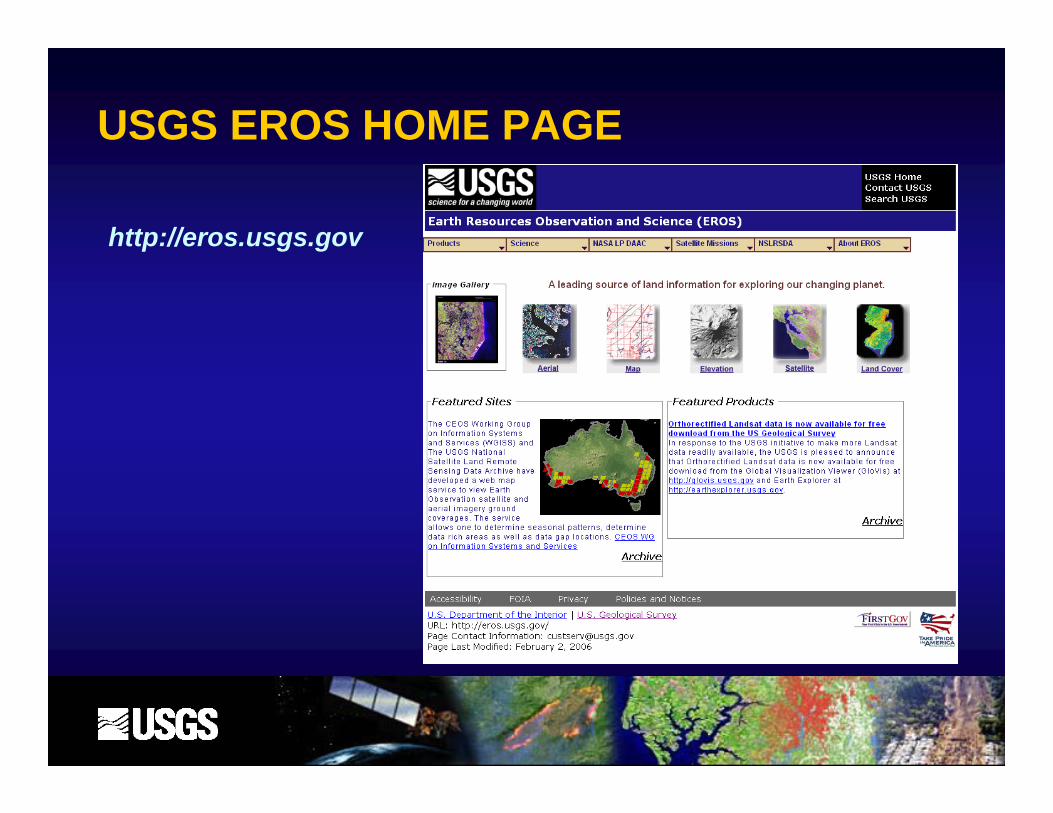
USGS EROS HOME PAGE
http://eros.usgs.gov

LP DAAC HOME PAGE
http://LPDAAC.usgs.gov

Overview of USGS EROS Data ProductsSatellite - http://eros.usgs.gov/products/satellite.html
ASTER (Advanced Spaceborne Thermal Emission and Reflection Radiometer) AVHRR (Advanced Very High Resolution Radiometer Sensor) Declassified Satellite Imagery 1959-1980 EO-1 - Hyperion and ALI (Advanced Land Imager) Landsat 1-5, 7
MSS (Multispectral Scanner)NALC (North American Landscape Characterization)
TM (Thematic Mapper)ETM+ (Enhanced Thematic Mapper Plus) Landsat Orthorectified (MSS, TM, ETM+)
MODIS (Moderate-Resolution Imaging Spectroradiometer) Terra and Aqua
SIR-C (Spaceborne Imaging Radar C-Band)

Overview of USGS EROS Data ProductsAerial - http://eros.usgs.gov/products/aerial.html
Digital Orthophoto Quadrangles (DOQs)
High Resolution Orthoimagery
Historical Aerial Photographs
Index/Mapping Photography
NAPP (National Aerial Photography Program)
NHAP (National High Altitude Photography)
SCAR (Scientific Committee on Antarctic Research)
Space Acquired Photography

Overview of USGS EROS Data ProductsMaps - http://eros.usgs.gov/products/map.html
Digital Raster Graphics (DRGs)Digital Line Graphs (DLGs)
Land Cover - http://eros.usgs.gov/products/landcover.html
National Land Cover Dataset (NLCD)Multi-Resolution Land Cover (MRLC)Global Land Cover Characterization (GLCC)Land Use and Land Cover (LULC)
Subset image of NLCD 92 classification(Glens Falls, NY)
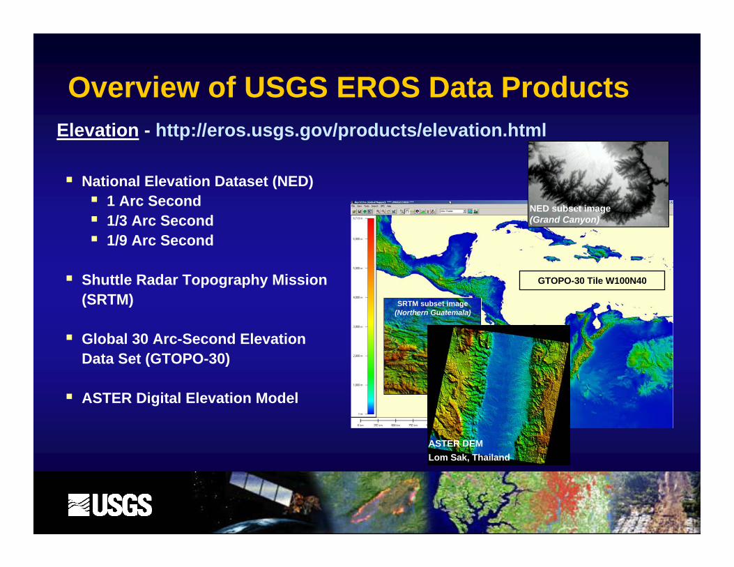
Overview of USGS EROS Data ProductsElevation - http://eros.usgs.gov/products/elevation.html
National Elevation Dataset (NED) 1 Arc Second1/3 Arc Second1/9 Arc Second
Shuttle Radar Topography Mission (SRTM)
Global 30 Arc-Second Elevation Data Set (GTOPO-30)
ASTER Digital Elevation Model
GTOPO-30 Tile W100N40
SRTM subset image(Northern Guatemala)
NED subset image(Grand Canyon)
ASTER DEM Lom Sak, Thailand

Earth Explorer Online Data Search, Browse and Order Tools
http://earthexplorer.usgs.gov
Attributes:Search multiple data sets at one time
Preview browse images
Retain order preferences and user profile information
Submit standing order requests
Refine and save search criteria and results
Send search results & search criteria to other EE users
Track Orders
Current Inventory includesAVHRR
• Declassified Satellite Imagery• EO-1 ALI & Hyperion• Landsat 1-5, 7 (MSS, TM, ETM+)• Landsat 7 International Ground Stations (search only)• Tri-Decadal Global Landsat Orthorectified (MSS, TM, ETM+, & TM Mosaics)• NLDC (search only)• NALC• SPOT (search only)• SIR-C• USGS Commercial Data Purchases• ASAS (search only)• Historical Aerial Photos• Aircraft Scanners (search only)• DOQs• NAPP• NHAP• Space Acquired Photography• DLG (1:100K & Large Scale)• NED Predefined Areas • DRGs• National Atlas of the United States• MRLC2001 Terrain Corrected
UPCOMING: SLC-off Standard L1T productSegment-based Fill Product
Narrow search results:
• Data image ID• WRS Path/Row• Cloud cover• Preview availability
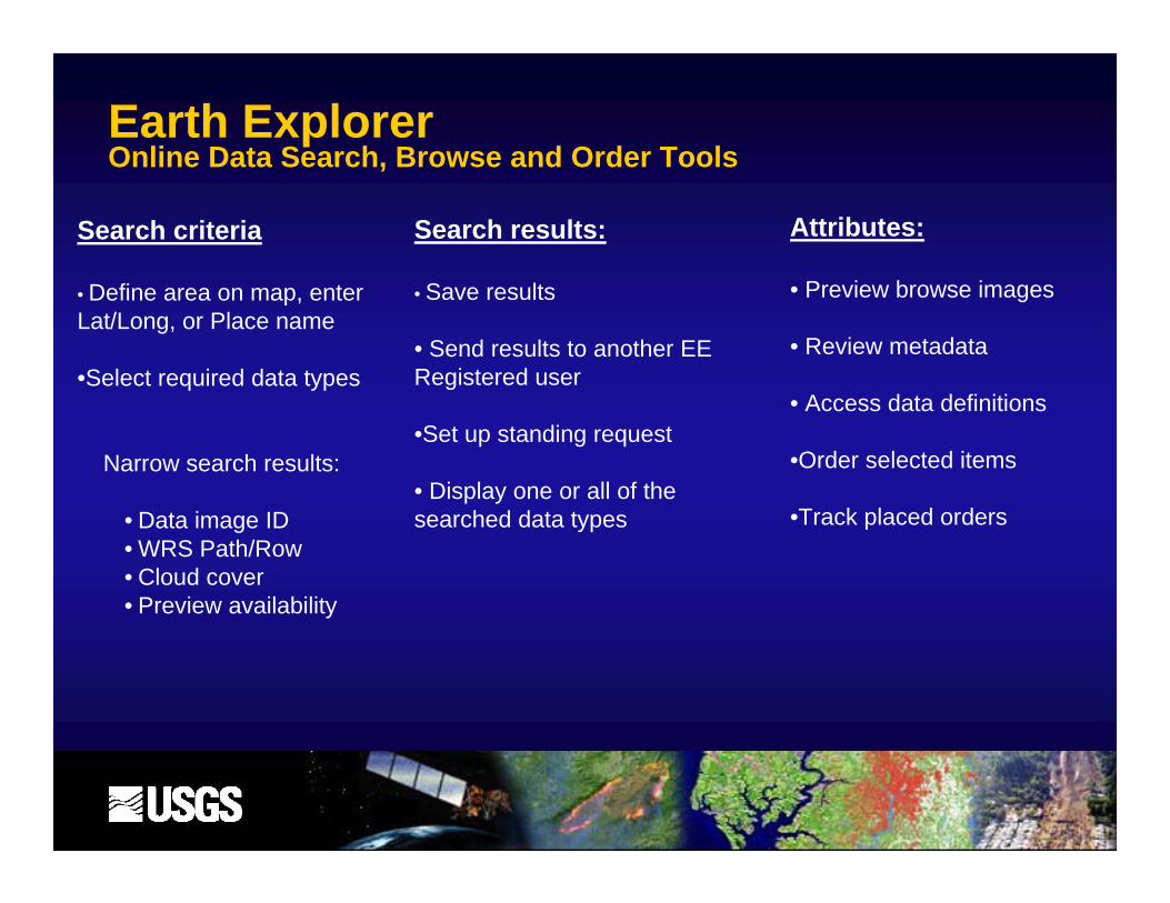
Earth Explorer Online Data Search, Browse and Order Tools
Search criteria
• Define area on map, enter Lat/Long, or Place name
•Select required data types
Search results:
• Save results
• Send results to another EE Registered user
•Set up standing request
• Display one or all of the searched data types
Attributes:
• Preview browse images
• Review metadata
• Access data definitions
•Order selected items
•Track placed orders

Global Visualization Viewer – GloVisOnline Data Search, Browse and Order Tools
http://glovis.usgs.gov
Search Attributes:• Locate area of interest:
• Enter Lat/Long• Click on map• Enter Path/Row
• Preview browse images
• Narrow search results:• Choose date range• Adjust cloud cover
• Cross-inventory searching of products
• Add map layers to help locate area of interest
• Search by swath mode:• ASTER• Landsat
• JavaScript – initial page necessary to run tool

Global Visualization Viewer – GloVisOnline Data Search, Browse and Order Tools
Current inventory includes:
• Landsat 1-5, 7 (MSS, TM, ETM+, SLC-Off)• ASTER VNIR & TIR• EO-1 ALI & Hyperion• MODIS Aqua & Terra• Landsat Orthorectified (TM, ETM+)• MRLC – TC, RA, 1992• NAPP Aerial
UPCOMING: SLC-off Standard L1T productSegment-based Fill Product

LP DAAC Data Pool Online Data Search, Browse and Order Tools
Attributes:
• Download ASTER and MODIS data FTP direct
• Enter search criteria
• Preview browse images
• Convert data:• Reformat, subset (MODIS) & reproject
• No charge for dataNo charge for data
http://LPDAAC.usgs.gov/datapool/datapool.asp

http://edcimswww.cr.usgs.gov/pub/imswelcome/
EOS Data Gateway (EDG)Online Data Search, Browse and Order Tools
Attributes:
• Access to LP DAAC’s complete archive of ASTER & MODIS data
• Access over 1500 data products from multiple NASA DAACs and affiliated centers
• Retain order preferences and user profile information
• Refine and save search criteria
• Preview browse images

Seamless Data Distribution SystemOnline Data Search, Browse and Order Tools
Attributes:
• Search multiple data sets at one time
• Download data at no cost
• Preview imagery
Current inventory includes:• 1-meter Orthoimagery• Bureau of Transportation Statistics (BTS) Roads• High Resolution Orthoimagery• LP DAAC MODIS• MODIS NDVI Direct Broadcast• National Atlas• National Elevation Data (NED)• National Land Cover Dataset (NLCD)• Shuttle Radar Topography Mission (SRTM)
• UPCOMING: Landsat Image Mosaic of Antarctica (LIMA)
http://seamless.usgs.gov/

Seamless Data Distribution SystemOnline Data Search, Browse and Order Tools
Search criteria:
• Select required data types
• Define area on map
• Enter Lat/Long
• Zoom to Region, State or Locale

Search and Order Toolshttp://eros.usgs.gov/about/customer/search.html

Other Websites of Interest
EarthNow! - http://earthnow.usgs.gov/
Spectral Characteristics Plotter - http://ldcm.usgs.gov/plotter.htmlInformation - http://ldcm.usgs.gov/spectral_plotter.html
LDCM - http://ldcm.usgs.gov/LDCMHome.html
Landsat - http://ldcm.usgs.gov/LDCMHome.html

Earth Explorer Landsat Science Team Profile DetailsProfile Allows:
•Searching and Previewing of datasets
•Use of the funding set up for Science Team research
Ordering Procedure
•Standard Search/Preview of imagery, adding items to the Shopping Basket
•Step 4 – Payment pageSelect Check/Money Order/Other
•Web and email order confirmation
EOS Data Gateway –does not use EE profile!

USGS Commercial Data Purchases Imagery Collection•Makes imagery purchased by several US Government agencies available to other Federal Users.
•IKONOS•OrbView•Quickbird•AWiFs
•Requires Agency Certification Form
•http://edc.usgs.gov/products/satellite/ucdp.html•http://crssp.usgs.gov/
•Shapefile coverage maps available:ftp://edcftp.cr.usgs.gov/pub/metadata/satellite/ucdp/UCDP_Shapefiles/

Customer Services Contact Information
Linda Jonescheit [email protected]
1-800-252-4547, Ext 69671-605-594-6967Fax 1-605-594-6589
USGS Customer ServicesToll free: 800-252-4547 Tel: 605-594-6151 TDD: 605-594-6933 Fax: 605-594-6589 Email: [email protected]://eros.usgs.gov
NASA LP DAAC User Services
Toll Free: 866-LPE-DAAC (573-3222)Tel: 605-594-6116TDD: 605-594-6933Fax: 605-594-6963Email: [email protected]://LPDAAC.usgs.gov
Business Hours: Monday thru Friday, 8:00 a.m. to 4:00 p.m., Central Time
U.S. Geological Survey Center for Earth Resources Observation and Science (EROS) 47914 252nd StreetSioux Falls, SD 57198-0001