USFWS - United States Fish and Wildlife Service · PDF fileChapter 3 USFWS Aerial view of Plum...
67
Chapter 3 USFWS Aerial view of Plum Tree Island National Wildlife Refuge Alternatives 3.1 Introduction 3.2 Formulating Alternatives 3.3 Actions Common to Both Alternatives 3.4 Alternative A. Current Management (No Action Alternative) 3.5 Alternative B. Increased Ecosystem Monitoring, Partnerships, and Public Use (Service-preferred Alternative) 3.6 Comparison of Alternatives
Transcript of USFWS - United States Fish and Wildlife Service · PDF fileChapter 3 USFWS Aerial view of Plum...
Chapter 3
USF
WS
Aerial view of Plum Tree Island National Wildlife Refuge
Alternatives 3.1 Introduction
3.2 Formulating Alternatives
3.3 Actions Common to Both Alternatives
3.4 Alternative A. Current Management (No Action Alternative)
3.5 Alternative B. Increased Ecosystem Monitoring, Partnerships, and Public Use (Service-preferred Alternative)
3.6 Comparison of Alternatives

3.1 Introduction
Chapter 3. Alternatives 3-1
3.1 Introduction This chapter describes:
our process for formulating two management alternatives;
actions that are common to both alternatives;
descriptions of the two alternatives we analyzed in detail; and
actions or alternatives we considered but did not fully develop.
At the end of this chapter, table 3.3 compares how the two alternatives address key issues, support major programs, and achieve refuge goals.
3.2 Formulating Alternatives As we describe in chapter 1, the purpose of a CCP is to develop strategic direction to meet the management goals of the refuge. Other broad purposes are to:
best achieve the refuge’s establishment purposes and vision;
contribute to the missions of the Service and the Refuge System;
contribute to the Refuge System vision implementation document “Conserving the Future” (USFWS 2011);
adhere to Service policies and mandates;
address significant issues; and
incorporate sound principles of fish and wildlife science.
Different approaches to meeting refuge management goals are explored through the CCP development process. Through this process, we explore a range of reasonable alternatives that may allow a refuge to achieve its purpose and goals, as well as the Refuge System mission.
The CEQ has provided guidance on the development and analysis of alternatives under NEPA. A full range of alternatives must be developed for analysis for any Federal action. The alternatives should meet the purpose and need as stated in chapter 1, at least to a large degree. Alternatives should also be developed to minimize impacts to environmental resources and be “reasonable,” which CEQ has defined as those that are economically and technically feasible, and show evidence of common sense. Alternatives or elements of alternatives that could not be implemented, if they were chosen, for economic or technical reasons or do not resolve the need for action and fulfill the stated purpose in taking action to a large degree, are therefore not considered reasonable.

3.2 Formulating Alternatives
3-2 Plum Tree Island National Wildlife Refuge Draft Comprehensive Conservation Plan and Environmental Assessment
Relating Goals, Objectives, and Strategies Goals Refuge goals are intentionally broad, descriptive statements of the desired future condition of refuge resources. They articulate the principal elements of the refuge purposes and our vision statement, and provide a foundation for developing specific management objectives and strategies. By design, they are less quantitative, and more prescriptive, in defining the target of our management. Both alternatives address these same goals, which are first presented in chapter 1.
Objectives The objectives we developed are incremental steps toward achieving a goal. Objectives further define management targets in measurable terms. Typically, they vary among the alternatives and provide the basis for determining strategies that are more detailed, monitoring refuge accomplishments, and evaluating successes. We followed guidance in “Writing Refuge Management Goals and Objectives: A Handbook” (USFWS 2004c) for writing “SMART” objectives that possess five characteristics:
Specific;
Measurable;
Achievable;
Results-oriented; and
Time-fixed.
A rationale accompanies each objective to explain its context and why we think it is important. The objectives outlined in the alternative selected for the final CCP would guide development of refuge step-down plans, described later in this chapter. We would measure our successes by how well we achieve the objectives. Unless otherwise noted, the objectives and strategies we describe would be implemented by refuge staff.
Strategies Strategies are the specific actions, tools, or techniques we may use to achieve the objectives. The list of strategies under each objective represents the potential suite of actions we may implement. We would evaluate most of them further as to how, when, and where we should implement them when we write our refuge step-down plans. We would measure our successes by how well our strategies achieve our objectives and goals.
Inventory and Monitoring Activities For most objectives, we also identify inventory and monitoring

3.2 Formulating Alternatives
Chapter 3. Alternatives 3-3
activities that would help us measure our success toward meeting refuge goals and objectives. The activities listed would be further refined in the refuge’s inventory and monitoring step-down plan to be developed after final CCP approval.
Developing Alternatives, Including the “No Action” Alternative In this chapter, we fully analyze two alternatives that characterize different ways of managing the refuge over the next 15 years, the life of the plan. We believe they represent a reasonable range of alternative proposals for achieving the refuge purpose, vision, and goals, as well as addressing the issues described in chapter 1. Unless otherwise noted, all actions would be implemented by refuge staff. Both alternatives are summarized in a matrix at the end of this chapter (table 3.3).
Alternative A addresses the NEPA requirement of a “no action” alternative, which we define as continuing current management. It describes our existing management priorities and activities, and serves as a baseline for comparing and contrasting alternatives.
Many of the objectives in alternative A do not strictly follow the current guidance in the Service goals and objectives handbook (Adamcik et al. 2004) because we are describing current management decisions and activities that were established prior to Service guidance. Our descriptions of those activities originate from a variety of formal and informal management decisions and planning documents. Thus, the objectives in alternative A are fewer and more subjective than are those in alternative B. Alternative B was developed in accordance with current and applicable laws, regulations, and Service policy manuals and guidance handbooks, as described in chapter 1. Alternative B also incorporates the principles of strategic habitat conservation and priority species management, as well as reflects the most recent advances in the fields of conservation science and delivery of conservation actions on the ground by the Service.
During the alternatives development phase of this CCP and EA, we considered all available information about the refuge, its resources, and public comments submitted since announcing in January 2012 that we would develop a CCP for Plum Tree Island NWR. Our review of all available refuge-specific information indicates that the existing quality of habitats is good. Surrogate species (such as nesting American black ducks, clapper rails, willets, northern harriers, and northern diamond-backed terrapins [USFWS 2012d]) are present in significant numbers, indicating that the habitat features that they require are readily available on the refuge. In addition, only a very small number of sites have been found to have invasive plant species. The NAWMP and the ACJV Plan have set goals to protect 12,000 acres of waterfowl habitat in the York/Poquoson River watershed. The 2,027 acres of salt marsh on Plum Tree Island NWR is a significant part of this goal and is very

3.2 Formulating Alternatives
3-4 Plum Tree Island National Wildlife Refuge Draft Comprehensive Conservation Plan and Environmental Assessment
important to the American black duck, saltmarsh sparrow, and other migratory wading birds that are high priority species (ACJV 2009). Maintaining the current conditions of refuge habitats is critical to supporting high priority bird and migratory fish species. Salt marsh, dune, and beach habitats are very sensitive to disturbance, and active management is presently not necessary to maintain these habitats in good condition as long as natural processes are still in place. Therefore, the top priorities for this habitat are protection from human disturbance, and inventory and monitoring.
Additionally, the USACE continues to lead the planning effort to remedy the human health and ecological risks associated with the UXO on the refuge and the vicinity. We have been and would continue to participate in the USACE planning efforts and interagency coordination effort to identify, select, and implement a remedy for the human health and ecological risks associated with the UXO on the refuge. Our ongoing coordination is essential to ensure that a feasible and most appropriate remedy is selected for implementation. Although eliminating all human health and ecological risks is not feasible at the PTI Range FUDS, residual human health and ecological risks can be effectively managed (USACE 2015).
Therefore, we have developed one action alternative to fulfill the Service’s responsibilities for wildlife and habitat management, while also considering opportunities to provide for limited wildlife-dependent recreation opportunities on the refuge once the USACE has an approved remedial action plan and implementation of the remedial actions are completed.
Comparison of the Alternatives Actions that are common to all alternatives are detailed in section 3.3.
We include a habitat map for each alternative to help visualize how refuge vegetation would look under each alternative (maps 3.1 and 3.2). Table 3.1 compares the acreages of the habitat types under each of the alternatives. Table 3.2 compares the visitor services offered annually under each of the alternatives.
Table 3.1 Comparison of Habitat Types, by Alternative, on Plum Tree Island NWR
Habitat Type Alternative A Alternative B Salt Marsh 2,027 2,027 Maritime Shrubland and Dune 102 102 Sandy Beaches and Mudflats 80 80 Estuarine and Marine Coastal 740 740 Habitat Total 2,949 2,949 Refuge Total 3,502 3,502
1Habitat areas estimated from GIS and rounded up to nearest whole number. The difference in habitat acres and total refuge acres occurs because boundaries that were used for habitat mapping project are not identical with the data held in our reality files.

3.2 Formulating Alternatives
Chapter 3. Alternatives 3-5
Table 3.2 Comparison of Visitor Services Offered Annually, by Alternative, on Plum Tree Island NWR
Visitor Services Offered Alternative A Alternative B Waterfowl Hunting Hunter use days accommodated
annually 540 558, which includes:
• 540 adult hunter • 18 youth hunter
Youth hunt days offered None 1 fall day Designated locations Six Six existing, plus investigate five
new potential blind locations Wildlife Observation, Photography, Environmental Education, and Interpretation
Designated public use areas None One on Cow Island Visitor use days accommodated annually
None 6,075 total, which includes: • 3,510 commercially guided • 2,475 individual recreational • 30 refuge-sponsored • 60 partner-sponsored
Commercially guided tours offered annually
None Up to 234, offered between early February and late October
Refuge-sponsored programs on refuge
None Opportunistically, up to two annually for 15 visitors each
Partner-sponsored on refuge None Opportunistically, up to four annually for up to 15 visitors each
Refuge- or partner-sponsored programs off refuge
By request, up to two annually By request, up to two annually
Service-preferred Alternative In accordance with CEQ guidance to do so, we identified in this draft CCP and EA that one of our alternatives would best fulfill our agency's statutory mission and responsibilities, giving consideration to economic, environmental, technical, and other factors. We identified alternative B as the Service-preferred alternative because it combines the actions we believe would be most effective at
meeting the refuge purposes, vision, and goals;
addressing issues and concerns identified throughout the planning process;
responding to public comments and inquiries; and
being feasibly implemented in accordance with applicable laws, regulations, policies, and guidance.
Alternatives or Elements Considered but Eliminated from Detailed Study As mentioned previously, alternatives to be analyzed should be reasonable. Unreasonable alternatives or elements of alternatives may be those that cannot be implemented for technical or logistical reasons; do not meet mandates; would be in violation of laws, regulations, or policies; are inconsistent with carefully considered, up-to-date refuge statements of purpose and significance or management objectives; have severe environmental impacts; or are unreasonably

3.2 Formulating Alternatives
3-6 Plum Tree Island National Wildlife Refuge Draft Comprehensive Conservation Plan and Environmental Assessment
expensive.
We considered the following suggestions from public comments, but dismissed them from further consideration and detailed study.
Close the Refuge to Public Waterfowl Hunting Public comments suggested that refuges, such as Plum Tree Island NWR, be closed to public waterfowl hunting.
As detailed in chapter 2, public waterfowl hunting is a historic, appropriate, and compatible use on the refuge that has been accounted for in refuge planning documents and refuge-specific regulation revisions published in the Federal Register and in Title 50 of the CFR. Closing the refuge to hunting would also conflict with the Improvement Act, which
includes hunting as an appropriate and priority use of the Refuge System,
requires that hunting shall receive priority consideration in refuge planning and management,
mandates that hunting opportunities should be facilitated when feasible, and
directs the Service to administer the Refuge System so as to “provide increased opportunities for families to experience wildlife-dependent recreation, particularly opportunities for parents and their children to safely engage in traditional outdoor activities, such as fishing and hunting.”
Additionally, we are required to provide public outdoor recreation opportunities in perpetuity on the 211-acre tract of Cow Island because this tract was purchased using monies from the LWCF (Public Law 88–578, codified at 16 U.S.C. 4601). Since public waterfowl hunting is the only public use currently allowed at Cow Island, closing the refuge to this use was not carried forward for further analysis.
In accordance with Service policy, we updated the refuge’s compatibility determination for hunting opportunities analyzed in this draft CCP and EA. The compatibility determination for hunting focuses on public waterfowl hunting and provides specific information regarding where, when, why, and how this use would be conducted on the refuge, to ensure that this use would not materially interfere with or detract from the fulfillment of the Refuge System mission or the refuge’s purpose. We provide detailed analyses of impacts associated with allowing this use in chapter 4 and in the compatibility determination included in appendix B of this draft CCP and EA. Expanding the existing hunt program for adults and youth requires additional NEPA review, and planning for these changes is anticipated

3.2 Formulating Alternatives
Chapter 3. Alternatives 3-7
to be initiated within 5 years of CCP approval.
Open the Refuge to Public Rail Hunting Public comments suggested that the refuge be opened to public rail hunting.
The purpose of this CCP is to develop a strategic course of action that achieves the refuge’s goals as presented in chapter 1. Hunting is one of the six priority wildlife-dependent public uses of refuges, each of which receives priority consideration in refuge planning and management. In accordance with the Improvement Act and the Service’s Compatible Use Policy, these six priority uses shall be facilitated where found to be compatible.
In accordance with Service policy, we prepared a compatibility determination for public hunting opportunities analyzed in this draft CCP and EA, appendix B. The refuge would remain open to hunting waterfowl (ducks), sea duck, coot, mergansers, light (snow) geese, Atlantic brant, and Canada geese. For purposes of this draft plan, these species are all included in discussions of “waterfowl hunting.”
Rails are not included in the hunting program. Public rail hunting differs in season and technique from our existing waterfowl hunt. The Virginia rail hunting season spans from September 1 through mid-November, which directly coincides with fall migration of shorebirds that use the refuge marshes and mudflats. Rail hunting also requires hunters to walk through the mudflats and shorelines, which conflicts with the refuge goal of minimizing human-caused disturbance to the shorelines and salt marsh habitats. For these reasons, opening the refuge to rail hunting was not carried forward for further analysis.
Open the Refuge to Public Deer Hunting Public comments suggested that the refuge be opened to public white-tailed deer hunting.
The purpose of this CCP is to develop a strategic course of action that achieves the refuge’s goals as presented in chapter 1. Hunting is one of the six priority wildlife-dependent public uses of refuges, each of which receives priority consideration in refuge planning and management. In accordance with the Improvement Act and the Service’s Compatible Use Policy, these uses shall be facilitated where found to be compatible.
Although some of the marsh habitat on the refuge does support white-tailed deer, the majority of the upland habitat that provides preferred food and cover resources for deer is not within the refuge boundary. Deer are only transitory on the refuge, and the refuge would not be capable of providing a quality deer hunt. Thus, opening the refuge to public deer hunting was not carried forward for further analysis. If upland habitat that supports deer is acquired for the refuge in the
3.2 Formulating Alternatives
3-8 Plum Tree Island National Wildlife Refuge Draft Comprehensive Conservation Plan and Environmental Assessment
future, we would reevaluate the potential to open the refuge to deer hunting at that time.
Open the Refuge to Recreational Fishing Public comments suggested that Plum Tree Island NWR be opened to public recreational fishing.
Similar to hunting, fishing is a priority public use of the Refuge System.
Since refuge establishment, we have worked to protect, maintain, and restore the ecological integrity of the refuge’s habitats for the benefit of wildlife. Because of the potential to disturb nesting, foraging, and wintering wildlife, we limit activities along the refuge’s shoreline to allow only those activities that support refuge operations and activities related to the PTI Range FUDS management. This closure to fishing, along with other refuge access restrictions, has been in place since refuge establishment. We believe the public understands that fishing from the refuge shoreline would conflict with our efforts to protect, maintain, and restore the refuge’s wildlife habitat (603 FW 2). In addition, we believe they recognize and are satisfied with the fact that there are many opportunities for fishing in State and other public waters (where authorized) in the refuge vicinity. However, if we acquire areas in the future that do not have the impacts and concerns of existing refuge lands, we would reevaluate the potential to open these new areas to public recreational fishing.
Open the Refuge to Recreational Public Beach Uses Public comments suggested that the refuge’s sandy beaches be opened for public use for various activities including, but not limited to, swimming, sunbathing, camping, and picnicking. Public comments suggested that the refuge consider opening sandy beaches in a manner similar to that allowed at Grandview Beach in Hampton, Virginia.
The Improvement Act identifies six priority and appropriate uses of wildlife refuges: hunting, fishing, wildlife observation, photography, environmental education, and interpretation. These priority public uses are dependent upon healthy wildlife populations. Where these uses are determined to be compatible, they are to receive enhanced consideration over other uses in planning and management. All other uses are defined by the Improvement Act as general uses and should be evaluated on each refuge for their appropriateness and compatibility in contributing to the purpose of that refuge.
Recreational beach activities do not contribute to the fulfillment of this refuge’s purposes for protecting migratory birds and other native fish and wildlife resources. Managing these uses would involve staff resources and time that would detract from accomplishing priority
3.2 Formulating Alternatives
Chapter 3. Alternatives 3-9
resource projects and administering priority public uses on the refuge. The refuge does not have the facilities or staff to manage these activities. These uses are not consistent with Service policy on secondary uses and are not consistent with any approved refuge management plan. Recreational beach activities have been determined to be inappropriate for this refuge (see appendix B).
Opening the PTI Range FUDS to Public Uses Due to the ecological concerns and safety hazards associated with its former use as a bombing range, the PTI Range FUDS (3,276 acres; 93.5 percent of refuge) has not been opened to public use since its transfer to the Service and refuge establishment in 1972. The PTI Range FUDS remains closed to all public use. However, public comments suggested that we open various locations within the PTI Range FUDS to a variety of public uses.
The Improvement Act states, “. . . the Secretary shall not initiate or permit a new use of a Refuge or expand, renew, or extend an existing use of a [refuge], unless the Secretary has determined that the use is a compatible use and that the use is not inconsistent with public safety.” If a public use can be safely accommodated, the Refuge Manager must find specific public uses compatible with the refuge’s purpose(s) and System mission to allow them (603 FW 2). Furthermore, the Refuge Manager has the authority and discretion to determine where appropriate and compatible public uses may occur on the refuge. The Refuge Manager has the authority and discretion to determine stipulations necessary to ensure that such public uses are appropriate and compatible with the refuge's purpose(s) and System mission.
At this time, we cannot consider opening the PTI Range FUDS to any public uses unless and until the proposed remedial action to reduce UXO hazards and to ensure public safety is successfully implemented. If the Service approves and USACE successfully implements remedial action(s) that reduce UXO hazards within the PTI Range FUDS, then the Refuge Manager would re-evaluate the potential to allow new compatible public uses within the PTI Range FUDS. Therefore, this alternative was not carried forward for further analysis.
3.3 Actions Common to Both Alternatives Both of the alternatives share some common actions. These actions are current practices or policies that would continue under all alternatives. Some of these actions are required by law or policy, or represent actions that have undergone previous NEPA analysis, public review, agency review, and approval. Others may be administrative actions that do not require public review, but are those that we want to highlight in this public document.
We discuss these common actions in more detail below and have organized our discussion under the following headings:

3.3 Actions Common to Both Alternatives
3-10 Plum Tree Island National Wildlife Refuge Draft Comprehensive Conservation Plan and Environmental Assessment
Refuge staffing and administration
Species and habitat conservation
Cultural resources management
Visitor services management
Findings of appropriateness and compatibility determinations
Refuge revenue sharing payments
Special designation areas
Additional NEPA analysis
It is important here to reemphasize that CCPs provide long-term guidance for management decisions through goals, objectives, and strategies. They represent our best estimate of future needs. This CCP details program levels and activities that are above current budget allocations and, as such, should be viewed as strategic in nature. Congress determines our budgets annually, which are then distributed through our Washington and regional offices before arriving at field stations. Final CCPs do not constitute a Service commitment for staffing increases or funding for operations, maintenance, or future land acquisition. Implementation must be adjusted annually given the reality of budgets, staffing, and unforeseen critical priorities.
Refuge Staffing and Administration All alternatives include the following actions related to refuge staffing and administration.
Refuge Staff Continue to share staff across the Eastern Virginia Rivers NWR Complex, including the three new positions identified in appendix C of this draft CCP, appendix C of the final CCP for Rappahannock River Valley NWR, final CCP for Presquile NWR, and appendix C of the draft CCP and EA for James River NWR (USFWS 2009d, USFWS 2012c, and USFWS 2014, respectively).
Discussion and Rationale In 2000, the Regional Chief decided to administratively group Rappahannock River Valley, James River, and Presquile NWRs to form the Eastern Virginia Rivers NWR Complex (Refuge Complex). In 2003, Plum Tree Island NWR joined the Refuge Complex. The intent of administratively grouping these refuges was to create management efficiencies, to the extent possible, due to declining budgets. Current staffing at the Refuge Complex includes seven positions. The Refuge Manager for the Refuge Complex is responsible
3.3 Actions Common to Both Alternatives
Chapter 3. Alternatives 3-11
for setting staff priorities and resource distribution across the four refuges.
In 2007, our Refuge leadership team completed the “Strategic Workforce Plan for the Refuge System in Region 5” (Phase 2; January 16, 2007) to support a new base budget approach. Its goal is a maximum of 75 percent of a refuge station budget to cover salaries and fixed costs, while the remaining 25 percent or more would be operating and maintenance funds. An analysis of refuge staffing using the National Staffing Model resulted in a proposed increase of three staff, with shared responsibilities among the four refuges in the Refuge Complex (USFWS 2007c). Increasing Refuge Complex staff by three would help support management on Plum Tree Island NWR, including increased visitor services opportunities and management of the natural and built facilities on the refuge. The three new positions would be allocated across each of the four refuges as needed to ensure efficient operation and management throughout the Refuge Complex.
Our region’s strategy is to improve each refuge’s capability to do the highest priority work and not to have most of a refuge budget tied up in inflexible fixed costs. This strategy was successful for a few fiscal years; however, we now anticipate a level or declining budget environment, which would affect our flexibility in managing financial resources and may have implications for the level of permanent staffing. A new round of workforce planning began in 2013 in response to the Federal Government’s sequestration directive and anticipated future budget reductions.
Jurisdiction over Lands and Waters Continue to coordinate with other Federal and State government agencies with legal authority to use or regulate use of lands or waters within the refuge’s approved acquisition boundary.
Discussion and Rationale As detailed in chapter 2, other Federal and State government agencies retain ownership and/or have legal authority to use or regulate use of lands or waters within the refuge. The Service would continue to coordinate with these agencies to ensure the protection of refuge resources, employee safety, and public safety.
The Commonwealth of Virginia retains title to the beds of navigable waterways when not specifically transferred in property deeds and on behalf of the public’s right to fish, hunt, and navigate. The Service would continue to work cooperatively with the State to resolve questions of ownership and overlapping jurisdiction for fishing, hunting, and navigation purposes.
The USAF has established a danger zone as an emergency jettison area and for ordnance disposal operations for limited durations. In

3.3 Actions Common to Both Alternatives
3-12 Plum Tree Island National Wildlife Refuge Draft Comprehensive Conservation Plan and Environmental Assessment
accordance with the rights reserved by the USAF, refuge staff would comply with the restriction that no person or vessel shall enter or remain in this danger zone during periods of firing, bombing, or when the zone is otherwise in use. Refuge staff would refer to the USCG “Local Notice to Mariners,” local press, and radio to be aware of the USAF planned use of the danger zone.
The USACE has established a temporary danger zone on the waters surrounding the southern portion of the refuge. In accordance with the use restrictions established by the USACE, refuge staff would closely coordinate with the USACE to ensure compliance and enforcement of restrictions on activities that would disturb sub-aqueous soil within the temporary danger zone, including dropping anchor or beaching of watercraft on the refuge.
The VMRC has established a restricted area on the waters surrounding the southern portion of the refuge. Refuge staff would continue to coordinate with VMRC as needed to ensure compliance and enforcement of the restricted area closure.
Land Acquisition In accordance with the refuge’s existing, approved Land Protection Plan (LPP; USFWS 1993), we would continue to consider land acquisition from willing sellers within the refuge’s approved acquisition boundary (map 1.3). If we acquire new lands for the refuge, they would be evaluated for compatible, priority public use opportunities, or otherwise managed in accordance with final CCP goals, objectives, and strategies.
Discussion and Rationale On October 13, 1993, the Service was authorized under the authority of the MBCA to expand the refuge's approved acquisition boundary to include an additional 2,119 acres of land in Poquoson, Virginia (USFWS 1993). The Service identified acquisition of these lands as fish and wildlife habitat worthy of protection because they support the goals set forth in the NAWMP, by protecting and enhancing migration and wintering habitat for black duck, and meet the intent of the Emergency Wetlands Resource Act by assuring the protection of critical wetland functions.
An approved acquisition boundary designates those lands that the Service has authority to acquire or manage through various agreements. The approval of an acquisition boundary does not grant the Service jurisdiction or control over lands within the boundary, and it does not make lands within the refuge boundary part of the Refuge System. Lands within a refuge’s approved acquisition boundary do not become part of the refuge until the Service buys them or they are placed under an agreement that provides for their management as part of the refuge.
3.3 Actions Common to Both Alternatives
Chapter 3. Alternatives 3-13
Since approval of the refuge boundary expansion in 1993, the Service has acquired only two parcels of land (USFWS 1993). Approximately 1,893 acres within the refuge’s approved acquisition boundary remains private property. Should any of these 1,893 acres be identified by willing sellers, we would consult with our Regional Office staff to determine if funding could be available for acquisition.
Refuge Access Continue to require a permit for access to areas of the existing refuge that are closed to public uses.
Discussion and Rationale Since refuge establishment, the refuge has been closed to general public access. Only those visitors who participate in the refuge’s waterfowl hunts or made advanced reservations to conduct a visit are allowed access to the refuge. People interested in visiting areas currently closed to general public use are required to request permission in advance of their visit. If the request is determined to be compatible and is granted, refuge staff issue a special use permit (SUP) that visitors are required to carry a copy of while on the refuge. It has worked well because it:
Protects human health and safety on the former bombing range;
Proactively prevents incompatible or unauthorized uses from occurring on the refuge;
Minimizes disturbance of refuge wildlife by stipulating in the permit that access is in designated areas only;
Minimizes disturbance of cultural resources by requiring visitors to stay in designated areas;
Allows for stricter monitoring of who is on the refuge and why;
Minimizes conflicts between user groups (e.g., bird watchers and waterfowl hunters) for safety purposes and supports high quality experiences;
Protects the visitor experience of being immersed in nature in a secluded and remote area; and
Provides a mechanism for law enforcement to prevent visitors from beaching their boats on the refuge and engaging in other unauthorized uses.
Non-Service personnel and public access to closed areas or for special uses would be allowed with a valid refuge-issued permit for appropriate and compatible public uses (e.g., waterfowl hunting) or SUP (e.g., research). We would continue to coordinate closely with the
3.3 Actions Common to Both Alternatives
3-14 Plum Tree Island National Wildlife Refuge Draft Comprehensive Conservation Plan and Environmental Assessment
Cyr
us B
ram
e/U
SFW
S
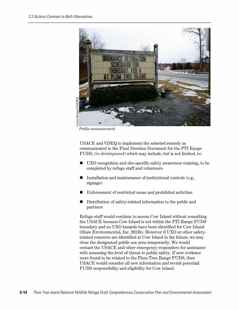
Public announcement
USACE and VDEQ to implement the selected remedy as communicated in the Final Decision Document for the PTI Range FUDS, (in development) which may include, but is not limited, to:
UXO recognition and site-specific safety awareness training, to be completed by refuge staff and volunteers
Installation and maintenance of institutional controls (e.g., signage)
Enforcement of restricted areas and prohibited activities
Distribution of safety-related information to the public and partners
Refuge staff would continue to access Cow Island without consulting the USACE because Cow Island is not within the PTI Range FUDS boundary and no UXO hazards have been identified for Cow Island (Shaw Environmental, Inc. 2013b). However if UXO or other safety-related concerns are identified at Cow Island in the future, we may close the designated public use area temporarily. We would contact the USACE and other emergency responders for assistance with assessing the level of threat to public safety. If new evidence were found to be related to the Plum Tree Range FUDS, then USACE would consider all new information and revisit potential FUDS responsibility and eligibility for Cow Island.
3.3 Actions Common to Both Alternatives
Chapter 3. Alternatives 3-15
Refuge Step-down Plans Continue to complete key refuge step-down plans according to the identified schedule. The habitat management plan, inventory and monitoring plan, and visitor services plan are priorities for completion.
Discussion and Rationale The Service uses CCPs to detail the “what, why, and how” of refuge management priorities that would be explored further in step-down plans, which detail the “how, where, and when” we would accomplish the refuge’s goals and objectives. Step-down plans would be prepared in accordance with Service guidance, handbooks, and the refuge’s final CCP. The following three step-down plans are a priority for completion on Plum Tree Island NWR. Under each description, we identify a timeline for their completion.
Habitat Management Plan (HMP): An HMP for the refuge is the requisite first step to achieving the biological objectives of Goals 1 and 3 for any of the alternatives (USFWS 2013). We would complete an HMP within 5 years of CCP approval. The HMP would provide more details on the habitat management strategies we would use to accomplish CCP goals and objectives over the life of the plan. In particular, the HMP would detail the specific areas and habitat types we would manage for, as well as the tools and techniques we would use and the timing of our management actions. Additional analysis of the impacts of specific methods may be necessary to fulfill our responsibilities under NEPA. The HMP would also incorporate the results of appendix A, which identifies how we derived priority refuge species and habitats for the refuge. We would not prepare a separate Forest Management Plan because the HMP would serve the same purpose for this refuge.
The goals, objectives, and strategies in this CCP identify how we intend to manage habitats on the refuge. Both the CCP and HMP are based on current resource information, published research, and our own field experiences. Our methods, timing, and techniques would be updated as new, credible information becomes available. To facilitate our management, we would regularly maintain our databases, including GIS data, documenting any major vegetation changes on at least a 5-year basis.
Inventory and Monitoring Plan (IMP): The IMP would outline and prioritize inventorying and monitoring activities for the refuge based on the priorities identified in the alternative selected for the final CCP and detailed in the HMP. The IMP would be completed within 5 years of completing the HMP. We would use our inventory and monitoring program to assess whether our original assumptions and proposed management actions are supporting the refuge’s habitat and species objectives, as well as Service priorities at the regional, flyway, and landscape scales. The results of inventories and monitoring would
3.3 Actions Common to Both Alternatives
3-16 Plum Tree Island National Wildlife Refuge Draft Comprehensive Conservation Plan and Environmental Assessment
provide us with more information on the status of our natural resources and allow us to make more informed management decisions. The IMP would incorporate recommendations from the “Strategic Plan for Inventories and Monitoring on National Wildlife Refuges: Adapting to Environmental Change” (USFWS 2010a) to ensure a coordinated approach to inventory and monitoring across refuges.
Visitor Services Plan (VSP): A VSP is required by Service policy (605 FW 1, Section 1.8.A) and, along with the HMP, is among the highest priority step-down plans for all refuges (USFWS 2013). Exhibit 1 of that policy includes an outline for the plan. The VSP would further detail strategies to help meet the visitor services goals and objectives contained in the refuge’s CCP over the life of the plan, including finding ways to increase the understanding and appreciation for fish and wildlife conservation by urban audiences (http://americaswildlife.org/wp-content/uploads/2012/04/Recommendation-131.pdf; accessed September 2013). We would complete a VSP within 5 years of CCP approval. If the VSP includes proposals for modifying existing visitor service facilities and/or additional visitor service improvements, additional NEPA and approvals may be necessary prior to implementing those actions.
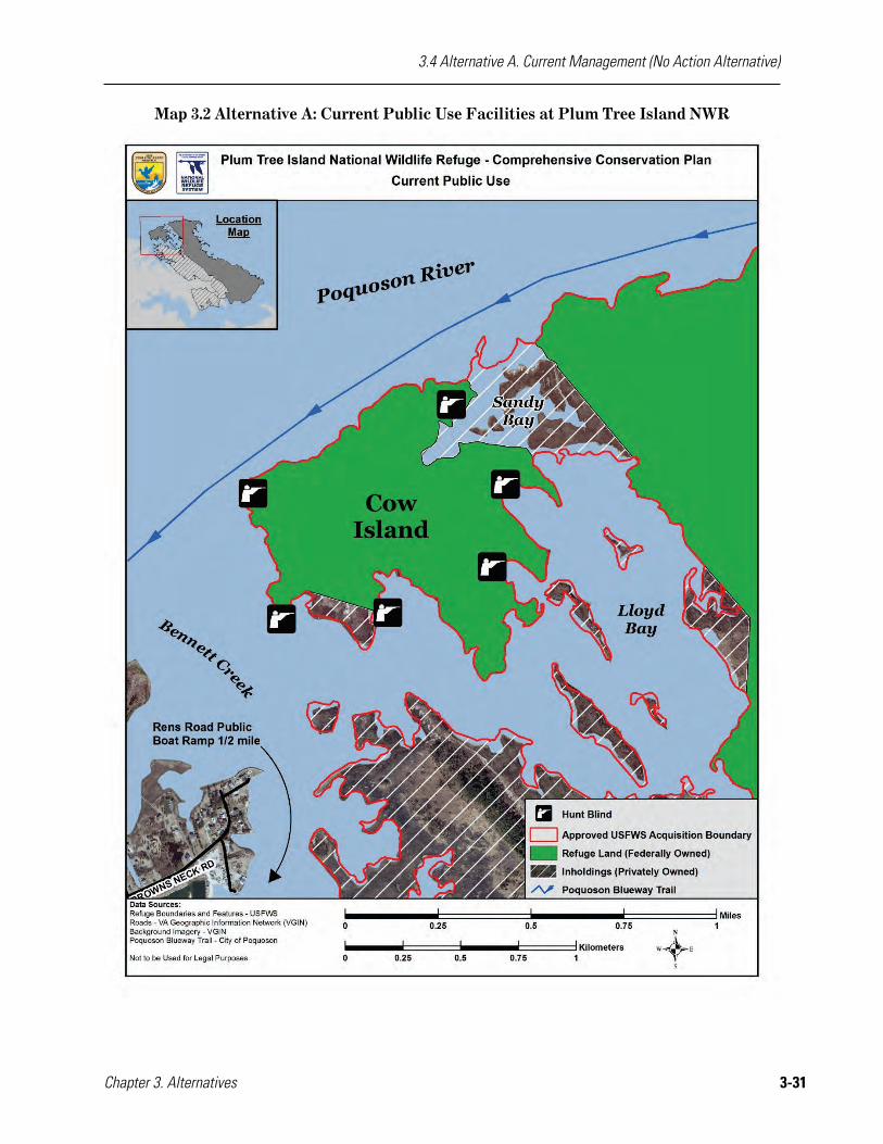
Existing Facilities Maintenance and Planned New Construction Continue to maintain the refuge’s existing six waterfowl hunt blinds.
Discussion and Rationale Periodic maintenance and renovation of existing facilities would continue to ensure safety and accessibility for staff and visitors. The refuge’s existing facilities are described in chapter 2. Construction and maintenance projects currently listed in the RONS and SAMMS databases would be undertaken in accordance with the regional and refuge rankings for each project (see appendix D).
As we undertake these projects, we would consult other Federal, State, and local government agencies with jurisdiction and authority to ensure that activities are consistent, to the maximum extent practicable, with applicable laws, regulations, and enforceable policies.
CEQ guidelines for implementing NEPA also require examining energy requirements and conservation potential in environmental documents. For any of the alternatives, we would meet these guidelines by incorporating principles of sustainability in the design, construction, and operation of facilities on refuges.
Species and Habitat Conservation Both alternatives include the following actions related to species and habitat conservation.
3.3 Actions Common to Both Alternatives
Chapter 3. Alternatives 3-17
Ecological Risks Associated with FUDS Ecological risks associated with the PTI Range FUDS are evaluated, identified, and minimized by working with the USACE and VDEQ to implement the selected remedy as communicated in the Final Decision Document (at press time the USACE decision document is in preparation).
Discussion and Rationale The USACE conducted site investigations, analyses, and assessments of munitions constituents (metals) at the PTI Range FUDS (Shaw Environmental, Inc. 2013a). The ecological risk assessment process included characterizing the ecological communities near the PTI Range FUDS, identifying the munitions constituents of potential ecological concern, identifying pathways for receptor exposure, and evaluating potential risk to identified receptors.
For the PTI Range FUDS, the USACE evaluated ecological risk using a multi-step process that included:
a Screening Level Ecological Risk Assessment, conducted as part of the Remedial Investigation;
a Focused Baseline Ecological Risk Assessment, conducted as part of the Remedial Investigation; and
a Feasibility Study Addendum.
The results of the Screening Level Ecological Risk Assessment indicated that the following munitions constituents may be a hazard to ecological receptors: cadmium, copper, lead, selenium, and zinc. The refined evaluation conducted in the Focused Baseline Ecological Risk Assessment eliminated cadmium, lead, selenium, and zinc as munitions constituents of ecological concern at the PTI Range FUDS; however, copper was still a concern. The USFWS, VDEQ, USACE, and the USACE contractor (Shaw Environmental, Inc.) reached a consensus in January 2013 that additional sampling of shrimp and crabs might resolve the concerns related to copper concentrations in prey species inhabiting refuge ponds outside of the PTI Range FUDS. In September 2013, USFWS and USACE personnel conducted additional shrimp and crab sampling in refuge ponds outside of the PTI Range FUDS. The prey species of fish, shrimp, and crabs in these ponds were found to have similar copper concentrations compared to prey species in the bomb crater ponds. It was concluded that munitions constituent-related copper does not cause unacceptable ecological risk to predators who feed upon prey at PTI ponds. Therefore, no further action was recommended for munitions constituents, including copper, at the PTI Range FUDS (USACE 2014).
Protecting Federally Listed Species Continue to protect and enhance northeastern beach tiger beetle

3.3 Actions Common to Both Alternatives
3-18 Plum Tree Island National Wildlife Refuge Draft Comprehensive Conservation Plan and Environmental Assessment
foraging habitat for both adults and larvae throughout the refuge shoreline by protecting sandy beaches and mudflat habitat, especially along the southeastern shoreline, to maintain an average annual count number of more than 300 individuals.
Protect and enhance existing habitat throughout the refuge for federally listed species found to exist on the refuge.
Discussion and Rationale The northeastern beach tiger beetle is currently a federally threatened species. The recent 5-year review conducted by the Service concluded that the northeastern beach tiger beetle populations should be reclassified as endangered because serious threats to this species’ existence continue to grow and populations are declining through most of its range (http://ecos.fws.gov/speciesProfile/profile/speciesProfile.action?spcode=I02C; accessed February 2015). Numerous sites have been lost or populations reduced in the past 10 years. Since 2001, there has been a 20 percent loss in occupied sites (12 of 58 occupied sites) (USFWS 2009b).
The refuge is within Virginia’s western shore of the Chesapeake Bay geographic recovery area, which is the southernmost occurrence of this species. Under both alternatives, we would continue to protect the northeastern beach tiger beetle by restricting activities from June 1 to September 15 on the refuge’s sandy beaches and dunes because adult northeastern beach tiger beetles emerge and use these areas during this time for sheltering, foraging, and mating. The section of beach from the mean low water line to the base of the dune system is where the larval northeastern beach tiger beetles burrows can be found. The larva is present year-round, so limiting human-caused disturbance to this habitat area will avoid the possible loss of larval northeastern beach tiger beetles.
Estuarine Habitats Management Continue to coordinate with partners on management actions to benefit estuarine habitats adjacent to Plum Tree Island NWR and the lower Chesapeake Bay.
Discussion and Rationale In all alternatives, the Service would continue to work opportunistically with VMRC and NOAA to improve estuarine habitats in the lower Chesapeake Bay. The quality of these habitats directly affects the health and integrity of the habitats and wildlife species that utilize the refuge. Estuarine habitats supply food resources to migratory and breeding wildlife of top priority to the refuge, as well as to species that are important in the larger Chesapeake Bay community, such as the blue crab, oyster, horseshoe crab, and striped bass. Our coordination with these partners would

3.3 Actions Common to Both Alternatives
Chapter 3. Alternatives 3-19
continue as we work to protect our common resources for human and wildlife population health.
Adaptive Management Continue to employ an adaptive management approach for improving our resource decisions and management.
Discussion and Rationale All alternatives would employ an adaptive management approach for improving resource management by better understanding ecological systems through iterative learning.
The DOI’s technical guidebook to assist managers and practitioners in adaptive management (“Adaptive Management: The U.S. Department of Interior, Technical Guide”) provides the following definition for adaptive management (https://www.usgs.gov/sdc/doc/DOI-%20Adaptive%20ManagementTechGuide.pdf; accessed January 2016):
Adaptive management is a decision process that promotes flexible decision making that can be adjusted in the face of uncertainties as outcomes from management actions and other events become better understood. Careful monitoring of these outcomes both advances scientific understanding and helps adjust policies or operations as part of an iterative learning process. Adaptive management also recognizes the importance of natural variability in contributing to ecological resilience and productivity. It is not a ‘trial and error’ process, but rather emphasizes learning while doing. Adaptive management does not represent an end in itself, but rather a means to more effective decisions and enhanced benefits. Its true measure is in how well it helps meet environmental, social and economic goals, increases scientific knowledge, and reduces tensions among stakeholders.
This definition gives special emphasis to the uncertainty about management impacts, iterative learning to reduce uncertainty, and improved management as a result of continuous learning. This approach recognized that we can never achieve perfect understanding of the natural world and that we must implement management in the face of uncertainty. At the refuge level, adaptive management is an integral part of management planning, research design, and monitoring. Uncertainties about ecological systems are addressed through targeted monitoring of resource response to management actions and predictive models that mimic the function of the natural world.
Adaptive management gives the Refuge Manager flexibility to adjust management action or strategies if they do not meet goals or objectives. As we adjust our management, we will evaluate whether
3.3 Actions Common to Both Alternatives
3-20 Plum Tree Island National Wildlife Refuge Draft Comprehensive Conservation Plan and Environmental Assessment
additional NEPA review is warranted. Implementing an adaptive management approach supports all refuge goals. Furthermore, adaptive management is even more compelling in light of climate change concerns.
Climate Change Continue to address climate change through maintaining and restoring healthy, connected, and genetically diverse wildlife populations and ecological communities; monitoring conditions over the long-term; and promoting energy efficient practices and other carbon reduction activities.
Discussion and Rationale There is consensus among the scientific community that global climate change, occurring in part as a result of emissions of carbon dioxide and other greenhouse gases from human activities, would lead to significant impacts across the U.S. and the world (Joint Science Academies 2005). The effect of climate change on wildlife and habitats is expected to be variable and species-specific, with a predicted general trend of species ranges and vegetation communities shifting northward and higher in elevation.
Uncertainty about the future effects of climate change requires Refuge Managers to use adaptive management to maintain healthy ecosystems in light of unpredictability (Inkley et al. 2004). This involves improving or adjusting policies and practices based on the outcomes of monitoring or management activities and may result in changes to regulations, shifts in active habitat management, or changes in management objectives. A few recommendations include:
preparing for diverse and extreme weather conditions (e.g., drought and flood);
maintaining or restoring healthy, connected, and genetically diverse wildlife populations to increase resiliency in wildlife and habitats; and
protecting coastal habitats to accommodate marsh migration in response to sea level rise (see Inkley et al. 2004 for more recommendations).
Plum Tree Island NWR may play an important role in monitoring and predicting the effects of global climate change. At the refuge level, it would be increasingly important to understand how the refuge and its habitats and communities respond to potential changes, such as habitat shifts, sea level rise, changes in temperature, changes in waterway salinity, and storm intensification.
Invasive Plant Species Monitoring Continue to monitor invasive species on refuge lands as funding,
3.3 Actions Common to Both Alternatives
Chapter 3. Alternatives 3-21
staffing, and equipment logistics allow, with particular attention to phragmites.
Discussion and Rationale EO 13112 defines an invasive species as “…an alien (or non-native) species whose introduction does, or is likely to cause economic or environmental harm or harm to human health.” The unchecked spread of invasive plants threatens the biological diversity, integrity, and environmental health of all refuge habitats. In many cases, invasive species out-compete native species and become the dominant cover. This situation reduces the availability of native plants as food and cover for native wildlife.
Over the past several decades, government agencies, conservation organizations, and the public have become more aware of the negative effects of invasive species. One report estimated the economic cost of invasive species in the U.S. at $137 billion every year (Pimentel et al. 2000). Up to 46 percent of the plants and animals federally listed as threatened and endangered have been negatively impacted by invasive species (Wilcove et al. 1998, National Invasive Species Council 2001).
The Service’s Northeast Region initiated an effort to systematically identify, locate, and map invasive plant species occurring on refuge lands, leading to an effective integrated management plan. Plum Tree Island NWR staff has begun identifying and mapping locations of invasive species on the refuge as time and resources allow. Phragmites is the only invasive plant species currently known to occur on the refuge.
Under all alternatives, we would continue to implement the following strategies related to invasive species monitoring:
Follow the national guidance on invasive species provided in the Service Manual (620 FW 1.7G).
Complete the inventory and mapping of invasive plant species.
When using heavy equipment on refuge property, we would ensure all equipment brought onto the refuge for this work is clean and free from reproductive plant parts to minimize opportunities for invasive species introduction.
Pest Management Continue to participate with State and Federal partners to monitor nuisance issues from wildlife, such as nutria.
Discussion and Rationale In controlling pests, whether invasive or native species, we would continue to use an integrated approach. The Refuge Manual (7 RM 14.4C) defines integrated pest management as “a dynamic approach to

3.3 Actions Common to Both Alternatives
3-22 Plum Tree Island National Wildlife Refuge Draft Comprehensive Conservation Plan and Environmental Assessment
pest management which utilizes a full knowledge of a pest problem through an understanding of the ecology of the pest and ecologically related organisms and through continuous monitoring of their populations. Once an acceptable level of pest damage is determined, control programs are carefully designed using a combination of compatible techniques to limit damage to that level.”
An integrated approach uses various methods, including natural, biological, cultural, mechanical, and chemical controls. An example of a potential problem and remedy of pest management follows.
Potential problem: Nutria eating roots and stems of wetland plants can convert marshes into unvegetated mudflats (Ehrlich 1962, Holm et al. 2011).
Potential solutions: If documented on the refuge in the future, use control methods to eliminate population on refuge property. Methods may be conducted by Service staff, partners, or other entities operating under refuge-issued SUPs.
When nuisance animals are affecting refuge management capabilities, they may be trapped and removed; nutria is considered a nuisance mammal in Virginia (http://www.dgif.virginia.gov/hunting/regulations/definitions.asp, accessed September 2015). We do not intend to initiate a public trapping program at this time. Trapping is considered an economic activity and must meet a higher standard of compatibility than priority wildlife-dependent public recreational uses or other non-commercial uses. We would reconsider our position if future situations arise in which predation, habitat loss, or disease is severe, and if we determine public trapping to be an effective, essential element in managing them. Until that activity is necessary, we would use trapping on a case-by-case basis to help alleviate a particular problem. Trapping may be conducted by refuge staff, their agents, or contractors to achieve a specific management objective. As such, it would be considered a management or administrative activity and not subject to compatibility review.
Cultural Resources Management All alternatives include the following actions related to cultural resource management.
Protection and Maintenance Recommendations Continue to comply with Section 106 of the NHPA through consultation with the Regional Historic Preservation Officer (RHPO) and SHPO (SHPO) when new ground-altering activities are proposed and evaluate standing structures more than 50 years old for National Register eligibility before altering.
3.3 Actions Common to Both Alternatives
Chapter 3. Alternatives 3-23
Discussion and Rationale As a Federal land management agency, we are entrusted with the responsibility to locate and protect cultural resources, including archaeological sites and historic structures that are eligible for the National Register. This applies not only to resources that are located on refuge lands, but also those on lands affected by refuge activities, as well as any museum properties.
We would conduct an evaluation of the potential for our projects to impact archeological and historical resources, and would consult with our RHPO and SHPO as appropriate. This would be especially important for those projects that include moving or displacing soil, as preservation in place is our preferred treatment for archaeological sites. A pre-project evaluation of activities would ensure we comply with Sections 106 and 110 of the NHPA, regardless of the alternative implemented. That compliance may require a State Historic Preservation Records survey, literature review, and/or field survey. In addition to any surveys and reviews, we would seek to minimize adverse impacts to eligible archaeological sites by limiting public access and through increased monitoring by law enforcement officials.
We also plan to work with the NPS, Tribal representatives, the SHPO, and local historical societies to interpret cultural resources on the refuge and to explain the importance of protection and preservation of those resources.
Outreach and Communications Continue to consult with federally recognized tribes and communicate actively with state recognized Tribal organizations, and Native American descendant communities to discuss proposed refuge activities and share periodic progress reports on refuge activities.
Discussion and Rationale Plum Tree Island NWR provides an ideal place to demonstrate to the public how an appreciation of indigenous values regarding stewardship of land and wildlife can enhance public and personal attachment to the Chesapeake Bay. We invited participation in CCP development from 11 federally recognized Indian Tribes (i.e., Absentee Shawnee Tribe of Oklahoma, Catawba Nation, Cherokee Nation of Oklahoma, Delaware Nation of Oklahoma, Delaware Tribe of Indians, Eastern Band of the Cherokee Indians, Eastern Shawnee Tribe of Oklahoma, Pamunkey Tribe, Shawnee Tribe, Tuscarora Nation, and United Keetoowah Band of Cherokee Indians in Oklahoma) and 10 unrecognized Indian Tribes represented in Virginia (i.e., Cheroenhaka [Nottoway], Chickahominy, Eastern Chickahominy, Mattaponi, Monocan Nation, Nansemond, Nottoway of Virginia, Pattawomeck, Rappahannock, and Upper Mattaponi (http://www.ncsl.org/issues-research/tribal/list-of-federal-and-state-recognized-tribes.aspx#s-va; accessed December 2015). In July 2015,

3.3 Actions Common to Both Alternatives
3-24 Plum Tree Island National Wildlife Refuge Draft Comprehensive Conservation Plan and Environmental Assessment
the Pamunkey Indian Tribe became the first Virginia tribe to win Federal recognition (http://www.bia.gov/cs/groups/public/documents/text/idc1-030829.pdf, accessed December 2015).
Visitor Services Management Outreach and Communications Continue to work with partners to promote the protection and preservation of the refuge for the benefit of wildlife through environmental education and interpretation about the natural environment and wildlife of the Chesapeake Bay.
Discussion and Rationale Developing and maintaining partnerships is key to fulfilling the Service’s mission. Refuge staff has established working relationships with a variety of partners to promote wildlife and habitat conservation through environmental education and interpretation. Under all alternatives, we would continue to participate in these partnerships and develop a better understanding of the refuge’s and the Service’s role in surrounding communities.
EO 13508, “Protection and Restoration of the Chesapeake Bay” (signed May 2009), outlines actions for the Federal government to make progress toward restoring the health of the Chesapeake Bay. A Federal Leadership Committee was created for the Chesapeake Bay and issued a strategic plan in September 2010 that identified specific efforts to undertake. Actions at Plum Tree Island NWR are related to the overall health of the Chesapeake Bay. Of the nine goals in the strategic plan, the refuge is most directly connected to the goals of conserving land, increasing public access, and expanding citizen stewardship.
To the maximum extent practicable, we would continue working with the NPS to promote the Captain John Smith Chesapeake NHT and Chesapeake Bay Gateways and Watertrails Network at Plum Tree Island NWR by enhancing place-based interpretation and fostering conservation and restoration of natural and cultural resources related to the Chesapeake Bay through programming, outreach, and citizen involvement. We would work with the NPS to ensure that Captain John Smith Chesapeake NHT-related activities proposed to occur at the refuge would be conducted in a manner compatible with the purpose and intent of the refuge.
Although Plum Tree Island NWR is not an officially designated urban refuge (per 110 FW 1), we would aspire to meet the Service’s “Standards of Excellence” for our visitor opportunities (http://www.fws.gov/urban/refugePDfs/Urban%20Standards%20of%20Excellence.October2014.pdf, accessed January 2016). The approach to excellence for urban national wildlife refuges must be as flexible and
3.3 Actions Common to Both Alternatives
Chapter 3. Alternatives 3-25
unique as the very communities the refuges serve. The Service must strive to understand both the human and natural environments to best address the expectations of the urban community. The Service must provide programs and leadership on conservation initiatives that are relevant to their urban audiences while highlighting the many ecosystem services and aesthetic benefits nature provides. Service staff, volunteers, and partners must proactively engage urban communities to develop meaningful connections to nature that will last a lifetime. This starts by building awareness, fostering deeper understanding, and growing participation through programs that will bring more people from the urban world into the broad conservation community. Among the potential means by which we could more effectively reach urban audiences, we could work with partners with financial resources to offset the cost of commercial tour services to the refuge.
Findings of Appropriateness and Compatibility Determinations Chapter 1 describes the requirements for findings of appropriateness and compatibility determinations. Uses are evaluated based on whether or not they contribute to meeting refuge purposes, goals, and objectives. Appendix B includes the appropriateness and compatibility determinations consistent with implementing alternative B, the Service-preferred alternative. Some of these uses are already approved, while others are presented here in draft for public review. Our final CCP would include all approved findings of appropriateness and compatibility determinations for the alternative selected. These activities would be evaluated based on whether or not they contribute to meeting refuge purposes, goals, and objectives.
All alternatives include the following actions related to findings of appropriateness and compatibility determinations. See appendix B for additional details.
Activities Allowed In accordance with approved compatibility determinations, we would continue to:
Support our existing partnership with the VDGIF to administer a quality public waterfowl hunt.
Support existing partnerships with other Federal and State agencies to conduct compatible research and investigations on the refuge that help further our knowledge of refuge resources, or that address regional or national conservation concerns of the Service.
Activities Not Allowed Continue to prohibit certain activities on the refuge that the Refuge Manager determined to be not appropriate.
3.3 Actions Common to Both Alternatives
3-26 Plum Tree Island National Wildlife Refuge Draft Comprehensive Conservation Plan and Environmental Assessment
Discussion and Rationale We occasionally receive requests for activities that are prohibited on refuges (50 CFR 25–26). Other activities are not allowed because the Refuge Manager has determined that the activities are not appropriate on the refuge. Appendix B documents the Refuge Manager’s justification for why they are deemed not appropriate.
All other uses not explicitly allowed or not allowed that require a SUP would be evaluated on a case-by-case basis by the Refuge Manager for appropriateness and compatibility (50 CFR 26, 603 FW 2).
Refuge Revenue Sharing Payments Continue to issue annual refuge revenue sharing payments to the City of Poquoson in accordance with law and annual Congressional appropriations.
Discussion and Rationale National wildlife refuges contribute to local economies through shared revenue payments. Federally owned lands are not taxable; however, under the provisions of the Refuge Revenue Sharing Act (16 U.S.C. 715s), the municipality or other local unit of government receives an annual refuge revenue sharing payment to offset the loss of property taxes that would have been collected if the land had remained in private ownership. In addition, federally owned land requires few services from municipalities, yet it provides valuable recreational opportunities for local residents. As we describe in chapter 2, we pay annual refuge revenue sharing payments based on the acreage and the appraised value of refuge lands. The annual payments are calculated by formula determined by, and with funds appropriated by, Congress. Under all alternatives, we would continue those payments in accordance with the law, commensurate with changes in the appraised market value of refuge lands, or new appropriation levels dictated by Congress.
Special Designation Areas All alternatives include the following actions related to special designation areas.
Federally Designated Special Status Areas (e.g., Wilderness Areas, Wild and Scenic Rivers) Continue to conduct reviews every 15 years as required by Service policies (602 FW 1 and 3, and 610 FW 4).
Discussion and Rationale A wilderness review is the process we follow to identify and recommend for congressional designation Refuge System lands and waters that merit inclusion in the NWPS. Wilderness reviews are a required element of CCPs, and we follow the planning process outlined in 602 FW 1 and 3.
3.3 Actions Common to Both Alternatives
Chapter 3. Alternatives 3-27
The wilderness review process has three phases:
Inventory—We identify lands and waters that meet the minimum criteria for wilderness. These areas are called wilderness study areas.
Study—We evaluate wilderness study areas to determine if they are suitable for wilderness designation.
Recommendation—We use the findings of the study to determine if we would recommend the area for designation as wilderness in the final CCP. We report our wilderness recommendations from the Director through the Secretary of the Interior and the President, to Congress, in a wilderness study report.
We conducted phase 1, the inventory, for Plum Tree Island NWR and determined that it does not meet all the minimum criteria for wilderness. Size, naturalness, solitude or primitive and unconfined recreation, and supplemental values are the minimum criteria established in the Wilderness Act. We found that the refuge did not meet two of these four criteria. Our wilderness review results are included as appendix E.
In addition, no designated Wild and Scenic Rivers are currently within our jurisdiction. Going forward under either alternative, we would take care to avoid or mitigate adverse effects on the river resources and values associated with its eligibility for Wild and Scenic River designation, and coordinate with other agencies in the event that they initiate Wild and Scenic River designation within the life of the plan.
Other Special Area Designations Continue to protect and maintain the characteristics on refuge lands that contributed to the area’s special designation as a Marine Protected Area and the Western Shore Marshes IBA, as well as its contribution to other State natural resource area designations.
Discussion and Rationale In chapter 2, we describe the various special area designations that include the refuge. Most relate to significant natural resources in the region, and the unique opportunities the area affords to protect and interpret these resources. Our existing and proposed activities on the refuge would be consistent with, or not detract from, those special area designations.
Additional NEPA Analysis This draft CCP and EA was developed with sufficient detail to account for the greatest potential impacts that could result from future step-down planning efforts. However, if we determine that our analysis of potential impacts on the human and natural environments are found to be inadequate during subsequent planning (e.g., refuge step-down

3.3 Actions Common to Both Alternatives
3-28 Plum Tree Island National Wildlife Refuge Draft Comprehensive Conservation Plan and Environmental Assessment
plans), additional NEPA review and NHPA compliance may be required prior to implementing those plans, actions, or activities (40 CFR 1508.28).
Although we analyze the impacts of the management alternatives we have developed in this draft CCP and EA, additional NEPA analysis would be necessary for certain types of actions, even once we adopt a final CCP. Where decisions have not been made in this CCP, but must be made later, we analyze the impacts of the possible range of alternatives in this document, but may need to supplement this analysis later.
Examples of proposed actions that may require further analysis include:
Improving or removing any existing facilities and construction of new facilities, including new waterfowl hunt blinds and visitor support facilities.
Expanding the existing hunt program and adding new hunting opportunities for adults and youth.
Removing nuisance wildlife through public hunting or trapping permits, if deemed necessary.
Cla
rke
Dir
ks/U
SFW
S
Youth hunter with retrieval dog

3.4 Alternative A. Current Management (No Action Alternative)
Chapter 3. Alternatives 3-29
3.4 Alternative A. Current Management (No Action Alternative) Alternative A satisfies the NEPA requirement of a “no action” alternative, which we define as continuing current management. It presents current and approved management plan activities; describes projects funded or underway; and serves as a baseline for comparing and contrasting alternative B.
Since refuge establishment in 1972, we have administered Plum Tree Island NWR in line with the following four broad goals of the Refuge System (USFWS 1982):
To preserve, restore, and enhance in their natural ecosystems (when practicable) all species of animals and plants that are endangered or threatened with becoming endangered.
To perpetuate the migratory bird resource.
To preserve a natural diversity and abundance of fauna and flora on refuge lands.
To provide an understanding and appreciation of fish and wildlife ecology and man's role in his environment, and to provide refuge visitors with high quality, safe, wholesome, and enjoyable recreational experiences oriented toward wildlife to the extent these are compatible with the purposes for which the refuge was established.
In addition to the actions detailed in section 3.3 as common to all alternatives, we would continue to conduct the following activities under alternative A.
We would continue to protect the refuge’s wildlife habitats by allowing natural processes to occur unimpeded (map 3.1). Our refuge management efforts would continue to focus on minimizing human-caused disturbance of refuge habitats and wildlife, conducting annual northeastern beach tiger beetle surveys, performing visual surveys of shoreline changes, and administering the waterfowl hunt while on the refuge (map 3.2). While off the refuge, our staff would continue to focus on interagency coordination to assess and evaluate hazards posed by the former bombing range. Refuge staff has also participated in community programs and events to promote understanding and appreciation for the purpose of the refuge and the mission of the Service. The refuge’s limited waterfowl hunt on Cow Island would continue to be the only public use permitted on the refuge.

3.4 Alternative A. Current Management (No Action Alternative)
3-30 Plum Tree Island National Wildlife Refuge Draft Comprehensive Conservation Plan and Environmental Assessment
Map 3.1 Alternative A: Current Habitat Management at Plum Tree Island NWR
3.4 Alternative A. Current Management (No Action Alternative)
Chapter 3. Alternatives 3-31
Map 3.2 Alternative A: Current Public Use Facilities at Plum Tree Island NWR

3.4 Alternative A. Current Management (No Action Alternative)
3-32 Plum Tree Island National Wildlife Refuge Draft Comprehensive Conservation Plan and Environmental Assessment
GOAL 1 WILDLIFE AND HABITATS Conserve the coastal estuarine ecosystem to sustain high ecological integrity for the benefit of native flora and fauna, with emphasis on priority refuge resources of concern, within the lower Chesapeake Bay.
Objective 1.1 Salt Marsh Over the life of the plan, allow natural processes to act unimpeded on 2,027 acres of salt marsh habitat.
Discussion and Rationale Tidal marsh ecosystems form the interface between the ocean and the land, playing a vital role in marine and terrestrial ecological processes (Bertness 1999). Salt marshes are unique and productive ecosystems with high intrinsic value as habitat for breeding and migrating wildlife, fishery nursery areas, and sources of food for near-shore finfish and shellfish populations. Salt marshes provide ecosystem services by filtering sediments, nutrients, and other pollutants from upland drainages and buffering shorelines from flood and storm damage. Harsh conditions including naturally extreme hydrology, salinity, soil conditions, and the narrow linear nature of salt marshes mean that few species are truly restricted to salt marsh habitats. In spite of these conditions, North American tidal salt marshes boast a high proportion of endemic taxa and are one of the most productive ecosystems in the world (Greenberg and Maldonado 2006).
Organisms in the lower levels of the marsh food chain are sensitive to changes in sediment and pollution loads. Adverse impacts on these lower level organisms cascade up through all levels of the marsh food chain. Hundreds of species depend on a healthy marsh or estuarine system at some point in their life cycle, many of which are important in commercial and recreational enterprises. These include fish (such as striped bass, Atlantic menhaden, and anchovy), waterfowl (such as black duck, mallard, and Canada goose), and shellfish (such as oyster, clams, and blue crab).
Public law directs the Secretary of the Interior to ensure the biological integrity, diversity, and environmental health of the Refuge System for the benefit of present and future generations of Americans (Public Law 105-57). Salt marshes and adjacent uplands are valuable as breeding, resting, and feeding habitats for migratory birds, and as producers of detritus, which forms the basis of a major marine food web. Refuges like Plum Tree Island NWR have been established in coastal areas to protect large tracts of salt marsh and wetland-dependent species. Unfortunately, minimal pristine salt marsh habitat remains and local, regional, and global changes to the environment have led to a disproportionately high number of salt marsh endemic species becoming conservation priorities (Pashley et al. 2000, Greenberg and Maldonado 2006).

3.4 Alternative A. Current Management (No Action Alternative)
Chapter 3. Alternatives 3-33
Watts (1992) states, “Marsh area is a good indicator of bird species richness for salt marshes of the Chesapeake Bay.” That is, larger marshes usually contain a greater diversity of bird species. In addition, he found that the presence of tide pools causes an increase in bird use of marshes. Marshes within the refuge’s approved acquisition boundary exhibit many of the characteristics important to breeding and foraging birds and is the largest contiguous marsh in the lower Chesapeake Bay.
The presence of invasive species like phragmites degrades this valuable habitat by creating a monoculture of dense stems and roots. Phragmites not only pushes out native plant species, but can also alter the hydrology and increase fire potential (Swearingen et al. 2010). This plant reduces feeding sites for invertebrates, fish, and waterbirds by eliminating small intertidal channels and pool habitats on which these species rely (USFWS 2007d). In New York and in Delaware, phragmites has formed dense vegetative mats above and below the surface, which reduces the availability of suitable nesting areas for terrapin females (Simoes and Chambers 1999, Delaware Wild Lands 2014). Currently, we have fewer than 20 acres of phragmites located on the refuge. However, refuge staff has not attempted to control phragmites infestations due to the safety concerns associated with the PTI Range, as well as limited staff time and resources to use a combination of mechanical removal and herbicide application.
Strategies Continue to: Limit human-caused disturbance.
Inventory and Monitoring Activities None.
Objective 1.2 Maritime Shrubland and Dune Over the life of the plan, allow natural processes to act unimpeded on 102 acres of maritime shrubland and dune habitat.
Discussion and Rationale Plum Tree Island NWR has 102 acres of maritime shrubland and dune habitat within its boundaries. This strip of dune and shrub habitat protects the salt marsh from erosion and inundation. Parts of this habitat also exist on the western border of the refuge as upland islands containing shrubs and pine trees. These areas were once more extensive but have been reduced through frequent salt spray and subsidence.
Coastal habitats are dynamic and interconnected. Activities that would affect the stability of the upland island habitats should be avoided because they would affect the integrity of the entire system (Mason 2009). Protecting vegetation on these dunes is also vital to protecting

3.4 Alternative A. Current Management (No Action Alternative)
3-34 Plum Tree Island National Wildlife Refuge Draft Comprehensive Conservation Plan and Environmental Assessment
the stability of the dune structure.
Strategies Continue to: Limit human-caused disturbance.
Inventory and Monitoring Activities None.
Objective 1.3 Sandy Beaches and Mudflats Over the life of the plan, allow natural processes to act unimpeded on 80 acres of sandy beaches and mudflats habitat.
Discussion and Rationale Plum Tree Island NWR has 80 acres of sandy beach and mudflat habitat. This habitat serves as the intermediate strip between the refuge dunes and the surrounding waters. The beaches of Plum Tree Island NWR are categorized as either impermeable beaches or marsh barriers beaches. These beach types have a layer of sand over Holocene sediments having a high clay content or salt marsh peat. These two types of sediments are most susceptible to erosion and subsidence respectively (Hardaway et al. 2001).
Wind and wave action creates and removes acres of beach and mudflat habitat over time; flora and fauna in these coastal habitats have adapted to the natural processes of overwash, salt spray, and adjusting coastlines. Refuge staff conducts visual surveys of the shoreline by boat to assess coastline changes, document wildlife and habitat conditions, and report any occurrences of UXO to the USACE.
The sandy beach and mudflat habitat is breeding and foraging habitat for the threatened northeastern beach tiger beetle at Plum Tree Island NWR (USFWS 1994). Adults emerge on the beaches in mid-June and forage along the intertidal zone. In July and August, this population breeds, with peak population numbers found in mid-July. Though once found on beaches throughout the Chesapeake Bay, there are few remaining natural beaches where this beetle thrives. The northeastern beach tiger beetle prefers wide beaches with a gradual slope and is very susceptible to activity in the intertidal zone. Beetles occurring at the nearby Grandview Beach in Hampton, Virginia, are part of the same population as the beetles at the refuge; however, beetle habitat at Grandview Beach has experienced drastic changes with human use and beach re-nourishment projects (Waterway Surveys & Engineering, Ltd. et al. 2011).
In addition to the northeastern beach tiger beetle, these changing coastlines provide an invaluable source of invertebrates to breeding and migrating shorebirds. Breeding black skimmers and oystercatchers have been documented foraging in these habitats, as
3.4 Alternative A. Current Management (No Action Alternative)
Chapter 3. Alternatives 3-35
well as common and least tern, semipalmated sandpipers, and short-billed dowitchers. The intertidal zone where these birds feed is also the area of highest human activity on beaches (Meager et al. 2012). Because the refuge’s sandy beach and mudflat habitats are closed to public use, these 80 acres provide a place where shorebirds can feed without human-caused disturbance.
Strategies Continue to: Limit human-caused disturbance.
Inventory and Monitoring Activities Continue to: Conduct informal visual survey for nesting birds.
Conduct annual survey for northeastern beach tiger beetle on- and off-refuge.
Conduct qualitative and quantitative shoreline erosion visual survey by boat and report presence of exposed UXO to USACE as needed.
GOAL 2 WILDLIFE-DEPENDENT RECREATION Provide safe and compatible wildlife-dependent recreational opportunities for visitors to connect with nature and foster enhanced stewardship of the lower Chesapeake Bay and the Refuge System.
Objective 2.1 Waterfowl Hunting Over the life of the plan, accommodate public waterfowl hunting opportunities on the refuge for up to 540 hunter use days annually during the last two segments of the waterfowl hunting season.
Discussion and Rationale Hunting is one of the six priority public uses as outlined in the Improvement Act. The Service strives to provide hunting opportunities that are not available on other public or private lands and to provide participants with reasonable harvest opportunities, uncrowded conditions, few conflicts among hunters, relatively undisturbed wildlife, and limited interference from, or dependence on, mechanized aspects of the sport (USFWS 1986). When managed responsibly, hunting can instill a unique appreciation of wildlife, their behavior, and their habitat needs. Service policy also states that, where practicable, we should make our hunt regulations consistent with State regulations. Because the original portion of the refuge was used as a bombing range and posed safety risks to refuge staff and refuge visitors, the refuge did not open to any public uses when first established.
In 1993, the Service proposed to expand the refuge’s boundary to preserve important habitat for migratory bird species and “to provide
3.4 Alternative A. Current Management (No Action Alternative)
3-36 Plum Tree Island National Wildlife Refuge Draft Comprehensive Conservation Plan and Environmental Assessment
for public enjoyment of the area's resources, through providing wildlife-oriented recreational opportunities, that do not materially detract from the purposes of the refuge” (USFWS 1993). An additional 2,119 acres adjacent to the existing refuge and beyond the limits of the former bombing range were identified as suitable lands for potential acquisition in the event willing sellers made them available and the Service has funding available to purchase them. Public comments on the proposed boundary expansion centered on one major theme-maintenance of hunting and fishing access to the area included within the proposed expansion boundary. In October 1993, the refuge’s boundary expansion plan was approved. One 5-acre parcel was acquired in 1996, and the 211-acre parcel known as Cow Island was acquired in 1997. No other lands have been acquired since 1997.
In July 1998, the refuge proposed to open specific areas for waterfowl hunting opportunities for two primary reasons: to provide for the wise use of a renewable natural resource, and to provide a high quality hunting experience. At that time, only Cow Island was proposed to be opened for hunting, and other tracts would be evaluated for inclusion in the hunting program as they are obtained. Cow Island is currently the only area on the refuge open to waterfowl hunting, with a refuge-issued permit. The refuge’s waterfowl hunting plan was approved on July 26, 1999, and designated areas within the refuge were announced as open to waterfowl hunting on August 11, 1999, for the 1999 to 2000 season (64 FR 43834; codified at 50 CFR 32.67). Since then, refuge-specific regulations for waterfowl hunting at Plum Tree Island NWR have been updated annually. Refuge-specific regulations take precedence where they are more restrictive than the State regulations.
Based on our experience administering the waterfowl hunt on Cow Island from 2003 through 2006, we determined that some minor changes were necessary to ensure that we would meet the original goals of offering safe, high-quality hunting opportunities while also providing resting and feeding opportunities for wintering waterfowl. The minor changes were aimed at reducing the potential for over-shooting or seasonally chasing waterfowl and other wildlife from the relatively small hunt site and to increase the potential for harvest success and species diversity (USFWS 2007b). We determine if our waterfowl hunt is meeting its goal of providing the public with a quality hunt program by distributing the Service’s Migratory Bird Hunt Report (FWS Form 3–2361) to participants and analyzing their voluntary responses.
Strategies Continue to: Administer waterfowl hunt on the refuge in accordance with the
approved waterfowl hunt plan (2007b) by:

3.4 Alternative A. Current Management (No Action Alternative)
Chapter 3. Alternatives 3-37
Allowing up to three persons and one retrieval dog per hunting party at each of the six designated locations on Cow Island.
Offering waterfowl hunting on up to 30 calendar days per year.
Inventory and Monitoring Activities Occasionally distribute the Service’s Migratory Bird Hunt Report
(FWS Form 3–2361) to hunt participants and analyze responses.
Objective 2.2 Wildlife Observation, Photography, Environmental Education, and Interpretation—On Refuge Over the life of the plan, the refuge remains closed to wildlife observation, photography, environmental education, and interpretation.
Discussion and Rationale The refuge would remain closed to wildlife observation, photography, environmental education, and interpretation because the refuge has not previously been opened to these uses. All national wildlife refuges remain closed to specific public uses until those uses are determined to be appropriate and compatible with the refuge purpose (50 CFR 26.31).
Strategies None.
Inventory and Monitoring Activities None.
Dan
iel L
ay/U
SFW
S In
tern
No trespassing sign on the refuge

3.4 Alternative A. Current Management (No Action Alternative)
3-38 Plum Tree Island National Wildlife Refuge Draft Comprehensive Conservation Plan and Environmental Assessment
Objective 2.3 Wildlife Observation, Photography, Environmental Education, and Interpretation—Off Refuge Over the life of the plan, provide wildlife observation, photography, environmental education, and interpretation opportunities to visitors on a by-request, case-by-case basis, off refuge only.
Discussion and Rationale Refuge staff has explored opportunities to participate in local programs and events held off-refuge that emphasize wildlife observation, photography, environmental education, and interpretation. Our involvement in up to two community programs and events annually allows us to foster a connection between visitors and natural resources, as well as discuss the refuge’s purposes, physical attributes, ecosystem dynamics, conservation strategies, and the Refuge System mission. We would tailor messages and delivery methods to specific audiences and present them in appropriate locations. Through heightened awareness, we aim to inspire support for refuge goals and the Refuge System mission.
Effective outreach depends on open and continuing communication and collaboration between the refuge and its many publics. Effective outreach involves determining and understanding the issues, identifying audiences, listening to stakeholders, crafting messages, selecting the most effective delivery techniques, and evaluating effectiveness.
Strategies Continue to: Opportunistically offer up to two environmental education or
interpretation programs off refuge annually.
Inventory and Monitoring Activities None.
GOAL 3 PARTNERSHIPS Cultivate partnerships to further conservation, education, and interpretation of the refuge’s natural and cultural resources, as well as the mission of the Refuge System.
Objective 3.1 Partnerships for Refuge Wildlife and Habitat Research Over the life of the plan, continue to maintain our collaborative relationships with Federal, State, and local governmental agencies to fulfill mutual goals.
Discussion and Rationale By sharing expertise and other resources with many agencies, we have developed strong partnerships for wildlife and habitat research at the refuge. We collaborate with the CCB and VDGIF to conduct a variety of wildlife surveys and research, acquiring new information
3.4 Alternative A. Current Management (No Action Alternative)
Chapter 3. Alternatives 3-39
about wildlife use of the refuge that is comparable to data for other nearby survey areas. Most recently, we have coordinated with the USACE and their agents (e.g., Shaw Environmental, Inc.) to inform selection of appropriate remedial actions to reduce hazards to human and ecological health resulting from the site’s former use as a bombing range. In addition, we look forward to collaborating with the Service’s Virginia Fisheries Coordinator Office and other programs. We would continue these partnerships to support the refuge purposes, fulfill refuge goals, and meet management objectives for wildlife and habitat.
Strategies Continue to: Coordinate with other Federal, State, and local government
agencies, and private research organizations regarding research conducted on or around the refuge.
Objective 3.2 Partnerships for Public Uses Over the life of the plan, continue to maintain our collaborative relationships with Federal, State, and local governmental agencies to fulfill mutual goals.
Discussion and Rationale We work closely with many agencies on special projects related to public use by sharing expertise and other resources. Our partnership with the VDGIF facilitates administration of a quality waterfowl hunt on Cow Island. We also work closely with the USACE, USCG, VDEQ, VMRC, and Virginia Marine Police regarding public awareness about the PTI Range FUDS hazards and enforcement trespassing regulations for the protection of public safety and refuge resources. We would continue to support the City of Poquoson’s promotion of safe and enjoyable public use activities around the refuge. We would continue to coordinate with the City on its recently established Blueway for kayakers and canoers. We would continue these partnerships to support the refuge purposes, fulfill refuge goals, and meet management objectives for appropriate and compatible use of the refuge.
Strategies Continue to: Protect public safety by enforcing refuge regulations.
Coordinate with other Federal, State, and local law enforcement agencies regarding public uses on and around the refuge.

3.5 Alternative B. Increased Ecosystem Monitoring, Partnerships, and Public Use (Service-preferred Alternative)
3-40 Plum Tree Island National Wildlife Refuge Draft Comprehensive Conservation Plan and Environmental Assessment
3.5 Alternative B. Increased Ecosystem Monitoring, Partnerships, and Public Use (Service-preferred Alternative)
In addition to the actions detailed in section 3.3 as common to all alternatives, the following describes what other activities would occur under alternative B. Map 3.2 depicts the habitat configuration that would result under alternative B management.
Over the life of the plan, we would continue to protect the refuge’s wildlife habitats by allowing natural processes to occur unimpeded (map 3.3). Our refuge management efforts would continue to focus on minimizing human-caused disturbance of refuge habitats and wildlife, while working with a greater diversity of partners to conduct biological research, inventory, and monitoring efforts. We are primarily interested in learning more about the presence, absence, and populations of priority wildlife species, as well as the monitoring of habitat conditions over the life of the plan. Collecting this information would serve as the basis for future refuge management actions in the next CCP.
We would continue to offer waterfowl hunting opportunities on Cow Island (map 3.4). We would investigate up to five new locations for waterfowl hunt blinds on the northern end of the refuge if resource and conditions allow.
Within 5 years of CCP approval, we would open the refuge to recreational and commercial wildlife observation, photography, environmental education, and interpretation at one designated location on Cow Island from early February through late October. Specifically, we would designate a landing area on Cow Island for kayaks and canoes and provide access to a viewing platform at the waterfowl hunt blind #2 location. Visitors could land both motorized and non-motorized boats to view, photograph, and learn about wildlife at this newly designated public area. We would work closely with commercial guide services and the City of Poquoson regarding public use of this designated location for wildlife observation, photography, environmental education, and interpretation on Cow Island.

3.5 Alternative B. Increased Ecosystem Monitoring, Partnerships, and Public Use (Service-preferred Alternative)
Chapter 3. Alternatives 3-41
Map 3.3 Alternative B: Proposed Habitat Management at Plum Tree Island NWR

3.5 Alternative B. Increased Ecosystem Monitoring, Partnerships, and Public Use (Service-preferred Alternative)
3-42 Plum Tree Island National Wildlife Refuge Draft Comprehensive Conservation Plan and Environmental Assessment
Map 3.4 Alternative B: Proposed Public Use Facilities at Plum Tree Island NWR
3.5 Alternative B. Increased Ecosystem Monitoring, Partnerships, and Public Use (Service-preferred Alternative)
Chapter 3. Alternatives 3-43
GOAL 1 WILDLIFE AND HABITATS Conserve the coastal estuarine ecosystem to sustain high ecological integrity for the benefit of native flora and fauna, with emphasis on priority refuge resources of concern, within the lower Chesapeake Bay.
Objective 1.1 Salt Marsh Over the life of the plan, manage and prevent the degradation of the refuge's 2,027 acres of salt marsh to include a mix of high and low salt marsh vegetation, pool, mudflat, and panne habitat that:
is eradicated of invasive plants,
is of high ecological integrity as measured by the Salt Marsh Integrity Index, and
sustains populations of breeding clapper rail and saltmarsh sparrow, as well as migrating and wintering American black ducks and shorebirds.
Discussion and Rationale Tidal marsh ecosystems form the interface between the ocean and the land, playing a vital role in marine and terrestrial ecological processes (Bertness 1999). Salt marshes are unique and productive ecosystems with high intrinsic value as habitat for breeding and migrating wildlife, fishery nursery areas, and sources of food for near-shore finfish and shellfish populations. Salt marshes provide ecosystem services by filtering sediments, nutrients, and other pollutants from upland drainages and buffering shorelines from flood and storm damage. Harsh conditions including naturally extreme hydrology, salinity, soil conditions, and the narrow linear nature of salt marshes mean that few species are truly restricted to salt marsh habitats. In spite of these conditions, North American tidal salt marshes boast a high proportion of endemic taxa and are one of the most productive ecosystems in the world (Greenberg and Maldonado 2006).
Organisms in the lower levels of the marsh food chain are sensitive to changes in sediment and pollution loads. Adverse impacts on these lower level organisms cascade up through all levels of the marsh food chain. Hundreds of species depend on a healthy marsh or estuarine system at some point in their life cycle, many of which are important in commercial and recreational enterprises. These include fish (such as striped bass, Atlantic menhaden, and anchovy), waterfowl (such as black duck, mallard, and Canada goose), and shellfish (such as oyster, clams, and blue crab).
Public law directs the Secretary of the Interior to ensure the biological integrity, diversity, and environmental health of the Refuge System for the benefit of present and future generations of Americans (Public Law 105-57). Salt marshes and adjacent uplands are most valuable as

3.5 Alternative B. Increased Ecosystem Monitoring, Partnerships, and Public Use (Service-preferred Alternative)
3-44 Plum Tree Island National Wildlife Refuge Draft Comprehensive Conservation Plan and Environmental Assessment
breeding, resting, and feeding habitats for migratory birds, and as producers of detritus, which forms the basis of a major marine food web. Refuges like Plum Tree Island NWR have been established in coastal areas to protect large tracts of salt marsh and wetland-dependent species. Unfortunately, minimal pristine salt marsh habitat remains, and local, regional, and global changes to the environment have led to a disproportionately high number of salt marsh endemic species becoming conservation priorities (Pashley et al. 2000, Greenberg and Maldonado 2006).
Watts (1992) states, “Marsh area is a good indicator of bird species richness for salt marshes of the Chesapeake Bay.” That is, larger marshes usually contain a greater diversity of bird species. In addition, he found that the presence of tide pools caused an increase in bird use of marshes. Marshes within the refuge’s approved acquisition boundary exhibit many of the characteristics important to breeding and foraging birds and is the largest contiguous marsh in the lower Chesapeake Bay.
The presence of invasive species like phragmites degrades this valuable habitat by creating a monoculture of dense stems and roots. Phragmites not only pushes out native plant species, but can also alter the hydrology and increase fire potential (Swearingen et al. 2010). This plant reduces feeding sites for invertebrates, fish, and waterbirds by eliminating small intertidal channels and pool habitats on which these species rely (USFWS 2007d). In New York and in Delaware, phragmites has formed dense vegetative mats above and below the surface that reduces the availability of suitable nesting areas for terrapin females (Simoes and Chambers 1999, Delaware Wild Lands 2014). Currently, we have fewer than 20 acres of phragmites located on the refuge. Under this alternative, we would conduct early detection and treatment of invasive species to prevent degradation of high quality habitats.
Coastal ecosystems are also threatened by accelerated rates of sea level rise caused by global climate change (Titus and Richman 2001). Coastal ecosystems are also subject to impacts from storm events, salinity changes, and nutrient runoffs that can change the composition, structure, and productivity of these habitats. Therefore, a variety of management practices are routinely applied to salt marshes on national wildlife refuges in an effort to restore and enhance ecological integrity and ensure marsh sustainability. Common management approaches include invasive species eradication, erosion abatement, and contaminant remediation.
To understand the impact of the threats listed above and those that any potential responsive management practices could have on salt marsh integrity, the refuge must implement an effective monitoring system. The purpose of the Service’s Salt Marsh Integrity Index is to

3.5 Alternative B. Increased Ecosystem Monitoring, Partnerships, and Public Use (Service-preferred Alternative)
Chapter 3. Alternatives 3-45
identify measurable salt marsh attributes that are useful for characterizing system status (Neckles et al. 2013). At coastal refuges along the North Atlantic Ocean, Service employees are assessing salt marsh integrity by measuring vegetation, water level and elevation, salinity, net sampling of invertebrates, and breeding birds including saltmarsh sparrows. This information will be used to inform management decisions (Neckles et al. 2013).
In addition to monitoring the habitat, it is also important to monitor priority species that rely on these habitats, such as American black duck, rail, and saltmarsh sparrow.
American black duck populations have declined by as much as 60 percent on wintering grounds and continue to be a species of management concern (Whitman and Meredith 1987, Link et al. 2006, Plattner et al. 2010). Loss of wintering habitat acreage and quality is one of several possible explanations for this decline (Morton et al. 1989). The black duck uses inland freshwater, tidal freshwater, and tidal brackish marshes throughout the Chesapeake Bay region. The Chesapeake Bay is one of the nation’s regions most susceptible to sea level rise, and shoreline development poses significant threats to black duck habitat availability (Glick et al. 2009, Serie 2002). For these reasons, the black duck is listed as an indicator species for the overall health of the Chesapeake Bay in the 2011 Action Plan for the EO on the Chesapeake Bay Protection and Restoration (Federal Leadership Committee 2010).
The vast saltmarsh habitats within BCR 30 support the regional stronghold of rails and saltmarsh sparrows (Dettmers and Rosenberg 2000). Both of these species are high priority within BCR 30 (ACJV 2008). One of the highest research priorities for BCR 30 is to determine the abundance of breeding birds during breeding and non-breeding periods to inform the development of models that predict abundance and productivity as a function of tidal marsh or tidal flat manipulations (ACJV 2008).
Pet
er M
cGow
an/U
SFW
S
American black ducks
3.5 Alternative B. Increased Ecosystem Monitoring, Partnerships, and Public Use (Service-preferred Alternative)
3-46 Plum Tree Island National Wildlife Refuge Draft Comprehensive Conservation Plan and Environmental Assessment
Strategies Continue to: Limit human-caused disturbance.
Throughout the life of the plan: Use a combination of mechanical removal and herbicide
application to treat infestations of phragmites.
Inventory and Monitoring Activities Throughout the life of the plan: Monitor known invasive plant infestations and conduct surveys for
new invasive plant and animal species.
Assess invasive species control success rates.
Initiate the Salt Marsh Integrity Index, which includes habitat monitoring along with breeding bird species counts including saltmarsh sparrow and net sampling of invertebrates and fish species.
Within 5 years of CCP approval: Conduct quantitative shoreline surveys.
Determine and implement best possible monitoring techniques for migrating and wintering black duck populations and their habitat needs.
Monitor breeding and migratory waterbird populations.
Monitor breeding and migratory shorebird populations.
Objective 1.2 Maritime Shrubland and Dune Over the life of the plan, protect 102 acres of maritime shrubland and dune habitat to ensure the integrity of the adjacent salt marsh and to maintain or increase northern diamondback terrapin nests by providing open sandy areas above the high tide line for nesting.
Discussion and Rationale Plum Tree Island NWR has 102 acres of maritime shrubland and dune habitat within its boundary. This strip of dune and shrub habitat protects the 2,027 acres of salt marsh from erosion and inundation. Parts of this habitat also exist on the western border of the refuge as upland islands containing shrubs and pine trees. These areas were once more extensive but have been reduced through frequent salt spray and subsidence.
Coastal habitats are dynamic and interconnected. Activities that would affect the stability of the upland island habitats should be avoided because they would affect the integrity of the entire system (Mason 2009). Protecting native vegetation on these dunes is also vital to

3.5 Alternative B. Increased Ecosystem Monitoring, Partnerships, and Public Use (Service-preferred Alternative)
Chapter 3. Alternatives 3-47
protecting the stability of the dune structure. This dune structure protects the salt marsh behind it from erosion and storm events that would otherwise destroy this important habitat type (Mitsch and Gosselink 2000).
Protection of the limited dune habitat on Plum Tree Island NWR is vital to breeding northern diamondback terrapins. The northern diamondback terrapin, listed as a species of very high conservation need in the Virginia WAP (http://bewildvirginia.org/wildlifeplan; accessed December 2013), is an important species in coastal habitats throughout the northeastern U.S. (USFWS 2009a). Though much of its life cycle is spent in the salt marsh habitat, females lay eggs in sandy areas above the high tide level in May. Their nests have been documented primarily in flat sections of high dune areas (Palmer and Cordes 1988). By monitoring diamondback terrapin nests, we would better understand species population trends, as well as the quality of the dune habitat on the refuge. Developing that background knowledge would allow us to identify threats to nesting success and take action to prevent future impacts on the overall nesting population.
The presence of invasive species like phragmites degrades this valuable habitat by creating a monoculture of dense stems and roots. In New York and in Delaware, phragmites has formed dense vegetative mats above and below the surface that reduces the availability of suitable nesting areas for terrapin females (Simoes and Chambers 1999, Delaware Wild Lands 2014). Currently, we have fewer than 20 acres of phragmites located on the refuge. Early detection and treatment of invasive species, like phragmites, would prevent this species from degrading the dune habitat.
Strategies Continue to: Limit human-caused disturbance, especially during terrapin
nesting season (May).
Within 5 years of CCP approval: Use a combination of mechanical removal and herbicide
application to treat infestations of phragmites.
Inventory and Monitoring Activities Within 5 years of CCP approval: Monitor diamondback nesting population and any threats on
nesting success.
Monitor known invasive plant infestations and conduct surveys for new invasive plant and animal species.
Assess invasive species control success rates.

3.5 Alternative B. Increased Ecosystem Monitoring, Partnerships, and Public Use (Service-preferred Alternative)
3-48 Plum Tree Island National Wildlife Refuge Draft Comprehensive Conservation Plan and Environmental Assessment
Objective 1.3 Sandy Beaches and Mudflats Over the life of the plan, protect 80 acres of sandy beaches and mudflats from human-caused disturbance and degradation to maintain an essential population of northeastern beach tiger beetles (average annual peak count of at least 300 adults), to maintain or increase the number of nesting black skimmers, and to provide foraging habitat for migrating shorebirds.
Discussion and Rationale Plum Tree Island NWR has 80 acres of sandy beach and mudflat habitat. This habitat serves as the intermediate strip between the refuge dunes and the Chesapeake Bay. The beaches of Plum Tree Island NWR are categorized as either impermeable beaches or marsh barriers beaches. These beach types have a layer of sand over Holocene sediments having a high clay content or salt marsh peat. These two types of sediments are most susceptible to erosion and subsidence respectively (Hardaway et al. 2001).
Wind and wave action creates and removes acres of beach and mudflat habitat over time; flora and fauna in these coastal habitats have adapted to the natural processes of overwash, salt spray, and adjusting coastlines. Shoreline stabilization methods often reduce wildlife habitat quality.
The sandy beach and mudflat habitat is breeding and foraging habitat for the threatened northeastern beach tiger beetle at Plum Tree Island NWR (USFWS 1994). Though once found on beaches throughout the Chesapeake Bay, there are few remaining natural beaches where this beetle thrives. As one of the remaining populations, it is important to monitor population numbers to trigger evaluation if significant population decline is discovered. Monitoring northeastern beach tiger beetle use of the habitats at Plum Tree Island NWR will also help to inform management in other populations.
These coastlines provide an invaluable source of invertebrates to our breeding and migrating shorebirds. Breeding black skimmers and oystercatchers have been documented foraging in these habitats, as well as common and least tern, semipalmated sandpipers, and short-billed dowitchers. Significant population declines have occurred in
Jare
k T
uszyńs
ki
Nesting black skimmers
3.5 Alternative B. Increased Ecosystem Monitoring, Partnerships, and Public Use (Service-preferred Alternative)
Chapter 3. Alternatives 3-49
black skimmer and common tern populations, as well as eight other seabird species, due to habitat change and loss due to sea level rise, increased mammalian predation, competition for colony sites, development, and changes in fish populations (Brinker et al. 2007). The intertidal zone where these birds feed is also the area of highest human activity on public beaches (Meager et al. 2012). Because the majority of the refuge’s sandy beach and mudflat habitats are closed to public use, these 80 acres provide a place where shorebirds can feed without human-caused disturbance. Recording and monitoring baseline nesting populations of black skimmers would allow refuge biologists to evaluate populations and further investigate significant population declines.
Strategies Continue to: Limit human-caused disturbance.
Inventory and Monitoring Activities Continue to: Conduct annual population surveys to estimate the northeastern
beach tiger beetle population.
Work with the northeastern beach tiger beetle recovery team to develop population research studies and make recommendations about habitat management.
Within 5 years of CCP approval: Regularly conduct quantitative shoreline surveys to assess
accretion and erosion (measuring acreage and shoreline changes).
Implement monitoring of migrating and nesting shorebirds.
Monitor black skimmer nesting population.
GOAL 2 WILDLIFE-DEPENDENT RECREATION Provide safe and compatible wildlife-dependent recreational opportunities for visitors to connect with nature and foster enhanced stewardship of the lower Chesapeake Bay and the Refuge System.
Objective 2.1 Waterfowl Hunting Over the life of the plan, improve existing public waterfowl hunting opportunities on the refuge for up to 540 adult hunter use days during the last two segments of the waterfowl hunting season, provide 18 youth hunter days on 1 day in the fall (in accordance with the State), and investigate opportunities to establish five new hunt locations.
Discussion and Rationale Hunting is one of the six priority public uses as outlined in the Improvement Act. The Service strives to provide hunting opportunities that are not available on other public or private lands,

3.5 Alternative B. Increased Ecosystem Monitoring, Partnerships, and Public Use (Service-preferred Alternative)
3-50 Plum Tree Island National Wildlife Refuge Draft Comprehensive Conservation Plan and Environmental Assessment
and to provide participants with reasonable harvest opportunities, uncrowded conditions, fewer conflicts among hunters, relatively undisturbed wildlife, and limited interference from, or dependence on, mechanized aspects of the sport (USFWS 1986). When managed responsibly, hunting can instill a unique appreciation of wildlife, their behavior, and their habitat needs. Service policy also states that, where practicable, we should make our hunt regulations consistent with State regulations. Because the original portion of the refuge was used as a bombing range and posed safety risks to refuge staff and refuge visitors, the refuge did not open to any public uses.
In 1993, the Service proposed to expand the refuge’s boundary to preserve important habitat for migratory bird species and “to provide for public enjoyment of the area's resources, through providing wildlife-oriented recreational opportunities, that do not materially detract from the purposes of the refuge” (USFWS 1993). An additional 2,119 acres adjacent to the existing refuge and beyond the limits of the former bombing range were identified as suitable lands for potential acquisition in the event willing sellers made them available and the Service has funding available to purchase them. Public comments on the proposed boundary expansion centered on allowing hunting and fishing access to the expansion area. In October 1993, the refuge’s boundary expansion plan was approved. One 5-acre parcel was acquired in 1996, and the 211-acre parcel known as Cow Island was acquired in 1997.
In July 1998, the refuge proposed to open specific areas for waterfowl hunting opportunities for two primary reasons: to provide for the wise use of a renewable natural resource, and to provide a high quality hunting experience. At that time, only Cow Island was proposed to be opened for hunting, and other tracts would be evaluated for inclusion in the hunting program as they are obtained. Cow Island is currently the only area on the refuge open to waterfowl hunting with a refuge-issued permit. The refuge’s waterfowl hunting plan was approved on July 26, 1999, and designated areas within the refuge were announced as open to waterfowl hunting on August 11, 1999, for the 1999 to 2000 season (64 FR 43834; codified at 50 CFR 32.67; USFWS 2007b). Since then, refuge-specific regulations for waterfowl hunting at Plum Tree Island NWR have been updated annually. Refuge-specific regulations take precedence where they are more restrictive than State regulations.
Based on our experience administering the hunt from 2003 through 2006, we determined that some minor changes were necessary to ensure that we would meet original goals of offering safe, high-quality hunting opportunities while also providing resting and feeding opportunities for wintering waterfowl. As detailed in chapter 2, the minor changes were aimed at reducing the potential for over-shooting or seasonally chasing waterfowl and other wildlife from the relatively

3.5 Alternative B. Increased Ecosystem Monitoring, Partnerships, and Public Use (Service-preferred Alternative)
Chapter 3. Alternatives 3-51
Cyr
us B
ram
e/U
SFW
S
Refuge waterfowl hunt blind on Cow Island
small hunt site and increasing the potential for harvest success and species diversity (USFWS 2007b). We determine if our waterfowl hunt is meeting its goal of providing the public with a quality hunt program by distributing the Service’s Migratory Bird Hunt Report to participants and analyzing their voluntary responses. We would request feedback up to five times during the life of this plan to assess waterfowl hunter satisfaction.
Since the approval of our revised hunt plan in 2007, we have identified that additional improvements to our waterfowl hunting program are needed. Data collected from Plum Tree Island NWR waterfowl hunt participants during the 2009 to 2012 seasons indicates that only 24 percent of selected hunters actually participate in the Plum Tree Island NWR hunt (USFWS 2012b). Also, refuge hunt participants harvested approximately half as many ducks or geese per hunter use day as compared to the national harvest (1.25 versus 2.3 ducks or geese, respectively; USFWS 2012b). We identified potential factors contributing to low participation rates to include unfamiliarity with the hunt unit due to distance from residences (more than 60 percent of selectees reside more than 60 miles away), dates selected are not convenient with selectees availability, lack of incentive to participate in a hunt, non-conducive weather, and health or boat issues. Possible reasons for low harvest ratio include natural unpredictability of migratory waterfowl usage aligning with hunt dates; weather factors; and inexperience of the hunter. Therefore, we propose to improve hunter participation in the currently available 540 hunter use day opportunities by offering additional opportunities to hunters should all available slots not be filled and by promoting Apprentice Hunter opportunities through the current hunt program.
Secondly, we propose to provide youth hunt opportunities on one day during the State’s fall waterfowl hunt season. During the scoping period for this refuge management plan, the VDGIF and public requested that we consider promoting youth hunt involvement. State fish and wildlife agencies across the Nation have reported significant

3.5 Alternative B. Increased Ecosystem Monitoring, Partnerships, and Public Use (Service-preferred Alternative)
3-52 Plum Tree Island National Wildlife Refuge Draft Comprehensive Conservation Plan and Environmental Assessment
declines in the number of youth hunters (Engelmeyer 2013 personal communication). Virginia has observed a 30-year decline in hunting license sales and in response has implemented a youth hunting program (http://www.dgif.virginia.gov/about/board/issues/hunter-recruitment-retention/hunter-recruitment-retention-presentation.pdf; accessed August 2013). By providing a separate youth hunt day on the refuge, we would contribute to the State and Service’s goals of developing a new generation of hunters and fostering a sense of stewardship for the environment. No new specialized infrastructure would be required to support youth hunting opportunities. Adding one youth waterfowl hunting day would result in an additional 18 hunter use days on the refuge, bringing the total to 558 hunter use days annually.
During the public scoping comment period for this CCP, we received comments requesting an increase in number of hunting locations on the refuge. New waterfowl hunting locations on the refuge would be located within the PTI Range FUDS, meaning that the USACE, VDEQ, and VDGIF would be consulted to determine if new waterfowl hunting locations could be provided on the refuge. We propose to investigate the potential for establishing five new blind locations on the northern end of the refuge because potential conflicts with resource management goals and objectives, as well as known hazards associated with the PTI Range FUDS, are lowest there as compared to other portions of the refuge.
Strategies Continue to: Administer waterfowl hunt on the refuge in accordance with the
approved waterfowl hunt plan (2007b) by:
Allowing up to three persons and one retrieval dog per hunting party at each of the six designated locations on Cow Island. The party limit is due to the size and distribution of blinds.
Offering waterfowl hunting on up to 30 calendar days per year.
Throughout the life of the plan: Investigate up to five new blind locations on the northern end of
the refuge that could be established if resources and conditions allow.
Within 3 years of CCP approval: Improve hunt administration processes and promotion by:
Offering additional opportunities to hunters should all available slots not be filled.
Promoting Apprentice Hunter opportunities through the regularly administrated hunt.
3.5 Alternative B. Increased Ecosystem Monitoring, Partnerships, and Public Use (Service-preferred Alternative)
Chapter 3. Alternatives 3-53
Host special youth waterfowl hunt day in the fall.
Inventory and Monitoring Activities Throughout the life of the plan: On up to five occasions, distribute the Service’s Migratory Bird
Hunt Report (FWS Form 2–2361) to hunt participants and analyze responses.
Objective 2.2 Wildlife Observation, Photography, Environmental Education, and Interpretation—On Refuge Over the life of the plan, provide wildlife observation, photography, environmental education, and interpretation opportunities on the refuge for up to 6,075 visitor use days annually at one designated location on Cow Island.
Discussion and Rationale Wildlife observation, photography, environmental education, and interpretation are four of the six priority public uses as outlined in the Improvement Act. When managed responsibly, these uses can instill refuge visitors with a deeper appreciation for wildlife, their behavior, and their habitat needs.
The 2011 Virginia Outdoors Demand Survey (VDCR 2013) identified that access to natural areas, public access to State waters for non-motorized boating, and trails for wildlife watching and nature study were among the top 10 recreational activities for the Hampton Roads Recreational Planning Region. During the scoping period for this CCP, we received comments expressing great interest in making the refuge accessible for safe, appropriate, and compatible public uses.
Under alternative B, we would complete a VSP within 5 years of CCP approval and open the refuge to wildlife observation, photography, environmental education, and interpretation opportunities at a designated kayak and canoe landing and viewing platform on Cow Island where we currently have waterfowl hunt blind #2. The site is a sandy beach spit, located at the northwest corner of Cow Island, bounded by the Poquoson River and Bennett Creek to the north and west. Maritime shrubland and dune habitat is to the south and east of the sandy beach. The shallow waters and flat beach at this site make getting in and out of kayaks and canoes easy. The waterways and vegetated habitats surrounding the beach serve as natural boundaries to the designated public use area.
To prepare the site for increased and expanded public use, we would transform the existing waterfowl hunt blind (#2). The existing structure would be modified so that it would support up to 15 visitors at any one time. The purpose of the structure would be to serve as a wildlife observation platform from early February through late October (approximately 275 days per year) and as a waterfowl hunting

3.5 Alternative B. Increased Ecosystem Monitoring, Partnerships, and Public Use (Service-preferred Alternative)
3-54 Plum Tree Island National Wildlife Refuge Draft Comprehensive Conservation Plan and Environmental Assessment
blind from late October through the end of January (approximately 90 days per year). We would avoid affecting the refuge’s waterfowl hunt by conducting construction activities outside of the waterfowl hunt season. We would clearly mark the boundaries of the designated public use area using signage. We would develop and install interpretive signage to enhance the visitor experience on the wildlife observation platform and waterfowl hunt blind. We would open the designated public use area after construction activities and signage installation has been completed.
In addition, within 3 years of opening the blind #2 area to public use, we would evaluate the north beach at Cow Island to determine if additional acreage could support these priority public uses without materially interfering with or detracting from the mission of the Refuge System or the purposes for which the refuge was established.
We would establish a 3-mile water trail loop around Cow Island for wildlife observation, photography, environmental education, and interpretation by kayak or canoe. We would offer up to two refuge-sponsored environmental education or interpretation programs on the refuge opportunistically and coordinate with the City of Poquoson to establish a connection between the existing Blueway and the location on Cow Island for these new refuge uses. We anticipate that an average of nine visitors would use the site per day that is open for wildlife observation, photography, environmental education, and interpretation, resulting in a total estimate of 2,475 visitor use days annually.
Because the refuge is only accessible by boat, and commercial guides are interested in offering trips to the refuge, we would allow commercially guided wildlife observation, photography, environmental education, and interpretation tours to use the designated public use area on Cow Island. We have determined that these commercially guided services are appropriate and compatible with the refuge purpose if they are conducted in accordance with refuge-specific regulations, stipulations for compatibility, and conditions detailed in an approved SUP issued to the service provider (appendix B). Upon approval of the final CCP, we would use a phased approach to pursue conversations with commercial service providers. In years 1 and 2 of this new commercial services program, the Refuge Manager would permit up to two commercial service providers to conduct tours on one day per week each, during a 39-week season. Up to 15 refuge visitors per commercially guided trip would be allowed, and each commercial guide service provider would be allowed to schedule up to three trips on their scheduled tour day per week. Each commercial guide service provider would be allowed to conduct tours one day per week between early February and late October, a 39-week season. In subsequent years, up to four commercial service providers may be permitted to conduct up to 234 tours annually. Up to 3,510 visitor use days annually

3.5 Alternative B. Increased Ecosystem Monitoring, Partnerships, and Public Use (Service-preferred Alternative)
Chapter 3. Alternatives 3-55
would be offered for visitors participating in commercial service provider tours for wildlife observation, photography, environmental education, and interpretation at Cow Island’s designated public use area.
Strategies Throughout the life of the plan: Opportunistically offer up to two refuge-sponsored environmental
education or interpretation programs on the refuge annually. An estimated 30 visitor use days annually are planned.
Opportunistically offer up to four partner-sponsored environmental education or interpretation programs on the refuge annually. An estimated 60 visitor use days annually are planned.
Within 5 years of CCP approval: Designate a kayak and canoe landing area on Cow Island for
wildlife observation, photography, environmental education, and interpretation, and transform the existing waterfowl hunt blind (#2) so that it also serves as a wildlife viewing observation platform. An estimated 2,475 visitor use days annually are planned.
Work with up to two commercial guide service providers in years 1 and 2 to provide wildlife observation, photography, environmental education, and interpretation opportunities. Up to 3,510 visitor use days annually are planned. In subsequent years, consider working with up to four commercial guide service providers to accommodate the same number of planned use days annually.
Develop and install interpretive media, where possible (e.g., panels, brochures).
Establish a water trail for canoes and kayaks around Cow Island for wildlife observation, photography, environmental education, and interpretation.
Inventory and Monitoring Activities Throughout the life of the plan: Evaluate the quality of these opportunities through formal and
informal surveys and unsolicited comments from the public.
Within 5 years of CCP approval: Evaluate the north beach at Cow Island to explore the possibility
of opening additional acreage for these priority public uses.
Objective 2.3 Wildlife Observation, Photography, Environmental Education, and Interpretation—Off Refuge Over the life of the plan, provide up to four off-refuge opportunities for wildlife observation, photography, environmental education, and
3.5 Alternative B. Increased Ecosystem Monitoring, Partnerships, and Public Use (Service-preferred Alternative)
3-56 Plum Tree Island National Wildlife Refuge Draft Comprehensive Conservation Plan and Environmental Assessment
interpretation opportunities to visitors on a by-request, case-by-case basis.
Discussion and Rationale Refuge staff has explored methods for engaging the public in opportunities held off-refuge that emphasize wildlife observation, photography, environmental education, and interpretation. Our involvement in up to four community programs and events annually allows us to foster a connection between visitors and natural resources, as well as discuss the refuge’s purposes, physical attributes, ecosystem dynamics, conservation strategies, and the Refuge System mission. In addition to offering staffed outreach opportunities at offsite programs and events, we would develop wayside signs, brochures, and electronic media that would allow us to reach a broader audience more consistently and effectively. We would tailor messages and delivery methods to specific audiences and present them in appropriate locations. Through heightened awareness, we aim to inspire support for refuge goals and the Refuge System mission.
Effective outreach depends on open and continuing communication and collaboration between the refuge and its many publics. Effective outreach involves determining and understanding the issues, identifying audiences, listening to stakeholders, crafting messages, selecting the most effective delivery techniques, and evaluating effectiveness.
Strategies Throughout the life of the plan: Promote the refuge through interpretive media (e.g., brochures,
waysides, and website sponsoring virtual tour).
Offer wildlife observation, photography, environmental education, and interpretive opportunities in partnership with others to focus on:
promoting community involvement and knowledge of the refuge’s natural resources and role of the refuge in the Refuge System (e.g., endangered species management).
risks and remedies regarding UXO.
natural and cultural history of the area.
Inventory and Monitoring Activities Throughout the life of the plan: Evaluate the quality of these opportunities through formal and
informal surveys and unsolicited comments from program participants.

3.5 Alternative B. Increased Ecosystem Monitoring, Partnerships, and Public Use (Service-preferred Alternative)
Chapter 3. Alternatives 3-57
GOAL 3 PARTNERSHIPS Cultivate partnerships to further conservation, education, and interpretation of the refuge’s natural and cultural resources, as well as the mission of the Refuge System.
Objective 3.1 Partnerships for Refuge Wildlife and Habitat Research Over the life of the plan, maintain existing partnerships and develop new partnerships with other government agencies, non-governmental organizations, groups, and individuals to conduct research that increases baseline knowledge, monitors regional and national priority species, and evaluates ecosystem quality.
Discussion and Rationale By sharing expertise and other resources with many agencies, we have developed strong partnerships for wildlife and habitat research at the refuge. We collaborate with the CCB and VDGIF to conduct a variety of wildlife surveys and research, acquiring new information about wildlife use of the refuge that is comparable to data for other nearby survey areas. Most recently, we have coordinated with the USACE and their agents (e.g., Shaw Environmental, Inc.) to inform selection of appropriate remedial actions to reduce hazards to human and ecological health resulting from the site’s former use as a bombing range. We would continue these partnerships to support the refuge purposes, fulfill refuge goals, and meet management objectives for wildlife and habitat.
Within the Chesapeake Bay, SAV is an important component to the estuarine habitat that provides food resources and breeding habitat for fish and invertebrates found here, as well as food resources for species of conservation concern like the migratory and wintering bufflehead. The VDGIF conducts annual mid-winter surveys that will provide population trend data for bufflehead and other diving ducks using this area. The Virginia Institute of Marine Science tracks SAV health data for the state by area. The refuge biologist will continue to work with both of these groups to monitor the health of these habitats and evaluate the role refuge upland habitats are playing in their status.
We would develop new partnerships to collect information about refuge resources of concern, with specific emphasis on migratory bird monitoring, northeastern beach tiger beetle population monitoring and research, diamondback terrapin monitoring and research, detection of nutria, monitoring phragmites infestations and treatment success, and potential safe access to conduct refuge management or research actions.
Strategies Throughout the life of the plan: Coordinate closely with partners regarding:
3.5 Alternative B. Increased Ecosystem Monitoring, Partnerships, and Public Use (Service-preferred Alternative)
3-58 Plum Tree Island National Wildlife Refuge Draft Comprehensive Conservation Plan and Environmental Assessment
migratory bird monitoring.
nutria detection and impacts.
long-term monitoring of the PTI Range FUDS.
northeastern beach tiger beetle population monitoring and research.
diamondback terrapin nesting and population monitoring.
investigation of potential safe access of the refuge to conduct biological research.
water quality and SAV bed monitoring and research.
climate change impact monitoring and research.
Objective 3.2 Partnerships for Public Uses Over the life of the plan, maintain existing partnerships and develop new partnerships with other government agencies, non-governmental organizations, groups, and individuals to promote priority public uses that foster an understanding and appreciation of the refuge and the mission of the Service.
Discussion and Rationale We work closely with many agencies on special projects related to public use by sharing expertise and other resources. Our partnership with the VDGIF facilitates administration of a quality waterfowl hunt on Cow Island. We also work closely with the USACE, USCG, VDEQ, VMRC, and Virginia Marine Police regarding public awareness about the PTI Range FUDS hazards and enforcement trespassing regulations for the protection of public safety and refuge resources.
We would continue to support the City of Poquoson’s promotion of safe and enjoyable public use activities around the refuge. We would continue to coordinate with the City on its recently established Blueway for kayakers and canoers. We would continue these partnerships to support the refuge purposes, fulfill refuge goals, and meet management objectives for appropriate and compatible use of the refuge. We would also coordinate with the City of Poquoson to establish a connection between the existing Blueway and the proposed refuge water trail around Cow Island for wildlife observation, photography, environmental education, and interpretation. The City of Poquoson recently established a Blueway, otherwise known as a water trail, for public canoeing and kayaking. Such trails offer a diversity of recreational opportunities on the land and water. We support the City of Poquoson in its promotion of safe and enjoyable public use activities around the refuge, and we would continue to coordinate with the City of Poquoson on its recently established Blueway to promote
3.5 Alternative B. Increased Ecosystem Monitoring, Partnerships, and Public Use (Service-preferred Alternative)
Chapter 3. Alternatives 3-59
awareness and appreciation of the refuge, its wildlife, and restricted use.
During the public scoping period for this CCP, the City of Poquoson expressed interest in partnering with the Service to explore opportunities to establish mainland access for visitors to participate in appropriate and compatible uses on the refuge. Since mainland access to the refuge would be through the PTI Range FUDS, coordination with the USACE and VDEQ would be required to ensure that such access and necessary infrastructure could be constructed and used safely.
We would continue these partnerships to enhance our ability to achieve goals and objectives, while also developing new partnerships. By expanding the number and types of partners with whom we coordinate, we would become more connected to and more effectively serve as an asset to our nearby communities. We would enhance our ability to connect people to nature, as well as to increase awareness about the cultural and historical significance of Plum Tree Island in the context of the Chesapeake Bay.
Strategies Throughout the life of the plan: Support partners and coordinate efforts, as time and resources
allow, to provide recreation opportunities near the refuge and in the Lower Chesapeake Bay that increase the appreciation for the refuge and its mission.
Coordinate and collaborate with partners and adjacent landowners to investigate potential viewing platforms for mainland public access to participate in appropriate and compatible public uses.
Offer wildlife observation, photography, environmental education, and interpretive opportunities in partnership with others to focus on:
promoting community involvement and knowledge of the refuge’s natural resources and role of the refuge in the Refuge System (e.g., endangered species management).
risks and remedies regarding UXO.
natural and cultural history of the area.
3.6 Comparison of Alternatives The following table displays the comparison of alternatives A and B as discussed throughout this chapter. See table 3.1 at the beginning of this chapter for a summary of the acreage comparisons.

3.6 Comparison of Alternatives
3-60 Plum Tree Island National Wildlife Refuge Draft Comprehensive Conservation Plan and Environmental Assessment
Table 3.3 Comparison of Alternatives
Refuge Resource or Program
Alternative A Current Management
(No Action Alternative)
Alternative B Increased Ecosystem Monitoring, Partnerships, and
Public Use (Service-preferred Alternative) Goal 1. Wildlife and Habitats Conserve the coastal estuarine ecosystem to sustain high ecological integrity for the benefit of native flora and fauna, with emphasis on priority refuge resources of concern, within the lower Chesapeake Bay. Objective 1.1: Salt Marsh
Objective 1.1 A Over the life of the plan, allow natural processes to act unimpeded on 2,027 acres of salt marsh habitat.
Objective 1.1 B Over the life of the plan, manage and prevent the degradation of the refuge's 2,027 acres of salt marsh to include a mix of high and low salt marsh vegetation, pool, mudflat, and panne habitat that: • is eradicated of invasive plants, • is of high ecological integrity as measured by the Salt
Marsh Integrity Index, and • sustains populations of breeding clapper rail and
saltmarsh sparrow, as well as migrating and wintering American black ducks and shorebirds.
Strategies Continue to: • Limit human-caused disturbance.
Inventory and Monitoring Activities None.
Strategies Continue to: • Limit human-caused disturbance. Throughout the life of the plan: • Use a combination of mechanical removal and
herbicide application to treat infestations of phragmites.
Inventory and Monitoring Activities Throughout the life of the plan: • Monitor known invasive plant infestations and conduct
surveys for new invasive plant and animal species. • Assess invasive species control success rates. • Initiate the Salt Marsh Integrity Index, which includes
habitat monitoring along with breeding bird species counts including saltmarsh sparrow and net sampling of invertebrates and fish species.
Within 5 years of CCP approval: • Conduct quantitative shoreline surveys. • Determine and implement best possible monitoring
techniques for migrating and wintering black duck populations and their habitat needs.
• Monitor breeding and migratory waterbird populations.
• Monitor breeding and migratory shorebird populations.
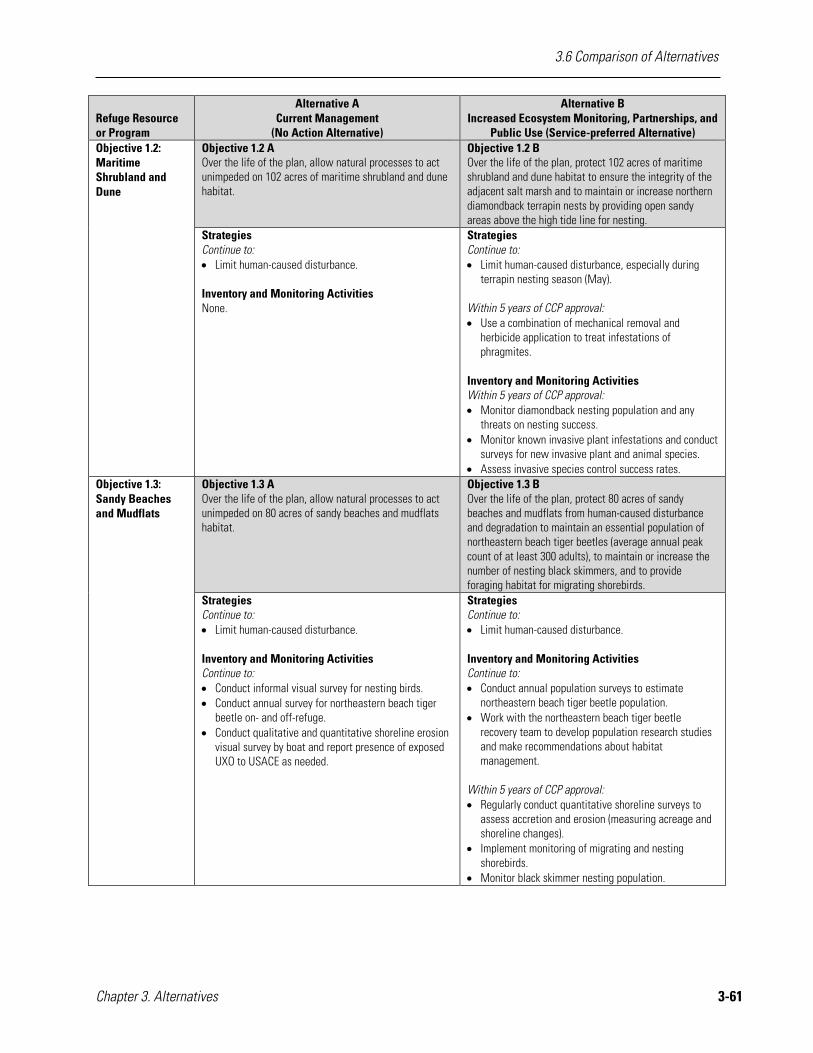
3.6 Comparison of Alternatives
Chapter 3. Alternatives 3-61
Refuge Resource or Program
Alternative A Current Management
(No Action Alternative)
Alternative B Increased Ecosystem Monitoring, Partnerships, and
Public Use (Service-preferred Alternative) Objective 1.2: Maritime Shrubland and Dune
Objective 1.2 A Over the life of the plan, allow natural processes to act unimpeded on 102 acres of maritime shrubland and dune habitat.
Objective 1.2 B Over the life of the plan, protect 102 acres of maritime shrubland and dune habitat to ensure the integrity of the adjacent salt marsh and to maintain or increase northern diamondback terrapin nests by providing open sandy areas above the high tide line for nesting.
Strategies Continue to: • Limit human-caused disturbance.
Inventory and Monitoring Activities None.
Strategies Continue to: • Limit human-caused disturbance, especially during
terrapin nesting season (May). Within 5 years of CCP approval: • Use a combination of mechanical removal and
herbicide application to treat infestations of phragmites.
Inventory and Monitoring Activities Within 5 years of CCP approval: • Monitor diamondback nesting population and any
threats on nesting success. • Monitor known invasive plant infestations and conduct
surveys for new invasive plant and animal species. • Assess invasive species control success rates.
Objective 1.3: Sandy Beaches and Mudflats
Objective 1.3 A Over the life of the plan, allow natural processes to act unimpeded on 80 acres of sandy beaches and mudflats habitat.
Objective 1.3 B Over the life of the plan, protect 80 acres of sandy beaches and mudflats from human-caused disturbance and degradation to maintain an essential population of northeastern beach tiger beetles (average annual peak count of at least 300 adults), to maintain or increase the number of nesting black skimmers, and to provide foraging habitat for migrating shorebirds.
Strategies Continue to: • Limit human-caused disturbance. Inventory and Monitoring Activities Continue to: • Conduct informal visual survey for nesting birds. • Conduct annual survey for northeastern beach tiger
beetle on- and off-refuge. • Conduct qualitative and quantitative shoreline erosion
visual survey by boat and report presence of exposed UXO to USACE as needed.
Strategies Continue to: • Limit human-caused disturbance. Inventory and Monitoring Activities Continue to: • Conduct annual population surveys to estimate
northeastern beach tiger beetle population. • Work with the northeastern beach tiger beetle
recovery team to develop population research studies and make recommendations about habitat management.
Within 5 years of CCP approval: • Regularly conduct quantitative shoreline surveys to
assess accretion and erosion (measuring acreage and shoreline changes).
• Implement monitoring of migrating and nesting shorebirds.
• Monitor black skimmer nesting population.
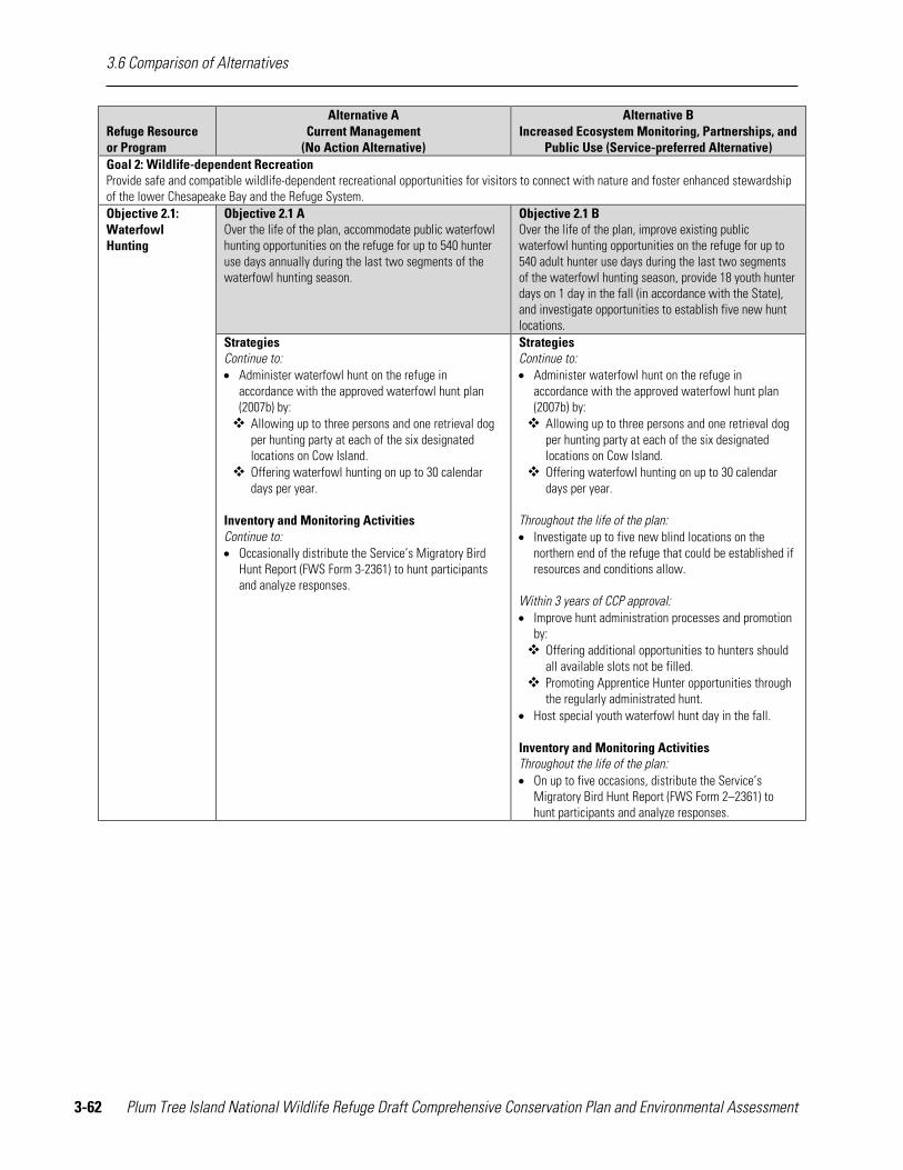
3.6 Comparison of Alternatives
3-62 Plum Tree Island National Wildlife Refuge Draft Comprehensive Conservation Plan and Environmental Assessment
Refuge Resource or Program
Alternative A Current Management
(No Action Alternative)
Alternative B Increased Ecosystem Monitoring, Partnerships, and
Public Use (Service-preferred Alternative) Goal 2: Wildlife-dependent Recreation Provide safe and compatible wildlife-dependent recreational opportunities for visitors to connect with nature and foster enhanced stewardship of the lower Chesapeake Bay and the Refuge System. Objective 2.1: Waterfowl Hunting
Objective 2.1 A Over the life of the plan, accommodate public waterfowl hunting opportunities on the refuge for up to 540 hunter use days annually during the last two segments of the waterfowl hunting season.
Objective 2.1 B Over the life of the plan, improve existing public waterfowl hunting opportunities on the refuge for up to 540 adult hunter use days during the last two segments of the waterfowl hunting season, provide 18 youth hunter days on 1 day in the fall (in accordance with the State), and investigate opportunities to establish five new hunt locations.
Strategies Continue to: • Administer waterfowl hunt on the refuge in
accordance with the approved waterfowl hunt plan (2007b) by: Allowing up to three persons and one retrieval dog
per hunting party at each of the six designated locations on Cow Island.
Offering waterfowl hunting on up to 30 calendar days per year.
Inventory and Monitoring Activities Continue to: • Occasionally distribute the Service’s Migratory Bird
Hunt Report (FWS Form 3-2361) to hunt participants and analyze responses.
Strategies Continue to: • Administer waterfowl hunt on the refuge in
accordance with the approved waterfowl hunt plan (2007b) by: Allowing up to three persons and one retrieval dog
per hunting party at each of the six designated locations on Cow Island.
Offering waterfowl hunting on up to 30 calendar days per year.
Throughout the life of the plan: • Investigate up to five new blind locations on the
northern end of the refuge that could be established if resources and conditions allow.
Within 3 years of CCP approval: • Improve hunt administration processes and promotion
by: Offering additional opportunities to hunters should
all available slots not be filled. Promoting Apprentice Hunter opportunities through
the regularly administrated hunt. • Host special youth waterfowl hunt day in the fall. Inventory and Monitoring Activities Throughout the life of the plan: • On up to five occasions, distribute the Service’s
Migratory Bird Hunt Report (FWS Form 2–2361) to hunt participants and analyze responses.
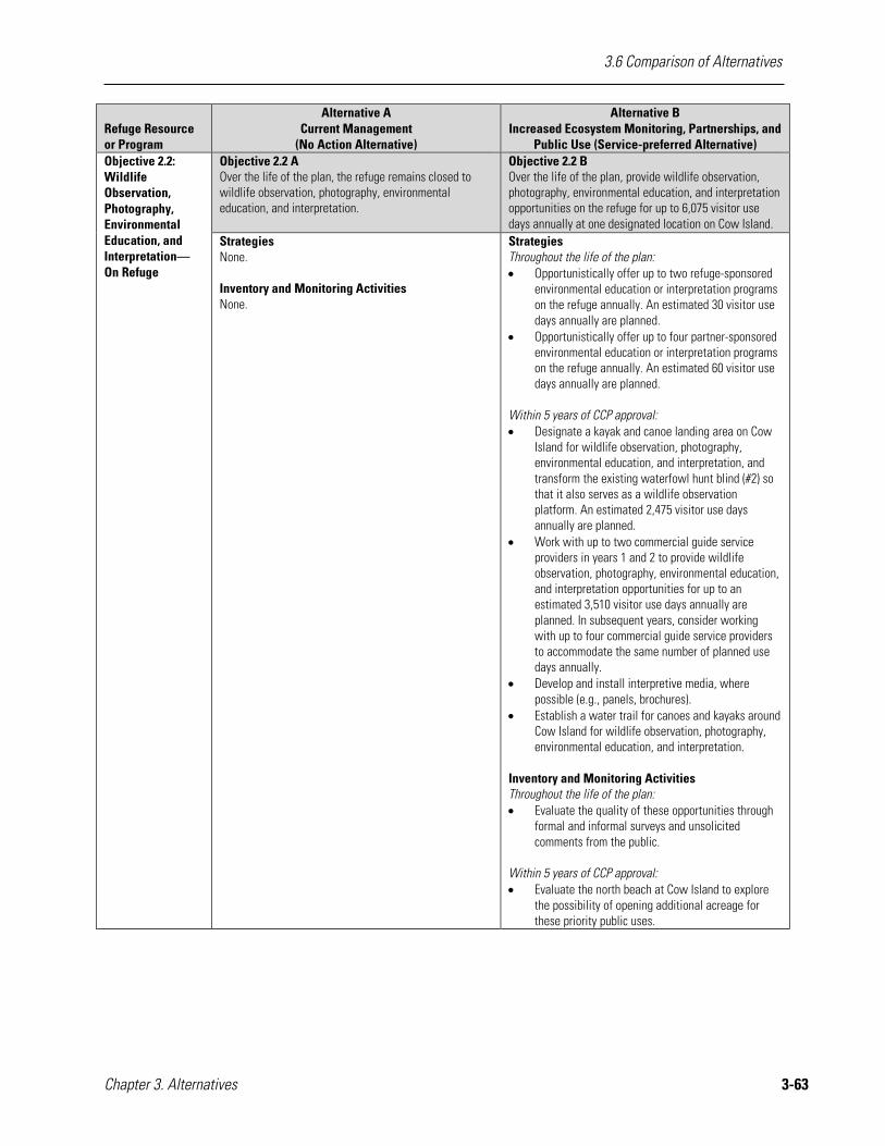
3.6 Comparison of Alternatives
Chapter 3. Alternatives 3-63
Refuge Resource or Program
Alternative A Current Management
(No Action Alternative)
Alternative B Increased Ecosystem Monitoring, Partnerships, and
Public Use (Service-preferred Alternative) Objective 2.2: Wildlife Observation, Photography, Environmental Education, and Interpretation—On Refuge
Objective 2.2 A Over the life of the plan, the refuge remains closed to wildlife observation, photography, environmental education, and interpretation.
Objective 2.2 B Over the life of the plan, provide wildlife observation, photography, environmental education, and interpretation opportunities on the refuge for up to 6,075 visitor use days annually at one designated location on Cow Island.
Strategies None. Inventory and Monitoring Activities None.
Strategies Throughout the life of the plan: • Opportunistically offer up to two refuge-sponsored
environmental education or interpretation programs on the refuge annually. An estimated 30 visitor use days annually are planned.
• Opportunistically offer up to four partner-sponsored environmental education or interpretation programs on the refuge annually. An estimated 60 visitor use days annually are planned.
Within 5 years of CCP approval: • Designate a kayak and canoe landing area on Cow
Island for wildlife observation, photography, environmental education, and interpretation, and transform the existing waterfowl hunt blind (#2) so that it also serves as a wildlife observation platform. An estimated 2,475 visitor use days annually are planned.
• Work with up to two commercial guide service providers in years 1 and 2 to provide wildlife observation, photography, environmental education, and interpretation opportunities for up to an estimated 3,510 visitor use days annually are planned. In subsequent years, consider working with up to four commercial guide service providers to accommodate the same number of planned use days annually.
• Develop and install interpretive media, where possible (e.g., panels, brochures).
• Establish a water trail for canoes and kayaks around Cow Island for wildlife observation, photography, environmental education, and interpretation.
Inventory and Monitoring Activities Throughout the life of the plan: • Evaluate the quality of these opportunities through
formal and informal surveys and unsolicited comments from the public.
Within 5 years of CCP approval: • Evaluate the north beach at Cow Island to explore
the possibility of opening additional acreage for these priority public uses.
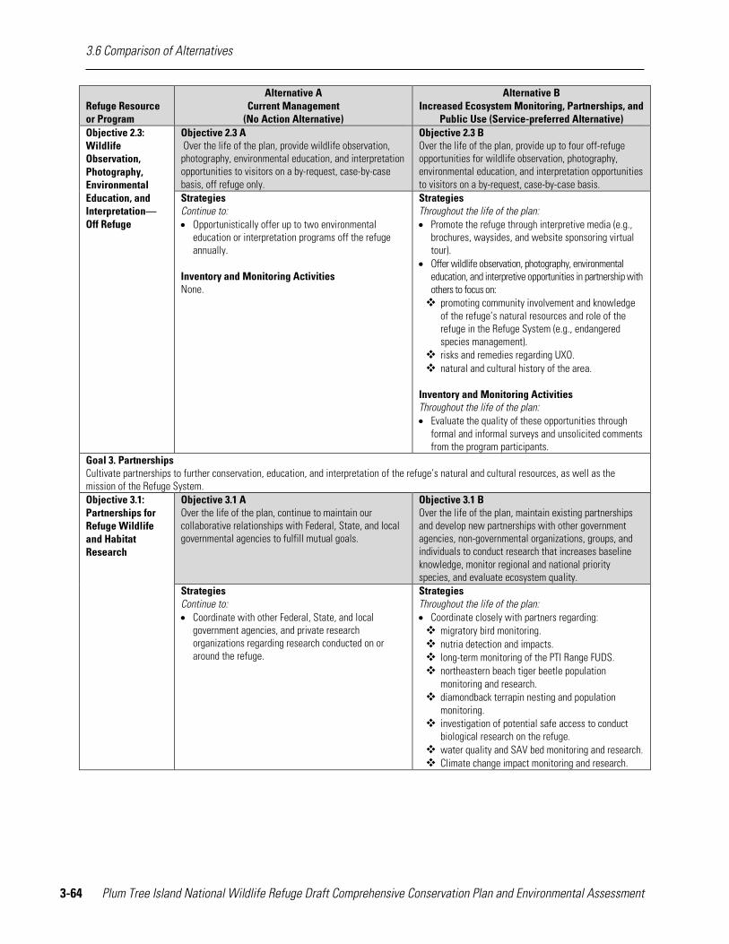
3.6 Comparison of Alternatives
3-64 Plum Tree Island National Wildlife Refuge Draft Comprehensive Conservation Plan and Environmental Assessment
Refuge Resource or Program
Alternative A Current Management
(No Action Alternative)
Alternative B Increased Ecosystem Monitoring, Partnerships, and
Public Use (Service-preferred Alternative) Objective 2.3: Wildlife Observation, Photography, Environmental Education, and Interpretation—Off Refuge
Objective 2.3 A Over the life of the plan, provide wildlife observation, photography, environmental education, and interpretation opportunities to visitors on a by-request, case-by-case basis, off refuge only.
Objective 2.3 B Over the life of the plan, provide up to four off-refuge opportunities for wildlife observation, photography, environmental education, and interpretation opportunities to visitors on a by-request, case-by-case basis.
Strategies Continue to: • Opportunistically offer up to two environmental
education or interpretation programs off the refuge annually.
Inventory and Monitoring Activities None.
Strategies Throughout the life of the plan: • Promote the refuge through interpretive media (e.g.,
brochures, waysides, and website sponsoring virtual tour).
• Offer wildlife observation, photography, environmental education, and interpretive opportunities in partnership with others to focus on: promoting community involvement and knowledge
of the refuge’s natural resources and role of the refuge in the Refuge System (e.g., endangered species management).
risks and remedies regarding UXO. natural and cultural history of the area.
Inventory and Monitoring Activities Throughout the life of the plan: • Evaluate the quality of these opportunities through
formal and informal surveys and unsolicited comments from the program participants.
Goal 3. Partnerships Cultivate partnerships to further conservation, education, and interpretation of the refuge’s natural and cultural resources, as well as the mission of the Refuge System. Objective 3.1: Partnerships for Refuge Wildlife and Habitat Research
Objective 3.1 A Over the life of the plan, continue to maintain our collaborative relationships with Federal, State, and local governmental agencies to fulfill mutual goals.
Objective 3.1 B Over the life of the plan, maintain existing partnerships and develop new partnerships with other government agencies, non-governmental organizations, groups, and individuals to conduct research that increases baseline knowledge, monitor regional and national priority species, and evaluate ecosystem quality.
Strategies Continue to: • Coordinate with other Federal, State, and local
government agencies, and private research organizations regarding research conducted on or around the refuge.
Strategies Throughout the life of the plan: • Coordinate closely with partners regarding: migratory bird monitoring. nutria detection and impacts. long-term monitoring of the PTI Range FUDS. northeastern beach tiger beetle population
monitoring and research. diamondback terrapin nesting and population
monitoring. investigation of potential safe access to conduct
biological research on the refuge. water quality and SAV bed monitoring and research. Climate change impact monitoring and research.

3.6 Comparison of Alternatives
Chapter 3. Alternatives 3-65
Refuge Resource or Program
Alternative A Current Management
(No Action Alternative)
Alternative B Increased Ecosystem Monitoring, Partnerships, and
Public Use (Service-preferred Alternative) Objective 3.2: Partnerships for Public Uses
Objective 3.2 A Over the life of the plan, continue to maintain our collaborative relationships with Federal, State, and local governmental agencies to fulfill mutual goals.
Objective 3.2 B Over the life of the plan, maintain existing partnerships and develop new partnerships with other governmental agencies, non-governmental organizations, groups, and individuals to promote priority public uses that foster an understanding and appreciation of the refuge and the mission of the Service.
Strategies Continue to: • Protect public safety by enforcing refuge regulations. • Coordinate with other Federal, State, and local law
enforcement agencies regarding public uses on and around the refuge.
Strategies Throughout the life of the plan: • Support partners and coordinate efforts, as time and
resources allow, to provide recreation opportunities near the refuge and in the Lower Chesapeake Bay that increases the appreciation for the refuge and its mission.
• Coordinate and collaborate with partners and adjacent landowners to investigate potential viewing platforms for mainland public access to participate in appropriate and compatible public uses.
• Offer wildlife observation, photography, environmental education, and interpretive opportunities in partnership with others to focus on: promoting community involvement and knowledge
of the refuge’s natural resources and role of the refuge in the Refuge System (e.g., endangered species management).
risks and remedies regarding UXO. natural and cultural history of the area.