HOW TO STUDY GEOGRAPHY Objectives: Use latitude & longitude Identify different maps.

5
USE OF GIS TO STUDY TOURISM BURDEN - CASE STUDY OF PROTECTED LANDSCAPE AREA KOKOŘÍNSKO Michaela Antoušková, Jana Mikulec Klíčová slova: Cestovní ruch, chráněná krajinná oblast, Kokořínsko, GIS, zatížení území Key words: Tourism, protected landscascape area, Kokořínsko, GIS, burden of region Abstrakt Trvale udržitelný rozvoj cestovní ruchu na určitém území by měl být navrhován a realizován, mimo jiné, také na základě monitorování jeho dopadů, tedy i zatížení území cestovním ruchem. Předkládaný příspěvek se zabývá turistikou a zatížením území cestovním ruchem v CHKO Kokořínsko. Konkrétně analyzuje nabídku a poptávku cestovního ruchu ve vymezeném území a monitoruje vytížení turistických tras. K monitorování vytížení turistických tras využívá geografických informačních systémů (GIS), jako nové metody hodnocení dopadů cestovního ruchu v České Republice. Abstract Sustainable tourism development should be proposed and realised on the bases of monitoring its impacts, among them also tourism burden of a concrete region. Presented article deals with hiking and tourism burden in the protected landscape area Kokořínsko. Concretely the article analyses tourism supply and demand in the region and further monitors the burden of hiking trails. To monitor the burden of hiking trails the GIS (geographical information systems) are used, as new methods for evaluating tourism impacts in the Czech Republic. 1. Introduction 1.1 GIS introduction
Geographic information system (GIS) is a computer-based database used to store, integrate in layers and display data of a geographical nature. It has a widespread use in the area of ecological monitoring and environmental planning. Nowadays, GIS is used for other purposes including tourism planning, tourism impacts and other tourism issues. The GIS was originally used in the USA for solving transportation problems. The first company that introduced this geographic information system and made the first edition of ARCINFO1 accessible for computers was ESRI, founded in 1969. ESRI is still a leading company in the geographic information systems market. Further development of GIS is connected to a boom of computers and the Internet. Nowadays, the original desktop character has changed to more important sever applications (data sharing, internet presentations) and mobile applications (mobile phones, PDA2, GPS3). 1 ARCINFO is a full-featured geographic information system 2 Personal Digital Assistant 3 Global Positioning System

6
1.2 GIS definitions
ESRI defines GIS as: “A geographic information system integrates hardware, software, and
data for capturing, managing, analyzing, and displaying all forms of geographically
referenced information.” Giles (2003) view GIS as capable of enabling the integration of datasets representing socioeconomic development and environmental capital within a giving special setting. McAdam (1999) defines GIS as a relational database capable of manipulating both spatial data (in the form of digitized maps) and attributes data (comprising data sets in the form of alfa-numerical records). Boers – Cottrell (2007) cite Malczewski (1999) who views GIS as a hardware, software and procedures collectively supporting the collection, input, storage, retrieval, manipulation, transformation, analysis and presentation of geo-referenced objects and field data. 1.3 GIS in tourism
Giles (2003) points out that GIS is efficient and effective mean of helping the various stakeholders examine the implication of land-use decisions in tourism development. Chen (2006) assumes that the analysis from GIS can determine both threats and opportunities for development. For business planners, the GIS consider the prospects for a large scale or multiple regions and then narrow the developmental focus on specific areas. Also consumers and business benefit because GIS may enable convenient shopping for consumers. Chen (2006) proposes the use of GIS in tourism planning in the following points:
� Visitor flow management (to identify principal tourist activities within a destination or among destinations).
� Facility inventory and resources use (to identify issues of environmental justice, to identify conflicts, complementary land uses, tourist activities, natural resources).
� Assessing impacts of tourism development (to demonstrate tourism impacts on its surrounding).
Giles (2003) adapted the Butler´s view of relation between tourism issues and GIS application. This relation is summarized in the table 1. Table 1 GIS application for tourism purposes
Problem GIS application
Benchmark/database Systematic inventory of tourism resources Environmental management Facilitating monitoring of specific indicators Conflicts Mapping recreational conflicts, i.e. recreation-wildlife Tourism behavior Wilderness perception Carrying capacity Identification of suitable locations for tourism development
Prediction Simulation and modeling spatial outcomes of proposed tourism development
Data integration Integration of socio-economic and environmental datasets Development control and direction decision support systems
Source: Giles (2003) adapted Butler (1993)
Tremblay (2005) founded out that a large part of GIS applications has developed by combining information about land and other spatial characteristics with ecological data to produce multilayered maps. These models played an important role in early tourism applications. Moreover, multilayered maps allow an integration of data e.g. about habitat for

7
wildlife species and data about recreational uses or special preferences to identify overlaps and potential conflict areas. Tourism destinations are usually characterized by three different features: points, lines and polygons. Point features are individual tourist attractions (e.g. historical buildings, museums). Coastal beaches may represent linear patterns, while polygons may be characterized by natural parks. Also other GIS functions may help users to get appropriate results. Layering enables the user to add and remove certain features from map display (e.g. to remove all other features and display only hiking trails). Querying and reclassification enable the user to adjust the map image for analysis (e.g. to determine museums or historical building with free entrance within the location of interest). Buffering enables to identify the areas of interest (e.g. to identify all hotels and restaurants around the hiking trail). Finally, data integration enables two different map layers of the same area to be laid one on the top of the other to form a new layer. Before the users may use, GIS several procedures have to be done. Janović (2007) adverted several procedures that enable the development of a spatial database such as:
� Acquisition of graphical maps covering the region; � Converting the paper maps into digital maps; � Creation of topology to establish relations among the map features; � Transformation into real world coordinates.
An example of the layers can be seen in the fig. 1. In tourism management the GIS may be used by a tour operator. A GIS file may show all hotels as points, all roads as lines within a specific area or polygon. GIS also enables to identify hotels within a specific area that match specific criteria. Fig 1 Examples of layers for tourism industry
Adapted from Janović (2007)

8
According to Jovanović (2007) the use of GIS may provide the tourism industry with: � A digital map base for printed maps � Digital files for internet mapping; � Digital files for mobile mapping; � An attraction map; � A website with interactive mapping.
1.4 Use of GIS
Numerous cases of the usage of GIS may be cited. In these cases GIS brings a significant value to tourism planning and development. For example, McAdam (1999) mentioned cases of GIS usage for the analysis of landscape views for visual impacts assessment. It may be used in landscape management in situations where there is a high level of scenic interest and where visitors are attracted to the scenic views. Moreover Harris at al. (1995) used GIS for a research in the Colorado National Forest. They compared the movement of tourists and the movement of mountain sheep. They assumed that sheep competed with tourists for the same land. Next, Giles (2003) mentioned the case of GIS usage for the research in the Mt. Everest. The increasing number of visitors resulted in high level of impacts on mountain trails. GIS was used for mapping trail impacts. Information about trails (e.g. soil erosion, vegetation loss along trail transects, trail displacement, bedrock exposition) were mapped and integrated with visitor’s data (e.g. visitor density). The trail database finally contained 208 trail segments. Furthermore, Tomczyk (2010) used GIS for the similar purposes. He modeled environmental sensitivity of recreational trail in the Gorce National Park in Poland. The model combined data about topography, soil properties and vegetation. The GIS allowed dealing with such an amount of data. According to Tomczyk the main advantages of this method could be seen in the capability to study spatial diversion and the distribution of environmental sensitivity and also in the possibility to assess which factors are the most important for environmental sensitivity in selected areas. Beedasy – Whyatt (1999) focused their research on Spatial Decision Support Systems for sustainable planning in Mauritius. GIS was a core component for this system. Giles (2003) concluded that GIS can play an important role in impacts assessment in tourism development, especially in auditing conditions, examining the sustainability of locations for regional development. GIS can also identify conflicts and model relations among the variables. Nevertheless, the use of GIS may be limited, mainly due to the lack of long-term, comprehensive and systematic data on tourism issues. With consistent spatial data on tourism locations, characteristics of these locations and long-term visitor data, the GIS application will grow significantly. 1.5 GIS in sustainable tourism development
According to Boers (2000) the GIS are believed to have great potential in sustainable tourism planning. McAdams (1999) adds that GIS has already served a variety of tourism purposes however using the GIS applications in tourism planning are scare. Sustainable tourism planning means avoiding the tourism burden. Tourist destination may be burden by tourism in several respects and this burden is caused by the exteriorization of negative impacts of tourism. Negative impacts can show themselves in the natural, cultural, social and economical environment. Many authors deal with negative impacts in their work, for more see Pásková (2008), Pearce (1995) or Cooper-Fletcher (2005). As Pásková presents

9
(2008), unregulated tourism is usually unfriendly towards the natural environment because with an excessive intensity and pace it consumes especially non-renewable resources. Thanks to an existence of market externalities auto-regulatory mechanisms of a market system do not work as they should and the tourism with its entrepreneurial activities depreciates own capital, so natural and cultural values of the destination. The impact intensity is given by a visit rate, a seasonality, and a vulnerability of eco-systems. Among negative influences on the environment there are, among others, also:
� Emissions – a resource of emission increase caused by tourism is especially transportation. The tourism, indirectly in them, participates by means of emissions produced e.g. in building industries, transportation of materials etc.
� Erosion – tourism participates in erosion of a natural surface e.g. in building of access ways to landmarks or in push-down in free nature.
� Importation of non-original species – usually it is dealt with unintentional activities of tourists and operators of tourist facilities when visitors transfer plant seeds of animal embryos in areas where they did not occur before. Problems arrive especially in national parks and Protected Landscape Areas (CHKO).
� Damaging of natural values and biodiversity – it is dealt often with vandalism or a tourists´ effort to get a unique souvenir.
Pásková (2008) presents that in comparison with influences of tourism on the natural environment the sociocultural impacts do not manifest themselves so markedly and on the instant; they are worse identified and measurable, and meanwhile, they are not examined thoroughly. Because it is dealt with influences of a subjective character, they are hardly monitorable. She characterizes them as a complex of undesirable influences of tourism and especially of visitors on a host community, its natural and social environment. Basic characters of social impacts are, among others, the following:
� demonstrational effect – an imitation of visitors´ behaviour by local inhabitants; � dualization of society – a process of division of the society to the rich (in areas with a
higher tourist intensity, higher incomes from tourisms) and the poor; � tourist irritation – it is dealt with a development process relation of local inhabitants
to tourists. As a suitable tool for measurement is used Doxey´s irritation index which identifies four phases of irritation: euphoria, apathy, satiety and antagonism (more Arrow – Bolin, 1995).
To keep the sustainable development in tourist destinations, proper research and analyses of tourism burden have to be conducted. Therefore the authors focus on tourism burden in the landscape protected area, in which the sustainable tourism developments should have high priority. Authors analyzed tourism burden in protected landscape area Kokořínsko and specialized on burden of hiking and cyclo trail, which represent one of the most important reasons for visiting this area. 2. Methodology 2.1 Database
2.1.1. GIS data
First of all, there was effectuated data collection with information about tourist trade – natural and socio-historical-cultural potentials, which belong to group of primary potentials and secondary potentials containing accommodation, catering establishment, hiking trails and bike

10
trails4. These data were collected from different sources - The Government of the protected landscape area of Kokořínsko, different municipalities of Kokořínsko, Tourist map of Kokořínsko and the club of Czech tourists. The Government of the protected landscape area of Kokořínsko, Agency for protection of nature and landscape area (AOPK5) was contacted and asked for a shape file data format with information about natural potentials. The club of Czech tourists was asked for a raster file with information about tourist and bike trails. The rest of the data, such as the border of the area of interest, roads, rivers, main towns were used from accessible internet map service of agency Cenia. The ARCIMS address of this map service is http://geoportal.cenia.cz.
2.1.2 Sociological questionnaire
For data collection there was chosen a method, which combines self-administred data collection (questionnaire is filled without the presence of the investigator) and other-administred data collection. In this case the investigator was absent during filling of the questionnaire but he/she spoke to respondents, gave them questionnaires with flash information about filling. This method should have ensured high returnability of the questionnaires. The data collection was effectuated on the crossroads of tourist trails during summer 2010.
The whole questionnaire contains 19 questions out of which 11 questions were used to analyze the tourist profile and his preferences. The whole questionnaire was consulted with experts in sociology.
There was also created a map6 in A0 size with all hiking and bike trails in the protected landscape area. The respondent was asked to write down numbers of trails which he/she visited/will visit during last seven days. 2.2 Analysis
Maps and layouts were done in program GIS version 9.3 ESRI (Arc Catalogue, Arc Map and Arc Toolbox). In all maps the coordinated system S-JTSK Krovak East North was set up. 2.2.1 Burden by tourist potentials
After the data collection in Arc Map there were done the layers including natural attractivities, socio-historical-cultural attractivities, small-area protected territory, accommodation, catering establishment, hiking trails and bike trails.
To indicate tourism burden by primary and secondary potentials methods of Thiessen Polygons was used. Thiessen polygons, is a collection of polygons formed around a set of points. The polygons are created by finding the nearest pathway, or connection, between each set of dots. (read more Yoo et al, 2007) 2.2.2 Hiking trails burden
In the next layout The most frequent sections of tourism trails (layout 2),, there can also be seen a layer called trails including hiking and bike trails. These vectors were created by tracing the raster file data. Hiking and bike trails were divided to the sections. In the attribute table of trail’s layer, the information about the number of sections, the type of trails (hiking,
4 According to Štěpánka – Šípa - Kopačky 5 Administration of Kokořínsko Protected Landscape Area 6 Viz. part Methodology – GIS – forth paragraph

11
bike), the colour of trails (blue, green, red, yellow, bike) and the number of tourists who visited a particular section were introduced.
On the basis of the obtained data there was executed the SQL request demanding to mark sections where the number of tourist who visited a particular section was equal or higher than 10 and than 20. The final map can be seen in the layout 2. 3. Case study of Kokořínsko
3.1 Landscape protected area Kokořínsko
Landscape protected area Kokořínsko is situated mainly in the Liberec Region and Central Bohemia Region, only a small part is the area belonging to the Usti Region. With its 272 km2, Kokořínsko belongs to the average landscape protected areas. It became a protected landscape area in 1976 by a decision of the Ministry of Culture, former Czechoslovakia. Kokořínsko is unique mainly for its sandstone towers, arches, windows and other formations, which do not exist in such a number and range in any other region of the Czech Republic. Apart from its specific geomorphology, there are also other features that make this area unique:
� High biological diversity, high variability of ecosystem on relatively small area; � Landscape character with well-balanced forest and non-forest land; � Architecture, especially original log, half-timbered or brick-wall architecture; � Wetlands, these areas were added to the Ramsar List of Wetlands of International
Importance in 1997; � High supplies of subterranean water.
The dominant landscape features are magmatic extruded rocks consisting of phonolite, basalt or trachyte mounds and cones (Vlhošť 614 m, Ronov 552 m, Vrátenská Hora 507 m). (Administration of Kokořínsko Protected Landscape Area, 2010) 3.2 Tourism supply and burden of tourist potentials
Primary potentials are characterized mainly by features of the landscape, and other features stated above. What belongs to the main attractions are sandstone and rock formations, such as Pot-lids, Snow-white, Frog and others. There are also 5 natural reserves and 16 natural monuments in the area. A part from the natural attractions, there may be found historical and cultural attractions that are also a part of primary potentials. What may be ranked among the historical attractions is the Kokořín castle. More than 50 000 visitors visit the castle each year. The Houska castle belongs as well to historical attraction with the average visitor rate of 30 000 tourists per year. The cultural potential may be connected to Karel Hynek Mácha, whose work had been inspired by this region. Many cultural events take place in Kokořín, such as a Castle ball, castle concert, Gothic market or Renaissance market. Moreover, some view-towers are also situated in Kokořínsko, for instance Vrátenská tower or Slavín.
Secondary potentials are generally characterized by establishments that enable to develop the primary potentials. What may be included in secondary potentials are accommodation facilities, boarding facilities, roads and other. Near hiking trails there may be found several accommodation facilities such as 2 hotels; 13 guest-houses; 3 hostels; 3 private accommodation and 2 camps. Nevertheless, tourists visiting Kokořínsko may be accommodated outside the protected landscape area. Kokořínsko is situated predominantly in the Mělník and Česká Lípa region, and so the secondary potential in accommodation may be extended to these regions.
12
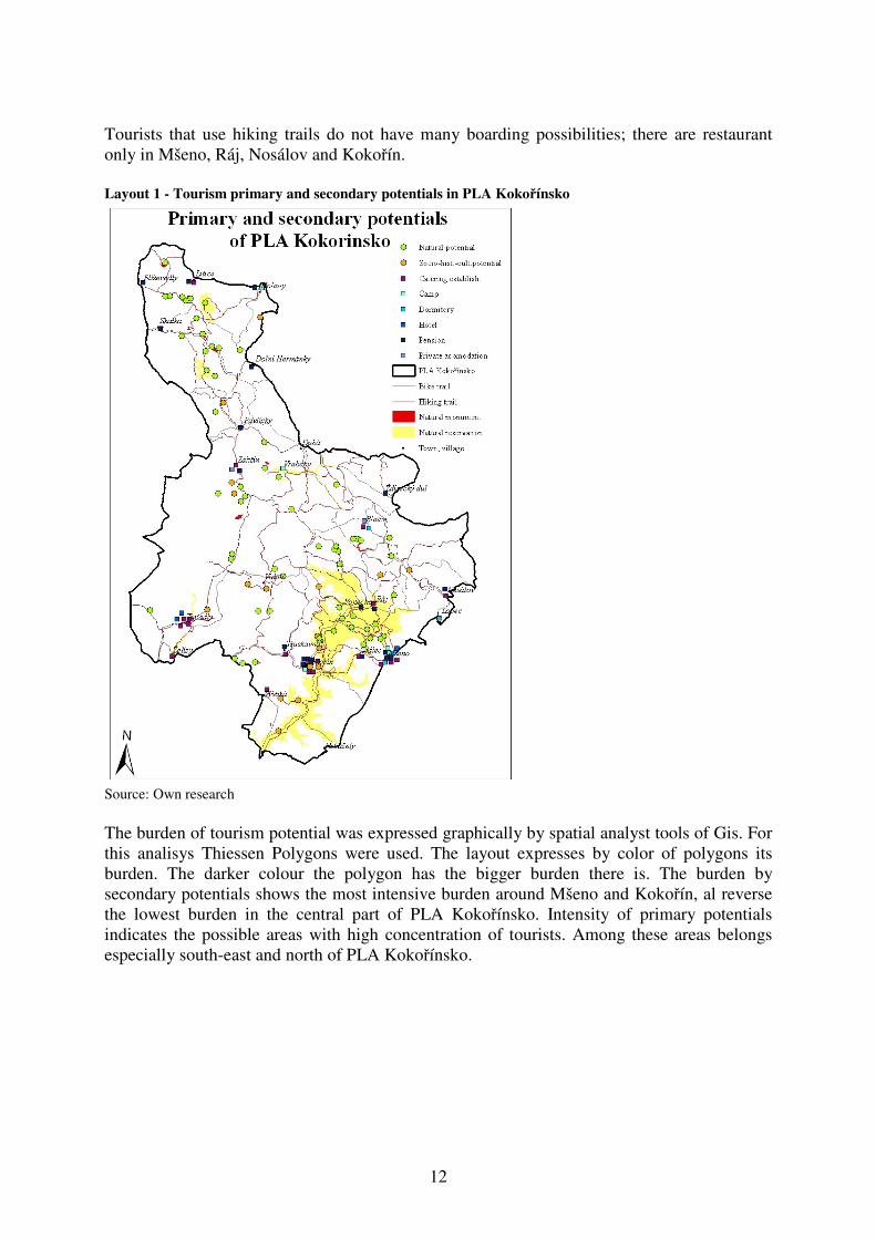
Tourists that use hiking trails do not have many boarding possibilities; there are restaurant only in Mšeno, Ráj, Nosálov and Kokořín. Layout 1 - Tourism primary and secondary potentials in PLA Kokořínsko
Source: Own research The burden of tourism potential was expressed graphically by spatial analyst tools of Gis. For this analisys Thiessen Polygons were used. The layout expresses by color of polygons its burden. The darker colour the polygon has the bigger burden there is. The burden by secondary potentials shows the most intensive burden around Mšeno and Kokořín, al reverse the lowest burden in the central part of PLA Kokořínsko. Intensity of primary potentials indicates the possible areas with high concentration of tourists. Among these areas belongs especially south-east and north of PLA Kokořínsko.

13
Layout 2 – Primary and secondary potentials – Thiessen polygons
Source: Own research
3.3 Hiking and bike trails burden
The research showed that tourists visited Kokořínsko primary for its natural and cultural attractions (45,3 %). Tourists also wanted to be and stay in the nature (15,1 %). Almost 10 % visitors went to Kokořínsko because of sport, especially cycling. The same amount of tourists came to visit their relatives or friends. The main indicators that influenced the tourist’s decision which hiking trail they would used were especially the landscape features (33,2 %). Tourist were also attracted by concrete objectives (castle, sandstone and rock formations – 22,3 %). For almost 16 % tourists it was important that the trail led through the forest. Other reasons to visit the hiking trails are demonstrated in the fig. 3.7
7 Tourists might indicate only up to 3 main reason to visit the trails in the questionnaire

14
Fig 2 Reasons to choose the hiking trails
6,9%
33,2%
4,7%15,9%1,3%
22,4%
5,6%8,2% 1,7%
trial length
features of landscape
features of municipalities,
houses
forest
offered services
concrete objects
start and finish of the trail
transport availability
other
Source: Own research The research does not prove that the length of trail is an important indicator for elder people. The indicators for choosing the trail were not influenced by the reasons for coming to the protected landscape area Kokořínsko. In the protected landscape area there were accommodated 26 % tourists, 52 % tourists used boarding facilities and 15,7 % tourists used the services of information centre.
The frequency of tourist sections equal or higher than 10 was marked in 26 sections from 188. The frequency of tourist section equal or higher than 20 was marked in 11 sections from 188. Layout 3 – The most frequent sections of tourism trails
Source: Own research

15
4. Conclusion GIS is very important tool for analysis of spatial data. In this study use of GIS was applied on tourism burden. The primary and secondary potentials were marked in PLA Kokorinsko. The most burden localities of tourist potentials were marked around Kokořín, Mšeno, hrad Houska, Ronov. This data give information about gathering of tourists which can serve for improving information centers, create educative pahts, interactive environmental parks, provide rubish baskets, etc. in the localities of high concentration of tourists. Also the analysis of tourist trails was effectuated in five different crossroads in all protected landscape area. The most visited sections were marked in the surrounding of the towns Mšeno and Kokořín. This information could be helpful for improving tourism facilities as accomodation and restaurant service. Pieces of knowledge introduced in this paper resulted from solution of an university grant no.20094209 „ Influence of aesthetic values on tourism in some protected landscape areas “. Literature: [1] ARROW K,: BOLIN, B. at al: Economic Growth, Carrying Capacity, and the
Environment. Ecological Economic. 1995, vol 268. [online] [cit.8.12.2008]. Available on <http://www.rachel.org/files/document/Economic_Growth_Carrying_Capacity_and_the_Envi.pdf>
[2] BEEDASY, J., WHYATT, D.: Diverting the tourists: a spatial decision-support system
for tourism planning on a developing island. JAG, vol. 1, 1999. doi:10.1016/j.physletb.2003.10.071
[3] BOERS, B.,COTTRELL, S.: Sustainable Tourism Infrastructure Planning: A GIS-
Supported Approach. Tourism Geographics, vol. 9, no 1, 2007 DOI: 10.1080/14616680601092824
[4] COOPER, C., FLETCHER, J. at al: Tourism, Principles and Practise. London: Prentice Hall, 2005. 851 p. ISBN 978-0-273-71126-14
[5] CHEN, R.J.C.: Geographic information systems (GIS) applications in retail tourism
and teaching curriculum. Journal of Retailing and Consumer Services, 2006. DOI 10.1016/j.apgeog.2010.07.04
[6] GILES.W.: GIS application in tourism planning. 2003, available on http://fama2.us.es:8080/turismo/turismonet1/economia%20del%20turismo/analisis%20geografico/GIS%20application%20in%20tourism%20planning.pdf , cited 2.9.2010
[7] JANOVIĆ V.: The application of GIS and its components in tourism. Yugoslav Journal of Operating Research. Vol. 18, no. 2, 2008 DOI: 10.2298/YUJOR0802261J
[8] McADAM, D.: The Value and Scope of Geographical Information Systems in Tourism
Management. Journal of Sustainable Tourism, Vol. 7, no. 1, 1999. ISSN 0966-9582 [9] PÁSKOVÁ, M.: Udržitelnost rozvoje cestovního ruchu.(Sustainability of tourism
development) Prague: Gaudeamus, 2008. 297 p. ISBN 978-80-7041-7 [10] PEARCE, D.: Tourism Today: A Geographical Analysis. New York: Longman Group
Limited. 1995 ISBN 0-582-070-104 [11] ŠTĚPÁNEK, V., ŠÍP, J., KOPAČKA, L.: Geografie cestovního ruchu. Praha:
Karolinum, 2001. 228 s. ISBN 80-246-0172-9 [12] TOMCZYK, A.M.: A GIS assessment and modelling of environmental sensitivity of
recreational trails: The case of Gorce National Park, Poland. Applied Geography, 2010, DOI 10.1016/j.apgeog.2010.07006

16
[13] TREMBLAY.: GIS Technique in Tourism and Recreation Planning: Applications to
Wildlife Tourism. In Tourism Research Methods. CABI Publishing, 2005. ISBN 85 1999 996 4
Format in coordinated system JTSK. Authors would like to thank for provided data to following organisations: AOPK ČR - provided vector’s data in shape file format in coordinated system JTSK Government of protected landscape area Kokořínsko – provided vector’s data in shape file KČT – provided raster data jpg JEL classification: E42, E52 Ing. Michaela Antoušková, Ph.D. Department of Economics Faculty of Economics and Management Czech University of Life Sciences Kamycka 1176 165 21 Prague 6 - Suchdol [email protected] Ing. Jana Mikulec Department of Applied Geoinformatics and Spatial Planning Faculty of Environmental Sciences Czech University of Life Sciences Kamycka 1176 165 21 Prague 6 - Suchdol [email protected]