Use of GIS in an Archaeological Study of the Island of St ... · similarities in culture there is...
17
TS 22 – New Measurement Technology and Its Application to Archeological and Engineering Surveys Madiha A. A. Farag, Keith M. Miller, Bheshem Ramlal and Claudius K. Fergus TS22.12 Use of GIS in an Archaeological Study of the Island of St. Kitts From Pharaohs to Geoinformatics FIG Working Week 2005 and GSDI-8 Cairo, Egypt April 16-21, 2005 1/17 Use of GIS in an Archaeological Study of the Island of St. Kitts Madiha A.A. FARAG, Keith M. MILLER, Bheshem RAMLAL and Claudius K FERGUS, West Indies Key words: SUMMARY The island of St Kitts is situated in the North East Caribbean Sea and covers an area of approximately 168 square kilometers. Throughout the last 6,000 years it has been the home of three Amerindian ethnicities, and then peoples of European and African descent. Changes in land use have been abrupt, as these groups have pressurized the previous occupants for space to live and survive under the natural threats of hurricanes and volcanic activity. Due to similarities in culture there is little to distinguish between artifacts of the Amerindian occupancies, and the sudden take over by the Europeans leaves little historical record of their activities. The European arrival marked a significant change in land use, and African labor was introduced to implement agricultural endeavors to full capacity. Later these people became the owners of the little remaining vacant land, using it in a different style. This work aims to investigate the impact that the change in land use has had on the island. Ultimately this will involve the analysis of soil samples from various parts of the land to identify variations. Initially however, a complete study of archaeological and historical evidence is required to assess the use that has been made of the island. Information that is available has been critically examined with the aid of GIS applications. Data from a wide range of sources has been integrated with the aim of evaluating and cross-referencing sources. This paper presents the findings of the study, which combines information from records and archaeological work with that from site visits and surveys to compile a GIS that documents the entire history of human occupation of St Kitts. While previous work has focused on settlements of particular eras or locations, this research brings it together and adds further data to compile a record that is as complete as is currently possible. It is fully justified and presented through maps and records in a digital database in the form of a GIS.
Transcript of Use of GIS in an Archaeological Study of the Island of St ... · similarities in culture there is...

TS 22 – New Measurement Technology and Its Application to Archeological and Engineering Surveys Madiha A. A. Farag, Keith M. Miller, Bheshem Ramlal and Claudius K. Fergus TS22.12 Use of GIS in an Archaeological Study of the Island of St. Kitts From Pharaohs to Geoinformatics FIG Working Week 2005 and GSDI-8 Cairo, Egypt April 16-21, 2005
1/17
Use of GIS in an Archaeological Study of the Island of St. Kitts
Madiha A.A. FARAG, Keith M. MILLER, Bheshem RAMLAL and Claudius K FERGUS, West Indies
Key words: SUMMARY The island of St Kitts is situated in the North East Caribbean Sea and covers an area of approximately 168 square kilometers. Throughout the last 6,000 years it has been the home of three Amerindian ethnicities, and then peoples of European and African descent. Changes in land use have been abrupt, as these groups have pressurized the previous occupants for space to live and survive under the natural threats of hurricanes and volcanic activity. Due to similarities in culture there is little to distinguish between artifacts of the Amerindian occupancies, and the sudden take over by the Europeans leaves little historical record of their activities. The European arrival marked a significant change in land use, and African labor was introduced to implement agricultural endeavors to full capacity. Later these people became the owners of the little remaining vacant land, using it in a different style.
This work aims to investigate the impact that the change in land use has had on the island. Ultimately this will involve the analysis of soil samples from various parts of the land to identify variations. Initially however, a complete study of archaeological and historical evidence is required to assess the use that has been made of the island. Information that is available has been critically examined with the aid of GIS applications. Data from a wide range of sources has been integrated with the aim of evaluating and cross-referencing sources. This paper presents the findings of the study, which combines information from records and archaeological work with that from site visits and surveys to compile a GIS that documents the entire history of human occupation of St Kitts. While previous work has focused on settlements of particular eras or locations, this research brings it together and adds further data to compile a record that is as complete as is currently possible. It is fully justified and presented through maps and records in a digital database in the form of a GIS.

TS 22 – New Measurement Technology and Its Application to Archeological and Engineering Surveys Madiha A. A. Farag, Keith M. Miller, Bheshem Ramlal and Claudius K. Fergus TS22.12 Use of GIS in an Archaeological Study of the Island of St. Kitts From Pharaohs to Geoinformatics FIG Working Week 2005 and GSDI-8 Cairo, Egypt April 16-21, 2005
2/17
Use of GIS in an Archaeological Study of the Island of St. Kitts
Madiha A.A. FARAG, Keith M. MILLER, Bheshem RAMLAL and Claudius K FERGUS, West Indies
1. INTRODUCTION The island of St. Kitts (officially known as St. Christopher) occupies an area of 168 km2 and is surrounded by the Caribbean Sea (Figure 1). The island is situated in the northern part of the archipelago of the Lesser Antilles. The main body of the land mass comprises of three groups of rugged volcanic mountains, which rise to 1,151 meters above sea level, and are split by deep ravines. As these hills gently slope down to the sea, an apron of lands that are suited to agricultural use exist. Towards the southeast the island extend to a peninsula that comprises of relatively lower steeply sloping hills, interspaced with sands and salt ponds. On the main body of the Island, cultivation has replaced the original vegetation on the surrounding sloping land where the primary crop is sugar cane (Watts, 1987). According to Beard (1949), the only remains of the natural forest exist on the steeply sloping areas towards the summit of Mount Liamuiga, the tallest peak on the island. On the Southern part of the island the remains of previous cultivation exist, but the land in this region is now mostly barren. Through the last 6,000 years the Island has provided a home, food supply and income for a range of people, mostly originating from South America, Europe and Africa. The original settlers used the land for their own sustenance, but 400 years ago this changed. St Kitts became the gateway to the Caribbean for Europe and the land was used to provide food internationally. Some knowledge of the history of the peoples that occupied the island is available, but the changing use of the land and consequences are not fully understood. The indigenous people had no documented history, and their sudden expulsion from the island leaves little information concerning their activities. In contrast the history of European occupation of St. Kitts is well documented and the activities of these inhabitants are signified by the massive clearance of the local forest. Without the tree cover the soils consolidate such that rainwater will not be absorbed so readily, and will evaporate much more rapidly. The introduction of catchment’s schemes on the hills has further reduced the amount of water reaching the North Western side of the island to the extent that the river at Stone Fort, which previously flowed all year, is now completely dry. The question that remains concerns the climatic changes at a global scale, and whether anthropogenic use of St Kitts had a significant impact on the microclimate? Throughout the agricultural years, the cultivated lands were mostly dedicated to sugar cane and occasionally to cotton. It is recognized that both crops are high in nutrient demand. The influence on the soil quality and structure is the subject for scientific investigation. The literature review, which is supported by archaeological evidence, is to be integrated into modern techniques for further analyses.
TS 22 – New Measurement Technology and Its Application to Archeological and Engineering Surveys Madiha A. A. Farag, Keith M. Miller, Bheshem Ramlal and Claudius K. Fergus TS22.12 Use of GIS in an Archaeological Study of the Island of St. Kitts From Pharaohs to Geoinformatics FIG Working Week 2005 and GSDI-8 Cairo, Egypt April 16-21, 2005
3/17
2. HISTORICAL OVERVIEW OF THE INDIGENOUS OCCUPATION When Columbus arrived in 1493 the Lesser Antilles Islands were home to an indigenous people, whom anthropologist Rouse (1986) called Island Caribs on the basis of ethnicity. Allaire (1997) maintains that they could be distinguished from the inhabitants of the Greater Antilles, the Tainos, by their customs, linguistic style, and cultural traits. The female, for example differed from the Tainos’ women by usually wearing a garment woven from cotton reaching her below the knee. Father Raymond Breton, who lived among the indigenous people of Guadeloupe during the seventeenth century, reported that the inhabitants called themselves Kalinagos, following the language of the men (Hulme and Whitehead, 1992 and Joseph, 1997). Based upon this fact, the title Kalinagos is adopted in this research instead of the commonly used “Island Caribs” or “Carib”. Exactly when the indigenous people established permanent settlements within the region is uncertain. Watson (1979) proposed that the Lesser Antilles were originally inhabited by the Siboney who came from the mainland more than 2000 years before the Europeans, although carbon dating (14C) of cultural traits by Armstrong (1980) suggests they may have arrived as early at 4100 ± 60 years BP. Watson (1979) suggests that the Siboney were an itinerant and primitive people who were pushed northwards and out of the Lesser Antilles by the Taino approximately 1000 years before the arrival of Columbus. In the late 15th century the Siboney lived in western Cuba and southwest Hispaňola only. The Taino were themselves replaced by the Kalinagos who, by the late 15th century, were the main inhabitants on the Lesser Antilles. Allaire (1980) postulated that on the islands north of Guadeloupe, only St. Kitts had a small and permanent settlement at the time of European arrival. Though, Allaire (1980) further indicates that they kept agricultural gardens and hunting grounds on Antigua and Marie-Galante. It suggested that they generally occupied the windward side of the islands (Watts, 1987). It is impossible to distinguish between the sites occupied by the different peoples from the artefacts that remain. The three ethnicities are known collectively as Amerindians, and as the way of life is similar in all cases, they are grouped together under this heading for further discussion. The rich volcanic soil and ready supply of fresh water that runs through the streams all around the island attracted human settlers from as early as 6000 BP (Boomert, 2000; Rouse, 1986 and Wilson, 1997). During the early years of human occupation, small plots of land were utilized. Access to the densely forested interior was limited by the technology available and the absence of large animals further restricted their ability to clear and cultivate areas inland (Sowell, 1998). Coastal regions were cleared in small plots for dwellings and for farming crops. Trees were cut down, left to dry, then burned; a method that is known as slash-and-burn. Crops farmed include cassava, yams, sweet potatoes, maize, bananas, tobacco and cotton (Rouse, 1986; Watts, 1987 and Verin 1967). Tobacco is recognized as a highly demanding crop on soil nutrients. In addition, there was no awareness of soil degradation and the use of fertilizer was absent. It is understood that as crops yield decline, they would move to another region, clear it and the tradition would continue. However, on the small areas of neglected land, the original trees would regenerate and the soils regain their nutrients (Lang, and Carroll, 1966). Hypothetically, the changes in the island physical environment would

TS 22 – New Measurement Technology and Its Application to Archeological and Engineering Surveys Madiha A. A. Farag, Keith M. Miller, Bheshem Ramlal and Claudius K. Fergus TS22.12 Use of GIS in an Archaeological Study of the Island of St. Kitts From Pharaohs to Geoinformatics FIG Working Week 2005 and GSDI-8 Cairo, Egypt April 16-21, 2005
4/17
have been limited and one of the objectives of this research is to examine the extent of impact by the indigenous people. 3. HISTORICAL OVERVIEW OF THE EUROPEAN OCCUPATION Settlers from both England and France arrived on the island independently, but almost simultaneously during the year 1624. By 1627 the island was divided in agreement arranged between the two nations. Accordingly, the centre was given to the English and the two ends were given to the French. Hunting of animals and the salt ponds were natural for both settlers, and due to conflicts over such resources this agreement was short-lived. During the seventeenth and eighteenth centuries the island’s ownership continuously changed between the English and the French. Apparently, the conflict between the mother countries further added to the rising tension between the settlers. In 1783, under the Treaty of Versailles, the English took hold of St. Kitts. The period that followed witnessed great expansion and growth for sugar industry, with little regard for the local environment. On their arrival, the natural forest dominated the island from the coastline up to the highest mountain, but following settlement it was gradually removed (Lang, and Carroll 1966; Watts, 1987; and Richardson, 1983). In the early days, land was cleared for agriculture, mainly the planting of tobacco, indigo, ginger, cotton, and sugarcane. St Kitts became a garden for the international market. However, the abrupt change in the land use led to severe environmental degradation (Merrill, 1958, and Watts, 1987). This was paralleled by an increase in the island’s demography to facilitate agricultural requirements. Prior to the importation of machinery, agriculture relied on intensive labor and the European supply was limited. From as early as 1635 laborers were brought from Africa in great numbers (Merrill, 1958). The demographic increases meant further modification of land use and clearance of further inaccessible forest steeply sloping land to supply materials for construction and fuel. Throughout the past four hundred years, the variety of the natural vegetation was reduced to a few selective cultivated crops (Lang, Carroll 1966; and Watts, 1987). The reduction meant the decline of the island’s fauna habitats that once lived in the forest. During colonization of the New World, it is reported that St Kitts was the worst affected by the arrival of the European settlers in terms of their impact on biodiversity. Natural habitats of the natural fauna and flora were damaged beyond the point of rejuvenation and many species became extinct, such as, the iguana and the snakes (Cunningham, 1997). Even though the negative changes were noticed from the early stages by contemporary observers, the activities continued. Sir Henry Colt of the 17th century reported on the destructive behavior of the early European settlers on St. Kitts (Watts, 1987). For example, although the planters realized that cultivating tobacco was exhaustive to the soil, they reluctantly shifted to indigo, ginger, and cotton. The lasting effect of tobacco on the soil fertility, most likely, impacted on the low yield of crops that replaced the crop later. Eventually, indigo became the cash crop for the both English and French settlers, until the arrival of sugar cane. In 1643, sugar cane was introduced to the island, not only becoming the staple crop, but also all available land was modified for the new crop. Sugar cane expanded over lands that were once dedicated to food growth, thus causing shortage in food supplies on the island (Merrill, 1958).

TS 22 – New Measurement Technology and Its Application to Archeological and Engineering Surveys Madiha A. A. Farag, Keith M. Miller, Bheshem Ramlal and Claudius K. Fergus TS22.12 Use of GIS in an Archaeological Study of the Island of St. Kitts From Pharaohs to Geoinformatics FIG Working Week 2005 and GSDI-8 Cairo, Egypt April 16-21, 2005
5/17
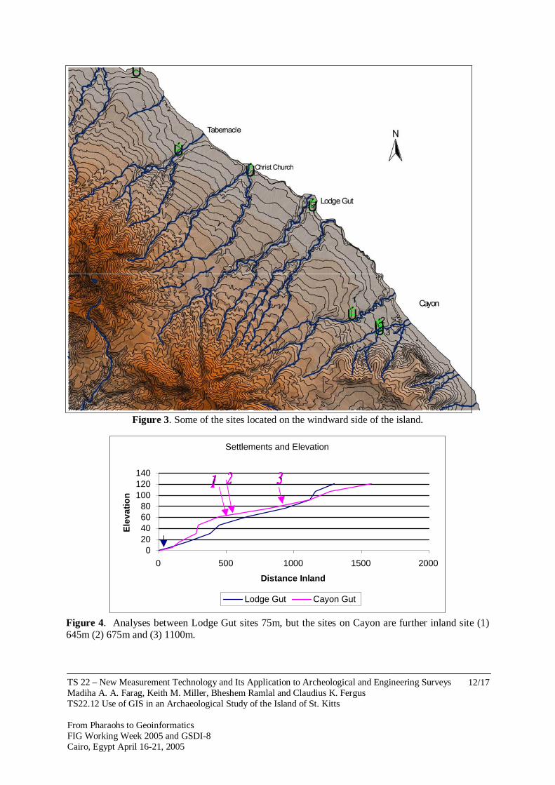
Merrill (1958) reported that the island once had lignum vitae that were cut down for export. The massive destruction for the forest combined with the clearance of the natural vegetation and the long continuous use of land over the years significantly exposed the soil surface. Consequently the exposed soil was prone to erosion, leaving beneath a solid-layer with limited capacity to absorb water, where only xerophytes vegetation can grow replacing the original tree. Recently, the awareness of these previous activities and their impact on the environment had been acknowledged. Initially, the action of the European colonial development in the Caribbean region, which was responsible for modifying the landscape and depleting the environment, is under scrutiny (Pulsipher and Goodwin 1997; and Redman, 1999). 4. AFRICAN SETTLEMENTS Following full emancipation in 1838, changes in land-use were further influenced by the movement of people. During that period, a large number of former slaves left plantations seeking shelter and land for farming. Richardson (1983) indicated that they cleared land in both low and high zones. It is understood that the use of the highland districts for root crops, vegetable and corn, further added environmental strains on the local modified land. As a result, on these zones the land became particularly susceptible to runoff erosion from rain, and in some cases had a further influence on drought. Furthermore, soil deterioration increased as a consequence of using land at those marginal ecological zones, where the native vegetation once protected the soil from weathering. 5. LAND USE BY INDIGENOUS SETTLERS This study uses the Geoinformatics as a tool to present historic geospatial data of the island into a computer system for processing. Data input to the GIS includes contour lines, soil classification, erosion, land use, rivers and settlements. From this further information such as slope and likely areas of direct impact of settlement can be derived. Furthermore, parameters associated with settlements such as proximity to fresh water, distance from coastline and land slope can be analysed to compare patterns. Considering the indigenous settlements, and using artefacts recovered as means of identification, there are 20 locations that are recognized as sites of interest. Eighteen of these are identified on a GIS map in Figure 2. A further two sites are reported by Branch (1907), but land marks that detail their location are long since gone and it is now impossible to include them in the modern map. The island’s topography was based on contour line data that was digitised from 1984 map. To understand what governed the selection of settlement location by the indigenous people, a comparison analyses was conducted using diagrams and maps to illustrate the results. Figure 3, shows the location of some of the Amerindian sites on the Windward of the island. On those locations, the indigenous setters occupied relatively high lands at Cayon River. There is the most inland settlement where artefacts were found at distant approximately 1100m, they were also found at 675m and 645m. However, on Lodge Gut, artefacts were found at 75m inland (Figure, 4). From the location of those settlements, one can speculate on differences in the culture of the people. On Cayon, the settlers tended to live from the land
TS 22 – New Measurement Technology and Its Application to Archeological and Engineering Surveys Madiha A. A. Farag, Keith M. Miller, Bheshem Ramlal and Claudius K. Fergus TS22.12 Use of GIS in an Archaeological Study of the Island of St. Kitts From Pharaohs to Geoinformatics FIG Working Week 2005 and GSDI-8 Cairo, Egypt April 16-21, 2005
6/17
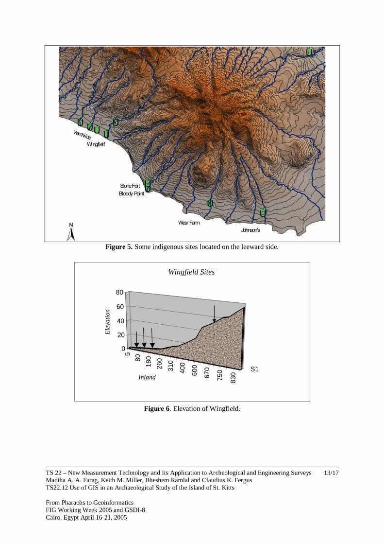
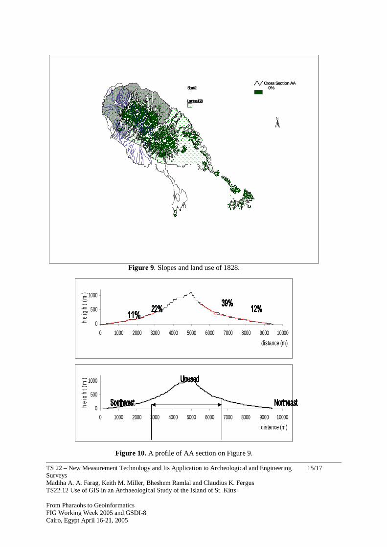
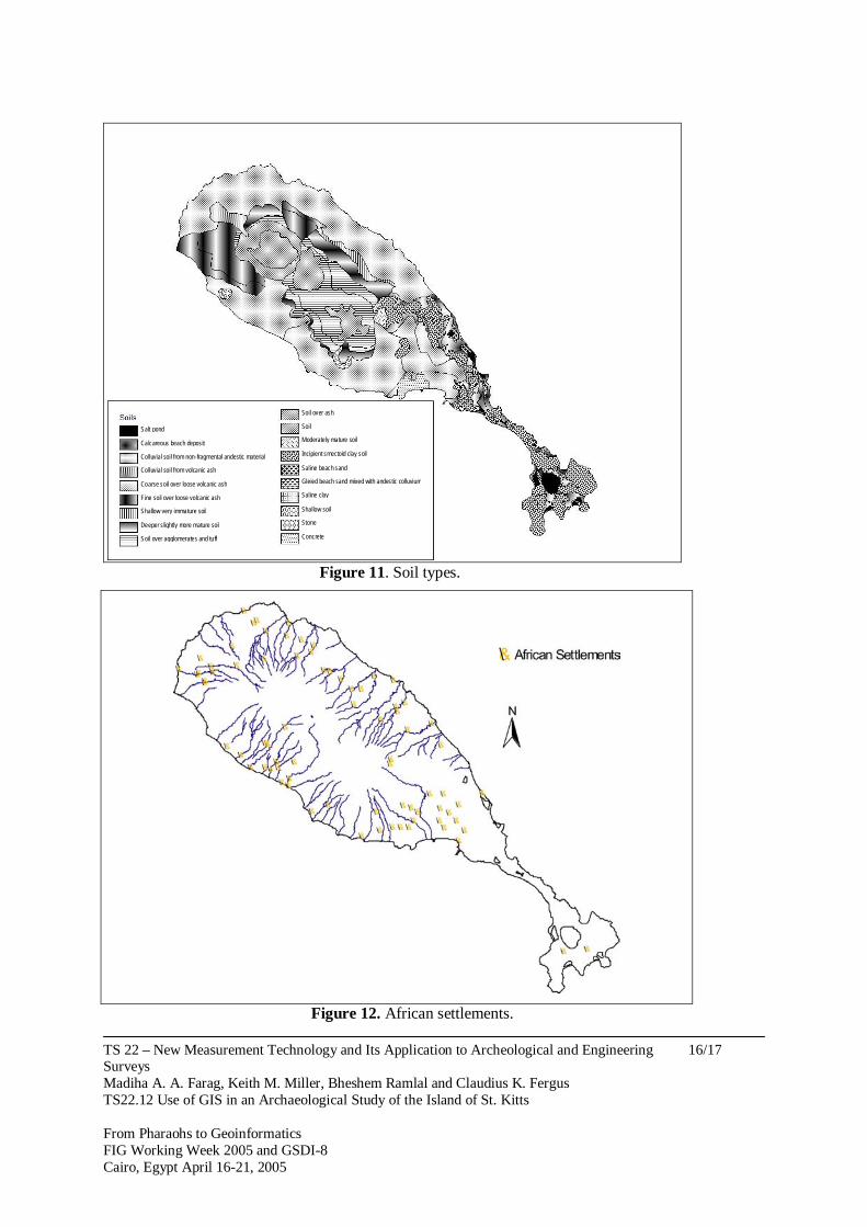
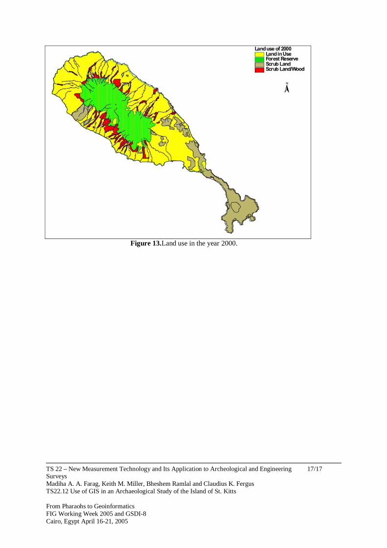
rather than the sea. Their dependence on terrestrial animals as a ratio to deep reef marine life, using data provided by Wing (1980) is more than 3:1, while that on the Sugar Factory coastal site almost, 2:3. Settlers at Lodge Gut were perhaps more dependent on coastal activities such as fishing for their food supply. The hypothesis requires further investigation using archaeological and scientific fieldwork. The figures available are derived from remains of fauna recovered from the sites. It is more difficult to discern their dependence on agriculture as no similar remnants survive through time. However, it is possible to reconstruct vegetational history from other sources, such as pollen, and this technique is to be used in further investigations. The majority of the sites located on the Leeward side were found at slope less than 15º. Evidence of occupation extended in some places, as the case on Verchilds, further from the shore line to 700 metres inland. While on the majority of Caribbean Islands the Amerindians preferred the windward side, perhaps for shelter from enemy attacks, they would be more susceptible to the weather. St Kitts is unusual for the extent of leeward use, and, it is postulated that the region was occupied by husbandry people who were attracted to the more fertile soil and abundant fresh water on this side of the island (Figure, 5). In figure 6, an illustration of Wingfield elevation is provided to indicate the location of indigenous sites. The southern part of the island currently contains no running streams, though topographic and field examination led to the speculation the possibility of previous active streams. The sites are presented in Figure 7. Four sites were identified based on Acra Zeebra Anadra, and Notabilis shells that were found including other types of shells were probably used as tools (Armstrong, 1980). Sites on Cockleshell Bay and Major’s Bay are considerably located on lowland as the diagram illustrate (Figure, 8). Seafood was probably became the main attraction to human settlements, and to mobile groups that might have visited the region for fishing purposes. The location is protected from the prevailing southeast wind by the island of Nevis, and given its proximity it is possible that some trade took place between the two island’s settlers. 6. LAND USE BY EUROPEANS During the first 200 years of cultivation, over than 92km2 (55%) of land was cleared for use. More land was cleared for lumber for construction and fuel. Consequently, a severe eradication of the natural species that was further deteriorated with the introduction of alternatives. Figure 9 shows that the amount of land on St. Kitts registered to owners in 1828 counted for almost amounts to 55% of the island (McMahon, 1828). Figure 10 compares the 1828 land use data with areas where slope is >20%. The representation provided is an approximation that has been fitted to a recent map using key features. Slope information is derived from contours and is placed on a 100m grid, and a section of the island through the highest point (shown in figure 11 as AA). There is a distinct change in gradient at the points where lands use ends. This is indicated in the lower diagram, which adds trend lines before and after the land use boundary. A soils map given in Figure 12 indicates that unused low-lying, flat zones constitute calcareous beach deposits unsuitable for plantation use. Plantations extended where land could be used as much as possible. During the 18th century, terraces of stones were erected by the slaves in the canyon regions to control flooding, thus
TS 22 – New Measurement Technology and Its Application to Archeological and Engineering Surveys Madiha A. A. Farag, Keith M. Miller, Bheshem Ramlal and Claudius K. Fergus TS22.12 Use of GIS in an Archaeological Study of the Island of St. Kitts From Pharaohs to Geoinformatics FIG Working Week 2005 and GSDI-8 Cairo, Egypt April 16-21, 2005
7/17
providing extra land for cane. In the later years, towards the end of the 19th century, the rotation of one or two crops of peas or some other light produce with cane was practiced. The pigeon peas plants, for example, would be ploughed into the soil before planting the cane to raise the nitrogen level. The small African farms that were established by former slaves were under constant use and with limited sources in his possession would have depreciated the land of its nutrients According to Merrill (1959) fertilizer on the provision farms was not practiced, which increased the risk of soil erosion. During the middle of nineteenth century, international crises for sugar cane producers led to the abandonment of some plantations on the island. Eventually tree ferns (Cyathea arborea) began to spread on those lands, and the rearing of free-range cattle such as goat and sheep developed. This signified a new era of pasture activity on the island. Lately, the heavy grazing is under scrutiny for increasing the rate of erosion. The constant removal of grass and vegetation through over grazing advances this process through extraction of the topsoil binder. During a reconnaissance visit by the researchers (2004) to the southeastern peninsula, the remains of a plantation were found on the tip of the peninsula. It is located on clay soil, and the remains of a windmill stand nearby. In addition, it appears that other land nearby was used as fishing spots, or perhaps for salt production. In the early 1900s sugar industry almost ceased to exist on the island, despite of building a central factory and railway, though it brought high return during the First World War, but declined short after. A ray of hope, eventually enlighten the almost dying industry, where in the 1930s, the plantations began modifying their management capacities and revised their agricultural methods to keep up with the changing World. In addition, the local government brought some of the declined estates, and distributed lands for small farmers. Sugar industry revived on St. Kitts, although some plantations, such as Wingfield Estate, were shut down. After being subsidized by the government, the sugar industry is still a dominant source of the foreign currency to the island (Williams 2003). At the close of the 20th century it was recognizable that soil deterioration impacted on agricultural activities, whereas the growth of scrubs is progressing (Figure 13). 7. CONCLUSIONS The impact of previous human activities on St. Kitts is obvious in the landscape when compared with descriptions provided by 17th Century observers. On some parts of the island the topsoil is completely eroded. Currently, landslide, falling rocks and flooding occurred frequently on the island threatening not only human safety but also the growth of food crops. The indigenous people mainly exploited lowland and coastal regions. Their impact on the natural resources was confined to particular zones. Cultural remains indicated the use of earth ware, shells and bone that is basically primitive tools suited with their culture. With the arrival of the western civilization in the early 1620s, the island landscape was modified for international commercial activities. Tobacco, indigo, ginger, and cotton cultivations replaced the local forest. Much of the local species declined, and some became extinct after the disappearance of their habitat. While some work has been done on ethnic archaeology to understand more about the cultural traits of former occupants, including the indigenous, the

TS 22 – New Measurement Technology and Its Application to Archeological and Engineering Surveys Madiha A. A. Farag, Keith M. Miller, Bheshem Ramlal and Claudius K. Fergus TS22.12 Use of GIS in an Archaeological Study of the Island of St. Kitts From Pharaohs to Geoinformatics FIG Working Week 2005 and GSDI-8 Cairo, Egypt April 16-21, 2005
8/17
European and the African settlers, their use of the land has not been fully explored. To understand the current situation and land use policy for the future, it is essential to gain a better understanding of influences from the past. The archival records and archeological evidence from previous and modern activities require further investigation. 8. FURTHER RESEARCH Further research aim to develop methodologies in landscape archaeology, and this will be achieved by analysing contents of the soil in terms of its chemical, physical and biological properties. Initially, four locations have been selected for further investigation under this study. These sites include − A former Amerindian settlement; − A former African settlement; − An early European settlement; − A site on the Southern peninsula, which was possibly used by Amerindians at some point
in time. In all cases sites were selected where there has been little further disturbance since the time of occupation. For further investigation sediment’s core samples were removed for analyses to construct a history of the vegetation for each site. Also, in two of the locations, core samples were removed from sugar cane fields in the vicinity, where cane is likely to have been the main cultivated crop since settlement. The result from these locations should enhance our understanding to the European cultivated land in comparison with the result from the small provision farm REFERENCES Allaire, L., 1980. On the History of Carib Migrations in the Lesser Antilles American
Antiquity, Society for American Anthropology, Vol 45, No 2, pp238-245. Armstrong, VD., 1980. Shellfish Gatherers of St. Kitts; A Study of Archaic Subsistence and
Settlement Patterns. In Lewenstein, SM. Ed. Proceedings of The Eight International Congress For The Study of the Pre-Columbian Cultures of the Lesser Antilles. Arizona State Universiy Anthropological Research Papers No. 22. PP.152-168.
Cunningham, RL. 1997. The Biological Impact of 1492. In Wilson, SM. The Indigenous People Of The Caribbean. University Press of Florida, USA, pp. 31-35.
McMahon 1828 A New Topographic Map of the Island of St Christopher in the West Indies – Containing all the Plantations with their Respective Boundaries. The St Christopher Heritage Society Collection.
Merrill, GC., 1958. The Historical Geography of St. Kitts and Nevis, the West Indies. Instituto Panamericano De Geografia E Historia, Mexico.
Rouse, I., 1986.Migration In Prehistory; inferring movement from Cultural Remains. Yale University Press, New Haven.
Pulsipher, LM. And Goodwin CM. 1999. Here Where the Old Time People Be: Reconstructing the Landscape of the Slavery and Post-Slavery Era in Montserrat, West Indies. In African Sites Archaeology in the Caribbean. Ed. Havisor, JB., Markus Wiener Publishers Princeton.

TS 22 – New Measurement Technology and Its Application to Archeological and Engineering Surveys Madiha A. A. Farag, Keith M. Miller, Bheshem Ramlal and Claudius K. Fergus TS22.12 Use of GIS in an Archaeological Study of the Island of St. Kitts From Pharaohs to Geoinformatics FIG Working Week 2005 and GSDI-8 Cairo, Egypt April 16-21, 2005
9/17
Sowell T., 1998. Conquests and Cultures, An international History. Washington Times. Vérin P.1968. Carib Culture in Colonial Times. Barbados Museum, Barbados. Watson, JB. The West Indian Heritage: A History of The West Indies. J. Murray, London,
1979. Watts, D., 1987. The West Indies; Pattern of Development, Culture, and Environmental
Change Since 1492. Cambridge University, New York. Williams, M. 2003. Deforesting The Earth, From Prehistory to Global Crisis. The University
of Chicago Press, Chicago. Wilson, SM. 1997. Introduction to the Study of the Indigenous People of the Caribbean.
Gannesville, University Press of Florida. CONTACTS Madiha Ata Ahmed Farag Research Student Department of History University of the West Indies St Augustine Trinidad West Indies Phone: (868) 662-2002 ext. 2022 fax: (868) 645-3236 ext: 2026 Email: [email protected] Dr Keith M Miller Department of Surveying and Land Information University of the West Indies St Augustine Trinidad West Indies Phone: (868) 662-2002 ext. 2108 fax: (868) 662-4414 Email: [email protected] Dr Bheshem Ramlal Department of Surveying and Land Information University of the West Indies St Augustine Trinidad West Indies Phone: (868) 662-2002 ext. 3312 fax: (868) 662-4414 Email: [email protected]

TS 22 – New Measurement Technology and Its Application to Archeological and Engineering Surveys Madiha A. A. Farag, Keith M. Miller, Bheshem Ramlal and Claudius K. Fergus TS22.12 Use of GIS in an Archaeological Study of the Island of St. Kitts From Pharaohs to Geoinformatics FIG Working Week 2005 and GSDI-8 Cairo, Egypt April 16-21, 2005
10/17
Dr Claudius K Fergus Department of History University of the West Indies St Augustine Trinidad West Indies Phone: (868) 662-2002 ext. 2025 fax: (868) 645-3236 ext: 2026 Email: [email protected]

TS 22 – New Measurement Technology and Its Application to Archeological and Engineering Surveys Madiha A. A. Farag, Keith M. Miller, Bheshem Ramlal and Claudius K. Fergus TS22.12 Use of GIS in an Archaeological Study of the Island of St. Kitts From Pharaohs to Geoinformatics FIG Working Week 2005 and GSDI-8 Cairo, Egypt April 16-21, 2005
11/17
Venezula
Caribbean Sea
St. Vincent
St. Lucia
Grenada
Tobago
Dominica
GuadeloupeMontserrat
Antigua and BarbudaSt. Kitts
Martinique
Barbados
Trinidad
Atlantic O
cean
N
-7500000
-7500000
-7250000
-7250000
-7000000
-7000000
-6750000
-6750000
-6500000
-6500000
-6250000
-6250000
-6000000
-6000000
000000 1000000
250000 1250000
500000 1500000
750000 1750000
000000 2000000
250000 2250000
Figure 1. The Archipelago of the Lesser Antilles.
Figure 2. Eighteen locations identified as indigenous sites.
TS 22 – New Measurement Technology and Its Application to Archeological and Engineering Surveys Madiha A. A. Farag, Keith M. Miller, Bheshem Ramlal and Claudius K. Fergus TS22.12 Use of GIS in an Archaeological Study of the Island of St. Kitts From Pharaohs to Geoinformatics FIG Working Week 2005 and GSDI-8 Cairo, Egypt April 16-21, 2005
12/17
Figure 3. Some of the sites located on the windward side of the island.
Settlements and Elevation
020406080
100120140
0 500 1000 1500 2000
Distance Inland
Ele
vati
on
Lodge Gut Cayon Gut
Figure 4. Analyses between Lodge Gut sites 75m, but the sites on Cayon are further inland site (1) 645m (2) 675m and (3) 1100m.
TS 22 – New Measurement Technology and Its Application to Archeological and Engineering Surveys Madiha A. A. Farag, Keith M. Miller, Bheshem Ramlal and Claudius K. Fergus TS22.12 Use of GIS in an Archaeological Study of the Island of St. Kitts From Pharaohs to Geoinformatics FIG Working Week 2005 and GSDI-8 Cairo, Egypt April 16-21, 2005
13/17
Figure 5. Some indigenous sites located on the leeward side.
5
80
180
260
310
400
600
670
750
830
S1
0
20
40
60
80
Ele
vati
on
Inland
Wingfield Sites
Figure 6. Elevation of Wingfield.

TS 22 – New Measurement Technology and Its Application to Archeological and Engineering Surveys Madiha A. A. Farag, Keith M. Miller, Bheshem Ramlal and Claudius K. Fergus TS22.12 Use of GIS in an Archaeological Study of the Island of St. Kitts From Pharaohs to Geoinformatics FIG Working Week 2005 and GSDI-8 Cairo, Egypt April 16-21, 2005
14/17
Figure 7. Location of indigenous sites on the southern peninsula.
1
112030405057657590
S10
5
10
15
20
Elevation
Inland
Cockleshell Bay
Figure 8. Elevation of indigenous sites at Cockleshell Bay.
TS 22 – New Measurement Technology and Its Application to Archeological and Engineering Surveys Madiha A. A. Farag, Keith M. Miller, Bheshem Ramlal and Claudius K. Fergus TS22.12 Use of GIS in an Archaeological Study of the Island of St. Kitts From Pharaohs to Geoinformatics FIG Working Week 2005 and GSDI-8 Cairo, Egypt April 16-21, 2005
15/17
Figure 9. Slopes and land use of 1828.
0
500
1000
0 1000 2000 3000 4000 5000 6000 7000 8000 9000 10000
distance (m)
hei
gh
t (m
)
0
500
1000
0 1000 2000 3000 4000 5000 6000 7000 8000 9000 10000
distance (m)
he
igh
t (m
)
Figure 10. A profile of AA section on Figure 9.
A
A L a n d
u s e 1 8 2 8
S l ope > 2 0 % C r o s s
S e c ti o n A A
N
TS 22 – New Measurement Technology and Its Application to Archeological and Engineering Surveys Madiha A. A. Farag, Keith M. Miller, Bheshem Ramlal and Claudius K. Fergus TS22.12 Use of GIS in an Archaeological Study of the Island of St. Kitts From Pharaohs to Geoinformatics FIG Working Week 2005 and GSDI-8 Cairo, Egypt April 16-21, 2005
16/17
Colluvial soil from non-fragmental andestic material
Calcareous beach deposit
Soil over ash
Colluvial soil from volcanic ash
Coarse soil over loose volcanic ash
Fine soil over loose volcanic ash
Shallow very immature soil
Deeper slightly more mature soil
Soil over agglomerates and tuff
Salt pond Soil
Moderately mature soil
Incipient smectoid clay soil
Saline beach sand
Gleied beach sand mixed with andestic colluvium
Saline clay
Shallow soil
Stone
Concrete
Figure 11. Soil types.
Figure 12. African settlements.
TS 22 – New Measurement Technology and Its Application to Archeological and Engineering Surveys Madiha A. A. Farag, Keith M. Miller, Bheshem Ramlal and Claudius K. Fergus TS22.12 Use of GIS in an Archaeological Study of the Island of St. Kitts From Pharaohs to Geoinformatics FIG Working Week 2005 and GSDI-8 Cairo, Egypt April 16-21, 2005
17/17
Figure 13.Land use in the year 2000.


![Major Amerindian Cultures [Inca]](https://static.fdocuments.in/doc/165x107/58ef640f1a28ab6f048b45bf/major-amerindian-cultures-inca.jpg)