USE OF BALANCED TWO-DIMENSIONAL GEOLOGICAL CROSS …
45
USE OF BALANCED TWO-DIMENSIONAL GEOLOGICAL CROSS-SECTION8 IN DEVELOPMENT OF SCENARIOS FOR PERFORMANCE ASSESSMENT ANALYSES AT YUCCA MOUblTAIN, NEVADA bll Gerry L. Stirewalt Center for Nuclear waste Regulatory Analyses 1235 Jefferson Davis Highway - Suite 1102 Arlington, Virginia 22202 6220 Culebra Road 8an Antonio, Texas 78228 Stephen R. Young Center for Nuclear Waste Regulatory Analyses Alan P. Morris Division of Earth and Physical Sciences University of Texas at San Antonio San Antonio, Texas 78249-0663 ABSTRACT Computerized cross-section balancing was applied to define a viable geologic framework for geometric representation of major faults beneath Yucca Mountain. The derived two-dimensional model consists of a linked listric-detachment fault system with the predicted detachment at a depth of 5.5 to 5.6 km below sea level. By considering the model in light of existing data, the following potential scenarios were formulated for consideration in preliminary assessment of site and repository performance: (1) Fault displacement scenarios involve distributive faulting on the linked fault system. Although the system may be decoupled from the present-day stress field, major northeast-trending faults are favorably oriented for oblique or strike slip. (2) Seismic hazard scenarios involve accommodating most seismogenic slip along structures deeper than the linked fault system, since the predicted detachment lies above the depth at which most earthquake foci are concentrated in this region. (3) Volcanic hazard scenarios 1
Transcript of USE OF BALANCED TWO-DIMENSIONAL GEOLOGICAL CROSS …

USE OF BALANCED TWO-DIMENSIONAL GEOLOGICAL CROSS-SECTION8 IN DEVELOPMENT OF SCENARIOS FOR PERFORMANCE ASSESSMENT ANALYSES
AT YUCCA MOUblTAIN, NEVADA
bll
Gerry L. Stirewalt Center for Nuclear waste Regulatory Analyses 1235 Jefferson Davis Highway - Suite 1102 Arlington, Virginia 22202
6220 Culebra Road 8an Antonio, Texas 78228
Stephen R. Young Center for Nuclear Waste Regulatory Analyses
Alan P. Morris Division of Earth and Physical Sciences University of Texas at San Antonio San Antonio, Texas 78249-0663
ABSTRACT
Computerized cross-section balancing was applied to define a
viable geologic framework for geometric representation of major
faults beneath Yucca Mountain. The derived two-dimensional model
consists of a linked listric-detachment fault system with the
predicted detachment at a depth of 5.5 to 5.6 km below sea level.
By considering the model in light of existing data, the following
potential scenarios were formulated for consideration in
preliminary assessment of site and repository performance: (1)
Fault displacement scenarios involve distributive faulting on the
linked fault system. Although the system may be decoupled from the
present-day stress field, major northeast-trending faults are
favorably oriented for oblique or strike slip. (2) Seismic hazard
scenarios involve accommodating most seismogenic slip along
structures deeper than the linked fault system, since the predicted
detachment lies above the depth at which most earthquake foci are
concentrated in this region. (3) Volcanic hazard scenarios
1

involve the linked fault system providing control on magmatia
pathways from about 5.6 km below sea level to the surface.
INTRODUCTION
General Backaround
A balanced geological cross-section is one that can be
geometrically restored (i.e. - retrodeformed) to its predeformed state by translation on mapped faults included in the section to
remove effects of deformation without any resultant changes in
cross-sectional areas in the plane of the section. It represents
an interpretation of subsurface structures which, while non-unique,
is both viable and admissible because it includes all observations
on geometric relationships between faulting and related
deformation. Hence, a balanced two-dimensional geological cross-
section provides a more accurate picture of subsurface deformation
than a cross-section which is not balanced.
Bally and others (1) published the first balanced geological
cross-sections in their paper on analysis of thrust faulting in the
Canadian Rockies, but Dahlstrom ( 2 ) was first to discuss mechanics
of cross-section balancing in areas of thrust faulting. Because of
these and other early efforts, wherein the method was extensively
applied and proven in the petroleum industry, the approach has
become standard for analyzing geometric and kinematic relationships
of subsurface faulting in compressionalterrains. Numerous authors
have also addressed use of the method in extended terrains (3, 4,
5, 6 , 7, 8, 9) and computerized techniques for balancing of cross-
sections (9, 10). More recently, a computer-assisted cross-section
2

balancing approach has been specifically applied for geometric and
kinematio analysis of subsurface faulting at Yucca Mountain (11).
Computer-assisted cross-section balancing provides a major
convenience for handling the necessary manipulations more rapidly
and with less chance for human error than the balancing-by-hand
approach. The computer-assisted approach readily permits iterative
balancing, so geological cross-section models can be modified and
refined as additional data are acquired on geometry of faults and
related deformation at Yucca Mountain. Computer-assisted
construction and analysis of balanced cross-sections provides a
powerful tool for developing and testing alternative tectonic
framework models of the Yucca Mountain region, and rigorously
assessing any alternative tectonic models and associated
conclusions about geometric and kinematic relationships of
subsurface structures which may be proposed.
Purpose and Obiective
The purpose of this paper is to indicate how existing geologic
information and computer-assisted techniques for geometric and
kinematic analyses of subsurface structures can be used to assess
the validity of geological cross-section models of the Yucca
Mountain area, and to show how these methods assist in constructing
a geological framework model (or models) for use in development of
scenarios for performance assessment analyses. Discussion of
geological concepts important for development of scenarios, rather
than quantitative recommendations for incorporation of detailed
geological information into performance assessment models, is the
3

W
focus of this paper.
Balanced geological cross-sections, aarefully constructed to
take into account field data and geometric relationships between
fault shape and hanging wall block structures, are deemed
fundamental for determining a viable subsurface geological
framework for Yucca Mountain and the surrounding region.
Assessment of the possibility of future repository disruption due
to fault displacement, magmatic/volcanic activity and earthquake-
induced seismicity will necessitate some level of scenario analysis
in which a realistic geological framework is an important element.
Computer-assisted cross-section balancing is used in this paper to
develop an admissible subsurface geological framework for the
region including Yucca Mountain. This geological framework
represents, as realistically as possible, the subsurface geologic
system of the region. It provides a geological foundation for
development of potential scenarios to be used in performance
assessment analyses. Discussion of the subsurface geological
framework derived from balanced cross-sections and its importance
in development of scenarios is the prime objective of this paper.
ANALYSIS OF YUCCA MOUNTAIN CROSS-SECTIONS
gssumptions and Constraints
Methods of geological cross-section balancing and analyses
used in this study depend mainly on assumptions about undeformed-
state geometries of geologic marker horizons, determination of
marker cut-off positions in footwall blocks of faults, observations
on orientations of bedding in hanging wall blocks, and
4

implementation of a simple shear mechanism for internal deformation
in hanging wallblocks. The methods are generally limited to two-
dimensional, plane-strain deformation models, so cross-sections
oriented approximately in the direction of true dip of bedding
should be used. Sections of this orientation are assumed to
contain the principal slip direction. Therefore, the fault system
is treated as a system initially generated by dip-slip movement.
Conservation of aross-sectional areas with deformation is also an
assumption of the approach.
A linked listric-detachment fault system is the fault model
chosen for this study. A key assumption governing the selection of
this fault model is based on field measurements of bedding dips
observed in hanging wall blocks throughout the Yucca Mountain area.
Bedding shows a relatively uniform eastward dip, with dip amount
increasing in the hanging wall blocks with proximity to the surface
trace of the underlying fault (12). This increase in dip of
bedding toward a fault zone, termed marollover8n or mmreverse dipnm,
is considered to be diagnostic of deformation of bedding in hanging
wall blocks lying above a listric fault system (3, 8, 13).
Consequently, the presence of bedding rollovers in hanging wall
blocks of faults at Yucca Mountain suggests the faults are listric
at depth, and the interpretation of an underlying detachment fault
into which they flatten and merge, or "sole", is geologically
reasonable (14).
The concept of detachment faulting in the region of the Basin
and Range surrounding Yucca Mountain is widely accepted by
5

geologists. Since Armstrong (15) first interpreted low-angle
normal faults of areal extent in the eastern Great Basin of western
Utah and eastern Nevada to be a consequence of major regional
Tertiary extension, numerous workers have concentrated efforts on
analysis of extensional deformation in this region. Based upon
experience in the Basin and Range, Wernicke (16, 17) has proposed
a regional model for low-angle detachment faulting in extensional
terrains involving simple shear of continental lithosphere along
shallow-dipping shear zones. Although some workers do not agree
with certain details of the Wernicke model (16, 17), many have
formulated regional concepts which incorporate aspects of this
model for describing regional deformation of crustalrocks in Basin
and Range extended terrain (18, 19). Maldonado (20) discussed
extension of crustal rocks along a detachment fault system by
listria and planar-rotational normal faults in the Bullfrog Hills
of southern Nevada (Figure 1). The concept of detachment faulting
in the region around and beneath Yucca Mountain was discussed by
Hamilton (la), and Scott (21) has interpreted field data to
indicate the presence of listric faults and detachment surfaces
beneath Yucca Mountain. However, Carr (22) does not consider
detachment faults to occur beneath Yucca Mountain based on
interpretations involving a tectonovolcanic model for development
of Crater Flat.
The relatively simple regional stratigraphy used in the
analyzed cross-sections is probably simpler than that actually
occurring at depth in the Yucca Mountain area because it is based
6

on information from relatively few, widely-spaced boreholes.
Additional subsurface information will likely increase the
complexity noted both within and between these stratigraphio units.
More detailed stratigraphic information can be readily included in
the cross-sections when it becomes available.
Data Sou roes
The index map of Yucca Mountain and the surrounding area shown
in Figure 1 delineates the region upon which this study was
focused. Two-dimensional geological cross-sections of Scott and
Bonk (12) illustrating geometry and distribution of geologia
structures at relatively shallow depth were the primary source of
cross-section data used to constrain models of deep subsurface
fault shape below Yucca Mountain. The entira suite of cross-
sections from Scott and Bonk (12) were used as sources of data,
including sections AA', BB', CC', DD', and EE' (Figure 2).
Information from the geologic map of Scott and Bonk (12) which
accompanied the cross-sections was used to further constrain the
fault dips, fault locations, and topographic profiles shown in
their published sections. Elevations of the top and bottom of the
Topopah Spring Member of the Paintbrush Tuff (Unit Tptw) in Calico
Bills and Little Skull and Skull Mountains (Figure 1) were obtained
from Frizzell and Shulters (23) and Maldonado (24).
Appropriately oriented sections from Scott and Bonk (12) which
were digitized directly and analyzed by cross-section balancing
included combined section ABB' and sections BB' and CC' (Figure 2).
Combined section ABB' was constructed to obtain a strike-normal
7

transect along the greatest length of section. Map data of Scott
and Bonk (12) indicate the northwest end of section AA', from A to
the intersection with section BB' at borehole USWH-5, is normal to
strike of rock units and major faults and is, therefore, a true dip
section. The entire length of cross-section BB' is normal to
strike of the rock units and major faults. Consequently, the
northwest end of cross-section AA' and all of BBB were combined to
produce section ABB'.
The primary source of information for stratigraphia
nomenclature and thickness of rock units was Scott and Bonk (12).
Identification of certain units older than the Crater Flat Tuff was
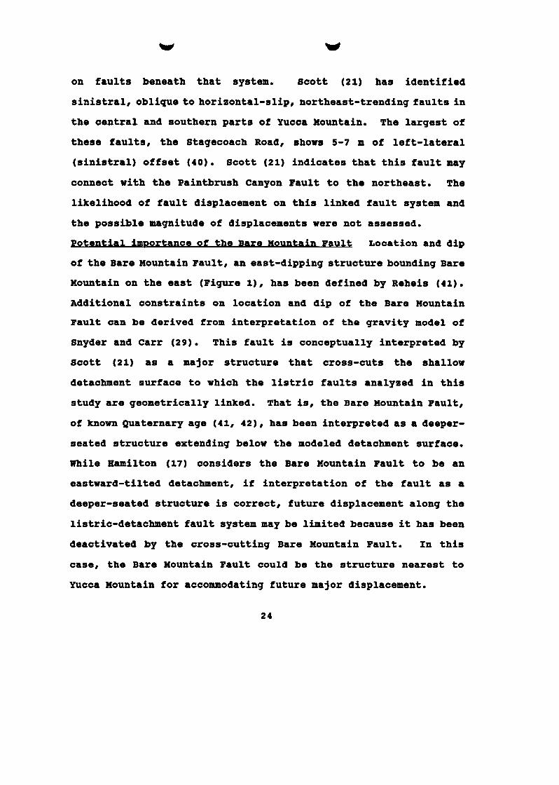
based on information in Carr and others (25) . Figure 3 illustrates the stratigraphic units used in this study.
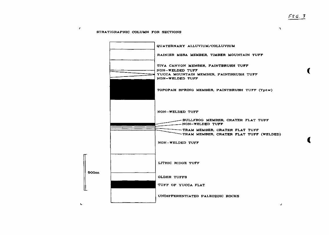
The western end of seismic reflection line AV-1 from Brocher
and others (26), located in Figure 1 and illustrated in Figure 4,
was used to interpret the approximate position of an inferred
Fortymile Wash Fault. The aeromagnetic map of Glen and Ponce (27)
also suggests a series of faults in the vicinity of Fortpile Wash
by analogy with patterns shown for the Yucca Mountain block.
A series of shallow boreholes drilled in the vicinity of Yucca
Mountain provided useful subsurface information on volcanic
stratigraphy. The surface locations of these holes are shown in
Figure 2. The deepest borehole used to constrain the published
cross-section data, Borehole UE25P#l# reaches 1804 meters below the
surface, or about 700 meters below sea level (25). Depths to
Paleozoic rock below Yucca Mountain and Crater Flat were obtained
8

from seismic refraction data of Ackerman and others (28) .
Additional constraints on depth to Paleoxoic rocks under Crater
Flat were derived from the gravity model of Snyder and Carr (29) .
InDut Data
The following data drawn from the sources indicated above were
critical for the cross-section balancing analyses. The geologic
map and cross-sections of Bcott and Bonk (12) were singularly
important sources of information.
Elevation a nd ueometrv of undeformed-state @'reaional'' marker
Bori son TDtv The top of the Topopah spring Member of the
Paintbrush Tuff (Unit Tptw of Figure 3) is exposed in the Calico
Hills at an elevation of approximately 1190 meters ( 2 3 ) r In Little
Skull and Skull Mountains, the base of the unit is exposed at
elevations of 1128-1450 meters (24 ) . These exposures are the
closest Tertiary volcanic rocks east of the area mapped by Bcott
and Bonk (12 ) . Within the area mapped by Scott and Bonk (12) , the
highest elevation of the top of Tptw in the deformed hanging wall
blocks is 1536 meters near the northwest end of their cross-section
AA'. Hence, using a thickness of 330 meters for Tptw based on data
from Scott and Bonk (12) , the constraints on elevation of the top
of Tptw east of Fortymile Wash are 1780 meters maximum and 1536
meters minimum. This elevation range is interpreted to represent
the pre-deformational DDregionalD' level of the top of the unit. In
the absence of evidence for major thickness changes in the
Paintbrush Tuff and contiguous stratigraphic units, it is further
assumed that Tptw was deposited horizontally within relatively
9

narrow limits. Consequently, it is deemed reasonable to use the
top of Tptw as a mgregionalmm marker horison for restoring balanced
cross sections to their undeformed states, with the undeformed
marker horizon lying at an elevation between 1536 and 1780 meters.
peformed-state hanuinu wall block ueometrv Although the top of
Tptw is not exposed everywhere, its near-surface geometry can be
constrained by measurements o f bedding orientation from overlying
stratigraphic units based on field data of Scott and Bonk (12) and
by borehole data. Consequently, data exist for constructing the
present-day geometry and position of the top of Tptw, and this unit
can be used as a deformation marker horizon with a relatively high
degree of confidence to represent the deformed-state hanging wall
block geometry. Because its subsurface position must be inferred
from well data and projections from other stratigraphic horizons
for some hanging wall blocks, however, geometry of all hanging wall
blocks is not precisely known and there is a range of permissible
interpretations for deformed geometry of Tptw in hanging wall
blocks
peformation mechanisms Simple shear along vertical or oblique
(synthetic or antithetic) shear planes is considered a viable
mechanism for internal deformation in hanging wall fault blocks in
extensional terrains (3, 7, 8, 14, 30). Vertical simple shear has
been used to represent the deformation mechanism in hanging wall
blocks for kinematic and geometric analysis of faulting at Yucca
Mountain (11). Field evidence from Scott and Bonk (12) and Scott
(21) suggests that a simple shear mechanism is reasonable for
10

....
internal deformation of hanging wall blocks in the Yucca Mountain
area. At several locations, Scott and Bonk (12) showed in their
cross-sections and on the accompanying map numerous, small-
displaaement, normal (synthetic) faults lying close to major
faults. In a later publication, Scott (21) reinterpreted these
small faults as an anastomosing system of small fractures which
could be averaged as approximatelyvertical. For this study, these
structures were interpreted as evidence, as Scott (21) did, that
the hanging wall blocks deformed internally along near-vertical
shear planes that were not parallel to bedding. Consequently,
field evidence strongly supports the choice of vertical shear as
the preferred deformation mechanism.
Initial modelling of fault trajectories was conducted using
shear plane orientations varying from 70 degrees synthetio to 60
degrees antithetic. This relatively narrow range of orientations
for the deformation mechanism shear planes was predicated upon
existence of the high-angle, small-displacement normal faults as
described by Scott and Bonk (12) and Scott (21). Because field
evidence is strong for the vertical shear deformation mechanism, a
possible alternative mechanism for internal deformation of hanging
wall blocks above listria normal faults whioh invokes bedding-
parallel flexural slip (31, 32) was not analyzed in detail in this
study. However, preliminary analyses for comparison purposes using
a bedding-parallel flexural slip deformation mechanism indicated
this mechanism gave results similar to those for the vertical shear
mechanism for fault trajectories (i.e. - fault shape at depth) and 11

depth to detachment.
Initial fault dip Measured dips of major faults in the Yucca
Mountain area vary between 54 and 82 degrees west, and cluster
strongly in the 60-75 degree west range in bedrock (12). Faults
included for analysis in this study, from east to west across Yucca
~ountain, are the inferred Fortymile Wash, Paintbrush canyon,
assumed Midway Valley, Bow Ridge, and Solitario Canyon Faults
(Figure 2). The only Zault with a dip constrained by subsurface
data is the Paintbrush Canyon Fault. Borehole UE2sP#l intersects
Paleozoic rocks at a faulted boundary, interpreted to be the
Paintbrush Canyon Fault, at a depth of 1244 meters from the surface
(25). This information gives a dip of approximately 66 degrees
west when the surface trace of the fault as shown by Scott and Bonk
(12) is taken into account. Therefore, for this study, the initial
dip of major faults being modeled is considered to be 66 degrees
west.
Dippinu detachment surface A gently-dipping detachment surfaoe
with the dip direction parallel to the general direction of
transport of the upper plate is consistent with existing models of
regional tectonic development in extensional terrains (17, 18, 19,
21). Applying this concept for regional geometry of the detachment
surface, a gently westward-dipping detachment was used in this
S tUdy
mDroach and R esults
The method used in this study to predict fault trajectory and
depth to detachment and construct balanced cross-sections is the
12

same as that previously applied at Yucca Mountain by Young and
others (11). The mechanics of the method, initially developed by
Verrall (14), are discussed in detail in Young and others (11) . Yucca Mountain is well-suited to this approach because surface and
shallow subsurface geologic controls are good, whereas very little
direct information, and only sparse geophysical data, are available
for depths greater than 2 km.
Heaves and throws for the five faults analyaed were
determined as fOllOW8 by measurement in combined section ABB' of
Scott and Bonk (121, using an assumed dip of 66 degrees west for
the faults and the top of Tptw as the offset marker: the inferred
Fortymile Wash Fault (throw, t = vertical component of net slip = 1030m; heave, h = horiaontal component of separation or
displacement = 457m); Paintbrush canyon Fault (t = 424m, h = 197m); an assumed Midway Valley Fault (t = 99m, h = 43m); Bow Ridge Fault (t = 105m, h = 46m) ; Solitario Canyon Fault (t = 200m, h = 85m) . Consequently, these faults have sufficiently large displacements to
be considered as major structures.
Determination of fault traieotories and deDth to detachment fault
Burface Iterative fault prediction analyses were conducted to
generate balanced subsurface fault trajectories for all five major
faults being studied. Iterations involved initial modelling of
fault trajectories using shear plane orientations varying from 70
degrees synthetic to 60 degrees antithetic to determine the
sensitivity of fault trajectory results to orientation of the shear
plane. The factors deemed critical in computation of the fault
13

trajectories were as follows:
1.
2.
3. Choice of deformation mechanism(s).
4. Choice of initial (near-surface) fault dips.
5. Inference of the Fortpile Wash Fault.
Choice of undeformed-state mmregionalDm marker horizon.
Choice of deformed-state hanging wall block geometry.
Inference of the Fortymile Wash Fault was a key step which allowed
the entire fault array model of Yucca Mountain to be balanced.
Dips in units east of the Bow Ridge Fault could not be restored to
an undeformed state relative to the undeformed marker horizon
without the presence of a fault in the vicinity of Fortymile Wash,
an inference that was also made in the study of Yucca Mountain by
Young and others (11).
When several faults are assumed to flatten and merge into a
single detachment surface as this study has done, it is necessary
to apply certain constraints for fault trajectory prediction to
satisfy this geometric relationship. These constraints may be
expressed as follows:
(a) Area created between marker horizon and deformed hanging
wall = Area leaving section = Heave x Depth to detachment;
(b) Vertical drop of hanging wall geometry over planar section
of fault / Heave = tangent of angle of dip of detachment. Using the notation shown in Figure 5, the following conditions must
be satisfied to accommodate these two constraints:
(1) A ( l ) / H ( l ) = A(2) / H(2) = ... A(n) / H(n) = D (2) V(1) / H ( 1 ) = V(2) / B(2) = ... V(n) / H ( n ) = tan(a1pha)
14

where A(n) = area between the marker horizon and hanging wall as a result of motion on fault n; V ( n ) = vertical drop of hanging wall geometry over the planar section of fault n; H ( n ) = heave of fault n; D = vertical depth to detachment below any deformed hanging wall segment above the planar portion of the fault surface; and alpha = dip angle of detachment fault.
In practioe, these constraints are taken into account by
modifying the hanging wall block geometry of each of the faults
until the two conditions expressed above are met. Because these
modifications must not violate geological controls provided by
field and borehole data, there is a limitation to modifications
which can be made. For this study, it was discovered thorough
iterative analysis of the cross-sections that the higher marker
horizon elevation (i.e. - 1780 meters) created a minimum depth to detachment for the Fortymile Wash Fault which was considerably
deeper than could be matched by any permissible modifications to
geometry of other faults in the sections. Therefore, to obtain
convergence of all fault trajectories at a single detachment
surface, it was necessary to select an elevation for the marker
horizon less than the maximum. Moreover, to preserve a gentle
westerly dip on the detachment surface as dictated by regional
interpretations (17, 18, 19, 21), the elevation could not be
decreased below about1600 meters, because of Condition 2 above, if
other faults in the sections were to have heaves and vertical
hanging wall drops consistent with a gently westward-dipping,
rather than a horizontal, detachment surface. An elevation of 1656
15

meters for the marker horizon permitted all faults to merge into a
single detachment surface having a regional dip of 8 degrees west.
For determining fault trajectories and depth to detachment,
the major faults were considered to have developed sequentially
from east to west. Each fault developed its deformed hanging wall
block geometry by deformation of the pre-existing regional marker
horizon which lay in the deformed hanging wall block of the
adjacent fault to the east (Figure 6). Each marker/hanging wall
block/fault segment "set" could then be used to determine a
discrete fault trajectory for each major fault to analyze depth to
detachment. This east to west-breaking sequence of fault
development ia simply a matter of convenience for the cross-section
balancing, and the same finite deformed state is achieved whether
the faults develop by breaking from east to west or west to east.
It was noted, however, that slip along the inferred Fortymile Wash
Fault was great enough to cause immediate deformation of the
repository block once displacement on that fault was included in
the fault model.
Young and others (111, using the same techniques as this
study, suggested the geometric need for a fault in the vicinity of
Fortymile Wash and predicted a resultant detachment level at 2.3 km
below sea level. In the current study, interpretation of geometry
related to the Fortpile Wash Fault has been refined, and the
estimate of pre-deformational level of the top of regional marker
horizon Tptw modified, to result in prediction of a deeper
detachment surface at 5.5 to 5.6 km below sea level. Predicted
16

depth tothe detachment surface is the principal difference between
results from the current study and those from Young and others
(11)
Construction of b alanced cross-sections The conditions to be
satisfied for balancing of cross-sections were that the faults
should be consistent with geometry of the observed hanging wall
block deformation (or with reasonably assumed geometry, taking into
account field and borehole information for hanging wall blocks
where deformation could not be observed because the marker horizon
was not detectable), and linked at depth to a single detachment
surf ace.
Figures 7 through 9 show the revised, balanced, present-day
deformed state interpretations of sections ABB', BB', and CC' .
Figure 10 illustrates restored section ABB' to indicate that the
section, as interpreted, can be retrodeformed to its unstrained
state by translation on the faults inoluded in the section without
any changes in cross-sectional areas within the section that would
lead to a gross mismatch of the marker horizon across the fault
surfaces. Therefore, the assumptions applied for this study
produce a series of well-balanced cross-seations that illustrate a
viable and admissible interpretation of subsurface structures in
the vicinity of Yucca Mountain.
Fortvmile Wash Fault The interpretation that a listric normal
fault exists near Fortymile Wash is based on several factors.
First, the elevation of the top of Tptw in borehole 5-13 (Figure 2)
is approximately 800 meters above sea level, whereas in Calico
17

Bills (23) and Little Bkull and Skull Mountains (24), the projected
elevation of the top of the unit is between 1780 and 1190 meters.
This is a change in elevation of 300-980 meters for an across-
strike distance of 2 km in the Calico Hills, and 8 km for Little
Bkull and Skull Hountains. Second, dips in bedding at Fran Ridge
and Aliae Point vary between 4 and 20 degrees east and average
about 10 degrees east (12). These dips imply the existenae of a
normal fault east of Fran Ridge. Third, the western end of seismia
reflection line AV-1 of Brocher and others (26) intersects the
trend of Fortpile Wash at its southern extension. Preliminary
examination of those data makes it possible to interpret a down-to-
the-west fault with normal displacement in the vicinity of
Fortpile Wash (Figure 4) . Fourth, aeromagnetic data shown by Glen and Ponce (27) suggest faulting in and adjacent to Fortymile Wash
(i.e. - east of Fran Ridge and including Fortymile Wash).
Preliminary examination of the aeromagnetic patterns at that locale
are similar to those over known faults in the Yucca Mountain block,
where the faults tend to lie adjacent to elongate, northeast-
trending magnetic lows.
Ghost Dance Fault Based on existing sparse data, the exact nature
of the Ghost Dance Fault is uncertain at this time. Several
possibilities exist for explaining the character of the Ghost
Dance. One possibility is that it may be one of the simple shear
planes proposed as the internal deformation mechanism of the
hanging wall block for the Bow Ridge Fault. Another is that it may
be an incipient, major, hanging wall block bounding fault; or it
18

may connect with the Abandoned Wash Fault to the south, as shown on
maps presented by Scott (21) and Coppersmith and Youngs (33) I to
form a structure that is comparable to other major faults at Yucca
Mountain. However, Scott and Bonk (12) mapped no bedding rollovers
associated with the Ghost Dance Fault, and it was not treated as a
major structure in this study. Interpretation of the Ghost Danoe
as a major fault was not required for balancing the sections.
Additional data on the Ghost Dance can be readily incorporated into
the balanced cross-section analyses as the data become available.
CONCLUSIONS ON POTENTIA& IMPORTANCE FOR SCENARIO DEVELOPMENT
Balanced geological cross-sections provide a means of
developing a regional geological framework model (or models) for
Yucca Mountain and the surrounding area which represents a
geometrically reasonable interpretation of subsurface structures.
While a balanced geological cross-section does not define a unique
solution for subsurface geometry of faulting and related
deformation, development of geological framework models and
consideration of scenarios in light of balanced cross-sections
assures that a viable geometric and kinematic model representing
admissible interpretations of subsurface structures will be used in
performance assessment analyses. Therefore, use of balanced
geological cross-sections for development of realistic subsurface
geological framework models and realistic scenarios is considered
important at Yucca Mountain to determine potential effects of
components of the natural system on site and repository
performance.
19

The concepts presented result from interpretations based on
analysis of balanced geological cross-sections derived from a
linked listric-detachment fault system model for Yucca Mountain and
the surrounding area. Other models can be analyzed in the future
to investigate alternative tectonic models. Considering at this
time only the described listric-detachment fault model, several
factors which should be considered in construction of realistia
scenario8 for performance assessment analyses at Yucca Mountain
have been derived. These factors are summarized below as
geological concepts important for consideration in development of
scenarios, rather than as quantitative recommendations for
incorporation of detailed geological information into performance
assessment models. The exact manner in which these factors should
be quantitatively included in scenarios for performance assessment
analyses will require additional thought to assure that appropriate
geological data are properly translated into model parameters.
mlications for ReDresentation of Fault 0 eometrv
Jlistric faults and detachment ueometrv A model involving listric
faults which flatten and merge into a single detachment surfaae is
a reasonable geometric interpretation for major faults occurring in
the repository area. Field evidence of rollover geometry in the
exposed hanging wall blocks of the major faults is strong evidence
that the proposed linked listric-detachment system evolved mainly
as a dip-slip fault system (12, 21), and the fact that sections
balanced suggests they have responded mainly in a dip-slip
deformation mode.
2 0

The amount of extension related to development of the proposed
linked fault system suggested by this study is 7-10 percent within
the Yucca Mountain block, an amount which is in agreement with the
10 percent estimate of Scott (21) for the northern part of Yucca
Mountain. This amount of '@local@@ extension of the Yucca Mountain
block is grossly different from that required for extension of the
region around Yucca Mountain, which has been estimated by Maldonado
(20) at greater than 100 percent, and up to 275 percent locally,
for the Bullfrog Hills area (Figure 1) northeast of Yucca Mountain.
DeDth to detachment The single detaohment into which these faults
sole, based on the balanced sections used in this modeling effort,
lies at a depth of 5.5 to 5.6 km below sea level. Even with the
existing concept that several detachment surfaces may occur in the
region around and beneath Yucca Mountain (21), the balanced
geometry of the suite of faults analyzed in this study suggests
they can all be linked to a single detachment surface at the depth
indicated.
Inferred Fortvmile Wash Fault Inference of this fault indicates
a listric normal fault, not previously defined, which is equivalent
to other major faults at Yucca Mountain. Amount of slip modeled
along the Fortpile Wash Fault, based on displacement of the fault
as indicated by calculated values for heave and throw, caused
deformation of the hanging wall block containing the potential
repository at Yucca Mountain. Seismic (26) and aeromagnetic (27)
evidence has been used in this study to suggest a series of faults
in the vicinity of Fortpile Wash similar to those which bound the
21

Yucca Mountain block, all of which are part of a linked listric-
detachment fault system. Scott (21) reports there is no evidence
of a fault cutting Quaternary deposits in Fortymile Wash. However,
sections would not balance using the proposed linked listric-
detachment model without a fault in the vicinity of the Fortymile
Wash.
Ghost Dance Fault The Ghost Dance Fault lies between the Solitario
Canyon and Bow Ridge Faults and cuts into the repository block.
Because of sparse data, it is not possible to make definitive
interpretations about the character of the Ghost Dance Fault from
this study. consequently, little can be said about its potential
importance in scenario development at this the.
Implications for a planar fault model A planar fault model seems
less geometrically reasonable for the fault system at Yucca
Mountain based on field evidence of rollover geometries in hanging
wall blocks of some major faults (12, 21). Axen (34) clearly
indicates that planar faults require consistent dips for deformed
bedding, rather than dips which steepen towards the fault surface.
For future consideration of alternative tectonic models, planar
fault models will be analyzed.
IlUDliC ations for Fault Displacement Hazard
Distributive faultinq Considering the linked nature of the
listric-detachment fault system suggested by this study,
distributive faulting and associated deformation along the fault
system is a conceivable scenario. That is, if slip did occur, it
could occur on more than one strand of this linked fault system.
22

V W
Hence, fault displacement concerns exist, even if seismicity is not
a concern, for the fault system at Yucca Mountain. The concept of
distributive faulting has been espoused forthe Yucca Mountain area
by Ramelli and others (35).
JmDlicati one fo r future slim under current stress fie14 Patton
and Sandt (36) infer the current state of stress in the southern
Great Basin to be maximum (horizontal) compressive stress oriented
northeast-southwest and minimum (horizontal) compressive stress
oriented northwest-southeast. These orientations agree with the
N65W orientation for minimum horizontal principal stress determined
at Yucca Mountain from hydraulier fracturing by Stock and others
(371, and with the N50W to N70W orientation for minimum
(subhorizontal) principal stress suggested by Rogers and others
(38) from evaluation of seismicity in the southern Great Basin.
The present stress field is different from that indicated at
Yucca Mountain for development of the major normal faults analyzed
in this study. Fault-slip lineations on normal and strike-slip
faults measured by Scott and Hofland (39) suggest a minimum
horizontal compressive stress oriented nearly east-west (N89E to
N8SW) . Considering the current state of stress indicated by Patton and Bandt (36), Stock and others (37) and Rogers and others (38),
it is conceivable that parts of the fault system could experience
oblique slip or strike slip in the future. Rogers and others (38)
speculate that Yucca Mountain may be decoupled from the current
stress field by underlying detachment faults, but did not preclude
the possibility of slip on the linked listric-detachment system or
23
on faults beneath that system. Scott (21) has identified
sinistral, oblique to horizontal-slip, northeast-trending faults in
the central and southern parts of Yucca Mountain. The largest of
these faults, the Stagecoach Road, shows 5-7 m of left-lateral
(sinistral) offset ( 4 0 ) . Scott (21) indicates that this fault may
conneat with the Paintbrush Canyon Fault to the northeast. The
likelihood of fault displacement on this linked fault system and
the possible magnitude of displacements were not assessed.
potential iglportance of the B are Mountain Fault Location and dip
of the Bare Mountain Fault, an east-dipping structure bounding Bare
Mountain on the east (Figure l), has been defined by Reheis (41).
Additional constraints on location and dip of the Bare Mountain
Fault can be derived from interpretation of the gravity model of
Snyder and Carr (29). This fault is conceptually interpreted by
Scott (21) as a major structure that cross-cuts the shallow
detachment surface to which the listric faults analyzed in this
study are geometrically linked. That is, the Bare Mountain Fault,
of known Quaternary age (41, 4 2 ) , has been interpreted as a deeper-
seated structure extending below the modeled detachment surface.
While Hamilton (17) considers the Bare Mountain Fault to be an
eastward-tilted detachment, if interpretation of the fault as a
deeper-seated structure is correct, future displacement along the
listric-detachment fault system may be limited because it has been
deactivated by the cross-cutting Bare Mountain Fault. In this
case, the Bare Mountain Fault could be the structure nearest to
Yucca Mountain for accommodating future major displacement.
2 4

W
Implications for Seismic Hazard
Thickness of seismogenic crust in the western United States is
approximately 15-20 km (36, 43). Therefore, the detachment surface
predicted in this study clearly lies within the present-day
seismogenio crust.
Sibson (43) provides data for the region including California
and part of the southern Great Basin which indicate most
microearthquakes occurred in the upper 10 to 12 km of the crust,
and shocks greater than magnitude 5.5 originated mainly at depths
of 10 to 12 km. Based on information from historical seismicity in
the southern Great Basin, Rogers and others (38) indicate that the
greatest number of earthquakes are confined to the upper 15 km of
arust. However, foai aluster at a depth around 8 km for the region
including the Nevada Test Site, with a distinct minimum number of
events at 4 km depth (38) . Regionally in the southern Great Basin, Rogers and others (38) indicate a bimodal depth distribution at
about 1.5-2 km and 7-8 km depth. While Patton and Sandt (36) show
depths around 5 km for earthquake foci of three events in
southwestern Nevada, Vetter and Ryall (44) determine a mean depth
for strike-slip events at about 7 km, with oblique and normal slip
events at mean depths around 12 km and 13 km, respectively, for
western Nevada. Patton and Sandt (36) do not recognize the change
in mechanism with focal depth suggested by Vetter and Ryall (44).
Doser (45) presents information on 13 historical earthquakes ofthe
Basin and Range of magnitude 6 or greater nucleating near the base
of the brittle-ductile transition zone. Rogers and others (38)
25

point out low seismicity levels at Yucca Mountain and conclude that
Yucca Mountain may be decoupled from the regional stress field
because of one or more underlying detaahment surfaaes, but do not
eliminate the possibility of seismic slip on the listria-detachment
system or on faults beneath the system.
Vetter and Ryall (44) further interpret the data to indicate
that fault plane dips decrease about 25 degrees from the surface to
around 15 kn depth, suggesting major near-planar faults may become
listric near this depth. In contrast to this interpretation, Doser
(45) interprets data on historical earthquakes of the Basin and
Range to indicate earthquakes occurred on faults dipping 38 degrees
or greater, with no evidence for listric or low-angle planar
faulting. Rogers and others (38) infer normal or strike-slip
mechanisms, and report that no subhorieontal focal mechanisms are
shown in the southern Great Basin or at Yucca Mountain. Doser (45)
indicates that about 38 percent of the faulting was normal, and 46
percent strike-slip in the Basin and Range region, while Patton and
Zandt (36) indicate that strike-slip faulting predominates in
southern Nevada.
Although different interpretations exist, there is an
implication that the listric-detachment fault system modeled at
Yucca Mountain, with a depth to detachment around 5.5 to 5.6km
below sea level, lies above the depth at which most earthquake foci
are concentrated. Therefore, seismic risk may be a lesser concern
for the linked fault system than for deeper-seated structures. As
discussed above, aseismic fault displacement on the linked listric-
2 6

detachment fault system is not precluded.
Implications for Volcanic Hagard
If the listric-detachment fault model is correct, the
implications for volcanic hazard involve possible shallow control
on looation of dikes and vents by northeast-trending faults, but no
deep-seated oontrol on pathways by these faults. Based on results
from this study, this control could have extended no deeper than
about 5.6 ka below sea level. Different structures would provide
conduits from deeper-seatedmagmatic sources to levels in the crust
where the northeast-trending fault system could control extrusion
of igneous materials at the surface. The northeast alignment of
basaltic cones in Crater Flat, pointed out by Crowe ( 4 6 ) and Smith
and others (4718 suggest that these structures have, in the past,
exercised oontrol on location of surface vents.
SUMMARY OF KEY IMPLICATIONS FOR SCENARIO DEVELOPMENT
Scenarios developed for assessment of site and repository
performance should be built around a geologic framework which
represents geological structures beneath Yucca Mountain as
realistically as possible. This study indicates a linked listric-
detachment fault system model is viable and admissible at Yucca
Mountain since it can be used to construct balanced geological
cross sections. Field evidence of bedding rollovers in hanging
wall blocks of major faults at Yucca Mountain strongly supports the
linked listric-detachment fault geometry interpretation. However,
because balanced cross-section solutions are non-unique,
construction and testing of alternative tectonic models (8.g. - a 27

planar fault model or a multiple detachment model) are not
precluded by results of this study. Potential key implications for
subsurface geological framework and scenario development derived
from analysis of balanced cross-sections using the linked fault
model are as follows:
(1) Fault geometry representation - A linked listric-
detachment fault system model, with depth to detachment around 5.5
to 5.6 km below sea level, is proposed for representation of
subsurface fault geometry at Yucca Mountain. A newly-inferred
listrio normal fault in the Vicinity of Fortymile Wash is
interpreted to be a part of this linked fault system, which
includes, from east to west, the inferred Fortymile wash,
Paintbrush Canyon, assumed Midway Valley, Bow Ridge, and Solitario
Canyon Faults. Conclusions about the Ghost Dance Fault are not
drawn because data are too sparse to include it in the modeling,
but sections did balance without inclusion of the Ghost Dance as a
major listric fault. Planar fault geometry for the major faults at
Yucca Mountain are contraindicated because of the strong field
evidence for listric faulting from bedding rollovers in hanging
wall blocks of major faults.
(2) Fault displacement hazard - Possible scenarios for fault displaoement involve distributive faulting on the linked listric-
detachment fault system. Although the linked system is interpreted
to be the result of mainly dip-slip movement, northeast-trending
faults in this system are favorably oriented to experience oblique
or strike-slip movement under the present stress field. The linked
28

listric-detachment fault system may be decoupled from the present
stress field and from major fault displacement, possibly by the
Bare Mountain Fault if it cross-cuts the predicted detachment
surf ace.
(3) Seismic hazard - Although the linked listric-detachment fault system, with a predicted detachment surface around 5.5 to 5.6
km below aea level, lies within the saismogenia crust, the fault
system appears to lie above the depth where most earthquake foci
are conoentrated in this region. Also, the linked fault system may
be decoupled from the present stress field and, consequently,
decoupled from seismogenic slip. Therefore, possible scenarios for
seismic hazard involve accommodating most of the seismic slip along
deeper-seated structures.
(4) Volcanic hazard - Possible scenarios for volcanic hazard involve northeast-trending faults of the linked listric-detachment
fault system providing control on magmatic pathways from about 5.6
km below sea level to the surface. In this case, the linked fault
system would strongly influence surface locations of vents, cones,
and fissures in the Yucca Mountain area. Deeper-seated structures
would be required for tapping magmatic sources at their origin and
feeding magma to the linked fault system.
ACKNOWLEDGEMENTS
This paper was prepared to document work performed by staff at
the Center for Nuclear Waste Regulatory Analyses (CNWRA) for the
U.S. Nuclear Regulatory Commission (NRC) under Contract Number NRC-
02-88-005. The activities reported were performed on behalf of the
2 9

NRC Office of Nuclear Material Safety and Safeguards, Division of
High-Level Waste Management, Geosciences and Engineering Branch.
The paper is an independent product of the CNWRA and does not
necessarily reflect the views or the regulatory position of the
NRC. Cross-sections presented herein were constructed and analyzed
using GEOSEC (Version 2 . 0 ) software, a product of Cogniseis
Development, IIIC., of Houston, Texas.
REFERENCES
1. A W Bally, P L Gordy and G A Stewart, Bull. Can. Pet. Geol.,
14, pp 337-381 (1966)
2. c D A Dahlstrom, Can. J. Earth sci., 6, pp 743-757 (1969)
3. A D Gibbs, J . St. Geol., 5 , pp 153-160 (1983)
4. A D Gibbs, Am. Assoc. Pet. Geol. Mem. 46, pp 81-93 (1989)
5 . A D Gibbs, J. St. Geol., 12, pp 795-803 (1990)
6. M Rowan and R Kligfield, Am. Assoc. Pet. Geol. Bull., 73, pp
955-966 (1989)
7. J Wheeler, J. St. Geol., 9, pp 1047-1049 (1987)
8. G williams and I Vann, J. st. Geol., 9 , pp 789-795 (1987)
9. IU B Woodward, 8 E Boyer and J Suppe, Am. Geophys. Union Short
Course in Geol. (American Geophysical Union, Washington, DOC),
61 132 p (1989)
10. J Geiser, P A Geiser, R Kligfield, R Ratliff, and M Rowan,
Mtn. Geol., 25, pp 47-59 (1988)
11. 8 R Young, G L Stirewalt and R A Ratliff, Proc. Second Ann.
Internat. High-Level Rad. Waste Man. Conf., 1, pp 248-259
30

12 .
13
14
15
16 9
17
18 . 19 . 20.
21.
22 .
25 .
26.
(1991)
R B Scott and J Bonk, U.S. Geol. Survey Open-File Rpt. 84-494,
9p (1984)
W A Bamblin, Geol. Soc. Am. Bull., 76, pp 1145-1163 (1965)
P Verrall, Joint Assoc. Pet. Expo Courses, JAPEC Course
Notes, 3 (1981)
R L Armstrong, Geol. SOC. Am. Bull., 83, pp 1729-1754 (1972)
B P Wernicke, Nature, 291, pp 645-648 (1981)
B P Wernicke, Can. J. Earth Sci. 22, pp 108-125 (1985)
W B Hamilton, U. 8 . Geol. Survey Bull. 1790, pp 51-85 (1988)
G A Davis and 0 8 Lister, Geol. 800. Am. Sp. Pap. 218, pp 133-
159 (1988)
B Maldonado, Geol. Boa. Am. Bull., 102, pp 992-1006 (1990)
R B Scott, Geol. SOC. Am. Mem. 176, pp 251-282 (1990)
W J Carr, Geol. 800. Am. Mem. 176, pp 283-303 (1990)
V A Frissell and J Shulters, U. 8 . Geol. Survey Misc. Inv.
Ser. Map 1-2046 (1990)
F Maldonado, U. 8 . Geol. survey Misc. Inv. Ser. Map 1-1519
(1985)
M D carr, S J Waddell, G S Vick, J M Stock, 8 A Monsen, A G
Harris, B W Cork and F M Byers, Jr, U. 8 . Geol. Survey open-
File Rpt 86-175, 87p (1986)
T Y Brocher, P E Hart and S F Carle, U. 8. Geol. Survey open-
Bile Rpt 89-133, 150p (1990)
J M Glen and D A Pome, U. 8. Geol. Survey Open-File Rpt 91-
105 (1991)
31

28 .
29
30.
31.
32
33 .
34 . 35 .
36
37 . 38 .
39 .
40.
41.
42
H D Ackerman, W D Mooney, D B Snyder and V D Sutton, U. 8 .
Geol. Survey Bull. 1790, pp 23-33 (1988)
D B Snyder and W J Carr, J. Geophys. Res., 89, pp 10,193-
10,206 (1984)
EJ J White and D P McKenxie, J. St. Geol. 8, pp 789-795 (1986)
W G Higgs, G D Williams and C M Powell, Geol. Soc. Am. Bull.,
103, pp 710-717 (1991)
R H Groshong, Geol. SOC. Am. Bull., 101, pp 96-105 (1989)
A J coppersmith and R R Youngs, Proc. Third Ann. Internat.
High-Level Rad. Waste Man. COlsf., 1, pp 1142-1150 (1992)
G Axen, J. St. Geol., 10, pp 405-411 (1988)
A R Ramelli, J W Bell and C M DePolo, Geol. SOC. Am. Abs. with
Programs, p A383 (1988)
H J Patton and 0 Sandt, J. Geophys. Res., 96, pp 18,245-18,259
(1991)
J N Stock, J H Eealey, 8 H Hickman and M D Boback, J. Geophys.
Res. 90, pp 8691-8706 (1985)
A M Rogers, S C Harmsen and M E Meremonte, U. 8 . Geol. Survey
Open-File Rpt 87-408 (1987)
R B Scott and 0 8 Hofland, EO8 Trans. Am. Geophys. Union
(AbS), 68, p 1461 (1987)
R B Scott and J W Whitney, Geol. SOC. Am. Abs. with Programs,
19, pp 332-333 (1987)
M Reheis, U. 8 . Geol. Survey Open-File Rpt 86-576, 13p (1986)
8 A Monsen, M D Carr, M C Reheis and P P orkild, U. 8 . Geol.
Survey Open-File Rpt 90-25, 20p (1990)
32

43. R H sibson, Bull. Seis. Sac. Am., 72, pp 151-163 (1982)
44. U R Vetter and A 8 Ryall, J. Geophys. Res., 88, pp 8237-8250
(1983)
45. D I Doser, Beis. Res. Let. ( - S o ) , 63, p 38 (1992)
46. B M crowe, Proo. First mn. Internat. High-Level Rad. Waste
Man. Conf., 1, pp 65-73 (1990)
47. E I Smith, D L Feuerbach, T R Naumann and J E Faulds, Proc.
First Ann. Internat. High-Level Rad. Waste Man. Conf., 1, pp
81-90 (1990)
33

REVISEQ FIGURE CAPTIONS FOR PAPER BY STIREWALT, YOUNG AND MORRIS ENTITLED "USE OF BALANCED TWO-DIMENSIONAL GEOLOGICAL CROSS-SECTIONS IN DEVELOPMENT OF SCENARIOS FOR PERFORMANCE ASSESSMENT ANALYSES AT YUCCA MOUNTAIN, NEVADA" ----- Revised 27 May 1992 -gls-
Figure 1. Named faults include FMD = Funeral Mountains Detachment Fault; BHD = Bullfrog Hills Detachment Fault; FC = Fluorspar Canyon Fault; BM = Bare Mountain Fault; CH = Calico Hills Fault; PR = Point of Rocks Fault; RM = Red Mountain Fault. Teeth occur on upper plates of identified low-angle normal faults; fault traces are dotted where concealed, and marked by queries where uncertain. AV-1 = location of seismic line AV-1 of Brocher and others (26) . LW = Lathrop Wells basaltic volcanic center. Asterisks in Crater Flat mark locations of basaltic vents. (Modified after Scott (21), Figure
Index map of Yucca Mountain and surrounding area.
14.)
Figure 2. Detailed map of Yucca Mountain showing locations of boreholes and cross sections AA8, BB8, CC8, DD8, and EE8 of Scott and Bonk (12). From east to west, named faults include PCF/FRF/SRF = Paintbrush Canyon Fault/Fran Ridge Fault/Stagecoach Road Fault; MVF = assumed Midway Valley Fault: BRF = Bow Ridge Fault; GDF/AWF = Ghost Dance Fault/Abandoned Wash Fault; SCF = Solitario Canyon Fault; FWF = Fatigue Wash Fault; WWF = Windy Wash Fault. (Fault locations from Scott (21), Figure 3 and Coppersmith and Youngs (33), Figure 1.)
Figure 3. Stratigraphic column for balanced cross sections. Note position of the Topopah Spring Member of the Paintbrush Tuff (Tptw), the regional marker horizon used in this study.
Figure 4. Western end of seismic line AV-1 at intersection of the southern extension of Fortymile Wash between Stations 889 and 1249, showing features interpreted in this study as normal faulting in the vicinity of Fortymile Wash. (Unmigrated 0-5s stack from Vibroseis source in relative amplitude format after Brocher and others (26), Figure 28a.)
Figure 5. Geometric constraints on hanging wall block geometry for merging balanced listric fault trajectories into a single detachment surf ace. Upper figure shows constraints for fault F (1) ; lower figure, for fault F(2). Boxed information summarizes the conditions which must be satisfied for multiple listric faults to sole into a single detachment.

W C
WISm FIGURE CAPTIONS FOR STIREWALT, YOUNG, MORRIS - pg 2 Figure 6. Respective positions of the top of regional marker horizon Tptw used to determine subsurface fault trajectories and depth to detachment when slip is modeled along major faults breaking sequentially from east to west across Yucca Mountain. From east to west, the following faults are included: inferred Fortymile Wash, Paintbrush Canyon, assumed Midway Valley, Bow Ridge, and Solitario Canyon Faults. This figure is based on combined cross-section ABB'.
Figure 7. Revised, balanced, present-day (deformed-state) cross section ABB'. From east to west, the following major faults sole into the detachment: inferred Fortymile Wash, Paintbrush Canyon, assumed Midway Valley, Bow Ridge, and Solitario Canyon Faults. Predicted detachment surface lies around -5.6 km below sea level. For stratigraphy shown in the section, refer to stratigraphic column of Figure 3.
Figure 8. Revised, balanced, present-day (deformed-state) cross section BB'. From east to west, the following major faults sole into the detachment: inferred Fortymile Wash, Paintbrush Canyon, assumed Midway Valley, and Bow Ridge Faults. The Solitario Canyon Fault is not included because original section BB' from Scott and Bonk (12) does not extend to this fault. Predicted detachment surface lies around -5.2 km below sea level. For stratigraphy shown in the section, refer to stratigraphic column of Figure 3.
Figure 9. Revised, balanced, present-day (deformed-state) cross section CC'. From east to west, the following major faults sole into the detachment: inferred Fortymile Wash, Fran Ridge- Paintbrush Canyon, and Bow Ridge Faults. An assumed Midway Valley Fault is not included because original cross-section CC' from Scott and Bonk (12) does not show this fault. Predicted detachment surface lies around -5.5 km below sea level. For stratigraphy shown in the section, refer to stratigraphic column of Figure 3.
Figure 10. Geometrically restored (retrodeformed) cross-section ABB' illustrating good match of stratigraphic units across major fault surfaces after slip has been removed. From east to west, the following major faults are shown: inferred Fortymile Wash, Paintbrush Canyon, assumed Midway Valley, Bow Ridge, and Solitario Canyon Faults. For stratigraphy shown in the section, refer to stratigraphic column of Figure 3.

I 1 1 7 O
N .

.OME
r
-
1
TIVA CANYON MEMBER, PAINTBRUSH TUFF NON-WELDED TUFF YUCCA MOUNTAIN MEMBER, PAINTBRUSH TUFF NON-WELDED TUFF
STRATIGRAPHIC COLUMN FOR SECTIONS
-
7 1 QUATERNARY ALLUVIUM/COLLUVIUM
NON-WELDED TUFF
BULLFROG MEMBER, CRATER FLAT TUFF j/NON--WELDED TUFF
I I RAINIER MESA MEMBER, TIMBER MOUNTAIN TUFF
I 1 OLDER TUFFS
I UNDIFFERENTIATED PALEOZOIC ROCKS I L
W
S t a t . No. 8 8 9 1009 1 1 2 9
E
I 2 4 9

r v
r
FOR COINCIDENCE OF DETACHMENTS. SET:
V(l)/H(l) = V(2)/H(2) = ... V(n)/H(n)
AND:
A(l)/H(l) - A(2)/H(2) - ... A(n)/H(n)
U
- ~ ( 1 ) . ARE/ LEAVING FN
V(l)/H(l) = V(2)/H(2) = TAN (ALPHA)
A(l) = H(l).D

FrG7.6 .-
REGIONAL FOR MIDWAY V A U E Y FAULT
L
REOIONAL FOR BOW RIDGE FAULT REGIONAL FOR FORTYMILE
WASH FAULT REGIONAL FOR PAINTBRUSH \ I CANYON FAULT
REGIONAL FOR SOLITARIO CANYON FAULT
I
I
RTYMILE
REGIONAL FO CANYON PC.VYA \ "BRUSH I -....I
IN FAULT
J

c in
PI
4

is D
L
E 0 0
0 0
0
0
0
0
0
d 0
(0
I I
I I
I I
E E
E 0 0
0
0
0
0
cv c3
E E 0 0 0 r(
1
. .. .

L
1
r
.

E 0 0 I 41,
4
L
E 0 0 0