Adaptasi Ekofisiologi Terhadap Iklim Tropis Kering: Studi ...
JANUARY 2017
This report is made possible by the support of the American People through the United States Agency
for International Development (USAID.) The contents of this report are the sole responsibility of DAI and
do not necessarily reflect the views of USAID or the United States Government.
USAID ADAPTASI PERUBAHAN IKLIM DAN KETANGGUHAN CLIMATE & WEATHER INFORMATION SERVICES ROADMAP
ADAPTASI PERUBAHAN IKLIM DAN KETANGGUHAN (APIK) – CLIMATE & WEATHER INFORMATION SERVICES ROADMAP
i
USAID ADAPTASI PERUBAHAN IKLIM DAN KETANGGUHAN
CLIMATE AND WEATHER INFORMATION SERVICES ROADMAP
Program Title: Adaptasi Perubahan Iklim dan Ketangguhan
Sponsoring USAID Office: USAID/Indonesia Office of Environment
Contract Number: AID-497-C-16-00003
Contractor: DAI
Date of Publication: March 2017
Author: DAI
ADAPTASI PERUBAHAN IKLIM DAN KETANGGUHAN (APIK) – CLIMATE & WEATHER INFORMATION SERVICES ROADMAP
ii
TABLE OF CONTENTS TABLE OF CONTENTS ................................................................................................ II
LIST OF EXHIBIT ......................................................................................................... IV
ACRONYMS AND ABBREVIATIONS .......................................................................... V
DEFINITIONS ............................................................................................................... VII
EXECUTIVE SUMMARY ............................................................................................. 10
TECHNICAL APPROACH TO STRENGTHENING CWI SERVICES ............................................................... 10
REGIONAL CWI SERVICES STRATEGIES ........................................................................................... 12
East Java ........................................................................................................................... 12
Southeast Sulawesi ........................................................................................................... 14
Maluku .............................................................................................................................. 16
NATIONAL LEVEL SUPPORT .......................................................................................................... 17
NEXT STEPS .............................................................................................................................. 18
INTRODUCTION .......................................................................................................... 19
OVERVIEW OF APIK ................................................................................................................... 19
CLIMATE AND WEATHER INFORMATION SERVICES ............................................................................ 20
ROADMAP OBJECTIVE ................................................................................................................. 20
REPORT STRUCTURE ................................................................................................................... 21
CWI SERVICES VALUE CHAIN ................................................................................. 22
Value Chain Phases ........................................................................................................... 23
The Range of Value Chain Complexity .............................................................................. 26
Cross-Cutting Themes of the CWI Value Chain ................................................................. 28
EAST JAVA.................................................................................................................. 30
INTRODUCTION ......................................................................................................................... 30
APPLICATION AREA SELECTION RATIONALE ..................................................................................... 32
AGRICULTURE AND FOOD SECURITY .............................................................................................. 32
Context .............................................................................................................................. 32
Preliminary Value Chain Analysis ..................................................................................... 33
DISASTER RISK REDUCTION .......................................................................................................... 36
User Context ..................................................................................................................... 36
Preliminary Value Chain Analysis ..................................................................................... 36
TECHNICAL ASSISTANCE ENTRY-POINTS ......................................................................................... 38
SOUTHEAST SULAWESI ........................................................................................... 41
INTRODUCTION ......................................................................................................................... 41
APPLICATION AREA SELECTION RATIONALE ..................................................................................... 42
AGRICULTURE AND FOOD SECURITY .............................................................................................. 43
Context .............................................................................................................................. 43
Preliminary Value Chain Analysis ..................................................................................... 43
DISASTER RISK REDUCTION .......................................................................................................... 47
Context .............................................................................................................................. 47
ADAPTASI PERUBAHAN IKLIM DAN KETANGGUHAN (APIK) – CLIMATE & WEATHER INFORMATION SERVICES ROADMAP
iii
Preliminary Value Chain Analysis ..................................................................................... 47
TECHNICAL ASSISTANCE ENTRY-POINTS ......................................................................................... 49
MALUKU ...................................................................................................................... 52
INTRODUCTION ......................................................................................................................... 52
APPLICATION AREA SELECTION RATIONALE ..................................................................................... 54
AGRICULTURE AND FOOD SECURITY .............................................................................................. 54
Context .............................................................................................................................. 54
Preliminary Value Chain Analysis ..................................................................................... 56
DISASTER RISK REDUCTION .......................................................................................................... 58
Context .............................................................................................................................. 58
Preliminary Value Chain Analysis ..................................................................................... 58
TECHNICAL ASSISTANCE ENTRY-POINTS ......................................................................................... 60
NATIONAL LEVEL TECHNICAL ASSISTANCE ....................................................... 62
IMPROVE THE RESOLUTION OF THE WEATHER PREDICTION .................................................................. 62
DEVELOPMENT OF CWI DISSEMINATION MODULE........................................................................... 62
DEVELOPMENT OF CWI PACKAGING MODULE ................................................................................ 62
CLIMATE FIELD SCHOOLS ............................................................................................................. 62
SUMMARY AND NEXT STEPS .................................................................................. 64
ANNEXES .................................................................................................................... 67
ANNEX I: APIK’S HIGH LEVEL INDICATOR .............................................................................. 67
ANNEX II: SUMMARY OF ASSESSMENT REPORT ................................................................... 68
Assessment Approach and Method .................................................................................. 68
Key CWI Institutions, Products and Communication Modes ............................................ 69
Summary of Findings across the Value Chain ................................................................... 70
Opportunities for Strengthening the CWI Services Marketplace...................................... 74
ANNEX III: COMPLETE STRENGTHENING ACTIVITY PLAN ......................................................... 76
ADAPTASI PERUBAHAN IKLIM DAN KETANGGUHAN (APIK) – CLIMATE & WEATHER INFORMATION SERVICES ROADMAP
iv
LIST OF EXHIBIT EXHIBIT 1 CWIS GAPS IN INDONESIA ............................................................................................................................ 11 EXHIBIT 2 ILLUSTRATIVE TECHNICAL ASSISTANCE ENTRY-POINTS FOR CWIS IN EAST JAVA ....................................................... 14 EXHIBIT 3 ILLUSTRATIVE TECHNICAL ASSISTANCE ENTRY-POINTS FOR CWIS IN SOUTHEAST SULAWESI ....................................... 15 EXHIBIT 4 ILLUSTRATIVE TECHNICAL ASSISTANCE ENTRY-POINTS FOR CWIS IN MALUKU ......................................................... 17 EXHIBIT 5 CWI SERVICES VALUE CHAIN ......................................................................................................................... 23 EXHIBIT 6: WEATHER FORECASTING MADE SIMPLE .......................................................................................................... 27 EXHIBIT 7: "PRANATA MANGSA" AN OLD-JAVANESE SEASON CALENDAR ............................................................................... 27 EXHIBIT 8: APIK'S SEVEN TARGETED DISTRICT/CITY IN BRANTAS WATERSHED ....................................................................... 30 EXHIBIT 9: CLIMATE RISK AFFECTED SECTORS ON APIK'S DISTRICT/CITY IN EAST JAVA ............................................................. 30 EXHIBIT 10: PRELIMINARY VALUE CHAIN ANALYSIS FOR AG AND FOOD SECURITY VALUE CHAIN IN EAST JAVA ............................. 33 EXHIBIT 11: CWIS VALUE CHAIN FOR EARLY WARNING SYSTEMS (DISASTER RISK REDUCTION) IN EAST JAVA ............................. 36 EXHIBIT 12 EAST JAVA'S MAJOR FOCUS AREAS ACCORDING TO WORKPLAN PY 2 .................................................................. 38 EXHIBIT 13: PY 2, 3, 4 AND 5 CWIS STRENGTHENING ENTRY POINTS FOR EAST JAVA ............................................................ 39 EXHIBIT 14: APIK’S CITY AND DISTRICT IN SOUTHEAST SULAWESI ....................................................................................... 41 EXHIBIT 15: CLIMATE AND DISASTER RISKS FACING THE LANDSCAPE ON APIK'S DISTRICT/CITY IN SOUTHEAST SULAWESI ................ 42 EXHIBIT 16: PRELIMINARY ANALYSIS OF THE CLIMATE SERVICES VALUE CHAIN FOR AG AND FOOD SECURITY IN SES ..................... 43 EXHIBIT 17: PRELIMINARY ANALYSIS OF THE CLIMATE SERVICES VALUE CHAIN FOR DRR IN SES ............................................... 47 EXHIBIT 18 HIGH LEVEL PY-2 APIK ACTIVITIES PLANNED FOR SOUTHEAST SULAWESI ............................................................. 49 EXHIBIT 19 PY-2, 3, 4 AND 5 CWIS STRENGTHENING ENTRY POINTS FOR SOUTHEAST SULAWESI ............................................ 50 EXHIBIT 20: AMBON-LEASE ISLAND LAND COVER ............................................................................................................ 52 EXHIBIT 21: CLIMATE AND DISASTER RISKS FACING THE LANDSCAPE ON APIK'S ISLANDS IN MALUKU (LEASE ISLANDS) ................... 52 EXHIBIT 22: CWIS VALUE CHAIN FOR THE AGRICULTURE AND FOOD SECURITY APPLICATION IN THE MALUKU ............................... 56 EXHIBIT 23: CWIS VALUE CHAIN FOR THE DISASTER RISK REDUCTION IN THE MALUKU ............................................................ 58 EXHIBIT 24: HIGH LEVEL PY2 APIK ACTIVITIES PLANNED FOR MALUKU/LEASE ISLANDS ......................................................... 60 EXHIBIT 25: PY-2, 3, 4 AND 5 CWIS STRENGTHENING ENTRY POINTS FOR MALUKU ............................................................. 61 EXHIBIT 26 PRIORITY CLIMATE SERVICES ACTIVITIES FOR PY 2 ............................................................................................ 65 EXHIBIT 27: APIK'S HIGH LEVEL INDICATORS .................................................................................................................. 67 EXHIBIT 28: PY 2, 3, 4 AND 5 CWIS STRENGTHENING ACTIVITIES FOR EAST JAVA ................................................................. 76 EXHIBIT 29: PY 2, 3, 4 AND 5 CWIS STRENGTHENING ACTIVITIES FOR SOUTHEAST SULAWESI ................................................. 78 EXHIBIT 30: PY 2, 3, 4 AND 5 CWIS STRENGTHENING ACTIVITIES FOR MALUKU ................................................................... 80
ADAPTASI PERUBAHAN IKLIM DAN KETANGGUHAN (APIK) – CLIMATE & WEATHER INFORMATION SERVICES ROADMAP
v
ACRONYMS AND ABBREVIATIONS
APIK Adaptasi Perubahan Iklim dan Ketangguhan
Climate Change Adaptation and Resilience
ARG Automatic Rain Gauge
AWS Automatic Weather System
AAWS Auxiliary Automatic Weather System
AWLR Automatic Water Level Recorder
AWOS Automated Weather Observing System
BASARNAS National Search and Rescue Agency
BBWS/BWS Watershed Regional Office
BMKG National Meteorological, Climatological and Geophysics Agency
BNPB National Disaster Management Agency
BPBD Local Disaster Management Agency
BPLHD Local Environmental Management Agency
BPDAS Watershed Management Agency
BLH Local Environmental Agency
Dinkes Local Health Agency
Dishub Local Transportation Agency
Distamben Local Mining and Energy Agency
DJF-JJA December-January-February (Wet Season) and June-July-August (Dry
Season)
DPU Local Public Works Agency
DKP Local Maritime and Fisheries Agency
CCROM Centre for Climate Risk and Opportunity Management; Bogor-based
NGO for climate change research organization
CWI Climate and Weather Information
CWIS Climate and Weather Information Services
ESDM Ministry of Energy and Natural Resources
IMACS The Indonesia Marine and Climate Support project
InAWARE Disaster Management Early Warning and Decision Support Capacity
Enhancement Project in Indonesia
ICAO International Civil Aviation Organization
IUWASH Indonesia Urban Water, Sanitation, and Hygiene Program
JABODETABEK Jakarta, Bogor, Depok, Tangerang and Bekasi Area
KATAM Planting Calendar
KEMENATR Ministry of Agrarian and Spatial Plan
KEMENHUB Ministry of Transportation
ADAPTASI PERUBAHAN IKLIM DAN KETANGGUHAN (APIK) – CLIMATE & WEATHER INFORMATION SERVICES ROADMAP
vi
KEMENKES Ministry of Health
KEMENTAN Ministry of Agriculture
Kemenkominfo Ministry of Communication and Informatics
KKP
KLHK
K/L
Ministry of Marine Affairs and Fisheries
Ministry of Environment and Forestry
Ministry/ National Level Agency
PY1 Project Year 1
PY2 Project Year 2
PIKU BMKG’s Center for Climate and Air Quality
POLRI Police
RASON Radiosonde Observation Network
RPJMD Regional Medium Term Development Plan
RPJMP Province Medium Term Development Plan
POKWASMAS
Pusdalops PB
Community Group for Monitoring
Center of Control Disaster Management Operation
PUPERA Ministry of Public Works and Housing
PUSDATIN Center of Data and Information
PUSLUHDAYA Counseling Center and the Marine and Coastal Community
Empowerment
RAN-API National Climate Adaptation Action Plan
SAR Search and Rescue
SIDIK Vulnerability Inventory Index Information System; a product of National
Climate Change Vulnerability Index owned by Ministry of Environment
and Forestry
SIMAIL Change Adaptation and Environmental Information System; a system
consist of maritime weather warning for fisher folk or seaman owned by
the Ministry of Marine Affairs and Fisheries
TNI National Army/Military
TNC Third National Communication
TV
MSME
Television
Micro, Small and Medium Enterprise
UNFCC United Nation Framework Convention on Climate Change
USAID United States Agency for International Development
WMO World Meteorological Organization
ADAPTASI PERUBAHAN IKLIM DAN KETANGGUHAN (APIK) – CLIMATE & WEATHER INFORMATION SERVICES ROADMAP
vii
DEFINITIONS
Climate (WMO), sometimes understood as the "average weather,” is defined as the measurement
of the mean and variability of relevant quantities of certain variables (such as temperature,
precipitation or wind) over a period of time, ranging from months to thousands or millions of years.
Climate Variability (WMO) is defined as variations in the mean state and other statistics of the
climate on all temporal and spatial scales, beyond individual weather events. The term "Climate
Variability" is often used to denote deviations of climatic statistics over a given period of time (e.g. a
month, season or year) when compared to long-term statistics for the same calendar period.
Climate variability is measured by these deviations, which are usually termed anomalies. Variability
may be due to natural internal processes within the climate system (internal variability), or to
variations in natural or anthropogenic external factors (external variability).
Climate Change (WMO) refers to a statistically significant variation in either the mean state of the
climate or in its variability, persisting for an extended period (typically decades or longer). Climate
change may be due to natural internal processes or external factors such as persistent changes to
the atmosphere or changes in land. UNFCC defines Climate Change is a change of climate which is
attributed directly or indirectly to human activity that alters the composition of the global
atmosphere and which is in addition to natural climate variability observed over comparable time
periods
Data is sets of values of qualitative or quantitative variables collected for reference or analysis. Data
is input to products and tools, and may be collected locally or remotely from satellites or sensors
(e.g., TRMM data, in-situ weather data, crop data, elevation data, rivers data, user preferences, user
feedback, and socioeconomic data, etc. Data is obtained from measurement instrumentation or
observation process that is owned and managed by an institution. For example, BMKG owns
weather and climatology station that spreads across Indonesia. The data can be accessed through
their website (http://dataonline.bmkg.go.id/). Another example is at the subnational level: BPBD that
owns automatic weather system (AWS) installed at several points in its location.
Dataset is an aggregate of data.
Decision maker is an individual who has authority to utilize (or not) information (tool, product,
data, service) in a decision making context. (E.g., individuals responsible for facility operations,
resource management, alerts/warnings, or planning, permitting, budgeting, or policy processes).
Derivative Product is a product resulting from benefitting the climate and weather data. For
example, PVMBG and BNPB issued an exposure map to volcanic ash from volcanic eruptions. This
product resulted from the modelling of volcanic ash spread where the input of that model is wind
direction and speed information from BMKG. Meanwhile, BNPB added more information such as
population data at each district/city. This product can be categorized as the derivative product of
weather information because in the process, it cultivates and adds other information and as a result
there is an existing product that has added value.
DJF-JJA-rule or “wet and dry season rules” in Indonesia means December-January-February for
wet season and June-July-August for dry season.
Information Channel/Mode is a media channel used to deliver climate and weather information
to the users. For example, website, text message, facsimile, telephone, bulletin board to name a few.
ADAPTASI PERUBAHAN IKLIM DAN KETANGGUHAN (APIK) – CLIMATE & WEATHER INFORMATION SERVICES ROADMAP
viii
Information System is an organized system to collect, organize, store, process, automate, and
distribute information that utilizes, disseminates or produce climate and weather information or its
derivative products.
Method/Methodology is a specific technique/approach falling within the bounds of a set of
scientific assumptions.
Model is a graphical, mathematical (symbolic), physical, or verbal representation or simplified
version of a concept, phenomenon, relationship, structure, system, or other aspect of the real world
created to (1) facilitate understanding by eliminating unnecessary components, (2) aid in decision
making by simulating scenarios, or (3) explain, control, and predict events on the basis of past
observations.
Product is information that has been processed or analysis results that use a certain dataset and
become derived information with more added value. Product also defines as the output of data
processing and analysis (or any organized aggregate collection thereof) to fulfill a particular purpose
of a user (e.g. land cover maps, land cover change statistics, forecasts, post-disaster imagery). For
example, BMKG has daily weather forecast information that is published via website, mobile
application or other channels. Another example, CCROM owns information as a result of
downscaled climate change projection that is used by SIDIK.
Portal is an online interface through which data, products and tools are hosted and/or
disseminated. e.g. MRC Data and Information Services Portal.
Qualitative Data is information that describes attributes, properties, or qualities and are often
expressed in words rather than numerically
Quantitative Data is information that can be measured or expressed numerically, typically
describing amounts, ranges, or quantities
Tool is a program, model, system or device that gathers, processes and analyzes data and
information to fulfill a particular purpose of a user (e.g. CREST viewer, flood mapper, frost monitor,
etc.)
In analyzing the value chain of climate and weather information, market segmentation is essential to
map consumer needs, producers and those that deliver the information.
In that regard, we categorize those actors into Producer, Communicator, User and
Beneficiary.
Producer is an institution that produces and publishes climate and weather information
data/product available for the public, free or as paid services. For example: BMKG-HO produces and
publishes national weather and climate data whereas on the regional base, BMKG owns weather and
climate station at each region and publishes regional weather and climate information. Other than
BMKG, APIK also identifies other producers such as university, business institution and SKPDs.
Communicator is an institution/individual/group that takes into account/plays an important role in
distributing climate and weather information. The delivered information can be the original
information obtained from the producer or processed into derived information as an analysis. An
example of a communicator is the Agriculture Agency in Batu District. This department has to
distribute information to the farmers at the beginning of monsoon season through the local
instructor. Furthermore, Kalender Tanam (KATAM) is an example of information that has been
processed. It is published by Research and Development (Litbang) Division of Agriculture Ministry
and can be accessed via http://katam.litbang.pertanian.go.id/. The information shows rainfall
prediction, planting schedules and recommended commodities for planting. Example of other
ADAPTASI PERUBAHAN IKLIM DAN KETANGGUHAN (APIK) – CLIMATE & WEATHER INFORMATION SERVICES ROADMAP
ix
prominent communicator is media, printed or electronic. The media role is very significant because
its accessibility can be reached by the whole society.
Users are the person/institution that directly uses the formal CWI product for their own interests
(e.g. SKPD staffs, Local Marine and Fisheries Agency, Transporter).
Beneficiaries are the individual who receives the benefits of climate data, products, or tools to
fulfill a particular purpose, but does not necessarily use the product directly (e.g. fisher folk,
farmers).
One participant/actor can act as a Producer, Communicator or Users or a combination of two of
three of them. An example of participant who acts both as a producer and as communicator is
BMKG Head Office (BMKG-HO) and BMKG Regional Office (BMKG-RO). Moreover, an example of
participant/audience who acts as a communicator and users is an officer/local official in a community.
Apart from using the climate and weather information for personal use, this actor is also responsible
to pass the information on his or her community. APIK is yet to find an example of an actor who
acts as a producer as well as user. An example of the combination of the three actors is BPBD.
BPBD can both consume the information from BMKG and have the authority to manage their own
AWS so they can produce as well as disseminate the information. In today’s crowdsourcing era,
there is a growing number of actors who acts as producer, communicator and user at the same time
so they can contribute to each other.

ADAPTASI PERUBAHAN IKLIM DAN KETANGGUHAN (APIK) – CLIMATE & WEATHER INFORMATION SERVICES ROADMAP
10
EXECUTIVE SUMMARY
Climate and weather information services (CWIS) are used by a wide range of actors in
Indonesia—public, private, and civil society—to fulfill specific, placed-based needs, from
maximizing crop yields to navigating coastal waters to warning communities of impending
flood risk. Recent advances in technology enable meteorologists to capture larger quantities
of more precise weather data, while mobile and internet-based communications are steadily
(albeit disparately based on location) allowing more and more community leaders, farmers,
and fisher folk to access real-time weather updates. Nevertheless, the CWIS “marketplace”
remains quite fragmented with varying levels of coordination along the “value chain” of
service provision that collects raw data, translates it into information useful for decision-
makers, and, ultimately, leads to tangible socioeconomic and security benefits at the
community level.
Building from the broad evaluation of climate services described in the APIK Climate and
Weather Information Services Assessment Report, the following CWIS Roadmap
sets forth the Adaptasi Perubahan Iklim dan Ketangguhan (APIK) Project’s implementation
strategy for improving the development and dissemination processes that will help to ensure
that climate services are both used and useful.
More specifically, the Roadmap serves to narrow the Project’s focus and home in on key
technical assistance entry-points for the coming four years. For each of APIK’s priority
provinces—East Java, Southeast Sulawesi, and Maluku—the document describes: (1) priority
application areas for technical assistance; (2) a preliminary analysis of specific climate
services value chains within each application area, including the respective users and
beneficiaries ultimately served; and (3) the Project’s proposed portfolio of assistance
activities to help strengthen each value chain and close critical information gaps at the place-
based level. Throughout the Roadmap report—and as part of its broader approach—APIK
strives to keep the users and beneficiaries at the fore, such that improvements along the
value chain of climate services yield safer, more resilient communities.
The following executive summary is presented in three subsections. First, we review APIK’s
technical approach to improving climate and weather information services as presented in
the aforementioned CWIS Assessment Report accompanied by the principal information
gaps identified during the assessment process. Second, we summarize the focal areas and
technical assistance strategies in the APIK priority provinces, identifying key stakeholders
and partners in each locale. Importantly, the work at the provincial and local level is also
then linked with supporting activities with national-level service providers. Finally, we discuss
the immediate next steps during Project Year (PY) 2 as the Project transitions from the
evaluation of climate services in Indonesia to activity implementation.
Technical Approach to Strengthening CWI Services
Broadly speaking, climate and weather information services consist of the hardware (sensor
networks, weather station infrastructure, and IT equipment), software (trained staff,
recognized communication and dissemination platforms, local awareness) and the supporting
institutional arrangements (codified roles and responsibilities, data sharing policies,
dedicated funding) that facilitate the systematic collection, analysis, packaging,
ADAPTASI PERUBAHAN IKLIM DAN KETANGGUHAN (APIK) – CLIMATE & WEATHER INFORMATION SERVICES ROADMAP
11
communication, and use of meteorological, hydrological, and climate data. Robust CWIS are
integral to Indonesia’s National Action Plan on Climate Change Adaptation (RAN-API) in
the context of hydro-meteorological disaster risk reduction and development planning. At
the international level, the WMO also recognized the critical role of improved climate
services, establishing the Global Framework for Climate Services in 2012 as a worldwide
mechanism for coordinated actions to enhance the quality, quantity, and application of
climate services.1
Climate and weather information services are most impactful when an active process is put
in place to transform raw environmental observations into actionable information
communicated to the right people at the right time. Toward this end, the APIK Project uses
the concept of a climate and weather information value chain to frame the
institutional roles and action steps required in the transformation of data into decisions.
These steps are: (1) raw data collection and organization, (2) product development
(including data analysis, visualization, and packaging), (3) communication and dissemination,
(4) application and use, and (5) benefit realization. The notion of climate and weather
information services as a value chain operating in the context of a market allows us to
identify and segment the key climate and weather services actors and define the roles that
such actors play across all the links of the value chain. Additionally, this approach seeks to
connect those that collect and produce CWI services (the “supply side”) and those that
apply them at the local level (the “demand side”) and, ultimately, detect specific gaps or
weaknesses in the value chain and target technical assistance efforts accordingly.
Based on research conducted for the Assessment Report, the APIK team previously
identified a series of critical gaps along the CWIS value chain in Indonesia. Exhibit 1 below
provides a summary of these gaps.
Exhibit 1 CWIS Gaps in Indonesia
Value Chain Phase Analysis of Key Process and Information Gaps
Data Collection While BMKG has (and continues to make) investments in the reliable collection of
observational data, significant spatial and temporal gaps persist, especially as man
systems remain dependent on manual data collection.
A lack of open data policies continues to inhibit the sharing of climate information,
inhibiting warning systems, the improvement of models, and the proliferation of
climate research.
Even when data is in the public domain, important gaps often exist in historical
datasets and platforms to access those datasets are not always reliable.
Product Development
(Analysis and Packaging) Like many climate and weather marketplaces around the world, product
development in Indonesia is supply-driven, lacking a clear focus on the needs of
users and beneficiaries.
One of the main challenges for CWIS across the different landscapes is that each
area has its own risk characteristics depending on the local context and issues.
Communication and
Dissemination Local TV and radio are the primary channels people use to access timely weather
information, while digital products are playing an increasing role in many areas,
1 See http://www.wmo.int/gfcs/
ADAPTASI PERUBAHAN IKLIM DAN KETANGGUHAN (APIK) – CLIMATE & WEATHER INFORMATION SERVICES ROADMAP
12
Value Chain Phase Analysis of Key Process and Information Gaps
leading to a “digital divide” in climate services availability.
CWI dissemination is not just about posting data and products, but requires
targeted marketing and capacity building.
Local staff and volunteers represent a critical link in communicating climate and
weather information at the community level.
Use/Application While both institutional and individual users expressed moderate satisfaction with
formal CWI products, there is still progress to be made on many levels, including
the timeliness with which CWI products are delivered to users in order to inform
actual decisions.
Many stakeholders continue to rely on personal observations and traditional climate
knowledge, especially when more “formal” climate services are not available or the
awareness of such services is low.
Benefit Realization Existing climate and weather products struggle to reach the “last mile” of
beneficiaries, often failing to make it to the communities and households where they
are most needed.
Regional CWI Services Strategies
Based on the CWIS Assessment Report, ongoing landscape vulnerability assessments, and
associated stakeholder consultations, the APIK team identified specific application areas and
associated climate services value chains in each priority province. In accordance with the
WMO’s Global Framework for Climate Services, we divide the application areas into five
sectors: agriculture and food security, disaster risk reduction, energy, health and water.
While the sectors emphasized below are likely to evolve as the Project progresses, they
nonetheless provide a concrete starting point for APIK’s assistance.
East Java
In the Province of East Java, APIK has forged municipal partnerships with seven
districts/cities within the Brantas Watershed: Kota Batu, Kota Malang, Malang, Blitar,
Mojokerto, Jombang, and Sidoarjo. The seven districts/cities make up a significant port of
the Brantas Landscape, starting from the upper most of the watershed in Batu (the source
of the Brantas River) until the downstream in Sidoarjo where the Brantas ultimately enters
the Madura Strait. The referenced local governments are exposed to a variety of climate and
disaster risks, with landslides (in the upstream areas) and flash flooding (in both upstream
and downstream communities) topping the list. Drought has also become an increasing
threat in the southern reaches of the watershed as the dry season becomes more prolonged
and groundwater resources face greater demand and more limited recharge.
Focal CWIS Application Areas and Value Chains. The immediate focal areas for
APIK in East Java are Agriculture/Food Security (AFS) as well as Disaster Risk Reduction
(DRR).
Concerning the emphasis on the former, agriculture represents the principal source of
income for the population of East Java as the province is one of the largest rice and maize
producers nationwide. From the upstream rice paddy farmers to the downstream
aquaculture farmers, communities rely heavily on ag-based incomes and are therefore highly
ADAPTASI PERUBAHAN IKLIM DAN KETANGGUHAN (APIK) – CLIMATE & WEATHER INFORMATION SERVICES ROADMAP
13
vulnerable to erratic weather patterns and longer-term shifts in climate. In accordance with
the findings of the Assessment Report, APIK will concentrate efforts on the climate services
value chains for upland agriculture (including food crops, vegetables, and fruits), lowland
horticulture farming, and coastal aquaculture communities (specifically pond farming and sea
salt harvesting). Agriculture extension officers and the farmers themselves require accurate,
easily understood forecasts, particularly relating to the timing of planting and harvesting.
Based on APIK’s preliminary value chain analysis for climate services in the ag sector, key
gaps or weaknesses include the following:
The collection and sharing of rainfall data is poorly coordinated between BMKG
Karangploso Station and the East Java Irrigation Agency, constraining both the temporal
and spatial resolution of data. Further, many rain gauge stations in East Java are no
longer operational or operate only on an intermittent basis (Data Collection);
While BMKG Karangploso produces a monthly rainfall forecast bulletin, some farmers complain that it is too lengthy and difficult to understand (Product Development);
BMKG Karangploso’s seasonal and monthly forecast products often do not reach the
heads of communities and farming cooperatives in a timely fashion such that they can
inform decision-making (Communication); and
Limited “climate literacy” among ag extension officers and farmers means that they do not readily take advantage of those climate products that are available (Use and
Application).
Regarding the Disaster Risk Reduction sector, APIK will focus efforts on CWI value chain
for flood and landslide early warning systems. Riverbank communities such as Desa
Galengdowo in Jombang, for example, are exposed to flash flood risk while others such as
Desa Kemiri in Mojokerto are prone to landslides due to steep topography. Notable gaps in
the flood/landslide early warning value chain include:
Local Disaster Management Agencies (BPBD’s) do not often have access to timely data from major collectors such as BMKG Karangploso or Perum Jasatirta I. The BPBD’s also
collect little hydrological data independently (Data Collection);
The existing early warning systems provided by Jasa Tirta I only cover the Bengawan
Solo watershed, meaning that many exposed communities do not have any formal
systems established (Product Development and Communication); and
Few community leaders are trained in the best ways to make use of climate and weather
information services for the purposes of issuing disaster alerts (Use and Application).
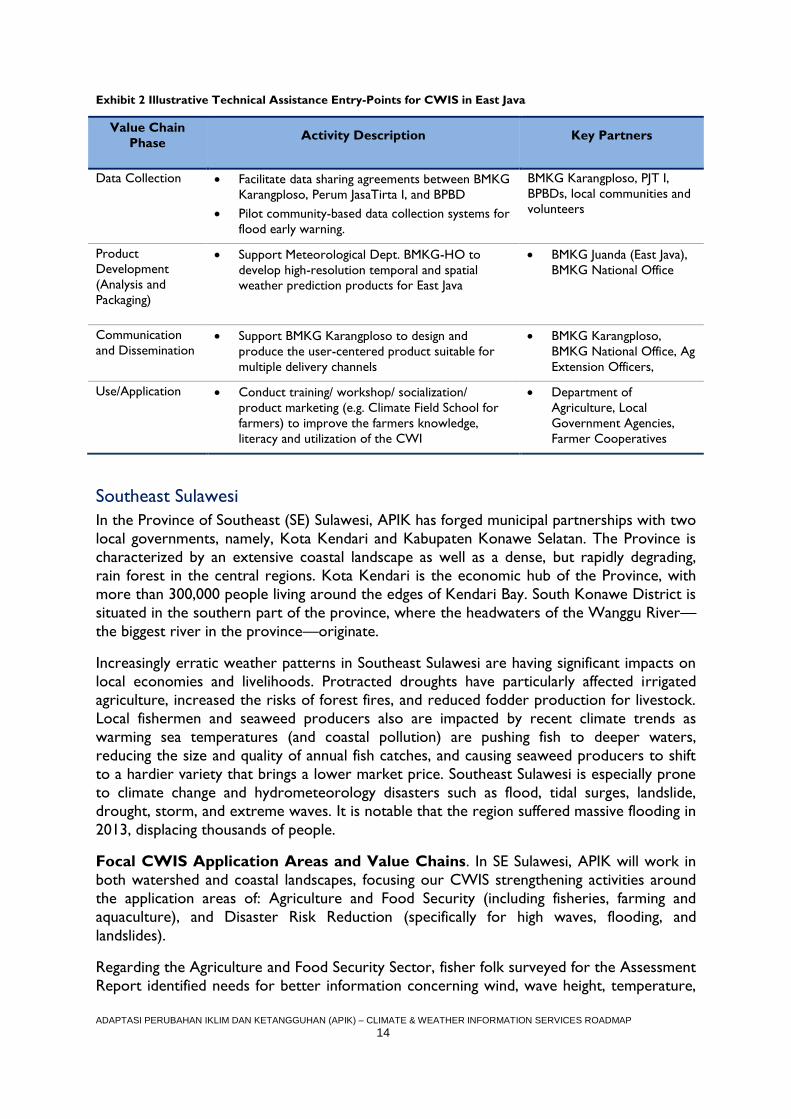
CWIS Entry-Points. Following the verification of the preliminary value chain analyses,
APIK will work with local stakeholders such as the BPBD of Kota Malang or BMKG Karangploso to improve how climate and weather data is collected, packaged,
communicated, and applied. The following exhibit highlights proposed interventions in the
Brantas Landscape.
ADAPTASI PERUBAHAN IKLIM DAN KETANGGUHAN (APIK) – CLIMATE & WEATHER INFORMATION SERVICES ROADMAP
14
Exhibit 2 Illustrative Technical Assistance Entry-Points for CWIS in East Java
Value Chain
Phase Activity Description Key Partners
Data Collection Facilitate data sharing agreements between BMKG
Karangploso, Perum JasaTirta I, and BPBD
Pilot community-based data collection systems for
flood early warning.
BMKG Karangploso, PJT I,
BPBDs, local communities and
volunteers
Product
Development
(Analysis and
Packaging)
Support Meteorological Dept. BMKG-HO to
develop high-resolution temporal and spatial
weather prediction products for East Java
BMKG Juanda (East Java),
BMKG National Office
Communication
and Dissemination Support BMKG Karangploso to design and
produce the user-centered product suitable for
multiple delivery channels
BMKG Karangploso,
BMKG National Office, Ag
Extension Officers,
Use/Application Conduct training/ workshop/ socialization/
product marketing (e.g. Climate Field School for
farmers) to improve the farmers knowledge,
literacy and utilization of the CWI
Department of
Agriculture, Local
Government Agencies,
Farmer Cooperatives
Southeast Sulawesi
In the Province of Southeast (SE) Sulawesi, APIK has forged municipal partnerships with two
local governments, namely, Kota Kendari and Kabupaten Konawe Selatan. The Province is
characterized by an extensive coastal landscape as well as a dense, but rapidly degrading,
rain forest in the central regions. Kota Kendari is the economic hub of the Province, with
more than 300,000 people living around the edges of Kendari Bay. South Konawe District is
situated in the southern part of the province, where the headwaters of the Wanggu River—
the biggest river in the province—originate.
Increasingly erratic weather patterns in Southeast Sulawesi are having significant impacts on
local economies and livelihoods. Protracted droughts have particularly affected irrigated
agriculture, increased the risks of forest fires, and reduced fodder production for livestock.
Local fishermen and seaweed producers also are impacted by recent climate trends as
warming sea temperatures (and coastal pollution) are pushing fish to deeper waters,
reducing the size and quality of annual fish catches, and causing seaweed producers to shift
to a hardier variety that brings a lower market price. Southeast Sulawesi is especially prone
to climate change and hydrometeorology disasters such as flood, tidal surges, landslide,
drought, storm, and extreme waves. It is notable that the region suffered massive flooding in
2013, displacing thousands of people.
Focal CWIS Application Areas and Value Chains. In SE Sulawesi, APIK will work in
both watershed and coastal landscapes, focusing our CWIS strengthening activities around
the application areas of: Agriculture and Food Security (including fisheries, farming and
aquaculture), and Disaster Risk Reduction (specifically for high waves, flooding, and
landslides).
Regarding the Agriculture and Food Security Sector, fisher folk surveyed for the Assessment
Report identified needs for better information concerning wind, wave height, temperature,
ADAPTASI PERUBAHAN IKLIM DAN KETANGGUHAN (APIK) – CLIMATE & WEATHER INFORMATION SERVICES ROADMAP
15
rainfall, currents, seasonal prediction, and fishing grounds. Upland farmers also noted the
importance of precise and timely information on optimal planting season, drought early
warning to encourage water management, and pest management practices. Based on the
preliminary value chain analysis for climate services in the agriculture sector, key gaps or
weaknesses include the following:
There is no existing climatological station in Southeast Sulawesi, as the closest one is in
Maros (South Sulawesi). This has greatly hindered the collection of usable, local data
accompanied by the issuance of tailored forecasts. That said, BMKG does plan to open a
Climatological Station in Kendari City in 2017 (Data Collection and Product Development);
The mobile messaging applications for local forecasts provided by BMKG provide very low resolution which is not useful for understanding localized weather patterns
(Communication and Dissemination); and
The limited penetration of programs such as Climate Field Schools hinders the
application of those climate products that are available (Use and Application).
On the Disaster Risk Reduction side, APIK will initially concentrate on the CWI services
value chain for early warning systems in Kendari City. Specifically, the Assessment Report
identified 37 villages as highly vulnerable to a combination of flooding and landslides.
Pertinent gaps in the local warning systems value chain include:
There are currently no early warning sensor systems in or near those villages identified
as high risk to flooding or landslides (Data Collection);
Only a limited number of the communities have established communication channels to
disseminate information related to the threat of landslides and floods. Very few villages
were found to have any type of flood warning siren, for example, and not all households
were able to receive Short Messaging Service (SMS) alerts (Communication and
Dissemination); and
Community disaster management volunteers are not well trained by government officials
in disaster response and the capacity of the local BPBD is also low (Use and Application).
CWIS Entry-Points. Following the verification of the preliminary value chain analyses,
APIK will work with local stakeholders such as the BPBD of Kota Kendari and the
forthcoming BMKG station to strengthen the CWIS supply chain. The following exhibit
highlights proposed interventions.
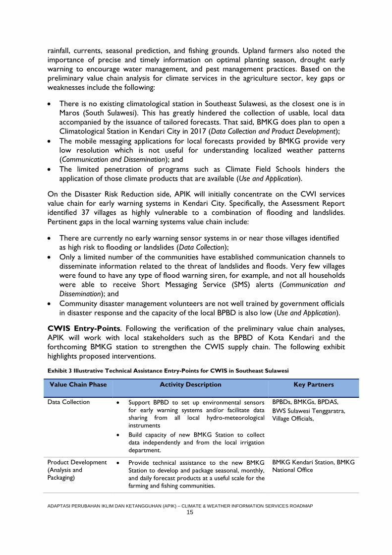
Exhibit 3 Illustrative Technical Assistance Entry-Points for CWIS in Southeast Sulawesi
Value Chain Phase Activity Description Key Partners
Data Collection Support BPBD to set up environmental sensors
for early warning systems and/or facilitate data
sharing from all local hydro-meteorological
instruments
Build capacity of new BMKG Station to collect
data independently and from the local irrigation
department.
BPBDs, BMKGs, BPDAS,
BWS Sulawesi Tenggaratra,
Village Officials,
Product Development
(Analysis and
Packaging)
Provide technical assistance to the new BMKG
Station to develop and package seasonal, monthly,
and daily forecast products at a useful scale for the
farming and fishing communities.
BMKG Kendari Station, BMKG
National Office
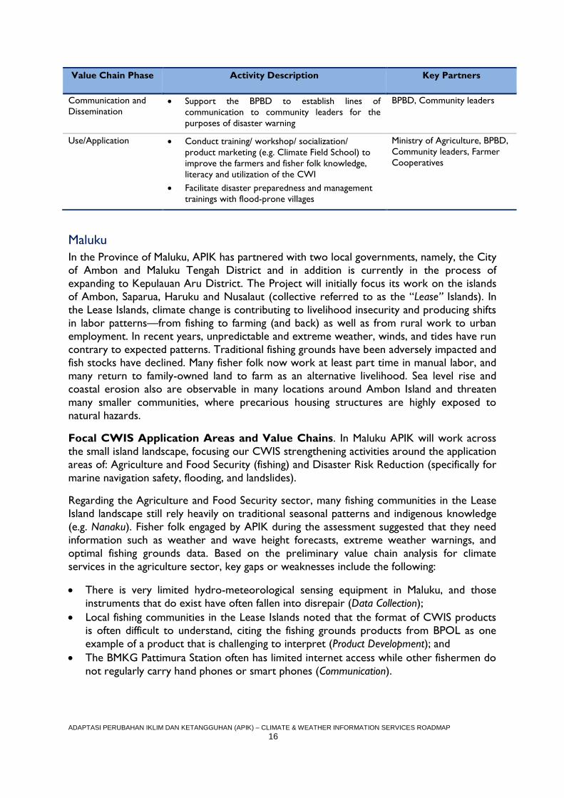
ADAPTASI PERUBAHAN IKLIM DAN KETANGGUHAN (APIK) – CLIMATE & WEATHER INFORMATION SERVICES ROADMAP
16
Value Chain Phase Activity Description Key Partners
Communication and
Dissemination Support the BPBD to establish lines of
communication to community leaders for the
purposes of disaster warning
BPBD, Community leaders
Use/Application Conduct training/ workshop/ socialization/
product marketing (e.g. Climate Field School) to
improve the farmers and fisher folk knowledge,
literacy and utilization of the CWI
Facilitate disaster preparedness and management
trainings with flood-prone villages
Ministry of Agriculture, BPBD,
Community leaders, Farmer
Cooperatives
Maluku
In the Province of Maluku, APIK has partnered with two local governments, namely, the City
of Ambon and Maluku Tengah District and in addition is currently in the process of
expanding to Kepulauan Aru District. The Project will initially focus its work on the islands
of Ambon, Saparua, Haruku and Nusalaut (collective referred to as the “Lease” Islands). In
the Lease Islands, climate change is contributing to livelihood insecurity and producing shifts
in labor patterns—from fishing to farming (and back) as well as from rural work to urban
employment. In recent years, unpredictable and extreme weather, winds, and tides have run
contrary to expected patterns. Traditional fishing grounds have been adversely impacted and
fish stocks have declined. Many fisher folk now work at least part time in manual labor, and
many return to family-owned land to farm as an alternative livelihood. Sea level rise and
coastal erosion also are observable in many locations around Ambon Island and threaten
many smaller communities, where precarious housing structures are highly exposed to
natural hazards.
Focal CWIS Application Areas and Value Chains. In Maluku APIK will work across
the small island landscape, focusing our CWIS strengthening activities around the application
areas of: Agriculture and Food Security (fishing) and Disaster Risk Reduction (specifically for
marine navigation safety, flooding, and landslides).
Regarding the Agriculture and Food Security sector, many fishing communities in the Lease
Island landscape still rely heavily on traditional seasonal patterns and indigenous knowledge
(e.g. Nanaku). Fisher folk engaged by APIK during the assessment suggested that they need
information such as weather and wave height forecasts, extreme weather warnings, and
optimal fishing grounds data. Based on the preliminary value chain analysis for climate
services in the agriculture sector, key gaps or weaknesses include the following:
There is very limited hydro-meteorological sensing equipment in Maluku, and those
instruments that do exist have often fallen into disrepair (Data Collection);
Local fishing communities in the Lease Islands noted that the format of CWIS products
is often difficult to understand, citing the fishing grounds products from BPOL as one
example of a product that is challenging to interpret (Product Development); and
The BMKG Pattimura Station often has limited internet access while other fishermen do
not regularly carry hand phones or smart phones (Communication).
ADAPTASI PERUBAHAN IKLIM DAN KETANGGUHAN (APIK) – CLIMATE & WEATHER INFORMATION SERVICES ROADMAP
17
As concerns Disaster Risk Reduction side, marine navigation amongst small island
communities is already challenging in Maluku, with passenger ferries prone to accidents.
Such risks are only exacerbated by unexpected weather patterns and increasingly intense
storm events. Unfortunately, marine and land-based warning systems in Maluku are
underdeveloped, and communities are highly exposed to coastal inundation during high tides
as well as flooding during storm events. Notable gaps in the DRR value chain include the
following:
As noted above, there is very low spatial resolution of hydro-met data in Maluku.
Further, the data that does exist is not widely shared, including with disaster
management agencies (Data Collection);
Early warning products/systems are often not tailored to the village level, making it
difficult for community leaders to ascertain the threat level (Product Development); and
Community leaders are not aware of those CWI early warning products that do exist or
are not trained by BPBD in their usage (Use and Application).
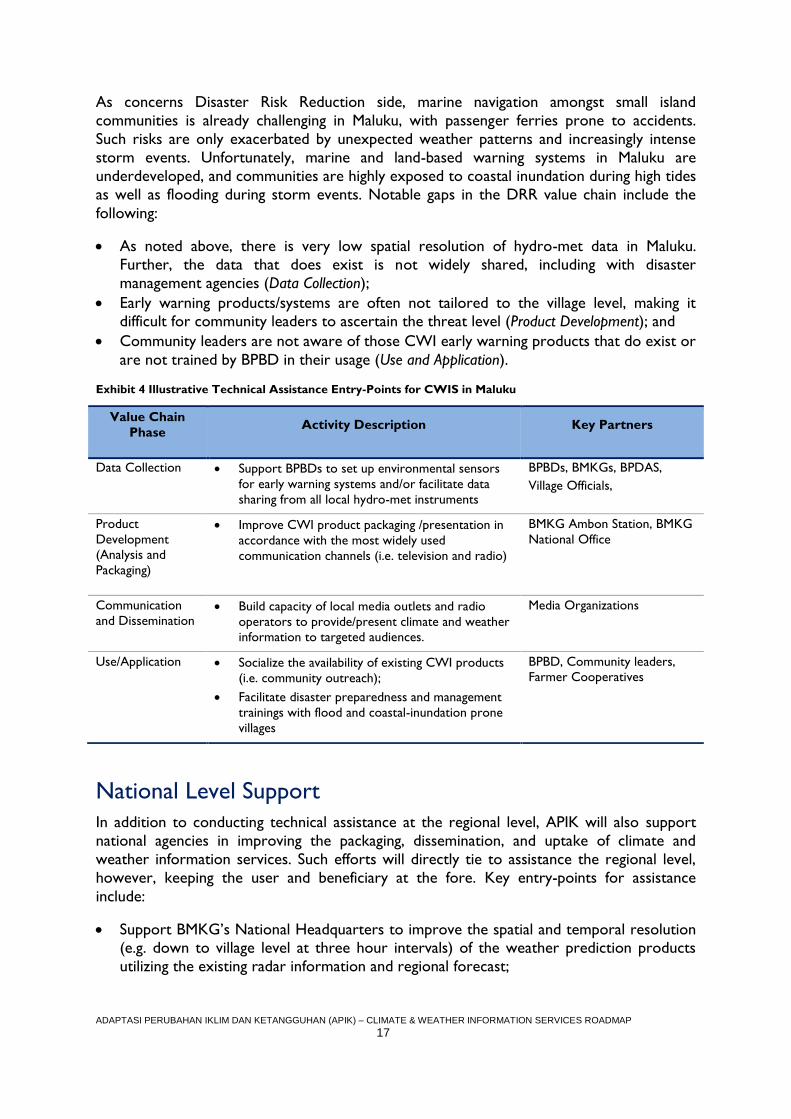
Exhibit 4 Illustrative Technical Assistance Entry-Points for CWIS in Maluku
Value Chain
Phase Activity Description Key Partners
Data Collection Support BPBDs to set up environmental sensors
for early warning systems and/or facilitate data
sharing from all local hydro-met instruments
BPBDs, BMKGs, BPDAS,
Village Officials,
Product
Development
(Analysis and
Packaging)
Improve CWI product packaging /presentation in
accordance with the most widely used
communication channels (i.e. television and radio)
BMKG Ambon Station, BMKG
National Office
Communication
and Dissemination Build capacity of local media outlets and radio
operators to provide/present climate and weather
information to targeted audiences.
Media Organizations
Use/Application Socialize the availability of existing CWI products
(i.e. community outreach);
Facilitate disaster preparedness and management
trainings with flood and coastal-inundation prone
villages
BPBD, Community leaders,
Farmer Cooperatives
National Level Support
In addition to conducting technical assistance at the regional level, APIK will also support
national agencies in improving the packaging, dissemination, and uptake of climate and
weather information services. Such efforts will directly tie to assistance the regional level,
however, keeping the user and beneficiary at the fore. Key entry-points for assistance
include:
Support BMKG’s National Headquarters to improve the spatial and temporal resolution (e.g. down to village level at three hour intervals) of the weather prediction products
utilizing the existing radar information and regional forecast;
ADAPTASI PERUBAHAN IKLIM DAN KETANGGUHAN (APIK) – CLIMATE & WEATHER INFORMATION SERVICES ROADMAP
18
Coordinate with the BMKG’s Public Relation and Dissemination Division to standardize
communication and dissemination processes, techniques, packaging and presentation
(including standardization of format, wording and imagery) of climate and weather
service; and
Facilitate the updating and expanded implementation of Climate Field Schools as an
important medium for building climate literacy amongst farming communities.
Next Steps
The CWIS Roadmap represents the starting point for strengthening the CWIS value chains
identified in each region. In other words, the value chain analysis table for DRR and
Agriculture and Food Security illustrate APIK’s working knowledge of the context and
existing gaps that prevent climate and weather data and information from reaching users and
translating into benefits. Following our strengthening strategy, in PY 2 APIK will engage
directly with target users and beneficiaries and work from there down the value chain to
further detail activities that will lead to improved use and application of CWIS products at
the ground level. Given the critical mass of CWIS products that already exist, we anticipate
that most initial strengthening activities will focus on the communication phase and the use
and application phase of the value chain. Notably, while the Roadmap presented four to five
priority interventions in each region, APIK will remain flexible and look for opportunities to
expand and scale this important work.
ADAPTASI PERUBAHAN IKLIM DAN KETANGGUHAN (APIK) – CLIMATE & WEATHER INFORMATION SERVICES ROADMAP
19
INTRODUCTION
Overview of APIK
USAID’s five year “Adaptasi Perubahan Iklim dan Ketangguhan” (APIK) Project supports the
Government of Indonesia to strengthen climate and disaster resilience, working in an
integrated manner from the national level down to the regional and community levels. In
support of this overall objective, APIK seeks to:
Mainstream climate change adaptation and disaster risk reduction into national and
sub-national governance frameworks;
Build the capacity of local communities and the private sector to address climate change and weather-related natural hazards; and
Support the use of information for climate and disaster risk management among key
stakeholders.
At the national level, APIK provides technical assistance to ministries to strengthen their
understanding of climate change and the impact of weather-related natural disasters, and to
mainstream tools and approaches that facilitate the systematic consideration of climate
change adaptation (CCA) and disaster risk reduction (DRR) in their core planning,
budgeting, and operations. Given the cross-cutting nature of CCA/DRR, APIK works with
economy-wide agencies—such as the Ministry of Planning (BAPPENAS) and the National
Disaster Management Agency (BNPB)—as well as technical ministries such as Environment
and Forestry (KLHK), Marine Affairs and Fisheries (KKP), Energy and Mineral Resources
(MEMR), Public Works and Public Housing (PUPERA), Agrarian and Spatial Planning, and
Agriculture (Kementan).
At the subnational level, APIK seeks to build the capacity of local governments in East Java,
Southeast Sulawesi, and Maluku to address CCA and DRR through planning and operations,
public outreach, and the institutionalization of resilience-building practices in day-to-day
activities. With a regional office located in the respective provinces, the Project works in
targeted landscapes with the communities on the front lines of climate change and disaster
resilience in the target districts to implement measures and link those measures to the
relevant government processes in a holistic systems approach.
Crosscutting the national and subnational levels, APIK further seeks to mainstream
CCA/DRR into the private sector as well as improve uptake and utilization of climate and
weather information (CWI) services. Private sector engagement is critical to addressing
shared economic risks and livelihoods, while improved climate and weather information
services empower public and private institutions alike to better prepare for and respond to
climate and disaster risk.
The APIK Project applies a technical approach centered on place-based resilience, which
emphasizes that vulnerability to natural disasters and climate change are directly linked to
each locale’s unique landscape, socioeconomic, and institutional characteristics.
ADAPTASI PERUBAHAN IKLIM DAN KETANGGUHAN (APIK) – CLIMATE & WEATHER INFORMATION SERVICES ROADMAP
20
Climate and Weather Information Services
In an era of increasing meteorological and hydrological uncertainty, climate and weather
information systems are fundamental to fostering place-based resilience, saving lives in the
near term through disaster preparedness while supporting better planning and investment in
the long term through climate change adaptation.
Broadly speaking, climate and weather information services consist of the hardware
(sensor networks, weather station infrastructure, and IT equipment), software (trained staff,
recognized communication and dissemination platforms, local awareness) and the supporting
institutional arrangements (codified roles and responsibilities, data sharing policies,
dedicated funding) that facilitate the systematic collection, analysis, packaging,
communication, and use of meteorological, hydrological, and climate data. Robust CWI
services are integral to Indonesia’s National Action Plan on Climate Change Adaptation
(RAN-API) in the context of hydro-meteorological disaster risk reduction and development
planning. The World Meteorological Organization (WMO) also recognized the critical role
of improved climate services, establishing the Global Framework for Climate Services in
2012 as a worldwide mechanism for coordinated actions to enhance the quality, quantity,
and application of climate services (see http://www.wmo.int/gfcs/).
Improved data and information is not an end in and of itself but must be linked to
institutional capacity building, pro-poor programming for sustainable livelihoods, and trans-
boundary ecosystem management. Indeed, the availability of reliable climate and weather
data is not sufficient; rather, it must also be effectively translated and communicated in a
manner that supports informed decision-making and action. Government, businesses, and
communities need data and tools to address climate change and climate related natural
disasters. Critically, they need that information to be packaged in ways that are usable, clear,
collaboratively developed, and provide a basis for action.
A key tenet of the APIK Project’s approach, therefore, is that, by strengthening the capacity
of stakeholders to develop, disseminate, and apply tailored climate information services that
are closely aligned with the information needs of practitioners, the use of climate and
weather information services will increase and empower people to better manage climate
and disaster risk. Strengthening CWI services will, for example, empower farmers to
understand the impacts of the El Nino Southern Oscillation (ENSO) and adjust the timing of
crop rotations accordingly; help keep fishermen safe during the hazardous monsoon season;
assist local government planners to incorporate extreme weather patterns into
infrastructure investments; and allow Regional Disaster Management Agencies (BPBDs) to
give more advanced warnings to communities. Simply put, strengthening climate and
weather information services can help people to live safer and more prosperous lives.
Roadmap Objective
The objective of the APIK Climate and Weather Information Services Roadmap is to
present the Project’s strategy to develop, disseminate, and institutionalize climate and
weather information services among appropriate local or national entities. More specifically,
the Roadmap seeks to identify climate services that can close critical information gaps at the
place-based level, and, further, describe the Project’s approach to strengthening those
services.
ADAPTASI PERUBAHAN IKLIM DAN KETANGGUHAN (APIK) – CLIMATE & WEATHER INFORMATION SERVICES ROADMAP
21
The Roadmap builds directly on APIK’s Climate and Weather Information Services
Assessment Report, which catalogued the existing actors, data, products, and users of
climate services in Indonesia while also homing in on key gaps or weaknesses in the CWI
marketplace (see the summary of the Assessment Report in Annex 2). In line with the
approach of the Assessment Report, the Roadmap analyzes the “value chains” for climate
services within APIK’s priority regions (East Java, Southeast Sulawesi, and Maluku) and sets
forth the Project’s proposed technical assistance entry-points over the coming four years
(2017 – 2020). While the activities are principally related to Task 3 of the APIK Project,
they will also support the achievement of results under Tasks 1 and 2 and the high-level
outcomes more broadly.
Report Structure
The Climate and Weather Information Services Roadmap is organized into seven chapters.
The remaining six chapters are as follows:
Chapter 2 describes the concept of CWI services as a “value chain” which moves
climate and weather data through a series of phases from collection (origination) to
benefit realization.
Chapters 3, 4, and 5 describe APIK’s approach to improving climate and weather
information services in each priority province, including a brief profile of each landscape,
the rationale for the selection of specific application areas, preliminary value chain
analyses, and technical assistance entry-points for PY 2 and beyond. Notably, the
Roadmap follows the nomenclature introduced in the WMO’s Global Framework for
Climate Services the when referring to the specific application areas.2
Chapter 6 briefly describes APIK’s technical assistance strategy with national agencies
such as BMKG, including how this assistance will directly address gaps in climate services
value chains at the regional and local level.
Chapter 7 provides a summary of the assistance strategy presented in the Roadmap
and then identifies immediate next steps.
2 The WMO’s Global Framework for Climate Services classifies activities into the following priority areas: agriculture and
food security, disaster risk reduction, energy, health, and water. See: http://www.wmo.int/gfcs/priority-areas.
ADAPTASI PERUBAHAN IKLIM DAN KETANGGUHAN (APIK) – CLIMATE & WEATHER INFORMATION SERVICES ROADMAP
22
CWI SERVICES VALUE CHAIN
The acquisition and application of relevant, accurate, and reliable climate and weather
information to support local decision-making is critical to bolstering resilience and mitigating
disaster risk. While it is easy to view climate and weather information services as a passive
process centered on the establishment of monitoring systems and the cataloging of trends,
such services are most impactful when an active process is put in place to transform raw
data into actionable information communicated to the right people at the right time. In this
sense, the series of steps involved in the transformation of data into decisions are akin to a
product value chain in which the raw materials—environmental data—are collected,
processed, packaged, and disseminated for “market” consumption.
The notion of climate and weather information services as a value chain operating in the
context of a local market represents an important aspect of APIK’s approach to the analysis
and evaluation of the effectiveness of such services in Indonesia. More specifically, adopting a
value chain approach serves to:
Identify and segment the key actors responsible for moving climate and weather information through the value chain;
Define the roles that actors play across all the links of the value chain. Notably, a
single institutional actor may (and often does) play more than one role, such as
managing both the collection of data as well as the packaging of that data into a CWI
product;
Connect the “supply-side” of climate and weather information services to the “demand side”, or those that collect and produce CWI services and those that
apply them at the local level. In this regard, it is essential that CWI products be
designed and communicated with the end-users and beneficiaries in mind; and
Detect specific gaps or weaknesses in the value chain and target technical assistance
efforts accordingly.
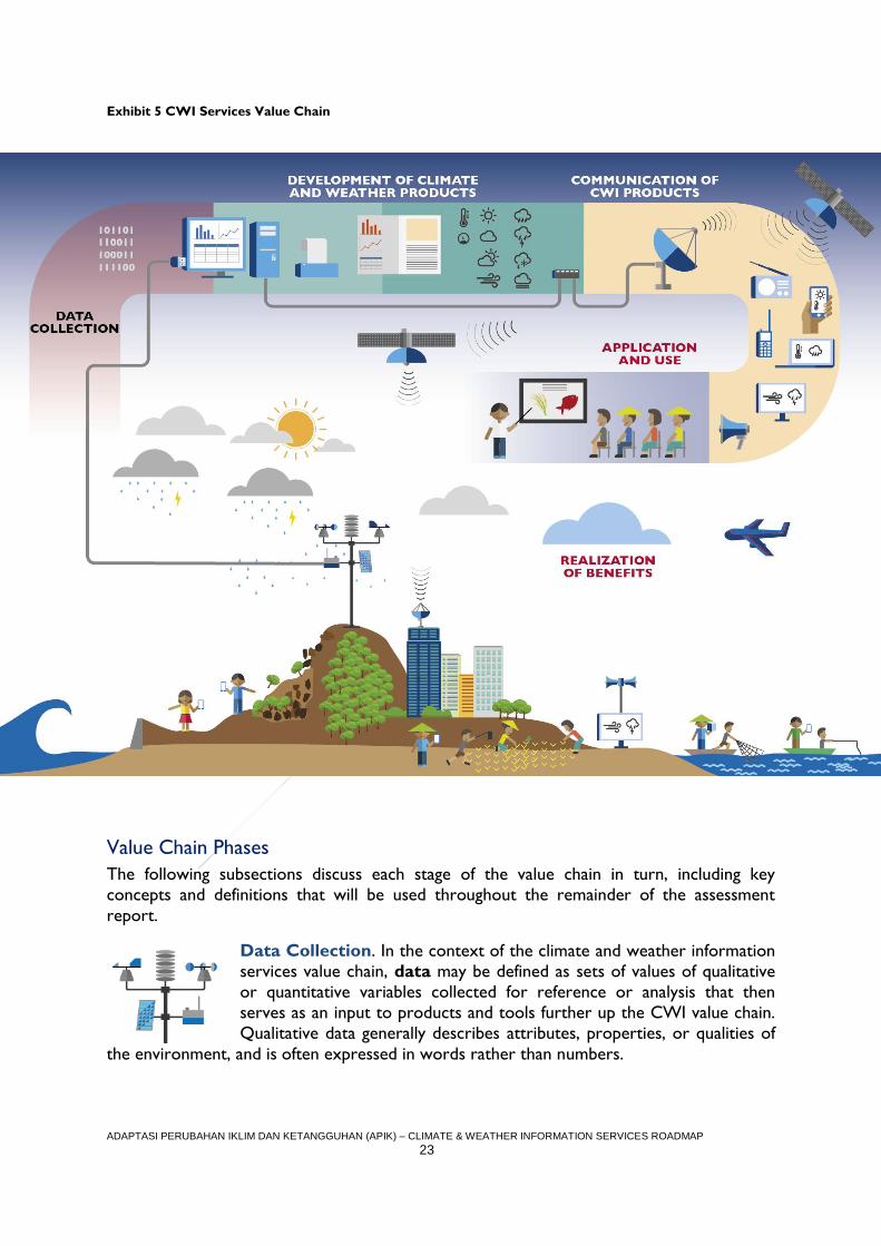
Exhibit 5 depicts the five stages or “links” in the climate and weather information services
value chain: data collection, product development, communication/dissemination, application
and use, and benefit realization. Each link in the chain is of equal importance to the
achievement of the ultimate objective of CWI services, namely, helping people better
manage climate and disaster risks in the context of their livelihoods and communities. For
illustrative purposes, Exhibit 5 considers the value chain stages for CWI product(s) aimed at
helping farmers, fisher folk, and communities make better livelihood decisions and be more
prepared for natural disasters.
ADAPTASI PERUBAHAN IKLIM DAN KETANGGUHAN (APIK) – CLIMATE & WEATHER INFORMATION SERVICES ROADMAP
23
Exhibit 5 CWI Services Value Chain
Value Chain Phases
The following subsections discuss each stage of the value chain in turn, including key
concepts and definitions that will be used throughout the remainder of the assessment
report.
Data Collection. In the context of the climate and weather information
services value chain, data may be defined as sets of values of qualitative
or quantitative variables collected for reference or analysis that then
serves as an input to products and tools further up the CWI value chain.
Qualitative data generally describes attributes, properties, or qualities of
the environment, and is often expressed in words rather than numbers.
ADAPTASI PERUBAHAN IKLIM DAN KETANGGUHAN (APIK) – CLIMATE & WEATHER INFORMATION SERVICES ROADMAP
24
Quantitative data, on the other hand, represents information that can be measured or
expressed numerically, typically describing amounts, ranges, or quantities. Importantly, data
may be collected locally (such as through direct observation or environmental sensors) or
remotely via aerial photography or satellites. Raw climate and weather data, then, comes in
many different forms, including TRMM satellite data, in-situ weather data, crop data,
elevation data, hydrological/flow data, and structured by user data preferences. Data is
generally aggregated into a dataset, which consists of the same type of data over a given
period.
Under the auspices of this assessment, a collector is any institution, entity, or individual
that has a formal responsibility to gather, organize, and store raw climate and weather data
from the environment. As discussed in detail in the next chapter, BMKG represents the
largest CWI collector in Indonesia, maintaining a vast network of weather and climatology
stations across the archipelago with the resulting data then made available on their website
(http://dataonline.bmkg.go.id/). An example of a collector at the subnational level is the
Watershed/River Management Agency (BBWS), which generally owns a separate network of
automatic weather stations (AWS) installed within its jurisdiction.
A robust climate and weather information value chain begins with data that is collected at
the necessary spatial and temporal resolution in a transparent, standardized, and reliable
manner. One common CWI gap is that data is not collected within a geographic area that is
relevant to decision-making (spatial resolution) due to the limited number of stations; a
second is that data is collected infrequently, making it difficult to understand the speed of
environmental change (temporal resolution). Additional complications that frequently inhibit
data collection or organization include the poor maintenance of observation stations as well
as the lack of transparent and standardized collection procedures. Importantly, the extent to
which raw data is widely shared also represents a significant determinant of how readily the
climate and weather information market develops to meet the needs of a diverse group of
stakeholders.
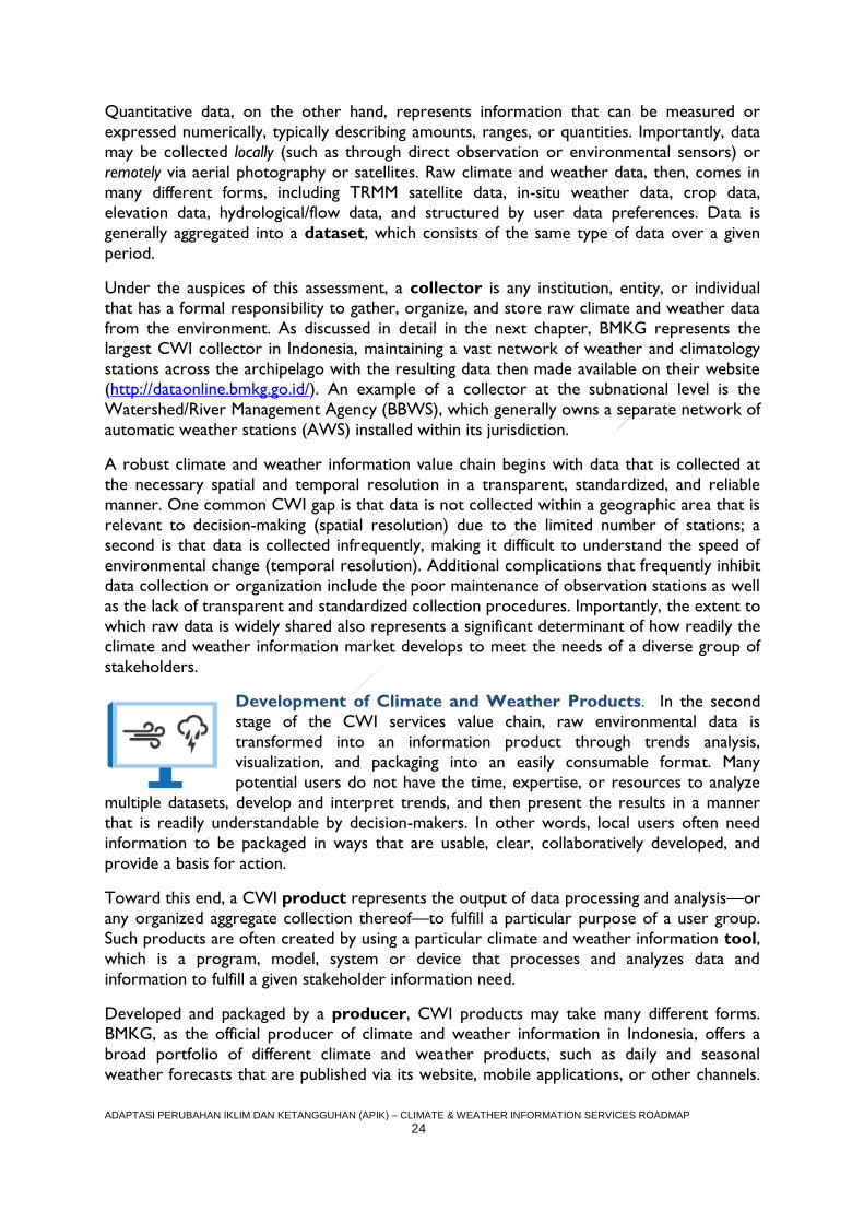
Development of Climate and Weather Products. In the second
stage of the CWI services value chain, raw environmental data is
transformed into an information product through trends analysis,
visualization, and packaging into an easily consumable format. Many
potential users do not have the time, expertise, or resources to analyze
multiple datasets, develop and interpret trends, and then present the results in a manner
that is readily understandable by decision-makers. In other words, local users often need
information to be packaged in ways that are usable, clear, collaboratively developed, and
provide a basis for action.
Toward this end, a CWI product represents the output of data processing and analysis—or
any organized aggregate collection thereof—to fulfill a particular purpose of a user group.
Such products are often created by using a particular climate and weather information tool,
which is a program, model, system or device that processes and analyzes data and
information to fulfill a given stakeholder information need.
Developed and packaged by a producer, CWI products may take many different forms.
BMKG, as the official producer of climate and weather information in Indonesia, offers a
broad portfolio of different climate and weather products, such as daily and seasonal
weather forecasts that are published via its website, mobile applications, or other channels.
ADAPTASI PERUBAHAN IKLIM DAN KETANGGUHAN (APIK) – CLIMATE & WEATHER INFORMATION SERVICES ROADMAP
25
Indonesian universities are also common producers in Indonesia; CCROM at the
Agricultural institute of Bogor, for example, has created products that illustrate downscaled
climate change projections; Weather and Climate Prediction Laboratory Institute
Technology of Bandung (WCPL-ITB) also contribute to weather data collection,
dissemination and prediction analysis in the Bandung area. Producers may develop climate
and weather products that are freely available for public use as well as for the purchase of
specific clients.
Throughout the Roadmap, we also refer to derivative products, which are “secondary”
products created from processing two or more sets of climate and weather data. For
example, PVMBG and BNPB sometimes publish an exposure map for volcanic ash that
combines two pre-existing analyses—a model of volcanic ash spread (based upon digital
elevation, wind direction patterns, and wind speed information) accompanied by population
density estimates from BNPB. In other words, the resulting volcanic ash exposure map
integrates and adds value to existing analyses and products to create a new, highly tailored
secondary product incorporating both weather and natural disaster risk.
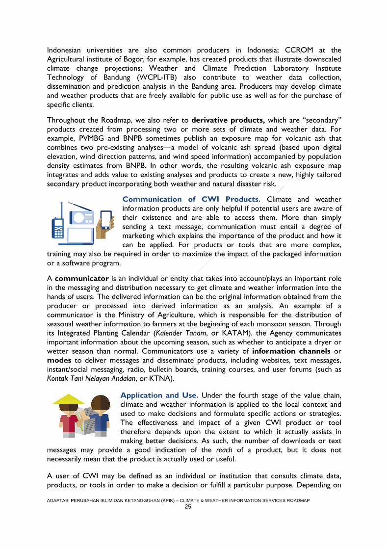
Communication of CWI Products. Climate and weather
information products are only helpful if potential users are aware of
their existence and are able to access them. More than simply
sending a text message, communication must entail a degree of
marketing which explains the importance of the product and how it
can be applied. For products or tools that are more complex,
training may also be required in order to maximize the impact of the packaged information
or a software program.
A communicator is an individual or entity that takes into account/plays an important role
in the messaging and distribution necessary to get climate and weather information into the
hands of users. The delivered information can be the original information obtained from the
producer or processed into derived information as an analysis. An example of a
communicator is the Ministry of Agriculture, which is responsible for the distribution of
seasonal weather information to farmers at the beginning of each monsoon season. Through
its Integrated Planting Calendar (Kalender Tanam, or KATAM), the Agency communicates
important information about the upcoming season, such as whether to anticipate a dryer or
wetter season than normal. Communicators use a variety of information channels or
modes to deliver messages and disseminate products, including websites, text messages,
instant/social messaging, radio, bulletin boards, training courses, and user forums (such as
Kontak Tani Nelayan Andalan, or KTNA).
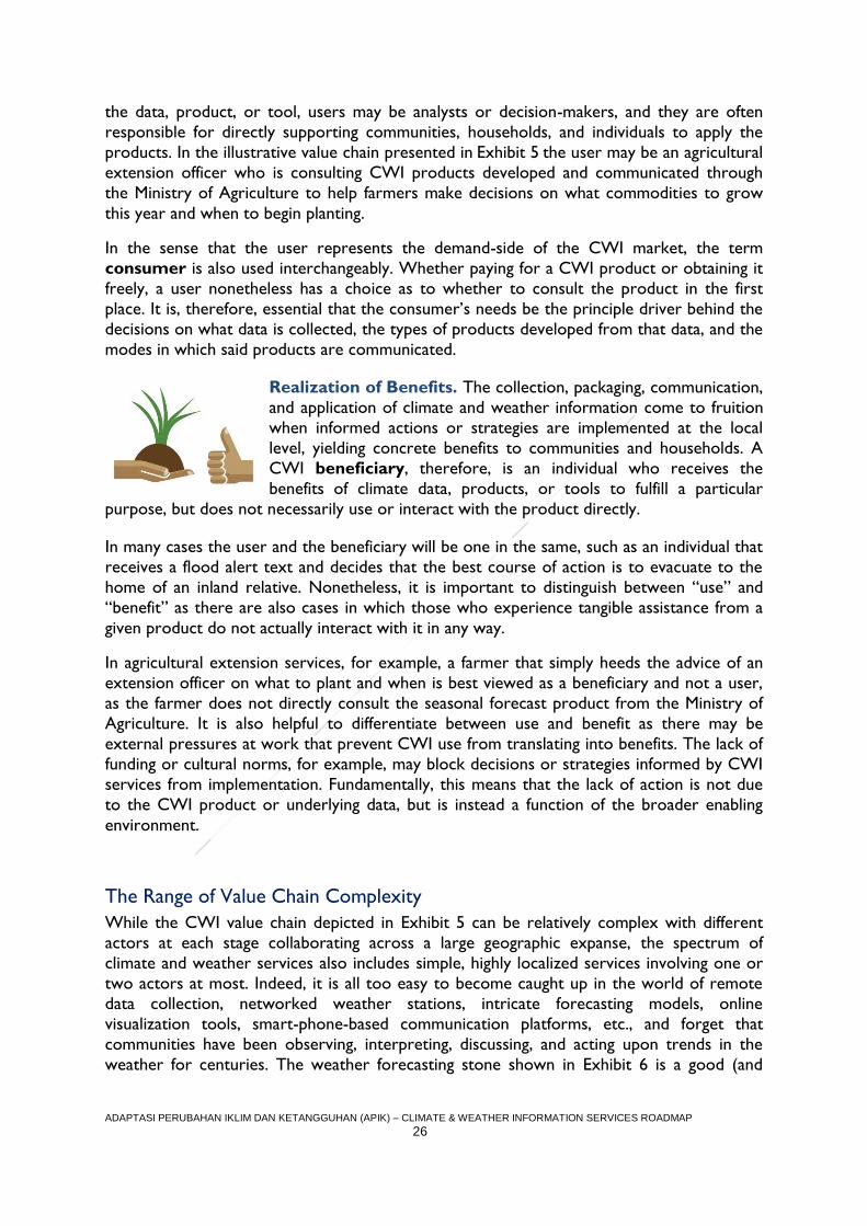
Application and Use. Under the fourth stage of the value chain,
climate and weather information is applied to the local context and
used to make decisions and formulate specific actions or strategies.
The effectiveness and impact of a given CWI product or tool
therefore depends upon the extent to which it actually assists in
making better decisions. As such, the number of downloads or text
messages may provide a good indication of the reach of a product, but it does not
necessarily mean that the product is actually used or useful.
A user of CWI may be defined as an individual or institution that consults climate data,
products, or tools in order to make a decision or fulfill a particular purpose. Depending on
ADAPTASI PERUBAHAN IKLIM DAN KETANGGUHAN (APIK) – CLIMATE & WEATHER INFORMATION SERVICES ROADMAP
26
the data, product, or tool, users may be analysts or decision-makers, and they are often
responsible for directly supporting communities, households, and individuals to apply the
products. In the illustrative value chain presented in Exhibit 5 the user may be an agricultural
extension officer who is consulting CWI products developed and communicated through
the Ministry of Agriculture to help farmers make decisions on what commodities to grow
this year and when to begin planting.
In the sense that the user represents the demand-side of the CWI market, the term
consumer is also used interchangeably. Whether paying for a CWI product or obtaining it
freely, a user nonetheless has a choice as to whether to consult the product in the first
place. It is, therefore, essential that the consumer’s needs be the principle driver behind the
decisions on what data is collected, the types of products developed from that data, and the
modes in which said products are communicated.
Realization of Benefits. The collection, packaging, communication,
and application of climate and weather information come to fruition
when informed actions or strategies are implemented at the local
level, yielding concrete benefits to communities and households. A
CWI beneficiary, therefore, is an individual who receives the
benefits of climate data, products, or tools to fulfill a particular
purpose, but does not necessarily use or interact with the product directly.
In many cases the user and the beneficiary will be one in the same, such as an individual that
receives a flood alert text and decides that the best course of action is to evacuate to the
home of an inland relative. Nonetheless, it is important to distinguish between “use” and
“benefit” as there are also cases in which those who experience tangible assistance from a
given product do not actually interact with it in any way.
In agricultural extension services, for example, a farmer that simply heeds the advice of an
extension officer on what to plant and when is best viewed as a beneficiary and not a user,
as the farmer does not directly consult the seasonal forecast product from the Ministry of
Agriculture. It is also helpful to differentiate between use and benefit as there may be
external pressures at work that prevent CWI use from translating into benefits. The lack of
funding or cultural norms, for example, may block decisions or strategies informed by CWI
services from implementation. Fundamentally, this means that the lack of action is not due
to the CWI product or underlying data, but is instead a function of the broader enabling
environment.
The Range of Value Chain Complexity
While the CWI value chain depicted in Exhibit 5 can be relatively complex with different
actors at each stage collaborating across a large geographic expanse, the spectrum of
climate and weather services also includes simple, highly localized services involving one or
two actors at most. Indeed, it is all too easy to become caught up in the world of remote
data collection, networked weather stations, intricate forecasting models, online
visualization tools, smart-phone-based communication platforms, etc., and forget that
communities have been observing, interpreting, discussing, and acting upon trends in the
weather for centuries. The weather forecasting stone shown in Exhibit 6 is a good (and
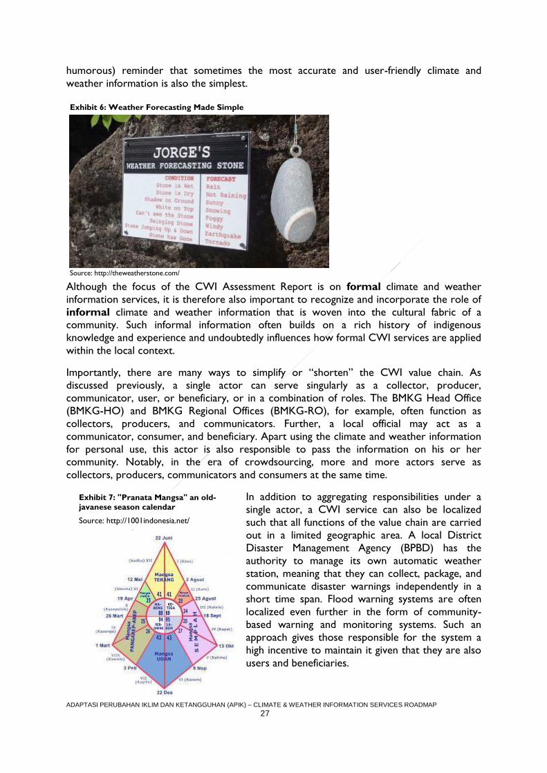
ADAPTASI PERUBAHAN IKLIM DAN KETANGGUHAN (APIK) – CLIMATE & WEATHER INFORMATION SERVICES ROADMAP
27
humorous) reminder that sometimes the most accurate and user-friendly climate and
weather information is also the simplest.
Although the focus of the CWI Assessment Report is on formal climate and weather
information services, it is therefore also important to recognize and incorporate the role of
informal climate and weather information that is woven into the cultural fabric of a community. Such informal information often builds on a rich history of indigenous
knowledge and experience and undoubtedly influences how formal CWI services are applied
within the local context.
Importantly, there are many ways to simplify or “shorten” the CWI value chain. As
discussed previously, a single actor can serve singularly as a collector, producer,
communicator, user, or beneficiary, or in a combination of roles. The BMKG Head Office
(BMKG-HO) and BMKG Regional Offices (BMKG-RO), for example, often function as
collectors, producers, and communicators. Further, a local official may act as a
communicator, consumer, and beneficiary. Apart using the climate and weather information
for personal use, this actor is also responsible to pass the information on his or her community. Notably, in the era of crowdsourcing, more and more actors serve as
collectors, producers, communicators and consumers at the same time.
In addition to aggregating responsibilities under a
single actor, a CWI service can also be localized
such that all functions of the value chain are carried
out in a limited geographic area. A local District
Disaster Management Agency (BPBD) has the
authority to manage its own automatic weather
station, meaning that they can collect, package, and
communicate disaster warnings independently in a short time span. Flood warning systems are often
localized even further in the form of community-
based warning and monitoring systems. Such an
approach gives those responsible for the system a
high incentive to maintain it given that they are also
users and beneficiaries.
Exhibit 6: Weather Forecasting Made Simple
Source: http://theweatherstone.com/
Exhibit 7: "Pranata Mangsa" an old-
javanese season calendar
Source: http://1001indonesia.net/
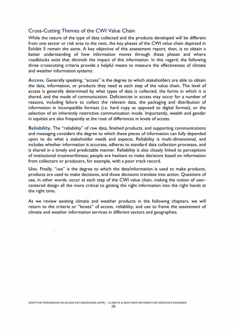
ADAPTASI PERUBAHAN IKLIM DAN KETANGGUHAN (APIK) – CLIMATE & WEATHER INFORMATION SERVICES ROADMAP
28
Cross-Cutting Themes of the CWI Value Chain
While the nature of the type of data collected and the products developed will be different
from one sector or risk area to the next, the key phases of the CWI value chain depicted in
Exhibit 5 remain the same. A key objective of this assessment report, then, is to obtain a
better understanding of how information moves through these phases and where
roadblocks exist that diminish the impact of this information. In this regard, the following
three crosscutting criteria provide a helpful means to measure the effectiveness of climate
and weather information systems:
Access. Generally speaking, “access” is the degree to which stakeholders are able to obtain
the data, information, or products they need at each step of the value chain. The level of
access is generally determined by what types of data is collected, the forms in which it is
shared, and the mode of communication. Deficiencies in access may occur for a number of
reasons, including failure to collect the relevant data, the packaging and distribution of
information in incompatible formats (i.e. hard copy as opposed to digital format), or the
selection of an inherently restrictive communication mode. Importantly, wealth and gender
in equities are also frequently at the root of differences in levels of access.
Reliability. The “reliability” of raw data, finished products, and supporting communications
and messaging considers the degree to which these pieces of information can fully depended
upon to do what a stakeholder needs and expects. Reliability is multi-dimensional, and
includes whether information is accurate, adheres to standard data collection processes, and
is shared in a timely and predictable manner. Reliability is also closely linked to perceptions
of institutional trustworthiness; people are hesitant to make decisions based on information
from collectors or producers, for example, with a poor track record.
Use. Finally, “use” is the degree to which the data/information is used to make products,
products are used to make decisions, and those decisions translate into action. Questions of
use, in other words, occur at each step of the CWI value chain, making the notion of user-
centered design all the more critical to getting the right information into the right hands at
the right time.
As we review existing climate and weather products in the following chapters, we will
return to the criteria or “lenses” of access, reliability, and use to frame the assessment of
climate and weather information services in different sectors and geographies.
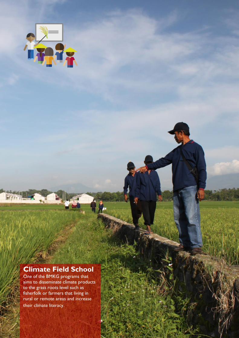
ADAPTASI PERUBAHAN IKLIM DAN KETANGGUHAN (APIK) – CLIMATE & WEATHER INFORMATION SERVICES ROADMAP
29
Climate Field School One of the BMKG programs that
aims to disseminate climate products to the grass roots level such as
fisherfolk or farmers that living in
rural or remote areas and increase
their climate literacy.
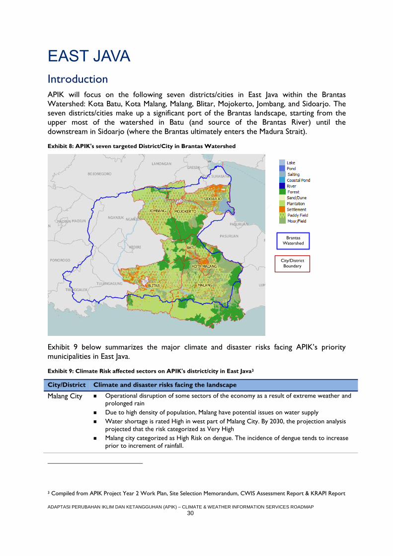
ADAPTASI PERUBAHAN IKLIM DAN KETANGGUHAN (APIK) – CLIMATE & WEATHER INFORMATION SERVICES ROADMAP
30
EAST JAVA
Introduction
APIK will focus on the following seven districts/cities in East Java within the Brantas
Watershed: Kota Batu, Kota Malang, Malang, Blitar, Mojokerto, Jombang, and Sidoarjo. The
seven districts/cities make up a significant port of the Brantas landscape, starting from the
upper most of the watershed in Batu (and source of the Brantas River) until the
downstream in Sidoarjo (where the Brantas ultimately enters the Madura Strait).
Exhibit 8: APIK's seven targeted District/City in Brantas Watershed
Exhibit 9 below summarizes the major climate and disaster risks facing APIK’s priority
municipalities in East Java.
Exhibit 9: Climate Risk affected sectors on APIK's district/city in East Java3
City/District Climate and disaster risks facing the landscape
Malang City Operational disruption of some sectors of the economy as a result of extreme weather and
prolonged rain
Due to high density of population, Malang have potential issues on water supply
Water shortage is rated High in west part of Malang City. By 2030, the projection analysis
projected that the risk categorized as Very High
Malang city categorized as High Risk on dengue. The incidence of dengue tends to increase
prior to increment of rainfall.
3 Compiled from APIK Project Year 2 Work Plan, Site Selection Memorandum, CWIS Assessment Report & KRAPI Report
Brantas
Watershed
City/District
Boundary
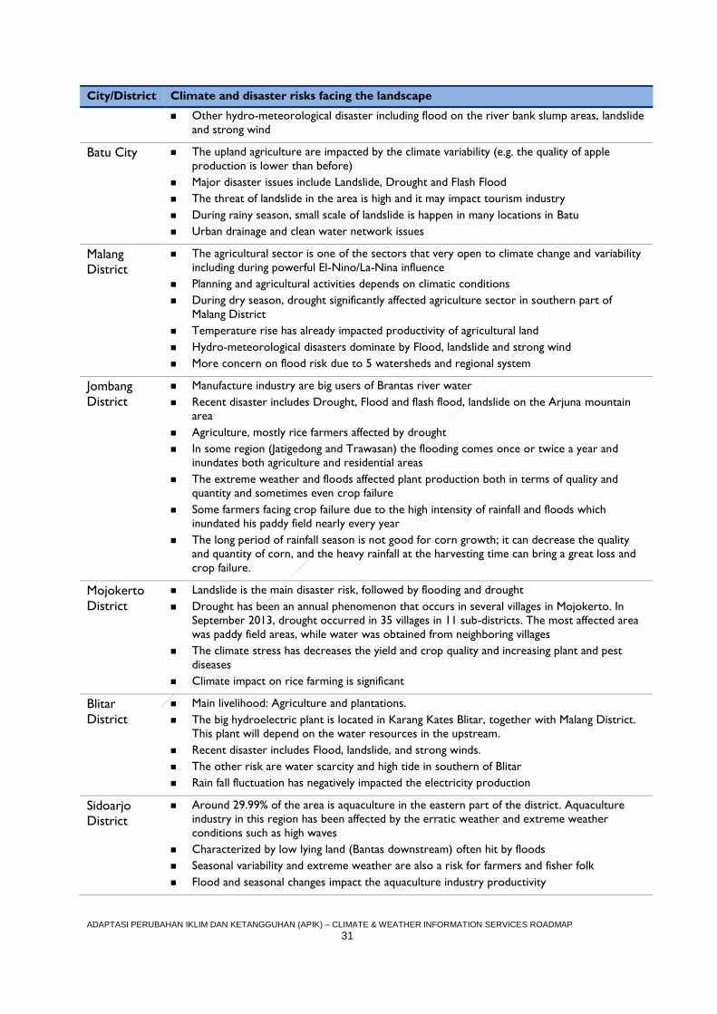
ADAPTASI PERUBAHAN IKLIM DAN KETANGGUHAN (APIK) – CLIMATE & WEATHER INFORMATION SERVICES ROADMAP
31
City/District Climate and disaster risks facing the landscape
Other hydro-meteorological disaster including flood on the river bank slump areas, landslide
and strong wind
Batu City The upland agriculture are impacted by the climate variability (e.g. the quality of apple
production is lower than before)
Major disaster issues include Landslide, Drought and Flash Flood
The threat of landslide in the area is high and it may impact tourism industry
During rainy season, small scale of landslide is happen in many locations in Batu
Urban drainage and clean water network issues
Malang
District
The agricultural sector is one of the sectors that very open to climate change and variability
including during powerful El-Nino/La-Nina influence
Planning and agricultural activities depends on climatic conditions
During dry season, drought significantly affected agriculture sector in southern part of
Malang District
Temperature rise has already impacted productivity of agricultural land
Hydro-meteorological disasters dominate by Flood, landslide and strong wind
More concern on flood risk due to 5 watersheds and regional system
Jombang
District
Manufacture industry are big users of Brantas river water
Recent disaster includes Drought, Flood and flash flood, landslide on the Arjuna mountain
area
Agriculture, mostly rice farmers affected by drought
In some region (Jatigedong and Trawasan) the flooding comes once or twice a year and
inundates both agriculture and residential areas
The extreme weather and floods affected plant production both in terms of quality and
quantity and sometimes even crop failure
Some farmers facing crop failure due to the high intensity of rainfall and floods which
inundated his paddy field nearly every year
The long period of rainfall season is not good for corn growth; it can decrease the quality
and quantity of corn, and the heavy rainfall at the harvesting time can bring a great loss and
crop failure.
Mojokerto
District
Landslide is the main disaster risk, followed by flooding and drought
Drought has been an annual phenomenon that occurs in several villages in Mojokerto. In
September 2013, drought occurred in 35 villages in 11 sub-districts. The most affected area
was paddy field areas, while water was obtained from neighboring villages
The climate stress has decreases the yield and crop quality and increasing plant and pest
diseases
Climate impact on rice farming is significant
Blitar
District
Main livelihood: Agriculture and plantations.
The big hydroelectric plant is located in Karang Kates Blitar, together with Malang District.
This plant will depend on the water resources in the upstream.
Recent disaster includes Flood, landslide, and strong winds.
The other risk are water scarcity and high tide in southern of Blitar
Rain fall fluctuation has negatively impacted the electricity production
Sidoarjo
District
Around 29.99% of the area is aquaculture in the eastern part of the district. Aquaculture
industry in this region has been affected by the erratic weather and extreme weather
conditions such as high waves
Characterized by low lying land (Bantas downstream) often hit by floods
Seasonal variability and extreme weather are also a risk for farmers and fisher folk
Flood and seasonal changes impact the aquaculture industry productivity
ADAPTASI PERUBAHAN IKLIM DAN KETANGGUHAN (APIK) – CLIMATE & WEATHER INFORMATION SERVICES ROADMAP
32
City/District Climate and disaster risks facing the landscape
Rice farming in Sidoarjo is also impacted by climate variability, although the number of rice
field is getting smaller due to urbanization which also creates water resource challenges
Porong is one of the sub-districts considered as high risk to flooding
Application Area Selection Rationale
Aligned with WMO’s Global Framework for Climate Services, we divide the application
areas into five areas: agriculture and food security, disaster risk reduction, energy, health
and water. For PY 2, the priority areas for APIK in East Java are agriculture and food
security and disaster risk reduction (e.g. early warning system) specifically on floods,
landslides and drought. However, some activities in PY 2 will also have an impact on other
areas such as water and health, and APIK will specifically shift to these areas in PY 3. APIK
also plans to carry out activities related to water scarcity, especially in anticipation of the
impact of 2017’s summer season.
Agriculture in East Java is the principal source of income for the population, including in
several of APIK working cities/districts. For the record, the agricultural sector also includes
agro-tourism and downstream agriculture such as salt farming and fish farming. Almost all
community livelihoods in APIK’s East Java cities/districts are engaged in the agricultural
sector on one manner or another.
Many cities and districts in East Java are prone to flooding and landslides (as described in
Exhibit 9). The increase of extreme weather events has raised the risk of floods and landslides in the region in recent years. Flood risk is exacerbated in urban areas by the lack
of proper drainage facilities; drainage infrastructure that does exist rarely incorporates the
extreme events associated with climate change, further heightening the potential for
disastrous flooding. Land use change and a burgeoning population also contribute to East
Java’s vulnerability, making disaster risk reduction an important starting point for APIK in PY
2.
Agriculture and Food Security
Context
The agricultural sector (in this subchapter defined as upland, midland, aquaculture and salt
farming) needs considerable CWI service improvement. Currently, many farming
communities have not taken advantage of climate services to inform their farming practices.
During the assessment, farmers stated they need CWI related to the timing of the start of
the rainy season to inform planting and harvesting, information regarding seasonal variability,
as well as daily weather forecasts (that include rainfall, temperature, humidity, wind
direction, and weather prediction). The profile of Farmer Husein on page 36 below provides
a snapshot of the unique needs and challenges faced by farmers in East Java.
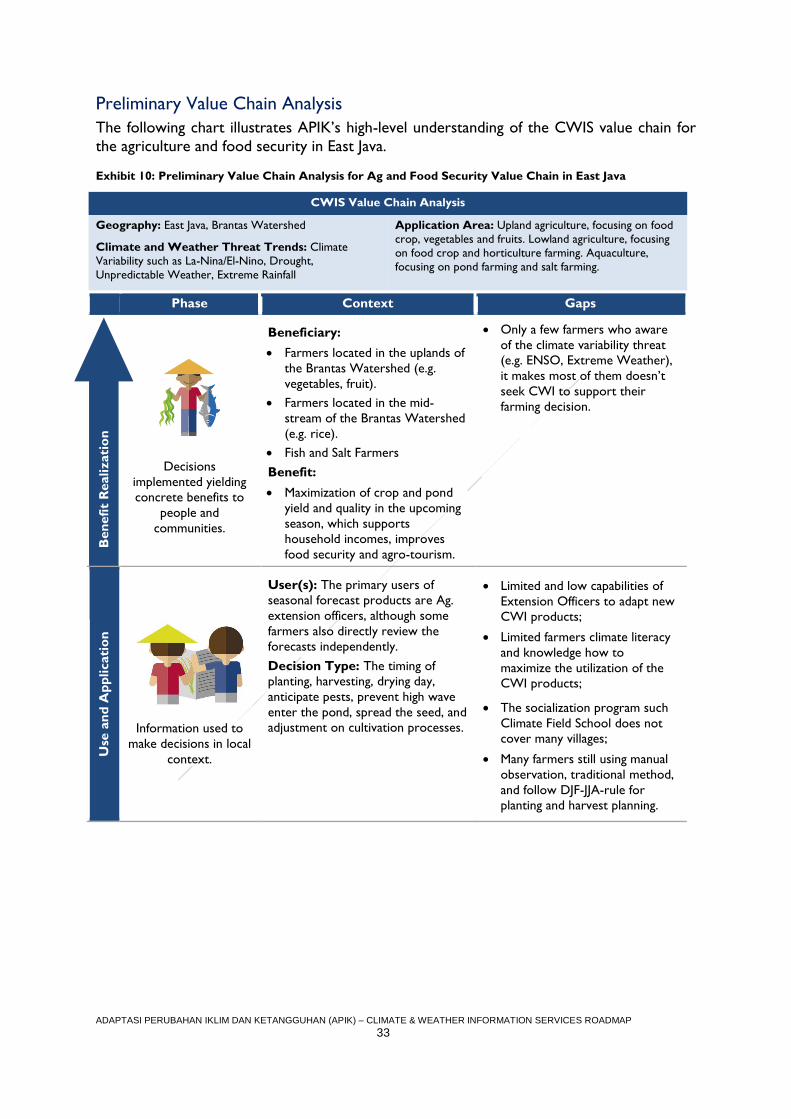
ADAPTASI PERUBAHAN IKLIM DAN KETANGGUHAN (APIK) – CLIMATE & WEATHER INFORMATION SERVICES ROADMAP
33
Preliminary Value Chain Analysis
The following chart illustrates APIK’s high-level understanding of the CWIS value chain for
the agriculture and food security in East Java.
Exhibit 10: Preliminary Value Chain Analysis for Ag and Food Security Value Chain in East Java
CWIS Value Chain Analysis
Geography: East Java, Brantas Watershed
Climate and Weather Threat Trends: Climate
Variability such as La-Nina/El-Nino, Drought,
Unpredictable Weather, Extreme Rainfall
Application Area: Upland agriculture, focusing on food
crop, vegetables and fruits. Lowland agriculture, focusing
on food crop and horticulture farming. Aquaculture,
focusing on pond farming and salt farming.
Phase Context Gaps
B
en
efi
t R
ealizati
on
Decisions
implemented yielding
concrete benefits to
people and
communities.
Beneficiary:
Farmers located in the uplands of
the Brantas Watershed (e.g.
vegetables, fruit).
Farmers located in the mid-
stream of the Brantas Watershed
(e.g. rice).
Fish and Salt Farmers
Benefit:
Maximization of crop and pond
yield and quality in the upcoming
season, which supports
household incomes, improves
food security and agro-tourism.
Only a few farmers who aware
of the climate variability threat
(e.g. ENSO, Extreme Weather),
it makes most of them doesn’t
seek CWI to support their
farming decision.
Use
an
d A
pp
licati
on
Information used to
make decisions in local
context.
User(s): The primary users of
seasonal forecast products are Ag.
extension officers, although some
farmers also directly review the
forecasts independently.
Decision Type: The timing of
planting, harvesting, drying day,
anticipate pests, prevent high wave
enter the pond, spread the seed, and
adjustment on cultivation processes.
Limited and low capabilities of
Extension Officers to adapt new
CWI products;
Limited farmers climate literacy
and knowledge how to
maximize the utilization of the
CWI products;
The socialization program such
Climate Field School does not
cover many villages;
Many farmers still using manual
observation, traditional method,
and follow DJF-JJA-rule for
planting and harvest planning.
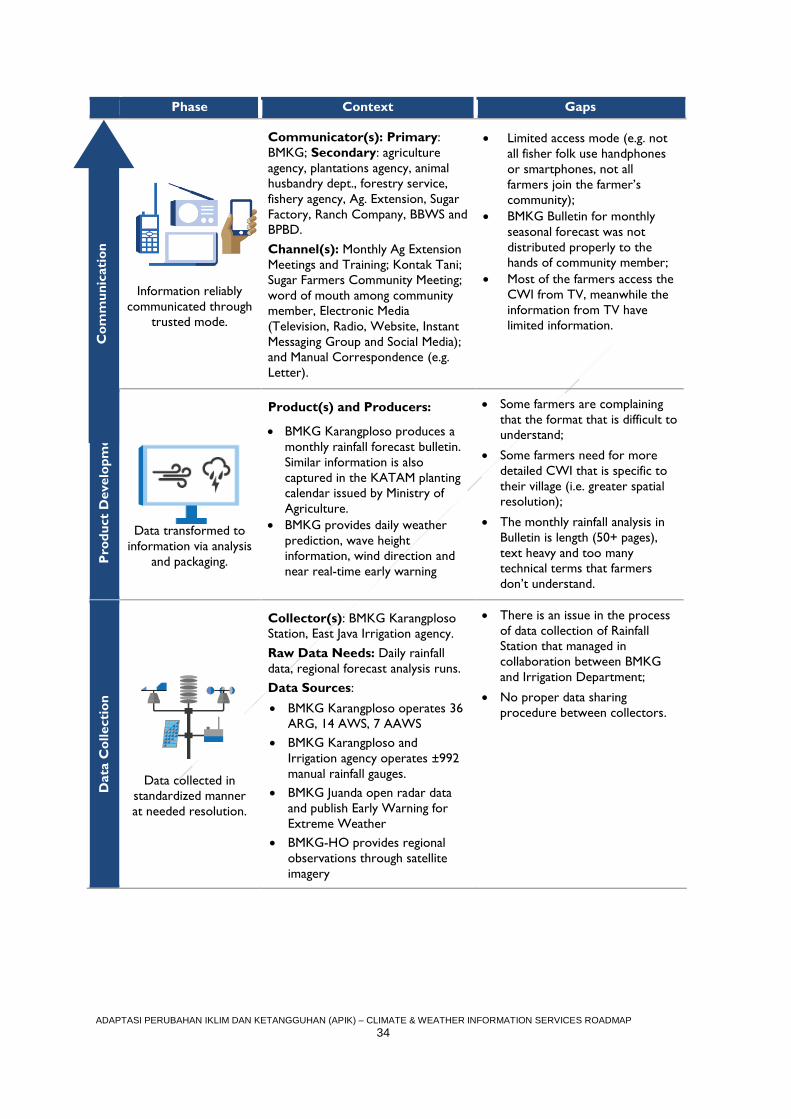
ADAPTASI PERUBAHAN IKLIM DAN KETANGGUHAN (APIK) – CLIMATE & WEATHER INFORMATION SERVICES ROADMAP
34
Phase Context Gaps C
om
mu
nic
ati
on
Information reliably
communicated through
trusted mode.
Communicator(s): Primary:
BMKG; Secondary: agriculture
agency, plantations agency, animal
husbandry dept., forestry service,
fishery agency, Ag. Extension, Sugar
Factory, Ranch Company, BBWS and
BPBD.
Channel(s): Monthly Ag Extension
Meetings and Training; Kontak Tani;
Sugar Farmers Community Meeting;
word of mouth among community
member, Electronic Media
(Television, Radio, Website, Instant
Messaging Group and Social Media);
and Manual Correspondence (e.g.
Letter).
Limited access mode (e.g. not
all fisher folk use handphones
or smartphones, not all
farmers join the farmer’s
community);
BMKG Bulletin for monthly
seasonal forecast was not
distributed properly to the
hands of community member;
Most of the farmers access the
CWI from TV, meanwhile the
information from TV have
limited information.
Pro
du
ct
Develo
pm
en
t
Data transformed to
information via analysis
and packaging.
Product(s) and Producers:
BMKG Karangploso produces a
monthly rainfall forecast bulletin.
Similar information is also
captured in the KATAM planting
calendar issued by Ministry of
Agriculture.
BMKG provides daily weather
prediction, wave height
information, wind direction and
near real-time early warning
Some farmers are complaining
that the format that is difficult to
understand;
Some farmers need for more
detailed CWI that is specific to
their village (i.e. greater spatial
resolution);
The monthly rainfall analysis in
Bulletin is length (50+ pages),
text heavy and too many
technical terms that farmers
don’t understand.
Data
Co
llecti
on
Data collected in
standardized manner
at needed resolution.
Collector(s): BMKG Karangploso
Station, East Java Irrigation agency.
Raw Data Needs: Daily rainfall
data, regional forecast analysis runs.
Data Sources:
BMKG Karangploso operates 36
ARG, 14 AWS, 7 AAWS
BMKG Karangploso and
Irrigation agency operates ±992
manual rainfall gauges.
BMKG Juanda open radar data
and publish Early Warning for
Extreme Weather
BMKG-HO provides regional
observations through satellite
imagery
There is an issue in the process
of data collection of Rainfall
Station that managed in
collaboration between BMKG
and Irrigation Department;
No proper data sharing
procedure between collectors.
Co
mm
un
icati
on
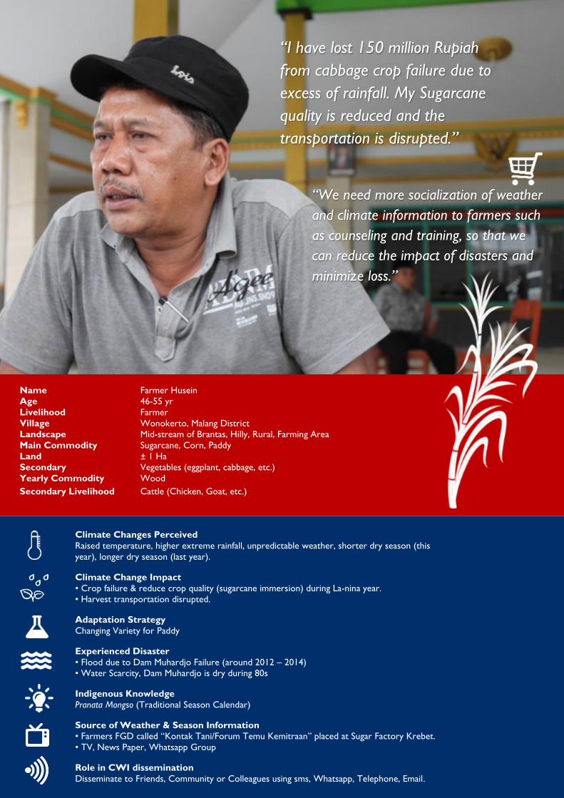
CLIMATE and WEATHER INFORMATION SERVICES ROADMAP
ADAPTASI PERUBAHAN IKLIM DAN KETANGGUHAN (APIK) – CLIMATE & WEATHER INFORMATION SERVICES ROADMAP
35
“I have lost 150 million Rupiah
from cabbage crop failure due to
excess of rainfall. My Sugarcane
quality is reduced and the
transportation is disrupted.”
Name Farmer Husein
Age 46-55 yr
Livelihood Farmer
Village Wonokerto, Malang District
Landscape Mid-stream of Brantas, Hilly, Rural, Farming Area
Main Commodity Sugarcane, Corn, Paddy
Land ± 1 Ha
Secondary Vegetables (eggplant, cabbage, etc.)
Yearly Commodity Wood
Secondary Livelihood Cattle (Chicken, Goat, etc.)
“We need more socialization of weather
and climate information to farmers such
as counseling and training, so that we
can reduce the impact of disasters and
minimize loss.”
Climate Changes Perceived
Raised temperature, higher extreme rainfall, unpredictable weather, shorter dry season (this
year), longer dry season (last year).
Climate Change Impact
• Crop failure & reduce crop quality (sugarcane immersion) during La-nina year.
• Harvest transportation disrupted.
Adaptation Strategy
Changing Variety for Paddy
Experienced Disaster
• Flood due to Dam Muhardjo Failure (around 2012 – 2014)
• Water Scarcity, Dam Muhardjo is dry during 80s
Indigenous Knowledge
Pranata Mongso (Traditional Season Calendar)
Source of Weather & Season Information
• Farmers FGD called “Kontak Tani/Forum Temu Kemitraan” placed at Sugar Factory Krebet.
• TV, News Paper, Whatsapp Group
Role in CWI dissemination
Disseminate to Friends, Community or Colleagues using sms, Whatsapp, Telephone, Email.
CLIMATE and WEATHER INFORMATION SERVICES ROADMAP
ADAPTASI PERUBAHAN IKLIM DAN KETANGGUHAN (APIK) – CLIMATE & WEATHER INFORMATION SERVICES ROADMAP
36
Disaster Risk Reduction
User Context
Many riverbanks community that are exposed to the dangers of flooding, landslides and
drought lack the capacity to exploit climate and weather information services as a means to
mitigate risk. Currently there are several villages in APIK’s municipalities with very high risk
of flooding and landslides. For example, Sitiarjo Village is in a flood prone area because the
village is located in a natural basin where two rivers converge. However, there are no
official procedures in place to publish flood or landslide early warning alerts to the
riverbanks community using the data from BMKG sensors. This is despite the fact that
BMKG Juanda has Radar that can observe cloud movement every 10 minutes with accuracy
above 80%.
Preliminary Value Chain Analysis
The following chart illustrates APIK’s high-level understanding of the CWIS value chain for
the flood/landslide early warning systems (Disaster Risk Reduction) in East Java.
Exhibit 11: CWIS Value Chain for Early Warning Systems (Disaster Risk Reduction) in East Java
CWIS Value Chain Analysis
Geography: East Java, Brantas Watershed
Climate and Weather Threat Trends: Intense rainfall,
extreme weather, prolonged dry days
Application Area: Disaster
Reduction focusing on Flood,
Landslide and Drought
Phase Context Gaps
B
en
efi
t R
ealizati
on
Decisions implemented
yielding concrete
benefits to people and
communities.
Beneficiary: the community
exposed to flood and landslide (e.g.
riverbank, hilly settlement, unstable
areas)
Benefit:
The exposed communities are safe
from the landslide and flood threat.
They receive sufficient warning
information in spatial and timely
manner to evacuate before disaster
event occur.
In several village there is no
intervention yet from the local
officials for early warning
system or how community
members should deal with
landslide and flood threats
Use
an
d A
pp
licati
on
Information used to
make decisions in local
context.
User(s): BPBD and exposed
community
Decision Type:
When to be vigilant, when to
prepare for evacuation, when
to immediately evacuate
Prepare for the catastrophic
impact on cropland, plantation
or pond
The users are not well trained
by the local disaster
management agency (BPBD)
Fewer community who are
trained to use the product of
CWI for early warning
purposes
CLIMATE and WEATHER INFORMATION SERVICES ROADMAP
ADAPTASI PERUBAHAN IKLIM DAN KETANGGUHAN (APIK) – CLIMATE & WEATHER INFORMATION SERVICES ROADMAP
37
Phase Context Gaps C
om
mu
nic
ati
on
Information reliably
communicated through
trusted mode.
Communicator(s): Primary:
BMKG, BBWS and Perum Jasa Tirta
I; Secondary: BPBD, local
volunteers, Head of Village/RT/RW,
Local Media, Community Radio,
other SKPDs.
Channel(s): Electronic Media
(Television, Radio, Website, Instant
Messaging and Social Media), Handy
Talkie, Mosque Speaker, Siren, Slit
drum, etc.
Lack of BPBD staff to
interpret the Radar data
The utilization of social media
for CWI dissemination by
BPBD is not optimal
Not all the exposed
community members use
handphones or smartphones
Not all villagers have a
network of communication to
disseminate information
related to the threat of
landslides and floods
Pro
du
ct
Develo
pm
en
t
Data transformed to
information via analysis
and packaging.
Product(s) and Producers:
BMKG provides daily weather
prediction, wave height
information, wind direction and
near real-time early warning
including radar images.
Perum Jasatirta I provide
Community-based early warning
system for several villages
Some community member
need more detailed CWI (e.g.
early warning) that is
specifically for their village (i.e.
greater spatial resolution)
Data
Co
llecti
on
Data collected in
standardized manner at
needed resolution.
Collector(s): BMKG (Primary),
Perum Jasatirta I and BBWS Brantas
(Secondary)
Raw Data Needs: High-
resolution real-time (temporal and
spatial) weather information.
Data Sources: Weather Forecast,
Early Warning and Near-realtime
Radar information (BMKG Juanda),
Rainfall and water level information
(Perum Jasatirta I and BBWS
Brantas)
Lack of raw data sharing
procedure and coordination
between collectors, especially
for Disaster Management
purposes.
Lack of in-situ instrument to
monitor real time weather and
water level
Lack of specific instrument to
monitor landslide hazard at
several landslide-prone area
The existing EWS provided by
Jasa Tirta I only covers
Bengawan Solo watershed
Co
mm
un
icati
on
CLIMATE and WEATHER INFORMATION SERVICES ROADMAP
ADAPTASI PERUBAHAN IKLIM DAN KETANGGUHAN (APIK) – CLIMATE & WEATHER INFORMATION SERVICES ROADMAP
38
Technical Assistance Entry-Points
APIK will conduct technical assistance activities to address the gaps outlined in the
preliminary value chain analysis in the previous subsection. We will work with key partners
including the central government (e.g. BMKG-HO, Ministry of Agriculture, Ministry of
Marine and Fishery), vertical institutions (e.g. BMKG Stations, BBWS), SKPDs (e.g. BPBDs,
Irrigation Agency, Agricultural Agency, BPDAS), Local Business (e.g. Perum Jasatirta I, PT
Jatinom, Sugar Plantation), NGOs and Universities (e.g University of Brawijaya, ITS, Pattiro
Foundation). Where appropriate and feasible, APIK will also work together with non-local
businesses (e.g. Telkomsel, INTEL) or innovator communities (e.g. Maker Movement, Start-
up Companies). We will open up opportunities for cooperation through, for example, the
resilience fund.
Some programmatic interventions will serve to benefit the public writ large (e.g.
improvement dissemination using social media, improvement of high resolution forecast).
Others, however, will specifically target certain communities facing highly localized risks,
such as farmers in a particular village, or flood-exposed communities along a waterway. In
this regard, based on the results of the CWIS assessment, APIK will target the following
villages due to their unique risk profiles: Sumber Brantas (Upstream), Wonokerto and
Karangsari (mid-stream) Kupang and Segoro Tambak (Downstream).
As mentioned in PY 2 Work Plan document, APIK East Java has the following major focus
areas:
Exhibit 12 East Java's Major Focus Areas according to Workplan PY 2
No. Focus
EJ-1 Execution of partnership agreements at the provincial and local government levels.
EJ-2 Setting up an effective coordination mechanism for Brantas Watershed landscape, with provincial
government as the facilitator.
EJ-3 Support vulnerability assessment and adaptation strategic planning at the landscape level in
partnership with the province of East Java
EJ-4 APIK will improve awareness of the local government on importance of the spatial planning to
address flood, landslide and drought related issues
EJ-5 Capacity building of local governments and other Pokja members
EJ-6 Develop a provincial strategy for climate and weather information systems
EJ-7 Mapping of private sector in the Brantas Watershed upstream, midstream and downstream
followed by dialogue of climate change perceptions and specific business risks.
EJ-8 Documenting two case studies on good adaptation practices from East Java
Exhibit 13 describes the initial entry-points to strengthen East Java’s climate services for all
geographic areas. Each entry-point will directly link to and reinforce activities under other
APIK tasks and Resilience Fund awards.
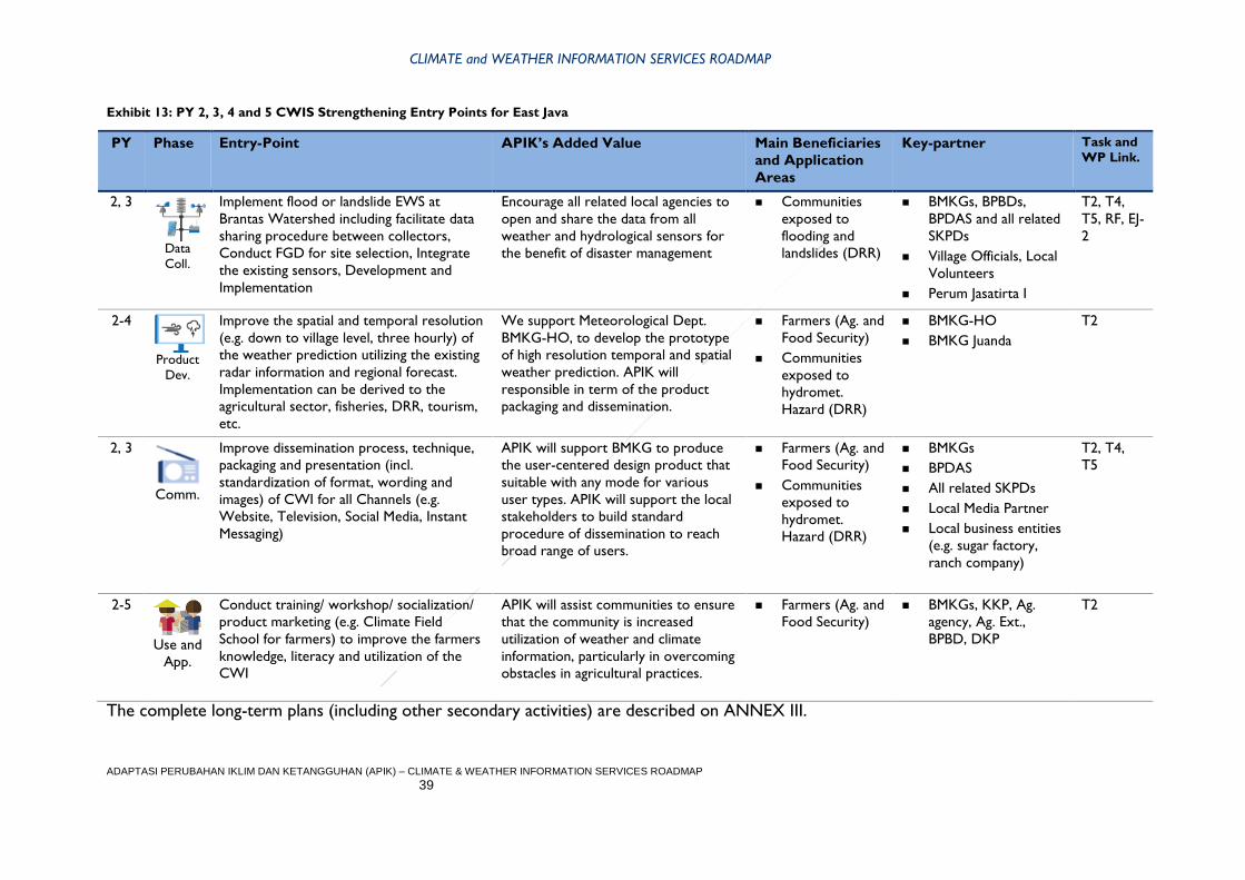
CLIMATE and WEATHER INFORMATION SERVICES ROADMAP
ADAPTASI PERUBAHAN IKLIM DAN KETANGGUHAN (APIK) – CLIMATE & WEATHER INFORMATION SERVICES ROADMAP
39
Exhibit 13: PY 2, 3, 4 and 5 CWIS Strengthening Entry Points for East Java
PY Phase Entry-Point APIK’s Added Value Main Beneficiaries
and Application
Areas
Key-partner Task and
WP Link.
2, 3
Data
Coll.
Implement flood or landslide EWS at
Brantas Watershed including facilitate data
sharing procedure between collectors,
Conduct FGD for site selection, Integrate
the existing sensors, Development and
Implementation
Encourage all related local agencies to
open and share the data from all
weather and hydrological sensors for
the benefit of disaster management
Communities
exposed to
flooding and
landslides (DRR)
BMKGs, BPBDs,
BPDAS and all related
SKPDs
Village Officials, Local
Volunteers
Perum Jasatirta I
T2, T4,
T5, RF, EJ-
2
2-4
Product
Dev.
Improve the spatial and temporal resolution
(e.g. down to village level, three hourly) of
the weather prediction utilizing the existing
radar information and regional forecast.
Implementation can be derived to the
agricultural sector, fisheries, DRR, tourism,
etc.
We support Meteorological Dept.
BMKG-HO, to develop the prototype
of high resolution temporal and spatial
weather prediction. APIK will
responsible in term of the product
packaging and dissemination.
Farmers (Ag. and
Food Security)
Communities
exposed to
hydromet.
Hazard (DRR)
BMKG-HO
BMKG Juanda
T2
2, 3
Comm.
Improve dissemination process, technique,
packaging and presentation (incl.
standardization of format, wording and
images) of CWI for all Channels (e.g.
Website, Television, Social Media, Instant
Messaging)
APIK will support BMKG to produce
the user-centered design product that
suitable with any mode for various
user types. APIK will support the local
stakeholders to build standard
procedure of dissemination to reach
broad range of users.
Farmers (Ag. and
Food Security)
Communities
exposed to
hydromet.
Hazard (DRR)
BMKGs
BPDAS
All related SKPDs
Local Media Partner
Local business entities
(e.g. sugar factory,
ranch company)
T2, T4,
T5
2-5
Use and
App.
Conduct training/ workshop/ socialization/
product marketing (e.g. Climate Field
School for farmers) to improve the farmers
knowledge, literacy and utilization of the
CWI
APIK will assist communities to ensure
that the community is increased
utilization of weather and climate
information, particularly in overcoming
obstacles in agricultural practices.
Farmers (Ag. and
Food Security)
BMKGs, KKP, Ag.
agency, Ag. Ext.,
BPBD, DKP
T2
The complete long-term plans (including other secondary activities) are described on ANNEX III.
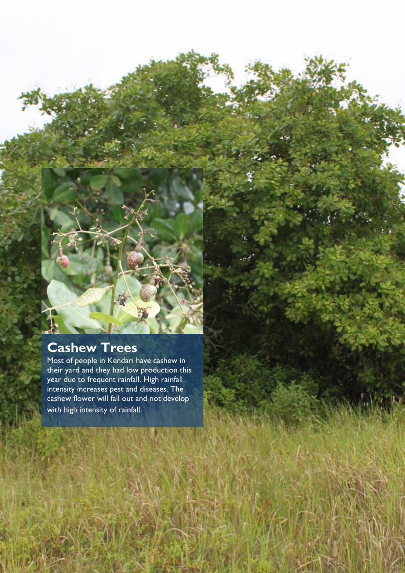
CLIMATE and WEATHER INFORMATION SERVICES ROADMAP
ADAPTASI PERUBAHAN IKLIM DAN KETANGGUHAN (APIK) – CLIMATE & WEATHER INFORMATION SERVICES ROADMAP
40
Cashew Trees Most of people in Kendari have cashew in
their yard and they had low production this
year due to frequent rainfall. High rainfall
intensity increases pest and diseases. The
cashew flower will fall out and not develop
with high intensity of rainfall.
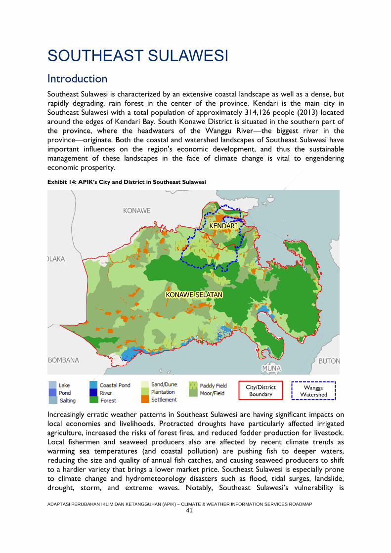
ADAPTASI PERUBAHAN IKLIM DAN KETANGGUHAN (APIK) – CLIMATE & WEATHER INFORMATION SERVICES ROADMAP
41
SOUTHEAST SULAWESI
Introduction
Southeast Sulawesi is characterized by an extensive coastal landscape as well as a dense, but
rapidly degrading, rain forest in the center of the province. Kendari is the main city in
Southeast Sulawesi with a total population of approximately 314,126 people (2013) located
around the edges of Kendari Bay. South Konawe District is situated in the southern part of
the province, where the headwaters of the Wanggu River—the biggest river in the
province—originate. Both the coastal and watershed landscapes of Southeast Sulawesi have
important influences on the region’s economic development, and thus the sustainable
management of these landscapes in the face of climate change is vital to engendering
economic prosperity.
Exhibit 14: APIK’s City and District in Southeast Sulawesi
Increasingly erratic weather patterns in Southeast Sulawesi are having significant impacts on
local economies and livelihoods. Protracted droughts have particularly affected irrigated
agriculture, increased the risks of forest fires, and reduced fodder production for livestock.
Local fishermen and seaweed producers also are affected by recent climate trends as
warming sea temperatures (and coastal pollution) are pushing fish to deeper waters,
reducing the size and quality of annual fish catches, and causing seaweed producers to shift
to a hardier variety that brings a lower market price. Southeast Sulawesi is especially prone
to climate change and hydrometeorology disasters such as flood, tidal surges, landslide,
drought, storm, and extreme waves. Notably, Southeast Sulawesi’s vulnerability is
City/District
Boundary Wanggu
Watershed
ADAPTASI PERUBAHAN IKLIM DAN KETANGGUHAN (APIK) – CLIMATE & WEATHER INFORMATION SERVICES ROADMAP
42
heightened by a lack of an appropriate and integrated disaster management system – such as
local disaster management regulations, local action plan for disaster risk reduction,
contingency plans, early warning systems, etc. Exhibit 15 offers a brief overview of climate
risks that affect Southeast Sulawesi.
Exhibit 15: Climate and disaster risks facing the landscape on APIK's district/city in Southeast Sulawesi
City/District Climate and disaster risks facing the landscape
Kendari City Key hazards include flood, landslide, and coastal abrasion / erosion
Hydro-meteorological disasters faced include floods from the Wanggu river, as well as
landslide and coastal erosion
Environmental issues include increased sedimentation in the Kendari bay
Land use change in Wanggu Watershed is exacerbating the severity of flood events
Unpredictable and erratic weather conditions outside of historical trends are
negatively impacting the ability of fisher folk to make a sustained income
Shifting seasonal patterns and increased frequency of extreme weather events are
negatively impacting farmer crop yields and quality
Konawe
Selatan District
Key hazards include flooding, typhoons, storms, landslides, and coastal abrasion /
erosion.
Flash floods and landslides are increasing in frequency; in 2013 seven sub-districts
were flooded after one intense storm event; villages such as Lamokula and
Laikandonga are beginning to suffer from flash flooding during the rainy season
Warming sea water, changing currents and seasonal patterns are negatively impacting
seaweed production; the ice-ice bacteria is becoming more prevalent and killing big
seaweed beds
Warming sea water is said to also be reducing fish stocks for fisher folk
Longer rainy seasons are increasing pests/diseases (rat, neck blast), which are
decreasing rice yields for paddy farmers
Cacao and banana crops are facing increased pest/diseases from increased rainfall;
cashew flowers fall out prematurely due to increased rainfall, which prevents nuts
from developing.
Application Area Selection Rationale
In SE Sulawesi, APIK will work in both watershed and coastal landscapes by focusing our
CWIS strengthening activities around agriculture and food security (including fisheries,
farming and aquaculture) and disaster risk reduction (specifically for floods, high waves,
and landslides). APIK will support improved climate services for a variety of users and
beneficiaries in Konawe Selatan, including fisher folk, seaweed producers, inland farmers,
and plantation and forestry businesses. In Kendari City, the Project will focus on early
warning systems for 37 villages identified during the assessment as highly vulnerable to
flooding and landslides.
As confirmed in the CWIS Assessment Report and USAID’s IMACS report, the utilization of
weather and climate information services is still very low for both Kendari City and Konawe
Selatan. Given that most people rely principally on personal observations, past experience,
and natural signs to understand weather and climate conditions, APIK will emphasize the
socialization of the use and application CWIS products.
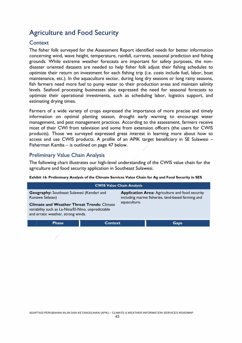
ADAPTASI PERUBAHAN IKLIM DAN KETANGGUHAN (APIK) – CLIMATE & WEATHER INFORMATION SERVICES ROADMAP
43
Agriculture and Food Security
Context
The fisher folk surveyed for the Assessment Report identified needs for better information
concerning wind, wave height, temperature, rainfall, currents, seasonal prediction and fishing
grounds. While extreme weather forecasts are important for safety purposes, the non-
disaster oriented datasets are needed to help fisher folk adjust their fishing schedules to
optimize their return on investment for each fishing trip (i.e. costs include fuel, labor, boat
maintenance, etc.). In the aquaculture sector, during long dry seasons or long rainy seasons,
fish farmers need more fuel to pump water to their production areas and maintain salinity
levels. Seafood processing businesses also expressed the need for seasonal forecasts to
optimize their operational investments, such as scheduling labor, logistics support, and
estimating drying times.
Farmers of a wide variety of crops expressed the importance of more precise and timely
information on optimal planting season, drought early warning to encourage water
management, and pest management practices. According to the assessment, farmers receive
most of their CWI from television and some from extension officers (the users for CWIS
products). Those we surveyed expressed great interest in learning more about how to
access and use CWIS products. A profile of an APIK target beneficiary in SE Sulawesi –
Fisherman Kamba – is outlined on page 47 below.
Preliminary Value Chain Analysis
The following chart illustrates our high-level understanding of the CWIS value chain for the
agriculture and food security application in Southeast Sulawesi.
Exhibit 16: Preliminary Analysis of the Climate Services Value Chain for Ag and Food Security in SES
CWIS Value Chain Analysis
Geography: Southeast Sulawesi (Kendari and
Konawe Selatan)
Climate and Weather Threat Trends: Climate
variability such as La-Nina/El-Nino, unpredictable
and erratic weather, strong winds.
Application Area: Agriculture and food security
including marine fisheries, land-based farming and
aquaculture.
Phase Context Gaps
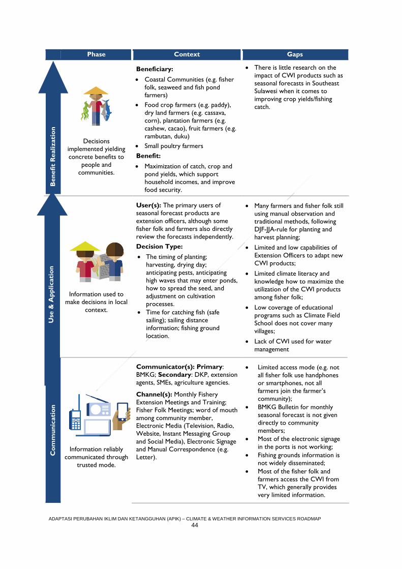
ADAPTASI PERUBAHAN IKLIM DAN KETANGGUHAN (APIK) – CLIMATE & WEATHER INFORMATION SERVICES ROADMAP
44
Phase Context Gaps B
en
efi
t R
ealizati
on
Decisions
implemented yielding
concrete benefits to
people and
communities.
Beneficiary:
Coastal Communities (e.g. fisher
folk, seaweed and fish pond
farmers)
Food crop farmers (e.g. paddy),
dry land farmers (e.g. cassava,
corn), plantation farmers (e.g.
cashew, cacao), fruit farmers (e.g.
rambutan, duku)
Small poultry farmers
Benefit:
Maximization of catch, crop and
pond yields, which support
household incomes, and improve
food security.
There is little research on the
impact of CWI products such as
seasonal forecasts in Southeast
Sulawesi when it comes to
improving crop yields/fishing
catch.
Use
an
d A
pp
licati
on
Information used to
make decisions in local
context.
User(s): The primary users of
seasonal forecast products are
extension officers, although some
fisher folk and farmers also directly
review the forecasts independently.
Decision Type:
The timing of planting;
harvesting, drying day;
anticipating pests, anticipating
high waves that may enter ponds,
how to spread the seed, and
adjustment on cultivation
processes.
Time for catching fish (safe
sailing); sailing distance
information; fishing ground
location.
Many farmers and fisher folk still
using manual observation and
traditional methods, following
DJF-JJA-rule for planting and
harvest planning;
Limited and low capabilities of
Extension Officers to adapt new
CWI products;
Limited climate literacy and
knowledge how to maximize the
utilization of the CWI products
among fisher folk;
Low coverage of educational
programs such as Climate Field
School does not cover many
villages;
Lack of CWI used for water
management
Co
mm
un
icati
on
Information reliably
communicated through
trusted mode.
Communicator(s): Primary:
BMKG; Secondary: DKP, extension
agents, SMEs, agriculture agencies.
Channel(s): Monthly Fishery
Extension Meetings and Training;
Fisher Folk Meetings; word of mouth
among community member,
Electronic Media (Television, Radio,
Website, Instant Messaging Group
and Social Media), Electronic Signage
and Manual Correspondence (e.g.
Letter).
Limited access mode (e.g. not
all fisher folk use handphones
or smartphones, not all
farmers join the farmer’s
community);
BMKG Bulletin for monthly
seasonal forecast is not given
directly to community
members;
Most of the electronic signage
in the ports is not working;
Fishing grounds information is
not widely disseminated;
Most of the fisher folk and
farmers access the CWI from
TV, which generally provides
very limited information.
Use
& A
pp
licati
on
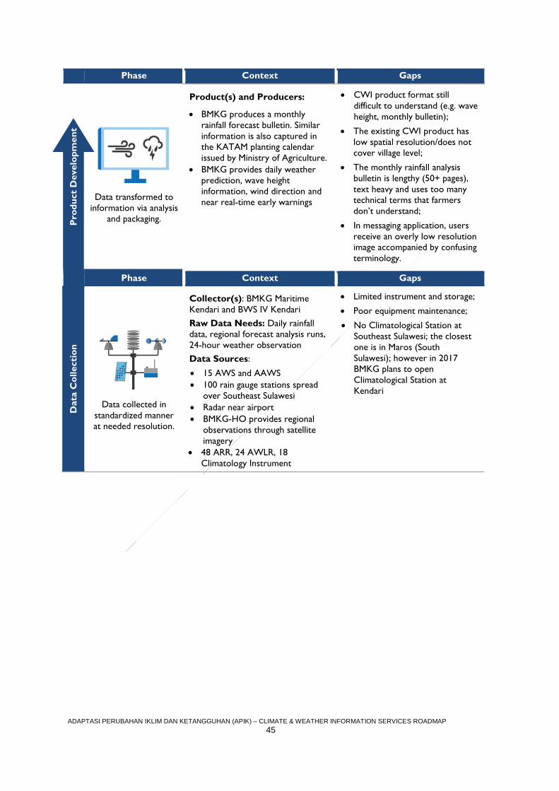
ADAPTASI PERUBAHAN IKLIM DAN KETANGGUHAN (APIK) – CLIMATE & WEATHER INFORMATION SERVICES ROADMAP
45
Phase Context Gaps P
rod
uct
Develo
pm
en
t
Data transformed to
information via analysis
and packaging.
Product(s) and Producers:
BMKG produces a monthly
rainfall forecast bulletin. Similar
information is also captured in
the KATAM planting calendar
issued by Ministry of Agriculture.
BMKG provides daily weather
prediction, wave height
information, wind direction and
near real-time early warnings
CWI product format still
difficult to understand (e.g. wave
height, monthly bulletin);
The existing CWI product has
low spatial resolution/does not
cover village level;
The monthly rainfall analysis
bulletin is lengthy (50+ pages),
text heavy and uses too many
technical terms that farmers
don’t understand;
In messaging application, users
receive an overly low resolution
image accompanied by confusing
terminology.
Phase Context Gaps
Data
Co
llecti
on
Data collected in
standardized manner
at needed resolution.
Collector(s): BMKG Maritime
Kendari and BWS IV Kendari
Raw Data Needs: Daily rainfall
data, regional forecast analysis runs,
24-hour weather observation
Data Sources:
15 AWS and AAWS
100 rain gauge stations spread
over Southeast Sulawesi
Radar near airport
BMKG-HO provides regional
observations through satellite
imagery 48 ARR, 24 AWLR, 18
Climatology Instrument
Limited instrument and storage;
Poor equipment maintenance;
No Climatological Station at
Southeast Sulawesi; the closest
one is in Maros (South
Sulawesi); however in 2017
BMKG plans to open
Climatological Station at
Kendari
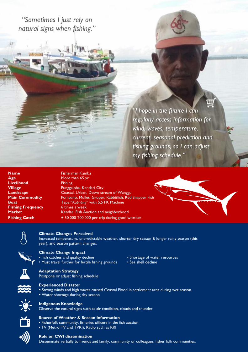
ADAPTASI PERUBAHAN IKLIM DAN KETANGGUHAN (APIK) – CLIMATE & WEATHER INFORMATION SERVICES ROADMAP
46
“Sometimes I just rely on
natural signs when fishing.”
“I hope in the future I can
regularly access information for
wind, waves, temperature,
current, seasonal prediction and
fishing grounds, so I can adjust
my fishing schedule.”
Name Fisherman Kamba
Age More than 65 yr.
Livelihood Fishing
Village Punggaloba, Kendari City
Landscape Coastal, Urban, Down-stream of Wanggu
Main Commodity Pompano, Mullet, Groper, Rabbitfish, Red Snapper Fish
Boat Type “Katinting” with 5,5 PK Machine
Fishing Frequency 6 times a week
Market Kendari Fish Auction and neighborhood
Fishing Catch ± 50.000-200.000 per trip during good weather
Climate Changes Perceived
Increased temperature, unpredictable weather, shorter dry season & longer rainy season (this
year), and season pattern changes.
Climate Change Impact
• Fish catches and quality decline • Shortage of water resources
• Must travel further for fertile fishing grounds • Sea shell decline
Adaptation Strategy
Postpone or adjust fishing schedule
Experienced Disaster
Strong winds and high waves caused Coastal Flood in settlement area during wet season.
Water shortage during dry season
Indigenous Knowledge
Observe the natural signs such as air condition, clouds and thunder
Source of Weather & Season Information
• Fisherfolk community, fisheries officers in the fish auction
• TV (Metro TV and TVRI), Radio such as RRI
Role on CWI dissemination
Disseminate verbally to friends and family, community or colleagues, fisher folk communities.
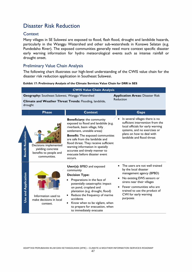
ADAPTASI PERUBAHAN IKLIM DAN KETANGGUHAN (APIK) – CLIMATE & WEATHER INFORMATION SERVICES ROADMAP
47
Disaster Risk Reduction
Context
Many villages in SE Sulawesi are exposed to flood, flash flood, drought and landslide hazards,
particularly in the Wanggu Watershed and other sub-watersheds in Konawe Selatan (e.g.
Pundedaho River). The exposed communities generally need more context specific disaster
early warning information for hydro meteorological events such as intense rainfall or
drought onset.
Preliminary Value Chain Analysis
The following chart illustrates our high-level understanding of the CWIS value chain for the
disaster risk reduction application in Southeast Sulawesi.
Exhibit 17: Preliminary Analysis of the Climate Services Value Chain for DRR in SES
CWIS Value Chain Analysis
Geography: Southeast Sulawesi, Wanggu Watershed
Climate and Weather Threat Trends: Flooding, landslide,
drought
Application Areas: Disaster Risk
Reduction
Phase Context Gaps
B
en
efi
t R
ealizati
on
Decisions implemented
yielding concrete
benefits to people and
communities.
Beneficiary: the community
exposed to flood and landslide (e.g.
riverbank, basin village, hilly
settlement, unstable areas)
Benefit: The exposed communities
are safe from the landslide and
flood threat. They receive sufficient
warning information in spatially
accurate and timely manner to
evacuate before disaster event
occurs.
In several villages there is no
sufficient intervention from the
local officials for early warning
systems, and no exercises or
plans on how to deal with
landslide and flood threat
Use
an
d A
pp
licati
on
Information used to
make decisions in local
context.
User(s): BPBD and exposed
community
Decision Type:
Preparations in the face of
potentially catastrophic impact
on pond, cropland and
plantation (e.g. drought, flood)
Reduce the frequency of marine
accidents
Know when to be vigilant, when
to prepare for evacuation, when
to immediately evacuate
The users are not well trained
by the local disaster
management agency (BPBD)
No existing EWS sensors or
sirens near their villages
Fewer communities who are
trained to use the product of
CWI for early warning
purposes
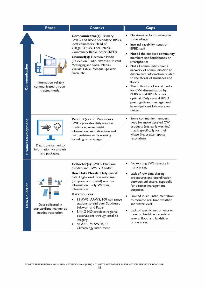
ADAPTASI PERUBAHAN IKLIM DAN KETANGGUHAN (APIK) – CLIMATE & WEATHER INFORMATION SERVICES ROADMAP
48
Phase Context Gaps C
om
mu
nic
ati
on
Information reliably
communicated through
trusted mode.
Communicator(s): Primary:
BMKG and BWS; Secondary: BPBD,
local volunteers, Head of
Village/RT/RW, Local Media,
Community Radio, other SKPDs.
Channel(s): Electronic Media
(Television, Radio, Website, Instant
Messaging and Social Media),
Walkie Talkie, Mosque Speaker,
Siren, etc.
No sirens or loudspeakers in
some villages.
Internal capability issues on
BPBD staff
Not all the exposed community
members use handphones or
smartphones
Not all communities have a
network of communication to
disseminate information related
to the threat of landslides and
floods
The utilization of social media
for CWI dissemination by
BMKGs and BPBDs is not
optimal. Only several BPBD
post significant messages and
have significant followers on
twitter.
Pro
du
ct
Develo
pm
en
t
Data transformed to
information via analysis
and packaging.
Product(s) and Producers:
BMKG provides daily weather
prediction, wave height
information, wind direction and
near real-time early warning
including radar images.
Some community members
need for more detailed CWI
products (e.g. early warning)
that is specifically for their
village (i.e. greater spatial
resolution).
Data
Co
llecti
on
Data collected in
standardized manner at
needed resolution.
Collector(s): BMKG Maritime
Kendari and BWS IV Kendari
Raw Data Needs: Daily rainfall
data, High-resolution real-time
(temporal and spatial) weather
information, Early Warning
Information
Data Sources:
15 AWS, AAWS, 100 rain gauge
stations spread over Southeast
Sulawesi, and Radar BMKG-HO provides regional
observations through satellite
imagery
48 ARR, 24 AWLR, 18
Climatology Instrument
No existing EWS sensors in
many areas;
Lack of raw data sharing
procedures and coordination
between collectors, especially
for disaster management
purposes;
Limited in-situ instrumentation
to monitor real time weather
and water level;
Lack of specific instruments to
monitor landslide hazards at
several flood and landslide-
prone areas.
Co
mm
un
icati
on
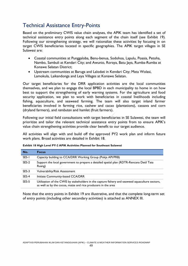
ADAPTASI PERUBAHAN IKLIM DAN KETANGGUHAN (APIK) – CLIMATE & WEATHER INFORMATION SERVICES ROADMAP
49
Technical Assistance Entry-Points
Based on the preliminary CWIS value chain analyses, the APIK team has identified a set of
technical assistance entry points along each segment of the chain itself (see Exhibit 19).
Following our strengthening strategy, we will rationalize these activities by focusing in on
target CWIS beneficiaries located in specific geographies. The APIK target villages in SE
Sulawesi are:
Coastal communities at Punggaloba, Benu-benua, Sodohoa, Lapulu, Poasia, Petoha,
Nambo, Sambuli at Kendari City; and Awunio, Roraya, Batu Jaya, Rumba-Rumba at
Konawe Selatan District;
Upstream communities at Baruga and Lalodati in Kendari City; Mata Wolasi,
Lamokula, Laikandonga and Leya Villages at Konawe Selatan.
Our target beneficiaries for the DRR application activities are the local communities themselves, and we plan to engage the local BPBD in each municipality to home in on how
best to support the strengthening of early warning systems. For the agriculture and food
security application, we plan to work with beneficiaries in coastal livelihoods including
fishing, aquaculture, and seaweed farming. The team will also target inland farmer
beneficiaries involved in farming rice, cashew and cacao (plantations), cassava and corn
(dryland farmers), and rambutan and hamlet (fruit farmers).
Following our initial field consultations with target beneficiaries in SE Sulawesi, the team will
prioritize and tailor the relevant technical assistance entry points from to ensure APIK’s
value chain strengthening activities provide clear benefit to our target audience.
All activities will align with and build off the approved PY2 work plan and inform future
work plans. Broad activities are detailed in Exhibit 18.
Exhibit 18 High Level PY-2 APIK Activities Planned for Southeast Sulawesi
No. Focus
SES-1 Capacity building to CCA/DRR Working Group (Pokja API/PRB)
SES-2 Support the local government to prepare a detailed spatial plan (RDTR-Rencana Detil Tata
Ruang)
SES-3 Vulnerability/Risk Assessment
SES-4 Initiate Community-based CCA/DRR
SES-5 Utilization of the CWIS by stakeholders in the capture fishery and seaweed aquaculture sectors,
as well as by the cocoa, maize and rice producers in the area
Note that the entry points in Exhibit 19 are illustrative, and that the complete long-term set
of entry points (including other secondary activities) is attached as ANNEX III.
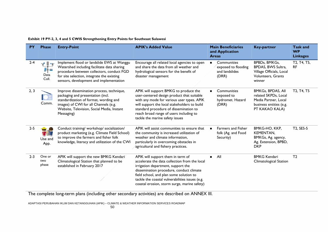
ADAPTASI PERUBAHAN IKLIM DAN KETANGGUHAN (APIK) – CLIMATE & WEATHER INFORMATION SERVICES ROADMAP
50
Exhibit 19 PY-2, 3, 4 and 5 CWIS Strengthening Entry Points for Southeast Sulawesi
PY Phase Entry-Point APIK’s Added Value Main Beneficiaries
and Application
Areas
Key-partner Task and
WP
Linkages
2-4
Data
Coll.
Implement flood or landslide EWS at Wanggu
Watershed including facilitate data sharing
procedure between collectors, conduct FGD
for site selection, integrate the existing
sensors, development and implementation
Encourage all related local agencies to open
and share the data from all weather and
hydrological sensors for the benefit of
disaster management
Communities
exposed to flooding
and landslides
(DRR)
BPBDs, BMKGs,
BPDAS, BWS Sultra,
Village Officials, Local
Volunteers, Grants
winner
T2, T4, T5,
RF
2, 3
Comm.
Improve dissemination process, technique,
packaging and presentation (incl.
standardization of format, wording and
images) of CWI for all Channels (e.g.
Website, Television, Social Media, Instant
Messaging)
APIK will support BMKG to produce the
user-centered design product that suitable
with any mode for various user types. APIK
will support the local stakeholders to build
standard procedure of dissemination to
reach broad range of users including to
tackle the marine safety issues
Communities
exposed to
hydromet. Hazard
(DRR)
BMKGs, BPDAS, All
related SKPDs, Local
Media Partner, Local
business entities (e.g.
PT KAKAO KALA)
T2, T4, T5
2-5
Use and
App.
Conduct training/ workshop/ socialization/
product marketing (e.g. Climate Field School)
to improve the farmers and fisher folk
knowledge, literacy and utilization of the CWI
APIK will assist communities to ensure that
the community is increased utilization of
weather and climate information,
particularly in overcoming obstacles in
agricultural and fishery practices.
Farmers and Fisher
folk (Ag. and Food
Security)
BMKG-HO, KKP,
KEMENTAN,
BMKGs, Ag. agency,
Ag. Extension, BPBD,
DKP
T2, SES-5
2-3 One or
two
phase
APIK will support the new BMKG Kendari
Climatological Station that planned to be
established in February 2017
APIK will support them in term of
accelerate the data collection from the local
irrigation department, support the
dissemination procedure, conduct climate
field school, and plan some solution to
tackle the coastal vulnerabilities issues (e.g.
coastal erosion, storm surge, marine safety)
All BMKG Kendari
Climatological Station
T2
The complete long-term plans (including other secondary activities) are described on ANNEX III.
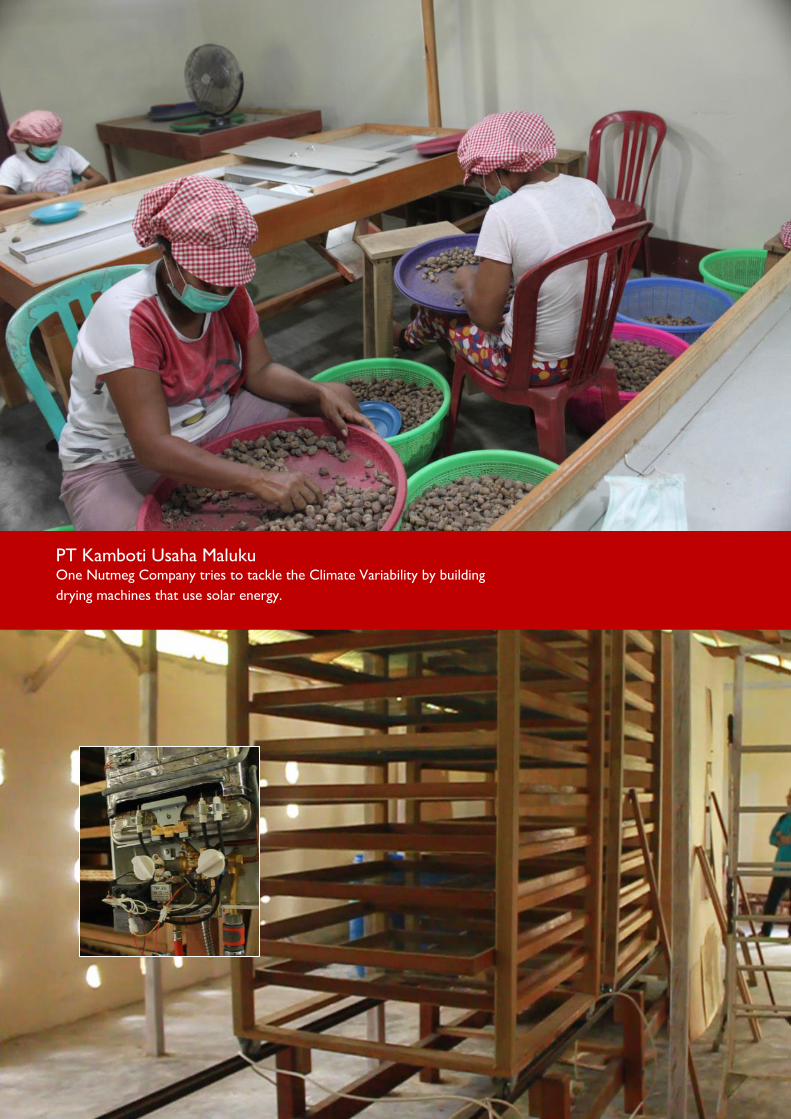
ADAPTASI PERUBAHAN IKLIM DAN KETANGGUHAN (APIK) – CLIMATE & WEATHER INFORMATION SERVICES ROADMAP
51
PT Kamboti Usaha Maluku One Nutmeg Company tries to tackle the Climate Variability by building
drying machines that use solar energy.
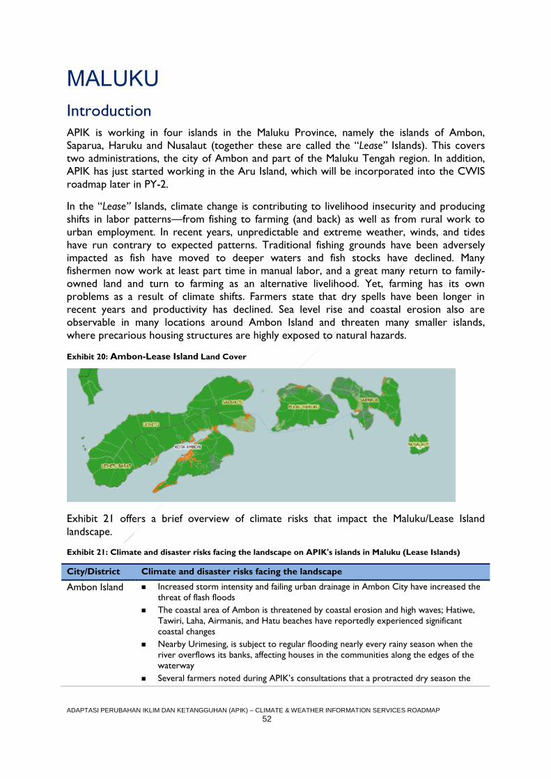
ADAPTASI PERUBAHAN IKLIM DAN KETANGGUHAN (APIK) – CLIMATE & WEATHER INFORMATION SERVICES ROADMAP
52
MALUKU
Introduction
APIK is working in four islands in the Maluku Province, namely the islands of Ambon,
Saparua, Haruku and Nusalaut (together these are called the “Lease” Islands). This covers
two administrations, the city of Ambon and part of the Maluku Tengah region. In addition,
APIK has just started working in the Aru Island, which will be incorporated into the CWIS
roadmap later in PY-2.
In the “Lease” Islands, climate change is contributing to livelihood insecurity and producing
shifts in labor patterns—from fishing to farming (and back) as well as from rural work to
urban employment. In recent years, unpredictable and extreme weather, winds, and tides
have run contrary to expected patterns. Traditional fishing grounds have been adversely
impacted as fish have moved to deeper waters and fish stocks have declined. Many
fishermen now work at least part time in manual labor, and a great many return to family-
owned land and turn to farming as an alternative livelihood. Yet, farming has its own
problems as a result of climate shifts. Farmers state that dry spells have been longer in
recent years and productivity has declined. Sea level rise and coastal erosion also are
observable in many locations around Ambon Island and threaten many smaller islands,
where precarious housing structures are highly exposed to natural hazards.
Exhibit 20: Ambon-Lease Island Land Cover
Exhibit 21 offers a brief overview of climate risks that impact the Maluku/Lease Island
landscape.
Exhibit 21: Climate and disaster risks facing the landscape on APIK's islands in Maluku (Lease Islands)
City/District Climate and disaster risks facing the landscape
Ambon Island Increased storm intensity and failing urban drainage in Ambon City have increased the
threat of flash floods
The coastal area of Ambon is threatened by coastal erosion and high waves; Hatiwe,
Tawiri, Laha, Airmanis, and Hatu beaches have reportedly experienced significant
coastal changes
Nearby Urimesing, is subject to regular flooding nearly every rainy season when the
river overflows its banks, affecting houses in the communities along the edges of the
waterway
Several farmers noted during APIK’s consultations that a protracted dry season the
ADAPTASI PERUBAHAN IKLIM DAN KETANGGUHAN (APIK) – CLIMATE & WEATHER INFORMATION SERVICES ROADMAP
53
City/District Climate and disaster risks facing the landscape
previous year decreased the quantity of nutmeg and cloves harvested, while a wetter
rainy season reduced the quality of the crops and caused prices to fall
Negeri Soya and Hatalae are principally exposed to flooding and landslides associated
with high intensity rainfall
In late May 2016, during the peak of the rainy season, landslides also struck
communities in Negeri Soya leading to three casualties
Landslides have occurred each of the past three years in Negeri Hatalae due to high
rainfall intensity and reduced recharge area, with 10 homes impacted by the landslide
events
Some village such as Negeri Leahari are highly vulnerable to hydro meteorological
disasters such as flooding, coastal inundation, extreme weather events (e.g. whirlwind,
storm, and high wave) and drought
2015 El Nino exacerbated forest fires and water shortages in some area
Disasters have also impacted public health and the incidence of water borne diseases,
most recently in the form of a dengue outbreak in 2016
Severe drought in 2015 which, among other impacts, killed many clove trees
Haruku Island Coastal erosion issues for the last five years; lack of coastal protection makes the
island vulnerable to sea waves and storm surges
Erratic weather patterns and climate change affecting fish catches, changing the
location of fishing grounds, and undermining crops
In 2016, dozens of homes located at coastal area in Rohomoni Village have become
threatened by coastal erosion
The predominant hydro-meteorological disasters in and around Haruku Island are
flooding, landslide, drought, and extreme weather
An abnormally protracted dry season in 2015 has since led to the death of thousands
of clove and nutmeg trees
High waves are posing an increasing threat to some villages
Coastal erosion could lead to social issues around the boundary marker between two
Villages (Negeri)
Saparua Island The predominant hydro-meteorological risks facing the communities of Saparua Island
are coastal flooding, drought, extreme weather and “puting beliung” winds
Uncertainty in the weather, increased rainfall, and longer rainy seasons impact the
livelihoods by decreasing the number of days for fishing, shifting the location of fishing
grounds, and decreasing the quantity and quality of crop yields
Loss of clove trees due to droughts and a longer dry season during El Nino
Some fisher folk are unable to fish in more distant waters due to the dangers posed by
erratic weather patterns
Water insecurity is increasing in some areas, such as Negeri Portom, where the
severity of the dry season forced the community to purchase water
In some area like Negeri Sirisori, the drought also exacerbated forest fires
Nusalaut Island According to isohyet map from Dirjen Cipta Karya, 1996 –high rainfall pattern has
been dominating climate condition of Nusalaut Island
This island is highly vulnerable to storms and massive floods, particularly during rainy
season
The coastal and marine areas of Nusalaut are yet to be recorded in any “Area Status”
(Status Kawasan) which means that no proper treatment/efforts to minimize
degradation of coastal ecosystem are currently in place
The predominant hydro-meteorological disasters in Nusalaut Island are coastal
flooding, extreme weather, and landslides
Fishing yields appear to have decreased while local fisher folk must also travel farther
out to sea to find fertile fishing grounds
ADAPTASI PERUBAHAN IKLIM DAN KETANGGUHAN (APIK) – CLIMATE & WEATHER INFORMATION SERVICES ROADMAP
54
City/District Climate and disaster risks facing the landscape
Wetter rainy seasons have yielded increased pests for farmers to deal with; for
example, caterpillars are infesting clove trees causing the leaves to yellow and
prematurely dry out
Negeri Titawai, massive landslides occurred in 2013 following heavy rains.
Furthermore, coastal flooding in Negeri Ameth during high tides that same year
impacted many homes that were not protected by a sea wall
Application Area Selection Rationale
Hydro-meteorological disasters in the city of Ambon and Lease Islands are increasing from
year to year. In 2013, Ambon City experienced flash floods, flooding, landslides, and coastal
erosion that caused significant losses. Marine incidents due to bad weather are on the rise
due to lack of awareness and poor safety practices among the fishing community. The 2015-
2016 La-Nina has also affected inter-island transportation routes between Ambon and
Banda, which impact local economic activity. The local government in Ambon City and
Maluku Tengah have expressed interest in improving their use of CWIS tools, thus APIK will
focus assistance on the application area of disaster risk reduction in the region.
On the agriculture and food security side, the most prominent livelihood in the Lease
Islands is marine fishing. For coastal communities, weather uncertainty shortens the time
fisher folk spend at sea, limits their sailing distance, and does not allow them to maximize
their investment in fishing trips. When facing a poor fishing season, these fisher folk turn to
alternative livelihoods such as farming clove, nutmeg, durian, salak, langsat, and mangosteen,
as well as planting seasonal vegetables. Recent climate impacts have caused a drop in crop
productivity, water shortages, and sectoral impacts such as the inability to sufficiently sun-
dry cloves, resulting in lower market prices for the crop.
Agriculture and Food Security
Context
Many fisher folk in the Maluku/Lease Island landscape still rely heavily on traditional
seasonal patterns and their traditional knowledge (e.g. Nanaku). Fisher folk engaged by APIK
during the assessment suggested that they need information such as weather and wave
height forecasts, extreme weather warnings, and optimal fishing grounds data. They
currently receive CWIS from BMKG via television and SMS. A profile of an APIK target
beneficiary in the Maluku/Lease Island landscape – Fisherman La Mochtar – is provided on
page 56 below.
Many local farmers do not regularly use CWI and do not realize the important role of
CWI in the context of agribusiness. Interviews during the assessment indicated that a large
opportunity exists to help build farmer capacity to understand how to apply CWIS
information for decision making, specifically around optimal planting windows and how to
respond to an impending drought event.
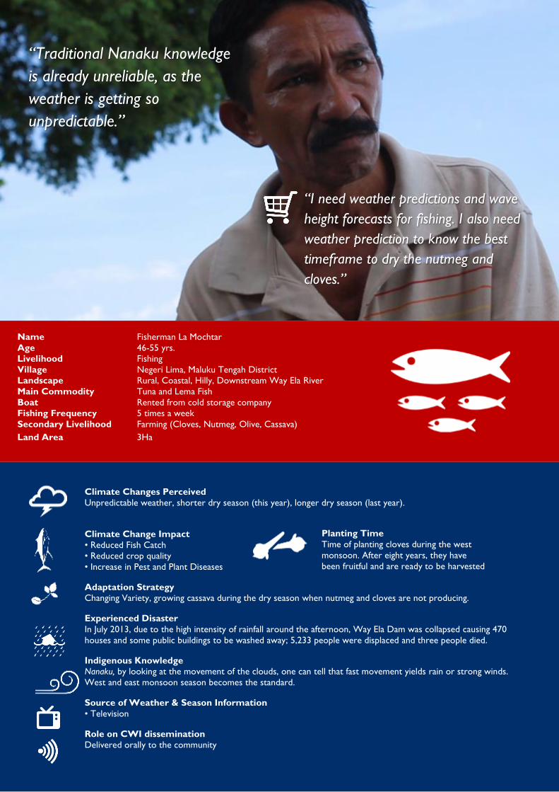
ADAPTASI PERUBAHAN IKLIM DAN KETANGGUHAN (APIK) – CLIMATE & WEATHER INFORMATION SERVICES ROADMAP
55
“Traditional Nanaku knowledge
is already unreliable, as the
weather is getting so
unpredictable.”
Name Fisherman La Mochtar
Age 46-55 yrs.
Livelihood Fishing
Village Negeri Lima, Maluku Tengah District
Landscape Rural, Coastal, Hilly, Downstream Way Ela River
Main Commodity Tuna and Lema Fish
Boat Rented from cold storage company
Fishing Frequency 5 times a week
Secondary Livelihood Farming (Cloves, Nutmeg, Olive, Cassava)
Land Area 3Ha
“I need weather predictions and wave
height forecasts for fishing. I also need
weather prediction to know the best
timeframe to dry the nutmeg and
cloves.”
Climate Changes Perceived
Unpredictable weather, shorter dry season (this year), longer dry season (last year).
Climate Change Impact
• Reduced Fish Catch
• Reduced crop quality
• Increase in Pest and Plant Diseases
Adaptation Strategy
Changing Variety, growing cassava during the dry season when nutmeg and cloves are not producing.
Experienced Disaster
In July 2013, due to the high intensity of rainfall around the afternoon, Way Ela Dam was collapsed causing 470
houses and some public buildings to be washed away; 5,233 people were displaced and three people died.
Indigenous Knowledge
Nanaku, by looking at the movement of the clouds, one can tell that fast movement yields rain or strong winds.
West and east monsoon season becomes the standard.
Source of Weather & Season Information
• Television
Role on CWI dissemination
Delivered orally to the community
Planting Time
Time of planting cloves during the west
monsoon. After eight years, they have
been fruitful and are ready to be harvested
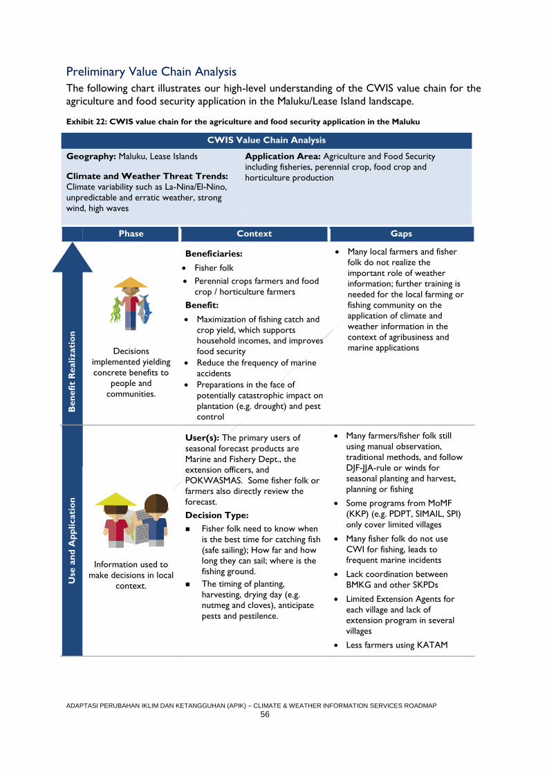
ADAPTASI PERUBAHAN IKLIM DAN KETANGGUHAN (APIK) – CLIMATE & WEATHER INFORMATION SERVICES ROADMAP
56
Preliminary Value Chain Analysis
The following chart illustrates our high-level understanding of the CWIS value chain for the
agriculture and food security application in the Maluku/Lease Island landscape.
Exhibit 22: CWIS value chain for the agriculture and food security application in the Maluku
CWIS Value Chain Analysis
Geography: Maluku, Lease Islands
Climate and Weather Threat Trends:
Climate variability such as La-Nina/El-Nino,
unpredictable and erratic weather, strong
wind, high waves
Application Area: Agriculture and Food Security
including fisheries, perennial crop, food crop and
horticulture production
Phase Context Gaps
B
en
efi
t R
ealizati
on
Decisions
implemented yielding
concrete benefits to
people and
communities.
Beneficiaries:
Fisher folk
Perennial crops farmers and food
crop / horticulture farmers
Benefit:
Maximization of fishing catch and
crop yield, which supports
household incomes, and improves
food security
Reduce the frequency of marine
accidents
Preparations in the face of
potentially catastrophic impact on
plantation (e.g. drought) and pest
control
Many local farmers and fisher
folk do not realize the
important role of weather
information; further training is
needed for the local farming or
fishing community on the
application of climate and
weather information in the
context of agribusiness and
marine applications
Use
an
d A
pp
licati
on
Information used to
make decisions in local
context.
User(s): The primary users of
seasonal forecast products are
Marine and Fishery Dept., the
extension officers, and
POKWASMAS. Some fisher folk or
farmers also directly review the
forecast.
Decision Type:
Fisher folk need to know when
is the best time for catching fish
(safe sailing); How far and how
long they can sail; where is the
fishing ground.
The timing of planting,
harvesting, drying day (e.g.
nutmeg and cloves), anticipate
pests and pestilence.
Many farmers/fisher folk still
using manual observation,
traditional methods, and follow
DJF-JJA-rule or winds for
seasonal planting and harvest,
planning or fishing
Some programs from MoMF
(KKP) (e.g. PDPT, SIMAIL, SPI)
only cover limited villages
Many fisher folk do not use
CWI for fishing, leads to
frequent marine incidents
Lack coordination between
BMKG and other SKPDs
Limited Extension Agents for
each village and lack of
extension program in several
villages
Less farmers using KATAM
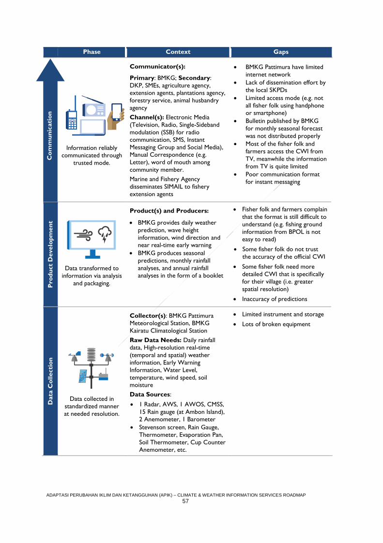
ADAPTASI PERUBAHAN IKLIM DAN KETANGGUHAN (APIK) – CLIMATE & WEATHER INFORMATION SERVICES ROADMAP
57
Phase Context Gaps C
om
mu
nic
ati
on
Information reliably
communicated through
trusted mode.
Communicator(s):
Primary: BMKG; Secondary:
DKP, SMEs, agriculture agency,
extension agents, plantations agency,
forestry service, animal husbandry
agency
Channel(s): Electronic Media
(Television, Radio, Single-Sideband
modulation (SSB) for radio
communication, SMS, Instant
Messaging Group and Social Media),
Manual Correspondence (e.g.
Letter), word of mouth among
community member.
Marine and Fishery Agency
disseminates SIMAIL to fishery
extension agents
BMKG Pattimura have limited
internet network
Lack of dissemination effort by
the local SKPDs
Limited access mode (e.g. not
all fisher folk using handphone
or smartphone)
Bulletin published by BMKG
for monthly seasonal forecast
was not distributed properly
Most of the fisher folk and
farmers access the CWI from
TV, meanwhile the information
from TV is quite limited
Poor communication format
for instant messaging
Pro
du
ct
Develo
pm
en
t
Data transformed to
information via analysis
and packaging.
Product(s) and Producers:
BMKG provides daily weather
prediction, wave height
information, wind direction and
near real-time early warning
BMKG produces seasonal
predictions, monthly rainfall
analyses, and annual rainfall
analyses in the form of a booklet
Fisher folk and farmers complain
that the format is still difficult to
understand (e.g. fishing ground
information from BPOL is not
easy to read)
Some fisher folk do not trust
the accuracy of the official CWI
Some fisher folk need more
detailed CWI that is specifically
for their village (i.e. greater
spatial resolution)
Inaccuracy of predictions
Data
Co
llecti
on
Data collected in
standardized manner
at needed resolution.
Collector(s): BMKG Pattimura
Meteorological Station, BMKG
Kairatu Climatological Station
Raw Data Needs: Daily rainfall
data, High-resolution real-time
(temporal and spatial) weather
information, Early Warning
Information, Water Level,
temperature, wind speed, soil
moisture
Data Sources:
1 Radar, AWS, 1 AWOS, CMSS,
15 Rain gauge (at Ambon Island),
2 Anemometer, 1 Barometer
Stevenson screen, Rain Gauge,
Thermometer, Evaporation Pan,
Soil Thermometer, Cup Counter
Anemometer, etc.
Limited instrument and storage
Lots of broken equipment
Co
mm
un
icati
on
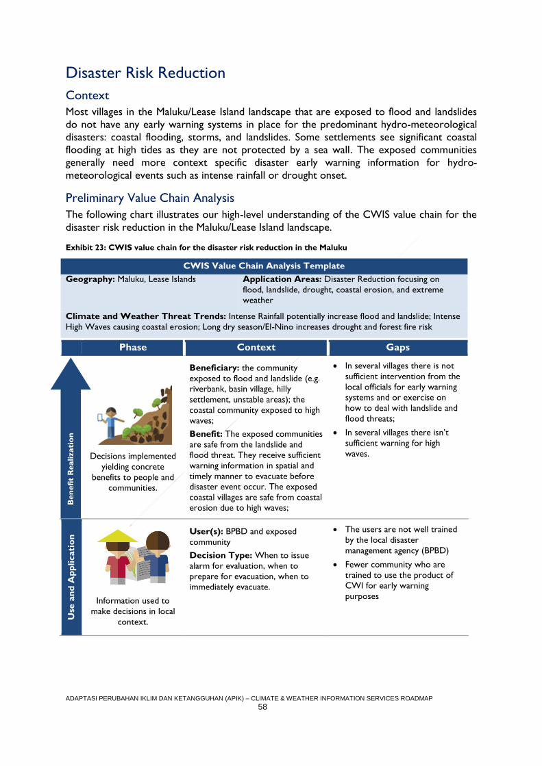
ADAPTASI PERUBAHAN IKLIM DAN KETANGGUHAN (APIK) – CLIMATE & WEATHER INFORMATION SERVICES ROADMAP
58
Disaster Risk Reduction
Context
Most villages in the Maluku/Lease Island landscape that are exposed to flood and landslides
do not have any early warning systems in place for the predominant hydro-meteorological
disasters: coastal flooding, storms, and landslides. Some settlements see significant coastal
flooding at high tides as they are not protected by a sea wall. The exposed communities
generally need more context specific disaster early warning information for hydro-
meteorological events such as intense rainfall or drought onset.
Preliminary Value Chain Analysis
The following chart illustrates our high-level understanding of the CWIS value chain for the
disaster risk reduction in the Maluku/Lease Island landscape.
Exhibit 23: CWIS value chain for the disaster risk reduction in the Maluku
CWIS Value Chain Analysis Template
Geography: Maluku, Lease Islands Application Areas: Disaster Reduction focusing on
flood, landslide, drought, coastal erosion, and extreme
weather
Climate and Weather Threat Trends: Intense Rainfall potentially increase flood and landslide; Intense
High Waves causing coastal erosion; Long dry season/El-Nino increases drought and forest fire risk
Phase Context Gaps
B
en
efi
t R
ealizati
on
Decisions implemented
yielding concrete
benefits to people and
communities.
Beneficiary: the community
exposed to flood and landslide (e.g.
riverbank, basin village, hilly
settlement, unstable areas); the
coastal community exposed to high
waves;
Benefit: The exposed communities
are safe from the landslide and
flood threat. They receive sufficient
warning information in spatial and
timely manner to evacuate before
disaster event occur. The exposed
coastal villages are safe from coastal
erosion due to high waves;
In several villages there is not
sufficient intervention from the
local officials for early warning
systems and or exercise on
how to deal with landslide and
flood threats;
In several villages there isn’t
sufficient warning for high
waves.
Use
an
d A
pp
licati
on
Information used to
make decisions in local
context.
User(s): BPBD and exposed
community
Decision Type: When to issue
alarm for evaluation, when to
prepare for evacuation, when to
immediately evacuate.
The users are not well trained
by the local disaster
management agency (BPBD)
Fewer community who are
trained to use the product of
CWI for early warning
purposes
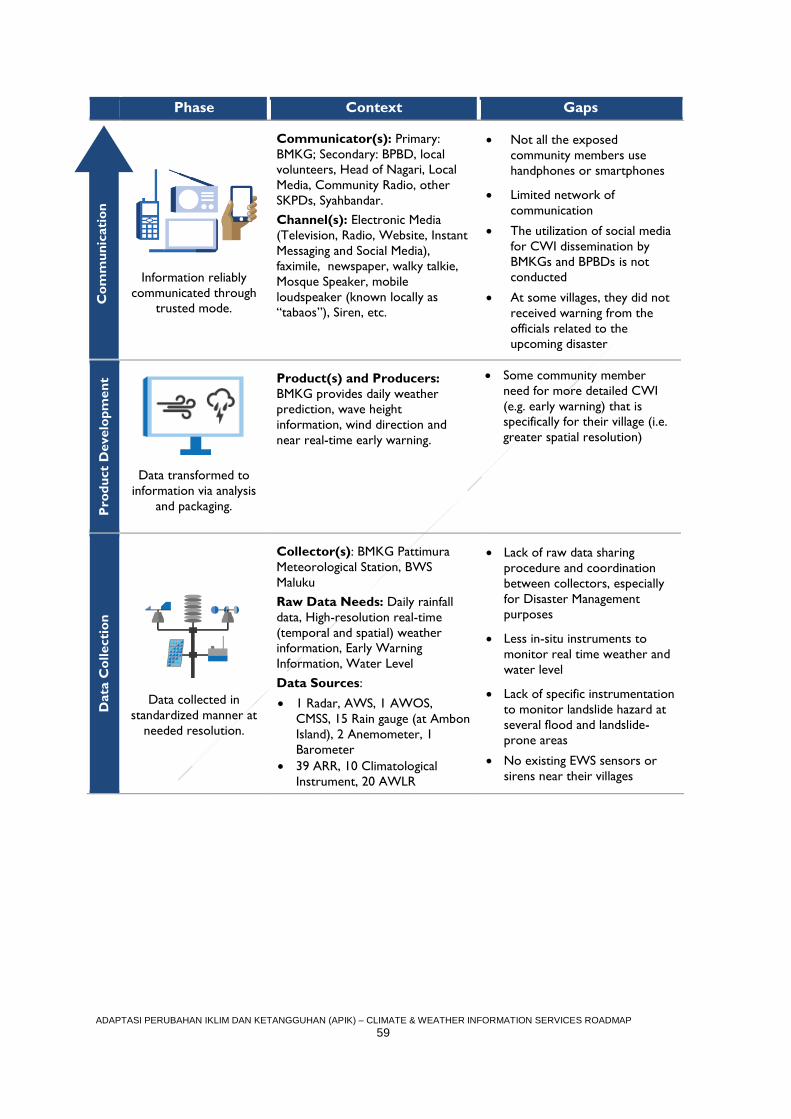
ADAPTASI PERUBAHAN IKLIM DAN KETANGGUHAN (APIK) – CLIMATE & WEATHER INFORMATION SERVICES ROADMAP
59
Phase Context Gaps C
om
mu
nic
ati
on
Information reliably
communicated through
trusted mode.
Communicator(s): Primary:
BMKG; Secondary: BPBD, local
volunteers, Head of Nagari, Local
Media, Community Radio, other
SKPDs, Syahbandar.
Channel(s): Electronic Media
(Television, Radio, Website, Instant
Messaging and Social Media),
faximile, newspaper, walky talkie,
Mosque Speaker, mobile
loudspeaker (known locally as
“tabaos”), Siren, etc.
Not all the exposed
community members use
handphones or smartphones
Limited network of
communication
The utilization of social media
for CWI dissemination by
BMKGs and BPBDs is not
conducted
At some villages, they did not
received warning from the
officials related to the
upcoming disaster
Pro
du
ct
Develo
pm
en
t
Data transformed to
information via analysis
and packaging.
Product(s) and Producers:
BMKG provides daily weather
prediction, wave height
information, wind direction and
near real-time early warning.
Some community member
need for more detailed CWI
(e.g. early warning) that is
specifically for their village (i.e.
greater spatial resolution)
Data
Co
llecti
on
Data collected in
standardized manner at
needed resolution.
Collector(s): BMKG Pattimura
Meteorological Station, BWS
Maluku
Raw Data Needs: Daily rainfall
data, High-resolution real-time
(temporal and spatial) weather
information, Early Warning
Information, Water Level
Data Sources:
1 Radar, AWS, 1 AWOS,
CMSS, 15 Rain gauge (at Ambon
Island), 2 Anemometer, 1
Barometer
39 ARR, 10 Climatological
Instrument, 20 AWLR
Lack of raw data sharing
procedure and coordination
between collectors, especially
for Disaster Management
purposes
Less in-situ instruments to
monitor real time weather and
water level
Lack of specific instrumentation
to monitor landslide hazard at
several flood and landslide-
prone areas
No existing EWS sensors or
sirens near their villages
Co
mm
un
icati
on
ADAPTASI PERUBAHAN IKLIM DAN KETANGGUHAN (APIK) – CLIMATE & WEATHER INFORMATION SERVICES ROADMAP
60
Technical Assistance Entry-Points
Based on the preliminary CWIS value chain analyses, the APIK team has identified a set of
technical assistance entry points along each segment of the chain itself (see Exhibit 25).
Following our strengthening strategy, we will rationalize these activities by focusing in on
target CWIS beneficiaries located in specific geographies. The APIK target villages in the
Maluku/Lease Island landscape are:
Soya, Paso, Hatife Besar, Negeri Lima and Allang Village at Ambon Island;
Negeri Haruku and Wassu Village at Haruku island; and
Ihamahu village at Saparua Islands.
Our target beneficiaries for the DRR application activities are the local communities
themselves, and we plan to engage the local BPBD in each geography to home in on how
best to support the strengthening of early warning systems. For the agriculture and food
security application, we plan to work with beneficiaries whose primary livelihood is marine
fishing, well as farmers involved in planting a mix of crops, including clove, nutmeg, durian,
salak, langsat, mangosteen, and seasonal vegetables like cassava and corn.
Following our initial field consultations with target beneficiaries in the Maluku/Lease Island
landscape, the team will prioritize and tailor the relevant TA entry points from Exhibit 25 to
ensure APIK’s value chain strengthening activities provide clear benefit to our target
audience.
All activities will align with and build off the approved PY2 work plan and also inform future
work plans. Broad activities are detailed in Exhibit 24.
Exhibit 24: High Level PY2 APIK Activities Planned for Maluku/Lease Islands
No. Focus
MA-1 At the local government level, the APIK Maluku team will integrate climate change issues into
Ambon city and Maluku Tengah District’s RPJMD, including the necessary budgetary allocations.
MA-2 Strengthening local government capacity in DRR/CCA planning at selected unit both in Ambon
and Central Maluku District, totaling 50 people.
MA-3 Implement VA and Adaptation Strategic Planning at provincial level.
MA-4 APIK will help the local government design a geospatial data center bringing efficiency and
fostering synergy among local government agencies particularly in addressing flood, landslide and
coastal hazards in the spatial plan. This will also feed into the government one-map policy.
MA-5 Engage local partners in CWIS development, product design, and utilization.
MA-6 To enable better climate and weather information dissemination APIK will strengthen the three
regional command centers (PUSDALOPS) in province, Ambon City and Central Maluku and 15
working groups at the community level.
MA-7 Facilitate the hydro-metrological disaster risk assessment in Maluku Tengah.
MA-8 Facilitate the formulation of local regulation on disaster management.
MA-9 Collaborate with Harta Samudra (tuna/pelagic fishing) as a private sector partner for addressing
risk reduction, CWIS demand, and CCA/DRR investment.
MA-10 Collaboration with other USAID projects such as SEA and TATTs
Note that the entry points in Exhibit 25 are illustrative, and that the complete long-term set
of entry points (including other secondary activities) are described in ANNEX III.
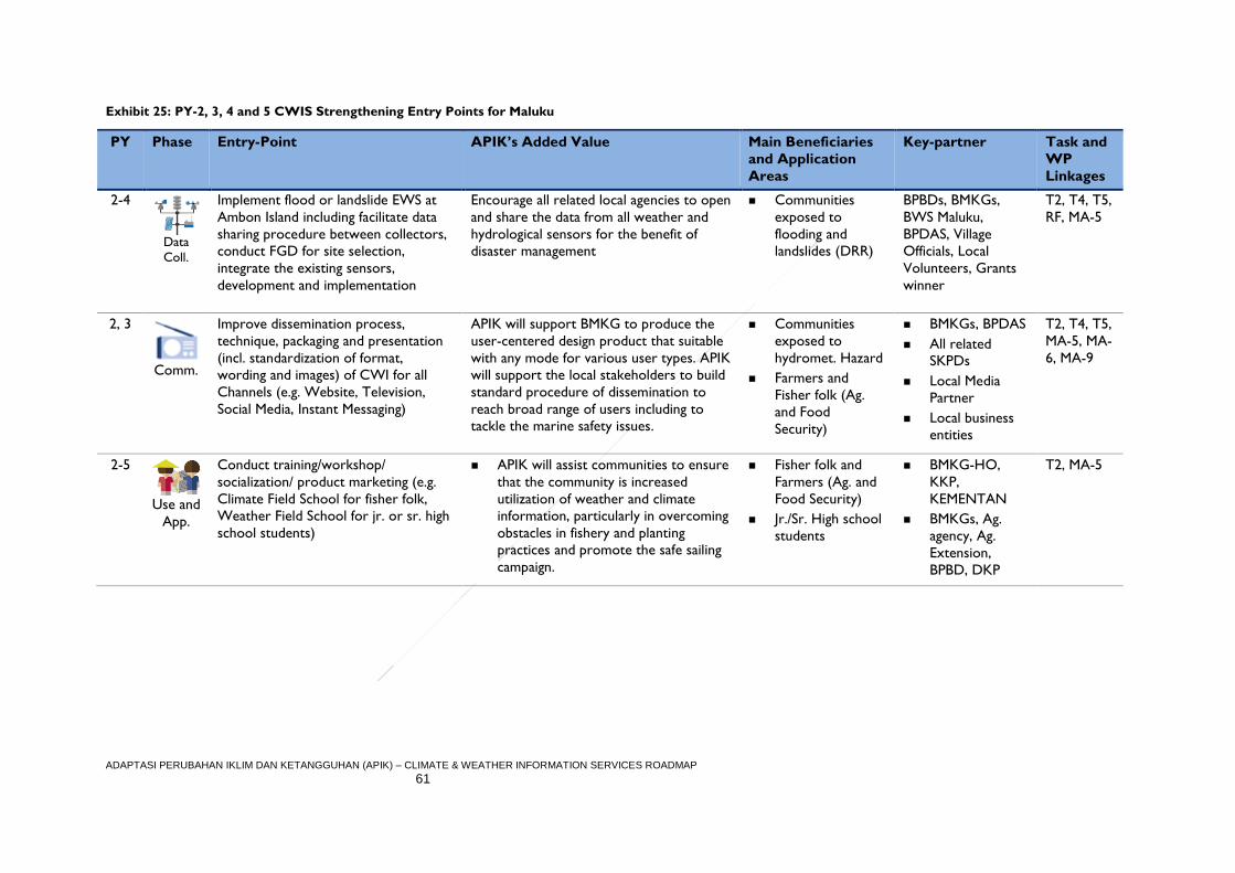
ADAPTASI PERUBAHAN IKLIM DAN KETANGGUHAN (APIK) – CLIMATE & WEATHER INFORMATION SERVICES ROADMAP
61
Exhibit 25: PY-2, 3, 4 and 5 CWIS Strengthening Entry Points for Maluku
PY Phase Entry-Point APIK’s Added Value Main Beneficiaries
and Application
Areas
Key-partner Task and
WP
Linkages
2-4
Data
Coll.
Implement flood or landslide EWS at
Ambon Island including facilitate data
sharing procedure between collectors,
conduct FGD for site selection,
integrate the existing sensors,
development and implementation
Encourage all related local agencies to open
and share the data from all weather and
hydrological sensors for the benefit of
disaster management
Communities
exposed to
flooding and
landslides (DRR)
BPBDs, BMKGs,
BWS Maluku,
BPDAS, Village
Officials, Local
Volunteers, Grants
winner
T2, T4, T5,
RF, MA-5
2, 3
Comm.
Improve dissemination process,
technique, packaging and presentation
(incl. standardization of format,
wording and images) of CWI for all
Channels (e.g. Website, Television,
Social Media, Instant Messaging)
APIK will support BMKG to produce the
user-centered design product that suitable
with any mode for various user types. APIK
will support the local stakeholders to build
standard procedure of dissemination to
reach broad range of users including to
tackle the marine safety issues.
Communities
exposed to
hydromet. Hazard
Farmers and
Fisher folk (Ag.
and Food
Security)
BMKGs, BPDAS
All related
SKPDs
Local Media
Partner
Local business
entities
T2, T4, T5,
MA-5, MA-
6, MA-9
2-5
Use and
App.
Conduct training/workshop/
socialization/ product marketing (e.g.
Climate Field School for fisher folk,
Weather Field School for jr. or sr. high
school students)
APIK will assist communities to ensure
that the community is increased
utilization of weather and climate
information, particularly in overcoming
obstacles in fishery and planting
practices and promote the safe sailing
campaign.
Fisher folk and
Farmers (Ag. and
Food Security)
Jr./Sr. High school
students
BMKG-HO,
KKP,
KEMENTAN
BMKGs, Ag.
agency, Ag.
Extension,
BPBD, DKP
T2, MA-5
ADAPTASI PERUBAHAN IKLIM DAN KETANGGUHAN (APIK) – CLIMATE & WEATHER INFORMATION SERVICES ROADMAP
62
NATIONAL LEVEL TECHNICAL ASSISTANCE In addition to conducting technical assistance at the regional level, APIK will also support
national agencies in improving the packaging, dissemination, and uptake of climate and
weather information services. Such efforts will directly tie to assistance the regional level,
however, keeping the user and beneficiary at the fore.
Improve the resolution of the weather prediction
As mentioned on the technical assistance entry-points for East Java, APIK will support
BMKG to improve the spatial and temporal resolution (e.g. down to village level at three
hour intervals) of the weather prediction products utilizing the existing radar information
and regional forecast. The existing forecast does not adequately meet the information needs
at the village level. This product can support agricultural sector in East Java. APIK will pick
one or two specific locations for testing this approach. As discussed with BMKH-HO
Meteorology Department, they will support the numerical modeling aspect of the process
and APIK will support the product packaging, dissemination, and communication strategy.
Development of CWI Dissemination Module
APIK will coordinate with the BMKG Head Office, Public Relation and Dissemination
Division to standardize communication and dissemination processes, techniques, packaging
and presentation (including standardization of format, wording and imagery) of climate and
weather services for all channels (e.g. Website, Television, Social Media, Instant Messaging).
This process also requires intensive coordination with local partners and related local
government working units (SKPDs).
Development of CWI Packaging Module
Both Climatology and Meteorology Department at BMKG-HO will be our major partner in
developing the packaging of each product that we will improve, because most of the CWI
products are produced and published by their division. We will intensively collaborate with
BMKG station in the region, because they were issued a forecast on a regular basis for their
region. Especially for Maluku and SES, maritime products will be our priority.
Climate Field Schools
Climate field schools represent an important medium for building the climate literacy of
farming communities. To maximize the impact of these field schools, APIK will support the
updating of the training modules as well as consider how to increase the reach of such field
schools. We anticipate that this effort will extend for the life of the project. Towards this
end. APIK will collaborate with BMKG (Applied Climatology Division), Ministry of
Agriculture, and National Extension Agency. As non K/L partners, University of Indonesia,
CCROM or IPB also will join to support the improvement. For CFS for fisher folk
improvement, we will closely work with BMKG (Maritime Meteorology Division), Ministry
ADAPTASI PERUBAHAN IKLIM DAN KETANGGUHAN (APIK) – CLIMATE & WEATHER INFORMATION SERVICES ROADMAP
63
of Marine and Fishery (KKP) and Agency for Human Resources Development of Marine and
Fisheries (BPSDMKP) to improve the module.

ADAPTASI PERUBAHAN IKLIM DAN KETANGGUHAN (APIK) – CLIMATE & WEATHER INFORMATION SERVICES ROADMAP
64
SUMMARY AND NEXT STEPS
Building from the broad evaluation of climate services described in the APIK Climate and
Weather Information Services Assessment Report, the CWI Roadmap sets forth the
Project’s strategy for improving the development and dissemination processes that are so
vital to ensuring that climate services are both used and useful. To narrow our focus and
make clear impact, the Roadmap identifies in each of the three regions (East Java, SE
Sulawesi, and Maluku): (1) priority application areas for technical assistance, (2) specific
climate services value chains within those priority areas, and (3) the targeted users and
beneficiaries that are ultimately served by each respective value chain. Based on this
narrowed focus, we have then carried out preliminary value chain analyses to home in on
existing gaps or weaknesses and, further, enumerated entry-points for the Project’s
technical assistance in PY2 and beyond.
Importantly, the Roadmap represents a starting point for strengthening the CWIS value
chains identified in each region. In other words, the value chain analysis tables for DRR and
Agriculture and Food Security illustrate APIK’s working knowledge of the context and
existing gaps that prevent climate and weather data and information from reaching users and
translating into benefits. Following our strengthening strategy, in PY2 APIK will engage
directly with target users and beneficiaries and work from there up the value chain to
further detail activities that will lead to improved use and application of CWIS products at
the ground level.
Based on our research for the Assessment Report, we anticipate that most CWIS
strengthening activities will be focused around the communication phase and the use and
application phase. While a critical mass of CWIS products exist – such as seasonal
prediction, extreme weather early warning, climate variability, and fishing grounds – most
people still only use daily forecast information. Thus, the majority of APIK activities early in
the process will focus on socialization of BMKG products to beneficiaries through Climate
Field School training, as well as identifying other less costly channels to continue CWIS
beneficiary education.
The team envisions that the thematic focus of PY-2 will be on CWIS product socialization,
with the idea that once beneficiaries understand how to apply these tools to enhance their
livelihoods and safety, the APIK team can then pivot our assistance from PY-3 forward to
product enhancement. Exhibit 26 below presents the timeline for PY2 activities.
Notably, while the Roadmap presented four to five priority interventions in each region,
APIK will remain flexible and look for opportunities to expand and scale this work. In this
regard, Annex 3 includes a more complete list of possible technical assistance entry-points
for consideration in PY3, PY4, and PY5. Above all, APIK will align CWI activities with other
aspects of the Project’s work plan to ensure that they are mutually reinforcing, working
collectively to improve place-based resilience.
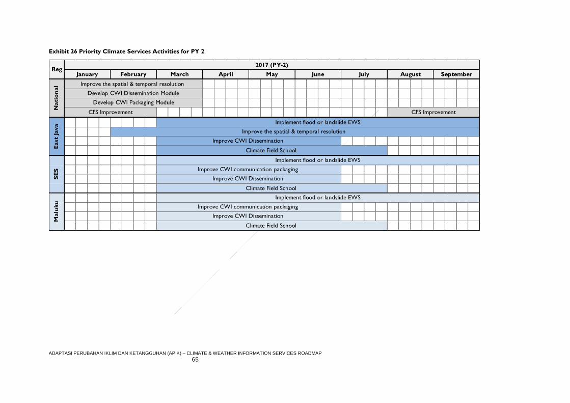
ADAPTASI PERUBAHAN IKLIM DAN KETANGGUHAN (APIK) – CLIMATE & WEATHER INFORMATION SERVICES ROADMAP
65
Exhibit 26 Priority Climate Services Activities for PY 2
Climate Field School
Climate Field School
Improve CWI Dissemination
Improve CWI communication packaging
Implement flood or landslide EWS
Implement flood or landslide EWS
Implement flood or landslide EWS
Improve CWI communication packaging
Improve CWI Dissemination
Climate Field School
September
2017 (PY-2)Reg
Improve the spatial & temporal resolution
Improve CWI Dissemination
Improve the spatial & temporal resolution
Develop CWI Dissemination Module
Develop CWI Packaging Module
CFS Improvement
March April May June July August
East
Java
SE
SM
alu
ku
Nati
on
al
January February
CFS Improvement
ADAPTASI PERUBAHAN IKLIM DAN KETANGGUHAN (APIK) – CLIMATE & WEATHER INFORMATION SERVICES ROADMAP
66
Adaptasi Perubahan Iklim dan Ketangguhan
World Trade Center, 7th Floor
Jl. Jend. Sudirman Kav. 28
Jakarta 12920
Indonesia
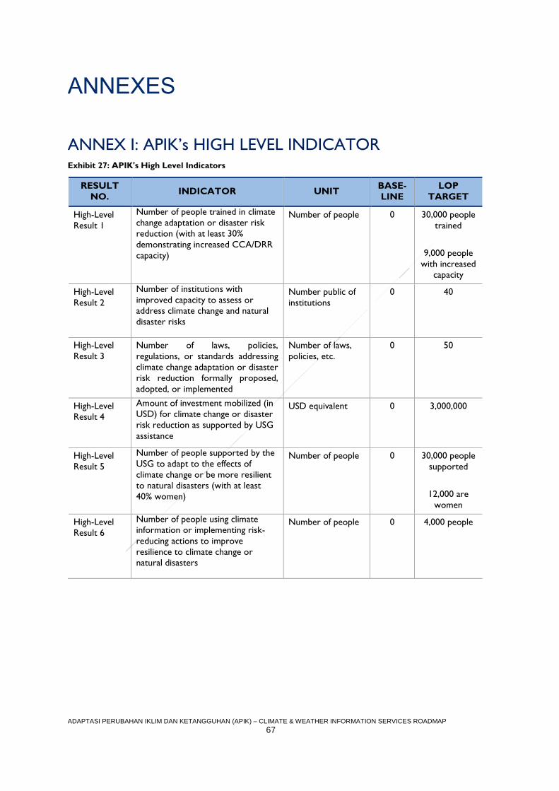
ADAPTASI PERUBAHAN IKLIM DAN KETANGGUHAN (APIK) – CLIMATE & WEATHER INFORMATION SERVICES ROADMAP
67
ANNEXES
ANNEX I: APIK’s HIGH LEVEL INDICATOR Exhibit 27: APIK's High Level Indicators
RESULT
NO. INDICATOR UNIT
BASE-
LINE
LOP
TARGET
High-Level
Result 1
Number of people trained in climate
change adaptation or disaster risk
reduction (with at least 30%
demonstrating increased CCA/DRR
capacity)
Number of people 0 30,000 people
trained
9,000 people
with increased
capacity
High-Level
Result 2
Number of institutions with
improved capacity to assess or
address climate change and natural
disaster risks
Number public of
institutions
0 40
High-Level
Result 3
Number of laws, policies,
regulations, or standards addressing
climate change adaptation or disaster
risk reduction formally proposed,
adopted, or implemented
Number of laws,
policies, etc.
0 50
High-Level
Result 4
Amount of investment mobilized (in
USD) for climate change or disaster
risk reduction as supported by USG
assistance
USD equivalent 0 3,000,000
High-Level
Result 5
Number of people supported by the
USG to adapt to the effects of
climate change or be more resilient
to natural disasters (with at least
40% women)
Number of people 0 30,000 people
supported
12,000 are
women
High-Level
Result 6
Number of people using climate
information or implementing risk-
reducing actions to improve
resilience to climate change or
natural disasters
Number of people 0 4,000 people
ADAPTASI PERUBAHAN IKLIM DAN KETANGGUHAN (APIK) – CLIMATE & WEATHER INFORMATION SERVICES ROADMAP
68
ANNEX II: SUMMARY OF ASSESSMENT REPORT
The APIK team conducted the CWI assessment over the period of April to November
2016. Led by the Project’s Climate and Weather Information Specialist, the assessment was
carried out in a collaborative manner with key sector actors at the national and subnational
levels. The purpose of APIK CWI Assessment is to better understand the current
capabilities and needs of stakeholders in Indonesia to generate, provide, and use weather
and climate information. The Assessment Report will then serve as the basis for the
development of this document, which details the Project’s approach to improve the
development, provision and uptake of information in ways that support the aforementioned
high-level outcomes on a sustainable basis, particularly at the local level. Many of the findings
and the facts written in the CWI Assessment Report will serve as a reference for the
strategy in this Roadmap. Authors advise readers to read the CWI Assessment Report to
find out more detailed results of the previous assessment.
Climate and weather information (CWI) services are used by a wide range of actors in
Indonesia—public, private, and civil society—to fulfill specific, placed-based needs, from
maximizing crop yields to navigating coastal waters to warning communities of impending
flood risk. Recent advances in technology enable meteorologists to capture larger quantities
of more precise weather data, while community leaders, farmers, and fisher folk increasingly
have access to that data via mobile connectivity. Nevertheless, the CWI services
marketplace remains quite fragmented with varying levels of coordination along the ‘value
chain’ of service provision that collects raw data and translates it into useful information for
beneficiaries.
Through the Climate and Weather Information Services Assessment, USAID’s Adaptasi
Perubahan Iklim dan Ketangguhan (APIK) Project catalogues the existing actors, data,
products, and users of CWI services in Indonesia with the aim of identifying key gaps in the marketplace. Detail from this Assessment report will then inform the forthcoming APIK CWI
Services Roadmap, which will analyze specific CWI value chains within APIK’s priority
regions and inform the Project’s technical assistance entry-points over the coming four
years.
Assessment Approach and Method
Broadly speaking, climate and weather information services consist of the hardware (sensor
networks, weather station infrastructure, and IT equipment), software (trained staff,
recognized communication and dissemination platforms, local awareness) and the supporting
institutional arrangements (codified roles and responsibilities, data sharing policies,
dedicated funding) that facilitate the systematic collection, analysis, packaging, communication, and use of meteorological, hydrological, and climate data. Robust CWI
services are integral to Indonesia’s National Action Plan on Climate Change Adaptation
(RAN-API) in the context of hydro-meteorological disaster risk reduction and development
planning. At the international level, the World Meteorological Organization (WMO) also
recognized the critical role of improved climate services, establishing the Global Framework
for Climate Services in 2012 as a worldwide mechanism for coordinated actions to enhance
the quality, quantity, and application of climate services (see http://www.wmo.int/gfcs/).
Climate and weather information services are most impactful when an active process is put
in place to transform raw environmental observations into actionable information
ADAPTASI PERUBAHAN IKLIM DAN KETANGGUHAN (APIK) – CLIMATE & WEATHER INFORMATION SERVICES ROADMAP
69
communicated to the right people at the right time. Toward this end, the APIK assessment
team used the concept of a climate and weather information value chain to frame the
institutional roles and action steps required in the transformation of data into decisions.
These steps are: (1) raw data collection and organization, (2) product development, (3)
communication and dissemination, (4) application and use, and (5) benefit realization. The
notion of climate and weather information services as a value chain operating in the context
of a local market allows us to: identify and segment the key climate and weather services
actors; define the roles that such actors play across all the links of the value chain; connect
those that collect and produce CWI services (the “supply side”) and those that apply them
at the local level (the “demand side”); and detect specific gaps or weaknesses in the value
chain and target technical assistance efforts accordingly.
Regarding methodology, the CWI Services Assessment was completed over a period of
approximately eight months, from April through November of 2016. The APIK assessment
team engaged in consultations with national level actors (i.e. top-down) as well as a wide
range of stakeholders at the subnational and community levels (i.e. bottom-up) in APIK’s
priority provinces of East Java, Southeast Sulawesi, and Maluku. The team principally used
structured, key informant interviews as well as focus group discussions (FGDs) across all
levels to gather inputs and perspectives. The results of this intensive stakeholder
engagement process were then synthesized by the APIK assessment team and compiled in
the full report, which details the current status of the actors, data, and products along the
value chain. The concluding chapter of the report then provides a summary analysis of
services gaps identified by the APIK assessment team at each step of the value chain,
including those at the national and subnational levels, in the public and private sectors, as
well as at the community level.
Key CWI Institutions, Products and Communication Modes
The institutional landscape of climate and weather information services is, not surprisingly,
dominated by the National Meteorological and Climate Agency (BMKG). According to
prevailing government regulations, BMKG represents the primary collector of climate and
weather data and producer of tailored climate products. More specifically, Presidential
Decree No. 61 of 2008 states that the Agency is obligated to conduct governmental tasks in
the field of meteorology, climatology and geophysics, including, but not limited to data
collection and management, analysis and delivery of weather and climate change information
to public and private stakeholders at both the national and subnational levels,
communication of disaster warnings to relevant institutions and agencies, and the
implementation of research and development. To fulfill these mandates, BMKG operates
122 meteorology stations, 31 geophysics stations, and 21 climatology stations across the
archipelago.
A wide variety of public and private organizations play targeted, supporting roles in the
climate and weather information services landscape. The National Disaster Management
Agency (BNPB) represents an important producer and communicator of disaster preparedness
and response products accompanied by broad reach through Local Government Disaster
Management Authorities (BPBDs). National planning and technical ministries play a role in
translating climate and weather data into specific sectors; the Ministry of Agriculture, for
example, helps farmers to apply climate information to maximize crop yields, while the
Ministry of Public Works and Housing works across administrative boundaries to manage
water resources within a given drainage basin.
ADAPTASI PERUBAHAN IKLIM DAN KETANGGUHAN (APIK) – CLIMATE & WEATHER INFORMATION SERVICES ROADMAP
70
The CWI institutional landscape extends well outside the public sector, however, to include
research organizations (e.g. universities), media entities (e.g. television stations, radio, and
print media), as well as commercial entities. While most of these are engaged in the
communication and use of climate and weather products, some also collect their own
observations directly. The Weather and Climate Prediction Laboratory at the Bandung
Institute of Technology, for example, collects and publishes its own weather data using local
instrumentation.
The array of CWI institutional actors currently develop and disseminate a diverse portfolio
of climate and weather information products, some for internal use only and others available to
the public. Notable products and systems commonly referenced during assessment
interviews included:
Daily and weekly weather forecasts collectively generated by BMKG Stations and
Head Office, as well as seasonal climate predictions;
Downscaled climate change projections for temperature and precipitation change with a resolution of four square kilometers, also generated by BMKG;
Vulnerability Inventory Index Information System (SIDIK) and the Early Warning
System for Forest and Land (Sipongi), both of which are managed by the Ministry of
the Environment and Forestry (KLHK);
Landslide Early Warning System, InAWARE (a Disaster Preparedness and Response
Platform), and the Disaster Risk Map, all of which fall under the Disaster Management Authority (BNPB);
The Integrated Planting Calendar (KATAM) and Resilience and Food Security Maps
promulgated by the Ministry of Agriculture;
Disaster Mitigation, Adaptation and Environmental Information System (SIMAIL) that
supports coastal communities and is managed by the Ministry of Fisheries (KKP);
Hydrology, Hydrometeorology and Hydrogeology Information System (SIH3) coordinated by BMKG with the Ministry of Public Works and Housing and the
Ministry of Minerals and Geologic Resources;
Bandung Metropolitan Early Warning System (ITB); and
Flood Forecasting and Warning System (FFWS) and Flood Early Warning and Early Action System (FEWEAS) established and operated by Perum. Jasa Tirta.
The modes of communication and dissemination of climate and weather information services
are equally diverse, and include internet sites, social media (specifically Twitter, Facebook,
and WhatsApp) print media, televised broadcasts, national and local radio programs,
smartphone applications, and short message services (SMS). In a country well known for its
rapid uptake of social media and digital technology, it is noteworthy that, based on APIK’s
interviews, digital communications do not necessarily translate well to more rural
communities. In communities in Southeast Sulawesi and Maluku, for example, many
informants reported that they obtain climate and weather information from television, word
of mouth, or loud speakers (in the case of emergencies).
Summary of Findings across the Value Chain
Based on more than 650 individual interviews including representatives from 11 national
government agencies, 152 local government agencies across cities and districts in 3
provinces, 61 businesses, representatives from media and research institutions and
ADAPTASI PERUBAHAN IKLIM DAN KETANGGUHAN (APIK) – CLIMATE & WEATHER INFORMATION SERVICES ROADMAP
71
community members from over 70 villages, the following summarizes the key findings of the
CWI Services Assessment across the stages of the value chain:
Data Collection and Processing:
While BMKG has (and continues to make) investments in the reliable collection of
observational data, significant spatial and temporal gaps persist. The instrumentation
necessary to collect climate data with a sufficiently high spatial and temporal resolution is
not yet established in many places, but especially in the more remote areas outside of the
Island of Java. Further, where instrumentation was set up, a lack of standardized/automated
collection methodologies and maintenance greatly impact the quality and utility of the data.
For example, 992 manually operated rain gauges in East Java require staff to visit them daily
and record data in a log book, which then must be summarized and sent monthly to the
irrigation office, where it is then compiled and distributed via email to BMKG. A lengthy
manual process like this contributes to poor data quality – as does the fact that many of the
gauges no longer function properly.
A lack of open data policies continues to inhibit the sharing of climate information,
inhibiting warning systems, the improvement of models, and the proliferation of
climate research. The APIK assessment team found that, at present, climate and weather
data collectors tend to focus on the gathering of environmental data in accordance with
their own needs, failing to recognize that other producers, communicators, and users may
have related yet distinct information needs that can only be fulfilled if the raw data is
maintained in a specific format and is of sufficient granularity (i.e. spatial and temporal
resolution).
Even when data is in the public domain, important gaps often exist and platforms to
access those datasets are not always reliable. From the perspective of data needs, APIK
found that historical weather data sets are typically the most in demand, but that the
completeness of those data sets is an important area of improvement for BMKG. That said,
the majority of users surveyed report being satisfied with the available data types, such as
ENSO, Sea Surface Temperature (SST), Extreme Climate, Flood Potential, Water Balance,
Days without Rainfall, and Season and Climate Prediction.
The assessment team also found that most CWI data users access the information through
inter-ministerial/agency correspondence. The agencies themselves often access the data
through sending a formal request letter to BMKG. While much of BMKG’s data can be
accessed directly through the website, most people interviewed stated the website
functionality needs improvement. The CWIS users from BNPB also highlighted a clear need
for better integration between platforms, such as connecting the Multi Hazard Early
Warning system with radar data to enhance its reliability.
Product Development:
Like many climate and weather marketplaces around the world, product
development in Indonesia is supply-driven, lacking a clear focus on the needs of users
and beneficiaries. The needs of the data collection institution often shape product
development. For example, wave height maps are often disseminated in low-resolution
format, making it difficult for fisherman to discern the conditions in local waters. Similarly,
technical jargon used by government officials frustrates public users, who in reality must play
the role of ‘product developer’ to actually analyze and use CWI data sets. Given most local
ADAPTASI PERUBAHAN IKLIM DAN KETANGGUHAN (APIK) – CLIMATE & WEATHER INFORMATION SERVICES ROADMAP
72
government survey respondents shared their unhappiness with community use of CWI data,
a considerable opportunity exists to connect users and producers for product development
purposes. In this regard, APIK did not find any widely used feedback mechanisms in which
users and producers interact to help improve existing products.
Notably, most institutional products focus on early warning for disaster risk reduction
purposes, while very few incorporate climate adaptation concerns such as shifts in
seasonality. This is due in part to product demand as well as data gaps – for example,
manual rain gauges do not capture one of the most anticipated changes in local climate,
namely, the hourly intensity of rainfall.
One of the main challenges for CWIS across the different landscapes is that each
area has its own risk characteristics depending on the local context and issues. From
the watershed point of view, at the upstream level the main issues include land use change
and water scarcity coupled with landslides or flash flood threats. In cities, the common issue
is urban flooding, with mismanaged rivers and drainage systems increasing the risk. Coastal
flooding, erosion, and sea level rise are threatening seaside communities, and land use
decisions can exacerbate those risks, as seen with the Bajo people who traditionally build
houses above the coastal sea water. For some coastal areas, especially those downstream
from big rivers, there is greater risk of landslides and flash flooding. Therefore, in order to
ensure local needs are met, CWIS must be contextualized and relevant for each area. There
is no “one size fits all” solution.
The assessment results show that climate variability is affecting community livelihoods,
especially those relying on natural resources. Many farmers face common issues, such as
difficulty determining the beginning of the rainy season, which impacts when to plant their
crops and how to manage pest control in different and varied weather conditions. In some
places there are also water shortage issues, especially during the dry season for rain fed
paddy fields. For coastal communities, the weather uncertainty shortens the time fisher folk
spend at sea and limits their sailing distance.
In the tourism sector, weather uncertainty and the strength of El-Nino/La-Nina has proven
to disrupt operational activities. For example, local marine tourism has been impacted by
dive site coral bleaching issues due to increasing sea water temperature. Agro-tourism is
also affected by climate change as well, since the activity is dependent on agricultural
products to draw tourists to a region.
Dissemination and Communication:
Local TV and radio are the primary channels people use to access timely weather
information, although digital communication modes are playing an increasing role in
some areas. Communities with limited access to smartphones or the internet rely heavily
on traditional media (through daily weather forecasts or special announcements for extreme
weather events on television, radio or amateur radio broadcast) and often disseminate
weather information verbally through group or village meetings. In Southeast Sulawesi and
Maluku, wave height information is an important data point that is routinely broadcasted by
the local media. Informal, community-based radio is especially useful in fishing communities.
That said, digital communications are on the rise. BMKG and BPBD, for example, both use
social media to disseminate CWI messages, with Twitter being the most popular tool. Some
remote communities receive climate and weather information through SMS (short
ADAPTASI PERUBAHAN IKLIM DAN KETANGGUHAN (APIK) – CLIMATE & WEATHER INFORMATION SERVICES ROADMAP
73
messaging service), but this is highly dependent on signal strength and thus it is generally not
on a regular basis. Further, instant message groups have become increasingly popular at the
local government level as well, often used to exchange weather information among staff at
SKPDs (local government departments). Information that can be displayed is quite
comprehensive, ranging from text, images and links to websites. Again, however, this mode
is only available in areas with an affordable and strong mobile internet signal (GPRS, HSDPA,
etc.).
Local staff and volunteers represent a critical link in communicating climate and
weather information at the community level. APIK found that local actors such as
agricultural extension officers, disaster coordinators, and BPBD volunteers play a
fundamental role in disseminating climate and weather information at the grassroots level.
Such individuals are interacting with potential users and beneficiaries on a daily basis, and are
able to take sometimes complex CWI products and translate them in a manner that is
meaningful to farmers and fishermen. Some disaster coordinators have also started their
own instant messaging groups among them to exchange early warning information.
CWI dissemination is not just about posting data and products, but requires
targeted marketing and capacity building. CWI users are ultimately “consumers”,
meaning that they have choices on whether to use a product or not. First and foremost,
they need to be aware what products exist through active marketing that targets specific
segments of the climate and weather information marketplace. Also, users must feel
comfortable with the product and be convinced of its usefulness. Notably, APIK
encountered several existing government programs that aim to enhance the capacity of the
public to apply climate services, including the Climate Field School program, PKPT / PDPT,
Indonesia Coastal School, Agricultural Extension and Fishermen, and Proklim. Unfortunately,
these have not reached scale – for example, Climate Field School Stage 3 for farmers covers
less than 10% of the total villages in APIK regions (East Java, SE Sulawesi, Maluku), and the
same program for fisher folk has not yet reached the village level based on our assessment.
The lack of marketing and familiarity with climate services also impacts local government
uptake. For example, the Livestock Agency in Malang District stated that they never obtain
regular CWI from BMKG; instead, they rely on historical knowledge concerning the seasons
or television broadcasts. Similarly, the SIDIK system on climate vulnerability, a derivative
product of KLHK, represents an example of a product that has not been socialized properly
in with the local BAPPEDA.
Application and Use:
Existing climate and weather products struggle to reach the “last mile” of
beneficiaries, often failing to make it to the communities and households where they
are most needed. Many communities facing climate change risks are not yet using the
climate and weather services produced by national authorities. Various ministries have
produced climate and weather information products, such as the Disaster Mitigation,
Climate Change and Environmental Information System (SIMAIL) run by the Ministry of
Maritime Affairs and Fisheries, the Kalender Tanam Terpadu (KATAM) planting calendar
produced by the Ministry of Agriculture, and BMKG’s monthly rainfall analysis. All of these
tools could be of considerable benefit were they to reach intended users. Unfortunately,
none are being used at scale by farmers and fisher folk; this assessment found only two
respondents familiar with KATAM and two others who had heard of the SIMAIL product.
ADAPTASI PERUBAHAN IKLIM DAN KETANGGUHAN (APIK) – CLIMATE & WEATHER INFORMATION SERVICES ROADMAP
74
Similarly, many local governments are still not optimally utilizing services to inform programs
or strategic planning. Such difficulties with “last mile” service delivery are a common
challenge for climate and weather information services, which reflects the importance of the
aforementioned emphasis on marketing and capacity building.
Many stakeholders continue to rely on personal observations and traditional climate
knowledge, especially when more “formal” climate services are not available. Most of
the communities visited by APIK continue to use their own indigenous knowledge for
predicting weather and seasonality rather than accessing formal services produced by
BMKG. While traditional methods such as Nanaku or Pranata Mangsa (traditional seasonal
calendar) have been used for centuries, many respondents admit that these methods are not
entirely reliable. Further, the long-standing “DJF-JJA-rule” (i.e. monsoonal pattern) that many
farmers have relied upon appears less and less consistent. It is especially difficult to predict
the onset and potential impacts of the La-Nina and El-Nino events. Some farmers
understand La-Nina as the condition of "the Wet Dry Season", but many are not fully
socialized on how the seasonal characteristics of the event can impact their crops.
While users are moderately satisfied with formal CWI products, there is still progress
to made. APIK surveys find that user satisfaction of BMKG products is 3.44 on a scale of 1-
5 (1=Not satisfied; 2=Less satisfied; 3=Satisfied, but need some improvement; 4=Satisfied;
5=Very satisfied). The areas of weakness identified by respondents include interoperability,
guidelines, and geographical coverage. The surveys also found a need for data not currently
captured by BMKG, including evaporation, evapotranspiration, and solar radiation
information.
At the national level, there is consensus that improvement is needed in the reliability of
existing weather forecast products as well as hot spot and smoke distribution information.
For marine weather and wave forecasts, the assessment found that most users are satisfied
with current products.
Opportunities for Strengthening the CWI Services Marketplace
While this assessment provides a ‘lay of the land’ in term of CWIS, to identify areas of opportunity for value chain strengthening, the next step for APIK is to complete a specific
analysis of CWI value chains for key social and economic sectors in East Java, SE Sulawesi,
and Maluku under the auspices of the CWI Roadmap. Chapters 4-6 in this assessment
provide an overview of CWIS in each of these APIK geographies, which will inform the
sector specific analyses and determine where APIK support could make scalable impact in
CWIS that enhances the lives and livelihoods of communities in our focus regions.
Nonetheless, as discussed in Chapter 7 CWIS assessment report, there are a myriad of
opportunities to strengthen the CWI marketplace available for further consideration and
analysis under the forthcoming roadmap. Briefly, these opportunities include:
Socializing and building capacity on user-centered design (UCD) process and
methods at local BMKG stations. An initial UCD analysis should be conducted on
existing CWI products operated by local governments such as water resources,
health, DRR, forest fires, and marine/agriculture information (e.g. planting calendar,
ground fishing information, flood modeling, ground water modeling, SiPongi). Some
ADAPTASI PERUBAHAN IKLIM DAN KETANGGUHAN (APIK) – CLIMATE & WEATHER INFORMATION SERVICES ROADMAP
75
products may simply need user manuals and training, while others may need a larger
overhaul to bolster their utility.
Homing in on specific sectors and regions to analyze areas of opportunity. For
example, for DRR, the program could evaluate the existing Landslide Early Warning System in the three APIK regions to identify how to improve reliability, coverage,
maintenance, procedure, etc. Another opportunity lies in piloting the Multi-Hazard
Early Warning System as a way to enhance the value chain analysis for the product.
Leveraging field staff such as extension workers, disaster volunteers, and
POKWASMAS as critical “communications assets” for CWIS. Within the right
structure, these assets could play a key role connecting product developers with
product users and beneficiaries. Another recommendation is to create a partnership
between BMKG and local media outlets. Members of the media we spoke with
suggested a need to better understand the potential impacts of climate change and
extreme weather events on public health, motorist safety, and agriculture, for
example – as opposed to simply receiving forecasts from BMKG.
Building on the national Hydrology, Hydrogeology, and Hydrometeorology Information System (SIH3) as a framework for institutional coordination, data
collection, and data processing. This may involve conducting regional focus groups
among national and subnational agencies to develop a roadmap to fully implement
SIH3 in their regions. Data collection and processing gaps cannot all be addressed at
once, so using the SIH3 framework will provide structure to solve current issues in a
standard and documented fashion that can be applied across sectors and
geographies; and
Working with communities to identify approaches to community-based monitoring
and early warning systems, such as by using affordable, open-source technologies to
measure rainfall levels or river height. Should adequate network coverage be
available, these technologies can be automated to send alert notices via SMS to local
leaders and disaster preparedness volunteers.
Taken together, the findings and opportunities presented in the Assessment Report provide
a firm foundation for developing an effective strategy to strengthen climate and weather
services in Indonesia, helping to realize the potential of such systems to foster place-based
resilience in an era of increasing meteorological and hydrological uncertainty.
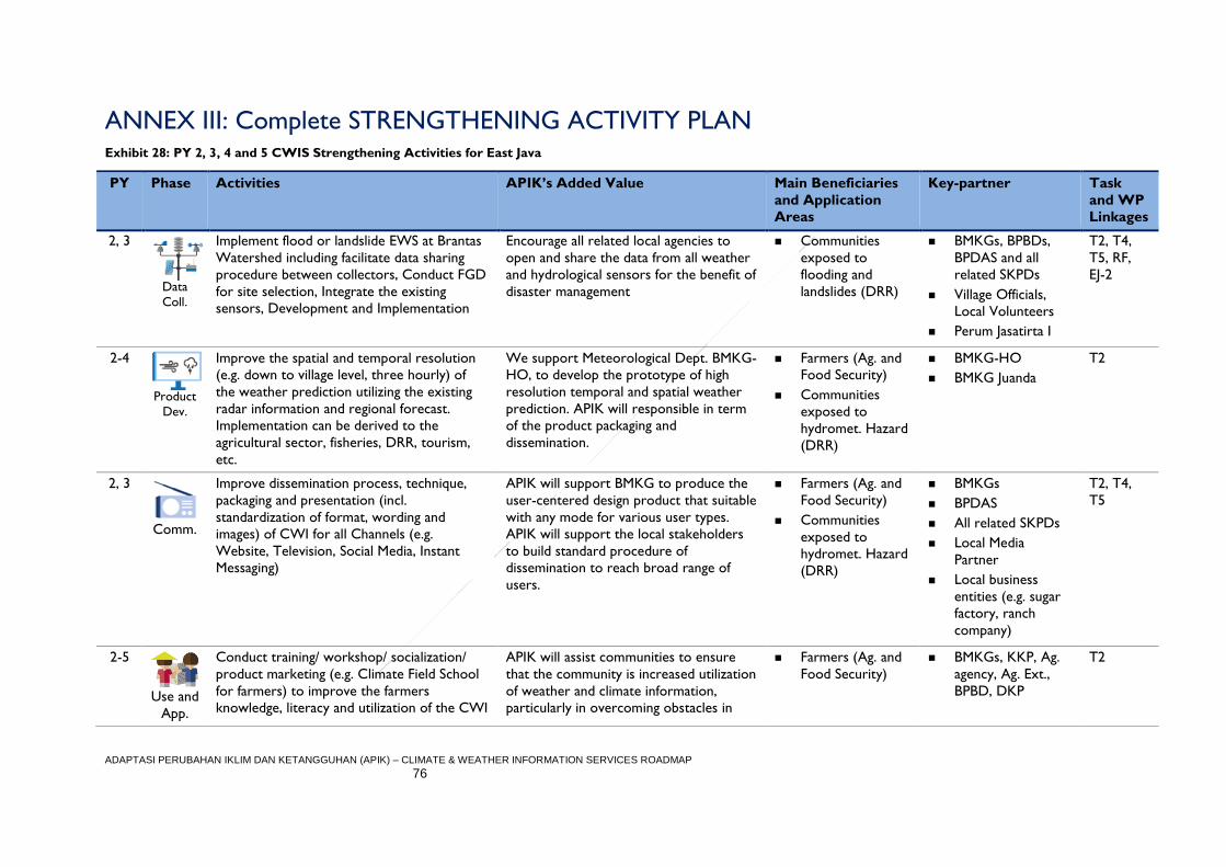
ADAPTASI PERUBAHAN IKLIM DAN KETANGGUHAN (APIK) – CLIMATE & WEATHER INFORMATION SERVICES ROADMAP
76
ANNEX III: Complete STRENGTHENING ACTIVITY PLAN Exhibit 28: PY 2, 3, 4 and 5 CWIS Strengthening Activities for East Java
PY Phase Activities APIK’s Added Value Main Beneficiaries
and Application
Areas
Key-partner Task
and WP
Linkages
2, 3
Data
Coll.
Implement flood or landslide EWS at Brantas
Watershed including facilitate data sharing
procedure between collectors, Conduct FGD
for site selection, Integrate the existing
sensors, Development and Implementation
Encourage all related local agencies to
open and share the data from all weather
and hydrological sensors for the benefit of
disaster management
Communities
exposed to
flooding and
landslides (DRR)
BMKGs, BPBDs,
BPDAS and all
related SKPDs
Village Officials,
Local Volunteers
Perum Jasatirta I
T2, T4,
T5, RF,
EJ-2
2-4
Product
Dev.
Improve the spatial and temporal resolution
(e.g. down to village level, three hourly) of
the weather prediction utilizing the existing
radar information and regional forecast.
Implementation can be derived to the
agricultural sector, fisheries, DRR, tourism,
etc.
We support Meteorological Dept. BMKG-
HO, to develop the prototype of high
resolution temporal and spatial weather
prediction. APIK will responsible in term
of the product packaging and
dissemination.
Farmers (Ag. and
Food Security)
Communities
exposed to
hydromet. Hazard
(DRR)
BMKG-HO
BMKG Juanda
T2
2, 3
Comm.
Improve dissemination process, technique,
packaging and presentation (incl.
standardization of format, wording and
images) of CWI for all Channels (e.g.
Website, Television, Social Media, Instant
Messaging)
APIK will support BMKG to produce the
user-centered design product that suitable
with any mode for various user types.
APIK will support the local stakeholders
to build standard procedure of
dissemination to reach broad range of
users.
Farmers (Ag. and
Food Security)
Communities
exposed to
hydromet. Hazard
(DRR)
BMKGs
BPDAS
All related SKPDs
Local Media
Partner
Local business
entities (e.g. sugar
factory, ranch
company)
T2, T4,
T5
2-5
Use and
App.
Conduct training/ workshop/ socialization/
product marketing (e.g. Climate Field School
for farmers) to improve the farmers
knowledge, literacy and utilization of the CWI
APIK will assist communities to ensure
that the community is increased utilization
of weather and climate information,
particularly in overcoming obstacles in
Farmers (Ag. and
Food Security)
BMKGs, KKP, Ag.
agency, Ag. Ext.,
BPBD, DKP
T2
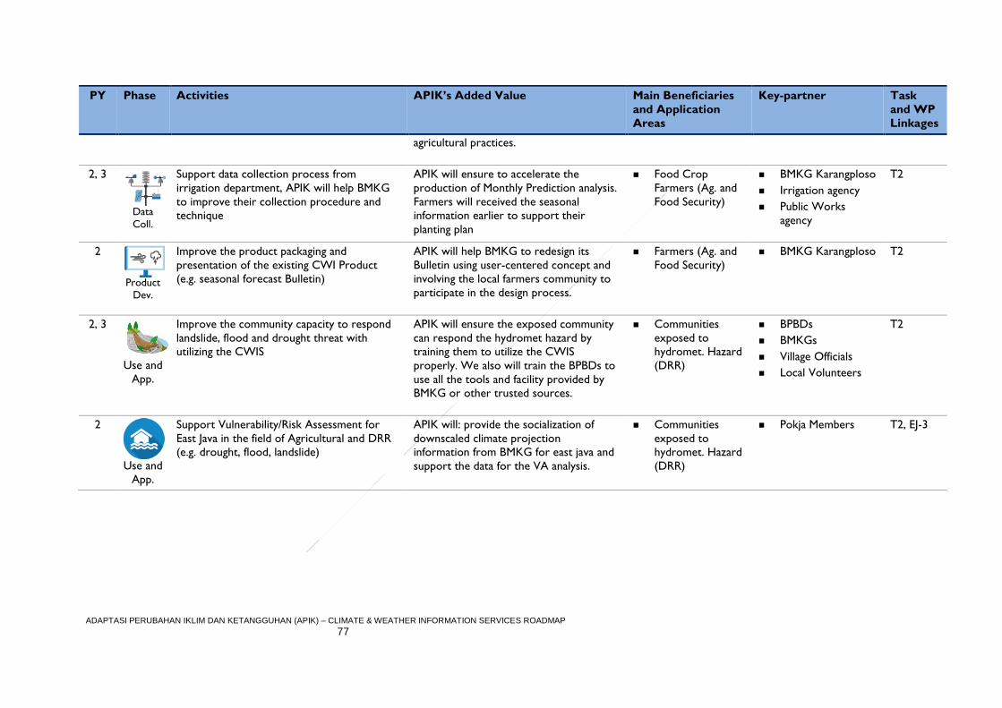
ADAPTASI PERUBAHAN IKLIM DAN KETANGGUHAN (APIK) – CLIMATE & WEATHER INFORMATION SERVICES ROADMAP
77
PY Phase Activities APIK’s Added Value Main Beneficiaries
and Application
Areas
Key-partner Task
and WP
Linkages
agricultural practices.
2, 3
Data
Coll.
Support data collection process from
irrigation department, APIK will help BMKG
to improve their collection procedure and
technique
APIK will ensure to accelerate the
production of Monthly Prediction analysis.
Farmers will received the seasonal
information earlier to support their
planting plan
Food Crop
Farmers (Ag. and
Food Security)
BMKG Karangploso
Irrigation agency
Public Works
agency
T2
2
Product
Dev.
Improve the product packaging and
presentation of the existing CWI Product
(e.g. seasonal forecast Bulletin)
APIK will help BMKG to redesign its
Bulletin using user-centered concept and
involving the local farmers community to
participate in the design process.
Farmers (Ag. and
Food Security)
BMKG Karangploso
T2
2, 3
Use and
App.
Improve the community capacity to respond
landslide, flood and drought threat with
utilizing the CWIS
APIK will ensure the exposed community
can respond the hydromet hazard by
training them to utilize the CWIS
properly. We also will train the BPBDs to
use all the tools and facility provided by
BMKG or other trusted sources.
Communities
exposed to
hydromet. Hazard
(DRR)
BPBDs
BMKGs
Village Officials
Local Volunteers
T2
2
Use and
App.
Support Vulnerability/Risk Assessment for
East Java in the field of Agricultural and DRR
(e.g. drought, flood, landslide)
APIK will: provide the socialization of
downscaled climate projection
information from BMKG for east java and
support the data for the VA analysis.
Communities
exposed to
hydromet. Hazard
(DRR)
Pokja Members T2, EJ-3
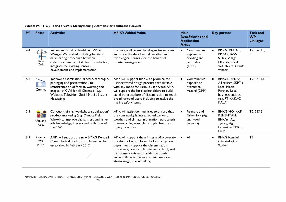
ADAPTASI PERUBAHAN IKLIM DAN KETANGGUHAN (APIK) – CLIMATE & WEATHER INFORMATION SERVICES ROADMAP
78
Exhibit 29: PY 2, 3, 4 and 5 CWIS Strengthening Activities for Southeast Sulawesi
PY Phase Activities APIK’s Added Value Main
Beneficiaries and
Application
Areas
Key-partner Task and
WP
Linkages
2-4
Data
Coll.
Implement flood or landslide EWS at
Wanggu Watershed including facilitate
data sharing procedure between
collectors, conduct FGD for site selection,
integrate the existing sensors,
development and implementation
Encourage all related local agencies to open
and share the data from all weather and
hydrological sensors for the benefit of
disaster management
Communities
exposed to
flooding and
landslides
(DRR)
BPBDs, BMKGs,
BPDAS, BWS
Sultra, Village
Officials, Local
Volunteers, Grants
winner
T2, T4, T5,
RF
2, 3
Comm.
Improve dissemination process, technique,
packaging and presentation (incl.
standardization of format, wording and
images) of CWI for all Channels (e.g.
Website, Television, Social Media, Instant
Messaging)
APIK will support BMKG to produce the
user-centered design product that suitable
with any mode for various user types. APIK
will support the local stakeholders to build
standard procedure of dissemination to reach
broad range of users including to tackle the
marine safety issues
Communities
exposed to
hydromet.
Hazard (DRR)
BMKGs, BPDAS,
All related SKPDs,
Local Media
Partner, Local
business entities
(e.g. PT KAKAO
KALA)
T2, T4, T5
2-5
Use and
App.
Conduct training/ workshop/ socialization/
product marketing (e.g. Climate Field
School) to improve the farmers and fisher
folk knowledge, literacy and utilization of
the CWI
APIK will assist communities to ensure that
the community is increased utilization of
weather and climate information, particularly
in overcoming obstacles in agricultural and
fishery practices.
Farmers and
Fisher folk (Ag.
and Food
Security)
BMKG-HO, KKP,
KEMENTAN,
BMKGs, Ag.
agency, Ag.
Extension, BPBD,
DKP
T2, SES-5
2-3 One or
two
phase
APIK will support the new BMKG Kendari
Climatological Station that planned to be
established in February 2017
APIK will support them in term of accelerate
the data collection from the local irrigation
department, support the dissemination
procedure, conduct climate field school, and
plan some solution to tackle the coastal
vulnerabilities issues (e.g. coastal erosion,
storm surge, marine safety)
All BMKG Kendari
Climatological
Station
T2
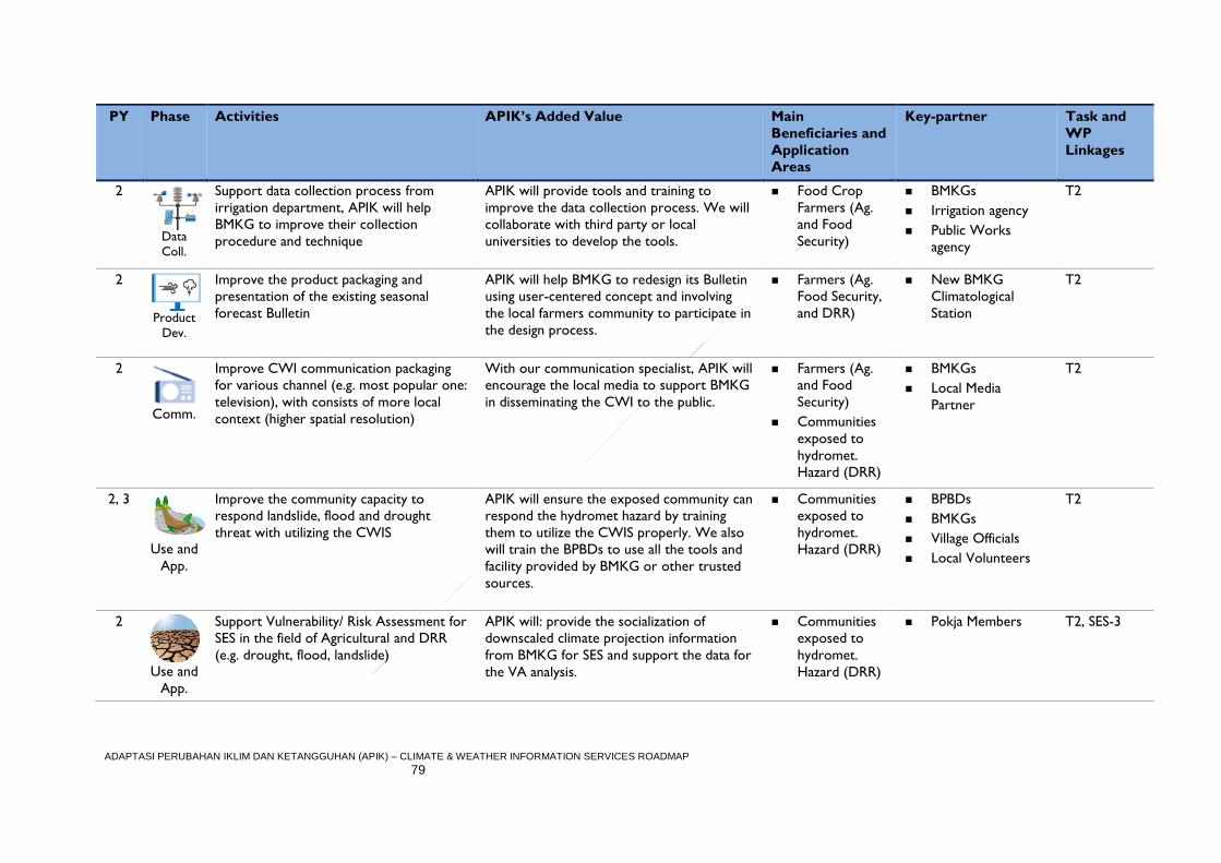
ADAPTASI PERUBAHAN IKLIM DAN KETANGGUHAN (APIK) – CLIMATE & WEATHER INFORMATION SERVICES ROADMAP
79
PY Phase Activities APIK’s Added Value Main
Beneficiaries and
Application
Areas
Key-partner Task and
WP
Linkages
2
Data
Coll.
Support data collection process from
irrigation department, APIK will help
BMKG to improve their collection
procedure and technique
APIK will provide tools and training to
improve the data collection process. We will
collaborate with third party or local
universities to develop the tools.
Food Crop
Farmers (Ag.
and Food
Security)
BMKGs
Irrigation agency
Public Works
agency
T2
2
Product
Dev.
Improve the product packaging and
presentation of the existing seasonal
forecast Bulletin
APIK will help BMKG to redesign its Bulletin
using user-centered concept and involving
the local farmers community to participate in
the design process.
Farmers (Ag.
Food Security,
and DRR)
New BMKG
Climatological
Station
T2
2
Comm.
Improve CWI communication packaging
for various channel (e.g. most popular one:
television), with consists of more local
context (higher spatial resolution)
With our communication specialist, APIK will
encourage the local media to support BMKG
in disseminating the CWI to the public.
Farmers (Ag.
and Food
Security)
Communities
exposed to
hydromet.
Hazard (DRR)
BMKGs
Local Media
Partner
T2
2, 3
Use and
App.
Improve the community capacity to
respond landslide, flood and drought
threat with utilizing the CWIS
APIK will ensure the exposed community can
respond the hydromet hazard by training
them to utilize the CWIS properly. We also
will train the BPBDs to use all the tools and
facility provided by BMKG or other trusted
sources.
Communities
exposed to
hydromet.
Hazard (DRR)
BPBDs
BMKGs
Village Officials
Local Volunteers
T2
2
Use and
App.
Support Vulnerability/ Risk Assessment for
SES in the field of Agricultural and DRR
(e.g. drought, flood, landslide)
APIK will: provide the socialization of
downscaled climate projection information
from BMKG for SES and support the data for
the VA analysis.
Communities
exposed to
hydromet.
Hazard (DRR)
Pokja Members T2, SES-3
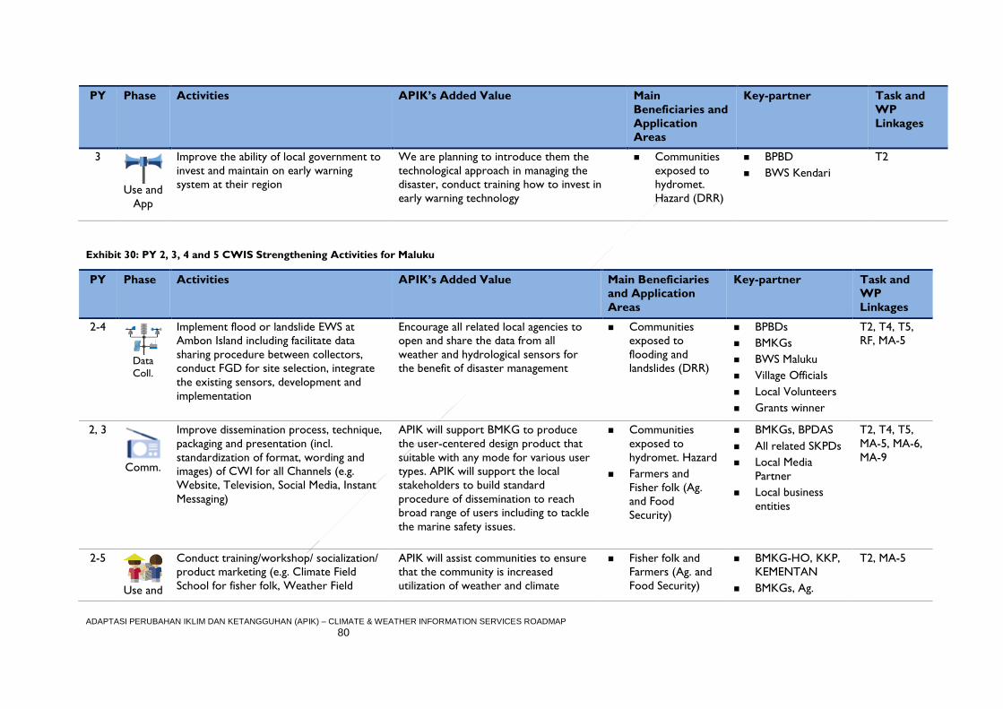
ADAPTASI PERUBAHAN IKLIM DAN KETANGGUHAN (APIK) – CLIMATE & WEATHER INFORMATION SERVICES ROADMAP
80
PY Phase Activities APIK’s Added Value Main
Beneficiaries and
Application
Areas
Key-partner Task and
WP
Linkages
3
Use and
App
Improve the ability of local government to
invest and maintain on early warning
system at their region
We are planning to introduce them the
technological approach in managing the
disaster, conduct training how to invest in
early warning technology
Communities
exposed to
hydromet.
Hazard (DRR)
BPBD
BWS Kendari
T2
Exhibit 30: PY 2, 3, 4 and 5 CWIS Strengthening Activities for Maluku
PY Phase Activities APIK’s Added Value Main Beneficiaries
and Application
Areas
Key-partner Task and
WP
Linkages
2-4
Data
Coll.
Implement flood or landslide EWS at
Ambon Island including facilitate data
sharing procedure between collectors,
conduct FGD for site selection, integrate
the existing sensors, development and
implementation
Encourage all related local agencies to
open and share the data from all
weather and hydrological sensors for
the benefit of disaster management
Communities
exposed to
flooding and
landslides (DRR)
BPBDs
BMKGs
BWS Maluku
Village Officials
Local Volunteers
Grants winner
T2, T4, T5,
RF, MA-5
2, 3
Comm.
Improve dissemination process, technique,
packaging and presentation (incl.
standardization of format, wording and
images) of CWI for all Channels (e.g.
Website, Television, Social Media, Instant
Messaging)
APIK will support BMKG to produce
the user-centered design product that
suitable with any mode for various user
types. APIK will support the local
stakeholders to build standard
procedure of dissemination to reach
broad range of users including to tackle
the marine safety issues.
Communities
exposed to
hydromet. Hazard
Farmers and
Fisher folk (Ag.
and Food
Security)
BMKGs, BPDAS
All related SKPDs
Local Media
Partner
Local business
entities
T2, T4, T5,
MA-5, MA-6,
MA-9
2-5
Use and
Conduct training/workshop/ socialization/
product marketing (e.g. Climate Field
School for fisher folk, Weather Field
APIK will assist communities to ensure
that the community is increased
utilization of weather and climate
Fisher folk and
Farmers (Ag. and
Food Security)
BMKG-HO, KKP,
KEMENTAN
BMKGs, Ag.
T2, MA-5
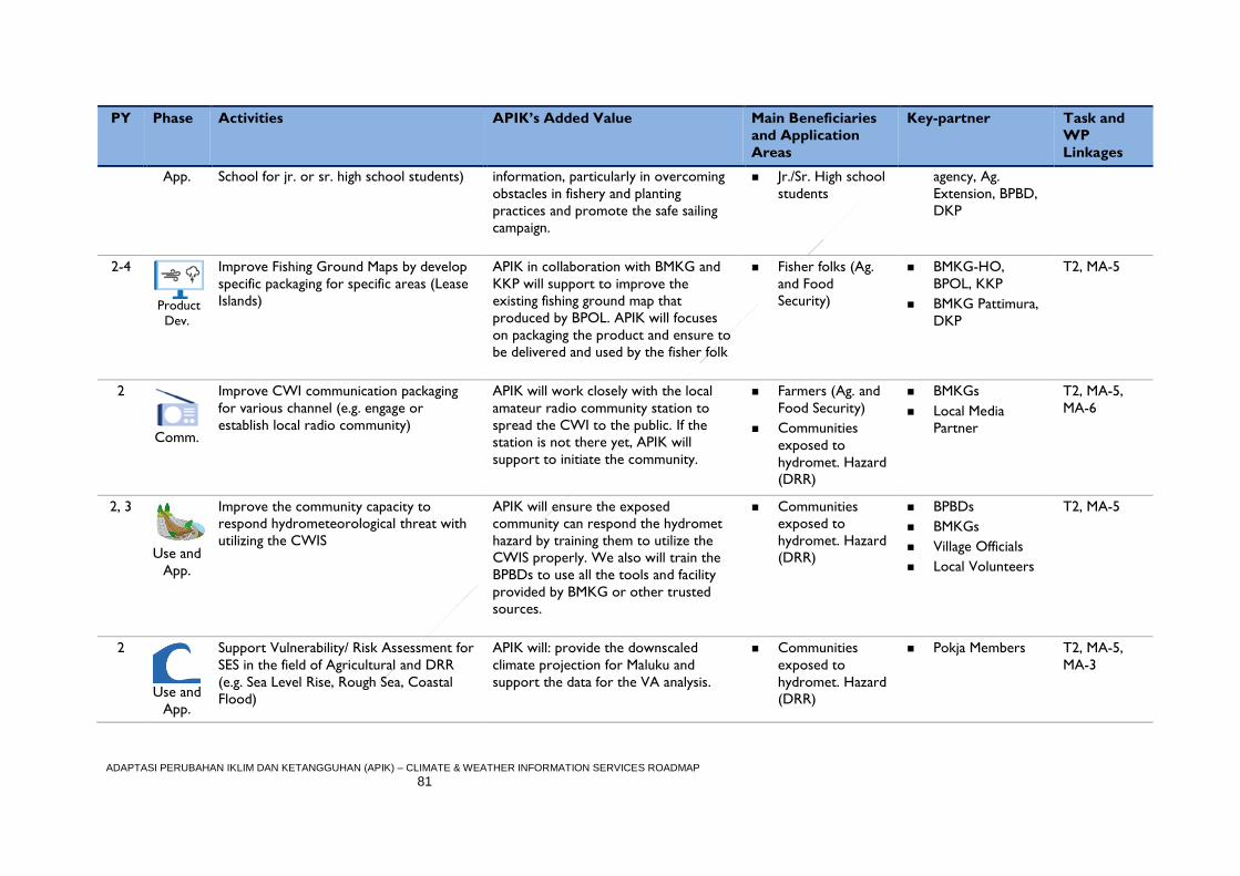
ADAPTASI PERUBAHAN IKLIM DAN KETANGGUHAN (APIK) – CLIMATE & WEATHER INFORMATION SERVICES ROADMAP
81
PY Phase Activities APIK’s Added Value Main Beneficiaries
and Application
Areas
Key-partner Task and
WP
Linkages
App. School for jr. or sr. high school students) information, particularly in overcoming
obstacles in fishery and planting
practices and promote the safe sailing
campaign.
Jr./Sr. High school
students
agency, Ag.
Extension, BPBD,
DKP
2-4
Product
Dev.
Improve Fishing Ground Maps by develop
specific packaging for specific areas (Lease
Islands)
APIK in collaboration with BMKG and
KKP will support to improve the
existing fishing ground map that
produced by BPOL. APIK will focuses
on packaging the product and ensure to
be delivered and used by the fisher folk
Fisher folks (Ag.
and Food
Security)
BMKG-HO,
BPOL, KKP
BMKG Pattimura,
DKP
T2, MA-5
2
Comm.
Improve CWI communication packaging
for various channel (e.g. engage or
establish local radio community)
APIK will work closely with the local
amateur radio community station to
spread the CWI to the public. If the
station is not there yet, APIK will
support to initiate the community.
Farmers (Ag. and
Food Security)
Communities
exposed to
hydromet. Hazard
(DRR)
BMKGs
Local Media
Partner
T2, MA-5,
MA-6
2, 3
Use and
App.
Improve the community capacity to
respond hydrometeorological threat with
utilizing the CWIS
APIK will ensure the exposed
community can respond the hydromet
hazard by training them to utilize the
CWIS properly. We also will train the
BPBDs to use all the tools and facility
provided by BMKG or other trusted
sources.
Communities
exposed to
hydromet. Hazard
(DRR)
BPBDs
BMKGs
Village Officials
Local Volunteers
T2, MA-5
2
Use and
App.
Support Vulnerability/ Risk Assessment for
SES in the field of Agricultural and DRR
(e.g. Sea Level Rise, Rough Sea, Coastal
Flood)
APIK will: provide the downscaled
climate projection for Maluku and
support the data for the VA analysis.
Communities
exposed to
hydromet. Hazard
(DRR)
Pokja Members T2, MA-5,
MA-3
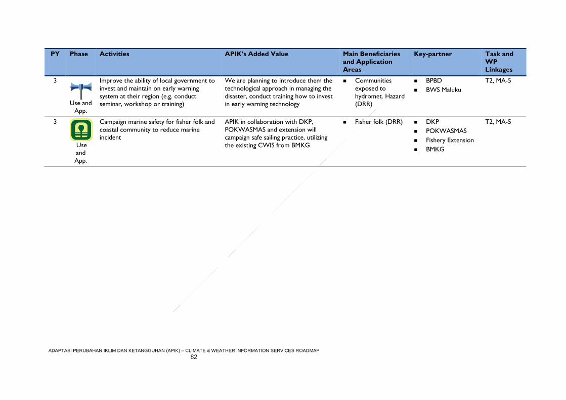
ADAPTASI PERUBAHAN IKLIM DAN KETANGGUHAN (APIK) – CLIMATE & WEATHER INFORMATION SERVICES ROADMAP
82
PY Phase Activities APIK’s Added Value Main Beneficiaries
and Application
Areas
Key-partner Task and
WP
Linkages
3
Use and
App.
Improve the ability of local government to
invest and maintain on early warning
system at their region (e.g. conduct
seminar, workshop or training)
We are planning to introduce them the
technological approach in managing the
disaster, conduct training how to invest
in early warning technology
Communities
exposed to
hydromet. Hazard
(DRR)
BPBD
BWS Maluku
T2, MA-5
3
Use
and
App.
Campaign marine safety for fisher folk and
coastal community to reduce marine
incident
APIK in collaboration with DKP,
POKWASMAS and extension will
campaign safe sailing practice, utilizing
the existing CWIS from BMKG
Fisher folk (DRR) DKP
POKWASMAS
Fishery Extension
BMKG
T2, MA-5