
U.S. GEOLOGICAL SURVEY and the NATIONAL PARK … · Fact Sheet 2012–3127 ... spectacular lava...
6
U.S. Department of the Interior U.S. Geological Survey Fact Sheet 2012–3127 January 2013 The Ongoing Pu‘u ‘Ö‘ö Eruption of Kïlauea Volcano, Hawai‘i—30 Years of Eruptive Activity U.S. GEOLOGICAL SURVEY and the NATIONAL PARK SERVICE—OUR VOLCANIC PUBLIC LANDS T he Pu‘u ‘Ö‘ö eruption of Kïlauea Volcano is its longest rift-zone eruption in more than 500 years. Since the eruption began in 1983, lava flows have buried 48 square miles (125 square kilometers) of land and added about 500 acres (200 hectares) of new land to the Island of Hawai‘i. The eruption not only challenges local communities, which must adapt to an ever-changing and sometimes-destructive environment, but has also drawn millions of visitors to Hawai‘i Volcanoes National Park. U.S. Geological Survey (USGS) scientists closely monitor and evaluate hazards at Hawai‘i’s volcanoes and also work with park rangers to help ensure safe lava viewing for visitors. Just after midnight on January 2, 1983, residents of Hawai‘i Volcanoes National Park and the nearby community of Volcano were awakened by rattling dishes and doors. Hundreds of small earthquakes indicated that magma (underground molten rock) was on the move again, forcing its way from Kīlauea’s summit into the volcano’s East Rift Zone, splitting it like a wedge. Scientists with the U.S. Geological Survey (USGS) Hawaiian Volcano Observatory (HVO) tracked the magma’s progress underground by the locations of these earthquakes. At 12:31 a.m. on January 3, almost exactly 24 hours later, lava broke the surface and began erupting near Nāpau Crater. Thus began the Pu‘u ‘Ō‘ō eruption—an eruption that is still going after 30 years of nearly continuous activity. Kīlauea is the Island of Hawai‘i’s youngest volcano and one of the world’s most active. More than 90 percent of the volcano’s surface has been covered by lava flows in the past 1,000 years. Kīlauea erupts either at its summit or along its East or Southwest Rift Zones. From the early 1800s through 1954, Kīlauea erupted mainly in the volcanic depression (caldera) at its summit. Since 1955, however, most eruptions have occurred along the East Rift Zone. The Pu‘u ‘Ō‘ō eruption, which has produced more than half the volume of lava erupted by Kīlauea in the past 190 years, is by far the largest of these eruptions. 1983–1986: The Rise of Pu‘u ‘Ö‘ö During the opening days of the eruption, fissures extended nearly 5 miles (8 kilometers) along Kīlauea’s East Rift Zone, but activity soon became localized along a shorter section of the fissure system that stretched between the forested volcanic cones of Pu‘u Kamoamoa and Pu‘u Kahauale‘a. Lava erupted intermittently in this area over the next 5 months, building Pu‘u Halulu—the first substantial vent structure of the eruption. In mid-June 1983, the eruption finally focused at one vent, now known as Pu‘u ‘Ō‘ō, which straddled the national park boundary about 12 miles (19 kilometers) from Kīlauea’s summit caldera. From then until mid-1986, Pu‘u ‘Ō‘ō was the site of Lava slowly engulfs rainforest on March 6, 2011, during the Kamoamoa fissure eruption—a brief interlude during Kïlauea Volcano’s long-lived Puÿu ÿÖÿö eruption (USGS photo by Tim Orr). spectacular lava fountains—44 episodes in total—that were visible and audible for miles around. Towering as high as 1,500 feet (460 meters), the fallout from these fountains built the Pu‘u ‘Ō‘ō cone, which reached a height of 835 feet (255 meters). The fountains, occurring every 3 to 4 weeks and lasting about a day, fed thick ‘a‘ā flows—the less fluid of the two types of Hawaiian lava flows—that blanketed the surrounding landscape. Some of these flows reached the sparsely populated Royal Gardens subdivision, and several houses were destroyed. 1986–1992: Eruption Shifts to Kupaianaha In July 1986, the magma conduit beneath Pu‘u ‘Ō‘ō ruptured, and new fissures opened and extended 2 miles (3 kilometers) downrift from the base of the cone. The easternmost fissure evolved into a single vent, later named Kupaianaha. This event marked the beginning of 5½ years of nearly continuous, quiet effusion Depa rtme nt of the Interio r
Transcript of U.S. GEOLOGICAL SURVEY and the NATIONAL PARK … · Fact Sheet 2012–3127 ... spectacular lava...

U.S. Department of the InteriorU.S. Geological Survey
Fact Sheet 2012–3127January 2013
The Ongoing Pu‘u ‘Ö‘ö Eruption of Kïlauea Volcano, Hawai‘i—30 Years of Eruptive Activity
U.S. GEOLOGICAL SURVEY and the NATIONAL PARK SERVICE—OUR VOLCANIC PUBLIC LANDS
The Pu‘u ‘Ö‘ö eruption of Kïlauea Volcano is its longest rift-zone
eruption in more than 500 years. Since the eruption began in 1983, lava flows have buried 48 square miles (125 square kilometers) of land and added about 500 acres (200 hectares) of new land to the Island of Hawai‘i. The eruption not only challenges local communities, which must adapt to an ever-changing and sometimes-destructive environment, but has also drawn millions of visitors to Hawai‘i Volcanoes National Park. U.S. Geological Survey (USGS) scientists closely monitor and evaluate hazards at Hawai‘i’s volcanoes and also work with park rangers to help ensure safe lava viewing for visitors.
Just after midnight on January 2, 1983, residents of Hawai‘i Volcanoes National Park and the nearby community of Volcano were awakened by rattling dishes and doors. Hundreds of small earthquakes indicated that magma (underground molten rock) was on the move again, forcing its way from Kīlauea’s summit into the volcano’s East Rift Zone, splitting it like a wedge. Scientists with the U.S. Geological Survey (USGS) Hawaiian Volcano Observatory (HVO) tracked the magma’s progress underground by the locations of these earthquakes. At 12:31 a.m. on January 3, almost exactly 24 hours later, lava broke the surface and began erupting near Nāpau Crater. Thus began the Pu‘u ‘Ō‘ō eruption—an eruption that is still going after 30 years of nearly continuous activity.
Kīlauea is the Island of Hawai‘i’s youngest volcano and one of the world’s most active. More than 90 percent of the volcano’s surface has been covered by lava flows in the past 1,000 years. Kīlauea erupts either at its summit or along its East or Southwest Rift Zones. From the early 1800s through 1954, Kīlauea erupted mainly in the volcanic depression (caldera) at its summit.
Since 1955, however, most eruptions have occurred along the East Rift Zone. The Pu‘u ‘Ō‘ō eruption, which has produced more than half the volume of lava erupted by Kīlauea in the past 190 years, is by far the largest of these eruptions.
1983–1986: The Rise of Pu‘u ‘Ö‘öDuring the opening days of the
eruption, fissures extended nearly 5 miles (8 kilometers) along Kīlauea’s East Rift Zone, but activity soon became localized along a shorter section of the fissure system that stretched between the forested volcanic cones of Pu‘u Kamoamoa and Pu‘u Kahauale‘a. Lava erupted intermittently in this area over the next 5 months, building Pu‘u Halulu—the first substantial vent structure of the eruption.
In mid-June 1983, the eruption finally focused at one vent, now known as Pu‘u ‘Ō‘ō, which straddled the national park boundary about 12 miles (19 kilometers) from Kīlauea’s summit caldera. From then until mid-1986, Pu‘u ‘Ō‘ō was the site of
Lava slowly engulfs rainforest on March 6, 2011, during the Kamoamoa fissure eruption—a brief interlude during Kïlauea Volcano’s long-lived Puÿu ÿÖÿö eruption (USGS photo by Tim Orr).
spectacular lava fountains—44 episodes in total—that were visible and audible for miles around. Towering as high as 1,500 feet (460 meters), the fallout from these fountains built the Pu‘u ‘Ō‘ō cone, which reached a height of 835 feet (255 meters). The fountains, occurring every 3 to 4 weeks and lasting about a day, fed thick ‘a‘ā flows—the less fluid of the two types of Hawaiian lava flows—that blanketed the surrounding landscape. Some of these flows reached the sparsely populated Royal Gardens subdivision, and several houses were destroyed.
1986–1992: Eruption Shifts to Kupaianaha
In July 1986, the magma conduit beneath Pu‘u ‘Ō‘ō ruptured, and new fissures opened and extended 2 miles (3 kilometers) downrift from the base of the cone. The easternmost fissure evolved into a single vent, later named Kupaianaha. This event marked the beginning of 5½ years of nearly continuous, quiet effusion
Departme ntof the Interio r

of lava. A tadpole-shaped lava lake 460 feet (140 meters) across formed over the vent, and frequent overflows built a broad, low shield 185 feet (56 meters) high in less than a year. During this period, the top of the Pu‘u ‘Ō‘ō cone collapsed progressively, forming a crater that often contained a small lava lake.
Pāhoehoe flows (the more fluid of the two types of Hawaiian lava flows) from Kupaianaha spread slowly downslope, constructing lava tubes as they advanced. On November 28, 1986, these flows reached the Pacific Ocean, 7.5 miles (12 kilometers) away, after cutting a swath through the community of Kapa‘ahu and closing the coastal highway. Over the next 5 years, lava flows overran houses on both sides of the ever-widening flow field. The village of Kalapana was almost completely buried, and its famous black sand beach was destroyed as nearby Kaimū Bay was filled by lava.
flows advanced slowly downslope, reaching the ocean in November 1992. From the end of 1992 through January 1997, tubes fed lava to the ocean almost continuously and widened the existing flow field, which was mostly contained within Hawai‘i Volcanoes National Park. The growing lava shield on the side of Pu‘u ‘Ō‘ō became pockmarked with collapse pits as lava tubes eroded down into the thick deposits of buried tephra (fragments of volcanic material) on the cone’s flank.
On January 29, 1997, a swarm of earthquakes struck Kīlauea’s East Rift Zone as the conduit leading to Pu‘u ‘Ō‘ō ruptured, cutting off the supply of magma to the ongoing eruption. The lava lake in Pu‘u ‘Ō‘ō drained, and residents 10 miles (16 kilometers) away heard a low, rumbling roar as the crater floor dropped 500 feet (150 meters) and the west wall of the Pu‘u ‘Ō‘ō cone collapsed. A few hours later, magma found a new path to the surface in nearby Nāpau Crater, and lava fountains lit up the night sky.
The eruption in Nāpau Crater lasted less than a day, and was followed by a 24-day hiatus, during which there was no eruptive activity on Kīlauea. Lava reappeared in the crater of Pu‘u ‘Ō‘ō in late February 1997 and erupted outside the cone a month later. Several new flank vents opened over the following few months, and tube-fed pāhoehoe flows began to advance downslope again, reaching the ocean within the national park in July. During these months, Pu‘u ‘Ō‘ō filled with lava and overflowed for the first time in 11 years.
From early 1998 through 2001, lava flowed almost continuously to the ocean, and eruptive activity within Pu‘u ‘Ō‘ō dropped to its lowest level since 1990. In early 2002, activity within Pu‘u ‘Ō‘ō increased briefly, with multiple vents erupting lava flows that filled the crater to within 33 feet (10 meters) of its east rim. On May 12, 2002, lava burst through the shield on the western flank of Pu‘u ‘Ō‘ō and advanced downslope along the western margin of the flow field. Flows began to enter the ocean near the end of Chain of Craters Road in the national park in mid-July, drawing as many as 4,000 visitors per day.
Activity at Pu‘u ‘Ō‘ō picked up again in late 2003, and lava filled the crater to overflowing by January 2004.
The first 3½ years of the Pu‘u ‘Öÿö eruption of Kïlauea Volcano (January 1983–June 1986) were dominated by episodic lava fountains that constructed the Pu‘u ‘Öÿö cone and fed ‘a‘ä flows (the less fluid of the two types of Hawaiian lava flows) (USGS photo by J.D. Griggs, June 1984). The map shows lava flows erupted from Kïlauea Volcano in the 19th and 20th centuries (gray). These flows originated from the summit caldera, the East Rift Zone, or the Southwest Rift Zone (not shown). Flows erupted during the first 3½ years of the Pu‘u ‘Öÿö eruption are shown in red. The Island of Hawai‘i (see inset map) is composed of five volcanoes—Kohala, Mauna Kea, Hualälai, Mauna Loa, and Kïlauea.
The First Years of Pu‘u ‘Öÿö (January 1983–June 1986)
By 1991, lava output from Kupaianaha was in steady decline, while activity at Pu‘u ‘Ō‘ō began to increase proportionately. Magma pressure increased uprift of Kupaianaha, and for 3 weeks in November 1991, new fissures erupted between Kupaianaha and Pu‘u ‘Ō‘ō. The rate of lava erupted from Kupaianaha continued to wane afterwards and, on February 7, 1992, finally stopped.
1992–2007: Activity Returns to Pu‘u ‘Ö‘ö
Ten days later, on February 17, 1992, eruptive activity returned to Pu‘u ‘Ō‘ō. Low lava fountains erupted from a fissure on the west flank of the massive cone. This was the first in a series of flank vents that gradually built a lava shield 425 feet (130 meters) high, banked against the southwestern slope of Pu‘u ‘Ō‘ō. As at Kupaianaha, pāhoehoe
155°15' 155°10' 155°05' 155°00'
19°25'
19°20'
P A C I F I C O C E A N
KīlaueaCaldera
Hawai‘i Volcanoes National Park
EAST RIFT ZONE
EAST RIFT ZONE
Chain of Craters Road
0 1 2 3 4 MILES
0 1 2 3 4 KILOMETERS
130
11
Pu‘u ‘Ō‘ō
Island ofHawai‘i
Map area
Kohala
Mauna Loa
Mauna Kea
Kīlauea
Hualālai
Kalapana
2
155°15' 155°10'
19°25'
19°20'
KilaueaCaldera
Hawai‘i Volcanoes National Park
EAST RIFT ZONE
Chain of Craters Road
11
155°05' 155°00'
0 1 2 3 4 MILES
0 1 2 3 4 KILOMETERS
EAST RIFT ZONE
130
P A C I F I C O C E A N
Pu‘u ‘Ō‘ō
Kupaianaha
Island ofHawai‘i
Map area
Kohala
Mauna Loa
Mauna Kea
Kīlauea
Hualālai
Kalapana
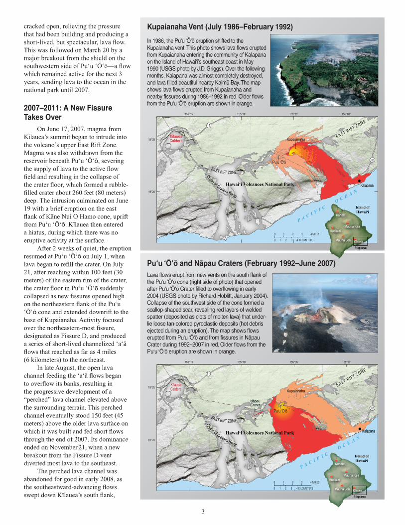
In 1986, the Pu‘u ‘Öÿö eruption shifted to the Kupaianaha vent. This photo shows lava flows erupted from Kupaianaha entering the community of Kalapana on the Island of Hawai‘i’s southeast coast in May 1990 (USGS photo by J.D. Griggs). Over the following months, Kalapana was almost completely destroyed, and lava filled beautiful nearby Kaimü Bay. The map shows lava flows erupted from Kupaianaha and nearby fissures during 1986–1992 in red. Older flows from the Pu‘u ‘Öÿö eruption are shown in orange.
Kupaianaha Vent (July 1986–February1992)
Lava flows erupt from new vents on the south flank of the Pu‘u ‘Öÿö cone (right side of photo) that opened after Pu‘u ‘Öÿö Crater filled to overflowing in early 2004 (USGS photo by Richard Hoblitt, January 2004). Collapse of the southwest side of the cone formed a scallop-shaped scar, revealing red layers of welded spatter (deposited as clots of molten lava) that under-lie loose tan-colored pyroclastic deposits (hot debris ejected during an eruption). The map shows flows erupted from Pu‘u ‘Öÿö and from fissures in Näpau Crater during 1992–2007 in red. Older flows from the Pu‘u ‘Öÿö eruption are shown in orange.
Pu‘u ‘Öÿö and Näpau Craters (February 1992–June 2007)
155°15' 155°10' 155°05' 155°00'
19°25'
19°20'
130
11
KīlaueaCaldera
EAST RIFT ZONE
EAST RIFT ZONE
Chain of Craters Road
P A C I F I C O C E A NHawai‘i Volcanoes National Park
Kupaianaha
NäpauCraterNäpauCrater
Pu‘u ‘Ō‘ō
0 1 2 3 4 MILES
0 1 2 3 4 KILOMETERS
Island ofHawai‘i
Map area
Kohala
Mauna Loa
Mauna Kea
Kīlauea
Hualālai
Kalapana
cracked open, relieving the pressure that had been building and producing a
This was followed on March 20 by a major breakout from the shield on the
which remained active for the next 3 years, sending lava to the ocean in the national park until 2007.
2007–2011: A New Fissure Takes Over
On June 17, 2007, magma from Kīlauea’s summit began to intrude into the volcano’s upper East Rift Zone. Magma was also withdrawn from the reservoir beneath Pu‘u ‘Ō‘ō, severing
deep. The intrusion culminated on June 19 with a brief eruption on the east
from Pu‘u ‘Ō‘ō. Kīlauea then entered a hiatus, during which there was no eruptive activity at the surface.
After 2 weeks of quiet, the eruption resumed at Pu‘u ‘Ō‘ō on July 1, when
21, after reaching within 100 feet (30 meters) of the eastern rim of the crater,
‘Ō‘ō cone and extended downrift to the base of Kupaianaha. Activity focused
designated as Fissure D, and produced a series of short-lived channelized ‘a‘ā
(6 kilometers) to the northeast.
In late August, the open lava
the progressive development of a “perched” lava channel elevated above the surrounding terrain. This perched channel eventually stood 150 feet (45 meters) above the older lava surface on
through the end of 2007. Its dominance ended on November 21, when a new breakout from the Fissure D vent diverted most lava to the southeast.
The perched lava channel was abandoned for good in early 2008, as
3
1992)

A lava channel, elevated as much as 150 feet (45 meters) above the adjacent terrain, transports lava away from the Fissure D vent, which opened in July 2007 (USGS photo by James Kauahikaua, October 2007). The “perched” (elevated) lava channel was the main path for lava until November 2007, when lava was diverted from the vent to the southeast. Pu‘u ‘Öÿö is at upper right. The map shows lava flows erupted in Pu‘u ‘Öÿö and from the Fissure D vent between Pu‘u ‘Öÿö and Kupaia-naha during 2007–2011 in red. Older flows from the Pu‘u ‘Öÿö eruption are shown in orange.
155°15' 155°10' 155°05' 155°00'
19°25'
19°20'
130
11
KīlaueaCaldera
EAST RIFT ZONE
EAST RIFT ZONE
Chain of Craters Road
P A C I F I C O C E A N
Hawai‘i Volcanoes National Park
Kupaianaha
FissureD vent
Pu‘u ‘Ō‘ō
0 1 2 3 4 MILES
0 1 2 3 4 KILOMETERS
Island ofHawai‘i
Map area
Kohala
Mauna Loa
Mauna Kea
Kīlauea
Hualālai
Kalapana
Pu‘u ‘Öÿö and the Fissure D Vent (July 2007–March 2011)
the southeastward-advancing flows swept down Kīlauea’s south flank, reaching the Pacific Ocean on March 5. Flow activity was relatively stable for the next 2 years, even with the opening of a new eruptive vent within Halema‘uma‘u Crater at Kīlauea’s summit in mid-March 2008.
In January 2010, however, the tube system broke down, and surface flows began moving toward the east, encroaching on the Kalapana area once again. Three more houses were destroyed between July 2010 and March 2011, when the surface flows faltered.
2011–2013: History Repeats Itself
Pu‘u ‘Ō‘ō began to refill slowly during 2010, and by early March 2011, the crater floor was within 65 feet (20 meters) of the crater’s east rim. On March 5, 2011, following rapid summit deflation and increased seismicity, the crater floor of Pu‘u ‘Ō‘ō collapsed. Within a few hours, it had dropped 380 feet (115 meters). Shortly thereafter, lava broke to the surface between Pu‘u ‘Ō‘ō and Nāpau Crater, marking the start of the Kamoamoa fissure eruption, which was active through March 9. Reminiscent of Kīlauea’s 1997 and 2007 East Rift Zone fissure eruptions,
the Kamoamoa eruption cut the lava supply to the active tube, causing activity on the flow field to die.
After 2 weeks of quiet, lava reappeared in Pu‘u ‘Ō‘ō on March 26, and a perched lava lake developed as the crater refilled. In late June, wholesale uplift of the crater floor raised the entire lava lake until its surface was higher than the eastern and western crater rims. Leaks from the “ring” fault bounding the uplifted area resulted in lava overflowing the crater for the first time since 2004, sending flows down the southwestern flank of Pu‘u ‘Ō‘ō.
On August 3, 2011, the crater floor of Pu‘u ‘Ō‘ō collapsed again when lava burst through Pu‘u ‘Ō‘ō’s west flank, burying the western base of the cone in a massive flood of lava. The floor of the crater dropped 260 feet (80 meters), accompanied by the collapse of large slabs of rock from the crater walls into the resulting pit. The flow on the west side of Pu‘u ‘Ō‘ō diminished greatly after the first several hours but remained active until August 15.
As in March, lava returned to Pu‘u ‘Ō‘ō within days of the August outbreak, but this time the crater filled quickly. By September 10, lava had begun to overflow the crater again, with flows spilling toward the northeast and southwest. This activity ended on September 21, when the northeastern
flank of the cone fractured and lava began pouring out.
Confined to a shallow valley between older Pu‘u ‘Ō‘ō flow fields, lava turned again toward the volcano’s southern coast. In March 2012, lava flows destroyed another house—the 214th since 1983—within the now-abandoned Royal Gardens subdivision.
Unlike past years, however, eruptive activity throughout 2012 was relatively weak. Lava flows were almost always active on the coastal flow field but failed to make significant forward progress.
4
Eruption Statistics 1983 to 2013 Lava Flows
• Area covered: 48.4 square miles (125.5 square kilometers)• New land: 500 acres (202 hectares)• Volume erupted: ~1 cubic mile (~4 cubic kilometers)• Thickness along coast: 33 to 115 feet (10 to 35 meters)• Coastal highway covered: 8.9 miles (14.3 kilometers)• Structures destroyed: 214
Pu‘u ‘Öÿö Facts
• Maximum height in 1987: 835 feet (255 meters)• Height in 2012: 560 feet (171 meters)• Crater size: 985 × 1,475 feet (300 × 450 meters)
0 1 2 3 4 MILES
0 1 2 3 4 KILOMETERS
155°15' 155°10' 155°05' 155°00'
19°25'
19°20'
130
11
KīlaueaCaldera
EAST RIFT ZONE
EAST RIFT ZONE
Chain of Craters Road
Hawai‘i Volcanoes National Park
P A C I F I C O C E A N
Kupaianaha
FissureD vent
Pu‘u ‘Ō‘ō
Island ofHawai‘i
Map area
Kohala
Mauna Loa
Mauna Kea
Kīlauea
Hualālai
Kalapana
NäpauCraterNäpauCrater
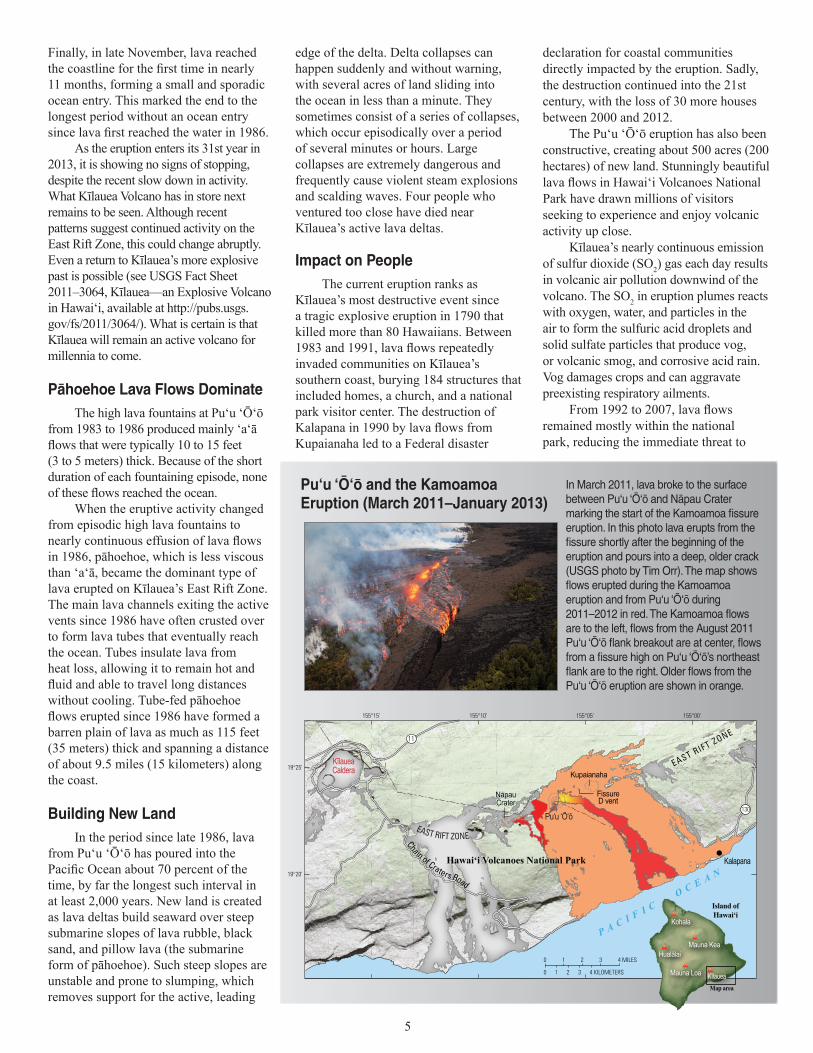
In March 2011, lava broke to the surface between Pu‘u ‘Öÿö and Näpau Crater marking the start of the Kamoamoa fissure eruption. In this photo lava erupts from the fissure shortly after the beginning of the eruption and pours into a deep, older crack (USGS photo by Tim Orr). The map shows flows erupted during the Kamoamoa eruption and from Pu‘u ‘Öÿö during 2011–2012 in red. The Kamoamoa flows are to the left, flows from the August 2011 Pu‘u ‘Öÿö flank breakout are at center, flows from a fissure high on Pu‘u ‘Öÿö’s northeast flank are to the right. Older flows from the Pu‘u ‘Öÿö eruption are shown in orange.
Pu‘u ‘Öÿö and the Kamoamoa Eruption (March 2011–January 2013)
Finally, in late November, lava reached the coastline for the first time in nearly 11 months, forming a small and sporadic ocean entry. This marked the end to the longest period without an ocean entry since lava first reached the water in 1986.
As the eruption enters its 31st year in 2013, it is showing no signs of stopping, despite the recent slow down in activity. What Kīlauea Volcano has in store next remains to be seen. Although recent patterns suggest continued activity on the East Rift Zone, this could change abruptly. Even a return to Kīlauea’s more explosive past is possible (see USGS Fact Sheet 2011–3064, Kīlauea—an Explosive Volcano in Hawai‘i, available at http://pubs.usgs.gov/fs/2011/3064/). What is certain is that Kīlauea will remain an active volcano for millennia to come.
Pähoehoe Lava Flows DominateThe high lava fountains at Pu‘u ‘Ō‘ō
from 1983 to 1986 produced mainly ‘a‘ā flows that were typically 10 to 15 feet (3 to 5 meters) thick. Because of the short duration of each fountaining episode, none of these flows reached the ocean.
When the eruptive activity changed from episodic high lava fountains to nearly continuous effusion of lava flows in 1986, pāhoehoe, which is less viscous than ‘a‘ā, became the dominant type of lava erupted on Kīlauea’s East Rift Zone. The main lava channels exiting the active vents since 1986 have often crusted over to form lava tubes that eventually reach the ocean. Tubes insulate lava from heat loss, allowing it to remain hot and fluid and able to travel long distances without cooling. Tube-fed pāhoehoe flows erupted since 1986 have formed a barren plain of lava as much as 115 feet (35 meters) thick and spanning a distance of about 9.5 miles (15 kilometers) along the coast.
Building New LandIn the period since late 1986, lava
from Pu‘u ‘Ō‘ō has poured into the Pacific Ocean about 70 percent of the time, by far the longest such interval in at least 2,000 years. New land is created as lava deltas build seaward over steep submarine slopes of lava rubble, black sand, and pillow lava (the submarine form of pāhoehoe). Such steep slopes are unstable and prone to slumping, which removes support for the active, leading
edge of the delta. Delta collapses can happen suddenly and without warning, with several acres of land sliding into the ocean in less than a minute. They sometimes consist of a series of collapses, which occur episodically over a period of several minutes or hours. Large collapses are extremely dangerous and frequently cause violent steam explosions and scalding waves. Four people who ventured too close have died near Kīlauea’s active lava deltas.
Impact on PeopleThe current eruption ranks as
Kīlauea’s most destructive event since a tragic explosive eruption in 1790 that killed more than 80 Hawaiians. Between 1983 and 1991, lava flows repeatedly invaded communities on Kīlauea’s southern coast, burying 184 structures that included homes, a church, and a national park visitor center. The destruction of Kalapana in 1990 by lava flows from Kupaianaha led to a Federal disaster
declaration for coastal communities directly impacted by the eruption. Sadly, the destruction continued into the 21st century, with the loss of 30 more houses between 2000 and 2012.
The Pu‘u ‘Ō‘ō eruption has also been constructive, creating about 500 acres (200 hectares) of new land. Stunningly beautiful lava flows in Hawai‘i Volcanoes National Park have drawn millions of visitors seeking to experience and enjoy volcanic activity up close.
Kīlauea’s nearly continuous emission of sulfur dioxide (SO2) gas each day results in volcanic air pollution downwind of the volcano. The SO2 in eruption plumes reacts with oxygen, water, and particles in the air to form the sulfuric acid droplets and solid sulfate particles that produce vog, or volcanic smog, and corrosive acid rain. Vog damages crops and can aggravate preexisting respiratory ailments.
From 1992 to 2007, lava flows remained mostly within the national park, reducing the immediate threat to
4 5
6
residential areas. However, with the shift in vent location to the east side of Pu‘u ‘Ō‘ō in 2007, the threat returned as lava flows again encroached on the Kalapana area. With the establishment of a new vent high on Pu‘u ‘Ō‘ō’s east flank in 2011, the threat remains as the eruption surpasses 30 years. To counter such threats, USGS Hawaiian Volcano Observatory scientists continuously monitor Hawai‘i’s volcanoes to provide reliable and timely warnings of new and ongoing volcanic activity.
Tim R. Orr, Christina Heliker, and Matthew R. Patrick
Edited by James W. Hendley IIGraphic design by Jeanne S. DiLeo
COOPERATING ORGANIZATIONS
Hawaiÿi County Civil Defense Hawaiÿi Volcanoes National Park
University of Hawaiÿi at Hilo
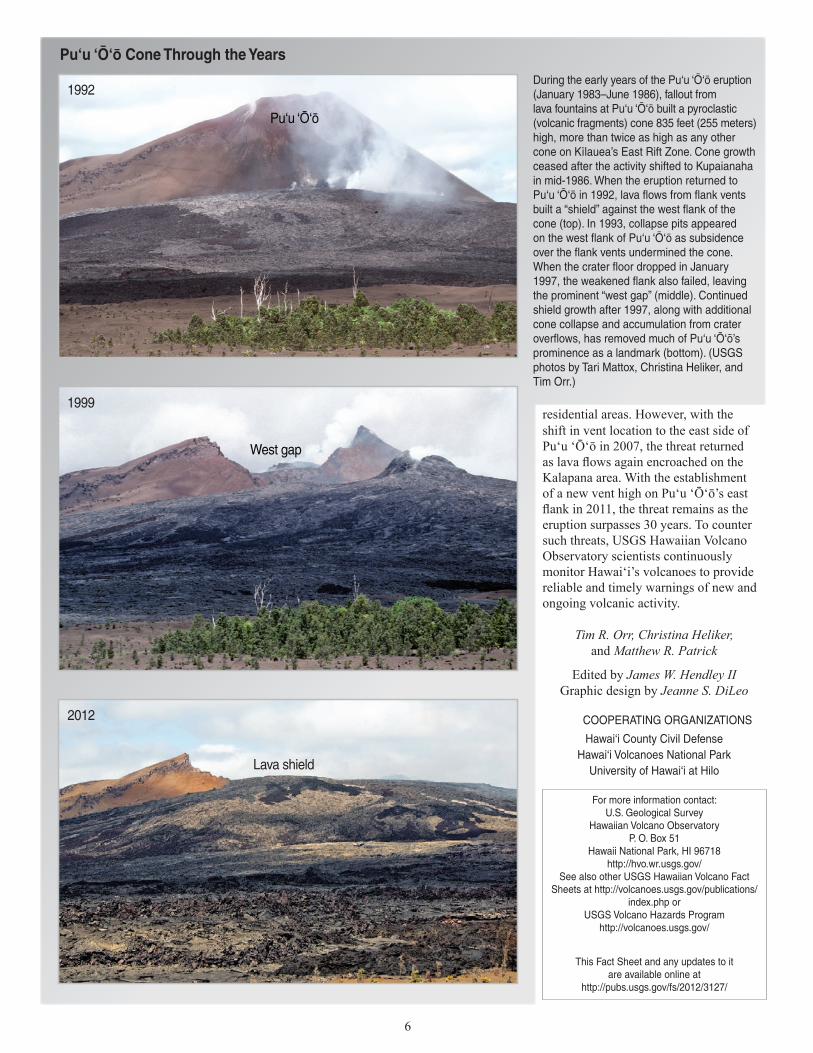
During the early years of the Pu‘u ‘Öÿö eruption (January 1983–June 1986), fallout from lava fountains at Pu‘u ‘Öÿö built a pyroclastic (volcanic fragments) cone 835 feet (255 meters) high, more than twice as high as any other cone on Kïlauea’s East Rift Zone. Cone growth ceased after the activity shifted to Kupaianaha in mid-1986. When the eruption returned to Pu‘u ‘Öÿö in 1992, lava flows from flank vents built a “shield” against the west flank of the cone (top). In 1993, collapse pits appeared on the west flank of Pu‘u ‘Öÿö as subsidence over the flank vents undermined the cone. When the crater floor dropped in January 1997, the weakened flank also failed, leaving the prominent “west gap” (middle). Continued shield growth after 1997, along with additional cone collapse and accumulation from crater overflows, has removed much of Pu‘u ‘Öÿö’s prominence as a landmark (bottom). (USGS photos by Tari Mattox, Christina Heliker, and Tim Orr.)
Pu‘u ‘Öÿö Cone Through the Years
1992
Pu‘u ‘Ō‘ō
1999
West gap
2012
Lava shield
For more information contact:U.S. Geological Survey
Hawaiian Volcano ObservatoryP. O. Box 51
Hawaii National Park, HI 96718http://hvo.wr.usgs.gov/
See also other USGS Hawaiian Volcano Fact Sheets at http://volcanoes.usgs.gov/publications/
index.php orUSGS Volcano Hazards Program
http://volcanoes.usgs.gov/
This Fact Sheet and any updates to it are available online at
http://pubs.usgs.gov/fs/2012/3127/