
U.S. Geological Survey and the California State Water ... · The Salinas Valley is a large...
4
U.S. Department of the Interior U.S. Geological Survey Fact Sheet 2011–3089 July 2011 Printed on recycled paper U.S. Geological Survey and the California State Water Resources Control Board Groundwater Quality in the Monterey Bay and Salinas Valley Groundwater Basins, California Groundwater provides more than 40 percent of California’s drinking water. To protect this vital resource, the State of California created the Groundwater Ambient Monitoring and Assessment (GAMA) Program. The Priority Basin Project of the GAMA Program provides a comprehensive assessment of the State’s groundwater quality and increases public access to groundwater-quality information. The basins around Monterey Bay, and in the Salinas and Paso Robles Valleys, constitute one of the study units being evaluated. Organic constituents Inorganic constituents High Moderate CONSTITUENT CONCENTRATIONS Low or not detected Values are a percentage of the area of the primary aquifers with concentrations in the three specified categories. Values on piechart may not equal 100 due to rounding of percentages. 49 36 15 93 7 <1 Salinas River San Benito River Salinas River San Joaquin River Fresno River Arroyo Seco Los Gatos Creek Carmel River Panoche Creek Cholame Creek Nacimiento River Chowchilla River San Juan Creek Pajaro River San Antonio River San Lorenzo Creek Llagas Creek MADERA CO Salinas Monterey King City Santa Cruz Watsonville Paso Robles Pacific Ocean Monterey Bay Base from U.S. Geological Survey National Elevation Dataset, 2006, Albers Equal-Area Conic Projection EXPLANATION STUDY AREA Santa Cruz Monterey Bay Salinas Valley Paso Robles Groundwater basin boundary Groundwater subbasin boundary 0 20 MILES 0 20 KILOMETERS The Monterey-Salinas Study Unit The Monterey-Salinas study unit is nearly 1,000 square miles and consists of the Santa Cruz Purisima Formation Highlands, Felton Area, Scotts Valley, Soquel Valley, West Santa Cruz Terrace, Salinas Valley, Pajaro Valley, and Carmel Valley groundwater basins (California Department of Water Resources, 2003; Kulongski and Belitz, 2011). These basins were grouped into four study areas based primarily on geography. Groundwater basins in the north were grouped into the Santa Cruz study area, and those to the south were grouped into the Monterey Bay, the Salinas Valley, and the Paso Robles study areas (Kulongoski and others, 2007). The study unit has warm, dry summers and cool, moist winters. Average annual rainfall ranges from 31 inches in Santa Cruz in the north to 13 inches in Paso Robles in the south. The study areas are drained by several rivers and their principal tributaries: the Salinas, Pajaro, and Carmel Rivers, and San Lorenzo Creek. The Salinas Valley is a large intermontane valley that extends southeastward from Mon- terey Bay to Paso Robles. It has been filled, up to a thickness of 2,000 feet, with Tertiary and Quaternary marine and terrestrial sediments that overlie granitic basement. The Miocene-age Monterey Formation and Pliocene- to Pleistocene-age Paso Robles Forma- tion, and Pleistocene to Holocene-age alluvium contain freshwater used for supply. The primary aquifers in the study unit are defined as those parts of the aquifers corresponding to the perforated intervals of wells listed in the California Department of Public Health database. Public-supply wells are typically drilled to depths of 200 to 650 feet, consist of solid casing from the land surface to depths of about 175 to 500 feet, and are perfo- rated below the solid casing. Water quality in the primary aquifers may differ from that in the shallower and deeper parts of the aquifer system. Groundwater movement is generally from the southern part of the Salinas Valley north towards the Monterey Bay. Land use in the study unit is about 44 percent (%) natural (mostly grassland and forests), 43% agricultural, and 13% urban. The primary agricultural uses are row crops, pasture, hay, and vineyards. The largest urban areas are the cities of Santa Cruz, Watsonville, Monterey, Salinas, King City, and Paso Robles. Recharge to the groundwater system is primarily from stream-channel infiltration from the major rivers and their tributaries, and from infiltration of water from precipitation and irriga- tion. The primary sources of discharge are water pumped for irrigation and municipal supply, evaporation, and discharge to streams. Overview of Water Quality GAMA’s Priority Basin Project evaluates the quality of untreated ground- water. However, for context, benchmarks established for drinking-water quality are used for comparison. Benchmarks and definitions of high, moderate, and low concentrations are discussed in the inset box on page 3. Many inorganic constituents occur naturally in groundwater. The concentra- tions of the inorganic constituents can be affected by natural processes as well as by human activities. In the Monterey- Salinas study unit, one or more inorganic constituents were present at high con- centrations in about 15% of the primary aquifers and at moderate concentrations in about 36% of the primary aquifers. Man-made organic constituents are found in products used in the home, busi- ness, industry, and agriculture. Organic constituents can enter the environment through normal usage, spills, or improper disposal. In this study unit, one or more organic constituents were present at high concentrations in less than (<) 1% of the primary aquifers and at moderate concen- trations in about 7%.
Transcript of U.S. Geological Survey and the California State Water ... · The Salinas Valley is a large...

U.S. Department of the InteriorU.S. Geological Survey
Fact Sheet 2011–3089July 2011
Printed on recycled paper
U.S. Geological Survey and the California State Water Resources Control Board
Groundwater Quality in the Monterey Bay and Salinas Valley Groundwater Basins, California
Groundwater provides more than 40 percent of California’s drinking water. To protect this vital resource, the State of California created the Groundwater Ambient Monitoring and Assessment (GAMA) Program. The Priority Basin Project of the GAMA Program provides a comprehensive assessment of the State’s groundwater quality and increases public access to groundwater-quality information. The basins around Monterey Bay, and in the Salinas and Paso Robles Valleys, constitute one of the study units being evaluated.
Organicconstituents
Inorganicconstituents
High ModerateCONSTITUENT CONCENTRATIONS
Low or not detected
Values are a percentage of the area of the primary aquiferswith concentrations in the three specified categories. Valueson piechart may not equal 100 due to rounding of percentages.
4936
15
93
7<1
Salinas River
San Benito
River
Salinas
River
San Joaquin River Fresno River
Arroyo Seco Los GatosCreek
Carmel River
Panoche Cree
k
Cholame
Creek
Nacimiento River
Chowchilla River
San Juan Creek
Pajaro River
San Antonio River
San Lorenzo Creek
Llagas Creek
MADERA CO
Salinas
Monterey
King City
Santa Cruz Watsonville
Paso Robles
P a c i f i c Oc e a n
MontereyBay
Base from U.S. Geological Survey National ElevationDataset, 2006, Albers Equal-Area Conic Projection
EXPLANATIONSTUDY AREA
Santa Cruz
Monterey Bay
Salinas Valley
Paso Robles
Groundwater basin boundary
Groundwater subbasin boundary
0 20 MILES
0 20 KILOMETERS
The Monterey-Salinas Study UnitThe Monterey-Salinas study unit is nearly 1,000 square miles and consists of the Santa
Cruz Purisima Formation Highlands, Felton Area, Scotts Valley, Soquel Valley, West Santa Cruz Terrace, Salinas Valley, Pajaro Valley, and Carmel Valley groundwater basins (California Department of Water Resources, 2003; Kulongski and Belitz, 2011). These basins were grouped into four study areas based primarily on geography. Groundwater basins in the north were grouped into the Santa Cruz study area, and those to the south were grouped into the Monterey Bay, the Salinas Valley, and the Paso Robles study areas (Kulongoski and others, 2007).
The study unit has warm, dry summers and cool, moist winters. Average annual rainfall ranges from 31 inches in Santa Cruz in the north to 13 inches in Paso Robles in the south. The study areas are drained by several rivers and their principal tributaries: the Salinas, Pajaro, and Carmel Rivers, and San Lorenzo Creek.
The Salinas Valley is a large intermontane valley that extends southeastward from Mon-terey Bay to Paso Robles. It has been filled, up to a thickness of 2,000 feet, with Tertiary and Quaternary marine and terrestrial sediments that overlie granitic basement. The Miocene-age
Monterey Formation and Pliocene- to Pleistocene-age Paso Robles Forma-tion, and Pleistocene to Holocene-age alluvium contain freshwater used for supply. The primary aquifers in the study unit are defined as those parts of the aquifers corresponding to the perforated intervals of wells listed in the California Department of Public Health database. Public-supply wells are typically drilled to depths of 200 to 650 feet, consist of solid casing from the land surface to depths of about 175 to 500 feet, and are perfo-rated below the solid casing. Water quality in the primary aquifers may differ from that in the shallower and deeper parts of the aquifer system. Groundwater movement is generally from the southern part of the Salinas Valley north towards the Monterey Bay.
Land use in the study unit is about 44 percent (%) natural (mostly grassland and forests), 43% agricultural, and 13% urban. The primary agricultural uses are row crops, pasture, hay, and vineyards. The largest urban areas are the cities of Santa Cruz, Watsonville, Monterey, Salinas, King City, and Paso Robles.
Recharge to the groundwater system is primarily from stream-channel infiltration from the major rivers and their tributaries, and from infiltration of water from precipitation and irriga-tion. The primary sources of discharge are water pumped for irrigation and municipal supply, evaporation, and discharge to streams.
Overview of Water Quality
GAMA’s Priority Basin Project evaluates the quality of untreated ground-water. However, for context, benchmarks established for drinking-water quality are used for comparison. Benchmarks and definitions of high, moderate, and low concentrations are discussed in the inset box on page 3.
Many inorganic constituents occur naturally in groundwater. The concentra-tions of the inorganic constituents can be affected by natural processes as well as by human activities. In the Monterey-Salinas study unit, one or more inorganic constituents were present at high con-centrations in about 15% of the primary aquifers and at moderate concentrations in about 36% of the primary aquifers.
Man-made organic constituents are found in products used in the home, busi-ness, industry, and agriculture. Organic constituents can enter the environment through normal usage, spills, or improper disposal. In this study unit, one or more organic constituents were present at high concentrations in less than (<) 1% of the primary aquifers and at moderate concen-trations in about 7%.

69
256
10
88
Trace and minor elements
Totaldissolved
solids
Nutrients
Radioactiveconstituents
Iron ormanganese
NDMA
2
INORGANIC CONSTITUENTS
SPECIAL-INTEREST CONSTITUENTS
8
5
87
9
3160
21
1167
7
93
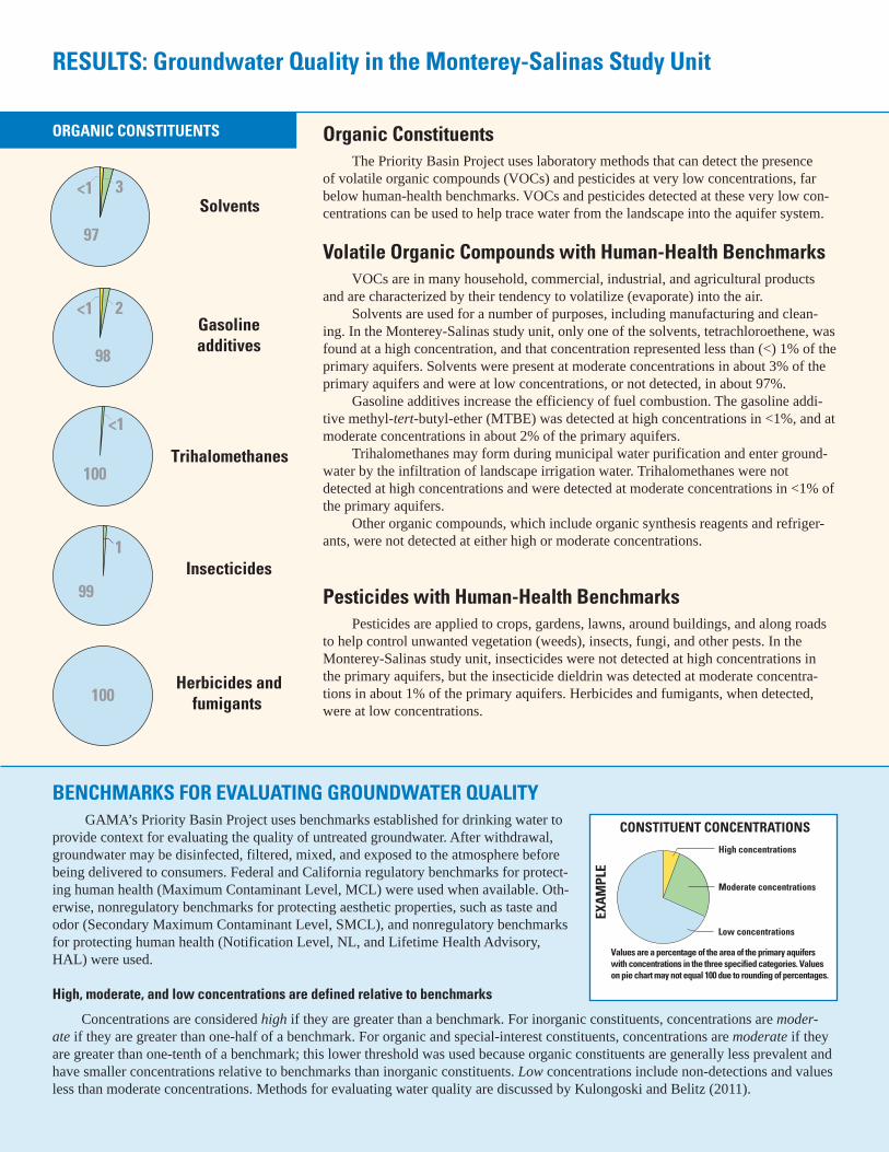
Solvents
Trihalomethanes
Herbicides andfumigants
ORGANIC CONSTITUENTS
100
100
Insecticides99
3<1
97
1
Gasolineadditives98
2<1
<1
RESULTS: Groundwater Quality in the Monterey-Salinas Study Unit
Inorganic Constituents with Human-Health BenchmarksTrace and minor elements are naturally present in the minerals in rocks
and soils, and in the water that comes into contact with those materials. In the Monterey-Salinas study unit, one or more of the trace elements were present at high concentrations in about 6% of the primary aquifers. Arsenic, boron, and molybdenum were the trace elements that most frequently occurred at high con-centrations. Aluminum, cadmium, and lead also were detected at high concentra-tions, but in less than (<) 1% of the primary aquifers.
Radioactivity is the release of energy or energetic particles during sponta-neous decay of unstable atoms. Most of the radioactivity in groundwater comes from the decay of naturally occurring isotopes of uranium and thorium in miner-als in the sediments of the aquifer. Gross-alpha radioactivity occurred at high levels in about 2% of the primary aquifers, and at moderate levels in about 10%.
Nutrients, such as nitrate and nitrite, can be naturally present at low concen-trations in groundwater. High and moderate concentrations generally occur as a result of human activities, such as applying fertilizer to crops. Livestock, when in concentrated numbers, and septic systems also produce nitrogenous waste that can leach into groundwater. Nitrate was present at high concentrations in about 8% of the primary aquifers, and at moderate concentrations in about 5% of the primary aquifers.
Inorganic Constituents with Non-Health Benchmarks(Not included in water-quality overview charts shown on the front page)
Some constituents affect the aesthetic properties of water, such as taste, color, and odor, or may create nuisance problems, such as staining and scaling.The State of California has a recommended and an upper limit for total dissolved solids (TDS) in drinking water. Groundwater naturally contains TDS as a result of the weathering and dissolution of minerals in soils. Anoxic conditions in ground-water (very low amounts of dissolved oxygen) may result in release of manganese and iron from minerals into groundwater.
In the Monterey-Salinas study unit, TDS concentrations were high (greater than the upper limit) in about 9% of the primary aquifers. About 31% of the primary aquifers had moderate TDS concentrations (between the recommended and upper limit). Iron and manganese are naturally occurring elements, and one or both were present at high concentrations in about 21% of the primary aquifers, at moderate concentrations in about 11% of the primary aquifers, and at low concen-trations in about 67% of the primary aquifers.
Perchlorate and N-Nitrosodimethylamine (NDMA) (Not included in water-quality overview charts shown on the front page)
Perchlorate, an inorganic constituent, and NDMA, a semi-volatile organic chemical, are of special interest in California because these constituents have recently been detected in, or are considered to have the potential to affect, drinking-water supplies. Their presence in groundwater is monitored by the Cali-fornia Department of Public Health. NDMA was detected at moderate concentra-tions in about 7% of the primary aquifers (2 of the 29 wells sampled). Perchlorate was not detected in any of the wells sampled.
High concentrations
Moderate concentrations
Low concentrations
EXAM
PLE
Values are a percentage of the area of the primary aquiferswith concentrations in the three specified categories. Valueson pie chart may not equal 100 due to rounding of percentages.
CONSTITUENT CONCENTRATIONS
Solvents
Trihalomethanes
Herbicides andfumigants
ORGANIC CONSTITUENTS
100
100
Insecticides99
3<1
97
1
Gasolineadditives98
2<1
<1
RESULTS: Groundwater Quality in the Monterey-Salinas Study Unit
Organic ConstituentsThe Priority Basin Project uses laboratory methods that can detect the presence
of volatile organic compounds (VOCs) and pesticides at very low concentrations, far below human-health benchmarks. VOCs and pesticides detected at these very low con-centrations can be used to help trace water from the landscape into the aquifer system.
Volatile Organic Compounds with Human-Health BenchmarksVOCs are in many household, commercial, industrial, and agricultural products
and are characterized by their tendency to volatilize (evaporate) into the air.Solvents are used for a number of purposes, including manufacturing and clean-
ing. In the Monterey-Salinas study unit, only one of the solvents, tetrachloroethene, was found at a high concentration, and that concentration represented less than (<) 1% of the primary aquifers. Solvents were present at moderate concentrations in about 3% of the primary aquifers and were at low concentrations, or not detected, in about 97%.
Gasoline additives increase the efficiency of fuel combustion. The gasoline addi-tive methyl-tert-butyl-ether (MTBE) was detected at high concentrations in <1%, and at moderate concentrations in about 2% of the primary aquifers.
Trihalomethanes may form during municipal water purification and enter ground-water by the infiltration of landscape irrigation water. Trihalomethanes were not detected at high concentrations and were detected at moderate concentrations in <1% of the primary aquifers.
Other organic compounds, which include organic synthesis reagents and refriger-ants, were not detected at either high or moderate concentrations.
Pesticides with Human-Health BenchmarksPesticides are applied to crops, gardens, lawns, around buildings, and along roads
to help control unwanted vegetation (weeds), insects, fungi, and other pests. In the Monterey-Salinas study unit, insecticides were not detected at high concentrations in the primary aquifers, but the insecticide dieldrin was detected at moderate concentra-tions in about 1% of the primary aquifers. Herbicides and fumigants, when detected, were at low concentrations.
BENCHMARKS FOR EVALUATING GROUNDWATER QUALITY GAMA’s Priority Basin Project uses benchmarks established for drinking water to
provide context for evaluating the quality of untreated groundwater. After withdrawal, groundwater may be disinfected, filtered, mixed, and exposed to the atmosphere before being delivered to consumers. Federal and California regulatory benchmarks for protect-ing human health (Maximum Contaminant Level, MCL) were used when available. Oth-erwise, nonregulatory benchmarks for protecting aesthetic properties, such as taste and odor (Secondary Maximum Contaminant Level, SMCL), and nonregulatory benchmarks for protecting human health (Notification Level, NL, and Lifetime Health Advisory, HAL) were used.
High, moderate, and low concentrations are defined relative to benchmarks
Concentrations are considered high if they are greater than a benchmark. For inorganic constituents, concentrations are moder-ate if they are greater than one-half of a benchmark. For organic and special-interest constituents, concentrations are moderate if they are greater than one-tenth of a benchmark; this lower threshold was used because organic constituents are generally less prevalent and have smaller concentrations relative to benchmarks than inorganic constituents. Low concentrations include non-detections and values less than moderate concentrations. Methods for evaluating water quality are discussed by Kulongoski and Belitz (2011).

MaximumContaminantLevel (MCL)
0
DEPT
H TO
TOP
OF
PERF
ORAT
ION
S, IN
FEE
T BE
LOW
LAN
D SU
RFAC
E
10 20 30 40
NITRATE PLUS NITRITE AS NITROGEN, IN MILLIGRAMS PER LITER
0.5 * MCL
0
400
800
1,200
Urban or Agricultural land useMixed land use
Urban or Agricultural land useMixed land use
Urban or Agricultural land useMixed land use
Natural land
EXPLANATIONModern-age groundwater
Mixed-age groundwater
Pre-modern-age groundwater
Low Moderate High
Factors that Affect Groundwater QualityIn the Monterey-Salinas study unit, nitrate is the constituent that most frequently
exists at high concentrations in the primary aquifers (about 8%), and trace elements occur at high concentrations in 6% of the primary aquifers. In contrast, trace elements
occur at high concentrations in 14% of the primary aqui-fers in the North San Francisco Bay study unit (Kulongoski and others, 2010), and 17% of the Central Eastside San Joaquin Val-ley study unit (Landon and others, 2010).
Nitrogen in groundwa-ter can occur as dissolved
nitrate, nitrite, or ammonia. Human activities, such as the application of nitrate as a fertilizer for agriculture, or the production of nitrogen-rich waste from livestock, gener-ate nitrate that can leach into groundwater. Septic systems may also introduce nitrogen-rich waste into groundwater. The human-health regulatory benchmark for nitrate plus nitrite, as nitrogen, is 10 milligrams per liter.
In the Monterey-Salinas study unit, high concentrations of nitrate were found in the shallower wells sampled (top of well perforations less than 400 feet depth) that are located in agricultural and urban areas (see figure above). The groundwaters with high and moderate concentrations of nitrate also were predominantly classified as modern age or mixed age, which indicates that a component of the groundwater was recharged in the past 50 years.
The elevated nitrate concentrations in recently recharged groundwaters from agri-cultural areas are most likely the result of farming practices that introduced nitrogen at the land surface; however, additional data are needed to confirm the sources of nitrate.
By Justin T. Kulongoski and Kenneth Belitz
SELECTED REFERENCESCalifornia Department of Water Resources, 2003, California’s groundwater: California
Department of Water Resources Bulletin 118, 246 p. Available at http://www.water.ca.gov/groundwater/bulletin118/update2003.cfm
Kulongoski, J.T., and Belitz, Kenneth, 2007, Ground-water quality data in the Monterey Bay and Salinas Valley Basins, California, 2005: Results from the California GAMA Program: U.S. Geological Survey Data Series Report 258, 84 p. Available at http://pubs.usgs.gov/ds/2007/258
Kulongoski, J.T., and Belitz, Kenneth, 2011, Status and understanding of groundwater quality in the Monterey Bay and Salinas Valley Basins, 2005: California GAMA Priority Basin Project: U.S. Geological Survey Scientific Investigations Report 2011-5058, 85 p. Available at http://pubs.usgs.gov/sir/2011/5058/
Kulongoski, J.T., Belitz, Kenneth, Landon, M.K., and Farrar, Christopher, 2010, Status and under-standing of groundwater quality in the North San Francisco Bay Groundwater Basins, 2004: California GAMA Priority Basin Project: U.S. Geological Survey Scientific Investigations Report 2010-5089, 88 p. Available at http://pubs.usgs.gov/sir/2010/5089/
Landon, M.K., Belitz, Kenneth, Jurgens, B.C., Kulongoski, J.T., and Johnson, T.D., 2010, Status and understanding of groundwater quality in the Central–Eastside San Joaquin Basin, 2006: California GAMA Priority Basin Project: U.S. Geological Survey Scientific Investigations Report 2009–5266, 97 p. Available at http://pubs.usgs.gov/sir/2009/5266/
Priority Basin Assessments GAMA’s Priority Basin Project
(PBP) assesses water quality in that part of the aquifer system used for drinking water, primarily public supply. Water quality in the primary aquifers, assessed by the PBP, may differ from that in the deeper parts of the aquifer, or from the shallower parts, which are being assessed by GAMA’s Domestic Well Project. Ongoing assessments are being con-ducted in more than 120 basins through-out California.
The PBP assessments are based on a comparison of constituent concentrations in untreated groundwater with bench-marks established for the protection of human health and for aesthetic concerns. The PBP does not evaluate the quality of drinking water delivered to consumers.
The PBP uses two scientific approaches for assessing groundwa-ter quality. The first approach uses a network of wells to statistically assess the status of groundwater quality. The second approach combines water-quality, hydrologic, geographic, and other data to help assess the factors that affect water quality. In the Monterey-Salinas study unit, data were collected by the PBP in 2005 and from the CDPH database for 2002–2005. The PBP includes chemical analyses not generally available as part of regulatory compliance monitoring, including measurements at concentra-tions much lower than human-health benchmarks, and measurement of constituents that can be used to trace the sources and movement of groundwater.
For more information
Technical reports and hydrologic data collected for the GAMA Program may be obtained from
GAMA Project ChiefU.S. Geological Survey
California Water Science Center4165 Spruance Road, Suite 200
San Diego, CA 92101Telephone number: (619) 225-6100WEB: http://ca.water.usgs.gov/gama
GAMA Program UnitState Water Resources Control Board
Division of Water QualityPO Box 2231, Sacramento, CA 95812
Telephone number: (916) 341-5779WEB: http://www.waterboards.ca.gov/gama


![A detrital record of Mesozoic island arc accretion and ...record of exhumation associated with island arc accretion to the inboard Intermontane belt. [5] A key debate surrounding the](https://static.fdocuments.in/doc/165x107/5f61fdd62f5f416b54076287/a-detrital-record-of-mesozoic-island-arc-accretion-and-record-of-exhumation.jpg)


