U.S. Department of Homeland Security United States Coast ... · 26 April 2018 LNM: 17/18 Coast...
39
26 April 2018 17/18 LNM: 11 Coast Guard District Page 1 of 18 U.S. Department of Homeland Security United States Coast Guard LOCAL NOTICE TO MARINERS CORRESPONDENCE TO: COMMANDER DISTRICT ELEVEN (DPW) COAST GUARD ISLAND BUILDING 50-2 ALAMEDA, CA 94501-5100 REFERENCES: COMDTPUB P16502.6, Light List Volume VI, 2017 Edition, U.S. Chart No.1 12th Edition, and Coast Pilot Volume 7 49th Edition. These publications, along with corrections, are available at: http://https://nauticalcharts.noaa.gov/ BROADCAST NOTICE TO MARINERS - Information concerning aids to navigation and waterway management promulgated through BNM HB-0004-18, SF-0071-18, LA-0052-18, and SD-0040-18 have been incorporated in this notice, or will continue if still significant. SECTION I - SPECIAL NOTICES This section contains information of special concern to the Mariner. SUBMITTING INFORMATION FOR PUBLICATION IN THE LOCAL NOTICE TO MARINERS BRIDGE INFORMATION- PROJECTS, DISCREPANCIES, CORRECTIONS & REGULATORY CAUTION TO BE USED IN RELIANCE UPON AIDS TO NAVIGATION INMARSAT I-3 TO I-4 SATELLITE MIGRATION UPDATE (Ref LNM 11/18) MARINE SAFETY INFORMATION BULLETIN A complete set of guidelines with examples and contact information can be found at http://www.pacificarea.uscg.mil/Our-Organization/District- 11/Prevention-Division/LnmRequest/ or call BM1 Adam Claude at 510-437-2980 or e-mail [email protected]. Please provide all Local Notice to Mariners submissions 14 days prior to the start of operations. For all bridge related issues, including lighting, operation, obstructions, construction, demolition, etc. contact the Eleventh Coast Guard District Bridge Administrator 24 hour cell phone at 510-219-4366. Flotsam may accumulate on and near bridge piers and abutments. Mariners should approach all bridges with caution. A vessel delay at a drawbridge may be reported to the District Bridge Administrator by telephone, or by using the Delay_Report_11-2017.pdf included in the Enclosures section of this Local Notice to Mariners. The aids to navigation depicted on charts comprise a system of fixed and floating aids to navigation with varying degrees of reliability. Prudent mariners will not rely solely on any single aid to navigation, particularly a floating aid to navigation. With respect to buoys, the buoy symbol is used to indicate the approximate position of the buoy body and the sinker which secures the buoy to the seabed. The approximate position is used because of the practical limitations in positioning and maintaining buoys and their sinkers in precise geographical locations. These limitations include, but are not limited to, inherent imprecision in position fixing methods, prevailing atmospheric and sea conditions, slope of and the material making up the seabed, the fact that buoys are moored to sinkers by varying length of chain, and the fact that the buoy body and/or sinker positions are not under continuous surveillance, but are normally checked only during periodic maintenance visits which often occur more than a year apart. Due to the forces of nature, the position of the buoy body can be expected to shift inside and outside the charted symbol. The mariner is also cautioned that buoys may be extinguished or sound signals may not function as the result of natural causes, collisions, or other accidents. For the foregoing reasons, a prudent mariner must not rely completely upon the position or operation of floating aids to navigation, but will also utilize bearings from fixed objects and aids to navigation on shore. Furthermore, a vessel attempting to pass close aboard always risks collision with a yawing buoy or with the obstruction that the buoy marks. Inmarsat has rescheduled the Inmarsat C services migration. The revised migration dates follow: Atlantic Ocean Region West (AORW) May 2018, Pacific Ocean Region (POR) July 2018, Atlantic Ocean Region East (AORE) September 2018, and Indian Ocean Region (IOR) October 2018. For further details on the satellite migration plan and new satellite footprints, consult Inmarsat at https://www.inmarsat.com/i3-i4- services-migration. Mariners directing the movement of large ships in or near the offshore approaches to San Francisco Bay have indicated to the Coast Guard that District: 11 Week: 17/18
Transcript of U.S. Department of Homeland Security United States Coast ... · 26 April 2018 LNM: 17/18 Coast...
26 April 201817/18LNM:
11Coast Guard DistrictPage 1 of 18
U.S. Departmentof Homeland Security
United StatesCoast Guard
LOCAL NOTICE TO MARINERS
CORRESPONDENCE TO:COMMANDER
DISTRICT ELEVEN (DPW)COAST GUARD ISLAND BUILDING 50-2
ALAMEDA, CA 94501-5100
REFERENCES: COMDTPUB P16502.6, Light List Volume VI, 2017 Edition, U.S. Chart No.1 12th Edition, and Coast Pilot Volume 7 49th Edition. These publications, along with corrections, are available at: http://https://nauticalcharts.noaa.gov/
BROADCAST NOTICE TO MARINERS - Information concerning aids to navigation and waterway management promulgated through BNM HB-0004-18, SF-0071-18, LA-0052-18, and SD-0040-18 have been incorporated in this notice, or will continue if still significant.
SECTION I - SPECIAL NOTICESThis section contains information of special concern to the Mariner.
SUBMITTING INFORMATION FOR PUBLICATION IN THE LOCAL NOTICE TO MARINERS
BRIDGE INFORMATION- PROJECTS, DISCREPANCIES, CORRECTIONS & REGULATORY
CAUTION TO BE USED IN RELIANCE UPON AIDS TO NAVIGATION
INMARSAT I-3 TO I-4 SATELLITE MIGRATION UPDATE (Ref LNM 11/18)
MARINE SAFETY INFORMATION BULLETIN
A complete set of guidelines with examples and contact information can be found at http://www.pacificarea.uscg.mil/Our-Organization/District-11/Prevention-Division/LnmRequest/ or call BM1 Adam Claude at 510-437-2980 or e-mail [email protected]. Please provide all Local Notice to Mariners submissions 14 days prior to the start of operations.
For all bridge related issues, including lighting, operation, obstructions, construction, demolition, etc. contact the Eleventh Coast Guard District Bridge Administrator 24 hour cell phone at 510-219-4366. Flotsam may accumulate on and near bridge piers and abutments. Mariners should approach all bridges with caution. A vessel delay at a drawbridge may be reported to the District Bridge Administrator by telephone, or by using the Delay_Report_11-2017.pdf included in the Enclosures section of this Local Notice to Mariners.
The aids to navigation depicted on charts comprise a system of fixed and floating aids to navigation with varying degrees of reliability. Prudent mariners will not rely solely on any single aid to navigation, particularly a floating aid to navigation. With respect to buoys, the buoy symbol is used to indicate the approximate position of the buoy body and the sinker which secures the buoy to the seabed. The approximate position is used because of the practical limitations in positioning and maintaining buoys and their sinkers in precise geographical locations. These limitations include, but are not limited to, inherent imprecision in position fixing methods, prevailing atmospheric and sea conditions, slope of and the material making up the seabed, the fact that buoys are moored to sinkers by varying length of chain, and the fact that the buoy body and/or sinker positions are not under continuous surveillance, but are normally checked only during periodic maintenance visits which often occur more than a year apart. Due to the forces of nature, the position of the buoy body can be expected to shift inside and outside the charted symbol. The mariner is also cautioned that buoys may be extinguished or sound signals may not function as the result of natural causes, collisions, or other accidents. For the foregoing reasons, a prudent mariner must not rely completely upon the position or operation of floating aids to navigation, but will also utilize bearings from fixed objects and aids to navigation on shore. Furthermore, a vessel attempting to pass close aboard always risks collision with a yawing buoy or with the obstruction that the buoy marks.
Inmarsat has rescheduled the Inmarsat C services migration. The revised migration dates follow: Atlantic Ocean Region West (AORW) May 2018, Pacific Ocean Region (POR) July 2018, Atlantic Ocean Region East (AORE) September 2018, and Indian Ocean Region (IOR) October 2018. For further details on the satellite migration plan and new satellite footprints, consult Inmarsat at https://www.inmarsat.com/i3-i4-services-migration.
Mariners directing the movement of large ships in or near the offshore approaches to San Francisco Bay have indicated to the Coast Guard that
District: 11 Week: 17/18

26 April 201817/18LNM:
11Coast Guard DistrictPage 2 of 18
the high-intensity “work-lights” on decks used by commercial fishing vessels prevent vessel operators from seeing the commercial fishing vessel’s navigation lights at night and in low-visibility conditions.
A clear and present threat to navigation safety exists when one vessel cannot see the navigation lights of another vessel. If navigation lights are obscured, the aspect of the latter vessel cannot be determined making it extremely difficult for both vessels to successfully execute the nautical rules of the road. International Navigation Rule 20 states that no other lights that may impair the visibility of the lights specified in the Rules shall be displayed from sunset to sunrise and during periods of low visibility. Vessels found to be in violation of Rule 20 may be subject to a potential $6,500 fine.
All vessels operating near the San Francisco Bay inbound or outbound off-shore traffic lanes are strongly encouraged to comply with the Navigation Rules as they pertain to navigation lights. Vessels are also encouraged to maintain an active listening watch on VHF/FM Channels 13 and 16 and, when the intentions of another vessel are unclear, communicate to make arrangements to reduce the risk of collision.
LNM: 45/16
DISCREPANCIES (FEDERAL AIDS)
SECTION II - DISCREPANCIESThis section lists all reported and corrected discrepancies related to Aids to Navigation in this edition. A discrepancy is a change in the status of
an aid to navigation that differs from what is published or charted.
LNM EndLLNR Aid Name Status Chart No. BNM Ref. LNM StDart Tsunami Warning Lighted Buoy Station 46412Point Loma Light
NOAA Environmental Lighted Buoy 46028Mile Rocks Light
NOAA Environmental Lighted Buoy 46006Newport Bay Channel Light 11Anaheim Bay East Jetty Light 6
Santa Cruz Harbor Lighted Buoy 2Mile Rocks LightOakland Outer Harbor Light 9
Alameda Naval Air Station Channel Entrance Lighted Buoy 2Redwood Creek Entrance Light 2
Redwood Creek Light 13Berkeley North Breakwater Light 4
San Pablo Bay Channel Light 5
Point Pinole Light PNapa River Light 8
Napa River Light 15
Suisun Bay North Channel Light 2San Joaquin River Daybeacon 1
San Joaquin River Light 25
San Joaquin River Light 47San Joaquin River Light 47
Stockton Channel Light 1
Stockton Channel Range J Rear LightSacramento River Deep Water Ship Channel Light 50Sacramento River Light 9
Bodega Harbor Channel Light 2
Bodega Harbor Channel Daybeacon 18Bodega Harbor Channel Daybeacon 22
ADRIFT
REDUCED INT
OFF STA
LT EXT
ADRIFT
STRUCT DEST/TRLBTRLB/STRUCT DEST
LT IMCHLT EXTMISSING/TRLB
BUOY DMGD
TRLB/STRUCT DEST
STRUCT DMGD/TRLBLT EXT
MISSING/TRLB
DAYMK DMGDSTRUCT DEST/TRLB
DAYMK MISSING
STRUCT DMGD/TRLBSTRUCT DEST/TRUB
STRUCT DEST/TRLB
MISSING/TRLBTRLB/STRUCT DEST
STRUCT DMGD
REDUCED INTSTRUCT DMGD/TRLB
STRUCT DMGD
STRUCT DMGD
STRUCT DMGD/TRLBTRUB/STRUCT DEST
52/16
36/17
36/17
49/17
02/13
50/1535/14
17/1849/1713/18
44/17
34/15
41/1705/17
36/17
26/1634/14
05/17
01/1404/16
21/15
06/1826/15
22/17
03/1725/17
15/18
34/17
50/1701/13
18022
18773
18700
18649
501
1875418749
186851864918650
18650
18651
1865118653
18654
1865418654
18654
1865718659
18660
1866018660
18660
1866318661
18662
18643
1864318643
1
5
275
365
510
24702805
409542454650
4750
5180
52405460
5885
58956165
6195
63256665
6760
68656865
6913
71257415
7690
7780
78657885
SD-0168-16
SD-0100-17
SF-0194-17
SF-0251-17
0013-13
LA-0176-15
LA-0108-14
SF-0074-18SF-0251-17
SF-0051-18
SF-0228-17
SF-0153-15SF-0201-17
SF-0035-17
SF-0193-17SF-0123-16
SF-0123-14
SF-0036--17SF-0004-14
SF-0017-16
SF-0083-15SF-0023-18
SF-0113-15
SF-0119-17
SF-0012-17SF-0143-17
SF-0066-18
SF-0184-17SF-0256-17
0669-12
18649 Chart

26 April 201817/18LNM:
11Coast Guard DistrictPage 3 of 18
DISCREPANCIES (FEDERAL AIDS) CORRECTED
DISCREPANCIES (PRIVATE AIDS)
DISCREPANCIES (PRIVATE AIDS) CORRECTED
SECTION III - TEMPORARY CHANGES and TEMPORARY CHANGES CORRECTEDThis section contains temporary changes and corrections to Aids to Navigation for this edition. When charted aids are temporarily relocated for dredging, testing, evaluation, or marking an obstruction, a temporary correction shall be listed in Section IV giving the
new position.
TEMPORARY CHANGES
TEMPORARY CHANGES CORRECTED
LNM End
LNM End
LLNR
LLNR
Aid Name
Aid Name
Status
Status
Chart No.
Chart No.
BNM Ref.
BNM Ref.
LNM St
LNM St
LNM End
LNM End
LNM End
LLNR
LLNR
LLNR
Aid Name
Aid Name
Aid Name
Status
Status
Status
Chart No.
Chart No.
Chart No.
BNM Ref.
BNM Ref.
BNM Ref.
LNM St
LNM St
LNM St
Bodega Harbor Channel Daybeacon 44
Humboldt Bay Lighted Bell Buoy 2Hookton Channel Light 8
Crescent City Harbor Light 9
San Diego Bay Channel Lighted Buoy 14
San Francisco Bay North Channel Lighted Buoy 1
Platform Gail Racon
Scripps Waverider Lighted Research Buoy 029San Diego-Coronado Bay Bridge Fog SignalCoronado Cays Channel Daybeacon 3Harbor Bait Barge Lighted Mooring Buoy "LB"Cabrillo Way Marina Light
San Francisco-Oakland Bay Bridge Pier AFog Signal
STRUCT DEST/TRUB
OFF STATRLB/STRUCT DEST
STRUCT DMGD/TRLB
WATCHING PROPERLY
WATCHING PROPERLY
RAC INOP
ADRIFT
SS IMCH
STRUCT DESTMISSING
LT EXT
SS INOP
50/15
08/1847/14
05/18
14/18
17/18
14/18
04/18
06/18
36/1716/18
12/18
15/18
17/18
17/18
18643
1862218622
18603
18773
18650
18725
18645
18765
1877318749
18751
18650
7990
81358320
8386
1585
5348
187
381
1860
20702848
3305
4420
Point Sur Light
Santa Barbara Harbor Lighted Buoy 6
Santa Barbara Harbor Lighted Buoy 7
Santa Barbara Harbor Lighted Buoy 8
Santa Barbara Harbor Lighted Buoy 11
Santa Barbara Harbor Lighted Buoy 10
Reduced Intensity
Returned to Assigned Position
Returned to Assigned Position
Returned to Assigned Position
Returned to Assigned Position
Returned to Assigned Position
06/17
13/18
12/18
13/18
12/18
13/18
17/18
17/18
17/18
17/18
17/18
18686
18725
18725
18725
18725
18725
280
3772
3775
3780
3785
3790
None
SF-0230-15
HB-0003-18HB-0036-14
HB-0002-18
SD-0035-18
SF-0070-18
LA-0045-18
SF-0022-18
SD-0014-18
SD-0098-17
SF-0064-18
SF-0045-17
PLATFORM DISCREPANCIES
PLATFORM DISCREPANCIES CORRECTED
Name
Name
Status
Status
Position
Position
BNM Ref.
BNM Ref.
LNM St
LNM St
LNM End
LNM End
None
None

26 April 201817/18LNM:
11Coast Guard DistrictPage 4 of 18
18640
18645
18649
18654
27th Ed.
28th Ed.
68th Ed.
45th Ed.
01-OCT-15
01-MAY-13
01-JUN-13
01-JAN-11
04/12
05/17
32/14
32/14
San Francisco to Point Arena
Gulf of the Farallones;Southeast Farallon
Entrance to San Francisco Bay
San Pablo Bay
ChartTitle:
ChartTitle:
ChartTitle:
ChartTitle:
NAD 83
NAD 83
NAD 83
NAD 83
Last LNM:
Last LNM:
Last LNM:
Last LNM:
17/18
17/18
17/18
17/18
Main Panel 1816 SAN FRANCISCO TO POINT ARENA. Page/Side: A
CHART CA - Gulf of the Farallons. Page/Side: N/A
Main Panel 1823 SAN FRANCISCO ENTRANCE. Page/Side: N/A
CHART CA - SAN PABLO BAY. Page/Side: N/A
CHANGE
CHANGE
CHANGE
CHANGE
San Francisco Main Ship Channel Lighted Bell Buoy 1
San Francisco Main Ship Channel Lighted Bell Buoy 1
San Francisco Main Ship Channel Lighted Bell Buoy 1
San Pablo Bay Channel Lighted Buoy 7
CGD11
CGD11
CGD11
CGD11
at 37-46-11.185N
at 37-46-11.185N
at 37-46-11.185N
at 38-01-51.904N
122-37-55.943W
122-37-55.943W
122-37-55.943W
122-22-26.832W
Add Magenta circle Chart No. 1: S17.2 and Label AIS
Add Magenta circle Chart No. 1: S17.2 and Label AIS
Add Magenta circle Chart No. 1: S17.2 and Label AIS
Remove Magenta circle Chart No. 1: S17.2
Santa Barbara Harbor Lighted Buoy 12 Returned to Assigned Position 12/18 17/18187253792
This section contains corrections to federally and privately maintained Aids to Navigation, as well as NOS corrections. This section contains corrective actions affecting chart(s). Corrections appear numerically by chart number, and pertain to that chart only. It is up to the mariner to decide which chart(s) are to be corrected. The following example explains individual elements of a typical chart correction.
Chart Chart Edition Last Local Notice Horizontal Source of Current LocalNumber Edition Date to Mariners Datum Reference Correction Notice to Mariners l . l . l . . . l . . . l . . . l . . l12327 91st Ed. 19-APR-97 Last LNM: 26/97 NAD 83 27/97Chart Title: NY-NJ-NEW YORK HARBOR - RARITAN RIVER Main Panel 2245 NEW YORK HARBOR CGD01(Temp) ADD NATIONAL DOCK CHANNEL BUOY 3 at 40-41-09.001N 074-02-48.001W . . l . Green can l . . . . . . l . Corrective Object of Corrective Position Action Action
(Temp) indicates that the chart correction action is temporary in nature. Courses and bearings are given in degrees clockwise from 000 true. Bearings of light sectors are toward the light from seaward. The nominal range of lights is expressed in nautical miles (NM) unless otherwise noted.
PLATFORM TEMPORARY CHANGES
PLATFORM TEMPORARY CHANGES CORRECTED
Name
Name
Status
Status
Position
Position
BNM Ref.
BNM Ref.
LNM St
LNM St
LNM End
LNM End
None
None
SECTION IV - CHART CORRECTIONS

26 April 201817/18LNM:
11Coast Guard DistrictPage 5 of 18
SECTION V - ADVANCE NOTICESThis section contains advance notice of approved projects, changes to aids to navigation, or upcoming temporary changes such as dredging, etc.
Mariners are advised to use caution while transiting these areas.
SUMMARY OF ADVANCED APPROVED PROJECTS
Approved Project(s) Project Date Ref. LNM
ANAHEIM BAY - TEMPORARY AID DISESTABLISHMENT
HUMBOLDT BAY - TEMPORARY AID DISESTABLISHMENT
LA/LB LED CONVERSION
NEWPORT BAY - PROPOSED ATON DISCONTINUANCE
The U.S. Coast Guard is proposing to disestablish Anaheim Bay East Jetty Lighted Buoy 6 due to the rebuild of Anaheim Bay East Jetty Light (LLNR 2805) on 19 Apr 18. The U.S. Coast Guard is seeking public comment on this change. Please direct questions, comments or concerns to BMC Gordon Laing at 510-437-2958 or [email protected].
The U.S. Coast Guard is proposing to convert Humboldt Bay Lighted Bell Buoy 2 (LLNR 8135) to a seasonal aid due to continued off-station reports after extreme weather fronts. The aid will be temporarily disestablished from November thru May of each year. The physical buoy will be positioned and on-station from May thru November of each year. A Synthetic AIS for the aid position is active and will be available year-round for this aid position.
The U.S. Coast Guard is seeking public comment on this temporary change. The U.S. Coast Guard also proposes an alternative solution and requests public comment on permanently disestablishing this aid and maintaining the Synthetic AIS in place. Please direct questions, comments or concerns to LT Amber Napralla, 510-437-3801 or [email protected].
The U.S. Coast Guard is planning to permanently change Point Vicente Light (LLNR 170) to an LED with a 14nm range. Date of implementation of thischange will be published once scheduled. Direct any questions to LT Amber Napralla at 510-437-3801 or [email protected].
The U.S. Coast Guard is discontinuing Newport Bay Channel Light 5 (LLNR 2450), Newport Bay Channel Light 6 (LLNR 2455), Newport Bay Channel Lighted Buoy 8 (LLNR 2460), Newport Bay Channel Light 10 (LLNR 2465), Newport Bay Channel Light 11 (LLNR 2470) and Newport Bay Channel
LNM:
LNM:
LNM:
17/18
09/18
34/15
18661
18662
18680
30th Ed.
22nd Ed.
32nd Ed.
01-MAR-09
01-MAY-09
01-MAY-13
12/12
21/09
33/16
Sacramento and San Joaquin Rivers Old River, Middle River and San Joaquin River extension;Sherman Island
Sacramento River Andrus Island to Sacramento
Point Sur to San Francisco
ChartTitle:
ChartTitle:
ChartTitle:
NAD 83
NAD 83
NAD 83
Last LNM:
Last LNM:
Last LNM:
17/18
17/18
17/18
Main Panel 1855 SACRAMENTO AND SAN JOAQUIN RIVERS. Page/Side: B
Main Panel 1857 SACRAMENTO RIVER ANDRUS ISLAND TO SACRAMENTO. Page/Side: N/A
Main Panel 1866 POINT SUR TO SAN FRANCISCO. Page/Side: N/A
(Temp)
(Temp)
ADD
ADD
CHANGE
Sacramento River Deep Water Ship Channel Light 50
Sacramento River Deep Water Ship Channel Light 50
San Francisco Main Ship Channel Lighted Bell Buoy 1
CGD11
CGD11
CGD11
at 38-13-43.710N
at 38-13-43.710N
at 37-46-11.185N
121-40-25.041W
121-40-25.041W
122-37-55.943W
Remove AIS label
Red Temporary Lighted Buoy in postion 38-13-43.766N 121-40-25.010W
Red Temporary Lighted Buoy in postion 38-13-43.766N 121-40-25.010W
Add Magenta circle Chart No. 1: S17.2 and Label AIS
Fl R 4s
Fl R 4s
Chart
Charts:
Charts:
18749
18620 18622
18020 18022 18740 18746
12 Ft, 3 Naut Mi
12 Ft, 3 Naut Mi
None
Advance Notice(s)

26 April 201817/18LNM:
11Coast Guard DistrictPage 6 of 18
POINT SUR - LED CONVERSION
Light 12 (LLNR 2475). The City of Newport has requested to take ownership, remove pile markers and establish lighted Private Aids to Navigation (PATON) buoys for all listed aids in Newport Bay due to concerns of vessel safety and to improve channel marking. Please direct any questions to LTAmber Napralla at 510-437-3801 or [email protected].
The U.S. Coast Guard is planning to permanently change Point Sur Light (LLNR 280) to an LED with a 14nm range. Date of implementation will be published once scheduled. Direct any questions to LT Amber Napralla at 510-437-3801 or [email protected].
LNM:
LNM:
31/17
41/17
SECTION VI - PROPOSED CHANGESPeriodically, the Coast Guard evaluates its system of aids to navigation to determine whether the conditions for which the aids to navigation were
established have changed. When changes occur, the feasibility of improving, relocating, replacing, or discontinuing aids are considered. This section contains notice(s) of non-approved, proposed projects open for comment. SPECIAL NOTE: Mariners are requested to respond in writing to the District
office unless otherwise noted (see banner page for address).
PROPOSED WATERWAY PROJECTS OPEN FOR PUBLIC COMMENT
Proposed Project(s) Closing Docket No. Ref. LNM
SECTION VII - GENERALThis section contains information of general concern to the Mariners. Mariners are advised to use caution while transiting these areas.
APPIAN WAY BRIDGE-The upsteam clearance gauge is damaged below the 14' mark. Estimated time of repair unknown.2nd ST BRIDGE (EAST)-One clearance gauge appears damaged and not visible at low tide. Estimated time of repair unknown.For further information contact the Coast Guard Bridge Office at 510-437-3516.
A rocky shoal has been reported below the Davis Dam in position 35-11-33.64N 114-34-16.39W where depths are reported between 5’ to less than 1’ depending upon the outflow from the dam. Recreational vessels have been seen running aground after making contact with the rocks as there are no signs or buoys marking the area. Mariners are requested to transit the area with caution. For more details or comments contact USCGSector San Diego at 619-278-7073.
BENICIA-MARTINEZ UPRR DRAWBRIDGE – Until further notice, vessels transiting eastbound should provide their advance call to the bridge tenderwhen passing Selby and provide a four digit time for their lift request based on their ETA at Carquinez Strait Light 23 (LLNR 6240). Vessels transiting westbound should continue to provide their advance call to the bridge tender when passing New York Point and provide a four digit time for their lift request based on their ETA at Suisun Bay Channel Light 11 (LLNR 6440). For further information contact the Coast Guard Bridge Office at 510-437-3516 or Coast Guard Vessel Traffic Service at 415-399-7402.
BENICIA-MARTINEZ UPRR DRAWBRIDGE-The drawspan will be secured in the closed-to-navigation position from 0800 to 1800, 26-29 Apr 18 and 12-13 May 18 to complete wire rope replacement. The bridge provides 70’ vertical clearance above mean high water. Vessels that can transit the bridge, while in the closed position, may continue to do so at any time. For more information, contact the Coast Guard Bridge Office at 510-437-3516.
Gregg Drilling and Testing will be conducting drilling operations from 01-10 May 18 in the vicinity of Scorpion Anchorage, Santa Cruz Island at 34-02-60N 119-33-21W. The R/V QUIN DELTA will be on scene monitoring VHF-FM Chan. 13 and 16. Mariners are requested to transit the area with caution. For more details or comments contact Captain Tim O’Donnell at 949-254-5190 or e-mail at [email protected].
LNM:
LNM:
LNM:
LNM:
LNM:
11/18
16/18
48/17
14/18
17/18
ALAMITOS BAY-BRIDGE
ARIZONA-BULLHEAD CITY-COLORADO RIVER-DAVIS DAM
CARQUINEZ STRAIT-BRIDGE
CARQUINEZ STRAIT-BRIDGE
CHANNEL ISLANDS-GEOTECHNICAL DRILL TESTING
COLORADO RIVER-BRIDGES
Chart
Charts:
18754
501 18020 18680 18686
Chart
Chart
Chart
Chart
18749
18656
18656
18729
None
None
Proposed Change Notice(s)
JAClaude
Highlight

26 April 201817/18LNM:
11Coast Guard DistrictPage 7 of 18
ANGES WILSON BRIDGE-The upriver and downriver red pier lights on the 3rd pier from either shoreline are extinguished.
PARKER HIGHWAY BRIDGE-The upriver and downriver red pier lights near the Arizona side are extinguished.
VETERANS MEMORIAL BRIDGE-The downstream mid-span red pier light is extinguished.
Estimated time of repair unknown. For further information contact the Coast Guard Bridge Office at 510-437-3516.
JIBBOOM ST BRIDGE-A temporary platform is in place below low steel of the bridge, reducing vertical clearance by 7' through 31 May 18. The upstream and downstream lower edge of the temporary platform will be lighted at night with steady burning red lights (see Jibboom_Platform_Lighting.pdf at the end of this notice). For further information mariners can contact the Coast Guard Bridge Office at 510-437-3461.
MILLERS FERRY DRAWBRIDGE-The furthest downstream red dolphin light is flashing red, showing improper characteristic. The two furthest upstream red dolphin lights are extinguished. Estimated time of repair unknown. For further information mariners can contact the Coast Guard Bridge Office at 510-437-3514.
AVAILABILITY OF PUBLIC NOTICE-All interested parties are notified that an application has been received from the California Department of Transportation by the Commander, Eleventh Coast Guard District for approval of location and plans for the modification of a bridge across a navigable waterway of the United States. The General Bridge Act of 1946 requires approval of the location and plans for bridges over navigable waters of the United States, prior to commencing construction. A Coast Guard Bridge Permit Amendment will be required for this project.
WATERWAY AND LOCATION: Mokelumne River, mile 22.9, north of Stockton, on the San Joaquin County and Sacramento County line, California. (N 38 15.292' W 121 26.872')
Public Notice (11-146), dated April 3, 2018, is being published on the Coast Guard Navigation Website. The public notice contains a detailed description of the proposed bridge modification project and includes location maps and bridge drawings with navigational clearances. Interested parties may access Active Public Notices for Bridge Projects for the Eleventh Coast Guard District at the following web site https://www.navcen.uscg.gov/D11BN. The public notice may also be obtained by calling the Eleventh Coast Guard District Bridge Office at 510-437-3516, by writing to Commander (dpw), Eleventh Coast Guard District, Coast Guard Island, Bldg 50-2, Alameda, CA 94501-5100, by email at [email protected], or by facsimile at 510-437-5836.
Mariners are requested to comment on the proposed modification project and navigational safety issues. Interested parties are requested to express their views in writing. Comments will be received for the record at the address given in Public Notice (11-146) through 02 May 18.
ISLETON BRIDGE-The downstream bridge name and radio frequency signs are missing.
PAINTERSVILLE BRIDGE- The upstream vertical clearance gauge and bridge name signs are missing. Caltrans is removing floating debris from upstream west pier. Mariners are requested to transit the area with caution.
PIONEER BRIDGE- The clearance gauges are damaged.
TOWER DRAWBRIDGE-The upstream clearance gauge is damaged below the 21 foot mark.
"I" STREET DRAWBRIDGE-The swing span east alternate red/green light is extinguished.
Estimated time of repair unknown. For further information mariners can contact the Coast Guard Bridge Office at 510-437-3514.
ISLETON DRAWBRIDGE-A temporary platform will be installed below low steel just west of the drawspan in order to conduct maintenance work. The temporary platform, reducing verticle clearance of the span by 5.2', will be in place from 07 May through 07 Jun 2018. The upstream and downstream lower corners of the temporary platform will be lighted at night with steady burning all-round red lights. (see Isleton_Platform_Lighting.pdf at the end of this notice). For further information, contact the Coast Guard Bridge Office at 510-437-3461.
AVAILABILITY OF PUBLIC NOTICE-All interested parties are notified that an application has been received from the California Department of
LNM:
LNM:
LNM:
LNM:
LNM:
LNM:
14/18
51/17
06/18
14/18
06/18
15/18
COLORADO RIVER-BRIDGES
DELTA & RIVERS-AMERICAN RIVER-BRIDGE
DELTA & RIVERS-MOKELUMNE RIVER-BRIDGE
DELTA & RIVERS-MOKELUMNE RIVER-BRIDGE
DELTA & RIVERS-SACRAMENTO RIVER
DELTA & RIVERS-SACRAMENTO RIVER-BRIDGE
DELTA & RIVERS-SACRAMENTO RIVER-BRIDGE
Chart
Chart
Chart
Chart
Charts:
18662
18661
18662
18661 18662
18661
26 April 201817/18LNM:
11Coast Guard DistrictPage 8 of 18
Transportation (Caltrans) by the Commander, Eleventh Coast Guard District for approval of location and plans for the modification of a bridge across a navigable waterway of the United States. The General Bridge Act of 1946 requires approval of the location and plans for bridges over navigable waters of the United States, prior to commencing construction. A Coast Guard Bridge Permit Amendment will be required for this project.
WATERWAY AND LOCATION: Sacramento River, mile 33.4, near Courtland, Sacramento County, California (N 38 19.118' W 121 34.662').
Public Notice (11-147), dated April 23, 2018, is being published on the Coast Guard Navigation Website. The public notice contains a detailed description of the proposed bridge modification project and includes location maps and bridge drawings with navigational clearances. Interested parties may access Active Public Notices for Bridge Projects for the Eleventh Coast Guard District at the following web site https://www.navcen.uscg.gov/D11BN. The public notice may also be obtained by calling the Eleventh Coast Guard District Bridge Office at 510-437-3516, by writing to Commander (dpw), Eleventh Coast Guard District, Coast Guard Island, Bldg 50-2, Alameda, CA 94501-5100, by email request at [email protected] or by facsimile request at 510-437-5836.
Interested parties are requested to express their views in writing on the proposed bridge modification project and navigational safety issues, giving sufficient detail to establish a clear understanding of their reasons for support of or opposition to the proposed work. Comments will be received for the record at the address given in Public Notice (11-147) through May 22, 2018.
REPLACEMENT NAVY DR BRIDGE CONSTRUCTION-Construction of the replacement bridge is in progress. Work will be conducted Monday through Saturday from 0600 to 1900. In-water has ended for the season and will resume in late spring 2018. On-shore and over-the-water work continues. 2 lanes of the replacement bridge are in place and spans the river. The vertical clearance of the replacement span is greater than the vertical clearance of the existing swing span. The existing bridge provides 15’ of vertical clearance from Mean High Water. Two trestles are in place from each bank out into the river to the newly installed bridge piles. Approximately 33’ of horizontal clearance is provided for vessel traffic from the north piers of the replacement bridge to a line parallel to the pivot pier. The upstream and downstream edges of the trestles will be lighted at night with steady burning red lights so as to be seen at a distance of 500 yards by approaching vessels. The western upstream swing span fender system has been removed. The upstream side of the pivot pier and the first of the upstream newly installed piles will be lighted at night with steady burning red lights. (see Trestle_Lighting_Navy_Dr.pdf in the enclosure section of this notice). Mariners are advised to use the north channel of the bridge; the south channel of the bridge will be impassable during this phase of construction. For conditions at the bridge mariners can contact the contractor at 925-200-9175 or 760-846-5842. For further project information contact the Coast Guard Bridge Office at 510-437-3516.
MCHENRY RD REPLACEMENT - San Joaquin County's contractor has started in water work to replace the bridge. A temporary bridge, built to facilitate construction, spans the waterway. Waterway users will be directed, via bouy lines, to the opening in the temporary bridge (see enclosure McHenry_Buoy_Line.pdf at the end of this notice). The temporary bridge provides at least 20' of horizontal clearance and 7' of vertical clearance at ordinary high water. The vertical clearance is subject to fluctuation if upstream dam releases increase or decrease. For further information mariners can contact the Coast Guard Bridge Office at 510-437-3516.
STEAMBOAT SLOUGH BRIDGE-The upstream northeast side vertical clearance gauge is missing. Estimated time of repair unknown. For further information mariners can contact the Coast Guard Bridge Office at 510-437-3514.
Integral Consulting Inc. will deploy one yellow spherical Wave-Rider buoy marked with a FL Y 2s light, offshore in the vicinity of the Fort Bragg at 39-22-04.8N, 123-54-36.0W until 28 Sep 18. The buoy has a watch circle diameter of 500 yds. Mariners are requested to transit the area with caution. For more details or comments contact Levi Kilcher at 303-384-7192.
Pacific Dredge Company will conduct continuous dredging operations at Portofino Cove Marina in Huntington Beach, CA, at 33-43-36N 118-04-26Wuntil 23 Jun 18. Material will be dredged from within the marina and transported offshore to LA-2. Temporary moorings will be located in the vicinityof the marina. Clamshell Dredge HORTON, scows THING 1 and THING 2, along with tugs JAG and CONNOR W will be on scene monitoring VHF-FM Chan. 13 and 16. Mariners are requested to transit the area with caution. For more details or comments contact McLaren Neal at 562-480-4210.
The U.S. Coast Guard has established a temporary lighted buoy at 33-43-33.809N 118-06-02.318W to mark the end of the damaged Anaheim BayEast Jetty. The buoy displays a Fl R 2.5s characteristic. It will be discontinued when Anaheim Bay East Jetty Light 6 (LLNR 2805) is reestablished. Direct any questions to LT Amber Napralla at 510-437-3801 or [email protected].
CJW Construction Inc. will be conducting dredging operations in Bolsa Chica inlet, Orange County at 33-41-09N 118-02-01W until 30 Jun 18.
LNM:
LNM:
LNM:
LNM:
LNM:
LNM:
LNM:
17/18
29/17
29/17
06/18
39/17
17/18
48/14
DELTA & RIVERS-SACRAMENTO RIVER-BRIDGE
DELTA & RIVERS-SAN JOAQUIN RIVER-BRIDGE
DELTA & RIVERS-STANISLAUS RIVER-BRIDGE
DELTA & RIVERS-STEAMBOAT SLOUGH-BRIDGE
FORT BRAGG-BUOY DEPLOYMENT
HUNTINGTON BEACH-DREDGING OPERATIONS
LONG BEACH-ANAHEIM BAY-TEMPORARY BUOY
LOS ANGELES-BOLSA CHICA-DREDGING
Chart
Chart
Chart
Chart
Chart
Chart
18662
18661
18662
18626
18754
18749
26 April 201817/18LNM:
11Coast Guard DistrictPage 9 of 18
Vessel CAT 345 will be on scene monitoring VHF-FM Chan. 16. Mariners are requested to transit the area with caution. For more details or comments contact Bob Hoffman at 714-454-8965.
The Sanitation Districts of Los Angeles County have deployed three moorings located on the Palos Verdes Shelf at 33-42-46N 118-21-59W, 33-46-04N 118-25-59W and 33-42-43N 118-20-01W. All three moorings will be in place until 08 Jan 19 and have a surface buoy with a 6’ spar approximately 2” in diameter with wraps of SOLAS reflective marine tape and a fluorescent orange radar reflector mounted at the top. Mariners are requested to transit the area with caution. For more details or comments contact Terra C. Petry at 310-830-2400 ext. 5603.
RAILROAD BRIDGE/MURRAY-EATON BRIDGE- The fender system on both bridges is damaged. Estimated time of repair unknown. For further information mariners can contact the Coast Guard Bridge Office at 510-437-3514.
The Army Corps of Engineers will be conducting dredging operations in the entrance channel at Morro Bay Harbor 01-20 MAY 18. Dredge YAQUINA will monitor VHF-FM Chan. 13 and 16. Call sign for vessel is AEPD. Mariners are requested to transit the area with caution. For more details or comments contact the Army Corps of Engineers Los Angeles District at 213-452-4026.
The Monterey Bay Aquarium Research Institute (MBARI) will be conducting 24/7 autonomous, unmanned maritime vehicle operations of two Liquid Robotics, Inc. Wavegliders until 30 Jun 18. Vehicles will be deployed in the vicinity of Moss Landing and Monterey Bay and operate continuously between latitudes 35-07-12N and 37-12-00N and will extend shoreward as far West as 122-58-35W. Operations consist of scientific ocean data collection. The Waveglider carries no fuel, lubricants or hydrocarbons. It is wave powered and remotely attended from MBARI, moving at speeds of ~1kt, and designed to give way or part if encountered by a vessel. It is approximately 6.5' x 2' (surfboard size), yellow in color, with a contact plaque and mast extending 3' above the water surface, supporting a flag. Mariners are requested to transit the area with caution. For more details or comments contact MBARI at 831-775-1700, [email protected] or Liquid Robotics 24/7 WGOC Operations at 888-574-4574.
The Coast Guard has been unable to dis-establish the seasonal sound signal for San Pablo Bay Channel Light 15 (LLNR 5940) in accordance with published operational timelines due to the protection of nesting osprey in position 38-03-32.84N 122-17-27.57W. Sound signal will be dis-established as soon as allowable. Mariners are requested to transit the area with caution. For more details or comments contact Aids to NavigationTeam San Francisco at 415-399-3517.
The Santa Cruz Port District is conducting dredging operations in the inner harbor between the fuel dock and AA dock until 30 Apr 18 in the vicinity of 36-57-57N 122-00-09W. Dredge TWIN LAKES will be monitoring VHF-FM Chan. 08. Mariners are requested to transit the area with caution and minimize wake in the vicinity of the dredge. For more details or comments contact Santa Cruz Harbor on VHF-FM Chan. 09 and 16 or at 831-475-6161.
Santa Cruz Harbor is cautioning mariners of possible hazardous conditions with breaking surf and shoaling that may occur at the Santa Cruz HarborEntrance due to high surf and extreme tidal conditions in the vicinity of 36-57-37N 122-00-06W. Mariners are requested to transit the area with caution. For more details or comments contact Santa Cruz Harbor on VHF-FM Chan. 09 and 16 or at 831-475-6161.
FISHBIO will be placing fyke traps at five locations in the San Joaquin River until 30 Jun 18 in the following locations:Lathrop: 37-48-59N 121-18-55WRiver Islands: 37-47-44N 121-18-51WBCID site: 37-43-17N 121-17-55W SJR1 site: 37-43-15N 121-15-40WSturgeon Bend: 37-40-34N 121-14-41WEach location will have one trap installed and fishing between Monday and Friday on a weekly basis until project completion. Traps measure approximately 10’ in diameter and will have a buoy attached in order to clearly mark their location when in fishing position. Mariners are requested to transit the area with caution. For more details or comments contact Patrick Cuthbert at 530-892-9686.
LNM:
LNM:
LNM:
LNM:
LNM:
LNM:
LNM:
LNM:
LNM:
14/18
01/18
06/18
17/18
13/18
16/18
17/18
46/17
12/18
LOS ANGELES-BOLSA CHICA-DREDGING
LOS ANGELES-MOORING OPERATIONS
MONTEREY BAY-SANTA CRUZ HARBOR-BRIDGE
NORTHERN CALIFORNIA-MORRO BAY-DREDGING OPERATIONS
NORTHERN CALIFORNIA-MOSS LANDING-WAVEGLIDER DATA COLLECTION
NORTHERN CALIFORNIA-SAN FRANCISCO-SAN PABLO BAY-UNABLE TO DISESTABLISH
NORTHERN CALIFORNIA-SANTA CRUZ-DREDGING OPERATIONS
NORTHERN CALIFORNIA-SANTA CRUZ-HAZARDOUS CONDITIONS
NORTHERN CALIFORNIA-STOCKTON-SAN JOAQUIN RIVER-FISHERIES STUDY
OAKLAND INNER HARBOR-LAKE MERRITT CHANNEL-BRIDGE
Chart
Chart
Chart
Chart
Chart
Chart
Chart
Chart
Chart
18746
18746
18685
18703
18685
18654
18685
18685
18661

26 April 201817/18LNM:
11Coast Guard DistrictPage 10 of 18
EMBARCADERO RD BRIDGE REPLACEMENT-Bridge replacement construction activities are now in progress from 0700-1700, Monday through Friday until 31 May 18. Dry cofferdams have been installed to facilitate removal of the existing bridge and construction of the replacement bridge. The contractor will use 3 to 4, 3' X 7.5' X 30', flexi-float barges during the demolition of the eastern pier (see enclosure Embarcadero_Flexi_Float_Lighting.pdf at the end of this notice). A 66' horizontal clearance for vessels will be maintained during construction. Mariners are urged to use caution when transiting the work site. For on-site conditions contact the contractor at 707-310-0631 and City of Oakland at 510-615-5566 after hours. For more details or comments contact the Coast Guard Bridge Office at 510-347-3515.
NORTHWESTERN PACIFIC (SMART) BASCULE BRIDGE-The Coast Guard is instituting a test deviation to determine if a proposed change in the operating schedule that governs the drawbridge is appropriate.
The test deviation will be in effect until 0600 17 June 18. During this time the draw of the SMART bascule bridge over the Petaluma River, mile 12.4, will open on signal from 0300 to 2300 if at least two hours notification are given to the drawtender. At all other times, the draw shall be maintained in the fully open position, except for the passage of trains or for maintenance. The drawtender can be reached via marine radio VHF-FM Chan. 09 and 16 or 707-890-8650.
Mariners may submit comments identified by docket number USCG-2018-0091 using Federal eRulemaking Portal at http://www.regulations.gov. Comments and related materials must reach the Coast Guard on or before 02 Jul 18.
For further information contact the Coast Guard Bridge Office at 510-437-3516.
BLACKPOINT RAILROAD DRAWBRIDGE-The upriver (WNW) fender system protecting the swing span has been destroyed and does not offer protection for vessels or the bridge. The NE red axis light on the pivot pier and the upstream red light on the end of the swing span fender systemare extinguished. Mariners are urged to use extreme caution while transiting the bridge. Debris from the fender system may be floating in the area.
BLACKPOINT HIGHWAY 37 BRIDGE-The fenders channelward side of the western pier are damaged. Estimated time of repair unknown.
For further information, contact the Coast Guard Bridge Office at 510-437-3516.
BEING REPLACED SCHUYLER HEIM BRIDGE DEMOLITION – Two trestles are in place at the bridge removal site, providing 75' of horizontal clearance for vessels. The upstream and downstream edges of the trestles are lighted at night with steady burning red lights. Piers 27-28, of the being replaced bridge, have been partially removed, down to approximately 17' below mean low water. Turbidity curtains have been installed around the in-water piers during pier removal. The curtains lining the navigational channel through the trestles are on the outside of the channel, behind the trestle wall, away from passing vessels. Vessel prop wash should be controlled to avoid damaging the turbidity curtains.
REPLACEMENT SCHUYLER HEIM BRIDGE CONSTRUCTION – Two temporary eastern trestles remain in place at the replacement bridge site. The main navigation span of the bridge, between the temporary trestles, provides 47' of vertical clearance from the edge of the trestles to the lowest hittable part of the bridge and 75' of horizontal clearance. The temporary trestles are lighted at night with fixed red lights (See Trestle_Lighting_Heim.pdf at the end of this notice). Portions of the eastern fenders on the existing bridge have been removed. The western portions of the fenders remain in place. Construction activities are taking place from 0700 to 1530, Mon-Fri. For conditions at the bridge mariners can contact Caltrans at 213-792-5518, MCM Construction at 714-305-2725, or MCM Construction at 714-330-5370. Mariners are requested to transit the area with caution.
VINCENT THOMAS BRIDGE – Painting of the under deck of the bridge is in progress. A 100' long platform has been erected below low steel of the bridge, just to the east of the west channel margin red light, reducing vertical clearance by 6'. Once a 100' section is complete the platform will be moved to the east 100' and work continued. The platform will migrate towards the east until it reached 100' west of centerline of the bridge span. Each corner and every 20' along the upstream and downstream side of the platform will be lighted at night with steady burning red lights (see V_Thomas_Platform_Lighting.pdf at the end of this notice). Work will take place during daylight hours, Monday through Friday. For conditions at the bridge mariners can contact 213-479-4138, 213-479-1144 or 310-261-9552. For further information contact the Coast Guard Bridge Office at 510-437-3516.
GERALD DESMOND BRIDGE REPLACEMENT PROJECT - A 160' X 60' barge will transfer equipment and materials from pier echo to the east and westshorelines approximately 130' north of the existing bridge, 0600 to 1730, Monday through Friday, occasionally Saturday until 01 May 18. The barge will be spudded and an assist tug will be on-scene at all times. Each corner of the barge will be lighted at night with steady burning red lights. Mariners can request the barge be moved for navigational safety with one hour advance notice by contacting SFI Water Traffic Coordinator at 562-240-9413 or by VHF-FM Chan. 16 and 74. When not actively engaged in transfer operations, the barge will be moored at pierecho. (For typical barge mooring and lighting see Barge_Lighting_GeraldDesmond.pdf at the end of this notice.) For further information mariners can contact the Coast Guard Bridge Office at 510-437-3516.
LNM:
LNM:
LNM:
LNM:
LNM:
20/16
09/18
10/18
10/15
29/17
OAKLAND INNER HARBOR-LAKE MERRITT CHANNEL-BRIDGE
PETALUMA RIVER-BRIDGE
PETALUMA RIVER-BRIDGE
PORTS OF LOS ANGELES/LONG BEACH-CERRITOS CHANNEL-BRIDGE
PORTS OF LOS ANGELES/LONG BEACH-LA/LB HARBOR-BRIDGE
Chart
Chart
Chart
Chart
Chart
18649
18654
18654
18749
18749

26 April 201817/18LNM:
11Coast Guard DistrictPage 11 of 18
Overhead power cables upstream of Sacramento River lights 11 and 12 at 38-03-54N 121-47-09W have a reported reduced vertical clearance of 119.5'.
Mariners operating in the vicinity of San Clemente Island are reminded of the restricted waterway access surrounding San Clemente Island (33 CFR 165.1131; 33CFR 165.1141). Since the inception of the regulations, numerous safety zone violations have been processed by Coast Guard Sector San Diego. Safety Zone Incursions put the public at risk and cause costly and unnecessary training delays, as well as range cancellations. Violators of the San Clemente Island Safety and Security Zones are subject to monetary penalties. Criminal penalties may also be issued for repeated Safety and/or Security Zone violations. Failure to comply with the federal regulations could result in civil penalties of up to $90,063.00.Furthermore, if a mariner holds a Merchant Mariner Credential, suspension or revocation action may be pursued against the mariner's credential.For more details see MSSB 02-16 SCI Safety Zone.pdf in the enclosure section.
CORONADO BRIDGE MAINTENANCE-Scaffolding installed between piers 13-14, 20-21 and 1/2 of the East Channel Span (piers 19-20), reduces vertical clearance by not more than 8' and is lighted at night with red lights. For more details or comments contact the Coast Guard Bridge Office at510-437-3461.
Camenzind Dredging Inc. will be conducting continuous maintenance dredging of Agua Hedionda Outer Lagoon in Carlsbad, CA at 33-08-42N 117-20-25W until 15 May 18. Dredging will be accomplished utilizing a hydraulic suction dredge and floating-submerged pipeline which will pass through the Outer Basin, passing under Carlsbad Blvd to the beach replenishment at North, Middle, and South Carlsbad State Beaches. Dredge PAUL VINCENT and work skiff FESTER will be on site monitoring VHF-FM Chan. 16 and 67. The pipeline will extend from barge to shore, marked continuously, with yellow floats. Anchors will be marked with white buoys. Operations will remain continuous for the duration of the project. Mariners are requested to remain clear of the pipeline and contact PAUL VINCENT prior to passing. For more details or comments contact Project Manager Kurt Camenzind at 650-424-0367.
Curtin Maritime Corp will conduct continuous dredging operations in the vicinity of Mission Bay, San Diego CA until 23 Aug 18. Material will be dredged from within the bay and transported in-bay to eel-grass planting locations where it will be used to create eel-grass transplanting beds. Clamshell Dredge DB BEN WESTON, scows LONG PT and ARROW PT, along with tugs BABY T and BERNARDINE C will monitor VHF-FM Chan. 01, 13, and 14. Mariners are requested to transit the area with caution. For more details or comments contact Steve Chew at 562-666-6971 or Sam Bice at 206-550-3916.
R.E. Staite Engineering Inc. is conducting marine construction on Shelter Island Boat Launch of San Diego Bay at 32-42-54N 117-13-21W until 30 Jun 18. The work will consist of boat launch facility improvements. DB POINT LOMA along with crane barges RES 180, RES 150, tugs KATHA C, KILLEEN, HAROLD M, and CLARENCE D will be on site monitoring VHF-FM Chan. 16. Mariners are requested to transit the area with caution and minimize wake in vicinity of the construction site. For more details or comments contact Project Manager Walt Jellison at 619-233-0178.
NORTH INGRAHAM STREET BRIDGE- During the hours of 0730-1730 until 30 Apr 18, the City of San Diego will be using a 35' wide mobile work platform at various locations of the bridge, as part of a pipeline replacement project. The work platform will reduce vertical clearance by 6', and will be marked by red lights. The work platform will be removed and not utilized during nighttime hours. For on-site contact, mariners can call Bridge Masters Inc. at 541-408-5693.
Coronado Cays Channel Daybeacon 17 is reported destroyed at 32-37-35.1N 117-07-43.6W. A portion of the piling remains and is submerged. Mariners are requested to transit the area with caution. For more comments and details contact Daniel Bick at 619-423-4353.
The City of San Diego Marine Biology Lab is conducting year-round ocean monitoring sampling in the vicinity of the South Bay Ocean Outfall and Point Loma Ocean Outfall. Ocean sampling will be conducted in an area bound by the following coordinates: 32-31-54.660N 117-11-11.200W 32-32-10.914N 117-11-57.678W 32-32-03.770N 117-12-06.840W 32-32-33.430N 117-11-56.260W
32-40-10.510N 117-19-22.710W
LNM:
LNM:
LNM:
LNM:
LNM:
LNM:
LNM:
LNM:
22/16
41/16
21/14
06/18
01/18
24/17
36/17
18/17
SACRAMENTO RIVER-REDUCED VERTICAL CLEARANCE
SAN CLEMENTE ISLAND-SAFETY ZONES
SAN DIEGO BAY-BRIDGE
SAN DIEGO-CARLSBAD-DREDGING
SAN DIEGO-DREDGING OPERATIONS
SAN DIEGO-MARINE CONSTRUCTION
SAN DIEGO-MISSION BAY-BRIDGE
SAN DIEGO-OBSTRUCTION TO NAVIGATION
SAN DIEGO-OCEANOGRAPHIC SURVEY-OCEAN MONITORING
Chart
Chart
Chart
Chart
Chart
Chart
Charts:
Charts:
18660
18762
18772 18773
18774
18765
18773
18765
18765 18772 18773

26 April 201817/18LNM:
11Coast Guard DistrictPage 12 of 18
32-40-04.790N 117-19-34.344W 32-39-37.590N 117-19-32.440W 32-39-56.930N 117-19-39.540W 32-40-10.690N 117-16-55.810WThe M/V OCEANUS and M/V MONITOR III when in the area will monitor VHF-FM Chan. 16. Mariners are requested to transit the area with caution. For more details or comments contact Mike Kelly at 619-758-2342.
R. E. Staite Engineering Inc. will conduct marine construction in San Diego Bay until 30 Jun 18 at 32-43-09N 117-10-25W. JEANNIE R, crane barge RES 180, deck barge RES 210, support barges 120, 110 and 80 will be on scene monitoring VHF-FM Chan 16. Mariners are requested to transit thearea with caution. For more details or comments contact project manager David McNiff at 858-552-0600.
Alameda Naval Air Station Channel Lighted Buoy 2 (LLNR 4750) has suffered damage to the tower portion which may affect the nominal range of the installed light. Aid has been verified to be on station and flashing correctly (Fl G 4s) in position 37-46-27.095N 122-20-27.763W. Mariners are requested to transit the area with caution. Report any signs of listing or sinking to USCGC GEORGE COBB at 310-261-2055.
SAN MATEO/HAYWARD BRIDGE - Caltrans' contractor, Liberty Maintenance, is installing bird screens above low steel, just beneath the road way, at the top of each column of the bridge. A snooper truck will deliver supplies to each column from the roadway within the area of each pier cap. The work will not impact the vertical or horizontal navigational clearances of the bridge. For details at the work site, mariners can contact Caltrans at 408-592-3785, or Liberty Maintenance at 330-272-4667, 516-369-8535, 330-509-4535, or 917-709-0742. For more details or comments contact the Coast Guard Project Manager at 510-437-3516.
GOLDEN GATE BRIDGE-The Golden Gate Bridge District’s contractor, Shimmick/Danny’s Joint Venture, will be constructing a suicide deterrent net, replacing maintenance traveler rails and replacing maintenance travelers at the bridge. In order to facilitate construction, two 54’ wide temporary platforms will be installed beneath low steel of the bridge, south of the north tower, from the eastern edge to the western edge of the bridge, reducing vertical clearance by 14’. Installation of the temporary platforms will be done by lowering portions of the platform from the roadway to the underside of the bridge where workers will assemble the pieces. Once in place, the two temporary platforms, south of the north tower, will move south as work progresses. The upstream and downstream lower edges of the platforms will be lighted at night with steady burning all-round red lights (see Lighting_WorkPlatform_GGBridge.pdf at the end of this notice to see the lighting plan and initial location of the temporary platforms). Installation of the temporary platforms will begin on 15 May 18, Monday through Saturday, 0700-1700 and 2100 to 0500. For conditions at the bridge, mariners can contact the bridge owner at 415-923-2220 or the contractor at 415-716-0384. For further information, contact the Coast Guard Bridge Office at 510-437-3516.
THIRD ST DRAWBRIDGE- The drawspan has resumed its normal operating schedule. The City of San Francisco has estimated to begin the second phase of rehabilitation of the bridge on 15 Jun 18, when the drawspan will be secured in the closed-to-navigation position until 01 Oct 19. For further information, mariners can contact the Coast Guard Bridge Office at 510-437-3461.
Deteriorating concrete pilings above and below the waterline are present in the vicinity of the the south edge of the Southampton Shoal Light (LLNR 5480). Mariners are advised to use caution when transiting this area. Direct any questions to LT Amber Napralla at 510-437-3801 or [email protected].
Shoaling has been reported on the south side of the Oakland Inner Harbor South Channel in the east passage through the Fruitvale Ave. Bridge. Mariners are requested to transit the area with caution and report any observed changes in shoaling conditions to the San Francisco VTS on VHF-FM Chan. 14. For more details or comments contact U.S. Coast Guard Sector San Francisco Waterways Management at 415-399-7443.
San Francisco Fire Department requests all vessel traffic transiting in the vicinity of Pier 22.5, San Francisco at 37-47-26N 122-23-17W, create minimum wake to lessen wake impact on vessels moored at Pier 22.5 until 15 Aug 18. Mariners are requested to transit the area with caution. For more details or comments contact San Francisco Fire Station 35 at 415-558-3235.
LNM:
LNM:
LNM:
LNM:
LNM:
LNM:
LNM:
LNM:
LNM:
22/17
15/18
44/17
13/18
14/18
09/18
23/15
16/15
33/17
SAN DIEGO-OCEANOGRAPHIC SURVEY-OCEAN MONITORING
SAN DIEGO-SAN DIEGO BAY-MARINE CONSTRUCTION
SAN FRANCISCO BAY-ALAMEDA NAVAL AIR STATION
SAN FRANCISCO BAY-BRIDGE
SAN FRANCISCO BAY-BRIDGE
SAN FRANCISCO BAY-CHINA BASIN-BRIDGE
SAN FRANCISCO BAY-DETERIORATING CONCRETE PILINGS
SAN FRANCISCO BAY-OAKLAND INNER HARBOR-SHOALING
SAN FRANCISCO BAY-SAN FRANCISCO PIER 22.5-MINIMUM WAKE REQUEST
SAN FRANCISCO-OAKLAND BAY BRIDGE (EAST OF YBI)
Chart
Chart
Chart
Chart
Chart
Chart
Chart
Chart
Charts: 18765 18772
18773
18649
18651
18649
18649
18649
18650
18649

26 April 201817/18LNM:
11Coast Guard DistrictPage 13 of 18
REPLACED SAN FRANCISCO/OAKLAND BAY BRIDGE-EAST OF YBI-Caltrans’ contractor, Kiewit/Manson SJV, has begun mobilizing equipment to remove piers E19-E20 and convert piers “G” (E2) and E21-E23 at the replaced eastern span of the SFOBB. Work will take place 0600 to 1800, Monday through Friday though 31 Jan 19. Either the derrick barge (DB) HAGAR, 150’ X 60’; DB OAKLAND, 140’ X 70’; or the DB VANCOUVER, 210’X 60’, will be anchored/moored in and around the piers. The barges will be left on-scene, unmanned, after the normal workday. If requested, the barges can be moved for the safety of navigation. A temporary trestle will be installed at the Oakland shoreline to E22. A temporary gangway willbe installed from the YBI shoreline to pier “G” (E2) and 2-10’ X 40’ spudded flexi-floats just north of pier “G” (E2). The upstream and downstream edges of the temporary trestle, the upstream and downstream ends of all the remaining piers, and each corner of each barge and flexi-floats, will be lighted at night with steady burning all-round red lights, visible at 2,000 yards from approaching vessels (See enclosures Barge-Trestle-Lighting_Retention.pdf and Barge-Pier-Lighting_PierRemoval.pdf at the end of this notice for barge locations and lighting plans.) Six buoys remain in place marking a submarine cable. Positions: 37-49-14N, 122-20-13W; 37-49-13N, 122-20-12W; 37-49-12N, 122-20-12W; 37-49-12N, 122-20-11W; 37-49-11N, 122-20-04W; 37-49-11N, 122-20-04W. For conditions at the construction site, mariners can contact the contractor at 510-773-7803, 360-580-3708, 925-326-0768 or Caltrans at 510-772-7895, 510-714-7074, 510-385-6915. To recover a breakaway barge contact 415-495-3191. For further information contact the Coast Guard Bridge Office at 510-437-3516.
FENDER REPAIRS - WESTERN SPAN SFOBB-Caltrans' contractor, Dutra, is conducting repairs to the pier protection systems at piers BRAVO, DELTA and ECHO until 16 May 18. The 140 ft. X 60 ft. crane barge, EM1106, will be anchored at pier DELTA from 25 Apr to 02 May 18, at pier ECHO from 03 May 18 through 11 May 18, and at pier BRAVO from 14 May though 16 May 18. Each anchor, in the 4-point anchor system, will extend approximately 700 feet radially from the center of the pier and marked with a 5 ft. diameter lighted white anchor buoy equipped with radarreflectors. (See SFOBB_Fender_Anchor.pdf at the end of this notice for locations of anchors) For the safety of navigation, the crane barge can bemoved with one-hour advance notice. The each corner of the barge is lighted at night with a steady burning all-round red light. The crane barge can be contacted on VHF-FM CH 16/13/14. For conditions at the work site mariners can contact Dutra at 415-254-4410 or 510-306-6097. For further information, contact the Coast Guard Bridge Office at 510-437-3461.
There is an awash/partially sunken 30’ X 60’ barge moored by a single line in the vicinity of Blackslough Landing in approximate position 37-59-41.1N, 121-25-09.3W. Mariners are requested to transit with caution at minimum wake.
BAY FARM ISLAND HIGHWAY AND BICYCLE DRAWBRIDGES-Both drawbridges are secured in the closed-to-navigation position until 07 Jun 18 in order to complete a rehabilitation and maintenance project. A temporary platform and containment system has been installed below low steel in the highway drawspan, reducing verticle clearance 3'. Temporary platforms have also been installed between bents 8-9, 10-12, 17-18, and 21-22reducing vertical clearance in those spans by no more than 5'. The low steel of the drawspan containment system and the bottom corners of the temporary platforms are lighted at night with steady burning red lights. (See Platform-SanLeandroBay.pdf at the end of this notice) If required forthe safety of navigation, the drawspan can open if 30 days notice is given to the bridge operator. For further information mariners can contact the Coast Guard Bridge office at 510-437-3461.
Cushman Contracting Corporation will conduct construction and repair of the City of Pismo Beach Pier in 35-08-17N 120-38-43W until 15 May 19. Divers will be utilized during removal of the timber piles. Mariners are requested to transit the area with caution. For more details or comments contact Doug Bell, Construction Site Superintendent 661-703-1610.
There are submerged piles partially exposed above the sediment surface south of the Pinole Shoal Channel along the 30' contour between 38-03-14.09N, 122-16-26.23W and 38-03-17.81N, 122-16-14.79W. The piles are present along the slope of the natural shoal at heights ranging from approximately 1' to 5' above the sediment surface. For more information contact Todd Muelhoefer of Coscol Petroleum Corporation at 719-520-4761.
Trans Bay Cable LLC owns and operates a charted submarine cable that experiences intermittent exposures in the San Pablo Bay. All vessels are advised not to anchor, use ground tackle, fish, or dredge in the vicinity of vicinity of 38-03-27N 122-16-22W as this increases the risk of damage violating 47 USC 2. Mariners are requested to transit the area with caution. For more details or comments contact Trans Bay Cable Operations Center at [email protected] or 925-427-9744.
The Scripps Institution of Oceanography research vessel ROBERT GORDON SPROUL will conduct oceanographic surface to floor operations in the vicinity of 34-22-00N 119-52-00W, 03-07 May 18. During over-the-side operations vessel will be restricted in ability to maneuver. R/V ROBERT GORDON SPROUL will not conduct oceanographic operations in the East and West-bound traffic lanes, but may operate in the separation zone between lanes. R/V ROBERT GORDON SPROUL will monitor VHF-FM Chan. 13 and 16. Mariners are requested to transit the area with caution. Formore details or comments contact Eric Buck at 858-534-5568.
LNM:
LNM:
LNM:
LNM:
LNM:
LNM:
LNM:
16/18
12/18
11/18
51/17
30/17
47/17
38/17
SAN FRANCISCO-OAKLAND BAY BRIDGE (EAST OF YBI)
SAN FRANCISCO-OAKLAND BAY BRIDGE (WEST OF YBI)
SAN JOAQUIN RIVER-BLACKSLOUGH LANDING-PARTIALLY SUNKEN BARGE
SAN LEANDRO BAY-BRIDGES
SAN LUIS OBISPO BAY-PISMO BEACH PIER-MARINE CONSTRUCTION
SAN PABLO BAY-CARQUINES STRAIT-SUBMERGED OBSTRUCTION
SAN PABLO BAY–CARQUINEZ STRAIT
SANTA BARBARA CHANNEL-OCEANOGRAPHIC OPERATIONS
Chart
Chart
Chart
Chart
Charts:
Charts:
Charts:
18649
18649
18661 18663
18649
18700
18654 18655
18654 18655

26 April 201817/18LNM:
11Coast Guard DistrictPage 14 of 18
The USGS Pacific Coastal and Marine Science Center (PCMSC) will be conducting geophysical surveys from Santa Cruz to Moss Landing until 12 Oct 18. A bathymetric survey using two personal watercraft, each equipped with a 200 kHz single beam echo sounder, will conduct cross shore transects from within the surf zone out to 1200m from shore to document the effects of large wave events on seafloor morphology. Two of the following operational windows will be chosen based on scheduling and conditions.24-28 Sep 1808-12 Oct 18Mariners are requested to transit the area with caution. For more details or comments contact Jenny White at 831-460-7485.
TRINIDAD LANE-The navigation lights on the bridge are extinguished. Estimated time of repair, unknown. For further information contact the Coast Guard Bridge Office at 510-437-3514.
Shoaling has been reported of 36’ MLLW on the Eastern side of the breakwater in vicinity of 33-43-33N 118-06-00W, deepest water reported entering Seal Beach is 20-30’ left of centerline. Mariners are requested to transit the area with caution. For more details or comments contact Albert Rosales at 562-626-7206.
Connolly-Pacific Co. is conducting piling inspection and repairs to the Tuna Club of Santa Catalina Island in Avalon Harbor between 0700-1700, until 31 May 18. Work floats and skiffs will be utilized, with diver support for some phases of the project. Mariners are requested to transit the area with caution. For more details or comments contact John Riley at 562-577-3602.
Marathon Construction Corp. will be dredging and excavating channels within the San Elijo Lagoon in the vicinity of 33-00-36N 117-16-30W until 28Feb 21. The dredging equipment for the main channels will be a 16” cutter-section with 8” and 10” cutter-section dredges being used in the smaller feeder channels. Dredges are anchored and marked with anchor buoys. Mariners are requested to transit the area with with caution at slow speeds to minimize wake. For more details contact Project Manager Jon Ruth at 619-962-1480 or Dane Kost at 619-607-2682.
Mariners and surfers in the vicinity of North Cayucos are advised of an anchor cable extending from the surf zone to the grounded F/V POINT ESTERO in the vicinity of Estero Bluffs State Park 35-26-51.4N 120-55-09.0W. The anchor cable is marked with multiple orange fenders with the end of cable connected to the vessel. For further information mariners are requested to contact the Coast Guard Sector LA/LB Command Center at 310-521-3815.
MAGNOLIA ST BRIDGE-A temporary work platform has been installed at each pier reducing horizontal clearance in each span by 8’. The upstream and downstream corners of each platform is lighted at night with steady burning all-round red lights. (See Magnolia_Lighting.pdf at the end of this notice). For further information, contact the Coast Guard Bridge Office at 510-437-3461.
The Port of Long Beach will conduct dredging operations for the Middle Harbor Redevelopment project in the vicinity of 33-45-18N 118-12-42W until 30 Sep 18 for the East Basin Sediment trap, Berth F, and Berth E. Tug JEFFERY M and tug ELMER M will monitor VHF-FM Chan. 13 ,16 and 66.Mariners are requested to transit the area with caution, minimize wake, and make arrangements with dredge vessels prior to passing. For more details or comments contact Thomas Stephens at 904-502-7787.
Connolly-Pacific Co. is conducting repairs to the breakwater for Los Angeles and Long Beach Harbors until 28 Feb 19. Derrick barges LOS ANGELES and LONG BEACH will be used to place stone along the middle and Long Beach breakwater along with tug DURRANGO. Derrick barges LOS ANGELES and LONG BEACH along with tug DURRANGO will be on site monitoring VHF-FM Chan. 13, 16, 79 and 80. Mariners are requested to transit the area with caution. For more details or comments contact Tim Kemp at 562-577-0724 or Ron Allard at 562-577-0814.
EGS Americas Inc. will be conducting ocean floor survey operations until 15 May 18 in the area between 35-00-00N 123-57-00W and 32-29-00N 118-15-00W. R/V GEO RESOLUTION will be using a towed sonar tethered to a steel cable at varying depths and monitoring VHF-FM Chan. 13 and
LNM:
LNM:
LNM:
LNM:
LNM:
LNM:
LNM:
LNM:
LNM:
LNM:
17/18
44/17
15/18
05/18
13/18
02/18
43/17
14/18
09/18
04/18
SANTA BARBARA CHANNEL-OCEANOGRAPHIC OPERATIONS
SANTA CRUZ-GEOPHYSICAL SURVEY
SOUTHERN CALIFORNIA-ANAHEIM BAY-HUNTINGTON BEACH HARBOR-BRIDGE
SOUTHERN CALIFORNIA-ANAHEIM BAY-SEAL BEACH-SHOALING
SOUTHERN CALIFORNIA-CATALINA ISLAND-MARINE CONSTRUCTION
SOUTHERN CALIFORNIA-ENCINITAS-DREDGING
SOUTHERN CALIFORNIA-ESTERO BLUFFS STATE PARK-SUBMERGED ANCHOR CABLE
SOUTHERN CALIFORNIA-HUNTINGTON BEACH CHANNEL-BRIDGE
SOUTHERN CALIFORNIA-LONG BEACH-DREDGE OPERATIONS
SOUTHERN CALIFORNIA-LOS ANGELES-MARINE CONSTRUCTION
SOUTHERN CALIFORNIA-LOS ANGELES-OFFSHORE SURVEY
Chart
Chart
Chart
Chart
Chart
Chart
Chart
Chart
Charts: 18720 18721
18680
18749
18749
18757
18774
18703
18751
18751

26 April 201817/18LNM:
11Coast Guard DistrictPage 15 of 18
16. Mariners are requested to transit the area with caution and remain at least 1NM from the vessel. For more details or comments contact Eric Roach at 772-341-9286.
Pacific Dredge Company is conducting dredging operations in Linda Isle in the vicinity of 33-36-46N 117-54-22W and 33-36-55N 117-54-01W until 01 Jul 18. Dredge barge NEWPORT, tug JAG, and workboat SAMMY G will monitor VHF-FM Chan. 13 and 16. Mariners are requested to minimize wake and transit the area with caution. For more details or comments contact Robbie Adair at 562-833-2825.
Associated Pacific Constructors, Inc. will be conducting dredging operations at Presta Marina at 33-36-53N 117-54-24W until 31 May 18. Operations will include an excavator dredge barge on spuds, tugs BALANA, dump scow #1 and assist vessel BREE TESSA. A temporary mooring area will be established at 33-36-31N 117-54-58W. Two mooring can buoys will be deployed in the temporary mooring area 40” dia. X 8’ each painted white with a single yellow light with reflector tape. Tug and dump scows will transit offshore to 33-31-00N 117-53-30W for disposal and return to Newport Beach Harbor. Barges and support vessels will be working in and around Balboa Peninsula area to 15th Street residential locations. All vessels will be monitoring VHF-FM Chan. 14, 16, and 80A. Mariners are requested to transit the area with caution. For more details orcomments contact Paul Gillen at 805-234-5055 or [email protected].
Scripps Institution of Oceanography has deployed a buoy 20nm south of Point Mugu State Park at 33-42-14N 119-00-14W until 27 Sep 18. The wave buoy is a 3' diameter sphere with an attached telemetry whip antenna and a night time yellow color warning flashing light. The light timing FL(5) Y 20s. The buoy is painted yellow and marked "Wave Buoy" with the phone number 858-534-3032. Mariners are requested to transit the area with caution. For more details or comments contact Julie Thomas at 858-534-3032.
R.E. Staite Engineering Inc. is conducting marine construction on Intrepid Boat Works travel lift pier near Shelter Island in the vicinity of 32-43-16N117-13-38W until 31 Jul 18. Crane barge RES 180 along with 3 support barges, tugs KILLEEN, and JEANNIE R will be on site monitoring VHF-FM Chan. 16 for passing arrangements. Mariners are requested to transit the area with caution and minimize wake in vicinity of the construction site. For more details or comments contact Project Manager DeWayne Holman at 619-233-0178.
The Port of San Diego will be conducting emergency fender replacement on the North Embarcadero Wharf until 15 May 18 in the vicinity of 32-43-14.62N 117-10-24.51W. Construction will be conducted by crane barge with a silt curtain surrounding the area and will be monitoring VHF-FM Chan. 13 and 16. Mariners are requested to transit the area with caution and to minimize wake after making passing arrangements. For more details or comments contact Timothy Barrett at [email protected] or 619-686-6544.
The Port San Luis Harbor District will sponsor dredging operations at the Port San Luis trailer boat basin and mobile hoist pier at 35-10-25N 120-45-15W until 31 Aug 18. Dredging will be performed from a land based crane utilizing a submersible pump. Dredged material will be disposed of at West Bluff Beach. Mariners are advised to transit the area with caution and maintain a safe distance of 1000-yds from the crane. For more details or comments contact Chris Munson at 805-595-5431.
Southern California Edison Co. will conduct restoration of the walkway retaining wall above the high tide mark from until 05 Sep 18 in the vicinity of 33-22-04N 117-33-20W. Work will take place from the shore and no vessels will be utilized. Mariners are requested to transit the area with caution. For more details or comments contact Brian Metz at 714-273-6418.
The US Coast Guard will be conducting marine construction to the pier in position 33-43-33N 118-16-10W until 30 Aug 18. Crane barge WILLIAM F will be on scene monitoring VHF-FM Chan. 66. Mariners are requested to transit the area with caution and minimize wake. For more details or comments contact LCDR Jared England at [email protected].
Boeing will be conducting sea trials for a large unmanned under sea vehicle (USV) called ECHO VOYAGER in the vicinity of the San Pedro Channel until 30 Oct 18 in the areas bound by the following coordinates:
OPAREA 1: 33-41.220N 118-24.660W
LNM:
LNM:
LNM:
LNM:
LNM:
LNM:
LNM:
LNM:
LNM:
15/18
07/18
17/18
40/17
15/18
17/18
09/18
13/18
10/18
SOUTHERN CALIFORNIA-LOS ANGELES-OFFSHORE SURVEY
SOUTHERN CALIFORNIA-NEWPORT BEACH-DREDGING
SOUTHERN CALIFORNIA-NEWPORT BEACH-DREDGING OPERATIONS
SOUTHERN CALIFORNIA-POINT MUGU-BUOY DEPLOYMENT
SOUTHERN CALIFORNIA-SAN DIEGO BAY-MARINE CONSTRUCTION
SOUTHERN CALIFORNIA-SAN DIEGO BAY-PIER CONSTRUCTION
SOUTHERN CALIFORNIA-SAN LUIS OBISPO BAY-DREDGING
SOUTHERN CALIFORNIA-SAN ONOFRE-MARINE CONSTRUCTION
SOUTHERN CALIFORNIA-SAN PEDRO-CONSTRUCTION
SOUTHERN CALIFORNIA-SAN PEDRO-USV OPERATIONS
Chart
Chart
Chart
Chart
Chart
Chart
Chart
Chart
Charts:
18022
18754
18754
18720
18773
18773
18704
18774
18749 18751

26 April 201817/18LNM:
11Coast Guard DistrictPage 16 of 18
33-39.780N 118-21.600W33-43.800N 118-22.800W33-42.420N 118-19.920W
OPAREA 2:33-35.411N 118-29.742W33-30.404N 118-29.804W33-30.487N 118-35.728W33-35.423N 118-29.705W
M/V AMERICAN SPIRIT and M/V AMERICAN ISLANDER will be on scene and monitoring VHF-FM Chan. 16. Mariners are requested to keep 500 yds distance from the USV and transit the area with caution. For more details or comments contact the project manager Ross Peterson at 714-262-1580.
BROOKHURST ST BRIDGE- A temporary work platform has been installed at each pier reducing horizontal clearance in each span by 8’. The upstream and downstream corners of each platform is lighted at night with steady burning all-round red lights. (See Brookhurst_Lighting.pdf at the end of this notice). For further information, contact the Coast Guard Bridge Office at 510-437-3461.
Liquid Robotics, Inc. will be conducting 24/7 autonomous, unmanned maritime vehicle operations 01 May 18 until 28 Jun 18. Two Wave Glider vehicles will be deployed in the vicinity of Monterey Bay and operate continuously between latitudes 36-45-55N and 32-10-32N and between longitudes 121-56-53W and 131-16-32W. Operations consist of scientific ocean data collection. The Wave Glider carries no fuel, lubricants or hydrocarbons. It is wave powered and remotely attended from Wave Glider Operations Center (WGOC), moving at speeds of ~1kt, and designed to give way or part if encountered by a vessel. It is approximately 6.5' x 2' (surfboard size), black in color, with a contact plaque and mast extending 3' above the water surface, supporting a flag. Mariners are requested to transit the area with caution. For more details or comments contact Liquid Robotics Operations Center at 408-636-4205 or by email at [email protected].
The Department of Water Resources will be installing flashboards across the maintenance channel at the Suisun Marsh Salinity Control Structure, and will begin operating the boat lock. Passage in either direction can only be accomplished using the lock. The lock is expected to be operated 0700-1700 until 31 May 18, contingent on hydrologic conditions. Mariners are requested to transit the area with caution. For more details or comments contact Dan Yamanaka at 916-574-0456 or [email protected].
LNM:
LNM:
LNM:
LNM:
17/18
14/18
17/18
47/17
SECTION VIII - LIGHT LIST CORRECTIONSAn Asterisk *, indicates the column in which a correction has been made to new information
PUBLICATION CORRECTIONS
ENCLOSURESREPORT OF DELAY AT DRAWBRIDGE
DELTA & RIVERS-SACRAMENTO RIVER-BRIDGE
OAKLAND INNER HARBOR-LAKE MERRITT CHANNEL-BRIDGE
Use link above to Report a Delay at a Drawbridge.
See link above for Isleton Bridge temporary platform lighting.
06/07
15/18
LNM:
LNM:
(1)No.
(2)Name and Location
(3)Position
(4)Characteristic
(5)Height
(6)Range
(7)Structure
(8)Remarks
Delay_Report_11-2017.pdf
Isleton_Platform_Lighting.pdf
SOUTHERN CALIFORNIA-SAN PEDRO-USV OPERATIONS
SOUTHERN CALIFORNIA-TALBERT CHANNEL-BRIDGE
SOUTHERN CALIFORNIA-WAVEGLIDER DATA COLLECTION
SUISUN MARSH-FLASHBOARD INSTALLATION
None
None
Chart
Chart
Chart
Chart
18022
18754
501
18656

26 April 201817/18LNM:
11Coast Guard DistrictPage 17 of 18
SAN CLEMENTE ISLAND-SAFETY ZONES
SOUTHERN CALIFORNIA-HUNTINGTON BEACH CHANNEL-BRIDGE
DELTA & RIVERS-SAN JOAQUIN RIVER-BRIDGE
PORTS OF LOS ANGELES/LONG BEACH-LA/LB HARBOR-BRIDGE
SAN FRANCISCO-OAKLAND BAY BRIDGE (WEST OF YBI)
DELTA & RIVERS-STANISLAUS RIVER-BRIDGE
NORTHERN CALIFORNIA-SAN LEANDRO BAY-BRIDGES
SOUTHERN CALIFORNIA-TALBERT CHANNEL-BRIDGE
DELTA & RIVERS-AMERICAN RIVER-BRIDGE
SAN FRANCISCO-OAKLAND BAY BRIDGE (EAST OF YBI)
SAN FRANCISCO BAY-BRIDGE
See link above.
See link above.
See link above for Magnolia St Bridge temporary platform lighting.
See link above for trestle lighting and location.
See link above for platform lighting for Vincent Thomas and Barge Location and Lighting for Gerald Desmond
See link above for barge anchor locations at piers “B”, “D”, and “E”.
See link above for buoy line location.
See link above for temporary platform lighting at the Bay Farm Island Highway Bridge.
See link above for Brookhurst St Bridge temporary platform lighting.
See link above for temporary below deck platform lighting.
See links above for barge, temporary trestle, flexi-float, and gangway lighting and locations at the replaced SFOBB.
20/16
41/16
14/18
29/17
29/17
12/18
50/17
51/17
14/18
51/17
16/18
LNM:
LNM:
LNM:
LNM:
LNM:
LNM:
LNM:
LNM:
LNM:
LNM:
LNM:
Embarcadero_Flexi _Float_Lighting.pdf
MSSB 02-16 SCI Safety Zone.pdf
Magnolia_Lighting.pdf
Trestle_Lighting_Navy_Dr.pdf
V_Thomas_Platform_Lighting.pdf Barge_Lighting_GeraldDesmond.pdf
SFOBB_Fender_Anchor.pdf
McHenry_Bouy_Line.pdf
Platform-SanLeandroBay.pdf
Brookhurst_Lighting.pdf
Jibboom_Platform_Lighting.pdf
Barge-Trestle-Lighting_Retention.pdf Barge-Pier-Lighting_PierRemoval.pdf
26 April 201817/18LNM:
11Coast Guard DistrictPage 18 of 18
PORTS OF LOS ANGELES/LONG BEACH-CERRITOS CHANNEL-BRIDGE
GOLDEN GATE BRIDGE-Temporary Platform Location and Lighting
See link above
14/18
45/11
LNM:
LNM:
THE LOCAL NOTICE TO MARINERS IS AVAILABLE ON THE WORLD WIDE WEB AT HTTPS://WWW.NAVCEN.USCG.GOV
A. E. WirtsU.S. Coast Guard
Chief Waterways Management Branch
Lighting_WorkPlatform_GGBridge.pdf
Trestle_Lighting_Heim.pdf Pier_Removal_Plan_Drawing.pdf

U.S. COAST GUARD REPORT OF DELAY AT DRAWBRIDGE
PER 33 CFR 117.5
BRIDGE NAME: DATE:
MILE : WATERWAY:
1. Name/ Type of Vessel: Direction of Travel :
2. Vessel Owner (Name):
(Address):
3. Name of Pilot (if applicable):
(Address):
4. Time vessel signaled for bridge opening:
5. Location of vessel when signal was given:
6. Time and location of vessel when delay began:
7. Method of signal for bridge opening: ( ) Radio ( ) Sound ( ) Visual.
(If sound or visual signal was used, specify: )
8. Time bridge operator acknowledged signal:
9. Method of bridge operator acknowledgement: ( ) Radio ( ) Sound ( ) Visual
(If sound or visual signal was used, specify: )
10. Did bridge operator acknowledgement indicate the bridge, ( ) Could be opened immediately? ( ) Could not be opened immediately?
11. If land traffic crossed the bridge:
Time land traffic started across the bridge
Time land traffic stopped crossing the bridge
Did land traffic stop on the bridge?
Duration land traffic stopped on the bridge
12. Time drawbridge opened for navigation
13. Additional comments: ___________________________________________________________________________________________________________________________________________________________________________________________________________________________________________________________________________________________________________________________
I certify the above information is true to the best of my knowledge and understand this statement may be used by the U.S. Coast Guard
in levying fines against the bridge owner.
Signature
Telephone
Mariners may complete and return to:
Commander (dpw) Fax: (510) 437-5836 Email: [email protected] Eleventh Coast Guard District Coast Guard Island, Building 50-2 Alameda, CA 94501-5100 Attn: Bridge Office Questions? Please contact: Carl Hausner, Bridge Administrator, Eleventh Coast Guard District Office: (510) 437-3516 Cell: (510) 219-4366 Mariners are reminded not to require bridge openings for appurtenances nonessential to navigation, per 33 CFR 117.11


REFERENCE SUBMITTAL 027-001-003 STAGING LAYOUT
Location of FlexiFloats during span6 demolition.
Embarcadero Road Bridge Replacement Project, Mile 0.17, Lake Merritt ChannelTypical Flexi-Float Barge Lighting
City of Oakland Contractor intends to use 3 to 4, 3 foot X 7.5 foot X 30 foot, flexi-float barges during the demolitionof the eastern pier of the existing Embarcadero Rd Bridge. The downstream corners of each flexi-float barge shallbe lighted at night with steady all-round red lights.
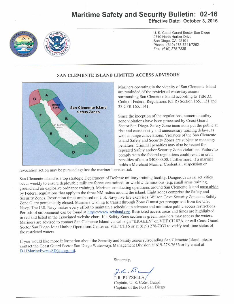


Vincent Thomas Highway BridgeMile 3.0
Los Angeles/Long Beach HarborPainting Project
A 100 foot long under deck temporary platform will reduce vertical clearance by 6 feet. Each corner and every 20 feet along thethe upstream and downstream side of the platform will lighted at night with steady burning red lights visible at 2000 yards byapproaching vessels. In a duration of 1-year the platform will progress from the western channel margin light to 100' west of thecenterline of the bridge.
Below Low SteelPlatform. 6 Footreduction invertical clearance
West Channel MarginLight

.
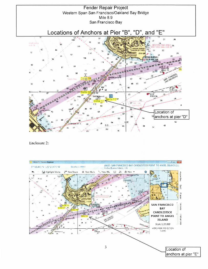


Buoy log booms will be set up to divert river trafficaway from any block nets, turbidity curtains,bridge trestle and falsework; the river traffic will bedirected through the designated trestle bayopening. Opening shall be wide enough tocompensate all water traffic; width of a single baywill be as wide as 24'-6". Buoy lines will beanchored on shore and then either attached to thetrestle itself or anchored to the bottom of theriverbed to keep the line in place.
McHenry Ave Bridge Replacement Project.
Mile 29.5.
Stanislaus River..
Buoy Line to direct waterway users floating downstream.A temporary bridge, providing 20' of horizontal clearance and 7' of vertical clearance, at
ordinary high water, will remain in place during the construction of the replacement bridge.

Bay Farm Island (CA RT 61) DrawbridgeMile 0.0
San Leandro BayUnder Deck Platform Lighting - Main Span
The temporary under deck platform reduces vertical clearance in the span byapproximately 3 feet. The upstream and downstream low deck of the platformis lighted at night with steady burning red lights so as to be seen byapproaching vessels at 2000 yards.

Bay Farm Island (CA RT 61) DrawbridgeMile 0.0, San Leandro BayUnder Deck Platform Lighting
The upstream and downstream lower corners of the under deck platforms between bents; 8-9,10-12, 17-18, and 21-22, are lighted at night with steady burning red lights so as to be seen byapproaching vessels at a distance of 2000 yards.


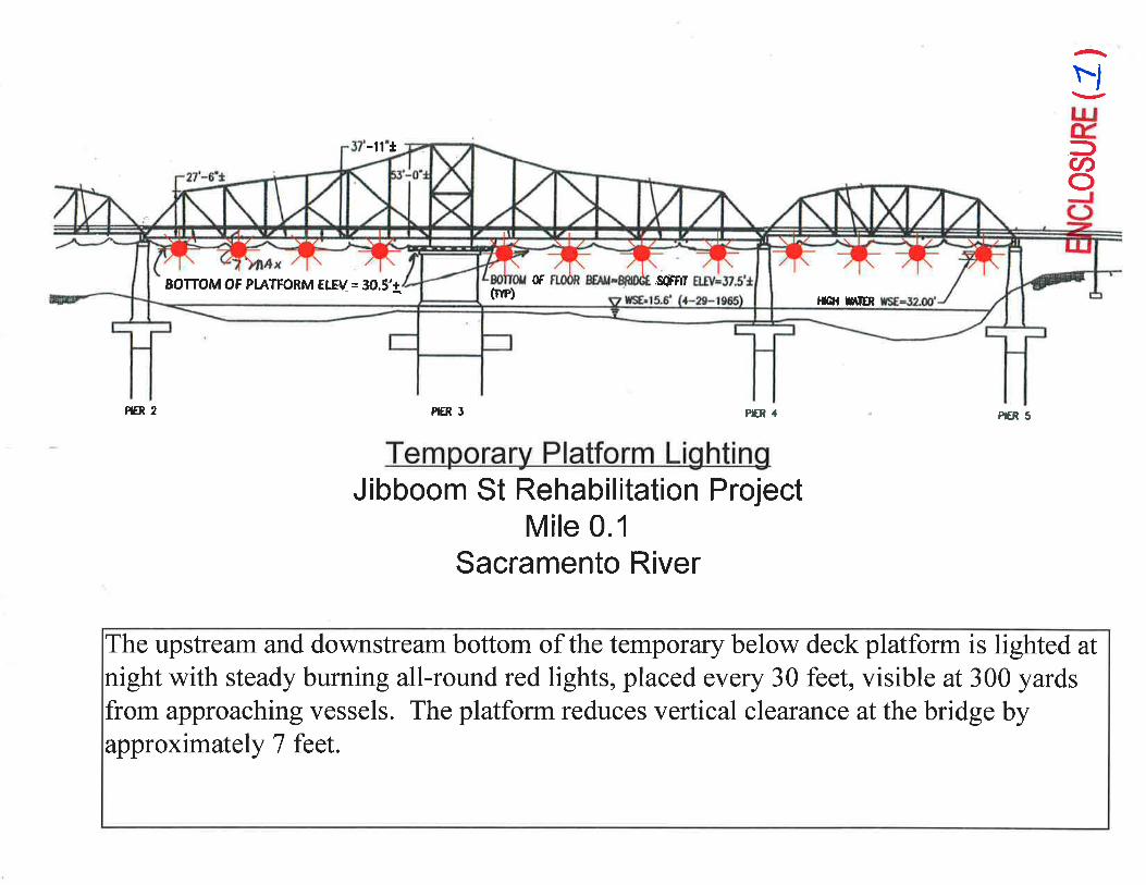

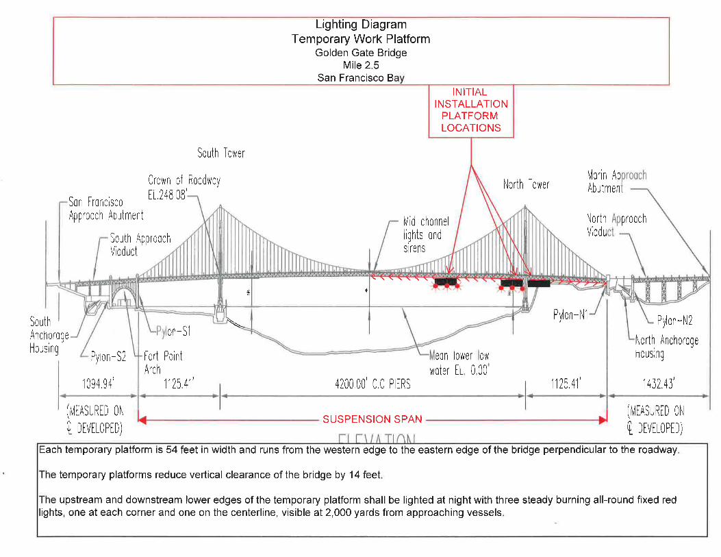

Replacement Schuyler Heim Bridge ProjectTemporary Lighting Diagram during Construction
The temporary trestles provide 75 feet of horizontal clearance and 48.5 feet of vertical clearance from Mean High Water to the lowest hittable portionof the bridge between the trestles.The upstream and downstream trestles are lighted at night with steady burning all-round red lights. The center of the navigation span, between piers 14and 15, is marked at night with all-round steady burning green lights.
48.5 feet VerticalClearance at MHW
75 feet HorizontalClearance betweentrestles
ENCLOSURE ( )