U.S. Department of Homeland Security FEMA Region X 130 … Oregon NFIP Draft RPA... · U.S....
35
UNITED STATES DEPARTMENT OF COMMERCE National Oceanic and Atmospheric Administration NATIONAL MARINE FISHERIES SERVICE West Coast Region 1201 NE Lloyd Boulevard, Suite 1100 Portland, OR 97232 Refer to NMFS No: NWR-2011-3197 March 9, 2015 Mark Carey U.S. Department of Homeland Security FEMA Region X 130 228 th Street SW Bothell, Washington 98021 Re: Draft Reasonable and Prudent Alternative and Incidental Take Statement for our Biological Opinion on Implementation of the National Flood Insurance Program in the State of Oregon Dear Mr. Carey: Attached you will find a draft Reasonable and Prudent Alternative (RPA) and Incidental Take Statement (ITS) for our biological opinion on implementation of the National Flood Insurance Program in the State of Oregon. The RPA and ITS are intended to accompany the biological opinion we shared with FEMA on September 5, 2013. This ITS and RPA were prepared considering comments from FEMA and the State of Oregon, including the Oregon Department of Land Conservation and Development. We appreciate the cooperation of your staff in preparation of these documents. We request you review the attached documents and contact us to schedule a meeting with FEMA and the State of Oregon to discuss any of your comments or concerns. We also request you submit any written comments on the RPA and ITS within 30 days of receipt of this letter. This draft of the RPA includes interim measures that can be implemented prior to completion of some elements of the RPA that may take more time to effectuate. We ask that you give careful consideration to the new interim measures included in RPA element #6. These measures are based on our collective experience implementing the biological opinion on the National Flood Insurance Program in the State of Washington. We would also welcome your feedback on the following specific items: 1. Recognizing the physical distinctions between the "built-out" floodplain of developed areas and the more intact functions of less developed floodplains, we welcome input from FEMA regarding the relative application of elements of the RPA to these distinct areas. For instance, certain types of floodplain development in built out areas may not result in any adverse effects on floodplain function. We are looking for ways to clarify this in the RPA.
Transcript of U.S. Department of Homeland Security FEMA Region X 130 … Oregon NFIP Draft RPA... · U.S....
UNITED STATES DEPARTMENT OF COMMERCE National Oceanic and Atmospheric Administration NATIONAL MARINE FISHERIES SERVICE West Coast Region 1201 NE Lloyd Boulevard, Suite 1100 Portland, OR 97232
Refer to NMFS No:
NWR-2011-3197 March 9, 2015 Mark Carey U.S. Department of Homeland Security FEMA Region X 130 228th Street SW Bothell, Washington 98021 Re: Draft Reasonable and Prudent Alternative and Incidental Take Statement for our
Biological Opinion on Implementation of the National Flood Insurance Program in the State of Oregon
Dear Mr. Carey: Attached you will find a draft Reasonable and Prudent Alternative (RPA) and Incidental Take Statement (ITS) for our biological opinion on implementation of the National Flood Insurance Program in the State of Oregon. The RPA and ITS are intended to accompany the biological opinion we shared with FEMA on September 5, 2013. This ITS and RPA were prepared considering comments from FEMA and the State of Oregon, including the Oregon Department of Land Conservation and Development. We appreciate the cooperation of your staff in preparation of these documents. We request you review the attached documents and contact us to schedule a meeting with FEMA and the State of Oregon to discuss any of your comments or concerns. We also request you submit any written comments on the RPA and ITS within 30 days of receipt of this letter. This draft of the RPA includes interim measures that can be implemented prior to completion of some elements of the RPA that may take more time to effectuate. We ask that you give careful consideration to the new interim measures included in RPA element #6. These measures are based on our collective experience implementing the biological opinion on the National Flood Insurance Program in the State of Washington. We would also welcome your feedback on the following specific items: 1. Recognizing the physical distinctions between the "built-out" floodplain of developed areas
and the more intact functions of less developed floodplains, we welcome input from FEMA regarding the relative application of elements of the RPA to these distinct areas. For instance, certain types of floodplain development in built out areas may not result in any adverse effects on floodplain function. We are looking for ways to clarify this in the RPA.
2. In the ITS, we are required to define the amount or extent of take1 resulting from implementation of the RPA. Since we cannot identify a number of animals to be taken, we describe the extent of take using metrics based on acres to be developed in the floodplain by county. Please let us know if you think these metrics reflect the amount of floodplain development likely to occur under implementation of the RPA. Also, be aware, these metrics do not reflect take resulting from floodplain development that may be exempted through individual section 7 consultations with other Federal agencies.
3. The Oregon Department of Land Conservation and Development has identified the challenge of depicting realistic channel migration zones within highly developed areas. They noted the proxy method for depicting channel migration zones will not account for areas that should be disconnected from migration due to intense development. We welcome suggestion on how to address this concern.
We look forward to working with FEMA to bring this consultation to a successful conclusion. Sincerely, William W. Stelle, Jr. Regional Administrator
1 Take as defined in the Endangered Species Act means to harass, harm, pursue, hunt, shoot, wound, kill, trap, capture, or collect, or to attempt to engage in any such conduct.
Preliminary Discussion Draft for FEMA, March 9, 2015
-1-
2.8.2 Reasonable and Prudent Alternative Introduction This RPA applies to all river basins (HUC 3) in Oregon that contain ESA-listed anadromous fish2 determined in this opinion to be jeopardized by the implementation of the NFIP, or containing critical habitat determined to be destroyed or adversely modified by the implementation of the NFIP. In order to fully carry out this RPA, FEMA shall implement the NFIP as revised below. The statutory authorities under which this RPA may proceed include: 42 USC 4001(e); 42 USC 4002(b)(3); 42 USC 4011(a) & (b); 42 USC 4102(c); 42 USC 4022(a)(1); 42 USC 4024; 42 USC 4101;42 USC 4101a; 42 USC 4101b; 42 USC 4102(c); 42 USC 4104; 42 USC 4121((c); 42 USC 4128; and 16 USC 1536(a)(1) & (2) et seq. For all RPA Elements 2–6, FEMA must ensure that the provisions are mandatory for communities to be included in as NFIP participating communities. When NMFS determines that a proposed Federal action is likely to violate the standards required of Federal agencies pursuant to ESA § 7(a)(2), NMFS is required to devise a Reasonable and Prudent Alternative (RPA) to the proposed action. An RPA is intended to provide an alternative to the proposed action that is consistent with the purpose of the proposed action, will avoid jeopardy and adverse modification, and is feasible to implement. Given that throughout the action area, some floodplains retain much of their natural condition, and others have been altered through extensive alteration and development, various components of the RPA are likely to apply differently given the habitat conditions and features that exist. As explained in this opinion, protection and restoration of floodplain habitat and functions are necessary, in order for the listed salmonids, and southern resident killer whales, to survive and recover. FEMA’s current implementation of the NFIP has contributed to and continues to exacerbate the existing degraded conditions. NMFS has framed the following recommendations based upon lessons derived from extensive efforts by FEMA, NMFS, and local governments in Western Washington to reshape the implementation of the NFIP based upon NMFS’ 2008 jeopardy opinion for western Washington. The RPA below focuses on the same basic building blocks of improvements as were recommended in the 2008 opinion to ensure that the NFIP does not continue to jeopardize endangered salmon runs. Those building blocks are (1) updated maps to more accurately depict floodplains; (2) updated development guidelines and standards to avoid unmitigated new or redevelopment in the floodplains; and (3) significantly strengthened systems of accountability to track and report on NFIP implementation. The major difference in this RPA relative to the 2008 RPA, is to shift the locus of accountability to FEMA through changes to its base NFIP regulations. More specifically, this RPA calls upon FEMA to revise its regulatory floodplain management standards defining eligibility requirements
2 We define the geographical scope of this RPA as HUC 3 river basins in order to ensure that this RPA applies both to basins containing listed salmonids and to subbasins where listed salmonids are not present but where floodplain development results in downstream effects to natural floodplain functions and, consequently, to listed salmonids.
Preliminary Discussion Draft for FEMA, March 9, 2015
-2-
for a local government to enroll in the NFIP. In the western Washington RPA, implementation rested largely on the discretion of the enrolled communities to choose their preferred method of compliance, and upon the ability of FEMA staff to provide significant technical assistance to those communities to support and track implementation effectively. The results to date are mixed, reflecting the highly variable response of these communities to protecting floodplain functions, the lack of local technical expertise in floodplain hydrology and function in some communities, highly mixed and ultimately unreliable reporting, and the inability of a small FEMA staff to track implementation across a very wide geography, despite their best efforts. Accordingly, this RPA recommends that FEMA implement a two-step approach in order to improve the likelihood that the adjustments in the NFIP needed to meet the high ESA standards of “ensuring” that the NFIP not jeopardize listed salmon or adversely modify their critical floodplain habitats occur. The first step is for FEMA and participating communities to implement the needed improvements using existing tools within the current regulatory construct. The second step is for FEMA to revise its regulations implementing the NFIP to incorporate these core requirements into the regulatory floodplain management criteria and thereby greatly enhance the likelihood of implementation, compliance, and success. NMFS notes that FEMA’s federal register notice (77 FR 28891) of May 16, 2012, indicated that an EIS would be undertaken on the NFIP and stated that FEMA’s proposed action was to “[m]odify the NFIP based upon changes identified through the evaluation process to enhance floodplain management standards including provisions to address endangered species and habitat concerns.” Acknowledging that FEMA has opened its rules to increase compatibility of the NFIP with the ESA, NMFS has developed some RPA Elements as recommended rule revisions. NMFS therefore strongly advises that FEMA revise its regulations (at, e.g. 44 CFR 65.6(a)(3)), policies, procedures, guidance, and/or protocols as necessary to ensure that the following mapping criteria and floodplain management criteria identified in RPA Elements 2-5 are implemented by FEMA and by NFIP communities, and that the measures are enforceable by FEMA (i.e., FEMA require that communities implement the measures as a condition of participation in the NFIP). These measures are identified as necessary to ensure that the NFIP avoids jeopardy to listed species and avoids destruction and adverse modification of critical habitat for those species. RPA Element 1: Notice to NFIP Participating Communities NMFS recommends that FEMA issue letters to all Oregon NFIP participating communities within 60 days of the issuance of the final opinion for the NFIP notifying them of the opinion. At a minimum, the letter should include the following:
A. A list of all communities located in river basins (HUC 3) containing ESA-listed species or designated or proposed critical habitat addressed by this opinion;
B. A recommendation to these communities to immediately suspend permitting of any floodplain development (as defined at 44 CFR 59.1)*3 until a determination is made that
3 Terms marked with “*” are defined in the Glossary to this RPA.
Preliminary Discussion Draft for FEMA, March 9, 2015
-3-
the proposed development does not reduce or degrade remaining natural floodplain functions (as defined by the 2013 CRS Coordinator’s Manual at 120-6)) to the detriment of ESA-listed species. Development that degrades floodplain functions include: loss of native riparian vegetation; increases in impervious surface; displacement or reduction of flood storage via fill or structures; interruption of habitat forming process; increases of pollutant loading in receiving water bodies; and increases in stormwater. FEMA should notify communities that allowing development that adversely affects floodplain habitat and functions prior to implementation of the measures contained in this RPA may result in a violation of ESA § 9 and subject the community and/or developer to civil and criminal penalties.
C. The list of measures for immediate implementation found at RPA Element 6
D. Notice to the communities of a pending requirement to report to FEMA information on all new development occurring in floodplains (see RPA Element 4A).
E. A recommendation that participating communities provide to FEMA within 90 days of the notice, their best available information on locally identified flood hazards due to erosion, or inundation, including anticipated build-out, climate change, or sea level rise, which are not currently reflected on maps adopted by FEMA, per 44 CFR 65.1. This provision applies to currently mapped floodplain areas, and those areas identified in RPA Element 2A. vi & vii.
RPA Element 2: Mapping Special Hazard* Zones/Areas As was noted in the hearings on HR 6525, the Flood Disaster Protection Act of 1973, which expanded the NFIP, “local officials in many flood-prone communities…like to think that a major flood is unlikely to happen to them, and thus they defer coming into the program until local developers have had a chance to build on the community’s remaining undeveloped lands without land use controls, both to take advantage of subsidized flood insurance rates at a later date and to obtain the cost advantages of construction at a lower elevation.”4 As noted by FEMA in its 2001 report, “[f]lood hazards may change significantly in areas experiencing urban growth or changes in physical conditions caused by such geologic processes as subsidence and erosion.”5 FEMA’s 2013 CRS Coordinator’s Manual (p. 410-2) further explains that “[d]evelopment regulations need thorough and accurate mapping of Special Flood Hazard Areas (SFHAs) and related flood hazard data.” FEMA’s CRS Coordinator’s Manual (p. 220-9) also notes that “[t]he faster an area grows, the more important it is to regulate development to prevent flood losses.”
4 Expansion of the National Flood Insurance Program, Tuesday May 8, 1973 House of Representatives, Subcommittee on Housing, of the Committee on Banking and Currency. HR 6524, 93rd Congress 1st Session. Statement of George K. Bernstein, Federal Insurance Administrator, Department of Housing and Urban Development. 5Modernizing FEMA’s Flood Hazard Mapping Program: Recommendations for Using Future-Conditions Hydrology for the National Flood Insurance Program, FEMA 2001.
Preliminary Discussion Draft for FEMA, March 9, 2015
-4-
As FEMA acknowledges, incomplete, out of date, and/or inaccurate mapping of flood hazard prone areas prevents local government officials from understanding how severe flood risk is and from implementing restrictive zoning and land use regulations and comprehensive planning. Thus, the second Element of the RPA provides program-level revisions to ensure that flood hazard risks are more fully and accurately reflected on the flood risk maps that dictate floodplain development restrictions and construction standards. Accurate mapping of areas likely to experience flood hazards such as flood inundation and flood-related erosion will provide valuable co-incidental information on, and protections for, floodplain functions and processes associated with important habitat features that support listed species. Accurate knowledge of important habitat features is essential to avoid jeopardy and to enable recovery. Thus flood hazard mapping must occur in both developed areas and areas of possible population growth, and should not be limited by the size of the watershed drainage area. Except where noted otherwise, all changes to regulations, policies, procedures and guidance as needed to fully implement Section 2 of this RPA must be in place no later than January 1, 2017 in order to meet the expectations of this RPA. As noted by FEMA, adoption of maps is prerequisite to effective management of flood-related hazard areas. “Outdated mapping hinders sound floodplain management. The map a community uses for floodplain management can and should be updated frequently to account for annexations, new subdivisions, site-by-site analyses, better ground elevation data, and incorporation of new hazard data. To make the map more useful and easier to use, it should include detailed topography, building footprints, natural features, and other data that can help relate the floodplain information to conditions on the ground and to other programs.” 2013 CRS Coordinator’s Manual at 440-2. NOAA Fisheries strongly concurs with these observations. Therefore, in order to avoid increasing the likelihood of jeopardy and the likelihood of adverse modification of designated critical habitat, this RPA calls for FEMA to take the necessary steps to ensure that all Oregon NFIP participating communities adopt FIRMs and FHBMs in accordance with the criteria in this RPA, and have fully complied with map updates and revisions as described by RPA Element 5B “Compliance Benchmarks”. This is compatible with authorities at 42 USC 4101(a)(1) and (b). REGULATIONS which are applicable or pertinent to this RPA Element include: 44 CFR 59.1; 59.23; 60.1, 60.2(c); 60.3(d)(2), 60.5, 60.24-26, 64.1, 64.3(a)(2), 65.1-3; 65.6(.a)(3) and 65.7.
A. Flood Hazard Mapping Protocols: Because FEMA’s mapped floodplains are intended to indicate the likelihood of exposure of certain lands to inundation in order to evaluate flood-related risks to life and property and thereby insure structures that are located in flood-prone areas and discourage new construction in flood-prone areas, consistent with 42 USC 4101(a) through (d) and consistent with recommendations developed according to 42 USC 4101a (d)(1)(A) and (2), and obligations under the Biggert-Waters Act to identify , update, and maintain maps of all areas of possible population growth within both the 100 and 500-year floodplain, per this RPA FEMA will incorporate in the data used for mapping, the current best available data that indicates both current risk and
Preliminary Discussion Draft for FEMA, March 9, 2015
-5-
reasonably anticipated increase of risk (see 42 USC 4101b(a) & 4101b(b)(3)(C) & 4101b(c)(1)(ii)), by implementing the following measures:
i. Use one or more of the following models and/or methods to produce more accurate maps:
a. Calibrating flood maps to historic flood events by using stage-discharge relationship at USFS gaging stations; or, where gage data is unavailable, to historic high water marks.
b. maximum probable roughness coefficient (i.e., Manning’s n) during flood modeling that corresponds to the full riparian vegetation community consistent with the land use zoning for the area, and the season of highest roughness.
c. unsteady-state hydraulic models, or an equally accurate modeling method, for conditions of significant floodplain storage and or tidal flow.
d. multi-dimensional hydraulic models, or an equally accurate modeling method for conditions of uncertain or changeable flow paths, complex overbank flow, and locations where flows have significant lateral flow compression (e.g., bridges).
ii. Present the range of modeled base flood elevation values when identifying the Base Flood Elevation in the FIS and include a safety factor of at least 25% for establishing BFEs (see 2013 CRS Coordinator’s Manual at 410-18).
iii. Depict the limit of moderate wave action (LiMWA) (as defined in the 2013 CRS Coordinator’s Manual at 120-6 and Procedure Memorandum 50) on FIRMs, and designate these as coastal A zones.
iv. Add to its generally applicable prioritization factors for mapping/remapping, the presence of ESA-listed, species and/or the designation of critical habitat for ESA-listed species, and the overlap between species presence and areas of projected population growth. FEMA shall work with NMFS on identifying the appropriate place in the map/remap selection process to seek NMFS input regarding the species presence and critical habitat factors.
v. Include all watersheds of 160 acres and larger when mapping the SFHA. vi. Include all areas in which flood depths reach 6 inches and deeper when
mapping the SFHA. vii. Define the floodway for full conveyance (i.e., a zero rise floodway); or use the
1 foot rise floodway expanded to include all locations where depths of flood water reach or exceed 3 feet, and all locations where the velocity of floodwater reaches or exceeds 3 feet per second (see 2013 CRS Coordinator’s Manual as 410-216).
B. Map Flood Hazard Boundaries – (42 USC 4101(a)-(f) & 44 CFR 60.2(a) & 44 CFR 64.3(a)(2), and 65.2(a)). In order to indicate the full range of hazards associated with
6 The Coordinator’s Manual explains: “Because the entire SFHA benefits from the implementation of a more restrictive floodway surcharge, a FWS [floodway standard] includes the entire width of that reach of the SFHA, not just the area of the floodway. A higher floodway standard helps prevent development within the SFHA, thereby reducing increases in flood elevations on existing structures.” 2013 Coordinator’s Manual at 420-21.
Preliminary Discussion Draft for FEMA, March 9, 2015
-6-
floods, FEMA shall also depict E Zones for both coastal and riverine erosion on its maps. Because FEMA is required by statute to depict flood hazards, and because FEMA’s statute at 42 USC 4121(c) includes flood-related erosion within the definition of flood risks, and because FEMA is required by statue at 42 USC 4101b(b)(3)(C) to include in updated maps any relevant information on land subsidence and other flood-related hazards, consistent with 44 CFR 60.5, and 44 CFR 9.7(b)(v)(B) it is necessary that FEMA’s maps depict special hazard areas (44 CFR 59.1) including flood-related erosion areas (incorporating channel migration zones (CMZs)* and avulsion hazard zones (AHZs)*), which are to be designated as the flood-related erosion zone (E Zone). The mapping protocols to depict E Zones shall be based on the table found at appendix 2.8–B, using mapping methodology identified by Rapp and Abbe 2003 or by Legg and Olsen 2014. A proxy may be used as an interim method for depicting the E Zone using either: (1) the entire SFHA as the E Zone; or, (2) the method described in Appendix 2.8-B (based on Sikder (2012)). Note that the CMZ may be disconnected by existing infrastructure and development in developed floodplains. An area determined to be a disconnected migration area pursuant to a CMZ delineation methodology consistent with Rapp and Abbe (2003), or another methodology determined by NMFS to be of comparable value, may be excluded from the CMZ/Zone E. Where the CMZ is determined using a proxy, no exclusion shall be available. Given that multiple areas across a broad geography will require E Zone mapping, the sequence for mapping E zones, inclusive of CMZs and avulsion hazard zones, should be based on the status of, and the relative importance of component populations of listed species, and the ranking of critical habitat. FEMA shall work with NMFS on identifying the appropriate place in the map/remap selection process to seek NMFS input regarding the species presence and critical habitat factors, above.
C. Depict the High Hazard Area. For this RPA, the high hazard area (HHA) is defined and
measured by the furthest extend landward of: i. V Zones
ii. LiMWA iii. Floodway (as defined by this RPA) iv. E Zones (as defined by this RPA)
D. Depict the Area of Future Conditions Flood Hazard (AFCFH). A report provided by
AECOM indicates that in the Pacific Northwest the combination of shifting rainfall and snowfall patterns from climate change, when coupled with future land use changes associated with increasing human population growth, will significantly increase the BFE of riverine areas in the next 85 years.7 Thus the FEMA flood risk maps shall also include
i. Area of Future Conditions Flood Hazard (i.e., shaded Zone X). FEMA should use its best efforts to ensure that the Technical Mapping Advisory Council provides its final Future Conditions Risk Assessment Modeling Report
7 See opinion pages 46, 147, and 152.
Preliminary Discussion Draft for FEMA, March 9, 2015
-7-
(report) to FEMA no later than September 30, 2015 (42 USC § 4101a(d)). As required by Biggert-Waters Act at section 100215(d)(2) FEMA shall implement the report’s recommendations on mapping future conditions. To satisfy this RPA, FEMA should carry this requirement out within 12 months or otherwise as promptly as possible. NMFS expect that the report will recommend mapping the area of future conditions flood hazard based on:
a. Sea Level Rise (42 USC 4101b(b)(3)(D)) b. Climate Change (EO 13653; 42 USC 4101a(d)) c. Build out/Land Cover Change (42 USC 4101a(d))
ii. The above shall be based upon best available science projections for the year 2100. Alternatively, if available data are inadequate to estimate future conditions hydrology, or if needed to address uncertainty, the surcharge identified by the Federal Flood Risk Management Standard may be used as a proxy. Or, an acceptable surrogate to either of these is to depict the 0.2 percent chance (i.e., the 500 year) floodplain as a proxy for the AFCFH. 42 USC 4101b(b)(1)(A)(ii).
E. Map Adoption Procedures Replacing outdated maps with more accurate maps is beneficial only if the updated maps are timely adopted by communities and used as a basis for implementing the NFIP’s requirements. Frequently, communities continue to rely on outdated maps long after new maps have been prepared, due to the lengthy process for appeals and general time lag between FEMA’s issuance of a preliminary map and a letter of final determination (LFD). To ensure that floodplain management and concomitant habitat protections are applied based on the best information available, this RPA calls for FEMA to:
i. Ensure that all timelines provided in 42 U.S.C. §§ 4104, 4104-1 and 44 C.F.R. part 67 are strictly complied with, and issue an LFD within 30 days of the date that any appeals process is completed (e.g., for matters referred to the Scientific Resolution Panel, FEMA shall issue its LFD no later than 280 days from the date the preliminary map is published (250 days required by statute, 30 additional days for FEMA to take final action);
ii. Interpret a “reasonable time” as provided in 44 C.F.R. 67.8(c) to be 180 days or fewer.
iii. During the time period for appeal and for the duration of any appeal process, FEMA should ensure that the regulatory floodplain management criteria as revised by this RPA are applied in all areas included in the preliminary map except when precluded by 42 U.S.C. § 4101-1(d).
iv. Modify 44 CFR 67.9 to state that when no appeal is filed by the affected community, any preliminary map shall become effective within 15 days from the date upon which the appeal period expired. The appeal of a map by an individual landowner under 44 C.F.R. 67.5 shall not be a basis upon which to delay the LFD for any portion of the map not subject to the individual appeal.
F. Mapping of residual flood hazards and risks behind levees
Consistent with FEMA’s obligations under the Biggert-Waters Act to identify , update,
Preliminary Discussion Draft for FEMA, March 9, 2015
-8-
and maintain maps of areas of residual risk that are protected by levees, dams and other flood control structures, this RPA calls for FEMA to:
i. Not omit any areas from the SFHA based on the presence of a non-accredited levee. Additionally, FEMA must not delay the finalization of flood risk and flood hazard maps irrespective of the presence of non-accredited levees. Levees shall not be provisionally accredited.
ii. FEMA shall depict residual risk behind accredited levees.
Accreditation of levees and the modification of mapped areas of risk behind levees are future actions that require consultation between NMFS and FEMA.
RPA Element 3: Regulatory Floodplain Management Criteria in Mapped Flood-Related Hazard Areas Accurate mapping, which is required by RPA Element 2, is a pre-requisite to the requirements of RPA Element 3, the effective implementation of floodplain management regulations, including land use and development standards, that both reduce exposure of life and property to flood risk, and preserve natural floodplain functions as described at the CRS Coordinator’s Manual at 120-6, and 42 USC 4121(a)(12)(A) and (B) and at 44 CFR 9.4 and at 44 CFR 9.10(d)(2). FEMA is required by statute to establish comprehensive criteria for land management and use that states or local communities must adopt in order to participate in the NFIP. The criteria are intended to constrict the development of land exposed to flood damage, guide development away from flood hazard areas, reduce flood-related damage, and improve long-range land management and use of floodprone areas. 42 USC 4102. As stated by Congress, “A most important public purpose which the [NFIP] will serve will be to encourage State and local governments to adopt and enforce appropriate land use provisions to restrict future development of land which is exposed to flood hazard.” H.R. Rep. No. 1585, reprinted in 1968 U.S.C.C.A.N. 2873, 2966. Floodplain management regulations that restrict floodplain development and reduce or avoid future disaster costs co-incidentally preserve resources important for the survival and recovery of listed fish. Except where noted otherwise, in order to meet the expected outcomes of this RPA, all changes to regulations, policies, procedures, and guidance required by Section 3 of this RPA must be in place no later than October 1, 2017. As authorized by 42 USC 4128 and consistent with 42 USC 4102 (a) through (c) and 4001(e), and as provided by 44 CFR Part 9(b) and 44 CFR 59.22, 60.2(a) and (c), 60.22-24, 60.7, 65.2(a), FEMA shall revise the floodplain management criteria of 44 CFR Part 60 and/or policies, procedures, and guidance, to require that NFIP participating communities incorporate land use, subdivision, design, and building placement standards for all development in special hazard areas, to protect natural and beneficial values of floodplains and wetlands (EO 11988 & 11990; 44CFR 9.4). Compliance with this RPA Element will better guide the development of proposed future construction away from locations which are threatened by flood and flood-related
Preliminary Discussion Draft for FEMA, March 9, 2015
-9-
hazards,8 and will protect and may reestablish some degree of natural and beneficial floodplain functions as defined by statute 42 USC 1421(12), and by regulation (44 CFR 9.4) e.g., “Natural values of floodplains…include but are not limited to (b) living resource values.” This RPA Element has two components: (1) development limitations and mitigation requirements in a buffer area closest to the flood source (and therefore most at risk of flood damage), and (2) mitigations requirements for development in the remainder of the floodplain. These criteria are similar to standards that FEMA has been implementing in western Washington since September 2008, and to the higher regulatory standards advocated by FEMA in the 2013 CRS Coordinator’s Manual. Per this RPA Element, FEMA will revise their codes (e.g., 44 CFR 60.3 and 60.5), policies, procedures, and guidance, to incorporate the following standards:
A. “Zero Rise/Zero Increase in Velocity” standard is required for all floodplain development except habitat restoration activities,* and rise must be measured within the hydraulic reach* where the development is proposed. If no BFE is established at the time the development is proposed, the proponent for the development must document the BFE and apply the zero-rise standard. Any action in the SFHA that would reduce flood storage volume or accessible floodplain habitat for fish must be “balanced” by the creation of new storage capacity and accessible habitat (i.e., balanced cut/fill). When the zero rise standard is met through mitigation for the loss of storage by creating compensatory storage, that constructed storage must be:
i. be hydrologically connected to the waterbody which is the flooding source, ii. designed so that there is no increase in velocity
iii. designed to fill and drain in a manner that does not trap fish, iv. within the same hydraulic reach as the proposed development to minimize
impact to affected fish populations. v. measured in one foot elevation increments relative to the amount and location of
fill placed and must occur at a 1.5 to one ratio in order to guarantee no loss of beneficial floodplain functions, including conveyance.
B. Restrictions on Subdivision of Lots. i. For properties that are located partially within special hazard areas, allow no
subdivision of parcels that would create a parcel fully within a special hazard area. Property must be partitioned only in such a manner as to reserve sufficient land outside of special hazard areas to accommodate future development.
ii. No subdivision of parcels that would create lots smaller than 5 acres. iii. Limit development to one building per 5-acre parcel for residential development
and coverage of 10% or less of the lot for non-residential development. Lots already smaller than 5 acres shall not be further divided and shall be subject to the same building number/coverage limits (see 2013 CRS Coordinator’s Manual at 420-26 to -27).
8 Compliance with this RPA will co-incidentally satisfy the GAO recommendation in its climate change report that FEMA should consider amending the NFIP minimum standards to incorporate forward looking standards. GAO 2014.
Preliminary Discussion Draft for FEMA, March 9, 2015
-10-
iv. Any lots or parcels created by subdivision must be able to accommodate development consistent with the applicable zoning and with the requirements of this RPA, including any on-site mitigation required by this RPA, without requiring any variance.
v. Partitioning to facilitate habitat restoration activities in the floodplain is excluded from provisions B.i through iv, above.
C. All development must provide on-site mitigation for all adverse effects to natural floodplain functions (except for compensatory storage, which may occur off-site as provided in Appendix 2.8-C). In addition, all structures* must:
i. be placed on the highest natural grade within the lot ii. incorporate Low Impact Development* methods
iii. include Green Infrastructure* iv. provide Setbacks and Open Space9 to redevelopment
D. Grandfathering
Development and construction existing* at the time of the signing of this biological opinion may be grandfathered. But, when structures that are grandfathered have been substantially damaged, or substantially improved, the structure must come into full compliance with the applicable floodplain management criteria as revised by this RPA. Substantial damage and substantial improvement shall be calculated at 50% of the value of the structure, measured cumulatively over a 10 year time frame. Also, improvements that increase the footprint of the structure 10% or more (based on the square feet of the lowest floor) measured cumulatively over 10 years shall constitute “substantial improvement” (See 2013 CRS Coordinator’s Manual at 430-1).
E. Additional Criteria for High Hazard Areas and Riparian Buffer Zones:
This RPA Element applies to the furthest landward extent of the High Hazard Area, as defined by this RPA, or the 170-foot Riparian Buffer Zone (RBZ)* as identified in FEMA’s proposed action for this consultation.
i. Due to the importance of protecting riparian habitat and functions within the High Hazard Area, except as expressly provided below, FEMA’s regulations must:
a. require that no new development be allowed in the high hazard area; b. revise 44 C.F.R. 60.3(d)(3) and(4), so that the floodway may not be
redrawn to accommodate new development in the floodway, and c. revise 44 CFR 60.3(e) to require that all new structures are located
landward of the reach of extreme high tide.* This will avoid development in flood-prone lands adjacent to marine waters that are designated as salmonid critical habitat.
9 “Preserving the floodplain as open space allows it to serve these primary natural functions and many other important functions. Keeping the floodplain free of development—free of buildings and infrastructure—means that there will be no flood insurance claims, no closed businesses, no homeless residents, and that the community can return to normal quickly after flooding occurs.” 2013 CRS Coordinator’s Manual at 420-3.
Preliminary Discussion Draft for FEMA, March 9, 2015
-11-
d. designate the required setback to create a “safety buffer consisting of a natural vegetative or contour strip” (44 CFR 60.5(b)(2)) as be the greater of: 1. The 60-year erosion setback (44 CFR 59.1) or, 2. One-half again the distance of the depicted “high” or “severe”
erosion risk. ii. Exceptions.
a. The following uses may be allowed in the High Hazard Area: 1) open space* uses (see CRS Coordinator’s Manual at 420-6 to -7); (2) habitat restoration activities; (3) low intensity recreational* uses; and (4) water-dependent uses. In that portion of the HHA outside of the floodway boundary, agriculture and forestry are additional uses that may be allowed.
b. Development for which the start of construction* occurred prior to issuance of this opinion may proceed anywhere in the High Hazard Area.
c. Any development allowed as an exception must meet the mitigation requirements of Elements 3A and C (i)-(iv) of this RPA. Habitat restoration activities are considered, however, self-mitigating and therefore do not require additional mitigation.
RPA Element 4: Data Collection and Reporting In order to document that FEMA and NFIP participating communities are managing floodplain development in a manner that preserves natural floodplain functions and meets the objectives of this RPA, FEMA must systematically collect and report information from all participating communities in Oregon so as to document (a) how many floodplain development activities were authorized by participating communities subject to this RPA; (b) where and when the activities occurred; (c) a basic description of the activity implemented, including mitigation; (d) the impact of the activity on natural floodplain functions, including identification of any functions that were adversely affected and any associated mitigation implemented to offset those adverse effects; and (e) information that allows an evaluation of compliance with the NFIP requirements as modified by this RPA.
A. Permit Reporting: Participating communities must report to FEMA on each permit for development in the special hazard areas*, including the following information:
i. The amount of fill (loss of flood storage/refugia), and the amount of compensatory storage measured by volume and area (both surface area and cross sectional area)
ii. the amount of impervious surface (loss of hyporheic function), the type(s) of LID and green infrastructure required, and any projected change in the timing, velocity, or peak flows of stormwater runoff
iii. The area in which clearing and/or grading occurred (loss of riparian function) and the type and amount of mitigative planting required
iv. If a project disconnects land from the floodplain (e.g., by accreditation of levees and by recognition of non-accredited levees), identify the type of project and the amount of land disconnected from the floodplain.
Preliminary Discussion Draft for FEMA, March 9, 2015
-12-
v. If a project reconnects land to the floodplain (e.g., by the removal or setback of a levee) identify the type of project and amount of land reconnected to the floodplain.
vi. The location of the project, and of the corresponding mitigation (e.g., within the high hazard area, the SFHA, or the AFCHA); for projects in the HHA identify the which exception from Element subpart 3E(ii) applies.
By July 1, 2015, FEMA shall finalize a standardized reporting form for communities to report permit information, and submit it to NMFS for review and concurrence. FEMA may develop its own standardized reporting form, or NMFS has prepared a Google Form that could be used for reporting as required by this component of the RPA. We estimate communities could complete the form in less than 10 minutes for each permit issued. To implement this RPA, permit reporting by NFIP communities must commence by January 1, 2016, and thereafter within 5 business days of each permit issuance
B. Annual Reporting. Until FEMA has fully implemented all Elements of this RPA, FEMA
will prepare and submit a report to NMFS annually, based on the calendar year, on implementation status. NMFS further recommends that these annual reports be publically available so that the public can track efforts to protect public health and safety and important floodplain functions and other indicators of the implementation of this RPA. FEMA will:
i. confer with NMFS to mutually agree upon a due date for submission of the annual report, but no later than April 1 of each year. The first report shall be prepared in 2016, and shall include information gathered up to December 31, 2015.
ii. annually meet with NMFS to review the most recent report and program performance. The interagency meeting purpose will be to, determine the adequacy of program compliance, identify what additional actions by FEMA are warranted, and determine whether re-initiation of this consultation is warranted.
iii. include in the report, at a minimum, the following: a. A list of communities that have adopted ordinances or enforceable
procedures that implement the revised floodplain management criteria required by this RPA
b. A list of completed FHBMs (including E Zones) and FIRMS that comply with RPA Element 2
c. The mapping status of each Oregon NFIP participating community (i.e., dates of effective maps, status of preliminary maps including status of any appeals, and anticipated dates for Final Letters of Determination)
d. The number of CLOMCs (specify how many are CLOMR-Fs) and, LOMCs, (specifying how many are LOMR-Fs) issued by FEMA
e. Sum by participating community: Fill area and volume values based on the community reported fill placed above the natural grade and below the BFE, excluding fill associated with restoration and mitigation actions.
f. Sum by participating community: Loss of riparian vegetation/clearing and acres replanted
g. Sum by participating community: Increase in impervious surface

Preliminary Discussion Draft for FEMA, March 9, 2015
-13-
h. Sum by participating community: The amount of floodplain disconnected and/or reconnected to the floodplain
i. A summary of the CAVs initiated and completed that year, including the community progress toward compliance benchmarks (below);
j. A brief description of any compliance problems or issues and resulting FEMA enforcement actions
RPA Element 5: Compliance and Enforcement. In order for this RPA to function as intended, it is critical that FEMA effectively monitor community compliance and promptly undertake appropriate enforcement actions if needed to ensure community compliance. FEMA must ensure both that communities adopt the required ordinances and/or enforceable procedures and that communities enforce their ordinances/procedures so as to achieve the intended outcome of this RPA, i.e., preservation and enhancement of all remaining natural floodplain functions.
A. Community Rating Systems Points Because compliance with this RPA will prevent destruction and adverse modification of critical habitat by reducing or avoiding degradation and loss of floodplains and floodplain functions; and because the preservation of floodplains and floodplain functions will reduce the likelihood of jeopardy to listed species; in order to encourage jurisdictions to independently pursue compliance with the RPA in advance of stated timelines, which would confer an early and permanent benefit to species and their habitat, this RPA directs FEMA , as authorized by 42 USC 4022(b), to modify the CRS rating system so that when, prior to FEMA’s own compliance with the regulatory provisions of this RPA, a community:
i. adopts a full conveyance floodway per RPA Element 2Avii, it receives 200 points under CRS part 410
ii. maps flood related erosion zones or uses an accepted scientific method to confirm no CMZ is present per RPA Element 2B, it receives 100 points under CRS part 410
iii. maps the HHA per RPA Element 2C, it receives 100 points under CRS part 410 iv. maps AFCFH per RPA Element 2D, it receives 100 points under CRS part 410 v. regulates to the preliminary map even though the letter of final determination has
not yet been issued, that community shall receive 100 points under CRS parts 430 and 510
vi. adopts zero rise/zero increase in velocity standard for development per RPA Element 3A, it receives 100 points under CRS parts 430
vii. restricts subdivision of lots per RPA Element 3B, it receives 150 points under CRS parts 420 and 430
viii. requires use of LID and/or Green Infrastructure for all new development per RPA Element 3C, it receives 200 points under CRS part 450
ix. prohibits new development in the HHA per RPA Element 3E, it receives 300 points under CRS parts 420 and 430
Preliminary Discussion Draft for FEMA, March 9, 2015
-14-
B. Community Assistance Visits to Ascertain Compliance. In order to ensure that all floodplain management criteria of the NFIP as revised by this RPA are both adopted and properly implemented, NMFS strongly recommends that FEMA conduct CAVs, or otherwise audit compliance with this RPA, for all Oregon NFIP communities within 10 years, and thereafter 25 communities each year. NMFS further recommends that FEMA prioritize for CAVs or audits those communities which:
i. FEMA is aware or has reason to believe (e.g., based on permit reporting data) are not fully implementing the RPA requirements
ii. Are subject to this RPA iii. Have mapped floodplains that retain low density characteristics and are subject to
possible population growth iv. Show an increasing number of floodplain development permits v. Have growth boundaries, comprehensive plans, or zoning that allow development
in special hazard areas.
C. Compliance Benchmarks. To demonstrate that it is achieving the expected outcomes of this RPA, participating communities must meet mapping requirements and development standards corollary to those maps. Thus, NMFS believes that FEMA may demonstrate that this RPA is being successfully implemented by showing that:
i. Within 4 years of the date of this opinion, FEMA must demonstrate to NMFS that in Oregon all participating county or municipal jurisdictions have met at least one of the mapping requirements (below), and 3 of the development requirements (below).
ii. Within 6 years of the date of this opinion, FEMA must demonstrate to NMFS that all participating county or municipal jurisdictions they have met at least 2 of the mapping requirements and 4 of the development requirements.
iii. Within 8 years FEMA must demonstrate to NMFS that all Elements of the mapping and development requirements are adopted and implemented by all Oregon participating jurisdictions:
a. Mapping: 1. Adopted SFHA maps must be more recent than the year 2005 2. Depiction of E-Zones, or documentation that erosion is not a risk 3. Depict the High Hazard Area 4. Adopt FHBM 5. Depict AFCFH
b. Development Standards: 1. Adopt restriction on development and uses in high hazard areas 2. Restrict subdivision of lots per RPA Element 3 B ii 3. Adopt the zero rise standard/compensatory storage requirement 4. Adopt the substantial damage/substantial improvement standard for
grandfathered structures 5. Adopt LID, Green Infrastructure, requirements for all development 6. Adopt setback and open space requirements for redevelopment 7. Adopt a best available data standard that mandates the use of
preliminary data (maps) provided by FEMA upon provision of the data
Preliminary Discussion Draft for FEMA, March 9, 2015
-15-
to the community, wherever the data is more restrictive than the effective map.
D. Enforcement Sequence for Non-Compliance. In order to meet the expectations of this
RPA, by February 1, 2023, FEMA will demonstrate full program compliance among or those communities subject to this RPA, based on the data from local permits reported to FEMA and from CAVs. For those communities subject to this RPA, a community that does not achieve and maintain compliance with the above benchmarks by February 1, 2022 should be placed on probation. For example, when development reporting reveals that unmitigated effects to floodplain/riparian resources have occurred within a jurisdiction, then FEMA will put that jurisdiction on notice for probation. Communities automatically out of compliance are those that fail to have in place ordinances and other enforceable procedures that comply with the revised floodplain management criteria in this RPA.
Should a participating community placed on probation fail to come into compliance with the revised floodplain management criteria within 24 months of being placed on probation, FEMA will suspend the community from the NFIP, and the community’s take coverage shall lapse.
RPA Element 6: Interim Measures for Immediate Implementation Given that RPA Elements 2, 3 and 5 anticipate a minimum of 2 years for initial compliance, and 8 years for full implementation, This RPA includes the following steps may be immediately taken to ensure that no jeopardy and no destruction or adverse modification of designated critical habitat results before the RPA is fully implemented. NMFS anticipates that FEMA and NFIP communities will begin implementation of these measures within 6 months of the date of this opinion:
A. FEMA will consult with NMFS on all CLOMRs, and FEMA shall not issue LOMR-Fs, to ensure that no map amendments are based on loss of floodplain function due to unmitigated fill or levees.
B. No new development will be placed in the currently designated floodway, velocity zone or sea-ward of the LiMWA. No floodway will be modified to accommodate new development. Where no floodway is designated, no new development will be allowed until a zero-rise/full conveyance floodway is identified. Acceptable uses in the floodway are agriculture, silviculture, open space/low intensity recreational, and uses that are functionally dependent on water. Effects to natural floodplain functions resulting from acceptable uses require mitigation.
C. Any structures to be located in special hazard areas for which the start of construction occurs after the date of this opinion are to
i. incorporate LID or Green Infrastructure features to reduce stormwater impacts
Preliminary Discussion Draft for FEMA, March 9, 2015
-16-
ii. fully mitigate for loss of flood storage and vegetation, and/or other reduction in other natural and beneficial functions of the floodplain per Appendix 2.8 C
D. Any parcel located in the SFHA that is transferred in ownership must include a statement that the property may be subject to future development standards that could curtail further subdivision and/or restrict certain future uses depending upon potential hazards such as flood-related erosion, increasing flood elevations, and/or floodway designations based on full conveyance/zero rise, deep water conditions, or fast water conditions.
E. The reporting criteria of RPA Element 4 are included as part of these interim measures consistent with the timelines for reporting provided above.
These measures, while protective of habitat and listed species as interim measures, are a subset of, and less protective of important habitat features and processes than, the full RPA, and are insufficient by themselves to avoid jeopardy or adverse modification over time. These requirements will sunset when Elements 2-5 are fully implemented and they replace these requirements to provide more permanent protection of the natural and beneficial functions of the floodplain that serve ESA-listed species. These interim measures do not alter the other timelines identified throughout this RPA.
Preliminary Discussion Draft for FEMA, March 9, 2015
-17-
RPA GLOSSARY Definition of Terms as Used in this RPA
Area of future conditions flood hazard (AFCFH) – The land area that would be inundated by the 1-percent-annual-chance (100-year) flood based on future conditions hydrology (44 CFR 59.1), inclusive changes due to climate change. Avulsion – “Described by Allen (1965 5:119) as ‘the sudden abandonment of a part or the whole of a meander belt by a stream for some new course.’ Channels may avulse into an abandoned channel or create a new channel depending on the preexisting boundary conditions that initiate the avulsion” (Rapp and Abbe 2003). Avulsion hazard zone (AHZ) – “The area not included in the Historic Migration Zone that is at risk of avulsion over the timeline of the channel migration zone” (refer to Section 4.2 of Rapp and Abbe 2003). Channel migration zone (CMZ) – “The area where a stream or river is susceptible to channel erosion” (refer to Rapp and Abbe 2003). The CMZ may extend beyond the 100-year floodplain. Where the delineated CMZ extends beyond artificial revetments, bulkheads, and levees, all such areas are included within the CMZ unless they are designated as DMAs, as these structures have a high risk of failure. Development – Any man-made change to improved or unimproved real estate, including but not limited to buildings or other structures, mining, dredging, filling, grading, paving, excavation or drilling operations, storage of equipment or materials (44 CFR 59.1), and expanded for the purpose of this RPA to include removal of vegetation or other alteration of natural site characteristics (including any remnant natural characteristics existing in a degraded site). For this RPA, development does not include the maintenance, repair, or remodel of existing buildings, facilities, and utilities within their existing footprints (except for substantial repairs and improvements); resurfacing of roads; lawn care; gardening; removal of noxious weeds, replacement of non-native vegetation with native vegetation; removal of hazard trees; or plowing and similar agricultural practices that do not involve filling, grading, or construction of levees or structures. Disconnected migration area (DMA) – An area that would normally be included within the CMZ, but is physically disconnected from the CMZ by accredited levees or other permanent man-made structures that constrain channel movement (refer to Section 4.4 of Rapp and Abbe 2003). Erosion hazard area – “The area, not included in the HMZ, or the AHZ, that is at risk of bank erosion from stream flow or mass wasting over the timeline of the CMZ. The EHA has two components: the Erosion Setback (ES) and the Geotechnical Setback (GS). The ES is the area at risk of future bank erosion by stream flow; the GS is defined by channel and terrace banks that are at risk of mass wasting (due to erosion of the toe). The GS projects from the ES at a side slope angle that forms a stable bank configuration, thereby accounting for mass wasting processes that will promote a stable angle of repose” (refer to Sections 4.3 and 4.5 of Rapp and
Preliminary Discussion Draft for FEMA, March 9, 2015
-18-
Abbe 2003). (At a minimum, that portion of the Coastal and Riverine Erosion Zones posing “high” and “severe” risk of subsidence, avulsion, or channel migration – identified using protocols from Rapp and Abbe (2003) Section 4.5, must be included in the E zone). Existing construction – Structures for which the “start of construction” commenced before the date of issuance of this biological opinion and reasonable and prudent alternative (see 44 CFR 59.1). Water-dependent uses – As defined in FEMA’s proposed action, a use that cannot perform its intended purpose unless located or carried out in proximity to water (e.g., pier, bridges). For NFIP insurable structures, “[t]he term includes only docking facilities, port facilities that are necessary for the loading and unloading of cargo or passengers, and ship building and ship repair facilities, but does not include long-term storage or related manufacturing facilities” (44 CFR Part 59.1). For structures other than NFIP insurable buildings (e.g., utility crossings, bridges), the locational dependence is determined by two tests (Interagency Task Force on Floodplain Management, 1984). First, is the purpose of the activity involved directly in the business of inserting and extracting goods into and out of waterborne vessels or inserting and extracting the vehicles themselves to and from the water, or to provide public access and use of the shoreline for recreation? Second, for an industry classified as functionally-dependent under the first question, is an individual structure vital to day-to-day production? Future-conditions hydrology – The flood discharges associated with projected land-use conditions based on a community’s zoning maps and/or comprehensive land-use plans and without consideration of projected future construction of flood detention structures or projected future hydraulic modifications within a stream or other waterway, such as bridge and culvert construction, fill, and excavation (44 CFR 59.1), and expanded for the purpose of this RPA to include projected changes in future riverine hydrology associated with climate change and changes in sea level, storm surge and wave heights due to climate change as of 2100. Green Infrastructure – Use of natural hydrologic features to manage water, and provide environmental and community benefits. Green infrastructure uses management approaches and technologies that utilize, enhance and/or mimic the natural hydrologic cycle processes of infiltration, evapotranspiration and reuse. See information available at http://www.epa.gov/smartgrowth/green-infrastructure.html; See also McIntyre et al (2014) re biological improvements from use of green infrastructure. Habitat – All habitat used by or that supports listed species, not only habitat designated as critical habitat. Habitat Restoration Activities -- Includes those actions that re-establish or improve natural conditions and functions of aquatic and floodplain areas, including, but not limited to, side channels, oxbows, and adjacent wetlands. Restoration does not include those activities the primary purpose of which is to provide, or repair, flood or erosion protection structures, even when those activities include habitat enhancement features. See Fish-Habitat Relationships and the Effectiveness of Habitat Restoration (Roni et al 2014). Available at: http://www.nwfsc.noaa.gov/assets/25/7422_08122014_141405_FishHabRelationshipsTM127WebFinal.pdf
Preliminary Discussion Draft for FEMA, March 9, 2015
-19-
High hazard area (HHA) – The area comprised of and measured to the furthest landward extent of: (1) V zones; (2) LiMWA; (3) floodway (as revised by this RPA); (4) E Zones (as revised by this RPA); and (5) connected wetlands, seeps, springs, and vernal pools within the SFHA. Historical migration zone – The collective area the channel occupied in the historical record (refer to Section 4.1 of Rapp and Abbe 2003). Hydraulic reach - The reach of a stream between the nearest features controlling the flood water elevations upstream and downstream from the proposed development site. In the absence of determining the flood elevation controlling features, a default length equivalent to 14 times the bankfull channel width of the stream or river at the project site may be used. Limit of moderate wave action (LiMWA) - The inland limit of the area affected by waves greater than 1.5 feet (covered by Procedural Memorandum 50). Low impact development - LID is an approach to land development (or re-development) that works with nature to manage stormwater as close to its source as possible. LID employs principles such as preserving and recreating natural landscape features, minimizing effective imperviousness to create functional and appealing site drainage that treat stormwater as a resource rather than a waste product. See http://water.epa.gov/polwaste/green/; See also EPA 841-R-13-004 (2013) Low intensity recreational use – pedestrian trails, natural turf ball fields, tent camping, temporary/transient structures such as campers/trailers. Mitigation – Sequential implementation of measures that avoid, minimize, replace, and/or otherwise compensate for, offset, or rectify adverse effects to natural floodplain functions. Natural floodplain functions – All natural floodplain functions, inclusive of natural processes, that create habitat conditions which support fish and wildlife, including the listed species subject to this consultation. Natural floodplain functions include all functions associated with the natural undisturbed floodplain that moderate flooding; retain flood waters; reduce erosion and sedimentation; mitigate the effect of waves and storm surges; maintain water quality and recharge of ground water; and provide fish and wildlife habitat. Natural floodplain functions include large wood recruitment Natural grade – The natural grade elevation is based on when the floodplain was first mapped. Where fill was placed before the initial flood mapping date, the fill is considered to reflect the natural grade. However, where fill has been placed after the initial flood mapping date, previously placed fill is not considered to reflect the natural grade. Therefore, development proposed in areas filled since the floodplain was first mapped may be subject to the NFIP provisions regarding fill, including those associated with this RPA. Open Space – Usage here is a descriptive term. It may include areas legally designated and encumbered as open space, but may also include other land use designations or zoning districts or overlays that restrict development and maintain areas in a condition that is largely devoid of structures or infrastructure regardless of ownership or access (private or public). For example, open space may include the follow provided development is indefinitely set aside:
1. A natural area containing only minor improvements. 2. A park that was "reclaimed" from a previously developed area.
Preliminary Discussion Draft for FEMA, March 9, 2015
-20-
3. A playground or playfields with natural turf. 4. An agricultural field or pasture.
Special hazard area: -- An area having special flood, mudslide (i.e., mudflow), or flood-related erosion hazards, and shown on an FHBM or FIRM as Zone A, AO, A1-30, AE, AR, AR/A1-30, AR/AE, AR/AO, AR/AH, AR/A, A99, AH, VO, V1-30, VE, V, M, or E (44 CFR 59.1), and expanded for the purpose of this RPA to include the AFCFH. Start of Construction – Includes substantial improvement, and means the date the building permit was issued, provided the actual start of construction, repair, reconstruction, rehabilitation, addition placement, or other improvement was within 180 days of the permit date. The actual start means either the first placement of permanent construction of a structure on a site, such as the pouring of slab or footings, the installation of piles, the construction of columns, or any work beyond the stage of excavation; or the placement of a manufactured home on a foundation. Permanent construction does not include land preparation, such as clearing, grading and filling; nor does it include the installation of streets and/or walkways; nor does it include excavation for a basement, footings, piers, or foundations or the erection of temporary forms; nor does it include the installation on the property of accessory buildings, such as garages or sheds not occupied as dwelling units or not part of the main structure. For a substantial improvement, the actual start of construction means the first alteration of any wall, ceiling, floor, or other structural part of a building, whether or not that alteration affects the external dimensions of the building. (44 CFR 59.1) Structure –A walled and roofed building, including a gas or liquid storage tank, that is principally above ground, as well as a manufactured home (44 CFR 59.1).
Preliminary Discussion Draft for FEMA, March 9, 2015
-21-
Appendix 2.8-C Mitigation
To ensure that all appropriate steps are taken to manage floodplain development in a manner that preserves natural floodplain functions, FEMA must use its authorities to prevent permanent degradation or loss of such functions corollary to floodplain development activities that authorized by NFIP participating communities. Accordingly, FEMA should develop and implement, with NMFS’s concurrence, a mitigation policy or standard to clarify what constitutes acceptable mitigation for adverse effects to natural floodplain functions, and where functions are degraded by development. Until FEMA finalizes a satisfactory mitigation policy or standard, the following mitigation standards apply and are considered adequate to ensure compensatory mitigation replaces or rectifies adverse effects associated with floodplain development:
A. Mitigation is required for all adverse effects to natural/beneficial functions of floodplains that occur as a consequence of development permitted within special hazard areas. Mitigation must be self-sustaining, meaning that the ecological processes that provide the habitat functions offered as mitigation need to be present and expected to persist in perpetuity. Floodplain functions and features requiring mitigation include: i. Loss of flood storage due to placement of fill, or construction of levees or dikes,
or new residential or commercial structures. ii. Loss of hyporheic function due to the addition of impervious surface.
iii. Loss of riparian vegetation due to clearing for conversion of land. iv. Loss of habitat forming processes due to bank armoring or other channel
simplification.
B. Mitigation is not appropriate without first taking all available measures to avoid adverse effects to floodplain functions and features. Where adverse effects cannot be fully avoided, those effects must be kept to a minimum. After being minimized, residual adverse effects must be mitigated by:
i. Taking measures that replace those features and functions that were impaired, and/or providing other adequate compensatory mitigation that offset or rectify the adverse effects.
ii. Mitigation activities shall benefit the same species and populations affected by the proposed development.
C. Mitigation must be performed prior to the issuance of final development authorization, or
the development proponent must demonstrate a legal right to implement the proposed mitigation activities (e.g., property owner agreement) and demonstrate that financial assurances are in place for the execution of and long-term maintenance of all mitigation projects. To offset the impacts of delay in performing mitigation, a 25% increase in the required minimum area is surcharged for each year mitigation implementation is delayed.
Preliminary Discussion Draft for FEMA, March 9, 2015
-22-
D. Where habitat preservation (e.g., conservation easement) is used to mitigate for lost habitat function:
i. The site must be at risk of loss (i.e., if not protected, the site is likely to be developed or otherwise degraded in the foreseeable future). The risk shall be documented by the community’s land use planner, or comparable authority, and attached to the development permit.
ii. The preserved site must be of equal or better habitat value (determined by, e.g., the relative presence or lack of impervious surface, native riparian vegetation, flood storage, floodplain connectivity, and complex habitat) than the full potential habitat value of the affected site, not just its current value
iii. FEMA must apply a minimum 10:1 replacement-preservation to impact area ratio (e.g., 10 acres preserved for each acre impacted)
iv. FEMA must require that the property be secured in perpetuity with a conservation easement and/or deed restriction that runs with the land
v. FEMA must require the parcel owner provide a management plan that identifies the responsible site manager, stipulates what activities are allowed on site, and requires the posting of signage identifying the site as a mitigation area
E. Any out-of-kind mitigation must address a NMFS-recognized limiting factor (e.g., identified in an appropriate recovery plan or other NMFS document).
F. Off-site mitigation must occur in the same hydraulic reach as the affected area. If proposed development cannot proceed without offsite mitigation, the proponent and/or the permitting authority must present the proposed action, together with proposed offsite mitigation, to FEMA for review to ensure no net loss of function for listed species. FEMA may contact NMFS for technical support in its review. In order to consider mitigation that would occur out of the same hydraulic reach, it must be located in the affected 5th field watershed and the required base mitigation must be increased by a multiplier of two (200%).
G. Mitigation must occur prior to or concurrent with the loss of habitat function. If proposed development cannot proceed without mitigation occurring subsequent to the development then the jurisdiction must increase the required mitigation by 25% per year (e.g., 1-year delay in replacing 4,000 cubic feet of flood storage mitigation requires 5,000 cubic feet of required mitigation).
H. Mitigation that has delayed realization of replacement functional value, must include an increase in the required mitigation by 5% for each year the mitigation site is below the existing performance level (e.g., replace the loss of 0.1 acre of 70-year old stand of trees by replanting 0.35 acres [(0.05 x 70 years) x 0.1 acres = 0.35 acres].
I. Existing habitat value must be deducted from the mitigation value and the required mitigation increased proportionally (e.g., a stand of 20-year old trees is proposed to mitigate for the loss of 0.1 acre of 70-year old trees would need to increase the mitigation area from 0.35 acres to 0.45 acres [((0.05 x (70 years + 20 years)) x 0.1 acres = 0.45 acres].
Preliminary Discussion Draft for FEMA, March 9, 2015
-23-
J. All mitigation must: i. Prior to the issuance of any development authorization, demonstrate a legal right by
the project proponent to implement the proposed mitigation activities (e.g., property owner agreement).
ii. Prior to the issuance of any development authorization, demonstrate that financial assurances are in place for the long-term maintenance and monitoring of all mitigation projects.
iii. Be secured in perpetuity with a conservation easement and/or deed restriction placed on the property.
iv. Include a management plan that identifies the responsible site manager, stipulates what activities are allowed on site, and requires the posting of signage identifying the site as a mitigation area
K. Any action in the special hazard area that would reduce flood storage volume or accessible floodplain habitat for fish that would be mitigated by the creation of new storage capacity and accessible habitat (i.e., balanced cut/fill) must comply with the following:
i. Site selection of replacement storage capacity and accessible fish habitat must effectively offset effects of the “loss” site and preferably be located on site. However, the replacement area(s) may occur off site if located within the same hydraulic reach as the affected area.
ii. Any replacement area created to provide replacement storage capacity must occur at or below the proposed “loss” site elevation relative to the BFE for the cut site. For example, if the loss site elevation is 2 feet below BFE, the cut site must be 2 feet or more below BFE. However, activities that occur in the SFHA may not be mitigated in the floodway.
iii. The size of any replacement area must be equal to or larger than the proposed “loss” area, and include:
iv. A 25% increase in the required minimum area for each year mitigation implementation is delayed (see Section 2(b)(v)(3) above);
v. A 5% increase in the required minimum area for each year the functional value of the mitigation site will remain below the proposed “loss” area’s existing habitat value (see Section 2(b)(v)(4) above), and
vi. Exclude any existing functional value that may exist at the mitigation site as stipulated above (see Section 2(b)(v)(5) above).
vii. The amount of any replacement volume must be equal to or larger than the proposed “loss,” and include: a. A 25% increase in the required minimum volume for each year
mitigation implementation is delayed (see Section 2(b)(v)(3) above); b. A 5% increase in required minimum volume for each year the mitigation
site will remain below the pre-development volume of the “loss” site (see Section 2(b)(v)(4) above), and
c. Exclude any existing storage volume that may exist at the mitigation site (see Section 2(b)(v)(5) above).
viii. Any replacement area must be vegetated and managed in such a manner as to allow the site to develop to its maximum functional habitat potential.
Preliminary Discussion Draft for FEMA, March 9, 2015
-24-
ix. Any replacement area must be designed to avoid fish entrapment in the site following the subsidence of flood flows.
L. Use of an NMFS-approved conservation bank or in-lieu fee program may provide an acceptable alternative approach to compensate for adverse effects of floodplain development.
2.9 Incidental Take Statement Section 9 of the ESA and Federal regulations pursuant to section 4(d) of the ESA prohibit the take of endangered and threatened species, respectively, without a special exemption. “Take” is defined as to harass, harm, pursue, hunt, shoot, wound, kill, trap, capture or collect, or to attempt to engage in any such conduct. “Harm” is further defined by regulation to include significant habitat modification or degradation that actually kills or injures fish or wildlife by significantly impairing essential behavioral patterns, including breeding, spawning, rearing, migrating, feeding, or sheltering (50 CFR 222.102). “Incidental take” is defined by regulation as takings that result from, but are not the purpose of, carrying out an otherwise lawful activity conducted by the Federal agency or applicant (50 CFR 402.02). For this consultation, we interpret “harass” to mean an intentional or negligent action that has the potential to injure an animal or disrupt its normal behaviors to a point where such behaviors are abandoned or significantly altered.10 Section 7(b)(4) and section 7(o)(2) provide that taking that is incidental to an otherwise lawful agency action is not considered to be prohibited taking under the ESA if that action is performed in compliance with the terms and conditions of an incidental take statement.
2.9.1 Amount or Extent of Take In the biological opinion, we concluded that the proposed program was likely to result in take among 18 ESA-listed species (see Section 2.4). The changes to the implementation of the NFIP in Oregon made by the RPA will allow implementation while no longer jeopardizing those ESA-listed species or destroying or adversely modifying their designated critical habitat. Avoiding jeopardy to anadromous salmon avoids prey-based effects on Southern Resident Killer Whales. While the RPA reduces the duration, magnitude, and intensity of take, it will not wholly avoid take. Consequently, under the RPA, take of 17 ESA-listed anadromous fish species that occur in the inland waters of the action area remains reasonably certain to occur. We determined the amount or extent of take based on the program as implemented with the RPA for the 17 ESA-listed fish species; the salmonid species addressed in this take statement are prey base to the Southern Resident Killer Whales, and thus the extent of take for the salmonids serves co-incidentally as a surrogate for the killer whale takes as well.
10 NMFS has not adopted a regulatory definition of harassment under the ESA. The World English Dictionary defines harass as “to trouble, torment, or confuse by continual persistent attacks, questions, etc.” The U.S. Fish and Wildlife Service defines “harass” in its regulations as “an intentional or negligent act or omission which creates the likelihood of injury to wildlife by annoying it to such an extent as to significantly disrupt normal behavioral patterns which include, but are not limited to, breeding, feeding, or sheltering (50 CFR 17.3). The interpretation we adopt in this consultation is consistent with our understanding of the dictionary definition of harass and is consistent with the Service’s interpretation of the term.
Preliminary Discussion Draft for FEMA, March 9, 2015
-25-
Here, a numeric expression of the number of animals taken cannot be made for a variety of reasons. First, the number and presence of fish in riverine systems is highly variable over time, given life history (anadromy, age class, residency period etc.). Secondly, impacts from the action as modified by the RPA will occur across a large area (riverine systems and their floodplains throughout much of the state of Oregon) over a long period of time (decades). Thirdly, harm as a source of take is best understood as a reduction in carrying capacity, as it is almost impossible to discern which animals will fail to survive because of reductions in habitat quantity or quality. Therefore, there is no possible way to count or observe the number of fish that would be killed, injured, or harmed. Under the RPA, NMFS concludes that incidental take would still occur (see Table 2.9-1):
1. Salmon and steelhead – Harm of juveniles and, to a lesser degree, adults is the primary category of take that results from floodplain development conducted under the NFIP standards as modified by the RPA. Development in the floodplain, with the exception of habitat restoration activities, permanently and incrementally removes, degrades, or prevents the natural habitat functions (e.g., off-channel habitat), including habitat processes (e.g., channel migration), upon which the species depend for their successful spawning, rearing, migration, and reproduction. Thus each project that alters natural floodplain functions incrementally contributes to the adverse modification of floodplain functions and the take of ESA-listed species. Under the RPA, the significance of those effects are expected to be limited by restrictions on development in the most sensitive areas and the timely implementation of offsetting mitigation activities, such that, over time, effects will not aggregate or impact successive year classes of salmon and steelhead. Where floodplain development occurs, however, some individuals of the listed species may continue to be directly wounded or killed during flood events due to impingement (e.g., screened foundation vents), or trap/capture (e.g., in structures or depressions), and alteration of habitat function (e.g., reduction in water quality, increase in high flows, decrease in low flows). Furthermore, a certain degree of mapping error is unavoidable. Where mapping inadvertently excludes areas at risk of flooding and erosion, harm is likely as result of development in such areas due the permanent loss of floodplain habitat and functions. During the 8 year RPA implementation period, take is likely to occur as floodplain development continues, although the measures in RPA Element 6, which require mitigation, and restrict development in the floodway, the velocity zone, and waterward of the LiMWA, will reduce the amount of take. Mitigation for development that occurs during the interim period is most likely to occur after the development occurs, and as such we anticipate a temporal loss of function, leading to harm. As FEMA and communities commence mapping (January 2017) and regulatory (June 2017) changes, the amount of take is expected to decline. That amount of take will decline further with increasing levels of implementation of the RPA at Federal, state, and local levels reaching the lowest level of residual take by February 2022).
2. Southern green sturgeon – Take is largely limited to harm of adult and sub-adult life stages. Floodplain development increases the level of contaminants in waterways,
Preliminary Discussion Draft for FEMA, March 9, 2015
-26-
particularly during flood events, and in riverine substrates. Even under the RPA, this will continue to occur as flood waters are displaced and flood elevations increase due to ongoing development and climate change. Exposure would occur seasonally during summer and early fall when individuals occupy estuaries and lower reaches of coastal river systems in the action area, predominately the Columbia River. As such, individuals are not likely directly exposed to flood-sourced contaminates during periods of high flow. However, indirect effects of flood-sourced contaminants include contact with contaminated substrate and through the consumption of contaminated prey. Background levels of some contaminants are high in some reaches occupied by Southern green sturgeon and some individuals are likely repeatedly exposed over the course of their lives. Consequently, it is reasonably certain that some individuals will experience harmful health effects as a result of periodic exposure to contaminants.
3. Southern eulachon – Harm of eggs and larvae is the primary category of take that results from floodplain development conducted under the NFIP standards. Floodplain development increases the level of contaminants in waterways, particularly during flood events, and the riverine substrates. The seasonal presence of eulachon in late winter through early summer coincides with the high flow period. Consequently, Southern eulachon are directly exposed to flood-sourced contaminates in the water column and sediments, including adults, eggs, and larval life stages. Considering the high surface to body mass ratio of these life stages and the developmental sensitivity of early life stages, it is reasonably certain that some individuals will experience detrimental health effects as a result of periodic exposure to contaminants. In addition, increases in flow volume and velocity that result from floodplain development are likely displace individuals or eggs, bury eggs, accelerate their departure from the river system, and likely cause injury or death to some individuals. Other physical habitat changes are likely to adversely modify preferred habitats (e.g., simplified channel forms, altered substrate composition) and adversely affect their run timing, spawning success, and migration pathways.
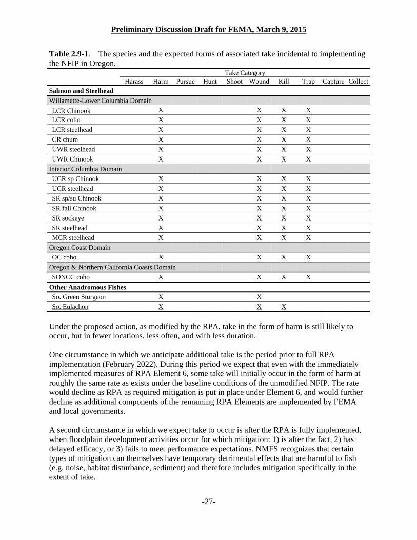
Preliminary Discussion Draft for FEMA, March 9, 2015
-27-
Table 2.9-1. The species and the expected forms of associated take incidental to implementing the NFIP in Oregon. Take Category
Harass Harm Pursue Hunt Shoot Wound Kill Trap Capture CollectSalmon and Steelhead
Willamette-Lower Columbia Domain
LCR Chinook X X X X
LCR coho X X X X
LCR steelhead X X X X
CR chum X X X X
UWR steelhead X X X X
UWR Chinook X X X X
Interior Columbia Domain
UCR sp Chinook X X X X
UCR steelhead X X X X
SR sp/su Chinook X X X X
SR fall Chinook X X X X
SR sockeye X X X X
SR steelhead X X X X
MCR steelhead X X X X
Oregon Coast Domain
OC coho X X X X
Oregon & Northern California Coasts Domain
SONCC coho X X X X
Other Anadromous Fishes
So. Green Sturgeon X X
So. Eulachon X X X
Under the proposed action, as modified by the RPA, take in the form of harm is still likely to occur, but in fewer locations, less often, and with less duration. One circumstance in which we anticipate additional take is the period prior to full RPA implementation (February 2022). During this period we expect that even with the immediately implemented measures of RPA Element 6, some take will initially occur in the form of harm at roughly the same rate as exists under the baseline conditions of the unmodified NFIP. The rate would decline as RPA as required mitigation is put in place under Element 6, and would further decline as additional components of the remaining RPA Elements are implemented by FEMA and local governments. A second circumstance in which we expect take to occur is after the RPA is fully implemented, when floodplain development activities occur for which mitigation: 1) is after the fact, 2) has delayed efficacy, or 3) fails to meet performance expectations. NMFS recognizes that certain types of mitigation can themselves have temporary detrimental effects that are harmful to fish (e.g. noise, habitat disturbance, sediment) and therefore includes mitigation specifically in the extent of take.
Preliminary Discussion Draft for FEMA, March 9, 2015
-28-
Per RPA Element 6, NMFS anticipates that FEMA and NFIP communities will implement the interim protective measures within 6 months of the date of this opinion. Accordingly, take in the form of harm from floodplain developments that is not otherwise exempted from ESA section 9 (e.g., through a separate section 7 consultation or incidental take permit) and occurs prior to 2022 is not exempt from the Section 9 prohibition on take, unless the jurisdiction in which the development is occurring demonstrates to FEMA and NMFS that it has complied with RPA Element 6 within 6 months, and, in the years thereafter, with Elements 2A vii, 2 C, 3A, and 3E per the associated timelines. In addition that, take is expected to occur at declining levels, throughout the 8 years NMFS projects to achieve full implementation, and even when all elements of the RPA are being carried out, some residual take will occur. This ITS addresses expected take under all of these scenarios. Individual activities that proceed under separate section 7 consultations will be considered by NMFS individually for their effects, and take will be identified appropriately under those reviews; NMFS assumes that irrespective of a Federal nexus, the location of future development in the floodplain will be subject to local government permitting and that the standards for avoiding habitat degradation identified in this RPA will apply. This program-level consultation and the RPA allow floodplain development activities to proceed so long as they are in compliance with the floodplain management criteria as revised by the RPA. Because take under the RPA will occur primarily in the form of habitat degradation, NMFS is unable to articulate a number of fish that may be affected as explained above. Therefore, NMFS has described in this ITS expected levels of take resulting from floodplain development by county measured in acres. When a jurisdiction approaches the extent described, additional development may proceed if a 10(a)(1)(B) Habitat Conservation Plan is developed that both avoids jeopardy/adverse modification of designated critical habitat, and furthers the conservation needs of the listed species. In the context of this incidental take statement, development that would result in take includes removal of vegetation, installation of structures that occupy space or reduce the flood water storage capacity of a floodplain, grading of land, creation of impervious surfaces, installation of structures capable of trapping or impinging fish during a flood (e.g., open foundation with screened openings), placement of fill, and other disturbance activities that detrimentally alter the existing value of the floodplain habitat to ESA-listed anadromous fish.11 These activities will harm, injure, or kill ESA-listed anadromous fish. While we are certain that some floodplain developments that are carried out under the proposed program as modified by the RPA will harm, injure, and kill some individuals of the 17 ESA-listed anadromous fish species that occur in the action area, and that some of these developments would not require a separate section 7 consultation, there is insufficient information available about those future developments to identify a specific amount of take. For instance, because FEMA does not have information regarding the amount of fill placed in the floodplain or the area of floodplain impacted by development, there is no way to predict the number, location, type,
11 In this context, development does not mean routine maintenance of existing structures, the installation of sign posts, removal of individual plants or trees outside of the high hazard area, or other activities that do not change the existing value of the floodplain habitat to ESA-listed anadromous fish.
Preliminary Discussion Draft for FEMA, March 9, 2015
-29-
design, or duration of any given future development activities and their associated specific effects. Consequently, we chose to identify the extent of take at the program scale as a surrogate to an amount of take enumerating individual fish. The extent of take corresponds to a proportion of the delineated SFHA acreages by county (inclusive of the incorporated jurisdictions within those counties) that may be temporarily and/or permanently disturbed due to floodplain development activities. Take may be exempted for development actions occurring in the floodplain through separate section 7 consultation, and for floodplain development actions that occur after the full implementation, but would which not require a separate section 7 consultations (e.g.,, in the floodplain but not in wetlands, and not relying on federal funding). NMFS estimates, by county, and including the incorporated jurisdictions within the county, the total acres of floodplain expected to be developed following full implementation of the RPA, as an appropriate surrogate measure of the extent of take, because the amount of disturbance in the floodplain is associated with diminishment in the habitat conditions that are necessary for juvenile refuge, rearing, feeding, growth, development, maturation and survival. Moreover, development activities typically involve vegetation or ground disturbance; these impair habitat features such as cover, shade, woody debris, and water quality, each of which bears on the success of juvenile to adult survival among listed fish species. The extent of take that NMFS estimates is measured by county and includes the communities therein:
from mitigated development - equivalent to 1.25 % of the total SFHA from the mitigation activities -1.875% of the total SFHA (measured as the
1.25% rate of the development with an expected mitigation ratio of 1.5 to one) from restoration activities – is 1.25% of the total SFHA, but the acreage “limit”
on restoration will renew every 2 years. (See Table 2.9-2). The estimated extent of take represents a minor portion of the existing remnant floodplain habitat outside of the HHA in which we expect development will occur, and which is directly associated with activities that harm ESA-listed anadromous species, and which NMFS expects to occur with a loss of function (further described below). The take surrogate was chosen because:
1. Floodplain development typically frequently affects floodplain functions in a manner that harms anadromous fish, and even when the RPA is fully implemented, some development is likely to occur in the HHA because it is a permitted use-type (silviculture, agriculture, or functionally water dependent).
2. Most floodplain development causing take would not require an individual section 7 consultation.
3. Mitigation consistent with the RPA will not immediately replace functions and features impaired by floodplain development.
4. The amount of loss of floodplain to development is measureable and can be tracked by FEMA.
Consequently, our expectation is the majority of floodplain development proceeding in compliance with the NFIP as modified by this RPA will proceed under the jurisdiction of local
Preliminary Discussion Draft for FEMA, March 9, 2015
-30-
governments but, the larger portion of these are unlikely to have other federal section seven obligations (e.g., due to probable location in floodplain areas which are, for example upland from Corps jurisdiction, development likely would not require an individual section 7 consultation). We also anticipate that remaining development would either avoid take by avoiding impacts by design when located in the HHA, or by mitigating impacts when in the remainder of the floodplain. The amount of floodplain development that NMFS anticipates will occur under this incidental take authorization is specifically identified in table 2.9-2. Thresholds for re-initiation are based on a combination of these thresholds being exceeded. Table 2.9-2 describes separate aspects of the extent of take limit for (1) development activities, (2) mitigation activities implemented to offset adverse effects associated with development activities, and (3) floodplain restoration actions. This is appropriate because, while such activities by design result in a beneficial outcome, they typically involve vegetation or ground disturbance that causes limited-duration harm to the listed species. The compensatory mitigation and restoration aspects of the extent of take were chosen because:
1. While largely beneficial to listed species, such activities typically affect floodplain functions in a manner that harms anadromous fish but these effects are of limited scale, duration, intensity, and severity.
2. We assume that most floodplain restoration activities that occur outside of the active channel would not include a Federal nexus, or would be exempt from pre-development review
3. We assume the RPA limits the amount of future floodplain development, and therefore the amount of development that would occur with corollary required mitigation will be employing the 1:1.5 ratio.
Consequently, because our expectation is that harm associated with mitigation and restoration activities will be of short duration, and because mitigation will offset and limit the magnitude and duration of the take associated with floodplain development, we have identified an extent of take for mitigation that exceeds the extent of take for development. Because of the anticipated benefits from habitat restoration, NMFS identifies the restoration take exemption as a renewing limit; according to the extent of take from restoration is reset to the maximum total every 2 years beginning on April 1, 2017. The extent of take includes all forms of development activities that may occur in flood-prone areas within FEMA’s jurisdiction, i.e., development as previously defined herein, and mitigation activities, and habitat restoration activities.
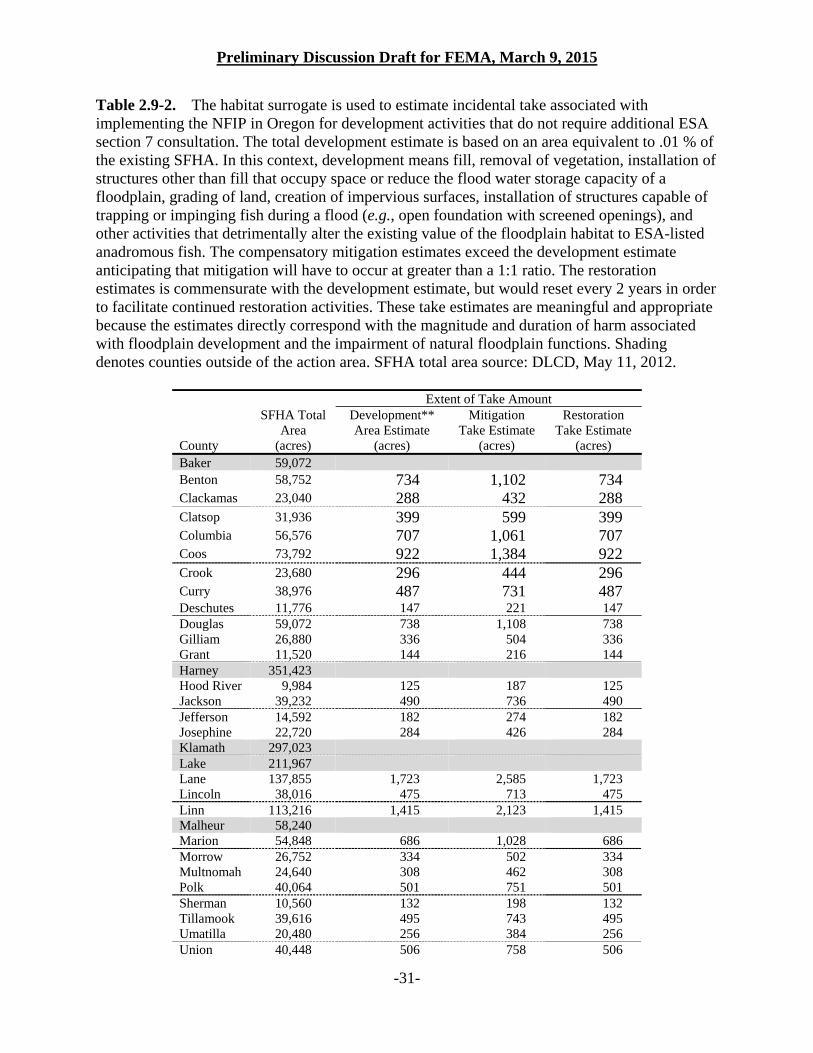
Preliminary Discussion Draft for FEMA, March 9, 2015
-31-
Table 2.9-2. The habitat surrogate is used to estimate incidental take associated with implementing the NFIP in Oregon for development activities that do not require additional ESA section 7 consultation. The total development estimate is based on an area equivalent to .01 % of the existing SFHA. In this context, development means fill, removal of vegetation, installation of structures other than fill that occupy space or reduce the flood water storage capacity of a floodplain, grading of land, creation of impervious surfaces, installation of structures capable of trapping or impinging fish during a flood (e.g., open foundation with screened openings), and other activities that detrimentally alter the existing value of the floodplain habitat to ESA-listed anadromous fish. The compensatory mitigation estimates exceed the development estimate anticipating that mitigation will have to occur at greater than a 1:1 ratio. The restoration estimates is commensurate with the development estimate, but would reset every 2 years in order to facilitate continued restoration activities. These take estimates are meaningful and appropriate because the estimates directly correspond with the magnitude and duration of harm associated with floodplain development and the impairment of natural floodplain functions. Shading denotes counties outside of the action area. SFHA total area source: DLCD, May 11, 2012.
Extent of Take Amount
County
SFHA Total Area
(acres)
Development** Area Estimate
(acres)
Mitigation Take Estimate
(acres)
Restoration Take Estimate
(acres) Baker 59,072 Benton 58,752 734 1,102 734 Clackamas 23,040 288 432 288 Clatsop 31,936 399 599 399 Columbia 56,576 707 1,061 707 Coos 73,792 922 1,384 922 Crook 23,680 296 444 296 Curry 38,976 487 731 487 Deschutes 11,776 147 221 147 Douglas 59,072 738 1,108 738 Gilliam 26,880 336 504 336 Grant 11,520 144 216 144 Harney 351,423 Hood River 9,984 125 187 125 Jackson 39,232 490 736 490 Jefferson 14,592 182 274 182 Josephine 22,720 284 426 284 Klamath 297,023 Lake 211,967 Lane 137,855 1,723 2,585 1,723 Lincoln 38,016 475 713 475 Linn 113,216 1,415 2,123 1,415 Malheur 58,240 Marion 54,848 686 1,028 686 Morrow 26,752 334 502 334 Multnomah 24,640 308 462 308 Polk 40,064 501 751 501 Sherman 10,560 132 198 132 Tillamook 39,616 495 743 495 Umatilla 20,480 256 384 256 Union 40,448 506 758 506
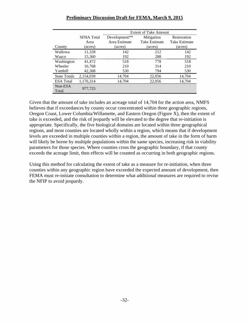
Preliminary Discussion Draft for FEMA, March 9, 2015
-32-
Extent of Take Amount
County
SFHA Total Area
(acres)
Development** Area Estimate
(acres)
Mitigation Take Estimate
(acres)
Restoration Take Estimate
(acres) Wallowa 11,328 142 212 142 Wasco 15,360 192 288 192 Washington 41,472 518 778 518 Wheeler 16,768 210 314 210 Yamhill 42,368 530 794 530 State Totals 2,154,039 14,704 22,056 14,704 ESA Total 1,176,314 14,704 22,056 14,704 Non-ESA Total
977,725
Given that the amount of take includes an acreage total of 14,704 for the action area, NMFS believes that if exceedances by county occur concentrated within three geographic regions, Oregon Coast, Lower Columbia/Willamette, and Eastern Oregon (Figure X), then the extent of take is exceeded, and the risk of jeopardy will be elevated to the degree that re-initiation is appropriate. Specifically, the five biological domains are located within three geographical regions, and most counties are located wholly within a region, which means that if development levels are exceeded in multiple counties within a region, the amount of take in the form of harm will likely be borne by multiple populations within the same species, increasing risk in viability parameters for those species. Where counties cross the geographic boundary, if that county exceeds the acreage limit, then effects will be counted as occurring in both geographic regions. Using this method for calculating the extent of take as a measure for re-initiation, when three counties within any geographic region have exceeded the expected amount of development, then FEMA must re-initiate consultation to determine what additional measures are required to revise the NFIP to avoid jeopardy.
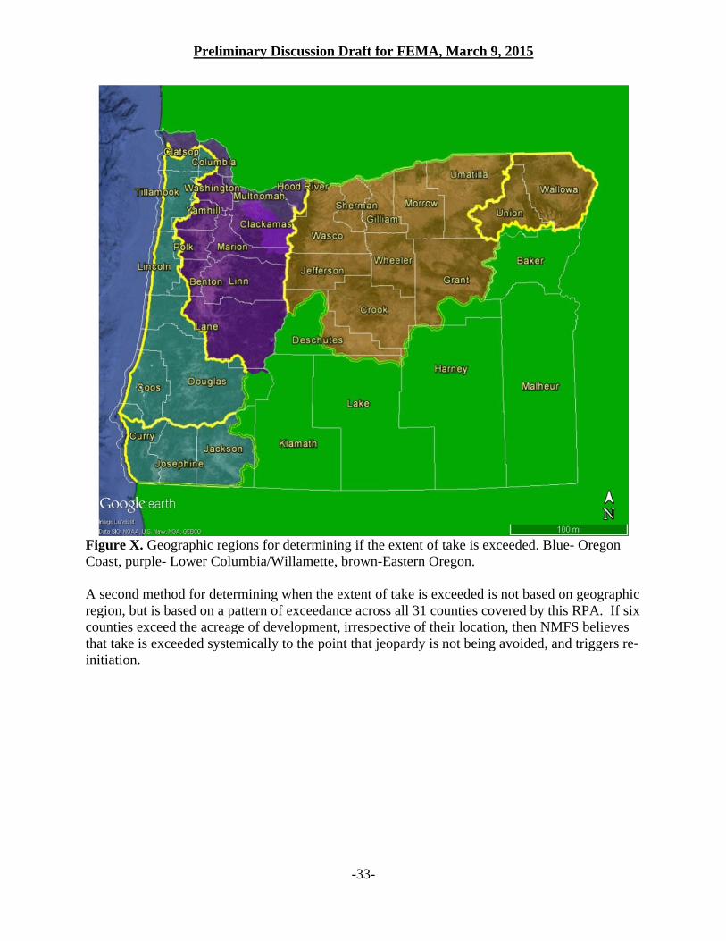
Preliminary Discussion Draft for FEMA, March 9, 2015
-33-
Figure X. Geographic regions for determining if the extent of take is exceeded. Blue- Oregon Coast, purple- Lower Columbia/Willamette, brown-Eastern Oregon. A second method for determining when the extent of take is exceeded is not based on geographic region, but is based on a pattern of exceedance across all 31 counties covered by this RPA. If six counties exceed the acreage of development, irrespective of their location, then NMFS believes that take is exceeded systemically to the point that jeopardy is not being avoided, and triggers re-initiation.