U.S. Army Corps of Engineers · U.S. Army Corps of Engineers ... silviculture, and ranching ......
6
Regulatory Program INTERIM APPROVED JURISDICTIONAL DETERMINATION FORM U.S. Army Corps of Engineers This form should be completed by following the instructions provided in the Interim Approved Jurisdictional Determination Form User Manual. SECTION I: BACKGROUND INFORMATION A. COMPLETION DATE FOR APPROVED JURISDICTIONAL DETERMINATION (AJD): Octobers, 2015 B. ORM NUMBER IN APPROPRIATE FORMAT(e.g.. HQ-2015-00001-SMJ): CESAW-RG-A, 2015-02009, Chrystal and Theodore Burk C. PROJECT LOCATION AND BACKGROUND INFORMATION: State; North Carolina County/parish/borough; Catawba City; Denver Center coordinates of site (lat/long in degree decimal format); 35.5694 N, 80.0157 W Map(s)/diagram(s) of review area (including map identifying single point of entry (SPOE) watershed and/or potential jurisdictional areas where applicable) is/are; Qattached 13 in report/map titled SAW-2015-02009 Burk Boat Access Channel. tH other sites (e.g., offsite mitigation sites, disposal sites, etc.) are associated with this action and are recorded on a different jurisdictional determination (JD) form. List JD form ID numbers (e.g., HQ-2015-00001-SMJ-1); D. REVIEW PERFORMED FOR SITE EVALUATION; ^ Office (Desk) Determination Only. Date; October 5, 2015. Q Office (Desk) and Field Determination. Office/Desk Dates; Field Date(s): SECTION II: DATA SOURCES Check all that were used to aid in the determination and attach data/maps to this AJD form and/or references/citations in the administrative record, as appropriate. 13 Maps, plans, plots or plat submitted by or on behalf ofthe applicant/consultant. Title/Date; Corps' project file under Action ID noted in Section I, B above, see permit application &/or JD request with supporting documents received. mi Data sheets prepared/submitted by or on behalfof the applicant/consultant. D Data sheets/delineation report are sufficient for purposes of AJD form. Title/Date; O Data sheets/delineation report are not sufficient for purposes of AJD form. Summarize rationale and include • information on revised data sheets/delineation report that this AJD form has relied upon; Revised Title/Date; Q Data sheets prepared by the Corps. Title/Date; D Corps navigable waters study. Title/Date; D Corps Map ORM map layers. Title/Date; • USGS Hydrologic Atlas. Title/Date; • USGS, NHD, or WBD data/maps. Title/Date; 13 USGS 8, 10 and/or 12 digit HUC maps. HUC number; Upper Catawba (03050101). 13 USGS maps. Scale &quad name and date; Denver, 7.5 minute, 1970. ^ USDA NRCS Soil Survey. Citation; Catawba County, NC, Web Soil Survey. D USFWS National Wetlands Inventory maps. Citation; • State/Local wetland inventory maps. Citation; S FEMA/FIRM maps. Citation; On-line FIRM/FEMA NC, Panel 4606, Map no 3710460600K, Sep. 5, 2007 El Photographs; ^ Aerial. Citation; Google Earth Mar. 2013 or • Other. Citation; O LiDAR data/maps. Citation; Q Previous JDs. File no. and date of JD letter; Q Applicable/supporting case law; • Applicable/supporting scientific literature; ti ^
Transcript of U.S. Army Corps of Engineers · U.S. Army Corps of Engineers ... silviculture, and ranching ......

Regulatory ProgramINTERIM APPROVED JURISDICTIONAL DETERMINATION FORM
U.S. Army Corps of EngineersThis form should be completed by following the instructions provided in the Interim Approved Jurisdictional Determination Form User Manual.
SECTION I: BACKGROUND INFORMATION
A. COMPLETION DATE FOR APPROVED JURISDICTIONAL DETERMINATION (AJD): Octobers, 2015
B. ORM NUMBER IN APPROPRIATE FORMAT(e.g.. HQ-2015-00001-SMJ): CESAW-RG-A, 2015-02009, Chrystal andTheodore Burk
C. PROJECT LOCATION AND BACKGROUND INFORMATION:
State; North Carolina County/parish/borough; Catawba City; DenverCenter coordinates of site (lat/long in degree decimal format); 35.5694 N, 80.0157 WMap(s)/diagram(s) of review area (including map identifying single point of entry (SPOE) watershed and/or potentialjurisdictional areas where applicable) is/are; Qattached 13 in report/map titled SAW-2015-02009 Burk Boat AccessChannel.
tH other sites (e.g., offsite mitigation sites, disposal sites, etc.) are associated with this action and are recorded on adifferent jurisdictional determination (JD) form. List JD form ID numbers (e.g., HQ-2015-00001-SMJ-1);
D. REVIEW PERFORMED FOR SITE EVALUATION;
^ Office (Desk) Determination Only. Date; October 5, 2015.Q Office (Desk) and Field Determination. Office/Desk Dates; Field Date(s):
SECTION II: DATA SOURCES
Check all that were used to aid in the determination and attach data/maps to this AJD form and/or references/citations inthe administrative record, as appropriate.
13 Maps, plans, plots or plat submitted by oron behalf oftheapplicant/consultant. Title/Date; Corps' projectfileunder Action ID noted in Section I, B above, see permit application &/or JD request with supporting documentsreceived.
mi Data sheets prepared/submitted byor on behalfof the applicant/consultant.D Datasheets/delineation report are sufficient for purposes ofAJD form. Title/Date;O Data sheets/delineation report are not sufficient for purposes ofAJD form. Summarize rationale and include
• information on revised data sheets/delineation report that this AJD form has relied upon;Revised Title/Date;
Q Data sheets prepared by the Corps. Title/Date;D Corps navigable waters study. Title/Date;D Corps Map ORM map layers. Title/Date;• USGS Hydrologic Atlas. Title/Date;• USGS, NHD, or WBD data/maps. Title/Date;13 USGS 8, 10 and/or 12 digit HUC maps. HUC number; UpperCatawba (03050101).13 USGS maps. Scale &quad name and date; Denver, 7.5 minute, 1970.^ USDA NRCS Soil Survey. Citation; Catawba County, NC, WebSoil Survey.D USFWS National Wetlands Inventory maps. Citation;• State/Local wetland inventory maps. Citation;S FEMA/FIRM maps. Citation; On-line FIRM/FEMA NC, Panel 4606, Map no 3710460600K, Sep. 5, 2007El Photographs; ^ Aerial. Citation; Google Earth Mar. 2013 or • Other. Citation;O LiDAR data/maps. Citation;Q Previous JDs. File no. and date of JD letter;Q Applicable/supporting case law;• Applicable/supporting scientific literature;
ti ^
Q Other information (please specify):
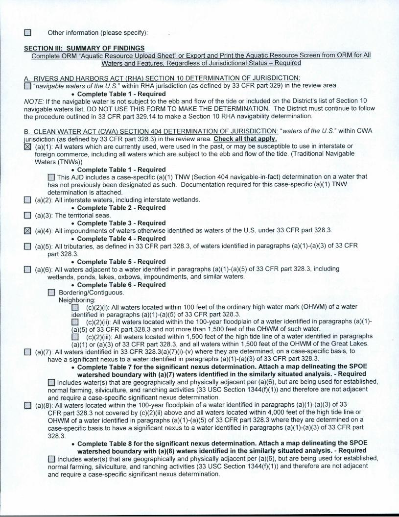
SECTION III: SUMMARY OF FINDINGS
Complete CRM "Aquatic Resource Upload Sheet" or Export and Print the Aquatic Resource Screen from ORM for AllWaters and Features. Reqardless of Jurisdictional Status - Required
A. RIVERS AND HARBORS ACT (RHA) SECTION 10 DETERMINATION OF JURISDICTION:n "navigable waters of the U.S." within RHA jurisdiction (as defined by 33 CFR part 329) in the reviewarea.
• Complete Table 1 - RequiredNOTE: Ifthe navigable water is not subject to the ebb and flow of the tide or included on the District's list of Section 10navigable waters list, DO NOT USE THIS FORM TO MAKE THE DETERMINATION. The District must continue to followthe procedure outlined in 33 CFR part 329.14 to make a Section 10 RHA navigability determination.
B. CLEAN WATER ACT (CWA) SECTION 404 DETERMINATION OF JURISDICTION: "waters of the U.S." within CWAjurisdiction (as defined by 33 CFR part 328.3) in the review area. Check all that apply.H (a)(1): All waters which are currently used, were used in the past, or may be susceptible to use in interstate or
foreign commerce, including all waters which are subject to the ebb and flow of the tide. (Traditional NavigableWaters (TNWs))
• Complete Table 1 - Requiredn This AJD includes a case-specific (a)(1) TNW (Section 404 navigable-in-fact) determination on a water thathas not previously been designated as such. Documentation required for this case-specific (a)(1) TNWdetermination is attached.
im (a)(2): All interstate waters, including interstate wetlands.• Complete Table 2 - Required
• (a)(3): The territorial seas.• Complete Table 3 - Required
13 (a)(4): All impoundments of waters otherwise identified as waters of the U.S. under 33 CFR part 328.3.• Complete Table 4 - Required
O (a)(5): All tributaries, as defined in 33 CFR part 328.3, of waters identified in paragraphs (a)(1)-(a)(3) of 33 CFRpart 328.3.
• Complete Table 5 - Required• (a)(6): All waters adjacent to a water identified in paragraphs (a)(1)-(a)(5) of 33 CFR part 328.3, including
wetlands, ponds, lakes, oxbows, impoundments, and similar waters.• Complete Table 6 - Required
• Bordering/Contiguous.Neighboring:
• (c)(2)(i): All waters located within 100 feet of the ordinary high water mark (OHWM) of a wateridentified in paragraphs (a)(1)-(a)(5) of 33 CFR part 328.3.• (c)(2)(ii): All waters located within the 100-year floodplain of a water identified in paragraphs (a)(1)-(a)(5) of 33 CFR part 328.3 and not more than 1,500 feet of the OHWM of such water.• (c)(2)(iii): All waters located within 1,500 feet of the high tide line of a water identified in paragraphs(a)(1) or (a)(3) of 33 CFR part 328.3, and all waters within 1,500 feet of the OHWM of the Great Lakes.
• (a)(7): All waters identified in 33 CFR 328.3(a)(7)(i)-(v) where they are determined, on a case-specific basis, tohave a significant nexus to a water identified in paragraphs (a)(1)-(a)(3) of 33 CFR part 328.3.
• Complete Table 7 for the significant nexus determination. Attach a map delineating the SPOEwatershed boundary with {a)(7)waters identified in the similarly situated analysis. - Required
• Includes water(s) that are geographically and physically adjacent per (a)(6), but are being used for established,normal farming, silviculture, and ranching activities (33 USC Section 1344(f)(1)) and therefore are not adjacentand require a case-specific significant nexus determination.
Q (a)(8): All waters located within the 100-yearfloodplain of a water identified in paragraphs (a)(1)-(a)(3) of 33CFR part 328.3 not covered by (c)(2)(ii) above and all waters located within 4,000 feet of the high tide lineorOHWM of a water identified in paragraphs (a)(1)-(a)(5) of 33 CFR part 328.3 where they are determined on acase-specific basis to have a significant nexus to a water identified in paragraphs (a)(1)-(a)(3) of 33 CFR part328.3.
• Complete Table 8 for the significant nexus determination. Attach a map delineating the SPOEwatershed boundary with (a)(8) waters identified in the similarly situated analysis. - Required
E3 Includes water(s) that are geographicallyand physically adjacent per (a)(6), but are being used for established,normal farming, silviculture, and ranching activities (33 USC Section 1344(f)(1)) and therefore are not adjacentand require a case-specific significant nexus determination.

C. NON-WATERS OF THE U.S. FINDINGS:
Check all that apply.
n The reviewarea is comprised entirely of dry land.E] Potential-(a)(7) Waters: Waters that DO NOT havea significant nexus to a water identified in paragraphs (a)(1)-
(a)(3) of 33 CFR part 328.3.• Complete Table 9 and attach a map delineating the SPOE watershed boundary with potential
(a)(7) waters identified in the similarly situated analysis. - Required10 Includes water(s) that are geographically and physically adjacent per (a)(6), but are being used for established,normal farming, silviculture, and ranching activities (33 (JSC Section 1344(f)(1)) and therefore are not adjacentand require a case-specific significant nexus determination.
H Potential-(a)(8) Waters: Waters that DO NOT have a significant nexus toa water identified in paragraphs (a)(1)-(a)(3) of 33 CFR part 328.3.
• Complete Table 9 and attach a map delineating the SPOE watershed boundary with potential(a)(8) waters identified in the similarly situated analysis. - Required
m Includes water(s) that are geographically and physically adjacent per (a)(6), but are being used for established,normal farming, silviculture, and ranching activities (33 USC Section 1344(f)(1)) and therefore are not adjacentand require a case-specific significant nexus determination.
• Excluded Waters (Non-Waters ofU.S.), even where they otherwise meet the terms ofparagraphs (a)(4)-(a)(8):• Complete Table 10 - Required
• (b)(1): Waste treatment systems, including treatment ponds or lagoons designed to meetthe requirements ofthe CWA.
• (b)(2): Prior converted cropland.• (b)(3)(i): Ditches with ephemeral flow that are not a relocated tributary orexcavated in a tributary.D (b)(3)(ii): Ditches with intermittent flow that are not a relocated tributary, excavated in a tributary, ordrain
wetlands.
• (b)(3)(iii): Ditches that do not flow, either directly or through anotherwater, into a water identified inparagraphs (a)(1)-(a)(3).
n (b)(4)(i): Artificially irrigated areas thatwould revert to dry land should application ofwater to thatarea cease.• (b)(4)(ii): Artificial, constructed lakes and ponds created in dry land such as farm and stock watering ponds,
irrigation ponds, settling basins, fields flooded for rice growing, log cleaning ponds, or cooling ponds.• (b)(4)(iii): Artificial reflecting pools or swimming pools created in dry land.^• (b)(4)(iv): Small ornamental waterscreated in dry land.^• (b)(4)(v): Water-filled depressions created in dry land incidental to mining orconstruction activity, including
pits excavated for obtaining fill, sand, or gravel that fill with water.• (b)(4)(vi): Erosional features, including gullies, rills, and otherephemeral features thatdo not meet the
definition of tributary, non-wetland swales, and lawfully constructed grassed waterways.^• (b)(4)(vii): Puddles.^• (b)(5): Groundwater, including groundwater drained through subsurface drainage systems.^• (b)(6): Stormwater control features constructed to convey, treat, orstore stormwater that are created in dry
land.""• (b)(7): Wastewater recycling structures created in dry land; detention and retention basins built for wastewater
recycling; groundwater recharge basins; percolation ponds built for wastewater recycling; and waterdistributary structures built for wastewater recycling.
Q Other non-jurisdictional waters/features within review area that do not meet the definitions in 33 CFR 328.3 of(a)(1)-(a)(8) waters and are not excluded waters identified in (b)(1)-(b)(7).
• Complete Table 11 - Required.
D. ADDITIONAL COMMENTS TO SUPPORT AJD:
^In many cases these excluded features will not be specifically identified on the AJD form, unless specifically requested. CorpsDistricts may, in case-by-case instances, choose to identify some or all of these features within the review area.
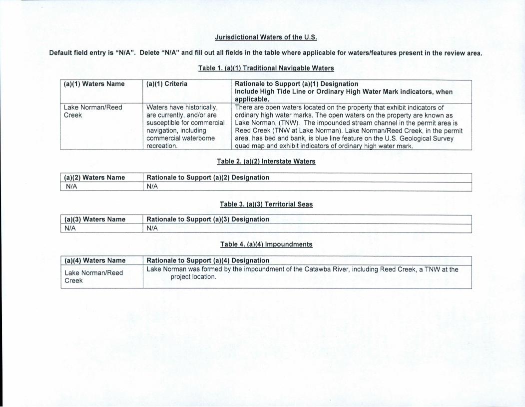
Jurisdictional Waters of the U.S.
Default field entry is "N/A". Delete "N/A" and fill out all fields in the table where applicable for waters/features present in the review area.
Table 1. (a)(1) Traditional Navigable Waters
(a)(1) Waters Name (a)(1) Criteria Rationale to Support (a)(1) DesignationInclude High Tide Line or Ordinary High Water Mark indicators, whenapplicable.
Lake Norman/Reed
Creek
Waters have historically,are currently, and/or aresusceptible for commercialnavigation, includingcommercial waterborne
recreation.
There are open waters located on the property that exhibit indicators ofordinary high water marks. The open waters on the property are known asLake Norman, (TNW). The impounded stream channel in the permit area isReed Creek (TNW at Lake Norman). Lake Norman/Reed Creek, in the permitarea, has bed and bank, is blue line feature on the U.S. Geological Surveyquad map and exhibit indicators of ordinary high water mark.
Table 2. (a)(2) Interstate Waters
(a)(2) Waters Name Rationale to Support (a)(2) DesignationN/A N/A
Table 3. (a)(3) Territorial Seas
(a)(3) Waters Name Rationale to Support (a)(3) DesignationN/A N/A
Table 4. (a)(4) Impoundments
(a)(4) Waters Name Rationale to Support (a)(4) Designation
Lake Norman/Reed
Creek
Lake Norman was formed by the impoundment of the Catawba River, including Reed Creek, a TNW at theproject location.
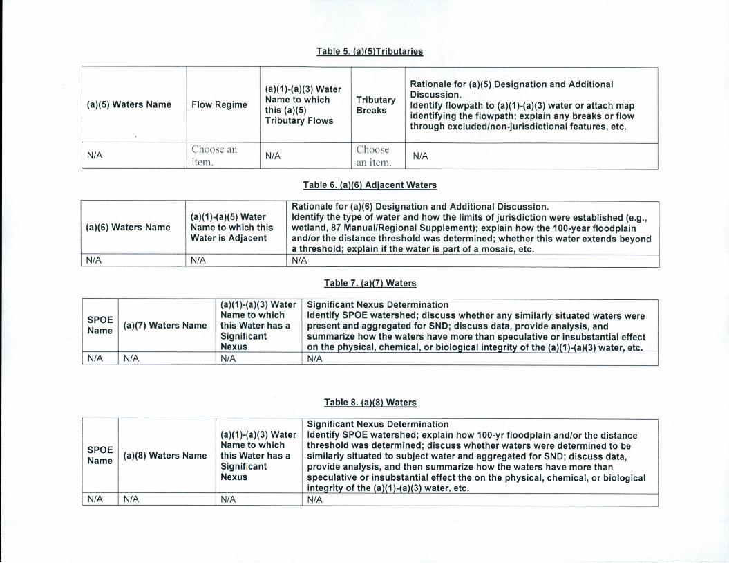
Table 5. (a)(5)Tributaries
(a)(5) Waters Name Flow Regime
(a)(1)-(a)(3) WaterName to which
this (a)(5)Tributary Flows
TributaryBreaks
Rationale for (a)(5) Designation and AdditionalDiscussion.
Identify flowpath to (a)(1)-(a)(3) water or attach mapidentifying the flowpath; explain any breaks or flowthrough excluded/non-jurisdictional features, etc.
N/AChoose an
item.N/A
Choose
an item.N/A
Table 6. (a)(6) Adjacent Waters
(a)(6) Waters Name(a)(1)-(a)(5) WaterName to which this
Water is Adjacent
Rationale for (a)(6) Designation and Additional Discussion.Identify the type of water and how the limits of jurisdiction were established (e.g.,wetland, 87 Manual/Regional Supplement); explain how the 100-year floodplainand/or the distance threshold was determined; whether this water extends beyonda threshold; explain if the water is part of a mosaic, etc.
N/A N/A N/A
Table 7. (a)(7) Waters
SPOE
Name(a)(7) Waters Name
(a)(1)-(a)(3) WaterName to which
this Water has a
SignificantNexus
Significant Nexus DeterminationIdentify SPOE watershed; discuss whether any similarly situated waters werepresent and aggregated for SND; discuss data, provide analysis, andsummarize how the waters have more than speculative or insubstantial effecton the physical, chemical, or biological integrity of the (a)(1)-(a)(3) water, etc.
N/A N/A N/A N/A
Table 8. (a)(8) Waters
SPOE
Name(a)(8) Waters Name
(a)(1)-(a)(3) WaterName to which
this Water has a
SignificantNexus
Significant Nexus DeterminationIdentify SPOE watershed; explain how 100-yr floodplain and/or the distancethreshold was determined; discuss whether waters were determined to besimilarly situated to subject water and aggregated for SND; discuss data,provide analysis, and then summarize how the waters have more thanspeculative or insubstantial effect the on the physical, chemical, or biologicalintegrity of the (a)(1)-(a)(3) water, etc.
N/A N/A N/A N/A

Non-Jurisdictional Waters
Default field entry is "N/A". Delete "N/A" and fill out all fields in the table where applicable for waters/features present in the review area.
Table 9. Non-Waters/No Significant Nexus
SPOE
Name
Non-(a)(7)/(a)(8)Waters Name
(a)(1)-(a)(3)Water Name to
which this
Water DOES
NOT have a
SignificantNexus
Basis for Determination that the Functions DO NOT Contribute Significantly to theChemical, Physical, or Biological Integrity of the (a)(1)-(a){3) Water.Identify SPOE watershed; explain how 100-yr floodplain and/or the distance thresholdwas determined; discuss whether waters were determined to be similarly situated tothe subject water; discuss data, provide analysis, and summarize how the waters didnot have more than a speculative or insubstantial effect on the physical, chemical, orbiological integrity of the {a)(1)-(a)(3) water.
N/A N/A N/A N/A
Table 10. Non-Waters/Excluded Waters and Features
Paragraph (b) ExcludedFeature/Water Name
Rationale for Paragraph (b) Excluded FeatureA/Vater and Additional Discussion.
N/A N/A
Table 11. Non-Waters/Other
Other Non-Waters of
U.S. Feature/Water NameRationale for Non-Waters of U.S. Feature/Water and Additional Discussion.
N/A N/A