The Political Rationalities of Fair-Trade Consumption in the

0
Urban Planning and Transport Rationalities in the City of
Johannesburg
The case of Louis Botha Development Corridor
David Chiwetu
1
Declaration
A research report submitted to the School of Architecture and Planning, University of the
Witwatersrand, in fulfilment of the requirements for the Bachelor of Science with Honours in
Urban and Regional Planning.
Supervised by Professor Claire Bénit-Gbaffou
Declaration
I declare that this research report is my own work. It has been submitted for the BSc with
Honours in Urban and Regional Planning to the University of the Witwatersrand,
Johannesburg. It has not been submitted for any degree to any other university.
……………………………………………
(Signature of Candidate)
………………Day of………………m……………….Year………………..
2
Abstract
Schoeman (2015:49) states that “urban and regional planning and transportation planning
requires the deliberation of what can and must occur where in spatial systems. It includes the
emphasis and collaboration of different policies and practices which comprises tools and
instruments and the interaction between professions in a wider context.’’ There is the need to
understand the different modes of thinking or rationalities that inform urban planners and
transportation planners in decision-making processes. I am interested in understanding how
these two professional disciplines approaching from different angles and viewpoints work
together in order to make decisions that affect the transformation of public space.
The research focuses on the Corridors of Freedom, which has received mainstream attention
in Johannesburg for its potential to contribute to socio spatial restructuring of the Apartheid
City. Through the case study of Louis Botha Corridor, the research aims to understand the
rationale / reasoning behind decisions undertaken by urban and transport professionals in
shaping development along the Corridor in a specific configuration whereby the JDA DFU
plays a mediating role. The study is concerned with uncovering the extent to which
‘contradicting rationalities’ in implementing development along the Louis Botha are
mediated by the Johannesburg Development Agency in facilitating infrastructural
development. Mediation for the purposes of this research focuses on uncovering the
compromise oriented negotiation processes and consensus oriented co-operation processes
that occur between the urban and transport professionals in the decision making process that
transform public space. The research concludes that there is a third rationality or mode of
thinking expressed by the JDA DFU which is the pushing of an equity agenda in order to
align the practices of both urban professionals and transport professionals in contributing to
the socio spatial restructuring of Johannesburg.
3
Acknowledgement
To my parents, I am truly grateful for the guidance and sacrifices you have made for my
education. I would not be where I am today without the support and love, you have provided
me.
To my supervisor Claire Benit-Gbaffou, I would like to express my gratitude for all the
support you have provided as the opportunity to undertake this research would not have been
possible without you. I appreciate your patience and all the assistance and you provided me in
carrying out this research and I would like to say that I am honored to have worked with you.
I would also like to thank the Development Facilitation Unit at the Johannesburg
Development Agency for affording me the opportunity to undertake this research with them,
thank you for the great hospitality. To Matt Jackson, I would like to say thank you very much
for being a great mentor and exposing me to the vast amounts of knowledge about town
planning and Transit Orientated Development in particular. The passion you have for town
planning is inspiring and the internship was a really valuable and worthwhile experience
I would like to thank my research funders and sponsor for financing my studies for this year,
National Research Foundation (NRF), the Practices of the State in Urban Governance
programme which is hosted by the Centre for Urbanism and Built Environment and the
Postgraduate Merit Award. I appreciate the financial support that has been made for me to
complete my studies.
To all the urban planning and transport professionals I interviewed, thank you for your
willingness to share your knowledge with me and dedicating time to contributing to this
research.
Finally, I would like to thank all my friends and classmates. To Lesley, thanks buddy for all
your assistance. To Yunus, our journey together started in high school now we complete this
degree together, all the best.

4
Table of Contents
CHAPTER 1: INTRODUCING THE RESEARCH ...................................................................................................... 7
1.1. PROBLEM STATEMENT ....................................................................................................................................... 8 1.2 THE RELEVANCE OF THE RESEARCH ........................................................................................................................ 9 1.3 BACKGROUND – WHAT IS THE ‘STATE’ INVOLVED IN THE MAKING OF THE COF. ............................................................ 10
1.3.1 Corridors of Freedom - Vision .............................................................................................................. 10 1.4 RESEARCH QUESTION ....................................................................................................................................... 12 1.5 SCOPE OF THE RESEARCH .................................................................................................................................. 13 1.6. CONTEXT ...................................................................................................................................................... 14 1.7. RESEARCH METHODOLOGY ............................................................................................................................... 14 1.8. CHAPTER OUTLINE .......................................................................................................................................... 15
CHAPTER 2: LITERATURE REVIEW ................................................................................................................... 17
INTRODUCTION ..................................................................................................................................................... 17 2.1. STATE RATIONALITIES AND THE MAKING OF THE CITY ............................................................................................. 17
2.1.1. Core Professional Planning Focus and Interests ................................................................................. 18 2.1.4 Understanding practises of street level bureaucrats: Multiple Norms ............................................... 19 2.1.2. Public Policy Instruments ................................................................................................................... 20 2.1.3 The Front-line policy implementers: Street Level Bureaucrats ............................................................ 22 2.1.5 Equity Planners ................................................................................................................................... 23
2.2. MEGAPROJECTS AND TODS .............................................................................................................................. 25 2.2.1. Transit Orientated Development – principles and tensions ............................................................... 25 2.2.2 Towards overcoming the tensions within TOD? .................................................................................. 28
CHAPTER 3: RESEARCH METHODS .................................................................................................................. 31
4.4.1 Norwood ‘High street’ plan – Grant avenue precinct, consolidating the street as public space? (2016)
..................................................................................................................................................................... 52 6.1 INTRODUCING THE ROLES OF THE URBAN AND TRANSPORT PROFESSIONALS INVOLVED IN THE SDZ .................................. 66
6.1.1 Department of Development Planning ............................................................................................... 66 6.1.2 Transport Department Official ............................................................................................................ 67 6.1.3 Johannesburg Roads Agency ............................................................................................................... 67
6.2 FACILITATING THE ROAD HIERARCHY: ACCESSIBILITY OR MOBILITY? .......................................................................... 67 6.2.1 First Proposal – Prioritising Mobility over Accessibility? ..................................................................... 67 6.2.2 Working towards a compromise? ....................................................................................................... 70
6.3 CONCLUSION .................................................................................................................................................. 72
CHAPTER 7: IMPLEMENTATION CHALLENGES AND THE ROLE OF THE DFU AS MEDIATOR ............................. 74
7.1 IMPLEMENTING THE BUS RAPID TRANSIT SYSTEM AND FEEDER ROUTES ..................................................................... 74 7.2 BRIDGING THE GAP BETWEEN THE PUBLIC AND PRIVATE SECTOR ................................................................................ 79
7.2.1. Facilitating development : Building public spaces through negotiation ........................................... 79 7.2.2. Building Alliances and finding resources: Attracting private sector development ............................. 81 7.2.3. Developing Affordable Urban Neighbourhoods – beyond facilitation, the role of equity planner ..... 84
7.3 CONCLUSION .................................................................................................................................................. 85
CONCLUSION ................................................................................................................................................. 86
DEVELOPING LOUIS BOTHA CORRIDOR: MANDATES ..................................................................................................... 86 THE RIGHT TO THE CITY CONFRONTATION .................................................................................................................. 87 THE STRATEGIC ROLE OF THE JDA DFU ..................................................................................................................... 87 TOOLS OF MEDIATION ............................................................................................................................................ 88
REFERENCES ................................................................................................................................................... 91

5
Policy and Official Documents...................................................................................................................... 93 Annexures .................................................................................................................................................... 96
6
List of Acronyms
BRT- Bus Rapid Transport
COF- Corridors of Freedom
DoT- Department of Transport
DFU – Development Facilitation Unit
COJ- City of Johannesburg
CUBES- Centre of Urbanism and Built Environment Studies
GDS- Growth Development Strategy
JDA – Johannesburg Development Agency
JRA – Johannesburg Roads Agency
GDS- Growth and Development Strategy
NMT- Non Motorised Transport
PSUG- Practises of State in Urban Governance
SDZ – Special Development Zone
SDF- Spatial Development Framework
SITPF- Strategic Integrated Transport Plan Framework
TIA –Transport Impact Assessment
TOD- Transit Orientated Development

7
Chapter 1: Introducing the Research
Schoeman (2015:49) states that “urban and regional planning and transportation planning
requires the deliberation of what can and must occur where in spatial systems. It includes the
emphasis and collaboration of different policies and practices which comprises tools and
instruments and the interaction between professions in a wider context.’’ There is the need to
understand the different modes of thinking or rationalities that inform urban planners and
transportation planners in decision-making processes.
The research focuses on the Corridors of Freedom, which were introduced in 2013 in order to
“re-stitch” the apartheid city by linking people in the city with places of employment along
three corridors. (Tau, 2013). The emphasis on corridors is linked to restructuring of the post-
apartheid city by forming easier and efficient links between workplaces and households. The
intention is then to interrogate the ‘state’ involved in the making of the CoF and the practises
of urban and transport professionals in contributing to the restructuring of the post-apartheid
city through the case of Louis Botha Corridor.
Figure 1: Spatial location of the three corridors

8
1.1. Problem Statement
Bickford (2015) highlights that transport planning and urban planning practices are ill-
aligned and are based on different principles, and as a result they do not communicate with
one another in terms of methodology and problem analysis. This research focuses on the
Louis Botha Corridor which has been earmarked as a Transit Orientated Development
corridor and requires the interaction of multiple stakeholders such as local businesses,
residents, city departments and agencies and built environment professionals to have a
common shared vision of making better public spaces that are inclusionary and
environmentally sensitive.
There is evidence of conflicting requirements for easy pedestrian movements and rapid
vehicular pedestrian movement and rapid vehicular transit can be evidenced around the story
around the fence erected on Louis Botha Corridor road which generated public complaints
from local businesses and residents alike.
The fence had been implemented along large sections of Louis Botha Corridor as part of
implementing the Bus Rapid Transit system, . to encourage people to cross at designated
areas such as pedestrian crossings and at the robots. in order to reduce numerous pedestrian
deaths that had occurred as a result of people crossing the road at random points.
Figure 2: Fence in the middle of the road along Louis Botha in Orange Grove (© Tsica,
2016)

9
This fence however is highly contested by local users.
“Its function is baffling. Perhaps one day it will prevent people from crossing in front of buses and
cars at any point on the road. But what it also does is stop people from crossing at legitimate
intersections.” (Guedes, 2015)
A clip from a newspaper article is shown above which is an example of how the fence
generated particularly different views from the public about its function and sections of it
have since been taken down by residents. The construction of the Rea Vaya Bus Rapid
Transit System along Louis Botha Avenue has caused disruptions and discontent among the
local businesses and residents in Orange Grove and it is with this regard that the research
seeks to develop a better understanding of how the transport professionals and urban planning
professionals work together to produce public space.
1.2 The relevance of the research
The research contributes to an emerging body of research of investigating barriers to the
implementation of corridors and TOD in the South African context and also in unpacking the
often contradictory and competing interests from the urban planning and transportation
planning disciplines at site level. This research builds on this knowledge by focusing on how
TOD strategy as part of the City of Johannesburg’s plans and policies is unfolding by
focusing on transport and urban planning practices. Therefore this research adds to a body of
literature that seeks to understand how two professional disciplines approaching from
different angles and viewpoints work together in order to make decisions that affect the
transformation of public space.
The research has three main aims, which are:
To identify challenges faced by urban planning and transport professionals at
implementation level of corridors
To develop a better understanding of how transport engineering and urban
design work together to produce public space
To assist in the building of new knowledge and practice that may contribute in
the production of public spaces.

10
1.3 Background – what is the ‘state’ involved in the making of the COF.
To assist in better reframing the research question, it is necessary to introduce and unpack
which state departments and agencies are primarily involved in the implementation of the
CoF, especially with reference to the Louis Botha Corridor, which is the site of investigation.
1.3.1 Corridors of Freedom - Vision
The State of the City Address in 2013 by Mayor Tau introduced the ‘Corridors of
Freedom’vision (Tau, 2013). The Corridors of Freedom is a spatial vision that the City of
Johannesburg is promoting based on Transit Orientated Development. The State of the City
address identified four key rights which the City of Johannesburg would endeavour to deliver
but however for the purposes of this research, two shall be discussed:
”The right to a spatially integrated and unified City –in which we rebuild and reconnect the divisions
created by decades of Apartheid Spatial Planning
The right to inclusive economic growth – to ensure that citizens are active participants in creating their
own economic opportunities and shaping their destiny.”
(Bickford 2016:80)
The emphasis on Transit Orientated Development is associated with the restructuring of the
city by creating easier and efficient connections between workplaces and homes of the
population. The Corridors of Freedom is the prominent component of the compact
polycentric approach that must essentially transform the spatial form and sustainability of the
City. The core planning concepts used to cultivate the vision is that:
“The most efficient urban form is compact, mixed land use with an extensive public transport
network that includes high intensity movement corridors and with attractive environment for
walking and cycling.”
(City of Johannesburg 2013: 4)

11
Figure 3: City of Johannesburg Structure (Source: City of Johannesburg, 2013)
The figure above shows the structure of the City of Johannesburg in relation to its
departmental makeup. The research has a specific focus on the Department of Development
Planning, Transport Department and the Johannesburg Development Agency. The making of
the Corridors of Freedom has championed political will and support and the socio spatial
transformation initiated by the previous mayoral dispensation. The ‘Line’ functions in the
City ensure that the operations of the City are undertaken and thus the Department of
Development Planning and Transport Department are involved in the making of the CoF
(City of Johannesburg, 2013).
The Development Planning Department is responsible for the overview of all the changes in
land use and of building construction. The Development Planning Directorate also manages
the built environment after construction and to carry out this mandate, it is divided into five
sub-directorates which are specialized management units responsible for land use
management, building control and legal administration (City of Johannesburg, 2017).
The Transport Department is responsible for the development of strategy and programmes,
and plans to direct and manage the private, business and public transport systems in

12
Johannesburg. The Department puts in place transport policy and public transport and also
plans and installs transport infrastructure.
The JDA is an agency of the City of Johannesburg that is tasked with encouraging and
supporting area-based economic development initiatives through the implementation of the
City’s Growth and Development Strategy and the development of the Corridors of Freedom
(Johannesburg Development Agency, 2016). The JDA comprises a recently established unit
called the Development Facilitation Unit, led by Christo Bates that is responsible for
“negotiating partnerships and collaborations with key stakeholders in JDA development”
(Johannesburg Development Agency, 2016). The unit comprises of four officials who are
each responsible for a particular area and project. The research will be focusing on the
development facilitation unit in particular, whereby there is an official directly involved and
responsible for Louis Botha Corridor.
1.4 Research Question
In order to best analyze how the transport and planning visions clash, overlap or intersect, it
was relevant in this context to look through the lens of the agency in charge of the
implementation of the project, the JDA and its particular its Development Facilitation Unit.
This informs the research question below:
To what extent does the JDA Development Facilitation Unit’s role in the Louis Botha
Corridor mediate the contradicting rationalities of urban planning and transportation planning
in the City of Johannesburg?
The subquestions to assist me in unpacking my research question would be:
What are the respective mandates of the Department of Planning and Department of
Transport in developing the Louis Botha Corridor?
What is the relationship of the J.D.A D.F.U to the different departments of Planning
and Transport?
How has the D.F.U been confronted with the contradiction of rationalities between the
Planning and Transport professionals?
How does the D.F.U view and tackle the contradiction of the two rationalities
What are the tools of the D.F.U in trying to mediate between the two professions?

13
Within the context of this study, rationality is understood for the purpose of this research, as
the reasoning or logic reasoning or logic behind a decision made which is influenced by
world views available, policy instruments and mode of action. Conflicting would entail a
contradiction and so “conflicting rationalities” means a contradiction in logics or reasoning.
In applying this understanding to the research, the contradiction in mandates / priorities /
professional skillset between the planners and transport engineers will be examined
particularly in relation to the decisions they undertake in implementing the project.
Mediation in the context of this study encompasses compromises and consensus building.
Compromises refer to the settlement of differences, an agreement reached by fine-tuning
conflicting viewpoints or positions through a mutual negotiation of needs and requests.
Consensus building is engaging in shared learning and decision-making that leads to common
ground for action by uniting diverse positions into a common direction for public action (van
den Hove, 2006). The research has a focus on the compromise oriented negotiation processes
and consensus oriented co-operation processes that occur between the urban and transport
professionals in the decision making process.
1.5 Scope of the Research
The research topic looking at urban planning and transport planning is broad in the sense that
within these disciplines there are a variety of professions which constitute different skillsets
within different contexts. For the purposes of this research, there will be a delineation
between the different boundaries of planners and designers. For the purposes of this research
the term ‘planners’ is an umbrella term that encompasses spatial planners and transportattion
planners while the term ‘designers’ refers to traffic engineers and urban designers .The
intention of this study is to focus on the different professionals which are based in the private
sector who often work for the public sector as consultants and also in the public sphere as
‘officials’ in understanding the rationale behind their decisions, and how they see the
challenges they encounter at site level .

14
1.6. Context
This research has a specific focus of the implementation phase of the CoF as it provides the
research the best con text within which to understand the decision making process. Louis
Botha was chosen as a case study due to the fact that there is the ongoing roll out of the Rea
Vaya Bus 1c Rapid Transit and projects that form part of the Transit Orientated Development
strategy in the Orange Grove area. A recent Department of Development Planning initiative
called the Special Development Zone, introduced in February 2017 makes Orange Grove and
Louis Botha Corridor, a relevant case study of investigating the unfolding of the TOD
strategy. I had access to the JDA DFU in particular through Matt Jackson who is currently
working in the JDA DFU in particular the Louis Botha Corridor. There are four members in
the unit as mentioned before and the research has a specific focus on the official responsible
for Louis Botha.
Matthew Jackson is working on the Louis Botha Corridor and the areas that he is working on
include Orange Grove Special Development Zone project and Grant Avenue in Norwood
.The Grant Avenue project is a neighbourhood redevelopment strategy and part of his work
included bringing together urban designers and transport professionals to work together with
the community in producing a precinct plan that would assist in unlocking the potential of the
area. The Special Development Zone project is part of the CoF initiative and is aimed at
accelerating densification in the Orange Grove area by attracting private developers through
incentives. His role has been to work with stakeholders that include transport and urban
planning professionals in the city and private sector in order to try get projects to move ahead
and be implemented.
1.7. Research Methodology
The research methods followed by this research will be explored in greater detail in chapter 3.
This research was made possible by the PSUG programme and by a relationship that my
supervisor and the Centre for Urbanisms and Built Environment Studies (CUBES)
coordinator, Claire Benit-Gbaffou has with some of the officials at the JDA. The relationship
allowed me the opportunity to have access to the officials. The research is part of a broader
research programme that is studying practices of the state and the idea of this research
spawned from a previous master’s class interview done on Matt Jackson.
15
The research utilises a case study method and Flyvberg (2014) states that the case study
method is beneficial as it creates a form of context based information. Grinell (1981:302)
explains a case study as a very flexible and open ended technique of data collection and
analysis. Kumar (2001) explains that the case study is an advantageous design when one
wants to have a holistic understanding of a situation. The research will utilise a variety of
research techniques which will be explored further in chapter 3 in order to understand the
different rationalities between transport professionals and urban planning professionals and
how the two professionals work together.
1.8. Chapter outline
Chapter one is the introductory chapter which looks at introducing the research. This chapter
looked at the research rationale, provided background into the ‘State’ involved in the CoF
and the scope and limitations of the research.
Chapter two is the literature review. The chapter explores three themes of Rationality, Mega
Project and State Practises
Chapter three is looking at the methodology that the research followed. The chapter looks at
the context in which the research was made possible as well as exploring the method of
observation and the structure of the findings chapters.
Chapter four is the contextual chapter which look at the analysis of city strategy documents
and plans to unpack the complexity involved in the implementation of the CoF through the
multiplicity of stakeholders and rationalities reflected in documents.
Chapter five will look at a community engagement story that shows how developing a shared
vision between the two different professions and community leads to better consensus
building in the policy implementation process.
Chapter six will look at the decision making process that occurred as part of Special
Development Zone process that led to the reaching of a compromise between the urban
professionals and transport professionals.

16
Chapter seven will focus on the implementation challenges faced in the Louis Botha Corridor
and also the role of the DFU in bringing the two professions together and facilitating the
implementation of projects along Louis Botha Corridor.
17
Chapter 2: Literature Review
Introduction
Building on from the topic analysis, this chapter will provide a review based on two themes
that have been identified as relevant for this research, which are Megaprojects and State
Practices. The themes where chosen as they dealt with different aspects of the research and
are reviewed specifically in relation to building a better understanding of how Urban
Planning and Transportation disciplines address built environment problems as influenced by
their different professional training methods and how to bring these two professions closer
together in the implementation process.
The first theme of State Rationalities and making of the City aims to find conceptual tools
that assist in analysing the actions and practices that officials and other professionals
undertake in order to shape development in the City through the Corridors of Freedom. The
theme focuses on ‘public policy instruments’ as tools, which achieve policy objectives and
outcomes by reflecting a rationality of a particular actor and looks at the role of the JDA
officials as ‘Equity Planners’ that seek to increase avenues of participation in infrastructural
development.
The second theme of Megaprojects was chosen due to the focus on ‘Corridors of Freedom’.
The main concepts that will be looked at are the different perspectives of stakeholders in
achieving TOD and the complexity of decision making in Megaprojects that results from
complex arrangements and multi stakeholder processes.
2.1. State Rationalities and the making of the city
This section seeks to explore how the academia has analysed the interdisciplinary relationship
between the planning and engineering disciplines in addressing the built environmental
problems. As this research deals with various professions such as spatial planners and
transportation planners as planners compared to urban designers and traffic engineers as
designers , it is important to unpack the core responsibilities and foci for each profession and
also to outline the relationship between planners and designers.

18
2.1.1. Core Professional Planning Focus and Interests
Anon (2017) defines transportation planning as having the focus on the efficient movement
of people and goods within the transportation network. Anon (2017) defines transportation
engineering as the design and operations of transportation infrastructure which comprises
traffic operations such as road design and bus scheduling .Therefore transport engineers
actually build and manage the day to day operations of transport infrastructure through
modelling such as traffic impact studies and hence it is a numbers based profession. The
engineering disciplines which are related to the built environment such as civil, construction
and transport engineering focus on tools and design to implement the plans set by the
transportation planner.
Akbar and Rahul (2012) state that the discipline of urban and regional planning is premised
on the managing the built environments whereby planners have the professional obligation to
provide plans for various aspects of built environment such as land use, infrastructure,
transport and communication and service delivery plans in order to make cities towns
environmentally, economically and socially sustainable.
Marshall (2013) considers urban design as a discipline that is integrated within the three
design disciplines of architecture, landscape architecture and urban planning. The urban
designer‘s role according to Barnett (1982) is to design built spaces from city scale down to
the street scale.
Figure 4: Delineation of professional boundaries (Jones and
Thoreau, 2007)

19
It is based on this that planning and engineering disciplines are intertwined in terms of
planning, designing, developing and managing our built environments (Akbar and Rasul,
2012). An important distinguishing characteristic of planners (Spatial and Transportation) vis
a vis designers is that planners focus on the strategic nature of a problem which is the
policymaking aspect as compared to designers (Traffic engineers and Urban designers) who
focus on producing the design component of the solution as illustrated in figure above . Jones
and Thoreau (2007) collaborate this point by stating that the relationship then between the
two professionals is that the ‘planners’ set the brief through procedural documents and
strategies for the designers to follow. The significance of this is that it will help in
understanding the roles and responsibilities of the transportation planners, urban designers,
traffic engineer and urban planner interviewed as part of this research. The research involves
urban professionals and transport professionals who work in the public sector and the private
sector hence policy implementation involves an ongoing process of decision making by key
actors who work in complex policy and institutional contexts.
2.1.4 Understanding practises of street level bureaucrats: Multiple Norms
Olivier de Sardan (2008) builds on Lipsky (1969)’s thought that street level bureaucrats
experience challenges when interacting face to face with citizens by further highlighting that
for example the innovative and practical solutions that they may invent or apply would
represent a case of ‘practical norms’ deviating from ‘official norms’. Practical norms refers to
what individuals learn through experience that is the “informal regulations or regularities of
routinized practises not complying at least partly with official norms” (Olivier de Sardan,
2008: 19). Official norms refer to official mandates as stated in policy and other official
documents. However Olivier De Sardan also acknowledges that there are also professional
norms and social norms that play a role in shaping officials’ practices. Professional norms are
the training and the skills acquired by for example the urban designer and transport engineer
in their education; while social norms represent the socially constructed beliefs and values
that prevail in a society or in a social group in a particular context. The argument being made
by Sardan (2008) is that official practises are not only shaped by official guidlines and a
pragmatic take on efficiency but they are also informed by embedded social norms some of
which are linked to specific and specialised professional training and skills of the urban
planning and transport planning professions.

20
The relevance of Sardan’s concept of understanding different types of norms is that the
actions of the urban designer and transport engineer in the Louis Botha Corridor are diverse
and influenced by the intersection and overlapping of professional norms between the various
professsional norms. The design interventions along Louis Botha can be seen as attempting to
restructure the post-apartheid city into a more compact and socio –equitable environment as
the overarching goal and thus there is a need to understand that the practises of urban and
transport professionals are influenced by different norms and understanding which norms
prevail. In particular, contradicting or clashing professional norms between the various
professions and officials involved in the complex project design and implementation, might
be overcome both by a strong official norm (the urgency of finding a compromise for what is
a mayoral flagship programme), and strong practical norms (contestations from society and
communities that impose a problem solving approach, beyond professional differences and
disagreements).
The concept of norms is beneficial for the research in understanding the actions undertaken
by the officials and professionals undertaking development that is by being aware of the
collective norms and beliefs that may play a role in shaping official’s practises . The
fieldwork for the reseacrh had a focus on asking the respondents what informed the actions
they undertook and thus this concept will suit best these instances.
2.1.2. Public Policy Instruments
Lascoumes and Le Gales (2007: 5) define public policy instruments as
“a device that is both technical and social, that organizes specific social relations between the state and
those it is addressed to, according to the representations and meanings it carries. It is a particular type of
institution, a technical device with the generic purpose of carrying a concrete concept of the
politics/society relationship and sustained by a concept of regulation”.
From the definition above , public policy instruments can be simply defined as the tools that
governments utilise to implement their policies and achieve policy goals and objectives.
These tools may include mandates, public private partnerships and policy documents and are
argued to represent the interests of the state in carrying out particular policy objectives.
Mandates are the rules that govern the actions of individuals and agencies in order that they
take part in actions in the context of society (MacDonnell, 1997). Public-private partnerships

21
is the collaboration of the public and private sectors in the financing and development of
public goods and services such as infrastructure (MacDonnell, 1997).
Les Gales ‘s main argument is that public policy instruments are not neutral as they structure
public policies and their outcomes as they have impacts on their own, which are independent
from policy goals. Therefore Les Gales and Lascoumes advocate for policy analysis which is
about identifying a complex web of relationships and practises and making sense of the
policies intended outcomes and the tools prescribed to achieve that particular instruments
stated vision.
The relevance of the policy instrument analysis for this research is that the CoF as a policy
involves the collaborating of public and private stakeholders in the development and
financing of the Louis Botha Corridor hence can be termed as a public private partnership
.The officials and professionals that are involved in the CoF work for the Transport
Department, Department of Development Planning, and the Johannesburg Development
Agency and private consultancy firms which have mandates that govern the actions that these
individuals undertake. The CoF spatial vision seeks to restructure the post-apartheid city by
creating easier and efficient connections between workplaces and homes of the population
located on the peripheries of Johannesburg by using Transit Orientated Development as a tool
to implement this objective. The research seeks to understand the different perspectives and
rationales involved in implementing TOD from both professions.
Les Gales (2007) prescribes a ‘document analysis’ that seeks to understand policy documents
as policy instruments reflecting a rationality or a mix of rationalities. This involves unpacking
the study of the processes and the ideas that led to the production of the policy instrument.
When analysing a policy document it involves unpacking which particular actor framed that
document, when the document was framed, the document’s stated vision, its key objectives
and finally the tools the document provides to achieve that particular vision.
For example, the CoF spatial vision seeks to restructure the post-apartheid city by creating
easier and efficient connections between workplaces and homes of the population located on
the peripheries of Johannesburg by using Transit Orientated Development as a tool to
implement this objective. Document analysis will be done in this research to unpack the
spatial plans at city scale and precinct scale that are in line with the Joburg 2040, the Growth

22
Development Strategy which are based on transit orientated development in order to uncover
the place of transportation in the planning process and the place of urban planning in the
transportation process.
As the research is focussed on unpacking the processes of mediation and collaboration that
occur between transport and urban professionals, the research will also uncover the
instruments of mediation utilised by the JDA DFU such as the use of meetings and
workshops to reveal the intent of these instruments and the outcomes. The concept of
rationalities is beneficial for this research in understanding the policy instruments such as
policy documents and precinct plans with regards to the stated intentions and tools to achieve
these intentions.
2.1.3 The Front-line policy implementers: Street Level Bureaucrats
Lipsky (1969) calls “street level bureaucrats” those officials who represent the government
through their daily, or frequent face to face interactions with citizens. According to Lipsky
(1969), these specific group of frontline workers or policy implementers are often committed
to providing good service and to driving socially useful jobs.
Lipsky (1969) points out that these bureaucrats have a degree of power that has been under
estimated and unexplored, to impact the people that they deal with, and makes them “policy
makers” even if they intervene mostly at implementation level. For Lipsky (1969), street
level bureaucrats are very junior in the policy and administration hieracrchy and hence this
degree of power emanates from having an impact on the people they deal with. Thus he
focuses on understanding the behaviour of street level bureaucrats, as shaped by the nature of
their work and conditions in which they operate.
The relevance of the concept for this research is in differentiating the role of the JDA DFU
from that of ‘street level bureaucrats’ as defined by Lipsky. The JDA DFU can play a more
strategic role in mediating between different state entities in facilitating development. The
DFU has a strategic role in bringing together and aligning the visions of entities within the
public and private spheres in facilitating development in the City. The limitation of the
concept is that it does not help explain the strategic nature or role of officials but rather is
mostly useful in explaining the administrative aspects of their jobs.

23
2.1.5 Equity Planners
An additional concept of “Equity Planners” is needed to understand the role , mandate and of
the JDA DFU and also to understand the ideology that informs the actions of the DFU official
working along Louis Botha Corridor. This section is based on Krumholz and Clavel’s (1994)
book which tells the experiences of professionals that are driven by their political or
ideological beliefs, to realise greater equity for marginalised groups in the city. Krumholz and
Clavel (1994:1) define equity planning as the “conscious attempt to devise redistributive
policies in favour of the least powerful and enhance the avenues of participation.” Equity
planners are the voices of the low income and working class people and seek to advocate
city planning issues and this best explains the role of the DFU official in the Louis Botha
Corridor. Krumholz and Clavel (1994) argue that equity planners who seek a better future for
their cities and their people must be concerned with the ends as well as means.
The concept of ‘equity planners’ will be important in understanding the mandate and role of
the JDA DFU which seeks to ensure that the low income or working class people benefit
from infrastructural developments such as the CoF. This is a very important dimension of the
DFU job and this will be demonstrated through the findings chapters of the strategies utilised
in order to realise this vision. Achieving this vision for the JDA entails the moving of
resources and participation towards the people through enlisting the support of the private
sector. The term facilitation which is is part of the acronym DFU can be understood as how
the Development unit engages various stakeholders such as urban planners and transport
professionals in assisting in the common understanding of objectives and how to achieve
them. The research has understood mediation to mean the reaching of compromises or
consensus and hence this concept is important for this research in order to unpack how the
JDA is trying to increase avenues of pro poor planning in the CoF in order to promote
consensus- building strategies that involve the collaboration of urban professionals, transport
professionals and the community particularly the low income population.
This concept of equity planners is most important for understanding the actions, tactics and
strategies of the DFU official responsible for the Louis Botha Corridor in bringing together
the two different professions to work together so as to reach compromises or a consensus.
The research’s main focus as highlighted in the research question is to understand to what
extent the JDA mediates between the urban planning and transport professionals particularly
in light of the different rationalities and professional foci of the different professionals.

24

25
2.2. Megaprojects and TODs
This theme of the literature review aims to tease out the characteristics of megaprojects in
relation to decision-making and their complexities in implementing them with relation to
Transit Orientated Development in Johannesburg. The CoF project is identified as a
megaproject based on TOD principles.
Flyvberg (2009) defines mega projects as large scale developments or infrastructure projects
carried out by the public sector involving multiple private and public stakeholders and are
transformational in nature . The ‘Corridors of Freedom initiative’ would fall under this
spectrum. This section first presents challenges associated with Transit Orientated
Development, and then introduces an emerging conceptual tool that has been used in the
developing of streets.
2.2.1. Transit Orientated Development – principles and tensions
The American architect Calthorpe (1993) first proposed the concept of T.O.D which is
premised on concentrating urban development around stations in order to support transit use,
and developing transit systems to connect existing and planned concentrations of
development. The T.O.D concept gained momentum in the 1990s in association with the
‘New Urbanism Movement’. Transit-oriented development (TOD) provides a central focus
where land-use planning and transport planning would be expected to strongly interact in a
manner that promotes the use of public and active transportation over private transport
(Curtis et al 2009). It is with this regard that TOD as a unique form of urban development has
been gaining thrust worldwide as a tool to achieve sustainable development.
TOD Principles
Loganne (2004) states that in the international context, the TOD Best Practise Handbook
produced by the City of Calgary in 2004 intended for developers, urban designers, planners
and the public had the aim of explaining the purposes, characteristics, benefits and challenges
of TOD. The key principles identified by Loganne (2004) in the Calgary Handbook which are
vital to the success of T.O.D are identified as:
Getting the Land Uses Right- The right mix of land use within TOD zones to differentiate between
supportive land uses which are high pedestrian generators such as tertiary facilities which promote
greater transit ridership and non-supportive uses that generate minimal ridership (Loganne,

26
2012).Thus fostering a mix of uses such as residential, offices and tertiary facilities in a TOD precinct
generates a live, work and play environment. Ditmar and Otland (2012) also argue that The T.O.D
should be understood to offer a wide range of housing, mobility and shopping choices than
conventional urban developments.
Promoting Density –Inducing adequate development density thresholds around each transit station is
critical for the success of any TOD project. Loganne (2012) notes that development of densities
patterns needs be in context with each station and its surroundings. More recently Dittmar and Otland
(2012) state that this goal seeks to have communities with affordable housing within an easy walk of
transit which would increase the ability of those economically disadvantaged to participate more fully
in the economy.
Create Convenient Pedestrian Connections- According to the Calgary Handbook (2004), an
important aspect to user oriented pedestrian movement is to make it direct, continuous and short.
Furthermore sidewalks and paths which anchor the precinct should be universally accessible which
means that the sidewalks are accessible to older people, people without disabilities and people with
disabilities. Another key aspect is designing vehicular and pedestrian routes in such a manner that
minimises points of conflict.
Create Compact Development Patterns- A key aspect that contributes to the success of TOD which
aims to structure future growth opportunities and also compact street networks and cluster buildings
.This then creates a fine grained urban form which increases permeability and accessibility of an area
which offers users greater choice .The grid system is seen to be between 100 to 150 meters in length
which help provides a comfortable walking distance.
Manage Parking – The provision of parking for vehicles should be meticulously managed and
planned such as for example by creating adequate parking which accommodates just enough tactically
locating them at the rear or sides of buildings, while also providing for NMT users such as cyclists.
Make Each Station a ‘Place’ - Dittmar and Otland (2012) argue that the greatest limitation of current
T.O.D practises is that not enough attention has been paid to making them attractive and pedestrian
friendly places. If transit is not convenient or not linked with the desired destinations of the local
riders then the transit oriented aspect of development fails. It is then argued that an important aspect
of this goal is making connections which require paying attention to how people get around in the
order of priority of foot, bicycle, public transportation and the car.
International literature states that TOD as a tool has been adopted as a tool in order to combat
the predominance of the private vehicle in areas such as North America. Bickford (2016)
argues that Transit Orientated Development as a tool in the South African context has been
adopted as an approach to overcome the socio spatial inequality of the Post-Apartheid City .
Wilkinson (2006) argues that there has been a policy shift towards prioritised investment in

27
public transport and compact city development which has then spawned the Corridors of
Freedom initiative. The main point to deduce from the implementation of TOD are the
tensions that exist between the different principles as a result of different understandings of
the concept of TOD by urban and transport professionals.
The Tension between Node and Place
Ditmar and Ohland (2012) identify the existence of a tension between the role of a transit
station as a node in a regional transportation network which can be described as the mobility
function, and the station’s role as a place in a neighbourhood which is the activity function,
where it attracts activity and is a desirable place in which to live, open a shop, locate a
workplace. They highlight the possibly contradictory need to deal with both transport and
urban development issues. Therefore there are design issues associated with a transit stations
role as an access point for people arriving by bus, train, bicycle and foot and its role as a
vibrant, pleasant public space. Ditmar and Ohland (2012:31) make the bold emphasis that “at
the core of T.O.D is the pedestrian and ensuring that the walker has precedence over other
modes is imperative.” This tension has been identified in international literature by various
scholars, and South African scholar Bickford (2016), as one of the major debates that occur
when planning and implementing TOD. It is important for this research then to understand
how this tension between the mobility and activity functions of a street has been resolved in
the various projects making up the Louis Botha project which will be explored in the findings
chapters.
Multi-stakeholder
Jacobson and Forsyth (2008) note that most academic literature has mainly focused on the
public policy aspects of T.O.D development such as planning strategies and less attention has
been awarded to finding ways to solve some of the difficulties of project planning. Jacobson
and Forsyth (2008) are therefore noting that much of the discussion of T.O.D in academic
literature is at the planning / policy scale and there is a gap in understanding site level issues
faced by built environment professionals. The CoF project can be described as having
alliances of various agents. They consist of internal stakeholders who consist typically of the
state or those that are tasked with delivering the project and external stakeholders, which are
different parties interested in undertaking the project and those affected by the outcome of the
project. The complexities of megaprojects can be highlighted by the fact that urban
professionals and transportation professionals which are the focus of this research are either
based in the public or private sector and this has the implication that each of these
stakeholders has their own objectives and agenda. This research seeks to contribute to this

28
missing gap in literature by focusing on the implementation and design stage of the Louis
Botha TOD corridor as it is at this scale that the goals and ideas of TOD are fine-tuned
according to real world constraints of space, time and money. Belzer and Autler (2012)
suggest that benefits of TOD are different for each stakeholder as there is no accepted
definition or a common aim for TOD. It is thus there are different perspectives of
stakeholders in the process of achieving TOD which will be important in understanding the
conflicting rationalities that occur in the research.
2.2.2 Towards overcoming the tensions within TOD?
This research is based on finding alternative conceptual tools around the concept of
“mediation” between urban planning and transport planning principles, in ways that would
better improve collaboration practises between the two disciplines.
An emerging approach that has been utilised in several English cities in the planning and
design of streets is based on their ‘Link and Place’ functions (Jones et al, 2008) .This ‘Link
and Place ‘approach is a conceptual tool which has been utilised to resolve the contentious
Node and Place debate which has been described in international literature.
This part of the literature review will also look at a public participatory exercise that has been
developed to deal with conflict situations based on link and place principles and directly
involves public stakeholders in developing street design options with support from the traffic
engineers and planners in advancing of going out for formal public consultation.
Link and Place
The street’s function as a ‘Link’ is for movement and designed for all modes of users (car,
bus, cyclists and pedestrian) to proceed through as swiftly as possible in a wider urban street
network. The most important need is to go along a continuous path through the street network
with the aim of reducing travel time (Jones et al, 2008). Jones et al (2008:16) define the
‘Place’ function as “ The Street is a destination in its own right where people are encouraged
to spend time taking part in activities such as shopping, working and eating while accessing
them on foot.”
29
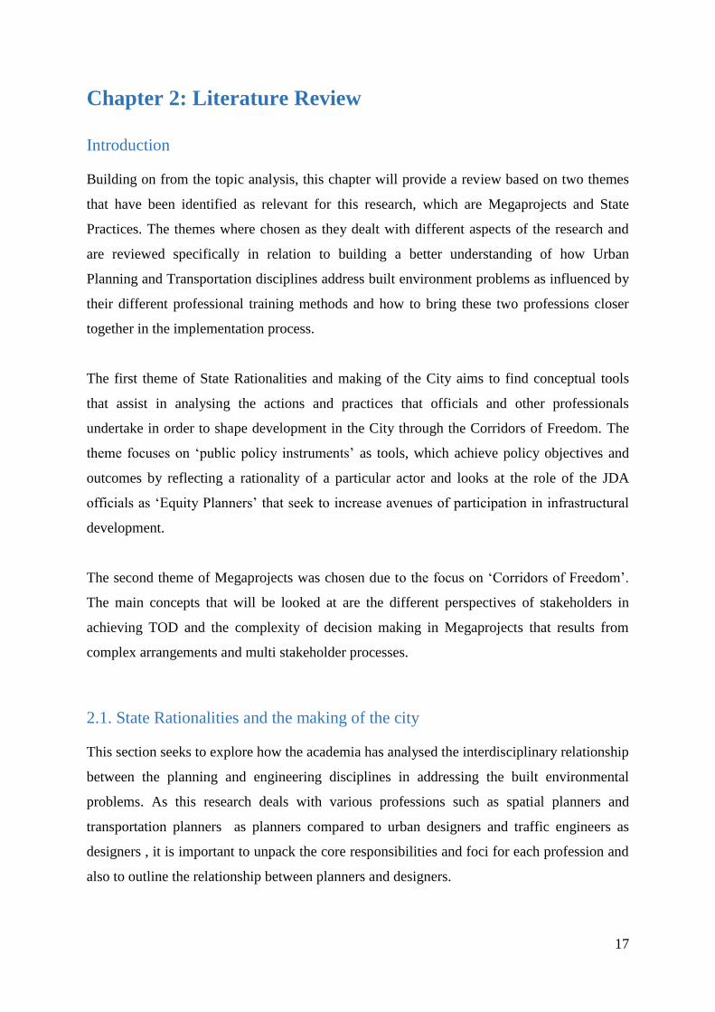
Figure 5: Link and Place classification
Source: Jones et al, 2008
Stakeholder engagement
Jones and Thoreau (2007) further describe the development of an interactive street design
workshop exercise which directly involves local stakeholders in developing design options on
conflict areas within parts of urban street network. The exercise which has two workshops
involves the combination of physical and computer based design aids.
Workshop 1- A project briefing about the study area where stakeholders (local businesses,
local residents, general interest groups and local politicians) are invited to discuss how they
would like to see the improvement of their area based on the range of Link and Place
problems experienced .The outcome of the discussion should bring forth a set of minimum
design requirements which are then left to the design team of traffic engineers and urban
designers to consider based on regulations and policy priorities.
The stakeholders are divided in two design groups and then provided with a large scale plan
of the street component at a scale of 1:250 which shows only the minimum requirements that
have been agreed upon but should there be remaining space, then the participants are allowed
the liberty to include their ambitions for the area. Each design group in essence decides on a
number of street design elements of link and place types to be provided and located along the
proposed street.
Workshop 2- The two design options developed by the group of participants in the first
workshop are projected on a G.I.S based program that displays the street layouts that have
been produced. After the discussion of both options, and an outcome decided, the traffic
engineers then refine the design outcome and the street plan put forward for formal public
consultation.
This interactive approach which has been utilised in the international context provides a
successful example of how street designs have been developed through stakeholder
engagement and where local councillors and professionals have co-operatively worked with
local businesses and residents. This conceptual tool is important for this research in
30
evaluating the extent to which it can be applicable to the challenges faced by the two
professions in the Louis Botha Corridor .

31
Chapter 3: Research Methods
This chapter outlines the research methods that are utilised in order to answer the main and
sub-questions which have been identified for this study in chapter 1. The first segment of this
chapter involves an explanation of the research method that was applied. The limitations of
these methods and techniques are then explored to identify potential gaps in the research. The
ethical considerations that form part of this research are then discussed in the concluding
section of the chapter.
3.1. Context in which the research has been made possible
The research is directed by the Centre for Urbanism and the Built Environment Studies and
forms part of the Practises of the State in Urban Governance research programme. An
informal agreement has been put in place between the JDA and CUBES for research to be
carried out on the JDA, in which the JDA has been made aware of the research and its aims,
and one official working in JDA has been hosting and mentoring me (inviting me to the
meetings that he thought were relevant for my research) throughout the research process.
Following from research carried out by Molema (2016) on exploring city official’s practises
of community engagement; this research has adopted a variety of techniques in acquiring data
collection.
3.2. Research Method – a case study
A case study approach is the main research method used in the study as it is informed by the
main and sub question. The case study approach is used to answer the main research
question:
“How does the JDA DFU mediate between the two different professions of urban planners
and transport planners’’
Flyvberg (2014) states that the case study method is beneficial as it creates a form of context
based information. Grinell (1981:302) explains a case study as a very flexible and open
ended technique of data collection and analysis. Kumar (2001) explains that the case study is
an advantageous design when one wants to have a holistic understanding of a situation. The
case study for this research is Orange Grove along Louis Botha as has been explained in
chapter 1. The Orange Grove area represents an ongoing site based application of TOD where

32
planners and designers are interacting which helps to determine the challenges faced in the
area and how the different professions work together in producing public space as part of the
Corridors of Freedom vision. Due to the research focusing on Louis Botha Corridor, it meant
that for most of the research I spent more time with the DFU official working on the Louis
Botha Corridor. Various research techniques were needed in order to conduct the research
method that would help in answering the research question.
3.3. Research techniques
This section now focuses on the research techniques that are used for the purpose of this
study. The techniques included the use of semi- structured interviews, participant
observations and secondary source research through the review of policy documents. Each of
these techniques is vital as each contributes different aspects of information to the research
findings.
3.3.1 Observations
An instrument of data collection that was utilised for this research was that of observations.
The observations were mainly limited to work occurring in the Louis Botha Corridor and
involved attending in-house meetings, meetings between the JDA and other departments and
consultants over a period of two weeks in which plans and project updates were discussed. In
each meeting I attended, I was introduced by the JDA official to participants of the meeting
and my research introduced to them. In both meetings I felt welcomed and although I
intended to stay quiet in most meetings, I was encouraged in some cases to participate by the
official and participants which made me confident. For instance in a meeting I attended
between the JRA official, JDA official and urban designer, the JRA official would ask me
during the meetings if I needed clarity or if I needed to make an input in the discussions
which made me feel like an equal participant in the interviews.
I also attended two workshops between the JDA and stakeholders in the private property
development in order to understand how the creation of partnerships was benefitting the TOD
strategy. During the course of the fieldwork, I spent two weeks shadowing the JDA official
working in the Louis Botha corridor by following his daily routine and work which helped
me gain insightful knowledge into understanding the TOD strategy and his work in trying to
bring the two disciplines to work together.

33
Box 1: ‘My hugely exciting fieldwork experience at the JDA’
My first day at the JDA was on Monday the 24TH
of July and I have to admit I was really nervous on
the day as I was quite unsure as to what to expect from my first day in a work environment. I arrived
at the JDA and met Matt Jackson who is the DFU official responsible for Louis Botha Corridor. He
introduced me to Christo , the Development Facilitation Unit manager and Nikki who were in the
office at the time. After the introductions, Matt explained that he had a meeting which would be of
interest to me as it involved the urban design team and a Department of Development Planning
official discussing concept plans for the Balfour Park area along Louis Botha. The day could not have
started any better, within my first hour I was already to attend a meeting that would be beneficial to
my research, where the discussion was based on detailed design issues on Louis Botha Corridor with
emphasis on participation meetings and engagement over designs. The meeting was exciting as it was
my first time being exposed to witnessing professionals engaging in the production of urban space
which made it more relevant to my research.
After the first day, I was certain that I was going to enjoy my fieldwork experience, attending
meetings where I could witness professionals at work was a truly enlightening experience for me
personally. It gave me first-hand experience of what to expect in the working world particularly as an
urban planner.
The following day I was introduced to Seipati and Lwazi, the whole team was particularly welcoming
and warm towards me which helped me blend in and feel at ease. The team invited me to attend any
of their meetings if there were relevant for my research. However since my research had a specific
focus on Louis Botha corridor , I spent most of the two weeks ‘shadowing’ Matt by following him to
meetings so as to get a better understanding of what his work entailed.
After two weeks I gained vast amounts of practical knowledge about what TOD actually means to be
implemented in Johannesburg. For me it was fascinating due to the fact that, reading literature on
TOD and actually seeing first-hand the processes that go about in transforming spaces, it was eye
opening and exciting. Over the course of the two weeks, I met various professionals that work in the
urban planning and traffic engineering fields and the best part of that fieldwork is particularly how
everyone was willing to share their knowledge with me and assist me with my research.
The work that is being undertaken at the DFU is really at the core of pushing for inclusivity and this
unit from the short period I spent at the JDA is crucially important in the successful implementation of
projects that have the desired outcomes of inclusion particularly of the low income population. My
fieldwork experience really exposed me to vast amounts of knowledge and I got more than what I
bargained from the experience. The ‘mentorship’ experience I received from Matt was indeed the
most helpful and vital part of the fieldwork as it helped bridge gaps in my knowledge about how
traffic engineers and urban designers work together to produce public space. Certainly it provided me

34
with enough background knowledge to be able to go to interviews with the respondents confident
about the information that I had acquired.
Below is a list of meetings and workshops I attended as part of my two weeks at the JDA.
Internal meetings with other City departments/consultants
Nature of meetings
JDA Official(s)
involved Other department Date Venue
Discussion around the
BRT (Balfour Park
Section) Louis Botha Matt Jackson
City Transformation,
Project Team and
Urban design
consultant 24-Jul-17 JDA offices
Discussion around
Orange Farm , Diepsloot
project interventions
Matt Jackson
and Nikki Pingo
JDA, Urban design
consultants 01-Aug-17 JDA offices
Discussion on detailed
design of intersection
treatment and site access
near Balfour Park Mall Matt Jackson
JDA, Urban Design
Consultant, JRA 01-Aug-17 JRA offices
Discussion on Inner City
Parks Masterplan Nikki Pingo
JDA,JCPZ and
landscape architects 03-Aug-16 JDA offices
Meetings with the Private Sector
Nature of meeting JDA officials Private company Date Venue
Transit Orientated
Development Lecture to
TUHF and entrepreneurs Matt TUHF
JDA
offices
Meeting with private
developer , town planner
and architect Matt
Private developer from
Balfour Park along
Orange Grove 16-Aug-17 Brixton
Workshop co-hosted by
JDA, COJ and
Nikki, Christo,
Land use
TUHF and emerging
property developers 19-Aug-17
JDA
offices
TUHF department
3.3.2 Semi-structured interviews
The JDA official assisted me in identifying key respondents from the projects and initiatives
occurring along Louis Botha and Orange Grove. By introducing what my research entailed to
the respondents and its intended outcomes, potential respondents had an idea of what the
research intent was, which made the process of setting up interviews less daunting and much
35
likelier to be successful. The respondents were identified due to their participation in the five
projects listed below occurring as part of the TOD strategy in the Louis Botha Corridor:
Louis Botha Bus Rapid System
Louis Botha Non-Motorised Transport Link
Orange Grove Special Development Zone
Paterson Park Precinct
Grant Avenue Precinct
Project Representatives Targeted Response
Louis Botha BRT Traffic engineer
consultant
Transport Department
official
2 interviews conducted with
traffic engineer consultant and
Transport Department official
Louis Botha Non-Motorised
Transport
JDA official
Traffic Engineer
Urban Designer working
for the JDA as a
consultant
1 interview conducted with
urban designer
Orange Grove Special
Development Zone
City Transformation
official
Urban Design Consultant
Traffic Engineer
1 interview conducted with
transportation planner consultant
and City Transformation Official
Paterson Park Precinct Land Use Planning
official
Urban design consultant
for the JPC
1 interview with an urban design
consultant
Grant Avenue Precinct JDA official
Urban Design Consultant
for the JDA
Transportation Planner
consultant for JDA
3 positive interviews conducted
With all
The respondents were chosen based on their roles in the projects listed above. Initially 16
people were targeted with letters requesting a face to face interview and of the 16 people, 7
interviews were conducted which comprised of a JDA official, Department of Development

36
Planning official, Transport Department official and four consultants. Setting up interviews
with the 7 respondents was fairly easy, however setting up interviews with some City
officials and some consultants was challenging as no responses were received and some
phone calls went unanswered.
The use of a semi-structured interview format with open ended questions was in order to
facilitate a conversation with the interviewee so that I could gain an in-depth knowledge into
both disciplines and in many instances by being able to guide the interview as it progressed, it
opened new channels of engagement which I had not conceived in the formulation of the
interview questions. The interviewees were generally pleased with the research I was
undertaking as they believed it would benefit the practises of professionals involved in
projects and in achieving desirable public spaces. It should be noted however that a
limitation of the research is that the sample was not complete which means that there are
views of stakeholders that are not represented in the research.
A generic interview guideline was developed for both transportation and urban planners
which was adapted to the particular user group which was being interviewed which can be
seen in the annexures. The questions where guidelines in enquiring the role of the
professional in each project, challenges they faced and also understanding the rationale
behind the methods used and decisions undertaken. The generic interview guideline for city
officials was intended to unpack challenges faced by city officials, their specific role in the
project and mandates for planning the project.
3.3.3 Structure of ‘Findings’ Chapters
The Louis Botha Corridor development around the Orange Grove Area comprises four
projects which entailed differing dynamics in arrangements and methods undertaken by the
different professionals. To best illustrate the variety of research techniques employed by this
research and to also best show the different methods which the JDA utilises to mediate
between the two professions at implementation / site level, I decided to structure the findings
into three findings chapters anchored by the Chapter 4 which is the contextual chapter that
introduces Louis Botha Corridor and the various city plans, strategies and projects occurring
as part of the TOD strategy in Louis Botha.

37
3.4. Ethical Considerations
Before undertaking the research fieldwork, the ethics and clearance forms were completed
and approval was granted, the letter can be found in the annexures. There were no vulnerable
groups participating in the study and hence there were no clear ethical rules to consider in the
research. This research utilised a variety of techniques and hence ethical issues needed to be
taken into consideration. The research interviewed various professionals from the different
projects making up the Louis Botha TOD strategy about their roles and responsibilities in the
projects it then presented challenges of keeping anonymity particularly due to the fact that
these are still ongoing projects. As part of the agreement that was made to respondents, it was
promised that I would make the research report available to them on completion.
3.5 Conclusion
This chapter has discussed the research method and techniques used in collecting data for this
research. The chapter has also identified the respondents that were interviewed as part of the
research and has also provided an outline of the structure of the findings of the research. A
limitation of the research is that the sample was not complete which means that there are
views of stakeholders that are not represented in the research particularly due to the fact that
initially I had conceived of interviewing the Orange Grove Residents Association
representative in order to understand the how the community feels about the development
that is occurring within Orange Grove, and the community’s perspective on the conflicts
between transportation and planning priorities.

38
Chapter 4: Understanding the City of Johannesburg as diverse, and the
Corridors of Freedom as vertical and transversal project across the City
The internal diversity of the local state is essential for developing a complex understanding of
how policy instruments defined as tools that seek to achieve policy outcomes are developed
to represent the interests of the participating actors. The production of policy instruments
such as regional plans and precinct plans reflect the rationality or way of thinking of the main
actor or department that was involved in the driving of the plan. The City of Johannesburg
comprises a variety of actors or departments that are involved in the Corridors of Freedom
hence it is a multi-departmental project that involves the collaboration of the Department of
Development Planning, Transport Department and the Johannesburg Development Agency
which is the project manager.
This chapter will introduce the Louis Botha Corridor and the roles and mandates of the
Department of Development Planning, Transport Department and JDA involved in the
implementation of the Louis Botha Corridor.
The chapter will then look at the vertical layering of city and regional scale policy
instruments to demonstrate how the framing of the documents in terms of guidelines,
perspectives and the priorities embedded in the City plans reveals a specific rationality of the
state in the Louis Botha Corridor with reference to understanding Transit Orientated
Development. The section seeks to show how the city plans are strategically aligned in a
hierarchical manner which ‘scales down’ to inform the plans at local scale.
The chapter will then focus on the local scale at the ‘horizontal web’ of precinct plans that
inform development in the Orange Grove Area. The research has a focus on the precinct scale
hence this section intends to introduce the precinct plans that will developed into short
stories.
4.1 Introducing Louis Botha Corridor
This section will introduce a brief account of the historical development of Louis Botha
Avenue with regards to its function.

39
The historical development of Louis Botha Avenue (Please refer to map 1) is important for
contextual understanding of the role and function of the road which will aid in understanding
recent interventions in the COF. Tsica (2016) note that in 1909, electric trams started
operating after Orange Grove had been established five years prior to that. The intervention
of the electric tram system enabled the development of denser mixed use buildings that
categorised the transit spine and created the conducive conditions for the retail and businesses
to emerge.
At the time, a decision was taken by the City in 1961 to forego the tram system and hence
roads were widened to make way for the private car. Louis Botha Avenue then became a
principal artery for connecting the CBD with northern and eastern suburbs (Tsica, 2016).
Appelbaum (2016) outlines that the great significance of the historical development of Louis
Botha Avenue has that the road has always equally functioned as a mobility and activity
spine.
Figure 6: Louis Botha Avenue in 1936 (Source: Museum
Africa, 2016)
Figure 7 : Louis Botha as a key BRT route in relation to the initial
choice of Oxford Road (Source: www.iol.co.za)

40
The choice of Louis Botha Avenue as a Rea Vaya Bus route was made because there was too
much opposition of residents association along Oxford road, which was initially envisaged to
be the corridor. The figure above shows spatially the old proposed Rea Vaya bus route
compared to the new choice of Louis Botha Avenue and also shows the location of Norwood
and Orange Grove in relation to the Corridor. These two areas will be form the main focus of
the findings chapters.
4.2 Introducing the main stakeholders
This section will introduce the mandates of the main stakeholders of Transport Department
and Development Planning in planning the Louis Botha Corridor. This section seeks to
answer the first sub question of the research, which is what the respective mandates of the
two departments. This section will also introduce the specific roles of the two city officials
from the Department of Development Planning and Transport Department in fulfilling the
mandates of their departments.
Figure 8 : The stakeholders involved in the Louis Botha CoF (Source: Department of Development
Planning official, 2017)

41
The sketch above is a representation of the main stakeholders involved in the Louis Botha
Corridor. The Department of Development Planning consists of four directorates which are
Geomatics Information Systems, Building Control, Land use planning and City
Transformation. The directorates that have had the most involvement in the Louis Botha
Corridor are the City transformation and Land Use Planning directorates. The Department of
Transport consists of the Strategic Support. The JDA is the project manager for the city and
thus hires the urban design and transportation consultants who are involved in projects. The
next section will look at the mandates of the two departments and JDA in developing the
Louis Botha Corridor.
4.2.1. Department of Development Planning
The core mandate of the City Transformation Directorate as explained by the Department of
Development Planning official is that:
“The City Transformation directorate is responsible for all policymaking and forward planning for
the City of Johannesburg whereby the unit takes a strategic view of planning across the City by
developing the Spatial Development Framework for the City and related strategies such as the
Growth Management Strategy.”
(Department of Development Planning official, 2017)
The official states that his role in the Louis Botha Corridor was specifically focussed on
attracting private development into the Orange Grove area to realise the City vision of
increasing densities within the area in line with the CoF vision.
“My role has been facilitating projects via the J.D.A for private development in and around the
area, working with private owners and developers that want to develop their sites by
communicating and meeting with them to understand their spatial outcomes, densities and land
use rights in order to align their development to the City’s vision.”
(Department of Development Planning official, 2017)
The quotation above highlights the fact that the official is involved in both spheres of
strategic planning and urban design and the core focus of his job in the Louis Botha Corridor
aligns with the City Transformation Directorate’s mandate which is to ensure that private
developers in the area work within the parameters of the Spatial Development Frameworks of
the City.
“The core responsibility is to work across all regions and with JDA particularly with
implementation of projects and precinct plans which have been identified by the City which then

42
in essence is facilitation through crossing the bridge between the Municipal Owned Entities such
as J.D.A, the City and private sector.”
(Department of Development Planning official, 2017)
In conclusion, it can be deduced that the Department of Development Planning, in particular
is concerned with the forward planning of the area through urban planning tools such as the
Spatial Development Framework and the Orange Grove SDZ.
4.2.2. Transport Department
The Transport Department is responsible for the planning and design of BRT stations and the
operation of the BRT (Rea Vaya) bus along the CoF including Louis Botha Avenue.
Transport Department official (2017) states that the core mandate of the Department of
Transport is to:
“Promote public transport and non-motorised transport.”
(Transport Department Official, 2017)
During the interview, as I got to learn more about the work of the Transport official, it
was noted that for Louis Botha, there was the need to increase mobility which is the fast
safe efficient movement for the proposed BRT system and also to ensure the
environment is cyclist friendly.
“There is a need to reduce availability of on street parking and to make sidewalks bigger”
(Transport Department Official, 2017)
The Transport Department official also highlighted that there is a business case to building
the corridors of freedom as the City had invested significant amounts of money to make it
work.
“The planning of the corridor with regards to demand modelling has shown that a lot of money
had been invested whereby in the yearly IDP, some of the targets that are limited to the CoF are
the number of passengers”
(Transport Department Official, 2017)
The business case is due to the fact that if prices for the Rea Vaya (BRT) have to be
subsidised by the Transport Department in order to make the bus fares affordable to the
population and hence from the Transport Department, increased densities are needed in order

43
to support the bus and ensure the operational cost recovery. It can be deduced that from the
transport side, operational cost recovery of the BRT is important as the Transport official
noted that subsidies have increased over the years and this then supports literature that
megaprojects such as the CoF are constrained by factors of time and money.
4.2.3. The JDA
The JDA is development manager on the behalf of the City and thus is the implementer of
transport projects such as the Bus Rapid Transit System with regards to related BRT precinct
upgrades which comprise of the roadway, sidewalks and stations (South African Cities
Network, 2016). Along the Louis Botha Corridor, the JDA is focusing on enhancing mobility
of the BRT and investing in amenity through the Paterson Park Project and Grant Avenue
Precinct (DFU official, 2017). The Transport Department as highlighted above is
concentrated on the operation of the BRT; hence the JDA closely works with the Transport
Department and the Johannesburg Roads Agency (JRA) which is responsible for all
developments on the road network in Johannesburg (South African Cities Network, 2016).
The JDA also negotiates with the Transport Department and Development Planning
Department on projects such as the Orange Grove Special Development Zone in facilitating
developments efficiently that contribute to a resilient, sustainable and liveable city as part of
their mandate.
The JDA also works closely with the Department of Development Planning in -coordinating
spatial development which is done through the formulation of Precinct Plans for the Grant
Avenue and Paterson Park Projects which are occurring as part of the TOD strategy. The
section has identified the complexities involved in planning the Louis Botha corridor as a
result of multi-stakeholder arrangements. The two departments have different mandates
which mean that each Department works to ensure their mandate is carried out and the JDA
can be seen as the bridge between the two departments in facilitating the projects from both
departments. The JDA Development Facilitation Unit has officials which are responsible for
the three development corridors which are Turfonttein Corridor, Louis Botha Corridor and
Empire Perth Corridor. The mandate of the JDA Development Facilitation Unit in facilitating
transit orientated development in the corridors is to:
“Promote inclusivity of all income groups particularly the low income and compaction of the
built form.”
(DFU official, 2017)

44
To achieve this mandate, The JDA DFU has an official that work in the development phase
of the Louis Botha Corridor and the role and actions of the official will be presented in the
last chapter.
4.3. Louis Botha, Norwood and Orange Grove developments, caught in a vertical
scaffolding of policy instruments
This section seeks to explain how the vertical policymaking process as shown in the sketch
below cuts across the Department of Development Planning and Transport Department. The
vertical design of the policies requires efforts aimed at administrative co-ordination and thus
this section will focus on the city scale and regional scale plans as shown in the sketch below.
The sketch above shows the interrelationship of different City policies that inform TOD in
the context of Johannesburg. The different colours represent the dominant rationality that is
prevailing within that particular policy instrument .The blue represents transportation
rationality while the red represents a planning rationality. The documents that shall be
reviewed are the Growth Development Strategy 2040, Integrated Development Plan,
Integrated Transport Plan, Spatial Development Framework and the Louis Botha Strategic
Area Framework. The logic of reviewing the documents in a hierarchical manner is due to the
fact that they are informed by the GDS 2040 which presents the overarching vision of the
City.
Figure 9: City scale policies (City of Johannesburg, 2017)

45
This section seeks to explore the vertical framework of policies within the City that inform
Transit Orientated Development. This will be done by analysing :
Which Department drives the formulation of the document within the City and what are the
aims or objectives of each document that is reviewed.
How the documents preceding one another inform the next document.
The time frames of each document.
4.3.1. Johannesburg 2040 Growth and Development Strategy
The Johannesburg 2040 Growth and Development Strategy is the City’s first long term path
for the future development of the city until 2040 (City of Johannesburg, 2011) .The GDS
2040 is a long term strategy, it is a pre-condition for medium term, strategic spatially oriented
plans of different sectors in the city such as transportation, housing and infrastructure (City of
Johannesburg, 2011). The Joburg 2040 Strategy was produced to work in conjunction with
the city’s medium term development strategy, the IDP. The GDS defines the type of society
the city aspires to achieve by 2040 and provides a set of defined strategies that frame the five
year IDP. The importance of the GDS 2040 is that it provides the strategic overarching vision
for the Department of Transport and Department of Development Planning which is:
“Johannesburg –A World Class African City of the Future-a vibrant, equitable African city,
strengthened through its diversity, a city that provides real quality of life; a city that provides
sustainability for all its citizens, a resilient and adaptive society "
(City of Johannesburg, 2011: 35)
The Joburg GDS 2040 is therefore a long term strategy outlining the City’s vision, mission,
principles, outcomes and indicators and provides a set of defined strategic directions that
frame the other medium term plans for infrastructure, housing and transportation. The Joburg
GDS 2040 states that sustained investments in mass public transport and non-motorised
transport would be in order to prioritise the pedestrian over the car in order to have a
Johannesburg that is pedestrian and public oriented by 2040.
4.3.2 Integrated Development Plan 2016-2021 (Draft)
The IDP is a municipal tool that is used as an incremental five year plan that is able to enable
the accomplishment of both long term and medium term goals of the City as also set by the
46
GDS 2040 (City Of Johannesburg, 2011). Whereas the GDS 2040 outlines the long term
strategic overarching vision about what to lay emphasis on if the city is to fast-track
development, the IDP then expresses where the city wants to be after five years and how we
intend to get there (City of Johannesburg, 2016). The City of Johannesburg has entrenched
TOD as a vital focus of the municipal departments of Transport and Development Planning
and this is evidenced by the fact that the 2012-2016 IDP was based on the T.O.D based
‘Corridor of Freedom’ vision .
The City of Johannesburg IDP for the period of 2016-2021 is titled “Delivering the promised
future by putting people at the centre of development”. The 2016/21 draft version of the IDP
translates the GDS 2040 outcomes into medium term programmes for implementation for this
current term. The IDP builds on the Corridors of Freedom delivery model whereby the
budget allocation for Louis Botha Corridor as a priority intervention stands at R912 745 336
(City of Johannesburg, 2016). This supports the statement by the Transport Department
official who highlighted the significant amount of money which has been invested in the
corridor which highlights the fact that the Transport Department also has operational cost
recovery as a priority for the BRT.
One of the main approaches which have been highlighted in order to achieve the spatial
vision is “the restructuring and integration of all public transport modes across the Gauteng
City Region and increased focus and support for walking and cycling.” The 2016-2021 draft
IDP thus places a priority to promote non-motorised transport through measures such as
public environment upgrades, complete streets and urban design interventions which are
essential in improving walkability, accessibility and safety of the streets (City of
Johannesburg, 2016). The SITP forms a component of the ITP and will be described next.
4.3.3. Strategic Integrated Transport Plan Framework 2013 - 2018
The Transport Department has developed the Strategic Integrated Transport Plan Framework
as one of four components that make up the Integrated Transport Plan for the period of 2013-
2018 (Transport Department, 2013). The SITPF is the component that relates to the Transport
Department’s intentions of promoting TOD. It is a sectoral plan and hence informs the IDP
formulation process. The Transport Department has developed both the ITP and SITPF
documents in 2012. The Transport department among other departments such as the

47
Department of Development Planning are responsible for the realisation of the second
outcome of the Johannesburg GDS 2040 (Transport Department, 2013). The Joburg 2040
GDS indeed identifies eco-mobility as key output and it is with this regard that the concept is
also identified as a long term goal for the Transport Department and seeks to promote non-
motorised transport that entails the use of public transport, walking and cycling (Transport
Department, 2013).
The SITPF has developed nine thrusts in order to achieve the policy outcome and objectives
of the GDS Johannesburg 2040 strategy, and the first one is:
“An efficient, city wide public transport system located predominantly along high density, mixed
land use corridors.”
(Transport Deaprtment 2013: 37)
This quote is important in showing the transport rationality that focuses on the functionality
of the BRT system and having the necessary densities that would support the bus. This
collaborates the information mentioned by the Department of Transport Official that the
Department is mandated to promote public transport.
The SITPF highlights the various benefits that result from promoting transit oriented
development in the corridors from a transport perspective which are:
“A ridership turnover that would result from a mixture of land uses as there would be ons and offs for
the full length of the route which would be the key driver of lowering the cost per passenger carried in
public transport
A mixture of land uses along a corridor also means that the public transport route can pick up
passengers in both directions of the route
Higher numbers of passengers per bus km mean better revenue: cost ratios
A higher ridership resulting from the increased densities which would mean a better service for
passengers as bus services would be running at higher frequencies
Modes of walking and cycling, for either feeder routes to public transport stops and stations, or as the
main mode for the shorter and convenience trips in the corridor, can play a greater role in a denser
corridor because of shorter average trip distances.”
(Transport Department, 2013: 44)

48
A major point that can be deduced from the quote that highlights the main benefits of
promoting development in the corridors is that the main focus of the Department of Transport
is to ensure the efficiency for the bus and the bus’s needs and taking the road and making it
usable for public transit in terms of vehicular modes and supporting walking as a second
priority.
4.3.4. City of Johannesburg Spatial Development Framework (2016)
The Spatial Development Framework 2016/2017 was developed by the Department of
Development Planning and as a sectoral plan it is aligned with the IDP. The SDF 2016/2017
takes direction from the GDS and IDP, and then provides direction for more detailed spatial
frameworks by guiding spatial development and land use decisions that the city takes (City of
Johannesburg, 2016).
Public transportation is identified as the major pillar on which the new city will be
constructed whereby an accessible and affordable public transport network would provide
efficient movement and connection to city opportunities. The objective is to create walkable
neighbourhoods around public transport stations and provide options for non-motorised
transport to become the primary means of neighbourhood movement (City of Johannesburg,
2016).
The various benefits arising that result from promoting transit orientated development in the
corridors from a spatial planning perspective is increased density and intensity of uses in
close proximity to transit infrastructure and the SDF further identifies the mechanisms and
tools suggested to support the implementation of the strategies that promote densification,
which with respect to the limits of the research are:
Louis Botha Strategic Framework
Form based codes to complement zoning in the transport corridors to help regulate street fronts,
building typologies, ground floor activities, public spaces and private-public boundaries.”
(City of Johannesburg, 2016:97)
The SDF provides the framing for the development of detailed Strategic Area Frameworks
and precinct plans. The distinction of the two documents is that Precinct Plans provide
detailed design and development guidance for interventions while the SAF identifies good
urban design and densities desired by the City.

49
4.3.5 Complete Street Guidelines (2013)
Complete Streets is a technical guide for urban street design which provides a uniform
approach to designing streets for modern communities. The City of Johannesburg Complete
Street Design Guideline Manual (2013b) is a document developed by the Transport
Department that guides the City in developing a street system that encourages the walking
and cycling modes, caters for all user groups and encourages the use of public transport.
“Complete Streets” are defined as streets which are safe, comfortable and convenient for
travel for everyone, regardless of age or ability and mode of movement and have an increased
focus on sidewalks, dedicated lanes for public transport; traffic calming, urban functionality
and attractive public spaces (Transport Department , 2013b). Complete Streets are designed
for:
Safety where the emphasis is on the safe movement of people and goods
Access and Mobility which seek to accommodate all street users with highest priority
afforded to space efficient modes
Liveability through the creation of a vibrant public realm with high quality public
spaces.
The importance of the Complete Streets Design Manual was that it was used as far as
possible to guide the feasibility study (Traffic Impact Assessment) in the Orange Grove
Precinct where a few challenges were encountered, thus as a guiding document it is
envisaged to be at the front end of transportation projects during the planning and design
stage.
4.3.6 Louis Botha Strategic Area Framework
The SAF has been developed by the Department of Development Planning and JDA as a
mechanism that guides investments within Louis Botha Corridor. The SAF provides the
spatial vision and direction for physical interventions such as City investments, infrastructure
upgrades and amenity investments and this is encapsulated in a quote taken from the policy
instrument:

50
“The Strategic Area Framework provides the spatial vision and guidance for physical
interventions but the implementation of the Corridors of Freedom requires the collaboration and
efforts of the full range of urban stakeholders and implementing agencies, including residents and
communities.”
(Department of Development Planning, 2015)
The Louis Botha S.A.F document has been compiled by five urban design consultants which
has the implication that the document will predominantly cater for urban design principles
that relate to building form and street design. The transport rationality reflected in the
document is in the optimisation of the BRT which is seen as a key priority for the Louis
Botha Corridor.
“The key intervention within the Louis Botha Avenue corridor is thus the Implementation of
Phase 1C BRT Projects, including construction of the dedicated lanes and stations, non-motorised
transport infrastructure and inter-modal transport facilities and a depot”
(Department of Development Planning, 2015)
This supports the claim made in the analysis of the SITPF that the Rea Vaya is the priority
project and thus the needs and requirements of introducing the BRT system will be
prioritised. The role of the corridor as envisioned by the SAF is to serve both mobility and
activity functions. A key point to note is that the corridor has a role to play in terms of
providing opportunities for retail functions and this vision for the role of Louis Botha Avenue
coincides with the original function of the road in the 1960s as highlighted in the first part of
the chapter.
“Based on prevailing land use and activity patterns, the Louis Botha Avenue Corridor is
predominately residential in nature, catering for a range of income groups and spatial preferences.
The corridor also has a role to play in terms of providing opportunities for economic activity, and
related employment potential.”
(Department of Development Planning, 2015)
The SAF as identified provides spatial guidance for physical interventions and another
priority mechanism which is critical for the development of the Corridors of Freedom is the
Special Development Zones which are a mechanism implemented at site level in the Orange
Grove Precinct.
51
“A key element in facilitating the longer term development of the Corridors of Freedom as
envisaged in the Strategic Area Frameworks is the establishment of Special Development Zones
for priority development areas. This is a clearly defined area, at cadastre level, to the cadastre that
the Council has delineated for focused planning and development intervention and investment.
Special Development Zones (SDZs) will be promulgated by means of an amendment scheme to
the Town Planning Scheme. SDZs will result in streamlined approval processes. The Department
of Development Planning will take the lead in establishing this mechanism.”
(Department of Development Planning, 2015)
The vertical layering of documents shows how the policy tools at city and regional scale are
aligned to each other and how they are informed by the Growth Development Strategy 2040.
A key point to deduce is that the SDF as a tool shows how from an urban planning
policymaking point of view, the CoF vision is to be achieved through the guiding of spatial
interventions particularly the private sector in increasing densities as part of the CoF vision .
The SITPF shows from a transport planning policy making point of view the necessary
prerequisites such as increased densities for the operational efficiency of the BRT and the
benefits from a transport planning perspective of achieving TOD.
4.4. Horizontal web of documents to plan interventions in Orange Grove
Horizontal tools comprise of networking which in the Orange Grove area is in the form of
public and private partnerships in the form of the two departments and the JDA working with
Urban Design and Transport Planning consultants. Molema (2016) notes that the City of
Johannesburg makes use of architects and urban design consultants in the production of
plans. The drawing up of the precinct plans that will be discussed below was done by urban
design consultants on behalf of either the Department of Development Planning or JDA.
This section of the chapter introduces the policy instruments that are occurring as part of the
TOD strategy at implementation level in and around the Orange Grove Area as part of the
TOD strategy . The overall development strategy encompasses the implementation of the
Orange Grove Special Development , the BRT station , Paterson Park Precinct and Grant
Avenue Precinct . I however did not have access to the BRT framework as the project is still
undergoing hence the document has not been published online yet and hence the precinct
plans reviewed are shown in the figure below . The figure below shows a spatial
representation of the projects that are occurring as part of the TOD strategy.

52
4.4.1 Norwood ‘High street’ plan – Grant avenue precinct, consolidating the street as
public space? (2016)
Map 1: spatial location of the Grant Avenue High Street marked in red (Source COJ/ JDA, 2017)
“The Grant Ave Precinct Plan commissioned by the City of Johannesburg (CoJ) Development
Planning and the Johannesburg Development Agency (JDA); was prepared by a multi-disciplinary
professional team including urban designers, town planners, architects, economic analysts,
transport, traffic and engineering services, and urban management specialists. The work was
undertaken in close co-operation between the JDA and officials from Region E and the City
Transformation Unit, in addition to extensive public engagement through a participatory planning
process”
Figure 10 showing the chronological order of the precinct developments (Source: drawn by author)

53
(ASM Architects and WSP, 2016: 9)
The Grant Avenue Precinct Plan was framed by mainly the City Transformation Unit in
Department of Development Planning and JDA. The JDA contracted an urban design
consultancy and a transportation planning consultancy whereby the transportation
consultancy worked under the leadership of the urban designers.
“The planning process is also informed by the application of innovative interactive public
engagement techniques, resulting in the co-production of a plan that reflects the interests and
priorities of a wider and diverse stakeholder base.”
(ASM Architects and WSP, 2016: 9)
The preparation of the Grant Avenue Precinct Plan involved community engagement
techniques from both the transport consultants and the urban designers involved. The wide
and diverse stakeholder base which is mentioned in the quote is encapsulated through the
figure below which shows the timeline for the draft plan to the presentation of the final plan.
Figure 11 showing the preparation of the Precinct Plan and the variety of stakeholders involved (Source: JDA, 2016)
Chapter 5 will look at the preparation of the final plan with respect to the public engagement
techniques undertaken by the Urban Design team and Traffic Engineering consultancy to
uncover how interaction with the community influences the urban design and transport
planner. The JDA through pushing for an Urban Area Management framework was pushing
for the inclusion of the Norwood community in the decision-making process of public space
interventions.

54
4.4.2. Orange Grove Special Development Zone (2017)
The Orange Grove Special Development Zone is a zoning mechanism which has been
implemented by the Department of Development Planning to fast-track zoning applications in
order to incentivise and attract property developers into the Orange Grove Area with the
intention of increasing densities within the area (Department of Development Planning,
2017a). The SDZ are therefore a densification model which is targeted to ensure that the key
goals of the CoF which are sustainable densification and retail are achieved (City of
Johannesburg, 2017a). The CoF has identified three priority precincts which include Brixton,
Orange Grove and the Knowledge Precinct (Department of Development Planning, 2017a).
Figure 12 showing the spatial location of the Orange Grove SDZ Precinct (Department of Development Planning,
2017a)

55
Figure 13 : the implementation timeline of the SDZ Precinct (Department of Development Planning, 2017a)
The Special Development Zone implementation phase is shown in the figure above and the
implementation phase kicked off with public engagement sessions. The Development
Planning Department of the City of Johannesburg hosted a series of public engagement
sessions during the weeks of 13-25 February 2017. During these sessions, communities
engaged with the City on the SDZ and provided written comments reflecting on what they
liked; disliked and aspects they thought were overlooked and not addressed in the project.
“Special Development Zones are a town planning mechanism whereby development, densification
and rejuvenation of a specific area can be promoted, facilitated and fast tracked.”
(Department of Development Planning, 2017: 6)
The Orange Grove SDZ has been framed by the Department of Development Planning to
achieve one of the main objectives of the CoF which is to introduce new high density housing
and social amenities linked to public transport (City of Johannesburg, 2017a). The quote
above supports the statement that the SDZ project is a responsibility of the Department of
Development Planning as it is a town planning mechanism which falls under the mandate of
town planning.

56
The SDZ document is structured into three parts. The first part introduces the Orange Grove
area and the Urban Design Masterplan before then detailing the densification approach that
will be undertaken. The second part of the document which is eight pages long details the
basic urban design development guidelines for buildings and streets and the final part of the
document which is sixteen pages long has an emphasis on development models that seek to
enhance the urban design and densification of the neighbourhood.
“To integrate and interrogate the Urban Design proposed by the respective
Strategic Area Frameworks to ensure it is positive and practically implementable.”
(Department of Development Planning, 2017)
The quote above shows the how the SDZ document is articulated from the Strategic Area
Framework and has a specific focus on the urban design aspects of development however as
part of establishing or implementing the SDZ vision, a transportation study was conducted to
find out the effects of a change in densities on the road network.
4.4.3. Transportation Study (Transportation Impact Assessment) (January 2017)
A Transportation Impact Assessment is a “tool for engineers and transport planners to
provide detailed information on a range of transport conditions both before and after a
development has been built” (Botha, 2005: 815). In South Africa, it is a requirement when
carrying out infrastructural developments through township establishments, rezoning
applications and consent use applications and therefore in establishing the SDZ for Orange
Grove which seeks to increase densities in the area, a traffic impact assessment is required to
determine the possible development impacts on the transportation and traffic system
(Department of Development Planning, 2017b).
The TIA done for Orange Grove was done by G.I.B.B consultants working on behalf of the
Department of Development Planning, which is responsible for the SDZ vision (Department
of Development Planning, 2017b). As part of the SDZ project, one transportation impact
assessment was conducted for the whole Orange Grove area as part of the incentive that
would mean that any private developer willing to develop property in the area would benefit
from not having to conduct his or her own TIA.

57
“The TIA investigates the impact of a proposed change in land use on the transportation system. It
is usually done to estimate site-generated traffic and assess its impact on the road network and on
the ultimate development (future). The TIA also identifies on-site and off-site improvements that
might be needed as a result of the development.”
(Traffic Impact Assessment 2017: 1)
The TIA follows an independent process but informs the SDZ and this will be unpacked in
Chapter 5 to evaluate how the SDZ as a policy instrument reflects a mix of rationalities that
reach a compromise through a process of repeated engagement. The work that was completed
to carry out to test the impact of proposed SDZ land use densities on the existing road
network required the collaboration of transportation planners, land use planners and urban
designers. Five plans were developed as part of the traffic impact assessment:
Access Management Plans
Public Transport Plan
NMT Plan
Informal trader accommodation plan
Parking management strategy
For the purposes of this research, three plans will be looked at based on the respondents that
were managed to be interviewed which are: the Access Management Plans, NMT plans and
Public Transport Plan. The T.I.A document highlights that these plans fall under the proposed
transport solutions and interventions for Orange Grove.
Access Management Plan
Access management integrates the activities of land use planning, transportation planning and
traffic engineering in order to optimize the safety and performance of the public street
network. The proposed road network hierarchy for the Orange Grove SDZ was discussed by
the COJ Development Planning Department, Johannesburg Roads Agency and consultants
(urban design and traffic engineering) from the Grant Avenue and Paterson Park projects was
based on functions of accessibility and mobility (Traffic Impact Assessment, 2017).
According to the Transport Impact Assessment (2017) done for the Orange Grove Special
Development Zone, Access Management Plans were developed to:

58
“Reduce conflicts on the roadway system and managed according to its planned
function of either accessibility or mobility. Mobility is concerned with the safe
movement of all modes of transport (not only private cars, but also public transport,
and goods and freight) while not neglecting Non-motorised transport. Accessibility
prioritises NMT modes over private car mobility guaranteeing walkable, pedestrian
friendly streets, while remaining reachable to cars, delivery vehicles, emergency and
utility services.”
(Transportation Impact Assessment, 2017: 65)
The quote above shows two dominant rationalities from an urban planning and transport
planning perspective. From an urban planning perspective, prioritizing non-motorized
transport over the private vehicle through accessibility is most desirable while from a
transport perspective, mobility is most desirable as it ensures the fast and efficient movement
of all user groups particularly the BRT which is the priority intervention along Louis Botha.
“From a transport planning perspective, it is desirable to have a hierarchy of streets where some
streets prioritise somewhat higher mobility than other streets, which will have a higher
accessibility function”
(Transportation Impact Assessment, 2017: 65)
The document therefore highlights two different understandings from both the transport
planner and urban planner with regards to what function the road should prioritize. Chapter 5
will unpack the Access Management Plan in order to view how compromises were reached in
facilitating the Access Management Plan.
4.5. Conclusion
The policy documents reveal a complexity due to the multi-stakeholder nature of the policies
This supports Flyvberg (2008)’s notion that that megaprojects clearly bring together under
various contractual arrangements, differing and competing partners, interests, values and
ways of doing and thinking. For instance, from a transport planning perspective, TOD is seen,
as having transit revenue generating ability through the operational cost recovery of the Rea
Vaya, while from an urban planning it is an opportunity to improve the quality of the public
realm. It is therefore important to note that megaprojects have multiple rationalities rather
than seeing them as having a singular shared way of thinking. A key finding is that

59
challenges or contradiction in ways of thinking between the two professions are encountered
at the detailed design implementation or site level.
Chapter 5: Grant Avenue Precinct, consolidating the street as ‘public
space’ through consensus building.
Jones and Thoreau, 2008 argue that the most successful street designs are as a result of
stakeholder/community engagement in developing design options on conflict areas within
parts of the urban street network , that result in the creation of a ‘shared vision’ in which the
community does not feel alienated by proposed designs. Temporary interventions have
emerged worldwide as an important way to make improvements to local neighbourhood
public spaces using low cost temporary measures. These low cost measures are known as
‘Tactical Urbanism” and alters the traditional planning process on its head in engaging
communities by helping them visualize how interventions could reshape urban spaces in
which they live in.
The chapter seeks to illustrate how developing a ‘shared vision’ between urban and transport
professionals through engagement with the community results in the development of a street
design that represents the interests and priorities of a wide range of stakeholders. This
involves looking at how the process of engagement unfolded in the Grant Avenue precinct.
5.1 Introducing the main stakeholders
The term co-production of a plan entails that everyone who is considered a stakeholder in
Grant Avenue from the community to business owners has the voice to influence how the
precinct plan for the area is developed. Grant Avenue serves as precedence in Johannesburg
for the usage of ‘Action Research’ techniques in the designing of public space (ASM
Architects and WSP, 2016). I interviewed both consulting professionals involved in the
production of the precinct plan from ASM urban designers and a transportation planner from
WSP/Parsons Brinckerhoff.

60
5.2 Building New City Practise: Engaging the community in the design of public
spaces
Figure 14 : the timeline for the strategies to be implemented. (Source: JDA, 2016)
The figure above shows the time line for the production and workshopping of proposals. The
research had not begun and I was unable to attend any of the meetings during this time period
hence the various proposals made by the two respondents were extrapolated from the draft
precinct plans for Grant Avenue Precinct Plan. The aim of the project was to make Grant
Avenue work better, safer and greener for all. Therefore the strategies shown in the figure
above such as street activities, project meetings and workshops were to be held in order for
the community to decide what they wished for the high street. The vision emerging from the
participatory process (ASM architects and WSP, 2016: 41):
“To create a well-connected, walkable, diverse and vibrant urban neighbourhood, supported by a
performing, rich and varied high street benefitting from its proximity to integrated community
facilities and served by a convenient public transport network.”
(JDA, 2016)
The main success of the participatory process for Norwood has been the ability of the policy
instrument process to enable various stakeholders from different backgrounds too see a
singular vision for the precinct. A key component of the development of the precinct plan has
been the community participation process in the planning and design process through a
participatory planning approach (JDA, 2016). A local action committee was established
which comprised of local residents, business owners and property owners of Norwood which
held meetings with the urban and transport professionals on developing concepts and the
activation strategy. Design workshops were served to test design concepts and public space

61
changes which were proposed through community engagements and workshops (JDA, 2016).
This allowed for an identification of the relevance of the proposed ideas by assessing how
they worked within the physical space through two test days that were held. The street
activations were intended to revitalise and mobilise the community which surrounds the high
street and to encourage the community to play a more active role in the transformation that
occurs in their environment.
5.2.1 The ‘High’ Street Narrative: Urban Design Proposals
The aim of the urban design proposal was to show that in redesigning a street, both mobility
and character of the street in terms of shops and businesses can co- exist as functions in the
same space. The utilisation of the participation process in the redesigning of Grant Avenue is
symbolic in the City as it now a precedent of how similar practises can be carried out in the
City and the quote by the urban designer below encapsulates this:
“We did a very extensive participation process .We worked very closely with the existing
structure of Norwood around Grant Avenue engaged with Norwood Residents Association
(NORA) and that exercise was specifically directed at optimising Grant Avenue as a High street
given the fact that certain things were changing as a result of Louis Botha Policy. The Grant
Avenue Precinct Plan was the first time the City has implemented the concept of tactical urbanism
instead of virtually engaging in technical studies, we did some experimentation by demonstrating
the rearrangement of the street can be achieved by not comprising the mobility and character of
the street.”
(Urban designer 1, 2017)
Two Design workshops were done in order to brainstorm ideas and the engagement with the
local action committee led to the identification of possible interventions that could improve
the high street environment along Grant Avenue (JDA, 2016). These ideas were to improve
traffic flow and make a more public environment by enriching the public space.

62
Figure 15: design workshop on Grant Avenue (Source: JDA, 2016)
The urban design proposals mentioned in the quote to rearrange the street without comprising
mobility and the character of the street involved including a closed pedestrian street, a one-
way street, the maximisation of public space for walkability, and the construction of two
multi-level parking garages in order to clear Grant Avenue of parking spaces. The test days
held was to physically test the ideas on the streets in order to identify the suitability of the
concepts for future planning and design of the Precinct (JDA, 2016). The rationale behind the
proposals made by the urban designer was to introduce the concept or a way of thinking of
the road as a “shared street”. This is the idea that the car and pedestrian can occupy the same
space and not minimise the interaction between the two user groups.
“There was a lot of discussions with other stakeholders especially with the City by introducing the
concept of the ‘shared’ street that the high street is not only mobility, it needs to accommodate
public transport, vehicular movement and the retail component of the city but they need to work
together, the car and the pedestrian must have the same kind of space.”
(Urban designer 1, 2017)
5.2.2 Grant Avenue as ‘Slow’ Street: Transportation Planning Proposals
“The Grant Avenue Precinct Plan is one of the very first collaborative projects the City has run
from the JDA side, the project was very hands-on compared to other projects .We had numerous
meetings and workshops with the local residents as well as business and property owners .We
worked very closely with the steering committee that was formed for representation from the
residents and business owners and essentially workshopped the various transportation proposals
and looked and listened to the concerns of the people in the area. Following that process we
compiled a list of projects which were then finalised and included in the precinct plan.”

63
(Transportation Planner 1, 2017)
The significance of the formulation of the Grant Avenue Precinct Plan as a precedent for
being the first collaborative project from the City is supported also by the transportation
planner. It showcases the JDA‘s role in trying to change and improve practises within the
City in the production of public space. When interviewing both the urban designer and
transportation planner, they both highlighted their excitement at working with each other.
Promoting collaborative practises between urban designers, transportation planners and the
community will result in better outcomes at implementation level.
The Draft Precinct Plan shows that the traffic and transport proposals were premised on the
view that the street is walk friendly but can be improved through the need for wider
sidewalks and more public space for seating and landscaping. The ‘slow’ character of the
streetscape is seen as being that the street caters for different functions such as vehicles,
Figure 19: Traffic proposals for taking away
parking to enable more space for restaurants
(Source: JDA, 2016)
Figure 19: Traffic Proposal for Gateway
Treatment (Source: JDA, 2016) Figure 19: Gateway Treatment (Source: JDA,
2016)
Figure 19: Traffic Proposal for lane narrowing
(Source: JDA, 2016)

64
pedestrians, cyclists, sidewalk trading and parking (JDA, 2016). The images above show
some of the main traffic proposals which can be categorised as:
Promoting walkability through better designated crossing areas which are properly
demarcated, wider sidewalks through reduction of lane widths and pathways linking
To Paterson Park and through to the BRT stations along Louis Botha Avenue (JDA,
2016).
Protecting the residential streets from unnecessary traffic flow by converting some
intersections to left in and left out accesses which would improve mobility along the
street (JDA, 2016)
The interview with the transportation planner provided me with information on the mode of
thinking or philosophy that informs the practise of WSP/Parsons Brinckerhoff Consultancy.
“The way WSP works is to look at best practise of what’s happening in the world, a forward
thinking philosophy, we want to come up with the best solution at the best price, it’s really about
place making. The focus is to ensure the needs of all users are accommodated using principles of
complete streets, Better streets and this new thinking maybe contentious for not being aligned
with current transportation standards which are more aligned to car use and not really focussed on
Non-Motorised Transport and we want to change that from our side.”
(Transportation Planner 1, 2017)
The quote shows illustrates that the transportation consultancy has a focus on promoting
walking and cycling and their traffic proposals highlighted earlier support this. An important
point to note from the quote is that the consultancy seeks to change the thinking that current
transportation standards should be more focussed on non-motorised transport.
5.2.3 Pushing for inclusive techniques
The Development Facilitation Unit’s goal is inclusivity and compaction and it is important to
note that this also coincides with main goals of the CoF. The DFU official notes that the way
inclusivity and compaction are pursued is through:

65
“DFU is trying to push the different stakeholders to change their techniques in achieving
inclusivity that is, technically they trying to change how spatial planners and traffic engineers go
about in transforming public space. In essence then, it is not just about making spaces beautiful
and exclusive as international TOD strategies but how to also make spaces equitable and inclusive
in the context of post-apartheid South Africa.”
(JDA official, 2017)
The DFU can then be seen as attempting to advance a mode of thinking amongst urban
designers and traffic engineers that seeks to prioritise the less privileged or low income
members of society when making improvements in the public realm. The DFU seeks to push
the two professions to transform public space along the lines of inclusivity and equity and
this was also the case in the Grant Avenue Precinct where the status quo analysis identified
that there was an increasing number of homeless people, street traders, mobile vendors, street
traders and car guards. An urban area management model was going to be created as part of
the formulation of the precinct plan and thus the DFU was pushing for these social groups to
be included in both the development and urban management plans particularly as these
groups are not seen as having ‘influential voices’ as part of the Norwood community which is
predominantly a middle class suburb.
5.3 Conclusion
The chapter has briefly illustrated the development of the Grant Avenue Precinct Plan with
regards to the participatory exercises that were undertaken to develop a shared vision for the
project and the design workshops and test days that occurred in order to workshop the various
proposals developed by the urban designers and traffic engineers. Grant Avenue serves as a
precedent for informing best practises for later collaborative practises in the City that seek to
contribute to the improvement in redesigning streets. The chapter also showed the rationale or
thinking behind what informed the various proposals made by the urban designer and
transportation planner.
The JDA can be seen as promoting partnerships or tools that seek to improve the way the two
professions work together. By pushing for inclusive techniques amongst the urban designer
and transportation consultancies, the JDA is trying advance a new mode of thinking in the
design of public space that seeks to benefit the low income members of society
66
Chapter 6- Reaching a compromise over the redesigning of ‘streets’
through repeated engagements
This chapter is going to unpack the Access Management Plan which is part of the Traffic
Impact Assessment done for the Orange Grove SDZ. The formulation of the Access
Management Plan involved the Development Planning Department, JRA, JDA and urban
design and traffic engineering consultants and occurred from the period of 18 April until 4
October 2016. I was not able to attend the workshops and meetings as these occurred before
the research had started which meant that I had to rely on the Transportation Impact
Assessment document and interviews done with transportation planner 2, Department of
Development Planning official and Transport Department official who were involved in the
implementation of the SDZ.
Although the interviews were semi-structured, the respondents were specifically asked about
their role in the Orange Grove SDZ and the rationale behind the viewpoints expressed in the
proposals made for the Access Management Plan. The aim of this chapter is to show the
process in which negotiations and compromises are reached to find middle ground between
transport and urban planning by reviewing the Access Management Plan and also to
understand the rationale of the views expressed by the professionals through the interviews
done with the respondents.
6.1 Introducing the roles of the Urban and Transport Professionals involved in
the SDZ
This section will introduce the role of the transportation planner, Department of Development
Planning official and the Transport Department official based on the interviews held with the
respondents.
6.1.1 Department of Development Planning
The interview with the Department of Development planning official was insightful in that it
showed that the main focus of the official was to ensure that there was good urban design as
stipulated in the SDZ document.
“The broader scheme of the Special Development Zone has a very detailed set of design principles
and guidelines based on how streets are interfaced with buildings, spatial physical outcomes in

67
terms of land use and land use elements which are envisaged for the Orange Grove area. This first
priority comes from the Department of Development Planning side in driving processes and
projects whereby the vision from an urban design perspective translates into land use.”
“Department of Development Planning Official, 2017”
6.1.2 Transport Department Official
The Transport Department official (2017) highlighted that there was involvement with
colleagues from City Transformation and Land Use Planning in the SDZ where the
Department of Transport pushed for incorporation of transport and limitation of parking
provision along the corridor.
6.1.3 Johannesburg Roads Agency
The Johannesburg Roads Agency is responsible for the planning, designing, construction and
maintenance of roads infrastructure in Johannesburg; hence in the negotiations for facilitating
the road hierarchy for the Orange Grove SDZ, the agency had the final decision on the
compromise proposals submitted by the urban design and transportation team.
6.2 Facilitating the Road Hierarchy: Accessibility or Mobility?
This section will discuss the initial proposal made by the transportation team, and the
negotiations and compromise proposals that followed based on the Transportation Impact
Assessment document and also the rationale for the proposals from the interviews with the
respondents. The conflicting logics were particularly on Patterson Road and Louis Road
shown on the map below.
6.2.1 First Proposal – Prioritising Mobility over Accessibility?

68
The Transportation Impact Assessment document states that the first proposal made was to
increase the road reserve widths so as to meet the minimum complete street dimensions
(Please refer to annexures) for the different class roads. In the first proposal, additional road
reserve widths were proposed by the transport team on the roads coloured in green on the
map which are deemed as Class 3 roads that should be 25 m wide according to minimum
complete streets dimensions (Transportation Impact Assessment, 2017). Paterson Road was
initially agreed to be 20 m however the document states that the JRA stated that Paterson
Road and 9th
road should also be 25 m. In the interview with the transportation planner, she
explained that:
“There was a disagreement of role players on what should happen on Patterson road and Louis
Road, the JRA desired it to be a bit wider which would require encroaching into some properties”
(Transportation Planner 2, 2017)
The Urban design team proposed that 2m or less be added to the road reserve width of
Paterson Road and minimum road reserve increases were proposed as shown in the map
Map 1 : The desired road network hierarchy from a transport planning perspective (Source: Transportation Impact
Assessment, 2017)
*Some of the 16m
streets are currently
12.6m wide, but
additional 4m unlikely to
affect buildings

69
below. The Urban Design Team was concerned about the impact of the proposed road
network hierarchy presented by the Transportation team, on properties and development
feasibility which would impact SDZ development vision which is to simplify the process to
encourage the private sector to invest in densifying in Orange Grove (Transportation Impact
Assessment, 2017).
Map 2 : Urban Design Team Proposal for widening roads (Source Transportation Impact Assessment, 2017)
In the interview with the Department of Development official, he briefly explained this
concern:
“There was a clash between the traffic engineering and urbanist principles. From the urban design
perspective, there was the focus to bringing things down in scale, narrow streets to slow down
traffic and induce more pedestrian movement in reaction to the Modernist movement that resulted
in an upscale in cities whereby the city became out of proportion with the human being. The road

70
widenings to accommodate the east-west movement along Louis Road and Paterson Road was
contrary to what we wanted to do which is slow down traffic and reduce traffic movement”
(Department of Development Planning official, 2017)
This quote shows the rationale behind the reason why the urban design team was opposing
road widenings as urban design is focused on prioritising the pedestrian and walkability of
the built environment by adhering to human scale principles. The concern from the
Department of Development Planning official is therefore in facilitating
Transportation Planner 1 however counters the argument that widening the road was in order
to encourage fast and wide roads as she notes that:
“The reason to have a wide road reserve was not to have a wide and fast road as argued by the
urban designers but to have the balance between mobility and accessibility especially when
densifying to the extent required by the SDZ vision. Although there was a focus on the BRT on
the North-South Link, equal amount of attention should be afforded to the East –West Linkages
such as Louis Road and Paterson Road to ensure efficiency of public transport.’’
(Transportation Planner 2, 2017)
The priority of the transportation planner in this regard was the efficiency of the BRT feeder
system [Paterson road] as it was equally important as the main BRT route [Louis Botha]. The
previous chapter highlighted that the SDZ project was planning on increasing residential units
from 2800 to 18 700 units, hence from the transportation perspective it would have an impact
on the transportation network. The reasoning of the transportation planner then was that the
higher order roads such as Paterson Road would need to provide future capacity or the road
system would be under risk. The transportation Planner is also focused on the regional
transportation network that is the interconnectivity of Orange Grove with other parts of
Johannesburg which highlights different understanding in scale between the two professions.
6.2.2 Working towards a compromise?
The Transportation Impact Assessment (2017: 65) highlights that “A series of discussions
were held with the CoJ Development Planning Department, JRA and representatives
(Consultants) from the Grant Avenue and Patterson Park projects, to find a workable middle
ground.” This quote stated in the TIA document is important in showing that there were
repeated engagements by the various professionals in order to reach a compromise.

71
“ We were on the same page on what we want to see in the precinct that is wider sidewalks , cycle
lanes, traffic calmed streets and safe intersection points, however it all came down to the available
road reserve.”
(Transportation Planner 2, 2017)
This quote is important in highlighting methodological tensions between the two professions
as it shows that although they had the same vision, each profession had a different
understanding of how to achieve that vision, thus problem analysis and implementation of
tools are incompatible. During the interview with the transportation planner, I then asked how
a compromise was reached and the transportation planner stated that:
“Two or three workshops were held to view pros and cons for widening the road in order to reach a
compromise”
(Transportation Planner 2, 2017)
The Transportation Impact Assessment document (2017) notes that a workshop was held on
the 4th of October 2016 attended by the JRA, Department of Development Planning , Urban
Design and Traffic engineering consultants to consider the facts around issues identified with
the proposed road hierarchy. The main argument from the Urban Design team as noted was
being against road widening while the transport team was concerned that an increase in
density would require future capacity on high order roads to be provided in order to reserve
one lane for public transport in the future to enhance east-west public transport mobility. The
TIA (2017) identifies that a choice needed to be made between two scenarios which were:
“(a) Reserve future road capacity and widen sidewalks on some streets (need wider road reserve
which has an impact on properties) or
(b) Cap road capacity on all streets – keep existing road cross sections, no property impact”
(Transportation Impact Assessment, 2017: 2)
The TIA indicates that the meeting ended with a compromise scenario where 25m road
reserves were proposed on Louis, Patterson and Osborn Roads, which will have an
impact on properties, but elsewhere the narrower road reserves would be retained as
shown in the map below. The compromise therefore when comparing the initial
proposal and final proposal is that other roads were minimised and the contentious ones
of Louis and Paterson Road were increased.

72
Map 3 showing final proposed road hierarchy plan (Source: Transportation Impact Assessment, 2017)
6.3 Conclusion
The Access Management Plan differs from the Grant Avenue Precinct Plan in the sense that
dialogue between the two professions was in the form of a technical study. The Access
Management Plan is a process of repetition reaching a compromise through the discussions,
meetings and workshops that were held in order to amend the access management plan. The
problem that has arisen from the plan is that of desired road widths by the different
professions and thus the workshops and meetings were held to reach a compromise over the
reduction of road widths. The nature of the problem is ideological, that is the differing
perspectives of which function the road should prioritise between accessibility and mobility.
The JRA had the final say on the outcome of the discussions and thus compromise can be
understood as a situation that allows the different professions to keep their distinct opinion

73
and reach a middle ground whereby some road widths were reduced in the benefit of the
urban designers and other road widths increased to the benefit of the transport team.

74
Chapter 7: Implementation challenges and the role of the
DFU as mediator
A gap that exists in literature is the knowledge of the challenges faced by urban and transport
professionals at implementation level of TOD. This section of the report will seek to
contribute to that gap by looking at the challenges faced by a transport engineer and urban
designer working as part of the ongoing implementation of the BRT. This chapter looks at the
DFU’s role in facilitating development along Louis Botha Corridor. The DFU can be seen as
playing three different roles along Louis Botha Corridor which are the roles of the mediator/
facilitator in bringing together the two professions to work together in producing public
space. The second role of mobilising resources involves the work of the DFU in bridging the
the gap between the public and private sector. The third role of equity planning relates more
closely to the DFU’s objective in striving for inclusivity in the projects occurring along Louis
Botha Corridor. The aim of this chapter is to show how the DFU through seeking to fulfill
these roles facilitates development along Louis Botha and addresses implementation
challenges being faced in the ongoing implementation of the BRT.
7.1 Implementing the Bus Rapid Transit System and Feeder Routes
The Louis Botha BRT project deals with precinct upgrades with an emphasis on the roadway,
sidewalks and BRT station. An interview held with a traffic engineer involved with the BRT
Phase was conducted to understand their role and responsibility in the project, the challenges
they faced and to understand the reasoning behind decisions they undertook to transform the
public space in Orange Grove.
Figure 20 : Ongoing construction of the Orange Grove BRT station (Source: taken by author 2017)

75
The traffic engineer stated that their core responsibility in the BRT phase of the project
entails:
“The design and implementation of the Rea Vaya, providing input to what traffic intersections
should look like in terms of geometry and was also tasked with undertaking traffic signal design
for Louis Botha Corridor. I was involved from planning evaluations and trying to incorporate any
urban design with the stations and also vetting where the stations would be located along Louis
Botha”
(Traffic Engineer, 2017)
The priority of the traffic engineer is to ensure that the Rea Vaya bus operates efficiently
along Louis Botha once fully implemented and in order to achieve this, a decision was
undertaken to try limit the amount of right turns as the BRT will be occupying the middle two
lanes of Louis Botha.
“The BRT is median based hence there was the need to try limit the amount of right turning traffic
across it as it would impact on the efficiency of the movement of the bus. Consequently there was
an effort to try limit right turns from Louis Botha into 1km intervals hence various intersections
were closed. For the pedestrian, every 500 m there was an attempt to introduce safe crossing
opportunities at traffic signals”
(Traffic Engineer, 2017)
The traffic engineer highlights that one on one stakeholder consultation was held with the
Jewish community, churches and schools in order to give the public the opportunity to give
input and try revise them as far as possible.
“We took preliminary plans and their implications to the community. The challenge is that not
everybody is going to come to public meetings, the Orange Grove community. The community
does not understand what is happening until the contractor is on site and roads are closed.”
(Traffic Engineer, 2017)
The SITPF which has been identified as a procedural document that outlines the City’s
Transport vision had a minimum requirement that pathways leading up to the BRT route and
stations should have a minimum of 3m sidewalks however the main challenge to be faced by
transport professionals and urban professionals is the issue of minimal space along the
corridor.
“Due to lack of available land , ended up only having 2m sidewalks but were striving for 3 m
sidewalks which was the minimum guideline as set by the implementation strategy and would
have catered for both cyclists and pedestrians due to lack of available land . A challenge was that

76
procedural or planning documents done by other planners that they had to follow where hard to
implement on the existing roads as there were problems of space and hence the design had to suit
the corridor whereby BRT stations were slightly moved to fit in better for the safety of all users.
The City does not want to buy land which minimised how much land is available and also means
that the BRT has no supporting densities to make it run efficiently.”
(Traffic Engineer, 2017)
The transport department official also noted the same concern with regards to Louis Botha in
terms of available land necessary to carry out their mandates:
“The city should have been visionary enough to buy land along the corridors”
(Transport Department Official, 2017)
From a transport perspective it can be noted that the focus is to encourage conditions that
benefit the implementation of the BRT such as increasing densities of people within the area
so as to support the BRT system as well as the right mix of land uses and densities hence
transport professionals aired the view that not enough was being done with regards to land
use densification.
A challenge stressed by the traffic engineer in the interaction with urban designers is the fact
that it was difficult to make an integrated design of the trunk route (Louis Botha) and the
feeder routes.
“It was not decided where the feeder routes should be that feed into the stations which made us
half blind, if you know that you can make an integrated design .We didn’t have this information ,
tried to do the best they can to project movements ”
Figure 21: Showing a picture of Louis Botha Corridor
(source: Taken by author, 2017)
Figure 22: showing the existing pavement width along
Louis Botha Corridor (source: Taken by author, 2017)

77
(Traffic Engineer, 2017)
The involvement of the traffic engineer was linked to the corridor but he needed to look to
the surrounding context in order to improve public transport usage. The design plan for the
corridor was used as a base for the other traffic impact studies for Patterson Park Precinct and
Grant Avenue Precinct. It was the respondent’s view that there was a greater need to
coordinate land use and transportation:
7.1.3 Fence: Minimising the conflict between vehicles and pedestrian?
The problem statement of this research involved introducing the story of the fence along
Louis Botha and how it has divided opinion among retailers and residents living in Orange
Grove. This section seeks to understand the rationale behind the implementation of the fence
along the middle of Louis Botha and its function.
“Fence was a principle from a safety point of view and it was our professional opinion that the
road is unsafe for a pedestrian to be attracted towards the road as one has to navigate buses and
cars moving at high speed in order to get from one side of the road to the other.”
(Traffic engineer, 2017)
The BRT will occupy the two middle lanes as mentioned when implementation is finished
and the last section indicated that pedestrians would be directed to safe crossing opportunity
after every 500 m at traffic signals hence the fence was to support this function. From a
transportation point of view, the fence had principles based on safety concern, which was to
channel pedestrians to only cross at a signalled pedestrian crossing to prevent jaywalking and
minimise conflict between the pedestrian and vehicular movement particularly along Louis
Botha which is defined a hybrid street that encourages access but also is supposed to be
mobile in promoting public transport to move faster.
Having asked transportation planner 2 about their opinion about the fence, she did note the
dangers of mixing cars and pedestrians:
“The recent tragic terror events to occur in Barcelona and Paris are likely to set back things in
urban design and mean that there maybe more barriers that separate pedestrians and vehicles”
(Transportation Planner 2, 2017)
There is a contradiction in rationalities evident based on the findings in the Grant Avenue
Precinct story whereby there was the concept of the “shared street” where vehicles and

78
pedestrians occupy the same space which contradicts the idea that there need to be barriers
that separate vehicles and pedestrians . These two ideas are informed by the differing
professional norms of the two professions.
7.1.4 Guidelines and standards
The respondent interviewed as part of the NMT Link project is an urban designer /architect
by profession and stated that the NMT interventions recently employed by the City ensure
that the environment is geared towards minimising the impact of the vehicle. In explaining
his perspective what his role as an urban designer entailed, he described that:
“The urban designer is the point of negotiation between transport engineers and the community by
enhancing the community experience of the public environment but also being practical about it.”
(Urban Designer 2, 2017)
Guidelines play an integral role in the practical implementation of government policies and
the interview with the urban designer involved with the NMT link project collaborated the
challenge identified by the traffic engineer of space constraints in following minimum
guidelines.
“Guidelines /standards are helpful as they help anticipate what conditions will be on site. They
present an opportunity to break new ground however if standards are too rigid, it does not allow
the professionals to express themselves. Standards apply generically and if the site takes a
different form such as the case in Orange Grove, where the conditions such as width of sidewalks
vary, the challenge is that the design has to shift and adapt so as to stick to standards as far as
possible as it goes to the JRA for approval”
(Urban Designer 2, 2017)
The challenge consultant’s face is that their flexibility in being innovative is restricted to a
certain degree as they have to adhere to the road standards that are currently in place so as to
get approval. An interesting point was made by the urban designer with regards to the
education of built environment professionals in which for example during tertiary education,
the disciplines work independently and mostly start collaborating or working together in the
professional world.
“There needs to be clear delineations as to who does what, planners project, engineers create the
standards and designers interpret the standards. In university, the urban planner or urban designer
does not really know much about the traffic engineer and vice versa and so when they meet in the
public realm, both professions do not really know the boundaries of each other’s works.”

79
(Urban Designer 2, 2017)
7.2 Bridging the gap between the public and private sector
Development Facilitation Unit’s objective and mandate in promoting Transit Orientated
Development along the Louis Botha Corridor is to promote inclusivity and compaction as has
been highlighted in Chapter 4. This is achieved by focusing on the production of space
where the DFU official who is responsible for the Louis Botha Corridor is the key person that
initiates and packages things and works with various stakeholders from both public and
private sectors in order to try get projects to move ahead in the City.
During the fieldwork as part of the mentorship experience, I had the privilege of following
the DFU official for two weeks as he carried out his daily duties particularly in attending
meetings and workshops between various stakeholders. The DFU official’s primary role in
the Louis Botha corridor had a focus on production of space which comprised an emphasis on
the following components (DFU official, 2017):
Public Space
Property Development which is privately delivered
Financing Strategies through capital funders such as banks
These are the several singular objectives to create a TOD environment within Louis Botha
whereby by encouraging the built form to emerge, it becomes the best opportunity for all
involved to make it a bit more inclusive. This section will show how the JDA DFU seeks to
achieve these objectives by combining the functions of facilitation and mobilisation of
resources while simultaneously pushing an equity agenda in their daily duties.
7.2.1. Facilitating development : Building public spaces through negotiation
The DFU official by putting himself in the development phase of a project tries to ensure that
urban designers and traffic engineers achieve the compact City form and inclusivity of lower
income groups. The DFU official’s role then is to inform, guide and push what the urban
designer or traffic engineer conceptualises implementing according to the DFU unit’s
mandate of inclusivity and compaction.

80
“In the development cycle of the project, it is the point where it is much easier to exert some level
of control over the outcome of the whole project.” (DFU official, 2017)
Chapter 5 highlighted this whereby in the development of the Grant Avenue precinct plan,
the role of the DFU official was to push for the inclusion of the lower income groups such as
the street vendors and homeless population to be included with in the urban area management
framework that was created for the area.
By promoting collaborative practises through facilitating and convening meetings between
traffic engineers and urban designers, this provides a platform upon which both professions
work and negotiate simultaneously in the production of space.
Box 3: Negotiating Space
On the 1st of August 2017, a meeting was held at the JRA offices in Newtown, which focused on
going over proposals for an area around Balfour Park Mall along Louis Botha. The meeting was
attended by the JDA official, JRA official (transport engineer), urban designer consultant and project
team where the urban designer was presenting the proposed interventions on the site layout plan
around Balfour Park. The location being discussed in the meeting is an area in Balfour Park precinct
at the intersection of two major arterial roads which means that from a transportation planning
perspective the site plays an important role in the regional transportation network due to the east- west
and north –south linkage
The design focussed on pedestrian safety through intersection treatment at Louis Botha road,
treatment of the land pattern and roadways and although there were common objectives between JRA
and JDA, the methods and principles in realising the intended outcomes was the challenge. In
summary the principles pushed for the urban designer were for narrow, wider sidewalks, quality of
pedestrian realm and less distance for people to cross roads while the traffic engineer pushed for
alternative treatment of intersections, mobility function of the road and and also was concerned about
the cost implications of proposals made by the urban designer.
“We are more concerned with the pedestrian environment and the challenge we have is a achieving a
combination of retail services and transport. Urban designer consultant wanted to support the Urban
Design Framework by giving a solution to the owners of properties.” (Balfour Park Urban Design
Consultant, 2017)
The JRA official was very engaging with the urban designer however a key observation in the
meeting was that in negotiating for the production of space, the urban designer has to pitch their
design to the traffic engineer and the engineer assessed the design in relation to constraints with cost
and feasibility and also road regulations and standards as shown in the quote below:
81
“Town planning regulations were specific on- street parking requirements as it would cause parking friction on mobility,
therefore there is the need to restrain on street parking.” (JRA official, 2017)
A general constraint on mobility is on street parking and it is largely undesired from the traffic
perspective as it reduces efficient movement of cars. The conversation would become a bit tense as
each professional was working according to their own professional parameters and seeked to achieve
what they thought would be a good outcome whether it is from an urban design or traffic engineering
perspective.
The DFU official played a critical role in the reaching of a compromise as he possessed good
knowledge of traffic engineering and urban planning principles and therefore by using the tactic of
introducing the impact on vulnerable user group of school children which would be affected by the
proposed development, both professionals then reached a compromise that allowed both professionals
to prioritise the safety and well-being of the school children over other concerns of vehicular modes
of transport.
Field notes, 01 August 2017
The role of the DFU official is to bring the two professionals together to reach a consensus
was that he would push the urban designer to be more progressive in advancing their design
and the traffic engineer would be more conservative in order to drive the middle ground. It is
argued that good mediators use many strategies and tactics to help different parties reach an
agreement. Thus a key mediator activity to be drawn is that the DFU official is the middle
person by facilitating the negotiations that build public space in order to reach an agreement.
The DFU official encourages both urban designers and traffic engineers to push the
boundaries of the existing guidelines and standards that exist within the City in order to push
the equity agenda. The official pushes for innovation in the professionals’ practises , that is
thinking out of the box tools in order to ensure that development benefits the low income
population.
7.2.2. Building Alliances and finding resources: Attracting private sector development
Molema (2016) notes that one of the City’s main challenges is the provision of affordable
low cost housing. The TOD strategy along Louis Botha particularly Orange Grove and

82
Patterson Park seeks to promote affordable housing options for the population earning less
than R3500. The City only has the financial and institutional capacity to provide a limited
supply of affordable low income housing and the rest of housing supply is provided by the
private sector which explains the densification process that is currently occurring. It is with
this background that the JDA has formed a relationship with Trust for Urban Housing
Finance and the Department of Development Planning. This initiative can be seen as
responding to the transport professionals’ main concern that densification along Louis Botha
is not occurring as quickly as it should be.
Trust for Urban Housing Finance (TUHF, 2017) is a financial provider that “provides access
to finance for entrepreneurs from all walks of life, to purchase and subsequently convert or
refurbish buildings in the inner cities of South Africa.” TUHF plays an important function in
the development of the City as they have a traditional working relationship with JDA and
City of Johannesburg on working with inner city neighbourhoods built on the foundation of
upgrading the public environment and then bringing in investors. The new priority of the City
which is the ‘’Corridors of Freedom” and the City is encouraging them to expand their loans
into the Corridors of Freedom. The DFU official noted that it is one thing to have a spatial
plan but the financing strategy is equally important to implement a spatial plan.
The business model used by TUHF allows them to enter areas that are normally considered
risky by conventional banks and hence it is for this reason that they play an important
function in the development of the city. Building on Molema (2016), it is then that the
Memorandum of Understanding between the three parties is intended “to further synergies
between the organisations in order to jointly improve the rate and scale of inner city
rejuvenation and Corridors of Freedom in the City “ . The MOU is then a tool utilised by the
JDA to co-ordinate and govern a partnership, interaction which outlines what each party is
expected to do. As a tool, the MOU binds stakeholders with the spirit and intent of what they
want to achieve together and what stakeholders do together. As part of the fieldwork I
attended a workshop/ lecture conducted by the DFU official held at TUHF offices in order to
inform emerging property developers on town planning legislation and TOD. This intended
function of the workshop was to lay the foundation of a working relationship between the
City and private sector.
Box 4: Mobilising Resources: Attracting small private developers

83
On the 25th of July 2017, I attended a workshop/lecture held by the DFU official at TUHF offices in
Braamfontein to emerging private property developers and TUHF representatives. The workshop was
well attended and The DFU official was to conduct a presentation on the City’s recent TOD strategy
where he would share and spend time explaining what TOD means in Johannesburg. The presentation
then focused on sharing what the City is trying to achieve with regards to TOD, getting small scale
property developers excited about taking up buildings within the corridors with affordable housing
options in mind. At the core of the presentation was the emphasis on low cost affordable housing and
encouraging higher densities as per the SDZ vision as it would aid in achieving compaction and
inclusivity as a means in redressing spatial inequality. The DFU official pushes an equity agenda in
his daily work, the presentation he held here was the added
My initial feelings of the presentation were that the property developers had no little awareness about
what TOD actually means in the South African context and its principles. It was an informative
exercise for them, as they seemed generally enthusiastic. The intention of this presentation was to
attract these developers into the corridors and make them aware of benefits of the SDZ of simplifying
development applications of private developers by doing the application on their behalf and a faster
application approval process and also to push for the consideration of low income earners in the
development of property.
Field notes, 25 July 2017
The DFU official is particularly passionate about bridging public and private sector and thus
his daily duties included with meeting up with private property developers in the Orange
Grove area in trying to convince them to densify their existing properties according to the
SDZ vision. The TUHF workshop and meetings with property developers are examples of
how the official involves himself in the development phase of the project by negotiating and
educating the private sector so that it aligns their vision with the City particularly by pushing
an equity agenda . One of the challenges mentioned by the transport professionals was that
land use densification is not occurring as quickly as possible however such workshops or
initiatives such as the TUHF presentation show that the DFU is committed to ensure
densification occurs inclusively by attracting potential developers who would be capable to
cater for the low income population. The important thing to deduce is that mediation then
encompasses blending the practises of urban and transport professionals, blending the public
and private sectors in order to provide affordable housing and then blending the community
and city to gain support for the development.
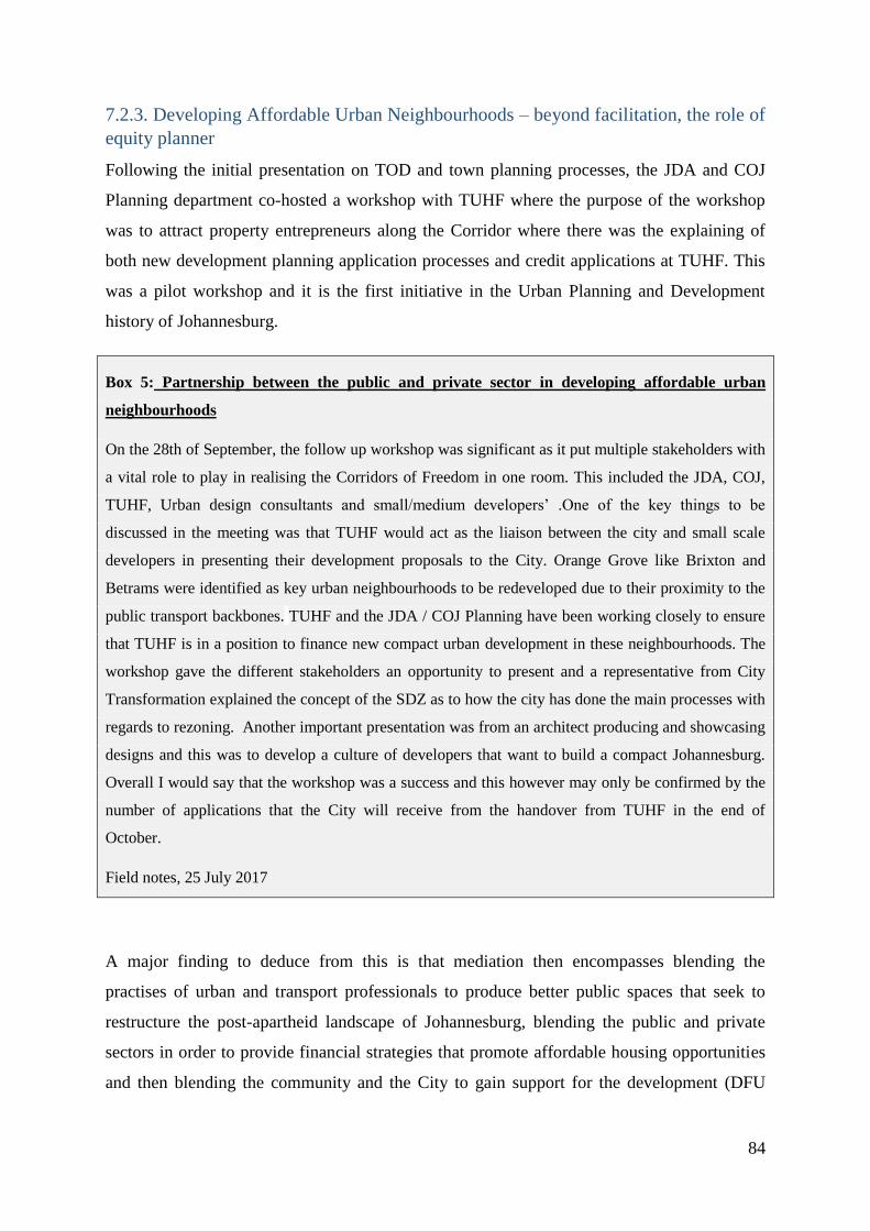
84
7.2.3. Developing Affordable Urban Neighbourhoods – beyond facilitation, the role of
equity planner
Following the initial presentation on TOD and town planning processes, the JDA and COJ
Planning department co-hosted a workshop with TUHF where the purpose of the workshop
was to attract property entrepreneurs along the Corridor where there was the explaining of
both new development planning application processes and credit applications at TUHF. This
was a pilot workshop and it is the first initiative in the Urban Planning and Development
history of Johannesburg.
Box 5: Partnership between the public and private sector in developing affordable urban
neighbourhoods
On the 28th of September, the follow up workshop was significant as it put multiple stakeholders with
a vital role to play in realising the Corridors of Freedom in one room. This included the JDA, COJ,
TUHF, Urban design consultants and small/medium developers’ .One of the key things to be
discussed in the meeting was that TUHF would act as the liaison between the city and small scale
developers in presenting their development proposals to the City. Orange Grove like Brixton and
Betrams were identified as key urban neighbourhoods to be redeveloped due to their proximity to the
public transport backbones. TUHF and the JDA / COJ Planning have been working closely to ensure
that TUHF is in a position to finance new compact urban development in these neighbourhoods. The
workshop gave the different stakeholders an opportunity to present and a representative from City
Transformation explained the concept of the SDZ as to how the city has done the main processes with
regards to rezoning. Another important presentation was from an architect producing and showcasing
designs and this was to develop a culture of developers that want to build a compact Johannesburg.
Overall I would say that the workshop was a success and this however may only be confirmed by the
number of applications that the City will receive from the handover from TUHF in the end of
October.
Field notes, 25 July 2017
A major finding to deduce from this is that mediation then encompasses blending the
practises of urban and transport professionals to produce better public spaces that seek to
restructure the post-apartheid landscape of Johannesburg, blending the public and private
sectors in order to provide financial strategies that promote affordable housing opportunities
and then blending the community and the City to gain support for the development (DFU

85
official , 2017). As has been stressed throughout the chapter ,at the core of the DFU official
in fulfilling these functions is the desire to push an equity agenda.
7.3 Conclusion
The objectives of the DFU in the development of the Louis Botha Corridor is to achieve inclusivity
of lower income people and a compact urban form that promotes densification. The DFU
plays three different key roles in Louis Botha which are mediating/ facilitating the
development of public spaces , the mobilising of resources by attracting private sector
development and also promoting inclusive development. The challenges faced at
implementation level from a traffic engineering perspective is that the rate of densification is
not occurring as quickly as it should be, however the JDA DFU in trying to develop
affordable urban neighbourhoods are engaging in pilot inititatives that seek to bring together
the public and private sector in providing low income housing options. This has meant that
densification along the corridor has occurred in stages in order to ensure that the low income
population benefit from the process. The role of the DFU official involved in the Louis Botha
Corridor is to not only blend the practises of urban and transport professionals but also to
work in blending the public and private sectors in order to achieve a compact urban form
while pushing an equity agenda that promotes affordable housing options. Referring to the
meeting I attended, the mediation tactic or strategy used by the DFU official to help the
professionals reach an agreement was focus on the commonalities by understanding the
differences between the two professions by being able to empathise with each professional’s
concerns. The DFU official would then act on the commonalities by reframing the
conversation to find an area of common concern where joint action would be possible. It is at
this point that the DFU official pushes the DFU’s agenda of pushing for inclusivity by
introducing the ‘voiceless’ community that are invincible in these negotiations that build
public space.
86
Conclusion
This closing chapter is focused on trying to pull together the findings discussed in the the
three findings chapters which were structured as short stories. The purpose of this chapter is
to align the findings and their and analysis to the aims and research questions which were
outlined in the first chapter of the report and also to undertake a theoretical reflection of the
main concepts covered in the literature review in relation to the findings chapters . There is a
great significance in researching state practises particularly understanding the actions and
practises of urban and transport professionals that undertake development in the City. This
involves unpacking how the different modes of thinking from the two professions merge
together in order to inform how public space is eventually built in the city. The officials and
professionals that are involved in the CoF work for the Transport Department, Department of
Development Planning, the Johannesburg Development Agency and the private consultancy
firms contracted by these public institutions.
The research question of the paper was: To what extent does the JDA Development
Facilitation Unit’s role in the Louis Botha Corridor mediate the contradicting rationalities of
urban planning and transportation planning in the City of Johannesburg?
In examining the research question it is important to answer the research subsidiary
questions, which aided in unpacking and tackling the main research question.
Developing Louis Botha Corridor: Mandates
The first subquestion of the research dealt with uncovering the respective mandates of the
Transport Department and the Department of Development Planning . The role of the City
Transformation directorate which forms part of the Department of Development Planning in
the Louis Botha Corridor was specifically focussed on a facilitating projects via the J.D.A for
attracting private development into the Orange Grove area to realise the City vision of
increasing densities within the area in line with the CoF vision. The Transport Department is
responsible for the planning and design of BRT stations and the operation of the BRT (Rea
Vaya) bus along the CoF including Louis Botha Avenue ( DFU official , 2017).
In answering the second subquestion, the JDA ‘s relationship to the Transport Department
and Department of Development Planning can be understood by unpacking the mandate of
the JDA which is , it is the development manager on behalf of the City. This means that the
87
JDA is the implementer of transport projects such as the Bus Rapid Transit System with
regards to related BRT precinct upgrades in the Paterson Park Project and Grant Avenue
Precinct. The JDA also works closely with the Department of Development Planning in -
coordinating spatial development which is done through the formulation of Precinct Plans for
the Grant Avenue and Paterson Park Projects which are occurring as part of the TOD
strategy. The significance of this is that the JDA is a linkage in the City that advances
infrastructural development from a transport perspective and an urban planning perspective.
The Right to the City confrontation
The third research subquestion was concerned with how the JDA DFU has been confronted
with contradictions in rationalities between the urban professionals and transport
professionals. The research has revealed that challenges mostly occur at the detailed design or
site level. The challenges occur as a result of the different perspectives from the
professionals in determining what constitutes ‘good’ public space as a result of the differing
professional norms and standards. The findings indicated that major confrontation that the
JDA DFU has faced is based on how to blend the right of the city approach into TOD, and
this has largely come from academics, strategists and politicians advocating for an equitable
and inclusive city that prioritises the needs of the low income population . Simply put the the
right to the city approach raises questions as to whose benefit is the new urban form in
creating public spaces along Louis Botha Corridor.
The Strategic Role of the JDA DFU
The fourth research subquestion dealt with how the DFU tackles and views the contradiction
in rationalities . The JDA DFU‘s main objectives are achieving inclusivity of low income
groups and a compact urban form and the JDA DFU operates three different roles in project
managing the Louis Botha Corridor. The DFU can be seen as playing three different roles
along Louis Botha Corridor which are the roles of the mediator/ facilitator in bringing
together the two professions to work together in producing public space. The second role of
mobilising resources involves the work of the DFU in bridging the the gap between the
public and private sector in order to promote innovative options that cater for low income
residnets living along Louis Botha. The third role of equity planning relates more closely to
the DFU’s objective in striving for inclusivity in the projects occurring along Louis Botha
Corridor.

88
The concept of ‘Equity Planners’ by Krumholz and Klavel (1994) helps to further explain the
work of the DFU in the Corridors of Freedom.. The research introduced the DFU official
working in the projects along the Louis Botha Corridor. The role of the DFU official involved
in the Louis Botha Corridor was to not only blend the practises of urban and transport
professionals, but also to influence both to achieve a compact urban form that promotes
affordable housing options. In this sense, the JDA is not only a mediator facilitating
interaction, compromise and consensus between transport engineers, urban planners and local
communities. It also gets involved in the formulation of policy through influencing the the
development phase of the Louis Botha Corridor in a more pro-poor direction that what was
initially envisaged or planned. This might be due however less to a designed and planned role
of the JDA, and more to the specific personality of the JDA DFU officials involved in the
process. The officials in the DFU are passionate and hardworking and these personality traits
are particularly important for this role as it requires a lot of hard work, patience and
dedication to contribute to achieving their mandate.
Tools of Mediation
Mediation in the context of this study encompassed compromises and consensus building.
Compromises refer to the settlement of differences, an agreement reached by fine-tuning
conflicting viewpoints or positions through a mutual negotiation of needs and requests (van
den Hove, 2006). Consensus building is engaging in shared learning and decision-making
that leads to common ground for action by uniting diverse positions into a common direction
for public action (van den Hove, 2006). The research has a focus on the compromise oriented
negotiation processes and consensus oriented co-operation processes that occur between the
urban and transport professionals in the decision making process.
The main policy instrument or tool of mediation that is utilised by the JDA are pilot
initiatives such as the urban area management plan that was developed for the Norwood area
that enabled the community, urban designers and transport engineers to develop a shared
vision of the area. The development of the Grant Avenue Precinct Plan vision was a
continuous process that involved the engagement of the community through design
workshops, public meetings and activation days that improved the consensus-building
process.

89
aa in a professional compromise between the urban planning professionals and transport
professionals . Compromise-oriented processes occurred whereby urban designers and
transport professionals had to find middle ground over the redesigning of streets based on
their function of accessibility and mobility through a range of meetings and workshops that
were held. This case represented a process whereby negotiations and compromises for the
different agendas that existed between the urban professionals and transport professionals
were reached through platforms of discussions that occurred through workshops and
meetings.
In answering the main research question, policy implementation can beviewed as an ongoing
process of bargaining and compromising among different interests. The research revealed that
the production of public space results from the negotiation of interests from urban
professionals and transport professionals that result in the reaching of a compromise or the
building of a ‘shared vision’ which results in a consensus . I therefore argue based on the
findings that the JDA is pushing for more innovative consensus oriented processes that result
in the co- production of plans that result in joint visioning in the Louis Botha Corridor as
opposed to the compromise oriented processes that have been prevailing in the City of
Johannesburg.
This research has revealed that the production of public space is a result of the negotiating of
the urban designer and traffic engineer and that the rationality or way of thinking of each
professional informs the tools they utilise to transform public space. However the research
has uncovered a third rationality that exists which is the work of the DFU in pushing for the
practises of the urban and transport professionals in both public and private sector to directly
benefit the low income population in the context of challenges such as gentrification. This
kind of research that seeks to contribute to the improvement of practises of professionals is
important as currently in South Africa, urban professionals and transport professionals are at
the forefront of contributing to the socio-spatial restructuring of the post-apartheid city.
When concluding the interviews done with all the professionals in this research, the final
question was directed at enquiring what improvements could be done in improving
collaborative practises by the City. The common thread that can be pulled among the urban
and transport professionals is that there is need for more dialogue between the two
professions and that the key is to keep talking and engaging. The recommendations were that
the constant upgrading of standards and parameters of the two professions should happen

90
simultaneously, so as to allow better co- ordination and also that there is a need for forward
thinking, more collaboration, full day workshops, and engagement with the city to produce
local specific plans that best suit each individual area.

91
References
Akbar, D. and Rasul, M. (2012). Review of the nexus between urban and regional planning
and engineering education. School of Engineering and Built Environment, Learning and
Teaching Education Research Centre, Queensland, Australia.
Barnett, J. (1982). An introduction to urban design. New York City: Harper & Row, 1982.
Belzer, D. and Autler, G. (2002) Transit-Oriented Development: Moving From Rhetoric to
Reality. Washington, D.C.: Brookings Institution Center on Urban and Metropolitan Policy.
Bickford, G. and Behrens, R. (2015) What does Transit Oriented Development Mean in a
South African Context? A multiple stakeholder perspective from Johannesburg. Proceedings
of the 34th South African Transport Conference, Pretoria
Dittmar and Poticha (2004) Defining Transit-Oriented Development: The New Regional
Building Block. In Dittmar, H. and Ohland, G. (Eds) (2004) The New Transit Town: best
practices in Transit-Oriented Development. Island Press: Washington
Dittmar and Ohland (2004) The new transit town: best practices in Transit-Oriented
Development. Island Press: Washington
Flyvbjerg, B. (2014). What You Should Know About Megaprojects and Why: An Overview.
Project Management Journal, 45(2), pp.6-19.
Grinnell, R. (1981). Social work research and evaluation. Oxford: Oxford University Press.
Harrison, P., Todes, A. and Watson, V., 2007. Planning and transformation: Learning from
the post-apartheid experience. Routledge
92
Hamilton-Baillie, B. (2010). Shared Space and Street Design. Future of Urban Space and
Humanity. [Online] Available at: http://www.cpij.or.jp/eng/file/hamilton-baillie.pdf
[Accessed 18 Oct. 2017].
Hebbert, M. (2005). The Street as Locus of Collective Memory. Environment and Planning
D: Society and Space, [online] 23(4), pp.581-596..
Jacobson, J. and Forsyth, A. (2008). Seven American TODs: Good Practices for Urban
Design in Transit-Oriented Development Projects. Journal of Transport and Land Use, 1(2).
Jones, P., Marshall, S. and Boujenko, N. (2007). Link and Place: A Guide to Street Planning
and Design. Aylesbury, Local Transport Today Limited, 2007.
Jones, P., Marshall, S. and Boujenko, N. (2008). Creating More People-Friendly Urban
Streets through ‘Link and Place’ Street Planning and Design IATSS Research, [online] 32(1),
pp.14-25.Available at: http://www.sciencedirect.com/science/article/pii/S0386111214601965
[Accessed 18 Oct. 2017].
Kumar R. (2001). Research methodology. Thousand Oaks, CA: Sage.
Lascoumes, P. and Le Galès, P. (2007) ‘From the Nature of Instruments to the Sociology of
Public Policy Instrumentation’, Governance, Understanding Public Policy through Its
Instruments 20(1): 1–21.
Lipsky, M. 1969. Toward a theory of street-level bureaucracy. Paper prepared for: Annual
Meeting of the American Political Science Association. September 2-6 1969, New York.
Logan, S. (2012). ‘Urban Planning and Transport planning: The Need for an Integrated
Model – THE Case Study of The EThekwini CBD, Umgeni Road Corridor ’. Masters.
University of KwaZulu-Natal.
Marshall, S. (2015). Refocusing urban design as an integrative art of place. Proceedings of
the Institution of Civil Engineers - Urban Design and Planning, [online] 168(1), pp.8-18.].

93
Olivier de Sardan, J.-P. (2008) Researching the Practical Norms of Real Governance in
Africa, Discussion Paper 5, London: Africa Power and Politics Programme.
Schoeman, C.B. 2005. The alignment between integrated transport plans and the preparation
of integrated development plans in South Africa
Schoeman, C.B. 2010. Urban and regional planning and the interface with environmental
management and transportation planning. Inaugural address. No. 238, Scientific
Contributions. North-West University, Potchefstroom Campus.
Schively Slotterback, C. and Zerger, C. (2017). Complete Streets from Policy to Project The
Planning and Implementation of Complete Streets at Multiple Scales. [Online] Minnesota:
Minnesota Department of Transportation Research Services& Library. Available at:
http://www.dot.state.mn.us/research/TS/2013/201330.pdf [Accessed 18 Oct. 2017].
Policy and Official Documents
City of Johannesburg (n.d) Corridors of Freedom. Retrieved, September 5, 2017,
from:http://www.joburg.org.za/images/pdfs/corridors%20of%20freedom_s.pdf
City of Johannesburg (2013b) Corridors of Freedom [online]. Available from:
http://www.joburg.org.za/images/pdfs/corridors%20of%20freedom_s.pdf [Accessed 19
September 2017]
Department of Development Planning (2013b) Spatial Development Framework 2040
[online] for the City of Johannesburg Available from
http://joburg.org.za/index.php?option=com_content&view=article&id=5941:spatial-
development-framework-2010-2011&catid=61&Itemid=114 [Accessed 9 August 2014]
Department of Development Planning (2015). Louis Botha Strategic Area Framework for the
City of Johannesburg . Available from http://www.corridorsoffreedom.co.za/index.php/saf

94
Department of Development Planning (2016) Grant Avenue Precinct Plan prepared by ASM
Architects and WSP for the City of Johannesburg
Department of Development Planning (2017) Transportation Impact Assessment prepared
by G.I.B.B for the City of Johannesburg
Department of Development Planning (2017a ) Orange Grove Special Development Zone
brochure for the City of Johannesburg . Available from:
http://www.corridorsoffreedom.co.za/attachments/article/21/SDZ%20Introductory%20Presen
tation_FINAL.compressed.pdf
Jackson, M. (2016) Interviewed by Wetu Memela and Nduduzo Nyanda for Masters class
course (Community Participation in Urban Governance), School of Architecture and
Planning, Wits University
Johannesburg Development Agency. (2016) About the JDA. [ONLINE] Available at
http://www.jda.org.za/index.php/more-news/75-who-we-are/who-we-are [Accessed 17 July
2017]
South African Cities Network (2014b) How to Build Transit Oriented Cities: Exploring
Possibilities. Johannesburg: SACN.
Transport Department (2013a ) Strategic Integrated Transport Plan Framework for the City
of Joburg [online]. Available from:
http://www.joburg.org.za/images/stories/2013/May/CoJ%20SITPF%20Draft%2013%20May
%202013.pdf [Accessed August 2017]
Transport Department (2013b)., Complete Street Design Guideline Manual. Johannesburg:
City of Johannesburg Available from
https://joburg.org.za/images/stories/2014/July/Complete%20Streets%20Design%20Guideline
%20Manual.pdf

95
TUHF (2016a) About us. [ONLINE] Available from: http://www.tuhf.co.za/about-us/
[Accessed 28 September 2017]
TUHF (2016b) TUHF and Johannesburg Development (JDA) Memorandum of
Understanding. Fourth draft for Discussion.

96
Annexures
Participant Information Sheet
Greetings
My name is David Chiwetu and I am an Honours student in Urban and Regional
Planning at the University of Witwatersrand. I am investigating the various city
plans and projects and the outcomes from transport planning and urban design in
the way in which public space as part of the TOD strategy is unfolding and
challenges faced by officials.This research is taking place in a broader relationship
between the Centre of Urban and Built Environment Studies/Practices of the State
in Urban Governance Programme coordinated by my supervisor Claire Benit-
Gbaffou and the Johannesburg Development Agency where there is trust and joint
framing of the research issues. This research is therefore part of the broader
programme studying practices of the state.
Part of the research involves interviewing people who are involved with the
development of the Louis Botha Corridor and it is for this reason, I would like to
invite you to take part. If you agree, you will be asked to sign a consent form and
participate in a face to face interview which will take no more than 30 mins to
complete With your permission, I would also like to record the interview using a
digital device and please indicate any sensitive material that you wish not to be
recorded.We will arrange a time to meet, which is convenient for you and at your
premises if that is appropriate. During the interview, I will ask you questions based
on your current engagement with the current development of the BRT along the
Louis Botha Corridor.
Your participation in this interview is voluntary, you may refuse to answer any
questions that make you uncomfortable, and you may withdraw at any time without

97
incurring any costs. There are no payments or other forms of reimbursement that
will be provided in recognition of your participation.
There are no known risks or disadvantages of taking part. Although the interviews
may be recorded, your answers will be stored safely and entered onto a password-
protected computer, which will only be accessed by the researcher and analyzed.
Once this has been done, the recordings themselves will be deleted. This study will
be written up as a research report .Should you request, I commit to send you the
entire report to allow you to ensure that you have not been misrepresented. The
research report will be made available to other academics, lecturer as well as
students of Wits.
If you have any questions, concerns, or comments or if you would like a copy of the
final report, please feel free to contact me at [email protected] or
Associate Professor Claire Benit-Gbaffou at [email protected] or
0117177718.
Let me express my appreciation for your willingness and interest to participate in
this study.
Name of researcher David Chiwetu………

98
Consent Form
I hereby confirm that I have been informed by the student researcher of the purpose and the
procedures of the research, and my rights as a participant. I have received, read and
understand the written Participant Information Sheet. I have also been informed that:
□ My responses will be used for education and research purposes and my privacy respected.
My identity will be anonymized and the information I provide will not be accessed by
anyone apart from the student researcher.
□ I understand that my participation is voluntary and that I am free to withdraw at
any time without giving any reason and without there being any negative
consequences. In addition, should I not wish to answer any particular question or
questions, I am free to decline.
□ I understand that the audio recording made of this interview will be used only for
analysis. I will also be given the opportunity to review the findings for
verification.
□ The data gathered in the interview will be destroyed after the completion of the
study
I therefore agree to participate in this study by being interviewed by the researcher.
I give/do not give the student researcher permission to audio record this interview
PARTICIPANT:
_______________________________ ___________________
Signature Date

99
Interview Guidelines
1) Can you please explain the core responsibilities and duties of your job?
2) What is your department’s role in contributing towards the realization of the
Corridors of Freedom?
3) Tell me about your engagement with other stakeholders in the project
4) What have you been focusing on as a city official in this project? Tell me about
the main focus and their challenges.
5) What are the challenges you faced in facilitating the road hierarchy and access
management plan?
6) From your perspective, what improvements could be made to better realize the
T.O.D vision
7) May you please explain the desired function of the fence along Louis Botha?