Urban Design Typology Analysis -...
22
Urban Design Typology Analysis A background report prepared for Richmond 300: A Guide for Growth September 10 th , 2018
Transcript of Urban Design Typology Analysis -...

Urban Design Typology Analysis
A background report prepared for Richmond 300: A Guide for Growth
September 10t h, 2018

Prepared by
Jim Smithers (Adjunct Professor)
Michal Voscek (Graduate Research Assistant)

Richmond’s Urban Design History 1
Figure 1. Map of Richmond 1737. Source: Library of Virginia
Urban Design DefinedUrban Design is the process of creating the public realm through the artful arrangement of buildings and site elements as cities grow and change. The public realm includes publicly-owned streets and rights of way, pathways, parks, plazas, publicly-accessible open spaces, and public and civic buildings. Successful urban designs create meaningful spaces that foster positive social interaction, cultural advancement, and civic identity. Furthermore, good urban design can: enhance a city’s image; increase property values and tourism; decrease crime; enhance safety; and foster social equity and environmental, cultural, and economic sustainability.
Richmond’s Urban DesignIn 1607 Christopher Newport sailed up the James River from Jamestown in search of a link to the West and was interrupted by the falls adjacent to what is now downtown Richmond. The first map of the city was laid out in 1737 by Major William Mayo for William Byrd II (see Figure 1). The southwest corner of the map is S. 17th St and E. Cary St. The streets and blocks ran parallel to the James River. This geometry remains today in the neighbor-hood called Shockoe Bottom. This grid pattern has highly influenced the design of the city for 280 years, only being modified to accommodate the turns of the river and topography (see Figure 4).

2 Richmond’s Urban Design History
Figure 2. Virginia State Capitol. Source: Ward, Harry, Richmond: An Illustrated History
Figure 3. Richmond circa 1830 Source: Library of Virginia
In 1785, the State Capitol was built (see Figure 2). It was designed by Thomas Jefferson and inspired by the Maison Carrée, an ancient Roman temple in Nîmes, France. The State Capitol was the first neoclassical building in the newly formed United States and set the architectural attern that is still evident. The Capitol building soon became the city’s central landmark and focal point until tall buildings in the financial district obscured it in the 20th century.
By the 1830s, Richmond was a thriving city (see Figure 2). As shown in Figure 3, the Capitol was surrounded by residential structures and evenly dispersed churches. The James River and Kanahwa Canal were commercial and industrial conduits that linked western Virginia to the Atlantic Ocean

3Richmond’s Urban Design History
Figure 4: Richmond Plan 1873 Source: Library of Virginia
and snaked through the industrial heart of the city. By 1865, Richmond was ranked 13th in the nation in terms of industrial output.
The world’s first successful electrified trolley system opened in Richmond in 1888. Many of the trolley lines extended several miles from downtown, allowing for the opportunity for new development to occur in suburban areas (see Figure 5). By the 1920s, this comprehensive system allowed for easy access to various parts of the city. Many new neighborhoods were built by the trolley companies themselves, including Barton Heights, Highland Park, and Woodland Park. Others like Ginter Park, The Fan, Oakwood, Forest Hill and Westhampton enticed the trolley lines to be extended further out. Today, the most compact neighborhoods in the city follow the path of the trolley system. The streetcar system was closed in 1949 but its legacy remains.
During the 20th century, the city annexed much territory beyond the reach of the trolley system, expanding the land area more than three times. Public transit gave way to private automobiles with suburbanization, making public interaction in space more difficult. In historic areas of the city, large numbers of buildings were destroyed to make way for highways and parking lots.

4 Richmond’s Urban Design History
Figure 5. Richmond Trolley Map 1930. Source: Virginia Library
Since 2010 the city’s population has increased after decades of decline. Since 2000, hundreds of old structures have been rehabilitated and re-occupied. In addition, many new buildings have been developed on vacant sites, filling in the gaps in the historic fabric of the city (see Figures 6a and 6b). This infill development has created more defined spaces for people to interact, enhancing the image of neighborhoods and increasing property values. Most of the new buildings have been built in the central areas of the city, including the campus of Virginia Commonwealth University, Shockoe Bottom, and Manchester. Many vacant sites still need to be filled, particularly along suburban corridors and Monroe Ward, but the city is firmly headed in the right direction to enhance its urban design.

Figure Ground (North), City of Richmond, 2018
__________________ 5
0 1 20.5 Miles´
James River
Figure 6a
Map shows structures in the city of Richmond in black.Space is represented by white. Notice the predominategraining of the structures in the east/west axis of the city,reinforcing the historic evolution of the city. Secondarylines run north/south, radiating out from the center.The strongest regular and compact patterns can befound in the Downtown, Fan, Museum District, and ChurchHill neighborhoods. These areas also have some of thehighest, per square foot, land values in the city.The public realm is weakest in areas where structuresare dispersed and lack coherent patterns.These are primarily found at the city's periphery.
LegendSpace (ground)Structure (figure)

0 1 20.5 Miles ´
Figure Ground (South), City of Richmond, 2018
__________________ 6
James River
Figure 6b
Map shows structures of the City of Richmondin black. Note that structures become moredispersed as they move out from the center.One notable exception is the large industrialstructures alongside Jefferson Davis Highway,and the James River, south from Downtown.
LegendSpace (ground)Structure (figure)

Urban Design Typology Map (North), City of Richmond, 2018
__________________ 7
0 1 20.5 Miles´§̈¦I-95
§̈¦I-95
§̈¦I-195
Broad St
Boule
vard
Downtown Expy
Main St
Chamberlayne Ave
25th S
t
Nine Mile Rd
§̈¦I-64
§̈¦I-64
Cary St
Libbie A
ve
Forest Hill Ave
Powhite Pkwy
Lee Br
idge
James River
Figure 7a
Urban Design TypologyCategory
Apartment CourtDowntownEstate NeighborhoodHistoric Urban NeighborhoodIndustrial LandOpen SpacePost-Industrial ZonePost-War SuburbSchool CampusStreetcar NeighborhoodSuburban Shopping and Business Park
Monument Ave
Hull St

0 1 20.5 Miles ´
Urban Design Typology Map (South), City of Richmond, 2018
__________________ 8Figure 7b
§̈¦I-95
James River
Forest Hill Ave
Powhite Pkwy
Hugueno
t Rd
Midlothian Tnpk
Hull Street Rd
Warwick Rd
Jefferson Davis Hwy
Semmes Ave
Commerce RdUrban Design TypologyCategory
Apartment CourtDowntownEstate NeighborhoodHistoric Urban NeighborhoodIndustrial LandOpen SpacePost-Industrial ZonePost-War SuburbSchool CampusStreetcar NeighborhoodSuburban Shopping and Business Park
Hull St

Urban Typologies 9
Figure 8: Downtown Mall in Charlottesville, Virginiasource: downtowncharlottesville.net
Glossary & Definitions:
This section is an analysis of urban design typologies based on various relationships between buildings and public spaces in the City of Richmond. The following pages illustrate this work.
Inherent in the analysis is an evaluation of places. Good urban design can be defined as the artful arrangement of buildings and public spaces to set the stage for positive public engagement and interaction (see Figure 8). At the neighborhood level, good urban design fosters spatial forms that create interconnected open networks. Well-designed cities foster social exchange of information, goods and services and access to all functions of the city (Jan Gehl, Life between Buildings: Using Public Space. 2006). Well-designed neighborhoods and corridors become attractive in the marketplace and therefore can support a host of values in cities, including increased quality of life, tax revenue, enhanced image, and economic sustainability.
• Public realm
• Setback
• Enclosure
• Landscape
• Right-of-way
-
-
-
-
-
Public realm includes all exterior places, linkages and built form elements that are physically and/or visually accessible regardless of ownership. It is defined as any publicly owned streets, right of ways, parks, publicly accessible open spaces, and any public and civic buildings and facilities. The public realm is vital if we are to be successful in creating environments that people want to live and work in.[1][2]
The distance from the property line in which building is prohibited.
The ratio of height to width. Good sense of enclosure means that the height of the buildings (or mature trees) is in proportion to the width of the intervening public space. The actual ratio depends on the type of street or open space being designed for. [3]
All the visible features of an area of countryside, land or street, often considered in terms of their aesthetic appeal.
The legal right to pass along a specific route through grounds or property belonging to another.
[1] arc-online.co.uk/public-realm/what-is-public-realm[2] upc.gov.ae/prdm/public-realm-definition.asp[3] chrishaile.com/2012/01/a-myth-of-urban-design-the-sense-of-enclosure-theory/
URBAN TYPOLOGIES

10 Urban Typologies
Figure 10: Birds-eye view of Downtown Figure 11: Map of Downtown
Figure 9: Ground level perspective of Downtown
This section of the city is the center of the Richmond Metropolitan Region. Downtown is dominated by tall office buildings and some retail spaces on the ground floor. Some buildings have been recently converted to apartments. However, the area mostly consists of financial offices, state offices, VCU Health, and Virginia Biotechnology Research Park. This area is the most compact in the city with many well-defined public spaces like Capitol Square, the James Center plaza, and Kanawha Plaza.
• Tall buildings 3-20 stories and above• Wide variations in heights• Zero setback• Mix of old and new structures• Strong sense of enclosure on the
street
DOWNTOWN
Primary Defining Characteristics:
Urban Typologies 11
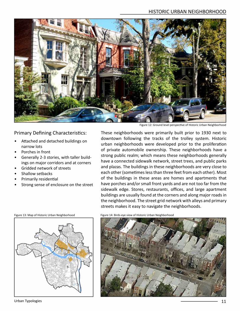
HISTORIC URBAN NEIGHBORHOOD
Figure 13: Map of Historic Urban Neighborhood Figure 14: Birds-eye view of Historic Urban Neighborhood
• Attached and detached buildings on narrow lots
• Porches in front• Generally 2-3 stories, with taller build-
ings on major corridors and at corners • Gridded network of streets• Shallow setbacks • Primarily residential• Strong sense of enclosure on the street
Figure 12: Ground level perspective of Historic Urban Neighborhood
These neighborhoods were primarily built prior to 1930 next to downtown following the tracks of the trolley system. Historic urban neighborhoods were developed prior to the proliferation of private automobile ownership. These neighborhoods have a strong public realm; which means these neighborhoods generally have a connected sidewalk network, street trees, and public parks and plazas. The buildings in these neighborhoods are very close to each other (sometimes less than three feet from each other). Most of the buildings in these areas are homes and apartments that have porches and/or small front yards and are not too far from the sidewalk edge. Stores, restaurants, offices, and large apartment buildings are usually found at the corners and along major roads in the neighborhood. The street grid network with alleys and primary streets makes it easy to navigate the neighborhoods.
Primary Defining Characteristics:

12 Urban Typologies
POST-INDUSTRIAL ZONE
Figure 17: Map of Post-industrial ZoneFigure 16: Birds-eye view of Post-industrial Zone
Figure 15: Ground level perspective of Post-industrial Zone
These sections of the city were once industrial areas but the factories and other industries that once used the buildings have either relocated, left the region or country, or closed. Many of the historic buildings remain and have been converted into apartments and offices. New buildings have been built on the vacant land. Post-industrial neighborhoods typically feature narrower streets than industrial lands and some sidewalks, although there are usually some sidewalks missing. Theres areas do not usually have a lot of plants, street trees, or public parks and plazas. Post-industrial areas feature a mix of uses including apartments, offices, restaurants, stores, and sometimes a few industrial businesses.
• Mix of new and historic industrial structures
• Many vacant lots• Varying building heights, generally 1 -
10 stories• Zero to shallow setbacks• Strong sense of enclosure on street
when buildings are present
Primary Defining Characteristics:

Urban Typologies 13
STREETCAR NEIGHBORHOOD
• Detached buildings • Ample setbacks • Sidewalks• Interconnected street network• Generally 1-2 stories • Primarily residential • Sense of enclosure on the street with
the presence of street trees
These neighborhoods were primarily built between 1880 and 1930. Streetcar neighborhoods are located next to the historic urban neighborhoods and originally had access to the historic trolley system. Their interconnected streets, sidewalks, public parks, street trees, and small lots create a strong public realm. Most of the buildings in streetcar neighborhoods are single-family homes with small yards on streets with sidewalks and street trees. Offices, stores, restaurants, and apartments are located on main roads.
Figure 18: Ground level perspective of Streetcar Neighborhood
Figure 19: Map of Streetcar Neighborhood Figure 20: Birds-eye view of Streetcar Neighborhood
Primary Defining Characteristics:
14 Urban Typologies
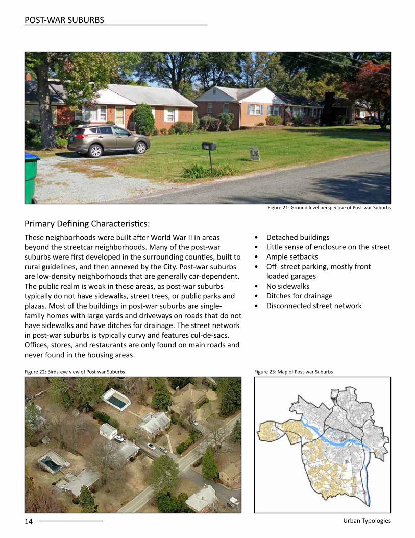
Figure 23: Map of Post-war Suburbs Figure 22: Birds-eye view of Post-war Suburbs
Figure 21: Ground level perspective of Post-war Suburbs
• Detached buildings • Little sense of enclosure on the street • Ample setbacks • Off- street parking, mostly front
loaded garages• No sidewalks• Ditches for drainage • Disconnected street network
These neighborhoods were built after World War II in areas beyond the streetcar neighborhoods. Many of the post-war suburbs were first developed in the surrounding counties, built to rural guidelines, and then annexed by the City. Post-war suburbs are low-density neighborhoods that are generally car-dependent. The public realm is weak in these areas, as post-war suburbs typically do not have sidewalks, street trees, or public parks and plazas. Most of the buildings in post-war suburbs are single-family homes with large yards and driveways on roads that do not have sidewalks and have ditches for drainage. The street network in post-war suburbs is typically curvy and features cul-de-sacs. Offices, stores, and restaurants are only found on main roads and never found in the housing areas.
POST-WAR SUBURBS
Primary Defining Characteristics:

Urban Typologies 15
Figure 26: Birds-eye view of Estate NeighborhoodFigure 25: Map of Estate Neighborhood
Figure 24: Ground level perspective of Estate Neighborhood
These areas were built prior to 1950. Estate neighborhoods are located next to the historic urban neighborhoods. Most of the buildings are very large houses with large yards and garages that are accessed via a rear alley. The homes are on tree-lined streets with sidewalks. Generally, the atmosphere in estate neighborhoods is similar to the streetcar neighborhood except the houses and yards are larger and estate neighborhoods do not have any restaurants, stores, and offices.
• Mix of interconnected streets• Detached buildings • Ample setbacks • Sidewalks• Generally 2-3 stories • Primarily residential • Sense of enclosure on the street with
the presence of street trees
ESTATE NEIGHBORHOOD
Primary Defining Characteristics:

16 Urban Typologies
APARTMENT COURT
Figure 28: Birds-eye view of Apartment Court Figure 29: Map of Apartment Court
Figure 27: Ground level perspective of Apartment Court
• Irregular layout• Generally 1 - 3 stories• Wide setbacks from the public right-
of-way• Private gardens and courtyards
Apartment courts are primary located in the post-suburban areas of the city built mostly after World War II. The apartment courts feature apartment buildings that are mostly stand-alone projects that create their own private campuses. Apartment courts have their own private courtyards and/or private gardens that are not accessible to the public and therefore do not contribute to the public realm. Oftentimes apartment courts are on super blocks that do not have through streets.
Primary Defining Characteristics:

Urban Typologies 17
Figure 32: Birds-eye view of Suburban Shopping and Business ParkFigure 31: Map of Suburban Shopping and Business Park
Figure 30: Ground level perspective of Suburban Shopping and Business Park
Suburban shopping centers feature low-slung stores and restaurants that have large parking lots and large signs in front of them. Office parks feature similarly low-slung buildings with large parking lots. Usually these areas have buildings that are far from streets and do not have sidewalks, street trees, and/or public parks and plazas. The public realm is nearly non-existent in suburban shopping centers and office parks because there are very few areas that are fully accessible to the public. These areas are generally completely car-dependent. Generally, there are no houses or apartments in these areas and the only uses are offices, stores, and restaurants.
• Detached buildings • Very wide setbacks • Large parking lots • Generally 1-2 stories • Primarily commercial • No sense of enclosure on the street
SUBURBAN SHOPPING AND BUSINESS PARKS
Primary Defining Characteristics:

18 Urban Typologies
Figure 35: Map of School Campus Figure 34: Birds-eye view of School Campus
Figure 33: Ground level perspective of School Campus
Schools throughout the city have created campus-like settings where their buildings are arranged around a series of parks and plazas that connect the buildings to create a unified place. Usually a portion of the campus does not allow car traffic and is only open to pedestrians and sometimes also cyclists. The buildings on school campuses may include housing, offices, stores, libraries, restaurants, theaters, and museums. Campuses feature sidewalks along roads and series of pedestrian paths that connect buildings. Oftentimes the school activity spills out of the campus and into the public realm, enlivening the neighborhoods next to the campus.
• Generally 1 - 6 stories• Mix of setbacks from zero to over 100
feet• City street network embraces
geometry of schools• Street trees define streets
SCHOOL CAMPUS
Primary Defining Characteristics:

Urban Typologies 19
INDUSTRIAL LAND
Figure 38: Birds-eye view of Industrial LandFigure 37: Map of Industrial Land
Figure 36: Ground level perspective of Industrial Land
Industrial lands are found in areas with access to the various rail lines and highways in the city. Industrial is a term used to describe land uses that include factories, warehouses, and businesses that require a lot of space to make products, use large machines that may create a lot of noise, and/or attract a lot of truck traffic. Industrial lands are dominated by large lots, pavement, and large low-slung buildings with few windows or doors. Industrial areas often feature wide roads for truck traffic, limited sidewalks and street trees, and typically do not have public parks or plazas.
• Wide setbacks • Little sense of enclosure on the street• Large surface parking areas• Very large buildings • Generally 1-3 stories • Detached • Sidewalks
Primary Defining Characteristics:

20 Urban Typologies
OPEN SPACE
Figure 41: Map of Open Space Figure 40: Birds-eye view of Open Space
Figure 39: Ground level perspective of Open Space
• Open spaces filled with plantings including trees, shrubs, and ground cover
• Many feature fountains, ponds and lakes
The city features a variety of open spaces, including small quarter- acre playgrounds in the Fan, large passive parks such as Byrd Park and Bryant Park and the wild James River Park system. Another strong element are the green spaces behind the houses. All are public gathering points for the city and region.
Primary Defining Characteristics: