Urban Design Guidelines for Greenfield Neighbourhoods
44
Urban Design Guidelines for Greenfield Neighbourhoods ottawa.ca
Transcript of Urban Design Guidelines for Greenfield Neighbourhoods

Urban Design Guidelines forGreenfield Neighbourhoods
ottawa.ca

City of Ottawa Planning, Transit and the Environment Department
Urban Design Guidelines for Greenfield Neighbourhoods
Ce document est disponible en français sur ottawa.ca This document is available in French on ottawa.ca Approved by City Council September 26, 2007 City of Ottawa Publication #21 – 11 Planning and Growth Management Department

City of Ottawa Planning, Transit and the Environment Department 1
Urban Design Guidelines for Greenfield Neighbourhoods
Definition A “greenfield neighbourhood” in the context of these design guidelines refers to a large area of land within the Urban Area that has not been developed previously, or that has the potential to be extensively redeveloped. Generally planned from the outset as a separate entity to create many lots fronting onto one or more public roads, it could be a single subdivision with fewer than 50 residential dwellings within an existing urban neighbourhood, or it could be several neighbourhoods with over 1,000 dwellings that form part of a larger area of new development. Purpose and Application These design guidelines illustrate the City’s expectations during the development review process for greenfield neighbourhoods within the Urban Area of the City of Ottawa. They are focused on providing guidance for neighbourhood design during the subdivision review and zoning processes. While they do not address the details of individual properties, such as commercial plazas or parks, they do provide guidance regarding the relationship between adjacent sites and between a site and the public street. These guidelines will work with existing planning and urban design guidelines to:
1. Provide direction to the development review process for areas without an approved secondary plan or community design plan;
2. Complement any design considerations in approved community design plans or secondary plans;
3. Assist the preparation of future community design plans or secondary plans, and the update of such documents as the Official Plan and zoning by-laws.
These guidelines are also informative for “Brownfield” projects that may have a neighbourhood component.
These guidelines are general in nature and provide guidance on issues that could influence all neighbourhoods in the Urban Area. They do not cover specific issues that might apply to particular sites. Official Plan Direction The Official Plan includes as one of its Guiding Principles, the creation of “A City of Distinct, Liveable Communities”. Such communities are comprised of neighbourhoods that are compact, inclusive, well designed, connected, environmentally sensitive, transit-supportive, and sustainable. Section 2.5.1 of the Official Plan contains policies relating to compatibility and community design. It includes Design Objectives and Principles aimed at influencing the built environment of the city as it matures and evolves. Annex 3, the Design Framework, expands on the Design Objectives and Principles. The Official Plan identifies various tools to implement these Design Objectives and Principles. One tool is the preparation of urban design guidelines, such as these guidelines for Greenfield Neighbourhoods. The intent of these guidelines is not to duplicate the Official Plan policies and Annex 3 the Design Framwork, but complement them and provide specific advice on a range of issues and topics. The Official Plan should be consulted for complete references.

2 City of Ottawa Planning, Transit and the Environment Department
Urban Design Guidelines for Greenfield Neighbourhoods
Objectives The objectives of the Urban Design Guidelines for Greenfield Neighbourhoods are:
• To protect and integrate the site’s inherent environmental, topographic, and cultural features;
• To create a comfortable pedestrian and cycling environment and attractive streetscapes;
• To ensure compatibility and links between different land uses in the neighbourhood, and with adjacent neighbourhoods;
• To encourage transit-oriented development; • To establish a system of parks and greenspaces that are
plentiful, accessible and connected to each other.
Context and Challenges Essentially there are two types of greenfield neighbourhoods within the City of Ottawa, each with their own unique challenges. These are:
(1) Greenfield neighbourhoods located in designated Urban Areas beyond the Greenbelt. These large, usually undeveloped, areas of land offer significant opportunity for innovative practices to achieve the Official Plan’s direction for liveable communities, but they face issues of scale, phasing, compatibility as well as sensitivity to environmental carrying capacity, and natural and cultural features.
(2) Greenfield neighbourhoods located among existing neighbourhoods, within the Greenbelt. These sites are generally smaller in size than those beyond the Greenbelt but offer the same opportunity for meeting the Official Plan’s objectives. However, given they are typically located in the midst of existing neighbourhoods, issues of connections, transition and compatibility are often at the forefront.
Other Available Guidelines The guidelines listed below have been approved at the time of writing of this document. They are intended to work together with the Urban Design Guidelines for Greenfield Neighbourhoods:
• Urban Design Guidelines for Development along Traditional Mainstreets (2006);
• Urban Design Guidelines for Development along Arterial Mainstreets (2006);
• Urban Design Guidelines for Large-Format Retail (2006) • Urban Design Guidelines for Drive-Through Facilities
(2006); • Urban Design Guidelines for Gas Stations (2006); • Urban Design Guidelines for Outdoor Patios (2006); • Infill Housing Design Guidelines for Low-Medium Density
(2005); • Transit-Oriented Development Guidelines (2007), and • Regional Road Corridor Design Guidelines (2000).
These and other guidelines are available on www.ottawa.ca The Design Guidelines The Urban Design Guidelines for Greenfield Neighbourhoods provide guidance when:
(1) Structuring the layout of the neighbourhood; (2) Designing streets and streetscapes; (3) Designing residential sites and buildings; (4) Designing non-residential sites and buildings; (5) Designing greenspaces; and (6) Locating and designing utilities and amenities.
The illustrations and photos are intended to demonstrate the idea that is being proposed by the respective guideline. These illustrations should not be interpreted as attempts to comment on standards or requirements.

City of Ottawa Planning, Transit and the Environment Department 3
Urban Design Guidelines for Greenfield Neighbourhoods
Greenfield Neighbourhood Example
Figure A: This hypothetical neighbourhood provides the framework around which the principles of the Design Guidelines are discussed and illustrated.

4 City of Ottawa Planning, Transit and the Environment Department
Urban Design Guidelines for Greenfield NeighbourhoodsSt
ruct
urin
g la
yout
1 When structuring the layout of the neighbourhood…
Guideline 1: Plan and build new communities based on the inherent capacity of the natural landscape to sustain the community over time. Consider soils, landforms, natural and cultural features, habitats, watercourses and climate.
Figure 1a: The pattern of natural landscape has influenced the design of many communities in Ottawa. New communities are improving on this relationship, as we understand more about ‘Design with Nature’.
Guideline 2: Create a connected network of parks, greenspaces and public lands that is structured by existing natural features and connected by pathways and sidewalks. Make this network easily accessible on foot or bike from homes throughout the neighbourhood.
Figure 2a: A network of greenspaces can include: parks and sport fields; natural features such as woodlots and creeks; open spaces such as storm water management areas, and community facilities such as school grounds and recreation centres.

City of Ottawa Planning, Transit and the Environment Department 5
Stru
ctur
ing
layo
ut
1 Urban Design Guidelines for Greenfield Neighbourhoods
Guideline 3: Conserve natural features such as woodlots, wetlands and creeks, and the natural connections between them, to sustain healthy habitats for plants and animals. When they are connected to other greenspaces, ensure that public use does not detract from the ecological functions and characteristics.
Figure 3a: The park and the adjacent wooded area each benefit from a their open space connections.
Figure 3b: This trails runs along the edge of a natural feature providing access for land management and recreation.
Guideline 4: Preserve existing green corridors such as along watercourses, as connections for wildlife and for pedestrians and cyclists. Maintain the natural character of these features and limit the number of encroachments. Ensure that public use does not detract from the environmental quality.
Figure 4a: This water course has been planted to restore its natural context
Figure 4b: This watercourse was retained in a natural setting in the neighbourhood.
6 City of Ottawa Planning, Transit and the Environment Department
Urban Design Guidelines for Greenfield NeighbourhoodsSt
ruct
urin
g la
yout
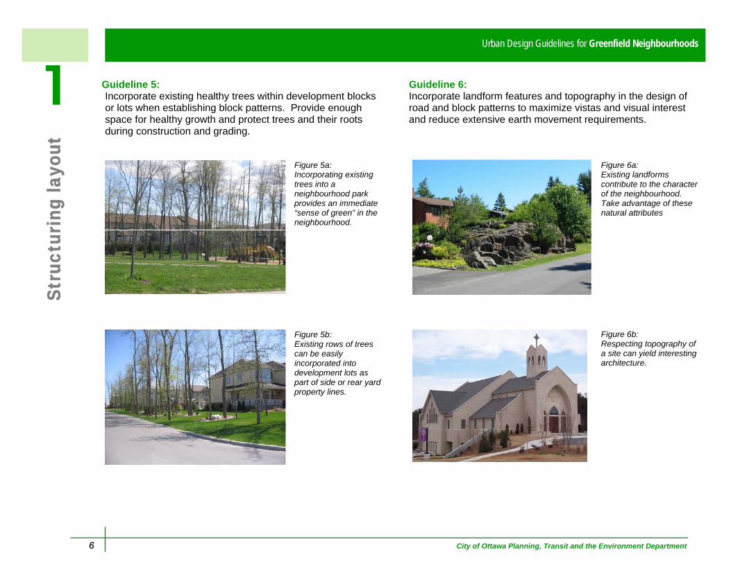
1 Guideline 5: Incorporate existing healthy trees within development blocks or lots when establishing block patterns. Provide enough space for healthy growth and protect trees and their roots during construction and grading.
Figure 5a: Incorporating existing trees into a neighbourhood park provides an immediate “sense of green” in the neighbourhood.
Figure 5b: Existing rows of trees can be easily incorporated into development lots as part of side or rear yard property lines.
Guideline 6: Incorporate landform features and topography in the design of road and block patterns to maximize vistas and visual interest and reduce extensive earth movement requirements.
Figure 6a: Existing landforms contribute to the character of the neighbourhood. Take advantage of these natural attributes
Figure 6b: Respecting topography of a site can yield interesting architecture.

City of Ottawa Planning, Transit and the Environment Department 7
Stru
ctur
ing
layo
ut
1 Urban Design Guidelines for Greenfield Neighbourhoods
Guideline 7: Locate stormwater management areas to be an integral part of the overall greenspace and pedestrian network within the neighbourhood.
Figure 7a: Stormwater management ponds can be important contributors to the overall greenspace network.
Figure 7b: Amenities, such as pathways, benches and waste receptacles, ensure that stormwater management ponds contribute to greenspace and connect neighbourhood destinations.
Guideline 8: Incorporate existing cultural heritage features, such as hedgerows, bridges, stone walls, ruins, archaeological sites and buildings when establishing the location of roads, parks, and public and institutional lands.
Figure 8a: An avenue of old maple trees and an old stone fence is incorporated into a greenspace at the entry of this new neighbourhood.

8 City of Ottawa Planning, Transit and the Environment Department
Urban Design Guidelines for Greenfield NeighbourhoodsSt
ruct
urin
g la
yout
1 Guideline 9: Concentrate higher density residential units around neighbourhood focal points that include transit stops, commercial areas, schools, community facilities, parks and multi-use pathways.
Figure 9a: The highest density residential units are focused around key locations within the neighbourhood such as surrounding parks, along collector and arterial streets, or near transit stops.
Figure 9b: Neighbourhoods should have mixed-use commercial areas that include residential and that are destination points, pedestrian friendly, and linked with transit.
Guideline 10: Create a walkable neighbourhood with pathways, trails and sidewalks that are accessible year round and that connect destinations such as transit stops, commercial areas, schools, community facilities and parks.
Figure 10a: Sidewalks (solid), trails or pathways through parks (dotted), and mid-block walkways (dashed) form a continuous network for pedestrians.
Figure 10b: A connected network of safe and attractive pedestrian routes creates an alternative to automobile travel within the neighbourhood.

City of Ottawa Planning, Transit and the Environment Department 9
Stru
ctur
ing
layo
ut
1 Urban Design Guidelines for Greenfield Neighbourhoods
Guideline 11: Connect new streets to existing streets in adjacent developments and plan for future connections to land that has yet to be developed.
Figure 11a: Development based on a connected network of streets provides different route choices for pedestrian, bicycles and automobiles.
Figure 11b: Streets connect neighbourhoods for all modes of travel.
Guideline 12: Layout collector streets to be direct and continuous through the neighbourhood so homes are within 400 metres of transit and other destinations along them.
Figure 12a: Direct and continuous collector streets provide more efficient options for transit routing.
Figure 12b: Neighbourhoods with accessible and convenient transit and transit stops with amenities provide more travel choices.

10 City of Ottawa Planning, Transit and the Environment Department
Urban Design Guidelines for Greenfield NeighbourhoodsSt
ruct
urin
g la
yout
1 Guideline 13: Layout local street patterns so that development blocks are easily walkable – between 150 and 250 metres in length.
Figure 13a: Shorter block lengths enhance pedestrian access to transit stops and to other neighbourhood amenities and facilities such as schools, parks, and commercial areas.
Figure 13b: Many older neighbourhoods are characterized by block sizes and street patterns that are easily walkable.
Guideline 14: Maximize opportunities for passive energy conservation and south facing exposure through street orientation, block pattern, building location and heights. Use vegetation and architectural detailing for shading and wind protection.
Figure 14a: South-facing buildings maximize passive solar energy gains (dashed arrows) during the winter season.
Figure 14b: Windows and doors capture solar energy of south-facing exposures, while architectural detailing and street trees provide shade.

City of Ottawa Planning, Transit and the Environment Department 11
Stru
ctur
ing
layo
ut
1 Urban Design Guidelines for Greenfield Neighbourhoods
Guideline 15: Create a transition in height from taller buildings to adjacent lower buildings, particularly when connecting to an adjacent development or neighbourhood.
Figure 15a: Tapering of heights and intensity between high-rise and low-rise dwellings should be planned from the outset.
Figure 15b: A progression in heights from high-rise to low-rise buildings is an important element in limiting the impact of sun shadowing and in the acceptability of higher densities.
Guideline 16: Locate elementary schools sites on sites of approximately 2.5 hectares that have at least two road frontages, one of which faces a collector street, and are near a neighbourhood park or greenspace. Consult with school boards.
Figure 16a: Elementary schools and playgrounds are focal points within the neighbourhood and should be integrated along collector or local streets and linked with neighbourhood parks.
Figure 16b: School playgrounds and sport fields make an important contribution to the overall accessible greenspace of a neighbourhood.

12 City of Ottawa Planning, Transit and the Environment Department
Urban Design Guidelines for Greenfield NeighbourhoodsSt
ruct
urin
g la
yout
1 Guideline 17: Locate intermediate and secondary school sites on sites of approximately 5.0 to 8.0 hectares that have at least two road frontages, one of which faces a collector street, and are near parks or greenspaces. Consult with school boards.
Figure 17a: Having several open sides for secondary schools provides flexibility for site design, particularly concerning access to the site.
Figure 17b: This secondary school is a focal point within the broader neighbourhood and is located along a major road.
Guideline 18: Locate community parks along arterial or collector streets; connect to other greenspaces, and ensure that they are approximately 3.25 hectares in size and that the shape accommodates fields and facilities.
Figure 18a: Community parks are larger than neighbourhood parks and serve the broader area.
Figure 18b: This community park is designed and located to provide both passive and active types of recreation.
City of Ottawa Planning, Transit and the Environment Department 13
Stru
ctur
ing
layo
ut
1 Urban Design Guidelines for Greenfield Neighbourhoods
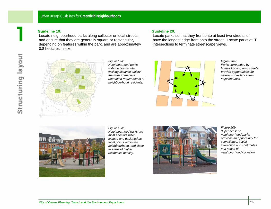
Guideline 19: Locate neighbourhood parks along collector or local streets, and ensure that they are generally square or rectangular, depending on features within the park, and are approximately 0.8 hectares in size.
Figure 19a: Neighbourhood parks within a five-minute walking distance satisfy the most immediate recreation requirements of neighbourhood residents.
Figure 19b: Neighbourhood parks are most effective when located and designed as focal points within the neighbourhood, and close to areas of higher residential density.
Guideline 20: Locate parks so that they front onto at least two streets, or have the longest edge front onto the street. Locate parks at ‘T’-intersections to terminate streetscape views.
Figure 20a: Parks surrounded by homes fronting onto streets provide opportunities for natural surveillance from adjacent units.
Figure 20b: “Openness” of neighbourhood parks provides an opportunity for surveillance, social interaction and contributes to a sense of neighbourhood cohesion.

14 City of Ottawa Planning, Transit and the Environment Department
Urban Design Guidelines for Greenfield NeighbourhoodsSt
reet
des
ign
2 When designing streets and streetscapes…
Guideline 21: Select the most suitable zoning setback and road right-of-way width for the land use context and the road function. Provide sufficient space for the various elements in the front yard, the boulevard, and the road including: trees, sidewalks, utilities, cycling facilities, parking and travel lanes.
Figure 21a: The best road corridor is one that is large enough to accommodate all the streetscape elements in the front yard and the right-of-way, yet narrow enough for buildings and trees to frame the space of the street.
Figure 21b: Residents make additional improvements to the front yards and boulevards, such as walkways, shrubs and flowers.
Guideline 22: Orient rear yard amenity areas away from arterial and collector roads to avoid the requirement for sound attenuation walls. Use single loaded streets, crescents, or rear access streets to access these residential properties.
Figure 22a: Single loaded local streets along an arterial street act as “windows” into a neighbourhood, and provide sight lines from the arterial road to open spaces, homes and other community features.
Figure 22b: Homes fronting onto an arterial road separate rear yards from road noise and provide a more welcoming neighbourhood edge that sound attenuation walls.

City of Ottawa Planning, Transit and the Environment Department 15
Stre
et d
esig
n
2 Urban Design Guidelines for Greenfield Neighbourhoods
Guideline 23: Include a landscaped buffer between the arterial right-of-way and the local right-of-way for single-loaded streets fronting onto arterial roads.
Figure 23a: Berming, deciduous and coniferous trees and shrubs provide a buffer between facing units and the arterial street.
Figure 23b: A dense avenue of boulevard trees and a flowering hedge separates this single-loaded road residential road from the busy community roads
Guideline 24: Plan development based on rear lanes or rear parking areas at important neighbourhood focal points such as mixed-use activity areas, surrounding parks, greenspaces and entrances to the community.
Figure 24a: Rear-lane garages enable dwellings to front directly onto a neighbourhood park, providing a greater sense of spatial enclosure in the park and natural surveillance opportunities.
Figure 24b: Rear parking areas can effectively remove the visual impact of garages and driveways.

16 City of Ottawa Planning, Transit and the Environment Department
Urban Design Guidelines for Greenfield NeighbourhoodsSt
reet
des
ign
2 Guideline 25: Design roads at the entrances to neighbourhoods to create a sense of arrival with such elements as enhanced landscape treatment in the boulevard and the median.
Figure 25a: This landscaped centre median identifies the arrival to a neighbourhood.
Figure 25b: These mixed-use buildings create a ‘mainstreet’ entry to the neighbourhood.
Guideline 26: Construct sidewalks on both sides of streets that serve key destinations, such as transit stops, greenspaces, or to community facilities like schools. Select the correct road right-of-way standard to allow for sufficient space for sidewalks and all streetscape elements.
Figure 26a: Safe connections between key destinations within the neighbourhood may require two sidewalks on a street.
Figure 26b: Tree-lined sidewalks separated from the road are an inviting place to walk.

City of Ottawa Planning, Transit and the Environment Department 17
Stre
et d
esig
n
2 Urban Design Guidelines for Greenfield Neighbourhoods
Guideline 27: Plant trees along all streets in a consistent pattern and coordinate with the location of street amenities and utilities. Base selection and location of trees on soil conditions, bearing capacity, and urban forestry principles.
Figure 27a: Trees planted in a consistent pattern provide a green canopy that creates a comfortable pedestrian environment and reduces “urban heat-island” effects.
Figure 27b: These trees, planted approximately 7.0 to 10 metres apart, provide an attractive, and continuous green edge along the street.
Guideline 28: Design crosswalks in areas with higher pedestrian and vehicular traffic volumes to be visually different from the street surface. Ensure that they are universally accessible.
Figure 28a: Paving stones and concrete for crosswalks clearly defines the pedestrian crosswalk.
Figure 28b: Sidewalk “bulb-outs” and tighter corner radii reduce vehicle turning speeds and minimize crossing distances for pedestrians.

18 City of Ottawa Planning, Transit and the Environment Department
Urban Design Guidelines for Greenfield NeighbourhoodsSt
reet
des
ign
2 Guideline 29: When sound attenuation walls cannot be avoided, diminish their visual impact on the streetscape by using quality materials and design elements in walls and by including landscaping. Refer to City of Ottawa policies for sound attenuation.
Figure 29a: This mature planting helps to integrate the sound wall in the streetscape
Figure 29b: Sound walls can be attractive when attention is paid to details and quality materials are used.
Guideline 30: Connect major greenspace elements, like community parks, stormwater management ponds, and natural features with ’green streets’ to create enhanced walking and cycling environments, and to improve ground water recharge.
Figure 30a: This wide landscape strip provides a physical and visual buffer for pedestrians, and reduces the amount of impervious surface along the street. ‘Green Streets ’may require more space for the various elements.
Figure 30b: Streets in Ottawa’s new communities have many green street elements

City of Ottawa Planning, Transit and the Environment Department 19
Stre
et d
esig
n
2 Urban Design Guidelines for Greenfield Neighbourhoods
Guideline 31: Create a cycling-supportive neighbourhood with bicycle routes that serve local destinations, and that are linked to the citywide network of bicycle routes. Routes include wide shared-use curb lanes, designated on-road bicycle lanes or multi-use pathways,
Figure 31a: Cycling routes are a key element in the overall design of the street network.
Figure 31b: While all roads should accommodate cyclists, clearly defined cycling routes improve cycling priority and visibility.
Guideline 32: Design pathways, trails and walkways that are connected to the road right-of-way so that they link to a sidewalk and cross at an intersection.
Figure 32a: This pathway intersects the sidewalk at an intersection and crosswalk
Figure 32b: This multi-use pathway crosses the road aligning cyclists to the road and pedestrians to the crosswalk and sidewalk.

20 City of Ottawa Planning, Transit and the Environment Department
Urban Design Guidelines for Greenfield NeighbourhoodsSt
reet
des
ign
2 Guideline 33: Construct streets, sidewalks, crosswalks and access to buildings that are universally accessible to a wide range of residents and abilities. Refer to accessibility standards such as the CSA (B651-04) "Accessible design for the built environment".
Figure 33a: Designing for accessibility provides benefits to a wide range of people: People of all ages;
Figure 33b: On foot and on-wheels;
Figure 33c: People at various stages in their lives.

City of Ottawa Planning, Transit and the Environment Department 21
Res
iden
tial
bui
ldin
g an
d si
te d
esig
n
3 Urban Design Guidelines for Greenfield Neighbourhoods
When designing residential buildings and sites…
Guideline 34: Locate residential buildings close to the property line with their primary face addressing the street, while making room for trees and utilities. Provide visual interest along the streetscape with a variety in setbacks and projections.
Figure 34a: Buildings close to the street reinforce the street edge and provide a pedestrian-scaled streetscape.
Figure 34b: Façade variety reinforces a visually interesting streetscape and contributes to a neighbourhood’s image and identity.
Guideline 35: Mix various types of housing on each street while considering the relationship (height, size, bulk) between each other, and to existing houses.
Figure 35a: Complementary materials and architectural elements contribute to the ability to mix different housing types and densities on the same street.
Figure 35b: Similar approach to architectural elements, such as window shapes and sizes, porches, and roofline treatment, can provide visual interest and enables different housing types to co-exist.

22 City of Ottawa Planning, Transit and the Environment Department
Urban Design Guidelines for Greenfield NeighbourhoodsR
esid
enti
al b
uild
ing
and
site
des
ign
3 Guideline 36: Design buildings at key intersections as “landmark buildings”, with enhanced height, massing, building projections, architectural elements, and public space.
Figure 36a: Landmark buildings reinforce the prominence of these key locations and contribute to a sense of place and identity.
Figure 36b: Landmark sites should be the focus of more intensive development and have a greater mix of uses than other locations.
Guideline 37: Design building façades so that windows and doors are prominent features that address the streets they front.
Figure 37a: Window and door treatment wrapped around this dwelling provides visual interest on both public streets.
Figure 37b: Doors and windows help to create a sense of human scale and a comfortable pedestrian environment.

City of Ottawa Planning, Transit and the Environment Department 23
Res
iden
tial
bui
ldin
g an
d si
te d
esig
n
3 Urban Design Guidelines for Greenfield Neighbourhoods
Guideline 38: Site and design residential buildings on corner lots so that both the front and the side of the building are oriented to the public street and are detailed with similar quality and style.
Figure 38a: All building types on corner sites should have detailed façades facing each public street.
Figure 38b: On corner sites, accessing garages from the secondary street allows the front façade to face the primary street and reduces vehicular conflicts on the primary street.
Guideline 39: Incorporate porches, which are big enough to accommodate sitting areas, into the overall architecture of the building. Wrap porches around the building façade on corner units..
Figure 39a: Porches can contribute to the active use of the front yard and enhance the public streetscape.
Figure 39b: This porch is large enough to be useable and not simply ornamental.

24 City of Ottawa Planning, Transit and the Environment Department
Urban Design Guidelines for Greenfield NeighbourhoodsR
esid
enti
al b
uild
ing
and
site
des
ign
3 Guideline 40: Design the lower floors of taller residential buildings to be in scale with the pedestrian environment and include individual at-grade doors for ground floor units.
Figure 40a: Doors for ground floor apartment units put an active use on the streetscape at the pedestrian level.
Figure 40b: The ground floor treatment to doors and windows reinforces the pedestrian environment.
Guideline 41: Screen at-grade structured parking or service areas located within a residential building from the public street through such treatments as tinted windows and soft and hard landscaping.
Figure 41a: Transparent tinted glass conceals this ground floor parking while permitting opportunities for natural surveillance.
Figure 41b: Landscaping further screens this ground floor parking structure from view.

City of Ottawa Planning, Transit and the Environment Department 25
Res
iden
tial
bui
ldin
g an
d si
te d
esig
n
3 Urban Design Guidelines for Greenfield Neighbourhoods
Guideline 42: Locate surface parking areas of multi-unit residential buildings away from public view and not between the public street and the building. Design and landscape parking areas so they do not detract from any rear yard amenity space.
Figure 42a: Parking in the rear area enables buildings to be close to the street and to enhance the streetscape.
Figure 42b: Without parking in the front yard, more space remains for street trees, landscaping and an uninterrupted sidewalks for pedestrians.
Guideline 43: Provide a landscape buffer along the edges of multi-unit residential parking areas, in situations where they are along a public street. Provide breaks in the buffers to connect the sidewalk to walkways on the site. Buffers may include low shrubs, trees, and decorative fences.
Figure 43a: Trees and plantings visually and physically separate parking areas from public sidewalks.
Figure 43b: Landscaped areas that are at least 3.0 metres wide provide an appropriate buffer between parking areas and the sidewalk.

26 City of Ottawa Planning, Transit and the Environment Department
Urban Design Guidelines for Greenfield NeighbourhoodsR
esid
enti
al b
uild
ing
and
site
des
ign
3 Guideline 44: Design residential buildings so that garages do not dominate the width of the front façade and do not project past the front wall. Design driveways so that they are not wider than the garage.
Figure 44a: These garages do not dominate the façade.
Figure 44b: Limiting the width of garages and driveways balances the proportions of the front façade and increases space for landscaping and winter snow storage.
Guideline 45: Provide shared driveways for ground–oriented attached dwellings to maximize area for trees, utilities, on-street parking, and snow storage, and to minimize the physical disruption of sidewalks along the street.
Figure 45a: Sharing driveways reduces the visual dominance of paved areas.
Figure 45b: Fewer curb cuts cause less interruption of the sidewalk.

City of Ottawa Planning, Transit and the Environment Department 27
Res
iden
tial
bui
ldin
g an
d si
te d
esig
n
3 Urban Design Guidelines for Greenfield Neighbourhoods
Guideline 46: Incorporate mid-block walkways to make walking more direct and convenient where long blocks cannot be avoided. Ensure that landscaping, fencing, and facing windows support a safe and attractive environment.
Figure 46a: Mid-block walkways for longer blocks provide a more direct access, (as indicated by the black dashed line) to neighbourhood focal points
Figure 46b: A 6.0 metre walkway corridor provides a comfortable walking space and privacy for adjacent properties, while still maintianing sightlines for visual surveillance.

28 City of Ottawa Planning, Transit and the Environment Department
Urban Design Guidelines for Greenfield NeighbourhoodsN
on-R
esid
enti
al b
uild
ing
and
site
des
ign
4 When designing non-residential buildings and sites…
Guideline 47: Locate community buildings and other non-residential buildings close to the street edge, with their primary face oriented to the street, and the front door directly accessible from the public sidewalk. Vary setbacks and projections, to provide visual interest along the streetscape.
Figure 47a: Buildings close to the street reinforce the street edge and provide a pedestrian-scaled streetscape.
Figure 47b: The façade of this commercial building is oriented to the street with large transparent windows at street level and an entrance that faces both public streets.
Guideline 48: Locate on-site surface parking areas to the side or rear and not between the public right-of-way and the front of the building. Landscape these parking areas to screen views of cars while maintaining view for natural surveillance.
Figure 48a: Bringing community buildings close to the street creates an inviting urban edge.
Figure 48b: The streetscape views are significantly improved when parking is located away from the public right-of-way.

City of Ottawa Planning, Transit and the Environment Department 29
Non
-Res
iden
tial
bui
ldin
g an
d si
te d
esig
n
4 Urban Design Guidelines for Greenfield Neighbourhoods
Guideline 49: Locate garbage and loading areas so that they are not visible from the public street. Screen or enclose them with similar materials as the main building.
Figure 49a: This building features an enclosed structure for garbage, loading and service areas that are accessed from the rear of the building.
Figure 49b: The same building as in Figure 49a. The enclosed service areas allows for a more visually appealing front along the streetscape
Guideline 50: Provide a landscaped buffer between residential areas and the service areas or rear lot areas of abutting non-residential development. Plant buffer to create a dense year-round screen.
Figure 50a: A dense planting with a variety of trees and shrubs provides a visual screen from the rear yards of residences to the servicing and loading area of an adjacent commercial plaza.
Figure 50b: This dense buffer separates commercial loading areas from this apartment’s outdoor amenity space.

30 City of Ottawa Planning, Transit and the Environment Department
Urban Design Guidelines for Greenfield NeighbourhoodsN
on-R
esid
enti
al b
uild
ing
and
site
des
ign
4 Guideline 51: Reduce and delay stormwater runoff from a property by using techniques such as stormwater retention gardens, green roofs, permeable paving and surfaces, and stormwater re-use.
Figure 51a: This commercial building collects solar energy and rainwater.
Figure 51b: Planting islands with depressed curbs allow stormwater to run from paved areas into the islands.
Guideline 52: Provide a landscape buffer along the edge of parking areas in situations were they are along the public street. Provide breaks in the buffers to connect the sidewalk to walkways on the site. Buffers may include low shrubs, trees, and decorative fences.
Figure 52a: This school site’s parking lot is visually screened by a combination of trees and shrubs.
Figure 52b: Landscaped areas that are at least 3.0 metres wide provide both a visual and physical separation of parking areas from public sidewalks.

City of Ottawa Planning, Transit and the Environment Department 31
Non
-Res
iden
tial
bui
ldin
g an
d si
te d
esig
n
4 Urban Design Guidelines for Greenfield Neighbourhoods
Guideline 53: Provide pathways between residential areas and non-residential sites that directly and clearly connect these areas.
Figure 53a: This flower-lined pathway provides a direct connection between residences and a commercial plaza.
Figure 53b: This walkway connects an adjacent higher density residential development to both the sidewalk and front doors of this commercial area.

32 City of Ottawa Planning, Transit and the Environment Department
Urban Design Guidelines for Greenfield NeighbourhoodsG
reen
spac
es
5 When designing greenspaces…
Guideline 54: Design stormwater management areas, and other greenspaces with majority of their frontage onto public roads to make a visible contribution to the neighbourhood.
Figure 54a: Open street frontages along stormwater management areas provide universal views for the entire neighbourhood.
Figure 54b: Single-loaded roads along stormwater management areas provide excellent views for facing units without monopolizing visual access.
Guideline 55: Naturalize the edges of stormwater management areas to deter public access and to create wildlife habitats. Use decorative fencing that complements the natural character of the area when fencing is needed for safety.
Figure 55a: Natural barriers perform their function while ensuring the area remains natural in character.
Figure 55b: The fencing around this stormwater management pond fits with the overall design of the amenity and contributes to saftey.

City of Ottawa Planning, Transit and the Environment Department 33
Gre
ensp
aces
5 Urban Design Guidelines for Greenfield Neighbourhoods
Guideline 56: Design streetscapes with open accessible frontages along greenspaces, such as woodlots and stormwater management ponds. Provide fencing along greenspaces only to prevent direct access to sensitive environmental areas or unsafe conditions.
Figure 56a: Single-loaded roads around woodlots provide excellent views and vistas for facing units.
Figure 56b: This woodlot is incorporated into the street and block pattern of the neighbourhood.
Guideline 57: Provide landscape buffer areas around natural features, such as woodlots or watercourses, to protect the ecological functions. Plant these buffers with native tree and shrub species to prevent invasive plant species from becoming established.
Figure 57a: A broad landscape buffer provides sufficient room for healthy growth and development and protects the natural features, with sufficient room for water recharge and root growth.
Figure 57b: While open turf areas may provide a good landscape buffer, areas planted to renaturalize enhances the natural features.

34 City of Ottawa Planning, Transit and the Environment Department
Urban Design Guidelines for Greenfield NeighbourhoodsG
reen
spac
es
5 Guideline 58: Provide trees and sidewalks along the edge of parks and greenspaces to complement the treatment across the street.
Figure 58a: Trees, within a park, line the street and provide a consistent and attractive streetscape environment.
Figure 58b: These trees within a community park form a canopy with the trees on the other side of the street.
Guideline 59: Design pathways to enhance the function and character of the type of open space they occupy, keeping in mind user safety, lighting and intended operational hours.
Figure 59a: This pathway is designed to reflect its formal relationship with the community park through the use of lighting, benches, paving, and garbage receptacles.
Figure 59b: This trail is designed with limited amenities and a stone dust surface to reflect its more natural setting in a woodlot.
City of Ottawa Planning, Transit and the Environment Department 35
Uti
litie
s an
d am
enit
ies
6 Urban Design Guidelines for Greenfield Neighbourhoods
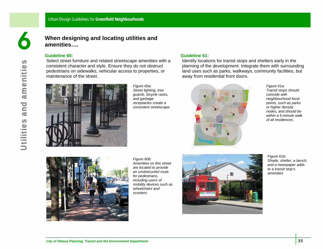
When designing and locating utilities and amenities…. Guideline 60: Select street furniture and related streetscape amenities with a consistent character and style. Ensure they do not obstruct pedestrians on sidewalks, vehicular access to properties, or maintenance of the street.
Figure 60a: Street lighting, tree guards, bicycle racks, and garbage receptacles create a consistent streetscape.
Figure 60b: Amenities on this street are located to provide an unobstructed route for pedestrians, including users of mobility devices such as wheelchairs and scooters.
Guideline 61: Identify locations for transit stops and shelters early in the planning of the development. Integrate them with surrounding land uses such as parks, walkways, community facilities, but away from residential front doors.
Figure 61a: Transit stops should coincide with neighbourhood focal points, such as parks or higher density nodes, and should be within a 5-minute walk of all residences.
Figure 61b: Shade, shelter, a bench, and a newspaper adds to a transit stop’s amenities

36 City of Ottawa Planning, Transit and the Environment Department
Urban Design Guidelines for Greenfield NeighbourhoodsU
tilit
ies
and
amen
itie
s
6 Guideline 62: Concentrate streetscape amenities at locations with higher levels of activity, such as adjacent to parks, walkways, commercial areas, and transit stops. Ensure that amenities do not impede pedestrian and transit vehicle movements, and are linked to near-by parking.
Figure 62a: Streetscape amenities include: mailboxes, garbage receptacles, newspaper boxes and benches.
Figure 62b: This mailbox is located at the edge of a park, under an enclosure, and with parking near by that permits convenient and safe access.
Guideline 63: Place mailboxes at locations with higher levels of activity, such as adjacent to parks, walkways, commercial areas, and transit stops, and link to near-by parking.
Figure 63a: This mailbox is located at the entrance to a walkway, a highly visible and accessible location, and is designed with enhanced materials to fit the context.

City of Ottawa Planning, Transit and the Environment Department 37
Uti
litie
s an
d am
enit
ies
6 Urban Design Guidelines for Greenfield Neighbourhoods
Guideline 64: Locate above-grade utilities away from key public view lines such as intersections, day lighting triangles and parking lot entrances. Screen the utilities through design or landscaping. For taller buildings, incorporate rooftop mechanical equipment as an integral part of the building design and screen using materials complementary to the building.
Figure 64a: This utility meter is hidden from the streetscape by incorporating it into the design of the stairs.
Figure 64b: This roof top mechanical equipment is well integrated into this apartment building.
Guidelines 65: Cluster or group utilities to minimize the visual impact on the streetscape. Coordinate utility trenching, street lighting and tree locations as per City servicing guidelines to ensure sufficient room for all elements in the road corridor.
Figure 65a: Separate trenches for underground utilities and for tree roots that are constructed to meet the requirements of each use reduces conflicts.
38 City of Ottawa Planning, Transit and the Environment Department
Urban Design Guidelines for Greenfield NeighbourhoodsG
loss
ary Amenity: something that contributes to an area’s needs, whether
social, environmental, or cultural. Articulation: architectural detail that gives a building interest and added richness. Brownfields: abandoned, vacant, or underutilized commercial and industrial properties where past actions have resulted in actual or perceived environmental contamination, and/or derelict, deteriorated or obsolete buildings. Built form: buildings and structures. Building height-to-street width: the ratio between the height of a building to the width of the street right-of-way, used in analysing the sense of enclosure of a street. Community Park: A large park that serves the needs of the broader community and that is designed primarily for providing active and structured recreation opportunities. Compatible/Compatibility: when the density, form, bulk, height, setbacks and/or materials of buildings are able to co-exist with their surroundings. Curb cut: a break in the curb for vehicular access from the street onto a property. Façade: the principal face of a building (also referred to as the front wall). Frontage: the front of the property facing the street. Front yard: the space between the property line and the front wall of a building facing the public street. Glazing: clear or lightly tinted glass windows.
Greenfields: large undeveloped lands within the urban boundary that serve as locations for new communities or for development that completes existing communities. Green roof: a vegetated area that is designed to become part of a building’s roof. Hard landscape: landscape features other than plant materials, such as decorative pavers, planter boxes, fences, or retaining walls. Landscaped buffer: a landscaped area located along the perimeter of a lot intended to screen or separate land uses and lessens the visual or sound impacts. Neighbourhood Park: a smaller park that serves the immediate needs of the surrounding neighbourhood or sub-neighbourhoods and that is designed primarily for non-structured recreation activities. Pedestrian scale: a size of a building or space that a pedestrian perceives as not dominating or overpowering. Pedestrian travel route: the unobstructed portion of the sidewalk. Pocket Park: the smallest type of park that serves the most immediate recreation needs of a sub-neighbourhood and that are often designed for small children. Primary Street: the street with a higher traffic volume where two streets intersect. Property line: the legal boundary of a property. Public realm: the streets, lanes, parks and open spaces that are available for anyone to use. Rapid Transit: A convenient, fast, and frequent public transportation service that features a high carrying capacity.

City of Ottawa Planning, Transit and the Environment Department 39
Glo
ssar
y Design Guidelines for Urban Residential Neighbourhoods
Right-of-way: a public or private area that allows for passage, such as freeways, streets, bicycle paths, alleys, trails, or pedestrian walkways. Scale: The relative size of an object when compared to others of its kind, to its environment, or to humans. Secondary Street: the street with a lower traffic volume where two streets intersect. Sense of enclosure: when buildings physically define public spaces particularly through proportions between height and width in an area to create places that are comfortable to pedestrians. Setback: the required distance from a road, property line, or another structure, within which no building can be located, with the exception of permitted projections. Sidewalk: unobstructed concrete pedestrian travel route in the public right-of-way. Soft landscape: landscape features of plantings, such as trees, shrubs, vines, perennials and annuals. Stormwater management area: a feature or facility for stormwater flows intended for capture and water quality improvement, including such elements as watercourses or management ponds. Streetscape: the overall character and appearance of a street formed by elements and features that frame the public street, such as building façades, street trees and plants, lighting, furniture, or paving. Trail: a route for non-motorized travel through natural areas or greenspaces Urban design: the physical design of places and their components.
Walkway: a route for non-motorized travel on public or private property outside of the public street right-of-way.

40 City of Ottawa Planning, Transit and the Environment Department
Urban Design Guidelines for Greenfield NeighbourhoodsFi
gure
Loc
atio
ns Figure 1a: Ottawa
Figure 2a: Ottawa Figure 3a: Ottawa (source: FoTenn
Consultants Inc) Figure 3b: Ottawa Figure 4a: Ottawa Figure 4b: Wilmington, North Carolina
(source: www.cyburbia.org) Figure 5a: Ottawa Figure 5b: Ottawa Figure 6a: Ottawa (Kanata) Figure 6b: Renfrew (source: FoTenn
Consultants Inc.) Figure 7b: Ottawa Figure 8a: Ottawa Figure 9b: Baltimore, Maryland Figure 10b: Orlando, Florida (source:
www.cyburbia.org) Figure 11b: Oakville Figure 12b: Ottawa Figure 13b: Ottawa Figure 14b: Source: FoTenn
Consultants Inc. Figure 15b: Montreal Figure 16b: Ottawa Figure 17b: Ottawa Figure 18b: Gatineau Figure 19b: Markham Figure 20b: Markham Figure 21a: Ottawa Figure 22b: Ottawa Figure 23a: Ottawa Figure 23b: Ottawa Figure 24a: Montreal Figure 24b: Ottawa Figure 25a: Ottawa Figure 25b: Calgary Figure 26a: Montreal Figure 27a: Vancouver
Figure 27b: Ottawa Figure 28a: Ottawa Figure 28b: Rochester Hills, Michigan
(source: Bousfields Inc.) Figure 29a Ottawa Figure 29b: Ottawa Figure 30a: Portland Figure 30b: Ottawa Figure 31b: Ottawa Figure 32a: Ottawa Figure 32b: Ottawa Figure 33a: Ottawa Figure 33b: Ottawa Figure 33c: Ottawa Figure 34a: Markham Figure 34b Calgary Figure 35a: Ottawa Figure 35b: Calgary Figure 36a: Madison, Wisconsin
(source: www.cyburbia.org) Figure 37a: Calgary Figure 37b: Montreal Figure 38a: Oakville Figure 38b: Ottawa Figure 39a: Ottawa Figure 39b: Markham Figure 40a: Ottawa Figure 40b: Markham Figure 41a: Ottawa Figure 41b: Ottawa Figure 42a: Ottawa Figure 42b: Montreal Figure 43a: Ottawa Figure 43b Ottawa Figure 44a Ottawa Figure 44b: Ottawa Figure 45a: Ottawa Figure 45b: Ottawa Figure 46a: Oakville
Figure 47a: Mississauga Figure 47b: Calgary Figure 48a: Ottawa Figure 49a: Ottawa Figure 49b: Ottawa Figure 50a: Ottawa Figure 50b: Ottawa Figure 51a: Portland Figure 51b: US Environmental
Protection Agency Figure 52a: Ottawa Figure 52b: Richmond ON (source: The
Planning Partnership) Figure 53a: Ottawa Figure 53b: Calgary Figure 54a: Ottawa Figure 55a: Ottawa Figure 55b: Ottawa Figure 56a: Ottawa Figure 56b: Gatineau Figure 57a: Ottawa Figure 57b: Ottawa Figure 58a: Montreal Figure 58b: Gatineau Figure 59a: Ottawa Figure 59b: Ottawa Figure 60a: Halifax Figure 60b: Calgary Figure 61b: Ottawa Figure 62a: Ottawa Figure 62b: Markham Figure 63a: Ottawa Figure 63b: Montreal Figure 64a: Markham Figure 64b: Ottawa Figure 65a Ottawa

City of Ottawa Planning, Transit and the Environment Department
Design Guidelines for Urban Residential Neighbourhoods

City of Ottawa Planning, Transit and the Environment Department
Urban Design Guidelines for Greenfield Neighbourhoods