Urban Design Analysis
7
This section sets out an urban design analysis of the Preston area, including an analysis of Preston’s historical development, movement, environmental quality and open space. This analysi s helps to determi ne the opportunities and constraints which will govern new devel opment in the area, as well as highlighting areas for improvement. 4. 1 HI STORY The plan lays the Ordnance Survey map of 1871 over the exist ing plan of the area. Noteworthy features include: Burgh Heath and Pit Wood have remained largely intact; - Mar bles Pond r emains an import ant feature in the area; - Some Vi ctorian field boundaries continue to play an important role in shaping the area. The boundaries defining the recreation ground and Banstead Athletic Football Club remain. 4 URBAN DESI GN ANAL YSIS The current Ordnanc e Survey plan with t hat of 1871 overlaid in red PRESTONARE A RE G E NERAT IO N M ASTERPL AN - F IN AL R EP ORT DE C EMB ER 20 05 16 Reproduced from the Ordnance Survey digital maps with the permission of the Controller of Her Majesty's Stationary Office © Crown Copyright. Unauthorised reproduction infringes Crown Copyright and may lead to prosecution or civil proceedings. Reigate and Banstead Borough Council License no 100019405 - 2004
-
Upload
yecto-pecto -
Category
Documents
-
view
219 -
download
0
Transcript of Urban Design Analysis

8/2/2019 Urban Design Analysis
http://slidepdf.com/reader/full/urban-design-analysis 1/6
This section sets out an urban design
analysis of the Preston area, including ananalysis of Preston’s historical development,
movement, environmental quality and open
space. This analysis helps to determine the
opportunities and constraints which will
govern new development in the area, as
well as highlighting areas for improvement.
4.1 HISTORY
The plan lays the Ordnance Survey map of
1871 over the existing plan of the area.
Noteworthy features include:
Burgh Heath and Pit Wood have remained
largely intact;
- Marbles Pond remains an important
feature in the area;
- Some Victorian field boundaries
continue to play an important role in
shaping the area. The boundaries
defining the recreation ground and
Banstead Athletic Football Club remain.
4 URBAN DESIGN ANALYSIS
The current Ordnance Survey plan with that of 1871 overlaid in red
PRESTON ARE
A RE
G
E
NERAT
IO
N M
ASTERPL
AN - F
IN
AL R
EP
ORT DE
C
EMB
ER 20
05 16
Reproduced from the Ordnance Survey digital maps with the permission
of the Controller of Her Majesty's Stationary Office © Crown
Copyright. Unauthorised reproduction infringes Crown Copyright andmay lead to prosecution or civil proceedings. Reigate and Banstead
Borough Council License no 100019405 - 2004

8/2/2019 Urban Design Analysis
http://slidepdf.com/reader/full/urban-design-analysis 2/6
4.2 MOVEMENT
Despite good access to the strategic road
network with the A240 and A217
providing good access to the M25, Preston
is relatively poorly connected to its
immediate environment. Access to the area
is primarily focussed along the Merland
Rise axis which itself connects with Great
Tattenhams to the north and Shelvers Way
to the south. This over dominance onMerland Rise/Preston Lane and lack of
vehicular connections to the east is the
area's main weakness in relation to the
local movement network and routes to and
through the area.
The key nodes where important routes
come together are concentrated along this
Merland Rise axis, being the junctionsbetween Shelvers Way and Preston Lane
at which point there is a small
neighbourhood shopping centre, the
junction between Preston Lane and
Merland Rise, and the junction between
Merland Rise and Chetwode Road in the
vicinity of the Primary School.
Secondary distributor roads branch off
Preston Lane, with the heavily engineered
Waterfield providing access to the health
centre and housing areas to the west.
Chetwode Road and Preston Lane
distribute traffic through the area to the
east and are connected by Marbles Way
on the east side of the recreation ground.
4 URBAN DESIGN ANALYSIS
17 PRES
TON AR
E
A REGE
N
ER
AT
ION MAS
T
ERPL
AN - F
INAL REPORT DE
CE
MBER 2005
Movement analysis plan
Reproduced from the Ordnance Survey di gital maps with the permission
of the Controller of Her Majesty's Stationary Office © Crown
Copyright. Unauthorised reproduction infringes Crown Copyright and
may lead to prosecution or civil proceedings. Reigate and BansteadBorough Council License no 100019405 - 2004
M E R L A N D R I S E
C H E T
W O D
E R O A
D
P R E S T O N
LA N E
S H E L V E R S
WA Y
A 2 1 7
G R E A
T T A
T T E N
H A M S
W A T E R F I E L D

8/2/2019 Urban Design Analysis
http://slidepdf.com/reader/full/urban-design-analysis 3/6
4.3 PEDESTRIAN ENVIRONMENT
The main safe pedestrian routes through
the area mirror the main vehicular routes.
Generally, good links exist, via Merland
Rise, to Tadworth and Tattenham Corner
railway stations which are roughly
equidistant from the geographical centre
of the area.
Some important pedestrian routes provide
links to surrounding areas where there is no
corresponding vehicular connection. An
important link exists between Shelvers Way
and Marbles Way via Copley Way in the
south-east corner of the study area. This
route provides much needed direct linkage
with the surrounding residential
neighbourhoods. There are severaladditional cycle and pedestrian routes
connecting with Shelvers Way although
they are less obvious and more tortuous in
nature.
A direct pedestrian route across Burgh
Heath provides an important link to the
Asda superstore on the A240 Reigate
Road. Whilst important, this route wouldbenefit from improvement, particularly at
each end where improved sight lines could
improve pedestrian safety. Once through
the Heath, the A240 provides a
formidable barrier to pedestrians
travelling to Asda. In general, pedestrian
access to Asda is extremely poor and there
is scope for significant improvement.
The footpath across the recreation ground,
whilst well used during the day, does not
feel safe in the evening despite being lit.
However, it is a key route for the area,
linking the small shopping parade with the
concentration of community facilities on
Merland Rise.
Merland Rise is itself not well linked with
Waterfield. Pit Wood provides the
opportunity for improved pedestrian
linkage which would better integrate the
health centre with its catchment.
4 URBAN DESIGN ANALYSIS
PRESTON ARE
A RE
G
E
NERAT
IO
N M
ASTERPL
AN - F
IN
AL R
EP
ORT DE
C
EMB
ER 20
05 18
Pedestrian environment analysis
Reproduced from the Ordnance Survey digital maps with the permission
of the Controller of Her Majesty's Stationary Office © Crown
Copyright. Unauthorised reproduction infringes Crown Copyright and
may lead to prosecution or civil proceedings. Reigate and BansteadBorough Council License no 100019405 - 2004
M E R L A N
D R I S E
C H E T
W O D
E R O A
D
P R E S T O N
LA N E
S H E L V E R
S WA Y
A 2 1 7
G R E A
T T A
T T E N
H A M S
W A T E R F I E L D

8/2/2019 Urban Design Analysis
http://slidepdf.com/reader/full/urban-design-analysis 4/6
4.4 FRONTAGES
Active frontages are those streets and
spaces which benefit from the activity,
movement and 'eyes on the street'
generated by windows and doors beingaccessed directly from them. Routes which
benefit from this activity are generally
safer and tend to be the ones used by
local people to move through an area.
In very simplistic terms, Preston is arranged
as areas of housing which surround the
central recreation ground. Merland Rise,
Preston Lane, Chetwode Road and Marbles
Way are the four principal routes servingthese residential areas running roughly
parallel to the sides of the recreation
ground.
Of these routes, Merland Rise is the
principal route through the area along
which most of its community facilities are
located. Merland Rise benefits from
almost continuous frontage andconsequently feels generally safe along its
length.
Preston Lane, Chetwode Road and Marbles
Way all benefit from some degree of
active frontage. However, these frontages
tend to be punctuated with breaks or the
buildings themselves are well set back from
the pavement, detracting from the benefitsmore complete or immediate building
frontages can bring.
Waterfield does not benefit from any
building frontage, this more recent area of
housing having been designed around
inward looking cul-de-sacs.
Significantly, some of the key areas of
open space do not benefit from active
frontages or the overlooking. Of perhaps
most significance is the relationship
between the new housing development at
De Burgh Gardens and the remainder of
the De Burgh site. This recently built
private housing enclave does not positively
address the De Burgh site.
4 URBAN DESIGN ANALYSIS
19 PRESTON AREA REGENERATION MASTERPLAN - FINAL REPORT DECEMBER 2005
Frontages analysis plan
Reproduced from the Ordnance Survey di gital maps with the permission
of the Controller of Her Majesty's Stationary Office © Crown
Copyright. Unauthorised reproduction infringes Crown Copyright and
may lead to prosecution or civil proceedings. Reigate and Banstead
Borough Council License no 100019405 - 2004
M E R L A N
D R I S E
C H E T
W O D
E R O A
D
P R E S T O N
LA N E
S H E L V E R S
WA Y
A 2 1 7
G R E A
T T A
T T E N
H A M S
W A T E R F I E L D

8/2/2019 Urban Design Analysis
http://slidepdf.com/reader/full/urban-design-analysis 5/6
8/2/2019 Urban Design Analysis
http://slidepdf.com/reader/full/urban-design-analysis 6/6
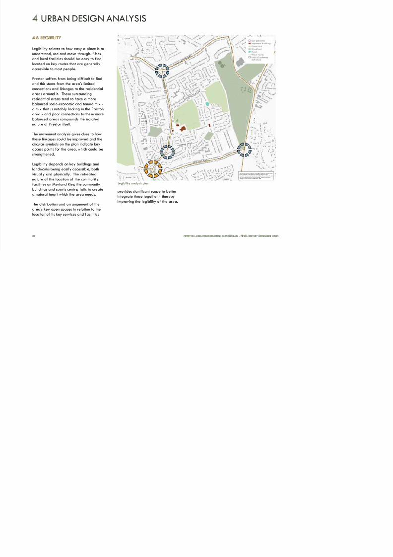
4.6 LEGIBILITY
Legibility relates to how easy a place is to
understand, use and move through. Uses
and local facilities should be easy to find,
located on key routes that are generally
accessible to most people.
Preston suffers from being difficult to find
and this stems from the area's limited
connections and linkages to the residentialareas around it. These surrounding
residential areas tend to have a more
balanced socio-economic and tenure mix -
a mix that is notably lacking in the Preston
area - and poor connections to these more
balanced areas compounds the isolated
nature of Preston itself.
The movement analysis gives clues to howthese linkages could be improved and the
circular symbols on the plan indicate key
access points for the area, which could be
strengthened.
Legibility depends on key buildings and
landmarks being easily accessible, both
visually and physically. The retreated
nature of the location of the community
facilities on Merland Rise, the community
buildings and sports centre, fails to create
a natural heart which the area needs.
The distribution and arrangement of the
area's key open spaces in relation to the
location of its key services and facilities
provides significant scope to better
integrate these together - thereby
improving the legibility of the area.
4 URBAN DESIGN ANALYSIS
21 PRESTON AREA REGENERATION MASTERPLAN - FINAL REPORT DECEMBER 2005
Legibility analysis plan
Reproduced from the Ordnance Survey digital maps with the permission
of the Controller of Her Majesty's Stationary Office © Crown
Copyright. Unauthorised reproduction infringes Crown Copyright andmay lead to prosecution or civil proceedings. Reigate and BansteadBorough Council License no 100019405 - 2004
M E R L A N
D R I S E
C H E T
W O D
E R O A
D
P R E S T O N
LA N E
S H E L V E R
S WA Y
A
2 1 7
G R E A
T T A
T T E N
H A M S
W A T E R F I E L D