
Urban Changes Spread of a City. We have learned that a city grows over time, and that it changes the...
25
Urban Changes Spread of a City
-
Upload
jemima-brooks -
Category
Documents
-
view
215 -
download
0
Transcript of Urban Changes Spread of a City. We have learned that a city grows over time, and that it changes the...

Urban Changes
Spread of a City

We have learned that a city grows over time, and that it changes the surrounding environment.
But have you ever wondered:
How fast does a city grow?
How can we map a growing city?
What does a city need to grow?

You know about these ways to measure growth:

But how do you think you could measure a city grow?
Las Vegas, 1905(Population: a few hundred people)
Las Vegas, 2003(Population: more than 1,000,000 people)From this
To this!

I’ll bet I know a few satellites who could help us out on this one!
Hey– I have an idea!

Let’s take a closer look at that city of Las Vegas…
Las Vegas, 2003Las Vegas, 1905

Here’s what Las Vegas looked like by airplane in 1931, way back before satellites were invented. This image shows an area that’s about 2 miles across.

Here’s what Las Vegas looked like in 1964. This image was taken by one of my satellite friends before we could take color images in high enough detail to see things like streets. This image is about 23 miles across.
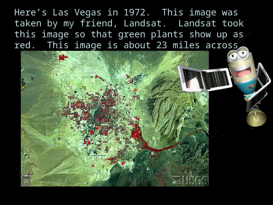
Here’s Las Vegas in 1972. This image was taken by my friend, Landsat. Landsat took this image so that green plants show up as red. This image is about 23 miles across.

Here’s Las Vegas 14 years later--in 1986. What’s the red stuff? What’s the brown and green stuff? What’s the white stuff? Do you notice any changes with the city?

Here’s Las Vegas one more time in 1992. The image is still 23 miles across. Don’t worry about the little yellow things. Wow—what’s going on here?

Let’s see what some of this stuff looks like on the ground. Some friends
of mine took pictures on the ground at these places.
2.
1.
3.
4.
5.
6.
8.
7.
9.

Here’s what they found! Match each photo with the correct description below. It’s OK to look back at the
satellite image again!
2.
1.
3.
4.
5.
6.
7.
8.
9.
A. Old golf courseB. Department storeC. Shrubs along wash
D. New golf courseE. Downtown
F. Small pond with houses
G. Building another house
H. Undeveloped desertI. Desert with reservoir

So, these images can help us figure out how a city grows, and how fast it grows! What other things do you think they could help us figure out
about cities?
1964
1992
1972
1986

1992
One thing is that we can figure out what resources might be needed keep the people in the city comfortable. Resources are things like food, water, lumber, and energy sources like gas and electricity. For example, red areas in this image are places where healthy green plants grow. Grey areas are places with lots of buildings. Greyish-red areas are neighborhoods, with both plants and buildings.
Can you find these colors?

Let’s imagine that you lived at the edge of town in 1972, and rode a school bus to school at the big “X”. If you lived at the edge of town in 1992 and went to the same school, would you have a longer ride or a shorter ride? Would the school bus use more resources, like gas, in 1972
or in 1992? 1992 1972
When a city gets spread out, more people drive around to get places.
That means more traffic, which means more gas!
X
X

So, remember those pictures on the ground? What other resources do the
people in the city need to go from:
to
to
to
Barren desert
Barren desert
grassy golf course?
building a new
house?
bright nighttime?
Sunny daytime
1.
2.
3.

1. Lots of water!
2. Lots of wood, metal, and concrete!
3. Lots of electricity!
Wow, this city needs lots of resources! Actually, all cities need lots of resources, but this is one that needs especially big amount of them because it was built in the hot and dry desert, where it takes a lot of
water and electricity to keep people comfortable.
So-- how do the people in Las Vegas get these things to stay comfy?

This is how. They built a dam.
Las Vegas is near the Colorado River.Can you see Las Vegas?
What’s behind the dam now?How do you think this dam affects the
people, plants, and animals living along the river?

This dam is the reason Las Vegas could get so big.
This is called the Hoover Dam, built in the 1930s and named
after President Herbert Hoover.
It provides water for Las Vegas and other places by making a big lake named Lake Mead.
When water goes through the dam, it turns big water wheels called turbines that make electricity for Las Vegas and other places.

In desert places like Las Vegas, it used to be that the only way people could stay cool inside was to do what other desert animals do
during the daytime: stay in a place surrounded by earth.
Mud and grass dwelling
Spiny lizard in the rocks
Earth is a good insulator, so it
stays cool inside.

But how would you keep cool in tall buildings like these?
We could use more insulation, but we usually don’t. So we use more electricity and other energy from places like
Hoover Dam. But what happens to the amount of resources we have to use, as our cities get bigger and
bigger?

Cities in the U.S. have grown a lot since 1975. Let’s think about this for a minute. How do you think this will
influence:• Farmland and ranchland, where we get our food?
• Forest land, where we get our timber?
• Reservoirs and ground water, where we get our water?
• Our energy supplies, and the sources of electricity and energy that we choose to use?
•The amount of gas that it takes for people to drive to places in their cars?

One thing is for sure. We will need to think carefully about how we use the Earth’s resources as more and more people live on the earth and as our
cities grow bigger and bigger.
Which of the numbers on the map above do you live nearest to?
Next, you can learn more about how much these cities have grown.

Photo Credits
UNLV Special Collections
U.S. IHS
USGS
PDPhoto.org
Northwestern University Library, Edward S. Curtis's 'The North American Indian': the Photographic Images, 2001.
ESC
USGS
NPS
NASA


