URBAN AREAS (STRATEGIC GROWTH AREAS) - City of … · Recognizing the importance of pres erving our...
56
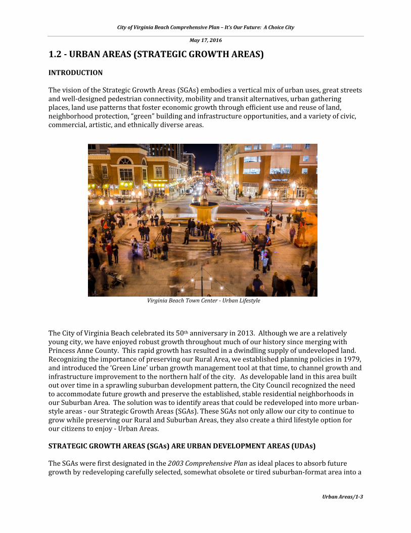
City of Virginia Beach Comprehensive Plan – It’s Our Future: A Choice City May 17, 2016 Urban Areas/1-3 1.2 - URBAN AREAS (STRATEGIC GROWTH AREAS) INTRODUCTION The vision of the Strategic Growth Areas (SGAs) embodies a vertical mix of urban uses, great streets and well-designed pedestrian connectivity, mobility and transit alternatives, urban gathering places, land use patterns that foster economic growth through efficient use and reuse of land, neighborhood protection, “green” building and infrastructure opportunities, and a variety of civic, commercial, artistic, and ethnically diverse areas. The City of Virginia Beach celebrated its 50 th anniversary in 2013. Although we are a relatively young city, we have enjoyed robust growth throughout much of our history since merging with Princess Anne County. This rapid growth has resulted in a dwindling supply of undeveloped land. Recognizing the importance of preserving our Rural Area, we established planning policies in 1979, and introduced the ‘Green Line’ urban growth management tool at that time, to channel growth and infrastructure improvement to the northern half of the city. As developable land in this area built out over time in a sprawling suburban development pattern, the City Council recognized the need to accommodate future growth and preserve the established, stable residential neighborhoods in our Suburban Area. The solution was to identify areas that could be redeveloped into more urban- style areas - our Strategic Growth Areas (SGAs). These SGAs not only allow our city to continue to grow while preserving our Rural and Suburban Areas, they also create a third lifestyle option for our citizens to enjoy - Urban Areas. STRATEGIC GROWTH AREAS (SGAs) ARE URBAN DEVELOPMENT AREAS (UDAs) The SGAs were first designated in the 2003 Comprehensive Plan as ideal places to absorb future growth by redeveloping carefully selected, somewhat obsolete or tired suburban-format area into a Virginia Beach Town Center - Urban Lifestyle
Transcript of URBAN AREAS (STRATEGIC GROWTH AREAS) - City of … · Recognizing the importance of pres erving our...
City of Virginia Beach Comprehensive Plan – It’s Our Future: A Choice City
May 17, 2016
Urban Areas/1-3
1.2 - URBAN AREAS (STRATEGIC GROWTH AREAS) INTRODUCTION The vision of the Strategic Growth Areas (SGAs) embodies a vertical mix of urban uses, great streets and well-designed pedestrian connectivity, mobility and transit alternatives, urban gathering places, land use patterns that foster economic growth through efficient use and reuse of land, neighborhood protection, “green” building and infrastructure opportunities, and a variety of civic, commercial, artistic, and ethnically diverse areas. The City of Virginia Beach celebrated its 50th anniversary in 2013. Although we are a relatively young city, we have enjoyed robust growth throughout much of our history since merging with Princess Anne County. This rapid growth has resulted in a dwindling supply of undeveloped land. Recognizing the importance of preserving our Rural Area, we established planning policies in 1979, and introduced the ‘Green Line’ urban growth management tool at that time, to channel growth and infrastructure improvement to the northern half of the city. As developable land in this area built out over time in a sprawling suburban development pattern, the City Council recognized the need to accommodate future growth and preserve the established, stable residential neighborhoods in our Suburban Area. The solution was to identify areas that could be redeveloped into more urban-style areas - our Strategic Growth Areas (SGAs). These SGAs not only allow our city to continue to grow while preserving our Rural and Suburban Areas, they also create a third lifestyle option for our citizens to enjoy - Urban Areas. STRATEGIC GROWTH AREAS (SGAs) ARE URBAN DEVELOPMENT AREAS (UDAs)
The SGAs were first designated in the 2003 Comprehensive Plan as ideal places to absorb future growth by redeveloping carefully selected, somewhat obsolete or tired suburban-format area into a
Virginia Beach Town Center - Urban Lifestyle

City of Virginia Beach Comprehensive Plan – It’s Our Future: A Choice City
May 17, 2016
Urban Areas/1-4
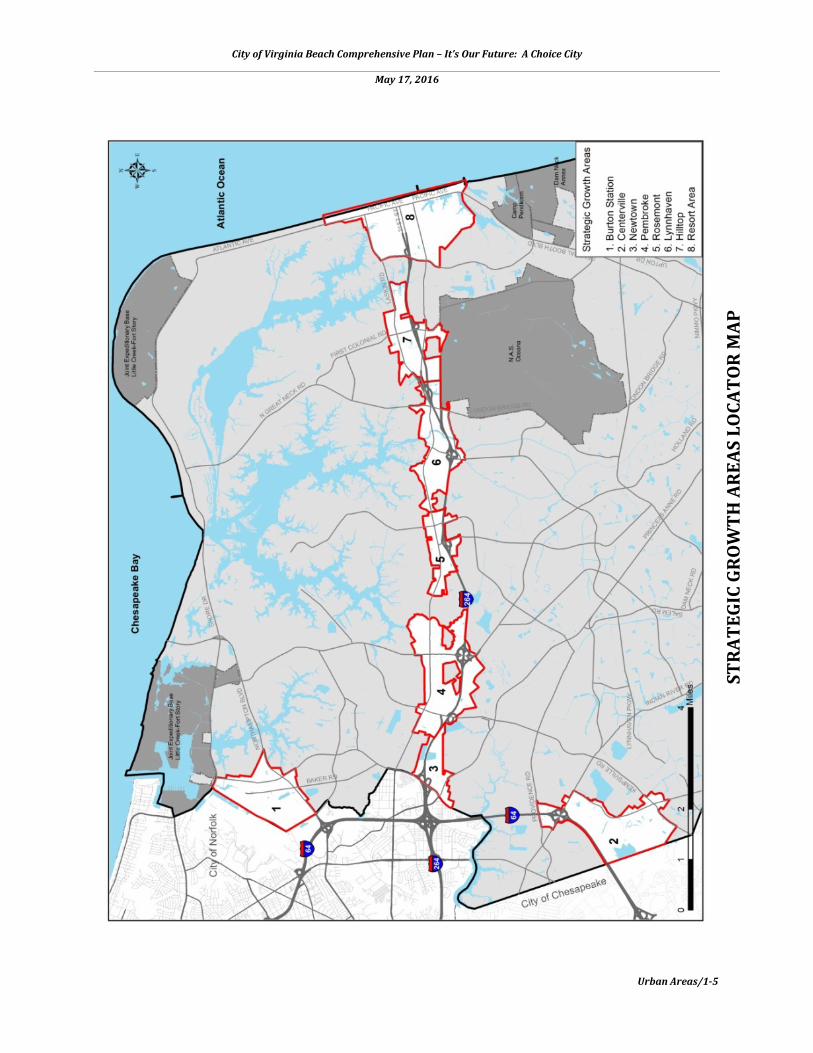
higher density, more efficient urban land use form. Over time, the City has refined its SGA location strategy. Today, there are 8 SGAs as follows, which can be found on the locator map located on p. 1-5.
• Burton Station • Centerville • Hilltop • Lynnhaven • Newtown • Pembroke • Resort • Rosemont
City of Virginia Beach Comprehensive Plan – It’s Our Future: A Choice City
May 17, 2016
Urban Areas/1-5
STRA
TEGI
C GR
OW
TH A
REAS
LO
CATO
R M
AP

City of Virginia Beach Comprehensive Plan – It’s Our Future: A Choice City
May 17, 2016
Urban Areas/1-6
Combined, these SGAs constitute only 2% percent of the City’s total land area of 258 square miles. This decision by our city leaders came years before the Commonwealth of Virginia mandated localities in 2007 to designate Urban Development Areas (UDAs) in their Comprehensive Plans. This mandate became voluntary in 2012 and was further relaxed in 2015. Under the new definition, UDAs can be any area(s) designated in a Comprehensive Plan for higher density development that incorporates the principles of Traditional Neighborhood Development. Traditional Neighborhood Development embodies classic characteristics of traditional communities such as walkable neighborhood centers, interconnected streets and blocks, diversity of land uses, and easy access to jobs, housing, and recreation by a variety of travel options. Our SGAs have been found to meet the requirements of the Code of Virginia, Section 15.2-2223.1 regarding “Urban Development Areas.” The City has identified Strategic Growth Areas to:
• provide opportunities for continued physical and economic growth; • help prevent urban sprawl; • protect our established residential neighborhoods and rural areas; • maximize infrastructure efficiency; offer more choice in built environments; and, • create unique and exciting urban destinations.
GUIDING PRINCIPLES FOR STRATEGIC GROWTH AREAS
1. Encourage efficient use of land resources 2. Maximize use of infrastructure 3. Create a compatible mix of uses 4. Offer a range of transportation options 5. Design at a human scale 6. Promote transit-oriented development 7. Diversify our housing stock 8. Provide accessible parks, open spaces, and recreation facilities 9. Expand upon our green sustainable infrastructure 10. Cultivate Arts and Culture 11. Preserve designated historic resources 12. Plan for sea level rise and recurrent flooding
The following describes each of the SGA Guidelines Principles and intended outcomes for the SGAs: 1. ENCOURAGE EFFICIENT USE OF LAND RESOURCES The land use techniques of higher density and more vertical development, infill development, regional stormwater management solutions, and structured parking are key components to successfully achieving a more efficient pattern of growth. The benefits include reduced sprawl, protection of existing stable neighborhoods, increased protection of farmland and open spaces, reduced dependence on the automobile and more cost-effective use of existing infrastructure.
City of Virginia Beach Comprehensive Plan – It’s Our Future: A Choice City
May 17, 2016
Urban Areas/1-7
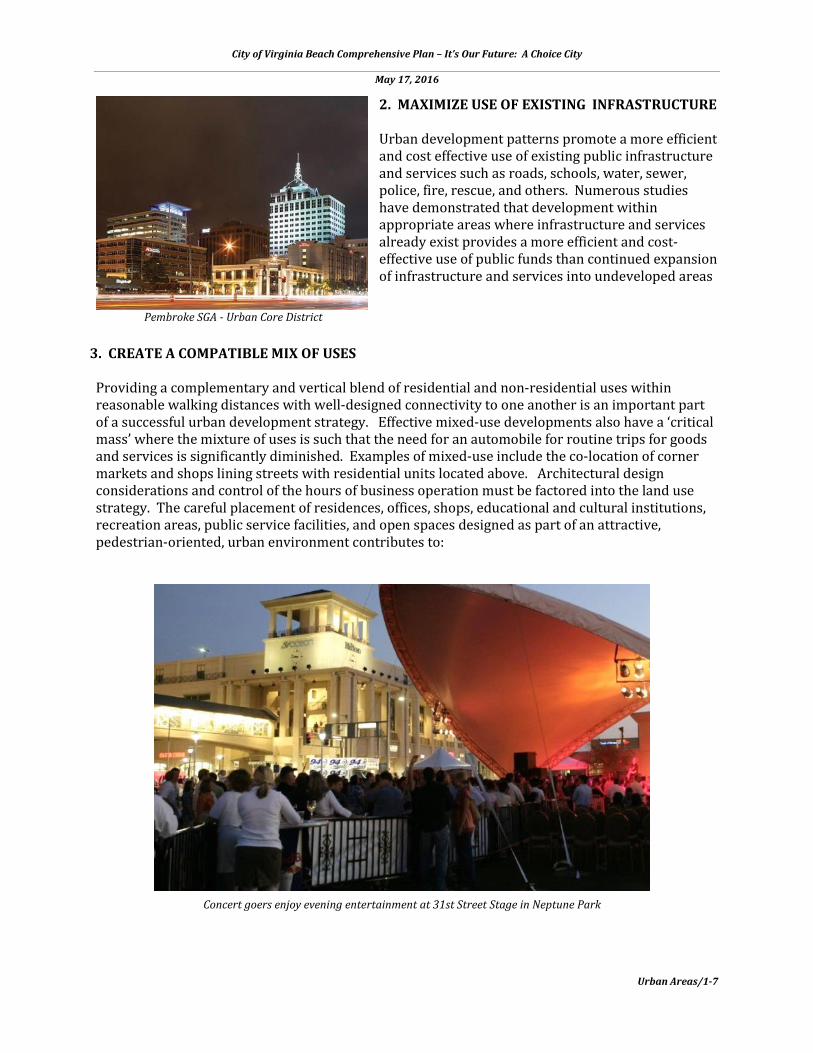
2. MAXIMIZE USE OF EXISTING INFRASTRUCTURE Urban development patterns promote a more efficient and cost effective use of existing public infrastructure and services such as roads, schools, water, sewer, police, fire, rescue, and others. Numerous studies have demonstrated that development within appropriate areas where infrastructure and services already exist provides a more efficient and cost-effective use of public funds than continued expansion of infrastructure and services into undeveloped areas
3. CREATE A COMPATIBLE MIX OF USES
Providing a complementary and vertical blend of residential and non-residential uses within reasonable walking distances with well-designed connectivity to one another is an important part of a successful urban development strategy. Effective mixed-use developments also have a ‘critical mass’ where the mixture of uses is such that the need for an automobile for routine trips for goods and services is significantly diminished. Examples of mixed-use include the co-location of corner markets and shops lining streets with residential units located above. Architectural design considerations and control of the hours of business operation must be factored into the land use strategy. The careful placement of residences, offices, shops, educational and cultural institutions, recreation areas, public service facilities, and open spaces designed as part of an attractive, pedestrian-oriented, urban environment contributes to:
Pembroke SGA - Urban Core District
Concert goers enjoy evening entertainment at 31st Street Stage in Neptune Park

City of Virginia Beach Comprehensive Plan – It’s Our Future: A Choice City
May 17, 2016
Urban Areas/1-8
Vibrant urban places typically offer transportation choices
• independence of movement and ease of access between home and neighborhood serving destinations;
• safer commercial areas due to the 24-hour presence of people or what is termed the ‘eyes of the community’;
• reduction in automobile dependency and opportunities for shorter work trips by focusing on mixed-use and transit-oriented development; and
• the development of a transit-oriented and multi-modal transportation system, in conjunction with planned development and mixed-use projects.
4. OFFER A RANGE OF TRANSPORTATION OPPORTUNITIES
As noted above, urban development patterns afford greater choice of transportation alternatives and less congestion than is otherwise experienced in communities. A three year study, Measuring Sprawl and Its Impact, by researchers from Rutgers University, Cornell University, and Smart Growth America concluded that, “People living in more sprawling regions tend to drive greater distances, own more cars, breathe more polluted air, face greater risk of traffic fatalities, and walk and use transit less. This study shows that sprawl is a real, measurable phenomenon with real implications for peoples’ everyday lives. Regions wishing to improve their quality of life should consider taking steps to reduce sprawl and promote smarter growth.” i Urban, mixed-use development that contains convenience, variety, and density of use, and integrates well-designed pedestrian systems, streetscapes, and transit opportunities can contribute to:
• decreased dependence on the automobile, especially the single-occupant vehicle; • extension of safe, convenient and efficient light rail transit service that provides alternative
mobility options, which can be particularly helpful in enabling young non-drivers, seniors, and those with physical disabilities to be fully engaged in community life;
• reduction in citywide Vehicle Miles Traveled (VMT); • increased opportunities for more
efficient and cost-effective forms of shared and mass transportation;
• increased opportunities with well-designed connectivity to commute by walking or biking;
• opportunities for local and metropolitan transit systems to link to regional and interstate transportation systems;
• cleaner air; and • safer travel.
5. DESIGN AT A HUMAN SCALE Part of what is required for urban, mixed-use developments to become acceptable patterns of development within communities is the creation or re-creation of well-designed areas that are safe, attractive, and convenient. It is important for these areas to be built at a ‘human scale,’ especially as people experience activity along the streets, sidewalks, and public spaces. For example, the sounds from outdoor cafes, people
City of Virginia Beach Comprehensive Plan – It’s Our Future: A Choice City
May 17, 2016
Urban Areas/1-9
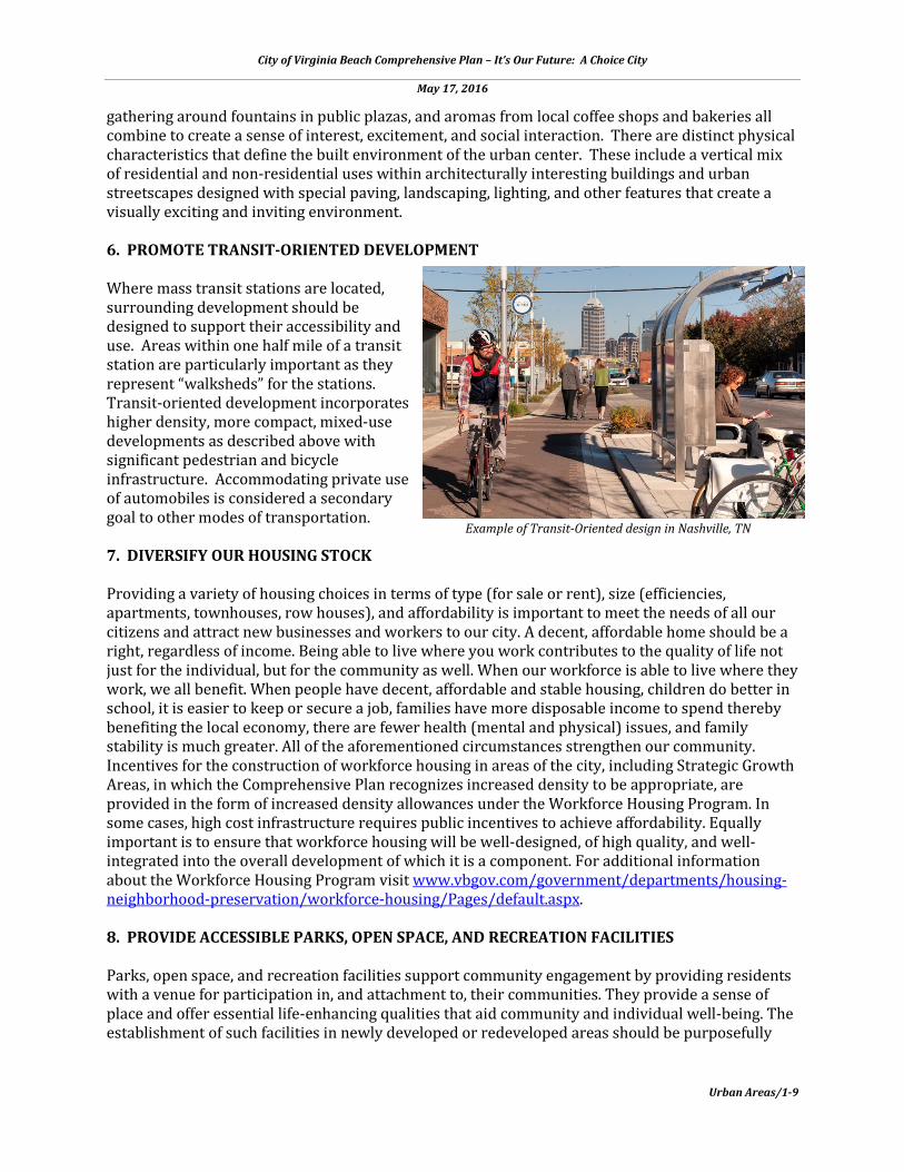
gathering around fountains in public plazas, and aromas from local coffee shops and bakeries all combine to create a sense of interest, excitement, and social interaction. There are distinct physical characteristics that define the built environment of the urban center. These include a vertical mix of residential and non-residential uses within architecturally interesting buildings and urban streetscapes designed with special paving, landscaping, lighting, and other features that create a visually exciting and inviting environment. 6. PROMOTE TRANSIT-ORIENTED DEVELOPMENT Where mass transit stations are located, surrounding development should be designed to support their accessibility and use. Areas within one half mile of a transit station are particularly important as they represent “walksheds” for the stations. Transit-oriented development incorporates higher density, more compact, mixed-use developments as described above with significant pedestrian and bicycle infrastructure. Accommodating private use of automobiles is considered a secondary goal to other modes of transportation. 7. DIVERSIFY OUR HOUSING STOCK Providing a variety of housing choices in terms of type (for sale or rent), size (efficiencies, apartments, townhouses, row houses), and affordability is important to meet the needs of all our citizens and attract new businesses and workers to our city. A decent, affordable home should be a right, regardless of income. Being able to live where you work contributes to the quality of life not just for the individual, but for the community as well. When our workforce is able to live where they work, we all benefit. When people have decent, affordable and stable housing, children do better in school, it is easier to keep or secure a job, families have more disposable income to spend thereby benefiting the local economy, there are fewer health (mental and physical) issues, and family stability is much greater. All of the aforementioned circumstances strengthen our community. Incentives for the construction of workforce housing in areas of the city, including Strategic Growth Areas, in which the Comprehensive Plan recognizes increased density to be appropriate, are provided in the form of increased density allowances under the Workforce Housing Program. In some cases, high cost infrastructure requires public incentives to achieve affordability. Equally important is to ensure that workforce housing will be well-designed, of high quality, and well-integrated into the overall development of which it is a component. For additional information about the Workforce Housing Program visit www.vbgov.com/government/departments/housing-neighborhood-preservation/workforce-housing/Pages/default.aspx. 8. PROVIDE ACCESSIBLE PARKS, OPEN SPACE, AND RECREATION FACILITIES Parks, open space, and recreation facilities support community engagement by providing residents with a venue for participation in, and attachment to, their communities. They provide a sense of place and offer essential life-enhancing qualities that aid community and individual well-being. The establishment of such facilities in newly developed or redeveloped areas should be purposefully
Example of Transit-Oriented design in Nashville, TN

City of Virginia Beach Comprehensive Plan – It’s Our Future: A Choice City
May 17, 2016
Urban Areas/1-10
Urban green space
planned in order to supplement existing recreational opportunities and maintain a high quality of life to be enjoyed by existing and future residents. 9. EXPAND GREEN INFRASTRUCTURE
Green infrastructure mitigates the negative impacts of land development by simulating natural processes in order to provide flood protection, cleaner air, cleaner water, wildlife habitat and corridors, and cultural and recreational opportunities. Green infrastructure elements can be woven throughout a watershed, from smaller scale elements that can be integrated into development sites to larger scale elements that span entire neighborhoods. Some examples are:
• downspout disconnection – routing rooftop drainage to rain barrels, cisterns or permeable areas;
• rain gardens – shallow, vegetated basins that collect and absorb rain from rooftops, sidewalks, and streets;
• permeable pavements – paved surfaces that infiltrate, treat, and/or store rainwater where it falls;
• green streets and alleys – green streets and alleys use a combination of vegetated and engineered strategies to manage rain, allowing it to soak into soil, filtering it, and reducing the amount of storm water transported to an outfall;
• green roofs – roofs covered with growing media and vegetation that absorbs heat and rainwater;
• urban tree canopy – planting and protecting trees provides shade and reduces storm water by intercepting precipitation; and,
• park and conservation lands – creating new open spaces and protecting sensitive natural areas within and adjacent to Strategic Growth Areas mitigates the water quality and flooding impacts of urban storm water, while providing cultural and recreational opportunities for residents.

City of Virginia Beach Comprehensive Plan – It’s Our Future: A Choice City
May 17, 2016
Urban Areas/1-11
"The Wave" - Public Art at the Oceanfront
10. CULTIVATE ARTS AND CULTURE Arts and culture should be woven into the fabric of the community, becoming an integral force in urban design, the educational system, commerce, community celebrations, neighborhood life, and public sector institutions. We need to create space for the arts to take hold and grow. When designed and built with quality in mind, these physical and cultural elements galvanize to foster a positive sense of urban place - something that is enjoying a resurgence of public interest in many communities across the country.
Expanding public art and place-making beyond traditional objects to create events, spaces, and public places animates the City and brings the community together for unique public experiences. Programming for these experiences can be both temporary (event-based) and permanent installations that address community beautification. They can be integrated into redevelopment and new construction projects. Development, support, and promotion of multicultural facilities should be elevated to diversify the arts through both traditional and contemporary styles. 11. PRESERVE DESIGNATED HISTORIC RESOURCES It is the policy of the City to use all available resources including those provided by the City’s Historical Review Board, Historic Preservation Commission, and the Princess Anne County/Virginia Beach Historical Society to preserve designated historic resources. Efforts to retain these historic resources should be accomplished in a responsible and innovative manner. The efforts include providing land use planning guidance and tax credit assistance to owners of historic properties in order to help protect and preserve the City’s limited number of valuable historic resources and surrounding open space areas. Owners of qualified properties should be encouraged to participate in the Virginia Beach Historical Register program and receive recognition for their contributions to our City’s heritage. 12. PLAN FOR SEA LEVEL RISE AND
RECURRENT FLOODING
Due to our abundance of shoreline, sea level rise and recurrent flooding are topics of great concern for our city and the entire Hampton Roads region. Fortunately, our Strategic Growth Areas are generally well-placed at higher elevations and away from inland tidal waters. A few of the SGAs either border or contain existing inland tidal waters. These include:
Entertainment at the Francis Land House in Lynnhaven SGA, circa 1850

City of Virginia Beach Comprehensive Plan – It’s Our Future: A Choice City
May 17, 2016
Urban Areas/1-12
Thalia Creek Greenway in Pembroke SGA
• Thalia Creek on the eastern boundary of the Pembroke SGA; • the southern tributaries of the Eastern Branch of the Lynnhaven River, which runs through
the center of the Lynnhaven SGA to London Bridge Creek; • Linkhorn Bay on the eastern border of the Hilltop SGA; and • Lake Rudee, Lake Holly, Owls Creek, and the southern tributaries of the Resort SGA.
Accordingly, our SGA Plans recommend substantial buffers between new development and these waterways, and in some cases, reclaiming these buffer areas for open space as opportunities arise. In order to fully assess impacts to the Strategic Growth Areas and our city as a whole, a capital project is underway which will model sea level rise, recurrent flooding, and storm surge under different scenarios. DISTINCT QUALITIES While they share many common goals, our Strategic Growth Areas also possess some distinct qualities. First, these areas vary in their ability to absorb the amount and type of new growth and redevelopment. For example, the Centerville, Newtown, Pembroke, and Rosemont SGAs are located along I-64, I-264, and Virginia Beach Boulevard near key highway interchanges and are unencumbered by AICUZ high noise or accident potential zones. These areas are most suitable for a blend of new residential and complementary non-residential uses in the form of attractive, more intense mixed-use centers. Other Strategic Growth Areas may not be suitable for new residential growth but can expand upon their unique qualities, such as a regional shopping destination in the Hilltop SGA and coveted waterfront properties in the Lynnhaven SGA. The Burton Station SGA is strategically located to take advantage of regional truck, rail, air and maritime shipping services. The Resort Area is a key part of our travel and tourism industry that attracted 5.9 million overnight visitors, who spent $1.3 billion citywide in 2013. As this SGA continues to grow as a vacation and convention destination, introducing new residential and year-round uses that include practical shared structural parking strategies in compatible locations will further support this vital economic engine for our city.

City of Virginia Beach Comprehensive Plan – It’s Our Future: A Choice City
May 17, 2016
Urban Areas/1-13
IMPLEMENTING THE SGA PLANS Having now adopted master plans for our eight Strategic Growth Areas (SGAs), we are positioned to realize the real return on investment put into such planning for our future to truly be “A Community for a Lifetime.” Each SGA Plan includes an implementation section that prioritizes public and private projects needed to reach the long-term vision. The public and private sectors must work together to implement these plans. SGA DEVELOPMENT INCENTIVES Identifying capital projects that will catalyze and support private development is essential to plan implementation. Each SGA Plan identifies key infrastructure initiatives to be considered and prioritized in the annual Capital Improvement Project (CIP) planning and budgeting process. In addition to capital infrastructure projects, project-specific incentives are available to encourage development consistent with the City’s adopted SGA Plans. On January 14, 2014, City Council approved a resolution updating a policy adopted in 2001, “Guidelines for Evaluation of Investment Partnerships for Economic Development.” The updated policy focuses on partnerships that are consistent with plans for the City’s Strategic Growth Areas (SGAs) and Special Economic Growth Areas (SEGAs). Qualifying projects must be financially feasible for the City and the private partner. Investment partnership incentives may take a variety of forms depending on the nature of the project. Most projects will have many, but not necessarily all, of the characteristics identified in the adopted resolution, but are nevertheless desirable projects. For assistance with developing in the SGAs or information regarding the Investment Partnership Incentives Policy, visit www.vbgov.com/government/departments/sga/Pages/default.aspx. All customers with private development proposals are strongly recommended to contact the Department of Planning & Community Development prior to entering the design process. Staff is available to interpret the SGA Plan as it applies to the subject property, listen to the customer’s goals for the property, and collaborate to find mutually agreeable development plans for both parties. Pre-design topics may include proposed land use, site design, building design, supporting infrastructure needs, how the proposal complements the SGA Plan, and any other questions or concerns about the project. INTERIM USE POLICY In order to achieve the long range vision identified in each SGA Plan, discretionary land use decisions affecting property in the Strategic Growth Areas should be based upon the guiding principles noted above. Following are area-specific planning recommendations, and applicable design principles that relate to development or redevelopment proposals in these areas. Recognizing that the transformation of the SGAs will be gradual and that land development is market driven, our objective is to achieve quality urban site design and building form with flexible building types that will enable a transition to recommended uses over time. Uses deemed inconsistent with the long range vision in the adopted plans, but acceptable as interim uses given current market forces and
Groundbreaking ceremony in Pembroke SGA
City of Virginia Beach Comprehensive Plan – It’s Our Future: A Choice City
May 17, 2016
Urban Areas/1-14
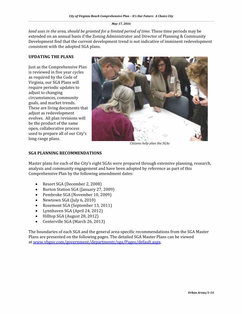
land uses in the area, should be granted for a limited period of time. These time periods may be extended on an annual basis if the Zoning Administrator and Director of Planning & Community Development find that the current development trend is not indicative of imminent redevelopment consistent with the adopted SGA plans. UPDATING THE PLANS Just as the Comprehensive Plan is reviewed in five year cycles as required by the Code of Virginia, our SGA Plans will require periodic updates to adjust to changing circumstances, community goals, and market trends. These are living documents that adjust as redevelopment evolves. All plan revisions will be the product of the same open, collaborative process used to prepare all of our City’s long range plans.
SGA PLANNING RECOMMENDATIONS Master plans for each of the City’s eight SGAs were prepared through extensive planning, research, analysis and community engagement and have been adopted by reference as part of this Comprehensive Plan by the following amendment dates:
• Resort SGA (December 2, 2008) • Burton Station SGA (January 27, 2009) • Pembroke SGA (November 10, 2009) • Newtown SGA (July 6, 2010) • Rosemont SGA (September 13, 2011) • Lynnhaven SGA (April 24, 2012) • Hilltop SGA (August 28, 2012) • Centerville SGA (March 26, 2013)
The boundaries of each SGA and the general area-specific recommendations from the SGA Master Plans are presented on the following pages. The detailed SGA Master Plans can be viewed at www.vbgov.com/government/departments/sga/Pages/default.aspx.
Citizens help plan the SGAs
City of Virginia Beach Comprehensive Plan – It’s Our Future: A Choice City
May 17, 2016
Urban Areas/1-15
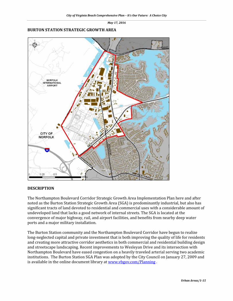
BURTON STATION STRATEGIC GROWTH AREA
DESCRIPTION The Northampton Boulevard Corridor Strategic Growth Area Implementation Plan here and after noted as the Burton Station Strategic Growth Area (SGA) is predominantly industrial, but also has significant tracts of land devoted to residential and commercial uses with a considerable amount of undeveloped land that lacks a good network of internal streets. The SGA is located at the convergence of major highway, rail, and airport facilities, and benefits from nearby deep water ports and a major military installation. The Burton Station community and the Northampton Boulevard Corridor have begun to realize long-neglected capital and private investment that is both improving the quality of life for residents and creating more attractive corridor aesthetics in both commercial and residential building design and streetscape landscaping. Recent improvements to Wesleyan Drive and its intersection with Northampton Boulevard have eased congestion on a heavily traveled arterial serving two academic institutions. The Burton Station SGA Plan was adopted by the City Council on January 27, 2009 and is available in the online document library at www.vbgov.com/Planning .
City of Virginia Beach Comprehensive Plan – It’s Our Future: A Choice City
May 17, 2016
Urban Areas/1-16
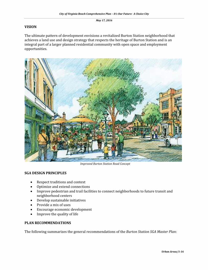
VISION The ultimate pattern of development envisions a revitalized Burton Station neighborhood that achieves a land use and design strategy that respects the heritage of Burton Station and is an integral part of a larger planned residential community with open space and employment opportunities.
SGA DESIGN PRINCIPLES
• Respect traditions and context • Optimize and extend connections • Improve pedestrian and trail facilities to connect neighborhoods to future transit and
neighborhood centers • Develop sustainable initiatives • Provide a mix of uses • Encourage economic development • Improve the quality of life
PLAN RECOMMENDATIONS The following summarizes the general recommendations of the Burton Station SGA Master Plan:
Improved Burton Station Road Concept

City of Virginia Beach Comprehensive Plan – It’s Our Future: A Choice City
May 17, 2016
Urban Areas/1-17
• Respect and retain the existing houses in the neighborhood along Burton Station Road and maintain the low density character of this neighborhood.
• Provide infrastructure including roads, utilities, and stormwater facilities needed to support existing residential and planned land uses within this SGA.
• Work with the City of Norfolk to achieve a mutually beneficial exchange of land when possible.
• Implement, where feasible, the arrangement of land uses as outlined in the SGA Plan to achieve an attractive, coherent, and marketable destination.
• Improve the design and function of Northampton Boulevard to improve pedestrian and transit access, and create a high quality first impression for this area.
• Provide significant areas devoted to recreational and open space amenities. • Leverage the economic growth potential of this area that is provided, in part, by the
presence of multimodal transportation systems. PLAN IMPLEMENTATION STRATEGIES Key plan recommendations for implementation: the core of the study area, focused around Burton Station Road, commercial development along the Northampton Boulevard – Diamond Springs Road corridor, and infrastructure improvements and potential expansion of the Airport Industrial Park.
Recommended Action Plan
• A Capital Improvement Project (CIP) for utility and roadway improvements to existing Burton Station Road. Improvements include sewer, city water, lighting, curb and gutter, and sidewalks.
• CIP to expand upon the improvements made to Wesleyan Drive on the north side of Northampton Boulevard.
Northampton Boulevard corridor redevelopment concept

City of Virginia Beach Comprehensive Plan – It’s Our Future: A Choice City
May 17, 2016
Urban Areas/1-18
Burton Station "Main Street" retail corridor concept
• Workshops between land owners and developers to educate them on rezoning and redevelopment opportunities.
• Optimize development of mixed-use and or retail parcels in Virginia Beach at the Northampton Wesleyan intersection.
• To facilitate plan implementation, an application for rezoning or zoning overlay should be created.
• CIP for Northampton/Diamond Springs Intersection Improvements to redesign the western side of the intersection.
• Airport Industrial Park road improvements, such as Barrs Road, to establish a front door to development opportunity for the Airport Industrial Park, allowing more direct access to the airport with additional roads to increase connectivity within the industrial park.
• Seek opportunities for redevelopment of the Airport Industrial Park to provide supporting uses to align with the Amphibious Base development. Extending Barrs Road into the port property would provide greater opportunity for substantial development.
• Revisions to certain areas of the Burton Station SGA Master Plan may be required in order to set the proper framework to accomplish many of the recommended actions outlined above.
Programmed and Funded Capital Improvement Projects (CIPs)
• 7-036000 - Baker Road Culvert & Ditch Improvements. This project will address roadway/property flooding through design and construction to upgrade existing pipe/drainage system from Baker Road to Diamond Springs Road, north of Northampton Boulevard, to minimize roadway/property flooding.
• 9-081000 - Strategic Growth Area Projects, Burton Station Village Phase I. Property acquisition and drainage improvements.
• 9-085000 - Burton Station Road Improvements, Phase II. This project will provide basic and long needed utility services and standard roadway improvements including curb and gutter,

City of Virginia Beach Comprehensive Plan – It’s Our Future: A Choice City
May 17, 2016
Urban Areas/1-19
Burton Station SGA Master Plan - Conceptual Plan
sidewalk, and streetlights necessary to preserve and revitalize the existing residential community consistent with the phasing and implementation goals of the adopted SGA Plan.
• 9-091000 - Burton Station Road Improvements, Phase III. The purpose of this project is to provide a connection between Burton Station Road and Air Rail Drive via an extension of Tolliver Road to provide infrastructure necessary to promote future development consistent with the SGA Plan.
AGENDA FOR FUTURE ACTION RECOMMENDATIONS:
• Update the Burton Station SGA Master Plan through a public process to reflect changes to the foundational assumptions that guided the development of the Burton Station SGA plan, particularly the extensive changes affecting future land use throughout the western half of the SGA.
For detailed Burton Station SGA Master Plan recommendations and information visit the online document library at www.vbgov.com/Planning.
City of Virginia Beach Comprehensive Plan – It’s Our Future: A Choice City
May 17, 2016
Urban Areas/1-20
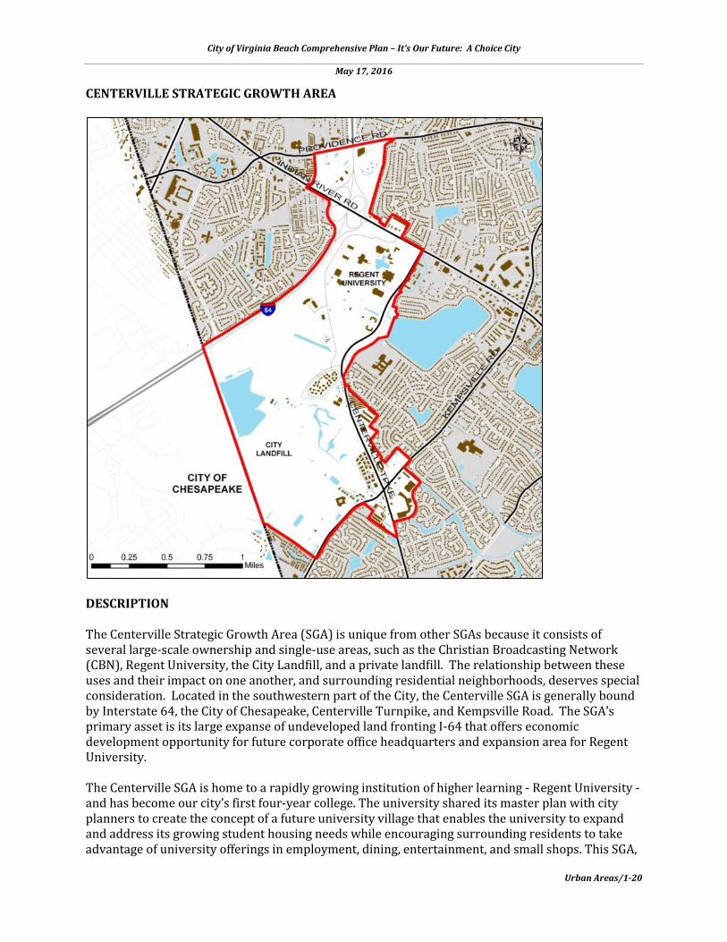
CENTERVILLE STRATEGIC GROWTH AREA
DESCRIPTION The Centerville Strategic Growth Area (SGA) is unique from other SGAs because it consists of several large-scale ownership and single-use areas, such as the Christian Broadcasting Network (CBN), Regent University, the City Landfill, and a private landfill. The relationship between these uses and their impact on one another, and surrounding residential neighborhoods, deserves special consideration. Located in the southwestern part of the City, the Centerville SGA is generally bound by Interstate 64, the City of Chesapeake, Centerville Turnpike, and Kempsville Road. The SGA’s primary asset is its large expanse of undeveloped land fronting I-64 that offers economic development opportunity for future corporate office headquarters and expansion area for Regent University. The Centerville SGA is home to a rapidly growing institution of higher learning - Regent University - and has become our city’s first four-year college. The university shared its master plan with city planners to create the concept of a future university village that enables the university to expand and address its growing student housing needs while encouraging surrounding residents to take advantage of university offerings in employment, dining, entertainment, and small shops. This SGA,

City of Virginia Beach Comprehensive Plan – It’s Our Future: A Choice City
May 17, 2016
Urban Areas/1-21
Concept for Regent University Quad
due to its lack of environmental constraints, affords an opportunity for significant economic development adjacent to the Interstate and a home to future Class A office space of a design that continues the architectural themes found on the campus. While the municipal landfill at the western edge of the SGA will continue to operate until it reaches capacity, the SGA plan envisions a new district park once it is closed that is modeled after the City’s beloved and well-used Mt. Trashmore Park. The Centerville SGA Master Plan was adopted by the City Council on March 26, 2013 and is available in the online document library at www.vbgov.com/Planning. VISION The vision for the Centerville SGA is to become an education-oriented master-planned community, which capitalizes on the regional access and visibility provided by I-64, and the existing institutional anchors of CBN and Regent University. The Plan envisions a mixed-use central village with connected trails to campus life, diverse neighborhoods, office, retail, and open space. SGA DESIGN PRINCIPLES
• Regenerate existing development areas to capitalize on existing public infrastructure investments.
• Build a mixed-use center for Centerville. • Better connect to existing parks and the Regent University campus through expanded trail
networks.

City of Virginia Beach Comprehensive Plan – It’s Our Future: A Choice City
May 17, 2016
Urban Areas/1-22
• Improve pedestrian and trail facilities to connect neighborhoods to future transit and neighborhood centers.
• Mitigate impacts to the Elizabeth River through stormwater best management practices. • Continue to diversify housing choice, including workforce housing. • Improve the jobs/housing balance to increase capture rate and decrease traffic congestion. • Identify immediate and interim actions for the landfills to effectively mitigate against
adverse impacts. • Pursue a joint planning strategy with the City of Chesapeake. • Build a transportation infrastructure network that provides for safety, equity, choice, and
economy. • Create an education-oriented, master-planned community as a unique identity for the
Centerville SGA. PLAN RECOMMENDATIONS The following summarizes the general recommendations of the Centerville SGA Master Plan:
• Establish a multi-modal circulation structure to connect Regent University within itself and to surrounding neighborhoods and the regional transportation network.
• Preserve the existing character of the campus by placing buildings around quad spaces. • Create new parks and open space systems to serve the University’s students and faculty. • Build a diversity of housing types to create a vibrant, authentic, and inclusive place. • Mix residential with retail uses. • Integrate a variety of natural and designed open space types. • Buildings should front the streets with parking primarily located behind in shared facilities. • Provide a 50-100 ft. buffer between development and I-64. • Connect the Regent campus and residential areas through a street and trail network. • Incorporate three to five-story suburban office development in the corporate office area. • Develop shared sports facilities with the university. • Take advantage of the proximity to highway location through improved street frontage. • Continue the residential character of the surrounding area with the Brandon neighborhood
expansion. PLAN IMPLEMENTATION STRATEGIES The Centerville SGA Plan builds on the momentum generated by the impending road expansion investments to stitch together a cohesive University district that initiates private development and redevelopment of individual parcels using the general street framework suggested by the Master Plan. Recommended Action Plan
• Update zoning regulations based on the SGA plan recommendations. • Implement Centerville’s portion of the City-wide trail system as roads and streets are
rebuilt. • Develop a comprehensive stormwater management strategy. • Provide development standards for frontage landscape, parking lot design, street
furnishings, exterior signage, storefronts, and lighting. • Implement the following key infrastructure improvements:

City of Virginia Beach Comprehensive Plan – It’s Our Future: A Choice City
May 17, 2016
Urban Areas/1-23
o New Kempsville Road and Indian River Road intersection o Expansion of Centerville Turnpike and Indian River Road intersection o Widening of Centerville Turnpike from Indian River Road to Kempsville Road o Completion of Lynnhaven Parkway o Widening of Centerville Turnpike from Kempsville Road to City line o Realign entry into landfills and stabilize the slopes of Cell 1 o Extension of the River Birch Run to connect to Centerville Turnpike o Completion of green network to Indian River Park along River Birch Run extension o Neighborhood park at back of Woods Corner Shopping Center o Landfill/waste management facility buffers and stormwater management south and
west of Centerville Turnpike o Regional stormwater management system o I-64 Interchange
Programmed and Funded Capital Improvement Projects (CIPs)
• 2-409000 - Centerville Turnpike – Phase II. This project addresses congestion in the Centerville area. This project is for the construction of a four-lane divided highway within a 130 foot right-of-way from Indian River Road to Kempsville Road, a distance of 1.85 miles. This project will provide improvements at the Indian River Road intersection, including triple left turn lanes onto Indian River Road from Centerville Turnpike. This project will include a four lane divided highway, sidewalk, on-street bicycle facilities, and landscaping.
• 2-093000 – Buses for Virginia Beach Transit Extension. This project funds 12 transit buses to support enhanced public transportation throughout the City in addition to feeding “The Tide” light rail system. With the extension of The Tide, there is a new bus route which will serve the Centerville SGA as it would extend north/south between the new Witchduck Light Rail Station to Greenbrier Mall area by way of Witchduck Road and Kempsville Road.
• 3-047000 – Landfill #2 Phase 1 Capping – The Phase 1 landfill cell is near capacity. Capping of completed landfill cells is required as part of the Virginia Solid Waste Permit #398.
Proposed “University Village” main street concept

City of Virginia Beach Comprehensive Plan – It’s Our Future: A Choice City
May 17, 2016
Urban Areas/1-24
For detailed Centerville SGA Master Plan recommendations and information visit the online document library at www.vbgov.com/Planning .
Centerville SGA Master Plan - Conceptual Plan

City of Virginia Beach Comprehensive Plan – It’s Our Future: A Choice City
May 17, 2016
Urban Areas/1-25
NEWTOWN STRATEGIC GROWTH AREA
DESCRIPTION The Newtown Strategic Growth Area is a western gateway to the City of Virginia Beach and is bisected by I-264. The future pattern of growth for Newtown and Pembroke are deemed to complement one another. Much of the area is developed with low to mid-rise structures representing a mix of office and light industrial uses of varying quality. There are a number of undeveloped and underdeveloped properties located throughout this SGA. The easternmost transit stop on the Hampton Roads Transit Light Rail system, that serves Norfolk, is immediately west of this SGA. This transit stop is conveniently located for much of the Newtown SGA and will enable the redevelopment of the area as a transit-oriented district. The Newtown SGA sits at the eastern terminus of the first segment of the region’s light rail transit system, The Tide, with service only in Norfolk at present. In a landmark decision in 2015, City Council voted to continue developing plans to extend The Tide to Town Center through the Newtown SGA. Newtown’s proximity to Town Center has the potential to echo the Town Center’s vibrancy but at an appropriate scale and density adjacent to established residential neighborhoods.

City of Virginia Beach Comprehensive Plan – It’s Our Future: A Choice City
May 17, 2016
Urban Areas/1-26
Historic Kempsville sits to the south of Newtown and is transforming into a mixed-use Suburban Focus Area that seeks to have a character reminiscent of Colonial Williamsburg, offering small shops and new housing choices. Intensive road and public space improvements have saddled its main intersection at Witchduck and Princess Anne Roads for a number of years, but private investment has begun as a result of these public investments. The Newtown SGA Master Plan was adopted by the City Council on July 6, 2010 and is available in the online document library at www.vbgov.com/Planning . VISION The Newtown SGA Plan envisions land uses transitioning over time to reflect increased land values achieved by improved access and proximity to the light rail station in Norfolk. A new mixed-use district will emerge with a village center, state of the art business parks, an educational campus, and new residential neighborhoods integrated with workforce housing. SGA DESIGN PRINCIPLES
• Mixed-Use and Commercial Buildings – These buildings are focused around Princess Anne Road and Southern Boulevard, proximate to the transit corridor. These buildings should be placed close to the street to promote a pedestrian environment and range from two to five stories in height.
• Office and Institutional Campus Buildings – The Newtown SGA’s location and access make it a premier office and institutional address. The office and institutional buildings that locate here should set a new standard in environmental quality, both in building technology and the indoor and outdoor spaces they create. In many cases, these buildings are located along water or other open space.
• Multi-Family Residential Buildings - With the planned improvements to both vehicular and mass transit options, multi-family housing will be an important component to the spectrum of housing offered. Apartments and condominiums will largely be three and four stories in height.
Proposed Southern Boulevard commercial and mixed-use redevelopment concept

City of Virginia Beach Comprehensive Plan – It’s Our Future: A Choice City
May 17, 2016
Urban Areas/1-27
• Single-Family Residences – Newtown is proximate to many residential neighborhoods. The Plan seeks to stitch these neighborhoods together with additional single-family detached and attached housing.
• Parking Garages – The increased land values coming from the envisioned transit corridor and improvements to I-264 will make structured parking a viable and necessary component to development. These structures should be easy to access but screened architecturally with façade treatments and buildings, where possible.
• Improve pedestrian and trail facilities to connect neighborhoods to future transit and neighborhood centers.
PLAN RECOMMENDATIONS The following summarizes the general recommendations of the Newtown SGA Master Plan:
• Reinforce the Newtown site as a “Gateway” into Virginia Beach. • Create interconnected pedestrian and street frameworks. • Build parks and open spaces throughout the site. • Build mixed-use, mixed-income, transit-oriented development. • Strengthen education and training institutions in the district. • Build at a compatible scale next to existing neighborhoods. • Extend a bicycle and trail system through the site. • Position light rail station as a centerpiece in a gateway public space. • Develop a shared parking strategy. • Coordinate transportation improvements including Light Rail, Newtown Road, the
Greenwich/Cleveland Flyover, and I-264 access/widening. • Develop design guidelines for the district.
PLAN IMPLEMENTATION STRATEGIES The Newtown SGA Master Plan transforms underutilized commercial property into a series of mixed-use development opportunities and public infrastructure improvements. A new street framework and block structure provides the access and visibility necessary to consider redevelopment at higher densities. The old commercial properties will be transformed into a new mixed-use center, state of the art business parks, an educational campus, new light industrial space, and new residential neighborhoods. Recommended Action Plan
• Revise zoning code to regulate building form and update permitted uses. • Develop design guidelines for the district. • Install district directional signs on expressway and other major roads leading into the
planning area. • Install signs or community logo in strategic entry locations in order to develop a distinct
sense of arrival to the district. • Develop a shared parking strategy. • Prepare an overall drainage master plan. • Create an interconnected pedestrian, trail and street framework. • Build parks and open spaces throughout the SGA. • Improve Newtown Road and Princess Anne Road with sidewalks and lane adjustments.
City of Virginia Beach Comprehensive Plan – It’s Our Future: A Choice City
May 17, 2016
Urban Areas/1-28
• Redirect Greenwich Road to a new flyover to connect Cleveland Street north of I-264 and cul-de-sac the remainder of the road at the Lake.
• Extend Business Park Drive to create a loop to improve access to the business park. • Establish a new street network to form a new mixed-use center. • Build new residential streets in the old Arrowhead Industrial Park to create new
development blocks. Since the adoption of the Newtown SGA Master Plan City Council has taken two actions in support of light rail which significantly impact the Newtown SGA Master Plan:
• Adopted a resolution favoring the extension of light rail 3.2 miles from the Newtown Road Station in Norfolk to Virginia Beach Town Center. The extension would include a new station at Witchduck Road and two stations in the Town Center area – one near Kellam Road and one at Constitution Drive. This is called the Locally Preferred Alternative.
• Adopted a budget that includes plans to extend light rail to Town Center, with plans to double the city’s bus service, build a walking-biking trail alongside the light rail, and build over 20 new bus shelters.
Based on these actions, a Transit-Oriented Development (TOD) implementation strategy should be developed through a public process for an implementation focus on development and redevelopment areas within one-half mile of the planned light rail stations. Programmed and Funded Capital Improvement Projects (CIPs)
• 9-081000 – Strategic Growth Area Projects – This project will provide planning and design services, build or replace public infrastructure improvements, and acquire property as needed in order to support implementation of the eight SGAs.
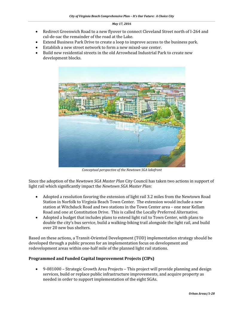
Conceptual perspective of the Newtown SGA lakefront
City of Virginia Beach Comprehensive Plan – It’s Our Future: A Choice City
May 17, 2016
Urban Areas/1-29
• 2-092000 – Virginia Beach Transit Extension Project – This is a design-build project to extend light rail fixed guideway transit, “The Tide,” from its terminus at the Newtown Station/Norfolk-Virginia Beach City line, east to Town Center at Constitution Drive.
• 2-093000 – Buses for Virginia Beach Transit Extension – This project funds 12 transit buses to support enhanced public transportation throughout the City in addition to feeding “The Tide” light rail system.
• 2-108000 – Light Rail Corridor Shared Use Pathway – This project will fund the design, construction, right-of-way acquisition and site furnishings required to create a shared-use pathway within and /or along the former Norfolk-Southern right-of-way in conjunction with the light rail extension project to provide additional modes of transportation.
For detailed Newtown SGA Master Plan recommendations and information visit the online document library at www.vbgov.com/Planning.
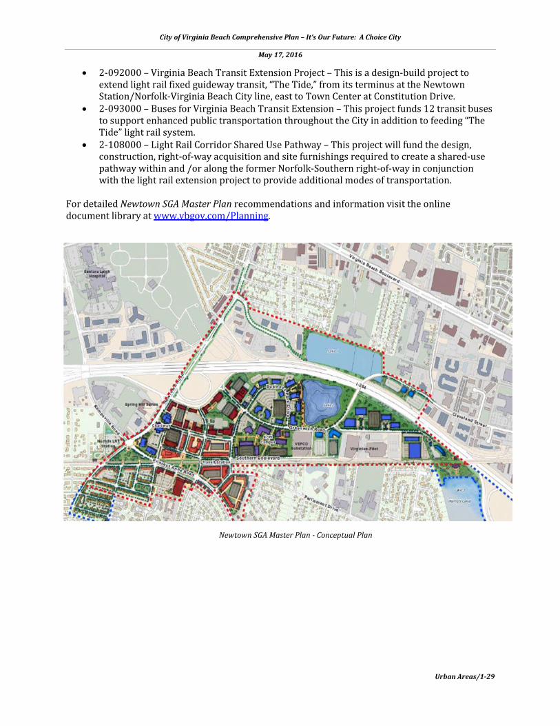
Newtown SGA Master Plan - Conceptual Plan

City of Virginia Beach Comprehensive Plan – It’s Our Future: A Choice City
May 17, 2016
Urban Areas/1-30
PEMBROKE STRATEGIC GROWTH AREA
DESCRIPTION The Pembroke Strategic Growth Area (SGA) is a 1,200 acre tract of land located in the heart of the City, generally bound by Thalia Creek to the east, Jeanne and Broad Streets to the north, Clearfield Avenue to the west and Bonney and Baxter Roads to the south. For the most part, this SGA reflects a classic suburban pattern of development. It includes some residential and institutional uses, but is dominated by commercial and industrial uses. An exception is Town Center. This vibrant, mixed-use urban center has established itself as a special destination within Virginia Beach and the larger metropolitan area. It is a well-designed urban center with a complement of office, retail, residential, educational, entertainment, cultural, restaurant, open spaces, and other uses. This SGA is served by Interstate 264 and two major arterial roadways, Virginia Beach Boulevard and Independence Boulevard. An unused rail line passes through extending from the Norfolk city line to the vicinity of the Oceanfront Resort Area. Pembroke has become the City’s “Town Center” providing a much desired sense of place central to the city. In just the past 15 years, an iconic skyline has emerged that offers an exciting new
City of Virginia Beach Comprehensive Plan – It’s Our Future: A Choice City
May 17, 2016
Urban Areas/1-31
residential, employment, shopping, and entertainment address. The City’s oldest shopping mall, Pembroke Mall, has received a facelift, and the Virginia Beach Boulevard corridor that was formerly dominated by the automobile now enables pedestrians to travel safely between the two destinations within Town Center. The arts scene thrives at the Sandler Center, showcasing both celebrity and local talent year-round, and an increasing number of outdoor festivals and events offer free entertainment in every season. The Pembroke Strategic Growth Area 4 Implementation Plan was adopted by the City Council on November 10, 2009 and is available in the online document library at www.vbgov.com/Planning. VISION The vision for the Pembroke SGA 4 is a central urban core with a vertical mix of uses, great streets, mobility and transit alternatives, gathering places, environmental and neighborhood protection, green buildings and infrastructure opportunities providing a variety of civic, commercial, artistic and ethnically diverse areas. The Master Plan describes and provides planning policies for six subareas or districts with each district having its own unique characteristics. These districts include:
• Central Business District (CBD) Core Area – the main business, cultural, and arts center of the Pembroke SGA;
• CBD Bonney Area – a mixed-use office, commercial, residential, and hospitality area to complement the adjacent;
• CBD Waterfront District – located along Thalia Creek combining the surrounding natural environment with recreational and cultural amenities;
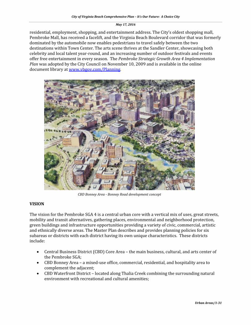
CBD Bonney Area - Bonney Road development concept
City of Virginia Beach Comprehensive Plan – It’s Our Future: A Choice City
May 17, 2016
Urban Areas/1-32
• Central Village District – draws from a plethora of activities, interests, and a variety of housing options, all woven into an eclectic neighborhood supporting small business and entertainment venues;
• Western Campus District – a park-like academic and recreational setting that showcases a pedestrian-friendly area; and,
• Southern Corporate District – an urban corporate village defined by unique eye catching office buildings with planned greenways.
This framework concentrates a high density mix of complementary urban uses within a defined central area, creates a skyline for Virginia Beach and provides for decreasing land use densities from the core. Each of these Districts is described in detail in the Pembroke SGA Master Plan. SGA DESIGN PRINCIPLES
• Efficient Use of Land Resources • Full Use of Urban Services • Compatible Mix of Uses • Improve pedestrian and trail facilities to connect neighborhoods to future transit and
neighborhood centers • Transportation Opportunities • Detailed Human Scale Design • Environmental Stewardship
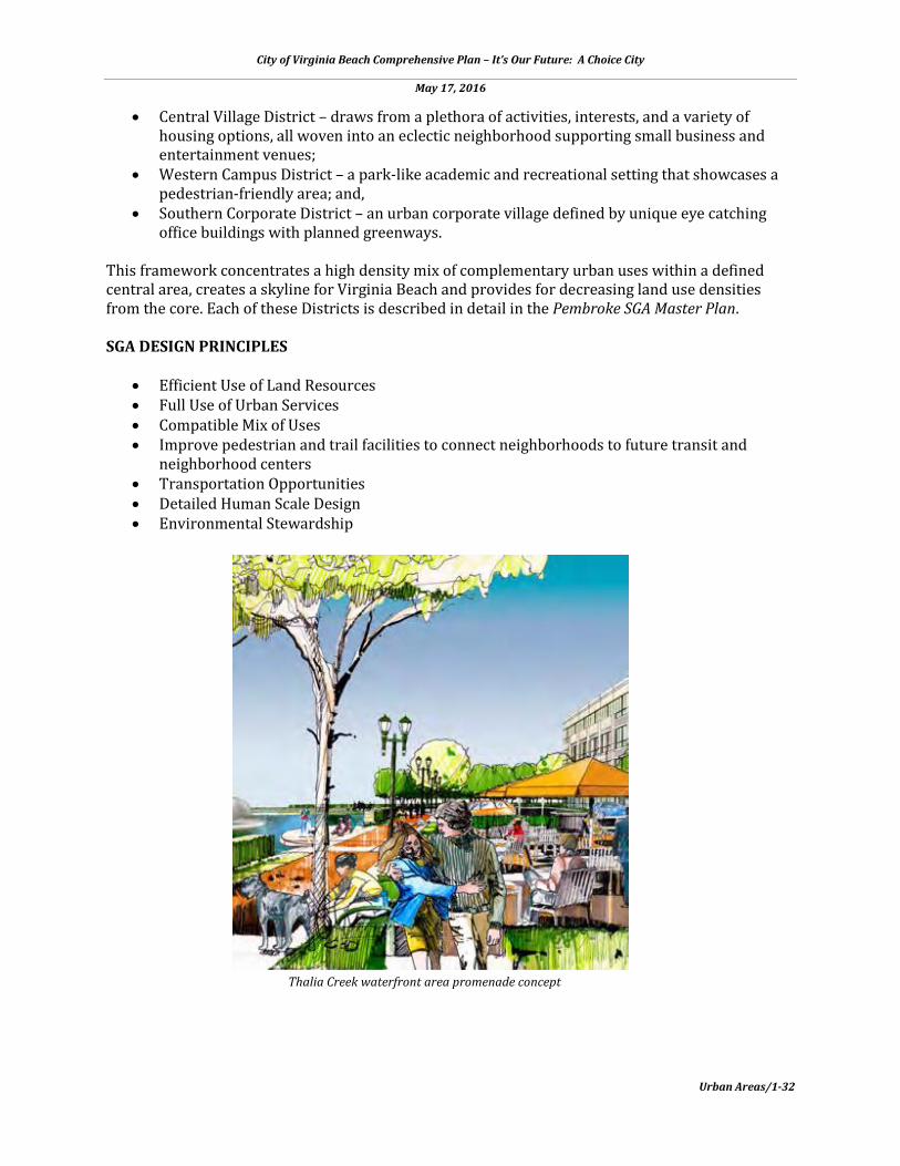
Thalia Creek waterfront area promenade concept

City of Virginia Beach Comprehensive Plan – It’s Our Future: A Choice City
May 17, 2016
Urban Areas/1-33
PLAN RECOMMENDATIONS The following summarizes the general recommendations of the Pembroke SGA Master Plan:
• Implement transit-oriented development around planned transit stations • Establish policies for developing affordable housing/workforce housing • Tailor a Form-Based Code for each district • Establish a Cultural Arts District in the Core Area • Expand the Pembroke SGA to include Mount Trashmore Park and the South Independence
Commercial corridor • Design and build the entire length of Cleveland Street to Greenwich Road as a ‘Complete
Street’ to be an attractive and efficient thoroughfare serving many modes of travel • Develop a public facilities strategy for City-owned lands, considering recreation, library,
museum, theatres, education, smaller spaces for visual and performing artists, and other uses
PLAN IMPLEMENTATION STRATEGIES The Pembroke SGA is located at the major intersection of the primary transportation corridors at a central position of the City’s developed area, which presents a unique opportunity for the creation of a world class regional downtown. As the City moves forward and the Pembroke SGA’s 1,200 acres continue to redevelop, future planning efforts will need to consider the proposed urban systems on a site-specific level to ensure that the larger goals of the plan will produce a modern metropolitan center. Western District urban open space concept

City of Virginia Beach Comprehensive Plan – It’s Our Future: A Choice City
May 17, 2016
Urban Areas/1-34
Recommended Action Plan
• Implement EMS, fire, and police urban policies and strategies • Install district directional signs on Expressway and other major roads leading into the
planning areas. Install signs or community logo in strategic entry locations in order to develop a distinct sense of arrival to the district.
• Develop a utility framework and urban policies for development of the utilities • Develop a parking strategy/structured parking • Develop a public facilities strategy within City owned lands, recreation, and libraries • Develop an open space/park policy • Develop an urban plan with Virginia Beach Public Schools for Princess Anne High School • Build two additional crossing of I-264, one east and one west of the Independence
Boulevard interchange • Improve Cleveland Street • Extend Market Street • Implement the Thalia Creek open space plan – bike paths, walking paths and parks • Develop designs for Cleveland Street improvements and a connection to Greenwich Road • Start land acquisitions for City properties to be used as parks and open space • Pursue the creation of Lynnhaven Landing in coordination with the Lynnhaven Ecosystem
Project • Develop a “Brand Name” for the SGA District
Since the adoption of the Pembroke SGA 4 Master Plan City Council has taken actions in support of light rail which significantly impact the Pembroke SGA Master Plan:
• Adopted a resolution favoring the extension of light rail 3.2 miles from the Newtown Road Station in Norfolk to Virginia Beach Town Center. The extension would include a new station at Witchduck Road and two stations in the Town Center area – one near Kellam Road and one at Constitution Drive. This is called the Locally Preferred Alternative.
• Adopted the below-listed CIP projects, including the light rail corridor shared-use pathway to provide opportunities for enhanced multi-modal mobility throughout the east-west corridors of the Newtown and Pembroke SGAs as well as nearby established neighborhoods.
• Adopted a budget that includes plans to extend light rail to Town Center, with plans to double the city’s bus service, build a walking-biking trail alongside the light rail, and build over 20 new bus shelters.
Based on these actions, a Transit-Oriented Development (TOD) implementation strategy should be developed through a public process for an implementation focus on development and redevelopment areas within one-half mile of the planned light rail stations. Programmed and Funded Capital Improvement Projects (CIPs)
• 1-107000 - Princess Anne High School Replacement. Originally built in 1954, the high school can no longer adequately house the required instructional programs, and the facility is in need of replacement.
• 2-025000 – Witchduck Road - Phase II. This project will provide a six-lane divided roadway on a 143-foot to 165-foot variable width right-of-way from I-264 to Virginia Beach Boulevard. The project will include improvements and modifications to Pennsylvania
City of Virginia Beach Comprehensive Plan – It’s Our Future: A Choice City
May 17, 2016
Urban Areas/1-35
Avenue, Mac Street, Southern Boulevard, Cleveland Street, and Admiral Wright Road at Den Lane. Aesthetic improvements include 16-foot benches comprised of 8-foot wide concrete sidewalks and 8-foot wide brick pavers
• 2—092000 – Virginia Beach Transit Extension Project. This is a design-build project to extend light rail fixed guideway transit, “The Tide”, from its terminus at the Newtown Station/Norfolk-Virginia Beach City line, east to Town Center at Constitution Drive.
• 2-093000 – Buses for Virginia Beach Transit Extension. This project funds 12 transit buses to support enhanced public transportation throughout the City in addition to feeding “The Tide” light rail system. The Constitution Drive Light Rail Station will serve as a major transfer point for both bus transit, park and ride for motor vehicles and on-demand shared transportation (i.e. taxis, Uber, etc.) and pedestrians and bicyclists.
• 2-108000 – Light Rail Corridor Shared Use Pathway. This project will fund the design, construction, right-of-way acquisition and site furnishings required to create a shared-use pathway within and /or along the former Norfolk-Southern right-of-way in conjunction with the light rail extension project to provide additional modes of transportation.
• 2-401000 – Greenwich Rd Crossover & Cleveland St. Improvements. This project is part of the overall eastbound VDOT I-264 interstate improvement projects between I-64 and the Witchduck Rd. interchange. This project will be designed and constructed in three phases.
• 3-503000 – Housing Resource Center. This project is to construct an approximately 62,000 square foot Housing Resource Center that will provide shelter and services to homeless persons and those at risk of homelessness. It will include a central intake and assessment function that will be critical to achieving the goals of the Strategic Plan to End Homelessness.
• 4-079000 – Thalia Creek Greenway I. This project will fund the design and construction of the boardwalk and trail facilities outlined in the greenway corridor of the Thalia Creek Greenway Master Plan. This project is a unique initiative to develop an urban greenway that will provide access to natural open space and recreational activities in the Town Center area, while also providing an alternative transportation route.
• 4-522000 – Thalia Creek Greenway Trail Grant. A master plan for Thalia Creek greenway was completed in April 2007. Phase 1 of the greenway runs from Independence Boulevard around Town Center to Virginia Beach Boulevard with another leg running toward I-264. Phase 1 is divided into four sections 1A, 1B, 1C, and 1D. This project was selected by VDOT to receive Transportation Enhancements Program funds, June 2012. This project is for the construction of a portion of Phase 1A, approximately 1,200 linear feet of paved trail and raised boardwalk to connect from Independence Boulevard to the City-owned property at 4560 Bonney Road.
• 5-028000 – Witchduck Road Phase II Water Improvements. This project provides funds to improve existing water facilities along Witchduck Road from the Cleveland Street intersection to Virginia Beach Boulevard.
• 6-604000 – Witchduck Road Phase II Sewer. This project provides funding to improve existing sewer facilities along Witchduck Road from the I-264 intersection to Virginia Beach Boulevard.
• 9-083000 – Town Center Garage and Plaza Capital Maintenance. This project provides funding necessary for the equipment, capital maintenance, repairs, replacements, improvements, as well as planning, design, and engineering services for the five Town Center garages and the fountain plaza.
• 9-081000 – Strategic Growth Area Projects. This project will provide planning and design services, build or replace public infrastructure improvements, and acquire property as needed in order to support implementation of the eights SGAs.

City of Virginia Beach Comprehensive Plan – It’s Our Future: A Choice City
May 17, 2016
Urban Areas/1-36
AGENDA FOR FUTURE ACTION RECOMMENDATIONS: Pembroke SGA 4
• Prepare a Master Transportation Plan for the Pembroke SGA using a public process that
involves the adjacent neighborhoods. For detailed Pembroke SGA Master Plan recommendations and information visit the online document library at www.vbgov.com/Planning.
Pembroke SGA Master Plan - Conceptual Plan

City of Virginia Beach Comprehensive Plan – It’s Our Future: A Choice City
May 17, 2016
Urban Areas/1-37
ROSEMONT STRATEGIC GROWTH AREA
DESCRIPTION The Rosemont Strategic Growth Area is a 158-acre area located in the center of the city, east of the Pembroke SGA along the I-264/Virginia Beach Boulevard corridor. It is defined by a heavily used roadway system that is further complicated by the confluence of a railroad crossing and an interchange ramp system in proximity to one another. The land use of this area is characterized by suburban strip commercial and multifamily residential uses along Virginia Beach Boulevard and generally encompassed by established single family neighborhoods. However, like Newtown, Rosemont’s future growth patterns are deemed to compliment the Pembroke land use. The Rosemont SGA, which lies immediately east of Pembroke SGA and the Town Center is planned to be a transit-oriented residential community for those who desire to live near Town Center but not in it. Transit extension is necessary for this vision to be fully realized, but commercial property owners already see that potential and have begun to make improvements to attract new shoppers and enhance the shopping experience for existing customers. The Rosemont Strategic Growth Area

City of Virginia Beach Comprehensive Plan – It’s Our Future: A Choice City
May 17, 2016
Urban Areas/1-38
Master Plan was adopted by the City Council on September 13, 2011 and is available in the online document library at www.vbgov.com/Planning. VISION The vision for the Rosemont SGA is a mixed-use development with a neighborhood center and improved pedestrian and trail facilities, with a street and block structure created to accommodate development and mobility. The Rosemont SGA will be a leading example of sustainable development practices, integrating high quality well designed workforce housing with guidelines and standards for land use, streets and open spaces. SGA DESIGN PRINCIPLES
• Transition from strip commercial uses to mixed-use, mixed-income development that emphasizes townhouses and multi-family residential
• Create a new neighborhood center for Rosemont • Improve pedestrian and trail facilities to connect neighborhoods to future transit and
neighborhood centers • Create a new street and block structure to accommodate development and improve
mobility • Require sustainable development practices • Develop a set of design guidelines and standards for development of proper land use,
streets, open spaces, and stormwater management • Integrate well designed and high quality workforce housing into mixed-use development
Rosemont SGA - Neighborhood Center “Village Green”

City of Virginia Beach Comprehensive Plan – It’s Our Future: A Choice City
May 17, 2016
Urban Areas/1-39
PLAN RECOMMENDATIONS The following summarizes the general recommendations of the Rosemont SGA Master Plan:
• Create an implementable series of private and public projects that can be packaged together to transform, over time, the heart of the city.
• Install district directional signs on Expressway and other major roads leading into the panning area. Install signs or community logo in strategic entry locations in order to develop a distinct sense of arrival to the district.
• Design to a “transit ready” framework that permits adequate scale and density, coupled with successive phasing of public investment to unlock a corresponding return on investment.
• Promote redevelopment through building the Sentara Way fly-over and other new connections within the SGA, supporting potential development, and improvements along South Plaza Trail.
• No industrial uses are recommended for this area. • Introduce the residential neighborhoods south of Virginia Beach Boulevard by realigning
Bonney Road, creating more regular development blocks to allow for higher density development, organized around parking garages and liner buildings.
• Establish criteria to humanize Virginia Beach Boulevard. Along the boulevard will be the new development of a village core, with surrounding lower-density residential neighborhoods to support the commercial uses and transit options that are being introduced.
PLAN IMPLEMENTATION STRATEGIES With improved connectivity and mobility, the Rosemont SGA will transition from an auto-oriented retail strip to a mixed-use transit-oriented neighborhood center at higher densities. Market potential created by the introduction of transit and human-scaling of infrastructure suggests the idea of commercial development to serve the needs of a growing population, and the introduction of multi-family housing within easy walking distance to transit and neighborhood amenities. Recommended Action Plan
• Update zoning regulations based on the SGA plan recommendations. • Develop a comprehensive stormwater management strategy. • Develop a comprehensive open space/park policy strategy. • Create a set of design standards for arterial and local streets within the SGA. • Sentara Way Fly Over creates a secondary street and pedestrian network off of Rosemont
and Virginia Beach Boulevard connecting Sentara Way south of I-264 to just west of Butternut Lane.
• South Plaza Trail north-south connection under I-264 will align with the rest of the Trail as it continues southbound. Discourages non-local traffic.
• Bonney Road Realignment is an incremental approach to realign Bonney Road to create full development sites between Virginia Beach Boulevard and Bonney Road.
• Rosemont Road Widening widens Rosemont Road from four to six lanes and incorporates sidewalks and on-street bike lanes.
• Virginia Beach Boulevard vision removes the outer lanes to widen for a planting strip and provides a dedicated bike lane.
City of Virginia Beach Comprehensive Plan – It’s Our Future: A Choice City
May 17, 2016
Urban Areas/1-40
Future Rosemont Transit Station concept
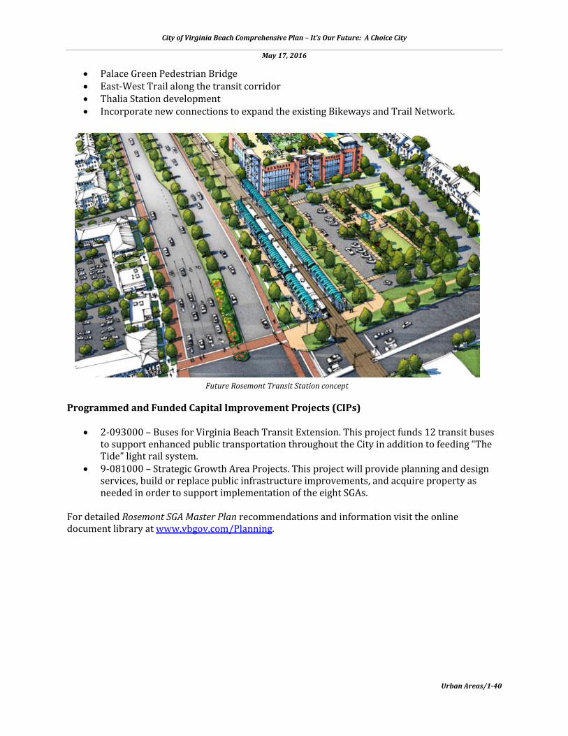
• Palace Green Pedestrian Bridge • East-West Trail along the transit corridor • Thalia Station development • Incorporate new connections to expand the existing Bikeways and Trail Network.
Programmed and Funded Capital Improvement Projects (CIPs)
• 2-093000 – Buses for Virginia Beach Transit Extension. This project funds 12 transit buses to support enhanced public transportation throughout the City in addition to feeding “The Tide” light rail system.
• 9-081000 – Strategic Growth Area Projects. This project will provide planning and design services, build or replace public infrastructure improvements, and acquire property as needed in order to support implementation of the eight SGAs.
For detailed Rosemont SGA Master Plan recommendations and information visit the online document library at www.vbgov.com/Planning.
City of Virginia Beach Comprehensive Plan – It’s Our Future: A Choice City
May 17, 2016
Urban Areas/1-41
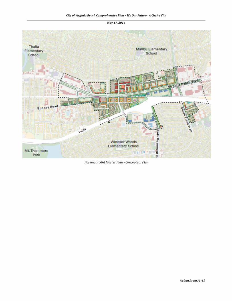
Rosemont SGA Master Plan - Conceptual Plan
City of Virginia Beach Comprehensive Plan – It’s Our Future: A Choice City
May 17, 2016
Urban Areas/1-42
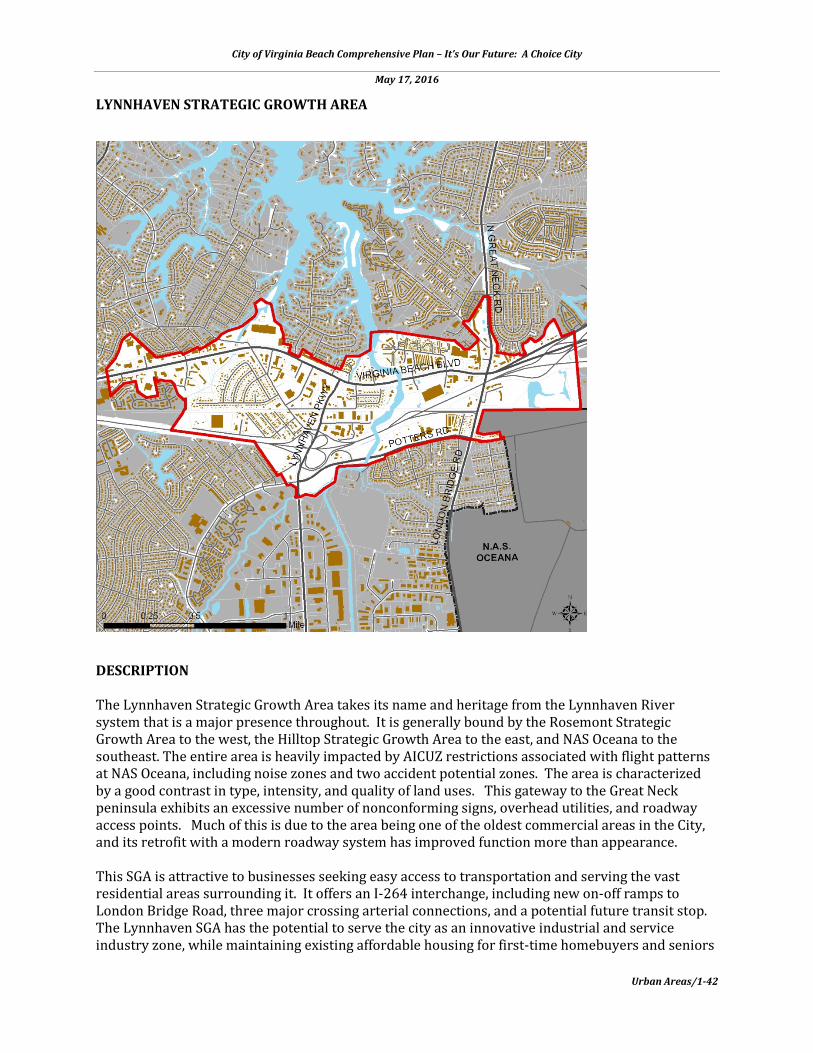
LYNNHAVEN STRATEGIC GROWTH AREA
DESCRIPTION The Lynnhaven Strategic Growth Area takes its name and heritage from the Lynnhaven River system that is a major presence throughout. It is generally bound by the Rosemont Strategic Growth Area to the west, the Hilltop Strategic Growth Area to the east, and NAS Oceana to the southeast. The entire area is heavily impacted by AICUZ restrictions associated with flight patterns at NAS Oceana, including noise zones and two accident potential zones. The area is characterized by a good contrast in type, intensity, and quality of land uses. This gateway to the Great Neck peninsula exhibits an excessive number of nonconforming signs, overhead utilities, and roadway access points. Much of this is due to the area being one of the oldest commercial areas in the City, and its retrofit with a modern roadway system has improved function more than appearance. This SGA is attractive to businesses seeking easy access to transportation and serving the vast residential areas surrounding it. It offers an I-264 interchange, including new on-off ramps to London Bridge Road, three major crossing arterial connections, and a potential future transit stop. The Lynnhaven SGA has the potential to serve the city as an innovative industrial and service industry zone, while maintaining existing affordable housing for first-time homebuyers and seniors

City of Virginia Beach Comprehensive Plan – It’s Our Future: A Choice City
May 17, 2016
Urban Areas/1-43
in the established neighborhoods of Eureka Park and Pinewood Gardens. Rediscovering the waterways that meander through the Lynnhaven SGA by orienting our buildings toward them and creating more visual and public water access points through an extensive public trail system is a underlying design principle. The Lynnhaven Strategic Growth Area Master Plan was adopted by the City Council on April 24, 2012 and is available in the online document library at www.vbgov.com/Planning. VISION The vision of the Lynnhaven SGA is a series of mixed-use and flexible developments along with targeted public infrastructure improvements. The under-performing commercial properties will have the opportunity to transform themselves into higher intensity uses to, in some cases, take advantage of the potential of transit, and, in other cases, to preserve and provide access to the Lynnhaven River. At the center of the redevelopment may be a new transit station that can provide park-and-ride, connection to nearby office uses, and transfer service to Lynnhaven Mall. The Lynnhaven SGA seeks to capitalize on existing adjacent assets such as the Lynnhaven River/London Bridge Creek system and healthy neighborhoods.
SGA DESIGN PRINCIPLES
• Enable a clear and easy-to-access open space and recreation network • Capitalize on the value of the water and marshlands • Meet the Chesapeake Bay Act mandates to protect and restore the Lynnhaven River and its
tributaries • Locate compatible uses that are consistent with the APZ-1/Clear Zone Master Plan, APZ
Zones, and AICUZ restrictions • Strengthen existing neighborhoods through providing community services and convenient
retail
Rail-Trail concept overlooking London Bridge Creek - Lynnhaven SGA

City of Virginia Beach Comprehensive Plan – It’s Our Future: A Choice City
May 17, 2016
Urban Areas/1-44
• Improve multi-modal connections from the adjacent neighborhoods • Connect future transit to employment, recreational destination, and park-and-ride • Enable flexible development sites and building types to respond to ever-changing market
needs and development programs • Coordinate transportation planning and development • Build on the existing good balance between homes, jobs, and services
PLAN RECOMMENDATIONS The following summarizes the general recommendations of the Lynnhaven SGA Master Plan, which calls for six new distinct areas, each with its own quality and character of development:
• Non-Residential Mixed-Use Development Area located between Virginia Beach Boulevard and interstate 264. This area is a prime location for a range of non-residential uses. New development blocks created to accommodate new office development in an urban, pedestrian friendly neighborhood center with supporting retail. This district is well positioned as a transit-ready development.
• Innovation Zone Development Area provides opportunities for small start-up businesses and technology innovation in two areas in this SGA. The first zone along Dean Drive is a small complex of buildings that can accommodate a flexible range of working spaces and can house a variety of existing uses, to provide development opportunities for small start-up businesses and technology innovation.
• Riverfront Development Area showcases the Lynnhaven River/London Bridge Creek system as a major natural amenity that can create addresses for office space with spectacular views and allow commercial uses to capitalize on outdoor space. Turning development sites towards the river and the open space allows existing sites to better capitalize on the amenity, create new development opportunities, and organize the way redevelopment evolves.
• Residential Development Area utilizes small pockets of existing residential zoning that emerged as potential redevelopment sites with equal or lesser residential density than what currently exists on site. This new residential development may be lined with a mix of town houses and smaller multi-family buildings at a scale appropriate to adjacent residential.
• Lifestyle Center Development Area orients buildings to face along a secondary road network and central green space to better provide for a safe, accessible retail address. The central green space is the ideal place for passive recreation, outdoor café seating, and for visitors to congregate while shopping.
• Highway-Oriented Retail Development Area orients small retail buildings or office buildings with parking in the rear of lots along Virginia Beach Boulevard to provide a desirable scaled street frontage, while remaining easily accessible and visible to traffic along the boulevard.
City of Virginia Beach Comprehensive Plan – It’s Our Future: A Choice City
May 17, 2016
Urban Areas/1-45
PLAN IMPLEMENTATION STRATEGIES The Lynnhaven SGA Plan recognizes that, with public improvements in transit, local street networks, and open space, private property owners have an increased range of opportunities for development and utilization of their land to create new mixed-use districts. Recommended Action Plan
• Update zoning regulations based on the SGA plan recommendations. • Develop a comprehensive stormwater management strategy. • Develop a comprehensive open space/park policy strategy. • Develop an implementation strategy for access improvements and open space restoration
along the Lynnhaven River and its tributaries. • Implement the following key infrastructure improvements: Lynnhaven Parkway/I-264
Interchange Improvements; Norfolk Southern Trail; Potter’s Road Bridge Restoration; Wesley Drive; Redevelopment; Transit Station and Park & Ride Lot; Virginia Beach Boulevard Improvements; North Lynnhaven Road Improvements; Southern Boulevard Improvements; London Bridge Improvements; Great Neck Road Improvements; Potters Road Improvements; Dean Drive Improvements; Lynnhaven Parkway Twin Bridges; and Virginia Beach Boulevard Bridge.
• Prepare a corridor plan for Virginia Beach Boulevard from Newtown Road to First Colonial Road
Programmed and Funded Capital Improvement Projects (CIPs)
• 2-093000 – Buses for Virginia Beach Transit Extension – This project funds 12 transit buses to support enhanced public transportation throughout the City in addition to feeding “The Tide” light rail system.
• 9-081000 – Strategic Growth Area Projects – This project will provide planning and design services, build or replace public infrastructure improvements, and acquire property as needed in order to support implementation of the eight SGAs.
Transit-oriented non-residential, mixed use district concept for Lynnhaven SGA
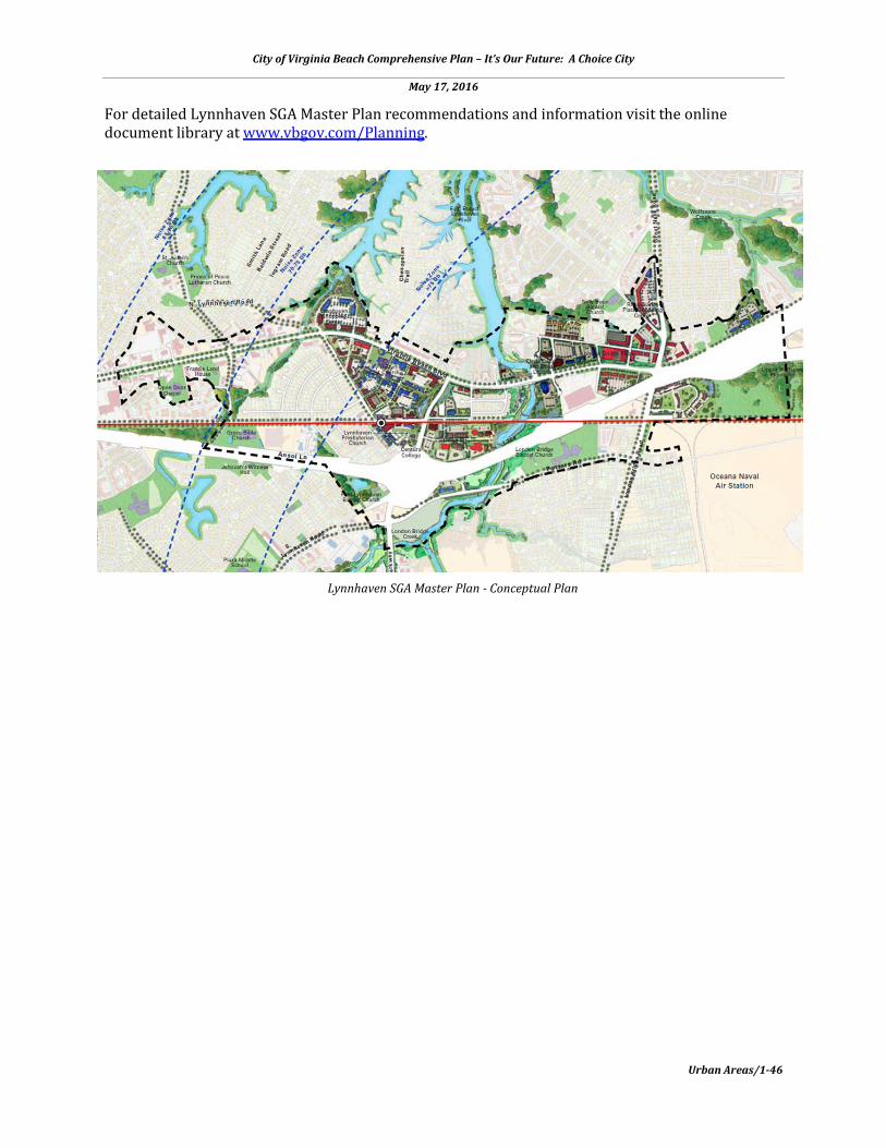
City of Virginia Beach Comprehensive Plan – It’s Our Future: A Choice City
May 17, 2016
Urban Areas/1-46
For detailed Lynnhaven SGA Master Plan recommendations and information visit the online document library at www.vbgov.com/Planning.
Lynnhaven SGA Master Plan - Conceptual Plan

City of Virginia Beach Comprehensive Plan – It’s Our Future: A Choice City
May 17, 2016
Urban Areas/1-47
HILLTOP STRATEGIC GROWTH AREA
DESCRIPTION Hilltop Strategic Growth Area (SGA) is home to a wealth of local businesses with a variety of retail, restaurant, office, health, and recreational uses. The SGA is generally bound by a diverse mix of retail located north of Laskin Road, the Lynnhaven Strategic Growth Area to the west, and Linkhorn Bay to the east, and Potters Road to the south. Although this area is located within a high noise zone, it is a good candidate for redevelopment and reinvestment because of its existing commercial strength and its proximity to the Oceanfront Resort Area, NAS Oceana, and I-264 interchange. The area south of I-264 is subject to greater AICUZ restrictions due to the presence of accident potential zones and the clear zone. The long-range vision for Hilltop SGA, which is already a regional retail destination featuring home-grown restaurants, a plethora of grocery stores, and a variety of shops, builds on the area’s strengths, yet introduces more greenspace. Doing so through redevelopment opportunities can address stormwater management needs and, in turn, create a healthier environment and

City of Virginia Beach Comprehensive Plan – It’s Our Future: A Choice City
May 17, 2016
Urban Areas/1-48
shopping/dining experience that welcomes more people out of their cars and outdoors as they move from place to place within the SGA. Industrial and commercial uses compatible with being in a military aircraft high noise zone have been relocated into this SGA through the City’s YesOceana Program at its southern end. The historic neighborhood of Oceana Gardens, which has a concentration of early 20th Century Sears Kit Homes, is evolving with a new residential lot and density pattern that is more compatible with being located in a military aircraft Accident Potential Zone and high noise zone, while still trying retaining its character. The Hilltop Strategic Growth Area Master Plan was adopted by the City Council on August 28, 2012 and is available in the online document library at www.vbgov.com/Planning. VISION The vision for the Hilltop SGA expands the develop opportunities of many of the local businesses by transforming land areas devoted to parking and under-utilized commercial property into a mix of retail and office opportunities. Targeted public infrastructure improvements and enhanced transit service will help evolve the Hilltop SGA as a convenient, regional retail destination that’s within close proximity to the beach.
SGA DESIGN PRINCIPLES
• Build a network of streets to improve traffic flow • Provide trails and sidewalks for pedestrians and cyclists • Provide a mix of retail, restaurants, and office uses • Build on existing healthcare, food and adjacent recreational assets • Match quality of local businesses with an equally memorable built setting • Provide additional transit connections to Hilltop • Comply with AICUZ land use zoning requirements • Reduce land areas devoted to parking and replace with more productive uses • Revisit and update old plans for roads and infrastructure • Incorporate an Urban Tree Canopy Program
Hilltop Shopping Center infill development concept
City of Virginia Beach Comprehensive Plan – It’s Our Future: A Choice City
May 17, 2016
Urban Areas/1-49
PLAN RECOMMENDATIONS The Hilltop SGA Master Plan represents a unique opportunity to enhance an established retail market area with a distinct identity within the City. With improved streets will be sidewalks, crosswalks, landscaping and lighting that will transform Hilltop into a walkable district. Over time, existing retail buildings will be replaced with new retail buildings built facing the new streets. The suburban pattern of highways lined with parking lots and strip centers will gradually give way to a new pedestrian friendly mixed-use district. The following summarizes the key recommendations of the Hilltop SGA Master Plan:
• Incorporate an Urban Tree Canopy Program within the Hilltop SGA to create a pedestrian environment and aid stormwater management.
• Define a clear hierarchy of streets to establish a structure of development blocks and reconnect places. Major street improvements should support urban, walkable environments that are positioned to service growth.
• Build upon the existing natural resources to expand access to public open space through an interconnected system of parks and trails.
• Evaluate repositioning the proposed transit station to the core of the Hilltop SGA with street and trail improvements to promote transit-oriented economic development.
• Encourage redevelopment of obsolete commercial structures with new buildings placed according to new urban planning standards for the district.
PLAN IMPLEMENTATION STRATEGIES The Hilltop SGA Master Plan transitions under-utilized commercial property into a transit-ready retail and office mixed-use urban environment by building a network of streets to improve traffic flow, trails and sidewalks for pedestrians and cyclists, and matching the quality of local business with an equally memorable setting. Recommended Action Plan
• Update zoning regulations based on the SGA Plan recommendations. • Consider tools for redevelopment such as those identified in the “Guidelines for Evaluation
of Investment Partnerships for Economic Development” Policy. For information about this policy visit www.vbgov.com/government/departments/sga/Pages/default.aspx.
• Develop a comprehensive stormwater management strategy. • Update the Sanitary Sewer Master Plan based on projected future densities to adequately
serve the redeveloped Hilltop SGA. • Develop a district parking strategy for Hilltop and introduce structured parking through
public/private ventures in order to increase open space and tree canopy throughout SGA. • Build upon existing natural resources by creating a new parks and open space network • Implement the following key infrastructure improvements to establish a structure of
development blocks and reconnect places: Laskin Road Redesign and Implementation to eliminate frontage roads and improve traffic flow and safety; First Colonial Road – six through lanes with consolidated turn lane and median with on street bike lanes; Virginia Beach Boulevard - redesign to an urban pedestrian friendly environment; Republic Road – incorporate pedestrian accommodations and on-street parking; Nevan Road – four through lanes with on-street bike lanes and improved pedestrian accommodations; and

City of Virginia Beach Comprehensive Plan – It’s Our Future: A Choice City
May 17, 2016
Urban Areas/1-50
Donna Drive – two through lanes with on-street bike lanes and improved pedestrian accommodations.
• Introduce a transit station and transit park in Hilltop as part of a new citywide transit system and open space network.
• District streetscaping improvements to include landscaping, trees, lighting, trails, sidewalks, crosswalks, and way finding signage
Programmed and Funded Capital Improvement Projects (CIPS)
• 2-093000 – Buses for Virginia Beach Transit Extension – This project funds 12 transit buses to support enhanced public transportation throughout the City in addition to feeding “The Tide” light rail system.
• 9-081000 – Strategic Growth Area Projects – This project will provide planning and design services, build or replace public infrastructure improvements, and acquire property as needed in order to support implementation of the eight SGAs.
For detailed Hilltop SGA Master Plan recommendations and information visit the online document library at www.vbgov.com/Planning.
Improved Laskin Road - First Colonial Road intersection with transit station concept

City of Virginia Beach Comprehensive Plan – It’s Our Future: A Choice City
May 17, 2016
Urban Areas/1-51
Hilltop SGA Master Plan - Conceptual Plan
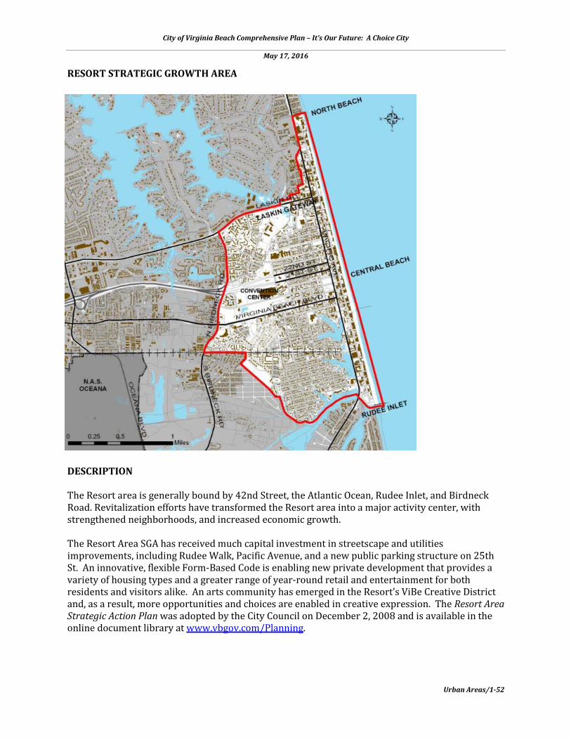
City of Virginia Beach Comprehensive Plan – It’s Our Future: A Choice City
May 17, 2016
Urban Areas/1-52
RESORT STRATEGIC GROWTH AREA
DESCRIPTION The Resort area is generally bound by 42nd Street, the Atlantic Ocean, Rudee Inlet, and Birdneck Road. Revitalization efforts have transformed the Resort area into a major activity center, with strengthened neighborhoods, and increased economic growth. The Resort Area SGA has received much capital investment in streetscape and utilities improvements, including Rudee Walk, Pacific Avenue, and a new public parking structure on 25th St. An innovative, flexible Form-Based Code is enabling new private development that provides a variety of housing types and a greater range of year-round retail and entertainment for both residents and visitors alike. An arts community has emerged in the Resort’s ViBe Creative District and, as a result, more opportunities and choices are enabled in creative expression. The Resort Area Strategic Action Plan was adopted by the City Council on December 2, 2008 and is available in the online document library at www.vbgov.com/Planning.

City of Virginia Beach Comprehensive Plan – It’s Our Future: A Choice City
May 17, 2016
Urban Areas/1-53
VISION With a vision supported by the community, the Virginia Beach Resort Area Strategic Action Plan (RASAP) identifies the potential for three distinct, yet complementary, districts at Laskin Gateway, Central Beach, and Rudee Marina. The plan is a vision for enhancing the area by extending the energy at the beach into these areas. This plan develops synergies between the cultural and commercial life, the recreational and natural life, and an overall focus on drawing residents and visitors into the area. SGA DESIGN PRINCIPLES
• Provide open space connections to the beach • Concentrate high-end retail on Laskin Road • Development and traffic patterns should be sensitive to needs of adjacent neighborhoods • Improve pedestrian and trail facilities to connect neighborhoods to future transit and
neighborhood centers • Extend light rail to Central Beach District • Create a linear park on 19th St • Create mixed use entertainment district including indoor activities in Central Beach District • Prioritize Boardwalk connections • Keep beach/Boardwalk public as private development moves forward • Use open space to emphasize views to beach and marina
Wide sidewalks in front of retail shops on Atlantic Avenue - concept
City of Virginia Beach Comprehensive Plan – It’s Our Future: A Choice City
May 17, 2016
Urban Areas/1-54
PLAN RECOMMENDATIONS The following summarizes the general recommendations for the Resort SGA which calls for three distinct areas:
• 19th Street/Central Beach District – A pedestrian-scale, mixed-use entertainment district that connects the convention center with the heart of the beach. The former Dome Site provides opportunity for an indoor activity counterpart to the beach, and will generate activity inland that enlivens the transition from the Convention Center to the beach along the 19th Street Corridor. A new arena across 19th Street from the Convention Center can offer a third major entertainment venue that shares parking resources and maximizes return on infrastructure investments in the area. The introduction of Light Rail Transit from Norfolk through Town Center is an initial first step to extending fixed guideway transit east to the Oceanfront via 19th Street, which makes this district a prime location for multifamily housing, transit orientated development, retail, restaurants, and similar uses.
• Marina District/South Beach – Builds on the area’s history and reorganizes the area into a
concentrated working waterfront for commercial activities and recreation and creates an opportunity for residents and visitors to observe boating activity from an extended boardwalk or an outdoor café along the water. An enhanced boardwalk connection to the marinas and a public park will retain the waterfront edge for public access and encourage private development with Rudee Loop serving as a large scale mixed-use development to create an anchor at the southern end of the beachfront.
• Laskin Gateway - Laskin Road district provides direct access to the oceanfront, and anchors
the northern end to the Resort Area. Distinct from the other focus areas, Laskin Gateway is the Oceanfront Resort Area’s established location for high-end retail. The plan envisions a corridor with a coordinated transportation and retail strategy that gets people out of their cars and on foot in a village-like setting. Development is scaled to the needs of adjacent neighborhoods, and mixes new residential opportunities with active street level retail uses that front on widened sidewalks to accommodate pedestrian traffic and outdoor dining.
Atlantic and Pacific Avenues will connect these three districts noted above, with new development opportunities on the blocks between the districts and transit, bike, and pedestrian enhancements will improve the navigability and vibrancy of the corridors. PLAN IMPLEMENTATION STRATEGIES
• Create great districts with distinctive identities • Improve transit and pedestrian connections between destinations • Create a transition from the resort area to the neighborhoods • Enhance visual access to the Oceanfront • Grow residential development • Provide additional higher-quality hotels • Concentrate retail development • Cluster office uses near the Convention Center and Birdneck Road • Continue to focus on achieving a “Year-Round Resort” • Promote shared parking strategies

City of Virginia Beach Comprehensive Plan – It’s Our Future: A Choice City
May 17, 2016
Urban Areas/1-55
Recommended Action Plan
• Develop the site of the former Dome site as a major entertainment venue. • Develop the Convention Center Hotel. • Complete the Laskin Gateway roadway project. • Conduct an Environmental Impact Study for Light Rail Transit extension from Norfolk to the
Oceanfront (former Dome site). • Design and build (in phases) the Rudee Loop pedestrian system, extending it along
Mediterranean Avenue and Winston Salem Avenue. • Develop streetscape improvements for 19th Street and Central Beach area by: determining
property/right-of-way impacts; establishing roadway and sidewalk widths; providing transit between Convention Center and Oceanfront using 19th Street.
• Establish incentives and zoning regulations to enable transition of older hotels along Oceanfront.
• Advance district shared parking strategy to induce desired form base resort developments. • Conduct a study for inter-connectivity of pedestrian, bicycle, transit, and water
transportation. • Target office and mixed use near Convention Center, Birdneck Road and 17th Street. • Establish a traffic and parking management plan. • Explore an Oceanfront Housing Fund for workforce (year round) housing. • Develop a marketing strategy with Virginia Aquarium for a water taxi. • Set aside key property for open space. • Implement the Rudee Loop Plan. • Finalize public private partnership to construct a new arena and surrounding infrastructure
in the Central Beach District.
19th Street Concept - Central Beach District
City of Virginia Beach Comprehensive Plan – It’s Our Future: A Choice City
May 17, 2016
Urban Areas/1-56
Programmed and Funded Capital Improvement Projects (CIPs)
• 0-007000 – Resort Public Transit Relocation. This project is for identification of sites and development of a Hampton Roads Transit (HRT) Bus Transfer Station, consisting of two bus shelters located on about one-half acre of land.
• 2-093000 – Buses for Virginia Beach Transit Extension – This project funds 12 transit buses to support enhanced public transportation throughout the City in addition to feeding “The Tide” light rail system.
• 9-081000 – Strategic Growth Area Projects. This project will provide planning and design services, build or replace public infrastructure improvements, and acquire property as needed in order to support implementation of the eight SGA plans.
• 9-009000 - 25th Street Public Parking Garage. This project provides funding to purchase the land and parking garage at 25th Street.
• 9-015000 - Arena Infrastructure Site Improvements. On-Site - This project provides infrastructure support for the Arena project including streetscape improvements that are closer to the Arena.
• 9-017000 – Arena Infrastructure Development. This project provides infrastructure support for the Arena project including streetscape improvements that are off-site of the Arena.
• 9-069000 – 19th Street Corridor Improvements. This project provides ongoing funding to reinvest in various high impact capital projects at the oceanfront.
• 9-082000 – Oceanfront Parking Facilities Capital Maintenance and Development. This project provides funding necessary for the acquisition, development, equipment, capital maintenance, repairs, improvements, design, planning, and engineering services for the Oceanfront Resort and Sandbridge Resort parking garages and parking lots.
• 9-096000 – Oceanfront Capital Projects Reinvestment. This project provides on-going funding to reinvest in various high impact capital projects at the oceanfront. The primary focus of the project is to replace Atlantic Avenue, side streets, and boardwalk lighting with energy efficient attractive LED lighting.
• 9-108000 – 29th Street Improvements. This project provides funding for improvements to 29th Street in the Resort Area as a continuation of the Laskin Road Gateway Project. The project area is 29th street from Arctic to Pacific Avenues and involves streetscape improvements including wide sidewalks, street trees, new street with improved drainage, and undergrounding of utilities.
• 2-045000 – Pacific Avenue Improvements-Phase 1. This project provides for the improvements to Pacific Avenue between 17th Street and 22nd Street within the existing right-of-way, to include undergrounding of the existing overhead utilities and public utility upgrades. In addition, new LED street lighting.
• 2-165000 – Laskin Road-Phase II. This project is for construction of a six-lane divided highway with a bikeway from the eastern terminus of Laskin Road Phase I (Oriole Drive) to the 30th/31st Street split. A transportation corridor analysis is included, along with undergrounding of utilities.
• 3-518000 – Convention Center Capital Maintenance. This project provides funding for capital replacements of vital infrastructure for the Virginia Beach Convention Center.
• 3-610000 – CIT-Police Oceanfront Cameras. The Virginia Beach Police department is seeking to replace and expand the security camera system at the oceanfront and increase the number of cameras and video management capabilities provided.
• 4-520000 – Grommet Island Park Repairs and Renovations I. This project will fund the required repairs and renovations to the infrastructure of the Grommet Island Park, a 15,000 square foot fully accessible park located between 1st and 2nd Streets on the Oceanfront.
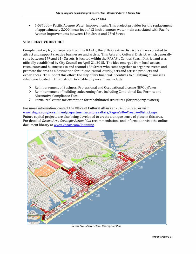
City of Virginia Beach Comprehensive Plan – It’s Our Future: A Choice City
May 17, 2016
Urban Areas/1-57
• 5-037000 – Pacific Avenue Water Improvements. This project provides for the replacement of approximately 3,000 linear feet of 12-inch diameter water main associated with Pacific Avenue Improvements between 15th Street and 23rd Street.
ViBe CREATIVE DISTRICT Complementary to, but separate from the RASAP, the ViBe Creative District is an area created to attract and support creative businesses and artists. This Arts and Cultural District, which generally runs between 17th and 21st Streets, is located within the RASAP’s Central Beach District and was officially established by City Council on April 21, 2015. The idea emerged from local artists, restaurants and businesses in and around 18th Street who came together to organize events and promote the area as a destination for unique, casual, quirky, arts and artisan products and experiences. To support this effort, the City offers financial incentives to qualifying businesses, which are located in this district. Available City incentives include: Reimbursement of Business, Professional and Occupational License (BPOL)Taxes Reimbursement of building code/zoning fees, including Conditional Use Permits and
Alternative Compliance Fees Partial real estate tax exemption for rehabilitated structures (for property owners)
For more information, contact the Office of Cultural Affairs at 757-385-0226 or visit: www.vbgov.com/government/departments/cultural-affairs/Pages/ViBe-Creative-District.aspx Future capital projects are also being developed to create a unique sense of place in this area. For detailed Resort Area Strategic Action Plan recommendations and information visit the online document library at www.vbgov.com/Planning.
Resort SGA Master Plan - Conceptual Plan

City of Virginia Beach Comprehensive Plan – It’s Our Future: A Choice City
May 17, 2016
Urban Areas/1-58
ENDNOTES
i Measuring Sprawl and Its Impact, 2002 by Reid Ewing, Rolf Pendall and Don Chen, http://www.smartgrowthamerica.org/research/measuring-sprawl-and-its-impact/