Urban and Regional Development Ph.D. ogrPr amme · ANNUAL REPORT 2018 Urban and Regional...
52
Urban and Regional Development Ph.D. Programme ANNUAL REPORT 2018 2018 - Number 2 ISSN 2533-2139
Transcript of Urban and Regional Development Ph.D. ogrPr amme · ANNUAL REPORT 2018 Urban and Regional...
1
Urban and Regional Development Ph.D. Programme ANNUAL REPORT 2018
Urban and Regional Development Ph.D. Programme
ANNUAL REPORT 2018
2018 - Number 2ISSN 2533-2139

Urban and Regional Development Ph.D. Programme ANNUAL REPORT 2018
2
Urban and Regional Development Ph.D. Programme - ANNUAL REPORT
Editorial coordination: Umberto JANIN RIVOLIN and Luca STARICCOGraphic design: Cinzia PAGANO
© DIST - Dipartimento interateneo di Scienze, Progetto e Politiche del Territorio dell’ Università e del Politecnico di TorinoViale Mattioli, 39 - 10125 Torino, Italy
2018 - Number 2ISSN 2533-2139
3
Urban and Regional Development Ph.D. Programme ANNUAL REPORT 2018
MAIN SPONSORS
MAIN PARTNERS
Urban and Regional Development Ph.D. Programme ANNUAL REPORT 2018
4
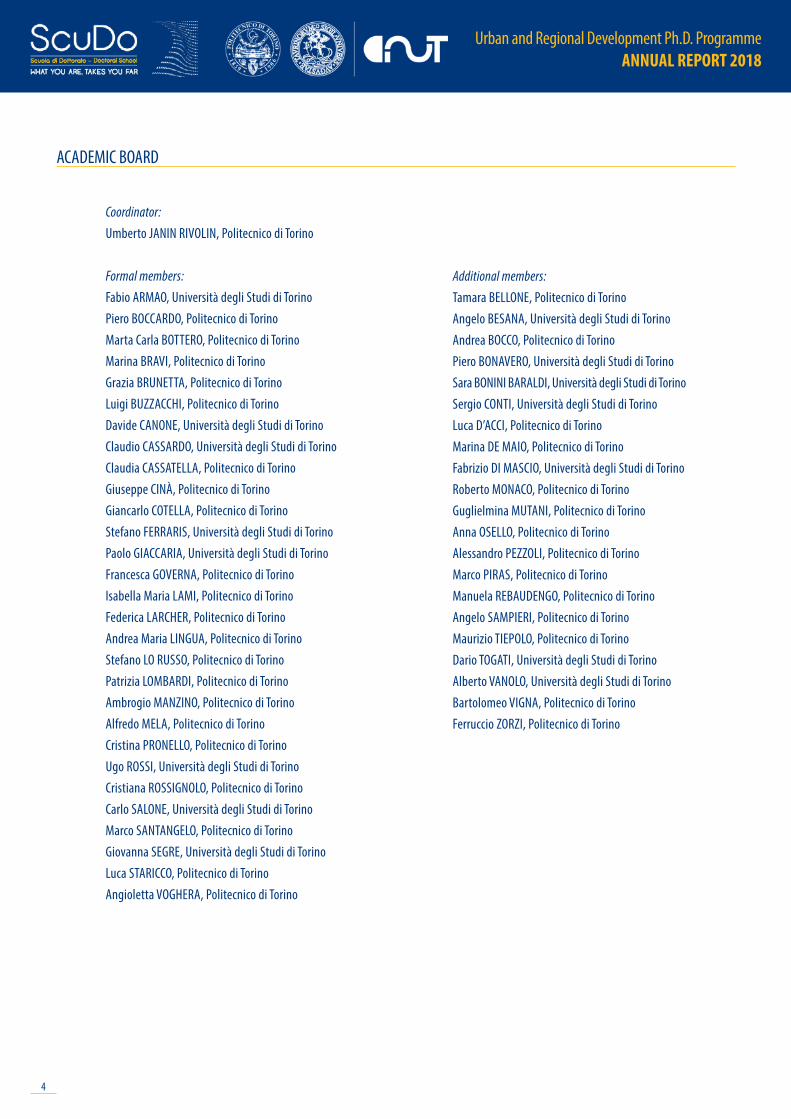
ACADEMIC BOARD
Coordinator:Umberto JANIN RIVOLIN, Politecnico di Torino
Formal members: Fabio ARMAO, Università degli Studi di TorinoPiero BOCCARDO, Politecnico di TorinoMarta Carla BOTTERO, Politecnico di TorinoMarina BRAVI, Politecnico di TorinoGrazia BRUNETTA, Politecnico di TorinoLuigi BUZZACCHI, Politecnico di TorinoDavide CANONE, Università degli Studi di TorinoClaudio CASSARDO, Università degli Studi di TorinoClaudia CASSATELLA, Politecnico di TorinoGiuseppe CINÀ, Politecnico di TorinoGiancarlo COTELLA, Politecnico di TorinoStefano FERRARIS, Università degli Studi di TorinoPaolo GIACCARIA, Università degli Studi di TorinoFrancesca GOVERNA, Politecnico di TorinoIsabella Maria LAMI, Politecnico di TorinoFederica LARCHER, Politecnico di TorinoAndrea Maria LINGUA, Politecnico di TorinoStefano LO RUSSO, Politecnico di TorinoPatrizia LOMBARDI, Politecnico di TorinoAmbrogio MANZINO, Politecnico di TorinoAlfredo MELA, Politecnico di TorinoCristina PRONELLO, Politecnico di TorinoUgo ROSSI, Università degli Studi di TorinoCristiana ROSSIGNOLO, Politecnico di TorinoCarlo SALONE, Università degli Studi di TorinoMarco SANTANGELO, Politecnico di TorinoGiovanna SEGRE, Università degli Studi di TorinoLuca STARICCO, Politecnico di TorinoAngioletta VOGHERA, Politecnico di Torino
Additional members:Tamara BELLONE, Politecnico di TorinoAngelo BESANA, Università degli Studi di TorinoAndrea BOCCO, Politecnico di TorinoPiero BONAVERO, Università degli Studi di TorinoSara BONINI BARALDI, Università degli Studi di TorinoSergio CONTI, Università degli Studi di TorinoLuca D’ACCI, Politecnico di TorinoMarina DE MAIO, Politecnico di TorinoFabrizio DI MASCIO, Università degli Studi di TorinoRoberto MONACO, Politecnico di TorinoGuglielmina MUTANI, Politecnico di TorinoAnna OSELLO, Politecnico di TorinoAlessandro PEZZOLI, Politecnico di TorinoMarco PIRAS, Politecnico di TorinoManuela REBAUDENGO, Politecnico di TorinoAngelo SAMPIERI, Politecnico di TorinoMaurizio TIEPOLO, Politecnico di TorinoDario TOGATI, Università degli Studi di TorinoAlberto VANOLO, Università degli Studi di TorinoBartolomeo VIGNA, Politecnico di TorinoFerruccio ZORZI, Politecnico di Torino

5
Urban and Regional Development Ph.D. Programme ANNUAL REPORT 2018
INTRODUCTION
This document contains a series of one-page reports from the students enrolled in the Urban and Regional Development Ph.D. Programme at the Interuniversity Department of Urban and regional studies and planning of Politecnico and Università di Torino.
The programme is designed to train highly-qualified specialists in urban and territorial development, while promoting the appropriate exploitation of their individual talents, to develop a distinctly multidisciplinary figure, a professional able to adapt to a wide variety of scientific knowledge and areas in a flexible and dynamic way.
The offered training will therefore give to PhD students the possibility to exploit specific skills acquired, to effectively interact with other professionals participating in urban and regional planning projects. Based on multi- and inter-disciplinary PhD skills, the programme intends to move fluidly through the conventional boundaries that separate social sciences from applied technical, engineering, physical-natural sciences.
In order to train specialists who are able to effectively navigate in the global context, the doctoral programme should adopt also a strong international nature, both in the sense of attracting young motivated and qualified scholars from abroad, as well as offering to students a training which corresponds to the highest academic and professional standards, also thank to the contribution of foreign scholars and the organisations of internships in highly qualified institutions. To stay coherent with the adopted approach the training activity is also developed entirely in English.
For more info:
[email protected]://dottorato.polito.it/urb/en/overview
Urban and Regional Development Ph.D. Programme ANNUAL REPORT 2018
6
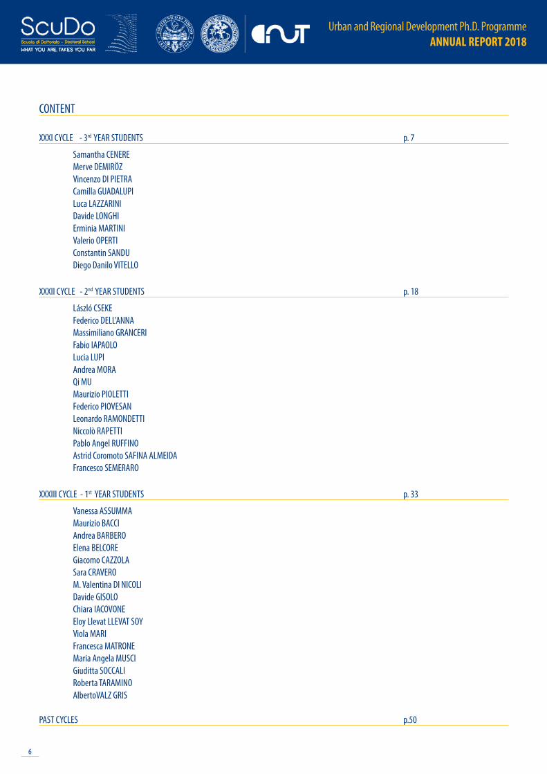
CONTENT
XXXI CYCLE - 3rd YEAR STUDENTS p. 7
Samantha CENEREMerve DEMIRÖZVincenzo DI PIETRACamilla GUADALUPI Luca LAZZARINIDavide LONGHIErminia MARTINIValerio OPERTIConstantin SANDUDiego Danilo VITELLO
XXXII CYCLE - 2nd YEAR STUDENTS p. 18
László CSEKEFederico DELL’ANNAMassimiliano GRANCERIFabio IAPAOLOLucia LUPIAndrea MORAQi MUMaurizio PIOLETTIFederico PIOVESANLeonardo RAMONDETTINiccolò RAPETTIPablo Angel RUFFINOAstrid Coromoto SAFINA ALMEIDAFrancesco SEMERARO
XXXIII CYCLE - 1st YEAR STUDENTS p. 33
Vanessa ASSUMMAMaurizio BACCIAndrea BARBEROElena BELCOREGiacomo CAZZOLASara CRAVEROM. Valentina DI NICOLIDavide GISOLOChiara IACOVONEEloy Llevat LLEVAT SOYViola MARIFrancesca MATRONEMaria Angela MUSCIGiuditta SOCCALIRoberta TARAMINOAlbertoVALZ GRIS
PAST CYCLES p.50
7
Urban and Regional Development Ph.D. Programme ANNUAL REPORT 2018
XXXI CYCLE - 3rd YEAR STUDENTS

Urban and Regional Development Ph.D. Programme ANNUAL REPORT 2018
8
NAME Samantha CENEREE-MAIL [email protected]
ACADEMIC CONTEXTBarry A., Slater D., eds., 2005. The technological economy. Psychology Press. Benkler Y., 2006. The wealth of networks: How social production transforms markets and freedom. Yale University Press.Callon M., 1986. The sociology of an actor-network: The case of the electric vehicle. In Mapping the dynamics of science and technology. London: Palgrave Macmillan, pp. 19-34.
EXTERNAL COLLABORATIONS- Department of Geography, Durham University, UK- Catholic University of Leuven
HIGHLIGHTS OF THE RESEARCH ACTIVITYNetworking, peering, sharing, and collaborating are considered the pillars of a new form of economy, a ‘Wikinomics’ (Tapscott & Williams, 2006) enabled by the potential of digital technologies to enhance the ‘wealth of networks’ (Benkler, 2006) by empowering individuals to have a more active role in the realm of production. Some of these productive communities present also a physical counterpart, being involved in shared community-driven local organizations devoted to experiment, produce, and hack both software and artefacts. In fact, the so-called commons-based peer production has been experiencing its ‘second wave’, characterised by its merging with the realm of manufacturing; indeed, ‘the emergence of networked “makerspaces” seems to distribute the means of making (Kohtala & Hyysalo, 2015; Niaros, 2016). Such spaces can either be hackerspaces, micro-factories, fab labs or other co-working spaces which are equipped with desktop and benchtop manufacturing technologies’ (Kostakis, Latoufis, Liarokapis, & Bauwens, 2016).However, the embedded nature of peer production (Kohtala & Bosqué, 2014) within Fablabs calls for a contextual investigation of the narratives, practices, and material outcomes of the communities revolving around various shared personal fabrication workshops. The present work theoreticallly and methodologically situates itself within a line of research that looks at the multiple and contingent ways in which the social is performed through different sociomaterial arrangements and practices. Drawing on the Actor-Network theory and STS (Science and Technology Studies) traditions (Callon, 1986; 1987; Latour, 1987; 1996), the research looks at how both a particular Fablab and Making practices come into being as new social and economic entities. As part of this process, specific economic knowledges are identified as crucial in performatively enacting the economic entities (i.e. Fablabs and Making) that they claim to simply describe. However, performativity processes are never guaranteed in their outcome, rather the contingency of the sociomaterial arrangements in which economic knowledges are just one part makes the stabilisation of new entities exposed to failure.Through the use of ethnographic methods, the research qualitatively explores Turin’s ‘Maker scene’, going more into details in the case of Fablab Torino. Analytically, the empirical findings are organised against the backdrop of three conceptual pillars, that is ‘knowledge’, ‘materiality’, and ‘work’. This tripartite structure has a double function: both the concepts mobilised allows to analyse the phenomenon under investigation from a different theoretical angle, drawing on the theoretical approaches above mentioned; and, the investigation of Fablabs and Making provides new insights on the strength of social sciences’ studies underpinned by a theoretical sensibility towards these conceptual foci.
COURSE XXXI cycle - 3rd year
RESEARCH TITLE Making in the making. Performing new forms and spatialities of production
TUTOR(S) Ugo ROSSI, Alberto VANOLO
9
Urban and Regional Development Ph.D. Programme ANNUAL REPORT 2018
NAME Merve DEMIRÖZE-MAIL [email protected]
ACADEMIC CONTEXTCinà G., Demiroz M., Mu Q., Forthcoming. Participation and Conflict Between Local Community and Institutions in Conservation Processes: The Case of Novara Old Town. Journal of Cultural Heritage Management and Sustainable Development.Demiroz M., Şahin Güçhan N., Forthcoming. Urban Conservation Legacies of Turkish Planning System: Tracing the Spatial Change in the Ankara Acropolis. Planning Perspectives, pp. 1923-2015.Pendlebury J., 2013. Conservation Values, the Authorised Heritage Discourse and the Conservation-Planning Assemblage. International Journal of Heritage Studies, 19(7), pp. 709-727.Waterton E., Watson S., eds., 2015. The Palgrave Handbook of Contemporary Heritage Research.
EXTERNAL COLLABORATIONS- Global Urban Research Unit, Newcastle University
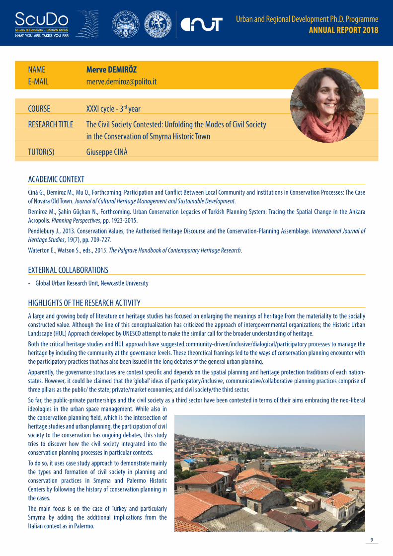
HIGHLIGHTS OF THE RESEARCH ACTIVITYA large and growing body of literature on heritage studies has focused on enlarging the meanings of heritage from the materiality to the socially constructed value. Although the line of this conceptualization has criticized the approach of intergovernmental organizations; the Historic Urban Landscape (HUL) Approach developed by UNESCO attempt to make the similar call for the broader understanding of heritage. Both the critical heritage studies and HUL approach have suggested community-driven/inclusive/dialogical/participatory processes to manage the heritage by including the community at the governance levels. These theoretical framings led to the ways of conservation planning encounter with the participatory practices that has also been issued in the long debates of the general urban planning. Apparently, the governance structures are context specific and depends on the spatial planning and heritage protection traditions of each nation-states. However, it could be claimed that the ‘global’ ideas of participatory/inclusive, communicative/collaborative planning practices comprise of three pillars as the public/ the state; private/market economies; and civil society/the third sector. So far, the public-private partnerships and the civil society as a third sector have been contested in terms of their aims embracing the neo-liberal ideologies in the urban space management. While also in the conservation planning field, which is the intersection of heritage studies and urban planning, the participation of civil society to the conservation has ongoing debates, this study tries to discover how the civil society integrated into the conservation planning processes in particular contexts. To do so, it uses case study approach to demonstrate mainly the types and formation of civil society in planning and conservation practices in Smyrna and Palermo Historic Centers by following the history of conservation planning in the cases. The main focus is on the case of Turkey and particularly Smyrna by adding the additional implications from the Italian context as in Palermo.
COURSE XXXI cycle - 3rd year
RESEARCH TITLE The Civil Society Contested: Unfolding the Modes of Civil Society in the Conservation of Smyrna Historic Town
TUTOR(S) Giuseppe CINÀ

Urban and Regional Development Ph.D. Programme ANNUAL REPORT 2018
10
NAME Vincenzo DI PIETRAE-MAIL [email protected]
ACADEMIC CONTEXTChiabrando F., Di Pietra V., Lingua A., Cho Y., Jeon J., 2017. An original application of image recognition based location in complex indoor environments. ISPRS International Journal of Geo-Information, 6(2):56. Dabove P., Di Pietra V., 2018. Towards high accuracy GNSS real-time positioning with smartphones. Advances in Space Research, Article in press. Dabove P., Di Pietra V., Piras M., Jabbar A.A., Kazi, S.A., 2018. Indoor positioning using Ultra-wide band (UWB) technologies: Positioning accuracies and sensors’ performances, 2018. IEEE/ION Position, Location and Navigation Symposium, Plans 2018 - Proceedings 2018, pp. 175-184.
EXTERNAL COLLABORATIONS- Electronic and Telecommunication Research Institute (ETRI), Republic of South Korea- Finnish Geospatial Research Institute (FGI), Finland
HIGHLIGHTS OF THE RESEARCH ACTIVITYThe Urban Environment is composed by outdoor spaces, indoor spaces and interface urban spaces where people live, performs everyday tasks and interact with each other or with the context. In the era of Internet of Things (IoT) every citizen holding a portable smart technology, every sensor installed in public infrastructure, every kind of communication network spread all over the living spaces is able to collect a huge amount of heterogeneous information useful for different purpose. Among the many, the spatial related information are one of the most important data to collect and analyze as it can be used from different stakeholders (policy makers, first responders, market analyst, social expert) in different spatial-related applications (urban planning, location-based services, autonomous navigation and more). The main problem in this panorama is how to provide the location in every situation. Nowadays, the well-known global navigation satellite system (GNSS) technology is able to provide accurate positioning in outdoor space but when this functionality is transposed in an indoor environment, the data signal is loss and the position is no longer available. For this reason, in the recent years has increased the interest in indoor positioning systems, a field of investigation that exploiting different technologies for localization in closed spaces. At the state of research does not exist an unique solution able to solve the positioning issues in all environment and for all applications. In my research I’m focusing on a particular aspect of the positioning problem: the navigation in seamless condition, where the continuity of the data have to be guaranteed into the transition from the inside to the outside. I have started to analyze three main technologies:- Image based navigation- GNSS positioning with smartphone- UWB positioningThe firsts solutions are approaches where a smartphone camera is the only or the primary main sensor. All camera-based system architectures use photogrammetry principle and computer vision techniques to define the position of the camera sensor. The seconds solution permit to define position with smartphone embedded GNSS low-cost chipsets. The UWB systems are based on radio frequencies to estimate distances and use it in trilateration algorithm for positioning. The integration of these three very different systems could be the solution for the seamlessness in positioning and navigation in urban environment.
COURSE XXXI cycle - 3rd year
RESEARCH TITLE Seamless positioning and navigation in urban environment
TUTOR(S) Andrea M. LINGUA, Marco PIRAS

11
Urban and Regional Development Ph.D. Programme ANNUAL REPORT 2018
NAME Camilla GUADALUPIE-MAIL [email protected]
ACADEMIC CONTEXTAwan N., Schneider T., Till J., 2011. Spatial agency: other ways of doing architecture. Abingdon. New York, NY: Routledge.Guadalupi C., 2017. Tattiche urbane, un concetto sfocato. Urbanistica, 157, pp. 46-49.Guadalupi C., 2018. Professionals of the unplanned. In Koch M., Tribble R., Siegmund Y., Rost A., Werner Y., eds., Changing perspectives in metropolitan research: new urban professions: a journey through practice and theory. Berlin: Jovis, pp. 157-163.Mould O., 2014. Tactical Urbanism: The New Vernacular of the Creative City. Geography Compass, 8(8), pp. 529-539.
EXTERNAL COLLABORATIONS- Catholic University of Leuven, Belgium- University of Gothenburg, Sweden
HIGHLIGHTS OF THE RESEARCH ACTIVITYIn recent years, there has been an increasing interest in urban tactics, small-scale and short-term initiatives shaping urban spaces. According to Brenner (2015), the generally recognized common features of the practices ascribable to such trend are the short time horizon, the small spatial scale, the mobilization of the locally available resources and a kind of open-endedness.This study aims at providing new insights into the encounter between urban practitioners and urban tactics. Assuming a Science and Technology Studies perspective, in the context of the spreading of practices characterized by a do-it-yourself attitude, the attention is drawn on the counterintuitive process of assemblage of a new expert authority. Indeed, all around Europe a growing body of new professional realities, recently defined in the literature as spatial agency (Awan, Schneider, & Till, 2011), started to deal with unplanned and spontaneous interventions and saw in this way of acting a new potential entrepreneurial path. The aim of this interview-based investigation is to explore how this emerging trend in planning theory and practice helps in questioning sharp analytical dichotomies. Keeping the focus on this emerging expertise, the main issues addressed in this study are: (I) the blurred line between amateur and professional practice, (II) the complex relationship between relationality and territoriality within the mobilities of knowledges and practices and (III) the paradoxes and ambiguities of what I have called “entrepreneurial urban activism”, an in-between status among self-precarization and emancipation. The first issue (I) implies a constructivist understanding of expertise and the focus is put on the demarcation strategies applied by the practitioners themselves, who - it is argued - are involved in a process of boundary work (Gieryn, 1983). The dissertation will then go on investigating (II) the mobility channels of urban tactics, framing these professionals as transfer agents. This unveils a geography of informal links and self-managed events, that resonates with what Doreen Massey called “the local production of the global” (2011, p. 9). Finally, (III) the controversial political potential of this emerging category is explored in light of the claims for “a more STS-informed politics” (Farías & Blok, 2016, p. 540). This offers the possibility to question and soften the paradigm of neoliberal co-optation of subversive micro-spatial practices.
COURSE XXXI cycle - 3rd year
RESEARCH TITLE Undisciplined expertise. Reflections on an emerging profession within tactical urbanism
TUTOR(S) Carlo SALONE, Paolo GIACCARIA
Urban and Regional Development Ph.D. Programme ANNUAL REPORT 2018
12
NAME Luca LAZZARINIE-MAIL [email protected]
ACADEMIC CONTEXTLazzarini L., 2018. The role of planning in shaping better urban/rural relationships in Bristol City Region. Land Use Policy, 71, pp. 311-319.Lazzarini L., Cinà G., 2018. Food narratives and planning spaces in Milan City Region. NEWDIST s.i. AESOP Sustainable Food Planning Workshop, June 2018, pp. 42-45.Lazzarini L., 2017. Soft Cooperation and Rural Development in Aso Valley in Italy. Journal of International Scientific Publications Agriculture and Food, 5, pp. 238-251.
EXTERNAL COLLABORATIONS- Countryside and Community Research Institute (CCRI), University of Gloucestershire, UK
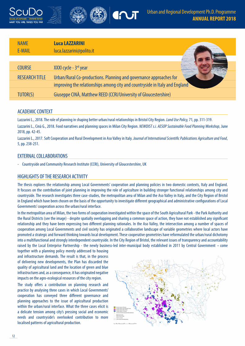
HIGHLIGHTS OF THE RESEARCH ACTIVITYThe thesis explores the relationship among Local Governments’ cooperation and planning policies in two domestic contexts, Italy and England. It focuses on the contribution of joint planning in improving the role of agriculture in building stronger functional relationships among city and countryside. The research investigates three case-studies, the metropolitan area of Milan and the Aso Valley in Italy, and the City Region of Bristol in England which have been chosen on the basis of the opportunity to investigate different geographical and administrative configurations of Local Governments’ cooperation across the urban/rural interface. In the metropolitan area of Milan, the two forms of cooperation investigated within the space of the South Agricultural Park - the Park Authority and the Rural Districts (see the image) - despite spatially overlapping and sharing a common space of action, they have not established any significant relationship and they have been expressing two different planning rationales. In the Aso Valley, the intersection among a number of spaces of cooperation among Local Governments and civil society has originated a collaborative landscape of variable geometries where local actors have promoted a strategic and forward thinking towards local development. These cooperative geometries have reformulated the urban/rural dichotomy into a multifunctional and strongly interdependent countryside. In the City Region of Bristol, the relevant issues of transparency and accountability raised by the Local Enterprise Partnership - the newly business-led inter-municipal body established in 2011 by Central Government - come together with a planning policy merely addressed to housing and infrastructure demands. The result is that, in the process of delivering new developments, the Plan has discarded the quality of agricultural land and the location of green and blue infrastructures and, as a consequence, it has originated negative impacts on the agro-ecological resources of the city region. The study offers a contribution on planning research and practice by analysing three cases in which Local Governments’ cooperation has conveyed three different governance and planning approaches to the issue of agricultural production within the urban/rural interface. What the three cases elicit is a delicate tension among city’s pressing social and economic needs and countryside’s overlooked contribution to more localised patterns of agricultural production.
COURSE XXXI cycle - 3rd year
RESEARCH TITLE Urban/Rural Co-productions. Planning and governance approaches for improving the relationships among city and countryside in Italy and England
TUTOR(S) Giuseppe CINÀ, Matthew REED (CCRI/University of Gloucestershire)

13
Urban and Regional Development Ph.D. Programme ANNUAL REPORT 2018
NAME Davide LONGHIE-MAIL [email protected]; [email protected]
ACADEMIC CONTEXTPronello C. , Longhi D., 2017. Analysis of mobility patterns and transport supply through the validation data of smart cards. HKSTS 2017 - proceedings of the 22nd Hong Kong Society for Transportation Studies.Pronello C., Longhi D., Gaborieau J.B., 2018. Smart Card Data Mining to Analyze Mobility Patterns in Suburban Areas. Sustainability 10.
EXTERNAL COLLABORATIONS- Extra.To s.c.a.r.l.- Regione Piemonte
HIGHLIGHTS OF THE RESEARCH ACTIVITYThe research aims at defining new mobility services for less densely inhabited areas, notably suburban and rural zones. To this end, an in depth analysis of the transport demand and supply in the case study area has carried out following a two-step methodology.The first step aims at estimating the Origin-Destination matrices of public transport through the analysis of smartcard validations to better understand how transport demand matches existing supply. The method enables to define the most frequent lines and stops as the peak and off-peaks hours. Both transport operators and transport authorities can use the proposed methodology to estimate origin-destination matrix using smart-card validations. Such data can be used also for quantifying passengers’ flows for those systems where validation is mandatory only during boarding.The second step is the design of a Mobility as a Service (MaaS) in rural and suburban areas thanks to the information obtained in the first step. To this end, an analysis of both transport demand and supply was conducted to identify those areas where the supply cannot entirely satisfy transport demand and, therefore, more investment or alternative modes of transport are needed.A mixed method is used, adopting together a quantitative and qualitative approach to investigate in depth the users’ needs. A web-questionnaire has been designed to understand users’ mobility habits and their attitudes toward a MaaS; then, focus groups with both travellers and transport operators are organised to support the definition of a new concept of mobility.
COURSE XXXI cycle - 3rd year
RESEARCH TITLE Mobility as a Service (MaaS) in suburban and rural areas: concept design and challenges
TUTOR(S) Cristina PRONELLO

Urban and Regional Development Ph.D. Programme ANNUAL REPORT 2018
14
NAME Ermina MARTINIE-MAIL [email protected]
ACADEMIC CONTEXTKatz J., 2013. The Big Truck That Went By: How the World Came to Save Haiti and Left behind a Disaster. New York: St Martin’s Press.Lundahl M., 2013. The Political Economy of Disaster. Destitution, plunder and earthquake in Haiti. London and New York: Routledge.Mosse D., ed., 2013. Adventures in Aidland: The Anthropology of Professionals in International Development, New York: Berghahn Books.
EXTERNAL COLLABORATIONS- University of Helsinki
HIGHLIGHTS OF THE RESEARCH ACTIVITYThe aim of this research is to investigate the significance and the features of the governance of aid in a post-disaster context, looking at the case study of Haiti after the 2010 earthquake. Through my research I will discuss the patterns of power distribution within the Haitian society and within the international aid system, showing the complexity of the aid system in the light of a post-development and post-colonial discourses.My research is marked by an interdisciplinary orientation, where the discipline of development studies (interdisciplinary by itself ) blends with political science, international relations, urban studies, human geography and history. The research methods adopted are characterized by an empirical and ethnographic orientation. To collect data I used a combination of qualitative methods, including semi-structured interviews, dialogue with interviewees, informal conversations, participant observation, field note diaries, photographs taken during the field work, and the acquisition of secondary data, including a large portion of the grey literature. The study aims to address the following main research questions:- How different actors conceived the task to rebuild the Haitian state/society?- How are patterns of cleavage and power relations re-shaped through the disaster and the recovery process?- Which are the features of the aid-governance in the reconstruction process in Haiti and which are the contrasting/alternative approaches to the
dominant reconstruction model?The research object is approached from different perspectives, and through thematic sub-case studies, which shape the structure of the chapters of the dissertation:a) Socio-political perspective: Analysis of the significance of the “Build
back Better” idea within the historical pattern of Haiti’s state-building process.
b) Institutional perspective: Analysis of the conception, functioning and results of the Interim Commission for the Reconstruction of Haiti (ICRH).
c) Grassroots perspective: Analysis of civil society watchdog initiatives for an alternative approach to the dominant power distribution emerging in the recovery process.
d) Urban-studies perspective: Analysis of the massive Camp-Corail relocation failing process and of the micro-scale housing project of the Scalabrini congregation;
e) Autobiographical perspective: an autobiographical journey of resistance to the development hegemony.
COURSE XXXI cycle - 3rd year
RESEARCH TITLE Power dynamics and aid governance in a post disaster context: a case study of Haiti’s recovery
TUTOR(S) Fabior ARMAO, Marjaana JAUHOLA

15
Urban and Regional Development Ph.D. Programme ANNUAL REPORT 2018
NAME Valerio OPERTIE-MAIL [email protected]; [email protected]
ACADEMIC CONTEXTLo S.H. et al., 2015. Commuting travel mode choice among office workers: Comparing an Extended Theory of Planned Behavior model between regions and organizational sectors. Travel Behaviour and Society, 4, pp. 1-10.Pronello C., Camusso C., 2011. Travellers’ profiles definition using statistical multivariate analysis of attitudinal variables. Journal of Transport Geography, 19(6), pp. 1294-1308.
EXTERNAL COLLABORATIONS- Rete Ferroviaria Italiana Spa- Regione Piemonte
HIGHLIGHTS OF THE RESEARCH ACTIVITYResearch contextOur modern world has to face several global problems, one of these is the Global Warming. To handle this problem, the international community adopted some protocols: Kyoto Protocol (1997) and Paris Agreement (2015). To achieve their targets, the European Commission is focused on the human activities that produce a large quantity of greenhouse gases, as transport sector. The mobility, in particular road transport, represents approximately a quarter of Europe’s greenhouse emissions.Therefore, huge investments are being undertaken on infrastructure and new vehicles, by European Organizations and by transport companies. Nevertheless, this efforts are not immediately effective and they are not sufficient without other complementary actions. The optimization of actual infrastructures and transport services is a key point to better suit transport demand. One way can be developing the integrated mobility: thinking all transport means as a connected and integrated system.ObjectivesTo promote and support the integrated mobility, it is needed to know:- how travellers’ attitudes towards transport influence behaviour and choice of transport mode;- what are the main barriers which restrain integrated mobility. The aim of the PhD is to give an original contribute to this research topic. The first objective is to understand the role of attitudes in the choice of transport mode. The second one is to find the most relevant obstacles creating a gap between intention to perform an intermodal trip and real behaviour. Finally, some guidelines to overcome the barriers, based on the study of pilot site will be proposed with the aim of exporting them also to other contexts whereas similar conditions occur.MethodologyTo reach the above goals, the methodology provides four phases: survey design, sample selection, survey administration and data analysis. The pilot site will be the Torino metropolitan area. For this PhD research a mixed approach, using a qualitative-quantitative method (focus group and questionnaires) has been chosen. This will allow to get both a quantitative data base and qualitative information allowing to deepen information related to the opinions, intentions, attitudes, lifestyles and preferences. The complementary nature of the two approaches is the strength of the data collection methodology.
COURSE XXXI cycle - 3rd year
RESEARCH TITLE Travellers’ Preferences and Attitudes to understand Travel Behaviour and define Market Segmentation
TUTOR(S) Cristina PRONELLO, Emmanuele VAGHI (Rete Ferroviaria Italiana Spa)
Urban and Regional Development Ph.D. Programme ANNUAL REPORT 2018
16
NAME Constantin SANDUE-MAIL [email protected]
ACADEMIC CONTEXTCotrufo S., Sandu C., Tonolo F.G., Boccardo P., 2018. Building damage assessment scale tailored to remote sensing vertical imagery. European Journal of Remote Sensing, 51(1), pp. 991-1005.Ghassemi S., Fiandrotti A., Sandu C., Tonolo F.G., Boccardo P., Magli E., Francini G., 2018. Satellite image segmentation with deep residual architectures for time-critical applications. In European Signal Processing Conference (EUSIPCO), 2018 IEEE The 26th. IEEE, 2018, pp. 1-6.Sandu C., Tonolo F.G., Cotrufo S., Boccardo P., 2017. Building damage scale proposal from VHR satellite image. European Geosciences Union General Assembly 2017, 23-28 April 2017.Sandu C., Vassileva M.S., Boccardo P., Disabato F., 2017. Sentinel-1 and Sentinel-2 imaging for reference water extraction and monitoring. European Geosciences Union General Assembly 2017, Vienna, 23-28 April 2017.
EXTERNAL COLLABORATIONS- Department of Architecture and Design (DAD), Politecnico di Torino- Istituto per il Rilevamento Elettromagnetico dell’Ambiente (IREA CNR)
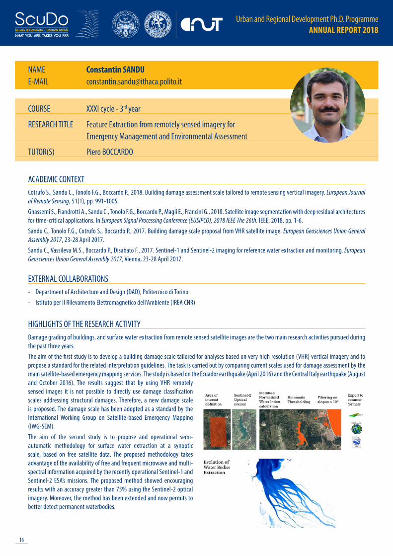
HIGHLIGHTS OF THE RESEARCH ACTIVITYDamage grading of buildings, and surface water extraction from remote sensed satellite images are the two main research activities pursued during the past three years.The aim of the first study is to develop a building damage scale tailored for analyses based on very high resolution (VHR) vertical imagery and to propose a standard for the related interpretation guidelines. The task is carried out by comparing current scales used for damage assessment by the main satellite-based emergency mapping services. The study is based on the Ecuador earthquake (April 2016) and the Central Italy earthquake (August and October 2016). The results suggest that by using VHR remotely sensed images it is not possible to directly use damage classification scales addressing structural damages. Therefore, a new damage scale is proposed. The damage scale has been adopted as a standard by the International Working Group on Satellite-based Emergency Mapping (IWG-SEM).The aim of the second study is to propose and operational semi-automatic methodology for surface water extraction at a synoptic scale, based on free satellite data. The proposed methodology takes advantage of the availability of free and frequent microwave and multi-spectral information acquired by the recently operational Sentinel-1 and Sentinel-2 ESA’s missions. The proposed method showed encouraging results with an accuracy greater than 75% using the Sentinel-2 optical imagery. Moreover, the method has been extended and now permits to better detect permanent waterbodies.
COURSE XXXI cycle - 3rd year
RESEARCH TITLE Feature Extraction from remotely sensed imagery for Emergency Management and Environmental Assessment
TUTOR(S) Piero BOCCARDO
17
Urban and Regional Development Ph.D. Programme ANNUAL REPORT 2018
NAME Diego VITELLOE-MAIL [email protected]
ACADEMIC CONTEXTChapple K., 2014. The Highest and Best Use? Urban Industrial Land and Job Creation. Economic, Development Quarterly, 28(4).Danilo V.D., 2018. The evolution process of Chicago’s industrial land-use policy. Urban Research & Practice, pp. 1-14. Ferm J., Jones E., 2017. Beyond the post-industrial city: Valuing and planning for industry in London. Urban studies, 54(14), pp. 3380-3398.Reynolds E.B., 2017. Innovation and Production: Advanced Manufacturing Technologies, Trends and Implications for US Cities and Regions. Built Environment, 43(1), pp. 25-43.
EXTERNAL COLLABORATIONS- IRES Piemonte- DePaul University, Chicago
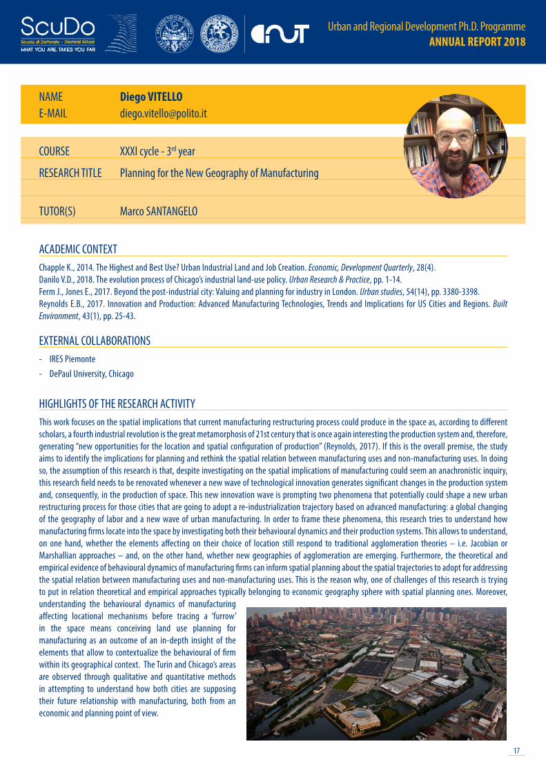
HIGHLIGHTS OF THE RESEARCH ACTIVITYThis work focuses on the spatial implications that current manufacturing restructuring process could produce in the space as, according to different scholars, a fourth industrial revolution is the great metamorphosis of 21st century that is once again interesting the production system and, therefore, generating “new opportunities for the location and spatial configuration of production” (Reynolds, 2017). If this is the overall premise, the study aims to identify the implications for planning and rethink the spatial relation between manufacturing uses and non-manufacturing uses. In doing so, the assumption of this research is that, despite investigating on the spatial implications of manufacturing could seem an anachronistic inquiry, this research field needs to be renovated whenever a new wave of technological innovation generates significant changes in the production system and, consequently, in the production of space. This new innovation wave is prompting two phenomena that potentially could shape a new urban restructuring process for those cities that are going to adopt a re-industrialization trajectory based on advanced manufacturing: a global changing of the geography of labor and a new wave of urban manufacturing. In order to frame these phenomena, this research tries to understand how manufacturing firms locate into the space by investigating both their behavioural dynamics and their production systems. This allows to understand, on one hand, whether the elements affecting on their choice of location still respond to traditional agglomeration theories – i.e. Jacobian or Marshallian approaches – and, on the other hand, whether new geographies of agglomeration are emerging. Furthermore, the theoretical and empirical evidence of behavioural dynamics of manufacturing firms can inform spatial planning about the spatial trajectories to adopt for addressing the spatial relation between manufacturing uses and non-manufacturing uses. This is the reason why, one of challenges of this research is trying to put in relation theoretical and empirical approaches typically belonging to economic geography sphere with spatial planning ones. Moreover, understanding the behavioural dynamics of manufacturing affecting locational mechanisms before tracing a ‘furrow’ in the space means conceiving land use planning for manufacturing as an outcome of an in-depth insight of the elements that allow to contextualize the behavioural of firm within its geographical context. The Turin and Chicago’s areas are observed through qualitative and quantitative methods in attempting to understand how both cities are supposing their future relationship with manufacturing, both from an economic and planning point of view.
COURSE XXXI cycle - 3rd year
RESEARCH TITLE Planning for the New Geography of Manufacturing
TUTOR(S) Marco SANTANGELO
Urban and Regional Development Ph.D. Programme ANNUAL REPORT 2018
18
XXXII CYCLE - 2nd YEAR STUDENTS
19
Urban and Regional Development Ph.D. Programme ANNUAL REPORT 2018
NAME László CSEKEE-MAIL [email protected]
ACADEMIC CONTEXTBraverman I., 2016. Animals, Biopolitics, Law: Lively Legalities. Abingdon and New York: Routledge.Esposito R., 2011. Immunitas: The Protection and Negation of Life. Cambridge: Polity Press.Gillespie K., Collard R.C., 2015. Critical Animal Geographies. Abingdon: Routledge.Neyrat F., 2018. The Unconstructable Earth: An Ecology of Separation. New York: Fordham University Press.
EXTERNAL COLLABORATIONS- Department of Architecture (DIARC), University of Naples Federico II- Fattoria Didattica Biologica Ponteré, Cancello ed Arnone – Caserta
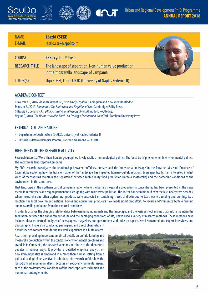
HIGHLIGHTS OF THE RESEARCH ACTIVITYResearch interests: ‘More-than-human’ geographies, Lively capital, Immunological politics, The ‘post-truth’ phenomenon in environmental politics, The ‘mozzarella landscape’ in Campania.My PhD research investigates the relationship between buffaloes, humans and the ‘mozzarella landscape’ in the Terra dei Mazzoni (Province of Caserta), by exploring how the transformation of the ‘landscape’ has impacted human–buffalo relations. More specifically, I am interested in what kinds of mechanisms maintain the ‘separation’ between high-quality food production (buffalo mozzarella) and the damaging conditions of the environment in the same area.That landscape in the northern part of Campania region where the buffalo mozzarella production is concentrated has been presented in the news media in recent years as a region permanently struggling with toxic waste pollution. The sector has been hit hard over the last, nearly two decades, when mozzarella and other agricultural products were suspected of containing traces of dioxin due to toxic waste dumping and burning. As a reaction, the local government, national bodies and agricultural producers have made significant efforts to secure and ‘immunize’ buffalo farming and mozzarella production from the external conditions.In order to analyse the changing relationships between humans, animals and the landscape, and the various mechanisms that seek to maintain the separation between the enhancement of life and the damaging conditions of life, I have used a variety of research methods. These methods have included detailed textual analyses of newspapers, magazines and government and industry reports, semi-structured and expert interviews and photography. I have also conducted participant and direct observation in a multispecies ‘contact zone’ during my work experience in a buffalo farm.Apart from providing important empirical details on buffalo farming and mozzarella production within the contexts of environmental problems and scandals in Campania, this research aims to contribute to the theoretical debates in various ways. It provides a detailed empirical analysis on how immunopolitics is employed in a more-than-human setting from a political-ecological perspective. In addition, this research unfolds how the ‘post-truth’ phenomenon affects debates on socio-environmental issues, such as the environmental conditions of the landscape with its human and nonhuman entanglements.
COURSE XXXII cycle - 2nd year
RESEARCH TITLE The landscape of separation. Non-human value production in the ‘mozzarella landscape’ of Campania
TUTOR(S) Ugo ROSSI, Laura LIETO (University of Naples Federico II)
Urban and Regional Development Ph.D. Programme ANNUAL REPORT 2018
20
NAME Federico DELL’ANNAE-MAIL [email protected]
ACADEMIC CONTEXTBecchio C., Bottero M., Corgnati S., Dell’Anna F., 2018. Decision making for sustainable urban energy planning: an integrated evaluation framework of alternative solutions for a NZED (Net Zero-Energy District) in Turin. Land Use Policy, 78, pp. 803-817.Becchio C., Bottero M., Corgnati S., Dell’Anna F., 2018. Evaluating Health Benefits of Urban Energy Retrofitting: An Application for the City of Turin. In: Bisello A., Vettorato D., Laconte P., Costa S. (eds), Smart and Sustainable Planning for Cities and Regions. SSPCR 2017. Green Energy and Technology. Cham: Springer, pp. 281-304.Becchio C., Bottero M., Corgnati S., Dell’Anna F., 2016. A MCDA-based approach for evaluating alternative requalification strategies for a Net-Zero Energy District (NZED). In Zopounidis C., Doumpos M., Multiple Criteria Decision Making. Cham: Springer, pp.189-211.Buso T., Dell’Anna F., Becchio C., Bottero M., Corgnati S., 2017. Of comfort and cost: Examining indoor comfort conditions and guests’ valuations in Italian hotel rooms. Energy Research & Social Science, 32, pp. 94-111.
EXTERNAL COLLABORATIONS- National University of Singapore- Universitat Politècnica de Catalunya- Energy Center Lab, Politecnico di Torino
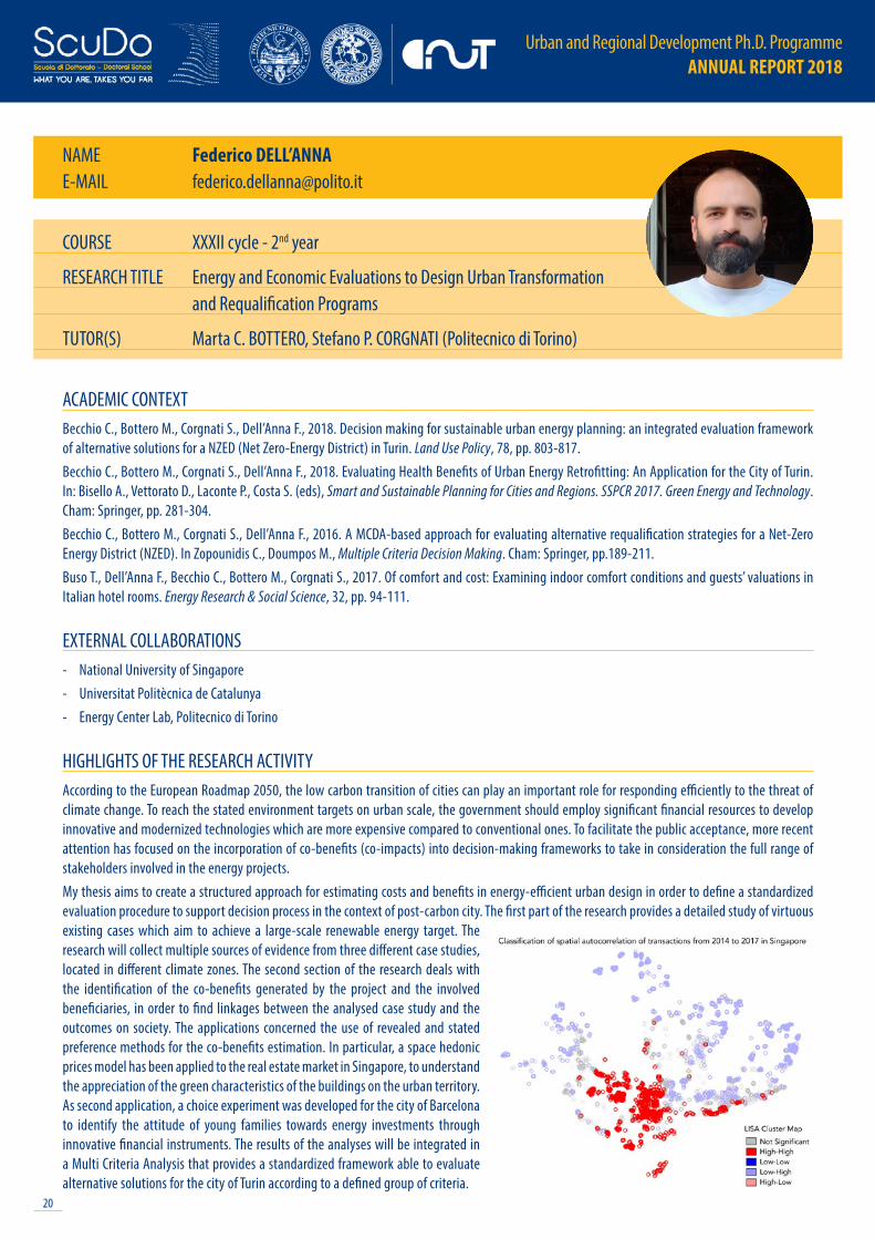
HIGHLIGHTS OF THE RESEARCH ACTIVITYAccording to the European Roadmap 2050, the low carbon transition of cities can play an important role for responding efficiently to the threat of climate change. To reach the stated environment targets on urban scale, the government should employ significant financial resources to develop innovative and modernized technologies which are more expensive compared to conventional ones. To facilitate the public acceptance, more recent attention has focused on the incorporation of co-benefits (co-impacts) into decision-making frameworks to take in consideration the full range of stakeholders involved in the energy projects. My thesis aims to create a structured approach for estimating costs and benefits in energy-efficient urban design in order to define a standardized evaluation procedure to support decision process in the context of post-carbon city. The first part of the research provides a detailed study of virtuous existing cases which aim to achieve a large-scale renewable energy target. The research will collect multiple sources of evidence from three different case studies, located in different climate zones. The second section of the research deals with the identification of the co-benefits generated by the project and the involved beneficiaries, in order to find linkages between the analysed case study and the outcomes on society. The applications concerned the use of revealed and stated preference methods for the co-benefits estimation. In particular, a space hedonic prices model has been applied to the real estate market in Singapore, to understand the appreciation of the green characteristics of the buildings on the urban territory. As second application, a choice experiment was developed for the city of Barcelona to identify the attitude of young families towards energy investments through innovative financial instruments. The results of the analyses will be integrated in a Multi Criteria Analysis that provides a standardized framework able to evaluate alternative solutions for the city of Turin according to a defined group of criteria.
COURSE XXXII cycle - 2nd year
RESEARCH TITLE Energy and Economic Evaluations to Design Urban Transformation and Requalification Programs
TUTOR(S) Marta C. BOTTERO, Stefano P. CORGNATI (Politecnico di Torino)

21
Urban and Regional Development Ph.D. Programme ANNUAL REPORT 2018
NAME Massimiliano GRANCERIE-MAIL [email protected]
ACADEMIC CONTEXTBirkmann J., Garschagen M., Kraas F., Quang N., 2010. Adaptive urban governance: new challenges for the second generation of urban adaptation strategies to climate change. Sustain Sci, 5, pp. 185-206.Fussel H-M., 2007. Adaptation planning for climate change: concepts, assessment approaches, and key lessons. Sustain Sci, 2, pp. 265-275.Runhaar H., Wilk B., Persson Å. et al., 2018. Mainstreaming climate adaptation : taking stock about “what works’’ from empirical research worldwide. Regional Environmental Change, 18, p. 1201 Wamsler C., 2014. Cities, Disaster Risk and Adaptation. Routledge.
EXTERNAL COLLABORATIONS- Universitat Internacional de Catalunya (UIC)- Comune di Torino, Assessorato all’Ambiente
HIGHLIGHTS OF THE RESEARCH ACTIVITYClimate Change Adaptation (CCA) in recent years has increased in terms of importance and audience, globally speaking. Differently from Climate Change Mitigation (CCM), CCA has been designed and planned later than CCM. Furthermore, CCA actions and effects mainly remain at the local level, differently from Mitigation. At local level, some cities have already designed CCA-oriented plans and projects, but still the quality of these planning tools is low and many times they lack in terms of integration with the other plans and in terms of operability. Municipalities play an important role in the urban governance of CCA, but supra-municipal levels (i.e. provincial, regional, national, supra-national) are also critical and have to be taken into account. All these multi-level and multi-scalar approaches reflect the complexity synthetized in the concept of “mainstreaming” CCA. Generally, the process of mainstreaming involves a cross-sectoral integration, both horizontal and vertical, of policies and measures, into ongoing urban development planning processes and existing plans or programmes.This PhD Thesis focuses on the CCA mainstreaming process and addresses several issues, i.e.: the effectiveness of planning and management tools for CCA purposes; the way local institutions deal with CCA and how they mainstream it across sectors and scales; the CCA-CCM dichotomy and the trade-offs that embeds; the role of private companies and civil society in CCA; the assessment of CCA mainstreaming processes along the understanding-planning-implementation path. Thus, the main objective of this PhD Thesis is to find the enabling factors that drive CCA to a successful implementation, through mainstreaming processes, and frame them within an Adaptive (Urban) Governance.This research frames its geographic focus on a specific context, namely the South Europe, and the cities that were selected for this study are: Barcelona (Spain) and Turin (Italy). Both municipalities have CCA plans and strategies in process. Barcelona approved its Strategic Climate Plan in the early 2018 and has already started the Plan’s co-implementation phase jointly with local organizations. Turin has started recently a multi-sectoral co-creation process of a CCA-oriented strategy that has its roots in the EU-LIFE+ project, namely DERRIS. Both cases have topical issues to be investigated, which give originality to the research, and the PhD Candidate participate officially in both processes.
COURSE XXXII cycle - 2nd year
RESEARCH TITLE Mainstreaming Climate Adaptation in southern European Cities. Challenges and Enablers toward an Adaptive Urban Governance
TUTOR(S) Maurizio TIEPOLO, Lorenzo CHELLERI (Universitat Internacional de Catalunya)

Urban and Regional Development Ph.D. Programme ANNUAL REPORT 2018
22
NAME Fabio IAPAOLOE-MAIL [email protected]
ACADEMIC CONTEXTBratton H.B., 2015. The Stack. On Software and Sovereignty. Cambridge: MIT Press.Parisi L., 2013. Contagious Architecture: Computation, Aesthetics, and Space. Cambridge and London: MIT Press.Pasquinelli M., ed., 2014. Alleys of Your Mind: Augmented Intelligence and its Traumas. Lüneburg: Meson Press.Simondon G., 2007. On the Mode of Existence of Technical Objects. (C. Malaspina, J. Rogove, Trans.). Minneapolis and London: University of Minnesota Press. (Original work published 1958).
EXTERNAL COLLABORATIONS- Research Group on Critical Machine Intelligence (KIM), University of Arts and Design, Karlsruhe
HIGHLIGHTS OF THE RESEARCH ACTIVITYDeep-rooted in technological animism, the field of Artificial Intelligence can be seen as the most recent stage of a centuries-old project attempting to explicate the human mind by means of artificial reproduction. Whereas industrial processes of automation attempted to reproduce assembly-line physical labour, the field of Artificial Intelligence has traditionally devoted itself to building machines possessing or simulating human-level intelligence.Although anthropomorphic notions of machine intelligence continue proliferate in the media and business-produced literature (e.g.: humanoid robots), what is popularly referred to as Artificial Intelligence more properly describes the design and application of advanced techniques of statistical induction used to extract patterns from data. In other words, today’s dominant paradigm in machine intelligence is based on intelligent agents endowed with machine learning, that is, that are trained on example tasks in order to become progressively autonomous in solving domain-specific problems.Intelligent systems based on the algorithmic processing of data are currently being employed in various domains, wherein machine agency is expressed, ultimately, in terms of a certain degree of decisional autonomy (e.g.: autonomous lethal weapons, algorithmic trading). The concept of autonomy here refers to the extent to which the contingent outcome of decision-making relies less on human knowledge and control than on the algorithmic elaboration of data. Various theories have been developed to reframe the agency of nonhumans and investigate the effects of technology on human subjectivity, while a growing number of studies is addressing the ethical, legal and socio-political implications of algorithmic governance. This project investigates a specific type of nonhuman agents: intelligent agents employed in automated systems that, together with human actors, constitute complex ‘cognitive assemblages’. Drawing on Simondon’s (2007 [1958]) philosophy of technology, this research project questions the ontological and methodological individualism dominant in the social sciences that treats both machines and humans as individual agents and that is proving inadequate in dealing with complex human-technical assemblages wherein perception and cognition are distributed throughout the system and thus the locus of decision-making is difficult to localize.With the aim to historically contextualize this emerging system of distributed agency and shed light on both its techno-geographical preconditions and transformative potentials, this research project investigates a specific technology: autonomous vehicles, also popularly known as self-driving cars. The latter are conceived not as a single technology – the autonomous vehicle as a perceptive, cognitive and decisional unit – but rather as a networked ensemble of human-technical components.
COURSE XXXII cycle - 2nd year
RESEARCH TITLE De-Individuation of the Modern Subject in the Age of Machine Autonomy
TUTOR(S) Marco SANTANGELO

23
Urban and Regional Development Ph.D. Programme ANNUAL REPORT 2018
NAME Lucia LUPIE-MAIL [email protected]
ACADEMIC CONTEXTFoth M., ed., 2008. Handbook of research on urban informatics: the practice and promise of the real-time city. IGI Global.Foth M., Brynskov M., Ojala T., eds., 2015. Citizen’s right to the digital city: urban interfaces, activism, and placemaking. Singapore: Springer.Wulf V., Schmidt K., Randall D., eds., 2015. Designing socially embedded technologies in the real-world. London: Springer.
EXTERNAL COLLABORATIONS- The Open University, Milton Keynes, UK
HIGHLIGHTS OF THE RESEARCH ACTIVITYThe central problem addressed by the research is that existing digital technologies intended to change the life in our cities and implement the visions of smart city futures are still marginal in the everyday actions of city stakeholders. The goal of this research is therefore to understand how to design future information technologies, in particular web technologies, that could be functional to the local development at urban scale by supporting the orchestration of the city stakeholders’ actions. The nature of the problem to be addressed and the need of integrating knowledge and methods of a plurality of disciplines for analysing the problem and developing alternative solutions led to choose a transdisciplinary framework as guide and support during the research process. This work explored the integration between approaches, methods and theories of urban planning, design, and development with informatics and system design disciplines, within a transdisciplinary research process that adapted the TIPS framework to the specificity of a design problem. In particular, by applying action research methods participatory design techniques during the development of the three prototypes of tools framed as multi-stakeholders, multi-purpose, and multi-scale, I investigated the constraints and the potential representations of social structures and city activities on a web platform. The findings, lessons learned and applicative scenarios gathered across the three case studies are currently under a process of progressive conceptualization and systematization in a theoretical framework aimed to define the principles for the design of web technologies effectively integrated in city activities and local development actions. A final synthesis of system requirements and evaluation criteria will provide operational guidelines for designers and decisions makers intended to build or adopt them in local initiatives.During this year of activities, I developed the methodological framework to carried out the analysis, compliant with the approaches and methods of the transdisciplinary research. Then, I elaborated a model of dynamic social structures for representing collective users (such as city stakeholders) associated with their activities on web platform. This model provided the lens for the analysis of the case studies. Lastly, I structured and carried out the field activities for the third case study aimed to design the smart city data interface of the City of Milton Keynes (UK) in collaboration with the MK:Insight project team.
COURSE XXXII cycle - 2nd year
RESEARCH TITLE Mirroring the city. Toward web technologies to support city stakeholders in the orchestration of local development actions
TUTOR(S) Marta C. BOTTERO, Giancarlo COTELLA, Anna DE LIDDO (The Open University)

Urban and Regional Development Ph.D. Programme ANNUAL REPORT 2018
24
NAME Andrea MORAE-MAIL [email protected]
ACADEMIC CONTEXTAmin A., 2013. Telescopic urbanism and the poor. City, 17(4), pp. 476-492.Jones A., Murphy J.T., 2011. Theorizing practice in economic geography: Foundations, challenges, and possibilities. Progress in Human Geography, 35(3), pp. 366-392.Nicolini D., 2009. Zooming In and Out: Studying Practices by Switching Theoretical Lenses and Trailing Connections. Organization Studies, 30(12), pp. 1391-1418. Roy A., 2005. Urban Informality: Toward an Epistemology of Planning. Journal of the American Planning Association, 71(2), pp. 147-158.Schatzki T.R., 2012. A Primer on Practices. In J. Higgs, R. Barnett, S. Billett, M. Hutchings, F. Trede, Practice-Based Education. Rotterdam: SensePublishers, pp. 13-26.
EXTERNAL COLLABORATIONS- Grupo Interdisciplinario de Investigación en Ciudades y Territorios Urbanos (INCITU), Centro de Investigación de la Arquitectura y la Ciudad (CIAC),
Pontificia Universidad Católica del Perú (PUCP)- Equipo permanente de Hábitat, TECHO Perú, TECHO
HIGHLIGHTS OF THE RESEARCH ACTIVITYAs Roy (2005) suggests informality should be an important epistemology for urban planning. Instead, while many of the greatest urban transformation world wide occur through informal processes of expansion and subsequent consolidation efforts of related urban areas to reach the line of what is erroneously assumed as “the city”.In the field of the urban studies with a focus in social and spatial justice, a recent entrant approach has attempted to examine informal urban conditions from a different prospective. The reflections on ‘telescopic urbanism’, started by Amin (2013) and fuelled by others scholars have the purpose to claim for different analytical lens enquiring cities. It refers to the opportunity to see the urban condition as an integral whole rather then separated pieces, each one self-referential. Following this debate, my research project addresses questions about low income and informal settlement situation and urban consolidation processes in Lima, Peru. It enquires practices of physical and social production of spaces among a multiplicity of involved actors, inside and outside the boundary of informality. The multiscaled dimension of action and agency is explored by this work assuming a practice-based approach (Schatzki, 2012). An approach chosen due to its capacity to “examine and interpret socioeconomic processes through a focus on the actions and meanings through which and wherein the everyday world is constituted” (Jones & Murphy 2011:371). Following its assumption, a specific qualitative multi-methods toolbox (Nicolini 2009) has been composed, including interviews, quasi-participant observation and focus groups. With the help of TECHO, an international NGO, case-study areas were located in La Nueva Rinconada in San Juna de Miraflores, were grassroot organizations had been selected as reference communities.
COURSE XXXII cycle - 2nd year
RESEARCH TITLE Unravelling collective efforts activities. Practices muddled and material arrangement in the third season of barriadas of Lima
TUTOR(S) Francesca GOVERNA
25
Urban and Regional Development Ph.D. Programme ANNUAL REPORT 2018
NAME Qi MUE-MAIL [email protected]
ACADEMIC CONTEXTMandal R.B., 1989. Systems of Rural Settlements in Developing Countries. New Delhi: Concept Publishing Company.Whitehand J.W.R, Gu K., Conzen. Whitehand S.M., 2014. The typological process and the morphological period: a cross-cultural assessment, Environment and Planning. Planning and Design, 41, pp. 512-533.Zhou Z.X., Cheng S.J., 2018. A Study on the Morphology and Survival Rationality of Ethnic Buyi Settlements in Baishui Valley, Guizhou Province. Architectural Journal, 3, pp. 101-106.
EXTERNAL COLLABORATIONS- Planning Bureau of the Municipality of Tongren, China
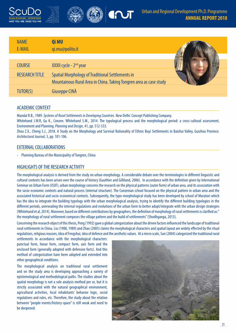
HIGHLIGHTS OF THE RESEARCH ACTIVITYThe morphological analysis is derived from the study on urban morphology. A considerable debate over the terminologies in different linguistic and cultural contexts has been arisen over the course of history (Gauthier and Gilliland, 2006). In accordance with the definition given by International Seminar on Urban Form (ISUF), urban morphology concerns the research on the physical patterns (outer form) of urban area, and its association with the socio-economic contexts and natural process (internal structure). The Conzenian school focused on the physical pattern in urban area and the associated historical and socio-economical contexts. Subsequently, the typo-morphological study has been developed by school of Muratori which has the idea to integrate the building typology with the urban morphological analysis, trying to identify the different building typologies in the different periods, unrevealing the internal regulations and evolutions of the urban form to better adopt/integrate with the urban design strategies (Whitehand et al, 2014). Moreover, based on different contributions by geographers, the definition of morphology of rural settlements is clarified as:“ the morphology of rural settlement composes the village pattern and the build of settlements” (Shodhganga, 2013). Concerning the research object of this thesis, Peng (1992) gave a global categorization about the driven factors influenced the landscape of traditional rural settlements in China. Liu (1988, 1989) and Zhao (2005) claims the morphological characters and spatial layout are widely effected by the ritual regulations, religious reasons, idea of Fengshui, idea of defence and the aesthetic values. At a micro scale, Sun (2004) categorized the traditional rural settlements in accordance with the morphological characters: punctual form, linear form, compact form, axis form and the enclosed form (generally adopted with defensive forts). And this method of categorization have been adopted and extended into other geographical conditions. The morphological analysis on traditional rural settlement and on the study area is developing approaching a variety of epistemological and methodological paths. The studies about the spatial morphology is not a sole analysis method per se, but it is strictly associated with the natural geographical environment, agricultural activities, local inhabitants’ behavior logic, social regulations and rules, etc. Therefore, the study about the relation between “people-events/history-space” is still weak and need to be deepened.
COURSE XXXII cycle - 2nd year
RESEARCH TITLE Spatial Morphology of Traditional Settlements in Mountainous Rural Area in China. Taking Tongren area as case study
TUTOR(S) Giuseppe CINÀ

Urban and Regional Development Ph.D. Programme ANNUAL REPORT 2018
26
NAME Maurizio PIOLETTIE-MAIL [email protected]
ACADEMIC CONTEXTMazza L., 2015. Spazio e cittadinanza: Politica e governo del territorio. Donzelli. Janin Rivolin U., 2012. Planning systems as institutional technologies: a proposed conceptualization and the implications for comparison. Planning Practice and Research, 27(1), pp. 63-85. Pioletti M., de Oliveira Royer L., Urquieta Crespo P., 2019. La relación entre democracia y gobernanza territorial como articulación de los derechos espaciales. Revista Cuadernos de Geografía, 28(2).Pioletti M., de Oliveira Royer L., Urquieta Crespo P., 2019. La articulación de los derechos espaciales en las ocupaciones ilegales para vivienda en el centro de San Pablo (Brasil) y en El Alto (Bolivia). Uso del derecho y acciones colectivas en areas urbanas segregadas de America Latina y El Caribe. FLACSO, Quito, Ecuador.
EXTERNAL COLLABORATIONS- FAU USP, University of São Paulo - FUNDO FICA, Fundo Imobiliário Comunitário para Aluguel, São Paulo, Brazil - CIDES UMSA, Universidad Mayor de San Andres, La Paz - GAMLP, Municipality of La Laz - GADLP, Departamento de La Paz- RED-HÁBITAT, El Taller
de Proyectos e Investigación del Hábitat Urbano y Rural, El Alto, Bolivia- Associazione di Amicizia Italia-Cuba, Torino, Italy
HIGHLIGHTS OF THE RESEARCH ACTIVITYThis research focuses on the relationship between spatial governance and democracy. It considers the definition and implementation of national planning systems and local policies, and the citizenship rights, in terms of spatial relationships and practices. The empirical objects of the analysis are the metropolitan regions in Bolivia, Brazil and Cuba. They are three different complementary cases, given by the fact that the agrarian and urban land reforms – which are at the basis of the current land use and occupation and spatial rights – were different and were implemented with totally different modalities, even if all based on the principle of the social function of property. Within the combination of formal and informal urban space production, the integration between right to property and practice of possession of land and housing seems to be central, because in a Lefebvre’s space appropriation perspective, given certain conditions, possession and its legitimation are needed to ensure to access to land and housing for whom are excluded from the formal market. The social, political and juridical debate on the regularization of property and the legitimation of possession has been very influent and the analysis of the socialist Cuban experience could significantly contribute to this debate offering a different perspective. Furthermore, historically the municipalities have been given the responsibilities to ensure the basic citizenship rights, included the ones having a spatial dimension. Nevertheless, now urban systems are composed of numerous municipalities which should cooperate, not only to improve the service provision performance, but also to assume a comprehensive urban approach, able to reduce the social differences with the same urban region, in other terms, to reduce the spatial injustice.
COURSE XXXII cycle - 2nd year
RESEARCH TITLE Spatial governance in Latin American and Carribean countries: a survey framed by metropolitan regions in Bolivia, Brasil and CubaTUTOR(S) Umberto JANIN RIVOLIN, Luciana DE OLIVEIRA ROYER (FAU USP, Brazil)

27
Urban and Regional Development Ph.D. Programme ANNUAL REPORT 2018
NAME Federico PIOVESANE-MAIL [email protected]
ACADEMIC CONTEXTHess C., Ostrom E., eds., 2007. Understanding knowledge as a commons: from theory to practice. Cambridge, Mass: MIT Press.Kelty C.M., 2016. Too Much Democracy in All the Wrong Places: Toward a Grammar of Participation. Current Anthropology S000–S000. Latour, B. 2005. Reassembling the social: an introduction to actor-network-theory. Oxford, New York: Oxford University Press.Reason P., Bradbury H., eds., 2011. The Sage handbook of action research: participative inquiry and practice. 2 ed., reprinted, London: SAGE.
EXTERNAL COLLABORATIONS- Avanzi, Sostenibilià per Azioni, Milan- Comune di Chieri
HIGHLIGHTS OF THE RESEARCH ACTIVITYThe goal of my research is to test whether ICT tools can be integrated within ongoing processes on the participatory management of urban commons, and reflect on the opportunities and risks connected with such digital instruments.Rather than building or deciding a priori which tools can best support participation, I experiment with available one, mainly deriving from open source and free software. In this way, I hope to prioritize the needs of stakeholders and promote autonomy through technological solutions that can be managed independently.The questions I address are: 1) What obstacles must be overcome to integrate a new digital tool within an ongoing process? What opportunities can be sought and what risks might arise?2) Do digital tools significantly impact different aspects of participation? If so, how?For example, do digital tools facilitate knowledge exchange and consequently affect internal power dynamics? Do they help actors to coordinate better, and perhaps make them more effective in the pursuit of their external goals? Also, what other aspects that were not not considered before emerge during field-work?Since my study is based on direct involvement as a key source of knowledge creation, the thesis starts with a chapter on the my research approach, which combines Action Research and Actor-Network Theory. Despite its ethical and epistemological consequences, direct involvement can help portray an unconventional, and hopefully nuanced, picture of participatory processes. In the two following chapters, I introduce the literature relevant to the study, respectively dealing with urban commons on the one hand, and participation on the other.So far, my field-work has revolved around two participatory processes in taking place in Chieri, a town thirty kilometers from Turin. Here I followed a team of consultants that the local municipality hired to facilitate the processes; while observing their work, proposed already available digital tools that might support different aspects of each process. For example, together with a group of young people (aged between 16 and 22) and a number of local associations, we built a web page to collect memories, opinions and proposals revolving around a former textile factory that was central to one of the processs (see image attached, or visit www.nextabasso.it).
COURSE XXXII cycle - 2nd year
RESEARCH TITLE Co-Governing Urban Commons with Context-Sensitive Technology
TUTOR(S) Giancarlo COTELLA, Grazia BRUNETTA

Urban and Regional Development Ph.D. Programme ANNUAL REPORT 2018
28
NAME Leonardo RAMONDETTIE-MAIL [email protected]
ACADEMIC CONTEXTBerger A., 2007. Drosscape: Wasting land urban America. Princeton Architectural Press.Chung C.J., Inaba J., Koolhaas R., Leong S.T., 2001. Great leap forward: Harvard design school project on the city. Taschen. Kurgan L., 2013. Close Up at a Distance: Mapping, Technology, and Politics. MIT Press.Phelps N., Wu F., 2011. International Perspectives on Suburbanization: A Post-Suburban World?. Palgrave Macmillan UK.
EXTERNAL COLLABORATIONS- Tsinghua University of Beijing, China- South China University of Technology of Guangzhou, China- Research CeNTO, Chinese New TOwns: negotiating citizenship and physical form, Politecnico di Torino, Tsinghua University, Ecole Polytechnique
Fédérale de Lausanne
HIGHLIGHTS OF THE RESEARCH ACTIVITYBy looking out from the window of an highspeed train, the central plains of Henan appears as a scattered patter of urbanization mainly composed by old and new villages, huge factories and farms. All this spaces are collected together by a dense infrastructural network composed by roads, highways, railways and canals. The train moves on, and after crossing the Yellow River the landscape abruptly changes. Construction sites replace the agricultural fields, the blue roofs of the workers’ shanks substitute the red roofs of the farmers’ houses, the infrastructural network densifies more and more, and several compounds of high rise buildings fulfill the landscape. The train slows down and stops in the railway station of Zhenghdong New District in Zhengzhou, the provincial capital of Henan, a municipality of 9 million inhabitants in a territory of 744.620 hectares. Zhengzhou is an icon of the radical transformation that is affecting the inner regions of China. An ongoing process which is totally redefining the landscape by changing the relationships and the composition of the spaces and the elements on the ground. Despite some similarities this phenomenon seems to be different from the transformations that since the Eighties has characterized the coastal regions of China. In the same way, even if it is possible to find some ambiguous analogies to the worldwide spread urbanization, the landscape of Zhengzhou shows some peculiar features that make it different from the European dispersed metropolis, the American sprawl or the Asian desakota.In fact, due to the significant role of urban design and planning activities supported by strong urbanization policies, nowadays in Zhengzhou the landscape presents syntropic characteristics: the city is expanding through progressive and bounded addictions, the new rural settlements are thickening the built-up land by replacing the older ones, and specific land use can be found in delimited areas (such as ecological corridors, agricultural parks, or industrial platforms). The in-between space is merely consider a blank canvas open up to further transformations. As result the landscape of Zhengzhou seems to be composed by several spaces ambiguously collected together next to each other. Starting from this considerations, the research set up an interpretation of this place by inquiring the morphological elements of the landscape and their relationships in order to understand how this urbanization is questioning the well-known metropolitan area in other parts of the world.
COURSE XXXII cycle - 2nd year
RESEARCH TITLE Spaces of Accumulation in the central plains of China. The case of Zhengzhou, Henan
TUTOR(S) Angelo SAMPIERI, Francesca GOVERNA
29
Urban and Regional Development Ph.D. Programme ANNUAL REPORT 2018
NAME Niccolò RAPETTIE-MAIL [email protected]
ACADEMIC CONTEXTCiribini A.L.C., 2013. Level of Detail e Level of Development: i processi di committenza e l’Information Modelling. Techne, 6, pp. 90-99.Clevenger C., Ozbek M., Mahmoud H., Fanning B., 2014. Impacts and Benefits of Implementing Building Information Modeling on Bridge Infrastructure Projects. Mt. Consort.Succar B., Sher W., Williams A., 2012. Measuring BIM performance: Five metrics. Archit. Eng. Des. Manag., 8(2), pp. 120-142.
EXTERNAL COLLABORATIONS- ANAS S.p.a
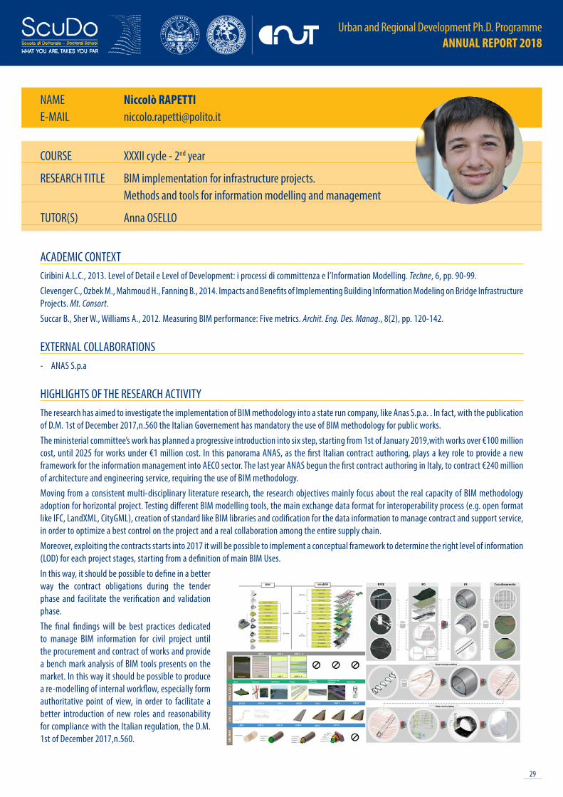
HIGHLIGHTS OF THE RESEARCH ACTIVITYThe research has aimed to investigate the implementation of BIM methodology into a state run company, like Anas S.p.a. . In fact, with the publication of D.M. 1st of December 2017,n.560 the Italian Governement has mandatory the use of BIM methodology for public works. The ministerial committee’s work has planned a progressive introduction into six step, starting from 1st of January 2019,with works over €100 million cost, until 2025 for works under €1 million cost. In this panorama ANAS, as the first Italian contract authoring, plays a key role to provide a new framework for the information management into AECO sector. The last year ANAS begun the first contract authoring in Italy, to contract €240 million of architecture and engineering service, requiring the use of BIM methodology.Moving from a consistent multi-disciplinary literature research, the research objectives mainly focus about the real capacity of BIM methodology adoption for horizontal project. Testing different BIM modelling tools, the main exchange data format for interoperability process (e.g. open format like IFC, LandXML, CityGML), creation of standard like BIM libraries and codification for the data information to manage contract and support service, in order to optimize a best control on the project and a real collaboration among the entire supply chain. Moreover, exploiting the contracts starts into 2017 it will be possible to implement a conceptual framework to determine the right level of information (LOD) for each project stages, starting from a definition of main BIM Uses. In this way, it should be possible to define in a better way the contract obligations during the tender phase and facilitate the verification and validation phase. The final findings will be best practices dedicated to manage BIM information for civil project until the procurement and contract of works and provide a bench mark analysis of BIM tools presents on the market. In this way it should be possible to produce a re-modelling of internal workflow, especially form authoritative point of view, in order to facilitate a better introduction of new roles and reasonability for compliance with the Italian regulation, the D.M. 1st of December 2017,n.560.
COURSE XXXII cycle - 2nd year
RESEARCH TITLE BIM implementation for infrastructure projects. Methods and tools for information modelling and management
TUTOR(S) Anna OSELLO

Urban and Regional Development Ph.D. Programme ANNUAL REPORT 2018
30
NAME Pablo Angel RUFFINOE-MAIL [email protected]
ACADEMIC CONTEXTDore C., Murphy M., 2012. Integration of Historic Building Information Modeling (HBIM) and 3D GIS for recording and managing cultural heritage sites. In Virtual Systems and Multimedia (VSMM), 18th International Conference, pp. 369-376.Ruffino P.A., Del Giudice M., 2018. From geospatial data to information modeling. In Dn Building Information Modeling, Data & Semantics. Roma, pp. 35-44.Ruffino P.A., Osello A, Perumal V., Wong C.O., 2018. Building information modeling: a new educational technology for construction students?. In 10th International Conference on Education and New Learning Technologies. EDULEARN18 Proceedings. Palma, Spain, pp. 544-548.
EXTERNAL COLLABORATIONS- MMU, Multimedia University of Malaysia- IIS Sella Aalto Lagrange - Associazione per il patrimonio dei paesaggi vitivinicoli di Langhe-Roero e Monferrato
HIGHLIGHTS OF THE RESEARCH ACTIVITYThe research topic focus on the digitalization of the built environment as important contribution for Smart Cities goals. The thesis is going to give attention to the main advanced technologies aiming to facilitate the conservation and dissemination of historical buildings and sites. For each innovative technology or methodology applied to case studies chosen, the research is committed to summarize their potentialities and limitations. More specifically, the research considers photogrammetry and geomatic technologies about surveying stages, BIM-base software for data restitution stage and AR/VR/MR (Augmented/Virtual/Mixed Reality) for dissemination issues. One of the main research value, it is to prove that virtual models of existing buildings can be useful for many goals belonging to different field. The basic hypothesis is that 3D models of buildings and cities, besides the digitalization of the built environment, allow to get new kind of innovative solutions during the construction life cycle in order to store, manage and visualize building data, but it is not limited to this. Taking advantages of 3D models and innovative visualization tools, it is possible to develop interesting solutions, especially concerning the dissemination of cultural heritage. About that, the research aims to apply this approach to get make easier the fruition and the accessibility to person who are unable to visit cultural sites. This methodology concerns relevant places such as museums, UNESCO sites, historical buildings and so on. Main users could be represented by far tourists, seniors, occupational therapy patients and so on. In the end, thesis faces training aspects to educate future professionals of medium level at digital skills addressed to the built environment. In conclusion, thesis goals can be summarized in the following research questions:- Can the digitalization approach contribute to achieve Smart Cities objectives?- Which are current and innovative technologies and methodologies to get digital cultural heritage?- What are achievable goals starting from historic building information models?- How to prepare future professional to govern digital environment applied to cultural heritage?
COURSE XXXII cycle - 2nd year
RESEARCH TITLE Digital cultural heritage: information modelling approach for conservation and dissemination issues of historical buildings and sites
TUTOR(S) Anna OSELLO
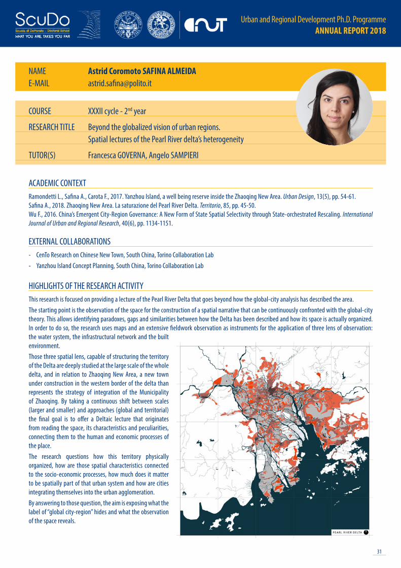
31
Urban and Regional Development Ph.D. Programme ANNUAL REPORT 2018
NAME Astrid Coromoto SAFINA ALMEIDAE-MAIL [email protected]
ACADEMIC CONTEXTRamondetti L., Safina A., Carota F., 2017. Yanzhou Island, a well being reserve inside the Zhaoqing New Area. Urban Design, 13(5), pp. 54-61.Safina A., 2018. Zhaoqing New Area. La saturazione del Pearl River Delta. Territorio, 85, pp. 45-50.Wu F., 2016. China’s Emergent City-Region Governance: A New Form of State Spatial Selectivity through State-orchestrated Rescaling. International Journal of Urban and Regional Research, 40(6), pp. 1134-1151.
EXTERNAL COLLABORATIONS- CenTo Research on Chinese New Town, South China, Torino Collaboration Lab- Yanzhou Island Concept Planning, South China, Torino Collaboration Lab
HIGHLIGHTS OF THE RESEARCH ACTIVITYThis research is focused on providing a lecture of the Pearl River Delta that goes beyond how the global-city analysis has described the area. The starting point is the observation of the space for the construction of a spatial narrative that can be continuously confronted with the global-city theory. This allows identifying paradoxes, gaps and similarities between how the Delta has been described and how its space is actually organized. In order to do so, the research uses maps and an extensive fieldwork observation as instruments for the application of three lens of observation: the water system, the infrastructural network and the built environment. Those three spatial lens, capable of structuring the territory of the Delta are deeply studied at the large scale of the whole delta, and in relation to Zhaoqing New Area, a new town under construction in the western border of the delta than represents the strategy of integration of the Municipality of Zhaoqing. By taking a continuous shift between scales (larger and smaller) and approaches (global and territorial) the final goal is to offer a Deltaic lecture that originates from reading the space, its characteristics and peculiarities, connecting them to the human and economic processes of the place. The research questions how this territory physically organized, how are those spatial characteristics connected to the socio-economic processes, how much does it matter to be spatially part of that urban system and how are cities integrating themselves into the urban agglomeration. By answering to those question, the aim is exposing what the label of “global city-region” hides and what the observation of the space reveals.
COURSE XXXII cycle - 2nd year
RESEARCH TITLE Beyond the globalized vision of urban regions. Spatial lectures of the Pearl River delta’s heterogeneity
TUTOR(S) Francesca GOVERNA, Angelo SAMPIERI
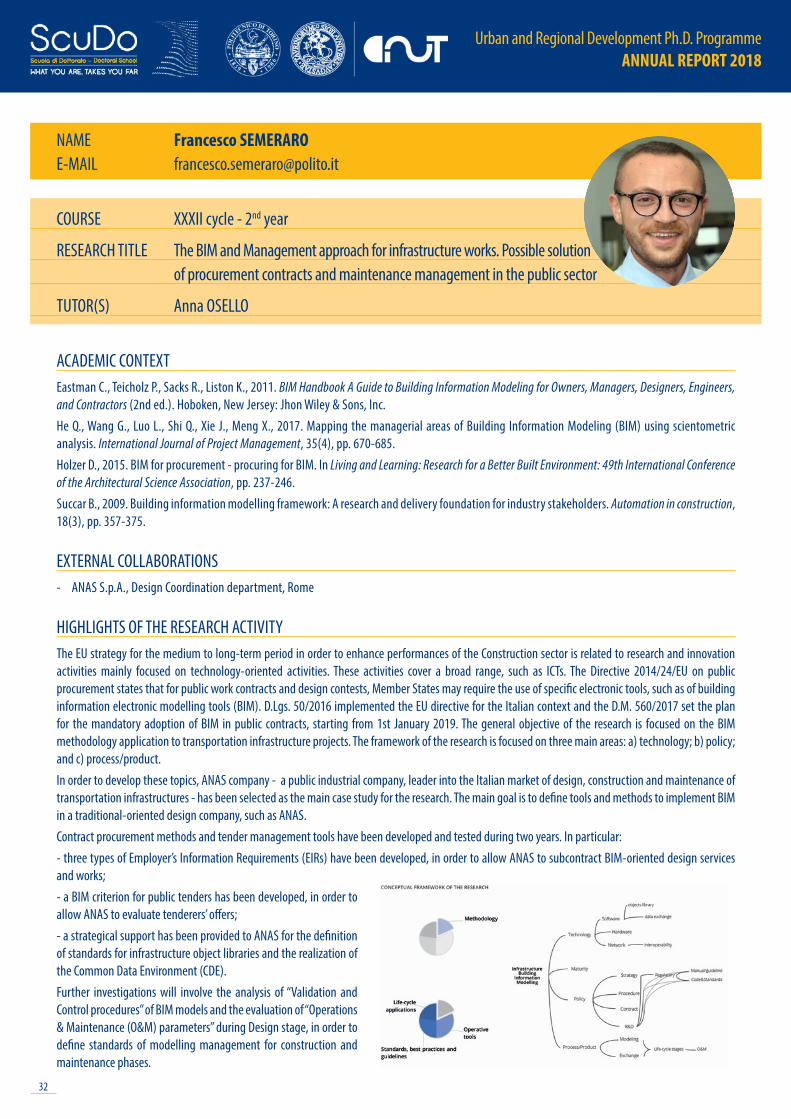
Urban and Regional Development Ph.D. Programme ANNUAL REPORT 2018
32
NAME Francesco SEMERAROE-MAIL [email protected]
ACADEMIC CONTEXTEastman C., Teicholz P., Sacks R., Liston K., 2011. BIM Handbook A Guide to Building Information Modeling for Owners, Managers, Designers, Engineers, and Contractors (2nd ed.). Hoboken, New Jersey: Jhon Wiley & Sons, Inc.He Q., Wang G., Luo L., Shi Q., Xie J., Meng X., 2017. Mapping the managerial areas of Building Information Modeling (BIM) using scientometric analysis. International Journal of Project Management, 35(4), pp. 670-685.Holzer D., 2015. BIM for procurement - procuring for BIM. In Living and Learning: Research for a Better Built Environment: 49th International Conference of the Architectural Science Association, pp. 237-246. Succar B., 2009. Building information modelling framework: A research and delivery foundation for industry stakeholders. Automation in construction, 18(3), pp. 357-375.
EXTERNAL COLLABORATIONS- ANAS S.p.A., Design Coordination department, Rome
HIGHLIGHTS OF THE RESEARCH ACTIVITYThe EU strategy for the medium to long-term period in order to enhance performances of the Construction sector is related to research and innovation activities mainly focused on technology-oriented activities. These activities cover a broad range, such as ICTs. The Directive 2014/24/EU on public procurement states that for public work contracts and design contests, Member States may require the use of specific electronic tools, such as of building information electronic modelling tools (BIM). D.Lgs. 50/2016 implemented the EU directive for the Italian context and the D.M. 560/2017 set the plan for the mandatory adoption of BIM in public contracts, starting from 1st January 2019. The general objective of the research is focused on the BIM methodology application to transportation infrastructure projects. The framework of the research is focused on three main areas: a) technology; b) policy; and c) process/product. In order to develop these topics, ANAS company - a public industrial company, leader into the Italian market of design, construction and maintenance of transportation infrastructures - has been selected as the main case study for the research. The main goal is to define tools and methods to implement BIM in a traditional-oriented design company, such as ANAS. Contract procurement methods and tender management tools have been developed and tested during two years. In particular:- three types of Employer’s Information Requirements (EIRs) have been developed, in order to allow ANAS to subcontract BIM-oriented design services and works; - a BIM criterion for public tenders has been developed, in order to allow ANAS to evaluate tenderers’ offers; - a strategical support has been provided to ANAS for the definition of standards for infrastructure object libraries and the realization of the Common Data Environment (CDE).Further investigations will involve the analysis of “Validation and Control procedures” of BIM models and the evaluation of “Operations & Maintenance (O&M) parameters” during Design stage, in order to define standards of modelling management for construction and maintenance phases.
COURSE XXXII cycle - 2nd year
RESEARCH TITLE The BIM and Management approach for infrastructure works. Possible solution of procurement contracts and maintenance management in the public sector
TUTOR(S) Anna OSELLO

33
Urban and Regional Development Ph.D. Programme ANNUAL REPORT 2018
XXXIII CYCLE - 1st YEAR STUDENTS

Urban and Regional Development Ph.D. Programme ANNUAL REPORT 2018
34
COURSE XXXIII cycle - 1st year
RESEARCH TITLE Assessing the resilience of environmental systems for Shaping Territorial Transformation Scenarios
TUTOR(S) Marta BOTTERO, Roberto MONACO
NAME Vanessa ASSUMMAE-MAIL [email protected]
ACADEMIC CONTEXTAssumma V., Bottero M., Monaco R., Mondini G., 2019. Assessing the Landscape Value: An Integrated Approach to Measure the Attractiveness and Pressures of the Vineyard Landscape of Piedmont (Italy). In New Metropolitan Perspectives, pp. 251-259, ISTH2020 New Metropolitan Perspectives in Reggio Calabria. Assumma V., Bottero M., Monaco R., Soares A.J., 2019. An Integrated evaluation model for shaping future resilient scenarios in multipole territorial systems. In TeMa Journal of Land Use, Mobility and Environment, INPUT Conference 2018 Viterbo 5-8th Septmber 2018. In press.Bottero M., 2011. Assessing the Economic Aspects of Landscape. In Cassatella C., Peano A., eds., Landscape Indicators: Assessing and Monitoring Landscape Equality, Dordrecht: Springer.Monaco R., Soares A.J., 2017. A new mathematical model for environmental monitoring and assessment. From Particle Systems to Partial Differential Equations IV. Springer Proceedings in Mathematics and Statistics, pp. 263-283.
EXTERNAL COLLABORATIONS- Universidade do Minho, School of Engineering, Centro de Território, Ambiente e Construção (C-TAC)- Regione Piemonte & IRES Piemonte- Risk Resiliense Responsible Centre, Politecnico di Torino- ResCult project, Increasing Resilience of Cultural heritage: a supporting decision tool for the safeguarding of cultural assets
HIGHLIGHTS OF THE RESEARCH ACTIVITYThe increasing of the resilience of environmental systems is considered a field with high margins of development and improvement at all scale dimensions. Driving forces as anthropogenic activities are responsible of biodiversity reduction, natural soil consumption, increase of landslides, earthquakes and floods phenomena: their non-linear interactions, their shape, their size and their characteristics cause a consistent loss of resources (Holling, 1973). Moreover, the intergenerational debt in economic, ecological, social and cultural terms shows on one hand a high degree of fragility, and on the other a high value unexpressed. An urgent need emerges from the decision-making process in response to the effects of climate change clarifying how the governance may contribute to increase the resilience of territories. For the above mentioned reasons, both multidisciplinary and transdisciplinary approaches are fundamental within policy decisions and in this sense the integration of different evaluation methodologies generate useful insights (Cutter, 2016; Sharifi, 2016).Starting from a deep literary review, the present research proposes an integrated evaluation framework to assess the resilience of environmental systems as support for the decision-making process for shaping future scenarios in the domain of resilient adaptation strategies and in response to natural and human disasters, for preserving territorial heritage. The first step of the research aims at defining a system of indicators and indexes to measure the resilience capability in ecological and economic terms, employing a mathematical model of Lotka-Volterra type to investigate people mobility over time as a resilience factor. The second step consists in the implementation of an ecosystem services-based approach in this framework in order to compare alternative scenarios of land use and management from the point of view of the social and environmental benefits delivered on the territory. The third step consists in stakeholder involvement in shaping shared future scenarios through the integration of GIS and Geodesign.
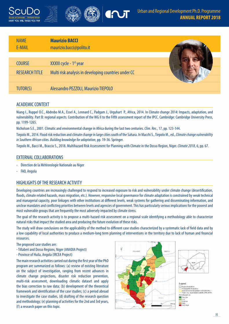
35
Urban and Regional Development Ph.D. Programme ANNUAL REPORT 2018
COURSE XXXIII cycle - 1st year
RESEARCH TITLE Multi risk analysis in developing countries under CC
TUTOR(S) Alessandro PEZZOLI, Maurizio TIEPOLO
NAME Maurizio BACCIE-MAIL [email protected]
ACADEMIC CONTEXTNiang I., Ruppel O.C., Abdrobo M.A., Essel A., Lennard C., Padgam J., Urguhart P., Africa, 2014. In Climate change 2014: Impacts, adaptation, and vulnerability. Part B: regional aspects. Contribution of the WG II to the Fifth assessment report of the IPCC. Cambridge: Cambridge University Press, pp. 1199-1265.Nicholson S.E., 2001. Climatic and environmental change in Africa during the last two centuries. Clim. Res., 17, pp. 123-144.Tiepolo M., 2014. Flood risk reduction and climate change in large cities south of the Sahara. In Macchi S., Tiepolo M., ed., Climate change vulnerability in Southern African cities. Building knowledge for adaptation, pp. 19-36. Springer.Tiepolo M., Bacci M., Braccio S., 2018. Multihazard Risk Assessment for Planning with Climate in the Dosso Region, Niger. Climate 2018, 6, pp. 67.
EXTERNAL COLLABORATIONS- Direction de la Métèorologie Nationale au Niger- FAO, Angola
HIGHLIGHTS OF THE RESEARCH ACTIVITYDeveloping countries are increasingly challenged to respond to increased exposure to risk and vulnerability under climate change (desertification, floods, climate related hazards, mass migration, etc.). However, responsive local governance for climate adaptation is constrained by weak technical and managerial capacity, poor linkages with other institutions at different levels, weak systems for gathering and disseminating information, and unclear mandates and conflicting priorities between levels and agencies of government. This has particularly serious implications for the poorest and most vulnerable groups that are frequently the most adversely impacted by climate stress.The goal of the research activity is to propose a multi-hazard risk assessment on a regional scale identifying a methodology able to characterize natural risks that impact the studied area and producing the future evolution of these risks. The study will draw conclusions on the applicability of the method to different case studies characterized by a systematic lack of field data and by a low capability of local authorities to produce a medium-long term planning of interventions in the territory due to lack of human and financial resources.The proposed case studies are:- Tillaberi and Dosso Regions, Niger (ANADIA Project) - Province of Huila, Angola (IRCEA Project)The main research activities carried out during the first year of the PhD program are summarized as follows: (a) review of existing literature on the subject of investigation, ranging from recent advances in climate change projections, disaster risk reduction prevention, multi-risk assessment, downloading climatic dataset and apply the bias correction to raw data; (b) development of the theoretical framework and identification of the case studies; (c) a period abroad to investigate the case studies, (d) drafting of the research question and methodology; (e) planning of activities for the 2nd and 3rd years, (f ) a research paper on this topic.
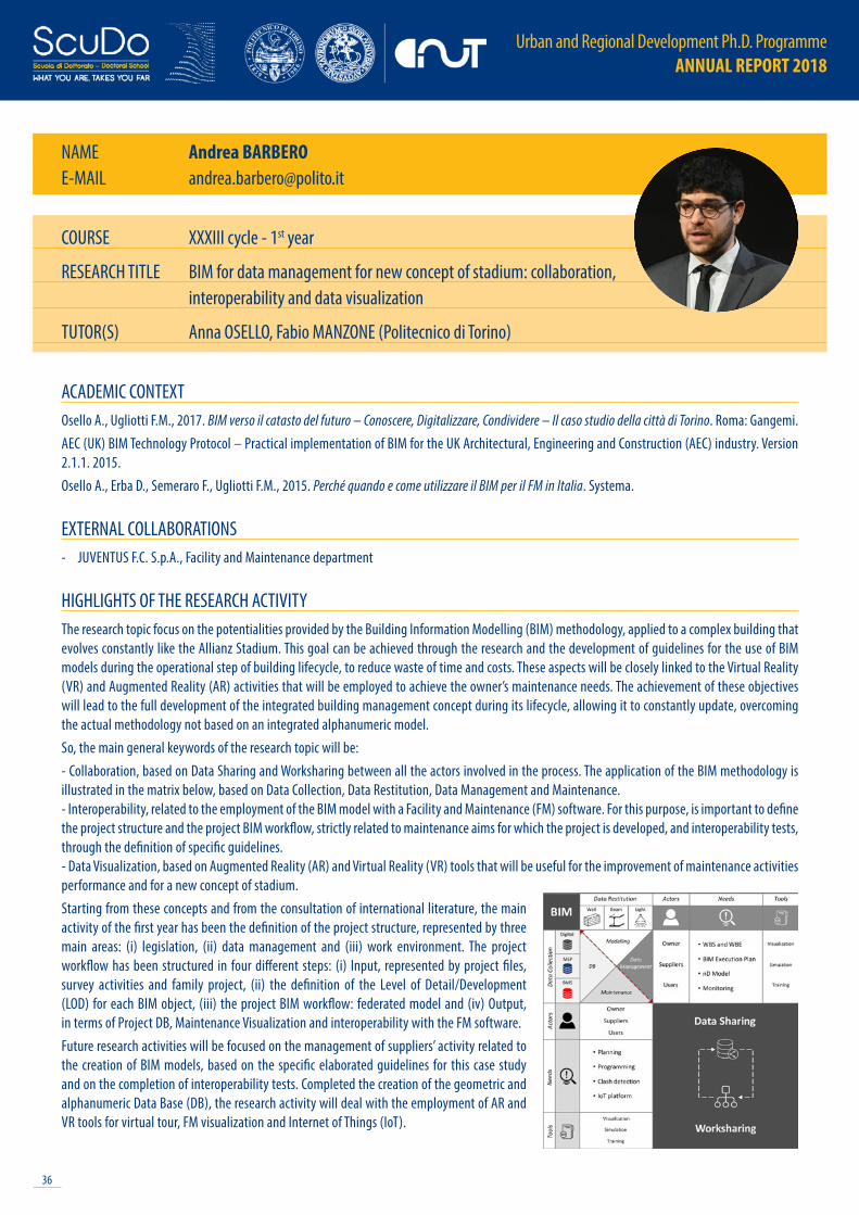
Urban and Regional Development Ph.D. Programme ANNUAL REPORT 2018
36
COURSE XXXIII cycle - 1st year
RESEARCH TITLE BIM for data management for new concept of stadium: collaboration, interoperability and data visualization
TUTOR(S) Anna OSELLO, Fabio MANZONE (Politecnico di Torino)
NAME Andrea BARBEROE-MAIL [email protected]
ACADEMIC CONTEXTOsello A., Ugliotti F.M., 2017. BIM verso il catasto del futuro – Conoscere, Digitalizzare, Condividere – Il caso studio della città di Torino. Roma: Gangemi.AEC (UK) BIM Technology Protocol – Practical implementation of BIM for the UK Architectural, Engineering and Construction (AEC) industry. Version 2.1.1. 2015.Osello A., Erba D., Semeraro F., Ugliotti F.M., 2015. Perché quando e come utilizzare il BIM per il FM in Italia. Systema.
EXTERNAL COLLABORATIONS- JUVENTUS F.C. S.p.A., Facility and Maintenance department
HIGHLIGHTS OF THE RESEARCH ACTIVITYThe research topic focus on the potentialities provided by the Building Information Modelling (BIM) methodology, applied to a complex building that evolves constantly like the Allianz Stadium. This goal can be achieved through the research and the development of guidelines for the use of BIM models during the operational step of building lifecycle, to reduce waste of time and costs. These aspects will be closely linked to the Virtual Reality (VR) and Augmented Reality (AR) activities that will be employed to achieve the owner’s maintenance needs. The achievement of these objectives will lead to the full development of the integrated building management concept during its lifecycle, allowing it to constantly update, overcoming the actual methodology not based on an integrated alphanumeric model.So, the main general keywords of the research topic will be:- Collaboration, based on Data Sharing and Worksharing between all the actors involved in the process. The application of the BIM methodology is illustrated in the matrix below, based on Data Collection, Data Restitution, Data Management and Maintenance.- Interoperability, related to the employment of the BIM model with a Facility and Maintenance (FM) software. For this purpose, is important to define the project structure and the project BIM workflow, strictly related to maintenance aims for which the project is developed, and interoperability tests, through the definition of specific guidelines.- Data Visualization, based on Augmented Reality (AR) and Virtual Reality (VR) tools that will be useful for the improvement of maintenance activities performance and for a new concept of stadium.Starting from these concepts and from the consultation of international literature, the main activity of the first year has been the definition of the project structure, represented by three main areas: (i) legislation, (ii) data management and (iii) work environment. The project workflow has been structured in four different steps: (i) Input, represented by project files, survey activities and family project, (ii) the definition of the Level of Detail/Development (LOD) for each BIM object, (iii) the project BIM workflow: federated model and (iv) Output, in terms of Project DB, Maintenance Visualization and interoperability with the FM software.Future research activities will be focused on the management of suppliers’ activity related to the creation of BIM models, based on the specific elaborated guidelines for this case study and on the completion of interoperability tests. Completed the creation of the geometric and alphanumeric Data Base (DB), the research activity will deal with the employment of AR and VR tools for virtual tour, FM visualization and Internet of Things (IoT).

37
Urban and Regional Development Ph.D. Programme ANNUAL REPORT 2018
COURSE XXXIII cycle - 1st year
RESEARCH TITLE Generation of LC and LCC Atlas using unconventional tools for climate planning
TUTOR(S) Marco PIRAS, Alessandro PEZZOLI
NAME Elena BELCOREE-MAIL [email protected]
ACADEMIC CONTEXTAicardi I., Dabove P., Lingua A.M., Piras M., 2016. Integration between TLS and UAV photogrammetry techniques for forestry applications. iForest, 10, pp. 41-47. Di Gregorio A., Jansen L.J.M., Food And Agriculture Organization Of The United Nations, Rome, 2000, land cover classification system (LCCS): classification concepts and user manual.Turner B.L., Lambin Eric F., Reenberg A., 2007. The emergence of land change science for global environmental change and sustainability. Proceedings of the National Academy of Sciences, 104(52), pp. 20666-20671.
EXTERNAL COLLABORATIONS- Istituto di Biometeorologia, Sede di Firenze, Consiglio Nazionale delle Ricerche (IBIMET-CNR)- Institut national de recherche en sciences et technologies pour l’environnement et l’agriculture (IRSTEA)- Dipartimento di Scienze Agrarie, Forestali e Alimentari, Università degli studi di Torino (UNITO-DISAFA)
HIGHLIGHTS OF THE RESEARCH ACTIVITYThis research aims to investigate on new and emerging technologies to create high-resolution Land Cover Change (LCC) Atlas through a multi-spatial, multi-temporal and multi-thematic analysis in the spotlight of natural hazards prevention and climate planning. In the framework of planning for natural risk reduction and prevention, monitoring of the most vulnerable areas has become crucial for policy makers. Particularly, multi temporal analysis play a key role in forecasting natural hazards and in understanding resilience-related processes. Nevertheless, monitoring activities can be resources consuming and moreover limited by extreme conditions. This is particularly true in those areas of the world characterized by lack of infrastructures, peculiar land morphology, extreme climate conditions and large scale homogeneous land cover. In these critical areas the emerging technologies can be a powerful tool to monitor the processes taking place in areas affected – and potentially affected – by natural hazards and for the detection of Land Cover Change (LCC). The atlas developed in this research will have a new level of detail to ensure meaningful information to data users and it will be based on the Land Cover Classification System (LCCS). The maps are built upon the data collected though the combination of different geomatics techniques for natural hazard monitoring. Particularly, it is planned to use areal imagery collected through UAV (Unmanned Aerial Vehicles) with high-resolution optical sensor (spatial resolution ≤10cm), but low-cost. The obtained data will be combined with terrestrial laser scanner ones, in order to obtain multi-layered information. The Land cover will be classified using different algorithms. Neural networks systems may be included in the research to automatize the classification process. A new web services for the elaboration of huge amount of data will be tested (i.e. Google Earth Engine) and the obtain results will be evaluated comparing them to the classification obtained from Very High Resolution (VHR) satellite imagery.The methodology is tested for three natural hazards: floods, rockfall and fires. The areas selected for the testing are Tillabery in sub Saharan region of Niger, which is particularly vulnerable to floods, and the protection forests of subalpine areas of Alpine Arch.

Urban and Regional Development Ph.D. Programme ANNUAL REPORT 2018
38
COURSE XXXIII cycle - 1st year
RESEARCH TITLE Back to the roots of socially constructed risk: envisioning disaster planning
TUTOR(S) Maurizio TIEPOLO
NAME Giacomo CAZZOLAE-MAIL [email protected]
ACADEMIC CONTEXTBlaikie P., Wisner B., Blaikie P.M., Cannon T., Davis I., 2004. At Risk: Natural Hazards, People’s Vulnerability and Disasters. Psychology Press.Lewis J., 2012. The Good, The Bad and The Ugly: Disaster Risk Reduction (DRR) Versus Disaster Risk Creation (DRC). PLOS Currents Disasters. Liu J., Dietz T., Carpenter S.R., Alberti M., Folke C., Moran E., Taylor W. W., et al. 2007. Complexity of Coupled Human and Natural Systems. Science, 317(5844), pp. 1513-1516. Oliver-Smith A., Alcántara-Ayala I., Burton I., Lavell A., 2017. The social construction of disaster risk: Seeking root causes. International Journal of Disaster Risk Reduction, 22, pp. 469-474.
EXTERNAL COLLABORATIONS- Haitian Civil Protection Agency- Cooperazione Internazionale (COOPI), Haiti
HIGHLIGHTS OF THE RESEARCH ACTIVITYMy journey on the transformative Disaster Risk Reduction (DRR) discourse in the context of transition and developing economies, started endorsing disaster risk as socially constructed and studying the different academic, political and theoretical perspectives related to understanding and conceptualizing such risks.The purpose behind this analysis refers to the ambition of modelling past and present empirical puzzles and non-linear dynamics, i.e. unintended, cascading and/or counterproductive chains and effects of certain harmful human factors, urban behaviors and land uses, in relation to effective DRR strategies. Thus, the common thread of the process concerns the framing of complexities and ambiguities in the accumulation of such hybrid threats and risks within wicked context such as humanitarian crisis, social and environmental conflicts and/or instability phenomena.Against this background, the first stage of this research recollects and debates relevant contributions from disaster root cause models of analysis leading to draft a step-by-step methodology and analytical framework capable of bridging this longitudinal analysis to the construction of more comprehensive future scenarios. This theoretical challenge attempting a deeper and structured understanding of causes, effects and interconnections of disaster forcing urban attributes, e.g. land degradation, hazard-prone building, inadequate building materials, health problems, lack of response capacity etc., may constitute the nexus between (1) patterns of damages, impacts and losses from past events, (2) stakeholder’s perception and explanation of the problem and (3) existing practices, policies, projects and plans facing such complexity.This process resulted in the definition of a general, explanatory and causal question looking at how partial/biased understandings of disaster risk and related planning and humanitarian aid lead to (and get stuck in) everlasting humanitarian crisis; and a more specific, diagnostic and interpretative question: How Root Cause and Forensic analytical approaches might link to and support humanitarian and DRR related decision and policy-making processes?The context of this research refers to the Caribbean Small Island Developing States (SIDS) where, with an actor-oriented explanation building approach, the ambition would be to refine, co-develop and test the analytical framework in different pilot areas.

39
Urban and Regional Development Ph.D. Programme ANNUAL REPORT 2018
COURSE XXXIII cycle - 1st year
RESEARCH TITLE Enhancing user’s perspective in the development and management of Smart Cities & Communities
TUTOR(S) Patrizia LOMBARDI, Isabella LAMI, Edwin CHAN (The Hong Kong Polytechnic University)
NAME Sara CRAVEROE-MAIL [email protected]
ACADEMIC CONTEXTAbt Clark C., 1972. Serious Game. New York: The Viking Press.Goldsmith S., Crawford S., 2014. The Responsive City: Engaging Communities Through Data-Smart Governance. John Wiley & Sons, p. 208.Mueller J., Lu H., Chirkin A., Klein B., Schmitt G., 2018. Citizen Design Science: A strategy for crowd-creative urban design. Cities, 72, pp. 181-188.
EXTERNAL COLLABORATIONS- The Hong Kong Polytechnic University
HIGHLIGHTS OF THE RESEARCH ACTIVITYIn the last years the rule of citizens in smart cities contest has grown a lot. Users are in the centre of attention toward sustainable development of urban project. This study is based on a joint project research between Politecnico di Torino and The Hong Kong Polytechnic University. The proposal is to experiment new evaluation tool in order to investigate and understand the needs of cities users in planning future smart cities initiatives. Nowadays, the introduction of new technologies in research field can be used for increase user’s awareness with respect of the creation of smart cities. Thanks to digital innovation and technologies, innovative learning method as well as social research methods can be applied. The Serious Game could be the medium, among many instruments, to adopt as a methodology. Basically, it is not applied in urban planning or smart cities context, in fact, according to the literature review, it is generally used in educational field and other sectors such as health care, engineering, administration and industry management. One of the main challenges is to try out the serious game in an unusual area of interest, in urban planning contest, evaluating its efficiency. In order to guarantee a complete overview of the research, the thesis could be resume in 3 main sections. The first one concerns a complete study of the existing literature review about the meaning of smart cities, smart and social communities and last but not least the serious game, with a focus on its history and application in recent years. The central section of the thesis deals with the creation of a serious game demo, after working on questionnaire and focus group, in order to test it, in parallel between Torino and Hong Kong, together with university users where the final objective is to enhance their participation and consciousness about human behaviour on urban environment. The final section will be dedicated to the experimental results coming from the application of the serious game and to evaluate the possible futures scenarios of serious game’s use, considering the opportunity to extend its application around the entire land of a smart cities.
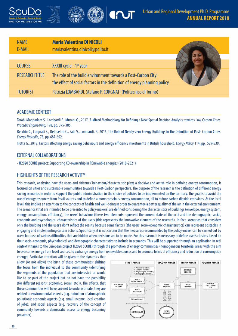
Urban and Regional Development Ph.D. Programme ANNUAL REPORT 2018
40
COURSE XXXIII cycle - 1st year
RESEARCH TITLE The role of the build environment towards a Post-Carbon City: the effect of social factors in the definition of energy planning policy
TUTOR(S) Patrizia LOMBARDI, Stefano P. CORGNATI (Politecnico di Torino)
NAME Maria Valentina DI NICOLIE-MAIL [email protected]
ACADEMIC CONTEXTTorabi Moghadam S., Lombardi P., Mutani G., 2017. A Mixed Methodology for Defining a New Spatial Decision Analysis towards Low Carbon Cities. Procedia Engineering, 198, pp. 375-385. Becchio C., Corgnati S., Delmastro C., Fabi V., Lombardi, P., 2015. The Role of Nearly-zero Energy Buildings in the Definition of Post- Carbon Cities. Energy Procedia, 78, pp. 687-692. Trotta G., 2018. Factors affecting energy saving behaviours and energy efficiency investments in British household. Energy Policy 114, pp. 529-539.
EXTERNAL COLLABORATIONS- H2020 SCORE project: Supporting CO-ownership in REnewable energies (2018-2021)
HIGHLIGHTS OF THE RESEARCH ACTIVITYThis research, analysing how the users and citizenzs’ behaviour/characteristic plays a decisive and active role in defining energy consumption, is focused on cities and sustainable communities towards a Post-Carbon perspective. The purpose of the research is the definition of different energy saving scenarios in order to support the public administration in the choice of policies to be implemented on the territory. The goal is to avoid the use of energy resources from fossil sources and to define a more conscious energy consumption, all to reduce carbon dioxide emissions. At the local level, this implies an attention to the concepts of health and well-being in order to guarantee a better quality of the air in the external environment. The scenarios (that are intended to be presented to policy-makers) are defined considering the characteristics of buildings (envelope, energy system, energy consumption, efficiency), the users’ behaviour (these two elements represent the current state of the art) and the demographic, social, economic and psychological characteristics of the users (this represents the innovative element of the research). In fact, scenarios that considers only the building and the user’s don’t reflect the reality because some factors (the users’ socio-economic characteristics) can represent obstacles in engaging and implementing certain actions. Specifically, it is not certain that the measures recommended by the policy-maker can be carried out by users because of various difficulties that are hidden when decisions are to be made. For this reason, it is necessary to define user’s clusters based on their socio-economic, phychological and demographic characteristics to include in scenarios. This will be supported through an application in real context (thanks to the European project H2020 SCORE) through the promotion of energy communities (homogeneous territorial areas with the aim to overcome energy from fossil sources, to exchange energy from renewable sources and to promote forms of efficiency and reduction of consumption energy). Particular attention will be given to the dynamics that allow (or not allow) the birth of these communities; shifting the focus from the individual to the community (identifying the segments of the population that are interested or would like to be part of the project but do not have the possibility (for different reasons: economic, social, etc.)). The effects, that these communities will have, are not to underestimate; they are related to environmental aspects (e.g. reduction of atmospheric pollution); economic aspects (e.g. small income, local creation of jobs); and social aspects (e.g. recovery of the concept of community towards a democratic access to energy becoming prosumer).
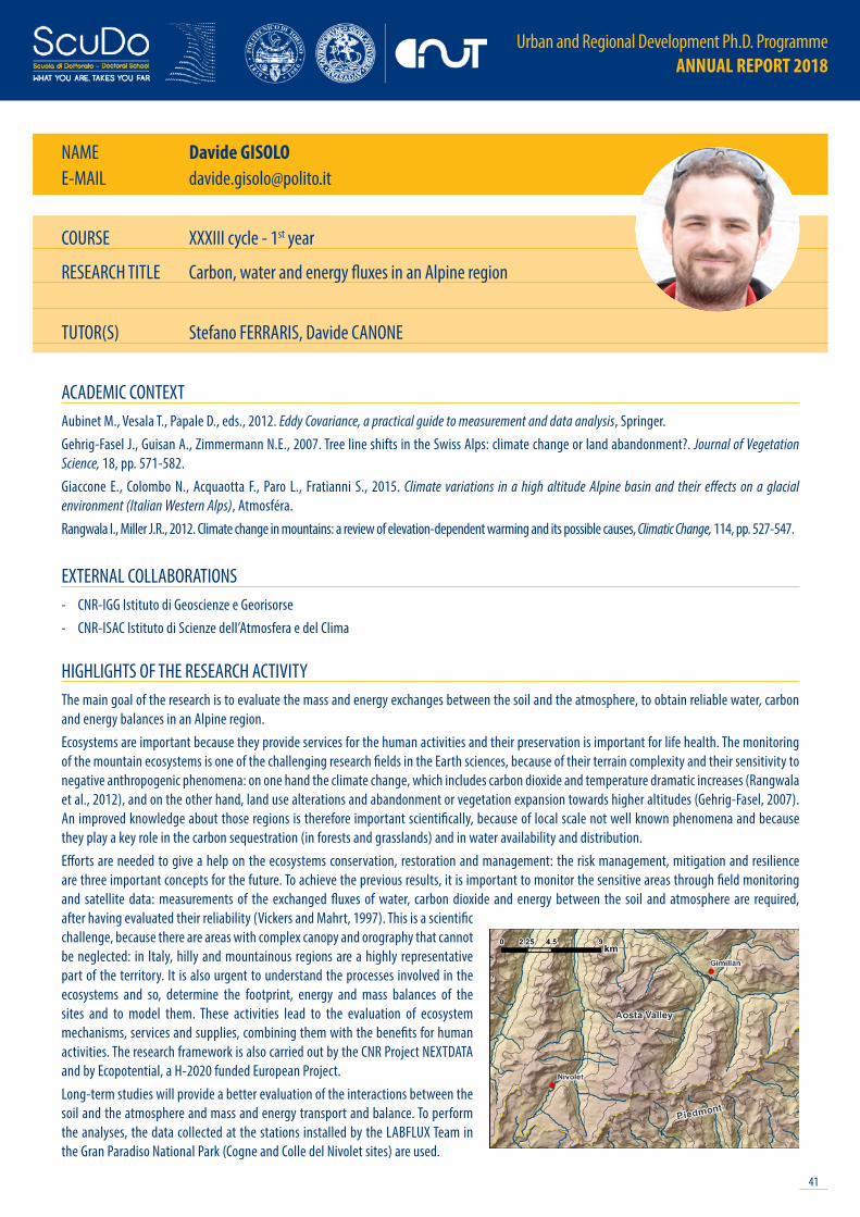
41
Urban and Regional Development Ph.D. Programme ANNUAL REPORT 2018
NAME Davide GISOLOE-MAIL [email protected]
ACADEMIC CONTEXTAubinet M., Vesala T., Papale D., eds., 2012. Eddy Covariance, a practical guide to measurement and data analysis, Springer.Gehrig-Fasel J., Guisan A., Zimmermann N.E., 2007. Tree line shifts in the Swiss Alps: climate change or land abandonment?. Journal of Vegetation Science, 18, pp. 571-582.Giaccone E., Colombo N., Acquaotta F., Paro L., Fratianni S., 2015. Climate variations in a high altitude Alpine basin and their effects on a glacial environment (Italian Western Alps), Atmosféra. Rangwala I., Miller J.R., 2012. Climate change in mountains: a review of elevation-dependent warming and its possible causes, Climatic Change, 114, pp. 527-547.
EXTERNAL COLLABORATIONS- CNR-IGG Istituto di Geoscienze e Georisorse- CNR-ISAC Istituto di Scienze dell’Atmosfera e del Clima
HIGHLIGHTS OF THE RESEARCH ACTIVITYThe main goal of the research is to evaluate the mass and energy exchanges between the soil and the atmosphere, to obtain reliable water, carbon and energy balances in an Alpine region.Ecosystems are important because they provide services for the human activities and their preservation is important for life health. The monitoring of the mountain ecosystems is one of the challenging research fields in the Earth sciences, because of their terrain complexity and their sensitivity to negative anthropogenic phenomena: on one hand the climate change, which includes carbon dioxide and temperature dramatic increases (Rangwala et al., 2012), and on the other hand, land use alterations and abandonment or vegetation expansion towards higher altitudes (Gehrig-Fasel, 2007). An improved knowledge about those regions is therefore important scientifically, because of local scale not well known phenomena and because they play a key role in the carbon sequestration (in forests and grasslands) and in water availability and distribution.Efforts are needed to give a help on the ecosystems conservation, restoration and management: the risk management, mitigation and resilience are three important concepts for the future. To achieve the previous results, it is important to monitor the sensitive areas through field monitoring and satellite data: measurements of the exchanged fluxes of water, carbon dioxide and energy between the soil and atmosphere are required, after having evaluated their reliability (Vickers and Mahrt, 1997). This is a scientific challenge, because there are areas with complex canopy and orography that cannot be neglected: in Italy, hilly and mountainous regions are a highly representative part of the territory. It is also urgent to understand the processes involved in the ecosystems and so, determine the footprint, energy and mass balances of the sites and to model them. These activities lead to the evaluation of ecosystem mechanisms, services and supplies, combining them with the benefits for human activities. The research framework is also carried out by the CNR Project NEXTDATA and by Ecopotential, a H-2020 funded European Project.Long-term studies will provide a better evaluation of the interactions between the soil and the atmosphere and mass and energy transport and balance. To perform the analyses, the data collected at the stations installed by the LABFLUX Team in the Gran Paradiso National Park (Cogne and Colle del Nivolet sites) are used.
COURSE XXXIII cycle - 1st year
RESEARCH TITLE Carbon, water and energy fluxes in an Alpine region
TUTOR(S) Stefano FERRARIS, Davide CANONE

Urban and Regional Development Ph.D. Programme ANNUAL REPORT 2018
42
NAME Chiara IACOVONEE-MAIL [email protected]
ACADEMIC CONTEXTButler T., Savage M., 2013. Social change and the middle classes. Routledge.Gillespie T., 2010. The politics of ‘platforms’. New media & society, 12(3), pp. 347-364.Kaika M., 2012. The economic crisis seen from the everyday: Europe’s nouveau poor and the global affective implications of a ‘local’debt crisis. City, 16(4), pp. 422-430.Marcuse P., Madden D., 2016. In defense of housing: The politics of crisis. Verso Books.
EXTERNAL COLLABORATIONS- Department of Architecture , University of Naples “Federico II”
HIGHLIGHTS OF THE RESEARCH ACTIVITYThe core of the research is to question the housing condition into actual society and contemporary in-crisis economic system. And set up a critical analysis on how contemporary form of applied capitalism —mostly focusing on the role of digital platform— can define new uneven geographies of social polarization. In particular focusing on the ongoing middle-class crisis.The structure of the research is based on the threefold linkage. Commodification of housing, digital platform and socio-economic change are connected by hierarchical and methodological relations.The first link involves commodification of housing and socio-economic change. Housing condition represented in history the mirror of social situation, it manifests inequalities within society. Through spatial phenomenon as displacement, segregation, eviction and marginalisation it reveals the uneven characters of social conditions. Commodification of housing stock is one of the contemporary phenomena inscribed into the deregulated, financialized and globalized system (Madden & Marcuse, 2016). Again, it will be read as a mirror to investigate the ongoing polarization of society, in particular on the shrink of middle classes, reading it as a mutual exchange relationship, as one the spatial consequence of the other (or vice versa, one the social consequence of the other).The phenomenon of commodification, among others, is supported by the role that digital platform has in enable speculation over private belongings. As the capitalized evolution of sharing economies and as the promoter for new typology of labour approach, digital platform gives everyone the possibility to became self-entrepreneur, as a legitimation and consolidation of precarious work approach. Airbnb is the platform that fully detain the monopoly over housing sphere and it stimulates the commodification of housing, triggering effects in the city as gentrification, social marginalization, touristification, imbalances in the real estate market and so on. The digital platform could link the commodification and the social change, here will be used as a methodology of analysis, so as the lens through which observe these phenomena. The hypothesis is that, questioning the geography drawn by the platform, it could be undermined the defined social geography within cities, revealing new uneven character into society.
COURSE XXXIII cycle - 1st year
RESEARCH TITLE Geography of social polarization, permanent crisis
TUTOR(S) Francesca GOVERNA
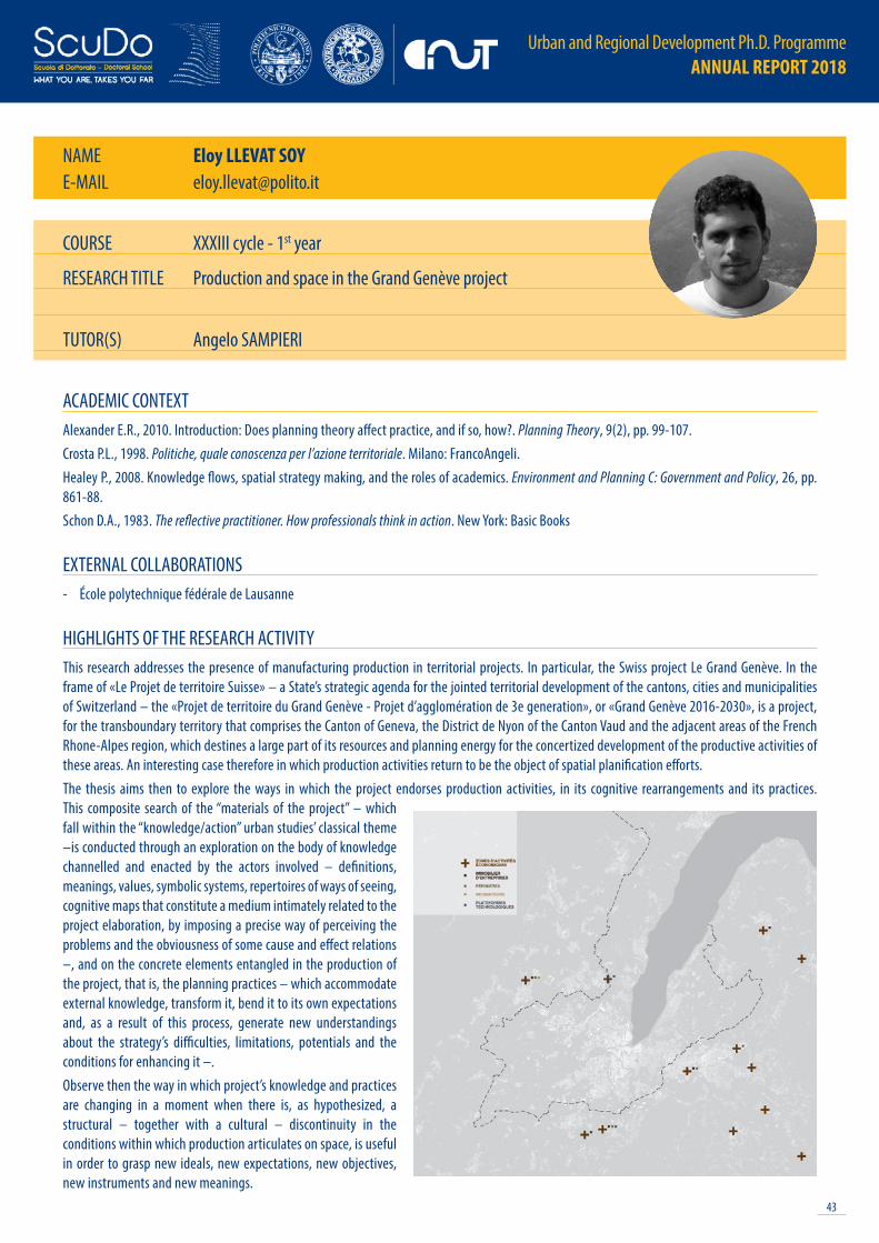
43
Urban and Regional Development Ph.D. Programme ANNUAL REPORT 2018
NAME Eloy LLEVAT SOYE-MAIL [email protected]
COURSE XXXIII cycle - 1st year
RESEARCH TITLE Production and space in the Grand Genève project
TUTOR(S) Angelo SAMPIERI
ACADEMIC CONTEXTAlexander E.R., 2010. Introduction: Does planning theory affect practice, and if so, how?. Planning Theory, 9(2), pp. 99-107.Crosta P.L., 1998. Politiche, quale conoscenza per l’azione territoriale. Milano: FrancoAngeli.Healey P., 2008. Knowledge flows, spatial strategy making, and the roles of academics. Environment and Planning C: Government and Policy, 26, pp. 861-88.Schon D.A., 1983. The reflective practitioner. How professionals think in action. New York: Basic Books
EXTERNAL COLLABORATIONS- École polytechnique fédérale de Lausanne
HIGHLIGHTS OF THE RESEARCH ACTIVITYThis research addresses the presence of manufacturing production in territorial projects. In particular, the Swiss project Le Grand Genève. In the frame of «Le Projet de territoire Suisse» – a State’s strategic agenda for the jointed territorial development of the cantons, cities and municipalities of Switzerland – the «Projet de territoire du Grand Genève - Projet d’agglomération de 3e generation», or «Grand Genève 2016-2030», is a project, for the transboundary territory that comprises the Canton of Geneva, the District de Nyon of the Canton Vaud and the adjacent areas of the French Rhone-Alpes region, which destines a large part of its resources and planning energy for the concertized development of the productive activities of these areas. An interesting case therefore in which production activities return to be the object of spatial planification efforts. The thesis aims then to explore the ways in which the project endorses production activities, in its cognitive rearrangements and its practices. This composite search of the “materials of the project” – which fall within the “knowledge/action” urban studies’ classical theme –is conducted through an exploration on the body of knowledge channelled and enacted by the actors involved – definitions, meanings, values, symbolic systems, repertoires of ways of seeing, cognitive maps that constitute a medium intimately related to the project elaboration, by imposing a precise way of perceiving the problems and the obviousness of some cause and effect relations –, and on the concrete elements entangled in the production of the project, that is, the planning practices – which accommodate external knowledge, transform it, bend it to its own expectations and, as a result of this process, generate new understandings about the strategy’s difficulties, limitations, potentials and the conditions for enhancing it –. Observe then the way in which project’s knowledge and practices are changing in a moment when there is, as hypothesized, a structural – together with a cultural – discontinuity in the conditions within which production articulates on space, is useful in order to grasp new ideals, new expectations, new objectives, new instruments and new meanings.

Urban and Regional Development Ph.D. Programme ANNUAL REPORT 2018
44
NAME Viola MARIE-MAIL [email protected]
ACADEMIC CONTEXTChiodi S.I., 2016. Crime prevention through urban design and planning in the smart city era: The challenge of disseminating CP-UDP in Italy: learning from Europe. Journal of Place Management and Development, 9(2), pp. 137-152.Sandercock L., 2000. When strangers become neighbours: Managing cities of difference. Planning Theory & Practice, 1(1), pp. 13-30.Tulumello S., 2017. Toward a critical understanding of urban security within the institutional practice of urban planning: The case of the Lisbon Metropolitan Area. Journal of Planning Education and Research, 37(4), pp. 397-410.Whitzman C., 2007. Stuck at the front door: gender, fear of crime and the challenge of creating safer space. Environment and Planning A, 39(11), pp. 2715-2732.
EXTERNAL COLLABORATIONS--
HIGHLIGHTS OF THE RESEARCH ACTIVITYIn the last decades it has been proven that urban safety is a fundamental prerequisite for urban sustainability and one of the cross-cutting societal challenges. The feeling of being safe is a primary need and an individual right of each citizen, a condition that has a huge impact on daily basic choices (e.g., modes of travel, social life) and influence the quality of life. Undoubtedly feeling safe is both an objective and subjective feeling, because it derives from the characteristics of the environment and of the individual. Thus, the complex and multifaceted nature of urban safety requires great efforts from different government and non-government agencies along with the civil society, to provide multi-dimensional responses. In this perspective, seems clear the necessity to adopt a wide, integrated and multidisciplinary approach able to create a physical setting in which people feel secure and can move freely.In the urban planning field, it is possible to track over the decades different approaches to urban safety, with the common beliefs that safety can be achieved through appropriate urban design strategies. However, even the more recent theorizations have finished to have an exclusionary impact on cities especially towards marginalized and vulnerable social groups.The work of this thesis assumes that the urban planning is the optimal framework to overcome the limits and pitfalls of these partial approaches, able to guarantee the development of safer cities and heighten a positive perception of the urban environment. Through the comparative analysis of few planning instruments, this work will seek to prove that to successfully and efficiently embed urban safety within urban planning practices, public administrations and decision makers need to really leverage on a participatory and dialogical dimension, working on the compelling idea of the co-production of urban safety to build a stronger, integrated, collaborative, tolerant, and fair community.
COURSE XXXIII cycle - 1st year
RESEARCH TITLE Co-production of urban safety. The role of participation in the deployment of a safer urban environmentTUTOR(S) Patrizia LOMBARDI
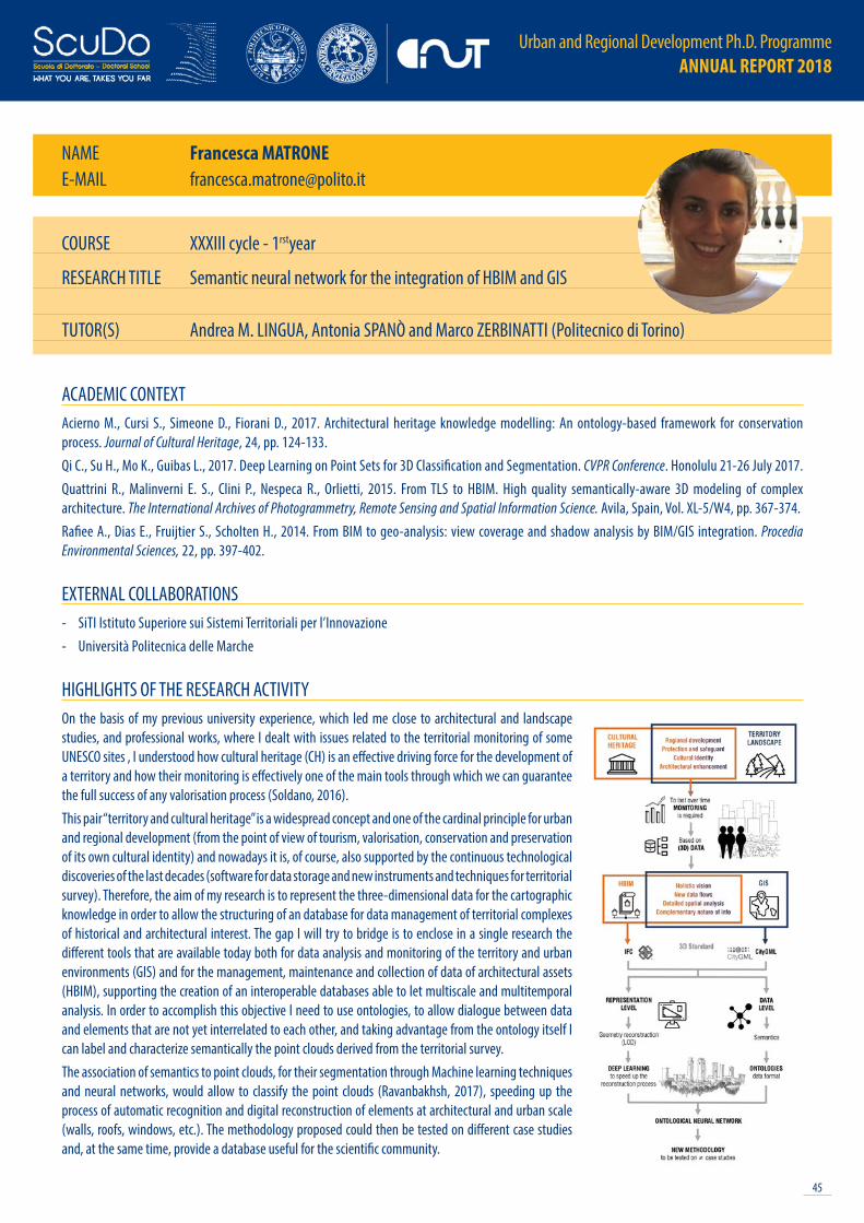
45
Urban and Regional Development Ph.D. Programme ANNUAL REPORT 2018
NAME Francesca MATRONEE-MAIL [email protected]
COURSE XXXIII cycle - 1rstyear
RESEARCH TITLE Semantic neural network for the integration of HBIM and GIS TUTOR(S) Andrea M. LINGUA, Antonia SPANÒ and Marco ZERBINATTI (Politecnico di Torino)
ACADEMIC CONTEXTAcierno M., Cursi S., Simeone D., Fiorani D., 2017. Architectural heritage knowledge modelling: An ontology-based framework for conservation process. Journal of Cultural Heritage, 24, pp. 124-133.Qi C., Su H., Mo K., Guibas L., 2017. Deep Learning on Point Sets for 3D Classification and Segmentation. CVPR Conference. Honolulu 21-26 July 2017.Quattrini R., Malinverni E. S., Clini P., Nespeca R., Orlietti, 2015. From TLS to HBIM. High quality semantically-aware 3D modeling of complex architecture. The International Archives of Photogrammetry, Remote Sensing and Spatial Information Science. Avila, Spain, Vol. XL-5/W4, pp. 367-374.Rafiee A., Dias E., Fruijtier S., Scholten H., 2014. From BIM to geo-analysis: view coverage and shadow analysis by BIM/GIS integration. Procedia Environmental Sciences, 22, pp. 397-402.
EXTERNAL COLLABORATIONS- SiTI Istituto Superiore sui Sistemi Territoriali per l’Innovazione- Università Politecnica delle Marche
HIGHLIGHTS OF THE RESEARCH ACTIVITYOn the basis of my previous university experience, which led me close to architectural and landscape studies, and professional works, where I dealt with issues related to the territorial monitoring of some UNESCO sites , I understood how cultural heritage (CH) is an effective driving force for the development of a territory and how their monitoring is effectively one of the main tools through which we can guarantee the full success of any valorisation process (Soldano, 2016). This pair “territory and cultural heritage” is a widespread concept and one of the cardinal principle for urban and regional development (from the point of view of tourism, valorisation, conservation and preservation of its own cultural identity) and nowadays it is, of course, also supported by the continuous technological discoveries of the last decades (software for data storage and new instruments and techniques for territorial survey). Therefore, the aim of my research is to represent the three-dimensional data for the cartographic knowledge in order to allow the structuring of an database for data management of territorial complexes of historical and architectural interest. The gap I will try to bridge is to enclose in a single research the different tools that are available today both for data analysis and monitoring of the territory and urban environments (GIS) and for the management, maintenance and collection of data of architectural assets (HBIM), supporting the creation of an interoperable databases able to let multiscale and multitemporal analysis. In order to accomplish this objective I need to use ontologies, to allow dialogue between data and elements that are not yet interrelated to each other, and taking advantage from the ontology itself I can label and characterize semantically the point clouds derived from the territorial survey.The association of semantics to point clouds, for their segmentation through Machine learning techniques and neural networks, would allow to classify the point clouds (Ravanbakhsh, 2017), speeding up the process of automatic recognition and digital reconstruction of elements at architectural and urban scale (walls, roofs, windows, etc.). The methodology proposed could then be tested on different case studies and, at the same time, provide a database useful for the scientific community.
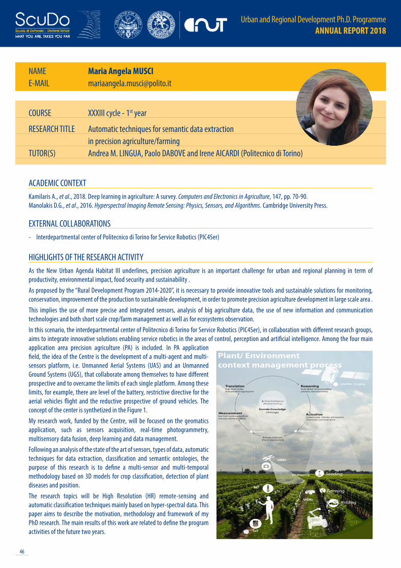
Urban and Regional Development Ph.D. Programme ANNUAL REPORT 2018
46
NAME Maria Angela MUSCIE-MAIL [email protected]
ACADEMIC CONTEXTKamilaris A., et al., 2018. Deep learning in agriculture: A survey. Computers and Electronics in Agriculture, 147, pp. 70-90.Manolakis D.G., et al., 2016. Hyperspectral Imaging Remote Sensing: Physics, Sensors, and Algorithms. Cambridge University Press.
EXTERNAL COLLABORATIONS- Interdepartmental center of Politecnico di Torino for Service Robotics (PIC4Ser)
HIGHLIGHTS OF THE RESEARCH ACTIVITYAs the New Urban Agenda Habitat III underlines, precision agriculture is an important challenge for urban and regional planning in term of productivity, environmental impact, food security and sustainability .As proposed by the “Rural Development Program 2014-2020”, it is necessary to provide innovative tools and sustainable solutions for monitoring, conservation, improvement of the production to sustainable development, in order to promote precision agriculture development in large scale area .This implies the use of more precise and integrated sensors, analysis of big agriculture data, the use of new information and communication technologies and both short scale crop/farm management as well as for ecosystems observation.In this scenario, the interdepartmental center of Politecnico di Torino for Service Robotics (PIC4Ser), in collaboration with different research groups, aims to integrate innovative solutions enabling service robotics in the areas of control, perception and artificial intelligence. Among the four main application area precision agriculture (PA) is included. In PA application field, the idea of the Centre is the development of a multi-agent and multi-sensors platform, i.e. Unmanned Aerial Systems (UAS) and an Unmanned Ground Systems (UGS), that collaborate among themselves to have different prospective and to overcame the limits of each single platform. Among these limits, for example, there are level of the battery, restrictive directive for the aerial vehicles flight and the reductive prospective of ground vehicles. The concept of the center is synthetized in the Figure 1.My research work, funded by the Centre, will be focused on the geomatics application, such as sensors acquisition, real-time photogrammetry, multisensory data fusion, deep learning and data management.Following an analysis of the state of the art of sensors, types of data, automatic techniques for data extraction, classification and semantic ontologies, the purpose of this research is to define a multi-sensor and multi-temporal methodology based on 3D models for crop classification, detection of plant diseases and position.The research topics will be High Resolution (HR) remote-sensing and automatic classification techniques mainly based on hyper-spectral data. This paper aims to describe the motivation, methodology and framework of my PhD research. The main results of this work are related to define the program activities of the future two years.
COURSE XXXIII cycle - 1st year
RESEARCH TITLE Automatic techniques for semantic data extraction in precision agriculture/farmingTUTOR(S) Andrea M. LINGUA, Paolo DABOVE and Irene AICARDI (Politecnico di Torino)

47
Urban and Regional Development Ph.D. Programme ANNUAL REPORT 2018
NAME Giuditta SOCCALIE-MAIL [email protected]
COURSE XXXIII cycle - 1st year
RESEARCH TITLE Universal heritage or exclusive nationalism? A tale of three cities in India
TUTOR(S) Ugo ROSSI, Giuseppe CINÀ
ACADEMIC CONTEXTFawcett M., 2009. The market for ethics. Culture and the neoliberal turn at Unesco. PhD Thesis, New York University. Harrison R., 2010. Understanding the politics of heritage. Manchester University Press.Kinnvall C., 2006. Globalization and Religious Nationalism in India: The search for ontological security. New York: Routledge.Soccali G., Cinà G., 2018. Historic cities and heritage policies in the globalised arena. Spaces of exclusion and gentrification in urban World Heritage sites. Forthcoming.
EXTERNAL COLLABORATIONS- CEPT University, Ahmedabad, India- INTACH Delhi Chapter
HIGHLIGHTS OF THE RESEARCH ACTIVITYOver the last decades, in coherence with the emergence of the neoliberal economy, national and local policies have been increasingly leaning on heritage use and consumption as strategies for development. Although common understanding of the notion and function of heritage in societies is problematic (Smith 2006), international intergovernmental and non-governmental actors engage with effort in the construction of largely blurred frameworks and recipes for culture-led and heritage-based development. From their part, local and national institutions address the international heritage system for obtaining tools, guidelines and recommendations. International organizations have therefore become active players in the process of national identity construction and place branding (Fawcett 2009). Unesco, in particular, is producing numerous tools which states may adopt for encouraging the visibility and “visitability” of places. By taking the case of the World Heritage label, the research will investigate how this instrument is used to foster specific heritage interpretations, reinforcing exclusive identities based on what has been called by critical scholars the “authorized heritage discourse” (Smith 2006; Harrison 2010). Assuming heritage elaboration as a political and administrative process which responds to specific governmental agendas, the research will address the case of India, which recently inscribed its first historic city on the World Heritage List – Ahmedabad (2017). Through the use of a combined “multi-spatial” investigation based on three Indian cities, I will deconstruct the heritage-making process, showing that local tensions and exclusions may be reinforced when the ambition of a globally-recognized, universal heritage, is declined into national and local policies. From different perspectives and through different actors, the cities of Ahmedabad, Delhi and Varanasi have tapped into the World Heritage system with the aim of obtaining national and international recognition and conservation guidelines. My research claims that the distinct but interrelated results of their involvement in the system should be analyzed as different sides of the same story. Through such perspective, this story will be able to reveal the ideological, exclusive and neoliberal character of the use of the World Heritage label in contemporary India.
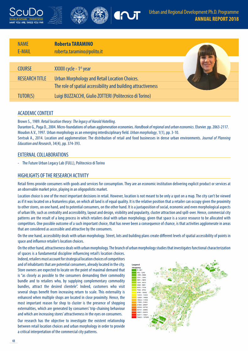
Urban and Regional Development Ph.D. Programme ANNUAL REPORT 2018
48
NAME Roberta TARAMINOE-MAIL [email protected]
ACADEMIC CONTEXTBrown S., 1989. Retail location theory: The legacy of Harold Hotelling.Duranton G., Puga D., 2004. Micro-foundations of urban agglomeration economies. Handbook of regional and urban economics. Elsevier. pp. 2063-2117.Moudon A.V., 1997. Urban morphology as an emerging interdisciplinary field. Urban morphology, 1(1), pp. 3-10.Sevtsuk A., 2014. Location and agglomeration: The distribution of retail and food businesses in dense urban environments. Journal of Planning Education and Research, 34(4), pp. 374-393.
EXTERNAL COLLABORATIONS- The Future Urban Legacy Lab (FULL), Politecnico di Torino
HIGHLIGHTS OF THE RESEARCH ACTIVITYRetail firms provide consumers with goods and services for consumption. They are an economic institution delivering explicit product or services at an observable market price, playing in an oligopolistic market. Location choice is one of the most important decisions in retail. However, location is not meant to be only a spot on a map. The city can’t be viewed as if it was located on a featureless plan, on which all land is of equal quality. It is the relative position that a retailer can occupy given the proximity to other stores, on one hand, and to potential consumers, on the other hand. It is a juxtaposition of social, economic and even morphological aspects of urban life, such as centrality and accessibility, layout and design, visibility and popularity, cluster attraction and spill-over. Hence, commercial city patterns are the result of a long process in which retailers deal with urban morphology, given that space is a scarce resource to be allocated with competitors. One possible outcome of a such important choice, that has never been a consequence of chance, is that activities agglomerate in areas that are considered as accessible and attractive by the consumers.On the one hand, accessibility deals with urban morphology. Street, lots and building plans create different levels of spatial accessibility of points in space and influence retailer’s location choices. On the other hand, attractiveness deals with urban morphology. The branch of urban morphology studies that investigates functional characterization of spaces is a fundamental discipline influencing retail’s location choices. Indeed, retailers must account for strategical location choices of competitors and of inhabitants that are potential consumers, already located in the city. Store owners are expected to locate on the point of maximal demand that is “as closely as possible to the consumers demanding their commodity bundle and to retailers who, by supplying complementary commodity bundles, attract the desired clientele”. Indeed, customers who visit several shops benefit from increasing return to scale. This externality is enhanced when multiple shops are located in close proximity. Hence, the most important reason for shop to cluster is the presence of shopping externalities, which are generated by consumers’ trip-chaining behaviour and which are increasing stores’ attractiveness in the eyes on consumers. Our research has the objective to investigate the existent relationship between retail location choices and urban morphology in order to provide a critical interpretation of the commercial city patterns.
COURSE XXXIII cycle - 1st year
RESEARCH TITLE Urban Morphology and Retail Location Choices. The role of spatial accessibility and building attractiveness
TUTOR(S) Luigi BUZZACCHI, Giulio ZOTTERI (Politecnico di Torino)

49
Urban and Regional Development Ph.D. Programme ANNUAL REPORT 2018
NAME Alberto VALZ GRISE-MAIL [email protected]
ACADEMIC CONTEXTAngelo H., Wachsmuth D., 2015. Urbanizing urban political ecology: A critique of methodological cityism. International Journal of Urban and Regional Research, 39(1), pp. 16-27.Brenner N., 2014. Implosions/explosions: Towards a study of planetary urbanization. Berlin: Jovis.Marcus G.E., 1995. Ethnography in/of the world system: The emergence of multi-sited ethnography. Annual review of anthropology, 24(1), pp.95-117.Tsing A.L., 2009. Supply chains and the human condition. Rethinking Marxism, 21(2), pp. 148-76.
EXTERNAL COLLABORATIONS- CIDMEJu, San Salvador de Jujuy, Argentina
HIGHLIGHTS OF THE RESEARCH ACTIVITYAutomation has been recently framed as an urgent issue by either alarmist or boosterist talk in print and online, the debate stressing either revolutionary possibilities of enhanced productivity or concerns towards unprecedented unemployment rates. Yet, while settlement forms are historically correlated with corresponding forms of technological innovation, a specifically urban geographic reconnaissance of automation still appears to be largely underdeveloped. This research program seeks to stress the relationship between ‘the urban’ and forms of economic production by unpacking the multiple and diverse forms of urbanisation processes in relation to the rapidly growing diffusion of labour automation technologies across urbanised landscapes.By employing a planetary understanding of urbanisation, this project investigates the global unfolding of automation by following a single commodity along its transcontinental supply chains. By working ethnographically and relationally, it retraces the planetary travels of li-ion batteries -from lithium extraction in South American salares to cell production in Chinese gigafactories and their employment in ‘new energy vehicles’ across new smart urban clusters.These global lines and the multi-species assemblages they encounter (humans, machines, minerals, …) describe complex automation patterns across the uneven geographies of contemporary capitalist urbanisation, threading bigness with diversity, extension with concentration. In responding to the set research question, this program proposes a twofold contribution to current debates: on the one hand, it seeks to advance knowledge and modes of knowledge of emerging urbanisation patterns in a planetary framing; on the other, it aims at offering an empirical perspective on the deployment of labour automation technologies and the socio-technical environments they produce.
COURSE XXXIII cycle - 1st year
RESEARCH TITLE Ecologies of Automation TUTOR(S) Francesca GOVERNA
Urban and Regional Development Ph.D. Programme ANNUAL REPORT 2018
50
PAST CYCLES

51
Urban and Regional Development Ph.D. Programme ANNUAL REPORT 2018
XXX CYCLE
Emere ARCOGeomatics for Mobility Management. A comprehensive spatial database model for Mobility Management
Chiara BASILEMaking arrival, making the city. Newcomers’ becoming through and with Brussels
Erblin BERISHAThe evolution of spatial planning systems in the Western Balkan Region. Between international influences and domestic actors
Amandine DUBOZWillingness to use real-time multimodal information to change travel behaviour. The use of psycho-social variables for the market segmentation
Benedetta GIUDICEEcological planning strategies for a qualitative land take
Nives GRASSO
Visibility analyses using 3D urban models generated by low-cost multi-sensor approaches
Gian Gavino PAZZOLAThe socio-spatial relations of innovative artistic production in Piedmont and Liguria
Anna Paola QUAGLIAThe politics of innovation, entrepreneurship and community as a discursive practice. Researching a startup incubator in Milan
Alys SOLLYSpatial Planning and Well-being: a Survey on the Swiss Case
Sara TORABI MOGHADAMA new integrated multi-criteria spatial decision support system for urban energy planning in the built environment
Francesca Maria UGLIOTTIBIM and Facility Management for smart data management and visualization
Urban and Regional Development Ph.D. Programme ANNUAL REPORT 2018
52
FOR MORE INFO:
[email protected]://dottorato.polito.it/urb/en/overview