
UPPER GARNOCK FLOOD PROTECTION SChcME - north-ayrshire.gov.uk · F ollowing the last public...
15
UPPER GARNOCK FLOOD PROTECTION SChcME 0 1 INTRODUCTION Welcome to the second public exhibition on the Upper G arnock Flood Protection Scheme. The purpose of this exhibition is to show you the proposed scheme f or Kilbirnie, Glengarnock and Dalry. North Ayrshire C ouncil would like your views on the proposed scheme i n advance of formal scheme notification under the F lood Risk Management (Scotland) Act 2009. W hy are we here? How can you provide your feedback? F ollowing the last public presentation early in 2013 • A questionnaire is available for you to leave your we have been working to explore options to protect comments. This is also available online at: properties in Kilbirnie, Glengarnock and Dalry from www.north-ayrshire.gov.uk/UpperGarnockFPS flooding from the River Garnock. We have now •You can also send your feedback to: developed an outline design which we would like t o consult on in advance of notification of the final p referred scheme. Email: fl [email protected] or W hat are the aims of this exhibition? •To describe the nature of the flooding problem in Kilbirnie, Glengarnock and Dalry • To tell you about the work that has been done to find a solution • To show details of the proposed scheme • To explain the next steps in the process Post: Upper Garnock FPS Consultation, T ransportation, North Ayrshire Council, P erceton House, Irvine, Scotland, KA11 2AL • If you wish to speak to someone in our team please call 01294 310 000 P lease browse though the information provided on the display boards. Our team is here to answer any q uestions you may have. 0 0 www.north-ayrshire.gov.uk/UpperGarnockFPS D ' /~~ North Ayrshire Council A=COM
Transcript of UPPER GARNOCK FLOOD PROTECTION SChcME - north-ayrshire.gov.uk · F ollowing the last public...

UPPER GARNOCK FLOOD PROTECTION SChcME
01 INTRODUCTION
Welcome to the second public exhibition on the UpperGarnock Flood Protection Scheme. The purpose ofthis exhibition is to show you the proposed schemefor Kilbirnie, Glengarnock and Dalry. North AyrshireCouncil would like your views on the proposed schemein advance of formal scheme notification under theFlood Risk Management (Scotland) Act 2009.
Why are we here? How can you provide your feedback?
Following the last public presentation early in 2013 • A questionnaire is available for you to leave yourwe have been working to explore options to protect comments. This is also available online at:properties in Kilbirnie, Glengarnock and Dalry from www.north-ayrshire.gov.uk/UpperGarnockFPSflooding from the River Garnock. We have now •You can also send your feedback to:developed an outline design which we would liketo consult on in advance of notification of the finalpreferred scheme. Email: [email protected] or
What are the aims of this exhibition?
• To describe the nature of the flooding problem inKilbirnie, Glengarnock and Dalry
• To tell you about the work that has been done tofind a solution
• To show details of the proposed scheme
• To explain the next steps in the process
Post: Upper Garnock FPS Consultation,Transportation, North Ayrshire Council,Perceton House, Irvine, Scotland, KA11 2AL
• If you wish to speak to someone in our teamplease call 01294 310 000
Please browse though the information provided onthe display boards. Our team is here to answer anyquestions you may have.
0 0www.north-ayrshire.gov.uk/UpperGarnockFPS
D' /~~North Ayrshire Council
A=COM

UPPER GARNOCK FLOOD PROTECTION SCHEME
02 HISTORICAL FLOODING IN KILB/RNIE, GLENGARNOCK AND DALRY
Many of you will need no remincDairy. The area has a long histcrecords indicate flooding at an s
The frequency of flooding has itrecorded in 17 years. The mostAugust 2008. Shown here is aAugust 2008 in Kilbirnie and Glf
e4nnWo~vVk
~~II~www.north-ayrshire.gov.uk/UpperGarnockFPS ~~M
D' North Ayrshire Council

UPPER GARNOCK FLOOD PROTECTION SChtME
03 WHAT IS THE SCALE OF THE FLOODING PROBLEM?
Defining the flood risk
We have used computer modelling to estimate the likelihood of flooding in Kilbirnie, Glengarnock and Dalry
from the River Garnock and its tributaries. We estimated what flood flows can be expected in the rivers based
on past events. We then applied this information to the computer model which contains the river channel,
structures and flood plain, allowing us to see which areas may be at risk. This gives us a best estimate of the
flood extent, depth and velocity throughout the study area.
See flooding where you wouldn't expect it?
None of the existing river and boundary walls, embankments and other features are formal flood defences.
Although some may provide a certain level of protection to properties, they could not be relied upon as part of
a formal flood protection scheme. We have therefore removed such features from the computer model. This
allows us to see the areas which would experience the greatest benefits from formal flood protection works.
The side effect of this is of course that you may see flooding on the flood maps where you wouldn't expect it.
What about my property?
v o /~www.north-ayrshire.gov.uk/UpperGarnockFPS ~C'OM
D'_—
Nonn ny~~n~~P ~~~~~~, ~ i
By all means looks up your property on the flood maps shown here. You should remember, however, that the
computer modelling was carried out on a catchment-wide scale that is not specific to any one property. No
specific account is taken of localised features such as buildings, roads and garden walls which may in reality
affect localised flow paths.

UPPER GARNOCK FLOOD PROTECTION SChEME
Oft WHAT OPTIONS DID WE CONSIDER?
Reviewing the options
Once we confrmed the flood risk locations using the latest model, we looked into ways to deal with the flood risk. This started with an option screening exercise; ahigh-level assessment of possible
options which would merit further investigation.
~;+,,. --
M. ~S~►^ i4 ~Y yTM,~p~,
.n~ .,em~~~ew~•m~~c,n~.,~n ~om~nnw~m
_'~:_FLOOD ALERT FLOOD WARNING SEVERE FLOOD
~~000.on~osys~~o~..~>..~o „~~w~,..,~„o ~,,,.a.,~.~„~~,~,ao WARNING
❑~
~I~www.north-ayrshire.gov.uk/UpperGarnockFPS ~~M
D' North Ayrshire Council

g
a~-,~
ie
~ ~.
,~, _
~..'- ~
,.a
y ~~~~n;.
..~̀ y.
:~
`1t \
~' ~~~ ~_,., ~z
~ , ~~ ~
WalkoversWe have visited the site a number of times to '~7 ~ ~ -~ensure our computer models gave realistic results ~ ~~. ~ t►~!~"~'{ ~ ~'and to help develop the options. ~ ~r ~ ,s
f
~ b ¢ _
Structural appraisalsOur structural engineers have visited the site tocheck the condition of the bridges in the study area.We also carried out a condition assessment of allthe existing walls in the study area.
ModellingWe used a computer model to simulate awide range of flood events in the study area.This allows us to predict which areas aresusceptible to flooding, including the depthsand velocities of flood water. The modelwas also used to test the options so that wecould see how well they performed.
Topographical surveysWe carried out detailed topographical surveysto determine the ground and river channel levelsthroughout the study area. This helped us makesure our modelling and options were as accurate aspossible.
Utility investigationsTo help us determine the best locationsfor defences and avoid the need for costlyservice diversions, we collated detailedmaps of utility infrastructure. This includes:-BT phone lines -Gas mains-Electricity cables -Water mains-Sewers -Street lighting
Environmental reviewsWe carried out an assessment of possibleenvironmental issues and met with theScottish Environment Protection Agency,Scottish Natural Heritage and Ayrshire RiversTrust. This allowed us to design the defenceswith minimal environmental impacts andalso identify further studies which would beneeded before construction.
Geotechnical desk studyWe used historical borehole data to determineground conditions in the area. This allowedus to design suitable foundations for the flooddefence walls.
ConsultationsWe have been consulting with a widerange of stakeholders throughout the optiondevelopment phase, including:SEPA Ayrshire Rivers TrustScottish Power Network RailDSM Land ownersScottish Water

UPPER GARNOCK FLOOD PROTECTION SCHEME
06 WHICH OPTIONS DID WE DEVELOP?
Kilbirnie and Glengarnock
This option would involve containing theriver within its channel using flood walls,embankments and flood gates on both banksof the Garnock Buried services, existing rivertraining walls and nearby properties would posesignificant challenges during construction.
To achieve a high standard of protection, floodwalls of over 2 metres high would be requiredin the town centre. A lower wall would offerreduced protection but not cost significantlyless, as the majority of costs are incurredbuilding wall foundations.
Upstream Storage
Upstream storage works by holding back theflood peak and releasing water at a slower rate,reducing river levels downstream.
It would be possible to construct a flood storagedam both on the River Garnock ("on-line")and on the Dipple Burn, diverting water fromthe Garnock ("off-line"). Either option wouldminimise the need for works in downstreamareas, keeping disruption during constructionrelatively localised.
Upstream storage is only able to intercept flowsin the Garnock, meaning other tributaries flowat their full rate. For the most extreme events,flows from these tributaries alone is enough tocause flooding; there is therefore a limit to thestandard of protection which can be providedwith upstream storage.
An off-line solution would require extensiveworks to divert water across to the Dipple Burn,and there are additional issues such as impactson farmland and historical mine workings.
With minor works downstream, the benefits ofthese options could be maximised to provide a1 in 100 year standard of protection.
The Powgree Burn is a contributor to flooding inGlengarnock. We looked at upstream storage,flood walls, channel widening and bridgereplacements. However, due to the differentflow paths none of the options were found tobe effective, and many of the solutions wouldadversely impact on flood risk elsewhere suchas the railway, the B777 road or propertiesupstream.
The only feasible option (apart from property-level protection) was found to be formalisingthe existing river training wall downstreamof the railway bridge, ensuring its structuralintegrity during times of flood. The benefits ofthis option will be enhanced with an upstreamstorage option on the River Garnock.
Dairy
n Dairy, only the flood risk at Mill Park wasfurther investigated. The only feasible optionwas found to be direct defences (flood walls).To minimise impacts on normal river flows,the walls were set back as far as possible.Furthermore, if these defences were placed onthe river's edge, they would get bypassed byflooding through the railway underpass.
Above a 1 in 50 year return period, Mill Parkwould also be affected by flooding fromthe south. To avoid the need for additionaldefences, and limit the consequences if thewall was ever overtopped the design is limitedto a 1 in 50 year standard of protection.
Works would be needed upstream to mitigateimpacts on the railway and the DSM factory,among others.
❑ ❑ J~. t.www.north-ayrshire.gov.uk/UpperGarnockFPS ~~ ~COM
D"North Ayrshire Council
Powgree Burn
Direct Defences
,~
+'~~~

UPPER GARNOCK FLOOD PROTECTION SCr~EME
07 HOW DID WE CHOOSE A PREFERRED OPTION?
I n line with Scottish Government guidance, we looked at the economic, social and environmental aspects of each option to make sure that not only the options would be economically worthwhile (that is thebenefits are greater than costs) but also that social and environmental benefits were maximised (and negative impacts minimised).
Economic Appraisal
We need to ensure any proposals are economically viable; thismeans that the cost of building the scheme should be less than thebenefit we expect. We worked with a contractor to develop detailedscheme costs. The benefits were based on the damages likely tobe avoided with the flood scheme in place, including:
• Direct property damages
• Emergency services costs induding environment agency
• Damage to utilities
• Temporary accommodation
• Clean-up costs (dehumidifier electricity and heating costs)
• Damage to vehicles
• Social equity and climate change allowances
We looked at the benefit cost ratio for each of the options andconcluded the following:
• In IGlbirnie and Glengarnock, the on-line dam with minor worksdownstream is economically viable. The costs of the directdefence option and off-line dam were simply too high for it to bea viable option
• In Dalry (Mill Parl~, the proposed defences are economically viable
• It follows that a "combined scheme" for 4Glbirnie, Glengarnockand Dalry is also economically viable
• Property-level protection could also be a feasible solution if noformal scheme is further developed
~- — ~. ,
Social Appraisal -Combined Scheme
Key Issues
• Disruption
• Visual impact of defences
• Privacy during construction and with defences adjacent toproperties —minimised for storage option
• Disruption to farming practices associated with upstreamstorage
Key Benefits
• Significantly reduced risk to life
• Protection to key services including fire and ambulance stations
• Reduced flood risk in Conservation Area and reduced loadingon existing walls
• Reduced flood riskto key employers in IGlbirnie andGlengarnock
• Reduced blighting of potential development areas
r R
h~ v ~l
~ f~~~~ _~'
y ~,' t . /~
~J
aom.i.~m~ cmo anwTM~wn~ro.kn.l M mw ~ e.im ~ x u~.~..e ~~x, n ersn ~a
* ~,.
:~
Environmental Appraisal -Combined Scheme
Key Issues
• Impacts on aquatic and riparian ecology near the dam
• Poterrtial changes to river flows affecting sediment transport
• Resource usage
• A Construction Environmental Management Plan would berequired, including issues such as noise, dust, pollution, trafficmanagement etc.
Key Opportunities /Benefits
• Sensitive construction using appropriate materials
• Reduced risk of pollution during flood events
• Reduced need for flood repairs (and associated materials)
• Detailed environmental /ecological surveys to enableenvironmentally sensitive construction
o a /, twww.north-ayrshire.gov.uk/UpperGarnockFPS ~ ~COM
❑• Nonh Ayrshire Council.. .: ; , ~.
UPPER GARNOCK FLOOD PROTECTION SChEME
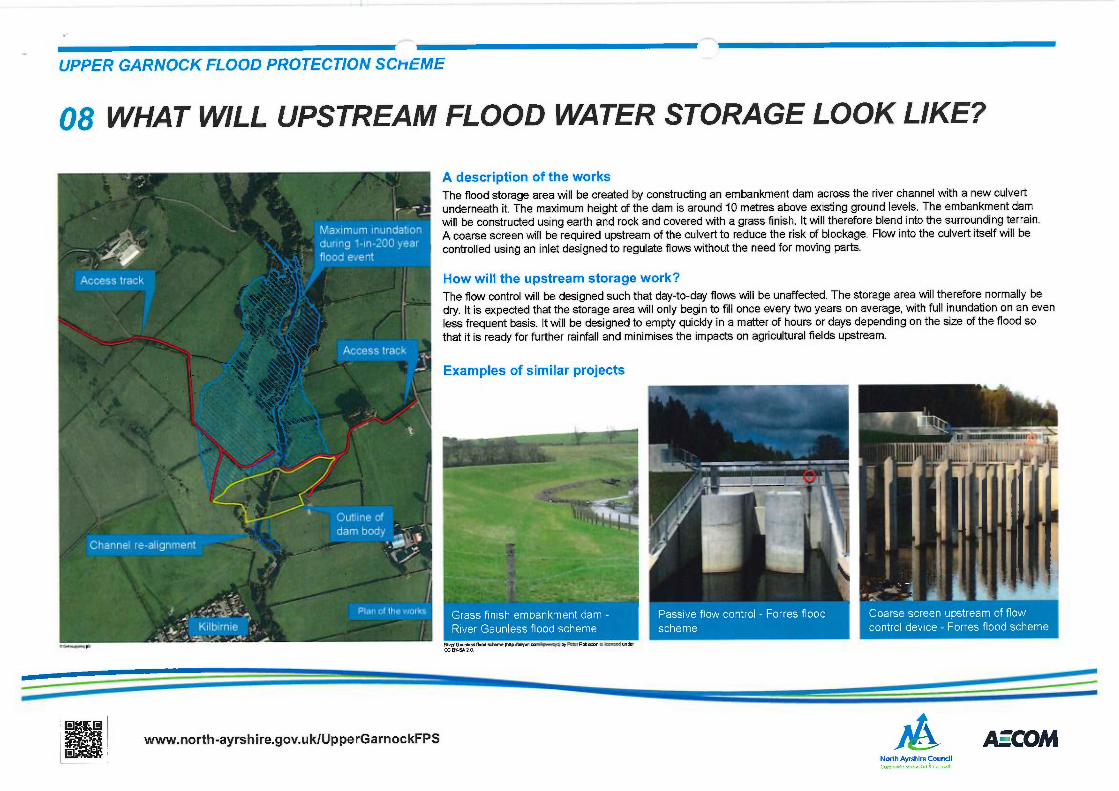
08 WHAT WILL UPSTREAM FLOOD WATER STORAGE LOOK LIKE?
A description of the works
The flood storage area will be created by constructing an embankment dam across the river channel with a new culvert
underneath it. The maximum height of the dam is around 10 metres above existing ground levels. The embankment dam
will be constructed using earth and rock and covered with a grass finish. It will therefore blend into the surrounding terrain.
A coarse screen will be required upstream of the culvert to reduce the risk of blockage. Flow into the culvert itself will be
controlled using an inlet designed to regulate flows without the need for moving parts.
How will the upstream storage work?
The flow control will be designed such that day-to-day flows will be unaffected. The storage area will therefore normally be
dry. It is expected that the storage area will only begin to fill once every two years on average, with full inundation on an even
less frequent basis. It will be designed to empty quickly in a matter of hours or days depending on the size of the flood so
that it is ready for further rainfall and minimises the impacts on agricultural fields upstream.
Examples of similar projects
D O ~
/~~www.north-ayrshire.gov.uk/UpperGarnockFPS ~~M
~ • Nonh Ayrshire Council

'1 = _ *' ,
~'~ -~~~
~ 'ii' c
~~ Low earth bund landscaped ~into surrounding ground
.`
\ ~ j.i ,~ ~
= ~_'~ - `
1~~~~
~ :__~ .1 .. '"
1 s' u ~.
Connell Court
There is an existing wall along the river's bank, howeverit was not designed as a formal flood defence wall, andits structural integrity and foundations are unknown.An allowance has therefore been made in the designto reinforce the wall using a low earth bund to ensure itperforms during flood conditions.
,r ~ ~ ~ ~,~
-. ~ ; \ ~ Repairs to river training=..: ~ vdall /scour protection
~• l~
fir.". -~~-~~ ~ ~~" ~-~ .~
i' ~~r"~ RaiS' "e'i9R@'er bank withY
footpath re-aligned(~
-f
~ ~ v~
l
/ I , 1
Paddockholm Industrial Estate
The raised ground on the river bank may offer someprotection to the industrial estate, but is not designed for floodconditions and has a number of low spots. It will be replacedwith an embankment and the existing river-training wall will berepaired to prevent scour.
~ _ ` !`~'? ~► t'
fir' "t'~~' ~~ Minor surfacew~s ~ watermanagement tyorks
r rY .
~°` ̀ ,*
.r,~~;~:~ .cam , C :~ ;,.
f Jt: R_~ ~
J _ \ ~ ~.'
- -
;~:y
Kirkland RoadThere remains a risk of water spilling out of the channel andonto Valefield playing fields before crossing Kirkland Road andflowing into the fields to the south. Flooding remains shallowand very few properties are likely to be directly affected by thiswater. There is an embankment along the river's edge whichmay prevent some of this happening, however it is not a formalflood defence structure. It was considered that minor surfacewater management measures would be more appropriate thana flood embankment along the river (which could simply passthe problem further downstream).

UPPER GARNOCK FLOOD PROTECTION SC►-~EME
10 WHAT MINOR WORKS ARE NEEDED?
Glengarnock / Powgree BurnGlengarnock would benefit significantly fromthe upstream storage. However, some areasare also at risk of flooding from the PowgreeBurn. Due to significant technical challenges,including potential impacts on flood risk to therailway, the only feasible measure was foundto be replacing the existing wall with a formalflood defence wall.
Continuing investigations
This avoids any adverse impacts on floodrisk to the railway. It is estimated that this willresult in a 1-in-15 year standard of protection(the standard of protection without the wall isless than 1-in-2 year, so this is a significantimprovement).
t o awww.north-ayrshire.gov.uk/UpperGarnockFPS
o' /~North Ayrshire Councilc ~R~r.,,~,n. ;,,~~,.nn A „ i ~,~r
A=COM
UPPER GARNOCK FLOOD PROTECTION SChEME
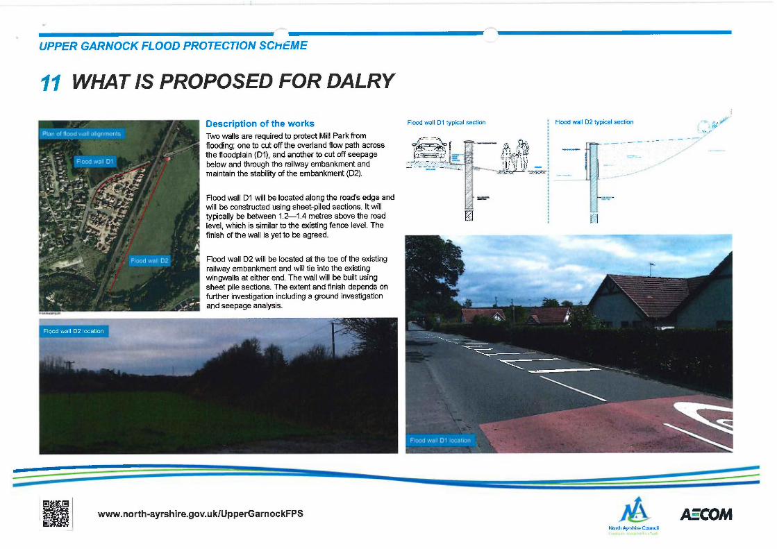
11 WHAT IS PROPOSED FOR DALRY
Description of the works Flood wall D1 typical section
Two walls are required to protect Mill Park fromflooding; one to cut off the overland flow across ~ -~ dpaththe flood lain D1 ,and another to cut off see a eP ( ) P 9 I~ ---"? ~a -below and through the railway embankment and _ _"_ - - — ~
~ ~~ ~!
'~, ~ """~'maintain the stability of the embankment (D2).
Flood wall D1 will be located along the road's edge andwill be constructed using sheet-piled sections. It willtypically be between 12-1.4 metres above the roadlevel, which is similar to the existing fence level. Thefinish of the wall is yet to be agreed.
Flood wall D2 will be located at the toe of the existingrailway embankment and will tie into the existingwingwalls at either end. The wall will be built usingsheet pile sections. The extent and finish depends onfurther investigation including a ground investigationand seepage analysis.
t o 0www.north-ayrshire.gov.uk/UpperGarnockFPS
o-
F
Flood wall D2 typical section ~• ~y~~L„~j,-i
~'~' .._ _-{
/~North Ayrshire Council
A=TOM

Description of the works
There are a number of locations where servicescross the flood defence. These will be divertedas necessary during the construction works.Works may also be required to the existingdrainage system to ensure surface water doesnot build up behind the defences.
By cutting off the natural flow path of water,more water is retained in the river channel.This results in increased flood levels on thefloodplain. Mitigation measures are proposedto address the impacts associated with theincreased flood levels:
• Network Rail—the railway embankmentswill need to withstand increased floodpressures
• The DSM factory—parts of the site are low-lying
• Scottish Water—the raised manholeslocated in the floodplain may be subject toi ncreased flood risk
• Scottish Power—the substation next toBeith Road may be impacted by increasedflood levels
It is worth noting that the flood wall will onlyi mpact on flood events sufficiently extreme toovertop the road and build up against the floodwall. The frequency of flooding of the fieldssurrounding Mill Park, as well as Beith Road, istherefore not affected by the scheme.
~ Low-level embankment '~►"':,; ` - Raise existing bond_ ~~ ground re-grading ~
~ ~ ~~~, ~~Short section of wall ~~ -to tie into existing New and raised kiosk"Y"~̀"
Existing track
~ Granular berms Wall where~~ is
. ~" against railway ~ space
restricted~++ ~_ ~ embankment ~O/
-- — 2O
2 1
_
Possible works O ~ Re-alignedto substation and track and belowraised Scottish,. ~ . ground pipeWater manholes -
\ ~ ""~ ~ ~:~, g,~ ;~ .~ ~ se.
FGranular berms
Minor road regrading '~~' ~ ¢ against railwayat Mill Park entrance ,- 1 ~'!~':r.: ~ embankment
-.~ .- ~ Flood wall D1J
f
.1: ~~ w "0'' , ~ Flood wall D2,,:
3 Surface water , ~drainage works ~,'ti~,,
a ~ .._~ ~~ J

'~ 6i 1` ., ~
-___ __ ~..,
_ _~
Footbridge at Dennyhohn Wynd, Kilbirnia
/ijl 7
ki' li.
''' lr ̀ '~~ ..~
Valefield playing fields, Glengarnock
What will we do to protect the environment?
We recognise that there may be impacts associated with theconstruction and operation of the scheme. This should, however,be compared with the pollution and damage caused by flooding.We will work with SEPA and other stakeholders to ensure anyi mpacts are minimised so far as is practical.
- r0
~ {-~, :. ,~, .
~,
c{°r
G
The works will be licenced under the Water Environment(Controlled Activities) (Scotland] Regulations 2011, commonlyknown as the Controlled Activities Regulations, or CAR. This would
"- regulate the works and include any conditions SEPA imposeswhen issuing a licence.
~~~
y
i! ~rI r ,~c,.: ,~ i..l~
r ~, ..,,~ ',` ~
~ ~~~r ~ ~ - .~~1:. +
.;
River Garnock at Dalry
!~#i?~~' ~ ~~A~:.r~"' Sho~dd the scheme progress to the next stage, we will carry out a~ range of environmental surveys. including habitat surveys and river
surveys, to allow us to identify sensitive habitats and species. Wecan then ensure the design and construction activities minimise thei mpacts on these receptors.
How will construction activities be managed?
We will work with all affected parties to minimise the impacts of theconstruction process. A Construction Environmental Management
Plan will be developed prior to construction. This will include:
• Construction management plan for noise and dust control
• Nuisance management and mitigation plan for noise, dust andtraffic
• Surface water management and control with pollutionprevention and control measures
• Site waste management procedures and controls
• Site environmental management and controls, with site rules
• Traffic management and control measures
~~:~ ~

UPPER GARNOCK FLOOD PROTECTION SChtME
14 WHERE ARE WE IN THE PROCESS OF DEVELOPING A FLOOD SCHEME?~FFINF THE PRnBl.FM
IDENTIFY OPTIONS
INITIAL CONSUL7AIIDN
DETAILED INVESilGR710N5
DEVELOP OPTIONS
APPRAISAL Of OPTIONS
ti/"I. f f. f f RII fNR(n GCHEME
corvsui innoN s
•-•-••--~-~ WHERE WE ARE TODAY
ON-GOING ................................................................................:
.......................................................................................................................................................................................................................................RESOLUTION OF OBJECTIONS /MINISTERIAL CALL-!NAND PUBLIC LOCAL INQUIRY/ COUNCIL HEARING
~ ~c ~ . iT._ IF O&/ECTOR IS LISTED IN 7HE ACT
❑ ❑■ ~~~~www.north-ayrshire.gov.uk/UpperGarnockFPS ~~M
~' North Ayrshire Council
FeedbackWe are keen to hear from as many people as possible, eitherby speaking to a member of our staff today, completing thequestionnaire or using the contact details shown on this page.We will accept feedback until the 7th of February. We willconsider all feedback and respond to any queries you may haveas we finalise the scheme before we publish it as part of thenotification process.
Please note that submitting feedback now does not constitutea formal objection to the scheme. This should only be donefollowing Scheme Notification as described below.
Scheme NotificationYour involvement in the consultation process will help to developthe final scheme we will put forward. After the consultationperiod, we will seek planning permission through the Flood RiskManagement (Scotland) Act 2009. This means we will publish thefinal scheme and notify key stakeholders and affected parties.There will then be a 28-day period within which objections maybe made.
The final scheme documents will be made available for publicviewing in person and on the council website (www.north-ayrshire.gov. uk/U pperGarnockFPS).
How do I make an objection?Any person may object to the scheme after the start of the 28day period. If there are any outstanding issues which have notbeen resolved following the consultation process, this will bethe opportunity to formally object. If you would like to makean objection, it should be made in writing and include yourname and address, along with the reason for your objection.
Objections made by electronic means (e.g. email) areacceptable and will be treated as being in writing. The contactdetails for objections are shown on the right.
If no objections are receivedIf no objections are received, North Ayrshire Council willeither confirm or reject the proposed scheme.
If objections are receivedIf valid objections are received, North Ayrshire Council willmake a preliminary decision to:a) confirm the proposed scheme without modifications,b) confirm the proposed scheme with modifications, or
c) reject the proposed scheme
Depending on the nature of the objection, the scheme maybe taken to a public inquiry or a local authority hearing. Thiswill be followed by a final decision.
Appeals and commencement of schemeIf confirmed, there would be a six 6-week period within whichappeals can be made. Details will be made available of theappeals process at a later stage.
...and then?North Ayrshire Council will need to apply for funding for thescheme. The Scottish Government has not yet releaseddetails of the funding process, however funding will not bemade available before the end of 2015.
Upon a successful funding application, detailed design andsite investigations can commence to prepare the scheme forconstruction.
ContactTel: 01294 310 000
Email: [email protected]
Roads and TransportationNorth Ayrshire CouncilPerceton HouseI rvine
i ~
~ ~~
~~
,~.~s
~! ~ i