Unravelling past and present interactions of people...
312
Unravelling past and present interactions of people and forests Editors Cristina Eghenter Bernard Sellato G. Simon Devung
Transcript of Unravelling past and present interactions of people...

ISBN 979-3361-02-6
SOCIAL SCIENCE RESEARCH
AND CONSERVATIO
N MANAG
EMENT IN TH
E INTERIOR O
F BORNEO
Edited by
Cristina E
ghenter, Bernard Sellato
and G. Sim
on Devung
Unravelling past and present interactionsof people and forests
Editors
Cristina EghenterBernard Sellato
G. Simon Devung
The Culture & ConservationResearch Program in KayanMentarang National Park, EastKalimantan, constituted a uniqueinterdisciplinary engagement in
central Borneo that lasted for six years(1991-97). Based on original ethnographic,ecological, and historical data, this volumecomprehensively describes the people andthe environment of this region and makesa rare contribution to the understanding of pastand present interactions between people andforests in central Borneo. Kayan Mentaranghas thus become one of the ethnographically bestknown protected areas in Southeast Asia.By pointing at the interface between researchand forest management, this book offers toolsfor easing the antagonism between applied andscholarly research, and building much neededconnections across fields of knowledge.
COVER Selato final 6/12/03, 1:20 AM1

Social Science Research andConservation Managementin the Interior of BorneoUnravelling past and present interactionsof people and forests
Editors
Cristina EghenterBernard SellatoG. Simon Devung
00 TOC selato May28.p65 6/11/03, 11:53 AM1

© 2003 by CIFOR, WWF Indonesia,UNESCO and Ford Foundation
All rights reserved. Published in 2003Printed by Indonesia Printer, Indonesia
WWF Indonesia holds the copyright tothe research upon which this book is based.
The book has been published with financial support from UNESCO through its MABProgramme. The authors are responsible for the choice and the presentation of thefacts contained in this book and for the opinions expressed therein, which are notnecessarily those of UNESCO and do not commit the organisation.
ISBN 979-3361-02-6
The Center for International Forestry Research (CIFOR) was established in 1993 aspart of the Consultative Group on International Agricultural Research (CGIAR) inresponse to global concerns about the social, environmental and economicconsequences of forest loss and degradation. CIFOR research produces knowledgeand methods needed to improve the well-being of forest-dependent people and tohelp tropical countries manage their forests wisely for sustained benefits. Thisresearch is done in more than two dozen countries, in partnership with numerouspartners. Since it was founded, CIFOR has also played a central role in influencingglobal and national forestry policies.
National Library of Indonesia Cataloging –in-Publication Data
Social Science Research and Conservation Management in the Interior of Borneo:Unravelling Past and Present Interactions of People and Forests/ed. by CristinaEghenter, Bernard Sellato and G. Simon Devung.—Bogor, Indonesia: CIFOR, 2003.p. cm
1. Forest management 2. Nature conservation 3. Social sciences 4. Anthropology5. Research 6. East Kalimantan 7. Indonesia I. Eghenter, C. (ed.) II. WWFIndonesia Program III. Kayan Mentarang Conservation Project
Published byCenter for International Forestry ResearchMailing address: P.O. Box 6596 JKPWB, Jakarta 10065, IndonesiaOffice address: Jl. CIFOR, Situ Gede, Sindang Barang,Bogor Barat 16680, IndonesiaTel.: +62 (251) 622622; Fax: +62 (251) 622100E-mail: [email protected] site: http://www.cifor.cgiar.org
00 TOC selato May28.p65 6/11/03, 11:53 AM2

Contents
Preface ixForeword xiContributors’ Biodata xiiiAcknowledgements xvExecutive Summary xvii
1 Introduction 1by Cristina Eghenter and Bernard Sellato
Resource management and traditional knowledge2. Biodiversity and traditional knowledge: Rice varieties
among the Leppo’ Ké of Apau Ping 35by Indah Setyawati
3 Making a swidden: Social and technological aspects of Leppo’ Kéagricultural practices 49by Herculanus Bahari Sindju
4. Management, processing, and uses of rattan in Long Uli,Pujungan Subdistrict 65by Martua Thomas Sirait
5. Eaglewood and forest product management and trade inthe Bahau River region 83by Blajan Konradus
Traditional institutions and land tenure in a changing society6. Traditional property rights over land among the Kenyah of Pujungan
Subdistrict 103by S. Jacobus E. Frans L.
7. Patterns of traditional land control among three Kenyah groups 117by Angguk Lamis, Concordius Kanyan and Y. Paulus Bunde
00 TOC selato May28.p65 6/11/03, 11:53 AM3

iv
8. Traditional forest use and management among the Kenyah ofthe Upper Bahau Area 139by G. Simon Devung
Recovering the past (in non-literate societies): Implicationsfor development9 A history of the Kenyah Leppo’ Ké and Nyibun in Pujungan
Subdistrict 153by Njau Anau
10. A history of the Kenyah Leppo’ Tau in Kayan Hulu Subdistrict,Apau Kayan 175by Liman Lawai
11. Archaeological surveys and research in four subdistricts of interiorEast Kalimantan 199by Karina Arifin and Bernard Sellato
Research output back to local communities: Strengtheningcultural identity and traditional rights?12. Kenyah Bakung oral literature: An introduction 241
by C. Yus Ngabut13. Folk songs of the Kenyah Leppo’ Ma’ut: A study of text and music 259
by Daniel Lawing
References and selected literature 275
00 TOC selato May28.p65 6/11/03, 11:53 AM4
v
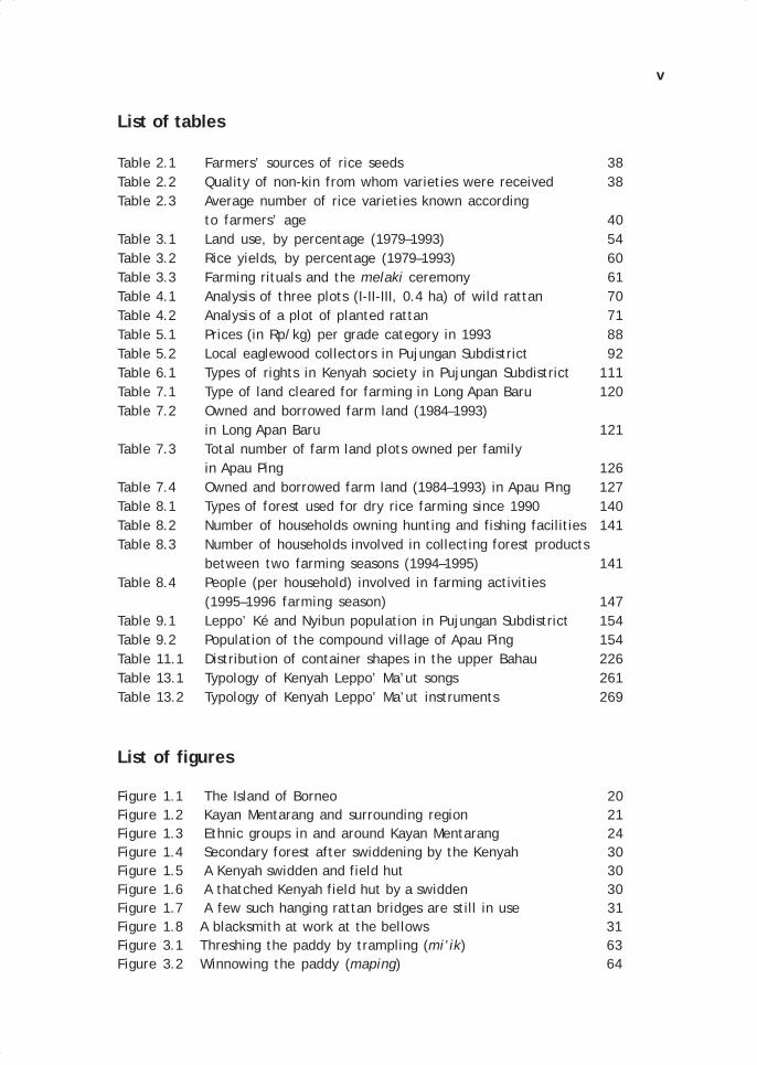
List of tables
Table 2.1 Farmers’ sources of rice seeds 38Table 2.2 Quality of non-kin from whom varieties were received 38Table 2.3 Average number of rice varieties known according
to farmers’ age 40Table 3.1 Land use, by percentage (1979–1993) 54Table 3.2 Rice yields, by percentage (1979–1993) 60Table 3.3 Farming rituals and the melaki ceremony 61Table 4.1 Analysis of three plots (I-II-III, 0.4 ha) of wild rattan 70Table 4.2 Analysis of a plot of planted rattan 71Table 5.1 Prices (in Rp/kg) per grade category in 1993 88Table 5.2 Local eaglewood collectors in Pujungan Subdistrict 92Table 6.1 Types of rights in Kenyah society in Pujungan Subdistrict 111Table 7.1 Type of land cleared for farming in Long Apan Baru 120Table 7.2 Owned and borrowed farm land (1984–1993)
in Long Apan Baru 121Table 7.3 Total number of farm land plots owned per family
in Apau Ping 126Table 7.4 Owned and borrowed farm land (1984–1993) in Apau Ping 127Table 8.1 Types of forest used for dry rice farming since 1990 140Table 8.2 Number of households owning hunting and fishing facilities 141Table 8.3 Number of households involved in collecting forest products
between two farming seasons (1994–1995) 141Table 8.4 People (per household) involved in farming activities
(1995–1996 farming season) 147Table 9.1 Leppo’ Ké and Nyibun population in Pujungan Subdistrict 154Table 9.2 Population of the compound village of Apau Ping 154Table 11.1 Distribution of container shapes in the upper Bahau 226Table 13.1 Typology of Kenyah Leppo’ Ma’ut songs 261Table 13.2 Typology of Kenyah Leppo’ Ma’ut instruments 269
List of figures
Figure 1.1 The Island of Borneo 20Figure 1.2 Kayan Mentarang and surrounding region 21Figure 1.3 Ethnic groups in and around Kayan Mentarang 24Figure 1.4 Secondary forest after swiddening by the Kenyah 30Figure 1.5 A Kenyah swidden and field hut 30Figure 1.6 A thatched Kenyah field hut by a swidden 30Figure 1.7 A few such hanging rattan bridges are still in use 31Figure 1.8 A blacksmith at work at the bellows 31Figure 3.1 Threshing the paddy by trampling (mi’ik) 63Figure 3.2 Winnowing the paddy (maping) 64
00 TOC selato May28.p65 6/11/03, 11:53 AM5

vi
Figure 3.3 Storing the paddy in the barn (lepubung) 64Figure 4.1 The rattan plant and its parts 68Figure 4.2 Proportion of young, old, dead, and harvested stems
in Plots I-II-III 71Figure 4.3 Proportion of young, old, dead, and harvested stems
in Plot IV 72Figure 4.4 Collecting rattan in the forest 74Figure 4.5 Coils of rattan (rotan sega) 74Figure 4.6 Tools for triming 75Figure 4.7 Rattan uses (1) 76Figure 4.8 Rattan uses (2) 79Figure 4.9 Rattan uses (3) 80Figure 5.1 Class I eaglewood 85Figure 5.2 Class II eaglewood 85Figure 5.3 Lower grade eaglewood 86Figure 5.4 Collectors checking and cleaning their produce 95Figure 5.5 The toké sorting the eaglewood into grades 96Figure 6.1 Author conducting an interview in Long Ketaman 104Figure 6.2 Old settlement site (lepu’un) at Long Ngiam 104Figure 7.1 Mulen signs made by the Kenyah Leppo’ Ma’ut 133Figure 7.2 Mulen signs made by the Kenyah Bakung 133Figure 9.1 A cluster of Leppo’ Ké swidden fields near Apau Ping 154Figure 9.2 Up the Bahau River with ‘long-tail’ engine to reach Apau Ping 156Figure 9.3 Sketch map of the Apau Ping settlement in 1992 157Figure 9.4 Elderly Leppo’ Ké informant Bilung Lerang
at Long Lat (Apau Ping) 158Figure 9.5 Migrations of the Leppo’ Ké and Nyibun (1) 160Figure 9.6 Historical settlements of the Kenyah Leppo’Ke’ 161Fgiure 9.7 Migrations of the Leppo’ Ké (2) 164Figure 9.8 Historical settlements of the Nyibun 166Figure 9.9 Migrations of the Nyibun (2) 167Figure 9.10 Nyibun informant Jalung Apui at Long Aking (Long Berini) 169Figure 9.11 Informant Oko’ Ncuk Usat, with author,
at Long Pengayan (Apau Ping) 171Figure 9.12 A Leppo’ Ké or Nyibun carved stone on a hill in
upper Ngiam area 173Figure 9.13 Stone barkcloth beaters excavated in Apau Ping 174Figure 9.14 Author and ancient Nyibun funerary monuments
at Long Lat site 174Figure 9.15 A Nyibun funerary monument in the upper Ngiam River area 174Figure 10.1 Hydrographic map of interior northern East Kalimantan 185Figure 10.2 Migrations of the Kenyah Leppo’ Tau (1) 186Figure 10.3 Hydrographic map of Apau Kayan 188Figure 10.4 Migrations of the Kenyah Leppo’ Tau (2) 189Figure 11.1 Archaeological sites in Pujungan Subdistrict 202Figure 11.2 Terminology of the stone urn-dolmen 203
00 TOC selato May28.p65 6/11/03, 11:53 AM6

vii
Figure 11.3 Surface finds of decorated pottery shards from Long Berini 204Figure 11.4 Two stone bark beaters as surface finds from Long Berini 205Figure 11.5 Surface finds from Apau Ping 205Figure 11.6 Surface finds of decorated pottery shards from Apau Ping 205Figure 11.7 Archaeological sites in Kerayan Subdistrict 207Figure 11.8 Two anthropomorphic figures at Paru’ Ating, Kerayan Hulu
area of Kerayan Subdistrict 209Figure 11.9 Anthropomorphic figure carved on a rock face by the river
near Pa’ Upan, Kerayan Subdistrict 209Figure 11.10 Two menhirs standing in front of the village school,
Tang La’an, Kerayan Subdistrict 210Figure 11.11 Archaeological sites in Kayan Hulu and Kayan Hilir
Subdistricts, Apo Kayan 210Figure 11.12 A basalt tool found at Long Ampung, Kayan Hulu
Subdistrict 211Figure 11.13 A basalt tool found in Mentarang Subdistrict 211Figure 11.14 Stone trough at Mudung Kerica, near Long Uro’,
Kayan Hulu Subdistrict 212Figure 11.15 Stone trough at Juman Nawang, near Long Nawang,
Kayan Hulu Subdistrict 212Figure 11.16 Stone trough at Juman Nawang, near Long Nawang,
Kayan Hulu Subdistrict 213Figure 11.17 Rectangular stone trough at Batu Tukung, near
Lidung Payau, Kayan Hulu Subdistrict 213Figure 11.18 Rectangular stone vat at Batu Tukung, near
Lidung Payau, Kayan Hulu Subdistrict 214Figure 11.19 Large stone container with carved pillar at
Data Kanuyang, Kayan Hilir Subdistrict 214Figure 11.20 Anthropomorphic figure carved on a standing stone;
Long Sungan, near Lidung Payau, Kayan Hulu Subdistrict 215Figure 11.21 Carved stone pillars at Long Sungan, near Lidung Payau,
Kayan Hulu Subdistrict 215Figure 11.22 Carved stone pillar at Sawa’ Angen, near Lidung Payau,
Kayan Hulu Subdistrict 216Figure 11.23 Anthropomorphic figure carved on a standing pillar at
Long Poh, Kayan Hilir Subdistrict 216Figure 11.24 Batu Kalung, a large carved boulder, some way off
Long Uro’, Kayan Hulu Subdistrict 217Figure 11.25 Graveyard sites inventoried and test pits in
Pujungan Subdistrict 218Figure 11.26 Typology of stone containers 219Figure 11.27 Urn-dolmen grave in Long Berini (No. 26) 220Figure 11.28 Urn-dolmen grave in Long Berini (No. 5) 220Figure 11.29 Urn-dolmen graves in Long Berini (Nos. 28, 29 and 32) 221Figure 11.30 Urn-dolmen graves in Long Berini (Nos. 5 and 38) 221Figure 11.31 Cylindrical stone container in Ka’ Tempu (No. 17) 222
00 TOC selato May28.p65 6/11/03, 11:53 AM7

viii
Figure 11.32 Ovoid stone container in Ka’ Tempu (No. 50) 223Figure 11.33 Carved stone urn in Long Pulung, upper Bahau 224Figure 11.34 Stone monuments in Long Beraa (No.3) 225Figure 11.35 Skulls and bones from grave No. 3 in Long Beraa 225Figure 11.36 Pottery Terminology 228Figure 11.37 Ridges in earthenware (Apau Ping):
(a to e) test pit III Lot 2; (f-g) test pit III Lot 4 229Figure 11.38 Ridges in earthenware from Apau Ping: test pit III Lot 3 229Figure 11.39 Rims in earthenware from Apau Ping: test pit III Lot 1 230Figure 11.40 Rims in earthenware from Apau Ping: test pit III Lot 2 230Figure 11.41 Pattern made by thin string wrapped around a paddle 231Figure 11.42 Pattern made by thick string wrapped around a paddle 231Figure 11.43 Terminology of the adze 232Figure 11.44 Typology of stone adzes from the upper Bahau, type A 233Figure 11.45 Typology of stone adzes from the upper Bahau, type B 234Figure 11.46 Typology of stone adzes of the upper Bahau, C to H 235Figure 11.47 Stone gouge from the upper Bahau 236Figure 11.48 Stone pounder from the upper Bahau 236Figure 12.1 Pui PeAnye’ Usat singing a tekena’ in the usual
lying position 245Figure 12.2 A singer performing and recording a tiang or kendau song 246Figure 12.3 An elderly Bakung chief, PeNcuk, in his warrior’s attire,
now used in dancing 251Figure 12.4 A Bakung girl in dancing attire, ready to perform 251Figure 13.1 Oko’ Dan Lawing performing the belian kenai ndok song 260Figure 13.2 Oko’ Jangin performing the belian suket song 262Figure 13.3 Oko’ Awing Lawing performing the silun ketena’ song 264Figure 13.4 A typical, comfortable posture for listening to a ketena’
epic song 265Figure 13.5 Oko’ Asong performing the menjaeng song 265Figure 13.6 Woman performing traditional dance in Long Alango 266Figure 13.7 Man performing traditional dance in Long Alango 266Figure 13.8 Author and friend in traditional Leppo’ Ma’ut costume 266Figure 13.9 Parts of the sambi’ lute (viewed from the front) 270Figure 13.10 Young man playing the sambi’ at Long Alango 270Figure 13.11 Recording Bakung lute music in Long Aran, 1992 270Figure 13.12 An example of sambi’ tuning 271Figure 13.13 Parts of the lutung zither 271Figure 13.14 A lutung zither, played by a Bakung woman at Long Aran 272Figure 13.15 Short (a) and long (b) odeng talang jaran jew’s harp 272Figure 13.16 The pentatonic geng galeng xylophone 273Figure 13.17 Leppo’ Ma’ut musician Oko’ Wak playing the geng galeng 273
00 TOC selato May28.p65 6/11/03, 11:53 AM8

Preface
UNESCO’s Programme on Man and the Biosphere (MAB) develops the basis, within thenatural and the social sciences, for the sustainable use and conservation of biologicaldiversity, and for the improvement of the relationship between people and theirenvironment globally. The MAB Programme encourages interdisciplinary research,demonstration and training in natural resource management. MAB contributes thusnot only to better understanding of the environment, including global change, but togreater involvement of science and scientists in policy development concerning thewise use of biological diversity.
Current and future MAB is focusing on new approaches, such as the EcosystemApproach adopted by Convention on Biological Diversity (CBD), for facilitating sustainabledevelopment. By taking advantage of the transdisciplinary and cross-culturalopportunities of UNESCO’s mandate in the fields of education, science, culture andcommunication. MAB is promoting both scientific research and information gathering,as well as linking with traditional knowledge about resource use. It serves to helpimplement Agenda 21 and related Conventions, in particular CBD.
During the last three decades UNESCO has supported and collaborated withthe Indonesian National MAB Committee in the implementation of the MAB Programme.Establishment of Biosphere Reserves that represent both biological and cultural diversity,expert training and research on interaction between people and forests integratingsocial and natural sciences in its approach, were among the main past activities. Oneexample was the training course in 1992 at the Kayan Mentarang National Park onresearch on ecology and conservation covering also ethnobotany and the production ofthe video films on ‘the Last Traditional Potter of Borneo’ in 1997. The training and thefilm production constituted part of the WWF Indonesia project on Culture and NatureConservation. UNESCO encouraged the publication of Kebudayan dan Pelestarian Alam,an Indonesian version of the book on Culture and Nature Conservation. It is thereforevery appropriate for UNESCO to support with CIFOR, WWF, the Ford Foundation andthe MacArthur Foundation the publication of the present book on Social Science Researchand Conservation Management in the Interior of Borneo: Unraveling Past and PresentInteractions of People and Forests.
00 TOC selato May28.p65 6/11/03, 11:53 AM9
x
The research approach adopted in the WWF project focusing on theinterrelationship between people and the natural environment of the Kayan Mentaranghas proved successful for integrating socio-cultural components into conservationmanagement of the National Park. It will be a very valuable reference for those managingBiosphere Reserves and other conservation areas in Indonesia and in Southeast Asia,and contribute to the conservation efforts at a global scale. We congratulate theeditors for their excellent work in the preparation of this book and believe thispublication will contribute to better integration of social and natural sciences forsustainable management of protected areas.
Ecology-MAB Section, UNESCO Office, Jakarta
00 TOC selato May28.p65 6/11/03, 11:53 AM10

Foreword
From the vantage point of early 2003, it is difficult to conjure the intellectual andpolitical atmosphere within which the ideas that eventually led to the Culture &Conservation Program were nurtured. In the late 1980s in Indonesia, the Suhartoregime was firmly in control—and indeed was the darling of the international donorcommunity—and all decisions about forest management and nature conservation werecentralised in the Ministry of Forestry in Jakarta. Landscapes to be managed forproduction and those to be managed for protection of nature were demarcated withstrict boundaries, at least in official policy and on paper. Discussions about indigenouspeoples’ resource rights were conducted sotto voce, if at all, when representatives ofthe regime were nearby.
Yet within this confined space, a number of creative individuals coming fromvery different backgrounds and institutions began imagining a different world. Theirintuition told them that there was a confluence of interest between those concernedabout threats to the ecological wealth of Indonesia’s forests, and those concerned aboutthreats to the cultural diversity and integrity of the peoples who inhabited those forests—threats that included misguided attempts to ‘develop’ the people and ‘protect’ theforests, for example, through resettlement.
More specifically, there was an intuition that efforts to document the oral historiesand contemporary natural resource management practices of forest-dwelling communitiescould serve three mutually-reinforcing purposes. First, documentation of the historiesof those communities could substantiate their claims to land and resources based onlong-term residence and management, especially if accompanied by maps that couldcompete for legitimacy with those drawn by officials in Jakarta and in provincial capitals.While such claims might not receive a fair hearing in the political climate of 15 yearsago, there was a hope that some day, that climate would change.
Second, a better understanding of how forest-dwelling communities hadtraditionally managed natural resources—and had adapted those systems in response todynamic pressures over the years—would provide insights into how those systems mightbe articulated with nature conservation approaches being promoted by various outsideinterests, in a way that served both community and conservation interests.
Third, translation of the rich cultural heritage of forest-dwelling communitiesinto forms accessible to outsiders would be a scientific, spiritual and aesthetic gift to
00 TOC selato May28.p65 6/11/03, 11:53 AM11

xii
the rest of the world. That gift would in turn give voice to the communities themselves,and broaden the constituency for protecting those communities from thoughtlessdisruption of the social and ecological systems that had generated such cultural riches.
With the 1990s now come and gone, we live in a world in which much of whatwas once intuition has achieved the status of conventional wisdom. Everyone now‘knows’ about the interdependence of ecological and cultural diversity. We all understandthe linkages between natural resources management and social justice. We appreciatethe value of local knowledge, and mapping techniques are a common arrow in the quiverof strategies to secure recognition of land rights. And the idea of anthropologists andconservationists working together on the same team is hardly novel.
But at the time the Cultural and Conservation Research Program was initiated,these ideas were not yet conventional wisdom. We all owe a debt of gratitude toBernard Sellato as well as Tim Jessup, Alan Feinstein and other individuals from theWorld Wide Fund for Nature (WWF) Indonesia and the Ford Foundation who were willingto reach across institutional and disciplinary interests to find common cause. We arealso indebted to the many young (Indonesian and foreign) researchers where were willingto take the risk of investing their early careers in a research program of as yet unprovenviability, including the Dayak researchers who took upon the task of looking scientificallyat their own history and traditions. And we are certainly indebted to the communities inKayan Mentarang whose welcome and knowledge were essential if the research were tohave any meaning at all, whether to scholars or practitioners.
Indeed, an underappreciated value of the Culture & Conservation Program hasbeen its demonstration of the feasibility of the approach and the utility of its outcome,despite the many challenges along the way. It has made a significant contribution to thebroad acceptance of the importance of integrating cultural and ecological values in thelandscape, and the value of integrating social science research into conservation efforts.
Despite the progress in loosening intellectual constraints, the political urgencyof applying these approaches has increased rather than diminished in the interveningyears. In the late 1990s, dramatic political and economic dislocations in Indonesia havecertainly opened up new opportunities to pursue community-based management of naturalresources, but they have also intensified internal and external threats to sustainability.I hope that this English, abridged edition of Social Science Research and ConservationManagement in the Interior of Borneo inspires a new generation of researchers andpractitioners to build on the many insights that have blossomed from a few seeds ofintuition when the research effort was first conceived.
Frances SeymourWashington, D.C.
March 20, 2003
00 TOC selato May28.p65 6/11/03, 11:53 AM12

Contributors’ Biodata
Angguk Lamis was born in 1953 in Tamiang Layang, Central Kalimantan; after takinga law degree, he now teaches law at Palangkaraya University, Central Kalimantan.
Herculanus Bahari Sindju was born in 1952 in Pahauman, West Kalimantan; hereceived a B.A. in Education (Yogyakarta, 1982) and now teaches at FKIP (Teacher’sCollege), Tanjungpura University, Pontianak, West Kalimantan.
Blajan Konradus, born in 1961 in Flores, holds a B.A. (1986) from Cendana University(Kupang, West Timor) and an M.A. in Anthropology from Universitas Indonesia(Jakarta, 1994). He now teaches at Cendana University.
Yohanes Paulus Bunde, born in 1965 in Belimbis, West Kalimantan, holds a law degreefrom Tanjungpura University, Pontianak, West Kalimantan (1991); he is currentlywith the Bela Banua Talino Institute, Pontianak.
Daniel Lawing, born in 1964 in Long Alango, East Kalimantan, has a B.A. in Education(Samarinda, East Kalimantan, 1994); now a school teacher in the upper Bahau, hecontinues to collect oral literature and music.
Cristina Eghenter, born in Trento, Italy, did fieldwork in Apo Kayan (1991–93) and tookher Ph.D. in Ecological Anthropology, Rutgers University (1995); she was C&C fielddirector (1995–97) and Community Development Program coordinator on the KayanMentarang Project (1996–99). Part of the work on this book was carried out whileshe was a European Science Foundation fellow at the Centre for South-East AsianStudies, Hull University.
Indah Setyawati, born in 1966 in Bandung, West Java, earned a B.A. in Anthropology(Universitas Indonesia, Jakarta, 1991) and an M.A. in Ecological Anthropology(Rutgers University, 1995); she is now a consultant in Timor.
S. Jacobus E. Frans L., born in 1945 in Sarawak, holds a B.A. in English (1977) and aLaw degree (Tanjungpura University, Pontianak, 1983); he coordinated C&C lawstudies, and after working at the Governor’s Office in Pontianak, he became Dis-trict Head of Kapuas Hulu, West Kalimantan.
Concordius Kanyan, born in 1964 at Sungai Utik, West Kalimantan, holds a law degree(1991) from Tanjungpura University, Pontianak; he now works with the BakermasKita Foundation in Pontianak.
00 TOC selato May28.p65 6/11/03, 11:53 AM13
xiv
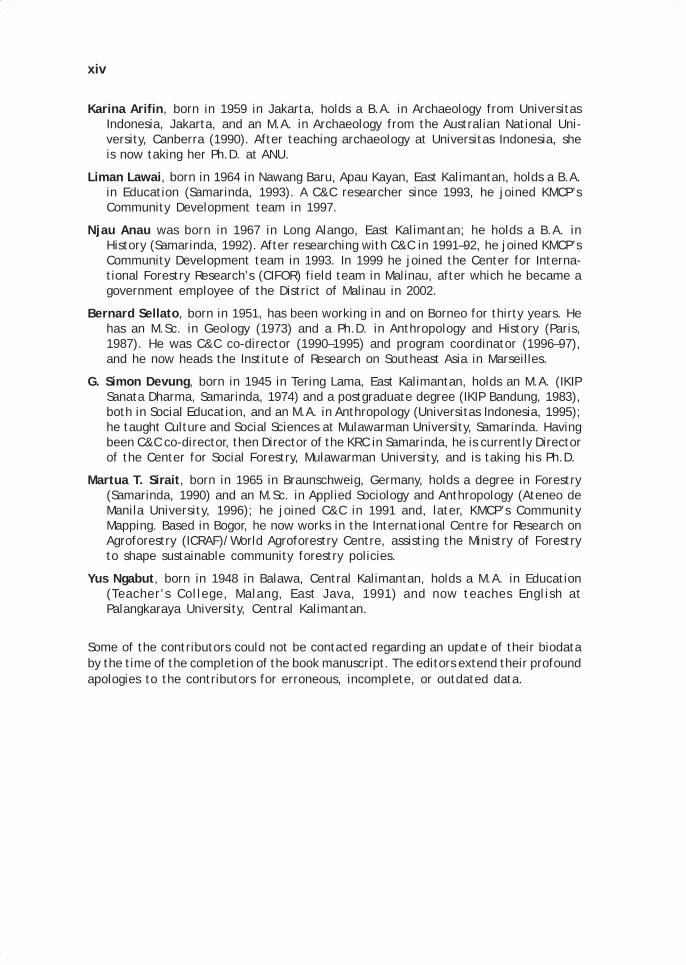
Karina Arifin, born in 1959 in Jakarta, holds a B.A. in Archaeology from UniversitasIndonesia, Jakarta, and an M.A. in Archaeology from the Australian National Uni-versity, Canberra (1990). After teaching archaeology at Universitas Indonesia, sheis now taking her Ph.D. at ANU.
Liman Lawai, born in 1964 in Nawang Baru, Apau Kayan, East Kalimantan, holds a B.A.in Education (Samarinda, 1993). A C&C researcher since 1993, he joined KMCP’sCommunity Development team in 1997.
Njau Anau was born in 1967 in Long Alango, East Kalimantan; he holds a B.A. inHistory (Samarinda, 1992). After researching with C&C in 1991–92, he joined KMCP’sCommunity Development team in 1993. In 1999 he joined the Center for Interna-tional Forestry Research’s (CIFOR) field team in Malinau, after which he became agovernment employee of the District of Malinau in 2002.
Bernard Sellato, born in 1951, has been working in and on Borneo for thirty years. Hehas an M.Sc. in Geology (1973) and a Ph.D. in Anthropology and History (Paris,1987). He was C&C co-director (1990–1995) and program coordinator (1996–97),and he now heads the Institute of Research on Southeast Asia in Marseilles.
G. Simon Devung, born in 1945 in Tering Lama, East Kalimantan, holds an M.A. (IKIPSanata Dharma, Samarinda, 1974) and a postgraduate degree (IKIP Bandung, 1983),both in Social Education, and an M.A. in Anthropology (Universitas Indonesia, 1995);he taught Culture and Social Sciences at Mulawarman University, Samarinda. Havingbeen C&C co-director, then Director of the KRC in Samarinda, he is currently Directorof the Center for Social Forestry, Mulawarman University, and is taking his Ph.D.
Martua T. Sirait, born in 1965 in Braunschweig, Germany, holds a degree in Forestry(Samarinda, 1990) and an M.Sc. in Applied Sociology and Anthropology (Ateneo deManila University, 1996); he joined C&C in 1991 and, later, KMCP’s CommunityMapping. Based in Bogor, he now works in the International Centre for Research onAgroforestry (ICRAF)/World Agroforestry Centre, assisting the Ministry of Forestryto shape sustainable community forestry policies.
Yus Ngabut, born in 1948 in Balawa, Central Kalimantan, holds a M.A. in Education(Teacher’s College, Malang, East Java, 1991) and now teaches English atPalangkaraya University, Central Kalimantan.
Some of the contributors could not be contacted regarding an update of their biodataby the time of the completion of the book manuscript. The editors extend their profoundapologies to the contributors for erroneous, incomplete, or outdated data.
00 TOC selato May28.p65 6/11/03, 11:53 AM14

Acknowledgements
The editors of this volume, in the name of all the participants in the Culture &Conservation (C&C) Program over the course of the years, wish here to extend theirheartfelt thanks to all the people of the Kayan Mentarang National Park area andsurrounding regions for their hospitality and generosity toward researchers and visitorsto their villages, as well as for their invaluable assistance to these visitors’ work. Nodoubt the C&C research would not have been successful, nor the present book havebeen published, without this assistance and their patience. We all shall keep a lastingand moving memory of this warm, unselfish hospitality that the people of Kalimantanhave demonstrated to us whenever we resided with them, and we also wish to extendour profound apologies to them for any blunders and misunderstandings that mayhave inconvenienced them.
We have been very lucky to benefit from the assistance of so many people that it isnow difficult to name them all, and for this, too, we apologise to them. We only shall listhere the names of their villages: Apau Ping, Long Berini, Long Kemuat, Long Alango,Long Tebulo, Long Uli, Long Peliran, Long Bena, Long Belaka, Long Pujungan, LongJelet, Long Pua, Long Apan Baru, Long Nawang, Nawang Baru, Long Temunyat, LongUro, Lidung Payau, Data Dian, Long Metun, Sungai Anei, Miau Baru, Sajau Metun, SajauPura, Kelubir, Naha Aya’, Long Peso’, Berayang, Mara Satu, Antutan, Teras Baru, TerasNawang, Jelerai Selor, Long Tunggu, Long Bang, Long Bawan, Long Rungan, Long Layu,Tang La’an, Long Api, Kuala Belawit, Long Midan, Terang Baru, Malinau, Long Loreh,Gong Solok, Paya Seturan, Langap, and Respen Sembuak. We wish to thank very warmlyall village heads, customary chiefs, community leaders, village ladies, and the five-yearold children who helped collect stone tools under Apau Ping houses.
Thanks to the invaluable support of the great adat chiefs of Pujungan, Hulu Bahau,Apau Kayan, Krayan Hulu, Krayan Tengah, Krayan Hilir, Krayan Darat, Mentarang, Tubu,and Lumbis Hulu, C&C’s activities and the purposes of its research program werebetter understood and well received in their respective customary territories. We alsobenefited from the precious help of many research assistants who, for two months orseveral years, participated in our activities. May they all find here the expression ofour deep gratitude.
00 TOC selato May28.p65 6/11/03, 11:53 AM15

xvi
It is our hope that this book serves to strengthen feelings of cultural pride andidentity among the people of the region. May it help, just a little, the people ofKalimantan fashion for themselves a brighter future. It is also hoped that it willencourage vocations among the local residents, especially community leaders andformer research assistants, to investigate and record themselves the wealth of theirown cultural and historical heritage. And we would be happy if it draws additionalnational and international attention to and recognition of Kalimantan cultures.
Finally, we would like to express our profound gratitude to all agencies of theprovincial government of East Kalimantan, the district governments of Bulungan,Malinau, and Nunukan, and the many subdistrict governments concerned; the Ministryof Forestry and the Directorate General of PHPA; the Indonesian Institute of Science(LIPI); The Ford Foundation, C&C’s friendly, steady, and consistent supporter since1990, and Alan Feinstein, Frances Seymour, Chip Fay, Mary Zurbuchen, Jennifer Lindsay,Suzanne Siskel, and Philip Yampolsky; UNESCO, Malcolm Hadley (Paris) and PhilippeDelanghe and Han Qunli (Jakarta), for their interest in C&C since 1993, then in thisbook; CIFOR, Carol Colfer, Gideon Suharyanto, Sally Wellesley, Dina Hubudin, NormanMacdonald, Kuswata Kartawinata, and Lini Wollenberg for their support to the publicationproject and their instrumental role in its realisation; Michael Dove and Tri Nugroho,for their critical evaluation of our work and their precious suggestions; the YayasanWWF Indonesia and Agus Purnomo, for permission; and DANIDA (Danish InternationalDevelopment Agency).
00 TOC selato May28.p65 6/11/03, 11:53 AM16

Executive Summary
This volume presents a selection of the work carried out under the Culture &Conservation Research Program, a program funded by the Ford Foundation as part ofthe Kayan Mentarang Conservation Project of WWF Indonesia in East Kalimantan,Indonesian Borneo.
It addresses two major methodological and epistemological issues that arecurrently debated in both academic circles and conservation organisations. Firstly,the role of social science research, and more specifically anthropology, in promotingand protecting the social, cultural, and economic interests of forest-dependent peopleliving at the margins. The program’s experience offers a privileged perspective fromwhich to assess the contribution of social science research towards the achievementof the integrated objectives of conservation and social justice. Secondly, the ways inwhich conservation NGOs have contributed to the creation and maintenance of unprovenassumptions concerning the natural environment and indigenous people, and sometimesmade those assumptions ready-made formulas for the management of conservationprojects.
As the outcome of a unique interdisciplinary engagement in central Borneo thatlasted for over six years (1991–97), this volume offers a rare and comprehensivepicture of the people and the environment of this region. Based on original ethnographic,ecological, and historical data, the authors make an important contribution to theunderstanding of past and present interactions between people and forests in theinterior of Borneo. While this provides undoubtedly important information about theways in which people have managed the forests of the interior, the book does nottender ready solutions, nor does it minimise the complex challenges faced in buildingequitable conservation management programs.
This collection also discloses the reality of a human and research experience, inwhich fieldwork encounters have enriched both the researchers and communitiesparticipating in the exchange. Through publication of the research results, the knowledgegenerated by and on the peoples of Kalimantan will acquire a new visibility. The fieldresearchers, too, stand to gain deserved recognition in professional and scholarlycircles, both nationally and internationally.
00 TOC selato May28.p65 6/11/03, 11:53 AM17

xviii
The many aspects that have made this program an important methodological andpractical experiment are reflected in this volume. The topics cover a wide range ofdisciplinary interests, transcending traditional headings such as anthropology,geography, archaeology, history, ethnobotany, and linguistics. The work is the result ofa fruitful collaboration between outside and local experts, experienced scholars andyoung professionals, foreign researchers and Indonesian and Dayak scientists, whohave all been able to integrate their views and insights to formulate a comprehensivebody of knowledge of the interrelationships between natural and human componentsin the forests of the interior of Borneo over time.
The large number of social science reports makes Kayan Mentarang one of theethnographically best known protected areas in Southeast Asia. This in itself is asignificant achievement. The purpose of this book is not, however, limited to presentinga selection of this important information and data. The research program has alsobeen a challenging process of design, implementation, and collaboration over theyears. Moreover, by pointing at the interface between research work and forestmanagement concerns, this book offers some tools for easing the antagonism betweenapplied and scholarly research, and building much needed connections across fields ofknowledge. It also prompts reflection upon ways to make social science research morepractically, academically, and socially significant.
00 TOC selato May28.p65 6/11/03, 11:53 AM18

Introduction
Cristina Eghenter and Bernard Sellato
THE CULTURE AND CONSERVATION RESEARCH PROGRAMThis volume presents a selection of the work carried out under the Culture &Conservation Research Program (henceforth, C&C), a program funded by the FordFoundation as part of the Kayan Mentarang Conservation Project (KMCP) of WWFIndonesia (WWF-I) in the province of East Kalimantan, Indonesian Borneo.
It addresses two major methodological/epistemological issues that are currently beingdebated in both academic circles and conservation organisations. Firstly, the book addressesthe role of social science research, and more specifically anthropology, in promoting andprotecting the social, cultural, and economic interests of forest-dependent people livingat the margins (see Brechin et al. 2002; Brosius 2001; Brosius, Tsing and Zerner 1998;Headland 1997; Sillitoe 1998; Wilshusen et al. 2002). The C&C experience offers a privilegedperspective from which to assess the contribution of social science research towards theachievement of the integrated objectives of conservation and social justice. Secondly, weexamine the ways in which conservation NGOs have contributed to the creation andmaintenance of unproven assumptions concerning the natural environment and theindigenous people, and sometimes made those assumptions ready-made formulas for themanagement of conservation projects (Chartier and Sellato 1998, 2002; Eghenter 2000a;Persoon and van Est 1998; Zerner 1994).
By being the outcome of a unique interdisciplinary engagement in central Borneothat lasted for over six and a half years (1991–1997), this volume offers readers a rareand comprehensive picture of the people and the environment of this region. Basedon much original ethnographic, ecological, and historical data, the dedicated andconcerned authors make a rare contribution to the understanding of past and presentinteractions between people and forests in the interior of Borneo. While this providesundoubtedly important information about the ways in which people have managed theforests of the interior, the book does not tender ready solutions, nor does it minimisethe complex challenges faced in building equitable conservation management programs.
1.
01 May28.p65 6/11/03, 10:55 AM1
Black
2 INTRODUCTION
This collection also discloses the reality of a human and research experience, inwhich fieldwork encounters have enriched both the researchers and communitiesparticipating in the exchange. By publishing the research results as a book, theknowledge generated by and on the peoples of Kalimantan will acquire a new visibility.The field researchers, too, stand to gain deserved recognition in professional andscholarly circles, both nationally and internationally.
The many aspects that have made the C&C research program an importantmethodological and practical experiment are reflected in this volume. The topics covera wide range of disciplinary interests transcending traditional headings such asanthropology, geography, archaeology, history, ethnobotany, and linguistics. The workis the result of a fruitful collaboration between outside and local experts, experiencedscholars and young professionals, foreign researchers and Indonesian and Dayakscientists, who have all been able to integrate their views and insights to formulate acomprehensive body of knowledge of the interrelationships between natural and humancomponents in the forests of the interior of Borneo over time.
The large number of social science reports makes Kayan Mentarang one of theethnographically best known protected areas in Southeast Asia. This in itself is asignificant achievement. The purpose of this book is not, however, limited to presentinga selection of this important information and data. The research program has alsobeen a challenging process of design, implementation, and collaboration over theyears. Moreover, by pointing at the interface between research work and forestmanagement concerns, this book offers some tools for easing the antagonism betweenapplied and scholarly research, and building much needed connections across fields ofknowledge (see Dove and Kammen 1997). It also prompts reflection upon ways tomake social science research more practically, academically, and socially significant(Eghenter 1999, 2002; King 2002).
C&C in Perspective: Building Stronger Research StrategiesThe C&C program originated in a proposal to the Ford Foundation for a project on oraltraditions in Kalimantan, and in a subsequent consultancy report (Sellato 1989a, 1990).The project aimed at studying all forms of oral tradition, particularly oral literature,history, and traditional legal systems, with the twofold purpose of documenting a richcorpus of oral literature and helping uphold traditional rights over land and naturalresources. Eventually, it was decided to implement this project in conjunction withefforts to develop the management plan for the Kayan Mentarang conservation area(then a nature reserve) by WWF-I (Jessup and Sellato 1990).
From the beginning, the C&C program focused the research on the interconnectionbetween society and the natural environment in and around Kayan Mentarang in orderto better understand the modalities of interaction of the communities with the forestaround them. The main assumption was that taking into account traditional knowledgewould help the planning and management of the nature reserve, and would allow forthe elaboration of conservation strategies that are community-based. The success ofnature conservation was seen as depending upon the preservation of indigenous culturesand, mostly, the maintenance of traditional practices of land tenure and natural resourcemanagement. More specifically, the program set out to: investigate the communities’knowledge and perceptions of, and attitudes toward, the natural environment; identifypast and present interactions between people and the forest; demonstrate the existenceof practices of land tenure based on traditional legal systems; and train Indonesian,particularly Dayak, researchers in field research techniques. Research activities were
01 May28.p65 6/11/03, 10:55 AM2
Black

3Cristina Eghenter and Bernard Sellato
also seen as an important opportunity for motivating local people to lead conservationand development activities in their own communities.
In 1990–1992, the program staged a dozen field studies, carried out by localscholars and students after a period of interdisciplinary training bridging ecology andanthropology, the natural and social sciences. Subsequently (1993–1994), field studieswere refocused on three main themes: linguistics and oral literature; land tenure andtraditional legal systems; and regional history of societies and the forest, movingfrom a synchronic to a diachronic approach of the relationship between society and itsnatural environment. These were carried out by about thirty scholars and students,most of whom were Indonesian, who spent three to six months in the field (Jessup andSellato 1993; Sellato and Jessup 1994).
In the last phase of the program (1995–1997), the overall scope of the C&C programremained much the same. Nevertheless, specific efforts were made to address the issueshighlighted by the program’s reviewers (Dove and Tri Nugroho 1994), and aim at anoutput of research more directly linked to, and better integrated with, the agenda of theKMCP for enhancing conservation awareness, strengthening local institutions, and increasingcommunity participation in the planning for the management of the National Park.
In this context, the C&C research agenda was geared towards the collection of empiricalevidence so as to understand how and why people have managed natural and culturalresources, and what conditions had triggered changes in the degree and mode of theirpractices. Addressing the reviewers’ recommendations to investigate changes in traditionalmanagement practices as they relate to changes in the context of evolving social andpower relations in the communities of the interior, the research was directed at trying todetermine changes in indigenous peoples’ practices and their social context, and look atthe extent to which these practices helped conserve resources or manage the forests tomaintain biodiversity (Eghenter 1997). Recruiting and training continued to target Dayakresearchers from communities in and around the Kayan Mentarang area who were concernedwith both investigating local cultures and enhancing local awareness of social andenvironmental issues. A small team of core researchers and research assistants was formed.
The Institutional Environment of C&CA thorough understanding of the history of the C&C program requires looking at theconcurrent developments that have taken place in the KMCP and in WWF-I in general. Theevolution of strategies reflects reciprocal adjustments and changing forms of collaborationin what often appear as the reversed-growth trajectories of the research program and theconservation project. The following provides a brief overview of how the two projects havecoexisted and how the forms of their partnership have shifted through time.
Begun in 1990 as a collaborative effort by WWF-I, the Directorate General of ForestProtection and Nature Conservation (PHPA, now PHKA) of the Ministry of Forestry, andthe Indonesian Institute of Sciences (LIPI), KMCP was hardly distinguishable from itsC&C component. In the initial years of KMCP’s life, its funding, management, and staffwere largely drawn from C&C, and the presence and activity in the field were largelythose of the C&C staff.
KMCP’s long-term goal was the establishment of conservation management andsustainable economic development in the Kayan Mentarang and surrounding areas. Withits 1.4 million ha, the Kayan Mentarang conservation area in the far interior of EastKalimantan is the largest protected area of rainforest in Borneo and one of the largest inSoutheast Asia. Extensive archaeological remains in the area are witness to a longhistory of human settlement. Nowadays, about 16 000 Dayak people live in or near the
01 May28.p65 6/11/03, 10:55 AM3
Black
4 INTRODUCTION
reserve, depending on swidden agriculture, wet rice farming, hunting, fishing, andcollecting forest products to fulfil their subsistence needs. In an effort to find viablesolutions for the management of this vast conservation area, KMCP and C&C collaboratedin collecting evidence to recommend a change of status for the conservation area fromstrict nature reserve (cagar alam), as it had been gazetted in 1980, to national park(taman nasional). While in a nature reserve all human settlements are in principle excludedand human activities illegal, in a national park traditional residents are allowed and their‘traditional use’ of natural resources permitted. It was upon the recognition of the localpeople’s dependence on forest resources and entitlement to economic development thatnegotiations for a change of status were started. The results conveyed by an evaluationteam sent by the Ministry of Forestry endorsed WWF-I’s recommendation. The conservationarea was finally designated as a National Park by a decree of the Ministry of Forestry twoyears later, in October 1996.
Encouraged by the positive response of PHKA, WWF-I used the concept of an IntegratedConservation and Development Project (ICDP) to develop the management of the KayanMentarang conservation area. In projects of this kind, the emphasis is on linking andintegrating economic development with biodiversity conservation in protected areas bydevising conservation measures with economic incentives for the local population (seeMuul 1993, Wells 1995, Wells and Brandon 1992). With funding from the John D. & CatherineT. MacArthur Foundation and the European Commission, the KMCP project adapted thebasic ICDP strategy and envisioned new directions and activities on a larger scale. AGeographic Information System (GIS) unit was set up to produce maps based on theinterpretation of satellite imagery and field data. The Primary Environmental Care (PEC)program started in 1993, its purpose emphatically focused on advocacy of communityrights and environmental awareness. In the meantime, several teams of C&C researcherswere spending two to three months in the field for what turned out to be C&C’s mostintensive and extensive phase of data collection and field activities. By the end of 1994,the KMCP-C&C partnership experienced a pendulum movement: KMCP was now biggerand more articulated, and research activity subsided in terms of its function. Althoughfunds were still being used in new and experimental ways to start community mapping,much of the sense of the value of social science research for the overall KMCP was fading.
In yet another switch of fortunes, a long phase of financial uncertainty started in1995 for KMCP, affecting its activities in severe ways, while C&C funding from the FordFoundation continued. It was only at the end of 1996 that KMCP managed to secure importantnew funding from DANIDA, the Danish International Development Assistance Agency. Inthe context of a revived KMCP, C&C, now a minor partner again and often viewed as amarginal entity, took the tricky path of trying to build a common ground and work moreclosely with other KMCP components. C&C’s final field and dissemination activities weredesigned to attend to KMCP’s immediate concern to develop a management plan for thenational park, which would draw on traditional tenure strategies and support the localpeople’s leading role in the management of their forest and in the sustainable developmentof their region.
An Overview of the Implementation of C&C
Methodological ApproachSince its inception, the C&C program has based its methodological approach on socialscience research techniques and the fieldwork experience of the anthropological tradition.Most of the data were collected during two- to three-month periods in the field and, often,repeated visits to the same communities over a period of time. This was especially feasible
01 May28.p65 6/11/03, 10:55 AM4
Black

5Cristina Eghenter and Bernard Sellato
for locally recruited researchers. The strategy rested on the commonly shared opinion thatone of the strengths of traditional social science research is its long-term commitment tothe object and place of study, by means of which research can provide deeper and morethorough insights into local traditions, history, and practices (e.g., Sillitoe 1998, Headland1997, Spradley 1980). Researchers were given formal training in interview techniques,surveys, and ethno-historical methods, and time was also devoted to discussions on howto develop a research plan and identify key research questions. It was deemed veryimportant that researchers learn how to plan and manage research or a survey, formulatethe significant questions to be asked, and envision the complexity of the possible linkagesbetween events or practices and their economic, cultural, social, environmental, andhistorical circumstances. In addition, rapid demographic and socio-economic surveys werecarried out to collect essential baseline data to better assess the overall context of thecommunities in and around the park.
The research stressed team work and collaboration among the researchers. This wasachieved in a variety of ways: common initial training in a range of disciplines; flexibleresearch units of two to three individuals investigating together similar topics in differentlocations; researchers focusing on distinct topics forming a team sharing the same fieldlocation; senior researchers guiding younger ones in joint field expeditions; numeroussmall-scale workshops in the field; researchers interpreting and writing up data together.The main objectives were to encourage exchange and crosschecking of information amongresearchers, reinforce the awareness of the degree of interconnectedness of the researchtopics investigated, and build team membership. Evaluation sessions on the progressmade in the research were also based on the participation and input from all the teammembers. C&C’s culture-sensitive researchers and the remarkably open, hospitable, andfriendly host communities also created a common ‘team’ spirit. They established andmaintained long-term relations of genuine collaboration and empathy that remained asalient feature of the C&C field experience through the years in and around the KayanMentarang area (see Dove and Tri Nugroho 1994).
The research experience of C&C was not, however, narrowly restricted to the use oftraditional social science methods. It was under this program that the first experimentswith community sketch maps took place, which later became one of KMCP’s trademarks(see Peluso 1995, Eghenter 2000b). These maps recorded local people’s knowledge anddecisions about land and resource use, as well as their claims to those resources. Informantsorganised in groups of men, women, and young people were directly involved in thecollection, analysis, and discussion of data, and in the drawing of the maps (Sirait et al.1994).
The significance of a diachronic perspective has long been praised as an importantaspect of understanding human activities and their environmental effects (e.g., Headland1997; Schrire 1984; Sellato 1994b, 1994c). In the context of the C&C research, the historicalcontextualisation of people-forest interactions was expected to shed light on circumstancesand events that might have important impact on future decisions for the management ofthe conservation area and the development of the surrounding region. The researchperspective emphasised the study of both present and past activities in order to be ableto compare events at different points in time and eventually find patterns in the ways inwhich people had exploited resources and responded to changing social, economic, andenvironmental circumstances over time.
Products and AchievementsThe output of six and a half years of research, training, and dissemination activitiesincludes several products and many achievements. Forty-two research reports were
01 May28.p65 6/11/03, 10:55 AM5
Black
6 INTRODUCTION
submitted to KMCP, covering a wide range of topics related to the Dayak communitiesof the interior—from swidden practices to oral literature, from traditional religions tothe exploitation of forest products, from migration history to music and songs. Acollection of thirty-six edited reports was released in 1995 as a set of five volumes(Sellato 1995e). Two video films were produced, the first one (1994) in collaborationwith the Sejati Foundation (‘Dayak and Biodiversity. Cultural Survival and NatureConservation in Remote Interior Kalimantan’); the second one (1997) was made byManguin and Sellato and sponsored by UNESCO (‘The Last Traditional Potter of Borneo’).Finally, in 1999, a selection of twenty-five reports, abridged and further edited, waspublished as a large volume in Indonesian, sponsored by the Ford Foundation, UNESCO,and WWF (Eghenter and Sellato 1999).
The importance of human resource development, particularly of local people, hasbeen emphasised since C&C’s beginnings. Priority was given to recruiting and trainingDayak researchers, initially from all over Kalimantan, then more specifically from thecommunities in and around the Kayan Mentarang National Park. The leading expectationwas that members of the communities, by becoming active participants in the researchprogram, could better clarify the scope and importance of in-depth, long-term studiesto record local knowledge of the environment and traditional practices of management.In this way, they could also trigger the communities’ interest in conducting their owndocumentation of their culture and history. Moreover, researchers were expected tobecome tomorrow’s spokespersons for their communities and lead them in conservationand development initiatives for the management of the National Park. More thantwenty-five community representatives were trained under the C&C program. Someof them moved on to become KMCP staff shortly after training. Others continued theirinvolvement in research and later took on other positions within KMCP.
An opportunity was offered to about 15 C&C researchers to present their findingsin scholarly forums through their participation in three successive internationalconferences of the Borneo Research Council, respectively in Kota Kinabalu (Sabah,1992), Pontianak (West Kalimantan, Indonesia, 1994), and Bandar Seri Begawan (BruneiDarussalam, 1996). For most of the Dayak researchers, it was their first time ever tobe part of and interact with the international scientific community at large.
Sustaining C&C’s LegacyAs rightly pointed out by the reviewers of the C&C program (Dove and Tri Nugroho1994), one of the consequences of field activities was the emergence of village-levelcuriosity about, and interest in, the research findings that could be exploited to helplocal communities develop plans to protect their biological and cultural resources. Asimilar concern motivated the promoters of C&C to start initiatives to furtherencourage the dissemination and ‘socialisation’ of research activities, and thussustain the legacy of the C&C program. The Kalimantan Resource Center (KRC) wasestablished in collaboration with a Jakarta-based organisation, the Foundation forResearch and Development in Borneo (YPPB). It was intended to provide localcommunities and other stakeholders with useful information to enable them to takethe lead in the long-term goal of the protection of the culture(s) and nature ofKalimantan. The objectives of the KRC included the creation of a library; thepublication and dissemination of articles and books based on the results of fieldactivities; the publications of papers to target scientific audiences and decisionmakers in both the government and private sectors; and the organisation of
01 May28.p65 6/11/03, 10:55 AM6
Black

7Cristina Eghenter and Bernard Sellato
promotional activities including exhibitions, thematic workshops, and networks withresearch institutions, local NGOs, and government agencies.
The transition of the KRC from a C&C unit to an independent nongovernmentalorganisation was formally sanctioned in 2000. The process has not been easy and hasbeen marred by difficulties, mainly financial. The bulk of the library collection (some1400 titles on the nature and cultures of Borneo, probably constituting the largestsuch library fund in Kalimantan) is currently under the temporary management of theCenter for Social Forestry (CSF), Mulawarman University, Samarinda. Meanwhile, othercommunity proposals for documentation have emerged, often stimulated by different,and new, community projects, like ecotourism.
Recognising Indicators of SuccessAssessing the value of a research and training program like C&C calls for more than along list of remarkable products, achievements, and initiatives carried out under itsauspices. The interconnectedness of the priorities of the research agenda with thoseof the management of the conservation area requires that the research output beevaluated in terms of its contribution toward the achievements of KMCP’s practicalobjectives. It is important to look at what themes and issues have emerged mostforcefully from the reports, and at what they tell us about local management andpractices, environmental knowledge, and people-forest interactions. It is necessaryto assess whether the social science research that has been conducted under C&C hasimproved our understanding of the local context and ensured useful results for KMCP.
The geographical scope of the C&C research program covered the entireconservation area. Most early activities, however, focused on one area, the Pujungansubdistrict (kecamatan), regarded as a strategic area from several points of view. Itscentral position with regard to the National Park suggests that it will become the corearea for the implementation of the management plan and the monitoring of the park.The existing number of archaeological remains and the diverse Dayak subgroups pointto the significance of the area in understanding the history of Dayak people and theirsettlement of this and other parts of the interior. Contrary to areas like Apau Kayanand Krayan, the Pujungan subdistrict is also more easily accessible by river, whichmakes it the natural entrance point to the National Park.
Highlights from the FieldThe chapters in this volume—a narrow selection from the original research reports—highlight the main attitudes and traditions in forest management among the peopleliving in and around the Kayan Mentarang conservation area.
First, it was established that the communities are still what is usually called‘traditional communities’ (masyarakat adat), largely regulated by customary law inthe conduct of their daily affairs and the management of natural resources (chapterby Jacobus Frans). This was a major point made with regard to both KMCP’s long-term goals of involving these communities in conservation efforts and seeking officialrecognition for claims on traditional land and resources. The role of traditionalinstitutions, presently reflected in institutions like the customary council (lembagaadat) and the customary chief (kepala adat), is key to understanding thecommunities’ views of rights and the way they deliberate on issues of forestmanagement and social responsibilities.
01 May28.p65 6/11/03, 10:55 AM7
Black

8 INTRODUCTION
Several chapters point to various aspects of what is usually referred to as an‘indigenous management system,’ or the ability of local people to use, alter, regulate,and restore land and other natural resources in their environment. With a distinctemphasis, Bahari describes the stages of traditional swidden farming in the upperBahau area and shows how farmers make their decisions on the basis of criteriarooted in their long experience of local environmental conditions (chapter by HerculanusBahari Sindju). Adding to the growing body of literature on the environmentallysustainable function of shifting cultivation in tropical forests under stable conditions(e.g., Brookfield et al. 1995; Dove 1985a, 1988a; Colfer 1993; Conklin 1957; Jessup1981), this research provides important evidence that local people’s agriculturalpractices are not intrinsically destructive of the environment but rather draw onknowledge and understanding of the dynamics of that environment.
The role of the forest as provider of goods that can be eaten or used in variousother ways, as well as traded out, is socially and legally reinforced by the concept thatthe forest must be protected from overexploitation by individuals from within and,especially, from outside that community. In all the traditional communities along thePujungan and Bahau rivers, specific regulations exist that restrict access to the forestand regulate the exploitation of its most valuable products (chapters by Blajan Konradus,Simon Devung, Martua Sirait, and Angguk Lamis et al.). Reserving part of forest inthe village territory for harvesting products when in need or under other specificcircumstances is a common strategy adopted also in other communities of the nationalpark, and elsewhere in Borneo (e.g., Wadley et al. 1997; Eghenter 2000a).
The wide range of forest plants and crop varieties exploited suggests a highdegree of biodiversity that has been managed and intentionally maintained for centuries(chapters by Martua Sirait, and Indah Setyawati). The Dayak are also keen collectorsof seeds. The connection between local environmental knowledge and customaryregulations also becomes apparent in the discussion of collective and individual rightsand practices of forest exploitation (chapters by Angguk Lamis et al., and SimonDevung). As we would expect in all communities, there are episodes of non-adherenceto common rules, yet the overall conformity of behaviour indicates a high degree ofsocial cohesion and the community’s vital dependence on the forest for its wellbeing(chapter by Simon Devung).
The definitive archaeological and historical evidence of the long presence of Dayakpeople in the Kayan Mentarang area (chapters by Njau Anau, Liman Lawai, and KarinaArifin and Bernard Sellato) reminds us that these peoples’ practices and interactionswith the forest also have a long history. Past attitudes toward the environment arereflected in the oral literature (chapter by Yus Ngabut) and the importance of naturalresources is embedded in their artistic traditions (chapter by Daniel Lawing). Recentchanges and adjustments brought about by new economic opportunities are alsodepicted (chapter by Blajan Konradus). The recognition of these changes is importantin that it contradicts stale formulations and stereotypical views of timeless, backwardindigenous people still entertained by government officials, urban residents, andromantic environmentalists. At the same time, the awareness that economic andsocial changes have taken place cannot prevent us from discerning that traditionalmanagement practices still remain in place, while adjustments are being made to suitnew circumstances.
The themes highlighted above represent a necessary recapitulation of the scientificcontributions of the research program. However, the findings need also be examinedwith regard to how useful they were in KMCP’s development and whether and how they
01 May28.p65 6/11/03, 10:55 AM8
Black
9Cristina Eghenter and Bernard Sellato
were (or could be) used to influence decisions and design solutions for the managementand economic development of the conservation area.
While this step might seem a logical and obvious one in evaluating a researchprogram created and implemented as part of a conservation project, it is rarely taken,with the result that there is little possibility to assess the effectiveness of the role ofsocial science research in conservation management and sustainable development(see Sillitoe 1998; Brosius 2001). What some of the reasons might be could only bespeculated on. The fact that proposals and projects of this kind are only too susceptibleto stringent requirements—securing funding, respecting deadlines, fittingpredetermined views of what the projects are expected to produce—might just explainthe paucity of objective appraisals. The persisting gap between the prevalent‘academic’ voice of research and the ‘practical’ concerns of field projects might alsoaccount for the still scarce instances where results of research succeed in indicatingsolutions and developing viable alternatives.
The contributions of C&C with regard to making KMCP a more successful projectcan be assessed at several levels. The training and fieldwork opportunities providedstaff with the knowledge of research techniques and the analytical skills that havebeen brought to bear in the ways these staff successfully fulfil new responsibilities inWWF-I projects and elsewhere. The opportunity to interact with the communitiesduring long stays in the field also enabled them to become more open-minded andgain a better sense of how to encourage community participation.
Findings that Make a DifferenceInformation collected in the field was instrumental in providing the crucial evidenceand formulating the recommendation for the change of status from strict nature reserveto national park. The historical and archaeological data undoubtedly showed that thecommunities of the park have long been residents of the area and could not be forcedout without raising sensitive issues of human rights abuse. Not only have Kenyah,Punan, Saben, Ngorek, and other Dayak communities settled the area for centuries,they have also maintained its forests and developed management systems. Theargument that the communities themselves could prove to be the best chance for thesustainable and continued management of the Kayan Mentarang conservation area,particularly the idea that the communities’ actual presence and strong cultural identitycould contribute to deterring or minimising the risk of encroachment by outside parties(Sellato 1992a), relies on the interpretation of the research findings.
The extensive documentation on land tenure systems and regulations for theexploitation of forest resources helped bring the issue of customary rights to theattention of government officials in the Bulungan district (kabupaten) and the Ministryof Forestry. Future negotiations for the official recognition of traditional systems andregulations like tana’ ulen and the definition of their role in the management of thenational park will depend on the accuracy and inclusiveness of the research findings.The data collected also provided a basis for structuring and developing a programaimed at strengthening local institutions. The realisation of the prominent role ofcustomary institutions in the management of forest resources requires that theseinstitutions become the privileged interlocutors and partners in planning for themanagement of the conservation area.
The presence of the researchers in the communities generated village-level discussionson conservation and the future of the area. In some cases, like in the customary territory
01 May28.p65 6/11/03, 10:55 AM9
Black

10 INTRODUCTION
of the upper Bahau, the outcome was a resolution to more tightly enforce traditionalregulations and exclude outsiders from the exploitation of forest products on villageland. Research activities also inspired local interest in documenting historical, cultural,and artistic heritage. So far, this interest was the motive for community representativesto join KMCP and work in the midst of their own communities on behalf of theconservation project. In the future, the conservation of cultural and natural resourcesin the area will require a role shift whereby community representatives take the leadin the management of the national park on behalf of their communities. Their newroles will draw vitality from a stronger sense of ethnic identity and pride in theircultural heritage.
Challenges to Conservation ManagementAs mentioned in the section above, the output of C&C’s research activities served theconservation management objectives of KMCP in direct ways that, in turn, raised thelevel of participation in and support for KMCP among local people and governmentofficials.
Research findings, however, also brought to light the multiple aspects andcomplexities of the social, environmental, political, and historical context within whichthe viability of KMCP is ultimately tested. Dayak village communities are increasinglyheterogeneous in their ethnic and socio-professional composition. This type ofinformation becomes extremely valuable for conservation and development projectswhen consistently linked to difficulties that may be encountered in the implementationof activities. Limited access to information, the resilience of stereotyped views, andpreference for quick results might encourage park managers to regard forest-dwellingcommunities as homogeneous entities in relatively uncomplicated situations, and toadopt common solutions for the whole conservation area. Although this might be easierand less time consuming, the chances of success are slim, insofar as they rest on theincongruity of the project’s views with the reality of the communities (see Dove 1992).On the contrary, acknowledging the complexity and diversity of the social and economiccontext will lead to designing flexible and locally appropriate measures of conservation,and thus ultimately will enhance the project’s sustainability in the long term.
Several of the C&C reports focusing on history point to the reality of overlappingterritorial claims caused by long histories of migrations. Recent experiences withKMCP’s community mapping underscored the need to take into consideration historicalfactors before finalising territorial maps and settling boundary issues between old andnew settlements. Similarly, the initial focus on the interactions between people andforest inside the conservation area proved too narrow when research findings indicatedthe significant impact of people who had moved out of the park area but go back forthe purpose of collecting forest products. The line between insiders and outsidersthus becomes inevitably blurred.
Communities of the interior are part of far-reaching trade networks in forestproducts such as eaglewood or incense wood (gaharu). The control of the trade might bein the hands of outsiders, but the local people’s growing debt with these merchants, aswell as their desire to purchase consumer goods and build new houses, leads them toadopt collecting practices that are unsustainable. The presence of large teams of collectorsfrom as far away as Java, Central Kalimantan, and Sulawesi (Celebes) created a situationof competition where customary rules were easily disregarded and considerations forshort-term economic gain prevailed. The presence of these outsiders, who sometimes
01 May28.p65 6/11/03, 10:55 AM10
Black

11Cristina Eghenter and Bernard Sellato
gain local residency by marrying into the village, brings new social and religious challengesto the communities. Such residents of a different religious denomination and ethnicbackground, in growing numbers, may embolden themselves to resist rulings by theirhosts’ customary council and, when convenient, challenge the validity of customary lawas conflicting with the national law (Sellato 2001; Eghenter 2000c; Wadley n.d.).
Discriminations that rock the social fabric of the village communities do not,however, always originate from the outside. The customary law is the law of thearistocratic category that has maintained economic and social supremacy, unchallengeduntil very recently, within Kenyah and Kayan communities. New developments,education, and the Christian faith are eroding the old privileges of the higher strataand providing more opportunities for educated and enterprising individuals to climbto power.
The Pioneering Role of C&CIf the product—i.e., the reports, information, data—elaborated by the C&C programnow remains as its most tangible contribution, the mere existence of the program wasimportant for KMCP in other ways. As mentioned earlier, in KMCP’s early stages, C&Ccontributed to its physical establishment and presence by training staff, and providinglabour and other resources. In addition, C&C helped establish the name of KMCP, especiallywith the communities of the park. It was C&C researchers who first visited thecommunities and explained the idea of a nature reserve. During their stay, researcherstook time to discuss the plans for conservation and sustainable development in thearea. In many villages, particularly outside the park boundaries, the first and only timeKMCP staff visited was on the occasion of C&C research activities. Researchers wereoften asked to convey to WWF-I the local people’s concerns about their rights and thecurrent or potential conflicts with neighbouring or encroaching outside companies.
KMCP’s image was largely shaped through the contacts and interactions of C&Cresearchers. By establishing lasting bonds with the communities, C&C unwittinglyfound itself in the position of spokesperson for the larger KMCP. In this role, C&Copened the way to other KMCP activities and promoted the gradual embracing by localcommunities of KMCP’s conservation and development objectives (Eghenter 1997).
Lessons from the C&C Experience: Improving the Dialoguebetween Social Science Research and Conservation ManagementSince the 1980s, in conservation and protected area management circles, there hasbeen an increasing emphasis on the need to balance conservation priorities with thedevelopment needs of the communities living in and around the conservation area.The neglect of resident people in conservation areas, which had long characterisedthe approach of governments and organisations alike, was being replaced by therealisation that virtually all wilderness areas had been modified or managed by humansin one way or another. Changes in the criteria for defining protected areas now includedthe protection of landscapes reflecting a history of human interaction with theenvironment, as well as the need to maintain the ‘traditional’ ways of humancommunities (Pimbert and Pretty 1994). The ecological evidence for the positive impactof traditional human activities in some areas justified the participation of residentcommunities in the protection, management, and restoration of the environment(Pimbert and Pretty 1994; Headland 1997). The necessity of involving local communities,
01 May28.p65 6/11/03, 10:55 AM11
Black

12 INTRODUCTION
however, was less of an absolute technical requirement for the management of theconservation areas than it was contingent upon the consideration of both pragmatic andsocial justice concerns (see Orlove and Brush 1996; Wells 1995). On the one hand, therealisation that the economic benefit of biodiversity conservation did not, for the mostpart, reach local people living in and around the conservation area required that othereconomic incentives be created to reduce local pressure on natural resources and thepotential loss of biodiversity (Wells 1995). On the other hand, the recognition of therightfulness of local peoples’ claims to the land, based on a long history of settlement inthe protected area, discredited initiatives of strict enforcement of protection measures,such as denying them access to the exploitation of natural resources.
It was also becoming evident that local people, precisely because of their long-term residence in the area, could become assets in management and conservationefforts. They possessed a wealth of knowledge about the natural environment thatcould be used to design more effective conservation management strategies involving,rather than excluding, local communities. Social science research could play an importantrole by providing insights into local practices and beliefs, and their wider social andpolitical context. Researchers, particularly anthropologists, have ever since beendocumenting indigenous knowledge and management systems in wilderness areas toattest to the conservation ethic held by local people and to the sustainability of theirtraditional practices (e.g., McNeely and Pitt 1985; Poffenberger 1990; Redford andPadoch 1992; Brush and Stabinsky 1995; Padoch and Peluso 1996; Sponsel et al. 1996;Wadley et al. 1997).
The general outlook of integrated conservation and development projects (or ICDPs,of which KMCP was an adjusted model) more specifically assumes that effectivemanagement of natural resources and their sustainable use over time need to incorporatetraditional management practices and involve local people from the planning phase on.This approach also stresses the development of buffer zones outside protected areas toreduce pressure on resources within the protected area by providing alternative economicoptions. The partnership between C&C and KMCP was built upon the recognition thatsocial science can make a significant contribution to the design of conservation andsustainable development strategies. As stated in C&C’s last proposal to the FordFoundation, the activities under the auspices of the C&C program were intended ‘todocument and support traditional rights of tenure and local resource management,including zonation; to strengthen the ethnic and cultural identity of Dayak people; toprovide training and field experience for young scientists from Kalimantan; to contributeto our knowledge of the cultural history and the forest ecology of the region’ (Jessup andSellato 1995). Moreover, it was expected that the results of research activities wouldenable KMCP to design better management strategies. The research would directly supportefforts to manage the conservation area by providing information for designingconservation strategies that involve local communities and maintain indigenousmanagement practices (Sellato 1994a, 1996a; WWF-I and WWF-D 1996).
Reasons for a Research ProgramThe brief evaluation of the usefulness of the outcome of C&C presented above allowsfor a re-interpretation of statements contained in the WWF-I proposal in light of whatactually happened. While there is little doubt that C&C helped train researchers,contributed to improving our knowledge of the cultural and environmental history ofthe region, generated local interest in research and other KMCP activities, and
01 May28.p65 6/11/03, 10:55 AM12
Black
13Cristina Eghenter and Bernard Sellato
documented forms of local resource management, it remains unclear whether C&C didor did not enable KMCP to design better management strategies. The uncertaintyhas less to do with the quality of the data collected than with current thinking inmany conservation organisations. Wells convincingly argued that several ‘unprovenand optimistic assumptions’ are often made in ICDP projects with regard tobiodiversity conservation and sustainable economic development, despite the factthat results have for the most part fallen short of expectations (Wells 1995: 322–323). Similarly, there seems to exist a sequence of causally related assumptions onthe ‘presumed’ key role of local people in sustainable management of protectedareas: indigenous people are good conservationists, hence they would make goodmanagers of the conservation area, hence it is important to study them. In theseterms, the protected area management’s prevailing position of blaming local residentsfor destroying the environment in the past can easily turn into the opposite, yetequally simplistic position—if unsupported by hard evidence—of praising localresidents as the natural managers of biodiversity.
How should a research program fit into this framework? Must it set out to provethat local people are good managers of the environment or, rather, turn such apremise into a working hypothesis that could or could not be borne out in the finalresults? What lessons can be drawn from the C&C experience?
Research can and should be effectively used as a means to critically questionand test key assumptions implicit in the project’s objectives. Reflecting onepistemological issues, Dove maintains that social sciences are in a position toaddress questions transcending boundaries between disciplines by problemising otherfields (Dove and Kammen 1997: 99). Then, problemising or questioning premises orunproven assumptions made in the field of biodiversity conservation and sustainabledevelopment is a task that research programs like C&C can and must undertake.Such assumptions may have arisen because of political reasons or financialconsiderations; sometimes, they may be ideas taken for granted and recycled inunassuming ways within the common discourse currently prevailing in conservationcircles. According to Ingerson, for example, the view that traditional knowledge andpractices of people in a conservation area are keys to the sustainable managementof that area might have been encouraged by anthropologists and advocatesthemselves, who have made use of romanticised notions of forest peoples asdefenders of the environment to prompt governments and international foundationsto fund projects for the participation of people in protected area management(Ingerson 1997; Conklin and Graham 1995).
By testing the basic assumptions implicit in the project’s statements of intent,the research program would be able to provide illuminating evidence on, for example,when and under what circumstances indigenous practices are sustainable. Qualifiedevidence to the contrary and conflicting findings need not be ignored, but must becarefully appraised by conservation managers in order to modify strategies and makethem more effective (see Sponsel 1997). Although the C&C program did not initiallyset out to test the validity of certain premises professed in KMCP’s proposal, successivedevelopments encouraged reflection on how this and future research programs couldbest fulfil this purpose.
The results of the C&C research preclude making simplistic and sweepingstatements in support of regarding local communities as the best possibleconservationists. While there is strong evidence of the existence of forms ofindigenous forest management and traditional regulation of resource use, there is
01 May28.p65 6/11/03, 10:55 AM13
Black

14 INTRODUCTION
also evidence of overexploitation of protected species, motivated by the desire tomake economic profits in a competitive situation. The evidence relating to thecircumstances and reasons for the existence or absence of sustainable traditionalmanagement of the environment is still incomplete. This shortcoming is due primarilyto KMCP’s inability (or reluctance) to question its own key assumptions in conservationarea management and to assign to the research program the task of testing them(see Sellato 1999). The absence of a clear, ‘assumptions testing’ agenda for the researchprogram ipso facto hampered efforts at finding the best possible ways to integrateresearch in the planning for conservation management.
A Need for Better ConnectionsIndeed, C&C’s research did not go without difficulties. Moreover, ambiguities concerningthe criteria and modalities of research in the context of a conservation and developmentproject have arisen throughout the three phases of C&C. These became even moreapparent when local communities raised occasional questions concerning the value ofresearch activities and the practical relevance of the results with regard to theirimmediate needs (Eghenter 1999a).
Difficulties point to a deficient mode of collaboration between research (C&C)and project (KMCP) staff, who failed to develop a common language and frameworkof reference. While anthropologists and other researchers working in conservationand development projects must ask themselves what (and how) social science researchcan contribute to conservation, conservation and park management specialists alsoneed to think about how and why they make use of social science studies in order tobetter meet the needs of a national park and the people in it (Eghenter 1999a).From the planning phase, the C&C experience lacked the concerted efforts thatwould have resulted in clear objectives for collaboration and reciprocal expectations.After the initial focus on documenting the social, historical, economic, and ecologicalcontext of the communities in the conservation area, the C&C research team wasoften alone in trying to define the research objectives of subsequent phases andformulate hypotheses, with both their field data and KMCP’s priorities in mind (seePelkey 1995).
There was exchange and communication, particularly in the beginning, but thiscould have been more effectively sustained by means of common discussions, internalevaluation of the usefulness of research findings, and definition of crucial issues inmanagement, in order to open the way for adjustments of research modalities to fitKMCP’s priorities and changes in management criteria following the research findings.As a result, some of the research output failed to prove of direct significance to KMCPfor the drafting of conservation policies.
At yet another level, improved communication was also played out in languageand mode of expression. It is important to point out that some of the reports, althoughinformative, were by and large embedded in a scholarly mode of writing too distantfrom the practical and analytical emphasis favoured by project managers. This problemis not uncommon. As noted by Sillitoe (1998) in discussing the use of indigenousknowledge, the esoteric accounts of local views conveyed by anthropologists and thescientific language of development and other technical advisors are far apart. Someknowledge of technical issues of conservation and development together with anappropriate research design can dramatically improve the degree of cooperation andunderstanding between social science researchers and conservation specialists.
01 May28.p65 6/11/03, 10:55 AM14
Black

15Cristina Eghenter and Bernard Sellato
The Holistic View of InterdisciplinarityThe co-incidence and co-dependence of people and forests in this part of interiorKalimantan require that conservation efforts be based on the recognition of theimportance of the human as well as natural components of the environment. From thepoint of view of a research program, this translates into the need for an interdisciplinaryapproach, whereby issues are investigated from a multiplicity of perspectives andpromote a tighter coordination of research components (see Vayda 1997). Sillitoe(1998: 231) contends that ‘interdisciplinary work will be central to methodologicaladvances in this development research’. The need to procure results that are relevantto the project and provide integrated solutions to management and development issuesrequires a research design based on a stronger multidisciplinary and interdisciplinaryperspective. Topics need not be guided by traditional disciplinary distinctions but,rather, investigated in ways that explicitly address, although they are not constrainedby, the concerns of the project.
For example, research to address the issue of the use of indigenous managementpractices for the management of the conservation area starts by investigating existingpractices of resource use and regulations. It then asks specific questions to determinetheir relevance and suitability as conservation measures, such as: Has traditionalrestricted access had a positive effect on the level of biodiversity? Does the practicein place account for the sustainable use of resources or do other economic anddemographic factors account for it? Has the practice been socially and economicallybeneficial to the entire community? The choice of research methods and approacheswill depend on criteria of appropriateness and inclusiveness, i.e., the ability to deliverall the relevant evidence to answer the questions at point. In this case, biologicalsurveys, inventories of forest products, analysis of local institutions, and the historyof forest practices may all be important to gain an understanding of the biological andsocial sustainability of indigenous management practices in a national park (seeEghenter 2000a).
The exchange of ideas and open discussion across disciplinary boundaries is oftenlimited by the researchers’ fear of having to make concessions on the theoretical andmethodological standards of their individual discipline or field, and thus lower theabsolute scientific value of their product. This is one of the many problems that oftenprevent interdisciplinary work from being more than a sound principle and reasonableapproach (see Sillitoe 1998).
From its onset, C&C exhibited a clear interdisciplinary aspiration. The researchprogram evolved by pursuing interconnected topics and themes about the complexmosaic of peoples and environment in the interior of Kalimantan. It identified topicsfor further interdisciplinary research and built on these possibilities within the limitsof its strong social science denominator. A better coordination with KMCP’s biologyconservation side would have promoted the integration of more biological and ecologicalinput to the research plan.
Ironically, it is precisely truly interdisciplinary research that would secure theholistic approach that is so often claimed by the social sciences and the discipline ofanthropology in particular. The integration of results from various perspectives, likelinguistics and geology, or ethnobotany and history, can further our understanding oflocal communities as part of their natural, social, and historical environment andmake sure that strategies of conservation and sustainable development acknowledgethese connections.
01 May28.p65 6/11/03, 10:55 AM15
Black

16 INTRODUCTION
The Local Identity of Social Science Research
The Native Social ScientistSocial scientists involved in participatory rural appraisal (PRA) activities insist thatone of the contrasting views in PRA and traditional social science research is theactive role accorded to local people in the research process. On the one hand,anthropologists and other social science researchers conduct research, for the mostpart, about local people, and sometimes, on behalf of local people; on the other hand,PRA practitioners claim that ‘poor people are creative and capable, and can and shoulddo much of their own investigation, analysis, and planning’ (Chambers 1994: 954).What follows from this premise is the resolve to transfer expertise and give localpeople the opportunity to become researchers in their own right. It does not follow,however, that all the people have or can acquire the skills to become researchers, asit is often implied, nor that they already possess the knowledge of the causes ofdevelopmental problems, and the potential solutions (Pelkey 1995).
C&C’s efforts to hire and train local researchers proved correct in the sense thatit stimulated interest in local cultures and provided young, educated Dayak with anopportunity to know more about their own history and cultural heritage. The experiencealso exposed the need to expand training sessions with special workshops for improvingwritten communication and style, which would enable Dayak researchers to upgradetheir contributions to national and international standards. C&C research activitiesthat initially saw a mix of foreign, Indonesian, and Dayak researchers became towardsthe end of the program the monopoly of local social scientists, native to the communitiesthat they were now studying. What were the advantages and shortcomings of thisstrategy?
Sillitoe asserts that employing nationals from the region of the project can provecost and time efficient, as they would be able to conduct the research more quickly(1998: 235). This is also an important (and attractive) consideration for project plannersand managers. The facility with the language and the lack of cultural shock allow thelocal researchers to immediately focus on key questions of interest to the research.The familiarity with members of their community can also increase acceptance ofresearch and informants’ goodwill, and promote support within the community.Employing local researchers has, however, some drawbacks, of which we need to beaware. Sillitoe points to epistemological concerns, such as the elimination of the‘distance’ of the researcher, one of the basic tenets of traditional fieldwork. He alsoargues that subjective factors, such as ‘losing face’, can constrain the effectivenessof the role of researchers in their own communities. Along similar lines, it is importantto note that local researchers face another set of challenges, precisely by being‘insiders’ and, thus, socially positioned within their own communities. In the C&Cexperience, the example of ethno-historical research, more than any other, broughtthe issue of self-censorship to light. The information on particular events would notbe recorded nor discussed because it might have exposed the ‘darker’ side of thecommunity, or stirred emotions about tragic past events still alive in the community’scollective memory. Several attempts at discussing ways to separate the issues ofresearching from writing and returning results only partially succeeded in convincingsome of the staff that their work as researchers did not necessarily undermine theirsocial positions as members of their communities. Moreover, their own informantswere also concerned about stories that might reflect unfavourably on other communities.They sometimes chose not to tell the entire story and share their knowledge.
01 May28.p65 6/11/03, 10:55 AM16
Black

17Cristina Eghenter and Bernard Sellato
Researchers who are at the same time members of a community have personalinterests and carry social responsibilities that might bias the research results or theway they go about doing research. While the research period spent in the communitymight be just a temporary occupation, social membership of the native social scientistis probably permanent, and the stakes inevitably higher. The recognition of the limitsof ‘native’ researchers requires some adjustments to avoid invalidating the entireresearch effort. In the C&C experience, team work, frequent stages in the field indifferent communities, progress evaluation, topic selection, and comparative focushelped local researchers strive for a more objective investigation without affectingtheir social positions.
With differing levels of awareness, the tendency among social scientists, includingnative researchers, doing work in conservation areas is to be ‘involved in both protectedarea and agricultural resource conservation as researchers on indigenous knowledgeand management, as practitioners in managing conservation programs, and as advocatesfor indigenous peoples’ rights’ (Orlove and Brush 1996: 330). This was true of theexpectation of both KMCP and C&C with regard to the contribution of local researchers.The moral underpinnings of doing research on sensitive issues like land tenure rights ina country where traditional community rights are still largely unrecognised become partof the research framework. Whereas the combination of research and communityadvocacy might turn uneasy at times, timing and methodological rigor become of theessence. If, on the one hand, an advocacy campaign being carried out at the same timeas social science research can hinder objectivity and bias the scientific results to fit theimmediate objectives of the campaign, on the other hand, the impact of an advocacycampaign that builds upon unprejudiced social science research findings can prove moreeffective in the long term. For example, the eagerness of KMCP’s staff, researchers,and activists to prove that traditional management systems were the best model forconservation solutions in the protected area had them overlook the nature of the systemand ignore aspects of it that were socially and economically discriminating. Initially,they presented a biased version of the facts to government officials. Years later, KMCPis discussing with local communities alternative solutions of joint management thatbuild on the knowledge of traditional systems but explore other arrangements that canalter past inequities (see Eghenter 2000a).
Devolution and RestitutionAs stressed above, the C&C research activities were for the most part conducted bylocal researchers and scholars. This in itself does not necessarily make a researchactivity locally valuable or locally based. A program like C&C, built on the premise ofusing research to help design management and sustainable development strategiesfor the Kayan Mentarang conservation area, needs to confront questions such as: Arethe results available locally? Have communities used them to plan for the futuredevelopment of their area? Has the research contributed to a better awareness of thesignificance of preserving cultural and natural resources locally? Are more local peopleinterested in conducting research?
By deciding to return the results of the research to the communities and findways to better disseminate them, C&C was concerned with creating a local identity forresearch, which could maintain its legacy and sustain local interest and cultural identityin the long term. Too often, researchers remain blissfully unconcerned about theirresponsibility with regard to returning the output of their research and/or to the long-
01 May28.p65 6/11/03, 10:55 AM17
Black

18 INTRODUCTION
term aftermath of both their activities and presence in the field. There are questions,however, as to the ways and modes of our ‘restitutions’. It is important to think interms of the media selected for returning the information collected, and of theirpossible effects on the community. Martin poignantly asks whether the written wordsof a Western literate tradition are necessarily the best mode (1997: 1–2) and theanswer is a qualified ‘no’ when dealing with communities where information exchangeis still largely based on oral transmission. However, initiatives like the KalimantanResource Center, discussions about community museums, and even published volumeslike our 1999 book and the present one provide alternative forms of returning resultsand making the research legacy more locally and community based.
The Kalimantan Resource Center is expected to become an independent entitymanaged by local people. When this happens—and we already mentioned the existingdifficulties—it will be one case of a successful transition and devolution ofresponsibilities from an international project to a local nongovernmental organisation.What about this book, our 1999 book, and other texts recently published by theKalimantan Resource Center? Will anybody in the communities read them? In localsocial circles, increasingly influenced by the church, government schools, and television,the permanency of a written text is valued, as well as the realisation that this mightbe the only way traditional knowledge will be transmitted to the younger generations.A book can also become a powerful weapon when dealing with the bureaucratic mindsetof government officials, who all too often regard spoken words and oral traditions astransient and short-lived. And it is a book that can also be read outside the localcommunities, so that local voices can be heard nationally and internationally.
Post Scriptum: An update on important steps towardscollaborative management of Kayan Mentarang National ParkWhen the introduction for the edited volume Kebudayaan dan Pelestarian Alam (1999)was written in the summer of 1998, the WWF Kayan Mentarang was still in the midstof lobbying with the Ministry of Forestry for the recognition of indigenous people’srights to manage the park and its resources. The data from the Culture & ConservationResearch Program and the community mapping program provided the main evidencethat the conservation area was first and foremost a tanah adat, lands historically andcontinuously claimed and managed by the communities. The efforts of thecommunities, the customary leaders, and WWF to obtain a community-basedmanagement for the park had been inexhaustible, yet the goal seemed still so faraway, almost unattainable.
In addition to mapping all traditional land, WWF together with the communitiesand local government had tried to seek recognition for tana’ ulen, a traditional systemof forest management and protection common in Kenyah communities. Although thestatus of tana’ ulen has undergone several changes with regard to its meaning andfunction, the issue of tana’ ulen remained a way to raise awareness on tenure andmanagement rights of indigenous people in the national park area. Moreover, it provedthat local communities had the experience and knowledge to manage the forestsustainably.
Fundamental social and political changes occurred in Indonesia 1998-1999. Aspart of the reform movement that was triggered by the new political climate, a newForestry law was issued (UU No 41/1999) and the law on decentralisation and regionalautonomy was promulgated (UU No 22/1999). Both laws set a new stage with regard
01 May28.p65 6/11/03, 10:55 AM18
Black

19Cristina Eghenter and Bernard Sellato
to both conservation policy and the rights of indigenous communities. The District ofBulungan was also divided into three new districts to reflect the growing population ofthe area: the new districts of Nunukan, Malinau and Bulungan. Most of the nationalpark now falls into the district of Malinau. Under these circumstances, new models ofnational park management could be designed to accommodate the aspirations ofindigenous people and engage the new districts.
In April 2002, the Ministry of Forestry issued a decree sanctioning the collaborativemanagement for the Kayan Mentarang National Park. Policies concerning themanagement of the conservation area will be decided by a Policy Board (DPK), whichincludes representatives of the Central Government (Agency for Forest Protection andNature Conservation), of the Provincial and District governments, and of the localcommunities through FoMMA (Alliance of the Indigenous People of the Kayan MentarangNational Park). In many ways, this innovative management model, which is beingapplied for the first time in Indonesia, responds to an important recommendationbased on the findings of the Culture & Conservation Research Program: sustainabilityof any conservation program is contingent on the degree to which the complexity anddiversity of the social and economic context are recognised and flexible and locallyappropriate measures of conservation are adopted. The unique circumstances of theKayan Mentarang National Park are the historical and cultural heritage of the Dayakpeople who have been living and managing the forest for centuries.
LAND AND PEOPLE: AN INTRODUCTION TO KAYAN MENTARANGThe pages below constitute a brief introductory basis to the set of twelve chapters ofthis book. Reflecting the research upon which it is based, the chapters mainly focus onthe Kenyah people, particularly the Kenyah of Pujungan subdistrict.
Each of these chapters should be viewed as one facet of a complex prism: theprism itself allows for a multidimensional approach to Kenyah society, its modes ofinteraction with its natural environment, and the history of this interaction; eachfacet offers insights into one or several interdependent aspects of these questions;and each is illuminated by a number of other facets of the prism. To some extent—andthis is, indeed, the way both the research and the present book were conceived—thebook should be read in its entirety and no single chapter should be read or usedseparately from the whole, as none is totally self-explanatory or self-contained as anindependent article should be.
Needless to say, this set of chapters does not cover all aspects of Kenyah societyor its interactions with its environment. For various reasons, certain aspects of Kenyahlife—such as fishing or gardening, house building or river navigation—while relevant,are not dealt with in this book. Be it as it is, with its incompleteness and flaws, webelieve that the picture offered by this book is significant enough to allow for a betterunderstanding of the current situation, by all parties concerned and for all purposescontemplated.
The EnvironmentThe Kayan Mentarang National Park includes the headwaters of the Kayan and Mentarangrivers and their tributaries, in the Malinau and Nunukan (Bulungan) districts of theprovince of East Kalimantan, and borders the two Malaysian states of Sarawak andSabah between 2o N and 4o 30' N (see Figures 1.1 and 1.2). Ranging in elevation from
01 May28.p65 6/11/03, 10:55 AM19
Black

20 INTRODUCTION
about 200 m to about 2500 m asl, it contains lowland valleys, montane plateaus (atabout 800–1000 m elevation), and steep mountainous massifs shaped from varioussedimentary and volcanic formations. The wet tropical climate, with no sharpseasonality, ensures an average annual rainfall of about 4000 mm.
C E L E B E S S E A
MA
KA
SS
AR
S
TR
AIT
S
J A V A S E A
S O U T H C H I N A S E A
S U L U S E A
S A R A W A K
B R U N E ID A R U S S A L A M
S A B A H
E A S T K A L I M A N TA N
S O U T HK A L I M A N TA N
W E S T K A L I M A N TA N
C E N T R A L K A L I M A N TA N
Padas
Baram
Kayan
Bulungan
Kelai
Balui
Baleh
Rajang
Mahakam
Ba
ri to
Ka
pu
as
Ka
ha
ya
n
Ka
t ing
an
Pe
mb
ua
ng
Pa
wa
n
Kapuas
Landak
Ketunggau
L abuk
Kinab a tan gan
Sembakung
SesayapTi d ung
B
erau
Me
nt a
ya
Melawi
4100
2597
Kina Balu
2438
2160
2371
2499
2985
2053
2000
2240
1960
1700
1450
2012
1927
Buki t Raya
1556
Sebayan
1756
1701
1892
Lumut
1233
1250
22761377
P. Balambangan
P. Banggi
Cagayan de Sulu
Tj . Labian
P. Sebat ik
P. Bunyu
P. Sebuku
P. Laut
Tj . LayarTj . Selatan
Tj. Put ing
P. Bawal
P. Kar imata
P. Maya
Tj. Datu
P. Berui t
P. Serasan
Tj. Baram
P. Labuan
Kudat
Sandakan
SempornaTawau
Tarakan
Samarinda
Tenggarong(Kutai)
Bal ikpapan
Tanahgrogot(Pasir)
Banjarmasin
Palangka Raya
Sampit
KualaPembuang
Pangkalanbun
Kotawaringin
Ketapang
Sukadana
Pont ianak
Mempawah
Sambas
Kuching
Sibu
Kapit
Bintulu
Niah
Mir i
Bandar Sr i Begawan
Marudi
Kota Kinabalu
Purukcahu
TanjungRedeb
Penam
bo
Iran
Kapuas
Kapuas
Batu Ayau
Mu
lle
r
Me
ratu
s
Mangkal ihat
Sc h w a n e
r
120¡ E115¡ E110¡ E
4¡ S
0¡
4¡ N
8¡ N
0 150 300 kmN
Figure 1.1 The Island of Borneo
01 May28.p65 6/11/03, 10:55 AM20
Black

21Cristina Eghenter and Bernard Sellato
1413
12
1110
95
87
1
426
3
LUMBIS
MENTARANG
MALINAU
LONG PESO'
KAYAN HILIR
KAYAN HULU
MALAYSIA (SABAH)
MALA
YSIA (S
ARAWAK)
KAYAN MENTARANG
LONGPUJUNGAN
APOKAYAN
KERAYAN
KABUPATEN BULUNGAN
KABUPATEN BERAU
KABUPATEN KUTAI
Sesayap
Bah
au
Kaya
n
Kayan
3¡N
4¡N
2¡N
115¡E 116¡E 117¡E
Mentarang
Iwan
Kera
yan
N
0 10 20 km
BOUNDARIES
OTHERS
international
state
regency
national park
administrative district center
village with an airstrip
village
field station
Figure 1.2 Kayan Mentarang and surrounding region
01 May28.p65 6/11/03, 10:55 AM21
Black
22 INTRODUCTION
The vegetation is varied, with much variation due to local factors (geologicsubstratum, slope, microclimates). The main types are the mixed dipterocarp forest(from the lowlands to about 1000 m asl), the Fagaceae-Myrtaceae forest (or ‘oakforest’), the Agathis forest, the heath forest (kerangas), the sub-montane and montaneforest (above 1000 m), as well as confined swamp forest, and a particular moss forestat high altitudes (above 1,500 m). Most, if not all, of these forests have undergone,since long ago, some degree of change due to human interference. Diverse types of‘secondary’ forest are present. In fact, there is a continuum in botanical compositionand distribution from village space, old swidden fields, and human-made agroforests(the human sphere) to what is usually called climax or ‘primary’ forest. As it is nowcommonly acknowledged, local people, through their utilisation of the forest and theirmanagement of its resources, actually made it what it is.
For the record, the flora reportedly includes about 500 species of orchids and atleast twenty-five species of rattan. As for the fauna, it includes about 250 species ofbirds (recorded), of which seven species of hornbills; and 96 species of mammals(excluding bats), including eight species of primates and various endemic species(Soedjito and Kartawinata 1994; WWF-I 2000; Wulffraat and Samsu 2000).
The Kayan Mentarang forest is rich in products of economic importance, either tothe local people or the outside markets, or both. Besides timber (mainly dipterocarps),useful palms are plentiful (rattans and sago), and for over 200 species of plants somelocal medicinal use has been recorded. While some non-timber forest products, suchas eaglewood (incense wood or aloeswood, gaharu), resins (damar), and illipe nut(tengkawang) have long been collected for trade, over 100 species of wild fruits areknown as edible by the local people. In one survey, an astonishing 86% of 383 planttaxa recorded were reported to have some use (Puri 1998; see also Puri 2001, Uluk etal. 2001, and Wollenberg, et al. 2001). This knowledge of forest resources and theiruses extends to the fauna: apart from the famous bearded pig (Sus barbatus), over 45animal species are hunted and consumed, and this does not include fish.
Population and TransportationKayan Mentarang National Park lies across five subdistricts (kecamatan) of the twodistricts (kabupaten) of Malinau and Nunukan (Bulungan), principally Pujungan, Kerayan,and also Kayan Hilir, Mentarang, and Lumbis (see Figure 1.2). In each subdistrictvillage, the administration, police, and army are represented, elementary and juniorhigh schools are available, and a doctor is in residence at a small hospital (puskesmas).
The area within, and in the immediate vicinity of, the park is home to about 16000 people. In 1997, Pujungan subdistrict had 3106 souls, Kerayan 9000, Kayan Hilir1364, Mentarang 4995, Lumbis 7382. Population density (per sq. km) ranges from 0.1(Kayan Hilir) and 0.3 (Pujungan) to about 2.8 (Kerayan and Lumbis). Most of thecommunities in or near the park are ‘traditional’ communities or masyarakat adat,with populations ranging from 50 to 500 people.
Transportation is mainly by river from coastal towns to Pujungan, Mentarang,and Lumbis, but Kayan Hilir and Kerayan are now only reached by air. Air service alsoreaches several villages of the upper Bahau River area (Pujungan). Most recently, theMalinau district government has made and agreement with MAF for subsidised flightsto all subdistrict villages.
River transport is by powerful longboat along the rivers’ middle courses and bysmall canoe with a long-tail engine (ketinting) in their upper reaches, but sudden
01 May28.p65 6/11/03, 10:55 AM22
Black

23Cristina Eghenter and Bernard Sellato
changes in water height and river depth, as well as a number of dangerous rapids,considerably hamper navigation. Communication on foot—and now, locally, bymotorcycle—is common in Kerayan, where rivers are not navigable. Difficult traditionalfootpaths across water divides connect the different interior subdistricts.
Ethnic Groups and HistoryThe hinterland region of what used to be Bulungan District and it is now Malinau andNunukan districts has a long and complex history (see Figure 1.3). The reconstructionoffered below remains sketchy, pending a more thorough study of the historical datagathered (see Sellato 2000 for additional discussion).
The Apau Kayan and Bahau-Pujungan regions likely were inhabited by a set of culturallyrelated peoples, which we have called Ngorek. These Ngorek probably were part of awider ethno-cultural entity including the groups now living in Kerayan and adjacentareas. All these groups are known, throughout the region, for their secondary burialpractices and related megalithic monuments. It is fairly possible that they were mainlyhorticulturalists with a subsistence based on tubers, and with no iron tools, as thepresence of stone tools attest (Sellato 1995c).
Presumably in the 17th century or earlier, new groups entered East Kalimantan fromSarawak through the Iwan River. Moving down the Iwan River, they found good lands inthe Apau Kayan Plateau. These groups, known as Modang and Kayan, dedicated riceswiddeners mastering the technology of iron, were socially stratified and militarilyaggressive.
During the first half of the 18th century, Kenyah groups—probably nomadic groupsfrom Sarawak that had more or less switched to rice farming under their neighbours’influence—moved over into the Iwan (see Whittier 1973, Rousseau 1990). There, theydifferentiated into a number of named groups, some of which moved down towards theApau Kayan and others over into the Pujungan River drainage.
Around the middle of the 18th century, the Kayan and Modang from Apau Kayan andtheir Kenyah allies massively attacked the Ngorek from the southwest and took over thePujungan and middle Bahau, enslaving some, vassalising others, and chasing away therest. Runaway Ngorek groups found refuge on the upper Baram and on the upper reachesof the Bahau.
The second half of the 18th century saw a large-scale split of the Kayan and Modanggroups, who started moving out of the Apau Kayan and Bahau areas (only one Kayangroup now remains in Apau Kayan) and leaving particular Kenyah groups, like the Leppo’Timai in the Apau Kayan and the Uma’ Alim in the Pujungan, in charge of their respectiveregion. The Kenyah soon occupied the vacant territories and pushed away remainingNgorek groups.
More Kenyah groups, the Leppo’ Ké and the Leppo’ Ma’ut, moved into the Lurahand, later, overland to the upper Bahau. Those were at war with the Kenyah of thePujungan River. Ngorek groups scattered away to neighbouring regions, where theirdescendants still live, most now known under other ethnonyms, like the Merap of theMalinau and the Tembau of the Tubu. Sections of Ngorek populations remaining in theregion, like the Pua’ and the Nyibun, were culturally assimilated by their successiveoverlords.
In the course of the following 100 years, more Kenyah groups (e.g., Uma’ Kulit andUma’ Baka’) moved in and out of the Bahau River system; some, like the Badeng,remained. The Dutch first surveyed the region in 1900–1905 but administrative control
01 May28.p65 6/11/03, 10:55 AM23
Black

24 INTRODUCTION
Figure 1.3 Ethnic groups in and around Kayan Mentarang
MALAYSIA (SABAH)
MALA
YSIA (S
ARAW
AK)
KABUPATEN KUTAI
Sesayap
Kaya
n
Kayan
3¡N
4¡N
2¡N
115¡E 116¡E 117¡E
Mentarang
Iwan
Ker
ayan
N
0 10 20 km
KABUPATEN BULUNGAN
KABUPATEN BERAU
ABAI
ABAI
LUN DAYEH
KELABIT
LENGILU'
PUNAN
PUNAN
PUNAN
PUNAN
PUNAN
SABEN
MERAPNYIBUN
LEPPO' KÉ
LEPPO' MA'UT
UMA' LONG
UMA' LONG
BADENG
PUA'
UMA' ALIM
UMA' LASAN
BAKUNG
KENYAH
GA'AI
KAYAN
KENYAH
KENYAH
01 May28.p65 6/11/03, 10:55 AM24
Black

25Cristina Eghenter and Bernard Sellato
was only truly achieved around 1925–30, halting warfare and headhunting. Massivemigration out of the Apau Kayan and the Bahau started in the 1960s to Sarawak, theMahakam, the Malinau River, and the coastal regions (see below; and Eghenter 1999b,2001).
The Kerayan and Mentarang areas are populated by groups now collectively knownas Lun Dayeh. These groups probably originated from the region downstream of Malinautown, where they lived close to the Tidung people. These swidden farmers were attacked,presumably in the 17th century, by Moslem sea raiders (Bugis or Tausug), who took controlof the local river trade (see Sather 1972). While the Tidung converted to Islam, the LunDayeh moved upriver. Some went up the Mentarang River, while others settled theKerayan Tengah region, and others yet entered the Kerayan Hulu area.
Pressed from the east, the groups of Kerayan Tengah soon spread to the westernpart of the plateau, then a large lake complex (see LeBar 1970, Schneeberger 1979),and allegedly uninhabited. At some point in the course of their migrations, thesegroups, later called Lun Baa’ (‘people of the swamps’), started growing wet rice.Some eventually moved into the Kelabit Plateau of Sarawak, and later to severalother river drainages there, but were kept in check by Kayan and Kenyah groups (seeHarrisson 1959c). Another group, the Lengilu’, lived along the Kerayan River nearthe limit of Mentarang subdistrict. From there, they entered Kerayan Tengah andKerayan Hulu.
Part of the groups of the Mentarang moved up the Kerayan, then entered theKemaloh and the Lutut river drainages (see also Harrisson 1959c, LeBar 1972). Othersentered the Kerayan Tengah area, and some probably went as far as Kerayan Hulu.Later, from the Kemaloh, some moved west and into the upper Padas River of Sabah,while others went up the Lutut and across into the Limbang and Trusan rivers ofSarawak.
The Malinau drainage was, in a remote past, inhabited by numerous nomadicbands of Punan and by the powerful Berusu’. The Merap group, fleeing the Bahau,allied with the Punan and took over the whole Malinau River drainage from theBerusu’, who withdrew to the Sekatak and Bengalun Rivers. Later on, large groupsof Pua’ and Kenyah from the Bahau settled in Merap territory, where they are nowquite prominent.
The upper Tubu was long the territory of nomadic Punan Tubu groups until runawayNgorek groups from the Bahau settled there, like the Tembau (or Milau). A large partof the Punan Tubu subsequently took up agriculture, as well as some other culturalfeatures. Some have recently moved into the middle Malinau drainage. In the lowerTubu drainage, as well as in other parts of Mentarang subdistrict and in Lumbissubdistrict, the Tebilun (a.k.a. Abai or Tinggalan), a group affiliated to the Murutfamily of Sabah, remain the dominant group, although several important communitiesof upriver Lun Dayeh (from Kerayan and the upper Mentarang) have now settled inthe lower Mentarang and near Malinau town.
LanguagesIn the Pujungan subdistrict and in Apau Kayan, the ethno-linguistic situation is ratheruncomplicated. At the time of their first visit, the Dutch (van Walchren 1907, Fischerand Gramberg 1910) found that each village and its precisely, de jure bounded territorywere home to a distinct, named Kenyah subgroup (e.g., Leppo’ Ké, Uma’ Alim)speaking a unique isolect referred to by the same name (see Rousseau 1990). As arule, indeed, each named Kenyah group has a dialect of its own, internally homogeneous
01 May28.p65 6/11/03, 10:55 AM25
Black
26 INTRODUCTION
and externally distinctive. Exceptions are Leppu’ Ndang, which is giving way toOma’ Long (or Uma Long), and Nyibun, which is becoming extinct. All these dialectsare mutually intelligible.
Whereas Blust (1972) included Kenyah languages in a North Sarawak Group, Hudson(1978: 28–32) classified them as a subgroup of his Kayan-Kenyah Group (which alsoincludes the Kayanic subgroup). Early C&C surveys (Sellato 1995b) and later dialectologystudies (Soriente 1999) in the Pujungan subdistrict distinguished two groups, oneincluding Leppu’ Ndang, Bakung, Leppo’ Ma’ut, Leppo’ Ké, and Badeng, all closely relatedto the Leppo’ Tau, Leppo’ Bem, and Leppo’ Tukung dialects of Apau Kayan; and anotherincluding Oma’ Long, Uma’ Alim, and Uma’ Lasan. For a more elaborate reconstructionof the history of Kenyah (and Kayan) languages, see Soriente (2002).
From the start, the Pua’ and Nyibun isolects were set apart. Pua’ is a Kayaniclanguage, related to the Kayan Uma Lekan language of Apau Kayan. As for Nyibun,although it is lexically a Kenyah dialect, its phonology places it in an intermediate positionbetween Kayanic and Kenyah(ic), and close to Kenyah Uma’ Timai of the Mahakam andthe so-called Leppo’ Pu’un isolects of Sarawak.
Non-Kenyah languages include Penan Benalui and Saben. The Penan Benalui (orMenalui) came to the Bahau region from the upper Balui in Sarawak around 1900, followingthe Kenyah Badeng’s migration route. They split into two groups—on the Aran River andon the Lurah—but always remained closely associated with the Badeng. These Penan aregenerally multilingual. Their language is undergoing rapid assimilation by the Badengdialect through a situation of bilingualism among the younger generation. The Sabenappear to have come from the upper Kerayan around 1800 as two distinct groups: theSaben proper and another group that later split to become known as the Selio’ (orSerio’) and the Merau Kalun. Among the Pujungan’s few remaining Saben (at ApauPing), only seven are native speakers. Saben is a member of Hudson’s Apo Duat Group.
In Kerayan subdistrict, today’s extremely perplexing situation reflects a long historyof intense ethnic and linguistic interaction related to small-scale and short distancemovements, as well as a marked degree of instability of ethno-linguistic entitiesthrough time, especially in recent decades. It appears difficult today to elicit clearethnonyms and isolect names, match them, locate the corresponding actual groups,and retrace their migration histories. Kerayan subdistrict comprises four customaryareas, Kerayan Darat in the West, Kerayan Hilir in the North and Northeast, KerayanTengah in the East, and Kerayan Hulu in the South (see Sellato 1997c).
All these entities have been labelled Southern Murut or Kelabitic Murut (e.g.,LeBar 1972), Lun Dayeh (Crain 1970, 1978), or more recently Lun Bawang (Ipoi 1989).They reportedly number 25 000 in Kalimantan (Kerayan, Mentarang, Lumbis, and Malinausubdistricts), 10 000 in Sarawak, 2000 in Sabah, and less than 1500 in Brunei. Allthese groups’ tongues belong to the Apo Duat Group (Hudson 1978). It was proposed(Sellato, in press 1) to distinguish in Kerayan subdistrict, on the basis of both historicaland preliminary linguistic data, four subgroups: Kelabitic, covering Kerayan Darat,the Pa’ Padi (River), and part of Kerayan Hulu; Kemaloh, more or less equivalent toHudson’s Sesayap-Trusan subgroup, in Kerayan Hilir and Mentarang subdistrict; Lengilu’,in Kerayan Tengah and Kerayan Hulu; and Saben, in Kerayan Hulu. Ongoing linguisticstudies, particularly by Beatrice Clayre, are progressively illuminating the situationand are bound to alter the groupings above. A few minor ethno-linguistic entities,such as the Milau and Tembau, still retain an ambiguous status. Finally, one smallgroup (70 people) of formerly nomadic and linguistically unrelated Punan Tubu (fromthe Tubu River) now lives in Kerayan Hulu.
01 May28.p65 6/11/03, 10:55 AM26
Black

27Cristina Eghenter and Bernard Sellato
The Kenyah of Pujungan SubdistrictPujungan subdistrict (one of Kalimantan’s largest subdistricts, approximately 8500km²) comprises 21 government-designated villages (desa) distributed in 16 locations,of which three are hamlets of precarious permanence (numbers 1 to 14 below refer toFigure 1.2). It should be stressed that the spatial distribution of villages may changeat any time, to the effect that the validity of the information in the paragraphs belowhas only a limited lifetime.
The subdistrict’s chief village, Long Pujungan (1) includes two desa, Desa LongPujungan proper, with a population of Kenyah Uma’ Alim and Uma’ Lasan, and DesaLong Sa’an, a group of Kenyah Oma’ Long from the upper Pujungan River.
In the lower course of the Bahau, including the Pujungan and Lurah rivers, thefollowing settlements are found: Long Ketaman (2) is populated by Uma’ Alim; LongJelet (Desa Long Mesahan, 3), by Uma’ Lasan. Long Aran (or Long Apan Baru, 4) has apopulation of Kenyah Bakung recently arrived from the Apau Kayan via the Lurah River.Long Peleran (7) comprises two groups of Kenyah Badeng, of which one came recentlyfrom Long Bena’, and a small group of Penan. At Long Bena’ (5), only a few families ofBadeng remain. At Long Uli (9), two groups coexist, the Kenyah Oma’ Long and theKenyah Leppu’ Ndang, both from the Lurah area. In the Lurah River, the hamlet ofLong Belaka (8) is home to a dozen families of Penan. Another group of Penan, registeredas Desa Long Sungai Ma’ut, has unpredictable whereabouts from one year to the next.Yet another group, which used to reside in the upper Aran River but later moved to themain Bahau River near Long Han, is now settled at Long Lame, next to Long ApanBaru. All these Penan groups, known as Penan Benalui, may still be viewed as semi-settled nomads. Finally, a small community of Pua’, a non-Kenyah group, still residesat Long Pua’ (6), after most of the village’s population moved to other regions.
In the upper half of the Bahau River drainage, the village of Apau Ping (14)comprises four desa, three of Kenyah Leppo’ Ké (Desa Long Lat, Long Pengayan, andApau Ping proper) and a couple of families of Saben or Berau (Desa Long Tua), a groupaffiliated to the Lun Dayeh of Kerayan subdistrict.
Part of the Leppo’ Ké have moved downstream to Long Tebulo (10), others to theMalinau drainage. Long Alango (11) is a large village of Kenyah Leppo’ Ma’ut, and twoother desa, Long Kemuat (12) and Long Berini (13) are also home to Leppo’ Ma’utcommunities. Desa Long Aking, now located at Long Berini, is a village of Nyibun, anon-Kenyah group that has long been associated with the Leppo’ Ké. Some Nyibunfamilies are also found at Long Kemuat.
Altogether, population figures per ethnic group are, grossly, as follows: Uma’ Alim(140), Uma’ Lasan (300), Oma’ Long (140), Leppu’ Ndang (90), Pua’ (60), Bakung(340), Leppo’ Ma’ut (580), Leppo’ Ké (440), Badeng (160), and Nyibun (140). ThePenan Benalui, scattered in the Lurah and middle Bahau, now total between 250 and300, and the Saben, only some 20. These figures, computed from 1993 SubdistrictOffice data, may not accurately account for actual resident populations, as scores ofregistered residents are really living outside the subdistrict (Sellato 1995a). For mostof these groups, the people living in the subdistrict are residual populations. Totalpopulation dropped from about 10 000 at the turn of the century (Sellato in press 1) toabout 7000 in 1965 (Rudes 1965), to the current 3000—in Apau Kayan, it dropped fromabout 20 000 in 1900 to 12 000 in 1971, to less than 6000 in 1994 (Nieuwenhuis 1904–07,von Franz 1988, Eghenter 1995).
This situation is typical of depopulating upriver regions throughout East Kalimantanin the last few decades (Jessup 1981, Guerreiro and Sellato 1984, Sellato in press).
01 May28.p65 6/11/03, 10:55 AM27
Black
28 INTRODUCTION
Outmigration is generally the result of a pursuit of better living conditions, focused onthe access to cheaper trade goods and better education and health facilities, butlocally the lack of swidden farming land also has been an important factor (Jessup1981). Large numbers of former Pujungan residents are now found in Malinausubdistrict, in the lower Kayan River region (Long Peso’ and Tanjung Palas subdistricts),in the Sajau River drainage, in Berau District, and in the upper Baram River in Sarawak.
The Pujungan subdistrict is divided into two customary areas (wilayah adat), onecalled Wilayah Adat Pujungan, comprising the villages numbered 1 to 9, that is, thePujungan and Lurah rivers and a large section of the Bahau; and the Wilayah Adat HuluBahau, comprising villages 10 to 14, covering the whole upper Bahau drainage. Forthe former, a customary chief (kepala adat besar) resides at Long Pujungan; for thelatter, the chief is at Long Alango. Historically, the Uma’ Alim were the prominentgroup in the Pujungan customary area, and the Uma’ Lasan, Oma’ Long, Leppu’ Ndang,Badeng, Bakung, and Pua’ were their allies. In the Hulu Bahau, the customary leaderswere traditionally from the Leppo’ Ma’ut. As for the Penan Benalui, relative newcomers,they were historically, and remain, associated with the Badeng.
Subsistence ActivitiesPujungan subdistrict consists almost exclusively of rugged and rather infertile geologicterrain—Cretaceous to Eocene sandstones and claystones, intruded by Miocene basicvolcanic rocks locally forming peaks over 2500 m. Rushing streams have cut throughthe volcanites, leaving plateaus overlooking the valleys. Relatively fertile claystone isscarce except in the upper courses of the Bahau, Lurah, and Pujungan rivers. TheBahau River flows swiftly from about 600 m at Apau Ping to about 200 m at Long Aran.
The Kenyah, now dedicated rice-swiddeners, farm the slopes of the narrow valleysof the Bahau and its main tributaries (on swidden farming in Borneo, see, e.g., Freeman1955, Chin 1985, Dove 1985a, Colfer 1993). Overall, Kenyah farmers stick to thepatches of claystone, which have long been under cultivation. Thirty to 50 varieties ofpaddy are known, up to 12 of which are sticky rice. Kenyah swiddening (uma) makesrepeated use of the same plots of land, which are left to fallow over long periods(bekan or jekau), and very little climax forest (mba’) is felled. An average family (fiveto six persons) farms a 2–4 ha swidden and has been using about 40 ha of land underrotating cultivation in the course of the last two decades. Ad hoc or permanentcooperative groups (senguyun) start work in May with the clearing of the undergrowth,then the burning of the field (in two stages) in August, followed by sowing, and paddyis harvested in January to March.
Some irrigated rice fields are found, but only four villages seem to have appropriateflat lands, and wet-rice farming, restricted to these narrow areas, is generally carriedout alongside swidden farming. How and when some Kenyah groups first learnt swampfarming is not quite clear (see Sellato 1997c), but irrigation and terracing techniqueswere only introduced to farmers around 1950 (e.g., in Long Alango). Work in the wetfields (peng or mbang) is scheduled to accommodate the priorities of swidden farming.A field apparently remains under cultivation no longer than three consecutive yearsand is then left fallow for several years, thus participating in a rotating wet-ricefarming system. Recent droughts several years on end probably accounted for adramatic increase of wet field acreage to reduce the risk of famine in case of failureof the hill-rice crop.
01 May28.p65 6/11/03, 10:55 AM28
Black
29Cristina Eghenter and Bernard Sellato
In the upper Bahau, self-sufficiency in food seems to be consistently achieved.This case compares favourably with cases in other regions of Borneo, where at leasthalf of the households cannot meet their needs (e.g., Dove 1993). No reliable data areavailable on yields in Pujungan, but in Apau Kayan, a figure of over one metric ton perhectare has been put forth (Jessup 1992). The Kenyah, however, still maintain thehabit of occasionally mixing boiled taro or cassava with their rice. Taro and cassava,both widely cultivated, may thus play an important role in their self-sufficiency.
Hunting is an important subsistence activity, which takes numerous forms, includingunusual ones (Puri 1997). Local patches of grasslands were deliberately maintained byfiring for the purpose of hunting deer (Nazir 1997). Until recently restricted to localconsumption, meat, particularly of wild boar and deer, has now become a trade product,due to the improvement of river transportation. Fishing is performed in various ways,including the use of different types of nets (thrownet, jala; and castnet, pukat) andtraps. A traditional form of fishing using tuba poison, meant to procure importantquantities of food for a religious festival and celebration, involve the whole village.The Penan also consume dozens of small animals, usually caught by hand and rangingfrom palm maggots, locusts, and river snails to crabs, frogs, and lizards.
The Kenyah maintain fruit orchards and vegetable gardens. While cassava andsugarcane are planted either in or around rice swiddens, either during the rice crop orafter the harvest, taro is planted in specific damp spots or on dykes around wetpaddies. Vegetable gardens are usually located near the village—or even around thehouse—or near the swidden. Fruit trees are kept near or in the village, as well as in oldand current swidden locations. Gardens may include over 100 plant taxa, of whichabout 40 are trees. Those include fruit trees for home consumption, such as speciesbelonging to the genera Durio, Nephelium, Lansium, Mangifera, and Artocarpus, aswell as cash crops, such as coffee and cocoa. Various species of banana play an importantrole as food. Some medicinal plants are also grown in gardens. Food gathering, awomen’s chore, takes place in gardens, but also in secondary forest, where scores ofedible plant parts (from about 80 taxa) are collected. Only a few such plant parts arealso locally traded in small quantities (e.g., the bekkay leaves used as a relish).
The traditional subsistence activities of the Penan Benalui hunter-gatherers includethe processing of edible starch, the sago (from several species of palms, principallyArenga undulatifolia and Eugeissona utilis), which is consumed in a variety of recipes.About 200 plant taxa comprising edible parts—fruit, root or tuber, buds, leafs, shoots—are also used, as well as some ferns and mushrooms. The Penan clean and maintainwild sago palm groves for their recurrent use. In times of famine, the Kenyah alsoresort to the carbohydrates of wild sago.
Non-timber forest products are collected by Kenyah and Penan alike for local use,as is the case for rattans of various species, and also for trade. Widely traded itemsinclude certain species of rattans and eaglewood (gaharu; see Sellato 2002, Momberget al. 2000, Wollenberg 2001)). A maritime trade (for instance, with China) in certainforest products goes back at least one millennium, relayed by petty coastal tradingpolities, such as the kingdom (later, sultanate) of Bulungan or that of Tidung on theSesayap (Sellato 2001). Cinnamon, a traditional non-timber forest product (NTFP) inthe upper Bahau, is now being planted. Local trade used to be controlled by a handfulof merchants based in downstream towns, but local traders are increasingly becomingimportant players at local level as middlemen. The villagers have also been facingmuch competition from teams of outside NTFP collectors sponsored by traders basedin Samarinda, Tanjung Selor, or Tarakan, or by large companies.
01 May28.p65 6/11/03, 10:55 AM29
Black

30 INTRODUCTION
Figure 1.4 Secondary forest after swiddening by the Kenyah
Figure 1.5 A Kenyah swidden and field hut
Figure 1.6 A thatched Kenyah field hut by a swidden
01 May28.p65 6/11/03, 10:55 AM30
Black

31Cristina Eghenter and Bernard Sellato
Figure 1.7 A few such hanging rattan bridges are still in use
Figure 1.8 A blacksmith at work at the bellows
Kenyah SocietyIn Pujungan subdistrict, Kenyah society traditionally was stratified into aristocrats(paren), commoners (panyen), and slaves (kula’; see Whittier 1978a; Rousseau 1990).In this system, similar to that of the Kayan and seemingly derived from it, the crucialpremise is the paren’s divine mythical origin and therefore distinct nature, whichentails a prevailing stratum endogamy and very low vertical social mobility, occurringthrough marriage only. In olden times, social ascription was very strict, and commoners—not to mention slaves—belonged to a given paren family, who often ruled heavy-handedlyand would not allow them to leave the village. Therefore, village endogamy was thenorm. High paren families, conversely, tended to weave an exogamic regional networkof aristocratic alliances with other groups (see Rousseau 1990).
01 May28.p65 6/11/03, 10:55 AM31
Black

32 INTRODUCTION
Although the ‘ethnographic’ situation described above has undergone dramaticchanges in recent decades, the Kenyah community to a large extent remains a political,economic, social, and ritual entity (see Rousseau 1990, Sellato 1987). It owns a territorythat is jurally defined and precisely bounded through treaties with its neighbours. Vis-à-vis these neighbours, the community acts as a political unit under the leadership ofits high paren. Subsistence economic activities are coordinated at village level, andso, in the past, were trading expeditions (peselai). Each and every individual formally(i.e., ritually) belongs to a village (leppo’), formerly also to a longhouse (uma’), andto a household (amin, a stem family, the minimal unit)—all of which are perpetualresidential units. Each household has ritual rights and duties and must be representedin village-level religious activities. In all respects, Kenyah communities form boundedentities. However, some degree of fluidity is allowed in the composition of agriculturalwork groups.
In the past, minor groups under enemy threat had to request protection from astronger group and accept its tutelage. When a village was defeated in war, its peoplewere divided among the victors’ aristocratic families and became their commoners.With the opening of formal relations with the coastal sultanates and, later, the Dutchadministration, the then prominent groups were confirmed in their superior position,their high paren officially becoming regional leaders.
After Dutch rule abolished slavery, the ruling stratum found itself economicallydiminished. Then, the Indonesian administration and a massive conversion toChristianity dramatically changed the longhouse social environment. In the moderncontext, and particularly after the splits and outmigrations that occurred in the 1960sand later, the remaining communities no longer strongly display traditional societalfeatures. Traditional social relations, particularly the stratification system, and familystructures have also been heavily influenced and disrupted by education in downstreamtowns, the search for jobs abroad, and the increased intermingling of villagers withoutsiders. To a certain extent, new structures sponsored by the Church have replacedtraditional ones.
A 1991 survey (Sellato 1995a) reveals that, while village endogamy remains thenorm (75% to 85%), other features have dramatically changed. With the advent ofseparate houses and neolocal residence, the proportion of stem families is down tobetween 20% and 40% and the number of individuals per household is down to between4.4 and 6.8, varying with villages—this suggests an average of about six for the wholesubdistrict. The number of children in residence per household is only three or four,with older children abroad at school or working. While uxorilocal residence was possiblythe norm in the old days of the longhouses and tends to remain dominant in stemfamilies (a young couple lives with the wife’s parents), virilocality is now prominent innuclear families (the couple’s house belongs to the husband). Finally, the study suggeststhat the impact of education should not be overstated: in the sample villages, onlybetween 20% and 40% of the people have received some formal primary education,and only 25% of those (i.e., 5% to 10% of the population) ever went on through somesecondary education.
A Kenyah family resides partly at its village house, where its social ascription lies,and partly at its farm. Villagers split into several groups for farming activities, eachgroup of families residing near their fields, clustered in a distinct sector of the village’sterritory, during periods of intensive farm work. Such a group functions as a cooperativeunit based on labour exchange (senguyun) and its membership, which does notautomatically follow village residential ascription or kinship, may change from one
01 May28.p65 6/11/03, 10:55 AM32
Black

33Cristina Eghenter and Bernard Sellato
year to the next. In 1993, Apau Ping had five farming groups, with membership rangingfrom 3 to 13 families who, in olden times, would have lived together in a small longhouse.Other types of collective work groups exist, restricted to particular activities.
Altogether, despite drastic modern alterations, communities in Pujungansubdistrict have remained ‘adat communities’, in the sense that they still functionunder the traditional customary legal system, adat, as Jacobus’ critical study hasestablished (this volume). While still internally efficient, this system is confrontedmore and more by the national legal system during intercourse with outsiders,particularly in the context of the management and exploitation of forest resources.New notions of territoriality and communal rights over land and resources have emergedand are now being negotiated with the administration.
01 May28.p65 6/11/03, 10:55 AM33
Black

2.Biodiversity and traditionalknowledge: Rice varieties amongthe Leppo’ Ké of Apau Ping
Indah Setyawati
INTRODUCTIONIt has been known for some time from agricultural and anthropological research (e.g.,Freeman 1970, Sutlive 1978, Padoch 1988) that Dayak farmers identify and plant anumber of varieties of rice. The importance of Borneo for collecting traditional ricevarieties has been recognised by breeders (see Vaughan 1980), aware that changingeconomic and environmental conditions may cause loss in germplasm biodiversity,especially in genetic resource areas like Asia and Africa (Richards 1992a, Oka 1988).National and international institutions—like the International Rice Research Institute(IRRI) in the Philippines, the Centre for Research and Development of Coarse Grains,Pulses, Roots and Tuber Crops (ESCAP CGPRT Centre) in Bogor, and botanical gardens inmany countries—have established seed gene banks to conserve and develop ricegermplasm. In situ conservation, however, is still needed for seed production, sincecomplex in situ environments cannot be replicated in screenhouses, and maintaining exsitu genetic populations is costly, as Vaughan and Chang (1992) noted. In situ environmentsare subject to dynamic changes—occurrence of new pests and diseases, naturalcrosspollination between cultivated and wild varieties—causing new stresses that mightproduce a new strain as a prolongation of natural evolution whereas ‘ex situ conservationessentially freezes germplasm at one point’ (Vaughan and Chang 1992: 372).
Some recent studies have found that farmers maintain genetic diversity of ricevarieties to match local environmental conditions (Watson 1984, Fujisaka 1987, Damus1992, 1995). Others have focused on farmers’ practices in plant breeding, theirexperiments related to varietal changes, their reasons for abandoning or choosingvarieties, and their means of obtaining new varieties (Lambert 1985, Richards 1986,Fujisaka et al. 1992). Studies of farmers’ knowledge and use of varieties have beencarried out worldwide and with respect to other crops—like beans in Central Africa

36 BIODIVERSITY AND TRADITIONAL KNOWLEDGE
(Voss 1992, Sperling 1992), potatoes in Peru (Prain et al. 1992), or maize in Mexico(Bellon 1991). Such studies, unfortunately, rarely go below the level of the localcommunity as a whole. While they generally mention the total number of rice varietiesknown to the community, they fail to provide a breakdown of the number of varietiesthat each individual farmer actually plants (e.g., Watson 1984, Widjaja and Jessup1986, Fujisaka et al. 1992, Damus 1995). As far as I know, this is also true of studieson other crops (e.g., Bellon 1991, Voss 1992).
To better understand farmers’ roles in in situ conservation of agro-ecosystems,we need descriptions of intracommunity dynamics (see Vaughan and Chang 1992),i.e., individual farmers’ agricultural practices and interactions with one another withregard to these practices. Research, then, should focus not only on what biodiversityand what knowledge of it are present, but also on how that diversity, and knowledge ofit, is generated and maintained (McCay and Vayda 1992, citing Vayda 1992). Richards,investigating the sources and dissemination patterns of the local knowledge of ricevarieties in Sierra Leone, found that each farmer actually planted from four to sixvarieties, while between 40 and 50 were known to the community as a whole (Richards1992b), and similar figures were put forth by A. Endre Nyerges (pers. comm. 1993)among another farming group of Sierra Leone. This raises another question notanswered by previous research: do farmers have the opportunity to try other varietiespresent in the village and, if so, how?
The research on which this contribution is based was carried out for seven weeksin 1993 among the Kenyah Leppo’ Ké community of Apau Ping on the upper BahauRiver (Long Pujungan District). It focused on a few specific questions, in some wayssimilar to Richards’ (1986): Why do farmers select and maintain certain rice varieties,and abandon others? Do some farmers take care to maintain certain varieties abandonedby most other farmers? Are any traditional practices effective for the conservation ofbiodiversity? And how are the knowledge of varieties and the seeds themselvesdisseminated? I also attempted to understand the mechanisms operating among farmersin the acquisition and maintenance of rice varieties (see Vayda 1992)—a questionthat, as far as I know, Richards and others did not address.
RESEARCH METHODSFor reasons of time constraints and availability of information, this research wasmeant to be a follow-up to Damus’ 1991 research (Damus 1995), in the same village ofApau Ping, the last village on the upper Bahau, populated by the Leppo’ Ké group ofthe Kenyah (250 persons; Sellato 1995a). In July 1993, there were 50 households,almost all full-time farmers. The hilly environment makes swidden rice cultivation themain farming method, sometimes combined with wet-rice farming. Swiddens aregenerally moved to different sites every year in order to get the best possible harvest.
Instead of focusing on the community’s general agricultural knowledge, I focusedon individuals’ knowledge and behaviour in farming activities and on elicitingexplanations for the occurrence of genetic diversity in rice varieties and the dynamicsof farmers’ knowledge of rice. Quantitative data from questionnaires was combinedwith depth-interview data from selected informants. As a sample, I took the 42households for which farming was the main livelihood and which had made swiddensin the previous two years.
Questionnaires were mostly short (two to five questions), devised from time totime in the field to obtain a larger picture of certain phenomena recorded in case studies.
37Indah Setyawati
One such questionnaire was meant to determine the number (and names) of the ricevarieties that each household had and to collect data on whether some farmers hadchanged some of their varieties within the previous two years. In those cases, I usedthe whole sample of 42 households. For other questions—such as why farmers changedtheir varieties, or how they learn about varieties—I randomly chose households (about22 out of 42) to provide case studies, ranging from those with the smallest number tothose with the highest number of varieties. For in-depth interviews, I used randomlychosen informants, mostly women, since most tasks in farming are handled by women,who thus know more about this subject than men.
Following advice from Chang et al. (1972), I also collected seed samples of 35 ofthe existing varieties. Three more varieties mentioned were unavailable, as the seedstock was just enough for planting needs—this occurs in the case of a new variety justbrought from another village, or of a poor harvest from the last planting season.Specimens were sent to the ESCAP CGPRT Centre in Bogor for identification, fromwhich some will be sent to the gene bank at IRRI. With these samples, I could learnhow to identify varieties and informants could demonstrate their capability for, andmethods of, identification. I could also observe their behaviour towards the seedsamples, which triggered their interest in varieties with which they were not wellacquainted. I also drew sketch maps of Apau Ping house and granary locations, inorder to check a possible link between house or granary proximity and seed exchange.
RICE VARIETIESDamus in 1991 found 31 varieties. I recorded 38, but could obtain samples of only 35.Farmers classify rice varieties into two categories: non-glutinous rice, padai nyain(25 varieties), and glutinous, padai pulut (10 varieties). Most varieties (23) are forupland farming and can be planted in various topographic conditions1, six can beplanted only in wetland or swamp areas, and six more in either wetland or uplandareas. Pending identification, it remains unclear whether any are indigenous varieties.
The remoteness of Apau Ping does not keep farmers from bringing new seeds fromother areas, to which trips are often made. In the past, migrations and headhunting andforest product collecting expeditions to distant regions must have provided occasionsfor the spread of varieties. Freeman (1970: 190) mentioned that he ‘encountered anumber of cases of [Iban] men having collected seed on their travels (bejalai)’, and 11of my 42 respondents brought in rice seeds from outside to be planted in their fields.Twenty-five varieties were thus brought in, six of them never before planted in thevillage. Bringing in new varieties may add to farmers’ knowledge, but it also hascontributed to the replacement of ‘old’ varieties which then might have become rare.
In each planting season, most farmers (32) plant at least one variety differentfrom the previous season. This variety may be a new one for the whole village or newonly to a given farmer. There may be considerable variation in the varieties planted
1 Farmers distinguish at least five kinds of farming land according to topography (see, e.g., Bahari inthis volume and Syahirsyah in Eghenter and Sellato 1999): 1) tana’ bila’, very steep, usually cannot beplanted at all; 2) tana’ miang, sloping but less steep, is the most commonly used for planting rice;glutinous varieties grow well on the slightly less sloped tana’ miang pejalai, rare around Apau Ping; 3)tana’ leka, a flat away from streams, can be planted in virtually all upland rice varieties; 4) tana’apau, a hilltop flat, can easily go dry during droughts and, according to farmers, is a risky bet; 5)tana’ bawang, a wet or swampy area near rivers, is used for wet-rice varieties.

38 BIODIVERSITY AND TRADITIONAL KNOWLEDGE
from one year to the next, and farmers offer various reasons, from the need for acertain variety for a special occasion (e.g., a wedding ceremony) to the disappointmentexperienced with a particular variety (more about this later).
SOURCES AND EXCHANGE OF RICE VARIETIESInvestigation into how the seeds of varieties planted the previous year were obtainedyielded information not only on sources of seed, but also on relationships among thepartners in the exchange of knowledge and seeds, and on the circumstances promotingexchanges. Data obtained from each of the 42 households identified 202 transfers ofrice seeds, showing that the most common sources of seed were households having kinties (consanguineal or affinal) with respondents (59.9% of cases). Some informantsmentioned that women moving from one household to another upon marriage oftenbring along rice varieties, a finding similar to that of other researchers (Boster 1986,Richards 1992b). Other sources of seeds are neighbours within the village (33.7% ofcases) or non-kin friends in other villages (two to five hours away by canoe; 1.98%).Most (55.9%) of those neighbours attend the same church as the respondents (seeTables 2.1 and 2.2). Farmers may also obtain seeds from coworkers in the samecooperative senguyun group (8 cases from 22 groups2).
Table 2.1 Farmers’ sources of rice seeds
Sources % N = 202 = 100% Within Apau Ping
- Relatives 53.5 % (108)- Non Relatives 33.7 % (68)
Outside Apau Ping within the Bahau area- Relatives 6.64 % (13)- Non Relatives 1.98 % (4)
From travels to other areas- Sarawak 3.98 % (8)
- Malinau 0.49 % (1)
Table 2.2 Quality of non-kin from whom varieties were received
Quality % N = 68 = 100% - Member of same senguyun group 29.2 % (14) * - Member of same church 55.9 % (38) - Member of same social stratum 45.5 % (20) **Notes:* The sample here is 48 rather than 68 cases; I eliminated some respondents from considerationbecause they did not have permanent senguyun group memberships.** The sample here is 44; I eliminated some respondents with special positions (nurse, teachers, andpriest) who were not born into any of the four established groups.
2 A senguyun group consists of farmers cooperating during the planting season (Galvin 1975), each inturn obtaining a full day of help from other members without paying for anything more than food anddrink. Membership in a particular senguyun group continues from year to year.

39Indah Setyawati
Practical considerations in the exchange of seeds, such as the closeness of thegranaries or houses, were also investigated. Of 22 cases of neighbours as sources ofseeds, 16 cases involved neighbours with granaries in the same area as therespondents, a situation providing extra opportunities, since farmers with neighbouringgranaries do not necessarily have neighbouring rice fields3. Activities like drying thegrain or pounding it, done mostly by the granaries, offer farmers the possibility oflearning about and examining one another’s varieties. Therefore, kinship, friendship,neighbourliness (maybe especially among farmers with neighbouring houses orgranaries), and membership in community groups (church or senguyun) play a role inthe transmission of knowledge and seeds.
Traditional forms of social organisation are still relevant to people’s life in ApauPing, where two strata are found: the aristocrats (paren, 24 households) and thecommoners (panyen, 18). Earlier studies of Kenyah society in the Bahau and elsewhere(Conley 1973; Galvin 1975; Whittier 1978a; Sellato 1995a), as well as the persistenceof senguyun activities, suggest that Apau Ping farmers are still influenced by socialstratification, although both church and government are said to disapprove of it. Butthe data shows that, in 68 cases of seed transfers to non-relatives within Apau Ping,25 farmers (10 paren and 15 panyen) were the recipients and, therefore, that socialstratification is not a significant factor.
KNOWLEDGE OF RICE VARIETIESThe existence of various means of acquisition and dissemination of the knowledge ofrice varieties does not, however, entail the acquaintance of all the farmers with allexisting varieties. In fact, no single farmer (in a sample of 20) was able to recogniseall 35 varieties. Informants were able to identify between 5 and 16 of the 35 varietiescollected (average was 9.71, and median was 10). If the sample is representative,then the average farmer knows only 28% of the locally existing varieties.
Age and ExpertiseEthnographic studies have shown that older members of society are often moreknowledgeable in particular domains of expertise than younger ones (Johannes 1981,Borofsky 1987). I found no evidence that this was true of knowledge of rice in ApauPing. The farmers who identified most varieties were a 30-year-old woman (16varieties) and a 47-year-old woman (15 varieties). The nine farmers who were between30 and 49 years old were more knowledgeable than either the six younger ones or thefive older ones (see Table 2.3). They had more experience than the younger ones andwere free of certain problems affecting the older ones. The oldest farmers (agedbetween 60 and 75 years) seemed to have the most difficulty in identifying rice varietiesfrom my seed samples, because of poor eyesight or failing memory about the shapesand colours of seeds planted long ago. They often limit their use of varieties because
3 Apau Ping farms, in any given year, are grouped into several clusters located in different areas of thevillage’s territory. An individual farmer can choose among those clusters, each consisting of theadjacent swiddens of several farmers. Practical reasons for this system are an easier cooperativework organization for clearing, burning, and fencing the swiddens (to protect the crop againstanimal pests), and security (if farmers have to work late or spend the night at the swiddens).
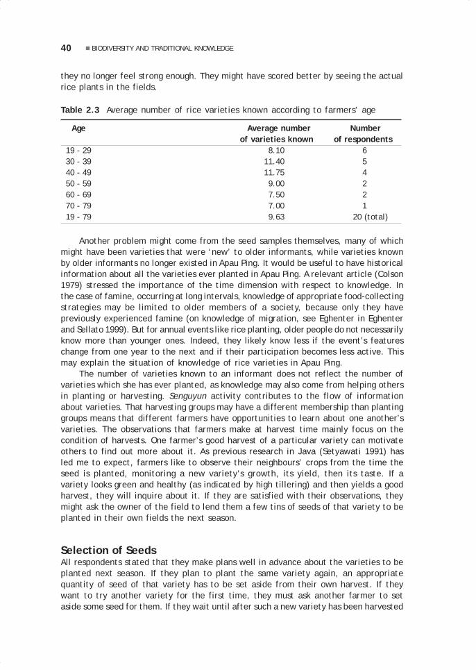
40 BIODIVERSITY AND TRADITIONAL KNOWLEDGE
they no longer feel strong enough. They might have scored better by seeing the actualrice plants in the fields.
Table 2.3 Average number of rice varieties known according to farmers’ age
Age Average number Numberof varieties known of respondents
19 - 29 8.10 6 30 - 39 11.40 5 40 - 49 11.75 4 50 - 59 9.00 2 60 - 69 7.50 2 70 - 79 7.00 1 19 - 79 9.63 20 (total)
Another problem might come from the seed samples themselves, many of whichmight have been varieties that were ‘new’ to older informants, while varieties knownby older informants no longer existed in Apau Ping. It would be useful to have historicalinformation about all the varieties ever planted in Apau Ping. A relevant article (Colson1979) stressed the importance of the time dimension with respect to knowledge. Inthe case of famine, occurring at long intervals, knowledge of appropriate food-collectingstrategies may be limited to older members of a society, because only they havepreviously experienced famine (on knowledge of migration, see Eghenter in Eghenterand Sellato 1999). But for annual events like rice planting, older people do not necessarilyknow more than younger ones. Indeed, they likely know less if the event’s featureschange from one year to the next and if their participation becomes less active. Thismay explain the situation of knowledge of rice varieties in Apau Ping.
The number of varieties known to an informant does not reflect the number ofvarieties which she has ever planted, as knowledge may also come from helping othersin planting or harvesting. Senguyun activity contributes to the flow of informationabout varieties. That harvesting groups may have a different membership than plantinggroups means that different farmers have opportunities to learn about one another’svarieties. The observations that farmers make at harvest time mainly focus on thecondition of harvests. One farmer’s good harvest of a particular variety can motivateothers to find out more about it. As previous research in Java (Setyawati 1991) hasled me to expect, farmers like to observe their neighbours’ crops from the time theseed is planted, monitoring a new variety’s growth, its yield, then its taste. If avariety looks green and healthy (as indicated by high tillering) and then yields a goodharvest, they will inquire about it. If they are satisfied with their observations, theymight ask the owner of the field to lend them a few tins of seeds of that variety to beplanted in their own fields the next season.
Selection of SeedsAll respondents stated that they make plans well in advance about the varieties to beplanted next season. If they plan to plant the same variety again, an appropriatequantity of seed of that variety has to be set aside from their own harvest. If theywant to try another variety for the first time, they must ask another farmer to setaside some seed for them. If they wait until after such a new variety has been harvested

41Indah Setyawati
(for example, to evaluate its yield) to express their interest, they may fail to secureseed from its owner. These seeds are always carefully selected. Ideally, they should befully ripe (as shown by the plant’s yellow, dry panicles and leaves) and come fromhealthy plants standing upright, with long panicles and fully ripe spikelets attached tothem, and no signs of disease or insect attack on either the plants or grains.
Most farmers stated that they take seed grains from plants in the centre oftheir fields, a practice reported by Richards (1992b) in Sierra Leone, where farmersexplain it as a way of getting pure seed since seeds from plants at the margins ofplots might have been crosspollinated by other varieties nearby. In Apau Ping, however,the only reason proffered is that the field centre is usually less disturbed by monkeysand other pests from the forest although, farmers also stated, it might suffer frominsect or bird attacks or from strong winds. In cases of such damage, seeds are selectedfrom any plants that look good by the criteria above, regardless of their location.
To identify varieties from seeds, farmers combine several criteria. They observethe size of the grain and its shape (categorised as ‘thin’, ‘full’, ‘straight’, or ‘slightlycurved’); the colour of the husk (bright yellow, dusty yellow, blackish or reddish) andof the glumes (red, white, black, patchy red or patchy black); the colour of the grain’send which, in some varieties, is different (like black or white); and certain signs, likethe awns in the spikelets or the shape of the sheath on the spikelet. In fact, they tendto name varieties after some special feature of the grains. Finally, they taste the rawgrain to check whether it comes from a variety of glutinous rice—said to smell goodand taste slightly sticky—or non-glutinous rice. I also observed farmers distinguishingbetween varieties by comparing the appearance of the grain.
Almost all respondents were women who knew more about rice varieties thananybody else in their household and were responsible, year after year, for decidingwhich varieties would be planted. If no elderly woman (the household head’s wife ormother) is present, the oldest daughter or even a granddaughter will bear thisresponsibility. The men’s opinion about the taste of cooked rice, however, may in-fluence the women’s decision. One informant stated that, because her husband caredabout taste, the two of them looked for new varieties whenever she or he had anopportunity to visit other villages.
Selection of Swidden LocationOf thirteen women interviewed on their role in the selection of sites for swiddens, six saidthat they usually take the initiative in proposing a field location to their husbands (or, inthe case of a widow, to her son); two informants said that they consider and decide onlocations together with their husbands; two more said that they only choose the site of thesmall garden (keli’it) close to the village where they plant such crops as onions and chillipeppers and a small quantity of certain rice varieties, while their husbands select the sitesof the main swidden fields; and three said that they always let their husbands decide thelocation of rice fields. When they propose sites, women usually just refer to some recognisedlocale—‘the Mela’ing River,’ ‘the Sekakan River’—rather than to a more particular site inthe locale. Men go in groups to inspect locales, which may include those suggested by theirwives. Usually only a few locations are selected each year. Then, individual men, heedingor not their wives’ suggestions, choose one among the selected locations and join otherfarmers who want to farm in that location.
The ten women who either proposed locations to, or discussed them with, theirhusbands gave various reasons for doing so. Some said that they wanted to have their

42 BIODIVERSITY AND TRADITIONAL KNOWLEDGE
field near those of certain good friends or relatives. Others, that they had certainconcerns at the time. For example, one suggested the Sekakan River area becauseshe wanted their swidden near their wet rice field and that area was the only placewhere she thought she could plant wet rice; having both fields near each other wouldmake it easier for her to care for the crops during the whole rice cycle. Another saidthat she wanted her swidden close to the village because she and her husband werethen busy building a new house.
Farmers follow certain rules in planting different rice varieties. They plant themaccording to the time that each needs to mature—most need about six months, butsome might need only about four to five months. The slower varieties (usually thenon-glutinous ones) are planted first, in the centre of the field, and the faster-growing(glutinous) ones later, at the edges. One farmer believes that the glutinous varietiesshould never be planted in the middle of the field because their fast growth would so‘embarrass’ plants of non-glutinous varieties as to make them yield poorly. But, asmost farmers explained, it is easier to harvest the faster varieties from the edges ofa plot.
REASONS FOR PLANTING DIFFERENT VARIETIESLike in other parts of the world, traditional farmers in Apau Ping, for various reasons,plant a number of rice varieties. In two planting seasons (1992–93 and 1993–94), thenumber of varieties planted (or to be planted) ranged from 2 to 11. For the 42 householdsthat farmed in 1992–93, the average number of varieties planted was 4.72—a figuresimilar to those other researchers found in Africa. For the 1993–94 planting season,the average number that farmers planned to plant was 4.09, a lower figure due tosome farmers not yet having made up their minds and others still trying to borrowseeds.
Rice Varieties and Soil ConditionsSome researchers (e.g., Richards 1992a, Damus 1995) stated that farmers plantdifferent varieties in order to match different soil conditions encountered from yearto year as the locations of the fields are shifted. This reason, however, was notmentioned by my informants, who stated that they wanted variety in taste—to keepthem from getting bored with their food—and needed different kinds of rice forceremonial and household consumption. Rice from glutinous varieties is also neededfor special occasions, like for lunches offered by farmers to their senguyun teams,and for making rice beer and various food preparations, important in any ritualcelebration. Rice from the glutinous padai pulut among variety is the only rice that awoman having just given birth may eat (gifts of this rice are made by family andneighbours), and it is also recommended to breast-feeding mothers. Moreover, rice isoften cooked with taro in Apau Ping households and only certain varieties taste goodwith taro, so farmers try to grow at least some of those varieties.
The notion of matching rice varieties with particular soil conditions was dismissedby my informants. They pointed out that they must collect and set aside their seed atharvest time, long before they even know where they will farm in the next season, andmonths before they can check the soil of their plots. They also believe that all uplandvarieties grow well enough in any plot as long as it has black soil (tana’ saleng)—which, according to Syahirsyah (in Eghenter and Sellato 1999), contains enough humus

43Indah Setyawati
(see also Fujisaka 1986, 1987). The responses to questionnaires relative to the 1992–93 and 1993–94 seasons show that farmers in most cases plant different varieties inthe same soil type or plant the same variety in different soil types. However, they doknow that certain varieties should be planted only in wetland and others only in upland,and that some varieties can be planted in either wetland or upland but that most ofthem grow better in wetland (where they are usually planted).
When land at a given farming location is divided up, individual farmers mightnot be able to make their fields entirely in the best soils that the location offers. Inthis case, they plant their favourite varieties—usually non-glutinous varieties yieldingwell and, in effect, their staple food—in the best soil available, while other varietiesare planted in whatever other soils are available. On the relation of farmers’ knowledgeof crop varieties to their knowledge of soil conditions, the following points should benoted. First, some statements by earlier researchers are ambiguous: do farmersreally try to match a particular variety to a soil type, or do they simply recognisedifferent varieties for wetland and upland (e.g., Damus 1995)? Reports from elsewhere(e.g., Johnson 1974, Fujisaka 1986, Voss 1992) mention that farmers match soiltypes to their cultivars, by actually planting different crops (or crop mixtures) indifferent kinds of soils, rather than matching different varieties of a single crop toparticular soil types. More focused and detailed research to clarify these matters isneeded.
Secondly, if farmers do plant different varieties in different soil types, do they doit with the intention of acting on their knowledge of how different varieties are suitedto different soils (or vice versa)? Actually there are two questions: Do the farmershave the knowledge? And are they acting on the basis of it? They might well plantdifferent varieties in different soils regardless of whether their knowledge is sufficient.Uncertainty about environmental conditions in their fields from year to year mightencourage them to try several varieties and change the combination of varieties withonly the hope (rather than experience-based knowledge) that some will yield well andbe well suited to soil conditions in that particular year and in those particular sites.Among the Kantu’ of West Kalimantan, unpredictability of the specific soil conditionsis why some villagers use augurs to select swidden sites (Dove 1993). Apau Ping farmershave given up augury, but may have other ways of dealing with this uncertainty, includingplanting several varieties without specific and detailed knowledge of the conditionsfor which they are best suited. We may also ask just how the farmers act and withwhat intentions. Do they look for the soils to match preselected varieties, or forvarieties to match preselected soil types? In reality, they do not completely preselecteither. A clarification of their aims regarding preselection and of the constraints onactually achieving these aims is needed, as well as on how hard they try. Besides, atparticular times or in particular contexts, soil types may be less important than otherfactors, e.g., land slope or water resources.
Thirdly, if it could be shown that Apau Ping farmers know about planting certainvarieties in particular soil types but are kept by the unavailability of certain seeds orsoils from applying their knowledge, we might still say (see Johnson 1974 about Braziliansharecroppers) that they have ‘rules’ about what to plant where. But having rules inagriculture is not enough and farmers, for various reasons, do not always follow them,as Johnson found. The types of data gathered in Apau Ping in 1993 do not allow foranswering these questions, and long-term research and direct observation in the fieldsare needed (see Bloch 1991 and Vayda 1992 on the need for participant observation).The complex knowledge connections that people make in their minds in response to

44 BIODIVERSITY AND TRADITIONAL KNOWLEDGE
external stimuli just cannot be described adequately in words such as are used ininterviews. We need, as much as possible, to see our subjects in action, repeatedly, insimilar but not identical contexts, to begin to understand the knowledge that they aredrawing on and combining as bases for context-dependent action.
Experience and ExperimentationSustained observation and participation can also keep researchers from misinterpretingwhat they see and are told. Experts sometimes start by observing what farmers do intheir fields with their crops, then try to build models to explain what farmers do—andwhy—as if they were following predetermined designs (see Richards 1989). What anexpert sees during any given period of observation, however, is a complex ‘perfor-mance’ by the farmers, based on years of experience, varying from year to year andfrom place to place, and depending on a particular sequence of conditions. No simple,complete, and neat design can be inferred from farmers’ actions during a limited periodand then used to predict or explain their actions at future times or in other places.
My data on two planting seasons hints at the farmers’ strong tendency to changevarieties from year to year. Several reasons were stated. Some farmers did not likesomething about a variety they planted earlier and wanted to replace it with a new one.Others were curious about new varieties that neighbours were talking about, and wantedto try them: e.g., a variety brought back from Malaysia, padai Mayun, that smells andtastes very good; a variety with long panicles (allegedly indicating high productivity),which does not quickly become ‘overripe’4; a variety called padai Mahak, the grains ofwhich are easy to separate from the panicles by the usual method of trampling. Onefarmer accidentally found a new variety and was curious to know its taste.
Farmers’ interest in and curiosity about new rice varieties are displayed in theirplanting experiments. New varieties are usually planted by the edges of the fields ornear the huts, and in the best soil in the swidden sites—a procedure common among ricefarmers in other places (see Lambert 1985, Richards 1986, Fujisaka et al. 1992). Oneinformant experimented for two successive years with a variety—found in a piece ofsackcloth obtained from a Punan family in Long Bena—that she called padai kapit becausethe sepals in its spikelets grow very long, like two wings (kapit). Curious about theirunusual appearance, she multiplied the three grains she had found by planting them inflat land (considered among the best for rice) and in the best soil available in hersuccessive swiddens and, after three seasons, was still saving all the seeds (about fourand a half cups) for planting, putting off cooking them to discover the taste. She saidthat she would plant this variety repeatedly until some day she could taste it and seewhether she likes it.
MAINTENANCE AND ABANDONMENT OF VARIETIESAs noted above, one reason why farmers change rice varieties and try new ones—which usually means abandoning some varieties—is dissatisfaction with somecharacteristic of varieties from their last harvest.
4 According to one farmer, in order to ensure the good preservation of stored grain, the rice plantsshould not be left in the fields for too long after they are ready to harvest lest, she says, their seedbecome ‘overripe’, empty, and decayed.

45Indah Setyawati
Taste, Droughts, and Good MatchesTaste characteristics are important. Some farmers no longer want to plant padai pulutamong because, they say, it tastes ‘bitter’. Others do not want to plant padai kalunbecause the leftover cooked rice hardens so quickly as to become inedible. One saidthat she does not like to plant wetland rice, simply because she and her family like thetaste of upland rice better. A few stated that they would not plant padai Mahak becauseits small grain is hard to separate from the husk—a factor probably accounting for thedisappearance of the padai Tamen Ba’un, recorded by Damus in 1991 but not found in1993, when it was still remembered by some farmers but no longer owned or planted.Farmers also abandon varieties if they have had unpleasant experiences due to theirphysical characteristics. The padai pulut among and padai pulut pute’, among others,have spikelets with long awns that chafe the farmer’s skin when harvesting and hurther soles when trampling it. One farmer said that she no longer wants to plant padaiimban because its short panicles do not produce enough grains and she had difficultycutting them.
Farmers are also concerned with the ability of a variety to cope with a droughtoccurring in the middle of the growing period. A variety known from experience to easilywilt in drought is hardly considered for planting again. A variety maturing so quickly thatthe grains easily become overripe or too old in the fields before farmers can finishbringing in the harvest will also be readily abandoned. Farmers also have no predilectionfor fast-ripening varieties, because of the extra time required to harvest varietiesripening at different times, and because different maturation times in the same fieldare believed to damage the whole harvest since the ripe grains attract pests that alsodamage the other varieties while they are still growing or later when they ripen.
Almost all informants have abandoned certain varieties due to harvest failure.Many would not plant any variety that has resulted in a bad harvest. Harvest failure isviewed as the sign of a ‘wrong match’ between a variety and a farmer, who wouldnever get a good harvest from that variety and should look for another that ‘matches’her better. Some farmers needed only a single harvest failure to decide that a varietywas a wrong match, while a few waited for two seasons before making a decision.Farmers strongly believe that a variety consistently giving them good harvests mustbe well matched with their personalities and that they should hold on to it. A few saidthat they keep experimenting with new varieties to find some that suit theirpersonalities and therefore consistently produce good harvests.
Introduction and ExtinctionThese beliefs might relate to the relatively high flow of new varieties that farmersbrought in from outside the village. In 1991 Damus recorded 31 varieties and in 1993I found 38, hinting at a substantial increase. Three of those found in 1991 (padaimelien, padai Tamen Ba’un, and padai Ubung Kirip) could no longer be found in 1993.Two more (padai bura bala and padai ibet), not recorded in 1991, were mentioned in1993 by a few informants. So the actual number of varieties introduced in two years isat least 10. From 11 respondents (out of 42) who introduced seeds, I recorded asmany as 20 introduced varieties that they were planting. Although not all are newvarieties for Apau Ping farmers and no data is available on just when each of themwas actually brought to Apau Ping, this clearly is a high number for a village with only42 farming households and, from the number of varieties introduced in two years, wecan get a rough idea of the extent of varietal change, with extant varieties being

46 BIODIVERSITY AND TRADITIONAL KNOWLEDGE
continually challenged by new varieties brought from outside in the hope that theyhave superior characteristics. Then, any variety with characteristics regarded as lessattractive than those of a new variety can easily be swept aside.
The 1993 data allows for the identification of only five of the varieties that havedisappeared, and annual local extinction rates cannot be calculated with confidence.Some ‘old’ varieties clearly do win out over new ones because of superior characteristics,since farmers stated that their favourite two varieties, padai pute’ and padai nyelungmembat, well suited to local conditions, have already been planted for a long time—although whether they are ‘indigenous’ cannot yet be established. Most farmers plantat least one of them as their staple, because they produce more than other varieties,can be planted in virtually any kind of soil, and are drought-resistant. They are said toproduce best when planted in the sloping sites common in swidden locations.
These two varieties, despite their superior characteristics, do not satisfy thetaste requirements of some farmers who, to improve the taste of the cooked rice,mix their grains with those of other varieties known for their good ‘aroma’, such asthe padai sabun (reminiscent of the smell of soap). To get both a good harvest andgood-tasting rice, these farmers mix seeds of padai pute’ and padai sabun together intheir swiddens, and some who said that they plant padai pute’ were actually plantingthis mixture. However, this may not be intentional, since they might have obtainedseed from other farmers who had mixed the varieties in their fields and could nolonger keep them separate. The practice of mixing seeds of two different varieties iscommon among Apau Ping farmers, although most do this when seeds of a particularvariety are in too short a supply for family consumption. I was unable to find varietiesother than padai pute’ and padai sabun that were mixed before planting.
Environmental Constraints and Seed CustodyOther factors contributing to the disappearance of some varieties relate to newenvironmental constraints. Some farmers said that they stopped planting two varietiesof wetland rice simply because there were no longer enough wetland areas. One saidthat the only conveniently located flat land, which used to be a wetland rice area, hasbeen turned into an airstrip. Other circumstances leading to the local extinction of avariety include harvest failure (especially when only one or two farmers have plantedit), a long drought, or so much rain that rice cannot be planted on time, any of whichmay force farmers to eat their seed stocks—all the seeds of the now-extinct padai ibetare said to have been consumed during a long drought.
Most farmers’ granaries have a separate container for each variety of rice intendedfor planting. Granaries are designed to protect the seeds from mice, but cannot protectthem from humidity, which would lessen their quality if kept for more than one year.Therefore, farmers must replant all their seeds each year to get new ones for thefollowing year. If farmers stopped planting a particular variety or if its harvest fails,its disappearance is the likely course. But some farmers do make an effort to plantcertain varieties each year just to keep them from becoming extinct. Others simplykeep distributing seeds of that variety to different farmers interested in plantingthem, in order to reduce the risk of local extinction because of harvest failure in justone or two swiddens.
Yet other farmers look for ‘custodians’ for seeds of particular varieties. Onefarmer, planning to stay away from the village for a year and wanting to maintain oneparticular wetland variety that she had obtained from her parents and that nobody
47Indah Setyawati
else in Apau Ping had, asked another farmer to plant it for her, just enough to renewthe seeds for the next season, so that she would have ‘live seeds’ when she returns.She said that, on several occasions, she had to ask other farmers to plant it for herbecause she had no suitable swampy land available. Another year, a farmer who hadaccess to a swampy area borrowed seeds of that variety from her, but she would makesure to get her seeds back. So, a rare variety might be planted by different farmers insuccessive years.
As can be seen from the descriptions above, many factors affect the occurrenceand loss of rice varieties. Apau Ping farmers themselves, with their ideas and inten-tions, are the main agents in selecting and maintaining a rice variety. Althoughenvironmental conditions certainly influence their decisions about planting that varietyor not, I regard attention to farmers’ individual experiences with different varietiesas the key to understanding the fate of those varieties in Apau Ping.
CONCLUDING REMARKSI have described various ways and reasons for Apau Ping farmers to acquire and spreadknowledge and seeds of rice varieties. In order to secure food supply in an uncertainfarming environment—unpredictable weather, variable soil fertility and other soilproperties—farmers need sufficient agricultural knowledge, not only of land or soilconditions, but also of varieties that can be planted under such conditions. That plantingseveral varieties contributes to curbing the risk of total harvest failure accounts forthe high number of varieties present. However, in selecting varieties, most farmersponder subjective factors, like personal taste, along with more objective ones, likeeasy milling.
Farmers construct their individual knowledge by way of experimentation,exchange of information, and careful observation of one another’s crops, carriedout on almost all occasions, most of which are culturally or socially provided forthem to gain and transmit this knowledge of varieties. As this knowledge is subjectto change, not all farmers within a village have the same knowledge and informa-tion, and their individual curiosity and capability, related to age and farmingexperience, in updating their knowledge becomes important.
Some researchers have suggested making farmers agents in local germplasmconservation (Vaughan and Chang 1992). In fact, that farmers have such great interestin looking at, experimenting with, and adopting new rice varieties might work againstconserving ‘local, rare, and indigenous’ varieties. Although many factors, includingnatural selection, are involved, the farmers’ possible bias in favour of new varietiesshould be taken into account in planning programs for germplasm conservation and,while they certainly should participate in such programs, there should also be amonitoring of local varieties by rice experts or breeders.
There is no doubt that farming experience and experimentation are sources forthe farmers’ knowledge of existing varieties and provide bases for our explanationsof what they do in their fields. However, most of what they do is not just part of afixed plan or design, but rather action is continually adjusted to particular, changingenvironmental conditions and may be performed in such an ad hoc, chance, oropportunistic fashion that we can find no simple general explanations of observedpractices.
The data presented here comes mostly from interviews and it is clear thatfurther studies to procure observational data are needed for discerning what farmers

48 BIODIVERSITY AND TRADITIONAL KNOWLEDGE
really do in their fields as compared to what they say in interviews. To get a clearunderstanding of their knowledge of rice varieties as well as other agricultural matters,direct observation during an entire annual farming cycle is critical (see Vayda 1993).The participant observation method provides researchers with opportunities to seemore in context how farmers put their knowledge into practice. A perception of thecontext of each activity is critical to understanding how and in what kinds of situa-tions farmers adjust their practices to cope with the various problems that theyface. Direct observation will also allow for a better comprehension of how farmersinteract with the environment and apply their knowledge to interpret what they seein their fields.

3.Making a swidden:Social and technological aspectsof Leppo’ Ké agriculturalpractices
Herculanus Bahari Sindju
INTRODUCTIONThis contribution focuses on the practices of land preparation and utilisation for swiddenfarming by the Kenyah of the Apau Ping area. It is especially aimed at understanding: 1)their methods of selecting farming land; 2) their ways of preparing the land beforesowing; 3) the land acreage needed by each farming family; 4) rice productivity inrelation to a family’s yearly needs, and the use of the land both during and after thefarming year; 5) the special forms of work organisation and the techniques for efficientuse of human resources; 6) particular cultural traditions in the preparation of the swiddens.The research, carried out from 6 July to 18 October 1993, used a participatory approachwith regard to agricultural and social activities. Participant observation techniques wereused, as well as interviews with 47 of the village’s 48 heads (kepala keluarga) of farmingfamilies, and also with several informants specifically connected with the topic of theresearch. This research can be described as population research, using a total sample.
Apau Ping is the last settlement on the upper Bahau River, famous for its rapids.It is located at an altitude of 600–700 m asl. The region consists of hills wedging insmall valleys and forming small rivers, so that there are no extensive flatlands, evenalong the main Bahau River. Apau Ping is close to the border with Sarawak (only athree-day walk away). The settlement of Apau Ping consists of four villages (desa):Apau Ping proper, Long Pengayan, Long Lat (all three of the Kenyah Leppo’ Ké), andLong Tua (a very small Saben group).
03 May28.p65 6/11/03, 11:57 AM49
Black

50 SOCIAL AND TECHNOLOGICAL ASPECTS OF LEPPO’ KÉ AGRICULTURAL PRACTICES
Every village is headed by its own village chief (kepala desa), assisted by his staff.The two ethnic groups, however, have been living peacefully side by side for a long time,as is obvious from the ongoing process of socialisation. Geographically and socially, theytruly have become one community, not only in the settlement itself, but also in the farmingareas. According to information obtained from the village chiefs, the government supportedthe relocation of the four formerly widely scattered villages to the site of Apau Ping toincrease the efficiency of social development (on the history of the Kenyah Leppo’ Ké, seeNjau, this volume; and Njau 1995). A group led by Njuk Anye’, Bilung Usat, Lerang Bilung,and Njau Bilung moved from Ka Buang (Leppo’ Ké) to Apau Ping in about 1962 and formedthe village (desa) of Apau Ping. The group of Liling Liran, Bilung Lerang, and Njuk Usatfrom the village of Long Pengayan (Leppo’ Ké) joined in 1982. The group of Laden, LawingUsan, and Darius Irang from the village of Long Tua (Saben group) also joined Apau Ping in1982. Finally, the group of Bilung Lerang and Lawai Bilong from Long Lian (a breakawayfrom the village of Long Lat, Leppo’ Ké) joined Apau Ping in 1983.
In 1993, this area had a population of 289 people, with 102 of them residing in desaApau Ping, 144 in Long Pengayan, 25 in Long Lat, and 18 in Long Tua. Ethnically, 247belonged to the Kenyah Leppo’ Ké and 15 were Saben. During the 1993–94 farming year,the farming population of Apau Ping consisted of 48 heads of families, of which 44 wereactive farmers, with a labour force of 150. Among the remainder were two inactivefamily heads (elderly people with no offspring), one family head engaged in trade, andone who was on a long journey (peselai) elsewhere. The workforce was composed of allage groups, including children of elementary school (SD) age who took part in clearingand sowing and could also assist with weeding after coming home from school. Thechildren had a rather high economic value in the family, but this was detrimental to theirstudies, for example during the sowing season when their labour, especially that of thegirls, was fully used, so that school could not operate for a period of two weeks.
LAND CLASSIFICATION ACCORDING TO LOCAL KNOWLEDGEThe people of Apau Ping have studied and analysed the conditions of their lands forgenerations, and thus have acquired a valuable body of knowledge to be passed on tothe next generation. Land is classified according to stages of plant growth, soilcharacteristics, and topography, similar in that to the land classification of the DayakKanayatn of West Kalimantan (see Bahari 1993: 14).
According to Plant SuccessionThe bekan jami are former swiddens that have been left fallow for approximately oneyear since the last harvest (ma’jau) and still display dried paddy stalks (jami). Thistype of land is dominated by low-growing plants or grasses (aka ceng and udu’ kapen),which will only later be mixed with small pioneer plants such as udu’ belenda (elephantgrass), mbong, balang iap, jelupang, and japa (for Latin names, see Syahirsyah 1995and Eghenter and Sellato 1999). In the bekan ca’lem, abandoned for two to six yearsafter the harvest, woody plants are found. The pioneering plants have alreadydisappeared as the fields were increasingly colonised by taller plants. In the bekanbu’et (or jekau bu’et; bu’et, short), the lower plants have increasingly disappeared(except for several hygrophilic plants, such as udu’ salasui), as the woody plants havegrown, and the vegetation is now dominated by shrub and plants of about 4 m highand with a trunk diameter of 10–15 cm.
03 May28.p65 6/11/03, 11:57 AM50
Black

51Herculanus Bahari Sindju
The jekau mbau (mbau, high) is dominated by tall trees with a trunk diameter of16–25 cm. Shrub is almost entirely absent, except in clearings of the canopy where thelower levels of vegetation are relatively exposed. The land is already covered with arather thick layer of deposits formed at least by the plants of the first two stages,i.e., pioneer and shrub plants, and even by plants of the third stage. The jekau mukun(mukun = old) is already a secondary forest, with tree trunks over 25 cm in diameterand over twenty years of age. In many respects, the land has now become jungle,differing from it only in tree size and age. The mba’ is land that has never beenfarmed, the primary forest that has remained untouched by human hands.
According to Soil CharacteristicsThe people of Apau Ping classify their lands according to the colour of the soils and thestructure of their sand contents into several types with different levels of fertility(Damus 1995). Based on soil colour, four types are known: tana’ bala, red and ratherfertile; tana’ da’ payau, reddish-brown like deer blood; tana’ bila’, yellow; and tana’saleng, black. Oko’ Uray Njuk Jalung Ungau (60 years old) recognises four subtypes oftana’ saleng: the common tana’ saleng, found in the jekau bu’et; tana’ saleng sepit,a sticky black soil found in the jekau mbau; tana’ ait saleng, containing fine sand andfound in the jekau mukun; and tana’ membo, found in mba’ land. The black colour isspecific to humus-rich soils, and thus tana’ saleng is known to be fertile, but its levelof fertility varies according to the land’s succession stage. In fields around the vil-lage, which have been repeatedly farmed as keli’it (small swiddens), the soil is generallyyellow, red, or blood red and is of the red and yellow podzolic type which is not veryfertile (Ardans 1993: 4). According to informants, a soil originally classified as tana’saleng changes colour over years of use and becomes red and yellow.
The people are also familiar with soil classification according to the type of sand:tana’ ait memut contains fine sand; tana’ ait metan contains packed sand; and tana’ait mebo has scattered sand and is known to be rather fertile (regarding levels ofacidity and the soil’s organic content, see Syahirsyah 1995). In addition, there is atype of soil, tana’ ngelaa, which has a high sand content and cannot clump. Othertypes of soil based on texture are also known: tana’ sepit contains a high level of clayand can be clumped without breaking; and tana’ la’e is a yellow soil mixed with com-pact soil.
According to TopographyThe people of Apau Ping distinguish land according to altitude and slope, for bothlands that can and cannot be used for farming: tana’ leka are flatlands on a riverbank, rarely found; tana’ bawang are flatlands with a high level of moisture, at thefoot of hills or the mouths of small rivers, similar to marshes with mud deposition andpermanent water seepage, and fertile for farming; tana’ miang, the prevalent typefound in the Apau Ping area, are hill slopes with an incline of 10° to 40°. Two subtypesof tana’ miang, based on land morphology, are known: tana’ tenjalun straddles bothflanks of a valley between two hills; and tana’ kelepek covers both sides of the samehill. There are also pejalai, with a slope of less than 10°; tana’ bilah, with a slope inexcess of 40°, often found on passes between hills and not good for farming; tana’apau, flatlands on top or on the sides of hills, which can still be farmed; and tana’tuan, lands formed by old landslides.
03 May28.p65 6/11/03, 11:57 AM51
Black

52 SOCIAL AND TECHNOLOGICAL ASPECTS OF LEPPO’ KÉ AGRICULTURAL PRACTICES
Evaluating the fertility according to the topography is closely tied to the succes-sion stage of the vegetation and the colour of the soil. Since the presence of wateralso plays a role, however, the morphological types considered the most suitable forswiddens are tana’ bawang, tana’ tenjalun, and tana’ kelepek, as compared to tana’apau and tana’ bilah.
According to Other CharacteristicsOther classifications of lands are based on features such as the plant species present,animal activity, or the level of moisture. For example, tana’ nyala is a red and yellowsoil covered by a layer of fern roots about 10 cm thick; tana’ mettan is exhausted soil,with a very reduced level of fertility due to repeated use; tana’ ngelu’bo is a crumbly soilcontaining the remains of decomposed plants or animals, with granules and a raisedsurface with cavities; tana’ u’dip refers to soil heaped up as a result of animal activity,such as mounds made by termites or white ants; tana’ lanut is a muddy soil but withoutthe presence of surface water; tana’ mbeng denotes land that is wet as a result ofhuman intervention, whether intentional, such as in wet rice fields, or unintentional,such as land at the edge of an artificial pool or fountain; tana’ betak-betak is soil witha cracked surface due to drought. This soil classification is based on physicalcharacteristics, organic content, and level of fertility (see Syahirsyah 1995).
SELECTION OF LANDIn order to meet their various needs, the people farm two types of swidden fields, amain field (uma) and a smaller field (keli’it). The same practice is also common inApo Kayan (Jessup 1992: 4). In Apau Ping, the uma is of large dimensions and isestablished on fertile secondary forest land. It is planted with rice together withvegetables and corn. The keli’it, on the other hand, is a secondary field, located closeto the village. It is established on land of younger growth or bekan jami and plantedwith sticky rice, secondary crops, corn, and cassava. The decision to make a keli’it isusually linked to the family’s schedule of festivities which require sticky rice in ratherlarge amounts. The following data refers to the primary fields (uma).
Through the experience of centuries, the people of Apau Ping have developed asystem of swidden farming that fits their needs, the demands of their life, and the localenvironment. Modern needs for education, health, and social and religious life todaylimit the distance the fields may be from the village. In 1993, the most distant fieldswere no more than a 90-minute walk from Apau Ping. It is no longer necessary for thefarmer to spend the night at the fields, except at times when the work is very intensive,as during weeding (but the children can still go to school). This type of adaptationresembles the farming practice known as lumma’ umma (shifting cultivation) amongthe Dayak Kayan of Kapuas Hulu, in West Kalimantan (Mering 1988: 17).
To guarantee the success of their farming activities, the Kenyah Leppo’ Ké ofApau Ping prepare their farming land very carefully. The selection of the land takesinto account the type of land and the rotation of the field being considered for use.
Selection ProcedureBecause farming activities involve cooperative work groups, the selection of landcannot be done individually. It considers not only soil fertility but also the effortsneeded for pest prevention, and thus habits developed which by now have become
03 May28.p65 6/11/03, 11:57 AM52
Black

53Herculanus Bahari Sindju
standard procedure. This procedure starts from the initiative of one person, and isbased on his experience or knowledge of an area visited while hunting. Bathing in theriver, doing voluntary work, or walking to church constitute opportunities for him toinformally convey his suggestion to a neighbour, a relative, or a close friend. In thisway a group is formed that will then go and study the feasibility of the location. If it isconsidered suitable, the location and boundaries of the fields for the various membersof the group are established. This stage is very important if this land is forested withlarge trees, as is the case with primary forest (mba’) or the old secondary forest leftby the Kenyah Leppo’ Ma’ut, who long ago occupied the Apau Ping area.
Basis for SelectionTo evaluate the level of fertility of the land, the farmers check the abundance ofplants with straight stems or trunks. The straighter the vegetation, the greater thefertility of the soil, because weeds are rather sparse, so people tend to select landwith big trees (mba’, jekau mukun, or jekau mbau). Next, a check is made of certaintypes of plants used as indicators of fertility. This is considered very important at thisstage for land covered with small secondary forest (bekan jami, bekan ca’lem, orjekau bu’et). If there are any indications of low fertility, the process may be stopped,as occurred with the family of Jalong Nyuk (70 years old). In addition, black soil is firstchoice, followed by tana’ bala and tana’ ait mebo. Fields with many stones at thesurface are not selected. In the middle of abandoned fields (bekan), one can see smallareas of primary forest (mba’) left over because the presence of many large stones oran accumulation of small stones on the surface made farming impossible. Lands locatedon hills or mountain slopes can still be farmed, whereas lands at higher elevations arebeyond the physical reach of the farmers. As for slope, farmers tend to select landswith a slope of less than 40°.
The distance of the farm site to the village is also a determining factor. If it is nottoo far away, it can be reached without requiring an overnight stay. In the 1993–94farming year, the most distant field was about 90 minutes on foot from the village. Inthe 1994–95 farming year, the lands in the upper reaches of the same river may not befarmed again, because the distance as well as the altitude render this area beyondfarming feasibility. This is, for instance, the case with the field of Apui Njuk’s family.Selecting a new field close to the field of the preceding year (bekan jami) is verypractical, making the preparation of the new field easier. The hut built the precedingyear can still be used, and the foodstuff available in the bekan jami (e.g., vegetables,fruits such as papaya and bananas, hot peppers, cassava leaves, taro, and sugarcane)can easily be resorted to while working in the new field.
The number of farmers joining in one farming site is also carefully considered,because it has a bearing on the problem of pest control—especially deer (Cervusunicolor), barking deer (Muntiacus muntjak), and wild oxen (Bos sundaicus). In thecase of large farming groups, prevention is easier and can reduce the risk of loss. Inthe 1993–94 farming year, the farmers of Apau Ping were distributed among five farmingsites, with a membership ranging from three to thirteen family heads. There werealso six family heads whose fields were separate, although not too far from one of theexisting farming sites.
03 May28.p65 6/11/03, 11:57 AM53
Black
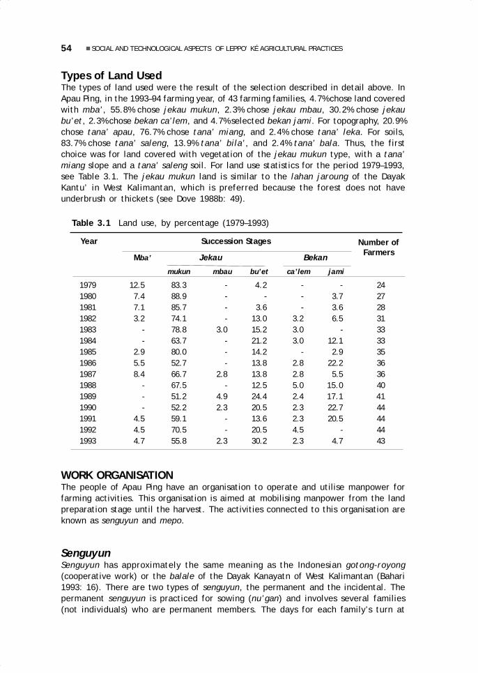
54 SOCIAL AND TECHNOLOGICAL ASPECTS OF LEPPO’ KÉ AGRICULTURAL PRACTICES
Types of Land UsedThe types of land used were the result of the selection described in detail above. InApau Ping, in the 1993–94 farming year, of 43 farming families, 4.7% chose land coveredwith mba’, 55.8% chose jekau mukun, 2.3% chose jekau mbau, 30.2% chose jekaubu’et, 2.3% chose bekan ca’lem, and 4.7% selected bekan jami. For topography, 20.9%chose tana’ apau, 76.7% chose tana’ miang, and 2.4% chose tana’ leka. For soils,83.7% chose tana’ saleng, 13.9% tana’ bila’, and 2.4% tana’ bala. Thus, the firstchoice was for land covered with vegetation of the jekau mukun type, with a tana’miang slope and a tana’ saleng soil. For land use statistics for the period 1979–1993,see Table 3.1. The jekau mukun land is similar to the lahan jaroung of the DayakKantu’ in West Kalimantan, which is preferred because the forest does not haveunderbrush or thickets (see Dove 1988b: 49).
Number ofFarmers
Year Succession Stages
Mba’ Jekau Bekan
mukun mbau bu’et ca’lem jami
1979 12.5 83.3 - 4.2 - - 241980 7.4 88.9 - - - 3.7 271981 7.1 85.7 - 3.6 - 3.6 281982 3.2 74.1 - 13.0 3.2 6.5 311983 - 78.8 3.0 15.2 3.0 - 331984 - 63.7 - 21.2 3.0 12.1 331985 2.9 80.0 - 14.2 - 2.9 351986 5.5 52.7 - 13.8 2.8 22.2 361987 8.4 66.7 2.8 13.8 2.8 5.5 361988 - 67.5 - 12.5 5.0 15.0 401989 - 51.2 4.9 24.4 2.4 17.1 411990 - 52.2 2.3 20.5 2.3 22.7 441991 4.5 59.1 - 13.6 2.3 20.5 441992 4.5 70.5 - 20.5 4.5 - 441993 4.7 55.8 2.3 30.2 2.3 4.7 43
Table 3.1 Land use, by percentage (1979–1993)
WORK ORGANISATIONThe people of Apau Ping have an organisation to operate and utilise manpower forfarming activities. This organisation is aimed at mobilising manpower from the landpreparation stage until the harvest. The activities connected to this organisation areknown as senguyun and mepo.
SenguyunSenguyun has approximately the same meaning as the Indonesian gotong-royong(cooperative work) or the balale of the Dayak Kanayatn of West Kalimantan (Bahari1993: 16). There are two types of senguyun, the permanent and the incidental. Thepermanent senguyun is practiced for sowing (nu’gan) and involves several families(not individuals) who are permanent members. The days for each family’s turn at
03 May28.p65 6/11/03, 11:57 AM54
Black

55Herculanus Bahari Sindju
sowing are set by tradition. For the paren (nobility) families, it is always Monday,Wednesday, and Friday, while for the panyen (ordinary people) it is Tuesday, Thursday,and Saturday. The senguyun activities are regulated through an official meeting led bythe paren bio’ (or kepala adat besar, the high customary chief), which discusses anddetermines first, the appropriate starting time for sowing; second, which families areready to plant in the first and second weeks; and third, which families are members ofwhich senguyun group according to long-standing custom.
Incidental senguyun is used for certain farming stages other than sowing. Themembership of these groups is determined informally, as when meeting in the street,visiting, bathing in the river, or doing voluntary work. The groups are set up to dealwith certain seasonal tasks requiring important manpower, such as clearingundergrowth, felling trees, harvesting, and building boats. Membership is individual—for example, one family member, regardless of age or sex—and is not binding. Forexample, someone can participate in a group for only one work rotation, and can thenstop and join another senguyun group with other members who may be more appropriatefor the type of work that has to be done. In this way, an incidental senguyun group cansimply disband, but on the other hand it can also aggregate more members.
The members of the senguyun groups traditionally adhered to a certain workpattern. This is evident in the food that is provided when one type of work is beingdone. In principle, every senguyun member who goes to work brings along his or herown lunch (rice and side dish). Yet the ‘host’ family must prepare food (rice, vegetables,and meat or fish) for the senguyun members working for them. For this, the host hasmade arrangements for the preparation of the food. There is also a sexual division oflabour: at clearing or felling time, the men are responsible for sharpening the tools(machetes or adzes) used by the female members of the senguyun group; or, at sowingtime, the men dibble holes in the soil for the women to drop the seeds.
MepoAnother type of work organisation, mepo, is, like the senguyun, also an effort tomobilise manpower, but it tends to be more of a purely social work group and emergesspontaneously to assist a person or family thought to be in need of help in completinghis or her farm work. The mepo members do not expect compensation in any form;moreover, they bring their own equipment and food provisions without expecting theseto be provided by the ‘host’. The membership of the mepo group is not based onfamily ties. Of 18 people who participated in a mepo group on 12 and 16 July 1993,only three happened to be related to the family assisted. The involvement of villagersin mepo is truly based on humanitarian considerations and solidarity with those thoughtto be unable to carry out their own tasks (especially farm work).
There are two forms of mepo: mepo leto balu, intended to help a widow (seeMeyer in Eghenter and Sellato 1999); and mepo kelunan sakit, intended to help anindividual or a family that is ill. In the 1993–94 farming year, mepo was organisedthree times. The first was a mepo kelunan sakit in the fields of Oko’ Irang’s family inearly June of 1994. According to him, his fields were entirely worked by his fellowvillagers without his having to pay anything. The second was a mepo leto balu in thefields of the widow Buring Lawing on July 12, 1993, to complete the cutting of theremaining tree branches (miting) prior to burning. The third was a mepo kelunansakit in Oko’ Liling Liran’s field, to assist with the clearing and felling that remainedunfinished after he had fallen ill.
03 May28.p65 6/11/03, 11:57 AM55
Black

56 SOCIAL AND TECHNOLOGICAL ASPECTS OF LEPPO’ KÉ AGRICULTURAL PRACTICES
Other Forms of CooperationA mobilisation of labour similar to mepo also occurs under pressing conditions and ifmany people are needed, as for harvesting, or carrying rice or construction materials.A family in need of help asks for it through the person in charge of managing cooperativeactivities, formerly the church board, but now occasionally also the board of the youthorganisation (Karang Taruna), and they contribute a fee of Rp. 5000 to 10 000. Tomobilise the villagers, the manager then goes round the village entreating participa-tion (pekasat) or he makes an announcement in church. This differs from mepo inthat this assistance must be compensated, and in that it is performed at the initiativeof the family requesting it. In mepo, the assistance is the result of the initiative ofthe villagers who have noticed the circumstances of a needy family.
Furthermore, every farming family head (kepala keluarga) in Apau Ping is obligedto work for the paren bio’ (today the village head, kepala desa). Formerly this obliga-tion was binding, and the villagers had to cultivate as large a field as the paren bio’wanted. Nevertheless, for some years the obligation of the villagers has now beenlimited to working for one day only for their kepala desa.
PREPARATION OF THE FIELDAfter a plot of land has been chosen, it has to be cleared, trees have to be felled andtheir branches cut off, and then the field has to be burned. In scheduling these activitiesin the farming cycle, people observe the position of the sun and the phases of themoon.
Using the Natural CyclesThere are two techniques using the natural cycles known to the people of Apau Ping,one being the observation of a shadow cast by the sun, and the other, that of themoon’s shape. The former makes use of a wooden staff pitched in the groundpermanently at a specially chosen place. The length of the staff’s shadow is measuredand its shifts observed. This technique can also use the pillar of a rice barn, as wasdone by the family of Oko’ Bilung Lerang (75 years old). In the course of many years ofobservation and record, certain shadow lengths have been linked to certain featuresor events relevant to the harvest secured. The experience thus obtained allows, throughthe measurement of that shadow, for the determination of auspicious days for startingfarming work. In the second technique, the shape of the moon is observed at night,and farming activities are only carried out when the shape of the moon is appropriate.For example, the right time for sowing has come when the moon takes the shape ofthe belekueng (the beak of the hornbill bird) or the lu’ung payang (the payang fruit),but the best time is when the moon is shaped like a chicken egg (tilu’ manuk; seeDamus 1995).
Traditionally, the observation of the shadow made by the sun and the shape of themoon is used in determining the most favourable days for beginning any farmingactivity, for not any day can be used. Today, for many farming activities, people nolonger follow these traditional requirements. For example, because it has now becomecustomary to celebrate the anniversary of the proclamation of Indonesian independenceon August 17 in the capital of the district, the sowing in the fields must be finished bythat date, as was the case in 1993.
03 May28.p65 6/11/03, 11:57 AM56
Black

57Herculanus Bahari Sindju
Clearing (Melidik)This activity (melidik) involves clearing away the underbrush of the areas to be turnedinto farmland with a machete (baing). The time for beginning this activity depends onthe type of forest growing on the land selected. For fields with tall vegetation, such asjekau mukun and mba’, clearing is usually carried out in early May so that the grassand the small wood cleared can dry for long enough to make burning easy. For fieldsestablished in young secondary forest (jekau bu’et and bekan ca’lem), it is carriedout in the first part of June, and for bekan jami, only in the middle of July, as was thecase with the church fields of the GKII congregation and the fields of the PKK (women’sorganisation) in 1993.
Felling Trees (Nepeng) and Cutting Branches (Miting)The next step is the cutting down of trees (nepeng) using a variety of equipment. Forsmall trees, it is enough to use a machete (baing), while for larger trees, the axe(asay), adze (asay peta’), and occasionally—if available—chain saws are used. In the1993–94 farming year, however, there were no farmers left who used an adze forfelling trees. Some traditional tools are made by local blacksmiths. At present, thereare still four smiths producing large machetes: Liling Liran (63 years old), Bilung Liran(50), Aran Lenggang (48), and Ging Bareng (43). The making of one machete requiresone to two days. Axes and chain saws are obtained from coastal traders and fromSarawak. The people of Apau Ping started to use chain saws in 1970, the produce oftheir salaried work in Malaysia. Today almost all families have a chain saw and about10 family heads have more than one. The felling of trees is combined with the cuttingof the large branches once they have been felled. This is done to accelerate the dryingprocess so that the burning of the fields will be more thorough.
Burning (Nutung and Mekuk)The field is now left for a certain period of time so that the fallen trees will dry out. Inmba’ and jekau mukun, 1.5 to 2 months are needed; in bekan ca’lem and jekaubu’et, 1 to 1.5 months; and in bekan jami, 1 to 2 weeks only. The drying out is veryimportant and its duration is carefully monitored, because if it is not dry enough, theburning (nutung) will not be thorough. However, the weather also has an influence onthis process. Certain methods are used to ensure that burning is successful. First, thewind direction is observed. If the wind blows to the north, the burning must start fromthe south and the wind will fan the fire, which will burn the branches and twigs andproceed northward rapidly. If there is no wind, the best place for starting the burningis in the lower part of a sloping field, or by lighting fires all around the field (this isused for leka and apau fields). The instrument used for burning, sulo’ bulo’, is madeof a length of bamboo of which the upper joint, filled with kerosene, is equipped witha wick, so that it can burn for a long time, usually long enough complete the burning ofthe field. If the burning is incomplete, the unburned plant or tree remnants are gatheredin several piles and are burned once again. This second burning is called mekuk.
Making a Field Hut (Lepau)To support the logistics of the farming activities, a lepau (hut or shed) is needed toprovide shade and a place to cook, eat, and rest, and to spend the night if necessary
03 May28.p65 6/11/03, 11:57 AM57
Black

58 SOCIAL AND TECHNOLOGICAL ASPECTS OF LEPPO’ KÉ AGRICULTURAL PRACTICES
(e.g., while weeding or guarding the fields against pests). Construction of the lepauis usually started before sowing and continued after sowing. The lepau around ApauPing has a more or less standard pattern, with two floors. The lower floor is used forresting in the shade, cooking, and eating, while the upper floor is used as a sleepingarea for the family. During the harvest, the lepau is used also as a temporary ricestorage barn, after the rice has been dried and before it is carried to the village forstorage in the permanent barn.
Sowing (Nu’gan)The equipment needed for sowing consists of a tu’gan (dibbling stick), which is apiece of wood with a piece of iron at its end, and a pasan or karien, or seed container,a type of basket with a neck that is tied to the waist. The people of Apau Ping use twotypes of sun hats, the common sa’ung, made of pandanus leaf and used by the panyen,and the sa’ung seling, made of plaited bamboo with very artistic designs and used bythe paren.
Burak, a type of rice beer, and a’dut, a food made from sticky rice, are traditionallyprovided at sowing time. The people of Apau Ping and other villages in the upper Bahauare familiar with two types of burak. One, burak ubi, made from fermented cassava, isusually present at feasts or parties (naming ceremonies, weddings, welcome parties forguests, and even Christmas and New Year); the other, burak ketan, made from fermentedsticky rice (padi pulut), is prepared for consumption during the sowing in the fields.After the cassava or sticky rice has fermented (tapai), it is mixed with boiled water thathas been left to cool, and then offered immediately without being pressed.
For consumption at sowing time, every family prepares burak. Burak ubi is preparedseveral weeks before sowing, while burak ketan is made about three nights beforesowing. When the day comes, the old people collect the bamboo pipes used for drinkingburak and the leaves to wrap food. Meanwhile, the children (especially the girls) dothe cooking; then the food is carried to the fields for those working there. In addition,a family which is about to sow prepares traditional foods such as chicken porridge anda’dut. A’dut is made from sticky rice (a kind of filled rice roll), wrapped in leaves, andthen boiled. When resting during the sowing, burak ketan is offered as a thirst-quencherand, in the evening, the family whose field has been sown offers burak ubi to thosewho participated in the sowing. This is not just a statement of thanks by the host, italso provides an occasion for friendly socialising between villagers and between membersof the same work group (senguyun).
LAND USE AND PRODUCTIVITYThe people of Apau Ping do not in fact evaluate their work productivity quantitativelyas is customary in the world of agribusiness, but they only classify the output of theirlabour into ‘a lot’ or ‘little’, into ‘insufficient’, ‘enough’, or ‘more than needed’,based on their families’ needs. In order to produce food in sufficient quantity andquality, land is used as efficiently as possible, for example through the practice of dualcropping before or when sowing rice, and the planting of vegetables and fruits afterthe rice harvest.
The rice productivity is closely tied to the fertility of the land, which in turn isclosely related to the stage of forest succession. The soil in former fields must begiven the time to recover its fertility. Through experience, the people have discovered
03 May28.p65 6/11/03, 11:57 AM58
Black

59Herculanus Bahari Sindju
and maintained a system of rotation for working their swiddens with a certainperiodicity, which is considered the most appropriate farming method for local condi-tions and the most profitable economically. According to Mubyarto, this method ofearning a living is suitable for the local ecology and thus does not harm the existingagro-ecosystem (Mubyarto 1992: 15).
Rotation of FieldsObservation of the history of family farming among the people of Apau Ping has notyet provided a clear pattern of rotation. As noted above, the first group of Leppo’ Késettled in Apau Ping in 1962; other groups did not join until 1982–83; and by 1993–94,the Leppo’ Ké had not yet completed the re-opening of the old fields left by the Leppo’Ma’ut, who had long occupied the area previously. Nevertheless, between 1979 and1993, the percentage of farmers farming jekau bu’et fields (which have been leftfallow for about 7 years) rose rather remarkably from 4.2% to 30.2% (see Table 3.1),while the re-opening of jekau mukun (more than 20 years fallow) has declined (from83.3% to 55.8%). It is worth noting that, in the last few years, only an average of 4.5%of the farming families have opened primary forest.
Land Use during the Farming YearSwidden fields are the primary source for meeting the nutritional needs of vegetableorigin for the people of Apau Ping. In fact, their fields are not only planted with rice, butalso with other crops such as corn, sorghum, millet, beans, amaranth, mustard greens,cucumber, squash, and watermelon, which are normally sown before the rice. When theburning of the rice fields is completed, the women sow corn over almost the entire field,rather far apart so that it does not interfere with the growth of the rice. The parts of thefields in which the burning was very successful are sown with various vegetables andwatermelon, whose shoots will already be visible when the rice is sown. The rice is sownall at once. By working in senguyun groups, it is possible to sow any one field in one day,so that the time elapsed between the first sown and last sown of the villagers’ fields isnot too long. In the 1993–94 farming year, the sowing went on for about two weeks(from 23 August to 4 September 1993), interrupted by Sunday breaks.
The varieties of rice planted vary considerably according to need and the type ofland (see Damus 1995). According to information from village notables and traders, theApau Ping area is in fact self-sufficient in rice, and has even managed to producesurpluses, as for example in the 1960s, when the area was able to supply rice for militaryoperations during the Confrontation with Malaysia. In the 1992–93 farming year, 36 of43 farm families interviewed stated that they produced enough rice for their needs,four that they produced more than needed, and three that their rice production wasinsufficient (see Table 3.2). Failures are in large part the result of prolonged dry spells,and in part attributable to pests, especially wild oxen, monkeys, wild pigs, and sparrows.Wild oxen and deer are the most feared pests, to the point that there is a taboo onbringing deer or wild ox meat to the fields during the sowing season.
Land Use after the HarvestAlmost all farmers continue to use their fields after the rice harvest by planting varioustypes of crops, such as fruits (papaya, banana, watermelon), tubers (cassava, sweetpotato, and taro), vegetables (onion, hot peppers, tomato, eggplant), and sugarcane.
03 May28.p65 6/11/03, 11:57 AM59
Black

60 SOCIAL AND TECHNOLOGICAL ASPECTS OF LEPPO’ KÉ AGRICULTURAL PRACTICES
Table 3.2 Rice yields, by percentage (1979–1993)
Year Yield in relation to needs Number of
Too Low Enough Surplus
1978-79 5.0 90.0 5.0 201979-80 - 95.8 4.2 241980–81 - 96.3 3.7 271981–82 3.5 94.5 - 281982–83 3.2 93.6 3.2 311983–84 12.2 84.8 3.0 331984–85 12.2 84.8 3.0 331985–86 11.4 88.6 - 351986–87 5.5 91.7 2.8 361987–88 1.8 98.2 - 361988–89 5.0 90.0 5.0 401989–90 9.7 90.3 - 411990–91 18.2 79.5 2.3 441991–92 11.3 86.4 2.3 441992–93 6.8 84.1 9.1 44
Farmers
Among all these, cassava and taro are given precedence. Cassava is planted in greaterquantities than taro, because the type of land suitable for taro is generally limited.There is a close relationship between the two types of plants and cultural traditions.Besides the custom of offering burak at various types of festivities, there are localdishes known as ma’ upa’, consisting of pieces of taro mixed with rice, and luko upa’,which is ma’ upa’ cooked in bamboo tubes.
In the Apau Ping area, plantation crops such as rubber, commonly found amongthe Dayak of West Kalimantan, are absent. Every family, however, plants fruits suchas ta’ap (unidentified), isau (Euporia longana), and rambutan (Nephelium spp.),although not in significant quantities and not as trade commodities. Other perennialplantation crops, such as coffee and cinnamon, are better known, but only planted insmall gardens around the village by a few families. Actually, coffee was once plantedby all the people rather extensively, but failed because the plants were not properlycared for.
THE TRADITIONAL MELAKI CEREMONYVarious matters related to the cultural tradition of the people of Apau Ping have beenmentioned above. The Kenyah Leppo’ Ké also had a tradition inspired by ancestralbeliefs and known as melaki, which has faded away since the people converted toChristianity and today it is almost extinct, so that the young generation no longerknow the melaki ceremony at all. According to informants, it was last held by thefamily of Oko’ Bilung Lerang in 1983.
The name melaki is derived from pelaki, the Brahminy kite, and to the calling ofthe kite in a ceremony aimed at asking the Almighty (Jelong Peselong or Bilung Nyelong)for good fortune, life force, health, and a long life. The Leppo’ Ké believed that thekite had a bali, i.e., a spirit, which could give clues to the humans regarding theintentions of Jelong Peselong. According to elderly informants, the melaki ceremony
03 May28.p65 6/11/03, 11:57 AM60
Black

61Herculanus Bahari Sindju
was not only carried out within the framework of agricultural activities but also attimes of birth feasts, and at times of epidemics (see Table 3.3). The frequency andthe scheduling of this ceremony differed between the Leppo’ Ké from the village of KaBuang and those from the village of Long Lat, who now live together in Apau Ping.
Table 3.3 Farming rituals and the melaki ceremony
Name of Organisation of the RitualRitual Time Participants Leader PlaceMELAKI 1. Before All villagers Village Hill near(for farming) clearing1 elders village
2. Before sowing Paren family Family elders Idem3. While All villagers Village elders One of theweeding and paren bio’ swiddens4. If there Idem Idem Idemare pests
NGELEPON Before Idem Adat Hill nearharvest1 leader2 village
UMAN MA’ First morning Idem Family From houseMA’DING3 when new rice elders to house
is cookedMELAKI (for 12th day Paren Panyen Idembirth ritual) after birth families eldersMELAKI (for If there is All villagers Adat Idemepidemics) an epidemic leader2
Notes:1 Known among the Kenyah Leppo’ Ké from desa Ka’ Buang.2 The villagers send a delegate to the man chosen, to request his willingness to become the ritualleader for these ceremonies, and offer him a machete, a sword, and glass beads as a sign of theirtrust. After the harvest, each family head surrenders one can of paddy (15 kg) to this leader as anexpression of thanks.3 Same as above, except that the leader does not receive a gift of paddy as is the case with thengelepon ceremony.
The holding of the melaki ceremony required several types of paraphernalia: 1) afibre taken from the stem of a Zingiberaceae (nyanding), split in two; 2) a piece ofwood about 1.5 to 2 handspans long, stuck into the ground and split in the middle toaccommodate the nyanding; 3) unung, a branch or twig about 1 to 1.5 m long with twoleaves as large as a thumb, stuck into the ground; 4) a piece of bamboo about 1.5handspans long, for placing offerings during the ceremony; 5) machetes made ofbamboo, sharpened and stuck into the ground, four to the right to symbolise goodforces and two to the left to symbolise evil forces.
Facing uphill, the leader of the ceremony begins by calling the bali pelaki byuttering a prayer known as ngelepon bali. Offerings in the form of ma’ luko (ricecooked in bamboo), jakan (sugarcane juice), and sam can (pork fat still attached tothe skin) are placed on the bamboo stuck in the ground. In the meantime, the bambootubes which have been used to cook the rice (bulo’ luko) are split and stuck into theground to the right and left of the unung. The remaining ma’ luko is distributedamong the participants and the leader of the ceremony, so they all eat a little of it.
03 May28.p65 6/11/03, 11:57 AM61
Black

62 SOCIAL AND TECHNOLOGICAL ASPECTS OF LEPPO’ KÉ AGRICULTURAL PRACTICES
They then request what they desire, according to the purpose of this ceremony. Assoon as the ngelepon bali prayer is finished, the leader of the ceremony and the otherparticipants anxiously wait for the coming of the kite. They observe the direction ofits flight and its behaviour and discuss the meaning contained in these, because theyare believed to indicate the wishes of the Almighty, Jelong Peselong (or Bilong Nyelong).
The interpretation is as follows: If when it first appears, the kite flies from rightto left three times in a row or more (the more the better), this is a sign that theAlmighty, through the bali pelaki, has bestowed life force, health, and long life. If thebird arrives from the left to the right, this is a sign of the good intentions of JelongPeselong, who is willing to grant good fortune and meet the request of the supplicants.If these signs do not appear, it means the request has not been bestowed, and theceremony has to be repeated four days later. If the ceremony is successful, the rest ofthe rice is carried home and, upon arriving at the village, is distributed with calls of‘Ma’! Ma’!’, which means: ‘Rice, rice!’ Those who hear this come to take it and tastea little of it, so that they too will be given life by Jelong Peselong.
Then a chicken is sacrificed, its blood rubbed on the arms of all those present,and the meat cooked for chicken porridge and then consumed collectively. The ceremonycontinues with circling the longhouse in procession while splattering water left andright of the house and on the top of the stairs with a machete (baing). This is the signthat the participants may now go down to the river to bathe. In the case of a melakiceremony held to heal a sick person, the patient is sprinkled with jakan (sugarcanejuice) also by using a machete. After bathing, a village council or meeting may be heldif necessary.
In addition to melaki, there are two other farming ceremonies, ngelepon (priorto the harvest) and eating the new rice (uman ma’ ma’ding; when the harvest begins).The ngelepon ceremony simply consists of saying a prayer and requires no paraphernaliasuch as is used in the melaki ceremony. Eating the new rice is a joyful ceremony. Afamily cooking the new rice for the first time must carry three packages of rice completewith side dish to their relatives and neighbours, and the children of the familiesreceiving the rice must mark the face of the one who brought it with soot.
SUGGESTIONSIn the traditional farming of Apau Ping, land use patterns allow for a long period oftime between the first opening of a plot of land and the next phase of farming. Thisperiod can last up to 30 years, which is sufficient for the cultivation of one generationof plantation crops. Since Apau Ping has a lot of vacant land, it is very possible toestablish smallholding rubber plantations. This suggestion, in line with ideas of landmanagement for the twenty-first century—which anticipate agricultural systemsconceived by taking into account the advantages as well as the weaknesses of systemsused and applied to this day (Sutarman 1993: 22)—can be applied in stages by thefarming community. On the basis of the experience of the case of the Dayak of WestKalimantan, smallholding rubber estates and plantations of forest products seemappropriate for development in Apau Ping. Other industrial plantations cannot be carriedout on a large scale in the conservation area.
The switch from rice to rubber can bring several benefits. First, rubber becomesproductive after at most 8 years, and it can thus be economically profitable for 12 to22 years for its planter. Second, planting former rice swiddens with perennialcrops like rubber contributes to conserving the forest in the form of agroforestry
03 May28.p65 6/11/03, 11:57 AM62
Black

63Herculanus Bahari Sindju
(see Mubyarto 1992: 4). Third, the planting of rubber can also be beneficial—like inWest Kalimantan, where it has been known since 1905—by contributing to theemergence of a clarification of individual land rights (Sapardi 1992: 79). Fourth, bythe time the rubber plantation needs to be rejuvenated, the land can again be usedfor rice, so that its fertility can be maintained by combining the advantages andweaknesses of the agro-ecosystem with the regeneration of the natural ecosystem. Inthis way, the people can be permitted to continue their traditional practices in oraround the protected areas and they can be made partners in the activities of natureconservation in their region (Mackinnon and Mackinnon 1990: 114).
Besides rubber, forest products such as cinnamon and illipe (tengkawang,Dipterocarpaceae), as well as incense wood (gaharu), can also be planted as long-termperennial crops and grown on former swidden fields during the fallow period. To increasethe economic value of the villagers’ enterprises, special attention should be giventhem by the government in the form of development projects capable of breakingdown the isolation of the region, one of the primary causes of its poverty andbackwardness. In the case of Apau Ping, priority must be given to the development ofinfrastructures and to the creation of transportation and communications facilities.
Figure 3.1 Threshing the paddy by trampling (mi’ik)
03 May28.p65 6/11/03, 11:57 AM63
Black

64 SOCIAL AND TECHNOLOGICAL ASPECTS OF LEPPO’ KÉ AGRICULTURAL PRACTICES
Figure 3.3 Storing the paddy in the barn (lepubung)
Figure 3.2 Winnowing the paddy (maping)
03 May28.p65 6/11/03, 11:57 AM64
Black

4.Management, processing,and uses of rattan in Long Uli,Pujungan Subdistrict
Martua Thomas Sirait
INTRODUCTIONThe village of Long Uli is located on the banks of the Bahau River. Its inhabitants aremembers of the Kenyah Oma’ Long (or Uma Long), the Kenyah Leppo’ Ndang (or Leppo’Ntang) and there are a few families of Punan Benalui who use the forest resources in thearea to make a living. Rattan, collected for sale as well as for everyday use, is one of themost important forest resources. Both raw and woven rattan are very valuable, forexchange, sale, and use, which makes it one of the economic mainstays of the community.The marketing of unprocessed rattan and woven rattan involves various social groups(village elders, local and outside rattan collectors, intermediary traders and shops).
History of the Village of Long UliThe Oma’ Long people now living in Long Uli formerly lived on the plateau of ApauUrung, between the upper Lurah and Pujungan rivers. In 1932, under the leadership ofImung Alang (the father of the present village head of Long Uli), they moved togetherwith the Leppo’ Ndang to Long Lurah. In Long Lurah, Imung Alang met with TumaiBilung, leader of the Kenyah Badeng at Long Peliran (the grandfather of the villagehead of Long Peliran at the time this research was conducted). Tumai Bilung presenteda jar to Imung Alang with the words ‘Let our two groups live together, raise childrenand grandchildren and farm until only the red stones are left on this land.’ In return
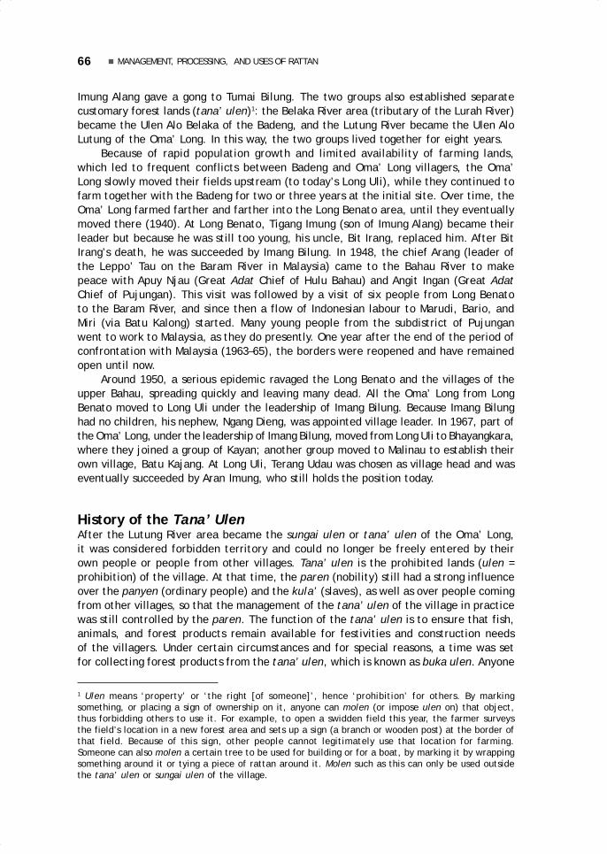
66 MANAGEMENT, PROCESSING, AND USES OF RATTAN
Imung Alang gave a gong to Tumai Bilung. The two groups also established separatecustomary forest lands (tana’ ulen)1: the Belaka River area (tributary of the Lurah River)became the Ulen Alo Belaka of the Badeng, and the Lutung River became the Ulen AloLutung of the Oma’ Long. In this way, the two groups lived together for eight years.
Because of rapid population growth and limited availability of farming lands,which led to frequent conflicts between Badeng and Oma’ Long villagers, the Oma’Long slowly moved their fields upstream (to today’s Long Uli), while they continued tofarm together with the Badeng for two or three years at the initial site. Over time, theOma’ Long farmed farther and farther into the Long Benato area, until they eventuallymoved there (1940). At Long Benato, Tigang Imung (son of Imung Alang) became theirleader but because he was still too young, his uncle, Bit Irang, replaced him. After BitIrang’s death, he was succeeded by Imang Bilung. In 1948, the chief Arang (leader ofthe Leppo’ Tau on the Baram River in Malaysia) came to the Bahau River to makepeace with Apuy Njau (Great Adat Chief of Hulu Bahau) and Angit Ingan (Great AdatChief of Pujungan). This visit was followed by a visit of six people from Long Benatoto the Baram River, and since then a flow of Indonesian labour to Marudi, Bario, andMiri (via Batu Kalong) started. Many young people from the subdistrict of Pujunganwent to work to Malaysia, as they do presently. One year after the end of the period ofconfrontation with Malaysia (1963–65), the borders were reopened and have remainedopen until now.
Around 1950, a serious epidemic ravaged the Long Benato and the villages of theupper Bahau, spreading quickly and leaving many dead. All the Oma’ Long from LongBenato moved to Long Uli under the leadership of Imang Bilung. Because Imang Bilunghad no children, his nephew, Ngang Dieng, was appointed village leader. In 1967, part ofthe Oma’ Long, under the leadership of Imang Bilung, moved from Long Uli to Bhayangkara,where they joined a group of Kayan; another group moved to Malinau to establish theirown village, Batu Kajang. At Long Uli, Terang Udau was chosen as village head and waseventually succeeded by Aran Imung, who still holds the position today.
History of the Tana’ UlenAfter the Lutung River area became the sungai ulen or tana’ ulen of the Oma’ Long,it was considered forbidden territory and could no longer be freely entered by theirown people or people from other villages. Tana’ ulen is the prohibited lands (ulen =prohibition) of the village. At that time, the paren (nobility) still had a strong influenceover the panyen (ordinary people) and the kula’ (slaves), as well as over people comingfrom other villages, so that the management of the tana’ ulen of the village in practicewas still controlled by the paren. The function of the tana’ ulen is to ensure that fish,animals, and forest products remain available for festivities and construction needsof the villagers. Under certain circumstances and for special reasons, a time was setfor collecting forest products from the tana’ ulen, which is known as buka ulen. Anyone
1 Ulen means ‘property’ or ‘the right [of someone]’, hence ‘prohibition’ for others. By markingsomething, or placing a sign of ownership on it, anyone can molen (or impose ulen on) that object,thus forbidding others to use it. For example, to open a swidden field this year, the farmer surveysthe field’s location in a new forest area and sets up a sign (a branch or wooden post) at the border ofthat field. Because of this sign, other people cannot legitimately use that location for farming.Someone can also molen a certain tree to be used for building or for a boat, by marking it by wrappingsomething around it or tying a piece of rattan around it. Molen such as this can only be used outsidethe tana’ ulen or sungai ulen of the village.
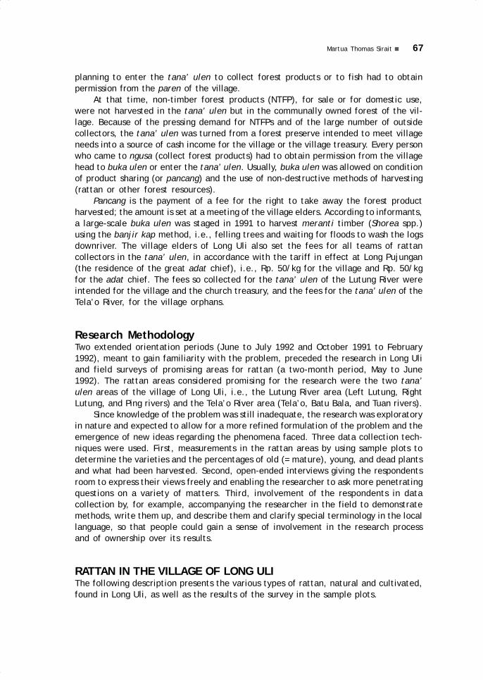
67Martua Thomas Sirait
planning to enter the tana’ ulen to collect forest products or to fish had to obtainpermission from the paren of the village.
At that time, non-timber forest products (NTFP), for sale or for domestic use,were not harvested in the tana’ ulen but in the communally owned forest of the vil-lage. Because of the pressing demand for NTFPs and of the large number of outsidecollectors, the tana’ ulen was turned from a forest preserve intended to meet villageneeds into a source of cash income for the village or the village treasury. Every personwho came to ngusa (collect forest products) had to obtain permission from the villagehead to buka ulen or enter the tana’ ulen. Usually, buka ulen was allowed on conditionof product sharing (or pancang) and the use of non-destructive methods of harvesting(rattan or other forest resources).
Pancang is the payment of a fee for the right to take away the forest productharvested; the amount is set at a meeting of the village elders. According to informants,a large-scale buka ulen was staged in 1991 to harvest meranti timber (Shorea spp.)using the banjir kap method, i.e., felling trees and waiting for floods to wash the logsdownriver. The village elders of Long Uli also set the fees for all teams of rattancollectors in the tana’ ulen, in accordance with the tariff in effect at Long Pujungan(the residence of the great adat chief), i.e., Rp. 50/kg for the village and Rp. 50/kgfor the adat chief. The fees so collected for the tana’ ulen of the Lutung River wereintended for the village and the church treasury, and the fees for the tana’ ulen of theTela’o River, for the village orphans.
Research MethodologyTwo extended orientation periods (June to July 1992 and October 1991 to February1992), meant to gain familiarity with the problem, preceded the research in Long Uliand field surveys of promising areas for rattan (a two-month period, May to June1992). The rattan areas considered promising for the research were the two tana’ulen areas of the village of Long Uli, i.e., the Lutung River area (Left Lutung, RightLutung, and Ping rivers) and the Tela’o River area (Tela’o, Batu Bala, and Tuan rivers).
Since knowledge of the problem was still inadequate, the research was exploratoryin nature and expected to allow for a more refined formulation of the problem and theemergence of new ideas regarding the phenomena faced. Three data collection tech-niques were used. First, measurements in the rattan areas by using sample plots todetermine the varieties and the percentages of old (= mature), young, and dead plantsand what had been harvested. Second, open-ended interviews giving the respondentsroom to express their views freely and enabling the researcher to ask more penetratingquestions on a variety of matters. Third, involvement of the respondents in datacollection by, for example, accompanying the researcher in the field to demonstratemethods, write them up, and describe them and clarify special terminology in the locallanguage, so that people could gain a sense of involvement in the research processand of ownership over its results.
RATTAN IN THE VILLAGE OF LONG ULIThe following description presents the various types of rattan, natural and cultivated,found in Long Uli, as well as the results of the survey in the sample plots.

68 MANAGEMENT, PROCESSING, AND USES OF RATTAN
Figure 4.1 The rattan plant and its parts.A: ocrea (pa uvey); B: ‘knee’ (lep); C:flagellum (kesavi); D: fruit (beva); E:flower (pie); F: shoot (belukuk); G: roots(aga); H: stem thorns (soek); I: stem(eneng); J: leaf (daen); K: nervure (daeng);L: internode (va); M: node (boge).
Diversity of Rattan TypesThe area of the village of Long Uli,especially its two tana’ ulen mentionedabove, is an area of great potential forrattan. In a 0.4 ha plot, seventy clumpswere found (n = 70), representingapproximately ten types (taxa) of localrattan (including uvey seka, uvey semole,uvey ayeng, uvey beloko, uvey tebongen,uvey bala mata, uvey bulu isau, and uveyseringan) belonging to five genera:Calamus, Daemonorops, Korthalsia,Plectocomiopsis, and Ceratolobus. Allrattans belong to the Palmae family(subfamily Lepidocaryoideae).
The people of Long Uli distinguishtypes of rattan in different ways (seeFigure 4.1). Types that have many usesare better known than those that areseldom used, and the characteristics ofeach type, described by analogy withother, local features, contribute to thevernacular names of particular types ofrattan.
Uvey seka (Calamus caesius*)2 isrecognised by the underside of its leaves,which is white, and by the silica layer onits stems (putik). It is sold unprocessedand used for many types of weavings.
Uvey katap (Calamus pogonacanthus?) is named for the fact that it grows togetherwith uvey seka and for the shape of its leaves and the size of its stems that resemble(katap) uvey seka. The back of its leaves is not white and its stems are not coveredwith a silica layer. It is only used for tying.
Uvey semole (Calamus pseudoulur*, Daemonorops didymophylla) has bigger stems, lon-ger leaves and smaller buds than uvey seka. It is used for coarse weavings.
Uvey timay (Calamus javensis, Calamus spp.) derives its name (timay, small) fromthe size of its stems. Several types of rattan are referred to as uvey timay; amongthem, uvey abun (abun, clouds) grows only in the highlands, which from below often lookas if they are wrapped in clouds. The people of Long Uli equate uvey abun with uveytimay. It is used for weaving without being first split or trimmed.
Uvey bulu isau (Calamus muricatus*) is so named because the thorns of its branchesresemble the skin of the isau fruit (Dimocarpus longan). It is only used for tying.
Uvey tebongan (Calamus ornatus*) has only one, large stem. It is used for makingbrooms and other utensils because it is too stiff for weaving.
2 The sign * indicates types of rattan that have already been matched with samples in the HerbariumBogoriense.

69Martua Thomas Sirait
Uvey ilem (Calamus pilosellus*) is used to make the frame of sa’ung hats and of kibacarrying baskets. It is often used together with uvey timay and is even stronger thanthe latter.
Uvey sanam (Ceratolobus concolor*, Korthalsia ferox*, K. hispida, and K. rostrata)often has ants’ nests (sanam) at its ocrea, and all types that have ants’ nests arereferred to as uvey sanam. It is only used for tying.
Uvey bala mata (Daemonorops histrix var. exulaus*) is characterised by its red (bala)-coloured thorns (mata). It is only used for tying.
Uvey pait (Plectocomiopsis geminiflora*) is distinguished by its bitter (pait) fruits,which despite their taste, can be used as vegetables. It has only one stem, light greenin colour, and small thorns. This type of rattan is used to make frames for kiba, taven,and koo vadei (see below).
Uvey beloko has shafts nearly the size of the those of uvey semole but stronger. It isused for tying boats and for sturdy weaving.
Uvey baya (Calamus blumea/tomentosu?) has bark showing the colour and the pat-terns of crocodile (baya) skin. It is used for tying.
Uvey kelasi (Daemonorops atra*) grows short and always has fruit. Its stems have longyellow thorns the colour of the skin of the kelasi monkey (red leaf monkey, Presbytisrubicunda). This type of rattan is not used.
Uvey seringan (Daemonorops sabut*) has thorns perpendicular to the stem and is usedto make frames for taven, kiba, and others.
Uvey lanya (Daemonorops fissa) is also used for making frames for taven, kiba, andothers.
Natural RattanPlot I (in Lalut Isau) and Plot II (on the Batu Bala River), located west of the village ofLong Uli, covered 0.4 ha (400 m x 10 m) each, and their vegetation represented thenatural rattan of the sungai ulen of Long Uli (Tela’o, Batu Bala, and Tuan rivers). Thesungai ulen has the following boundaries: along the Bahau River, it borders on jekau(secondary growth on former rice fields); upstream, it is bordered by the Tela’o River,from Lepau Batu (the Batu River) to Apau (the highlands); downstream, by the TuanRiver, from Lalut Dian to the highlands. The vegetation near the sungai ulen of theTela’o, Batu Bala, and Tuan rivers begins with young jekau for about 400 m from thebanks of the Bahau; deeper into the sungai ulen, there is primary forest (mba’); then,on the modong ang (ridge between two valleys) on the upper Batu Bala and upper LalutIsau rivers, there is ten namam (open fern forest), followed by ten sang (palm forest),and ten uvey (rattan forest). Plot III, measuring 63 x 63 m (0.4 ha), is located in thesungai ulen of the Lutung River, at Lalut Pekelem in the Left Lutung River, not far fromits confluence with the Lutung River, and it is estimated that the rattan forest there hasalready been exploited too far. The plot contains pulung mba’, a mix of forest and fruitgardens. It is unclear whether the rattan was planted or grew naturally and was latercultivated (Table 4.1 and Figure 4.2).
The natural rattan vegetation in all three plots has been analysed using localterminology for young rattan stems (mengeg) and old (mature) rattan stems (mugeng),and also considering rattan stems already harvested (as indicated by the stumps

70 MANAGEMENT, PROCESSING, AND USES OF RATTAN
Plo
t I (
Tela
o-Ba
tuba
la)
Plo
t II
(Tel
ao-B
atub
ala)
Pl
ot II
I (B.
Lut
ung)
TYPE
S 1
2 3
4 5
Fre
% F
re 1
2 3
4 5
Fre
% F
re 1
2 3
4 5
Fre
% F
re
Seka
113
91
22
17
1 1
522
.73
161
104
57
43
0 1
014
.28
14
7 7
7 1
4 4
.16
Sem
ole
45
17
28
8 4
913
.64
39
7 3
2 0
0 4
5.7
1
-
-
-
-
- 0
0
Belo
ko 6
4 2
0 0
2 3
.03
-
-
-
-
-
0 0
-
-
-
-
-
0 0
Kata
p 4
5 2
0 2
5 5
1 1
116
.67
120
70
50
17
0 2
434
.29
37
11
26
2 3
5 5
.21
Bala
mat
a 2
0 8
12
0 0
14
21.2
1 1
3 6
7 0
0 9
12.8
6 2
0 1
7 3
0 0
10
10.4
2
Tebo
ngen
9 7
2 0
0 6
9.0
9 4
2 2
0 0
4 5
.71
21
15
6 0
0 1
212
.50
Bulu
isa
u 9
4 5
0 0
5 7
.58
14
8 6
0 0
5 7
.14
141
51
90
2 3
5 2
526
.04
Kela
si 1
1 0
0 0
1 1
.52
-
-
-
-
-
0 0
2 1
1 0
0 1
1.0
4
Pait
3 2
1 0
0 1
1.5
2 6
0 6
0 0
1 1
.43
12
4 8
0 5
3 3
.12
Seri
ngan
6 4
2 0
0 2
3.0
3 3
7 1
7 1
5 0
0 1
014
.28
17
11
6 3
1 3
3.1
2
Ilem
-
-
-
-
-
0 0
13
9 4
0 0
2 2
.86
101
44
57
0 1
5 1
3 3
.12
Baya
’
-
-
-
-
- 0
0 1
0 1
0 0
1 1
.43
-
-
-
-
-
0 0
Aye
ng
-
-
-
-
- 0
0
-
-
-
-
- 0
0 4
6 1
7 2
9 0
21
20
20.8
3
TOTA
L25
715
8 9
9 3
0 6
66
100
403
223
180
52
0 7
010
041
117
823
3 1
4 8
1 9
610
0
Perc
enta
ge 5
4 3
3 1
0 2
100
49
39
11
010
0 3
5 4
6 3
16
100
Not
e: 1
= s
tem
s; 2
= y
oung
; 3
= ol
d; 4
= h
arve
sted
; 5
= de
ad;
Fre
= Fr
eque
ncy
Tabl
e 4.
1 A
naly
sis
of t
hree
plo
ts (
I-II-
III,
0.4
ha)
of w
ild r
atta
n

71Martua Thomas Sirait
remaining after cutting) and those that have simply died off. This analysis revealedthe existence of ten different types of rattan in Plots I, II, and III, consisting of 13local varieties belonging to five genera (Calamus, Ceratolobus, Korthalsia,Plectocomiopsis, and Daemonorops).
In Plots I and II, sufficient amount of mature rattan was available for harvesting(about 35%). The rattan types were generally commercial varieties and had many uses(uvey seka, uvey semole). In Plot I and II, about 11% of the rattan had already beenharvested, without visible effect of the harvest on either the young stems or the deadones. In Plot III, many mature stems were found (46%), but they included types that arenot particularly used. There was also a substantial percentage of dead or harvested stems(18%), the result of excessive and improper harvesting which cut the stems too close tothe ground so that the rattan began to rot, which spread to the roots. According to infor-mation obtained, several years ago Plot III was known as a promising plot for uvey seka.
Cultivated RattanSeveral families have begun to plant rattan, specifically uvey seka (Calamus caesius)in their fields and gardens to guarantee sustainable production. In light of the people’sefforts to improve their economic situation and raise their welfare level, an effort toprotect sustainable production is needed. This effort relates to patterns of landownership—this concerns farm lands (bekan and jekau), gardens, pulung (graveyards),and tana’ ulen. There should be further efforts, which already have been undertakenor can be undertaken by both the local people and government to improve the localeconomy in the forest-product sector, and especially with regard to rattan. One sungaiulen (Tela’o River) is located in the Kayan Mentarang nature reserve; the second one(Lutung River) is included in a forest concession belonging to the Sarana Tri Karyatimber company (Roda Mas Group) (Table 4.2 and Figure 4.3).
Figure 4.2 Proportion of young, old, dead, and harvested stems in Plots I-II-III
old
46.0% harvested
2.77%
dead
16% young
35.1%
old
33.0 %
harvested
10.2 %
dead
2.05 %
young
53.9 %
old
39.5 % harvested
11.4 %
dead
0 % young
49.0 %
I II III
Rattan Types Stems Young Old Harvested Dead Frequency % Freq.Seka 457 239 218 127 8 14 52
Semole 41 26 15 9 0 9 33
Tebongen 3 3 0 0 0 2 7
Balamata 4 2 2 0 0 2 7
TOTAL 505 270 235 136 8 27 100Percentage 42 36 21 1
Table 4.2 Analysis of a plot of planted rattan (Plot IV at Long Sebung, 0.25 ha)

72 MANAGEMENT, PROCESSING, AND USES OF RATTAN
Luat’s family. It covered 0.25 ha (250 m x 10 m) on the banks of the Bahau River atLong Sebung. This plantation was first planted with uvey seka and uvey semole by IdiAluy, Lidem Luat’s grandmother, in the 1960s. In 1986, it was planted again with thesame types of rattan by Luat Apuy, the father of Lidem Luat.
In Plot IV, the percentage of dead (8%) and live (77%) plants was fairly good,even though it has already been harvested (21%), and the percentage of maturestems ready for harvest (37%) was good. Field observation showed that the harvestedrattan had not been cut too close to the base, so that there was no rot. It could beconcluded that the rattan gardens were better managed than the natural rattangroves.
THE MANAGEMENT OF RATTAN BY LOCAL PEOPLEEvery social group has its own techniques for managing natural resources in order tosustain life and, further, to improve its quality. Nature provides a livelihood, andsocial groups regulate control over the lands they occupy, for their own people, aswell as for outsiders, who pay fees in cash or in kind (see Soerjono 1985). Thesecustomary or adat rights and the use and management of local resources must bestudied in greater depth in order to support the future development of the localpeople’s economy.
PermitsPermits are regulated in the village (desa) and the requirements depend on need,whether the collection is for commercial purposes or for domestic use. To enter thetana’ ulen area, a collector must obtain permission from the village head (kepaladesa) and follow the rules regarding rattan harvesting techniques. If the rattan collectedis intended for sale, the collector must pay a tax to the village treasury. If it is intendedfor domestic use, it is enough to obtain permission from the village head. To collectrattan from private gardens, either for sale or domestic use, it is also necessary toobtain permission from the owner and to set terms for compensation to the owner.The actual harvesting of the product is done only by the owner of the garden. Villagerscan collect rattan freely in the communally owned forest of their village withoutpermission from or notification to the village head, either for sale or domestic use.
Figure 4.3 Proportion of young, old,dead, and harvested stems in Plot IV
old
36.21 %harvested
20.96 %
dead
1.23 % young
41.6 %
Cultivated rattan is planted in thegardens, in former swiddens and in otherareas that are not going to be farmed. Thetypes of rattan planted are limited to thosevarieties that have many uses, such asuvey seka and uvey semole. These usuallygrow together with sang (a type of palm,Licuala sp., used for making sunhats),talang (a type of palm, Arengaundulatifolia, which has edible shoots andleaf stems that can be used for roofing),as well as other types of rattan that arecultivated in rattan gardens. Plot IV was arattan plantation belonging to Lidem

73Martua Thomas Sirait
Collectors other than villagers, either people from neighbouring villages or outsidersfrom downstream regions, must first report to the village head.
Rattan Work GroupsRattan collecting groups each consist of four to five of the village’s young men; thegroup is coordinated by a group leader, usually the oldest among them. If they intendto be absent for over one week, those who already have families will leave riceprovisions (or money) for as long as they will be gone. Each individual’s work equipmentconsists of a kiba (carrying basket), pet (sleeping mat), keloma (blanket), ntelu (apillow made from kapok, kapuk saleng), baing and elang (machete and knife), batutenap (sharpening stone), losan batung (tobacco container), malat batung (or mece,batung ketib, matches), jemo (tow for making a fire, from the birai plant), jako (tobacco),da’un jako (cigarette wrapper).
The equipment of the group includes a sengau (tarpaulin), keleput (blowgun),keleput langan (darts), salo (dart poison), and piping (dart fliers). If they do not havea blowgun, they bring along a selapeng kiep (or senjata dorlok, a homemade gun) ora keleber (an 8 mm rifle and bullets), or a bujak (hunting spear); they also carry abuan lenya (lantern), telang lenya (kerosene), kere (kettle), and parei (cooking pot).The food supplies that they bring along are baa (rice), gola (sugar), kupi (coffee),osen (salt), bicing (monosodium glutamate), telesi babui (lard), and siei (smokedpork).
Usually part of this equipment is borrowed, while the food supplies are obtained oncredit from the store or the rattan trader, so that the output of the harvest cannot besold to anyone else. On the occasion of rattan harvesting of this kind, intermediarydealers in the village try to coordinate ‘rattan expeditions’, provide for all the group’sneeds and buy the rattan harvested at cheaper prices (e.g., Rp. 650/kg while the priceis Rp. 800/kg in Long Pujungan).
Harvesting and Transporting RattanThe rattan, usually uvey seka, is harvested by pulling down a mature rattan stem andcutting it. The signs that a stem is mature are: peeling bark, a yellowish colour, and aclearly visible silica layer (putik). The harvested rattan is more than 3 depa (= depo orrepo, approximately 1.70 m) long, the tip is cut off (if necessary, someone will climbup), then the base is cut approximately one depa from the ground and is stuck into theground again. According to reports and observation, cutting the stem so high abovethe ground prevents rotting of the stem to spread to the roots. The cut rattan isgathered and tied into a coil of thirty lengths, each 3 depa long and weighing 4 to 5 kg(Figures 4.4 and 4.5).
The coils are dragged or carried to camp and piled together near the hut. Usually50–60 coils are considered enough. The rattan is then carried to the village in stages,over land or by river. If this is done by land, the rattan is dried, so that it is lighter tocarry, and a carrier (ee) is made, which can be carried by anyone. If transport is byriver, the rattan is also dried, so that it can float in the water—it should be able to stayafloat for at least three days. Then it is rolled up and made into a raft (akit Uma’Baka) to float alongside the boat. If the duration of the trip exceeds three days, theraft is taken apart after three days and the rattan left to dry for a day or two, until itcan float again, and then the trip is resumed.
74 MANAGEMENT, PROCESSING, AND USES OF RATTAN
Figure 4.4a Harvesting the rattan Figure 4.4b Tying up the rattan in bundles
Figure 4.4c Carrying the rattan Figure 4.4d Hauling the rattan
Figure 4.5 Coils of rattan (rotan sega)

75Martua Thomas Sirait
Use and Preparation of RattanThe rattan harvested can be sold or be intended for domestic use.
For SaleTo be sold unprocessed, the coils must be completely dry; that is, until there is nomore rattan that is green in colour (bileng) or that is green and yellow (korap), whichcan lower its quality. After drying, it is tied again into coils. With a row boat (alut) ora ketinting (small motor boat) rented from its owner or from the village, the rattan isthen transported to the subdistrict capital at Long Pujungan, where shop owners Momingor Obet will buy it at a price of Rp. 800/kg (as of May 1992). All the work describedabove is carried out by men. Some intermediary buyers go to the villages themselvesto buy rattan at lower prices. They also must pay fees for the tana’ ulen to the villageif this has not yet been done by the harvesting group when they entered the tana’ulen. The money from the sale of the rattan is used to pay off the credit for the goodsobtained before departure. The rest is divided among the members of the harvestinggroup, who use it to buy daily necessities (soap, sugar, oil, cigarettes, clothing), andany amount left is saved.
For Domestic UseRattan is woven into useful tools and utensils, and it is also used for tying, or thefruits and shoots are harvested for food. This type of work is done by men as well aswomen.
If it is woven into useful items, the rattan is cut up (mutun) on the basis of theitem to be manufactured and it is dried (ngetow) for one day. In the case of uvey seka,the silica layer (putik) is removed (mutik), and the rattan is then cut according to therequired measurements. Generally, uvey seka is split into four strands and uvey semoleis split into six strands. Rattan that has not yet been split on a given day is left to soakin water, so that it is easily split the next day. Then the rattan is trimmed and calibratedusing two iron blades (elang venet) set in a piece of wood (Figure 4.6).
Figure 4.6a Elang venet Figure 4.6b Elang venet usedin a different position
Figure 4.6c A tool totrim rattan strands

76 MANAGEMENT, PROCESSING, AND USES OF RATTAN
The rattan is woven (manyan) into a variety of utensils: Kiba, a type of carryingbasket or backpack, comes in two different forms according to whether it is for use bymen, or by women (kiba leto); belanyit, also a type of carrying basket, can be of threedifferent types: with loose weave, tight weave, or patterned weave; ingen, a basketfor carrying foodstuff; ingen biyen is a large basket used for carrying paddy ears tothe field hut, and ingen tesek, manufactured to fit their owners’ backs, are used forcarrying threshed paddy to their houses; bening, used for carrying small children, arebeautifully decorated to indicate the child’s social status; abut, a large rice container.Iye, a shoulder strap for the kiba, belanyit, or bening; pet, sleeping mats; pet lampit,floor mats for the living room; tayang uvey, mats for drying rice; badang, a small ricecontainer to be taken along on a trip; terezen, a container for paddy seed while planting(nugan); boeing paen, a container for keeping the betel nut equipment; kereben, acontainer, usually tied to the head, for keeping the catch while fishing with a scoop;sengep sang, a container to store a roll of sewn sang leaves (Licuala sp.) used as atarp; sa’ung, a broad sun hat, worn when working, and made of sang leaves on arattan frame; tapung beloko, a war helmet, decorated with the feathers of the kuwaibird (Argusianus argus), is frequently used today as an accessory for dancing; tabit, asitting mat, was used in the past when loincloths were still in use, but today only anaccessory when dancing; poaen, a cage: either a chicken coop (poaen za), or bird cage(poaen sui) for the popular kekeng (parakeets, Bloriculus galgulus) or the yellow crownedbulbul (Pycnonotus zeylanicus) (Figure 4.7).
Figure 4.7b Belanyit (left) and belanyit kalong (right)
Figure 4.7a Kiba (left) and kiba leto (right)

77Martua Thomas Sirait
Figure 4.7c Ingen Figure 4.7d Bening Figure 4.7e Abut
Figure 4.7f Lye Figure 4.7g. Pet Figure 4.7h Pet lampit
Figure 4.7i Tayang uvey Figure 4.7j Badang Figure 4.7k Terezen

78 MANAGEMENT, PROCESSING, AND USES OF RATTAN
Figure 4.7l Boeing paen Figure 4.7m Kereben
Figure 4.7n Sengep sang Figure 4.7o Sa’ung Figure 4.7p Tapung beloko
Figure 4.7q Tabit Figure 4.7r Poaen za Figure 4.7s Poaen sui
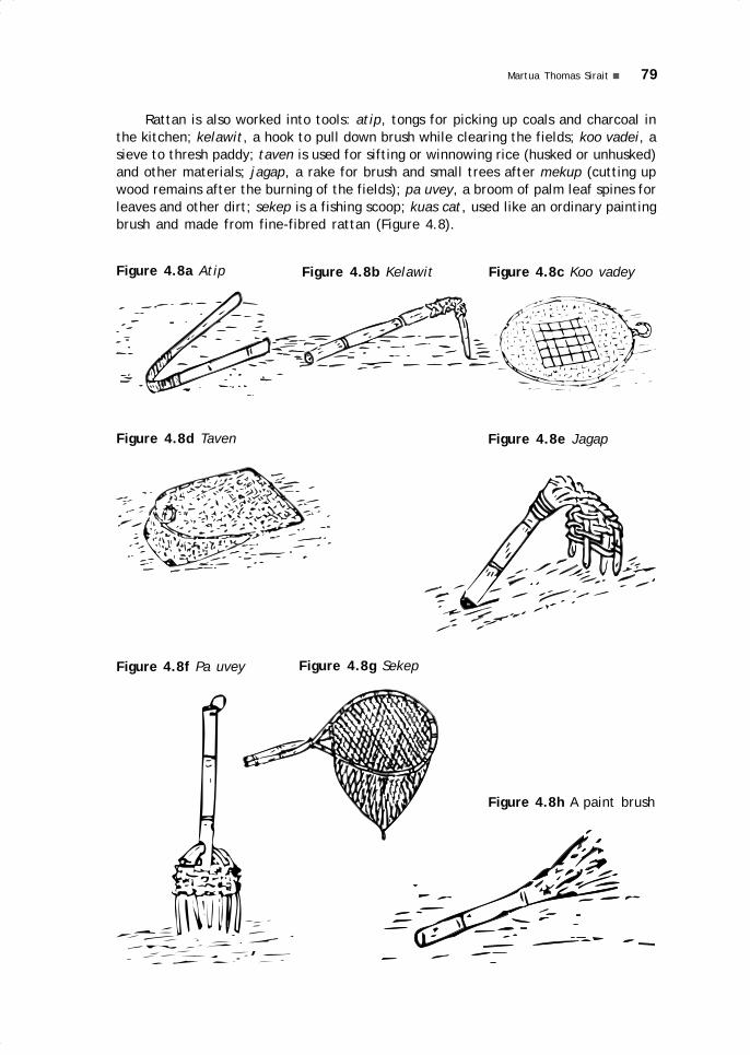
79Martua Thomas Sirait
Rattan is also worked into tools: atip, tongs for picking up coals and charcoal inthe kitchen; kelawit, a hook to pull down brush while clearing the fields; koo vadei, asieve to thresh paddy; taven is used for sifting or winnowing rice (husked or unhusked)and other materials; jagap, a rake for brush and small trees after mekup (cutting upwood remains after the burning of the fields); pa uvey, a broom of palm leaf spines forleaves and other dirt; sekep is a fishing scoop; kuas cat, used like an ordinary paintingbrush and made from fine-fibred rattan (Figure 4.8).
Figure 4.8a Atip Figure 4.8b Kelawit Figure 4.8c Koo vadey
Figure 4.8d Taven Figure 4.8e Jagap
Figure 4.8f Pa uvey Figure 4.8g Sekep
Figure 4.8h A paint brush

80 MANAGEMENT, PROCESSING, AND USES OF RATTAN
As a tying material (seli), rattan is used to attach iron blades to their handles orshafts: spears (bujak), adzes (bikung), machetes (bazang), axes (asai). Seli kelorangforms a casing for earthenware pots (kuden tana’); seli kepang secures the woodenshingles, usually made from benatu wood, to the roof; and seli lepau fastens thestructure of a hut. Rattan also serves to tether a canoe (alut) and, in the old times,before iron nails were available, to fasten its side boards. And a rattan rope alsoserves for drying clothes (akui galen) (Figures 4.9).
Figure 4.9a Seli: bujak,bikung, bazang, asai
Figure 4.9b Seli kelorang Figure 4.9c Seli kepang
Figure 4.9d Seli lepau Figure 4.9e A canoe rope Figure 4.9f Akui galen
Rattan, finally, can also be consumed: the fruits of uvey bala mata are used inplace of areca nuts for betel; the shoots of uvey pait are used as vegetables; and uveylanya is boiled and drunk as a poison antidote.
The Rattan Trading NetworkAmong the non-wood forest products only uvey seka (Calamus caesius) can be marketedin raw form. The other types of rattan are used for daily needs (Puri et al. 1991).However, knowledge of rattan’s regenerative capacity, its harvesting techniques, andits management is not yet widespread among the people (Jessup and Peluso 1986).

81Martua Thomas Sirait
The first group in the NTFP (non-timber forest products) trading network compri-ses the rattan collectors from among the farming people. Usually, the people in thevillages, specifically the Kenyah, try to find spare time for collecting rattan (or otherNTFPs, such as the incense wood, gaharu; see Blajan Konradus in this volume) afterweeding, after harvesting, and on other occasions. This work is adjusted to the farmingschedule, because every family member has responsibilities in the family’s farm work.Usually, no one spends more than one month at a time in the forest.
Another group engaged in rattan collecting includes the Punan Benalui, who liveat Long Uli and nearby villages (Long Peliran and Long Bena), and the Punan from theMalinau and the Tubu rivers. They usually make swiddens but do not tend them properly.Thus, they have comparatively more free time than the Kenyah who tend their fieldsmore intensively. The Punan generally are less familiar with market prices for NTFPsand tend to trade them in the nearest village for their daily necessities, such as sugar,rice, salt, clothing, or machetes.
Other rattan collectors are those coming from downstream areas (usually fromthe villages of Long Lian, Long Peso’, Long Bia, and Bhayangkara). These groups canwork for months in the forest, because they usually are not farmers. Thus all theirnecessities are purchased with the money they receive from the sale of the NTFP.They are coordinated by traders keeping shops in villages or by intermediary rivertraders. Those come with either their own boats or rented boats and carry away largequantities of product.
In Pujungan subdistrict, it is indeed difficult to distinguish between intermediaryvillage traders, village store traders, intermediary river traders, or boat traders, suchas described by De Beer and McDermott (1989). In this area, the existence of a clusterof several trading individuals or families linked to an NTFP trading network extendingfrom upstream to downriver is very clear. Regarding the NTFP trading networks,especially concerning incense wood, see Blajan’s chapter.

5.Eaglewood and forest productmanagement and trade inthe Bahau River region
Blajan Konradus
INTRODUCTIONThe highly effective forest management institutions formerly used by all Kenyah peopleare no longer strictly enforced today, even though the Kenyah have lived in closeinteraction with the forest for centuries. Factors much touted as the primary causesof this change are economic pressures and market demands for forest products whichcontinue to force people to collect forest products in disregard for their traditionalmanagement rules. These pressures and demands also seem to have caused a shift inthe values relating to the tana’ ulen leppo’ (village forest preserves). These areasthat formerly served social and economic functions nowadays retain only an economicfunction (see the chapter by Jacobus et al. and other writings in this book).
In fact, the forest products used by the people are non-timber forest products(NTFP), such as incense wood or eaglewood (gaharu), cinnamon bark, rattan, andketipai (Palaquium quercifolium), while timber products tend to be exploited by bigbusiness through their forest concessions (HPH). If we compare environmental damage,it is obvious that the effects of the NTFP business are much less significant thanthose of the logging activities. Nevertheless, the expansion of the NTFP business(maximalisation) has had some harmful effects and has brought about a change in theoverall patterns of forest management. This article focuses on the effects of themaximalisation of the NTFP business, especially in the growing eaglewood marketingnetwork, on forest management patterns in the Bahau River region. These effects are
05 May28.p65 6/11/03, 11:58 AM83
Black
84 EAGLEWOOD AND FOREST PRODUCT MANAGEMENT AND TRADE
viewed from a sociological perspective, and with regard to the sustainability of thepotential of the resource, and with concern for the economic life of the local society.
The subdistrict (kecamatan) of Pujungan contains various types of forested lands,including lowland dipterocarp forest, submontane forest, heath forest (kerangas), andsecondary forest. Farming is the primary economic occupation of the inhabitants. In thespare time between their farm work, they gather non-timber forest products (NTFP) forsale. The most sought after of these products is eaglewood, and in the last few years, ithas been extensively collected by the people. The area covered by this research, carriedout from July to October 1993, includes the entire subdistrict of Pujungan. The primaryobservation point, however, was the village of Long Pujungan, the subdistrict capital,which serves as a trading centre providing food and medicine needed by the people andby the NTFP collectors. This village also serves as the operational base for the NTFPdealers, and as a NTFP trading centre for the entire district. Non-timber forest productsare carried from here to Long Peso’, Tanjung Selor, or even Tarakan.
Eaglewood and its MarketingThe eaglewood (Aquilaria beccariana van Tiegh, as well as several other species andgenera) that is traded is a part of the tree that has been damaged or infected (by atype of fungus), so that a resin fills the holes or pores of the wood. These heavy,resin-filled parts of the tree are collected. Eaglewood is used as raw material forperfumes and, as dust or powder, is used for the manufacture of incense sticks andthe like for religious purposes in the People’s Republic of China, India, Saudi Arabia,Singapore, and Thailand.
The Kenyah language recognises three types of eaglewood trees (sekkau); theseare sekkau tengun (‘mountain-horn’ eaglewood), sekkau baya’ (‘crocodile’ eaglewood),and sekkau nyibung, all of which have different characteristics. The sekkau tenguntree has soft wood, and may grow as tall as a coconut palm and reach a circumferenceof 1 to 1.5 m. It is found in coastal areas and along rivers, but not at high altitudes.The sekkau baya’ tree is a hardwood with many knots and it may reach a circumferenceof 25 to 30 cm. The valuable resin is found in the trunk, and only rarely in the bran-ches. This tree, which is not very high, usually grows along rivers, on hillsides, and instony areas. The sekkau nyibung is a tall and broad tree, but with few branches. Itsdark resin (if present at all) is very abundant, in the trunk as well as in the branches.The tree’s circumference can reach 50 cm to 1 m.
Quality ClassificationEaglewood quality varies widely. No less than five levels (generally six) of quality areknown, and they are often divided again into a number of subclasses: super (superbuku and super biasa); teri (teri A and teri B), class I (IA and IB), class II (IIA and IIB),class III (IIIA and IIIB), class IV (pelagon or long adau). The characteristics of thesevarious categories are as follows:
● Super: the pieces of eaglewood are small, round, dense, and shiny; wood fibresare not straight; there are no holes; and weight varies between 100 to 300 gr perpiece; in super buku, the resin content exceeds 90% and the material is com-pletely black; in super biasa, the resin content is below 90% and the material isreddish black.
05 May28.p65 6/11/03, 11:58 AM84
Black

85Blajan Konradus
● Teri: in this category, the materialcomes in small, knotty pieces of lessthan 100 gr; it comprises Teri A (orteri kacang): round, nutlike shapes,entirely black; and Teri B (or teri tebu):thin like sugarcane skin, mixed blackand light brown.
● Class I (see Fig. 5.1): in this category,pieces are solid, without holes, andheavier than 300 gr; it comprises ClassIA: entirely black,; and Class IB: mixedblack (95%) and dark brown (5%).
● Class II (see Fig. 5.2): pieces are densebut contain holes; Class IIA: black (85%)and dark brown (15%) alternating; andClass IIB: mixed black (50%) and brown(50%) alternating.
● Class III (see Fig. 5.3): pieces are big-ger, showing traces of axe cuts, darklines circling the light brown wood thatis less dense and has a high water con-tent; it comprises Class IIIA: weightbetween 3 and 4 kg per piece; andClass IIIB: weight between 5 and 6 kgper piece.
Figure 5.1 Class I eaglewood
Figure 5.2 Class II eaglewood
05 May28.p65 6/11/03, 11:58 AM85
Black

86 EAGLEWOOD AND FOREST PRODUCT MANAGEMENT AND TRADE
● Class IV (or long adau): it comprises Class IVA (or adau berbaju): weight up to 20kg per piece; thick brown lines surround a large part of the wood so that it seems‘dressed’ (berbaju); rather high water content, rather low resin content (15%);shrinks easily; and Class IVB: (or ‘regular’): wood without a ‘dress’ (withoutbrown lines); weight 20–25 kg per piece; high water content, and shrinks easily;light brown mixed with white.
Price of EaglewoodThe eaglewood classifications used in the subdistrict of Pujungan and its environs asfar as Tanjung Selor (the capital of the district) are marked by a lack of standardisationin quality and terminology. Dealers tend to devise their own criteria in order to procurethe largest possible profits. For example, the division of the kelas super into superbuku and super biasa is only used by a few dealers who have been operating on theupper Bahau for a long time. The coming of eaglewood traders (toké) from outside thesubdistrict has led to greater variation in the classification, and at the same time hascontributed to decreasing standardisation of prices. Four businessmen in the LongPujungan area separately admitted that traders tend to elaborate the qualityclassifications in order to manipulate prices. One trader, in fact, not only uses thegeneral system of classification, but he has also devised another system of eaglewoodclassification based on classes and price grades (see Table 5.1).
Figure 5.3 Lower grade eaglewood
05 May28.p65 6/11/03, 11:58 AM86
Black

87Blajan Konradus
Faced with these matters an eaglewood seller commented: ‘It seems that priceshave dropped in 1993. There are too many categories and groups. There are super,IIA, IIB, III, IV, Category IV or long adau. I have noticed that this is one way used by thedealers to confuse the eaglewood sellers so that they themselves can make moremoney. Actually, eaglewood only consists of at most five or four classes: super, I, II,III, and IV. The creation of seven classes is only an attempt to manipulate the prices tomake the highest possible profits. That is why these games are played. Many peoplealready know that prices are higher, so to counter this, dealers have devised manycategories. When they sell downriver, however, they lump the various categoriestogether again.’
Market ConditionsHunting for eaglewood in the spare time between farming activities is not new to theKenyah. Yet, recently, the eaglewood-hunting schedule has undergone radical changes.In the 1970s, the eaglewood business was viewed as a side activity and the peopleused their free time from farm work—such as between planting and weeding, or theperiod after harvesting and before looking for a new farming site. In the 1980s theeaglewood business increased rapidly and the collectors entered the forest more andmore frequently, especially if the price rose dramatically, which usually occurred duringthe Haj season in May and June. The sudden jump in prices not only induced localpeople to rush to the forest but also attracted eaglewood collectors from outside thesubdistrict. The latter came in large groups in longboats. Some even came from Malinauby airplane. Others reportedly were flown into the Apau Kayan area with large helicoptersby companies from Samarinda (see WWF and PHPA 1995).
The search for eaglewood has continued to expand into the 1990s and now iscarried out throughout the year. This is made possible by the ‘note system’ (credit): thecollectors receive cash and supplies (fuel, food, and medicines) from dealers orbusinessmen (toké, usually of Chinese descent) on the basis of a note (credit). Theeaglewood they find is later bought by this same toké, who then subtracts the collector’scredit. The rise and fall of the market price also influences the intensity of the search.The effects of the international political situation (especially as they relate to theeaglewood-importing countries) and of relations between Indonesia and those countriesare felt even in Long Pujungan. In 1991, during the Gulf War, dealers could not ship theireaglewood to Saudi Arabia and many potential pilgrims did not make the Haj pilgrimageto Mecca. As a result, the eaglewood price fell drastically (by as much as 40%).
FOREST PRODUCT MANAGEMENTThis section describes the forest product management system that has been in forcefor a long time. The term tana’ ulen has been mentioned earlier. In the Kenyah language,ulen means ‘prohibition’, and the term mulen means to ‘reserve’ or ‘supply’ byrestricting access. Tana’ ulen leppo’ contains the meaning ‘village land which hasbeen reserved, protected, or even managed for the interests of the villagers, byprohibiting all forms of interference from people of any other village.’ The history ofthe formation of tana’ ulen leppo’ in the subdistrict of Pujungan is inseparable fromthe traditional social structure of the Kenyah, which consisted of paren (nobility),panyen (ordinary people), and kula’ (slaves).
05 May28.p65 6/11/03, 11:58 AM87
Black
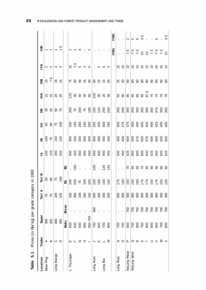
88 EAGLEWOOD AND FOREST PRODUCT MANAGEMENT AND TRADE
Tab
le
5.1
Pr
ices
(in
Rp/
kg)
per
grad
e ca
tego
ry i
n 19
93
Loca
tion
Tra
der
Supe
rTe
ri A
Te
ri B
IAIB
IIA
IIBII
IAIII
BIV
A
IV
BAp
au P
ing
A
30
0
75
50
150
100
50
35
15
10
2
1B
325
75
6
512
5 7
5 5
0 2
5 1
5
7.5
2
1Lo
ng A
lang
oC
400
100
7
520
015
0 7
5 5
0 2
0 1
5 2
1
D
45
0 1
25
100
250
100
100
75
25
15
3
1.5
Buku
Bia
sa B
1 B
2L.
Puj
unga
nE
500
- 1
5010
0 -
550
350
250
200
125
75
15
1
F50
0 -
350
250
150
250
250
100
75
30
20
2.
5
1G
500
- 1
00 7
5 -
350
300
250
200
40
30
5
3H
600
- 1
5010
0 -
400
300
100
75
20
15
2
-
I65
0-70
0 -
150
100
-55
040
020
018
0 5
0 4
0 5
2
Long
Ara
nJ
700
650
200
150
100
500
350
250
150
100
50
-
-K
600
- 2
0015
0 -
400
350
250
120
35
15
5
-
Long
Bia
L70
0 -
200
150
125
450
400
300
250
25
15
5
-M
800
- 2
0015
012
545
040
025
020
0 3
0 2
0 3
-
IVB
1IV
B2
Long
Pes
oN
700
- 2
5017
5 -
500
450
300
250
50
25
10
- -
O70
0 -
250
150
-45
040
027
520
0 5
0 2
0 1
5 -
-Ta
njun
g Pa
las
P80
0 7
50 3
0015
0 7
062
560
037
530
0 6
5 6
0 1
0 7
.5 2
Tanj
ung
Selo
rQ
750
725
300
150
60
600
500
400
350
65
60
15
7.5
5R
800
750
300
160
65
600
575
400
350
65
60
10
7.5
5S
750
700
300
175
70
600
650
400
350
65
60
15
10 3
.5
T80
0 7
50 3
0017
0 6
060
057
540
035
0 6
7.5
60
15
10 -
U80
0 7
50 3
0015
0 6
062
560
040
035
0 7
0 6
0 1
0 7
.5 -
V80
0 7
50 3
0017
5 6
565
060
042
537
5 7
0 6
0 2
0 7
.5 5
W75
0 7
00 3
0015
0 6
060
055
040
035
0 7
0 6
0 1
5 7
.5 -
X80
0 7
00 3
0015
0 6
062
560
040
035
0 7
0 6
0 1
510
3.5
05 May28.p65 6/11/03, 11:58 AM88
Black
89Blajan Konradus
Tana’ Ulen in the PastIn the past, the tana’ ulen was land allocated to the paren who held power in thevillage, and it was a reserve of natural resources that could be harvested from time totime for the benefit of the paren. At times, as occurred in the village of Long Berini,the paren awarded a piece of tana’ ulen as a sign of respect to a war leader whoreturned victoriously. The management of the tana’ ulen by and for the paren with thelabour of the panyen was based on a number of considerations. First, only the parenwere permitted to build houses of hard wood. In fact, it was believed that only theparen were able to handle the bali (spirits) that inhabited hardwood trees. The panyenthus were only allowed to use soft wood or bamboo. The tana’ ulen was located inforest areas with an abundance of hardwood, which could only be harvested for thebenefit of the paren. Second, the paren were responsible for entertaining guests tothe village, while the panyen hunted, fished, and harvested vegetables in the tana’ulen for these feasts.
During the 1963–1964 Confrontation between Malaysia and Indonesia, the mana-gement practices relating to the tana’ ulen changed drastically. The soldiers of theIndonesian Army who were assigned to the border area together with some local peo-ple often entered the tana’ ulen of the upper Bahau (where observation posts hadbeen established) to hunt or look for food. The paren could not object because theywere afraid of the armed soldiers. Gradually, the collection of forest products in thetana’ ulen came to be viewed as normal by the people, and the rules for managing thetana’ ulen were increasingly ignored. In the early 1960s, the tana’ ulen finally changedstatus and became village-rather than paren-owned and referred to as tana’ ulenleppo’. This change was subsequently reinforced by a decree of the provincialgovernment of East Kalimantan in 1967 that further eroded traditional controls overland. The tana’ ulen leppo’ then was protected and carefully managed for the commoninterest of all villagers, because it served as a source of supplies and a reserve formeeting the villagers’ needs for natural resources, such as construction materials,foodstuffs, and economically valuable non-timber forest products.
Tana’ Ulen Leppo’The management of the tana’ ulen leppo’ by the village is guided by a number of rulesthat are strictly adhered to by all villagers. Forest products are collected at certaintimes, referred to as buka ulen, which do not follow the calendar as does the farmingcycle. The collection is specifically intended to benefit the village, as for example, inthe case of construction wood for a church or a meeting hall (BPU, Balai PertemuanUmum). Some villages have allowed exceptions for those of their citizens who neededconstruction wood for building houses or making boats with the provision that theyobtain permission from the village head. The same applies to the collection of rattan,eaglewood, and cinnamon by the villagers for sale to the toké (trader-dealer), anactivity that is organised by the village head together with the local governmentapparatus. The buka ulen activities are planned in a village meeting, from the beginningto the sale to the levying of a fee to be paid by the toké.
The meeting of village leaders and adat elders discusses the location, types ofnon-timber products to be harvested, and the number of days needed for buka ulen. Ifthe market price of NTFP rises, a meeting on buka ulen is held by the village. Themoney obtained through buka ulen is used to support village activities. At the time ofbuka ulen, all citizens have the right to enter the tana’ ulen to ngusa. They can selltheir harvest directly to the toké, the purchasing or collecting dealer. Demands for
05 May28.p65 6/11/03, 11:58 AM89
Black

90 EAGLEWOOD AND FOREST PRODUCT MANAGEMENT AND TRADE
fees for the village treasury (kas desa) are handled directly by the village leadership,who contact the toké. People from other villages who wish to ngusa must pay a tax of20% of the revenues obtained from the sale of their products to the toké. This tax isused as follows: 10% to the village treasury and 10% to the families of the paren fortheir service in creating the tana’ ulen leppo’ of the village.
Certain very strict prohibitions exist: villagers may not go ngusa (here, harvestNTFPs) in the tana’ ulen outside the time of buka ulen; people from other villages maynot enter without permission from the village head or leaders, at the time of bukaulen and at any other time; cutting young rattan or felling young cinnamon trees isstrictly forbidden. Violations of the rules of tana’ ulen leppo’ meet with sanctions thatare appropriate to the type of violation and take the form of fines paid to the village.Every individual who violates the rules is fined a machete, which will be used in otheractivities for the benefit of the village, or will be sold and the money added to thevillage funds. Violations by outsiders are more heavily punished. The same is true forviolations by the paren, and village leaders, because they come from families thatsponsored the creation of the tana’ ulen leppo’, that is, a group that should serve asa model for other villagers.
From 1969 to the 1970s the rules for managing the tana’ ulen leppo’ becamemore and more relaxed in the Bahau River area. A local adat figure took the opportunityto relax the rules for all villagers, allowing them to take hardwood for building housesand making boats. This attitude, backed by considerations of equality of all citizens(including the non-paren), has elicited favourable as well as unfavourable reactionsamong the paren of several other villages.
Tana’ Ulen at PresentSince 1978, the condition of the tana’ ulen in the subdistrict of Pujungan has givenincreasing cause for concern. Heavy market demands have enticed many collectors ofNTFP (primarily eaglewood) from downriver to the area. These do not only come tongusa in the open forest belonging to the villages of the subdistrict, but they alsotrespass into various tana’ ulen leppo’ areas. The large number of outside collectorsputs pressure on the local people to collect eaglewood themselves, not only in the openforest but also in the tana’ ulen leppo’ of their own village, without heeding theirmanagement rules. The tana’ ulen leppo’, which initially had social and economicfunctions, shifted more and more to only an economic function. Tana’ ulen leppo’ ispromoted as a promising area for forest products and a source of cash income for thevillage through fees.
The fees charged to outside eaglewood collectors are Rp. 5000 per individual andRp. 50 000 per group. This tariff applies to NTFP collectors who ngusa in the openforest of the village, while for collecting in the tana’ ulen leppo’ they are charged Rp.50 000 per person. The amount of the fee varies among villages. In practice, manytypes of transgressions are common. For example, outsiders who, in fact, make upseveral groups, only pay Rp. 50 000 posing as one group for one entry into the tana’ulen leppo’.
Trespassing on the open forests and the tana’ ulen leppo’ by groups of outsideeaglewood collectors, now a frequent occurrence, results from collusion between outsidetraders and local leaders through rather large payments for lining the latter’s pockets.In 1992–1993, there were also several cases of trespassing on the tana’ ulen leppo’ ofa particular village by eaglewood collectors from other villages who were sponsored by
05 May28.p65 6/11/03, 11:58 AM90
Black

91Blajan Konradus
an eaglewood dealer. In addition, there are many cases of villagers entering the tana’ulen leppo’ of their own village without authorisation.
As a result of these unauthorised entries, the potential for NTFPs, especially ofeaglewood, in various tana’ ulen leppo’ in the subdistrict of Pujungan has already declined.Of the subdistrict’s 21 villages, only the village of Long Pujungan proper has begun torevive the management rules for its tana’ ulen leppo’. In 1990 the village established aTana’ Ulen Committee, charged with helping the villagers and the village leadership inmonitoring the condition of the tana’ ulen leppo’ as a whole, with regard to both landconditions and the resources growing on it. The responsibilities of the Committee includetaking action against violators of the tana’ ulen leppo’ management rules, both fellowvillagers and outsiders; setting the time for buka ulen in cooperation with village lea-ders and adat elders; collecting the fees for forest products (timber and non-timber)from the dealers (toké) who purchase or collect them from the local people; and reportingto the people in a village meeting at the end of the year.
EAGLEWOOD IN THE SOCIAL, ECONOMIC, AND CULTURALFRAMEWORKThe economic life of the people of the subdistrict of Pujungan is supported by theagricultural sector, including cash crops, animal husbandry, and the trade in forestproducts. The people’s primary enterprise is farming, specifically rice growing in dryand wet fields, as well as secondary crops, reinforced to a limited extent by commoditiessuch as coconuts, cloves, coffee, pepper, and cocoa. The crops grown are consumedby the people themselves, because of the lack of markets. Thus, even the coffee andthe cocoa, which for several years were promoted by the government, are not boughtby traders. The problems faced are difficulties of transportation to marketing centresand lack of technical guidance from the government, so that the harvest from perennialplants only remains a promise but does not yet produce money. Pig and goat farming isfor local consumption and poultry (chickens and ducks) is sold to visitors only occasionallyand in small quantities. The produce of game hunting (wild pigs, deer, and others) andthe fish catch usually are also intended only for local consumption, except for thosethat are routinely sent from the village of Long Pujungan to the toké in Long Peso’.This actually has greater potential for generating cash income than livestock cultivation.
Eaglewood Collectors and their OrganisationUnder these conditions, it is reasonable that forest products have become a majorsource, relied on for meeting daily needs. Local people practise shifting cultivationagriculturalists and traditionally have collected eaglewood in their free time betweenfarming activities. For some Kenyah people, however, these activities have now becomea permanent full-time profession. Thus the people of the subdistrict of Pujungan (seeTable 5.2) must be distinguished between professional eaglewood collectors, who collectthroughout the year and do not farm, and occasional eaglewood collectors, who onlycollect in their spare time between other activities, such as farming, teaching, oroffice work (civil servants).
In addition, a number of outside eaglewood collectors, usually professionals, areoperating in the subdistrict. Some of them have come from the downstream areas ofthe Kayan River (hundreds of people), and some have come by plane from the districtsof Lumbis (30 people) and Malinau (25 people). It is difficult to determine their numbers
05 May28.p65 6/11/03, 11:58 AM91
Black

92 EAGLEWOOD AND FOREST PRODUCT MANAGEMENT AND TRADE
with any precision. They are employed by several toké and have a rather complexwork coordination and strategy. Overall—and seen from several angles (such as capi-tal, organisation, numbers)—the eaglewood collection in the subdistrict of Pujunganis dominated by professional collectors from outside.
The local people can only enjoy the forest products as a source of boards (forconstruction) and food. With regard to income generation, however, they do not benefitsignificantly from NTFPs (such as eaglewood, rattan, and cinnamon) with a high economicvalue. Even though nowadays, a large-scale business in NTFPs has developed (especiallyin eaglewood), the eaglewood collectors among the local people are not yet able toenjoy to the fullest the results of this growth, because they are faced with problems ofcapital, which eventually also afflict the outlet organisation.
A KUD (Koperasi Unit Desa or village cooperative) managed by the subdistrictonly sells a few staple products that are daily necessities. The people are not yetorganised or given training on the role of the KUD in supporting the village economy,and they see the KUD only as a small shop. To enable the people to benefit directlyfrom the existence of a KUD, it would be better to transform the KUD into a venue forbusiness of the local people by establishing a management system and setting qualityand price standards in a situation of open information.
Table 5.2 Local eaglewood collectors in Pujungan Subdistrict
Village (Desa) Numbers of Collectors Total
Active Occasional
Long Pujungan 25 5 30Long Sa’an 10 2 12Long Ketaman 20 3 23Long Pua’ 1 - 1Long Jelet 12 1 13Long Apan Baru 20 3 23Long Lame 15 - 15Long Pelian 20 2 22Long Belaka 26 2 28Long S. Bawang 12 - 12Long Bena 10 - 10Long Uli 12 2 14Long Tebulo 10 1 11Long Alango 26 7 33Long Lat 2 - 2Long Berini 10 1 11Long Aking 5 - 5Long Atua 1 - 1Long Pengayan 11 1 12Long Tua 1 - 1Apau Ping 10 - 10Total 259 30 289
05 May28.p65 6/11/03, 11:58 AM92
Black

93Blajan Konradus
Social and Cultural FactorsThe socio-cultural background plays an important role in eaglewood-collecting activitiesat the subdistrict level. The domination of these activities by professional collectorsfrom downriver areas often causes problems. For example, in several villages, suchas Long Apan Baru and Long Ketaman, a dilemma developed between economiccompetition and feelings of village cohesion when it became known that a group ofpeople of the same ethnic group from Long Peso’ had come to the village to look foreaglewood in the forest around the village. The news forced local villagers to rush tothe forest to ngusa before the eaglewood on their own village lands was finished bythe outside collectors.
Farming activities are only undertaken by women and old people, while the menwho are still strong collect eaglewood. The sex ratio is no longer balanced becausemany young men go to school in the towns or go to Sarawak to earn their living. Thismeans that the farm work is neglected and does not produce optimal results.Furthermore, communication is obstructed by the long distances between the villagesand the subdistrict capital; transportation is difficult and expensive, especially to themarket centre at Tanjung Selor; much time, energy, and money are required. Thus, ingeneral, the socio-economic condition of the people may be described as worrying.
Male workers who live in the villages are gradually shifting from farming toeaglewood collecting, not only because eaglewood guarantees tempting money, butalso because the local institutions are increasingly weakening, especially those relatedto forest management rules. Today, the traditional social groupings no longer officiallyexist among the Kenyah, yet the village heads throughout the subdistrict continue tobe members of the paren class, who still are very influential in various economicmatters, such as determining the location of fields, managing the tana’ ulen leppo’,and regulating the collection of forest products, both in the interest of various villagersand in the common interest. Usually the panyen agree to the wishes of the paren inmatters relating to the interests of the village.
Ceremonies, Prohibitions, TaboosThe Kenyah and the Punan of the subdistrict of Pujungan generally are familiar with avariety of ceremonies and taboos related to the collection of eaglewood. Yet, only asmall number of the people, especially the occasional collectors of eaglewood, stillobserve them, while the others simply are of the opinion that the eaglewood businessis not exempt from fate—good luck or bad luck. Therefore, the eaglewood collectionmethods differ greatly among collectors, individually as well as by groups.
The melewa (Kenyah) or tapo (Punan) ceremony is held, among other occasions,before departing to collect for eaglewood. The leader of the ceremony and the parti-cipants who will go to the forest wear black shirts and pants. A cock is killed, a woodenstick sharpened and its tip split (ngelebu), and a chicken feather is then slipped intothe split tip. A prayer is uttered (Punan Benalui): ‘Go, wood, ask him for eaglewood,he the god of the land, the god of the mountain, the god of the tana’ ulen, the god ofhills, the god of mountains, the god of water, the god of springs. When you come backlooking for an offering, I will give you wood shavings, I remind you, so that one or twoof the trees that I will fell have something [eaglewood] in them. I give this to the tapo[the split wooden stick] because I ask to become rich, I ask for good luck, for prosperity,I ask for eaglewood, I ask it of you, I, a lowly human, a poor man, without money,without ringgit, without even one. I only give you this pure white chicken, this rooster,
05 May28.p65 6/11/03, 11:58 AM93
Black
94 EAGLEWOOD AND FOREST PRODUCT MANAGEMENT AND TRADE
this chicken for help.’ The base of the wooden stick is thereupon stuck into the groundand only then may the eaglewood collectors depart for the forest.
A group of Kenyah in the subdistrict of Pujungan still believe in and adhere tovarious taboos. The night preceding their departure, eaglewood collectors areprohibited from associating with women, from using coarse language or scolding,because looking for eaglewood is considered a sacred task that tests one’s fate in theforest. If the house is dirty, the eaglewood collector may not sweep it, because garbagein the house must be left scattered like the eaglewood is expected to be found scatteredin the forest. There is also a belief that all plans are known to the gods who bring goodor bad fortune, and if some member of a group is prevented from departing on the setday the entire group must abandon their plan and make a new plan for another day sothat the god does not abandon his readiness to protect the group.
If some object has been left behind in the village and this is only discovered whenthe group is approaching the forest, it is forbidden to go back for it and the trip mustbe continued. It is believed that good luck has followed the collectors since they leftthe village, and if anyone returns, the good luck also will go back and will not accompanythem further. In collecting for eaglewood, the members of a group must go in thesame direction, they cannot disperse in opposite directions. It is also advisable tolook for eaglewood from downriver going upriver, because the hoped-for good luck isbelieved to follow the course of the river. It is prohibited to catch fish in the river withtuba poison, because the tuba root, which smells rather sharp, might annoy theaccompanying gods, angering them so that they will bring disaster down on thecollectors. If the collectors find high quality eaglewood, they must remain quiet; it isforbidden to brag, because the gods who have accompanied them from the beginningdo not like conceit in men.
EAGLEWOOD COLLECTING PRACTICESThe people downriver who have long gathered eaglewood and traded it via middlemenhave extensive experience in the eaglewood business. Even though the Kenyah havebeen farmers since the old days and have collected eaglewood only in their free time,there have also been a few Kenyah in the subdistrict of Pujungan who have traditionalknowledge of the physical characteristics of eaglewood, because they have been familiarwith the eaglewood trade since their youth. These characteristics can serve as a guideto determine whether a tree trunk is already old or still young, and contains eaglewoodor not.
Selecting an Eaglewood TreeThe first step is to determine the type of eaglewood (sekkau tengun, sekkau baya’, orsekkau nyibung), according to the characteristics discussed earlier. The chances offinding eaglewood and the possible amounts of eaglewood differ among the variousspecies.
The eaglewood tree that can be expected to contain the sought-for substance isusually relatively old and has the following characteristics: the trunk is dark brown,with black lines and moss, and its leaves are dark green or yellowish (if the tree is sickand almost dead). This type of tree shows traces of machete or axe cuts, broken anddead (dry) branches due to high winds, and holes made by black ants. A young treeusually has light green leaves, whitish bark, and white wood. Tree height and trunk
05 May28.p65 6/11/03, 11:58 AM94
Black
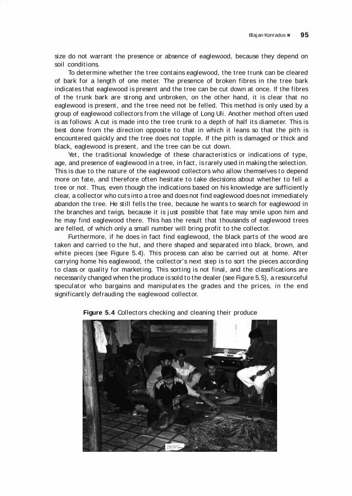
95Blajan Konradus
size do not warrant the presence or absence of eaglewood, because they depend onsoil conditions.
To determine whether the tree contains eaglewood, the tree trunk can be clearedof bark for a length of one meter. The presence of broken fibres in the tree barkindicates that eaglewood is present and the tree can be cut down at once. If the fibresof the trunk bark are strong and unbroken, on the other hand, it is clear that noeaglewood is present, and the tree need not be felled. This method is only used by agroup of eaglewood collectors from the village of Long Uli. Another method often usedis as follows: A cut is made into the tree trunk to a depth of half its diameter. This isbest done from the direction opposite to that in which it leans so that the pith isencountered quickly and the tree does not topple. If the pith is damaged or thick andblack, eaglewood is present, and the tree can be cut down.
Yet, the traditional knowledge of these characteristics or indications of type,age, and presence of eaglewood in a tree, in fact, is rarely used in making the selection.This is due to the nature of the eaglewood collectors who allow themselves to dependmore on fate, and therefore often hesitate to take decisions about whether to fell atree or not. Thus, even though the indications based on his knowledge are sufficientlyclear, a collector who cuts into a tree and does not find eaglewood does not immediatelyabandon the tree. He still fells the tree, because he wants to search for eaglewood inthe branches and twigs, because it is just possible that fate may smile upon him andhe may find eaglewood there. This has the result that thousands of eaglewood treesare felled, of which only a small number will bring profit to the collector.
Furthermore, if he does in fact find eaglewood, the black parts of the wood aretaken and carried to the hut, and there shaped and separated into black, brown, andwhite pieces (see Figure 5.4). This process can also be carried out at home. Aftercarrying home his eaglewood, the collector’s next step is to sort the pieces accordingto class or quality for marketing. This sorting is not final, and the classifications arenecessarily changed when the produce is sold to the dealer (see Figure 5.5), a resourcefulspeculator who bargains and manipulates the grades and the prices, in the endsignificantly defrauding the eaglewood collector.
Figure 5.4 Collectors checking and cleaning their produce
05 May28.p65 6/11/03, 11:58 AM95
Black
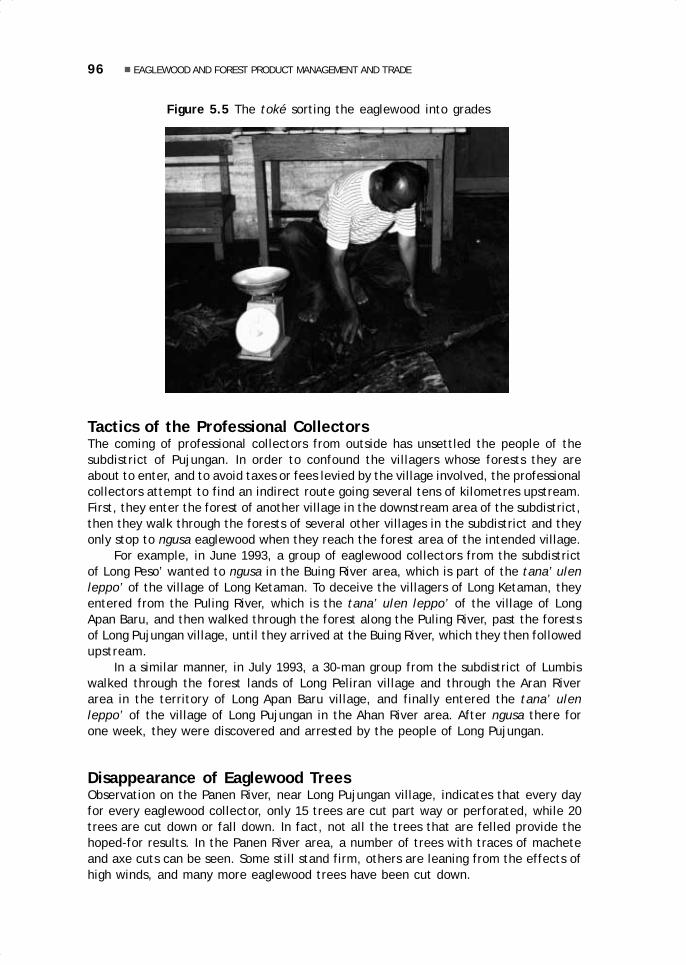
96 EAGLEWOOD AND FOREST PRODUCT MANAGEMENT AND TRADE
Tactics of the Professional CollectorsThe coming of professional collectors from outside has unsettled the people of thesubdistrict of Pujungan. In order to confound the villagers whose forests they areabout to enter, and to avoid taxes or fees levied by the village involved, the professionalcollectors attempt to find an indirect route going several tens of kilometres upstream.First, they enter the forest of another village in the downstream area of the subdistrict,then they walk through the forests of several other villages in the subdistrict and theyonly stop to ngusa eaglewood when they reach the forest area of the intended village.
For example, in June 1993, a group of eaglewood collectors from the subdistrictof Long Peso’ wanted to ngusa in the Buing River area, which is part of the tana’ ulenleppo’ of the village of Long Ketaman. To deceive the villagers of Long Ketaman, theyentered from the Puling River, which is the tana’ ulen leppo’ of the village of LongApan Baru, and then walked through the forest along the Puling River, past the forestsof Long Pujungan village, until they arrived at the Buing River, which they then followedupstream.
In a similar manner, in July 1993, a 30-man group from the subdistrict of Lumbiswalked through the forest lands of Long Peliran village and through the Aran Riverarea in the territory of Long Apan Baru village, and finally entered the tana’ ulenleppo’ of the village of Long Pujungan in the Ahan River area. After ngusa there forone week, they were discovered and arrested by the people of Long Pujungan.
Disappearance of Eaglewood TreesObservation on the Panen River, near Long Pujungan village, indicates that every dayfor every eaglewood collector, only 15 trees are cut part way or perforated, while 20trees are cut down or fall down. In fact, not all the trees that are felled provide thehoped-for results. In the Panen River area, a number of trees with traces of macheteand axe cuts can be seen. Some still stand firm, others are leaning from the effects ofhigh winds, and many more eaglewood trees have been cut down.
Figure 5.5 The toké sorting the eaglewood into grades
05 May28.p65 6/11/03, 11:58 AM96
Black

97Blajan Konradus
It is difficult to calculate with precision the number of trees that have been felledby eaglewood collectors throughout the subdistrict of Pujungan. Yet, on the basis ofdata on the number of collectors and the frequency of their activities while in theforest, the number of trees cut can be estimated at between 250 000 and 750 000 peryear. This means that the eaglewood tree is in the process of disappearing.
THE ROLE OF TRADERS IN THE EAGLEWOOD MARKETING NETWORKIt is not easy to become a dealer or a trader in forest products in the interior of Kalimantan.To succeed in this profession, it is not enough to rely on capital and other facilities, suchas storage houses for forest products and manpower trained in marketing. A man mustalso have the ‘soul of a trader’, that is, the will, the spirit, and the determination towork hard, and the courage to take risks—nonmaterial types of capital. Another equallyimportant factor is skill in maintaining relations with other traders, workers (labour),the government, and the social environment in the business area.
AuthorisationThe tricks of the dealers and traders in forest products have a significant effect onthe local institutions that regulate the management of forests and forest products inthis area. Generally, the greatest emphasis is placed on the trade negotiations, atdistrict level, with the Tripika (including the subdistrict head, the local chief of police,and the local military commander). The subdistrict leadership issues licenses to anyonefor carrying business in eaglewood anywhere in the Pujungan Subdistrict area. Thismeans that adat figures and informal leaders do not play a significant role in forestproduct management activities. Some adat figures not only fail to act firmly againstviolators of forest resource management rules in their area, but they themselves areresponsible for the violation of those rules.
For example, a well-known individual, X, from village Z granted permission to aprofessional collecting group from outside to do business in eaglewood in the forestarea of the village of Z, both in the open forest and in the tana’ ulen leppo’. In additionto the fees, this group also paid the party who gave permission a certain amount ofmoney that subsequently was not surrendered to the village treasury. When this wasdiscovered, extended unrest among the people of the village of Z developed and finallyended in popular indifference toward X and his leadership. As a protest and because oftheir need for cash, the people of Z then consciously and intentionally began trespassingon the tana’ ulen leppo’, in disregard of the forest management rules.
The attitude displayed by X is also viewed as destructive of earlier patterns ofsocial life. As a result, the enforcement of forest management rules is increasinglyslack, and many of the rules have stopped functioning altogether. A further result isthe growing weakness of the role played by adat institutions in village society in thesubdistrict of Pujungan.
Eaglewood Marketing ChannelsThe influence of traders on the Kenyah’s forest management strategy and activities isapparent in the intensity and the frequency of eaglewood business activities. Initially,eaglewood for marketing purposes was only attractive to a small number of tradersfrom downriver areas, who purchased and stored the eaglewood in Long Pujungan andin Long Bia (subdistrict of Long Peso’) prior to export.
05 May28.p65 6/11/03, 11:58 AM97
Black

98 EAGLEWOOD AND FOREST PRODUCT MANAGEMENT AND TRADE
Recently, the eaglewood business in the subdistrict of Pujungan has become muchmore lively and has attracted a number of outside traders who go directly to the villagesto buy eaglewood. They not only wait for the villagers to sell their eaglewood harvest,but they also send out tens of groups to collect for eaglewood. These groups are in andout of the forest for weeks at a time, and even for as long as two to three months.
Eaglewood collectors are operating from Long Bia, Long Peso’, and Long Bang(subdistrict of Long Peso’). In Tanjung Palas there is also a large-scale trader, whileTanjung Selor (capital of the district of Bulungan) has not less than seven, some ofthem of Chinese descent and others of Arab descent. The marketing network in thelower Kayan River area, too, is linked to a large-scale eaglewood exporter in Tarakan.Cooperation between traders from the subdistrict of Pujungan thus extends as far asTarakan and forms an intricate eaglewood-trading network.
Labour and the Credit SystemFor a better understanding of this network stretching from the village to the marketingcentre, it is necessary to describe the organisation of eaglewood collecting, that is,the expeditions that are arranged by dealers and the form of the dealers’ relationswith the workers, both outside and inside the subdistrict of Pujungan. One trickthat traders use in order to employ as many eaglewood collectors as possible is togive them loans of goods and supplies on the basis of what are generally known asbon or ‘notes’ (i.e., credit). The collectors are expected to repay these loans in theform of eaglewood after their return from their expeditions. The debts, however,can only rarely be paid promptly, and thus the collectors are tied to the trader bythese debts and forced to continue to collect eaglewood for that trader. In this way,the dealer attempts to obtain a labour monopoly on as many local workers as possible.
A ‘general’ (or group) note covers the needs of a group for food, medicine, kerosene,gasoline, cigarettes, batteries, raincoats, shoes, and alcoholic beverages (whiskey), aswell as essential cash. The amount of the notes varies with the needs of the groups andthe length of time that they plan to be in the forest. It can total as much as Rp 2 millionfor one entry by the group into the forest. Cash is also provided individually on a personalnote, in amounts between Rp. 50 000 and Rp. 500 000. Prices of goods provided on thebasis of a note, either personal or group, usually are higher than they would be if thegoods were paid in cash—sometimes as much as double.
In addition to providing the supplies for entering the forest, traders also acceptpersonal notes for other goods. For example, while the eaglewood collector is in theforest, his family (wife, children, or parents) may pick up daily necessities on thebasis of a note to enable them to surmount any cash shortage and make ends meet.Household goods, such as pressure lamps, boat engines, or even bicycles, radios, andcassette players, as well as televisions, may also be obtained on the basis of a note.The note system thus is already commonly accepted among eaglewood collectors.
In the subdistrict of Pujungan, the system of paying off notes to the trader witheaglewood leaves many eaglewood collectors’ families trapped in their debts. If theycannot pay their debts, the goods that they have obtained must be returned. The caseof a group of eaglewood collectors of the Punan Benalui sufficiently demonstrates thepressures and the dependence resulting from the note system. Unable to pay off theirdebt with eaglewood, they were forced by trader Y in Long Pujungan to return the fiveboat engines previously provided by him.
05 May28.p65 6/11/03, 11:58 AM98
Black

99Blajan Konradus
Relations with the Eaglewood CollectorsBecause of the existing note system, work relations between the trader and theeaglewood collectors resemble a patron-client relationship, in which the eaglewoodcollector is in a weak position, because he is resigned and forced to do whatever thetrader wants. Caught up in the note system, he is forced to go to the forest repeatedlyjust to enable himself to pay off his debts. Thus, the frequency of expeditions isclosely related to the note system. Farm work is necessarily neglected, resulting indeclining harvests. The health of families also does not receive adequate attentionbecause the responsibility for caring for the family is left only to the wife.
The tricks of the traders in maintaining relations with eaglewood collectors arealso apparent in their efforts to transport them to and from the forest in longboats.Two stopover posts (in Long Pujungan and Long Apan Baru) have been established bytraders from the subdistrict of Long Peso’ as locations for local dealers who serve asan extension of the traders’ reach. These posts function to meet the needs of thetraders’ employees from downriver who are operating in the subdistrict of Pujungan.If they run short of supplies, fall ill, or have an accident, the toké in that post will takecare of everything. The posts are also used to arrange the transmission and receipt ofinformation relating to the movement of eaglewood collecting groups.
The dealers also attempt to create a moral dependence on the part of the eaglewoodcollectors by establishing informal associations of an incidental nature. For example,during the commemoration of the anniversary of Indonesian independence on 17 August1993, eaglewood collectors who worked for toké Z formed a sports team. All theirexpenses of registration, uniforms, and shoes, as well as a number of prizes for theteams, were paid by Z.
EFFECTS OF THE EAGLEWOOD MARKETING NETWORKEven though there have been shifts in values and changes in rules, the forestmanagement practices used by the Kenyah in the subdistrict of Pujungan in their tana’ulen leppo’ bear proof that the rural people in the interior of East Kalimantan havelocal institutions that since the old days have played a role in the preservation offorest resources. This is in line with the statement of Poffenberger et al. (1990) andof Alcorn et al. (1990) that fundamentally the rural people have long carried outtraditional conservation activities. The practices for managing the tana’ ulen leppo’,including the management of eaglewood, have been heavily influenced by the traditionalsocial cultural background, among others, the social structure, the traditions andcustoms, and the belief system of the past (see Cernea 1988 and McKinnon and McKinnon1990). The Kenyah’s management of the forest generally and of eaglewood in particularrepresents a means of adapting to the forest environment.
As a system, human ecology has several component parts, such as the naturalenvironment, humans interacting with the environment, and the methods—or theculture—of that interaction. In the management of eaglewood, the environmentalcomponent is the forest, with its promise of both timber and non-timber resources.To obtain the necessities of life, the people use their environment according to theirlocal knowledge of existing forest resources, and they also manage the forest accordingto their local customs and belief systems. The efforts to manage the forest resourcesare an adaptation strategy of the local people to enable them to live by using theresources in their local environment.
05 May28.p65 6/11/03, 11:58 AM99
Black

100 EAGLEWOOD AND FOREST PRODUCT MANAGEMENT AND TRADE
Changes in rules and shifts in values that now affect the management of the tana’ulen leppo’ are the result of intervention by outside forces, that is, the eaglewoodmarketing network. In fact, the Kenyah since long ago have had contact with outsideparties through the forest product trading network. This contact became more inten-sive and easier at the beginning of the 20th century as a result of the military expeditionsof the Dutch government, which succeeded in pacifying the interior by reducing theinterethnic fighting and weakening the headhunting tradition. Later, as the value ofmoney became known—it was used for commodities that could not be produced by thepeople themselves, such as salt, sugar, tobacco, clothing, and others—in village life, theisolation of the interior region decreased steadily and a new way of life began.
As mentioned earlier, the eaglewood business initially was a side occupation forthe farmers, undertaken in spare time between their farm work. Nevertheless, inresponse to high prices and growing market demands, these activities were pursuedmore and more intensively so that they became a basic source of livelihood for thelocal inhabitants. Dealers from downriver areas not only maintained local tradingchannels, but also sent in hundreds of eaglewood collectors from downriver. The chan-ges in the eaglewood management practices in the end had their own impact on variousaspects of community life, including sociological, economic, and ecological aspects.
Sociological AspectsInitially the management of eaglewood followed the management practices used for thetana’ ulen, which later changed into tana’ ulen leppo’. Nevertheless, in fact, at presentthe devices used by traders to obtain eaglewood are not limited to trade relations withsellers. The field situation shows that cooperation between dealers and the subdistrictleadership, the police (POLSEK), and the military (Koramil) is diversifying into the eaglewoodtrade. The same type of cooperation has spread to village leadership and the adat leadership,as well as to informal community leaders such as elementary school principals. This hasresulted in blocking the channels by which the people can pass up information regardingproblems that they face in the fight over forest resources—such as eaglewood—whichoccur because of competition by the eaglewood collectors from outside.
At the village level, certain well-known leaders and adat leaders are in collusionwith the traders, for example, in the issuing of permits. In addition, complaints bythe people to the subdistrict leadership regarding violations by the outside eaglewoodcollectors are ignored. In fact, according to district leaders, eaglewood grows on itsown in the forest, and everyone is free to deal in it. The people, who are facingeconomic pressure and are in need of cash, become irritated and restless becausetheir complaints are ineffective, while the outside eaglewood collectors continue tocome. In part to deal with their irritation, the local people, who in fact clearly understandthe rules for managing the tana’ ulen leppo’, now intentionally violate these rules byngusa eaglewood not only in the open forest but also in their tana’ ulen leppo’. Thefunction of the tana’ ulen leppo’, which formerly was social as well as economic,thereby has contracted to an economic function only, because the tana’ ulen leppo’ ispromoted as a source of fees for the village treasury without regard for the futurepotential of its natural resources.
The sociological impact of the eaglewood trade network thus is evident in thevanishing authority of and respect for some of the adat notables as individuals fullyresponsible for maintaining social order, and in the growing weakness of the role oflocal institutions in forest management. Another sociological impact is seen in the
05 May28.p65 6/11/03, 11:58 AM100
Black

101Blajan Konradus
labour problem. Because of the appearance of hundreds of eaglewood collectors fromoutside the subdistrict, competition for work among local collectors and newcomershas developed. Because they feel that the forest and its products—which it has alwaysbeen their right to work—have been taken over by outsiders, many young people havedropped out of school and have gone to Sarawak to find work. This has had ademographic impact, leaving an imbalance in the demographic ratio between menand women. There are many women without husbands (spinsters), as well as manybalu (‘widows’) who live alone, not because their husbands are dead, but becausethey went to Sarawak, married again there, and never returned (see Meyer in Eghenterand Sellato 1999).
Economic ImpactThe area of the subdistrict of Pujungan holds great promise for eaglewood if it ismanaged well, but that potential is not of much significance for the life of the localpopulation. The emergence of an eaglewood-marketing network has created labourproblems and led to emigration to Sarawak. As a result, the productive labour availablefor farming is declining steadily. Many farming families consist only of father, mother,and daughters. They work increasingly smaller fields, so that the harvests continue todecline every planting season. Data obtained from the subdistrict office in LongPujungan shows that in 1992 the farmed area amounted to about 128 ha with anaverage production of only 240 kg per ha. These figures really give cause for worry.
The most outstanding aspect of the economic impact is the indebtedness of the localeaglewood collectors, caught in a cycle of debts and repayments as a result of the notesystem of the dealers. Seen from the point of view of employment, the recruitment oflocal farmers to collect eaglewood is something positive, because it can help to reduceunemployment. If researched more thoroughly, however, the mechanism of giving andreturning notes is very deleterious to the economic situation of the eaglewood collectors.The note system that has thrown many eaglewood collectors’ families into debt also hasshaped the work relationship between traders and eaglewood collectors until it resemblesa patron-client relationship in which the client finds himself in a weak position and isforced to follow the wishes of the trader. Thus, the local eaglewood collectors are underincreasing economic pressure; and as the number of notes continues to increase, theirdebts keep swelling, but their farming activities are more and more neglected.
Another factor that worsens the economic situation of the households of eaglewoodcollectors is the fluctuation in the market price of eaglewood and the lack of standar-disation of eaglewood quality. In this area, the traders’ tendency to determinethemselves the quality of the eaglewood that they are buying has resulted in frequentcheating of the local eaglewood collectors. In the end, the benefits of eaglewood,which has significant potential on the export market, are not enjoyed by its originalowners. In the writer’s opinion, the emergence of the eaglewood marketing networkin the subdistrict of Pujungan economically has not helped to raise the standard ofliving of the local people, but in fact, has tended to impoverish them.
Ecological ImpactThe entanglement of the eaglewood collectors in the note system has forced them toenter the forest repeatedly and exploit the eaglewood business to the fullest. Theseactivities have of course been affected by economic pressures, as well as by theweakening of the traditional social forces in the form of adat institutions and
05 May28.p65 6/11/03, 11:58 AM101
Black

102 EAGLEWOOD AND FOREST PRODUCT MANAGEMENT AND TRADE
management rules for the tana’ ulen leppo’. Ecologically, the large-scale eaglewoodbusiness with its limited, economic orientation is very dangerous. In agreement withBennett’s (1976) opinion, it may be said that the Kenyah in the subdistrict of Pujunganare experiencing an ecological transition in their interaction with the forestenvironment, as demonstrated in their harvesting of eaglewood.
Initially, the harvesting of eaglewood was based on the Kenyah’s local knowledgeand regulations. This included the manner of distinguishing eaglewood trees that werestill young from those that were already old, and adherence to prohibitions of gatheringeaglewood in the tana’ ulen leppo’. In the end, however, the appearance of outsideeaglewood collectors and the emergence of a eaglewood-trading network in this areabrought many changes. Pushed by the desire for cash to pay off their notes and to meetvarious other necessities of life, the Kenyah became overexploitative in their eaglewoodcollecting activities. Not only did they no longer apply their traditional knowledge, butthey even intentionally ignored the rules for managing the tana’ ulen leppo’.
Furthermore, the ecological transition that the Kenyah are experiencing is alsoevident in the imbalance between the availability of the eaglewood resource and thepopulation needing it, that is, the local eaglewood traders and the outside collectorswho are routinely imported in large numbers by the dealers.
CONCLUSIONThe benefits of the eaglewood forest product should be very marked in the economic lifeof the local people, but the existence of the note system has thrown the eaglewood collectorsgenerally into debt, and the effects of the note system have tended to impoverish thelocal population.
At present, the principle of ‘indiscriminate felling’ that is influenced by a belief infate, and the demands for paying off their notes have caused the eaglewood collectors tolose their ecological wisdom. This is highly damaging to the environment and to efforts topreserve nature, and is a threat to the very existence of the eaglewood resource.
The potential of the eaglewood resource in the subdistrict of Pujungan can no longerbe fully controlled through the management rules of the tana’ ulen leppo’ of the localpeople, but tends to be controlled more by the marketing networks.
The appearance of eaglewood collectors from outside the subdistrict of Pujungan aspart of a long chain of the networks of traders has a potential for conflict which significantlyunsettles the local people.
Among the various deviations from or violations of the eaglewood managementrules, some are committed by village leaders and adat leaders in collusion with traders andthe members of the Tripika. This has caused a decline in the status of those figures andhas weakened the functioning and the role of the local institutions in maintaining theeaglewood management regulations.
The involvement of members of the local Tripika in the diversification of businessinto the eaglewood trade has complicated the eaglewood trade and has worsened theeconomic condition of the people and the condition of the forest, especially withregard to the potential of the eaglewood resource.
The market situation in this area is not advantageous to the local eaglewoodcollectors because the market price is manipulated by the local traders in cooperationwith dealers from outside the subdistrict.
05 May28.p65 6/11/03, 11:58 AM102
Black

6.Traditional property rightsover land among the Kenyahof Pujungan Subdistrict
S. Jacobus E. Frans L.
INTRODUCTIONThe research into customary law conducted in the subdistrict of Pujungan in 1991 hasits starting point in a question that all indigenous Dayak people of Kalimantan haveoften been asking lately: ‘Is it true that land ownership based on customary or adatlaw can be recognised?’ Today the easy answer is: ‘Yes, it can be accepted if there isevidence.’ In light of administrative practices dealing with land titles that have beenin use so far, the formal judicial meaning intended by the term ‘proof’ or ‘evidence’tends to be the land certificate issued by the Office for Land Affairs (known as KantorBadan Pertanahan Nasional).
If this is really true, has all the land of Kalimantan already been certified asevidence of ownership of the land? The answer that we give will remain full of questionmarks unless some wise efforts are made to harmonise views of what ‘is’ and what‘should be.’ Thus, the attempt to reconcile fact and theory, beginning with Articles 5,2, 3 and 4 of Law No. 5 of 1960 on Basic Agrarian Regulations (UUPA), and Law No. 56of 1960 on Determining the Area of Agricultural Land, requires focused research inorder to answer the above question.
The Pujungan Subdistrict comprises two customary territories, the PujunganCustomary Land and the Hulu Bahau Customary Land. The inhabitants are for themost part from several Kenyah subgroups, as well as related groups such as the Punan,Pua’, Nyibun, and Saben. Every customary territory consists of a number of smaller
06 May28.p65 6/11/03, 11:59 AM103
Black

104 TRADITIONAL PROPERTY RIGHTS OVER LAND
territories (village level). The writer carried out field research in both areas in 1991and returned in 1993 as a field research coordinator. He focused on the general aspectsof traditional land ownership. In the meantime, the writer’s three colleagues, duringtheir field work in 1993, looked at several specific aspects of traditional land ownershipin three different Kenyah subgroups (see Angguk Lamis, Concordius Kanyan, and Y.Paulus Bunde, in this volume).
The research focus for this paper is the issue of land tenure among the Kenyah ofthe Pujungan Subdistrict. The research approach combined description and analysis tobe able to clearly illustrate the facts at the time of the research as well as at the time ofdrawing the conclusions. As a sample, the writer selected six of the nine villages in theHulu Bahau Customary Land, and an additional sample of four of the 12 villages in thePujungan Customary Land. The author discussed directly with the people, traditionalleaders, and customary chiefs from both customary territories by means of interviews;the author also visited the various locations in the field. In addition, the author usedindirect communication techniques such as questionnaires (Figures 6.1 and 6.2).
Figure 6.1 Author conducting an interview in Long Ketaman
Figure 6.2 Old settlement site (lepu’un) at Long Ngiam
06 May28.p65 6/11/03, 11:59 AM104
Black
105S. Jacobus E. Frans L.
SOCIAL STRUCTURE AND THE PLACE OF TRADITIONAL (ADAT) LAWThe Kenyah of Pujungan no longer live in longhouses, once the traditional living arran-gements in the community. Nevertheless, the communal attitude present in thestratified social structure (see Liman Lawai in this volume), which has begun todisappear, remains evident in legal matters, such as marriages or violations of socialnorms of decency and good manners. Stratification in social life and social relations,however, does not appear to be an obstacle because, in relative terms, the Kenyahlegal system no longer distinguishes between social classes.
Generally, Kenyah society was divided into three social levels, the paren (ornobility), the panyen (ordinary people), and the kulak or kula’ (slaves). This was thecase among the Kenyah Uma’ Alim and the Kenyah Badeng. Yet, in several subgroupsthere were differences in the terminology of social classes and subclasses. For example,in the Hulu Bahau area, the Kenyah Leppo’ Ké differentiated between datau pekukuk(original paren) and datau pebese (mother was paren and father panyen); and amongthe panyen they distinguished panyen tiga (well-known ordinary people) and panyenuma’ or kelunan kadu (ordinary people). In the Pujungan area, the Kenyah Uma’ Lasandifferentiated between paren pu’ub (original nobility) and paren ma’ding (motherparen and father panyen), while the Kenyah Leppo’ Ndang used the terms paren lai(da tau) and paren (tau). The Kenyah Bakung recognise paren pu’un (original nobility)and paren ma’ding (mother paren, father panyen), while they distinguish among panyentiga (well-known ordinary people), panyen (ordinary people) and panyen ja’at (low-ranking people).
In addition to social classes, the Kenyah also have customary or adat institutionsdivided into three levels, with related functionaries. In the Hulu Bahau area, the firstlevel is the kepala adat bio’ (or great customary chief) of Hulu Bahau; the second levelis the kepala leppo’ (or village chief); and with regard to the third level, the KenyahLeppo’ Ké and Leppo’ Ma’ut recognise the pengela ta’ adat or the pengukun (eldersand well-known figures). The entire adat structure is referred to as penteneng adatleppo’. In the Pujungan area, the first level is known as kepala adat bizu by the Uma’Lasan and Uma’ Alim, and kepala adat bio’ by the Leppo’ Ndang, Bakung, and Badeng,that is, the Great Customary Chief of Pujungan. The second level is referred to aspengohon adat by the Uma Lasan and Uma Alim; tu’a leppo’ by the Badeng; or tu’a-tu’abio’ by the Bakung. The third level is known as perava adat among the Uma’ Lasanand Uma’ Alim; tu’a uma’ among the Leppo’ Ndang; or tu’a penguma among theBadeng. The elders or other well-known figures are called pengelata adat by the Leppo’Ndang, or tu’a-tu’a penguma by the Badeng.
Adat functionaries have legal control of a specific area where they carry out theduties that derive from their position. The great customary chief, as head of anethnic group and highest customary chief within a certain customary territory, maintainscontrol of the ulen leppo’, or the territory of a group that includes one or more villages(in line with Law No. 5 of 1979 on Village Government). For example, the GreatCustomary Chief of Pujungan covers 12 villages and the Great Customary Chief ofHulu Bahau covers 9 villages. The kepala leppo’, tu’a leppo’, tu’a uma’, pengohonadat, tu’a adat, and perava adat, who ex officio assist the great customary chief,have legal authority over an area as extensive as their respective village territorywithin the customary territory. The pengelata adat or pengukun adat are the localadat officers who assist the village chief in upholding and applying local customaryregulations.
06 May28.p65 6/11/03, 11:59 AM105
Black

106 TRADITIONAL PROPERTY RIGHTS OVER LAND
This general picture describing the social structure and the hierarchical levels ofadat functionaries, as part of cultural history, reinforces the evidence that the Kenyahof Long Pujungan are an indigenous and customary law-based society.
RECOGNITION OF TRADITIONAL INSTITUTIONS IN THE NATIONAL LAWAccording to Law No. 5 of 1979 on Village Government, customary institutions are equivalentor at the same level as the kepala desa or village chief. They are both part of the LembagaMusyawarah Desa (LMD) or village council, which is headed by the village chief.
The existence of traditional or community institutions is defined in Article 17 ofLaw No. 5 of 1979 as follows: ‘(1) The village council is a venue for consultation/discussion. Its members include village chiefs, the leaders of community institutions,elders and well-known figures in the same village.’
Law No. 5 of 1979 is very basic, because a large portion of the Indonesian peoplelive in rural areas and their daily life, work and social interactions follow customarynorms and moral norms known as adat-istiadat (traditions and customs). For thisreason, adat and community institutions are highly effective for implementing villagegovernment if both can work together and are in harmony. In traditional societies,specifically among the Kenyah, these conditions still prevail.
In the meantime, Hilman Hadikusuma (1987) stated that ‘allowing customary figuresto participate does not mean to revive feudalism; respecting existing customary lawwill instead ease the way to development.’ (quoted in Abdurrahman 1990: 35). This isespecially the case if leaders and notables are part, as they should be, of these institutions,because a large part of the society, in fact, still values their customary institutions.Especially in rural areas far from easy reach of transportation and communications,adat institutions and adat notables play a very important role in creating and preservinga sense of security and order, and even of justice among the people.
This existence of adat institutions, customary laws and customs, and the traditionsof a society based on law is in line with the philosophical bases or foundations expressedin:
1. The preamble ‘Taking into account’ of Law No. 5 of 1979, paragraph b, whichstates:
‘b. whereas in line with the nature of the Unitary State of the Republic of Indonesia,the position of the Village Government has been made uniform as far as possible,by paying attention to the uniformity of village conditions and the integration ofexisting traditions and customs in order to strengthen the Village Governmentand enable it to mobilise the people for development and provide a broader andmore effective village administration.’
2. The preamble ‘Considering’ of the Decree of the Minister of Home Affairs(PERMENDAGRI) No. 11 of 1984 regarding Guidance and Development of Traditionsand Customs at the village level:
‘a. whereas Law No. 5 of 1979 on Village Government only regulates aspects ofGovernment while continuing to recognise the unity of the society based on law,on customs and traditions, and on persisting traditions as long as they supportdevelopment and national security;b. whereas traditions and customs that have grown and developed through centuriesof history have made a valuable contribution to the continuation of social life,
06 May28.p65 6/11/03, 11:59 AM106
Black
107S. Jacobus E. Frans L.
the struggle for independence, and the development of the Nation, the Region,and the Village.’
3. In the preamble ‘Considering’ of the Decree of the Minister of Home Affairs No. 17,1989 regarding the Guidance and Development of Adat Institutions at Village Level:
‘a. whereas Law No. 5 of 1979 on Village Government continues to recognisesocial unity including the unity of the society based on law, customs and traditionsand existing traditions as long as they support the continuation of developmentand national security;b. whereas customs and traditions are a set of values, norms and social beliefsthat have grown since the beginning together with the development of ruralpopulation, are known, internalised, and practiced by the villagers concerned sothat the traditions and customs that have been institutionalised within an adatinstitution can become more effective;c. whereas the customs and traditions that have taken root and can support thecontinuation of development and national security shall be preserved, nurtured,and developed continuously;d. whereas the goals and purpose of the ‘Guidance and Development of AdatInstitutions’ are to enhance the role and function of Adat Institutions and preservethe traditions and customs (adat istiadat) within the Village.’
4. Paragraphs of Regulation of the Minister of Home Affairs No. 11, 1984:Article 1 (paragraphs d and e):‘d. Customs and traditions are habits that are alive and maintained in daily socialinteraction in line with Pancasila.e. Guidance and development include all activities carried out in an effort tonurture and promote customs and traditions that support the continuation ofdevelopment and national security, and do not conflict with the public interestand existing laws and regulations.’
Article 2:‘Nurturing and promoting traditions and customs are aimed at enabling thesetraditions and customs to promote and support the continuing development ofnational security within the concept of the Archipelago.’Article 3:‘The nurturing and development of customs and traditions must be aimed at thepromotion of national stability, in ideology, politics, economics and social-culturalmatters as well as in the field of defence and security, and must support thesmooth progress of the implementation of government, development, and socialduties.’Article 4:‘In an effort to preserve regional culture and enrich the national cultural heritage,government apparatus at all levels must nurture and develop customs andtraditions which are alive and useful in development.’Article 5:‘The head of the district as well as village chiefs and their officers are chargedwith nurturing and developing the traditions and customs that are alive amongthe people of their areas.’
06 May28.p65 6/11/03, 11:59 AM107
Black

108 TRADITIONAL PROPERTY RIGHTS OVER LAND
5. The First Edict of Instruction of the Minister of Home Affairs No. 17 of 1989:Determine regional regulations regarding guidance and development of adat institu-tions at village level as a guide to implementing Ministerial Instruction No. 11 of 1984which regulates the following matters:
a. Undertake the inventory of existing adat institutions at village level and thereorganisation of the position, role, and function of existing adat institutions,making them more effective in the support of government, development andpublic life.b. Regulate the naming and organisational structure of existing adat institutionsalive in each area.c. Regulate the inventory of financial resources and wealth of adat institutionswhich are used in support of the activities of these Institutions in the interests ofimplementing government, development, and social guidance.d. Regulate the mechanisms that provide guidance and development for adatinstitutions in line with the conditions in various areas.e. Determine the role and function of adat institutions in line with the goals andpurposes which are expected to be achieved.’
For this reason, if good and harmonious cooperation exists between these twoinstitutions, progress in village development will be easy to attain.
THE LEGAL BASIS OF CONTROL FOR OWNERSHIPIn 1945, when the Indonesian nation proclaimed its independence, which legally andconstitutionally was reiterated on 18 August 1945, it stated that the territory of theUnitary State of the Republic of Indonesia covers the former colonial territory of theDutch Indies from Sabang at the northernmost tip of Sumatra to Merauke in theeasternmost part of West Papua.
According to theory, a state is sovereign if it controls people and territory, includingland, sea, and air. For the Unitary State of the Republic of Indonesia, this matter wasregulated in Article 33, Paragraph (3), of the Constitution of 1945, which states: ‘Theland and the water and the natural wealth contained in them is controlled by the stateto be used for the maximum prosperity of the people.’ The meaning of ‘controlled bythe state’ does not signify that the state is the absolute owner of the land and the soilin the sense an individual can with ease buy and sell or change the status of land theyown. In this connection, control as intended in Article 2, Paragraph (2), of Law No. 5 of1960 on Basic Agrarian Regulations (UUPA) suggests that the state has the authority to(a) regulate and arrange the purpose, use, availability, and management of the land,the water, and space; (b) determine and regulate legal relations between people andland, water, and space; and (c) determine and regulate legal relations between peopleand legal activities regarding land, water, and space.
Authority that is based on the state’s right to control as intended in Article 2,Paragraph (2) of Law No. 2 of 1960 is used to achieve overall prosperity of the peoplein the sense of nation, welfare, and liberty in the society and under the law of anIndonesia that is sovereign, just, and prosperous. The authority of the state is not anauthority founded on the right of individual ownership. Viewing state authority asidentical to individual ownership would result in a general view that sees everythingwithin the borders of the Republic of Indonesia as belonging to the state. This wouldmean that the state through its administrators would be free to do anything.
06 May28.p65 6/11/03, 11:59 AM108
Black
109S. Jacobus E. Frans L.
Here, the meaning of ‘own’ related to the meaning of region and the concept ofarchipelago in the general sense of the national administrative law is in fact that way.Ownership in the general sense, however, is not limited to land, water, and space but,individually, the citizens of the Republic of Indonesia, with all their property, alsobelong to the Unitary State of the Republic of Indonesia. On the other hand, however,if the view arises from civil law, the resulting meaning will be that found in Article 2,Paragraph (2) of Law No. 5 of 1960, which takes Article 33, Paragraph (3) of theConstitution of 1945 as its conceptual basis: ‘It is clear that the state does not own,but controls.’
For this reason, land ownership among the Kenyah people, which is based oncontrol because of discovery, control because of purchase, or control because ofexchange is in line with the theory of territorial control by the state. If land ownershipbased on control of a region, area, or site that is judicially under adat law, then amongthe Kenyah this has generally been the case since long before Law No. 5 of 1960—theBasic Agrarian Law (Undang-Undang Pokok Agraria or UUPA)—went into effect, evenlong before the proclamation of Indonesian independence, and even before theoccupation by Japan and by the Dutch, because the Dayak ethnic groups have beenliving on the island of Kalimantan since about 3000 to 1500 BC (Coomans 1987).
Customary law, an oral tradition that regulates control over land, is still recognisedand the articles in the 1960 Basic Agrarian Law reflect the fact that customary law isone of the primary sources for the compilation of the regulations of territorial law inparticular. Etymologically, the words of hak ulayat can be taken to mean: 1) hak isright/claim in the sense of control; 2) ulayat is territory; so 3) hak ulayat is control/right over territory. So, in relation to ownership over certain pieces of land, hakulayat refers to the territory in which one society exerts control over land in accordancewith customary law.
The literal meaning of the word ulayat originates in the Minangkabau language,and clearly, as such, is not found in the Kenyah languages. Nevertheless, the meaningof tanah hak ulayat in relation to land ownership according to traditional law is foundin the Kenyah expression tana’ ulen leppo’. It is the right to control land, or the rightto a common territory controlled by a Kenyah ethnic group according to customary law,in both the broad and narrow senses. In the narrow sense, tana’ ulen is limited to acertain area, as, for example, in ulen rattan, ulen timber, and others. In the broadsense, however, it comprises the entire area or territory of a Kenyah ethnic group, as,for example, in tana’ ulen leppo’ Kenyah Leppo’ Ké, tana’ ulen leppo’ Kenyah Uma’Lasan, and so on.
On this basis, then, it may be concluded that among the Kenyah ethnic group, hakulayat is the right of ulen leppo’, or the territory controlled by common or sharedrights of a social group in accordance with the customary law of that particular Kenyahgroup. It includes land, water, air, and the objects and creatures in or on it. The use ofthe term ulen leppo’ is in line with the meaning of hak ulayat, which is referred to as‘... other such laws’ as found in Article 3 of Law No. 5 of 1960, which states that: ‘...the implementation of the hak ulayat and other such laws in traditional societies aslong they still exist must proceed in such a way ...’
Therefore, if the patterns of land control according to traditional law as discussedabove are connected to Article 4 of Law No. 5 of 1960, based on the state’s right tocontrol, then the rights over land that may be given to individuals or legal entities aredifferentiated as follows: a) right of ownership, right of use for construction, right ofusage, right to rent, right to open land, right to collect forest products; b) right to
06 May28.p65 6/11/03, 11:59 AM109
Black

110 TRADITIONAL PROPERTY RIGHTS OVER LAND
pawn, right of sharecropping, right of tenancy, and right to rent agricultural land,which are temporary in nature and can be later defined according to law; and c) theright to control, which is public in nature and usually referred to as hak ulayat or othersuch rights found in societies adhering to traditional or customary law.
The reference to hak ulayat and other such rights in Article 3 of Law No. 5 of 1960is a consequence of the variety of adat laws and of traditions and customs foundamong the various Indonesian ethnic groups that use different terms to refer to theselaws and traditions. For example, in Ambon they are referred to as patuanan, in SouthSulawesi as limpo, in Buru as nuru, in Java as wewengkon, in Bali as prabumian, andso on. In West Kalimantan, however, the hak ulayat and Other Such Rights are referredto by the term panyampeto or pawatasan (Jacobus 1988). In East Kalimantan, theKenyah ethnic group uses the term ulen. This term, as explained above, is obtainedfrom or has developed from the type of control that is based on discovery, conquest,or gift, as well as purchase or exchange.
As determined in Article 2, Paragraph (2) of Law No. 5 of 1960, the right tocontrol of an adat community—a society united by adherence to adat law—is in linewith or is an indirect extension of the authority of the state’s right to control. Afterindependence, adat law was recognised as an existing form of law that was native toand valid on Indonesian soil together with the Indonesian nation, as long as itsimplementation did not conflict with the Constitution of 1945, as included in Article IIof the Regulations for Transfer of the Constitution of 1945, especially regarding land,which were further implemented through Articles 5, 56, and 58 of Law No. 5 of 1960.
In this connection, a professor of traditional law from the University of Jember isof the opinion ‘that ... traditional law is the manifestation of Pancasila in matters oflaw, in legal terms, that Pancasila is, among others, the source (welbron) and AdatLaw is the mark (kenbron) of Pancasila in legal matters, because a nation or societywith a Pancasila identity gives rise to, develops, applies, and maintains Pancasilalaw, which is commonly referred to as Adat Law.’ (Abdurrachman 1990:38).
Matters relating to land ownership and control in Kenyah society in the subdistrictof Pujungan, especially as they concern agricultural lands, are protected not only bythe regulations of Law No. 5 of 1960, but also by Law No. 5 Prp. of 1960 regardingthe regulation of agricultural land area (confirmed 29 December 1960). It setsmaximum limits for such areas according to the following criteria: (1) not denselypopulated, maximum area 15 ha for wet rice fields and 20 ha for dry fields; (2)densely populated: a) not-so-densely populated, 10 ha for wet rice fields and 12 hafor dry fields; (b) rather densely populated: 7.5 ha for wet rice fields and 9 ha for dryfields; and (c) very densely populated: 5 ha for wet rice fields and 6 ha for dry fields.The population density is determined as follows: (1) not densely populated: 50 peopleper km²; (2a) not-so-densely populated: 51–250 people per km²; (2b) rather denselypopulated: 251–400 people per km²; (2c) very densely populated: 401 or more peopleper km².
TRADITIONAL LAND OWNERSHIP RIGHTSAs is true generally in Kalimantan, the Dayak ethnic groups of East Kalimantan stilldepend for their livelihood on nature, and work the land by farming, hunting, fishingin rivers, and gathering forest products in a traditional manner. Since their movehundreds of years ago from the Belujo River in Sarawak via the Kayan River, they haveopened and worked the forest in one location after another, in one settlement area
06 May28.p65 6/11/03, 11:59 AM110
Black
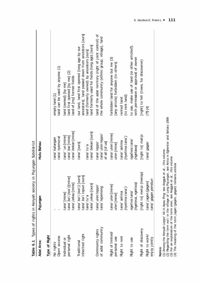
111S. Jacobus E. Frans L.
Tabl
e 6.
1 T
ypes
of
righ
ts i
n Ke
nyah
soc
iety
in
Puju
ngan
Sub
dist
rict
Adat
Are
a:Pu
jung
anH
ulu
Baha
u
Type
of
Righ
t
No
righ
ts-
tana
’ kal
anga
nem
pty
land
(1)
Ope
n ac
cess
-ta
na’ n
yem
urat
land
can
be
used
by
anyo
ne (
1)
Indi
vidu
al o
rta
na’ [
min
e]ta
na’ ‘
un [m
ine]
land
(ow
ned)
[by
me]
pers
onal
rig
htta
na’ b
a’i (
wa’
i)[m
ine]
tana
’ bai
[min
e]la
nd f
irst
ope
ned
[by
me]
(2)
tana
’ jek
au [m
ine]
tana
’ bek
an [m
ine]
land
of
[my]
for
mer
fie
lds
Trad
itio
nal
tana
’ ba
’i (
wa’
i) [
ours
]ta
na’
[our
s]ou
r la
nd,
land
fir
st o
pene
d (l
ong
ago
by o
urin
heri
ted
righ
tta
na’
ba’i
tep
un [
ours
]an
cest
ors)
; la
nd p
asse
d do
wn
from
anc
esto
rs [
ours
]ta
na’ t
u’a
tana
’ tu’
ala
nd (
form
erly
ow
ned)
by
ance
stor
s [o
urs]
tana
’ je
kau
[our
s]ta
na’
beka
n [o
urs]
land
for
mer
ly u
sed
for
fiel
ds (
long
ago
) [o
urs]
Com
mun
ity
righ
tsta
na’ u
len
lepp
o’ta
na’ l
eppo
’la
nd o
f th
e ad
at t
erri
tory
(ri
ght
of j
oint
con
trol
) of
of a
dat
com
mun
ity
tana
’ lep
emon
gta
na’
ulen
lepp
o’th
e w
hole
com
mun
ity
(eth
nic
grou
p, v
illag
e),
land
of a
ll [o
f us
]
Righ
t of
lim
ited
/ta
na’ u
len
[min
e]ta
na’ u
len
[min
e]fo
rbid
den
land
for
any
one
but
me
(3)
pers
onal
use
ulen
[m
ine]
ulen
[m
ine]
(any
art
icle
) fo
rbid
den
(to
othe
rs)
Righ
t to
ren
tta
na’
seli
ma
tana
’ se
lim
are
nted
lan
d(n
yeli
ma
tana
’)(n
yeli
ma
tana
’)(t
o re
nt l
and)
Righ
t to
use
ngel
iva
tana
’ng
aliw
a ta
na’
to u
se,
mak
e us
e of
lan
d (o
r ot
her
arti
cles
?),
(nge
leva
, nge
liw
a)(n
gela
wa)
wit
h pe
rmis
sion
or
appr
oval
of
owne
r
Righ
t of
dis
cove
ry[r
ight
to]
met
ip (
met
ep)
[rig
ht t
o] m
atip
[rig
ht]
to f
ell
(tre
es,
for
disc
over
er)
Righ
t to
wor
k/ta
na’ j
agen
(gag
en)
tana
’ gag
an(?
?) (4
)en
joy
join
tly
ta
na’
gaga
n pe
mbu
n
Not
es:
(1)
Amon
g th
e Ke
nyah
Lep
po’
Ké i
n Ap
au P
ing;
see
Ang
guk
et a
l.,
this
vol
ume
(2)
Rega
rdin
g th
e te
rm w
a’i
in t
he v
illag
e of
Lon
g Pu
jung
an,
see
Anit
a in
Egh
ente
r an
d Se
llato
199
9(3
) Fo
r an
exp
lana
tion
of
the
term
ule
n, s
ee A
nggu
k et
al.
, th
is v
olum
e(4
) Th
e m
eani
ng o
f th
e te
rm j
agan
(ga
gen,
gag
an)
rem
ains
unc
lear
06 May28.p65 6/11/03, 11:59 AM111
Black

112 TRADITIONAL PROPERTY RIGHTS OVER LAND
after another, according to need, ever since ancestral times and from generation togeneration (see Njau Anau’s and Liman Lawai’s contributions to this volume) (Table 6.1).
In addition to having to open new forest to meet their need for agricultural landthrough a recycling system, they occasionally exchanged land with, borrowed landfrom, and/or lent land to the citizens of other Kenyah groups. For example, the KenyahLeppo’ Ké in Apau Ping borrowed or exchanged the use of land with the Kenyah Leppo’Ma’ut at Long Berini (see Njau Anau in this volume); or the Kenyah Uma’ Lasan borrowedor exchanged land use with the Kenyah Uma’ Alim. In this way, this habitual customdeveloped and was handed down through the generations, especially among those wholived in nearby areas or who had social or kinship relations.
Over time, these activities of borrowing to use or exchanging use became customary,and one side might even voluntarily offer its ulen as fields to be worked by anotherparty, as described above. For example, the ulen leppo’ that the Kenyah Leppo’ Ma’utabandoned in Apau Ping when they moved was subsequently and is today occupied by theKenyah Leppo’ Ké and the Saben (or Berau). This legal event, in fact, was recognised bythe Leppo’ Ma’ut who today live at Long Alango, Long Kemuat, and Long Berini. Theseactivities are approved by the traditional law of the Kenyah ethnic group in the subdistrictof Pujungan, both in the adat area of Hulu Bahau and in the adat area of Long Pujungan.In line with agreements concluded, for example, after the forest was opened, it wasworked over generations and planted with crops to meet daily needs, based on thecondition of the land and in accordance to a system of recycling.
In the same way, the ulen leppo’ of a Kenyah ethnic group that, for some reason,migrated to another area could be surrendered to a related or neighbouring Kenyahgroup on the basis of a joint agreement. Through other means of land acquisition,such as exchange, various types of rights held by one party developed (even thoughactual land sale seldom occurred).
In line with the legal theories advanced above, both according to adat law andaccording to the Indonesian national laws that regulate land matters, specifically the1960 Basic Agrarian Law, the ownership of land by the Kenyah ethnic group in thesubdistrict of Pujungan is well founded. This is in line with the legal theory advancedby Iman Sudiyat (1982: 9), which states that the right to own land can be obtained by:‘1) opening land/jungle; 2) inheriting land; 3) acquiring land because of purchase,trade, or as a gift; 4) expiration (verjaring).’ This theory can be demonstrated inArticle 4 of Law No. 5 of 1960, in combination with Article 2, as suggested byParlindungan (1991: 38): ‘4) the state’s right to control can be delegated to autonomousareas and adat societies as long as it is necessary and not in conflict with the nationalinterest according to the stipulations of Government Regulations.’
In the meantime, with regard to rights obtained according to traditional law (hakulayat), Parlindungan also states (1991: 45): ‘The article by article elucidation of theUUPA notes that the right to open land and the right to use forest products are rightsoriginating in traditional (adat) law. For this reason, the UUPA applies nationwide andthe adat law only applies within the various adat environments and must be controlledby government regulations, so that the regulation in Article 46 can apply nationallyand so that every Indonesian citizen, without discrimination as to sex, region, originalcitizenship, or descent, can open land and use forest products, with protection givento weak economic groups (Article 1 of UUPA) and preserving the hak ulayat (traditionalland rights) of the adat societies.’
This analysis does not conflict with observations on the history of the Kenyah inthe subdistrict of Pujungan, which consists of two adat areas, the Hulu Bahau area
06 May28.p65 6/11/03, 11:59 AM112
Black

113S. Jacobus E. Frans L.
and the Long Pujungan area, as illustrated through the lepu’un (former settlementsites) or even through sites left by earlier generations, because, as the UUPA states,the authority that they hold is obtained from the state (Hak Ulayat Negara). For thisreason and on the basis of the above-mentioned facts, various types of land ownershiprights have developed among the Kenyah, in both the Hulu Bahau and the Long Pujunganadat areas.
GENERAL CONCLUSIONIf we look only briefly at the Kenyah societies found in those two adat areas, LongPujungan and Hulu Bahau, which include a total of nine ethnic groups who lived asneighbours and even mixed with other Dayak groups, it is, in fact, rather difficult todetermine the relationships to the land that these societies have controlled until today.
The Kenyah are an Adat SocietyAccording to research results discussed earlier, both based on direct personal obser-vation and on information or explanations obtained from informants and a number ofrespondents, matters relating to control and ownership of land are based on thetraditional or adat law of the Kenyah in the subdistrict of Pujungan. In line with thestatement ubi jus ubi societas (where there is law, there is a society), it becomesclear that the Kenyah are a society based on traditional law.
The truth of this statement can be demonstrated. It is shown in the social life ofthe Kenyah, where adat law still occupies the highest place in dealing with socialconflicts among the people and even with other people outside their own adat legalunit. Therefore, traditional rights of land ownership among the Kenyah certainly werein existence long before Law No. 5 of 1960 on Basic Agrarian Regulations (UUPA).
Nevertheless, in the meantime, people are mistaken in contrasting the adat lawwith laws based on the teachings of the Protestant church followed by the majority ofthe Kenyah. Yet, if faced with a conflict or dispute over land, or with some other civilconflict, the Kenyah will settle it through consultation of the adat leaders. Examplesare the conference of the adat leaders on 10 November 1991 between the KenyahUma’ Long and the Kenyah Leppo’ Ndang (or Ntang) who lived at Long Uli, and theKenyah Badeng, held at Long Peliran; or the conference of the Adat Court on 2 November1991 regarding the delinquency of elementary school students suspected of stealingsugarcane from their teacher, which was held in Apau Ping.
With this exception, in the application of adat sanctions, they are familiar withthe exchange value of objects as fines, including gongs, ceramics, or large jars, matsfor drying rice, beads, plaited floor mats, ba’ing (a type of sword), obo ba’ing (anunused machete), and domestic animals such as chickens and pigs. Additional evidenceis found in the decision of the adat conference held between adat notables, civilservants, and the people of Long Alango in the adat area of Hulu Bahau on 5 May 1987.
Land as a Source of LivelihoodLand is a valuable possession. Not only is its significance inseparable from the life ofthe Kenyah ethnic group, but for generations it has definitely had strategic and vitalsignificance for them. The life and death of Kenyah communities is heavily dependenton their land use policies. How could it be otherwise, since the Kenyah’s primary and
06 May28.p65 6/11/03, 11:59 AM113
Black

114 TRADITIONAL PROPERTY RIGHTS OVER LAND
most important sources of livelihood are farming, hunting, fishing, and gatheringforest products. The cultivation of land generally is still done in a traditional manner.This applies to both farming patterns as well as the management and conservation ofland. Although a small number of people are attempting to apply new agriculturaltechnology with a simple form and modest absorptive capacity, they are not yet ableto influence the traditional methods of the majority.
Traditional planting patterns, land management, and crop care not only requirelabour and time but also relatively extensive field surfaces. For example, whereas inflat land at the edge of rivers, which contain humus and mud deposits from flooding,the fields are rather small, in highlands or hilly areas, which represent the generalsituation along the Bahau River and its tributaries, dry (swidden) fields are generallymuch larger.
Limited land availability—in view of land use needs and population growth withits steadily growing requirements—tends to push the Kenyah of a given village to opennew lands, while control over lands owned through the generations has been decreasing.In the meantime, river traffic has gradually reached almost all Kenyah settlements.The opening of communication lines has gradually opened their areas to outsiders,bringing those outsiders increasingly close to their settlements. The coming of theseoutsiders, either as individuals or in groups, will nevertheless bring about another setof problems for the Kenyah in the subdistrict of Pujungan.
The Problem of Written EvidenceThe reasons for establishing or developing ulen, either as ulen leppo’ or as individuallyowned ulen, based on adat law, left the individual rights that developed without writtenevidence. The Kenyah have never known written evidence. In Indonesia, documentaryevidence or formal legal transcripts of land rights only became known during the colo-nial period, and concerned particularly lands granted under Western law, or earlier, bykings during the feudal age or by the autonomous regional governments (sultanates).Only in recent times have they followed the 1960 Basic Agrarian Law (UUPA).
Yet, control and ownership of land based on adat law existed long before all theseregulations or rules came into effect. This is often insufficiently realised by the localcommunities, because their settlements are isolated, transportation is difficult, andthey can neither read nor write. All these are obstacles that from the beginning, sincethe arrival of the Kenyah in the subdistrict of Pujungan, have prevented them fromowning certificates as written proof of their control over land.
Expected DevelopmentsA feeling of unease or anxiety haunts or unsettles all Kenyah citizens, both those whostill live around the ulen leppo’ of their early settlements and those who, for whateverreason or in whatever pursuit, have moved to urban areas. They are haunted by thethreat of loss and disappearance of their traditional lands, which they have held forgenerations, especially since efforts have been made by certain parties to obtaincontrol over these adat lands, both those that are ulen in the broad sense and the ulenin the narrow sense of the term, by using the theory of domeinverklaring from Dutchcolonial times. There is, then, a need for the Kenyah to prove their ownership (acontrario evidence). If they are unable to do this, the land in question is state land.
06 May28.p65 6/11/03, 11:59 AM114
Black

115S. Jacobus E. Frans L.
Even though these fears are reasonable for the Kenyah in the subdistrict ofPujungan, they are unnecessary if the parties in question are in fact well-intentioned,that is, if they sincerely mean to develop the area for the sake of progress of thenation and its people, on the basis of existing laws and regulations. Article 33 of theConstitution of 1945, the 1960 Basic Agrarian Law (UUPA), Law No. 5 of 1979,Presidential Instruction No. 9 of 1973 (which establishes the meaning of the PublicInterest), as well as other regulations and laws have provided guarantees of the principlesof equalisation and justice.
For this reason, as among other people in East Kalimantan, a growing sense ofjustice based on the implementation of development to raise the standard of living ofthe entire society in line with the goals of the Proclamation of Independence on 17August 1945, forms the basis for the hope and the expectations of all Kenyah people inthe district of Bulungan, and specifically those in the subdistrict of Pujungan.
ADDENDUM 2002
By Cristina EghenterAs noted in the Introduction, the new law (Law No. 22 of 1999) on regional autonomyand decentralisation came into effect in Indonesia. The law accommodates the aspi-rations of provinces, regencies, and districts for more autonomy and more controlover budget and resources. It also sanctions a change away from the old centralisticsystem of the government towards more administrative and financial federalism.
This law institutes some major changes in the structure and authority of thegovernment, including the status of pemerintahan desa, or village government, whichis now gaining greater autonomy and decision-making power. Under the new system,the village head is elected by the people by a majority vote, established formally bythe new Village Legislative Assembly (Badan Perwakilan Desa), and acknowledged bythe district head. As a result of these changes, the old law on village government (LawNo. 5 of 1979) is annulled. The protection and respect of adat-istiadat, or customarylaws and traditions, becomes the prerogative of the Village Legislative Assembly.
More importantly, the regencies now have full legislative power on a variety ofmatters and issue decrees (Peraturan Daerah), including on the role of customary law.In 2001, the District of Malinau, which includes the subdistrict of Pujungan, passed alaw on the ‘Empowerment, protection, and development of customary law and customarycouncils.’
Although the legal and social environment in Indonesia has changed, the discussionby Jacobus Frans remains relevant, particularly in connection with the function andimportance of customary institutions in traditional Kenyah society.
06 May28.p65 6/11/03, 11:59 AM115
Black

7.Patterns of traditional landcontrol among three Kenyahgroups
Angguk Lamis, Paulus Bunde and Concordius Kanyan
INTRODUCTIONThe traditional utilisation of land and natural resources is an expression of the deeprelationship between humans and their environment. This relationship also determinesthe form of control over or ownership of land by individuals as well as by groups.
In 1991, preliminary research was carried out in the subdistrict of Pujungan byJacobus Frans (previous chapter). Jacobus’ research included all the Kenyah groups inthis subdistrict and focused primarily on judicial aspects of adat law and their positionas seen from the point of view of national law. He demonstrated that the Kenyah ofthe subdistrict of Pujungan form adat communities, that is, communities that are stillfully regulated by local traditional law.
Later, in 1993, the present three writers carried out follow-up research over threemonths among three different Kenyah subgroups. Paulus Bunde stayed in the village ofLong Apan Baru (in the adat area of Pujungan), whose inhabitants are Kenyah Bakung.Concordius Kanyan stayed in the compound village of Apau Ping with a populationconsisting mainly of Kenyah Leppo’ Ké, and Angguk Lamis stayed in the village of LongAlango, whose inhabitants are Kenyah Leppo’ Ma’ut. (The last two villages are locatedin the adat area of the Hulu Bahau.) The three writers’ research focused on practicalaspects and the implementation of adat law in daily life, especially with regard torights over land and natural resources and to patterns of land control and the processof land transfer.
07 May28.p65 6/11/03, 10:59 AM117
Black

118 PATTERNS OF TRADITIONAL LAND CONTROL AMONG THREE KENYAH GROUPS
Even though there is some degree of divergence in the special attention given toparticular problems relating to adat law in the different villages, this three-part chapterinvites comparison of similarities and differences between the three ethnic groups studied.
PATTERNS OF LAND CONTROL AMONG THE KENYAH BAKUNGThis part aims at describing and determining the land rights and the patterns of landcontrol among the Kenyah Bakung in the village of Long Apan Baru (also known as LongAran). The traditional village (leppo’) consisted of several longhouses (uma’). Thesocial structure of the Bakung formerly recognised three classes: the paren (nobility),the panyen (ordinary people), and the salut or kula’ (slaves). Today only the first twogroups are still known. Even though this social structure has increasingly faded away,these social categories still are considered in the election of the village chief and ofadat leaders. This structure also continues to play a role when the people providevolunteer labour to open a rice field for the village chief. (This event is known asmabe.) The research data were collected through interviews with each head of familywho played a role in land management activities.
Position and Function of Adat InstitutionsThe Bakung are familiar with several levels of institutional adat leadership: the kepalaadat bio’ (great adat chief), tua leppo’ (traditional village chief or village head),pengelata’ (adat elders or social leaders), and pegawa’ (lower adat leaders). Theseadat functionaries have authority over their respective adat law areas in accordancewith their position.
The village of Long Apan Baru is part of the adat area of Pujungan, which isheaded by a kepala adat bio’ (from the Kenyah Uma’ Alim) residing in Long Pujungan.It includes twelve villages (desa). The village of Long Apan Baru is headed by a tua’leppo’ (village head) serving as leader and arbiter in dealing with the various problemsencountered within the leppo’ area. Formerly the tua’ leppo’ (also known as parenleppo’; see Ngindra in Eghenter and Sellato 1999) were the highest local nobility andconsidered the owners of the leppo’ territory and of its people (panyen). Today theposition of the tua’ leppo’ parallels that of the village chief, and thus it is normal thatin the selection of the village chief the people always choose a member of the parengroup. Traditionally, the tua’ leppo’ in fact was not an adat leader and, in settlingproblems within his territory, he was assisted by several pengelata’ believed to beknowledgeable in adat matters and influential among the people. Even thoughlonghouses no longer exist, the uma’ continues to be a social unit lead by a tua’ uma’(longhouse head) or a paren uma’ (longhouse noble). Long Apan Baru village is thusdivided into three uma’, which today tend to be referred to as blok, or ‘block’, whilethe tua’ uma’ tends to be known as ketua blok, or block chief.
In the earlier society the pegawa’ performed an important function in dealing withdisputes at the uma’ level, endeavouring to settle them internally. Because the problemsfaced today are increasingly complex, it is very difficult to find influential people whoare respected and capable of taking appropriate action. As a result, the duties of thepegawa’ have shifted to the tua’ uma’. In addition, there is also a pelawa’, an assistantto the village chief, who delivers various announcements to the public.
So far the settlement of disputes relating to adat matters still follows the oldprocedures. In the early stages of settling a problem affecting the village, the pegawa’
07 May28.p65 6/11/03, 10:59 AM118
Black

119Angguk Lamis, Paulus Bunde and Concordius Kanyan
(nowadays the tua’ uma’) attempts to solve it within the uma’ or block. Only if thisproves impossible is the problem passed on to the village chief (tua’ leppo’), who isassisted by the pengelata’ as legal advisor. If it still cannot be settled, the problem ispassed on to the level of the kepala adat bio’. Similarly, the selection of the villagechief does not entirely adhere to the regulations of Law No. 5 of 1979, particularlywith regard to the criteria for the village chief’s position, because the people stillfollow adat regulations.
Even though settlement patterns have already changed from longhouses toindividual family houses, adat institutions still continue to function, showing thatnational law need not be applied as long as adat settlements are considered adequatefor solving problems. In rural areas still far from easy communications andtransportation, adat institutions and adat leaders still play a very important role increating and perpetuating a sense of security and order, and even a sense of justiceamong the people.
Land Rights in Land UsageIn using land, especially agricultural land, the Bakung people generally tend to re-useformer fields that they own themselves (right of ownership). Occasionally, they alsocan borrow lands belonging to others (right of use). Other types of land rights do notexist among the Bakung.
Right of OwnershipArticle 20 of the Basic Agrarian Law (No. 5 of 1960, or UUPA) states that the right ofownership is a right that is passed down through the generations, and is the strongestand most comprehensive right that anyone may have over land. In line with this, theBakung of Long Apan Baru use and own land according to adat, and their lands havebeen farmed for generations. They live off traditional shifting (swidden) agriculture,combined with hunting and gathering. The process of land ownership among the Bakungis very simple. Anyone who opens forest land and establishes a field on this land holdsthe rights to that land. Former fields that have reverted to forest (jekau) remain theproperty of the family that first opened those lands—or their descendants—and thisright is recognised by other members of the community. Thus, as many as 85% of the47 heads of farming families in Long Apan Baru each own between 6 and 20 plots ofjekau land (see Bunde 1995). Proof of ownership often consists of the fruit treesplanted along the boundaries of the fields.
The territory of the village of Long Apan Baru actually used to belong to theKenyah Uma’ Alim, who were its early inhabitants. The Uma’ Alim were followed by theKenyah Oma’ Long. After these two groups had migrated elsewhere, the area wasoccupied by the Kenyah Bakung, who are still settled there today. The transfer of therights to the territory to the Bakung did not present a problem because it was handledby the kepala adat bio’ of the adat area of Pujungan. Ownership rights on formerfields are annulled if the owner moves to another area and no descendant remains toinherit the lands. In practice, then, the abandoned land becomes land owned by theadat community. The Bakung have lived in the village of Long Apan Baru for thirtyyears, and so far not one member of the Uma’ Alim or the Oma’ Long, who onceoccupied the area made a claim to the lands they abandoned.
07 May28.p65 6/11/03, 10:59 AM119
Black

120 PATTERNS OF TRADITIONAL LAND CONTROL AMONG THREE KENYAH GROUPS
Because the village territory is rather extensive, every farmer can select the typeof land he wants for farming (see Table 7.1). In general, the use of secondary forest(jekau) dominates over the opening of primary forest (mba’) and the use of brushland (bekan). Jekau land is considered easier to work, because its trees are ratherthin (with an average diameter of 10–30cm) and not too dense, while its undergrowthis not too thick. The predominant use of jekau also is due in large part to the strategiclocation of the fields in valleys (leka’), on plateaus (apau), or at river confluences(long), which all had once been farmed by the Uma’ Alim when they lived there. TheBakung needed but to work the lands left by the Uma’ Alim.
Table 7.1 Type of land cleared for farming in Long Apan Baru (N=47 family heads)
Year mba’ % jekau % bekan % Not farming %
1984 5 10.64 40 85.11 0 0 2 4.251985 3 6.38 41 87.23 1 2.13 2 4.251986 8 17.02 37 78.72 1 2.13 1 2.131987 10 21.28 36 76.65 1 2.13 0 01988 13 27.66 31 65.97 3 6.38 0 01989 17 36.17 29 61.70 1 2.13 0 01990 8 17.02 33 70.21 5 10.64 1 2.131991 7 14.89 39 82.98 0 0 1 2.131992 9 19.15 36 76.60 2 4.25 0 01993 8 17.02 39 82.98 0 0 0 0
The opening of primary forest (mba’) was more significant in the years 1986–1989 because the people then began to use chainsaws for felling trees. They obtainedthese chainsaws with the income from their work as labourers in Sarawak, Malaysia.The area of primary forest opened every year is still relatively small, because in factthe felling remains difficult and very time- and labour-consuming, even though thesoil of the primary forest is rather fertile. Primary forest is usually opened only toenlarge the agricultural area around existing fields. In fact, beginning in 1990, landuse patterns reverted to the pre-1986 situation.
The use of brush land (bekan) for swidden fields has declined somewhat. In theBakung language, the term bekan refers to rice fields recently abandoned, in whichthe rice stalks are still visible. These fields are not very fertile for farming and, if theyare planted with rice, experience shows, the grass grows more thickly than the rice.The Kenyah generally use bekan land for planting secondary crops and describe thesefields as kelimeng (gardens).
Right of UseAmong the Bakung, the right of use is limited to borrowing and lending land withoutformal agreement regarding the division of the harvest. The right to rent is alsounknown, because extensive lands for farming are still available. Every farmer is freeto expand the land he works according to the labour force available in his family.
In establishing swidden fields (uma’), the Bakung place great importance ontogetherness and unity so that farmers of the same village join in groups at severalfarming locations. Farming in groups is also more effective for cooperative activities
07 May28.p65 6/11/03, 10:59 AM120
Black
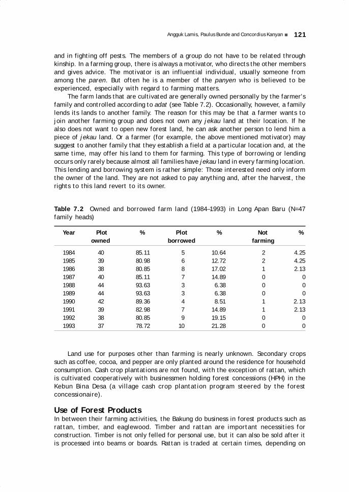
121Angguk Lamis, Paulus Bunde and Concordius Kanyan
and in fighting off pests. The members of a group do not have to be related throughkinship. In a farming group, there is always a motivator, who directs the other membersand gives advice. The motivator is an influential individual, usually someone fromamong the paren. But often he is a member of the panyen who is believed to beexperienced, especially with regard to farming matters.
The farm lands that are cultivated are generally owned personally by the farmer’sfamily and controlled according to adat (see Table 7.2). Occasionally, however, a familylends its lands to another family. The reason for this may be that a farmer wants tojoin another farming group and does not own any jekau land at their location. If healso does not want to open new forest land, he can ask another person to lend him apiece of jekau land. Or a farmer (for example, the above mentioned motivator) maysuggest to another family that they establish a field at a particular location and, at thesame time, may offer his land to them for farming. This type of borrowing or lendingoccurs only rarely because almost all families have jekau land in every farming location.This lending and borrowing system is rather simple: Those interested need only informthe owner of the land. They are not asked to pay anything and, after the harvest, therights to this land revert to its owner.
Table 7.2 Owned and borrowed farm land (1984–1993) in Long Apan Baru (N=47family heads)
Year Plot % Plot % Not % owned borrowed farming
1984 40 85.11 5 10.64 2 4.251985 39 80.98 6 12.72 2 4.251986 38 80.85 8 17.02 1 2.131987 40 85.11 7 14.89 0 01988 44 93.63 3 6.38 0 01989 44 93.63 3 6.38 0 01990 42 89.36 4 8.51 1 2.131991 39 82.98 7 14.89 1 2.131992 38 80.85 9 19.15 0 01993 37 78.72 10 21.28 0 0
Land use for purposes other than farming is nearly unknown. Secondary cropssuch as coffee, cocoa, and pepper are only planted around the residence for householdconsumption. Cash crop plantations are not found, with the exception of rattan, whichis cultivated cooperatively with businessmen holding forest concessions (HPH) in theKebun Bina Desa (a village cash crop plantation program steered by the forestconcessionaire).
Use of Forest ProductsIn between their farming activities, the Bakung do business in forest products such asrattan, timber, and eaglewood. Timber and rattan are important necessities forconstruction. Timber is not only felled for personal use, but it can also be sold after itis processed into beams or boards. Rattan is traded at certain times, depending on
07 May28.p65 6/11/03, 10:59 AM121
Black

122 PATTERNS OF TRADITIONAL LAND CONTROL AMONG THREE KENYAH GROUPS
the market price. In recent times, the price of rattan has tended to decline and, as aresult, the people have been reluctant to do business in rattan.
Eaglewood is a forest product gathered specifically for sale. In recent times, itsprices on the world market have tended to shoot up, causing a variety of problemsbetween the Bakung and outside collectors (see Blajan Konradus in this volume). Theseproblems, which continue to cause confrontation between local customary law (adat)and national law, are discussed below.
Within the Adat CommunityThe Bakung sell the eaglewood through cukong (or toké, usually Chinese traders andfinancial backers) who come to the area to gather it from collectors. This means thatthe difference between the village price and the true market price is rather marked.In practice, all economic activities of the Bakung are controlled through complexmarketing networks. The forest product management is regulated by traditionalcustomary law (adat), because it occurs within the territory of the community. Everyvillage has reserve lands that are referred to as village preserves and commonly knownas tana’ ulen, ‘prohibited lands.’ But the phrase tana’ ulen as it is used now in themodern context in the subdistrict, is not yet universal or standardised, and somepeople do not even understand its meaning.
Fundamentally, ulen is a prohibition that can be applied to certain things. Forexample, ulen for a particular tree means that this tree is marked with a sign ofprohibition known as atap, to prevent other people from cutting it down. The termulen can also be used for a site or area in which an important event has taken place,such as a murder, a war, or some other historical event, which makes it impossible touse the site. Some of the land of the village may also be marked as ulen and the forestproducts found in this ulen area can only be used for the common interest and may notbe exploited for personal interest. The social policies regarding the processing offorest products are contained in a decision of the LKMD (Lembaga KetahananMasyarakat Desa, Institute of Village Community Resilience) issued by the bupati(district head) of Bulungan.
The use of the term tana’ ulen of the village treasury (tanah kas desa), or landmeant to be exploited to fill the village treasury, is in fact based on a new concept.The people are still permitted to take timber, rattan, and other products in the villagetreasury land. Even more ironically, in Long Apan Baru, the tana’ ulen of the villagetreasury includes lands farmed by the people and which have not yet been fullysurrendered to the village. The people can still own and work these lands for their ownbenefit. The tana’ ulen concept here is intentionally adjusted to make possible thedesignation of these lands as intended for the village treasury.
Relations with OutsidersIn recent days, the people have been confronted with the choice of opening up to theoutside. They have to be prepared to take all the risks, especially because their sourceof livelihood and economy have come under pressure. The coming of companies holdingHPH (Hak Pengusahaan Hutan, or timber concession) in fact can bring good fortune tosome of the people, but those people who rely on traditional farming will certainlycome under pressure. In fact, village regulations have tried to anticipate the effectsof contact with the outside world. For example, the LKMD requires individuals orgroups doing business in timber, rattan, or eaglewood on the lands of the village ofLong Apan Baru to pay fees in the form of money for village development. Nevertheless,
07 May28.p65 6/11/03, 10:59 AM122
Black

123Angguk Lamis, Paulus Bunde and Concordius Kanyan
the funds that can be so netted are usually limited and originate from the local peoplethemselves, and often this only benefits the cukong.
A number of cases demonstrate this. For example, the village of Long Apan Barucontains a 10 ha rattan plantation, managed by the local people together with a forestconcession holder, PT Dana Mulia Bakti. The management of this plantation is hamperedbecause the funds that are spent are not consistent with the agreed-upon rules. Initially,the funds agreed on totalled Rp. 10 million, but, in fact, only Rp. 2 million were spent,only enough for providing seedlings, cleaning the fields, and several plantings. Becauseof this, the rattan plantation was eventually abandoned by the people and the enterprisecame to a halt because the company did not issue the remaining funds due.
Field observation leads to the conclusion that the failure of this rattan plantationbusiness was primarily caused by inadequate coordination between the village chief,the relevant government authorities, and the timber concessionaire, culminating infailure to issue the remaining funds. Secondly, the rattan plantation that was alreadyestablished was neglected and is no longer cared for because the people are not informedor aware of the importance of this plantation. And no extension worker has beenmade available to assist the people in their attempt at cash crop plantation.
The local people also fell timber, which is sold to interested cukong. Timber isfelled by the riverside with simple technology. The price reaches Rp 30 000 per m³.The cukong collect the timber from the people, float the trunks down the Bahau River,and gather them at Long Bia and Long Peso’. It appears that this unregulated exploitationof timber does not evade the grip of timber mafias, which disregard the law in orderto procure a higher profit.
ConclusionsThe above discussion permits several conclusions. (1) Control of land among theBakung is always based on adat law. Land may be owned by individuals, or adatcommunities and institutions that play a functional role in the protection of society.(2) In the traditional social structure of the Bakung, the paren had the primary rightto land within the territory of the leppo’, while the panyen had the right to work theland. (3) There are strong indications that the Bakung have a tolerance for patternsof land control that are governed by the adat community (pewatasan or ulen). Thecommunity rights (besikkingrecht), governing land control and use, limit individualrights. (4) At present, the right of the leppo’ to exploit its territory is the same asthe hak ulayat (or traditional land rights), while holders of ownership rights overland are individual members of the community. (5) The process of transferringinherited lands is always based on a feeling of togetherness, of being part of thesame ethnic group, and always focuses on the majority’s best interests in benefitingfrom a given territory. The process of land ownership, however, certainly alwaysfocuses on traditional evidence, such as the planting of one or two trees in an areaonce worked or farmed. (6) The use of forest products is limited to certaincommodities and is temporary in nature, and still carried out in a traditional manneror with simple technology. (7) In settling disputes, the people not only continue toadhere to traditional customary regulations, but they also make decisions jointly,together with the village chief and notables. The decision is then put into writing ina ‘decree’ of the LKMD (Lembaga Ketahanan Masyarakat Desa) in order to regulatethe use of forest resources.
07 May28.p65 6/11/03, 10:59 AM123
Black
124 PATTERNS OF TRADITIONAL LAND CONTROL AMONG THREE KENYAH GROUPS
PATTERNS OF LAND CONTROL AMONG THE KENYAH LEPPO’ KÉThis part attempts to discuss the manner in which the Kenyah Leppo’ Ké of Apau Pingdefine and confirm their land rights. The village of Apau Ping is a compound villageconsisting of four desa, the product of a resettlement scheme. It is located on the farupper reaches of the Bahau River. Three of the four desa are occupied by KenyahLeppo’ Ké (see Njau Anau in this volume), while the fourth is inhabited by a fewremaining families of a group of Saben that has moved to Sarawak.
The residential arrangement today does not indicate clear boundaries betweenthe desa, and these boundaries are not considered problematic by the villagers, eventhough they have been drawn administratively. Reinforced by intermarriages betweenthe two ethnic groups, a gradual integration of culture and traditional customs hasoccurred. Many aspects of life, including farming patterns, indicate that the Sabenhave voluntarily and fully submitted to the adat law of the Leppo’ Ké. The village ofApau Ping is part of the adat area of the upper Bahau.
Even though Apau Ping is difficult to reach from the coastal region, its inhabitantsare not excessively isolated and are able to receive news from the outside world.Among other things, Apau Ping is a transit area for people travelling to Sarawak, andthus it is not surprising that its inhabitants are more familiar with cities in Sarawak(the town of Miri, for example) than with the towns of coastal East Kalimantan.
The data were gathered through interviews with well-known figures among theLeppo’ Ké, and by disseminating a questionnaire to several heads of families, followedby more in-depth interviews (case studies).
The Position of Adat LawTies to ancestral customs, traditions, and culture are no longer very conspicuous ineveryday life in Apau Ping. Yet, a very close relationship to land and surviving traditionalbeliefs appear when the people are about to work their land. They hold a short ceremonyor prayer, as a request for advice or protection, as well as for blessings and abundancefor their fields. This is a transformation from the melaki ritual (see Herculanus BahariSindju in this volume), which was usually held by the people before they converted toChristianity.
At present, the Leppo’ Ké live in individual houses, rather than their formerlonghouses (uma’ dado’). This reflects a change in their values. The communal valuescharacteristic of a traditional, or adat, society persist, while individualistic valuesbegin to be accepted. Formerly, the primary rights among the Leppo’ Ké were held bythe village (leppo’) community, led by the paren or nobility, who played a very importantrole in the control over land rights.
The work in the fields was carried out by turns according to the system ofcooperation in groups that is known as senguyun (see Herculanus Bahari Sindju in thisvolume). The membership of the senguyun nugan group (for planting purposes) wasfixed since ancestral times, and may have served as the community’s means of recordingin memory the location of former fields. In fact, there is a general agreement on landrights, and people work their fields without challenges from the rights of others.Except in planting, the composition of the senguyun group changes every year.
The church as a social organisation is now considered as the protector oftogetherness, community, and harmony among congregations. The church is also givenpriority in the use of lands for the interest of the congregation. Thus there areregulations regarding the existence of church fields and church land. In addition, the
07 May28.p65 6/11/03, 10:59 AM124
Black
125Angguk Lamis, Paulus Bunde and Concordius Kanyan
church is given a chance to use forest products from certain areas around the village.The existence of an elementary school and a public health centre (Puskesmas) in ApauPing also plays a role in changing the way of life of the traditional society.
The traditions and customs adhered to by the Leppo’ Ké not only contain sacredvalues, as reflected in the melaki ceremony, but they are also legal in nature andcontain legal principles in the form of laws, prohibitions, and duties. The existence oflegal rules within the adat provides the people with rights to prohibit access to orclaim (mulen) something that is considered valuable, such as land, rivers, trees, andso on. In other words, mulen is a particular act with legal implications on the part ofand for the Kenyah Leppo’ Ké. It consists of placing a marker or sign on fields orobjects that are to be prohibited to others.
No official process involving other villagers occurs in claiming, or mulen, aparticular item, such as a tree; no announcement or other official statement ismade. The sign or mark, however, is proof that the ownership of that tree must berespected and recognised by everyone. Something may be claimed or mulen (orbecome someone’s ulen), as long as it has not yet been previously claimed as ulenby someone else. Violations of ulen trees by others are settled on the basis oftraditional legal rules. These ownership patterns are effectively implemented by thepeople of Apau Ping.
Rights to Agricultural LandsThe Leppo’ Ké have a very long history in Apau Ping, and land is truly important forthem as a place to live, to farm, bury their dead, and so on. Everything that is on theland can contribute to the livelihood of every member of society who needs it. Land issacred in nature, and the people believe that there is a power that occupies the landand can protect or damage it. The social, religious, and legal aspects that are inherentin the society’s relationship with the land form the primary basis for controlling land.
The migration of social groups and their ways of life in meeting their daily needsare historical proof of the existence of close relationships between a society and thenatural resources that provide their livelihood. For example, it is recognised that theindividual who first opened primary forest (mba’) retains the right to the fields. Thisright is only that of the primary user, while the holder of the highest right is the leppo’(as a social institution), and the rights of the leppo’ among the Leppo’ Ké is controlledby the paren who leads the leppo’ in question.
Land Ownership RightsThe system of shifting agriculture is a traditional form of control over land. After theinhabitants had been resettled in Apau Ping, population pressure gradually led to problemswith regard to land ownership. Fields had only been made around the settlement (withthe most distant no more than a two-hour walk away) and the land available for fieldsgrowing increasingly scarce. Residents who had settled there earlier, in 1963 (theoriginal village of Apau Ping), gradually began to feel enclosed because the threevillages that joined later (1988), i.e., Long Pengayan, Long Lat, and Long Tua, had tofarm within the area of the village of Apau Ping, while they continued to claim therights to their original territories. These conditions presented opportunities forcompetition over land rights among residents, no longer among social groups (leppo’or desa). The shift of land rights from leppo’ to individuals or families is a clear shiftin values.
07 May28.p65 6/11/03, 10:59 AM125
Black

126 PATTERNS OF TRADITIONAL LAND CONTROL AMONG THREE KENYAH GROUPS
It was possible to interview 39 heads of families who, from memory, could pointout the locations, boundaries, and crops of every plot of land that they owned (seeTable 7.3). Variation in the number of plots is closely related to the preference andcapabilities of each farming family in using free lands (primary forest, mba’), whichgives the opener of the land the right of ownership. Yet in the period 1984–1993, nomore than three families each year opened new land in Apau Ping (see Kanyan 1995).
Table 7.3 Total number of farm land plots owned per family inApau Ping (N=39 families)
Number of plots Number of families % of all families
6–10 8 20.5111–15 9 23.0816–20 6 15.3921–25 8 20.5126–30 5 12.8231–35 1 2.5636–40 0 0.0041–45 2 5.13
Eight of the 39 heads of families (20.5%), who owned 6–10 plots of land fell intotwo groups: new families (newly settled in Apau Ping or newly independent marriedcouples); and families with a greater tendency to use land covered by young secondaryforest or brush land (jekau bu’et or bekan), because of a lack of available labour intheir families. In the second case, the land worked was always owned land, eitherpersonally owned or owned by others. Two heads of families (5.13%), who owned 41–45plots of land, were elderly paren who, as leaders, had long been helped by leppo’residents with work in opening fields in primary forest. Nevertheless, because landrights only take the form of right of use, even those who have many plots of land donot become landlords as is the case in Java, for example.
The system of farming in groups means that the status of land is not the mainfactor in owning land, since ownership tends to favour social aspects, as farming ingroups creates opportunities for borrowing the land of others villagers (see above onthe Bakung) on the condition that the land not be planted with perennials, such ascinnamon or coffee. Interviews with 45 families regarding their farming activities duringthe period 1984–1993 (see Table 7.4) show that, from 1984 to 1988, an average of 16%of all farming families chose to cultivate borrowed lands, because the groups from LongPengayan, Long Lat, and Long Tua had not yet joined Apau Ping. Beginning in 1989,however, as a result of the resettlement in Apau Ping and of population growth, populationdensity suddenly became high. Because of the general tendency to use jekau land ratherthan primary forest, this percentage increased sharply to 35% in 1993.
In 1993, as many as 68% of 41 respondents in Apau Ping established wet ricefields in addition to their dry rice fields. The rights to wet rice fields are more securethan those over dry fields. The people have also begun to plant and cultivate cinnamon(85% of 41 respondents; see Kanyan 1995), which is usually found wild in the forestand considered a forest product. If the cinnamon trees are cultivated and no longerconsidered a forest product, the rights to cinnamon fields are identical to the rights
07 May28.p65 6/11/03, 10:59 AM126
Black

127Angguk Lamis, Paulus Bunde and Concordius Kanyan
over wet-rice fields or coffee plantations, and are no longer subject to the regulationsregarding the harvesting of forest products (see below).
It should also be noted that, due to the switch from longhouses to individualhouses, new married couples tend to establish neolocal residence, to the effect thatthese new families take initiatives on their own in the use of land around the settlement.This is leading toward more individualistic patterns of land use.
Transfer of Land Ownership RightsLand rights in the Apau Ping area are generally acquired by opening plots that are stillfree, tana’ nyemurat. These lands can be used by anyone since, as yet, no one holdsany rights over them. They include lands covered by ‘primary’ forests that are in factvery old secondary forests—these lands were farmed by the Kenyah Leppo’ Ma’ut, whomoved elsewhere about one century ago. The same is true for tana’ kalangan, orempty lands which have never been farmed and are not yet covered by any rights ofownership. These lands are very extensive in the area and, as a result, large landareas are not yet owned or controlled by anyone and may be used by anyone. Mostfarmers, however, prefer to open land covered by young secondary forest rather thanprimary forest (see Herculanus Bahari Sindju in this volume).
When they are ready to open rice fields, farmers first go in groups to survey thearea that they will farm together, always keeping in mind the matter of the ownershipof the plots. This survey results in a map showing the land ownership in that area. Thefarmers then hold an informal meeting. If the prospective plot of land is not yetcovered by ownership rights, the farmer only needs to mention his intentions to otherfarmers. If the plot already has an owner, the farmer hoping to work it must determineif its owner is willing to lend it to him. On the other hand, the owner may also offer hisfields to others for farming.
A formal transfer of the right of use only occurs in connection with wet-rice fields,and the length of use is determined by agreement between the owner and the user.Such transfers take place when an owner is unable to protect, maintain, or cultivate afield himself and therefore asks another to do so. A potential user may also approach
Table 7.4 Owned and borrowed farm land (1984–1993) in Apau Ping(N=45 families)
Year Plot % Plot % Not % owned borrowed farming
1993 27 60.10 16 35.55 2 4.441992 32 71.11 12 26.66 1 2.221991 31 68.88 13 28.88 1 2.221990 29 64.44 14 31.11 2 4.441989 29 64.44 13 28.88 3 6.661988 34 75.55 5 11.11 6 13.331987 33 73.33 3 6.66 9 20.001986 26 57.77 10 22.22 9 20.001985 32 71.11 3 6.66 10 22.221984 24 53.33 8 17.77 13 28.88
07 May28.p65 6/11/03, 10:59 AM127
Black

128 PATTERNS OF TRADITIONAL LAND CONTROL AMONG THREE KENYAH GROUPS
the owner. This transfer does not involve any type of fee and the people do not knowrental rights or sharecropping.
Inheritance of ownership of dry farming lands is almost unknown, since the Leppo’Ké are relatively new settlers in Apau Ping (1963 and 1988). The area available forfarming is still adequate in light of the population’s ability to work it, and the farmerscan easily obtain land to work, either owned or borrowed. In the case of wet-ricefields, however, the transfer of rights through inheritance is prevalent. An informantfrom Long Pengayan village, for example, admits to inheriting land from his wife’sparents.
Intervillage relations have not become tense over land ownership because ofpopulation growth, since the residents of the three villages in fact belong to the sameethnic group and many are closely related. No formal process is required if a residentof Long Pengayan opens new fields in the Apau Ping area, as long as the ownershiprights of the farmer who originally opened the land are taken into account. In ApauPing, the same is true for the rather vague boundaries between desa. Similarly, villageresidence is not much of a problem for the members of a senguyun group. This workinstitution is formed only on the basis of good social relations among fellow villagersin daily life.
Tana’ Ulen and the Use of Forest ProductsThe concept of tana’ ulen, which is of great importance for traditional societies, hasundergone a shift in meaning, especially because of the boom in forest products(eaglewood) that has recently engulfed the interior of East Kalimantan and unsettledits people.
Tana’ UlenControl over land closely tied to the collective interests of the leppo’ of the KenyahLeppo’ Ké is referred to as tana’ ulen, from the word tana’ (land) and ulen (claim;mulen means ‘to prohibit access to or to claim’). The legal meaning of tana’ ulen isthat of a ‘land that is off-limits to other people’, and ‘other people’ here refers tothose who are not members of the family that controls or has claimed the land inquestion. Formerly, tana’ ulen developed for a variety of social and religious reasons.For example, as a reward to a member of the paren who had bravely fought in aninterethnic war, a piece of land was set aside for him. It had to be protected andrespected by every resident.
Basically, it is the leppo’ as a communal social unit that may claim or control land.According to the Leppo’ Ké’s traditional laws, the leppo’ is led by the paren (nobility),and thus it seems as if only the paren have the right to control the tana’ ulen. Yet, thetana’ ulen may be used by the common people (panyen) at certain times (except forpurposes of farming), such as ritual occasions and adat ceremonies, which are directlyrelated to the public interest of the people of the leppo’. These occasions are restrictedto members of the leppo’ itself, and require the permission of the head of the leppo’involved. Even though the leppo’ as a communal unit within the adat community hasthe right to control land, the use and ownership according to traditional law is anindividual or family matter.
Among the Leppo’ Ké, the territory of the leppo’ is today better known as thevillage territory (wilayah desa). The village head and his staff play a significant role in
07 May28.p65 6/11/03, 10:59 AM128
Black
129Angguk Lamis, Paulus Bunde and Concordius Kanyan
the changes occurring in traditional land ownership, which is now undergoing a shift injudicial values and functions. In line with the changes and shifts in cultural, social,and economic values, and the social changes of the traditional society into a villagesociety, the concept of tana’ ulen has also changed. It is no longer limited to certainareas controlled by the paren, but is based on the common interest of all members ofthe adat community (leppo’). At present, the tana’ ulen includes the entire villageterritory and has become the property of all villagers.
It is difficult to define the concept of tana’ ulen. The history and the purpose ofthe creation of tana’ ulen are different from those of the watas in West Kalimantan.Watas can be established for various reasons, but basically it is controlled by an adatcommunity in the public interest. Tana’ ulen, on the other hand, was initially controlledby one social group (paren) within an adat community (leppo’), primarily for theinterests of the paren themselves. In addition, tana’ ulen includes an overall idea ofconservation, while the concept of village territory in East Kalimantan tends to havean administrative emphasis to facilitate supervision of the use of natural resources.
The setting aside of land for the village treasury, a step suggested for everyvillage by the government, in fact is not conceptually identical with the tana’ ulen.The location of the village treasury lands is determined by the availability of naturalresources. While these lands as yet have not been claimed, they are located close tothe settlement, so that they can be put to optimal use by the members of the society.
Use of Forest ProductsThe Apau Ping area still has what may be described rich in natural resources. Forestproducts in general are used for consumption, except for cinnamon and eaglewood,which are beginning to form the basis for large-scale business enterprises. The businessin these two commodities even involves many outsiders, because their economic valueis high and their marketing channels are rather simple (see Blajan Konradus in thisvolume).
The regulation of the use of forest products among the people of Apau Pingthemselves has not given rise to any significant problems, because the lands of thefour desa within the Apau Ping area are only viewed as administrative boundaries setby the government. Nevertheless, residents of village A who are planning to gatherforest products on the lands of village B are expected to report to the village head orhis staff in village B. This reporting is not particularly formal and more in the natureof ‘letting him know.’ People from outside Apau Ping, on the other hand, who want togather forest products on the lands of village B must officially report to the villagechief or his staff in village B.
The regulations that become the basis for policy decisions regarding the use offorest products are always made in consultation by the four desa heads and localnotables in Apau Ping. The enforcement of these regulations, however, always ran intodifficulties because there were no personnel charged with the task of and responsibilityfor controlling the forest product collectors entering the area. The fees required fromoutside eaglewood collectors, that is, 10% of the income obtained, could not be leviedbecause outsiders tended to enter and leave the area without reporting to the villagechief. New rules, requiring the payment of an entry fee, were also ineffective.
Finally, regulations were made, entirely forbidding outsiders to search for eaglewoodin the areas protected by the community. Only local people could go straight into theforest, and only eaglewood dealers who purchased the produce directly from theselocal collectors were permitted to be present. Even though these regulations appear to
07 May28.p65 6/11/03, 10:59 AM129
Black

130 PATTERNS OF TRADITIONAL LAND CONTROL AMONG THREE KENYAH GROUPS
have the people’s full support, they are still difficult to enforce, because, among otherthings, each of the four village chiefs has autonomy in setting policies regarding theuse of forest products in his area, and the joint decision by the four village heads isoccasionally difficult to use as a reference or control for the decisions of each villagehead. Furthermore, there are complicating factors within the Apau Ping community;that is, leaders who themselves violate the rules for personal profit.
ConclusionFrom the above discussion of the system of shifting agriculture and land ownershippatterns, the following conclusions can be drawn: (1) A social group’s history in theregion that it controls can be demonstrated through its land-holding patterns. Thehistory of the Kenyah Leppo’ Ké is characterised by frequent changes of settlements,as shown by the existence of a number of former settlement sites (leppu’un; see NjauAnau in this volume). According to tradition, the people still retain their land rights informer areas. (2) When settled in one area, the people have always established fieldsaround their villages, and as long as they remain there they continue to control theirformer fields. (3) In the traditional social structure of the Kenyah Leppo’ Ké, theparen were the primary holders of land rights within the territory of the leppo’, whiletheir panyen only had the right to use or work the land. (4) As a result of the developmentand social changes that have recently flooded the society, the leppo’’s rights of controlhave been reduced to the same level as other traditional ownership rights. Landownership rights are held by individuals or families. (5) The first person to open aforest area not yet controlled by others holds the right of ownership to that land. (6)Control over land is more certain if that land is worked continuously as wet rice fieldsor planted with perennial crops. (7). The patterns of land ownership rights among theLeppo’ Ké have become more varied as the need for land became more varied and asthe land available for shifting agriculture became scarcer.
PATTERNS OF LAND CONTROL AMONG THE KENYAH LEPPO’ MA’UTThe village of Long Alango is located on the upper Bahau river. Its territory includesextensive and fertile lands that are very supportive of the people’s agriculturalactivities. The inhabitants of Long Alango include Kenyah Leppo’ Ma’ut and severalLeppo’ Ké families. Their source of livelihood generally includes dry land farming aswell as wet-rice farming. There are also several civil servants (elementary schoolteachers and paramedics) and a preacher. In addition to farming, the people alsocultivate gardens and hunt. The average educational level is elementary school. Mobilityis rather high, especially among the young people, who tend to go to Sarawak to workin companies and only return home at the end of the year to visit their families.
Village History and Territorial BordersLong Alango village, part of the Hulu Bahau adat area, is bordered upstream the BahauRiver by the village of Long Kemuat, and downstream by the village of Long Tebulo.The formation of the traditional territory of a leppo’ and its borders are the result ofthe historical development of the Leppo’ Ma’ut group and the migration of its people.Until now, the transfer of territory from one village to another, as well as disputes,have been settled according to traditional law. In 1991, however, the camat (head of
07 May28.p65 6/11/03, 10:59 AM130
Black
131Angguk Lamis, Paulus Bunde and Concordius Kanyan
the kecamatan, or subdistrict) of Pujungan ordered all villages to set definitive bordersto be reported to the subdistrict office.
Setting Borders with Long Tebulo VillageThe people of Long Tebulo village came from Long Lio’ village on the upper Ngiamriver (see Njau Anau in this volume). According to Apui Njuk, village head of LongTebulo, the Long Lio’ area is so isolated that it was difficult to meet daily needs forsalt, clothing, and tobacco. With permission of the great adat chief of the Hulu Bahau,Dan Awan, Apui Njuk and several others from Long Lio’ began to farm in the LongTebulo area, which still had extensive unused land areas. This action was welcomed bythe village chief of Long Alango and, in time, many more inhabitants of Long Lio’moved. By 1972, some of the inhabitants of Long Lio’ migrated to Long Loreh (in thedistrict of Malinau), while the remainder moved to Long Tebulo in 1973 on the suggestionof Dan Awan and Apui Njuk.
The great adat chief set the village boundaries at the Poton Loten River confluenceon the left bank of the Bahau and at the Lalut Sungan confluence on the right bank ofthe Bahau River. In line with the orders of the camat of Pujungan in 1991, the LongAlango village head invited the village head of Long Tebulo and his people to determinethe village borders. The meeting went smoothly and the people from Long Tebulobasically gave in on everything to the people of Long Alango. The results of the meetingonly reinforced the borders that had been determined long before.
Setting Borders with Long Kemuat VillageIn the 1940s, several residents of Long Kemuat began to open land in the Alango Riverarea, because the land around Long Kemuat was becoming increasingly insufficient.The great adat chief of the Hulu Bahau at that time (Apuy Njau) encouraged his peopleto establish wet rice in former dry rice fields near the Alango River, which has manytributaries that flow year round. Even though the wet-rice growing experiment succeededwell, the land was thought to be too far from Long Kemuat, and in 1948 the great adatchief and the village head of Long Kemuat village encouraged the people to movedownstream to Long Alango. Because extensive empty and fertile lands were available,a number of Long Kemuat villagers agreed to the move and in 1952 the village of LongAlango was established. People from Long Kemuat gradually moved to Long Alangountil the 1960s. Finally, only about seven heads of families had resisted the movefrom Long Kemuat, and the village of Long Kemuat could only could start to developagain after it received an influx of new inhabitants (1978) from Long Aking (Leppo’ Kéand Nyibun people; see Njau Anau in this book).
Traditionally, the border between Long Alango and Long Kemuat did not pose aproblem, because the two villages belonged to the same ethnic group. To follow theinstructions of the camat, however, the head of Long Alango (Ajang Apuy) invited thehead of Long Kemuat (Ingan Irang) and other notables to attend a meeting. Thismeeting set the boundary at the mouth of the Ilan River and the Oko’ Bun Stream,calling attention first of all to the borders of the land worked by the people of thevarious villages: 1) dry fields and wet-rice fields worked by the people of Long Kemuataround Long Ilan and Oko’ Bun Stream belonged to the people of Long Alango; 2) atpresent a large part of the people of Long Kemuat are newcomers from other ethnicgroups, not original settlers in Long Kemuat; 3) setting village borders at the Ilan
07 May28.p65 6/11/03, 10:59 AM131
Black

132 PATTERNS OF TRADITIONAL LAND CONTROL AMONG THREE KENYAH GROUPS
River does not restrict the farming activities of the people of Long Kemuat, eventhough their fields are located in the territory of Long Alango. This decision also tookinto account the responsibility of the parties in maintaining paths connecting the twovillages (located at Oko’ Bun Stream near the Apuy Njau air strip).
The village head of Long Kemuat, however, was not willing to sign this decision,because he considered the border at the Ilan River too close to the Long Kemuatsettlement. A second meeting was held in Long Kemuat; it was attended by the villageheads and the heads of the ‘block’ residential units of Long Alango, but it was unableto reach a decision. Only after Baya’ Apuy, the elder brother of the great adat chief atthe time this research was conducted and a member of the regional parliament of thekabupaten (district) of Bulungan, had explained the purpose of defining village bordersdid the participants of the meeting understand (although some continued to resist),and finally the village head and the notables from Long Kemuat signed the decisionthat was in line with the results of the earlier meeting at Long Alango.
Controlling Land RightsThe different land rights that are based on local tradition, including the ulen and thetana’ ulen and rights related to farming activities (dry fields, wet-rice fields, gardens/orchards, and home yard) are described in detail below. Ways of settling disputes overland rights at various levels in the adat structure are also described.
Private UlenAccording to the Leppo’ Ma’ut, mulen is control or ownership of a particular object.For example, if someone finds in the forest a tree carrying a bee hive, or a fruit treethat has not yet been touched by human hand, he can own that tree by cleaning theground around it and sticking a 2 m long piece of wood (known as cak) into the groundwith its central part split in such a way as to make possible the insertion of a woodtwig. The process of clearing the brush, cleaning, and sticking the cak into the groundis known as mulen. The term mulen includes the following ideas: 1) an object alreadyhas an owner; 2) the object may not be disturbed; 3) anyone who disturbs it accidentallyor intentionally, can be charged with an offence and punished; and 4) the article maybe used by others (for example, the fruit of the tree may be picked,) but this must bedone with the permission of the owner (see Figures 7.1 and 7.2).
The ownership of the tree is an example of private or personal ulen. The sameapplies to land. If someone opens land in the primary forest, after the harvest that landbecomes the ulen of the one who opened it. Others may work the land but they need thepermission of the one who first cleared the land. Nevertheless, in daily language, theowner does not need to say ‘This is my tana’ ulen,’ but only: ‘This is my land.’
Tana’ Ulen of Adat CommunitiesLand is basic capital for meeting the necessities of daily life—for opening fields,hunting, fishing, collecting rattan, gathering wood for construction, and collectingother forest products—both for own use and for sale. The ulen land of the adatcommunity of Long Alango has been in existence from the very beginning of the village,even since the people opened land for agriculture, and it expresses the direct andstrong connection between the village society and its land, as seen from both inside
07 May28.p65 6/11/03, 10:59 AM132
Black

133Angguk Lamis, Paulus Bunde and Concordius Kanyan
Figure 7.1 Mulen signs made by the Kenyah Leppo’ Ma’ut (by Bilung Njau)
Figure 7.2 Mulen signs made by the Kenyah Bakung (by Lukas Lahang)
07 May28.p65 6/11/03, 10:59 AM133
Black

134 PATTERNS OF TRADITIONAL LAND CONTROL AMONG THREE KENYAH GROUPS
and outside the village. In this way, the natural resources in the ulen land can onlybe used for the interests of the villagers. The ulen concept known in the Hulu Bahauadat area is identical to the traditional ownership rights known in various other adatcommunities throughout Indonesia.
After the establishment of Long Alango village, two ulen areas for the villagewere set aside: the tana’ ulen of the Nggeng River and the tana’ ulen of the PandeRiver. Both were owned by the great adat chief of the Hulu Bahau (residing in LongAlango), who intentionally claimed (memulen) them. The products of this tana’ ulen,particularly the animals hunted and fish from the rivers bordering them, can be usedby all people of the village, and not only for the interest of the adat chief and hisfamily alone. For example, if a family was unable to provide side dishes for itsfeasts or ceremonies by hunting around the village, they could be given permissionby the adat chief to hunt in the tana’ ulen. During the dry season, the adat chiefcould invite the people to fish together in the rivers within the ulen lands. Thepeople could not freely hunt or fish in the ulen lands without obtaining permission.The lands were closely guarded, and anyone trespassing was charged and had to paya fine in the form of a machete (bayeng). So, in the eyes of the people, the tana’ulen was also a place that kept available a supply of animals for hunting and of fishif they could no longer be found elsewhere.
Long ago, the adat chief declared the tana’ ulen on the Pande River open to thepeople for hunting and fishing, on the grounds that the area was located too close tothe village and game was no longer as plentiful as earlier. The meeting of the villageleaders and the people, led by the village head on 5 September 1993, determinedthat the tana’ ulen area on the Nggeng River, today the home of the WWF fieldstation, was no longer to be monitored, on the grounds that the area produced nosignificant products. People from the neighbouring village were permitted to farmin the Long Alango area with the permission of the village chief. Prior to 1992, otherpeople were allowed to enter the village area. These included eaglewood collectorsfrom outside the district, as long as they paid an entrance fee of Rp. 50 000 into thevillage coffers (see Blajan Konradus in this volume). It was soon realised that theiractions were very damaging to the village, since eaglewood collecting was a sideactivity for the villagers, carried out in the free time between their farming activities(before and after harvest). Finally, as of 1992, outsiders are no longer givenpermission.
Dry FieldsThe primary source of livelihood of the people is dry field farming and wet-ricecultivation. The dry field farming activities begin with a meeting of the farmers todiscuss potential field sites or (uma). Attention is given to soil fertility, and distancefrom the village. Once agreement has been reached, the farmers go in a group toview the location and delineate its borders with a path. On the following days, theybegin to clear the brush, both individually and in groups, taking turns (senguyun). Ifthe site is covered with large trees (mba’) or old (25–30 year-old) secondary forest(bekan mokon), the clearing activities are begun in May; if it is covered with youngforest (6–15 years, bekan lawan), they are begun in June. To facilitate pest control,the people tend to make the fields side by side (uma’ kelindung) rather than separately(uma’ tegen).
07 May28.p65 6/11/03, 10:59 AM134
Black

135Angguk Lamis, Paulus Bunde and Concordius Kanyan
If the fields are opened in primary forest (mba’), then they continue to belongto the one who opened them after the harvest, even if they are abandoned to revertto secondary forest. Anyone wanting to open lands once opened by someone elsemust ask permission from the first pioneer, who usually prefers that the fields areworked even if he cannot do it himself, since fields that remain fallow for longperiods become the hiding places of pests, particularly in the uma’ kelindung.
Wet Rice FieldsFor wet rice fields the people do not open forest, but also use former fields. Theirknowledge of wet-rice cultivation is said to have originated from Apuy Njau, whohad occasion to visit Java, Kuching in Sarawak, and often travelled to Long Peso’,where he observed wet-rice culture. From his experience, he taught the people howto grow wet rice on former dry fields on the Alango River. The seed he used had beenobtained in Long Peso’. Subsequently, local rice varieties were planted. Because thearea permits it, ditches were dug to channel water from springs in the hills forirrigation, and wet-rice cultivation expanded into the area around the Ait River,Apau Arai, and Long Arai. The borders between rice fields are the dikes made by therespective owners.
From that time until today, the methods of wet-rice cultivation have not changed.First, the people clear the land to be planted of brush, and at this time the ditchesand waterways are covered with stones and leaves. The dry cuttings are burned andwater is channelled through the ditches. Wet-rice planting is done individually orcooperatively (senguyun). At harvest time, the water channels are closed again. Thepeople also channel water from the field ditches with plastic pipes for householduses. Rice fields cannot be worked continuously. After 2–3 years, production willcertainly decline and a farmer will open a new rice field. This move is not too difficultbecause former dry fields are widely available for wet-rice growing. Large numbersof farmers still prefer dry field farming to wet-rice cultivation, even though the adatchief and the village head of Long Alango, who only cultivate wet rice, obtain twoabundant harvests a year.
Because wet rice fields are established on former dry fields, the farmers tend touse recently abandoned fields (bekan) that they own themselves. If a farmer plansto use a piece of bekan land belonging to someone else to grow wet rice, the adatstatus of that field is not very clear, because wet-rice cultivation is a relatively newphenomenon in Long Alango. It seems that the creator of the new wet rice field is ina stronger position. There is also a possibility for the plot of bekan land to simply begiven by its original owner to the creator of the wet rice field, not as a loan, but toown. Dikes between wet rice fields can still be seen clearly even though the fieldshave not been worked for several years. Generally, land rights to wet rice fields tendto be more certain and definite, either individually or by family, than rights over dryfields.
Gardens and YardsA garden (pola) is land that is planted with crops other than rice. In Long Alango,these activities have been side occupations carried out on the dikes between therice fields, in the yards of houses, and in former fields. Two types of crops areplanted, perennials and annual crops. Trees, for example, Lansium, rambutan, kapok,
07 May28.p65 6/11/03, 10:59 AM135
Black
136 PATTERNS OF TRADITIONAL LAND CONTROL AMONG THREE KENYAH GROUPS
terap (grown for its bark and fruit), coconuts, jackfruit, and tamarind are planteddispersed and mixed in relatively small numbers, and their owners do not take careof them. Perennials planted and cared for specially are cinnamon and coffee, but notall villagers grow them. A crop planted specially is cassava, in former fields after theharvest, while bananas, papaya, and sugarcane are planted on the dikes betweenrice fields. Beans are planted together with the dry field rice, in small quantities.The people are not much interested in gardens beyond their own familial needs, becausethey are too far from markets to market their production.
It seems that rights over gardens are not known, except for perennial crops such ascinnamon, which is a commercial crop, and even this seems to be a recent development.Ownership generally relates to plants (trees) themselves, rather than to the land on whichthey are planted, and it is an individually or family-held right of ownership.
When they settled in Long Alango, the people still followed the old customs andtraditions. The establishment of the village of Long Alango was preceded by a melakiceremony, that is, a ceremony of calling the Brahminy kite, the messenger of the godswho can heal the sick, protect the village from all harm, and protect the fields fromattacks of pests. After the ceremony was completed, the great adat chief and thevillage head divided the village’s residential land into yards for building houses, eachmeasuring 15 depa (a depa is the distance to which someone can spread their arms)along the road.
The boundaries of these yards were very simple, indicated only by a fruit tree,flowering plants, a ditch, a marker, or any other sign. Even though controlled by thevillage, the yards are individually or family owned, and recognition of this ownershiptakes various forms. The residents respect each other’s ownership and do not bothereach other, there is no involvement of the village government apparatus.
Settling Land DisputesDisputes occur if any party feels harmed, either intentionally or otherwise, as forexample in the case of T and S, who owned fields side by side. When they had openedthe primary forest, the plot border was a small creek (lalut). According to T, theborder was a straight line from one end of the field to the other. According to S,however, the border followed the bends of the small river.
The case was brought by the party that felt he had suffered a loss, that is, S, tothe head of the block unit, who called both parties and other farmers. S and T wereeach given a chance to state their case and those present had a chance to respond.Then everyone conferred to arrive at a decision and T was declared in the wrong. (Ifthe decision is still a source of concern, a field review must be held.) No cost orpayment was involved in settling the dispute, only food and drink were made availablefor the village staff who went to the field. The substance of the decision was madepublic only through the assigned village staff who also served as witnesses.
If disputes develop between residents of different blocks, the settlement isarranged before the heads of both blocks. If settlement is impossible, the village headcalls the parties and the heads of their respective blocks to discuss the problem. Thisdiscussion is attended by the block elders and other notables. All explanations becomematerial to be considered in joint consultation and by the great adat chief. The greatadat chief attends and gives his views regarding the settlement of the dispute, sothat the decision is acceptable by both sides without too much worry or waste ofenergy and time.
07 May28.p65 6/11/03, 10:59 AM136
Black

137Angguk Lamis, Paulus Bunde and Concordius Kanyan
The people adhere closely to adat law and decisions reached through consultationand discussions are considered logical. By the time the writer carried out his research,there had never been a dispute that had to be settled according to written rules andthrough the involvement of the government.
Transfer of Land RightsThe transfer of land ownership rights can occur in two ways: through inheritance andthrough sale/purchase. Generally, inheritance is the transfer of a right from one personto his children, the heirs. There is no differentiation between biological children andadopted children. Children (anak sekeret) adopted through certain adat ceremonieshave the same rights and obligations as biological children. Since the Leppo’ Ma’uthave adopted Christianity, adoption of children is done through a church service led bya pastor.
An estate can be divided by its owner during his/her lifetime. One of the childrenwho still remains in the house is responsible for taking care of his/her parents in oldage. If both parents have passed away, the division of property is carried out by theoldest child, and attended by relatives from both the mother’s and the father’s side,who can provide explanations in case misunderstandings occur. Basically, the divisiondoes not distinguish between younger and older children or between sons and daughters.One of the children and his/her family, who carry on the parental home, haveresponsibility for taking care of and maintaining the property and the rights attachedto the household and the house, the fields, heirlooms, and so on. Children who live inother villages because of marriage or who have moved for other reasons, give up theirright to the inheritance to their siblings who remain in the house.
The Leppo’ Ma’ut in Long Alango became familiar with the transfer of rights bysale or purchase after 1988, when some of the villagers moved to Long Belua’ (alsocalled Bhayangkara, near Tanjung Selor) to be closer to educational and marketfacilities. The villagers who left generally surrendered the rights to their wet ricefields and gardens to people who remained behind, receiving for them a woven mat,a wok, a machete, clothing according to the ‘purchaser’s’ ability, as well as money.According to informants, those who received wet rice fields or gardens did so only toprotect them against the demands of other parties, while the sellers preferred to selltheir land rather than leave them unused. Even though simple, this transfer ofownership rights was nevertheless a sale/purchase transaction because the land wastransferred in perpetuity. Some residents transferred their land to family membersor to the village without any reimbursement whatsoever; some simply left theirland. Generally the buyers or the recipients of the land were people whose landsbordered directly on the lands sold/purchased. So far, only agricultural land has beensold/bought, while home yards, which are still fully controlled by the village, havenot been sold/purchased; the owner of the yard can only sell the products of theplants.
07 May28.p65 6/11/03, 10:59 AM137
Black
138 PATTERNS OF TRADITIONAL LAND CONTROL AMONG THREE KENYAH GROUPS
ConclusionThree conclusions may be drawn regarding control over land according to the traditionaladat of the Leppo’ Ma’ut in Long Alango. First, the status of village land (territory) sofar is fully controlled and regulated by local traditional law, especially as it relates toland ownership, land use, land borders, and transfer of land rights. Second, the tana’ulen of a village is controlled by the village. This does not mean total exclusion ofothers though, as outsiders may use the land with the permission of the village head.Land disputes are always settled according to traditional law, that is, in a villageconsultation, and the decision is always honoured by all parties involved, with theresult that so far no dispute has ever come before the government officials forsettlement. Third, it is time that land rights came under the regulation of written law,specifically Law No. 5 of 1960. At the very least this should be the case for the yardsof houses in light of present rapid population growth, economic growth anddevelopment.
07 May28.p65 6/11/03, 10:59 AM138
Black

8.Traditional forest use andmanagement among the Kenyahof the Upper Bahau Area
G. Simon Devung
INTRODUCTIONThis contribution is a modified version of a paper presented at the Fourth BiennialInternational Conference of the Borneo Research Council in Bandar Seri Begawan,Brunei Darussalam, in June 1996. It is based on fieldwork carried out in two villages,Long Tebulo and Long Uli, in the upper Bahau River area, Pujungan District.
The absence of national laws regulating activities related to the use andmanagement of specific forest resources does not imply that there are no effectivemechanisms for the same purpose at community level (Ostrom 1992: 47). A communitymay possess special rules and regulations, transmitted from generation to generation,or new forms of such rules and regulations modified to meet changing circumstancesand needs. These I generally refer to here as ‘traditional institutions’ (following Davis1949; see Alisjahbana 1974: 90). The role of traditional institutions in filling thelacunae of national law is particularly clear at the operational level, as these institutionsdo affect the strategies of the users, their actions, and the consequences of thoseactions (Ostrom 1992: 20, 47).
However, it is also worth mentioning that traditional institutions are not alwayseffective in every traditional community, at either the individual or community level.Numerous studies in various parts of Indonesia indicate that in some communitiesactivities related to forest resource use and management by community membersgenerally conform to existing traditional rules and regulations (see i.a. Abdoellah et al.
08 May28.p65 6/11/03, 11:08 AM139
Black

140 TRADITIONAL FOREST USE AND MANAGEMENT AMONG THE KENYAH
1993, Atmadja 1993, Tjitradjaja et al. 1994), as opposed to other communities wherethe level of conformity is somewhat poor (see Momberg 1992, Tjitradjaja 1993). It istherefore useful to try to better examine the mechanisms that cause traditionalinstitutions to function or not; and to look more closely at the context of thesemechanisms.
FOREST RESOURCE USE AND MANAGEMENTThe study of the use and management of forest resources by village communities inthe upper Bahau area in Long Tebulo and Long Uli shows that the forest still representsthe main source of livelihood for the local communities (Devung 1996). Long Tebulo(LT) is populated by a subgroup of Kenyah, the Leppo’ Ké, while the people of Long Uli(LU) are Kenyah Oma’ Long (Uma Lung) and Kenyah Leppo’ Ndang.
The forest is used for various needs related to subsistence: rotational cultivationof rice in both primary and secondary forest, hunting and fishing, harvesting of fruitand plants, and gathering of building materials. The major portion of the villagers’cash income originates from commercial forest products, particularly eaglewood (oraloe wood, or incense wood, LT sekkau, LU sekkou, Indonesian gaharu; Aquilariabeccariana and A. malaccensis, Thymelaeceae, and other taxa) and, to a lesser extent,rattan (LT uway sekka, LU véy sekko; Calamus caesius, Palmae), and resin used toglue machete hilts (LT-LU ketipay; Palaquium quercifolium, Sapotaceae) as well asspice leaves (LT-LU bekkay; Pycnarrhena cauliflora, Menispermaceae) for the localmarket.
Considerable variation has been observed with regard to the intensity andfrequency of the use of each of these resources, at both the individual and communitylevels. The use of primary and secondary forests for the cultivation of dry rice fields isdescribed in Table 8.1. Field size ranges from 1.5 ha to 2 ha per household. Thehouseholds not accounted for were cultivating only permanent wet rice fields thatparticular year (LT mpeng, LU sava).
Table 8.1 Types of forest used for dry rice farming since 1990 (number ofhouseholds; households not accounted for were cultivating wet rice fields)
Type of forest Long Tebulo % Long Uli %
Primary 5 24 5 21
Secondary 6 29 21 88
In hunting and fishing, variation can be seen from the amount of hunting andfishing equipment owned by each household (see Table 8.2). Hunting is performedgenerally once a week by those who have hunting dogs and at least twice a week bythose who possess guns. Fishing is done almost every day by those who have fishingnets, either dragnets or cast nets, when river conditions allow. Besides hunting andfishing for household consumption, these are also done in connection with collectiveneeds of the village such as the harvest festival, a wedding party, or cooperativework. The collection of commercial forest products, such as gaharu, rattan, ketipay
08 May28.p65 6/11/03, 11:08 AM140
Black
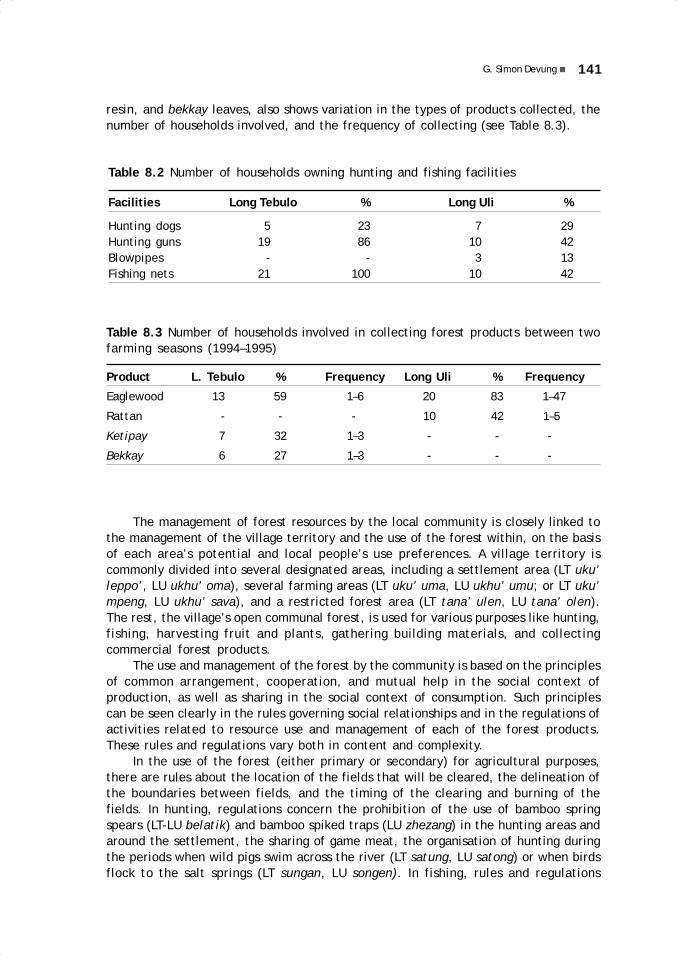
141G. Simon Devung
resin, and bekkay leaves, also shows variation in the types of products collected, thenumber of households involved, and the frequency of collecting (see Table 8.3).
Table 8.2 Number of households owning hunting and fishing facilities
Facilities Long Tebulo % Long Uli %
Hunting dogs 5 23 7 29Hunting guns 19 86 10 42Blowpipes - - 3 13Fishing nets 21 100 10 42
Table 8.3 Number of households involved in collecting forest products between twofarming seasons (1994–1995)
Product L. Tebulo % Frequency Long Uli % Frequency
Eaglewood 13 59 1–6 20 83 1–47
Rattan - - - 10 42 1–5
Ketipay 7 32 1–3 - - -
Bekkay 6 27 1–3 - - -
The management of forest resources by the local community is closely linked tothe management of the village territory and the use of the forest within, on the basisof each area’s potential and local people’s use preferences. A village territory iscommonly divided into several designated areas, including a settlement area (LT uku’leppo’, LU ukhu’ oma), several farming areas (LT uku’ uma, LU ukhu’ umu; or LT uku’mpeng, LU ukhu’ sava), and a restricted forest area (LT tana’ ulen, LU tana’ olen).The rest, the village’s open communal forest, is used for various purposes like hunting,fishing, harvesting fruit and plants, gathering building materials, and collectingcommercial forest products.
The use and management of the forest by the community is based on the principlesof common arrangement, cooperation, and mutual help in the social context ofproduction, as well as sharing in the social context of consumption. Such principlescan be seen clearly in the rules governing social relationships and in the regulations ofactivities related to resource use and management of each of the forest products.These rules and regulations vary both in content and complexity.
In the use of the forest (either primary or secondary) for agricultural purposes,there are rules about the location of the fields that will be cleared, the delineation ofthe boundaries between fields, and the timing of the clearing and burning of thefields. In hunting, regulations concern the prohibition of the use of bamboo springspears (LT-LU belatik) and bamboo spiked traps (LU zhezang) in the hunting areas andaround the settlement, the sharing of game meat, the organisation of hunting duringthe periods when wild pigs swim across the river (LT satung, LU satong) or when birdsflock to the salt springs (LT sungan, LU songen). In fishing, rules and regulations
08 May28.p65 6/11/03, 11:08 AM141
Black

142 TRADITIONAL FOREST USE AND MANAGEMENT AMONG THE KENYAH
concern the use of fish poison (LT tu’ba, LU tu’bo), the designation of certain streamsfor daily and occasional fishing, and the sharing of fish among involved parties andwith relatives and neighbours (LT ngatu, LU mate). In the harvesting of fruit andplants for consumption, regulations concern collective and private ownership of treesand plants, the harvesting, and sharing of the product. In the gathering of buildingmaterials from the forest, rules and regulations mostly relate to the establishment ofcollective or private ownership of the trees or plants that provide the materials. Incollecting commercial forest products, rules and regulations govern the customaryterritory (Indonesian wilayah adat), village territory (Indonesian wilayah desa), villagerestricted forests (LT tana’ ulen, LU tana’ olen), modes of harvesting the forestproducts, and the dues to be paid to the village (Indonesian iuran LMD).
Some degree of variation also exists between the two communities observed,with regard to both the content and complexity of rules and regulations, for example,the sharing of wild pig meat during the pig swimming season (see below).
The common principles underlying rules and regulations govern individual andgroup access to each type of resource in such a way that 1) every individual or householdhas more or less the same opportunity; 2) given this opportunity, there is possibilityfor cooperation and mutual help, as well as a chance for every individual or householdto earn a larger share than others; and 3) the surplus thus obtained can be redistributed.In this way, unhealthy competition and open conflict over resource use in the communitycan be minimised.
The following is an inventory of rules and regulations relative to forest use andmanagement in the two communities at the time of my field research (Devung 1996:128–158).
FarmingThe rice fields should be located in one or another of the designated farming areas.Fields should be side by side in clusters or at least close to one another. The fieldboundaries as agreed upon among households should not be altered without priorcommon agreement. In a given cluster of fields, the clearing of the forest should becarried out more or less simultaneously. At the time of the clearing, omens should beobserved and fellow villagers notified. In a given cluster, the burning of the fieldsshould be done simultaneously.
HuntingBamboo spring spears are not allowed in hunting areas, around the rice fields, or nearthe village. In Long Uli, bamboo spiked traps may be set up along the rice field fencesas long as fellow villagers are notified. In Long Tebulo, the regulation for this kind oftrap is the same as for the bamboo spring spear, both are prohibited.
Some hunters are more successful than others. A successful hunter must sharethe meat with neighbours within a radius of two houses and with close relatives(grandparents, parents, siblings) outside of that radius.
Local people usually hunt in groups with dogs. The owner of the dog pack, whetherhe participates in the hunt or lets others borrow his dog pack, gets the head portion (LTtulat ulu, LU tolet ule) and the tail portion (LT tulat so’et, LU tolet pali) of the catch,then the rest is evenly shared among all the hunters of the group, including the owner ofthe pack. When hunting is performed using a gun, the gun owner gets the head portion
08 May28.p65 6/11/03, 11:08 AM142
Black

143G. Simon Devung
of the catch, whether or not he participates in the hunt. If the bullets also belong tohim, he also gets the tail portion. If the bullets belong to someone else, that persongets the tail portion, whether or not he participates in the hunt. The rest is thenevenly shared among all hunters, including the gun owner and the bullet owner.
When a party goes hunting for the village’s collective consumption (LT nyamet,LU nyaméd)—for example, for the harvest festival or a wedding—the owners of thedog pack, of the gun, and of the bullets get their shares as specified above. Otherhunters get the innards (LT-LU tena’i; LT betuka’, LU betukho; LT atay, LU até). Thenthe rest is handed over for collective consumption (LT mung kuman, LU femong omen).
During the season when wild pigs swim across the river, it is forbidden to gohunting with dogs or guns around the places where the pigs usually cross. It is alsoprohibited to wait for the pigs on the same bank where they descend to cross. Huntingmay only be done with spears (LT buja’, LU sekke’) on canoes built from wood planks(LT alut, LU aled) while the wild pigs are swimming across the river. The hunterswhose canoe is closest to the swimming pigs have priority over others, and thus, theopportunity to be the first to spear the pigs.
The first hunter to get a catch in the swimming-pig season must invite all householdheads in the village to dinner (LT mung kuman, LU femong omen). At the dinner, avillage official publicly announces the beginning of the season and reminds the villagersof the rules and regulations regarding this type of hunting activity. Every day during thepig swimming season, the catch must be gathered and shared among all participatinghunters before they return home. Hunters who first stabbed and injured a pig get thehead portion and the rest is evenly shared among all hunters, including those who havereceived the head portion. In Long Tebulo, this rule is valid for the entire pig swimmingseason. In Long Uli, however, it applies only to the first two weeks. During the followingtwo weeks, the sharing is performed only among hunters at the same waiting site (ka),and afterwards, only among those on board the same canoe.
During the season when birds flock to the salt springs, the use of guns around thearea is not allowed. Birds may only be caught using bird nets (LU kap sevi). The firsthunters to build their huts in the vicinity of the spring have priority in setting theirnets in front of their huts during the whole period. If another hunter wishes to use thehut and nets, he must notify the owner, and the catch must be evenly shared with him.
When there are two or more hunters setting their nets at the same time near thespring, all the nets should be taken down simultaneously. The hunter whose net hascaught the most birds gives the signal to start taking down the nets. When all the netshave been folded, the hunters with the least catch must assist the others in pickingthe birds from the nets, cleaning up the surroundings, and resetting the nets. Fortheir assistance they get a portion of the catch.
FishingIndividual villagers are not allowed to fish using poison in the Bahau River and inrivers within the area of the restricted forest, which may be poisoned only for collectiveconsumption. In small tributaries of the Bahau River or other small rivers outside thearea of restricted forest, poisoning for individual needs is permitted. The kinds offish poison permitted in all cases are those extracted from plant roots (LT tu’ba aka,LU tu’bo aka) or tree bark (LT sok elang, LU zak ilang). The streams where fish areknown to spawn or where people usually set bamboo fish traps (ilid) may in no case bepoisoned.
08 May28.p65 6/11/03, 11:08 AM143
Black

144 TRADITIONAL FOREST USE AND MANAGEMENT AMONG THE KENYAH
A person catching a big fish or a large amount of fish must share with his neighboursand close relatives. When a group goes fishing with a casting net, the catch is sharedmore or less evenly among the participants, the owner of the net and the owner of thecanoe, whether or not they have participated in the fishing.
In the case of fishing for the village’s collective consumption, a small part ofthe catch is shared among the fishermen and the rest is handed over to thecommunity.
Harvesting Fruit and Plants for ConsumptionTrees and plants with edible parts—leaves, flowers, or shoots commonly used asvegetables, or fruits—growing around the village or near the rice fields may be claimedas private property by those who first found or cleared them, and may later be inherited.A claim is established by certain ownership marks: LT cek (LU ce’), a plain woodenstake stuck in the ground, pointing to the tree or plant; or LT tak ulu (LU ta’ ule), asign resembling a human face carved in the trunk of the tree; or prohibition marks: LTsip (LU tip), a wooden stake stuck in the ground, pointing to the tree or plant, with aprohibition symbol slipped across the split upper end of the stake.
Prohibition signs usually have four escalating levels of warning. The first levelhas LT da’un (LU da’eng), a fresh leaf or leafy twig, placed at the sip (slip), meaning:‘This is owned by someone!’ The sign da’un (da’eng) represents the words LT i’da un(LU é’da eng), which means: ‘someone owns (it)’. Thus this prohibition sign hasexactly the same function as the ownership mark.
People are prohibited from taking edible parts from a tree or plant bearing suchownership marks without permission from its owners. If someone gets caught red-handed, the owner has the right to reprimand the thief on the spot, file a complaintthrough the elders, or prosecute through the adat court.
If the thief is unknown, the owner may place a second-level prohibition sign,using udu’ ai’ (Imperata cylindrica), meaning: ‘Don’t take it!’ The sign ai’ representsthe word ayen which means ‘don’t’. If theft occurs again and the thief is still unknown,the owner may place a third-level prohibition sign, using udu’ tangé (Lycopodiumcernuum), meaning: ‘Your bad deed makes us cry!’ The sign udu’ tangé representsthe word nangé, ‘to cry’. In case of repeated theft, the last level of prohibition signsuses puten luten (a piece of burnt firewood), meaning: ‘We are now angry!’ The burntpart symbolises the owner’s hurt feelings.
People having collected forest vegetables or fruits in large quantities must sharewith their neighbours and close relatives. In case of need (a wedding party, cooperativework, or a sudden death), the owners of forest trees or plants with edible parts mustallow the harvesting of these edibles for collective consumption.
Gathering Building and Other Materials from the ForestTrees and plants commonly used for building materials or household implements whichgrow around the settlement, near the rice fields, or in the village’s common forestmay be claimed as private property by those who first found or cleared them, and theymay later be inherited. Ownership marks or prohibition marks may be placed next tothose trees or plants. For large trees, owners also commonly carve a sign resemblinga human face (LT tak ulu, LU ta’ ule) on the trunk, and recently also the initials oftheir name (LT tak kalung nga’dan).
08 May28.p65 6/11/03, 11:08 AM144
Black
145G. Simon Devung
A fallen tree without ownership marks may be claimed by the person who firstfound it, who then must clear the ground around it and place an ownership or prohibitionmark or a stick (LT sekiwat, LU sekéved) across over the trunk. A tree drifting in theriver without ownership marks or the initials of the owner’s name may be claimed bythe person who first found and tied it up by carving his/her ownership mark (humanhead or initials) on the trunk.
It is prohibited to cut any standing and fallen tree bearing ownership marks orprohibition marks without permission from the owner. In case of theft, the owner mayreprimand the thief on the spot, file a complaint through the elders, or prosecutethrough the adat court.
Collecting Commercial Forest ProductsIn the Upper Bahau customary area (Wilayah Adat Hulu Bahau), to which Long Tebulobelongs, outsiders are prohibited from collecting commercial forest products, and areonly allowed to purchase the products from local collectors. The villagers of LongTebulo, like villagers of other settlements in the Upper Bahau customary area, areallowed to collect commercial forest products within the territory of any village (wilayahdesa) in the Upper Bahau, as long as they have permission from the concerned villageofficials. Every group going on a forest expedition, whether in their own or anothervillage’s territory, must pay Rp. 2500 per collector as dues to the LMD (LembagaMasyarakat Desa or village council).
In the Pujungan customary area (Wilayah Adat Pujungan), to which Long Ulibelongs, outsiders are permitted to collect commercial forest products but need toprocure permission from the district officials in Long Pujungan. They may not, however,enter the Sungai Lutung restricted forest area of Long Uli. For each week spent in theforest, a group of outsiders must pay Rp. 50 000 as LMD dues, whereas a group oflocal collectors must pay only Rp. 5000, whether the collecting is carried out in thevillage’s communal forest area or in the restricted forest area of Sungai Lutung.
Small Aquilaria trees may not be cut when collecting eaglewood, and collectorsare required to gouge the trunks of large trees in order to check whether they containany gaharu resin (Indonesian isi gaharu), before cutting down the tree. Likewise,young stems may not be cut in the collection of rattan. Mature rattan stems must becut at about 1 m from the ground, and the upper part of the stem must be plantedback into the ground to allow it to produce new shoots. In collecting ketipay resin,small ketipay trees may only be tapped and may not be cut down. In harvesting relishleaves (bekkay), only mature leaves may be picked, while the stems may not be cutdown.
TRADITIONAL INSTITUTIONS AND ACTUAL PRACTICESIn both Long Tebulo and Long Uli, traditional rules and regulations are still effectivelypracticed in the use and management of forest resources for subsistence needs, atcommunity level as well as individual level. Conversely, in the use and management offorest resources for commercial purposes, particularly in the extraction of gaharu,traditional rules and regulations seem to be no longer in effect, either at individual orat community level. In the collection of rattan, in both Long Tebulo and Long Uli, somerules and regulations are still maintained and effectively used at community level,while others are already neglected. In the extraction of ketipay resin and collection ofbekkay leaves in Long Tebulo, traditional rules and regulations relating to the technical
08 May28.p65 6/11/03, 11:08 AM145
Black

146 TRADITIONAL FOREST USE AND MANAGEMENT AMONG THE KENYAH
aspects of extraction are still maintained and effectively used at community level butthose concerned with the payment of the village dues are not in effect and are practicallyneglected.
Seen in the social context of production and consumption, compliance andincompliance between practices and traditional regulations may relate to a number offactors: 1) the relationship of the individuals involved in forest resource use andmanagement activities; 2) the group’s influence on individuals; 3) the transparencyof forest resource use and management activities; and 4) the nature of control inthese activities. Some of these factors play independent roles in the phenomena ofcompliance and incompliance, while others play interconnected roles, with somewhatdifferent causal mechanisms and intensity. These aspects can be seen in severalactivities of forest resource use and management as described above.
In activities of forest resource use and management that are related to subsistenceneeds, the interdependency of individuals involved in the activities and the group’sinfluence on individuals are greater, the activities undertaken are more transparent,and controlling measures can be taken directly in case of deviation. This is possiblebecause in the social context of production there are mechanisms of cooperation andcollective organisation. In the social context of consumption, there are mechanismsof mutual help and sharing. Besides, all of these activities are undertaken internallyto the community. There is no interaction with other actors beyond the communitymembers and there is no intervention of other mechanisms.
In forest resource use and management activities that are related to commercialpurposes, the interdependency of individuals involved in the activities and the group’sinfluence on individuals are somewhat loose, the activities undertaken are lesstransparent, and controlling measures cannot be taken directly in case of deviation.This happens because in the social context of production the mechanisms of cooperationand collective arrangement in forest resource use and management activities are limitedto the work groups and do not include the entire community. The same situation alsoapplies to the mechanism of mutual help and sharing in the social context of consumption.Besides, some of these activities are performed beyond the internal context of thecommunity, in interaction with outside actors beyond the circle of the community.
In both the activities of forest resource use and management related to subsistenceneeds, and in those related to commercial purposes, the aforementioned circumstancesto a certain extent are generated by one or more situational factors, such as theexisting physical environment, forest resource characteristics, population numbers,economic condition, social organisation, community leadership, production (forestresource use) system, technology, and interactions with other actors.
In the use of forest for agricultural land, either for dry or wet-rice cultivation,every household needs the cooperation and the help of other households. Such a situationis caused by the shortage of labour available in each household and the limits ofagricultural technology adapted to the local environmental conditions and socialorganisation. For example, the limited number of days without rain needed for burningthe rice fields, and the traditional organisation of rice planting (LT nu’gan, LU nogen)with fixed days for planting for each household, require a strict schedule for clearingand felling trees in the rice fields. Due to shortage of labour, every household needsthe cooperation and help of the other households, in the form of either labour exchange(LT senguyun, LU sengozen) or cooperative work (LT ga’gan pembun, LU jagenfempeng), to meet such an arrangement. Table 8.4 shows labour per household involvedin agricultural activities in Long Tebulo and Long Uli.
08 May28.p65 6/11/03, 11:08 AM146
Black

147G. Simon Devung
In the social context of consumption, every household can at one time or anotherexperience harvest failure, either because of pests, a long dry season, or river flooding.Some environmental factors, such as the elevation of the rice field or soil conditions,may cause more detrimental effects to some households’ rice fields than others. Insuch conditions, the unlucky households normally expect to be allowed to help harvestothers’ rice fields (LT mettau, LU metto) and get a share of the rice for the service tomake up for the shortage in meeting the needs of their annual rice consumption. It isalso common that after the harvesting season the unlucky households still expect tobe allowed to help pound rice for other households and receive some of the poundedrice in return for the service.
With the interdependency of households in the social context of production aswell as in the social context of consumption as described above, it is understandablethat rules and regulations relating to the use of forests for agricultural fields arenormally adhered to. Some individual adjustments in order to conform to the rulesand regulations may occur, for instance, at Long Tebulo. In the last five years, for twoconsecutive farming seasons, two households were late in beginning the clearing oftheir wet rice fields. They decided to make smaller fields, and thus managed to catchup with their fellow farmers and burn and water the fields at the same time as theydid, although they knew that they would have a smaller harvest.
The decisions concerning the location of the fields, the boundaries among fields,the time to begin clearing and burning the fields are traditionally determined collectively,either in village meetings or in discussions held among households of the same cluster.In that way, group influence on individuals is greater, and conformity to what wasagreed together more guaranteed (Krech et al. 1967: 506). Activities following thosedecisions and arrangements are also undertaken collectively, thus being moretransparent, and the necessary controlling measures can also be applied directly incase of deviation.
Hunting and fishing also involve cooperation and mutual help among households.First, not all households possess hunting or fishing equipment, as shown in Table 8.1.Those that do not possess hunting or fishing equipment commonly expect to borrow itfrom those who own it, or to be invited to join in hunting or fishing activities. Due toa shortage of adult males in certain households, it is also common that those possessingthe equipment prefer to lend it to other households or to invite members of otherhouseholds to go fishing or hunting with them. The thick forest and rapid river current
Table 8.4 People (per household) involved in farming activities (1995–1996farming season)
Number Households % Households %of people Long Tebulo Long Uli
1 - - 1 4 2 7 34 7 29 3 5 29 8 33 4 2 10 4 17 5 1 5 1 4 6 1 5 1 4 7 3 14 4 4
08 May28.p65 6/11/03, 11:08 AM147
Black

148 TRADITIONAL FOREST USE AND MANAGEMENT AMONG THE KENYAH
also encourage people to go together when hunting or fishing, especially if thedestination is quite distant from the village, or if they go hunting and fishing at night.
In the social context of consumption, as people do not go hunting or fishing everyday—or if they do, there is no guarantee that they will always be successful—people asa consequence also depend on the sharing of meat and fish by their fellow villagers.Such conditions of dependency urge people to consciously conform to the rules andregulations relating to hunting and fishing arrangements. Such arrangements are alsodecided collectively either at the village level or at group level, as has been describedbefore. Group influence on individuals is therefore greater, forcing them to conformto the rules and regulations.
Deviation from rules and regulations relating to hunting and fishing arrangementsis also easily found out. Most of the activities are commonly undertaken together withother people. The hunting and fishing areas are frequently visited, especially duringparticular seasons such as the wild pig swimming season, the salt spring bird season,or the fish spawning season. In such conditions, controlling measures can be alsoapplied directly when necessary. For example, in the 1990 wild pig swimming season,a hunter went chasing his prey on the river bank alongside the area that is prohibitedduring that season. After seeing his canoe by the beach, other hunters, who arrivedlater to wait for the wild pigs to swim, got mad and hoisted the canoe to the top of anearby laran tree (Dipterocarpus oblongifolia Bl.).
Those who come home from hunting or fishing with an abundant catch are alsoeasy to notice. The boats are always parked at the bathing area by the river bank,which is commonly shared with neighbours, and the path to every house in the villageis wide open. Given these conditions, the rules concerning the obligation to sharemeat and fish with close relatives and neighbours tend to be readily conformed to bythe villagers. Individual adjustments to rules and regulations exist among the huntersin both Long Tebulo and Long Uli. If the catch is too heavy to carry home, the huntersnormally leave the heads and the innards in the forest. In such a case, the owner ofthe hunting dogs or the gun would get the fatty skin of the catch (LT-LU nyak) insteadof the head or tail portion.
In harvesting fruit and plants for consumption, although more limited, cooperationamong parties involved is also frequently needed. To harvest edible parts and fruits of bigand tall trees, people usually need someone to climb the trees; or if the location of thetrees is quite distant from the village, they prefer to have some company. In the afternoon,in both Long Tebulo and Long Uli, one can notice groups of two or three women comingback from the adjacent forest with vegetables or fruits in their baskets (kiba).
In the social context of consumption, when someone comes from the forest withabundant vegetables or fruits, it is very common that fellow villagers ask for some. Atspecial occasions such as funerals, weddings, or cooperative work, people also getvegetables or fruits from fellow villagers as a contribution. The obligation to sharewith fellow villagers is frequently stressed, particularly in the words of advice given tothe bridal couple at the wedding ceremony, or as part of the advice given to newsettlers in the village. At Long Tebulo, the advice concerning this obligation is: Ayenma’em, buk uba’ tareng kuman sin, kuman atuk, kuman bua’, atek tareng lina ngatumaan panak, maan i’da cen a’jo’ (‘Don’t be selfish, if you want to eat game meat,eat fish, eat fruits frequently, you must also frequently share yours with your relativesand neighbours’).
The influence of the group on individuals is also great in this context. Deviationfrom the rules and regulations will bring blame on the offender from all parties. The
08 May28.p65 6/11/03, 11:08 AM148
Black

149G. Simon Devung
prohibition on taking vegetables or fruits from trees having ownership marks withoutthe owners’ permission is always reiterated in the village meetings, especially whenthose fruits are in season, to avoid conflict and disputes among households. In LongUli, the forefathers’ advice concerning this is frequently recited by the elders inmeetings: É’en vonén beva, beva kadu loung (‘Don’t fight over fruit trees, fruit treeshave many fruits’).
Taking vegetables or fruits from trees bearing ownership marks without theowners’ permission is also easy to notice, as such trees are commonly close to theowner’s residence or rice field. The custom of sharing, the influence of the group onthe individual, and the location of the fruit trees or vegetable plants, make the rulesand regulations relating to the harvesting of fruit and plants easy to conform to.
The case of gathering building materials and other plants for domestic use fromthe forest is more or less similar to that described for hunting and fishing, as well asfor harvesting fruit and plants. In the social context of production, cooperation amongfellow villagers is sometimes needed because not all households possess the necessaryworking equipment, such as chainsaw (sensor or shinsow) for felling trees and cuttingwood, or motor boat (ketinting) for transporting materials. When traditional equipment,such as axes (LT asay, LU azé), is used for felling and cutting trees, or when a rowboator wooden raft is used for transporting materials, even more cooperation is neededamong households and may sometimes involve all the households in the village (LTga’gan pembun, LU jagen fempeng). During my stay in the field, I had the opportunity(twice in Long Tebulo and once in Long Uli) to observe people undertaking villagecooperative work, namely gathering building materials from the forest for housebuilding. In the social context of consumption, in emergency cases, such as whensomeone’s house or boat is washed away by a flood (e.g., on 26 April 1995), fellowvillagers usually lend the spare building materials, boat keel or hull they have to thefamily in need.
The rules and regulations concerning the prohibition on cutting trees or plantsbearing ownership marks for building materials without the owners’ permission arecommonly conformed to by the villagers. Besides the cooperation and the custom ofsharing mentioned above, the location of such trees and plants is commonly close tothe paths frequently used by the villagers. Deviations or violations are easy to notice,at least when the violators take the materials home or when they dry the materials intheir open yards.
In the collection of commercial forest products, especially gaharu (eaglewood),cooperation in the social context of production is relatively limited and a considerablenumber of alternatives are available to the collectors. Outside collectors only needlimited cooperation with local villagers during their short stay in the village. Theircooperation is often limited to the village authority (pengurus desa) and/or the hostfamily. If there is a problem or difficulty during their stay, they can easily move toother villages. Cooperation among the local collectors is also limited, as the collectionis commonly done in small groups, or even individually, and the provisions needed forthe expedition for the most part supplied by the gaharu traders (buyers) who act astheir patrons.
In the social context of consumption, the sharing of products collected during theexpeditions is limited to the members of the collecting group. No direct sharing withfellow villagers is expected, even if the collection is known to have been successful.This way, the rules and regulations concerning the collection of commercial forestproducts are perceived by people to limit rather than bring benefits. As a consequence,
08 May28.p65 6/11/03, 11:08 AM149
Black

150 TRADITIONAL FOREST USE AND MANAGEMENT AMONG THE KENYAH
those rules and regulations tend to be neglected whenever possible. Such a tendencyapplies to rules and regulations concerning the areas off-limits for collection, villagedues payment, and the mode of collection.
Geographical aspects and the characteristics of the resource also play an importantrole in the poor conformity to the rules and regulations. The vast customary areas(wilayah adat) as well as village areas (wilayah desa), and restricted forest areas(tana’ ulen) allow people to encroach on these areas from various entry points, beyondthe control of the local authorities and inhabitants. The gaharu trees are widely scatteredand those potentially containing gaharu resin seem to grow more abundantly in remotelocations that are rarely visited by the villagers in their subsistence-gathering activities.Such conditions make it difficult to secure and control the implementation of rulesand regulations concerning prohibited areas or permitted modes of collection. No oneis able to check who goes where, and who cuts which gaharu trees and how.
The quantity of gaharu trees encountered in a collecting trip also plays aconsiderable role in the compliance with rules and regulations concerning the modesof collection. The collectors both in Long Tebulo and Long Uli admitted that, if duringthe trip they encounter many gaharu trees, they normally leave all small trees andselectively check the big trees for gaharu resin before felling them. However, if theyencounter only a few gaharu trees during the trip, they prefer to fell all the gaharutrees that they find, regardless of size or content indicators, especially when it isalready late in the afternoon.
Conformity to the rules and regulations in the collection of rattan, ketipay resin,and bekkay leaves varies. In the collection of rattan, the rule concerning the obligationto cut only mature stems is usually complied with, as the collectors realise that rattanwith mature stems weighs more and does not break easily. The rule concerning theobligation to plant the upper end of the stem back into the ground, however, is hardlyconformed to, as it is quite time consuming and hard to do in the midst of thornyclumps, especially when large-scale collecting is taking place.
In the collection of the ketipay resin and bekkay relish, rules relating to themodes of collection are quite well conformed to. Ketipay trees are hardwood, so collectorsare naturally reluctant to fell young trees, which normally have less resin. The bekkaystems are climbing vines wrapped around other trees. Even if the collectors cut thestems, it is impossible to pull the stems down to pick the leaves. If they fell the mainvine, it will cost more time and energy. The natural tendency in this case is to pickmature leaves on the lower part of the stem, which can be easily reached by climbingor from the ground.
Regarding the LMD dues, the collectors are only willing to pay it when they haveobtained a successful harvest during their trip. In such a case, as the collectors put it,not only the LMD dues would be paid, but also ‘the tenth for the Church’. The principlesapplied here are similar to those used in the sharing of game meat in hunting or in thesharing of fish in fishing activities. However, what exactly a big harvest is dependsvery much on the collectors’ own evaluation at a particular time. Commercial forestproducts are mostly sold directly to the traders (buyers) in Long Pujungan or LongAlango, so it is hard to know precisely how much one has received in payment. Whenfellow villagers ask the collectors about the sale, they usually answer: un kedi’ut da(‘only a little’)! Another complicating factor is the bon system (credit, advance paymentin kind). Even if a large quantity of products is sold, their profit will be much smallerafter they have paid back their debts to the trader.
08 May28.p65 6/11/03, 11:08 AM150
Black

151G. Simon Devung
Actually, the system of LMD dues was relatively simpler before 1990. The collectionof commercial forest products, especially rattan, was done collectively and was directlyorganised by village authorities. The collection was done during the LT buka ulen (LUmesik olen) or ‘open the restricted area’ season, which usually took place after therice harvest. The payment of LMD dues could be controlled, as it was directly deductedor paid from each collector’s rattan harvest or from the proceeds of the sale. Theprinciples applied in the collection were similar to those practiced in the sharing ofgame meat when people go hunting in groups during the wild pig swimming season, orin the sharing of fish when groups go fishing with poison for a village party.
CONCLUSIONS AND POLICY IMPLICATIONSAfter examining the phenomena above, at individual level, I am inclined to seeconformance or nonconformance to traditional rules and regulations as an ‘adjustmentprocess’ (Bennet 1980: 252). Rules and regulations are coercive in nature. Responseto such coerciveness may vary from one individual to the next, and from one situationto another. In the cases observed in Long Tebulo and Long Uli, it seems to dependmostly either on ‘external group control and pressure’ upon the individual (Keesing1958: 305); or simply on ‘pragmatic considerations of self-interest and expediency’ indeciding whether to conform or not to the rules and regulations (Krech et al. 1967:506; Beattie 1977: 168). Ethical motivations (awareness and responsibility) functioningas ‘internal individual repressive control’ (Keesing 1958: 305) could not be discernedin the cases observed.
At community level, I tend to see conformance or nonconformance as an ongoingprocess of retaining or modifying traditional rules and regulations to meet the community’spersisting or changing circumstances and needs (Ostrom 1992: 62). As a process, atsome points, it may, or may not, be well adaptive, in the sense that it may, or may not,lead to efficient and fair management of forest resources (Ostrom 1992: 47).
However, without pretending to blindly admire everything that is ‘traditional’, itis important to realise that traditional institutions and regulations still exist in variouscommunities simply because of their greater long-term adaptive value (Bodley 1976:52). Following this consideration, if adjustments, changes, or substitutions are neededin the existing traditional rules and regulations, it is necessary to be able to identifywhich factors have played a role, in what conditions, and by what mechanisms, inallowing the institutions to function well or not function.
Information on such factors, conditions, and mechanisms is badly needed in orderto design policies concerning adjustments, changes or substitution of traditionalinstitutions, whether in terms of rules or in terms of regulations. Even when there isa significant gap between practices and associated rules and regulations, it is worthlooking at whether the rules or regulations themselves need to be adjusted, changedor substituted; or whether the monitoring system and the sanctions need to be modified.
Various practices of use and management of forest resource by traditionalcommunities, as seen in the Upper Bahau region, have some implications with regardto policy. One practical implication is the necessity of pluralism and flexibility in rulesand regulations to accommodate as much as possible the needs of communities withdifferent environmental, social, and institutional contexts. For this purpose, studiesaimed at finding typologies of forest resource use and management by variouscommunities living in and around forest areas are needed. By taking such typologiesinto consideration, it would be much easier for planners to design various policies
08 May28.p65 6/11/03, 11:08 AM151
Black

152 TRADITIONAL FOREST USE AND MANAGEMENT AMONG THE KENYAH
adjusted to the various types of existing forest resource use and management, eitherregionally or nationwide.
In designing policies, the principles of traditional management regarding accessto forest resources and control over their use should also be considered andaccommodated. If not, the implementation of policies would face the same fate asthe payment of LMD dues, which was simply neglected because it was not in accordancewith traditional principles and common practices of forest resource use andmanagement.
08 May28.p65 6/11/03, 11:08 AM152
Black

9.A history of the KenyahLeppo’ Ké and Nyibunin Pujungan Subdistrict
Njau Anau
INTRODUCTIONThe Leppo’ Ké and the Nyibun are two ethnic groups belonging to the larger group of theKenyah, who are presently living in the subdistrict of Pujungan, specifically in the desa(administrative villages) of Apau Ping, Long Pengayan, Long Lat, Long Berini, LongKemuat, Long Alango and Long Tebulo (see Table 9.1). Leppo’ Ké and Nyibun are alsofound in the villages of Long Loreh and Gong Solok along the Malinau River, and in LongBanga’ and Long Selaan, in the Baram area of Sarawak. The village of Apau Ping, thefocus of this research, is the last settlement on the upper Bahau River, a very isolatedarea. The village of Apau Ping consists of four desa: Apau Ping proper, Long Lat, andLong Pengayan, inhabited by Leppo’ Ké and Nyibun, and the desa of Long Tua, which hasvery few residents, from the Saben group (also known as Berau, see Table 9.2).
This research into the history of the Leppo’ Ké and the Nyibun uses theethnohistorical method and is based on interviews with people able to provide historicalinformation. All interview results were crosschecked, and the historical events werethen reconstructed accordingly. For accuracy of data, lepu’un (former sites of villages)and other historical sites were visited.
Social Organisation of the Leppo’ Ké and the NyibunEven though Apau Ping is an isolated village, the values of modernity have begun toaffect it. As in other traditional societies that have subsequently disappeared, thesenew values slowly but surely have begun to replace traditional values.
09 May28.p65 6/11/03, 11:07 AM153
Black

154 HISTORY OF THE KENYAH LEPPO’ KÉ AND NYIBUN IN PUJUNGAN SUBDISTRICT
Table 9.1 Leppo’ Ké and Nyibun population in Pujungan Subdistrict
Desa Total Composition
Families Persons
Apau Ping 20 108 Leppo’ Ké + NyibunLong Pengayan 25 122 Leppo’ Ké + NyibunLong Lat 4 16 Leppo’ KéLong Berini 30 197 Leppo’ Ma’ut + NyibunLong Kemuat 16 75 Leppo’ Ma’ut + NyibunLong Alango 55 397 Leppo’ Ma’ut + NyibunLong Tebulo 18 102 Leppo’ Ké
TOTAL 168 1017
Table 9.2 Population of the compound village of Apau Ping
Desa Total Composition
Families Persons
Apau Ping 20 108 Leppo’ Ké + NyibunLong Pengayan 25 122 Leppo’ Ké + NyibunLong Lat 4 16 Leppo’ Ké + NyibunLong Tua 3 11 Berau (Saben)
TOTAL 52 257
Figure 9.1 A cluster of Leppo’ Ké swidden fields near Apau Ping
09 May28.p65 6/11/03, 11:07 AM154
Black

155Njau Anau
The first school was established in the settlement of the Leppo’ Ké and Nyibunwhen they were still living in the village of Long Lat in 1964, with a teacher by thename of Pak Tasa. In 1978, an Inpres (Presidential instruction) school was established.As a result, the people in the seven villages of the Leppo’ Ké and the Nyibun now havean elementary school level education. A junior high school (SLTP), however, is foundonly in the capital of the district, which is far away, and the senior high school (SMU)is even farther away downstream. Therefore, the present educational level in thevillage of Apau Ping is generally limited to elementary school level. There are alsopeople who have never attended any school, and only a few people have gone on toinstitutions of higher learning in Samarinda.
The Leppo’ Ké and the Nyibun as a whole have been Protestants for more than tenyears, with half of them belonging to the GKPI church (Gereja Kristen Pemancar Injil)and half to the GKII church (Gereja Kemah Injil Indonesia), each church with its ownseparate building. The relationship between the two congregations is a friendly oneand every month the two churches hold a joint service. Religious services take placeon Sundays and on high holidays such as Christmas and Easter, and also on certainother occasions such as deaths, weddings, and baptisms.
Economic SituationThe economy of Apau Ping is based on agriculture, gardens, animal husbandry, huntingand fishing, gathering of forest products, and handicrafts. Agriculture is aimed primarilyat meeting local needs for rice, which has been the staple food since former times.Rice is planted in wet and dry fields (Figure 9.1). The main crops in gardens arevegetables, such as string beans, bitter gourd, white and yellow squash, cucumbers,eggplants, amaranth, mustard greens and hot peppers. In addition, cassava, taro,sweet potatoes, pineapple, bananas and papaya are also planted.
Animal husbandry is also intended for own consumption and is limited to chickensand pigs. Their by-products (eggs) are sold only if a trader or other consumer fromoutside happens to be looking for them (for example, a researcher). The people havealways been known as hunters of wild game and fish eaters. The preferred game arewild pigs, deer, barking deer, mouse deer and squirrels. The favourite fish are paked,selareng, baung and pasa. The animals hunted and the fish caught are intended fordomestic consumption.
Forest products are collected to guarantee a source of additional income to beused for purchasing daily necessities that people cannot produce themselves. Forestproducts gathered are gaharu or eaglewood, resin, and various types of rattan, especiallyrattan sega. The main handicrafts produced are beadwork, rattan weaving, and sa’ung,a broad sun hat made of leaves and decorated with pieces of cloth. Among otherhandicrafts, iron tools are manufactured, such as decorative swords, shields, andhats decorated with bird feathers and used in traditional dances (kanjet).
Modern trade activities only began after the four villages joined together in ApauPing, but these activities are still limited to one or two families that have enough capitalto open small shops. Because access to outside markets by either river (Figure 9.2) orplane continues to be rather problematic, the shops often run out of trade goods. Thecommodities traded also remain limited to daily necessities, such as tobacco, cigarettes,kerosene, salt, granulated sugar, and some medicines.
09 May28.p65 6/11/03, 11:07 AM155
Black

156 HISTORY OF THE KENYAH LEPPO’ KÉ AND NYIBUN IN PUJUNGAN SUBDISTRICT
Kinship SystemThree factors impinge upon the kinship system: lines of descent, the locality of amarried couple, and the system of relationships and associated terminology. The KenyahLeppo’ Ké and the Nyibun recognise paternal lines of descent and use the father’sname after the personal name. For example, if a man is called Njau and his father’sname is Anau, he will be called Njau Anau. The wife usually resides with her husband’sfamily, which is a practice locally known as ngiban. Recent developments have seenchanges, however, because of the disappearance of the longhouses. The newly marriedpair now live in their own house, separated from either spouse’s family, as agreedupon by all parties involved (see the map in Figure 9.3). The kinship system hasalways shown a tendency towards bilaterality, that is, both the paternal and the maternalfamilies are part of the kinship environment. Names used for family members arefrom both the paternal and maternal side.
Social StratificationSociety, traditionally, was stratified. Formerly, the community within one village (leppo’)was divided into groups based on residence in and affiliation to longhouses (uma’)The people belonged to three social classes: the paren or nobility; the panyen orcommon people, subdivided into panyen tiga or prominent individuals, and panyenngelayan or ordinary commoners; and the group of ula’ or slaves. The paren were thepower holders, both as paren leppo’, village lords, or as paren uma’, longhouse lords.Nobility status was by birth, based on paternal as well as maternal descent. The panyentiga comprised the descendants of the intermarriage of nobility with commoners, orthose commoners who had their social status upgraded because of some personalachievement. The slaves were generally descendants of prisoners of war or of peoplesentenced/punished. In recent times, the slave class has disappeared as a result ofassimilation into the commoner class.
Figure 9.2 Up the Bahau River with ‘long-tail’ engine to reach Apau Ping
09 May28.p65 6/11/03, 11:07 AM156
Black
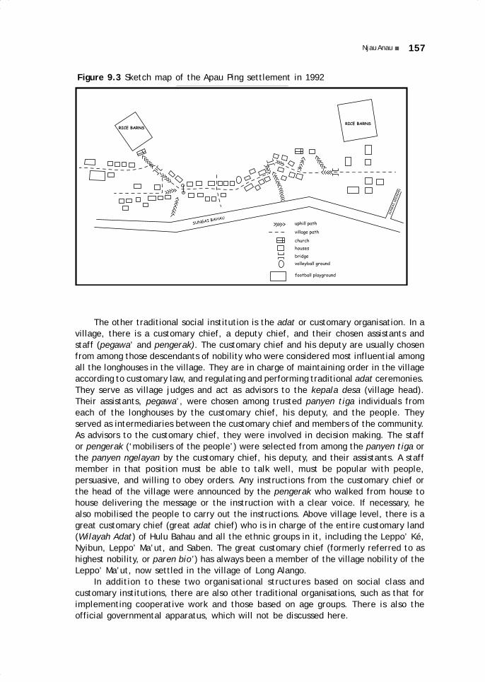
157Njau Anau
Figure 9.3 Sketch map of the Apau Ping settlement in 1992
SUNGAI BAHAU
SUN
GAI
SEKA
KAN
RICE BARNS
RICE BARNS
uphill path
village path
church
houses
bridge
volleyball ground
football playground
The other traditional social institution is the adat or customary organisation. In avillage, there is a customary chief, a deputy chief, and their chosen assistants andstaff (pegawa’ and pengerak). The customary chief and his deputy are usually chosenfrom among those descendants of nobility who were considered most influential amongall the longhouses in the village. They are in charge of maintaining order in the villageaccording to customary law, and regulating and performing traditional adat ceremonies.They serve as village judges and act as advisors to the kepala desa (village head).Their assistants, pegawa’, were chosen among trusted panyen tiga individuals fromeach of the longhouses by the customary chief, his deputy, and the people. Theyserved as intermediaries between the customary chief and members of the community.As advisors to the customary chief, they were involved in decision making. The staffor pengerak (‘mobilisers of the people’) were selected from among the panyen tiga orthe panyen ngelayan by the customary chief, his deputy, and their assistants. A staffmember in that position must be able to talk well, must be popular with people,persuasive, and willing to obey orders. Any instructions from the customary chief orthe head of the village were announced by the pengerak who walked from house tohouse delivering the message or the instruction with a clear voice. If necessary, healso mobilised the people to carry out the instructions. Above village level, there is agreat customary chief (great adat chief) who is in charge of the entire customary land(Wilayah Adat) of Hulu Bahau and all the ethnic groups in it, including the Leppo’ Ké,Nyibun, Leppo’ Ma’ut, and Saben. The great customary chief (formerly referred to ashighest nobility, or paren bio’) has always been a member of the village nobility of theLeppo’ Ma’ut, now settled in the village of Long Alango.
In addition to these two organisational structures based on social class andcustomary institutions, there are also other traditional organisations, such as that forimplementing cooperative work and those based on age groups. There is also theofficial governmental apparatus, which will not be discussed here.
09 May28.p65 6/11/03, 11:07 AM157
Black

158 HISTORY OF THE KENYAH LEPPO’ KÉ AND NYIBUN IN PUJUNGAN SUBDISTRICT
Social InstitutionsThe formal institutions that maintain public order—dealing with the settlement ofconflicts, the imposition of fines, and social control—are the customary institutions,the village government administration, and the head of the church congregation andits associated leaders. In addition, every elder, or every individual regarded as anelder because of his position in the family, informally becomes an administrator ofsocial order in their respective families. Similarly, all villagers have the responsibilityand the obligation to maintain social order within their own environment.
If conflicts occur, efforts are made to settle them within the family first. Only ifthey cannot be settled are the problems brought to a higher level, according to thenature of the conflict. In general, social order is well maintained because of, in thefirst place, the existence of institutions and mechanisms that represent and involveall societal organisations and groups, and, secondly, because order is supported by asystem of fines that, by local standards, are heavy.
HISTORY OF THE LEPPO’ KÉ AND THE NYIBUN
Origins of the KenyahWritten sources on the history of the Leppo’ Ké and the Nyibun are very rare andlimited to foreign writers (Fischer and Gramberg 1910, van Walchren 1907). But muchcan be learned from local oral traditions, even though these often contain differences,depending on the memory of the informant. According to Oko’ Bilung Lerang, aninformant who is now approximately 75 years old, the ancestors of the Leppo’ Ké livedin the Belaga river area in Sarawak and were led by a chief known as Apuy La’ing.From Apuy La’ing to Oko’ Bilung Lerang, ten generations have passed, with the following
succession of leaders: La’ing, ApuyLa’ing, Mahan Apuy, Apuy Mahan,Lian Apuy, Apuy Lian, La’ing Apuy,Apuy Jalung, Lerang Apuy, and BilungLerang. Assuming an average of 25years per generation, we canestimate that the ancestors of theLeppo’ Ké lived along the BelagaRiver at the end of the 17th century(Figure 9.6).
Other sources indicate that, atthat time, all the Kenyah groupswere still together, and the Leppo’Ké had not yet separated from otherKenyah. From the upper reaches ofthe Belaga River, the Kenyah movedin the direction of the Iwan Riverand first settled at Apau Julun (c.1700). The first split occurred as onegroup of Kenyah moved to theLemeting River and eventuallycontinued on the upper Iwan River,and another group remained in Apau
Figure 9.4 Elderly Leppo’ Ké informant BilungLerang at Long Lat (Apau Ping)
09 May28.p65 6/11/03, 11:07 AM158
Black

159Njau Anau
Julan until today. The group that went to the Iwan River finally settled in a highlandarea known as Apau Data.
On the Upper Iwan River (18th century)The upper reaches of the Iwan River were occupied by three successive waves ofDayak peoples from Telang Usan (a village on the Baram River, Sarawak). These were:the Modang and the Ga’ai; the Kayan and the Kayan Bahau; and the Kenyah. When theKenyah arrived in that area, the other groups had already moved on southward to theApau Kayan plateau. The Kenyah, initially one group, eventually split in severalsubgroups, including the Leppo’ Ké and the Nyibun (see Henoch Merang, pp. 15–17).The Kenyah in Apau Data eventually broke up into several independent groups, eachwith its own separate longhouse, to areas that they considered suitable for settlement.The inhabitants of the various longhouses multiplied, so that the longhouse (uma’)became a village (leppo’) consisting of several longhouses. The name of the leppo’eventually became the name of the ethnic group, which often retained the name ofthe location of the village of origin. For example, the Kenyah Leppo’ Ma’ut originatedfrom the Ma’ut River.
The breakup in the Iwan River area was caused by frequent famines since theland in the area was not fertile for agriculture, and by frequent warfare betweengroups or longhouses. For example, according to informants, a power struggle betweenbrothers led to a breakup. The younger brother, by the name of Lenjau, moved to theAkah River in Sarawak, taking many people with him. The elder brother, instead,remained on the upper Iwan River and continued to obstruct the departure of Lenjau.He went to the Akah River and brought back to the upper Iwan River a follower of theyounger brother. In revenge, the younger brother came to the Iwan River and killedthat person. Because he was under pressure from other groups, the older brothermoved his group to Bawang Ipung (see below). In this manner, a number of groupsmoved to find other areas that were more secure or fertile. The following describesthe sequence of moves that brought the Leppo’ Ké to their present location (see mapsand sketches).
The Kenyah Leppo’ Ké
Bawang Ipung (1780–1800)Bawang Ipung is located in the water divide area of the Iwan, Lurah, and Pujunganrivers. The move to Bawang Ipung was intended as an escape to a safer and morefertile area. In Bawang Ipung, the Leppo’ Ké encountered the Nyibun for the firsttime. From there, they moved to Apau Urung.
Apau UrungApau Urung is located on the mountain ridge between the upper Lurah and Pujunganrivers, on the upper Sa’an River. After they had settled in Apau Urung, the Leppo’ Kéwere attacked by the Kenyah Uma’ Alim from the Pujungan River. A large war brokeout, which led to subsequent feuds between the two groups (who thereafter wereoften at war). From Apau Urung the Leppo’ Ké moved to Long Bena.
09 May28.p65 6/11/03, 11:07 AM159
Black

160 HISTORY OF THE KENYAH LEPPO’ KÉ AND NYIBUN IN PUJUNGAN SUBDISTRICT
Figure 9.5 Migrations of the Leppo’ Ké and Nyibun (1)
0 300 km
N
B.S. 0492
N
0 100 km50
TARAKAN
TANJUNG SELOR
MALINAU
Mal
inau
Kaya
n
Bahau
Kayan
Iwan
Tub
u'
To Long Akah
To Long Banga'and Long Selaan
From S. Belaga
1
2
3
4
56
7
8
9
10
11
Pujungan
1- APAU JULAN 5- LONG BENA 8- LONG LOREH 2- HULU IWAN 6- LONG APAN 9- GONG SOLOK 3- BAWANG IPUNG 7- DAERAH S. NGIAM 10- LONG KEMUAT4-APAU URUNG (see other maps) 11- LONG TEBULO
The Lurah River: Long Bena and Long Apan (1810–1840)Long Bena is located on the upper reaches of the Lurah River. Not feeling safe in LongBena because of continued attacks by the Uma’ Alim, the Leppo’ Ké finally moveddownstream along the Lurah River to the area known as Long Apan (c. 1830) under theleadership of Njau Lian. Since there, too, they were not safe, they moved once againand left the Lurah River altogether.
Sawa’ Bio’ (c. 1850)Sawa’ Bio’ is located on the upper Beraa River in the mountains between the Lurahand the Beraa rivers. While settled there, the Leppo’ Ké were once again attacked bythe Uma’ Alim from the Pujungan River. After about five years, the Leppo’ Ké moveddown to Bawang Liong on the lower Beraa River. Initially, they established a settlementon a hilltop. Beginning to feel safer as they were further and further away from thebase of the Uma’ Alim, they moved to nearby locations on the banks of the BeraaRiver.
09 May28.p65 6/11/03, 11:07 AM160
Black

161Njau Anau
Figure 9.6a Historical settlements of the Kenyah Leppo’ Ké (1)
SUNGAI BELAGA
APAU JULAN
MALAYSIAHULU IWAN
MALAYSIA / S. AKAH
BAWANG IPUNG
APAU URUNG attack by Uma' Alim
LONG BENA
LONG APAN
SAWA' BIO' attack by Uma' Alim
HILIR S. BERAA (Lunggung Batu - Tokok Nggau
- Apau Batu - Bawang Liong)
NGGON PUTON (+/- 1860)
APAU AII' / A. LUBUNG / A. SULING (+/-1870)
TOKOK DOK (+/- 1875) NGGAU LIANG (+/- 1875)
(see Part 2) (see Part 3)
09 May28.p65 6/11/03, 11:07 AM161
Black

162 HISTORY OF THE KENYAH LEPPO’ KÉ AND NYIBUN IN PUJUNGAN SUBDISTRICT
Figure 9.6b Historical settlements of the Kenyah Leppo’ Ké (2)
APAU PING (1963)
LONG SELAAN (1972)
LONG BANGA' (1963)
KA' BUANG (+/- 1930)
LONG PENGAYAN (+/-1905)
TOKOK DOK (+/- 1875) NGGAU LIANG (+/- 1875)
(See Part 3)
09 May28.p65 6/11/03, 11:07 AM162
Black

163Njau Anau
Figure 9.6c Historical settlements of the Kenyah Leppo’ Ké (3)
NGGAU LIANG
NDA' PA (1905) UMA' LASAN (1905)
LONG LIO' (1925)
LONG LAT (1930)
LONG MUTAN (1925) LONG SIBAU (1925)
LONG ATUAH (1932)
LONG BULAN (1934)
LONG ABAI (1932)
S. TUBU'
LONG AKING
(1963)(1966) LONG PENGAYAN LONG TEKOLAH (1966)
LONG LOREH
(1972)LONG LOREH
(1972)LONG
TEBULO
(1973)
LONG KEMUAT (1978)
GONG
SOLOK
(1975)
LONG BERINI
(1980)
LONG LIAN
(1978)
APAU PING
(1988)
09 May28.p65 6/11/03, 11:07 AM163
Black

164 HISTORY OF THE KENYAH LEPPO’ KÉ AND NYIBUN IN PUJUNGAN SUBDISTRICT
Fgiu
re 9
.7
Mig
rati
ons
of t
he L
eppo
’ Ké
(2)
B.S
04
92
1
2
3
4
5 6
7
89
10
11
12 13
14
15
16
17
18
19
20
21
Baha
u
Berau
Lian
Pengayan
Ngi
am
Ber
ini
Bera
a
Fro
m L
ong
Apa
nT
o L.
Kem
uat
To
L. T
ebul
o
To
Mal
inau
To
Mal
inau
To
Sar
awak
L. B
anga
'Ñ>
L. S
elaa
n
22
N
04
km
2
1- S
AW
A'
BIO
'2
- B
AW
AN
G L
ION
G3
- N
GG
ON
PU
TO
N4
- A
PAU
AII
'5
- N
GG
AU
LIA
NG
6-
TO
KO
K D
OK
7-
LON
G P
EN
GA
YA
N8
- B
AI
TA
MB
U'
9-
LON
G S
. KO
YA
T10
- U
MA
' LA
SA
N11
- N
DA
' PA
'12
- LO
NG
LA
T13
- LO
NG
LIO
'14
- LO
NG
SIB
AU
15-
LON
G M
UT
AN
16-
LON
G A
BA
I17
- LO
NG
BU
LAN
18-
LON
G A
KIN
G19
- LO
NG
BE
RIN
I2
0-
LON
G L
IAN
21-
KA
BU
AN
G2
2-
APA
U P
ING
09 May28.p65 6/11/03, 11:07 AM164
Black

165Njau Anau
Nggon Puton (c. 1860)The Leppo’ Ké were once again forced to move from Bawang Liong and build a newvillage on a hilltop, at Nggon Puton, between the Bahau and the Semué rivers. Thephrase nggon puton in the Ngorek language means ‘interrupted ridge’. There are noremains at this site, except for fruit trees such as abong (a species of Nephelium),which are quite large. According to some accounts, the Leppo’ Ké village consisted of20 longhouses with roofs made of leaves. The threat from the Uma’ Alim persistedeven then, and after they had settled in Nggon Puton for some time, the Leppo’ Kémoved to a location across the Bahau River.
On the Upper Bahau: Apau Aii’, Apau Lubung, and Apau Suling (1860–1870)These three sites are on the highlands between the Bahau and the Ngiam rivers. ApauAii’, Apau Lubung, and Apau Suling are located at a distance of only about 500 m fromeach other. The compound settlement consisted of 30 longhouses headed by the parenbio’ Apuy Lian. Remains such as a ditch that once surrounded the village like moatsfor defensive purposes can still be seen. Subsequently, there was disagreement amongthe heads of the longhouses which led to the breakup of the settlement into two parts.The first part, consisting of 25 longhouses, moved to Nggau Liang, following theirleader Lawing Usat La’ing. The five remaining longhouses moved to Tokok Dok underthe leadership of Jalung Irang.
The Ngiam River: Nggau Liang and Tokok Dok (c. 1875)Nggau Liang was located on a mountaintop between the Salo’ and the Pengayan rivers(a tributary of the Ngiam River), while Tokok Dok was located on a mountaintop betweenthe Kuyat and the Salo’ rivers (both tributaries of the Pengayan river). After theLeppo’ Ké settled at Nggau Liang and Tokok Dok, war with the Uma’ Alim broke outagain. As a result of the extended feud, the Uma’ Alim gathered their allies, theKenyah Uma’ Kulit, Leppo’ Ndang, and Leppo’ Ma’ut, to attack the villages of theLeppo’ Ké and the Nyibun. They were defeated by the Leppo’ Ké at Nggau Liang. Atthe beginning of the 20th century, the Leppo’ Ké from Nggau Liang split into twoparts, one part moving to Uma’ Lasan, and the second part to Nda’ Pa’. In themeantime, the Leppo’ Ké of Tokok Dok had moved to Long Pengayan.
The NyibunWe will leave the Kenyah Leppo’ Ké temporarily to follow the movements of the Nyibun.According to informants among the Leppo’ Ké, the Nyibun were living in Bawang Ipungbefore the Leppo’ Ké (about 1780–1800), who only subsequently arrived in BawangIpung from the Iwan River. Their village was located close to that of the Nyibun. Forsecurity reasons the Leppo’ Ké and the Nyibun moved together to the upper reaches ofthe Lurah River (Figures 9.5, 9.8 and 9.9).
The Lurah River: Lepu’un Jalung and Apau Angan (1810–1820)The Nyibun village site on the upper reaches of the Lurah River was known as Lepu’unJalung and located very close to the village of the Leppo’ Ké in Long Bena. It waslocated on the top of a hill and was very pleasant and clean. From there, the Nyibun
09 May28.p65 6/11/03, 11:07 AM165
Black

166 HISTORY OF THE KENYAH LEPPO’ KÉ AND NYIBUN IN PUJUNGAN SUBDISTRICT
Figure 9.8a The historicalsettlements of the Nyibun (1)
BAWANG IPUNG
LEPU' UN JALUNG
APAU ANGAN
LONG BENA
SAWA' BIO'
Figure 9.8b The historical settlements ofthe Nyibun (2)
TOKOK ISAU (1860) attack by U. Alim
SUNGAI TUBU' (1890) attack by U. Alim
UMA' LASAN join the Leppo' Ke
LONG MUTAN (1925)
LONG ATUAH (1932)
LONG BULAN (1938)
LONG AKING (1963)
LONG SIBAU (1925)
LONG ABAI (1932)
LONG KEMUAT (1975) GONG SOLOK (1975)
LONG BERINI (1988)
(1965)
09 May28.p65 6/11/03, 11:07 AM166
Black

167Njau Anau
Figure 9.9 Migrations of the Nyibun (2)
N
0 4 km2
To Malinau
1
2
34
5
6
7
8
9
To Sungai Tubu'
To L. KemuatFrom L. ApanB.S. 04 92
1- SAWA' BIO'2- TOKOK ISAU3- UMA' LASAN4- LONG SIBAU5- LONG MUTAN6- LONG ABAI7- LONG BULAN8- LONG AKING9- LONG BERINI
moved to nearby Apau Angan, which was also located on a hilltop. They remainedthere a long time because the area was a very effective stronghold.
Long Bena (c. 1830)After remaining for some time at Apau Angan, the Nyibun no longer felt safe anddecided to join the Leppo’ Ké. For the first time, they lived on the bank of a river.Although the Leppo’ Ké may have been about to move to Long Apan at that time, theNyibun remained in Long Bena, also close to their allies, the Kenyah Leppo’ Ma’ut,who lived at Long Sungai Ma’ut, thereby forming a strong defence network. But on theupper Lurah River, there were frequent attacks by the Uma’ Alim and their allies, whowere fierce warriors. In the end, the Nyibun felt under pressure and went in search ofa safe and fertile area. They decided to follow in the steps of the Leppo’ Ké who hadmoved from Long Apan to Sawa’ Bio’.
Sawa’ Bio’ (c. 1850)At Sawa’ Bio’ the Nyibun suffered a famine caused by an extended dry season, andpeople were forced to eat cassava in order to survive. Later they moved from Sawa’Bio’ to Tokok Isau.
09 May28.p65 6/11/03, 11:07 AM167
Black

168 HISTORY OF THE KENYAH LEPPO’ KÉ AND NYIBUN IN PUJUNGAN SUBDISTRICT
The Upper Bahau: Tokok Isau (c. 1860)Tokok Isau was located in the mountains on the upper reaches of the Lian River. Atthat time, the Nyibun were led by a high aristocrat by the name of Irang. When Irangdied, his son Bilung Irang succeeded him, but the Nyibun were not happy with hisleadership. Some of them decided to join the Leppo’ Ma’ut, who had already movedfrom the upper Lurah River and settled in Long Nan, while other Nyibun joined theLeppo’ Ké at Nggau Liang. While they were in Tokok Isau, the Nyibun were againattacked by the Uma’ Alim and they asked for help from the Leppo’ Ké. After the Uma’Alim were defeated by the Leppo’ Ké at Nggau Liang, Bilung Irang moved with the restof the people across the watershed, to the Tubu’ River.
The Tubu’ River (c. 1890)After the Nyibun had been living on the Tubu’ River for some years, the Uma’ Alimrealised that they were no longer living in proximity of the Leppo’ Ké and they tookthe opportunity to attack them again (c. 1900–1905). Many Nyibun died in this attack,especially children and old people, and the Uma’ Alim burned the Nyibun houses. TheLeppo’ Ké, who at that time were settled in Uma’ Lasan and Nda’ Pa’, heard the newsand, before the Uma’ Alim could attack again, they sent young men to take the Nyibunsurvivors from the Tubu’ River back to Uma Lasan and Nda’ Pa’ to join the Leppo’ Ké.From that time on, the history of the Nyibun becomes one with that of the Leppo’ Kéat Uma’ Lasan.
The Dutch Period to the Present
Uma’ Lasan (1905)At Uma’ Lasan, the Leppo’ Ké and the Nyibun formed one settlement that consisted ofthree groups: Apau Kian (a group of Nyibun, led by Lenggang Ipuy), Apau Namam (witha majority of Leppo’ Ké, led by Jalung Kiring), and Nda’ Tilang (with a majority ofNyibun, led by Bilung Irang). In 1906, the Dutch colonial government sent a militaryunit under Captain Fischer to Uma’ Lasan, with a plural assignment. They were supposedto forbid war among ethnic groups, ensure safety for the movements of the Dutchgovernment in the interior, advise the people to move their settlements from themountaintops to the river banks, and punish those who violated Dutch orders. In1925, the Leppo’ Ké and the Nyibun of Uma’ Lasan finally moved to Long Lio’, on thebanks of the Ngiam River.
Long Lio’ (1925)After the area had become safe thanks to the Dutch government, the Leppo’ Ké andthe Nyibun scattered to various locations. Eight longhouses of Nyibun and Leppo’ Kéled by Jalung Lenggang moved to Long Lio’; two longhouses led by Apuy Bilung movedto Long Mutan; and one other longhouse, led by Dungau Bilung, moved to Long Sibau.After several years, the village of Long Lio’ suffered an epidemic of cholera and manyof its residents died. The entire village of Long Lio’ burned down because of an oldwoman who was roasting a pig, and all its residents were forced to take refuge in theirrice barns. In 1932, the group that had moved to Long Mutan moved to Long Atuah, onthe Berini River. From there, it moved again to Lulou Bulan (or Long Bulan) in 1938,under the leadership of Apuy Bilung, and then once again back to Long Aking.
09 May28.p65 6/11/03, 11:07 AM168
Black

169Njau Anau
In Long Lio’, remains such as house and rice barn stilts, as well as fruit trees suchas mango, coconut, and citrus, can still be found. Downstream from the village, fourNyibun graves can still be seen; they are made of hard lemelai wood, 5 m high, andhold jars containing human bones. According to Oko’ Bilung Lerang, these are thegraves of Jalung Lenggang, Lerang Lenggang, Usat Bilung, and Bilung Usat.
Long Aking (1963) and Long Tebulo (1973)The Nyibun living in Long Aking were led by Jalung Apuy. During his period of leadership,the confrontation with Malaysia (1963–1965) took place. In 1975, Long Aking broke upinto three parts: one part moved to Gong Solok (district of Malinau), under theleadership of Lawai Apuy; the second, led by Ingan Irang moved to Long Kemuat (1978);and the third remained at Long Aking, to later move to Long Berini under the leadershipof Jalung Apuy (1988). These groups have remained in these locations until today (seeFigure 9.10).
Figure 9.10 Nyibun informant Jalung Apui atLong Aking (Long Berini)
One longhouse that had moved from Long Lio’ to Long Sibau under the leadershipof Dungau Bilung moved again to Long Abai (1932), and then again to the Tubu’ River.After several years in the Tubu’ River area, the group returned to Long Abai, and thenmoved to Long Aking (1965). In 1972, part of the population of Long Lio’ moved toLong Loreh (district of Malinau). Another part remained for a while in Long Lio’, butlater moved downriver to Long Tebulo (1973), on the Bahau River, under the leadershipof Dan Awan, and has remained there until today.
09 May28.p65 6/11/03, 11:07 AM169
Black

170 HISTORY OF THE KENYAH LEPPO’ KÉ AND NYIBUN IN PUJUNGAN SUBDISTRICT
Nda’ Pa’ (1905)Let us now return to the second splinter group under the leadership of Njuk Apuy,which moved from Nggau Liang to Nda’ Pa’. Nda’ Pa’ was located on a mountaintopbetween the Pengayan and the Ngiam rivers, and it was only about 500 m from the siteof Uma’ Lasan village. At Nda’ Pa’, the Leppo’ Ké and the Nyibun lived together. AfterNjuk Apuy’s death, the leadership was taken over by his younger brother, Lerang Apuy.It was at that time that the military unit under Captain Fischer arrived. In Nda’ Pa’,the remains of a fortification and a 7 m wide ditch that surrounded the village are stillvisible. From there the group moved to Long Lat.
Long Lat (1930)Around 1930, the village of Nda’ Pa’ moved to Long Lat, on the banks of the NgiamRiver. This village consisted of six longhouses under the leadership of Lerang Apuy. Atthat time, the interethnic wars (ngayau) had ceased, and the area could be describedas safe. Lerang Apuy died and the leadership passed to Ging Apuy. In 1966, the villageof Long Lat split into three parts: one part moved to Long Tekolah (district of Malinau);the second to Long Pengayan, under the leadership of Lenjau Lawing; and the thirdgroup remained in Long Lat.
Downstream from the village, one can still see four Nyibun graves with 4 m highpoles made of jangin lapan wood, large jars containing human bones and sealed withgongs, and with stone slabs on top. According to the informants, these graves wereerected to contain the bones of two women named Bai Lian and Bun Lawing, both inone jar; of their husbands Njau Irang Njau Cin, who died in 1960; of Lawing DungauUsat Aran, a high aristocrat of the Nyibun who joined the Leppo’ Ké in Long Lat, anddied in 1930; and of Lian Bilung Njau Igau.
Long Lian (1978)All the people who stayed put at Long Lat moved to Long Loreh (district of Malinau) in1972–73, under the leadership of Laway Lerang, and live there until today, except forfour families who remained at Long Lat under the leadership of Bilung Lerang. Thesefour families eventually moved from Long Lat to Long Lian upon the advice of thegovernment, and joined the multigroup settlement at Apau Ping in 1988. The groupthat moved from Long Lat to Long Pengayan also finally moved to Apau Ping in 1988under the leadership of Lenjau Lawing, upon the advice of the government.
Long Pengayan (c. 1905)We return to the five longhouses that had left Tokok Dok to settle in Long Pengayanaround 1905 under the leadership of Lawing Jalung. After the visit of the Dutch militaryunit, life there began to feel safer because the interethnic warfare had come to an end.From Long Pengayan, the Leppo’ Ké then moved to Ka’ Buang (1930) (Figure 9.11).
Ka’ Buang (1930)The move from Long Pengayan to Ka’ Buang was led by Jalung Lawing. At that time,Christian missionaries (KINGMI) began spreading Christian beliefs in the interior, wherethe old religion still prevailed. In 1931, the missionary Fisk baptised 221 people in theBahau River area. The village of Ka’ Buang was destroyed by a fire caused by a child.When Jalung Lawing died, the leadership passed to his son Apuy Jalung. The village ofthe Leppo’ Ké then included seven longhouses. After Apuy Jalung died and was succeededby Njuk Anye’, the village of Ka’ Buang suffered a cholera epidemic, which caused
09 May28.p65 6/11/03, 11:07 AM170
Black

171Njau Anau
many deaths and prompted two longhouses to move to Long Banga’, on the upperBaram River in Sarawak, under the leadership of Njau Asang.
Apau Ping and Long Banga’ (1963)The five longhouses that had remained in Ka’ Buang later moved to Apau Ping under theleadership of Njuk Anye’, and became the original village of Apau Ping. When they hadnewly settled in Apau Ping, the confrontation with Malaysia broke out and many peoplewere involved as volunteers. In 1993, Apau Ping was led by the village chief Aran Lenggang.The people of the two longhouses that had moved to Long Banga’ in the end split again:one longhouse moved to Long Selaan, while the other remained in Long Banga’.
DISCUSSIONThe preceding analysis leads to the conclusion that, in the past, the frequent movementsof groups of Kenyah Leppo’ Ké and Nyibun—as well as other Kenyah groups—weregenerally caused by their search for better land. The selection of a location for settlementwas based on the consideration of several important factors: the size of the areaneeded by the group, and in light of its population growth; soil fertility, which wascrucial for meeting subsistence needs; security and defence, in order to avoid hostileattacks; and health to prevent outbreaks of diseases. In addition, there were frequentdisagreements among the high aristocrats in a village which caused groups to breakup. Generally, a group always had to negotiate among these factors and, in fact,security was given highest priority. A small and weak group, for example, first of allsought security, even though the surrounding soil might have not been sufficientlyfertile. A large and strong group like the Leppo’ Ké, whose population was estimatedat about 3000, out of necessity left the fertile area of Long Bena in order to escapethe attacks of the Uma’ Alim and their allies.
Figure 9.11 Informant Oko’ Ncuk Usat, with author, at Long Pengayan(Apau Ping)
09 May28.p65 6/11/03, 11:07 AM171
Black

172 HISTORY OF THE KENYAH LEPPO’ KÉ AND NYIBUN IN PUJUNGAN SUBDISTRICT
Security was also an important factor in the selection of village sites. Two typesof sites were most common. First, hilltops and high plateaus. These could be easilydefended because of their steep slopes, they were usually reinforced with fortificationsmade of tree trunks and sharpened bamboo, and surrounded by broad and deep ditches.The other type was a location along a river and usually also surrounded by fortifications.The first type of site was usually selected in a situation threatened with the outbreakof big interethnic wars or even attacks from hostile headhunters. This type of sitewas not most suitable for the wellbeing of the people, as they often suffered fromwater shortages, and made it necessary to dig a pond at the village site in order tocollect rainwater. An example of such a pond can still be seen at the Uma’ Lasan site.If conditions were safe, the second type of location was generally chosen for settlement.
A group could also maintain two settlements at both sites at the same time, oneof them on the banks of a river, and the other on the top of a nearby hill. Most peoplewould live in the village by the river and only retreat to the fortified village on themountaintop for defence when getting news of enemies approaching the area. A two-village situation is reported with regard to the Leppo’ Ma’ut when they were settledon the lower Ngiam River. A similar arrangement may have existed among the Leppo’Ké when they were living in Bawang Liong.
Generally the history of settlement patterns shows that groups like the Leppo’ Kétried to prevent differences among the paren uma’ aristocrats from causing the groupto break up. If a group remained together or lived very close by, it could defeat itsenemies, like, for example, the Leppo’ Ké who succeeded in defeating the Uma’ Alimand their allies at Nggau Liang. On the other hand, if they split up and settled far fromeach other, like the Nyibun when the moved to the Tubu’ River, they could easily beattacked and destroyed by their enemies. Similarly, the history of the Leppo’ Ké showsa pattern of mass movements (for security reasons), not movements of small groups.Even in the event the Leppo’ Ké were forced to settle temporarily in locations thatwere less than suitable for their needs along their route movement—for example fromthe Lurah River to the upper Bahau River—they nevertheless remained together.
In time, especially under the Dutch government, movement and settlementpatterns changed. One of the effects of the presence of the Dutch government becamevery noticeable after 1925: the formerly frequent interethnic wars started to disappearand the situation became safer. Settlements that were formerly one large village beganto break up into several small villages; and settlements that had been located onhilltops began to move down to the river banks. The social structure began to change,too, because slavery was abolished by the Dutch government.
It must be mentioned that changes in settlement pattern were the result of thepeaceful situation, which also triggered certain other effects: differences among thehigh aristocrats became increasingly obvious and could not be limited by considerationsof security, and therefore breakups occurred. Also, the desire of the people for largerterritories, for agricultural land, for hunting grounds and fishing, promoted theestablishment of villages at a further distance from each other. The wish for fertilesoil and improved welfare pushed the people to seek settlement areas near rivers.The shift to locations by the river banks was strongly supported by the Dutchgovernment, which could thus control the inhabitants more easily. In fact, the Dutchgovernment recommended that the people gather in large, easy-to-reach villages onthe river banks, but this was not achieved during the colonial period.
After Indonesia achieved independence, three kinds of change occurred among theLeppo’ Ké and the Nyibun. First, the Indonesian government required that the villages
09 May28.p65 6/11/03, 11:07 AM172
Black

173Njau Anau
that were scattered and located in upstream areas of river tributaries join and move tothe banks of the main Bahau River. This objective was finally achieved in the 1980s.Secondly, the effects of Christianisation led to changes in the settlement pattern becauseof the disappearance of the longhouses, which from the 1960s to the 1980s were graduallyreplaced by individual family dwellings. Thirdly, the establishment of the official villageadministration and the influence of Christianity gradually changed the traditional socialstructure, progressively weakening the role of the aristocrats. In addition, the changesin the social structure and the decline of the traditional religion were accompanied bythe loss of a number of customs and traditional cultural features.
The most important event in the lives of the Leppo’ Ké and the Nyibun in the lastthree decades, however, has been the mass movement out of the subdistrict of Pujungan,especially the move to the Baram River area in Sarawak, which took place during theConfrontation (Long Banga’ village in 1963), and to what was then the neighbouringdistrict of Malinau (the villages of Long Tekolah, Gong Solok, and Long Loreh, between1966 to 1975). These mass movements originated in the people’s desire to find easierand more pleasant living conditions than those prevailing in the very isolated area ofthe upper Bahau River, and conditions that would provide, among others, education,health, and access to market. Individual or family moves have also taken place to thecoastal areas of the district of Bulungan (Tanjung Selor area) in an effort to seek workor pursue higher education; and to Sarawak, in search of waged work.
Figure 9.12 A Leppo’ Ké or Nyibun carved stone on a hill in upper Ngiamarea
09 May28.p65 6/11/03, 11:07 AM173
Black
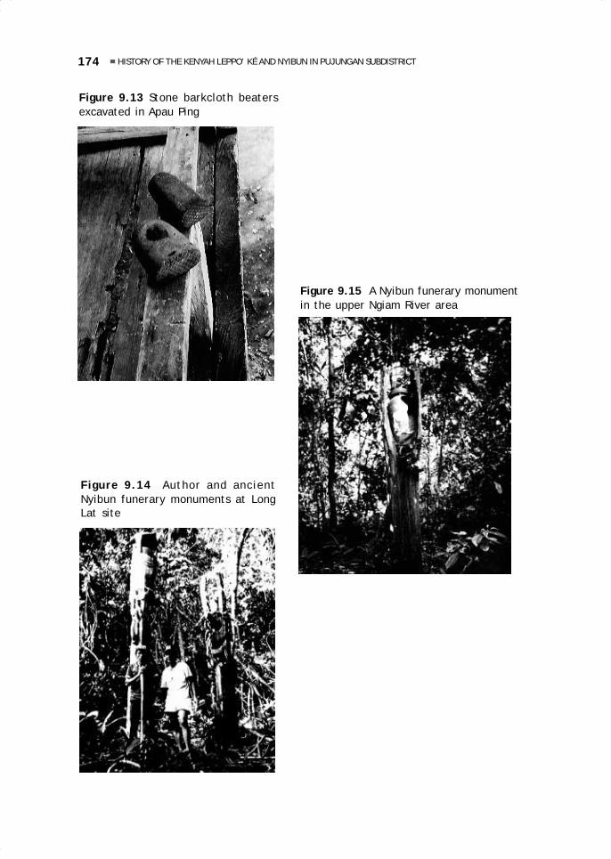
174 HISTORY OF THE KENYAH LEPPO’ KÉ AND NYIBUN IN PUJUNGAN SUBDISTRICT
Figure 9.15 A Nyibun funerary monumentin the upper Ngiam River area
Figure 9.14 Author and ancientNyibun funerary monuments at LongLat site
Figure 9.13 Stone barkcloth beatersexcavated in Apau Ping
09 May28.p65 6/11/03, 11:07 AM174
Black

10.A history of the Kenyah Leppo’ Tauin Kayan Hulu Subdistrict, Apau Kayan
Liman Lawai
INTRODUCTIONThe history of the Kenyah Leppo’ Tau can be reconstructed on the basis of local oraltraditions in combination with written records produced by officials of the Dutch colonialgovernment, Kenyah leaders (such as Gun Kila), and several foreign researchers (suchas H. Whittier). These historical records also make it possible to analyse changes inthe social structure through time.
It is known that the Kenyah initially lived in the mountainous area between whatis now part of the Bahagian Belaga and Bahagian Baram in Sarawak and the Iwan Riverarea in East Kalimantan. It is possible that they were still hunters and gatherers atthat time and did not grow crops. Later, in the late 18th century, they moved to theIwan River area. From there, some of them entered the Pujungan River drainage,others moved to the region of the Buram River, and yet others moved to the ApauKayan highlands after the area had been abandoned by the Kayan people. The migrationof the Kenyah to Apau Kayan seems to have occurred at the beginning of the 19thcentury. The first group to enter the Apau Kayan area were the Kenya Leppo’ Timai,followed by the Leppo’ Tau and other Kenyah groups. Although many Kenyah groupsonce lived in the Apau Kayan, which is very difficult to reach, at present many of themhave moved out to other areas, primarily in the vicinity of urban areas where accessto basic necessities such as salt and clothing is easier.
10 May28.p65 6/11/03, 11:01 AM175
Black

176 A HISTORY OF THE KENYAH LEPPO’ TAU IN KAYAN HULU SUBDISTRICT, APAU KAYAN
The writer carried out field research from 1993 until January 1994. The aim ofthe research was to learn about the reasons for migrating, obtain information on thestopovers and settlements of the Kenyah Leppo’ Tau as they moved from the IwanRiver to Apau Kayan, and study the evolution in the forms of leadership from the pastuntil today. Historical events and genealogies of leaders were compiled, andcrosschecked, on the basis of interviews with informants according to historicalaccounts. In particular, the author collected the names of leaders at the time certainevents occurred.
As a time frame, a standard scale of 20 to 25 years for a generation was adopted.The calculation then was as follows: Baya’ Li’ (the last generation in 1993) was 50years old, so he was born in 1943, rounded off to 1940. Assuming a standard of 20years per generation, 24 generations equal 480 years. Assuming a standard of 25years, 24 generations equal 600 years. The birth of Pejulan Awang (24 generationsbefore Baya’ Li’) thus is estimated to have taken place between 1350 and 1450 (roundedoff). In compiling historical sequences in Borneo, this method may be used to calculategenealogies.
GENERAL DESCRIPTION OF THE RESEARCH AREAThe research location included all the villages inhabited by the Leppo’ Tau in the ApauKayan area: Long Nawang, Nawang Baru, Long Temuyat, Long Uro’, and Lidung Payu.To obtain additional data, research was also carried out in several of the villages ofthe other Kenyah groups in Apau Kayan, such as Long Ampung (Kenyah Leppo’ Jalangroup), Long Sungai Barang (Kenyah Leppo’ Tukung), Long Payau and Metulang Baru(Kenyah Bakung). Historical reconstruction regarding these groups can be found in anearlier research report (Liman 1995).
The settlements of the Kenyah Leppo’ Tau in the Apau Kayan area in the subdistrictof Kayan Hulu are (1993): Long Nawang (809 people), Nawang Baru (585), Long Temuyat(327), Long Uro’ (303), Lidung Payau (351), and Long Lebusan (648). The totalpopulation of the Leppo’ Tau amounts to 3023 (1993). The settlements of other Kenyahgroups and of Punan in Apau Kayan (comprised in the subdistrict of Kayan Hulu) are:Long Betao’ (Kenyah Badeng group, 111 people), Long Ampung (Kenyah Leppo’ Jalan,454), Long Sungai Barang (Kenyah Leppo’ Tukung, 369), Long Payau (Kenyah Bakung,104), Long Top (Punan, 73), Long Metulang (Bakung, 82) Mahak Baru (Bakung, 378),and Dumu Mahak (Bakung, 242), with a total population of 1822 people.
Education and ReligionThe formal educational level of most Kenyah in Apau Kayan is elementary school (SD),and many people have never attended any school. The first school was opened in LongNawang during Dutch times. At that time, the people did not yet realise the importanceof education and many parents prohibited their children from going to school. Thefirst private SMP (junior high school) was established in Long Nawang in 1976 and itsstudents came from two subdistricts, Kayan Hulu and Kayan Hilir. This SMP becamestate managed in 1990. At present many children attend school in Apau Kayan, eventhough many of them only graduate from SD. Unfortunately, the SMP is rather inadequatewith regard to equipment and facilities for studying and teaching, and the studentsare often given days off. A low salary has forced teachers to find additional workoutside the school.
10 May28.p65 6/11/03, 11:01 AM176
Black

177Liman Lawai
Almost all the Kenyah in Apau Kayan (96%) became either Protestant or Catholicsince the 1960s. In the village of Long Betao’, two families (six persons) still followthe old religion (Adat Bungan) and thirteen newcomers are Moslems. In the subdistrictof Kayan Hulu, people are divided among the following congregations: Protestants ofthe GKII Church (2673), Protestants of the GPIB Church (1001), and Catholics (1143).Every village already has its own church. A mosque has been built in Long Nawang. TheAdat Bungan community holds its ceremonies in their own houses, but ceremoniesfrequently held in the past, such as the mamat festival and the lemiwa ceremony, nolonger receive much attention today. The relations between the religious congregationsare good. For example, the building of a place of worship is done jointly regardless ofchurch affiliation and Christmas and Easter are celebrated together. Some programsare arranged by the various church organisations separately, such as weekly services,wedding services, and baptisms, as well as funeral services.
Economic LifeAgricultural enterprises of the Kenyah are mainly intended to meet household needsand the main activity is cyclical (shifting) dry-field rice cultivation. Since olden times,the Kenyah have been planting beans and tubers in the old swidden (secondary forest)fields and today they cultivate plants such as onions, beans, eggplant, squash, mustardgreens, red peppers, amaranth, pineapple, bananas, cassava and sweet potatoes.The people generally are not yet interested in perennial crops, because they have notyet mastered the cultivation methods, or lack marketing opportunities. Livestock(especially chicken and pigs) are also raised to meet household needs and they areonly traded very rarely (there is no standard price). Hunting and fishing are verycommon. At present the people are beginning to trade the catch of their hunt orfishing, especially in the subdistrict capital.
Forest products currently exploited in Apau Kayan are eaglewood (Ind. gaharu, Kenyahsekau) and bezoar stones from monkeys and porcupines. Even though rattan and resinare still found abundantly in Apau Kayan, they are rarely collected today because theprices are very low and the people still do not have ways to process these raw materialsinto commercial products. Forest products are generally harvested to meet additionalexpenses like buying goods that the people cannot produce.
In 1993, the price of eaglewood in Apau Kayan has reached Rp 1 000 000 per kg forthe best quality. Eaglewood traders (10 people) use local labour or import labour fromoutside the area (150 people, some of whom are stationed in Long Nawang). Traderswith large capital use services and purchase their daily necessities, and they tend tomonopolise the small airplanes, which are the only means for transporting staples (rice,sugar, salt, cooking oil and the like) from the coast to Apau Kayan. The supply of thesegoods is thus limited, the prices are very high and the local people, whose purchasingpower is low, are often unable to obtain them.
Women often do handicraft work, such as beadwork, rattan weaving (baskets,mats, and baby carriers), and saong (a kind of broad sun hat with applications ofmulticoloured cloth). Old men make machete handles decorated with goat hair andcarved from deer antlers.
Modern commerce only began when the airfield was opened in Long Ampung (locatedone-and-a-half hours away by ketinting (small motorised boat) from Long Nawang.Smallscale trade, which was formerly limited to the subdistrict employees, is expanding.Traders and villagers often import goods for local consumption from Sarawak along
10 May28.p65 6/11/03, 11:01 AM177
Black

178 A HISTORY OF THE KENYAH LEPPO’ TAU IN KAYAN HULU SUBDISTRICT, APAU KAYAN
footpaths. These commodities, gasoline, kerosene, salt, and granulated sugar, sellquickly because their prices are competitive compared to those of goods brought in byplane. River transportation from Tanjung Selor is very risky because of the rapids andwater levels. Other types of goods—cigarettes, cooking oil, soap, tea, coffee,monosodium glutamate, and medicines—are imported from Samarinda, because theprices for these items in Sarawak are much higher, but the supplies are very muchdependent on the availability of air transportation.
THE SOCIOCULTURAL SYSTEM OF THE LEPPO’ TAUVarious aspects of the social and cultural traditions and customs of the Leppo’ Tauhave influenced the history of their movements. Among these are their traditionalclass system, their leadership system and social institutions, the process of decisionmaking and customary laws, as well as the peacemaking or petutung tradition.
Social ClassesIn the language of the Leppo’ Tau, the nobility is referred to as paren. The formationof the paren resembles the establishment of a kingdom when an individual who ismuch honoured and respected for having liberated his people from the enemy, especiallyon the battlefield, is elevated to kingship. The term paren first appeared when theLeppo’ Tau lived in the area of Bawang Da’a (Apau Kayu Tau), and it is possible that itwas derived from a similar Kayan word. At that time, an outstanding Kenyah leaderwas Suhu Batu, who was brave and strong and did not want to submit to any othergroup. On the contrary, he was the one who forced the other Kenyah groups to surrenderand follow his leadership. In the period after Suhu Batu, Leppo’ Tau people began todistinguish between the descendants of Suhu Batu and other families, which led to theformation of three social strata, i.e., the paren (nobility, descendants of Suhu Batu),the panyen (ordinary people), and the ula’ (slaves).
Subsequently, society provided the paren class with the kind of recognition andhonour that distinguished their position in society. In addition to playing an importantrole in the leadership of the society, both during a migration and in each successivesettlement, the paren class also had special rights. Their apartments (amin) at thecentre of the longhouse were taller and larger than the other apartments. To the rightand left of their amin there were several amin of the panyen. The corvee labour system(mahap) required that the people work without compensation for one or two days forthe nobility, especially in doing farm work. Before any decision was made in the community,the paren were always asked for guidance. The nobility was allowed to own valuablegoods and objects of great symbolic significance and, to this day these items indicatethe social status of the paren families. Among these items are objects such as tigerclaws and skins, several types of expensive and ancient beads, large ceramic jars withraised dragon figures, and gongs. Some motifs (tigers and hornbills) and tattoos couldonly be used by the paren. In addition, the paren played an important ritual and ceremonialrole in the ancient religion (Adat Puon) that pre-existed Adat Bungan (see below).
EvolutionFrom generation to generation, the paren families continued to grow in number, untilthey could no longer be accommodated in one amin. Some of the members of the
10 May28.p65 6/11/03, 11:01 AM178
Black

179Liman Lawai
original amin set up a new longhouse (uma’) in the same village (referred to as leppo’),and some of the panyen were moved to the new uma’, where the paren maintainedtheir position as paren. Their amin was taller and larger and was located at the centreof the new longhouse, but they could not build it taller than the amin of the paren inthe original longhouse, because the position of the leader of the new longhouse (parenuma’) was inferior to that of the paren leppo’, the leader of the original longhouseand—at the same time—of the whole village.
Informants claim that these aristocratic leaders were expected to have variouspraiseworthy characteristics, as well as the maren (noble) traits of Suhu Batu. Theywere expected to be courageous and strong (makang), sagacious and prudent (dena’kimet), and helpful (‘un sahe’); to have a sense of compassion and social responsibility(‘un lesau); to be polite when talking and to think rationally (tiga tira’ ngan kenep); tobe effective in uniting and advising the people (mencam pebeka’ ngan mencam pekatokdulu ngeleppo’); to speak the truth and dislike lying (abe’ uba’ lemalo, ngan bangpisiu iya lan); to have a broad perspective and an open mind (‘un kenep iya dado’); tohave a sense of shame (‘un sae’); to not be hasty in action (abe’ uba’ basuk kenep),to keep from vilifying others (abe’ uba’ pejaat dulu); and, finally, to have greatdetermination and a sense of responsibility in leadership (bawa’). This was the idealleader who was respected by the panyen, and anyone chosen to be a leader had tounderstand and adhere to these principles of leadership.
The Adat PuonIn the ceremonies of the Adat Puon tradition, society was divided into the detaubio’, or high nobility; the detau dumit, or low nobility; the panyen, consisting ofpanyen tiga, or the descendants of intermarriages of paren and panyen, and thepanyen kelayan, or ordinary people; and the ula’, or slaves. As soon as a ceremonywas over, the paren category became one again, and was no longer divided into highand low nobility.
The Adat Puon tradition, the old beliefs of the Kenyah, occupied an importantplace in all social activities including choosing the location of settlements. Bird omens(amen-amen) were always used, and people did not hesitate to abandon a settlementif the signs were unfavourable, even if village construction was already almostcompleted. In the Adat Puon, the sound and the direction of the passage of severaltypes of animals and birds—the isit bird and the pengulung (a type of owl), the deer,the Brahminy kite, the cobra, and others—were believed to influence human life andwere interpreted as auspicious or inauspicious signs.
The Adat Puon had ceremonial aspects with definite and heavy requirements,which had a significant impact on social life, among others with regard to protection.For example, the mamat festival always involved human skulls (the result ofheadhunting, ngayau). If an epidemic spread to a village and left many people dead, itwas necessary to hold the tepo ceremony, which required the use of blood of a murderedhuman being in order to protect the village.
Adat Bungan and its InfluenceIn 1947–50, a new religious current, Adat Bungan, appeared. The new belief, whichwas spread by Juk Apui, a man from Long Ampung (of the Kenyah Leppo’ Jalan group),was reportedly revealed to him in a dream. This belief was actually only a revised
10 May28.p65 6/11/03, 11:01 AM179
Black

180 A HISTORY OF THE KENYAH LEPPO’ TAU IN KAYAN HULU SUBDISTRICT, APAU KAYAN
version of the Adat Puon. Certain requirements, such as animal sacrifice, wereeliminated because they were a heavy burden on the people and several strict tabooswere removed. In the Adat Bungan ceremonies, it was sufficient to pray directly toBungan Malan Paselong Luan (the goddess of creation) and use a chicken egg as aintermediary that replaced all animal sacrifices. After the introduction of the AdatBungan to Leppo’ Tau society, the social stratification changed, resulting in theelimination of the distinction between high and low nobles or aristocrats. With regardto the panyen and the ula’, no changes occurred.
The Leppo’ Tau nobility initially was opposed to the Bungan cult, especially becauseit eliminated several hitherto essential ceremonial requirements. They feared for thesafety of the people, because they were responsible to the gods. They opposed theprinciples of the Bungan cult and tried to prevent its growth and spread; finally, however,they had to accept it.
The Influence of ChristianityChristianity was introduced to the Leppo’ Tau between 1952 and 1965, as its adherentsspread. Christianity actually had already been introduced at the time of the Dutchpresence in Apau Kayan, but it had not spread among the people. In the early 1950s,positions for and against the acceptance of Christianity were taken among the Leppo’Tau, and especially among the nobility in Long Nawang. Many of the residents ofLong Nawang were strongly in favour of retaining the Adat Bungan; they separatedfrom the village and established a new village at Nawang Baru, on the Nawang River(1952), while those who converted to Christianity have remained in Long Nawanguntil today. In approximately 1965, Christianity received a great opportunity, becausethe Indonesian government threatened that anyone still following the Adat Bunganor even the Adat Puon would be considered ‘godless’, and could thus be declared aCommunist and be subject to punishment. The government apparatus forciblydisrupted and destroyed all places of worship of the adherents of the Adat Bungan.
The effects of Christianity are visible in the social stratification. The nobilitybecame one single category. So did the class of ordinary people, as the distinctionbetween panyen tiga and panyen kelayan also disappeared. The slave category waseliminated by the government, in line with the now dominant Christian ideas. Todaythe differences between the two remaining classes or strata are no longer striking forvarious reasons: Christian beliefs, educational progress, and economic factors. Thismeans that the social classes are no longer functional, except in the selection ofleaders: As of today, no panyen has ever been chosen to become village head, muchless adat chief.
The System of Leadership and Social InstitutionsThe system of leadership of the Leppo’ Tau is as follows: 1) at the level of the wilayahadat (a large customary domain, for example, a whole river basin, consisting of morethan one ethnic group): the kepala adat besar (great adat chief) and his staff ofnotables or elders (pengelata’ leppo’), his assistants (pegawa leppo’), and ‘publicrelations’ officers (pelawa’); 2) at the level of a settlement or single ethnic group:the village chief (kepala leppo’ or paren leppo’, today the village head), with hisappointees, the pengelata’ leppo’ (community leaders), assistants (pegawa leppo’),and public relations officers (pelawa’); and 3) at the longhouse level: the longhouse
10 May28.p65 6/11/03, 11:01 AM180
Black
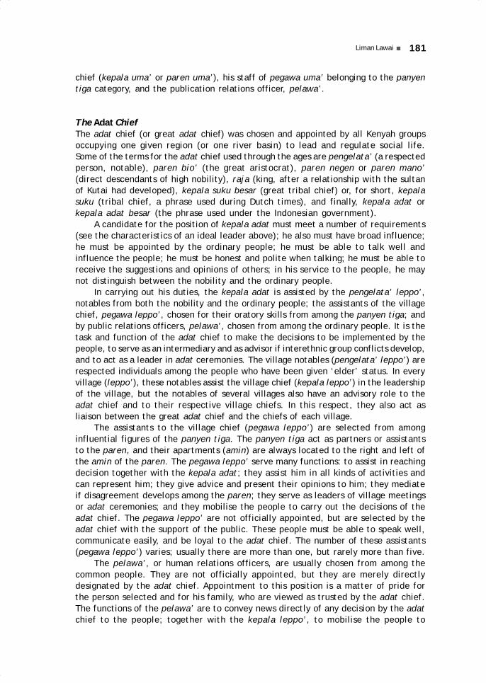
181Liman Lawai
chief (kepala uma’ or paren uma’), his staff of pegawa uma’ belonging to the panyentiga category, and the publication relations officer, pelawa’.
The Adat ChiefThe adat chief (or great adat chief) was chosen and appointed by all Kenyah groupsoccupying one given region (or one river basin) to lead and regulate social life.Some of the terms for the adat chief used through the ages are pengelata’ (a respectedperson, notable), paren bio’ (the great aristocrat), paren negen or paren mano’(direct descendants of high nobility), raja (king, after a relationship with the sultanof Kutai had developed), kepala suku besar (great tribal chief) or, for short, kepalasuku (tribal chief, a phrase used during Dutch times), and finally, kepala adat orkepala adat besar (the phrase used under the Indonesian government).
A candidate for the position of kepala adat must meet a number of requirements(see the characteristics of an ideal leader above); he also must have broad influence;he must be appointed by the ordinary people; he must be able to talk well andinfluence the people; he must be honest and polite when talking; he must be able toreceive the suggestions and opinions of others; in his service to the people, he maynot distinguish between the nobility and the ordinary people.
In carrying out his duties, the kepala adat is assisted by the pengelata’ leppo’,notables from both the nobility and the ordinary people; the assistants of the villagechief, pegawa leppo’, chosen for their oratory skills from among the panyen tiga; andby public relations officers, pelawa’, chosen from among the ordinary people. It is thetask and function of the adat chief to make the decisions to be implemented by thepeople, to serve as an intermediary and as advisor if interethnic group conflicts develop,and to act as a leader in adat ceremonies. The village notables (pengelata’ leppo’) arerespected individuals among the people who have been given ‘elder’ status. In everyvillage (leppo’), these notables assist the village chief (kepala leppo’) in the leadershipof the village, but the notables of several villages also have an advisory role to theadat chief and to their respective village chiefs. In this respect, they also act asliaison between the great adat chief and the chiefs of each village.
The assistants to the village chief (pegawa leppo’) are selected from amonginfluential figures of the panyen tiga. The panyen tiga act as partners or assistantsto the paren, and their apartments (amin) are always located to the right and left ofthe amin of the paren. The pegawa leppo’ serve many functions: to assist in reachingdecision together with the kepala adat; they assist him in all kinds of activities andcan represent him; they give advice and present their opinions to him; they mediateif disagreement develops among the paren; they serve as leaders of village meetingsor adat ceremonies; and they mobilise the people to carry out the decisions of theadat chief. The pegawa leppo’ are not officially appointed, but are selected by theadat chief with the support of the public. These people must be able to speak well,communicate easily, and be loyal to the adat chief. The number of these assistants(pegawa leppo’) varies; usually there are more than one, but rarely more than five.
The pelawa’, or human relations officers, are usually chosen from among thecommon people. They are not officially appointed, but they are merely directlydesignated by the adat chief. Appointment to this position is a matter of pride forthe person selected and for his family, who are viewed as trusted by the adat chief.The functions of the pelawa’ are to convey news directly of any decision by the adatchief to the people; together with the kepala leppo’, to mobilise the people to
10 May28.p65 6/11/03, 11:01 AM181
Black

182 A HISTORY OF THE KENYAH LEPPO’ TAU IN KAYAN HULU SUBDISTRICT, APAU KAYAN
implement the decisions of the adat chief; and to serve as messengers of the adatchief whenever necessary.
The Village ChiefThe village chief (kepala leppo’, or also paren leppo’) is selected and appointed fromamong the paren. In former times, it was often the case that one ethnic group wasequated with only one village, so that the village head was simultaneously the chief ofthe group (kepala suku)—but this was not the case for the great chief (kepala sukubesar). The village chief, then, was only the leader of his own group. The kepala leppo’from the various villages (or ethnic groups) in the area surrounding a given village alsotook part in the selection of that village’s kepala leppo’. The kepala leppo’ had tosubmit to and follow the decisions of the great adat chief; he implemented the decisionsof the great adat chief in his village, and he was responsible to the great adat chief forthe safety and security of the people of his own village. He reported to the great adatchief on any disputes in or among villages; and he was expected to settle disputesamong the residents of his own village; he assisted the great adat chief in settlingintergroup conflicts. Qualifications for becoming kepala leppo’ did not differ from thosethat had to be met by an adat chief. The kepala leppo’ is today referred to as ‘villagehead’, either kepala desa, kepala kampung, or petinggi (village mayor).
The Longhouse ChiefThe chief of the longhouse, kepala uma’ (also referred to as paren uma’), is always amember of the nobility and a descendent of the paren leppo’. Population growth led tothe breakup of the original uma’ (longhouse; see above) and led to the establishment ofnew longhouses. The paren who established them became their chiefs, paren uma’. Inthis way, a leppo’ (village) could consist of several longhouses. If a paren moved toanother area, he also became the new longhouse chief (kepala uma’) in the new village.If the longhouse has been replaced with family homes, the kepala uma’ is now the headof the ‘block’, or neighbourhood unit (RT, Rukun Tetangga), and is called Ketua RT.
The longhouse chief leads the people in the longhouse, and he may be selected tobecome village chief (paren leppo’) or even great adat chief. If he is selected tobecome adat chief, then his apartment (amin) may be raised and enlarged to the sizeof that of the preceding adat chief.
The longhouse chief is charged with protecting and regulating life in the longhouseand with leading the people. In this, he is responsible to the adat chief. He alsoaccompanies the adat chief on his visits to other groups. Within the longhouseenvironment, he settles conflicts and leads adat ceremonies. The longhouse chief isalways accompanied by the pegawa uma’, who act as his advisors in all decisionsmade. The pegawa uma’ belong to the panyen tiga category, who live to the right andleft of his amin and must be ready whenever called for without having to be assigned.
The Process of Decision Making and the Customary LawWithin the stratified Kenyah society, leadership has always been in the hands of theparen, who exercise power and make decisions. Nevertheless, the leaders rarely actdictatorially, because at times they only formalise decisions that have already beentaken in a consultative meeting (musyawarah) and with advice from the notables
10 May28.p65 6/11/03, 11:01 AM182
Black

183Liman Lawai
(pengelata’, pegawa leppo’, and members of the panyen tiga). The system of leadershipof the Leppo’ Tau has always resembled a ‘guided democracy’, in which the parenmake the final decision after holding meetings and consultations.
Tradition and customary law (adat) is highly honoured and respected. If offencesagainst adat occur—such as elopements, sexual relations outside marriage and adultery,slander or insults of others, or pregnancy outside of marriage—the adat chief or thevillage chief will immediately call an adat meeting to take action by applying adatsanctions, punishments, or fines. Fines require the payment of a machete or thesurrender of an heirloom item such as a gong, jar, or other, according to existing adatregulations. In addition to fines, sanctions such as banishment may also be imposed.For example, if a woman becomes pregnant without a known husband (temale’ awah),she is banned from the village until she has given birth. She sets up a hut and food,and care can only be provided by her parents. After she has given birth, she may bringher child back to the village, but she still has to turn in what she was required to pay,which becomes the property of the village.
For crimes such as theft, fraud, robbery, murder of a fellow resident, there are nostrict and definite sanctions, which may derive from the fact that such crimes hardlyever occur among the Kenyah. If a fellow resident is killed, it is usually unintentionally,as in a hunting accident. To cleanse the village from the evil effects of such accidents,it is necessary to hold a great adat ceremony, which is attended by all residents. Thecost for the ceremony is charged to whoever was responsible for the accident. Thatperson is also required to surrender heirloom items (such as a jar), which has mainlysymbolic significance—it does not require a particular size or type of heirloom, nordoes it pay excessive attention to its value. On the occasion of this ceremony, thenotables, the adat chief, and the village chief offer words of advice and guidanceaimed at preventing the recurrence of such accidents.
Adat PetutungPetutung means ‘to make peace’ between two Dayak groups or villages by means of analliance by marriage between children of the village chiefs (kepala leppo’) of the twoparties that have been in conflict, in the hope that the descendants of these marriageswill eventually also become village chiefs and will play an important role as mediators ifdisputes or tension develop again between the two parties. This peacemaking can alsooccur through an exchange of symbolic objects, such as gongs (tawe’), tiger claws,spears, or shields, that is accompanied by an oath taken on these objects.
Petutung can also be used preventively, when signs of impending conflict betweentwo groups appear and there is concern that these might lead to war. It is also used toimprove unity among different groups living near each other in one region, even ifthere are no signs of hostility. Historically, the Leppo’ Tau frequently used the latterapproach to extend their power over other, smaller groups to force them to submitand recognise the leadership of the Leppo’ Tau. Petutung involving such imposedintermarriage has resulted in the presence among the leaders of the other, less powerfulgroups of a Leppo’ Tau paren, representing the power of the Leppo’ Tau. Thus, oncethe child of this paren had become a leader, he could ensure the group’s continuingloyalty to the Leppo’ Tau. Thus, petutung was a frequent occurrence in the history ofKenyah society, and became an important political tool for the Leppo’ Tau in itscompetition for power in the Apau Kayan area.
10 May28.p65 6/11/03, 11:01 AM183
Black
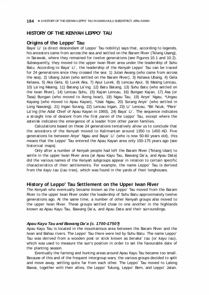
184 A HISTORY OF THE KENYAH LEPPO’ TAU IN KAYAN HULU SUBDISTRICT, APAU KAYAN
HISTORY OF THE KENYAH LEPPO’ TAU
Origins of the Leppo’ TauBaya’ Li’ (a direct descendant of Leppo’ Tau nobility) says that, according to legends,his ancestors came from across the sea and settled on the Baram River (Telang Usang),in Sarawak, where they remained for twelve generations (see Figures 10.1 and 10.2).Subsequently, they moved to the upper Iwan River area under the leadership of SuhuBatu. According to Baya’ Li’, the leadership of the Kenyah Leppo’ Tau can be tracedfor 24 generations since they crossed the sea: 1) Julan Awang (who came from acrossthe sea), 2) Ubang Julan (who settled on the Baram River), 3) Kelawa Ubang, 4) GelaKelawa, 5) Aka Gela, 6) Lurek Aka, 7) Apui Lurek, 8) Lencau Apui, 9) Masing Lencau,10) La’ing Masing, 11) Batang La’ing, 12) Batu Batang, 13) Suhu Batu (who settled onthe Iwan River), 14) Lencau Suhu, 15) Kajan Lencau, 16) Bungan Kajan, 17) Asa (orTasa) Bungan (who moved to Ikeng Iwan), 18) Ngau Tau, 19) Anye’ Ngau, *UngauKayang (who moved to Apau Kayan), *Usat Ngau, 20) Surang Anye’ (who settled inLong Nawang), 21) Ingan Surang, 22) Lencau Ingan, 23) Li’ Lencau, *Bit Ncuk, *Pare’La’ing (the Adat Chief of Apau Kayan in 1993), 24) Baya’ Li’. The sequence indicatesa straight line of descent from the first paren of the Leppo’ Tau, except where theasterisk indicates the emergence of a leader from other paren families.
Calculations based on these 24 generations tentatively allow us to conclude thatthe ancestors of the Kenyah moved to Kalimantan around 1350 to 1450 AD. Fivegenerations lie between Anye’ Ngau and Baya’ Li’ (who is now 50-60 years old), thismeans that the Leppo’ Tau entered the Apau Kayan area only 150-175 years ago (seehistorical maps).
Only after a number of Kenyah people had left the Baram River (Telang Usan) tosettle in the upper Iwan River area (at Apau Kayu Tau, Bawang Da’a, and Apau Data)did the various names of the Kenyah subgroups appear in relation to certain specificcharacteristics of their settlements. For example, the name Leppo’ Tau is derivedfrom the kayu tau (tau tree), which was found in the yards of their longhouses.
History of Leppo’ Tau Settlement on the Upper Iwan RiverThe Kenyah who eventually became known as the Leppo’ Tau moved from the BaramRiver to the upper Iwan River under the leadership of Suhu Batu approximately twelvegenerations ago. At the same time, a number of other Kenyah groups also moved tothe upper Iwan River. These groups settled close to one another in the highlandsknown as Apau Kayu Tau, Bawang Da’a, and Apau Data and their surroundings.
Apau Kayu Tau and Bawang Da’a (c. 1700–1750?)Apau Kayu Tau is located in the mountainous area between the Baram River and theIwan and Bahau rivers. The Leppo’ Tau there were led by Suhu Batu. The name Leppo’Tau was derived from a wooden post or stick known as beraka’ tau (or kayu tau),which was used to measure the sun’s position in order to set the favourable date ofthe planting season.
Eventually the farming and hunting areas around Apau Kayu Tau became too small.Because of this and of the frequent intergroup wars, the various groups decided to splitand move away, settling quite far from each other. The Leppo’ Tau moved to LalengBawai, together with their allies, the Leppo’ Tukung, Leppo’ Bem, and Leppo’ Jalan.
10 May28.p65 6/11/03, 11:01 AM184
Black

185Liman Lawai
Figure 10.1 Hydrographic map of interior northern East Kalimantan
SELLATO 09 94
TRU
SA
N
LIMBANG
TUTOH
BARA
M
AKAH
TINJA
R
MO
H
SILAT
PELERAN
DANUM
LINAUKAJANG
BAHAU
MALARANBALUI
BALUI
BALEH
MAHAKAM
MAHAKAM
PARI
BO
H
OGAH
BELAYA
N
KE
DA
NG
KE
PA
LA
KE
DA
NG
RA
NT
AU
KE
LIN
JA
U MARAH
TELEN
WA
HA
U
KELAI
SEGAHKAYAN
KAYAN O
K
IWA
N
PUJUNGAN
BAHAU
LURAH
MA
LIN
AUTU
BU
'
KE
RA
YA
N
SESAYAP
SEKA
TA
K
KAYAN
MEN
TA
RA
NG
0 100 km
N
10 May28.p65 6/11/03, 11:01 AM185
Black

186 A HISTORY OF THE KENYAH LEPPO’ TAU IN KAYAN HULU SUBDISTRICT, APAU KAYAN
Figure 10.2 Migrations of the Kenyah Leppo’ Tau (1)
0 100 km
N
1
2
3
4
5
6
7
8
9
10
1825
1972
1970-851983
1967-75
1970
-80
1700-1750
1800
1- APAU KAYU TAU2- LALENG BAWAI3- IKANG IWAN4- NAHA JANGIN5- LONG LEBUSAN6- TERAS NAWANG7- MARA8-TANJUNG MANIS9- BILA' TALANG10- RUKUN DAMAI
seeother map
SELLATO 10 94
?
10 May28.p65 6/11/03, 11:01 AM186
Black

187Liman Lawai
Since that time, the Leppo’ Tau have attempted to keep their various allies united inorder to guarantee their common safety. In every migration, the Leppo’ Tau werealways followed by these groups, who established settlements nearby.
Laleng Bawai (c. 1730–1800?)Laleng Bawai was located on the upper Iyung River, a tributary of the Iwan. The Leppo’Tau were led by Lencau Suhu. They remained in this area for three generations. In thethird generation, as a result of war, no suitable leaders were left and a vacancydeveloped in the leadership. A young orphan, Uyau I’ut (the term means ‘small orphan’),who had been raised among the Kenyah Uma’ Alim, was appointed leader of the Leppo’Tau, who subsequently moved to Ikeng Iwan, joining other Kenyah groups which hadsettled there earlier.
Ikeng Iwan (c. 1780–1820)Ikeng Iwan is located on the banks of the Iwan River. The Leppo’ Tau were led byPalung Lawai, the son of Uyau I’ut. After his death, Palung was succeeded by TamanBawe’ Tului (whose original name was Tului Lawai). Under Tului’s leadership, open warbroke out between the Leppo’ Tau and their Kenyah allies (Leppo’ Tukung, Leppo’Jalan, Leppo’ Bem, and Bakung), on the one hand, and the Kenyah Uma’ Alim, on theother. The Leppo’ Tau lost and suffered many casualties. Several years later, Tuluidecided to move his group back to the Baram River, but the other leaders (paren)disagreed. Tului departed, taking with him a large number of people, that is, sevenlonghouses. This group initially settled at Lusung Laku (or Apau Paya), but they wereattacked by the Iban. Then, they moved to Long Uheng, under the leadership of NguloArang. Later, they moved again to Long Belian, and finally to Long Mu’u (Long Moh,Baram) and Lepu’un Sampi (Baram), under the leadership of Bilung Kuleh. In themeantime, only three longhouses had remained at Ikeng Iwan, led by Usat Ngau,Ungau Kayang, and Palung Tanyit, respectively. From these three longhouses derivedall the Leppo’ Tau who are settled in Apau Kayan today.Not long after this, the Leppo’ Timai allies of the Leppo’ Tau, who had formerly settledon the upper Pujungan River, decided to move to Naha Jangin, not far from IkengIwan. The Leppo’ Tau invited the Leppo’ Timai to join them to form a single settlement,but the Leppo’ Timai preferred to survey the Kayan River area, with the intention ofmoving to Long Metun. At that time, many Kayan groups were still living in the ApauKayan. Civil war broke out between two Kayan leaders, Ngau Wan Luhang and KulehLaleng Awang. After Kuleh was killed, Ngau swore to leave the Kayan River areaaltogether and, as a result, the Kayan people dispersed to various areas, including theMahakam River region and the Balui River in Sarawak. This left the Apau Kayan regionempty, and the Leppo’ Timai moved from Naha Jangin to Long Metun, on the KayanRiver. The Leppo’ Timai, the largest and strongest among the Kenyah groups and thefirst to enter the upper Kayan River basin, were led by Ajang Ipui and Jalung Ipui.Among all Kenyah groups in Ikeng Iwan, the Leppo’ Timai were the most respected.
In the meantime, at Ikeng Iwan, the child of a member of the nobility of theLeppo’ Tau, was killed, and this led to a split. Part of the Leppo’ Tau moved with theirparen, Ungau Kayang, to Naha Jangin. New leaders were appointed by the bali dayung(spirits that possess religious leaders). Those appointed were Surang Anye’ and NgauMerang Anye’, both orphans since early childhood (uyau i’ut), and the bali dayung
10 May28.p65 6/11/03, 11:01 AM187
Black
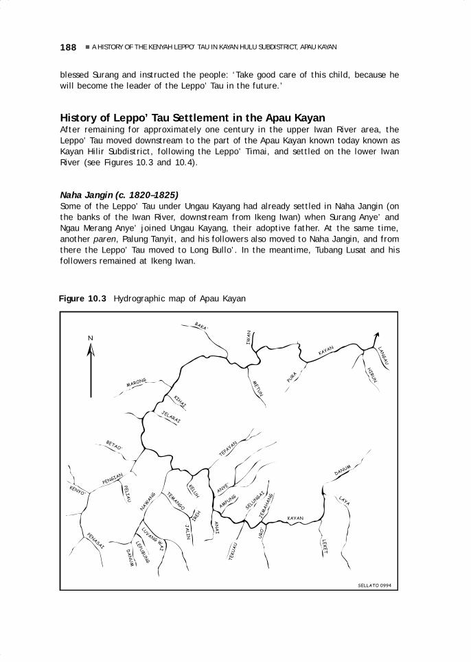
188 A HISTORY OF THE KENYAH LEPPO’ TAU IN KAYAN HULU SUBDISTRICT, APAU KAYAN
blessed Surang and instructed the people: ‘Take good care of this child, because hewill become the leader of the Leppo’ Tau in the future.’
History of Leppo’ Tau Settlement in the Apau KayanAfter remaining for approximately one century in the upper Iwan River area, theLeppo’ Tau moved downstream to the part of the Apau Kayan known today known asKayan Hilir Subdistrict, following the Leppo’ Timai, and settled on the lower IwanRiver (see Figures 10.3 and 10.4).
Naha Jangin (c. 1820–1825)Some of the Leppo’ Tau under Ungau Kayang had already settled in Naha Jangin (onthe banks of the Iwan River, downstream from Ikeng Iwan) when Surang Anye’ andNgau Merang Anye’ joined Ungau Kayang, their adoptive father. At the same time,another paren, Palung Tanyit, and his followers also moved to Naha Jangin, and fromthere the Leppo’ Tau moved to Long Bullo’. In the meantime, Tubang Lusat and hisfollowers remained at Ikeng Iwan.
Figure 10.3 Hydrographic map of Apau Kayan
N
LAN
GA
U
HIR
UN
KAYAN
PURA
MET
UN
IW
AN
BAKA'
MARONG
KIHAI
JELARAI
BETAO'
PENGIAN
PE
LIA
U
KENYO'
PENASAI
NA
WA
NG
KELU
HTEMAN
GO
IREH
JA
LIN
LEPU
BU
NG
DA
NU
M
ANYE'
AN
AI
TE
KU
AU
UR
O'
SELUN
GAI
JE
MA
HA
NG
DANUM
LE
KE
T
LAYA
KAYAN
LUVANG W
AI
AMPUNG
SELLATO 0994
TEPAYAN
10 May28.p65 6/11/03, 11:01 AM188
Black

189Liman Lawai
Figure 10.4 Migrations of the Kenyah Leppo’ Tau (2)
N
123
4
5
6
7
8 9
11
10
12
13
14 15
1617 18
1970-80
1972
1967-75
1970-85
197
0
to TERAS NAWANGand MARA I
to TANJUNG MANIS
to BILA'TALANG
to L. LEBUSAN
to RUKUN DAMAI
1- LONG BULLO'2- LONG METUN3- LONG KELASA4- APAU TUTUNG5- LONG BETAO'6- LONG DANUM7- LALUT LEPUBUNG8- APAU LUDAT9- LONG TEMANGO10- LONG TEMUYAT11- LONG NAWANG12- NAWANG BARU13- LONG IREH14- LULAU BAHANG15- LONG TEPAYAN16- TANAH PUTE'17- LONG URO'18- LIDUNG PAYAU
SELLATO 10 94
Long Bullo’ (c. 1825–1830)At Long Bullo’, on the Kayan River, downstream from Long Metun, they remained onlyfor a short time, because they felt too distant from the village of the Leppo’ Timai atLong Metun. In the meantime, Surang Anye’ and Ngau Merang were approachingadulthood and began to lead the Leppo’ Tau. They invited Tubang Lusat and his followersin Ikeng Iwan to join them at Long Bullo’, because the latter’s small numbers at IkengIwan did not guarantee their safety. After they arrived at the Kayan river, however,Tubang Lusat’ s group decided to move on upriver along the Kayan River. They enteredthe Metun River and settled in Long Kelasa.
Long Kelasa (c. 1825–1830)Long Kelasa is located on the Metun River, not far from the mouth of the river. Thegroup of Leppo’ Tau led by Tubang Lusat settled there for only a short time, movingagain to an apau or highland area, not far from Long Kelasa and close to the village ofthe Leppo’ Timai. Less than a year later, their longhouse burned down, and hence thislocation was named Apau Tutung (‘burnt plateau’). The Leppo’ Timai, notified of thisdisaster, picked up the people of Apau Tutung to join them in Long Metun. The Leppo’Tau who had lived at Long Bullo’ also joined them in Long Metun.
10 May28.p65 6/11/03, 11:01 AM189
Black
190 A HISTORY OF THE KENYAH LEPPO’ TAU IN KAYAN HULU SUBDISTRICT, APAU KAYAN
Long Metun (c. 1825–1830)The Leppo’ Tau remained only a short time at Long Metun with the Leppo’ Timai,because the relationship between the two groups suddenly became tense when a Leppo’Tau woman was killed by a member of the Leppo’ Timai. However, the leaders of theLeppo’ Tau, Surang Anye’ and Ngau Merang Anye’, had to submit to the paren of theLeppo’ Timai, Ajang Ipui and Kalung Ipui. As a consequence of this killing, the Leppo’Timai moved to the upper reaches of the Kayan River, and there they split into twogroups, each group taking with them part of the Leppo’ Tau. One group of Leppo’Timai, under Jalung Ipui, moved to the Tahap River (a tributary of the Pengian), andwas soon followed by a group of Leppo’ Tau under the leadership of Surang Anye’ andNgau Merang Anye’, who established a village at Long Betao’ (near the Tahap River).The second group of Leppo’ Timai, led by Ajang Ipui, moved to the Lubang Wai River(a tributary of the Nawang river), and was followed by another group of the Leppo’ Tauunder the leadership of Tubang Lusat, who settled in Long Danum (on the Upper NawangRiver). This left Long Metun empty.
History of Leppo’ Tau Settlement on the Upper Kayan RiverFrom Long Metun (today part of the subdistrict of Kayan Hilir), the Leppo’ Tau movedacross the Apau Kayan far upriver along the Kayan River (now part of the subdistrict ofKayan Hulu).
Long Betao’ (c. 1830–1835)Long Betao’ is located on the banks of the Pengian River, not far from the mouth ofthe river and close to the Tahap River and the village of the Leppo’ Timai. There, theLeppo’ Timai and the Leppo’ Tau remained only one year, because Tubang Lusat wantedto force the Leppo’ Tau at Long Betao’ to move to Long Danum. Tubang ordered theLeppo’ Yibun (i.e., Nyibun; see Njau Anau in this volume), then living on the IwanRiver, to attack Long Betao’. Surang Anye’ and Ngau Merang fled the village of LongBetao’ in order to avoid the burning of the village by the Nyibun, and they moved theirgroup to Long Danum. The Leppo’ Timai from the Tahap River moved to Apau Kuleh,upstream from Long Danum, while the Leppo’ Timai from the Luban Wai River, underthe leadership of Ajang Ipui, moved nearby, to Apau Kuleh.
Long Danum (c. 1830–1835)The Danum River is located on the extreme upper reaches of the Nawang River. TheLeppo’ Tau remained there for four years, then they split again, because of leadershipproblems: Surang Anye’ and Ngau Merang Anye’ brought their followers to LalutLepubung (slightly upstream from Long Danum), while Mpui Julang and Ingan Lusatled theirs to Apau Ludat (in the mountains between the Nawang and the Pengianrivers). At Apau Ludat, they remained for only about two years, because they wereattacked by the Iban of Sarawak. Subsequently, they moved again to Long Ireh.
Lalut Lepubung (c. 1835–1850)At Lalut Lepubung, the Leppo’ Tau were still led by Surang Anye’ and Ngau MerangAnye’. At this site two important events occurred between the Leppo’ Tau and the
10 May28.p65 6/11/03, 11:01 AM190
Black

191Liman Lawai
Leppo’ Timai, as well as one incident involving the Kenyah Leppo’ Kulit. There, too,all the Kenyah groups of the Apau Kayan formed a union.
According to the old custom, during the rice-planting season, Kenyah peoplearranged the work schedule according to social stratification. The first day was usedfor people who took omens and observed a number of prohibitions on behalf of theentire community; the second day was reserved for the kepala leppo’; the third forthe entire paren group; the fourth day for the panyen tiga, and so on. At that time,the village heads (kepala leppo’) were Surang Anye’ and Ngau Merang for the Leppo’Tau, and Jalung Ipui and Ajang Ipui for the Leppo’ Timai. Jalung Ipui and Ajang Ipuiharshly prohibited Surang Anye’ and Ngau Merang from planting on the second day,because the Leppo’ Tau were considered of lower standing than the Leppo’ Timai. Themessengers from the Leppo’ Timai were thrashed by the Leppo’ Tau.
Another incident occurred as a result of an attack by the Kenyah Uma’ Baka’ onthe Kenyah Uma’ Kelep, who were allied with the Leppo’ Timai. The Uma’ Kelep believedtheir aggressors to be the Leppo’ Tau, and reported this to the Leppo’ Timai at ApauKuleh. The Leppo’ Timai responded by attacking the Leppo’ Jalan, who were allies ofthe Leppo’ Tau. In response, the Leppo’ Tau threatened to attack the Leppo’ Timaivillage of Apau Kuleh but, in the end, an agreement was reached with the Leppo’Timai and the Leppo’ Tau were satisfied with attacking only the Leppo’ Kelep, a lower-ranking group allied to the Leppo’ Timai. After this event, the Leppo’ Timai moved toBawang Beliu (upriver from Long Ampung), and not long thereafter they moved againto Long Jemahang, and from there to the Tabang River area (a tributary of theMahakam river). Since that time, there have been no Leppo’ Timai in Apau Kayan,and the Leppo’ Tau have remained as the most prominent and best known of theKenyah groups in Apau Kayan.
After the Leppo’ Timai had left the Apau Kayan, the Sultan of Kutai in Tenggaronginquired as to whom could be trusted to represent all Kenyah groups in Apau Kayan.The three kepala leppo’, who were visiting Tenggarong, suggested that Surang Anye’of the Leppo’ Tau be appointed as the leader of all the Kenyah groups in Apau Kayan.The Sultan sent to Surang Anye’ symbols of his investiture, in the form of a spearnamed nyatap bujak and several pieces of cloth and royal clothing, with the messagethat he should maintain safety in the Apau Kayan area. Surang Anye’ firmly refusedthese presents in consideration of the feelings of all the other Kenyah groups, andsuggested that these symbols be sent around to all Kenyah groups in Apau Kayan. Heinvited the Kenyah leaders to Lalut Lepubung to discuss the problem of the sultan’sgift or investiture. This meeting was attended by Lake’ Langet (from the Kayan Uma’Lekan), Bilung Lusat (Kenyah Leppo’ Bem), La’ing Imang (Kenyah Bakung, Taman Bo’Bilung (Kenyah Leppo’ Tukung), Udau Ajang (aka Bo’ Bulan, Kenyah Leppo’ Kulit), PengLa’eng (Kenyah Leppo’ Teppu), and Ngau Bilung (Kenyah Leppo’ Jalan).
The meeting’s outcome was that Surang Anye’ was the most appropriate leaderto retain the gifts of the Sultan. Surang was elevated to the position of leader of allthe Kenyah groups of Apau Kayan, and he was given the title of Kepala Suku Besarse-Apau Kayan (equal to the term paren bio’ in the Kenyah language). All ethnic groupsof Apau Kayan were strictly forbidden from creating unrest or make war. A unionsymbolised by the hornbill was established. It was controlled by the leader of the allKenyah groups in Apau Kayan. If this bird was sent out, its voice served as a call to allgroups and had to be obeyed. If any one of these groups purposely committed crimesand destroyed the unity, action was to be taken by all the other groups together. Afterthis, the leaders of the Leppo’ Tau were responsible for travelling through the Apau
10 May28.p65 6/11/03, 11:01 AM191
Black

192 A HISTORY OF THE KENYAH LEPPO’ TAU IN KAYAN HULU SUBDISTRICT, APAU KAYAN
Kayan area and visiting all the Kenyah groups to implement the petutung (peacemakingceremonies).
These events were followed by the Long Peliau incident. Because a married Leppo’Tau woman had slept with a Leppo’ Kulit man in Lalut Lepubung, a group of Leppo’ Tauattacked the Leppo’ Kulit near the village of Long Peliau. Because the weeding seasonwas already over, they did not encounter anyone and to appease their anger, they cutdown the paddy of the Leppo’ Kulit. The Leppo’ Kulit rushed to their fields and anuneven fight took place, in which the Leppo’ Tau were outnumbered and exterminated,leaving only one survivor to carry the news back to Lalut Lepubung. The Leppo’ Tautook revenge and many Leppo’ Kulit fell victim. Thereupon the Leppo’ Tau madepeace (petutung) with the Leppo’ Kulit, and soon after, moved to Long Temango.
Long Temango (c. 1850–1865)In Long Temango, the Leppo’ Tau were still led by Suran Anye’ and Ngau Merang Anye’.After one year in that location, Ngau Merang died. While the Leppo’ Tau lived in LongTemango, two important military events occurred.
The first, was a war with the Bakung, who did not want to adhere to the agreementreached at the meeting in Lalut Lepubung and who tended to kill anyone who came to theirvillage at Tegeh. Surang Anye’ met at Long Temango with all the kepala leppo’ (villageheads) of the Kenyah, and it was decided that the Bakung had to surrender a number oftheir people as slaves to all groups involved in order to replace the people whom they hadkilled. If this was not complied with, the allied Kenyah forces, coordinated by the Leppo’Tau, would attack the Bakung at Tegeh. The Bakung opted for war, and thus open warbroke out with unevenly balanced forces and the Bakung suffered many casualties.
Then war broke out with the Uma’ Baka’, who often attacked the Leppo’ Jalan—this resulted in the death of Ajang Apui, brother of Lawai Ingan (kepala leppo’ of theLeppo’ Tau at Long Ireh)—and with the Leppo’ Tukung and the Leppo’ Bem. Because ofsuch extended feuds, the Leppo’ Tau in Long Ireh asked Surang Anye’ in Long Temangoto plan a revenge. As head of all the Kenyah of Apau Kayan, Surang Anye’ could notapprove of this plan, but he appointed several of his men from Long Temango toaccompany the forces of Long Ireh in their attack on Batu Aping (the village of theUma’ Baka’), with instructions not to chase people into their houses, because theUma’ Baka’ were very few in number. The Uma’ Baka’ were unable to resist andsuffered many casualties.
From Long Temango, Surang Anye’ moved his group to Long Nawang. In themeantime, the group at Long Ireh, under the leadership of Mpui Jalan, split: MpuiJalan himself and his followers moved to Tana’ Pute (on the Jemahang River), and thegroup led by Ingan Lusat moved to Long Tepayan (on the banks of the Kayan River).After several years at Tana’ Pute, Mpui Jalan moved again to Long Uro’, and thisgroup still resides there today). In the meantime, Ingan Lusat moved to Lulau Bahang(across from the village of Long Nawang), but did not remain there long, movingagain to Long Temuyat on the Nawang River).
History of the Leppo’ Tau at Long NawangAfter their arrival in Long Nawang (c. 1865), the Leppo’ Tau remained there, and arestill there to this day.
10 May28.p65 6/11/03, 11:01 AM192
Black

193Liman Lawai
The Times of Ingan Surang (c. 1865–1890)Surang Anye’, the leader of the Leppo’ Tau at Long Nawang, died after two yearsthere, and by common agreement Ingan Surang was appointed to succeed his fatheras the leader of the Kenyah groups of all Apau Kayan. Under the leadership of InganSuran, several important events took place. The Kenyah from Malaysia threatened theLeppo’ Kulit in Apau Kayan, and asked that the Leppo’ Kulit send one of their ownpeople to replace someone they had killed. So Ingan Surang, to keep the peace amongthe Kenyah groups in Apau Kayan and Sarawak, surrendered one slave. Sometimelater, a Leppo’ Tau killed several Kenyah in Sarawak, forcing Ingan Surang to surrenderanother slave. At the request of the leader of the Leppo’ Timai in Tabang, InganSurang once more had to surrender a slave to the Leppo’ Timai, as a sign that hecontrolled Apau Kayan. Throughout the period of his leadership, Ingan Surang tried tomaintain peace in the Apau Kayan area, He strictly prohibited all attacks on anyoneand in whatever form, so that gradually peace was brought about. This is the timewhen the Kenyah people of Apau Kayan began to travel freely and began to go onpelesai (go away to work) in Sarawak.
In the meantime, the government of Raja Brooke succeeded in extending itsinfluence to the interior of Sarawak, that is, the upper reaches of the Balui and Baramrivers. A large-scale peace ceremony was held to stop war among Dayak groups. Theceremony was attended by all the village chiefs (kepala leppo’) of the area. InganSurang, too, was invited to represent the Apau Kayan area. In his meeting with RajaBrooke, Ingan Surang made an agreement that he would maintain peace in his area,and Raja Brooke presented Ingan Surang with a royal vest as a symbol of his power inApau Kayan. Not long after Ingan Surang had returned home from Sarawak, the Dutchcarried out their first survey of Apau Kayan. They entered the Apau Kayan area fromthe Berau region, and, as a result, became known as Tuan Berau. Ingan Surang diedand was succeeded by his son, Lencau Ingan (also called Uyung Lencau), who by commonagreement became the kepala suku besar (great adat chief) of all of Apau Kayan.
The Times of Lencau Ingan, aka Uyung Lencau (c. 1893–1947)Some time after Uyung Lencau assumed the leadership, the Dutch came again to ApauKayan, in approximately 1900 (Coomans 1980). They came to set up government,headed by Controleur Habbema (known as Tuan Habuma). Several war incidentsoccurred under the leadership of Uyung Lencau. The Kayan killed two members of theLeppo’ Kulit on the Kihan River. The Leppo’ Kulit took revenge and killed ten Kayanpeople on the Irun River. Later the Bakung, the Leppo’ Jalan, and the Leppo’ Taujoined forces to attack the Leppo’ Kulit on the Kihan River, and the attack was carriedout at Long Kelasa (on the Metun River). The Bakung subsequently killed eight membersof the Punan tribe on the Kelai River (Berau). The Punan on the Kelai River foughtagainst the Punan Uho’ (from the area of the Boh River).
Initially, the Dutch did not interfere in these conflicts, because they respected theauthority of Uyung Lencau. Uyung Lencau settled all conflicts in accordance with adatlaw. This meant that the side that had done wrong had to replace the life taken bysurrendering one of their own to become a slave to the group that had suffered theloss. After some time in Apau Kayan, the Dutch did begin to take power directly,without paying attention to the adat law that had always been followed by all Kenyahgroups. At a certain time, Ingan Lencau (the son of Uyung Lencau) killed two personswho were in Dutch custody in Long Nawang. The Dutch captured Uyung Lencau, sentenced
10 May28.p65 6/11/03, 11:01 AM193
Black

194 A HISTORY OF THE KENYAH LEPPO’ TAU IN KAYAN HULU SUBDISTRICT, APAU KAYAN
him to eight years in prison, and transported him to Samarinda to serve his sentence. InApau Kayan, a leadership vacuum developed, which resulted in widespread uncertaintyamong the people with regard to the future. All the elders or kepala leppo’ in Apau Kayan,gathered at a great meeting, suggested that the Dutch Resident of Samarinda visit theApau Kayan to see for himself the conditions of the people who were now without a leader.When the resident arrived in Apau Kayan, he was earnestly asked to set Uyung Lencaufree, and this request was met. As soon as Uyung Lencau returned, the kepala leppo’ helda meeting to reappoint him as kepala suku besar of all Apau Kayan.
During Uyung Lencau’s second period of leadership, other challenges developed.In 1913, Catholic and Protestant missionaries began to spread their religion in ApauKayan. The Catholic mission opened a post at Laham, in the Mahakam region, butbecause of communication difficulties, the religious services in Apau Kayan werediscontinued. The Protestant mission (KINGMI), in the meantime, was able to growquickly, because its centre at Tanjung Selor had uninterrupted connections with ApauKayan. The Kenyah groups that first converted to the KINGMI Christianity were theUma’ Baka’ at Long Marong and Long Iron. This took place after the visit of theminister Dixon in 1934 (see Lewis 1987).
World War II and, later, the Indonesian war for independence put a complete stopto Christian missionary activities in Apau Kayan. Yet, Christian ideas had alreadytaken root among the Kenyah and began automatically to shift the position of the oldadat (Adat Puon). The Christian principles were firmly rejected by the paren in LongNawang, who wanted to maintain their old adat and beliefs, and Christians wereforbidden to enter the village of Long Nawang. At that time (1947), the adat of BunganMalan Paselong Luan started being disseminated by a member of the Leppo’ Jalannamed Juk Apui to compete with Christianity. The Adat Bungan also was continuouslychallenged by the Leppo’ Tau. Juk Apui was scolded publicly and was forced to stop hisactivities. In the public’s view, Juk Apui would suffer an unfortunate fate because hehad offended the old Adat Puon. In fact, however, he grew more prosperous, and in1950 the Kenyah as a whole, as well as Kayan and Punan groups, turned to Adat Bungan,not only in the Apau Kayan area but even as far away as Sarawak.
Nevertheless, KINGMI was able to re-enter the Apau Kayan area and gainedadherents among the Leppo’ Tau in Long Nawang. In 1952 a split occurred in LongNawang: some of the Leppo’ Tau, who kept to the Adat Bungan, moved into theNawang River, approximately 2 km from its mouth, while those who had alreadyconverted to Christianity remained at Long Nawang. In the midst of these upheavalsoccasioned by the acceptance or rejection of Christianity, Uyung Lencau died on 11June 1949. A meeting of all the groups chose Li’ Lencau to succeed his father as greatchief of the Kenyah of Apau Kayan.
The Times of Li’ Lencau (1949–1969)The appointment of Li’ Lencau as great chief of the Kenyah coincided with a time oftransition from the old religion (Adat Puon) to the Bungan cult and then to Christianity.The process of conversion ran smoothly after 1965, because of the concern among thepeople that they would be considered communists if they did not have one of thereligions officially recognised by the Indonesian government. Since the Bungan cultwas not recognised, the Leppo’ Tau people opted for the appropriate religion thatwould guarantee their life as one family; that is, Christianity.
10 May28.p65 6/11/03, 11:01 AM194
Black

195Liman Lawai
The title of Great Chief of the Kenyah groups of all Apau Kayan was changed tothat of kepala adat besar (great customary chief, or simply kepala adat, customarychief) of all Apau Kayan, following the suggestion of the government. With theappearance of the government of the Republic of Indonesia in Apau Kayan, anopportunity opened for the introduction of cultural elements from outside, which broughtabout great changes into Kenyah society. Several Kenyah groups began to plan for abetter way of life for their children and grandchildren in the future, to enable them toobtain more easily the staple goods that were so difficult to obtain in Apau Kayan.They made plans to move to the vicinity of towns in the lowlands.
During the period 1963–1970, many Kenyah from Apau Kayan moved out to severalplaces, especially close to urban areas (see Liman 1995). In 1970, a group from thevillages of Long Nawang and Nawang Baru moved to the village of Mara I, near TanjungSelor (subdistrict of Tanjung Palas), under the leadership of Gun Bit. Even the greatcustomary chief, Li’ Lencau, also moved to Mara I in 1970. One group from Long Uro’moved to Bila’ Talang and Tanjung Manis, in the Mahakam area, in 1967, followed byanother group, which moved from Lidung Payau to Tanjung Manis. The movementfrom Apau Kayan is still continuing today, even though the government has madeprovisions to prohibit migrations, out of fear that the border area with Sarawak willbecome empty. After Li’ Lencau had moved, a meeting of the Kenyah groups appointedBit Ncuk to take his place as kepala adat of all the Kenyah in Apau Kayan.
The Times of Bit Ncuk (1970–1981)Under the leadership of Bit Ncuk, the life of the people did not yet change much,although they were trying to overcome the alienation of isolated life far from thetowns. The people voluntarily built an airstrip to enable the Cessna planes of theProtestant missionaries to land in the various villages, depending on field conditions.Airstrips of this type are today found in Long Nawang (350 m in length), Long Lebusan(700 m), Long Suleh (350 m), Long Sungai Barang (300 m, no longer in use because itis too short), Mahak Baru (350 m), Data Dian (350 m), and Long Ampung (750 m). Thelast airstrip is a government ‘pioneer airfield’, built directly by the government tobetter connect the city and the rural areas, and it can be used by Twin Otters ofMerpati, Asahi, and Pelita Air Service.
During this period, the Leppo’ Tau moved many times, both within the ApauKayan area—among others, from Long Uro’ to Lidung Payau and Long Lebusan (c.1970)—and even outside Apau Kayan—from Long Uro’ and Lidung Payau to the Mahakamarea (in the 1960s); from Long Temuyat to Rukun Damai (Mahakam, 1972); from LongNawang and Nawang Baru (the second group under the leadership of Baya’ La’ing) toMara I in 1972; and from Long Temuyat to Rukun Damai (Mahakam) under the leadershipof Kihin Bit in 1972. In 1981, Bit Ncuk died and was succeeded by Pare’ La’ing.
The Times of Pare’ La’ing (1981–1993)Till his death in 1993, Pare’ La’ing held the position of kepala adat of all the Kenyah ofApau Kayan. A number of advances have already been made thanks to cooperation andparticipation between the Apau Kayan adat institutions and the local subdistrictgovernmental agencies, especially with regard to development. Upon the kepala adat’ssuggestion to the government, a path was opened across the border with Sarawak tofacilitate the import of staple goods difficult to obtain in Apau Kayan. The provincial
10 May28.p65 6/11/03, 11:01 AM195
Black
196 A HISTORY OF THE KENYAH LEPPO’ TAU IN KAYAN HULU SUBDISTRICT, APAU KAYAN
governor contributed televisions and parabolic antennas so that the Apau Kayan areawould no longer be isolated from sources of information. Another suggestion made bythe kepala adat, that the cultural values be preserved, was well received by thesubdistrict government, and a building was constructed in which these values will bepromoted. There are many other signs of the smooth cooperation between adatinstitutions and government agencies in efforts to encourage the development ofApau Kayan rural areas.
In the meantime, the Leppo’ Tau in the Long Nawang area have increased innumber: in 1993, Long Nawang had 809 inhabitants (399 men and 410 women), NawangBaru 585 (294 men, 291 women), and Long Temuyat 327 (164 men and 163 women).This increase, the smooth process of development in the rural areas, and the presenceof the pioneer airfields would appear as sufficient reasons for the local residents toforego a move to join their relatives in the lowlands. However, one group from NawangBaru and Long Nawang, under the leadership of Ncuk Apui and Saging La’ing, movedto the village of Teras Nawang (subdistrict of Tanjung Palas) in 1980–81; and some ofthe residents of Long Lebusan moved in 1983–85 to the village of Bila’ Talang (subdistrictof Tabang).
The trail to Sarawak can be used to carry staples needed by the people, so thatLong Nawang has now become a strategic point for the economy of this cross-borderregion. It is hoped that the standard of living will improve and that dependence ongovernment subsidies will decline. The latter often arrive late because they aretransported by air and are thus very dependent on weather conditions. Despite theofficial policy aiming at preventing population depletion in the border areas, staplesare still always in short supply in Apau Kayan. If relations between the rural areas andthe cities are only maintained by air and if there are transportation problems at anytime, even more Kenyah groups will move in pursuit of more advantageous locations.
CONCLUDING NOTESBeginning with their departure from their region of origin in Sarawak until their arrivalin Apau Kayan in the 18th century, the Kenyah groups often carried out mass movementsand group movements. These movements had several causes:
Security ReasonsIn former times, ayau (headhunting attacks) were carried out to fulfil the requirementsof the Adat Puon, among others, fresh human heads for ritual purposes. So everyleppo’ was obliged to set up ayau expeditions against their neighbours in order tofulfil this need. The targets of the ayau were generally smaller groups with weakdefences. For security reasons, people often moved their villages, travelling at nightfor fear that stronger groups would find them out. Certain groups, such as the Leppo’Kelep, left the Apau Kayan forever. For protection from hostile attacks, the weakgroups often moved near to, and under the protection of, stronger groups with whomthey were allied.
BeliefsBeliefs could also be reasons for moving. In the traditional beliefs of the Adat Puon,the interpretation of unfavourable signs or omens (amen-amen) required the immediate
10 May28.p65 6/11/03, 11:01 AM196
Black

197Liman Lawai
abandonment of a settlement or fields. For example, when a grave or a belawing(ceremonial pole) was hit by lightning, when blood was shed in the village, or when aspecial omen bird as a messenger of the gods acted in a way that was thought to be asign from the gods.
Population PressureIf the total population or the number of members of a leppo’ (or group living in thesame village) increased, the farming and hunting area became increasingly limitedand the people tended to move to try to find new, more suitable locations. This mayhave occurred when the Apau Kayan region was abandoned by the Kayan groups. Inconnection with this abandonment, the Kenyah groups that occupied the upper IwanRiver quickly moved in and settled on the banks of the Kayan River.
Competition Among ParenAmong the Kenyah, leadership has always been in the hands of the paren category,whose history has been discussed above. Incidents, conflicts, or competition amongthe paren in one leppo’ were common and could lead to the split of the village or thedeparture of one of the factions. If a difference of opinion developed between tworelated paren regarding a joint decision, e.g., whether to move villages or go to war,a village (leppo’) would simply split into two groups. This same thing could happen inthe case of a power struggle between two descent lines of paren of the same rank.
Competition Among GroupsKenyah groups also competed for prestige. For example, after the Leppo’ Timai firstentered the Apau Kayan area, they were the most respected and powerful group in thearea, and other groups had to recognise and accept their leadership. As the Leppo’Tau grew stronger and more daring, they confronted the Leppo’ Timai and finallysucceeded in forcing them to leave the Apau Kayan area. Then the Leppo’ Tau emergedas the most powerful group, and their leaders were able to unite a number of smallergroups under their control. This struggle also had an effect on population movements,especially in the neighbouring settlement area.
Interaction of the Kenyah with Other GroupsSince early times, related Kenyah groups have tended to live near one another, becausethey were dependent on one another, particularly for defence against other Kenyah ornon-Kenyah groups. Relations with unrelated Kenyah groups, however, such as theLeppo’ Kulit, were relatively limited. This was also the case especially with regard tonon-Kenyah groups, such as the Punan or the Kayan, and this situation was reinforcedby religious beliefs that comprised many taboos vis-a-vis relations with the outside.
The groups that were of common stock—i.e., the Leppo’ Tau, Leppo’ Tukung,Leppo’ Jalan, Leppo’ Bem, Leppo’ Timai, Bakung, and Badeng—maintained relationsfrom the time they came to the Apau Kayan area together, as was demonstrated andconfirmed by the meeting of the Kenyah from the entire Apau Kayan area for purposesof arranging a general peace (petutung). As a result of this peace, intermarriageamong different Kenyah groups, formerly limited to a few members of the paren
10 May28.p65 6/11/03, 11:01 AM197
Black
198 A HISTORY OF THE KENYAH LEPPO’ TAU IN KAYAN HULU SUBDISTRICT, APAU KAYAN
class, spread to the ordinary people. Loose relations also existed with Kenyah groupsthat did not come from the same stock and with non-Kenyah groups that had settledtogether with the Kenyah in the Apau Kayan area.
Effect of MigrationsTheir frequent long-distance migrations have affected the Kenyah in various ways.For example, only rarely do they own historical objects (such as ancestral heirlooms),and there are few ancient historical sites. Furthermore, at times, people starved intheir new settlements, because the rice supplies carried from their place of originwere only sufficient to meet food needs during the move, or the harvest in the newsite failed. In this way, poverty developed, forcing people to work in the fields of othervillages in exchange for rice and to make clothing from tree bark. Their attachment totheir land of birth was weak because of their moves. Their way of life, with its frequentmoves, left them always in a state of transition and obstructed efforts to improvetheir standard of living. This is still visible today among the new generation, whichtends to move in search of better places closer to urban areas.
10 May28.p65 6/11/03, 11:01 AM198
Black

11.Archaeological survey andresearch in four subdistrictsof interior East Kalimantan(Pujungan, Kerayan, Malinauand Kayan Hulu)
Karina Arifin and Bernard Sellato1
with reports by Aryandini Novita, Krisprihartini S.,Dody Johanjaya, Anggara Yonathanand Yoga Prima Subandono
INTRODUCTIONA number of megalithic structures are found on the upper reaches of the Bahau Riverand along its tributaries, in Pujungan Subdistrict. They consist primarily of urn-dolmenburial monuments. According to the Kenyah who now inhabit this area, these megalithicstructures were erected by the Ngorek (see Sellato 1992b, 1995c). From historicalreconstructions by Sellato, it is surmised that the Ngorek originally came from theupper Baram River in Sarawak. War with the Kelabit peoples finally forced some of theNgorek to move to East Kalimantan in approximately 1700 AD. By about 1750, theNgorek are believed to have occupied the area of the upper Lurah and upper Bahaurivers. By the middle of the 18th century, a coalition of Modang, Kayan, and Kenyahgroups attacked the Ngorek. Some of the Ngorek were defeated and taken away bytheir conquerors far from their area of origin, and the rest fled and scattered. Today
1 Karina Arifin compiled the sections titled ‘Survey of Megalithic Sites in Four Districts’ and ‘Test Pitsin Long Pujungan Subdistrict’ (on the basis of her own research), and ‘Megalithic Graves: A Summary’;while Bernard Sellato contributed data from his survey in Kayan Hulu Subdistrict and rewrote thesections titled ‘Inventory of Stone Grave Sites on the Upper Bahau’ (based on a report by DodyJohanjaya, Anggara Yonathan, and Yoga Prima Subandono) and ‘Analysis of Artefacts Found in ApauPing’ (based on a report by Aryandini Novita and Krisprihartini). For more comprehensive data, seeKarina Arifin 1995, Dody Johanjaya et al. 1995, Aryandini Novita and Krisprihartini 1995.
200 ARCHAEOLOGICAL SURVEY AND RESEARCH
the entire area is occupied by various Kenyah groups. On the basis of this reconstruc-tion, the history of these megalithic remains is believed to be traceable to the 17thcentury. The most recent structures, however, may date back to the beginning of the19th century, and the current local inhabitants state that the carved urn-dolmen burialsite at Long Pulung contains the bones of one Paran La’ing, a king of the Ngorek(Sellato 1995c).
The megalithic remains in the Long Pujungan area were reported by Schneeberger,who visited Long Pulung and Long Berini in the course of a geological survey in the1930s (Schneeberger 1979: 67–68). He referred to them as urn-dolmens, on the basisof the standard in their construction, i.e., a large stone urn placed on top of four riverstones or two stone slabs, and protected by a large stone slab supported by two otherstone slabs. Sometimes, this large stone slab is placed directly on top of the stone urnas a cover, without supporting slabs. Schneeberger also visited a number of megalithicsites in the Kerayan area and one site on the upper Malinau River. Explanations forthese megalithic remains have also been offered by Martin Baier, in his discussion ofvarious stone burial structures in the Long Pujungan area (Baier 1987, 1992). He alsodescribed a number of sarcophagi in the Apo Kayan area (Baier 1992), which had beenmentioned earlier by Sierevelt (1929). These monuments have been grouped into twotypes, the urn-dolmen and the sarcophagus.
ARCHAEOLOGICAL ACTIVITIESResearch into the history of the Ngorek and their connection with the megalithic struc-tures was started by Sellato in his first short survey in Pujungan Subdistrict in 1990.
Previous Surveys and ResearchIn 1991, Sellato carried out a more systematic survey in order to obtain some basicinformation. From ethnohistorical studies, in particular, it was possible to learn alittle about the Ngorek who built the megalithic structures in the Long Pujungan area.In February and March of the following year (1992), a very short archaeological surveywas undertaken in Apau Ping. Several sites were visited, among them a site thoughtto be a former settlement, as well as seven burial sites (Manguin 1995). It was alsopossible to record approximately 70 urn-dolmen burial sites and 15 settlement sites.
In addition, more than 100 stone tools were collected from local inhabitants. Ofthese, 90% originated in Apau Ping, while the remainder came from the surroundingarea and from neighbouring villages. A test pit measuring 2 x 1 m was opened and twoscrapings were also dug in Apau Ping by Drs. Kiwok Rampai from the Regional Office ofthe Department of Education and Culture in Central Kalimantan. Their locations werechosen on the basis of the density of surface finds of stone tools and of the situationof the site’s surface, slightly elevated above the surrounding area. Earthenware shardswere found in abundance at every level and some of them shared similarities with theearthenware made in Apau Ping today. In 1992, all available information was combinedin a report on the Ngorek (Sellato 1995c).
By early 1993, more than 100 Ngorek sites had been recorded in PujunganSubdistrict, and about 250 stone implements had been collected from the people inApau Ping. On the basis of this survey, further research was considered necessary inorder to obtain more detailed information about the Ngorek groups.
201Karina Arifin and Bernard Sellato
Archaeological Research in 1993The archaeological research in 1993 consisted of several activities. The activitiescarried out in Jakarta concerned the analysis of a number of stone tools andearthenware shards from the Apau Ping location (Aryandini Novita and Krisprihartini).In the field, the activities included a survey of several urn-dolmen burial sites thatcould not be visited in the earlier surveys in Pujungan Subdistrict (by Karina Arifin), aswell as a first survey of sites in Kerayan Subdistrict and Malinau District (by KarinaArifin and Bernard Sellato) and Kayan Hulu Subdistrict (by Sellato); inventory andmapping of several sites already visited in the Apau Ping and Long Berini areas (byDody Johanjaya, Anggara Yonathan, and Yoga Prima Subandono); and the opening oftest pits in several former settlement sites (by Karina Arifin).
The survey of archaeological sites in Pujungan Subdistrict aimed at obtaining aclearer picture of the range of variation of burial structures and their distribution,visiting Ngorek settlement sites, and searching for a stone extraction site or a stonetool workshop site. The districts of Kerayan and Malinau also were chosen for surveyingbecause of the recorded existence of megalithic structures possibly related to themegalithic structures of Long Pujungan and for comparative purposes. It was thushoped that this would produce additional information to assist the interpretation ofthe megalithic structures in the Long Pujungan area. The digging of several test pitsin two former settlement sites in Apau Ping and Long Beraa was especially intended toclarify the existence of cultural strata which distinguished the remains of the Ngorekpeople from those of groups which occupied the same sites in later times, that is, theKenyah Leppo’ Ma’ut and the Leppo’ Ké, and to improve understanding of the featuresof the life of the Ngorek people.
In addition, an ethnographic survey was carried out and data was collected on theburial customs of several ethnic groups now living in the three districts of Pujungan,Kerayan, and Malinau (see Karina Arifin, in Eghenter and Sellato 1999). Surface surveyswere undertaken in Apau Ping, Long Beraa, and Long Berini (Pujungan Subdistrict),mainly, the collection of earthenware shards, for comparison with the finds in the testpits and with modern earthenware; and ethnographic information was collected on themanufacture of traditional earthenware (see Karina Arifin 1995; Karina and Sellato, inEghenter and Sellato 1999).
SURVEY OF MEGALITHIC SITES IN FOUR SUBDISTRICTSThis survey was carried out in the subdistricts of Pujungan, Kerayan, Malinau, andKayan Hulu. The age of the megalithic sites in Pujungan Subdistrict has been determinedapproximately on the basis of ethnohistorical research and it is thought that nonepostdate the early 19th century. Similarly, the remains found in Kayan Hulu Subdistrictare thought to date back to the 17th and 18th centuries. The age of the known sites inKerayan Subdistrict is not yet known, and, in fact, for a large number of them, it isnot yet clear which ethnic group established them.
Schneeberger (1979: Map III) reported on an urn-dolmen burial site on the upperMalinau River which resembles those on the upper Bahau River, leading to theexpectation that similar structures would be found further downriver on the Malinau.So far, in the areas visited, no remains of stone structures have been found, and thusMalinau District will not be further mentioned in this part. A number of wooden burialstructures have been discovered, which has been discussed by Karina Arifin (in Eghenterand Sellato 1999).

202 ARCHAEOLOGICAL SURVEY AND RESEARCH
Pujungan SubdistrictArchaeological surveys were carried out in two areas (see Figure 11.1): on the upperBahau River, including the vicinity of Apau Ping, where work was conducted by KarinaArifin and three young archaeologists (Dody Johanjaya et al. 1995); and on the LurahRiver, where Karina Arifin carried out work with the assistance of four local staff. Anumber of the upper Bahau sites reviewed in earlier surveys were visited again inorder to obtain a clearer picture of the problem. Five of them were later mapped anddocumented in detail (Dody Johanjaya et al. 1995; see below). Other sites that were
Figure 11.1 Archaeological sites in Pujungan Subdistrict
village
visited sites
recorded sites
LONG PUJUNGAN
LONG ALANGO
APAU PING
Berau
Bah
au
Ngia
m
Berini
Bera
a
LurahIwan
Pujungan
KAYAN HULU
KERAYAN
MALINAU
Bahau
N
0 10 20 km
SARAWAK

203Karina Arifin and Bernard Sellato
visited are described briefly here (for terminology relating to the parts of the burialstructure, see Figure 11.2). The survey in the Lurah River area was intended to locatesites showing outcropping basalt, the material from which the stone implements foundon the upper Bahau River were manufactured. In addition, other, new archaeologicalsites were visited. In a previous survey, Sellato had obtained information that at aplace called Leppo’ Teranan, on the watershed between the Lurah and Iwan riverbasins, piles of worked stones could be found. This raised the possibility that the sitemay have been a workshop for the manufacture of stone implements. Leppo’ Terananwas not visited, however, because the information was somewhat unclear, especiallywith regard to the time required in order to reach the site.
Figure 11.2 Terminology of the stone urn-dolmen
12
3
4
5
The Apau Ping AreaSeven sites were surveyed in this area. Some had been surveyed earlier, others werenew sites, surveyed for the first time.
● Kiam Bio’: 18 urn-dolmens, most of which have already collapsed, with theirstone urns already opened. Urns are 60–70 cm high, round (diameter of the hole45 cm) or oval (50 x 30 cm; depth of the hole 30 cm). The pillars of the dolmenare oval river stones, or stone pieces resembling a curved board (‘onion skin’).
● Tanjung Ikeng: a large, intact stone urn-dolmen, partially covered with soil.The table (or roof) of the dolmen measures 225 x 150 cm, and the urn 95 x 70cm. Its height is not clear. Its five pillars are ‘onion skin’ stone pieces.
● Long Ngiam: a line of 13 stone urn-dolmens, oriented north-south, all of themalready toppled over. There likely are others, covered by brush. The urns areeither round or ovoid; one of them is very round (hole diameter 48 cm, and 52cm deep). The pillars are ‘onion skin’ stone pieces; the table’s shape varieswith the shape of the stone used.
cap
lid
urn
posts
stands

204 ARCHAEOLOGICAL SURVEY AND RESEARCH
● Lubang Buka’: a line of five or more urn-dolmens with a NW-SE orientation. Allof them have toppled over and are scattered about. One is located on a steepcliff, its urn broken, and some of its pillars have tumbled to the foot of the cliff.
● Long Beraa: see the site description below. Surface finds of earthenware shardsshow similarities with finds in the test pit on this site. The shards are parts ofa pot’s body, except for one neck part. The temper is sand and crushedearthenware. On the basis of colour, this earthenware consists of at least threetypes.
● Long Berini: see the site description below. Surface finds of earthenware shardsinclude 13 pieces (including two rims, and one neck), of a grey colour with atemper of crushed earthenware. Some show a residual layer of resin. Two shardsshow string decoration or incised decoration (Figure 11.3). Two tools for beatingtree bark (to make clothing), made of sandstone, show a flat bottom partincised with cross lines (Figure 11.4).
● Apau Ping: Apau Ping was successively inhabited by the Ngorek, the Leppo’Ma’ut, and today the Leppo’ Ké. Surface finds (see Figure 11.5) include anovoid pounder with a flat base forming a 1.5 cm wide ring (see Sellato 1996); asharpening tool made of sandstone of the same shape as that described below;and earthenware shards of several colours, generally of the same type as thosefound in the test pit, including shards of a round cooking pot and of a containerthought to have been a plate (Figure 11.6). The earthenware shows stringdecoration and chequered decorations produced by a paddle carved with crosslines. The temper is sand and crushed earthenware. Shards of foreign stonewarewith a grey paste and a brownish black glaze were also found.
Figure 11.3 Surface finds of decorated pottery shards from Long Berini
0 3cm

205Karina Arifin and Bernard Sellato
Figure 11.4 Two stone barkbeaters as surface finds from LongBerini
0 4 cm
0 3cm
Figure 11.6 Surface finds of decoratedpottery shards from Apau Ping
Figure 11.5 Surface finds from Apau Ping:sandstone pounder (top left), sharpening stone(top right), and earthenware neck with spout
0 4 cm

206 ARCHAEOLOGICAL SURVEY AND RESEARCH
The Lurah River AreaOf the five sites visited, the first three on the upper Lurah River had been visitedearlier by Sellato, and the remainder were surveyed by Karina Arifin on her travels to theleft tributaries of the upper Lurah River with the help of information from Puri (1993).
● Long Lenjau Ca: two stone graves. One is rectangular (159 x 88 cm; with 11cm thick walls), with a narrower base. Its lid (140 cm long) was found nearby,along with a beam-shaped menhir (80 x 32 x 20 cm). The second grave isovoid (49 x 33 cm, wall thickness 6 cm). Its lid (105 x 102 cm) is lying nearby.
● Long Ping: a dolmen with a table (165 x 130 cm) resting on stone pillars 50 cmhigh. The stone urn is not visible. Nearby are four rectangular columns orslabs measuring 105 x 47 x 10 cm and 75 x 23 x 20 cm, and three standingmenhirs, two of which resemble beams measuring 90 x 34 x 26 cm and 70 x 34x 27 cm.
● Long Tela’u: two nearby sites. At one site are a dolmen with a table measuring164 x 164 cm and several menhirs, one of which resembles a long beam. Inthe second site, several menhirs are found standing around a pile of riverstones.
● Lepu’un Nyibun: the site is located on a flat hilltop, where a line of Ficus treesstand. Four cylindrical stone urns range between 52 and 165 cm in height.One is ovoid (104 x 55 cm) and rather squat, with urn walls 15–20 cm thick;the urn cover is lying nearby. Nearby, too, lies a takung or swampy pond.
● Lubang Lenjau: the site is on a flat hilltop. An artificial ditch 4 m wide isvisible (formerly sharpened bamboos were stuck into the ground as a defence).One of several small clefts in the hill side, which can be entered for about 2m, contained four human skulls and various bones (limbs), already cementedinto the cave sediments, as well as an old baby carrier, the remains of awooden shield, and the sheath of a machete.
Kerayan SubdistrictThis survey was carried out to obtain some preliminary information on the district’sinhabitants, their traditional burial practices, and related archaeological remains (KarinaArifin), and their languages, history, economy, and customs (Sellato). Archaeologicalinformation had been available only from written sources (Schneeberger 1979), whichmention ten sites of menhirs and carved human figures. Only a few of these sitescould be visited, but thanks to information obtained from the local people a largenumber of new sites was recorded (Figure 11.7) and some of these could be visited:
● Long Api, Kerayan Darat: Here is found a batu (battuh) terupun (‘stone heap’),consisting of an accumulation of river stones on which a large dolmen ofboard-shaped pillars and table stand. At present, only two of these stone slabpillars (220 cm high) and the collapsed table slab (290 x 195 cm) remain.These stones are linked to the popular mythical figure of Yupai Semaring. Astone mortar, with a single deep cavity like a stone urn, is found in front ofthe elementary school. Only part of its square base remains, showing incisionsaround it and indentations scratched in. This stone is beaten during the dryseason to bring on the rains.
● Bang Iluk, Long Bawan: One of a number of caves in the hills around LongBawan, believed to contain archaeological remains. The cave walls are ofcoarse yellow sandstone permeated with water. At the end of the low, 50 m

207Karina Arifin and Bernard Sellato
Figure 11.7 Archaeological sites in Kerayan Subdistrict
0 10 km5
N
LONG API
KUAKA BELAWIT
LONGBAWAN
LONGUMUNG
TERANGBARU
LEMBUDUD
PA' PADI
LONG PADI
LONGLAYU'
TANGLA'AN
LONGRUNGAN
LONG PUJUNGAN
SARAWAK
SELLATO 1993
village
visited site
recorded site
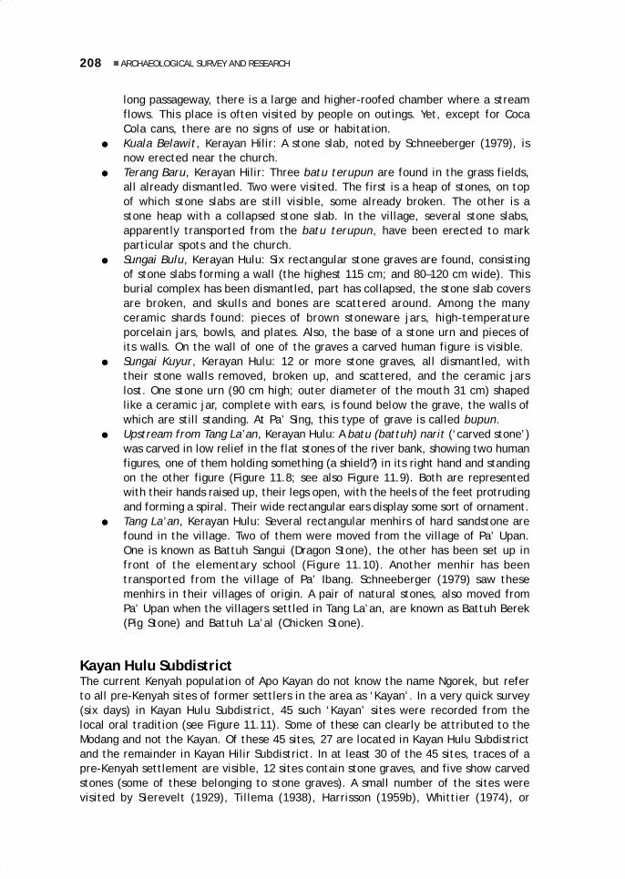
208 ARCHAEOLOGICAL SURVEY AND RESEARCH
long passageway, there is a large and higher-roofed chamber where a streamflows. This place is often visited by people on outings. Yet, except for CocaCola cans, there are no signs of use or habitation.
● Kuala Belawit, Kerayan Hilir: A stone slab, noted by Schneeberger (1979), isnow erected near the church.
● Terang Baru, Kerayan Hilir: Three batu terupun are found in the grass fields,all already dismantled. Two were visited. The first is a heap of stones, on topof which stone slabs are still visible, some already broken. The other is astone heap with a collapsed stone slab. In the village, several stone slabs,apparently transported from the batu terupun, have been erected to markparticular spots and the church.
● Sungai Bulu, Kerayan Hulu: Six rectangular stone graves are found, consistingof stone slabs forming a wall (the highest 115 cm; and 80–120 cm wide). Thisburial complex has been dismantled, part has collapsed, the stone slab coversare broken, and skulls and bones are scattered around. Among the manyceramic shards found: pieces of brown stoneware jars, high-temperatureporcelain jars, bowls, and plates. Also, the base of a stone urn and pieces ofits walls. On the wall of one of the graves a carved human figure is visible.
● Sungai Kuyur, Kerayan Hulu: 12 or more stone graves, all dismantled, withtheir stone walls removed, broken up, and scattered, and the ceramic jarslost. One stone urn (90 cm high; outer diameter of the mouth 31 cm) shapedlike a ceramic jar, complete with ears, is found below the grave, the walls ofwhich are still standing. At Pa’ Sing, this type of grave is called bupun.
● Upstream from Tang La’an, Kerayan Hulu: A batu (battuh) narit (‘carved stone’)was carved in low relief in the flat stones of the river bank, showing two humanfigures, one of them holding something (a shield?) in its right hand and standingon the other figure (Figure 11.8; see also Figure 11.9). Both are representedwith their hands raised up, their legs open, with the heels of the feet protrudingand forming a spiral. Their wide rectangular ears display some sort of ornament.
● Tang La’an, Kerayan Hulu: Several rectangular menhirs of hard sandstone arefound in the village. Two of them were moved from the village of Pa’ Upan.One is known as Battuh Sangui (Dragon Stone), the other has been set up infront of the elementary school (Figure 11.10). Another menhir has beentransported from the village of Pa’ Ibang. Schneeberger (1979) saw thesemenhirs in their villages of origin. A pair of natural stones, also moved fromPa’ Upan when the villagers settled in Tang La’an, are known as Battuh Berek(Pig Stone) and Battuh La’al (Chicken Stone).
Kayan Hulu SubdistrictThe current Kenyah population of Apo Kayan do not know the name Ngorek, but referto all pre-Kenyah sites of former settlers in the area as ‘Kayan’. In a very quick survey(six days) in Kayan Hulu Subdistrict, 45 such ‘Kayan’ sites were recorded from thelocal oral tradition (see Figure 11.11). Some of these can clearly be attributed to theModang and not the Kayan. Of these 45 sites, 27 are located in Kayan Hulu Subdistrictand the remainder in Kayan Hilir Subdistrict. In at least 30 of the 45 sites, traces of apre-Kenyah settlement are visible, 12 sites contain stone graves, and five show carvedstones (some of these belonging to stone graves). A small number of the sites werevisited by Sierevelt (1929), Tillema (1938), Harrisson (1959b), Whittier (1974), or

209Karina Arifin and Bernard Sellato
Figure 11.8 Two anthropomorphic figuresat Paru’ Ating, Kerayan Hulu area of KerayanSubdistrict
Figure 11.9 Anthropomorphic figure carved on a rock face by the rivernear Pa’ Upan, Kerayan Subdistrict

210 ARCHAEOLOGICAL SURVEY AND RESEARCH
Figure 11.10 Two menhirs standing in front of the villageschool, Tang La’an, Kerayan Subdistrict
Figure 11.11 Archaeological sites in Kayan Hulu and Kayan Hilir Subdistricts, ApoKayan
DATADIAN
LONG NAWANG
1
2 34
5
8
16
20
1718
19
28
2930
31SARAWAK
visited or documented
recorded
village
N
0 5 10 15 20 km
Baier (1992). Furthermore, at Long Ampung a tool (adze) made of basalt (13 cm long)was found, closely resembling the Apau Ping finds (see Figure 11.12; see also Figure11.13).
Only two stone burial sites were visited, the easily accessible sites of Mudung Kericaat Long Uro’ (see Figure 11.14) and Juman Nawang at Long Nawang (Figures 11.15 and11.16). Information was obtained on the sites at Batu Tukung near Lidung Payau (J.Halapiry, pers. comm.; Figures 11.17 and 11.18) and Data Kanuyang near Data Dian (C.Eghenter, pers. comm.; Figure 11.19). The stone grave at Data Kanuyang is a large

211Karina Arifin and Bernard Sellato
Figure 11.13 A basalt tool found in Mentarang Subdistrict
Figure 11.12 A basalt tool found at Long Ampung, KayanHulu Subdistrict
rectangular vat (1.8 m long and 1.2 m high) with four partially carved pillars and astone slab cover. The graves at the three other sites are also vats, measuring 90–120cm in length, 50–100 cm in width, and 25–55 cm in height (see Figures 11.20 to 11.22;also Figure 11.23). Information was also obtained on sites with carved stones, such asLong Sungan, Sawa’ Angen, and Batu Kalung, in the vicinity of the village of LidungPayau (J. Halapiry, pers. com.). The carved stones at the first two sites clearly werepillars for a stone vat. At Batu Kalung, however, a large boulder has been incised withmotifs representing an aso’ (dog-dragon; see Figure 11.24).

212 ARCHAEOLOGICAL SURVEY AND RESEARCH
Figure 11.14 Stone trough at Mudung Kerica, near Long Uro’, KayanHulu Subdistrict
90 cm
60 cm
25 cm
Figure 11.15 Stone trough at Juman Nawang, near Long Nawang, KayanHulu Subdistrict
110 cm
10 cm
102 cm80 cm
105 cm
46 cm
55 cm
25 cm
90 cm
115 cm
150 cm
14 cm
N S

213Karina Arifin and Bernard Sellato
Figure 11.16 Stone trough at Juman Nawang, near Long Nawang, KayanHulu Subdistrict
Figure 11.17 Rectangular stone trough at Batu Tukung, nearLidung Payau, Kayan Hulu Subdistrict
50 cm
120
cm

214 ARCHAEOLOGICAL SURVEY AND RESEARCH
Figure 11.19 Large stone container with carvedpillar at Data Kanuyang, Kayan Hilir Subdistrict
?
10 cm
+ 180 cm_
+ 120 cm_
Figure 11.18 Rectangular stone vat at BatuTukung, near Lidung Payau, Kayan Hulu Subdistrict

215Karina Arifin and Bernard Sellato
Figure 11.21 Carved stone pillars at LongSungan, near Lidung Payau, Kayan HuluSubdistrict
+ 90 cm_
Figure 11.20 Anthropomorphic figurecarved on a standing stone; LongSungan, near Lidung Payau, Kayan HuluSubdistrict

216 ARCHAEOLOGICAL SURVEY AND RESEARCH
Figure 11.22 Carved stone pillar at Sawa’ Angen, near Lidung Payau,Kayan Hulu Subdistrict
+ 85 cm_
Figure 11.23 Anthropomorphic figure carved on a standing pillar atLong Poh, Kayan Hilir Subdistrict
+ 1 m_
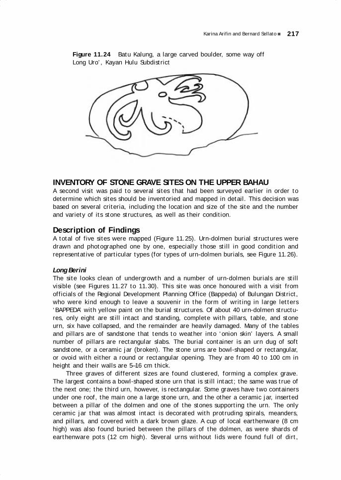
217Karina Arifin and Bernard Sellato
Figure 11.24 Batu Kalung, a large carved boulder, some way offLong Uro’, Kayan Hulu Subdistrict
INVENTORY OF STONE GRAVE SITES ON THE UPPER BAHAUA second visit was paid to several sites that had been surveyed earlier in order todetermine which sites should be inventoried and mapped in detail. This decision wasbased on several criteria, including the location and size of the site and the numberand variety of its stone structures, as well as their condition.
Description of FindingsA total of five sites were mapped (Figure 11.25). Urn-dolmen burial structures weredrawn and photographed one by one, especially those still in good condition andrepresentative of particular types (for types of urn-dolmen burials, see Figure 11.26).
Long BeriniThe site looks clean of undergrowth and a number of urn-dolmen burials are stillvisible (see Figures 11.27 to 11.30). This site was once honoured with a visit fromofficials of the Regional Development Planning Office (Bappeda) of Bulungan District,who were kind enough to leave a souvenir in the form of writing in large letters‘BAPPEDA’ with yellow paint on the burial structures. Of about 40 urn-dolmen structu-res, only eight are still intact and standing, complete with pillars, table, and stoneurn, six have collapsed, and the remainder are heavily damaged. Many of the tablesand pillars are of sandstone that tends to weather into ‘onion skin’ layers. A smallnumber of pillars are rectangular slabs. The burial container is an urn dug of softsandstone, or a ceramic jar (broken). The stone urns are bowl-shaped or rectangular,or ovoid with either a round or rectangular opening. They are from 40 to 100 cm inheight and their walls are 5–16 cm thick.
Three graves of different sizes are found clustered, forming a complex grave.The largest contains a bowl-shaped stone urn that is still intact; the same was true ofthe next one; the third urn, however, is rectangular. Some graves have two containersunder one roof, the main one a large stone urn, and the other a ceramic jar, insertedbetween a pillar of the dolmen and one of the stones supporting the urn. The onlyceramic jar that was almost intact is decorated with protruding spirals, meanders,and pillars, and covered with a dark brown glaze. A cup of local earthenware (8 cmhigh) was also found buried between the pillars of the dolmen, as were shards ofearthenware pots (12 cm high). Several urns without lids were found full of dirt,

218 ARCHAEOLOGICAL SURVEY AND RESEARCH
Figure 11.25 Graveyard sites inventoried and test pits in Pujungan Subdistrict
2
3 5
1
4
APAU PING
LONG BERINI
LONG ALANGO
LONGPUJUNGAN
LONG BENA
LEPU' UN JALUNG
APAU ANGAN
BAHAU
BERAA
LURAH
PUJUNGAN
N
0 5 10km
1. LONG BERINI2. KA TEMPU3. LONG KALE'
4. LONG PULUNG5. LONG BERAA TEST-PITS

219Karina Arifin and Bernard Sellato
Figure 11.26 Typology of stone containers: 1. rectangular with narrower base;2. bowl-shaped; 3. rectangular ‘bowl’; 4. cylinder; 5. ovoid with oval opening;6. ovoid with rectangular opening; 7. rectangular with rounded base
1 2
3 4
5 6
7
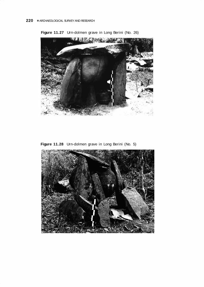
220 ARCHAEOLOGICAL SURVEY AND RESEARCH
Figure 11.27 Urn-dolmen grave in Long Berini (No. 26)
Figure 11.28 Urn-dolmen grave in Long Berini (No. 5)
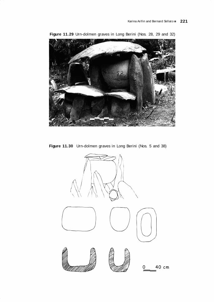
221Karina Arifin and Bernard Sellato
Figure 11.29 Urn-dolmen graves in Long Berini (Nos. 28, 29 and 32)
Figure 11.30 Urn-dolmen graves in Long Berini (Nos. 5 and 38)
0 40 cm

222 ARCHAEOLOGICAL SURVEY AND RESEARCH
seeds, and pieces of bones. It was not possible to determine whether the few intacturns contained bones, because the space between the mouth of the urn and the roofof the dolmen was too small.
Ka TempuThe site is covered with brush and trees and after it was cleared it became clear thattrees and roots have already done considerable damage to the structures (see Figures11.31 and 11.32). The graves are concentrated in the southeastern part of the site; inthe northwest they are much fewer; and in between is an empty area. Several gravesare also located on a steep slope, where some of the soil has already slid down. Thereis a total of about 80 graves of various sizes, types, and conditions, of which 6 areintact, 12 have collapsed, and the rest are heavily damaged. In several graves, aceramic jar is found in place of the stone urn under the roof of the dolmen. One stonecontainer is cylindrical and has toppled. One stone urn lid is carved in relief with acreature (a frog?) with hands and feet with five fingers/toes.
As at Long Berini, the burial containers are of soft sandstone, while the roof andpillars are of ‘onion skin’ stone, except for a few that have slab pillars. The urns arevariously shaped: cylindrical, bowl-shaped, rectangular, or ovoid with either a roundor rectangular opening. They range in height from 33.5 cm to 117 cm, with walls 10–12 cm thick. Two ceramic jars are of the same type as those found in Long Berini,broad and short and with a dark brown glaze.
Figure 11.31 Cylindrical stone container in Ka’ Tempu (No. 17)

223Karina Arifin and Bernard Sellato
Figure 11.32 Ovoid stone container in Ka’Tempu (No. 50)
Long Kale’This rather narrow site with an uneven ground surface was covered with brush andtrees and needed clearing. None of the 18 graves stands intact, and only three are infairly good condition, even though some parts have collapsed or disappeared. Theother graves are broken, although in several of them the form of the urn is stillrecognisable. The pillars and roof of the dolmen are of ‘onion skin’ slabs of hardstone, while the containers are of soft stone. There is not much variation in urnshapes: cylindrical, bowl-shaped, and ovoid with rectangular opening. Not a singleceramic jar was found.
Long PulungThe site is located on a gently sloping plain, in an old orchard, and looks clean and wellmaintained. This site, too, has been visited by staff from the Development PlanningOffice of Bulungan District, as indicated by the word ‘BAPPEDA’ in yellow paint on oneof the monuments. It is enclosed by a 2 m high fence, already damaged, and by a lockon the gate. Of the dozen graves visible, only two remain intact, one still stands buthas lost its urn, four have collapsed, and the remainder are nothing but broken pieces.
The dolmens have ‘onion skin’ pillars and roofs. Several of those stones look asif they have been worked to smoothen out both surfaces, and one has been processed

224 ARCHAEOLOGICAL SURVEY AND RESEARCH
into a slab. One rectangular stone container with a narrower base (palung or trough)has a dent cut at the mouth and a hole in the side. Another, partly broken, is cylindrical,with geometric decorations carved all over its surface (see Figure 11.33). Altogether,there are four urn shapes: cylindrical, rectangular with a narrower base, bowl-shaped,and ovoid with a round opening.
Figure 11.33 Carved stone urn in LongPulung, upper Bahau
Long BeraaThis site is covered with dense brush and trees. Nyibun burial structures are locatedslightly below the megalithic graveyard. One big, Y-shaped wooden post still standsfirmly and the ceramic jar at its top is intact. Another Nyibun post has rotted andcollapsed, and scattered around and half buried are pieces of the ceramic jar withdragon motifs in relief, two gongs of different sizes, and a bent machete blade.
The stone grave complex is located on level land that was once cleared, andconsists of five structures. Two intact monuments display stone containers with arectangular opening and a rounded and narrower base. The pillars and roof are stoneblocks, or slabs combined with coarse blocks. The containers are of softer stone. Onecontainer has a domed lid of ‘onion skin’ stone, underneath the dolmen roof. In onecontainer (Figures 11.34 and 11.35), 12 human skulls and other bones (limbs and ribs)and a small rusty gong are found. Another grave contains a ceramic jar already broken.The remaining graves are heavily damaged.
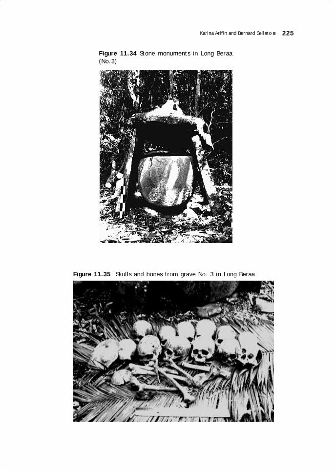
225Karina Arifin and Bernard Sellato
Figure 11.34 Stone monuments in Long Beraa(No.3)
Figure 11.35 Skulls and bones from grave No. 3 in Long Beraa

226 ARCHAEOLOGICAL SURVEY AND RESEARCH
DiscussionThe sites mapped cover an area ranging from 30 to 6000 m² and are located from 5 to20 m from the river. Generally, they extend parallel to the river (except at Long Beraa).At the five sites, a total of 155 graves were found, more than 50% of which are at KaTempu. On average, only 11.6% of the total number of graves are still intact. This factis a matter for considerable concern, and even the sites in isolated areas have notescaped destruction. According to the local people, several sites have in fact beenused for farming, one of the major causes of destruction, because the future field isburned. Destruction, however, can also be caused by the river (erosion of the banks),the growth of roots and trees, and the activities of animals, such as pigs, which liketo root around in the ground. Of the five sites, only one (Long Pulung) shows anyindication of an effort at preservation (fencing the site), since this location is veryeasy to visit.
For 80 graves (51.6%), it was still possible to determine the original type andshape of the burial container (see Table 11.1). For example, at Long Berini (22containers): 10 urns are ovoid with a round opening, 4 are bowl-shaped, 3 arerectangular, 2 are ovoid with a rectangular opening, and 3 more are ceramic jars. Theoverall most common container shape is the ovoid urn with a round opening (36examples). One monument at Long Berini should be noted, because not only is it thehighest monument recorded, but its stone urn is also the largest, with a diameter of120 cm, a height of 80 cm, and 10 cm thick walls.
Cyl
inde
r
Long Berini - - - 4 3 10 2 3 22
Ka Tempu 5 - - 6 2 21 5 1 40
Long Kale 1 - - 2 - 4 - - 7
Long Pulung 1 1 - 4 - 1 - - 7
Long Beraa - - 1 - 1 - 1 1 4
Total 7 1 1 16 6 36 8 5 80
Rect
angu
lar
wit
hN
arro
wer
Bas
e
Rect
angu
lar
wit
hRo
unde
d Ba
se
Bow
l Sh
aped
S I T E
Rect
angu
lar
’bow
l’
Table 11.1 Distribution of container shapes in the upper Bahau
Ovo
id w
ith
Roun
d O
peni
ng
Ovo
id w
ith
Rect
angu
lar
Ope
ning
Cera
mic
Jar
Tota
l
Shape of Stone Container
Little can be said about the structure of the graves because it varies considerably,following the types and shapes of their containers. At Long Beraa, for example, dolmenpillars are found only on the two sides of the grave, a consequence of the use of arectangular container (sarcophagus). Likewise, supporting stones are used for the bowl-
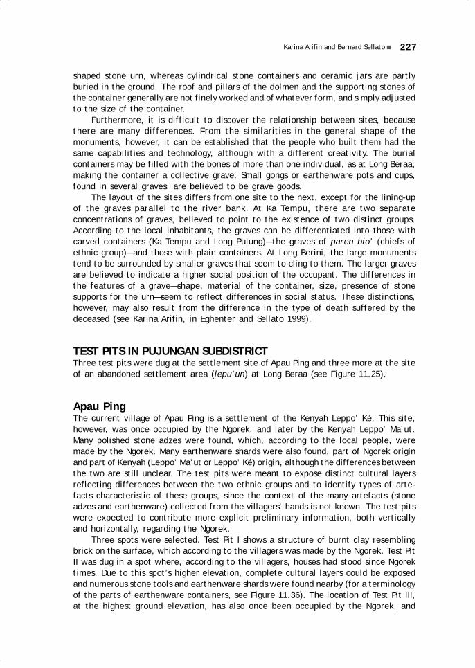
227Karina Arifin and Bernard Sellato
shaped stone urn, whereas cylindrical stone containers and ceramic jars are partlyburied in the ground. The roof and pillars of the dolmen and the supporting stones ofthe container generally are not finely worked and of whatever form, and simply adjustedto the size of the container.
Furthermore, it is difficult to discover the relationship between sites, becausethere are many differences. From the similarities in the general shape of themonuments, however, it can be established that the people who built them had thesame capabilities and technology, although with a different creativity. The burialcontainers may be filled with the bones of more than one individual, as at Long Beraa,making the container a collective grave. Small gongs or earthenware pots and cups,found in several graves, are believed to be grave goods.
The layout of the sites differs from one site to the next, except for the lining-upof the graves parallel to the river bank. At Ka Tempu, there are two separateconcentrations of graves, believed to point to the existence of two distinct groups.According to the local inhabitants, the graves can be differentiated into those withcarved containers (Ka Tempu and Long Pulung)—the graves of paren bio’ (chiefs ofethnic group)—and those with plain containers. At Long Berini, the large monumentstend to be surrounded by smaller graves that seem to cling to them. The larger gravesare believed to indicate a higher social position of the occupant. The differences inthe features of a grave—shape, material of the container, size, presence of stonesupports for the urn—seem to reflect differences in social status. These distinctions,however, may also result from the difference in the type of death suffered by thedeceased (see Karina Arifin, in Eghenter and Sellato 1999).
TEST PITS IN PUJUNGAN SUBDISTRICTThree test pits were dug at the settlement site of Apau Ping and three more at the siteof an abandoned settlement area (lepu’un) at Long Beraa (see Figure 11.25).
Apau PingThe current village of Apau Ping is a settlement of the Kenyah Leppo’ Ké. This site,however, was once occupied by the Ngorek, and later by the Kenyah Leppo’ Ma’ut.Many polished stone adzes were found, which, according to the local people, weremade by the Ngorek. Many earthenware shards were also found, part of Ngorek originand part of Kenyah (Leppo’ Ma’ut or Leppo’ Ké) origin, although the differences betweenthe two are still unclear. The test pits were meant to expose distinct cultural layersreflecting differences between the two ethnic groups and to identify types of arte-facts characteristic of these groups, since the context of the many artefacts (stoneadzes and earthenware) collected from the villagers’ hands is not known. The test pitswere expected to contribute more explicit preliminary information, both verticallyand horizontally, regarding the Ngorek.
Three spots were selected. Test Pit I shows a structure of burnt clay resemblingbrick on the surface, which according to the villagers was made by the Ngorek. Test PitII was dug in a spot where, according to the villagers, houses had stood since Ngorektimes. Due to this spot’s higher elevation, complete cultural layers could be exposedand numerous stone tools and earthenware shards were found nearby (for a terminologyof the parts of earthenware containers, see Figure 11.36). The location of Test Pit III,at the highest ground elevation, has also once been occupied by the Ngorek, and

228 ARCHAEOLOGICAL SURVEY AND RESEARCH
earthenware and stone adzes were also found on the surface. During the 1992 survey,a test pit had been dug by Kiwok Rampai not far from Test Pit III, in the yard of alower-lying house.
Figure 11.36 Pottery Terminology
LIP
NECKRIM
RIDGE
BODY
BOTTOM
Test Pit IThe 1 x 1m test pit consists of five lots. It reveals a ‘brick structure’ forming twohollows of, respectively, 40 x 30 cm (to the south) and 60 x 30 cm (to the north). Thebottom and sides consist of layers of hard brick. The outer walls are less hard andtheir colour shifts from bright red to brown and finally fades into the colour of thesurrounding soil. In the hollows, river stones, charcoal particles, and earthenwareshards were found. One of the river stones, of unclear function, has a round sidecovered by a layer of greenish yellow glaze. The base of the hollows is greenish brownand rippled and is impermeable to water, maybe the result of high temperatures atburning. Earthenware shards, all from the bodies of containers, are red, grey, andblack, with a temper of crushed earthenware. One shows string decoration. No dis-tinct soil layers or other artefacts were found that could be used as markers of culturallayers.
Test Pit IITest Pit II is 1.5 x 1.5m and consists of three lots. Lot 1 consists of disturbed black soilcontaining stones and 68 pottery shards (including 1 ridge, 1 neck, and 1 rim). In Lot2, an earthenware artefact of unclear function, with a temper of coarse crushed potterywas found. The bottom of Lot 2 is a layer of dense yellow soil with black pellets andchunks of river stones, and one piece of dark grey pottery with a coarse temper. Thebottom of Lot 3 (75 cm deep) displayed a sterile layer of yellow soil mixed with blackpellets. Test Pit III, thus, shows a single cultural layer.
Lot 1 yielded 640 gr of earthenware shards, generally rather small (less than 2cm), and Lot 2 only revealed one shard (5 cm). The thickness of the shards variesfrom 0.3 to 1.1 cm. The temper is of crushed earthenware (from fine to coarse, witha maximum of 0.4 cm), or sand with grains still visible, indicating a low firingtemperature. The pottery is orange, reddish grey, or black. It does not always have anoutside layer of resin, but occasionally the inside is covered by such a layer. One shardshows a straight rim, similar to the form manufactured by the villagers today. Nodecorated earthenware was found.

229Karina Arifin and Bernard Sellato
Test Pit IIITest Pit III is 1.25 x 1.25 m and consists of four lots. Lot 1 shows crumbly soil withchunks of river stones, 3 unpolished basalt adzes, small flakes of basalt, animal teeth,charcoal, and small pellets of batu bala (literally, red rocks, natural red ochre mixedwith water and used for painting coffins, house walls, or shields). The earthenware (3kg of small shards) includes 594 pieces of container bodies, 53 ridges, 65 necks, and34 rims. Lot 2 yielded earthenware shards and chunks of river stone, batu bala, 2flakes of basalt, and one polished basalt adze with one of its edges reworked. Theearthenware (1.6 kg) consists of 286 pieces of container body, 53 ridges, 22 necks,and 23 rims. In Lot 3, the dense brown soil contains basalt flakes, several chunks ofyellow and red ochre, and small river stones. The earthenware (less than 1 kg) consistsof 216 pieces of the body, 30 ridges (Figures 11.37 and 11.38), 8 necks, and 6 rims(Figures 11.39 and 11.40). In Lot 4, the soil is still of the same type, and the earthenware(0.5 kg) consists of 87 pieces of the body, 19 ridges, 9 necks, and 4 rims, as well aspieces of white earthenware. Furthermore, two basalt adzes were found at a depth of82 cm. The test pit ended with a layer of sterile yellow soil at a depth of 94 cm. Thus,a single cultural layer was found, which did not show any sublayers.
Figure 11.37 Ridges in earthenware(Apau Ping): (a to e) test pit III Lot 2;(f-g) test pit III Lot 4
A B
CD
E
F G
0 3 cm
0 3 cm
Figure 11.38 Ridges in earthenwarefrom Apau Ping: test pit III Lot 3

230 ARCHAEOLOGICAL SURVEY AND RESEARCH
Figure 11.40 Rims in earthenware fromApau Ping: test pit III Lot 2
0 3 cm
Figure 11.39 Rims in earthenwarefrom Apau Ping: test pit III Lot 1
0 5 cm
The pottery is red orange, grey, black or, most infrequently, pale yellow. A layer ofresin is often found, either on the outside or the inside. Some pottery polished to ablack shine was found, as well as another type, yellowish or greyish red on the outsideand black on the inside. The temper generally consists of finely crushed pottery. Somepottery with a sand temper with quartz grains still visible indicates a low firingtemperature. More than half the pottery is decorated, generally with a string patternobtained by beating the pot with a paddle wrapped in string with varying diameter(see Figures 11.41 and 11.42). The straight rim of one container shows anothertechnique of string decoration, made by impressing a string around the neck. Adecorative pattern of boxes (squares or diamonds) is also found, made with a woodenpaddle incised with crossed lines. The lip may be decorated with a motif of deepscratches around the edge. On the pot’s body, decoration may be restricted to thebottom part, below the ridge, or to the part from the ridge to just below the rim. Oneof the pottery, showing a neck forming an angle, is decorated with a string patterninterrupted just below that angle.
Long BeraaThe Long Beraa site, located on the second terrace from the river bank, is an oldNgorek settlement site (lepu’un) and has been occupied again by the Kenyah Leppo’Ma’ut in the 1940s. This is an ideal location, because the flat is extensive, with anearby hill suitable for defence. Many earthenware shards are found on the groundsurface, as well as fruit trees (rambutan and candlenuts). Test pits were opened inthree locations.

231Karina Arifin and Bernard Sellato
Figure 11.41 Pattern made bythin string wrapped around a paddle
0 2 cm
Figure 11.42 Pattern made bythick string wrapped around a paddle
Test Pit ITest Pit I, measuring 1 x 1m, is located on a flat covered with grass and a few treesand consists of three lots. Lot 1 shows crumbly black soil mixed with roots, charcoal,shards of foreign ceramic, and earthenware shards (less than 0.5 kg) consisting of 30parts of container body, 3 necks, and 5 rims. There is also one pot bottom with athickness of 2 cm (110 gr), thought to be part of a large container. The local people,however, claim that they have never seen one so thick. Batu bala is also present. InLot 2, still denser yellow soil contains river stones, charcoal, and orange and greypottery shards (200 gr) consisting of 11 shards of body, 4 necks, and 1 rim, with atemper of crushed earthenware and very coarse sand (0.5 cm). In the upper part ofLot 3, a grey soil layer yielded one shard of a pot body and charcoal particles, and isgradually replaced with dense yellow soil. Lot 3 ends with a sterile yellow layer at adepth of 60 cm.
Test Pit IIIn a flat overgrown with ferns and dense tall Imperata grass, Test Pit II, measuring 1x 1m, consists of 2 lots. In Lot 1, crumbly black soil with charcoal particles yielded 7chunks of batu bala (200 gr) and pottery consisting of 15 shards of container body, 4necks, and 4 rims. Downward, the soil becomes sandy with fine grey soil pellets, andat the bottom of the lot it is mixed with yellow soil. Lot 2 was dug only 18 cm deep tocheck the underlying soil in the south of the square. At its bottom, the soil is still blackand contains charcoal particles and earthenware (200 gr) consisting of 11 shards ofcontainer body, 4 necks, and 1 rim. Small chunks of batu bala were also found. Theyellow soil layer appears to be sterile.
Test Pit IIITest Pit III, measuring 1 x 1m, is located at the end of a flat area overgrown with thickfern and it consists of three lots. In Lot 1 below the humus, a black sandy soil mixedwith charcoal yielded earthenware shards (100 gr) comprising 15 shards of containerbody, 1 neck, and 1 rim, as well as pieces of glass and bottles, pieces of tin plates,river stones, and todan (a sort of resin). Lot 2 consists of dense yellow and brown soilwith no charcoal or artefacts at all. Lot 3 was dug in the middle of the square toexamine a spot of dark grey crumbly soil to a depth of 17 cm, possibly the remains of

232 ARCHAEOLOGICAL SURVEY AND RESEARCH
a house stilt. The pottery is reddish orange and dark grey, some showing remains of aresin layer, and the temper is coarsely crushed pottery. Straight rims indicate a ratherclosed type of pot, like that still made by the local people today. Not a single shard ofdecorated pottery was found.
ConclusionThe two sites display similar features, i.e., a black upper layer containing charcoaland artefacts (primarily pottery), and a yellow, sterile substratum. In between aretransition layers of black and yellow soils, frequently still containing artefacts. Theupper layer does not show distinctive sublayers that could be viewed as representingtwo or more different cultural layers. It is thus difficult to identify or distinguishbetween the groups that manufactured the artefacts recovered. The Kenyah nevermanufactured basalt tools and always insist that these were made by the Ngorek,which leads to the conclusion that the stone tools in Test Pit III at Apau Ping were madeby the Ngorek. The problem is different with regard to the pottery shards foundeverywhere. Without a clear differentiation of cultural layers, there is no indication todetermine who made these pots. Although the people of Apau Ping tend to state thatthese shards are of Ngorek origin, they themselves, to this day, still produce earthenware(see Sellato 1997a).
ANALYSIS OF ARTEFACTS FOUND IN APAU PINGResearch on the artefacts found in the Apau Ping area in 1991–92 was conducted inJakarta. These artefacts consisted primarily of stone implements and pottery shards,and a few shards of foreign ceramic ware and pieces of iron.
Stone toolsThe stone tools investigated totalled 205 pieces. They can be classified as adze,pounder, gouge, scraper, and sharpening stone. Adzes form the largest group (59items)—to which should be added 42 unpolished adzes. A large number of brokenbasalt tools could not be classified.
Figure 11.43 Terminology of theadze: a) upper surface; b) longi-tudinal section; c) lower surface;1) butt; 2) cutting edge
A B C
1
2
AdzesThese adzes generally are elongated with aquadrangular cross section, and are finelypolished all over (see Figure 11.43). A cuttingedge is made by abrading the extremity ofthe tool, giving a sharper slant to the extremityof the lower surface. They vary in size from 4to 25 cm. They can be divided into eight ty-pes according to shape. It should be noted thatthis typology is essentially descriptive and doesnot carry implications regarding differencesin the functions of the tools.
Type A (23 items; see Figure 11.44): theupper surface rises from a narrow butt towardsthe centre of the tool and broadens increasingly

233Karina Arifin and Bernard Sellato
Figure 11.44 Typology of stone adzes from the upper Bahau, type A
0 3 cm
0 3 cm
0 3 cm3 cm
0 3 cm3 cm
0 3 cm3 cm
Type A Subtype A1
Subtype A2 Subtype A3
Subtype A4 Subtype A5
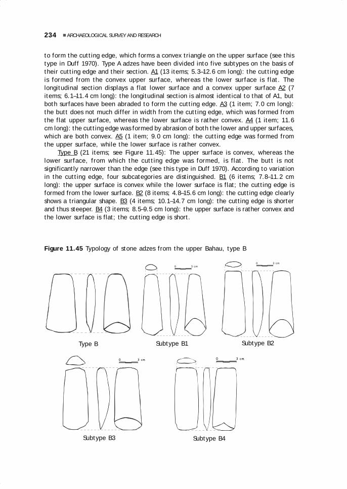
234 ARCHAEOLOGICAL SURVEY AND RESEARCH
to form the cutting edge, which forms a convex triangle on the upper surface (see thistype in Duff 1970). Type A adzes have been divided into five subtypes on the basis oftheir cutting edge and their section. A1 (13 items; 5.3–12.6 cm long): the cutting edgeis formed from the convex upper surface, whereas the lower surface is flat. Thelongitudinal section displays a flat lower surface and a convex upper surface A2 (7items; 6.1–11.4 cm long): the longitudinal section is almost identical to that of A1, butboth surfaces have been abraded to form the cutting edge. A3 (1 item; 7.0 cm long):the butt does not much differ in width from the cutting edge, which was formed fromthe flat upper surface, whereas the lower surface is rather convex. A4 (1 item; 11.6cm long): the cutting edge was formed by abrasion of both the lower and upper surfaces,which are both convex. A5 (1 item; 9.0 cm long): the cutting edge was formed fromthe upper surface, while the lower surface is rather convex.
Type B (21 items; see Figure 11.45): The upper surface is convex, whereas thelower surface, from which the cutting edge was formed, is flat. The butt is notsignificantly narrower than the edge (see this type in Duff 1970). According to variationin the cutting edge, four subcategories are distinguished. B1 (6 items; 7.8–11.2 cmlong): the upper surface is convex while the lower surface is flat; the cutting edge isformed from the lower surface. B2 (8 items; 4.8–15.6 cm long): the cutting edge clearlyshows a triangular shape. B3 (4 items; 10.1–14.7 cm long): the cutting edge is shorterand thus steeper. B4 (3 items; 8.5–9.5 cm long): the upper surface is rather convex andthe lower surface is flat; the cutting edge is short.
0 3 cm 0 3 cm
Figure 11.45 Typology of stone adzes from the upper Bahau, type B
0 3 cm
0 3 cm
Type B Subtype B1 Subtype B2
Subtype B3 Subtype B4

235Karina Arifin and Bernard Sellato
Other types (see Figure 11.46): Type C (7 items; 7.0–10.9 cm long): the uppersurface is convex while the lower surface is flat. The cutting edge was formed fromboth the upper and lower surfaces. Type D (6 items; 7.7–10.6 cm long): the uppersurface is convex while the lower surface is flat; the cutting edge was formed fromthe lower surface, and is narrower than the butt. Type E (2 items; 11.1–11.7 cm long):the lower surface is flat while the upper surface is slightly convex; the cutting edgewas formed from the lower surface, and is wider than the butt; the sides of the toolare polished, and the butt is also polished to form a square. Type F (3 items; 10.1–13.8 cm long): the upper surface is convex, while the lower surface is flat; the cuttingedge, formed from the lower surface, somewhat widens, while the butt is rounded.Type G (1 item; 15.4 cm long): both the upper and lower surfaces are convex; the buttis rounded and the cutting edge, formed from the lower surface, is slightly wider. TypeH (1 item; 9.0 cm long): both the upper and lower surfaces are flat; the butt is smallerthan the cutting edge, formed from both the upper and lower surfaces.
A total of 42 unpolished adzes (4.3–21.5 cm long) were collected. Their featuresare in line with those of an adze, except that they remained unpolished.
0 1 cm
0 3 cm
Figure 11.46 Typology of stone adzes of the upper Bahau, C to H
0 3 cm
0 3 cm
0 4 cm0 1 cm
Type C Type D Type E
Type GType F Type H

236 ARCHAEOLOGICAL SURVEY AND RESEARCH
Other toolsGouges (2 items; 9.2–17.8 cm long; seeFigure 11.47): the overall shape is elongatedand rather convex, with the butt and cuttingedge of the same width. The curved cuttingedge is found on the lower part. Pounders (2items; 12.2–14.1 cm long; see Figure 11.48):they are ovoid, with a butt smaller than thepounding end, which has a hollow centre anda rim forming a flat circle and is used forcrushing (see Sellato 1996). Scraper (1 item,7.5 cm long): it is rectangular with a thickbutt and a pointed cutting edge, and boththe upper and lower surfaces are flat.Sharpening stone (1 item; 9.1 cm long): it isthin and triangular, with a hole at the buttend. Unidentified (83 items; 2.6–13.8 cmlong): various broken tools and pieces ofworked basalt of unknown function and type.
Pottery and CeramicsThese finds are distinguished into localearthenware and foreign ceramics. Theanalysis is based on the analytical methodsfor pottery described by Wahyudi (1985).
Local EarthenwareThe basic material is clay, but some piecesare made from clay mixed with lime. Theclay, with a high iron content, is grey, black,or red. Low-temperature firing results in acoarse earthenware, whereas fineearthenware results from medium-temperature firing. The tempers are sandand crushed earthenware. The technique usedis hand modelling (for terminology, seeFigure 11.36), and finger imprints are foundon several earthenware shards.
At the end of the manufacturing process,a brushing technique was applied, which mayhave used straw, leaving fine lines visible onthe pot’s body. Pressure techniques ofdecoration were also used, employing paddleswrapped in string, resulting in lines whose widthdepended on the size of the string. Some verythick black shards of a container’s body mayhave belonged to a metal-smelting container.
Figure 11.48 Stone pounder fromthe upper Bahau
Figure 11.47 Stone gougefrom the upper Bahau
0 2 cm
0 6 cm
0 6 cm

237Karina Arifin and Bernard Sellato
A total number of 676 shards included 7 pieces of black or grey, undecorated rims,with an open, straight, or closed angle, with a mouth diameter of 8 to 18 cm; 1 pieceof black ridge with line decoration, manufactured by the hand modelling technique;182 pieces of grey, black, or red container body, plain or decorated with (thick or thin)lines made with a paddle wrapped with string (see Figures 11.41 and 11.42); 6 shardsof smelting containers, black and undecorated; and 487 unidentified undecoratedshards.
Foreign CeramicsThis category includes all shards of glazed, white or pale blue, kaolin base. From atotal number of nine shards, 1 is a rim shard with a flower motif under the glaze, anopen angle, and a probable diameter of 21 cm (possibly from a plate); 3 bottomshards, plain or decorated with floral motif under the glaze, one of which contains afactory mark which could not be clearly read (only a crown is visible); and 5 unidentifiedpieces with floral motif under the glaze.
MEGALITHIC GRAVES: A SUMMARYThe surveys that were carried out indicated differences in the form of the burialstructures in the four subdistricts visited. In Long Pujungan, the graves generallyconsisted of stone urn-dolmens in various forms, but a few menhirs were also found,usually erected near graves. In Kerayan, two forms are known, the batu terupun (orperupun, pelepuun) and a type of urn-dolmen with a ceramic jar container, as well asa number of menhirs. So far, no stone burials have been found in Malinau where,instead, there are grave monuments made of wood and including ceramic jars. InKayan Hulu, the most common burial container is a rectangular stone trough. This lastsubdistrict, however, will not be discussed in this summary.
Pujungan SubdistrictThe urn-dolmen burial structure (Figure 11.2) basically consists of a stone urn, standingon short stone pillars or blocks or directly on the ground, and covered with a flat stone(lid or cover). This container is protected by a dolmen consisting of several stonepillars supporting a large stone slab (the roof or table). The term urn-dolmen wascoined by Schneeberger (1979). The materials used generally can be found in thevicinity of the grave, yet, in some cases they must have been carried from rather faraway. The container and its lid, as well as a number of dome-shaped dolmen roofs,consist of medium-to-coarse-grained feldspatic sandstone of Cretaceous age. Thisrock formation is found in several locations, for example, on the Ngiam River and atKiam Bio’. Many stone slabs which have been made into dolmen tables consist ofCretaceous siliceous siltstones or fine-grained sandstones, found along the length ofthe Bahau River. The pillars of the graves were made of whatever type of stone wasavailable (Sellato 1995c).
The form of the structures varies significantly. For example, the cylindricalcontainers, found at Ka Tempu and Lepu’un Nyibun and reaching 1.5 m in height,apparently had not been protected by a dolmen, but only by a stone slab as a cover.The shape of the stone container also varies. Its mouth may be rectangular, oval, orcircular, while its bottom is round. The rectangular containers found at Long Pulung

238 ARCHAEOLOGICAL SURVEY AND RESEARCH
and Long Lenjau Ca have a base smaller than their opening, so that their walls slope.The pillars may resemble a square beam, or be somewhat convex (‘onion skin’), orjust retain the natural shape of the stone used. There are also pillars of rectangularstone (e.g., at Long Tela’u), or made of carefully processed and shaped flat slabs(e.g., at Long Beraa). So far, only two carved stone graves have been found (LongPulung and Ka Tempu).
The size of the graves, too, varies. The highest is 2 m, with its container alonereaching 1 m in length. Yet, more commonly found are graves about 50 cm high. Nearor attached to large structures are occasionally a number of smaller structures, seemingto form a cluster, as in Long Berini. Ceramic jars are also found, placed between thepillars of large stone urn-dolmens. The differences in the size and layout of the gravestructures are thought to indicate status differences.
Ceramic jars were found at several sites, placed on the ground, or sometimespartly buried to prevent them from toppling. At Long Berini, a broken ceramic jar waslocated on the ground, enclosed by a ring of stone slabs slanting as if covering the jar.The various ceramic jars found as parts of stone burial structures in the Long Pujunganarea still await identification with regard to their origins and age. Some have beenidentified as 18–19th century Chinese jars, such as the rather common brown jars withdragon motif and the jars with four ears and two rows of protruding pegs underneath(Sellato 1995c). A number of jars with a red paste, coarse temper, and black leadglaze, originated from 15–17th century Thailand or Burma (see Manguin 1995).
Kerayan SubdistrictHere, too, a variety of burial structures are found. At Sungai Bulu and Sungai Kuyur,ceramic jars are often used as burial containers, and placed inside a square chamberof rectangular stone slabs with relatively straight edges and of even thickness; thechamber was covered with a stone slab. The only stone urn found was unique in that ithad been carved to resemble a ceramic jar, complete with ears. At Sungai Bulu, atriangular stone pillar carved with a human form had been set up in one of the insidecorners of the stone chamber—a similar carving was found on the surface of a stonecropping out on the bank of the Kerayan River upstream from Tang La’an. The gravesof Sungai Kuyur and Sungai Bulu seem to represent a specific form, which may bewidespread in the Kerayan Hulu region. In the area of Kerayan Darat, the commongrave structure is the batu terupun (or perupun, pelepuun), a large dolmen made ofstone slabs reaching 2 m in length and 1 m in width, erected on a heap of river stones.
Several stones stand alone, both rectangular pillars (menhirs) and flat slabs. AtTerang Baru, for example, several stone slabs had been erected in the ground asmarkers of the village, the church, or something else. Very likely, in the Kerayan Daratarea, these slabs were formerly part of a dolmen structure. For example, one pillar ofa batu terupun in Pa’ Api has been moved to the edge of the football field to beerected as a village marker. In the Kerayan Hulu area (e.g., at Tang La’an), severaltall menhirs clearly had not been part of a dolmen structure.
Malinau DistrictThe grave structures here are made of large wooden beams, yet their constructionand their function are reminiscent of the megalithic structures in other districts. Thesame is true of the burial structure of the Nyibun people—a large wooden post supporting

239Karina Arifin and Bernard Sellato
a ceramic jar containing human bones—which seems to represent a sequel to the tradi-tion of the stone structures. It may be guessed that the use of stone as constructionmaterial for graves does not only depend on the local traditions, but also on the availabilityof the materials. A shortage of stone of the right type does not mean, however, that acommunity must abandon its tradition of megalithic structures. In the Kerayan area, forexample, the large stone slabs used in the batu terupun must have been brought therefrom a rather distant area. It must be asked why some people stopped building megalithicgraves, even though the underlying ideas persisted. It is also possible that an importantchange in social structure caused the abandonment of the megalithic tradition, so thatthe stone burial structures were replaced with wooden ones.
Further ResearchThe test pits dug at two former Ngorek settlement sites (Apau Ping and Long Beraa)did not show distinct cultural layers. It was possible, however, to determine differencesin the types of artefacts, especially with regard to the basalt tools and the earthenware.Further surveys of other settlement sites are needed to determine their size,characteristics, and environment, before selecting some for excavation. Further surveysshould also focus on cave sites, to obtain a better picture of their types, morphology,and distribution, before test pits or true excavations begin. Extension work should beperformed among the local people regarding the protection and preservation ofarchaeological remains in their regions, in order to protect the sites and preventfurther destruction. This is also important for inducing pride and a feeling of ownershipregarding these historic monuments among the villagers, who so far do not understandtheir significance.

12.Kenyah Bakung oral literature:An introduction
C. Yus Ngabut
INTRODUCTIONThis contribution focuses on the Kenyah Bakung who are at present living in the vil-lage of Long Apan Baru (Long Aran) in the district of Pujungan. These people originallycame from Lasan Adie (Iwan River) and subsequently moved to Long Bakung on thePujungan River (on the history of the Bakung, see Ngindra, in Eghenter and Sellato1999, and Rousseau 1990). More recently, a group of Bakung living in Long Apan (onthe Lurah River) finally moved to Long Aran in about 1969. Because they came fromLong Apan, the village of Long Aran is better known as Long Apan Baru. From LongAran, some of the people moved again to Sa’jau, while others moved to Long Bang onthe lower Kayan River.
So far, the oral literature of the Bakung has been little documented. In 1992,Paternus Hanye was able to examine some examples of oral literature and made somecassette recordings (see Hanye 1995). Yet, it is almost certain that this literature willdisappear if no efforts are made to preserve it. Today, only very few people remainwho have mastered the literature, and they are generally already advanced in age.The younger generations appear to be uninterested in this heritage. Furthermore, theoccasions for using the literature have decreased considerably as the traditional adatand religion have been abandoned by the Bakung themselves. Thus, it is clear that theoral literature of the Bakung must be studied and recorded and efforts be made tosave it from extinction. It is hoped that this article will be of use in drawing attentionto this rich and imperilled heritage.
12 May28.p65 6/11/03, 11:04 AM241
Black

242 KENYAH BAKUNG ORAL LITERATURE: AN INTRODUCTION
The research is intended to 1) inventory the types of oral literature in existence;2) learn the position and the function of oral literature; 3) save the tekena’ (folktales)of the Bakung from disappearance by recording, transcribing, and translating varioustypes of tekena’ into Indonesian; 4) analyse and describe basic themes and thecharacters and characterisation in the tekena’; 5) return the literary manuscripts tothe Bakung in the form of printed books; and 6) stimulate interest among the Bakungthemselves in taking over the preservation of their own oral literature. It is hopedthat this article can contribute to the efforts of the Culture & Conservation Program inpreserving the oral literature of the Kenyah, and especially that the Kenyah themselveswill eventually take over the preservation efforts.1
The Body of Oral LiteratureBecause of the short research time, the writer restricted himself to studying the proseknown as tekena’. Nine texts were recorded, but as the writer’s assistants were notmuch available and the writer himself had but a limited command of the Bakunglanguage, not all of them have been transcribed. In addition to these recordings, thewriter was also able to obtain two tekena’ recorded by Hanye in 1991. The tekena’that could be transcribed and freely translated are Tekena’ Laking Kuyang ngan Lenjau,Tekena’ Jalung Merang, and Tekena’ Balan Tempau. Some tekena’ were only transcribedand translated literally: Tekena’ Tamen Burin Batu Tusan, Tekena’ Sigau Belawan, andTekena’ Payau ngan Pelanuk. Other texts were only transcribed: Tekena’ Uyau Apan,Tekena’ Mering Belawan, and Tekena’ Baya’ ngan Lenjau. For one, the Tekena’ UyauApan, an abstract had been made by Hanye (1995), and for two more, abstracts weremade by the researcher and informants.
Some texts were not transcribed—Tekena’ Sigau Belawan ngan Jalung Ila andTekena’ Mending Orang Sakit. The former, as its title resembles that of other textsalready translated (Tekena’ Sigau Belawan and Tekena’ Balan Tempau), is believed totell the same story as these two other texts, staging the same individual hero, JalungIla. As for the latter, it is not a pure tekena’, since its content describes the mendingceremony for treating the sick (see Ngindra 1995b and in Eghenter and Sellato 1999).
Research MethodologyThe writer’s informants were native speakers of the Bakung language, who lived inthe village of Long Aran. The writer first sought information regarding potentialinformants, and the informants finally selected were a number of old people who couldstill tell the stories well, without difficulties in speaking. The writer visited theinformants by appointment in the evenings to record them. To gather additional infor-mation regarding types of oral literature and the situation of the Bakung generally,informal interviews were conducted with informants while they were casually relaxing
1 A large quantity of recordings of Bakung oral literature (and also of the literatures of other Kenyahsubgroups in the area) were made during the years of the Culture & Conservation Program. A substantialpart of them has been transcribed, at least cursorily, and some translated into Indonesian. One, atleast, the story of Laking Kuyang ngan Lenjau, was published as an illustrated booklet (1997) withboth the Bakung and Indonesian texts, for use in elementary schools in the area. Furthermore, in theframework of the C&C program, Stephanie Morgan produced a preliminary Bakung-Indonesiandictionary (1996), the only existing dictionary of a Kenyah language in Kalimantan to date.
12 May28.p65 6/11/03, 11:04 AM242
Black

243C. Yus Ngabut
at home, planting in the fields, and on other occasions that did not interfere with theinformants’ activities. While interviewing, the researcher did not use any electronicrecording equipment.
Data gathered through recordings were subsequently processed in three stages:transcription, translation, and analysis. The writer was assisted by four persons: onemain assistant for transcription and translation, one person who helped transcribingonly one tekena’, and two others for literal translation. The free translation and thewriting of the abstract were done by the writer. In this article, only the three tekena’that had passed through the stage of free translation are analysed (see the abstractsof these three tekena’ in the Appendix). They are Tekena’ Laking Kuyang ngan Lenjau(The Orangutan and the Tiger), Tekena’ Jalung Merang (The Story of Jalung Merang),and Tekena’ Balan Tempau (The Story of Balan Tempau).
After the transcription had been done solely by the writer’s assistant, it waschecked by the writer, who again listened to the cassette. For translation needs, thetranscription was also used by the writer’s colleagues, i.e., language specialists, intheir studies of Bakung phonology, morphology, and syntax, and it represents acontribution to the vocabulary of the Bakung dictionary (see Sri Munawarah 1995,Morgan et al. 1996). The translation of the tekena’ was done in two stages, beginningwith a word-for-word literal translation, followed by a free translation. The literaltranslation was used as a step toward the final goal, a free translation acceptable togeneral readers. When the writer studied the literal translation of the tekena’, it wasclear that certain aspects—usually found at the beginning and simultaneously servingas an introduction—did not need to be retained. In the final transcription andtranslation, these aspects were omitted because they did not contribute to thecompleteness of the story, or facilitate enjoyment of the story. Nevertheless, thisinformation was retained in the recording and in the early transcription and translationto document the process toward the final transcription and translation.
The following quotations from Tekena’ Jalung Merang illustrate the process inwhich the data were treated. The first line is a transcription in the Bakung language,the second is a word-for-word translation, and the third line is the free translation inIndonesian (followed in the fourth line by the English translation).
(1) Aun ne dau Jalung Merang mudip kiang batu tusanAdapun si Jalung Merang hidup di tebing batu jurangJalung Merang hidup danJalung Merang lived and
(2) mudip kapau le’ mande lepusut bunyau jangin nuyanhidup di atas gunung kata mereka jeruk pegunungan tembaga buatantinggal di daratan sebuah pegunungan.made his home on a flat in the mountainous highlands
(3) Uba’ ketai umen selai mendang liran le mandeingin pergi merantau melihat-lihat orang yang kata merekaIa ingin pergi merantau untuk melihat-lihat orang yang tinggalHe wanted to travel and visit the people who lived
12 May28.p65 6/11/03, 11:04 AM243
Black

244 KENYAH BAKUNG ORAL LITERATURE: AN INTRODUCTION
(4) ri’ ke daya alo Mara rene’ kanan nde’ mande. Nanedi hulu arus sungai Mara yang dipakai kata mereka. Itulahdi daerah hulu Sungai Mara. Iaon the Upper Mara River. He
(5) dau katai pisu inai re nguleng jelai latung pudan.pergi tanya namanya kalung jelai perhiasan badan.menanyakan ibunya apakah ia diperbolehkan.went and asked his mother for permission.
The analysis of the tekena’ contents was aimed at finding themes, protagonists,and characterisations in the various stories. In addition, the analysis was also used todetermine connections between the stories’ content, themes, and protagonists andtheir titles and social and natural environmental conditions at present and in the past.
ORAL LITERATURE OF THE BAKUNGThe oral literature of the Bakung comprises those literary works of the Bakung speakingpeople, which are passed from mouth to mouth, spread orally and anonymously, andwhich describe the life of the Bakung in the past.
Position and FunctionAs a regional literature, the oral literature of the Bakung has four functions. First, itis a means of entertainment and is used to fill free time. The literature meant tomeet this function usually is funny and humorous, such as is found in legends. Second,it serves as a means of education and of transmitting ancestral values. Stories servingthis function are useful, not only for children but also for adults and old people. Storiesof this type usually display positive values that are suitable for handing down, as wellas undesirable values and attitudes that must eliminated. Third, it serves as a meansof stating intentions and declaring wishes in connection with magical forces. For this,the oral literary forms used are mantra, used when fishing, taking honey, and treatingthe sick (mending ceremony). Fourth, it serves to tighten the relationship oracquaintance with a newcomer, which is usually done through singing (kendau or tiang).
Genres of Oral LiteratureAmong the genres in prose of the oral literature of the Bakung are tekena’ (folktales),ngidau (lamenting the dead or saying a mantra when treating a patient), bon-bon usatalon (when taking honey from a tall tree), tuba la’it tuba sanit (when catching fishusing tuba poison), and kelap ta’ penyakit kini (to drive out evil spirits from thevillage; see Hanye 1995).
The tekena’ that have been collected (see Figure 12.1) can be divided into twocategories: heroic tekena’ (epics) and regular, entertaining tekena’. Heroic tekena’in fact are neither myths nor legends, nor are they fairy tales. The titles of someheroic tekena’ are Tamen Burin Batu Tusan, Mering Belawan, Balan Tempau, and Baya’ngan Lenjau; while the titles of entertaining tekena’ are Sigau Belawan, Jalung Merang,Laking Kuyang ngan Lenjau, and Payau ngan Pelanuk. Three tekena’ seem to be fables,featuring animal characters: Laking Kuyau ngan Lenjau (The Orangutan and the Tiger),
12 May28.p65 6/11/03, 11:04 AM244
Black

245C. Yus Ngabut
Payau ngan Pelanuk (The Deer and the Mouse Deer), and Baya’ ngan Lenjau (TheCrocodile and the Tiger). In fact, however, only the Tekena’ Payau ngan Pelanuk is ananimal story. In the case of the other two, the indications of the titles are not followedthrough in the content of the stories.
Figure 12.1 Pui PeAnye’ Usat singing a tekena’ in the usual lying position
Poetry, as a literary form, can be divided into two categories, the kendau and thetiang (see Figure 12.2). Both forms are songs and are only distinguished according tothe number of participants. If a song is performed by a solo singer, it is called kendau;if more than one singer is involved, it is a tiang. Both kendau and tiang are usuallyperformed when receiving guests or as special performances when getting acquainted.Sometimes kendau are sung while people are relaxing. The content of kendau andtiang is generally fitted to the situation, including a focus on the person for whom thesong is sung.
Tekena’, as a lyrical genre, are prose that have been turned into song. Basically,all tekena’ can be grouped into the two categories above, because the singers usesongs and rhythm in telling a story, in an effort to beautify and add interest to thecontent of the story. In telling a tekena’, singers tend to slip into silun, which arecertain parts of the story especially made into songs. The telling of tekena’ with songand rhythm as grouped according to these lyrics depends very much on the style andthe abilities of the singer himself. The researcher’s main informant, Aga La’ing (betterknown as PeNgang), who had a special secret for telling tekena’, used songs andfollowed a beat from the beginning to the end of the story.
12 May28.p65 6/11/03, 11:04 AM245
Black
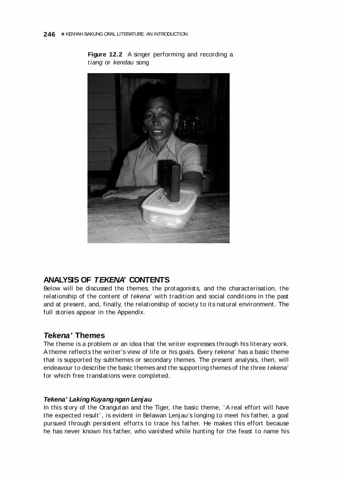
246 KENYAH BAKUNG ORAL LITERATURE: AN INTRODUCTION
ANALYSIS OF TEKENA’ CONTENTSBelow will be discussed the themes, the protagonists, and the characterisation, therelationship of the content of tekena’ with tradition and social conditions in the pastand at present, and, finally, the relationship of society to its natural environment. Thefull stories appear in the Appendix.
Tekena’ ThemesThe theme is a problem or an idea that the writer expresses through his literary work.A theme reflects the writer’s view of life or his goals. Every tekena’ has a basic themethat is supported by subthemes or secondary themes. The present analysis, then, willendeavour to describe the basic themes and the supporting themes of the three tekena’for which free translations were completed.
Tekena’ Laking Kuyang ngan LenjauIn this story of the Orangutan and the Tiger, the basic theme, ‘A real effort will havethe expected result’, is evident in Belawan Lenjau’s longing to meet his father, a goalpursued through persistent efforts to trace his father. He makes this effort becausehe has never known his father, who vanished while hunting for the feast to name his
Figure 12.2 A singer performing and recording atiang or kendau song
12 May28.p65 6/11/03, 11:04 AM246
Black
247C. Yus Ngabut
son, and because his friends ridiculed him as an illegitimate child. In the end, hemeets his father and is appointed a paren (leader) of his father’s longhouse by itsinhabitants.
Secondary themes are ‘Arrogance will bring disaster’ and ‘Unexpected benefits’.The first is expressed in the arrogance of Lenjau (Tiger), who considers Laking Kuyang(Orangutan) incapable of defeating him in a fight over the traditional territory oftheir ancestors. Orangutan repeatedly offers peace and says that war is not the bestway to settle a problem. When they finally do go to war, Orangutan defeats Tiger bythrowing him into the middle of the a great and deep river, where he immediatelysinks to the bottom. Unexpectedly, Tiger lands on the veranda of the house of Baya’(Crocodile), who has a daughter named Bungan Baya’. This girl is amazed at thehandsome Tiger and endeavours to make him her husband. In the end, they marry andhave a child named Belawan Lenjau. These events represent the second subsidiarytheme.
Tekena’ Jalung MerangThe basic theme, ‘Friendship and restraint of feelings are more important than hostility’,is expressed at the time of Jalung Bilung’s (JB) arrival. The hero from the mouth ofthe Mara Rian River stops at Jalung Merang’s (JM) village on his way to ask for thehand of the beautiful Urai Belawan on the upper Mara Rian. JM had previously askedhis mother for permission to go and woo Urai Belawan, but his mother was not readyto allow this because she still needed his help for the farm work. When he hears thereason for JB’s arrival, JM is very angry with his mother, and when JB asks him tocome along, he refuses on the grounds that he (JM) is busy. Although he is very angryand annoyed, JM does not say anything to JB. His hostility develops after JB and hisfriends leave next day, but JM does not say anything openly. With the help of hismother’s magic powers, he changes himself into a hornbill and the rope of his macheteinto a tudo’ bala pipa bala (a snake with a red tail and head), a very bad omen thatforces JB to abort his journey. Starting on his own journey, JM flies upriver and asksfor Urai Belawan’s hand.
When JB finally reaches the upper Mara Rian River to ask for his beloved UraiBelawan, he develops feelings of hostility when he learns that JM has already marriedher. JB has no reason to be angry at JM, because he never clearly stated the goal of hisjourney. In the end, the latent hostility ends with feeling of friendship and theestablishment of family ties when JB marries JM’s sister.
The secondary theme, ‘Marriage partners are determined by Fate’, is expressedin the fact that we learn that the parents of Urai Belawan had already, since herchildhood, promised her to JM’s parents. So it was not by chance that JM, who assumedthe shape of a hornbill, became their daughter’s husband. If JB had succeeded inarriving first, the agreement already made with the parents of JM would necessarilyhave been violated.
Tekena’ Balan TempauThe basic theme of this story is ‘If there is a will, there certainly will be a way.’ It isexpressed in the complications of the struggle and journey of Uyau Balan Tempau insearch of the enemy who abducted his wife almost without leaving a trace, until hefinally meets an old woman in a dream. She tells him that his wife’s abductor came
12 May28.p65 6/11/03, 11:04 AM247
Black

248 KENYAH BAKUNG ORAL LITERATURE: AN INTRODUCTION
from the sky, and she orders him to make a blowgun with as many darts as possible.Failing repeatedly, because the darts cannot hit the sun, Balan Tempau finally remembershis wife’s belongings and, among them, he finds three large needles. He makes theseinto arrows, which finally hit the sun. The three arrows are connected to the otherarrows to form a ladder leading to the sky.
After he has managed to reach the sky and arrives at the sun, he meets Ulau Tau(the Protector of the Sun), who helps him by advising him to pursue Jalung Ila. On hisjourney, he unexpectedly meets his older sister, who was abducted long ago by KiringJalung. His sister and brother-in-law then fix Balan Tempau with magic to enable himto defeat his enemy. He finally finds Mening Nyanding, his wife, whom Jalung Ila hasnot been able to convince to become his wife. Very determined, he then kills all theresidents of Jalung Ila’s longhouse, and kills Jalung Ila himself by tying a rope aroundhis neck. He and his wife return to earth, bringing along all valuables in a flying boat.
Secondary themes are ‘Crime is repaid in like measure’, ‘Arrogance bringsdisaster’, ‘Negligence brings disaster’, and ‘Unexpected meetings’. The first isexpressed in the defeat of Jalung Ila in his war with Balan Tempau. The second isevident in the arrogance of the father of Usun Garing Luran and Awing Liwen, whounderestimates Uyau Balan Tempau’s capabilities in claiming invincibility. In the end,however, he is killed by Uyau Balan Tempau. The third theme is expressed in thecarelessness of Mening Nyanding, the wife of Uyau Balan Tempau, who mentions UyauMo’s name when he pretends to be Uyau Balan Tempau. This carelessness revives theenemies’ courage and they kill Uyau Mo’ who was about to win the fight. The enemiesactually were about to surrender or flee, because the power of Uyau Balan Tempau wasalready widely known. Because of this blunder, Uyau Mo’ is killed and Mening Nyandingis carried off to the sky. The fourth theme is the unexpected meeting of Balan Tempauwith his older sister. The two had never met before because she was kidnapped longbefore Balan Tempau was born. As a result of this meeting, Balan Tempau obtainsspecial powers from his relatives and is able to deal with all challenges and enemies.
Characters and CharacterisationThe characters in the tekena’ stories of the Bakung are consistent with the titles,when these reflect the story’s basic content. This analysis will discuss the protagonists,as well as the supporting characters.
Tekena’ Laking Kuyang ngan LenjauThe characters in this story, as indicated by the title, are Laking Kuyang (Orangutan)and Lenjau (Tiger), as well as others, such as Belawan Lenjau, the son of Lenjau. Asupporting character is Bungan Baya’, the mother of Belawan Lenjau.
Laking Kuyang is a character who is not arrogant because of his power, which isinvisible to others. Instead, he is humble and maintains that he is not good in war.Continuously pressured by Lenjau to fight, he is finally forced to accept the challenge.He wins the fight by throwing Lenjau far out into a large river. Lenjau, on the otherhand, feels that he is much stronger than Laking Kuyang and continues to challengehim to fight, until he is finally defeated. Lenjau is still lucky because when he isthrown into the river, he lands on the veranda of the house of Bungan Baya’, daughterof the Crocodile, and falls in love with her.
12 May28.p65 6/11/03, 11:04 AM248
Black

249C. Yus Ngabut
Belawan Lenjau, the son of Lenjau and Bungan Baya’, is a strong and determinedfigure who searches for his father, whom he does not know. His search bears fruit,and he finally meets his father in his home village, where he is appointed leader of alonghouse. Bungan Baya’ represents someone who unexpectedly meets her life partner.In the beginning, she is lucky but eventually she is abandoned by her husband while heis hunting to procure food for their child’s naming ceremony. She is startled when herson asks who and where is father is and then sets out to find him.
Tekena’ Jalung MerangThe main characters in this story are Jalung Merang, Jalung Bilung, and Urai Belawan,while Jalung Merang’s mother is a supporting character. Jalung Merang is strong anddetermined to woo Urai Belawan, who is famous for her beauty. He forces his motherto allow him to ask for Urai’s hand, even though she has in fact already been promisedto him since childhood. He has sufficient self-restraint and does not tell Jalung Bilungthat he also wants Urai Belawan. Taking the shape of a hornbill, he is able to defeatthe purpose of Jalung Bilung’s journey to ask for her. He then flies to the upper MaraRian and, in his bird form, he is captured by Urai Belawan and at once returns to hishuman form.
Jalung Bilung is able to restrain his jealous feelings and nurtures great feelings offriendship. On his first journey to ask for Urai Belawan, he stops overnight in thehouse of Jalung Merang and asks him to come along. When his journey is aborted bybad omens, he again stops, on his second trip, at Jalung Merang’s house. He showsrestraint in not becoming angry immediately when he learns that Urai Belawan hasalready become the wife of Jalung Merang. His feelings of friendship return with hisreadiness to marry the younger sister of Jalung Merang. Urai Belawan is a pretty andpolite girl. She is not aware of the competition between Jalung Merang and JalungBilung over her. Jalung Merang’s mother is a woman who pays close attention to theinterests of her son. She feels that she was wrong in delaying her son’s departure toask for the girl he loves. And so, she magically turns her son into a hornbill to enablehim to fly after Jalung Bilung. To defeat the purpose of Jalung Bilung’s trip and tosmooth the road for her son, Jalung Merang’s mother tells her son to read a mantra toturn the string on his sword into a snake with a red head and tail. This type of snakeis a sign that a journey cannot be continued.
Tekena’ Balan TempauThe main characters in this story are Uyau Balan Tempau, the father of Usun GaringLuran and Awing Liwen, Mening Nyanding, and Jalung Ila. Supporting characters areUyau Mo’, Ulau Tau, Kirin Jalung, and his wife. Uyau Balan Tempau is a strong andconfident figure, who is convinced that he will be able to persuade the father of UsunGaring Luran and Awing Liwen (and the murderer of his father) and to find the manwho carried off his wife and that he will be able to kill them. The father of Usun GaringLuran and Awing Liwen (two girls living on a beran tree) tends to underestimate thestrength of his enemies. He is convinced that he is invincible. Because of this atti-tude, he eventually loses the struggle with Uyau Balan Tempau.
Mening Nyanding, the wife of Balan Tempau is careless in the beginning, whenshe says: ‘Never mind, Uyau Mo’, let’s run away’, even though the enemy already hasaccepted his claim that he is Uyau Balan Tempau. This carelessness on the part of
12 May28.p65 6/11/03, 11:04 AM249
Black

250 KENYAH BAKUNG ORAL LITERATURE: AN INTRODUCTION
Mening Nyanding has a fatal outcome, i.e., Uyau Mo’ is killed and Mening herself iscarried off to the sky. She dares to defend her love for her husband and does not wantto be touched by Jalung Ila, and for approximately one year she remains on the verandaof Jalung Ila’s house until her husband arrives. Jalung Ila does not understand whyMening Nyanding suddenly changes behaviour. He does not suspect that people fromearth like Uyau Balan Tempau can pursue him up to the sky.
Uyau Mo’ believes that people will waver before Uyau Balan Tempau. By claimingto be Uyau Balan Tempau, he confuses the enemies and fights them. He is almost ableto defeat all the enemies, when his identity is revealed, and they no longer fear him.Ulau Tau, as the guardian of the sun, is a kind person and helps Balan Tempau, whenhe faints from the heat, by cooking porridge for him. After Balan Tempau regains hisstrength, Ulau Tau shows him the direction in which he must go.
It is appropriate for Kiring Jalung and his wife to help her younger brother. JalungKiring’s wife, older sister of Balan Tempau, was kidnapped long ago and carried off tothe sky. These two people do not want to let her brother leave until they are sure thathe can defeat Jalung Ila. They give him special powers to enable him to defeat Jalungand take his wife back home to earth.
Relationship to Society in the PastThrough the tekena’ that have been handed down from generation to generation, thesocial conditions and traditions of the Bakung can be studied.
The name of a child is always followed by the name of his or her father. Thus,even though two Kenyah persons may have the same second name, they are notnecessarily siblings. It is possible that two people have given their children the samename. In the past, the use of teknonyms, such as uko’ (grandfather), tamen (father),tinen (mother), and of necronyms, such as uyau (orphan), was prevalent among theBakung. Children were given names in a ceremony for which the basic foodrequirements (meat, fish, vegetables, and fruits) were gathered cooperatively(pengayeng) by the people. Pengayeng was used because the people did in fact livetogether in a longhouse. Marriages were arranged by parents when the children werestill young, as was the case in the marriage of Jalung Merang and Urai Belawan.
Interethnic wars were frequent. Wars were fought over land rights or settlements,or because of a wish to test the ability or defend the honour of a group, a wish forrevenge, and so on. War, better known as mengayau, cannot be equated with savagery,as is often done by outsiders. The movement of people from one village to anotherresulted from the wishes of the paren to be leaders, from feelings of insecurity, frommisfortune, or from defeat in war (in Tekena’ Balan Tempau and Tekena’ Tamen BurinBatu Tusan).
Ceremonies of meeting with or parting from a guest or outsiders were oftenaccompanied by dances. Usually, the host first demonstrated his dancing ability, bothin solo dances and in group dancing, and then gave the guest an opportunity to dance(see Figures 12.3 and 12.4). All present were expected to participate in these dancingactivities. Invitations for wedding ceremonies, meeting guests, or other social activitieswere delivered orally. This task was carried out by Asang (a kind of assistant/messenger). When calling for meetings to decide on important matters, such as warplans, the paren (leaders of the longhouse) beat a drum on a beat that the peoplerecognised.
12 May28.p65 6/11/03, 11:04 AM250
Black

251C. Yus Ngabut
Figure 12.3 An elderly Bakung chief,PeNcuk, in his warrior’s attire, now usedin dancing
Figure 12.4 A Bakung girl in dancingattire, ready to perform
Tolerance or restraint and feelings offriendship were very strong within thecommunity. The people joined in greetingand sending off guests. Problems betweenindividuals were not mentioned directlyto the person involved. In war, people whoconsidered themselves invinciblepreferred that those who came to attackthem abort their plans (cf. the father ofUsun and Awing Liwen with regard to UyauBalan Tempau and his group). Friendshipand restraint were also expressed in thebehaviour of characters toward peoplewho had been killed, yet were notconsidered as having been wrong. Thesepeople who were not wrong were revivedthrough magic by Balan Tempau and thefather of Burin Batu Tusan.
Popular belief in omens (amen-amen)and dreams as guidelines for thoseinvolved was very strong. This wasrelated to adat customs, like the callingof certain animals such as the kite(pelaki) and isit to ask for advice.Neglecting adat may have a fatal resultfor someone, as in the case of the deathof Mering Belawan in the war against thefather of Usun and Awing Liwen. The samewas true for the popular belief inprohibitions or taboos. A journey had tobe abandoned if the traveller met a snakewith a red head and tail (tudo’ bala pipabala). If someone was departing for war,a white rooster was sacrificed and itsblood rubbed on his arms to preventsickness. Victory in war was alwayscelebrated with a mamat festival (thegreatest adat ceremony). Whenconditions were difficult, the peoplebelieved in mantras and in the readinessof the ancestors to help theirdescendants. For example, Balan Tempauin his effort to destroy the war gear ofhis enemy, the father of Usun and AwingLiwen, who has a glowing fire, calls onthe ancestral spirits Uko’ Baya(Grandfather or Grandmother Crocodile)and asks for wet clothing.
12 May28.p65 6/11/03, 11:04 AM251
Black
252 KENYAH BAKUNG ORAL LITERATURE: AN INTRODUCTION
Relevance to Modern Social ConditionsThe social conditions and the traditions of the past still have an influence on modernsocial conditions. Several facts found in the tekena’ still apply today.
The belief that the paren symbolically are the descendants of strong and powerfulanimals is still evident in the tendency of parents to name children Baya’ (Crocodile),Lenjau (Tiger), and so on. A child’s name is always followed by the name of his father,and there is as yet no effort to adopt one name as a family name. Similarly, teknonymsand necronyms are still used consistently.
Forms of cooperation such as village collective work (Indonesian gotong royong)are maintained in almost all aspects of social life, and the social awareness of thepeople is rather high. They join together to help if any member of the communityneeds assistance, as for example in building a house. This is also true for farming,hunting, and other activities. Even though the longhouse organisation no longer existsin Long Apan Baru, its basic characteristics endure. The villagers formerly were partof one longhouse, which eventually split up into three longhouses. Today these threelonghouses are recognised in three blocks of individual houses (Block I, II, and III; theBlock is an administrative unit on the same level as an RT, Rukun Tetangga, orneighbourhood unit).
Ceremonies introducing or seeing off guests with dancing are still found, but theyhave been brought in line with modern conditions. Invitations for village meetings aredelivered orally by a messenger or pelawa, who runs through the whole village shoutingthe invitation. The pelawa who replaced the dignitary Asang in the tekena’ is paid inkind.
Friendship is expressed by collectively seeing off someone about to depart, andgifts no matter how small are often given to acquaintances whom one may not meetagain. Restraint and friendship are still cultivated among the people. A person who isthought to have violated adat and must be fined will not personally attend the meetingof the village officials. The decision of the meeting is delivered to the individualconcerned by one or two messengers, while the meeting rests awaiting the responseof the accused. Only after that does the meeting continue.
Relationship to Nature in the Past and TodaySeveral aspects of the relationship between society and the natural environment inthe past can be seen in the tekena’. Nature provides various facilities for meeting thedaily necessities of society, such as meat, fish, vegetables, fruits, and various otheruseful articles, which the people can obtain easily. The people use objects in space(the sun and the moon) to determine the farming schedule: for example, they set upa palan tau (gnomon, a pole to measure shadows at noon) to determine when to beginplanting; and the phase of the moon is also observed.
The tekena’ indicate a close and harmonious relationship between man and animalsand among animals. Man and animals seem to speak the same language and are ableto help each other. Because of this connection, land animals can live in harmony withriver animals. They can even marry and have human offspring. Not surprisingly, in thetekena’, human beings turning into animals and the reverse is common. Birds oftenhelp people to overcome the problems facing them. In several tekena’, the kite, isit,hornbill, as well as the chicken, help or advise human beings about what they must do,even showing them how to reach the sky. The hornbill (temengang) is the best friendof human beings, as is often stated in the silun.
12 May28.p65 6/11/03, 11:04 AM252
Black

253C. Yus Ngabut
The content of the tekena’ shows that, today, nature still continues to providevarious means for meeting social and individual needs. The harvest of the fields isalways adequate as long as people make a satisfactory effort. The same is true for theproduct of the hunt, or other forest products. Even though all the residents of LongAran have already abandoned the old beliefs, remnants of these beliefs are still foundin present-day society, as for example in setting up a palan tau in front of the houseof one of the residents to determine the beginning of the planting season. Thesebeliefs clearly are related to the fertility of the soil and the eventual product of theharvest.
The same applies to the belief that the harvest will fail if a woman gives birthunexpectedly in the hut of another person. The offender must inform the village headand pay a fine of two machetes to the owner of the hut, in hopes of expunging theviolation and thereby annulling its effect on the harvest.
CONCLUSIONThe analysis of the tekena’ contents above, in fact, only serves a subsidiary purpose.The main purpose of the research is to save the tekena’ from extinction. The productof our work in recording, transcribing, and translating such oral texts will later bereturned to the Bakung people. Further research must be done to seek more accurateand more precise information from informants through interviews or other promisingtechniques. This article, it is hoped, will stimulate the interest of members of theBakung community themselves, to study and value more highly their own culture.Because the research team came from outside, it could not possibly remain very longat the location, and it would be a of great advantage if the collection and preservationof oral literature were done by people who are native speakers of the language of thatliterature. For this purpose, special training in collecting and preserving oral literatureshould be given to those interested parties who have helped so far to make the researcha success, including, among others, Noh La’ing and Gun Upa.
ACKNOWLEDGEMENTSThe author wishes to express his gratitude to the tekena’ performers (PeNgang, PeDateUpa, PeNjau Igau, and Pui PeDau La’ing), his assistants (Gun Upa, Yamos Ncuk, HendriLie, Imang Usat), and all the people of Long Apan Baru.
12 May28.p65 6/11/03, 11:04 AM253
Black
254 KENYAH BAKUNG ORAL LITERATURE: AN INTRODUCTION
APPENDIX
1. Tekena’ Laking Kuyang ngan Lenjau (Orangutan and Tiger),AbstractAn orangutan and a tiger lived and worked for their livelihood in the area inheritedfrom their ancestors. Each of them claimed the area belonged to him. The tiger invitedthe orangutan to fight for the area, but the orangutan refused on the grounds that hecould not fight. The tiger continued to challenge him until he was forced to accept thechallenge.
The two of them took their weapons and began to fight. They pursued each other,attacked, and evaded each other’s hostile moves. After they had fought for a longtime, they felt weak. Then suddenly the orangutan captured the tiger’s hand, swunghim, and threw him far out into a large and deep river. He sank and fell right into theyard of the house of Bungan Baya’. Bungan Baya’ was attracted to the dashing tiger.
The mother of Bungan Baya’, on first seeing the tiger, asked his name, but hewas unwilling to reveal it. In the end, he did say that his name was Tiger. The parentsof Bungan Baya’ politely presented their guest with food and asked Tiger to remainwith them in the river and marry their daughter.
In the evening Bungan Baya’ asked Tiger to dance to get to know each other. Theyboth expected to have a turn to dance. Bungan appeared to be very suitable as Tiger’sfuture wife. This was the hope and opinion of her friends. In the afternoon, Baya’invited the village elders to discuss his daughter’s marriage plans. The day for thewedding was set and the people helped to prepare the wedding by hunting and fishing.All villagers worked voluntarily.
Not long afterward, Bungan became pregnant and gave birth to her son, BelawanLenjau. The naming had to be accompanied by a ceremony. For the needs of theceremony, the villagers, including the child’s father, Tiger, went hunting in the forest.Unfortunately, Tiger did not know how to return to the bottom of the river. In the end,he was forced to remain on land.
The child grew up and could already play with his friends, spinning tops and fightingcocks and young dogs. He always won because his top was made of metal, his chickenwas a civet, and his dog a bear. Because they were annoyed at losing, the childrencalled Belawan Lenjau an illegitimate child who did not have a father. When he camehome, he asked his mother who his father really was. His mother explained what hadhappened to his father while hunting.
Belawan Lenjau then became determined to search for his father on the land,even though he had no idea where to go. He walked without any definite direction.Finally, he arrived at a high mountain, at the edge of a deep ravine. He was uncertainabout how to climb the mountain. The only way was to climb the roots of the banyantree to a cave. He climbed up and arrived at the cave. There he found a variety ofanimal skeletons and heard a frightening roar from inside the cave. That was thevoice of Tiger. Belawan was very afraid, but he resigned himself to whatever wasabout to happen.
‘Hey, stupid child, why did you come here?’ ‘I miss my father very much, Tiger!’he answered, ‘That is why I came here.’ ‘What’s your name?’ Tiger asked again.‘Belawan Lenjau,’ he answered, and Tiger realised that this was his own son.
12 May28.p65 6/11/03, 11:04 AM254
Black

255C. Yus Ngabut
Tiger then took off his clothes and became human. Crying, he embraced his son.In fact, there were many people in the area and Belawan Lenjau then settled in thevillage and married his beloved Mening Nyanding. In the end he became a great leaderof that village.
2. Tekena’ Jalung Merang, AbstractJalung Merang and his parents lived in the fertile mountainous area at the edge of theMara Rian River. He wanted to ask for the hand of Urai Belawan on the upper reachesof the river, but his parents asked that he first help them with the farm work. JalungMerang grumbled to his mother: ‘In that case, when am I going to get married?’
In the meantime, Jalung Bilung and his followers came from downstream. Thisnobleman from the mouth of the river stayed overnight in Jalung Merang’s house andinformed them that the purpose of his journey was to see the beauty of Urai Belawan.When he heard this, Jalung Merang became very angry. Yet, he kept his anger in hisheart, but when Jalung Bilung asked him to come along, he refused.
The next day Jalung Bilung left. After that, Jalung Merang told his mother of hisannoyance. Feeling that she was in the wrong, she acceded to her son’s request andendeavoured to abort Jalung Bilung’s journey. She changed Jalung Merang into a hornbillbird, who then flew after the boat of Jalung Bilung. He perched on the boat to obstructtheir journey.
This attempt did not succeed. The hornbill then recited a mantra that changedthe string of Jalung Bilung’s machete into a snake with a red head and a red tail.Meeting with a snake of this type was a taboo or a sign that it was not good tocontinue the journey. For this reason, Jalung Bilung turned his boat around and wenthome. He was not aware that the obstacle was Jalung Merang, who then flew straightto the village of Urai Belawan.
When he arrived in Jalung Merang’s village, Jalung Bilung stayed overnight again.Of course, Jalung Merang was not at home. Jalung Bilung told Jalung Merang’s motherwhy they had returned. From his story, she learned that Jalung Merang’s efforts hadbeen successful.
Still in the shape of hornbill, Jalung Merang was captured by Urai Belawan. Onlythen did he change back to his human form. Urai Belawan accepted him as a suitor.Accompanied by a group of young people led by Sigau Belawan, Jalung Merang wenthome taking along his future wife.
The wedding was held immediately. After the wedding, Sigau Belawan and hisgroup returned home. When they had just left, Jalung Bilung and his followers cameagain from downstream. He was surprised to hear that Urai Belawan had alreadymarried Jalung Merang.
Jalung Bilung was very angry, but he did not say anything directly to Jalung Merangand his family. Restraining his anger, he remembered that he had never expresslystated that the purpose in his earlier journey had been to ask for the hand of UraiBelawan.
Aware of their fault, the family of Jalung Merang tried to restore friendly relationswith Jalung Bilung. In the end, Jalung Bilung married the younger sister of JalungMerang and took her to his home downriver.
12 May28.p65 6/11/03, 11:04 AM255
Black

256 KENYAH BAKUNG ORAL LITERATURE: AN INTRODUCTION
3. Tekena’ Balan Tempau, AbstractLong ago, Uyau Balan Tempau fought with the father of Awing Liwen and Usun GaringLiwen, whose weapon in war was a fiery flame. As was usual before fighting, thepeople held an adat ceremony to call the isit bird and the kite to ask whether theywould win or lose. The advice was received by Balan Tempau.
During his journey to the place of Awing Liwen’s father, he was confronted by thelatter’s defences, a mynah bird that pecked everyone who passed and sharpened bamboothat could walk on their own and pierce the body of the enemy. He was able to overcomethese two obstacles by reciting mantras. After they had been fighting for a long time,they climbed up to a flat land and saw weapons shining on top of a beran tree. Thiswas their destination.
They took turns climbing up, but failed. Then Balan Tempau, who in fact was thedescendant of a tiger, tried to climb and succeeded. Everyone followed him like ants ina line, except for Pambo’ Baat, who was fat.
At that time, the father of Awing Liwen was out hunting. His wife called him whenshe saw the enemy attacking her two children. Awing Liwen’s father came home, buthe did not immediately go to the house of his children because he used to underestimateall enemies. When he arrived at the beran tree, he met Pambo’ Baat and attackedhim. Pambo’ lost because he was struck by the fiery flame. After climbing the tree,Awing Liwen’s father said, ‘Go on down, there’s no need to fight with me, there is nochance that you will be able to defeat me!’ Balan Tempau and his friends were determinedand they started to fight. Everyone fell down, hit by the weapon of Awing Liwen’sfather, except for Balan Tempau and Balan Tiling, his brother-in-law.
Balan Tempau asked the spirit of his ancestors, the crocodile, to give him wetclothing, and the spirit fulfilled his request. The war continued, but the burning weaponcould not harm Balan Tempau. Awing Liwen’s father lost. In line with the instructionsof Awing Liwen’s father, Balan Tempau met the two children and asked for magic torevive his friends and then made the two girls smaller so that they could be taken backhome.
When they arrived at their village, a victory celebration was held, which includedspearing the head of Awing Liwen’s father. During the night, Balan Tempau dreamed ofa landslide as a sign that an enemy was about to attack. The celebration was postponedto be continued on the next night. Balan Tempau’s wife, Mening Nyanding, and UyauMo’ went to the upstream end of the village to cut sugarcane for the coming celebration.In a riverbed full of large stones, they saw a large group of enemies.
Uyau Mo’, who claimed to be Balan Tempau, had almost won the fight, whenMening Nyanding mentioned his name. The enemy attacked again and defeated UyauMo’. Uyau Mo’s body floated away in the boat, while Mening Nyanding was carried offto the sky.
Uyau Balan Tempau was very angry and tried to track down the people who hadcarried off his wife. He did not find any sign, until he met an old woman in his dream,who told him that his wife had been carried off to the sky and that he had to make ablowgun. He made the blowgun, but none of his arrows could hit the sun. Then BalanTempau looked through his wife’s things and found three large needles, which hemade into arrows. He shot the first needle and it hit the sun. Then he shot withordinary arrows and connected them all the way down. He did the same with thesecond needle, and the third. These connected arrows were then shaken until theybecame an iron ladder. With this ladder he was able to reach the sun.
12 May28.p65 6/11/03, 11:04 AM256
Black

257C. Yus Ngabut
After reaching the sun, he fainted because of the heat. He was assisted by UlauTau, the guardian of the sun, who showed him the way to his elder sister’s house, whohad also been carried off to the sky long ago. His sister was very happy, and she and herhusband gave him extraordinary powers to enable him to defeat Jalung Ila. After testinghis strength, he was allowed to continue his journey.
He climbed a mountain and reached a stone wall that was his destination. Therewas no road leading further, except via the roots of a banyan tree, which was still rathersmall. He waited there a long time, until those roots had grown large enough and couldbe climbed. Below there was the house of Jalung Ila. Fortunately there was a gibbon. Hejumped into the animal’s mouth to be carried down. Mening Nyanding was sitting infront of the house, near the drying area. She was thin and very dirty. From inside themouth of the gibbon Balan Tempau watched his wife.
Balan Tempau told his wife to do whatever she had been told to do by Jalung Ila,including inviting all residents to dance and entertain her. When they had all assembledfor the dance, Balan Tempau called on his ancestral spirit to tell a white rooster to crow.When the rooster crowed, he immediately jumped into its mouth.
While people were dancing, Balan Tempau found a way to enable the rooster to flyto the upriver and downriver ends of Jalung Ila’s longhouse. All those who were touchedby the flapping wings died immediately, except for Jalung Ila and Mening Nyanding.Uyau Balan Tempau emerged from the mouth of the rooster and pulled the hand ofJalung Ila to fight and test their respective levels of nobility. Jalung Ila used his weapons,while Balan Tempau was without any weapon. In the end, Balan Tempau won the fightand he tied a rope around the neck of Jalung Ila till he was dead.
Balan Tempau and his wife then gathered all the goods and valuable objects fromthe village storehouse and placed them into a flying ship. Then they flew home. The twoof them were welcomed joyfully in their village because the evil deeds had been avenged.
12 May28.p65 6/11/03, 11:04 AM257
Black

13.Folk songs of the KenyahLeppo’ Ma’ut: A study oftext and music
Daniel Lawing
INTRODUCTIONNot surprisingly, traditional songs and music play a prominent role in the daily life ofthe Kenyah Leppo’ Ma’ut. Demonstrably, almost every daily activity is accompanied bysongs and musical performances. The importance of songs and music can also bemeasured by the great variety of songs and music of the Leppo’ Ma’ut. Nevertheless,the traditional culture of the Leppo’ Ma’ut is disappearing, and this includes theirtraditional songs and music. Thus, it is very important to document these and makeas complete as possible an inventory and classify them according to the context inwhich they are used.
This article focuses on the village of Long Alango, in the district of Pujungan. Themajority of the village population (415 people or 60 family heads) belong to the Leppo’Ma’ut group. On several short visits to the villages of Long Kemuat and Long Berini,not far from Long Alango and also inhabited by Leppo’ Ma’ut, the writer was able toobtain comparative materials. Research was carried out through interviews with oldpeople well versed in the culture of the Leppo’ Ma’ut and especially familiar with theiroral literature, folk songs, and traditional musical instruments. These elderly expertsincluded three individuals from Long Alango, ten from Kemuat, and nine from LongBerini. Some of the folk songs and music were recorded.
13 May28.p65 6/11/03, 11:10 AM259
Black

260 FOLK SONGS OF THE KENYAH LEPPO’ MA’UT
GENRES OF FOLK SONGSThe Leppo’ Ma’ut are familiar with nine types of folk songs, which can be classifiedinto five categories (see Table 13.1). The songs and music use both the pentatonicscale (limited to 5–7 notes) and the diatonic scale (for songs using a full octave). Therhyme of Leppo’ Ma’ut folk songs generally follows an A-A-B-B pattern. The fivecategories and their types are as follows: 1) belian songs include three types: beliankenai ndok, belian suket, and belian sakit; 2) silun songs consist of three types: siluntidau, silun ketena’, and silun menjaeng; 3) londe’; 4) uyau along; and 5) melalo’.
Belian SongsThis category consists of three main song types. The belian kenai ndok are very highlyvalued because they can be used for nepet (declaring someone’s personal character)and as katok (advice). The belian suket is reserved for healing ceremonies by atraditional healer, who in former times could be possessed by the belian spirits. Thebelian sakit or dayong is used in healing ceremonies of the Adat Bungan religion. Inaddition, there is the belian burak, which is sung when welcoming honoured guests atburak (rice wine) drinking ceremonies.
According to the informants, some of the belian songs originated in the adat customsof the Leppo’ Ma’ut who have been living in the upper Bahau River area since the beginningof the 19th century. This is especially true of the songs sung at adat ceremonies and atburak drinking ceremonies. Other songs originated with the Kenyah who lived in Sarawak.
Belian Kenai Ndok SongsThe name kenai ndok means ‘the firewood is coming’(Figure 13.1). These belian songs have twopurposes: nepet and katok. The term nepet refersto a custom in which someone describes at lengthanother person’s personality (his/her shortcomings,special characteristics, and outstanding qualities).The content of the songs can also give high praiseto a person, often metaphorically, as in the words:Le pa aki’ matai ka’ nda’ palat taket to’ ia na iku’te’a (‘I am ready to die under your foot if this makesyou happy’). The term katok means ‘advice’. Thebelian kenai ndok songs have always been used inspeeches or sermons to advise other people, toadmonish people to do positive things, and to prohibitnegative things, for example, in the notong posa(child naming) ceremony. As a sign of respect, thesesongs may be used to praise a guest and askguidance or advice from him.
The lyrics of the belian kenai ndok songs (as wellas those of the belian burak songs) generally exhortand play on the emotions of the audience duringcertain social activities, such as inviting an honouredguest to drink burak. The text of these songs and
Figure 13.1 Oko’ Dan Lawingperforming the belian kenaindok song
13 May28.p65 6/11/03, 11:10 AM260
Black
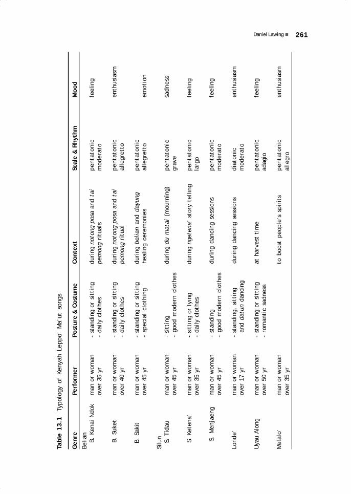
261Daniel Lawing
Tabl
e 13
.1
Typo
logy
of
Keny
ah L
eppo
’ M
a’ut
son
gs
Gen
rePe
rfor
mer
Post
ure
& C
ostu
me
Cont
ext
Scal
e &
Rhy
thm
Moo
d
Belia
n
B.
Kena
i N
dok
man
or
wom
an-
stan
ding
or
sitt
ing
duri
ng n
oton
g po
sa a
nd t
aipe
ntat
onic
feel
ing
over
35
yr-
daily
clo
thes
pem
ong
ritu
als
mod
erat
o
B
. Su
ket
man
or
wom
an-
stan
ding
or
sitt
ing
duri
ng n
oton
g po
sa a
nd t
aipe
ntat
onic
enth
usia
smov
er 4
0 yr
- da
ily c
loth
espe
mon
g ri
tual
alle
gret
to
B
. Sa
kit
man
or
wom
an-
stan
ding
or
sitt
ing
duri
ng b
elia
n an
d da
yung
pent
aton
icov
er 4
5 yr
- sp
ecia
l cl
othi
nghe
alin
g ce
rem
onie
sal
legr
etto
emot
ion
Silu
n
S.
Tida
um
an o
r w
oman
- si
ttin
gdu
ring
du
mat
ai (
mou
rnin
g)pe
ntat
onic
sadn
ess
over
45
yr-
good
mod
ern
clot
hes
grav
e
S
. Ke
tena
’m
an o
r w
oman
- si
ttin
g or
lyi
ngdu
ring
nge
tena
’ st
ory
telli
ngpe
ntat
onic
feel
ing
over
35
yr-
daily
clo
thes
larg
o
S. M
enja
eng
man
or
wom
an-
stan
ding
duri
ng d
anci
ng s
essi
ons
pent
aton
icfe
elin
gov
er 4
5 yr
- go
od m
oder
n cl
othe
sm
oder
ato
Lond
e’m
an o
r w
oman
- st
andi
ng,
sitt
ing
duri
ng d
anci
ng s
essi
ons
diat
onic
enth
usia
smov
er 1
7 yr
an
d da
tun
danc
ing
mod
erat
o
Uya
u Al
ong
man
or
wom
an-
stan
ding
or
sitt
ing
at h
arve
st t
ime
pent
aton
icfe
elin
gov
er 5
0 yr
- ro
man
tic
sadn
ess
adag
io
Mel
alo’
man
or
wom
anto
boo
st p
eopl
e’s
spir
its
pent
aton
icen
thus
iasm
over
35
yral
legr
o
13 May28.p65 6/11/03, 11:10 AM261
Black

262 FOLK SONGS OF THE KENYAH LEPPO’ MA’UT
their rhythms are very short, while their solo voices are always chasing or answeringthe choir voices (ngendaeng). These songs have a rather even intonation or melody,and the choir only uses one note, namely 6 (la) low. A solo ends every part on the notes1, 3, 6 (low). Example:
Solo.....1 Solo.....3Choir....6 Choir....6Solo.....6Choir....6
Belian Suket SongsThe belian suket songs (Figure 13.2)differ greatly from the belian kenaindok. Formerly they were sungespecially by a healer who was believedto have a bali belian (belian spirithelper) or to be susceptible to posses-sion by such a spirit. Belian suket songswere performed in special rooms, suchas the room of a patient’s family, andwere attended by several people whoaccompanied the solo of the beliansuket song, which in the local languageis called ngendaeng (accompaniment orchoir). The meaning of suket is ‘slowly’,in the sense of doing something in aslow but orderly manner, as is describedby this sentence of the song: Nisep ngansain apan no’ magat (‘Drink slowly sothat you will get well and full of energy’).The text of the belian suket songs islong. The solo voices and their choir are
like those of the belian kenai ndok, always chasing each other. These songs have asoft intonation that is rather drawn out. The solo voices end on two notes, a high 4(fa) and a low 1 (do). The choir voices are also marked by two notes, a low 4 (fa) anda middle la (6). Example:
Solo.....4 Solo.....1Choir....4 Choir....6
Belian Sakit SongsThese songs are reserved for sick people, and serve to mediate between the patientand Jalong Peselong (The Almighty in the Adat Bungan religion). According to popularbelief, a variety of illnesses can be cured with the belian sakit ceremony. The text andthe beat are not regular but depend on the preference of the singer (healer); they can belong or short. Furthermore, they are also adjusted to the instructions given by the bali(spirit) of the healer, or who is assigned to help the healer. Any requests made by thebali must be met by the healer and the patient, including words that must be uttered in
Figure 13.2 Oko’ Jangin performingthe belian suket song
13 May28.p65 6/11/03, 11:10 AM262
Black

263Daniel Lawing
the prayer song or the mantra. This song is preceded by a choir (ngendaeng) with a basenote of 5 low (sol). After the solo has begun with note 2 (re), the choir follows with 4 (fa)low. The solo only uses 4 notes at the end of each sentence of the song, 2, 3, 4, 6; thechoir, on the other hand, only uses one note to the end of the song, 4 (fa) low. Example:
Solo.....2 Solo.....3Choir....4 Choir....4Solo.....4 Solo.....6Choir....4 Choir....4
Before the solo voice begins to sing, it has to start with a rather long sound suchas ‘Aaa... Eee...’, and exhale with a long ‘Huss...’, and then the song is started.
Characteristics of the Belian SongsThe belian songs is delivered in the following way: The song (vocal) begins with a solopart, which is then joined at the end of a certain sentence by a choir or ngendaeng.The singer either sits or stands, depending on the situation. For example: 1) whilesinging, a singer who is sitting holds a glass full of burak that will be offered to theguest or honoured person; the lyrics of the belian burak song are directed at theguest. After the song is finished, the glass of burak is offered to the guest to bedrunk. 2) The singer faces the audience, and sings while dancing; the lyrics of thesong are directed at the audience, both in the form of nepet or katok, and in the wayin which he conveys his humility, e.g., Aki’ uba’ pakalai nyambet, li’i kunia lesauoban nem na’ gelam maki (‘I want to learn how to dance, since you have already givenme a dancing costume and it would be a shame to waste it’). 3) In delivering thebelian sakit song, the singer faces the audience and the patient, and he may besitting or standing. The singer always sits when he is telling the story of the balibelian, but he stands when the sacrificial animals (chickens or pigs) are killed.
The language used in the lyrics of the belian songs is a highly metaphorical literarylanguage, and not the language of everyday use. Today’s young generation of Leppo’Ma’ut are no longer able to understand the meaning of these lyrics, e.g., kusun lilitsada langit anjan, which literally means ‘above the circle of the sky and space’, whileits real meaning is ‘the second world in human life other than earth’. Only a few peoplewho are older than 35 can still understand this metaphorical language clearly. Themetaphorical language of the belian songs takes many of its metaphors from the namesof birds, animals, rivers, and forest plants. For example: the term suwi ta’, whichrefers to a certain small bird that likes to sit on the tips of leaves or on fruit flowers isused metaphorically to refer to describe the panyen people (the commoner class); theterm temenggang (the hornbill bird) is a metaphor for the paren (nobility); the phraseLenjau Makang, ‘Brave Tiger’, describes heroes, especially those from among the paren;the phrase Kule Sip Mawe Poyan, ‘Leopard with Sharpened Fangs’, is a metaphor for aneat and strong individual, or someone strong and of a noble heart; the phrase TanyitLanya Enan, ‘Smooth Tanyit-tree Trunk’, is a metaphor for a tall person with smoothskin; or the phrase Sungai Limun Kanan, ‘Domestic River Water’, must be understoodas the area of a river basin owned by a village. The names and characteristics of animalsand plants that are closely tied to human life, have been used since olden times asmetaphors in the lyrics of the Leppo’ Ma’ut songs as a matter of pride.
Belian songs are a matter of pride for the singer, because not everyone can singthem. The belian songs are in the blood of the Leppo’ Ma’ut, making them feel cheerful
13 May28.p65 6/11/03, 11:10 AM263
Black

264 FOLK SONGS OF THE KENYAH LEPPO’ MA’UT
and spirited if someone is able to sing them at the time of an adat ceremony, and theydo not feel very uplifted if a ceremony takes place without a belian song. Thoseattending feel that these songs have represented a special trait of Kenyah culturefrom olden times until today.
Silun SongsSilun songs are sung when mourning a deceased person (nidau); when singing ahistorical or epic story (ngetena’); when lamenting, telling a story, or praising somethingor someone (menjaeng); and also at certain ceremonies such as collective dances,weddings, or births. According to stories, the silun songs were already known whenthe Leppo’ Ma’ut were living at Tokong Julut (on the Iwan River), Data Pea (IwanRiver), and Long Sungai Ma’ut (Lurah River), before they moved to the upper Bahau.They still use them today, but rather infrequently, and only for special ceremonies.Silun songs recall the past or one’s youth, because formerly they were in fact sung byyoung people almost every evening, and not only at certain ceremonies.
Silun Tidau SongsSilun tidau songs are laments and they are song at times of death. Their lyrics raisefeelings of longing and sadness. They are sung to tell those present about the relationshipof human beings to the Almighty (Jalong Peselong in the Bungan religion), and to tellthem that after life in this world there is a second, better life in that other world. Thesilun stories are related to death, as is the one entitled Petapan (‘Lament’), whichtalks about human beings who must meet their destiny, or Kusun Langit Tawang Deman,which describes another world beyond this earth. Silun tidau also tell the life stories ofrelatives who have already passed away and,at times, they mention the site of their gra-ves on the upper Bahau and elsewhere. Thebeat of the silun tidau is short and rathermonotonous.
Silun Ketena’ SongsKetena’ is a story, and ngetena’ means to tell astory (see Figures 13.3 and 13.4). The storiesgenerally are about the families of bali (spirits)who, according to local beliefs, live in the areaof Long Berini or on the Berini River. The BeriniRiver, which is called Alo Mararini Marani Kananor Alo Mara Rian, is located between Apau Pingand Long Kemuat. Other stories are titledNgayau (‘Attacking the enemy’), Tai Ala’ Letto(‘Go to get your wife back’), Laki Muat (‘TheChampion Hero’), Nai Uli’ Anak Da’ Lingu (‘Thereturn of the lost child’), and Letto Mi’ Nai Uli’(‘The return of the lover’). The silun ketena’songs are pentatonic and have a rather longand slow beat.
Figure 13.3 Oko’ Awing Lawingperforming the silun ketena’ song
13 May28.p65 6/11/03, 11:10 AM264
Black
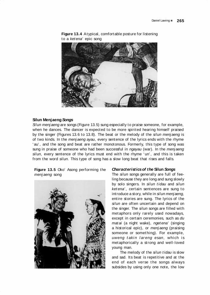
265Daniel Lawing
Figure 13.5 Oko’ Asong performing themenjaeng song
Silun Menjaeng SongsSilun menjaeng are songs (Figure 13.5) sung especially to praise someone, for example,when he dances. The dancer is expected to be more spirited hearing himself praisedby the singer (Figures 13.6 to 13.8). The beat or the melody of the silun menjaeng isof two kinds. In the menjaeng ayau, every sentence of the lyrics ends with the rhyme‘au’, and the song and beat are rather monotonous. Formerly, this type of song wassung in praise of someone who had been successful in ngayau (war). In the menjaengsilun, every sentence of the lyrics must end with the rhyme ‘un’, and this is takenfrom the word silun. This type of song has a slow long beat that rises and falls.
Characteristics of the Silun SongsThe silun songs generally are full of fee-ling because they are long and sung slowlyby solo singers. In silun tidau and silunketena’, certain sentences are sung tointroduce a story, while in silun menjaeng,entire stories are sung. The lyrics of thesilun are often uncertain and depend onthe singer. The silun songs are filled withmetaphors only rarely used nowadays,except in certain ceremonies, such as dumatai (a night wake), ngetena’ (singinga historical epic), or menjaeng (praisingsomeone or something). For example,uweng takin lareng esan, which ismetaphorically a strong and well-lovedyoung man.
The melody of the silun tidau is slowand sad. Its beat is repetitive and at theend of each verse the songs alwayssubsides by using only one note, the low
Figure 13.4 A typical, comfortable posture for listeningto a ketena’ epic song
13 May28.p65 6/11/03, 11:10 AM265
Black

266 FOLK SONGS OF THE KENYAH LEPPO’ MA’UT
Figure 13.7 Man performing traditionaldance in Long Alango
Figure 13.6 Woman performing traditionaldance in Long Alango
Figure 13.8 Author and friend intraditional Leppo’ Ma’ut costume
13 May28.p65 6/11/03, 11:10 AM266
Black

267Daniel Lawing
1 (do). The silun ketena’ songs resemble the silun tidau, but in the second and thirdverses of some silun ketena’ the notes rise higher than in the preceding verse. Thesilun menjaeng songs finish the first two verses with note 3 (mi), but end the thirdverse with low 7 (si). Thereafter the song returns to the beginning note.
Londe’ SongsThe term londe’ carries the meaning of soft, gentle, and beautiful. Londe’ songsare sung especially at dances and are intended to encourage those present to dance.Before the dancing begins, a datun dance is usually held by those organising theevent, while awaiting further arrivals. The datun dance consists of a long stretched-out line of people who are walking and stomping their feet to the beat of the londe’(resembling a polonaise). Singing the londe’ in the yard or on the veranda of atraditional house means that all residents are invited. This dancing event does notoccur at any particular time, but is usually held in the evening; it may also take placein the daytime. The inviting group is usually composed of adults, both men andwomen. The londe’ songs are still much sung and people aged 14 and over still knowthem very well.
Examples of londe’ songs are Leleng and Kolong Ponai, which invite people todance through their lyrics. Leleng means to turn or go around while dancing, inaccordance with the general Dayak dance pattern of going around in a circle. KolongPonai means ‘a pet pigeon’, a metaphor for ‘a loved one.’ If after hearing a KolongPonai song, someone stands up and invites another to dance, the one asked will feelhonoured because that one is seen as the kolong ponai or loved one of the oneinviting. Londe’ songs, like popular songs, are diatonic. For musical accompaniment,they use plucked or percussion instruments with many notes such as the sambi’ andgeng galeng. The londe’ with free notes use a full octave or more, and are usuallyaccompanied by guitars or other diatonic instruments.
Uyau Along SongsThe Uyau Along songs have an even beat, use a pentatonic scale, and are romantic innature if sung in an answering manner, like traditional pantun (verses). When the senguyun(cooperative work) groups are planting rice together in the dry fields, Uyau Along maybe sung by a couple (a man and a woman) in an answering manner. These songs can alsobe sung alone, by someone feeling sad or lonely, because, for example, s/he misses abeloved or remember his/her youth. The words Uyau Along are actually taken from apersonal name: uyau is a term (necronym) for calling a boy whose father has died, whilealong means sad or lonely and is used as a boy’s name. In the Uyau Along songs, thebeginning of a verse is accompanied by two beats, and then the voice is drawn out to sixbeats, and only then does it proceed to the following parts of the song.
Melalo’ SongsMelalo’ songs are connected to ngayau (war, headhunting), a frequent activity of menin former times, which involved attacking an enemy with the intention of taking andbringing home their heads.
13 May28.p65 6/11/03, 11:10 AM267
Black

268 FOLK SONGS OF THE KENYAH LEPPO’ MA’UT
Melalo’ in Ancient TimesThe head was used as a protective agent (lewa) in the melewa ceremony (the collectivecleansing of the village) held at the time of the mamat religious festival. It was meantto protect the residents from illness and danger. Human heads were also used if amember of the nobility (paren) died. During the mourning period, the people wear hats,shirts, and kuau (women’s skirt), pants (for men; formerly, loincloths), which are allcoloured light yellow with a dye made from clay. After taking a human head, the group ofmen who had gone headhunting returned to the village singing melalo’ songs to dispelsadness, and they took off their mourning clothes. A pet lomo (‘to discard mourning’)ceremony was held, then the mourning clothes were thrown away, and a dancing ceremonywas held to the singing of melalo’ songs.
If a mamat festival was being held, or if a member of the nobility had died,when the successful headhunters arrived in their home village, they raised the headhigh in their left hand and, holding their swords in their right hand, they shoutedtheir victory and joy. They were joined by the other members of their group andwere answered by all the villagers together. These cries of victory and joy wereformerly referred to as melalo’. This kind of joy was beyond earthly value, becauseonly rarely was a man able to kill an enemy and cut off his head in a face-to-faceconfrontation. Only someone who was mayeng bali otong (able to endure trials thatbefall him, who was physically strong, and old enough) could win glory by ngayau orheadhunting.
Melalo’ TodayThe melalo’, songs to boost the spirit, are often sung when working together, aswhen carrying something heavy like a rice mortar or a large boat, or when setting upa belawing (a tall ritual pole). Before a singer begins a belian kenai ndok or beliansuket song, he first sings a melalo’ to boost the spirits of the choir members aboutto sing the belian songs. If anyone is going to dance, melalo’ songs are also sungfirst by someone who is only sitting and watching. The melalo’ songs really raise thespirits of those who are attending and can create a very emotional mood. They canalso evoke memories of the mamat festival, which is no longer held today, and ofthe past glory of the Leppo’ Ma’ut.
Characteristics of the Melalo’ SongsThe melalo’ songs use pentatonic notes and an even beat that is almost like regularspeech. The songs are preceded by a solo that also resembles normal speech. Whenthe solo is completed, it is answered by a choir of many voices following a beat. Thelyrics at the beginning of every verse are sung by a solo voice that is joined by thechoir at the end of the sentence. The first two verses consist of couplets introducingthe story, while the second and third tell the content of the story. Melalo’ can bedelivered standing or sitting, but it seems that a sitting position is more common,when, for example, accompanying the feasting of a guest with burak. These songsalso use a metaphorical language. For example, sadin mambin baya oban, whichmeans ‘younger sibling’, while in ordinary language it is simply sadin or asri’.
13 May28.p65 6/11/03, 11:10 AM268
Black

269Daniel Lawing
MUSICAL INSTRUMENTSThe Leppo’ Ma’ut are also familiar with instrumental music as accompaniment todances, which forces the dancers to coordinate their movements and steps with thebeat of the musical instruments. Five types of instruments are known, and they belongto three categories (see Table 13.2): 1) plucked instruments, which include the sambi’,lutung, and odeng talang jaran; 2) percussion instruments, such as geng galeng; 3)wind instruments, such as kediri’ bulu’, which is made of bamboo and used like aharmonica. The researcher did not obtain satisfactory information regarding the kediri’bulu’, and therefore only the plucked and percussion instruments will be discussedbelow. The sambi’, lutung, odeng talang jaran, and geng galeng are still used today.
Table 13.2 Typology of Kenyah Leppo’ Ma’ut instruments
Instrument Performer Posture & Context Scale & MoodCostume Rhythm
Sambi’ man over 18 yr - sitting during dancing pentatonic feeling- costume according sessions moderato
to context
Lutung man or woman - sitting during dancing pentatonic feelingover 40 yr - costume according sessions and in quiet, moderato
to context lonely times
Odeng man or woman - sitting or standing in quiet, lonely times pentatonic feelingtalang jaran over 50 yr moderato
Geng man or woman - sitting or standing in quiet, lonely times pentatonic feelinggaleng over 40 yr moderato
The Sambi’The sambi’ is a type of kecapi (lute) with at least three strings (see Figures 13.9 and13.10), but it may have up to four or five strings depending on its origins. In otherKenyah languages, it is known as sampe’, and in Kayan it is called sape’. Beforeplastic and metal strings appeared, fibres from the iman tree (Arenga pinnata, sugarpalm) were used as strings for the sambi’. Today, steel wire is much used, it is obtainedfrom the wires of bicycle brakes or from guitar strings. Steel wire is preferred becauseit is strong, does not break easily, and has a soft but piercing sound. The first stringor wire is used to play the melody. To set the notes, small pieces of rattan (1 cm longand 3 mm wide) called nden are placed under the strings, and glued to the body of thesambi’ with odep (a kind of resin). The sambi’ is played by plucking like a guitar:while the left hand presses the strings in accordance with the notes of the song, theright hand plucks the strings. Two or more people may play the sambi’ at the sametime (Figure 13.11); the first one plays the melody, the second the accompaniment(pepa). The third and other players play variations of the melody and/or of theaccompaniment (to embellish the presentation of the song). The sambi’ can be tunedin different ways depending on whether it is to be played alone or to accompanydancing or singing; Figure 13.12). It can also be tuned to either the pentatonic ordiatonic scale.
13 May28.p65 6/11/03, 11:10 AM269
Black

270 FOLK SONGS OF THE KENYAH LEPPO’ MA’UT
Figure 13.9 Parts of thesambi’ lute (viewed fromthe front): 1) kalong ulu,carved head; 2) poreng,pegs; 3) batuk, neck; 4)nden, nut made of rattan;5) osa, body; 6) batek,soundboard; 7) nden, frets;8) tali sambi’, strings; 9)nden, frets; 10) pen, endpart; 11) odep, spare resinto glue frets.
9 46
211
13810
7 7
5
Figure 13.10 Young man playing the sambi’ at Long Alango
Figure 13.11 Recording Bakung lute music in Long Aran, 1992
13 May28.p65 6/11/03, 11:10 AM270
Black
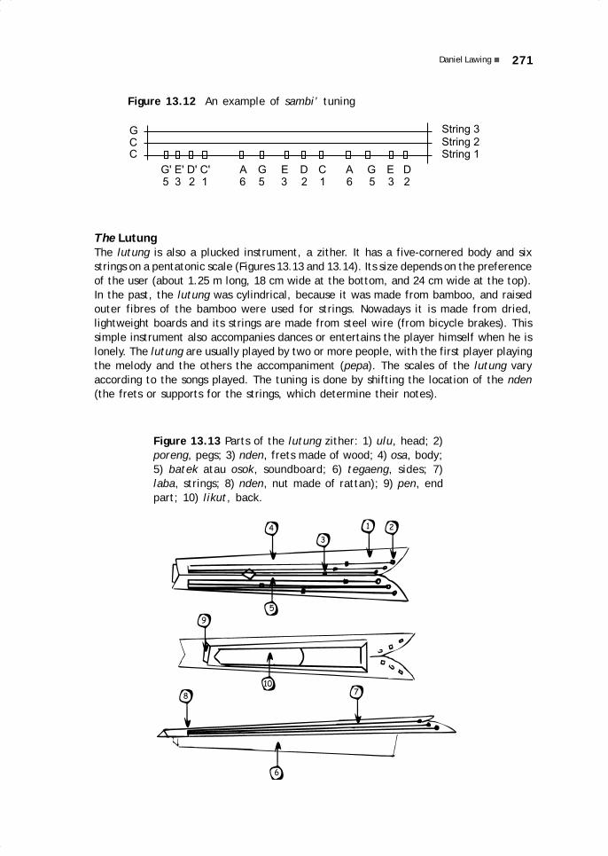
271Daniel Lawing
Figure 13.12 An example of sambi’ tuning
String 3String 2String 1
G' E' D' C' A G E D C A G E D5 3 2 1 6 5 3 2 1 6 5 3 2
GCC
The LutungThe lutung is also a plucked instrument, a zither. It has a five-cornered body and sixstrings on a pentatonic scale (Figures 13.13 and 13.14). Its size depends on the preferenceof the user (about 1.25 m long, 18 cm wide at the bottom, and 24 cm wide at the top).In the past, the lutung was cylindrical, because it was made from bamboo, and raisedouter fibres of the bamboo were used for strings. Nowadays it is made from dried,lightweight boards and its strings are made from steel wire (from bicycle brakes). Thissimple instrument also accompanies dances or entertains the player himself when he islonely. The lutung are usually played by two or more people, with the first player playingthe melody and the others the accompaniment (pepa). The scales of the lutung varyaccording to the songs played. The tuning is done by shifting the location of the nden(the frets or supports for the strings, which determine their notes).
Figure 13.13 Parts of the lutung zither: 1) ulu, head; 2)poreng, pegs; 3) nden, frets made of wood; 4) osa, body;5) batek atau osok, soundboard; 6) tegaeng, sides; 7)laba, strings; 8) nden, nut made of rattan); 9) pen, endpart; 10) likut, back.
4
3
21
5
10
9
6
87
13 May28.p65 6/11/03, 11:10 AM271
Black

272 FOLK SONGS OF THE KENYAH LEPPO’ MA’UT
The Odeng Talang JaranThe odeng talang jaran, or jew’s harp, isa plucked instrument made of bamboo thatuses the mouth as a sound chamber. Thesound produced resembles that of a frog.The shape is not very standardisedaccording to definite measurements. Itvaries between 22 to 32 cm and can bechanged according to preference andcomfort of the instrument’s fit to themouth of the maker or user. There are twotypes of odeng, a short odeng and a longodeng (see Figure 13.15). This instrumentis usually played by older people, both menand women, who are feeling lonely. Theodeng talang jaran is usually played by twopeople, with one playing the melody andthe second the accompaniment. The sharptip of the odeng is plucked, the tail end isthe handle, and the tongue part is placedin front of the mouth cavity. The soundproduced is louder if the player is toothless,as the mouth cavity then is a more effec-tive sound box.
Figure 13.14 A lutung zither, playedby a Bakung woman at Long Aran
Figure 13.15 Short (a) and long (b) odeng talang jaran jew’s harp: 1) ulu, head; 2)jella’, tongue; 3) batok, neck; 4) osa, body; 5) pen, end part.
3
14
52
12
3 2 14
13 May28.p65 6/11/03, 11:10 AM272
Black
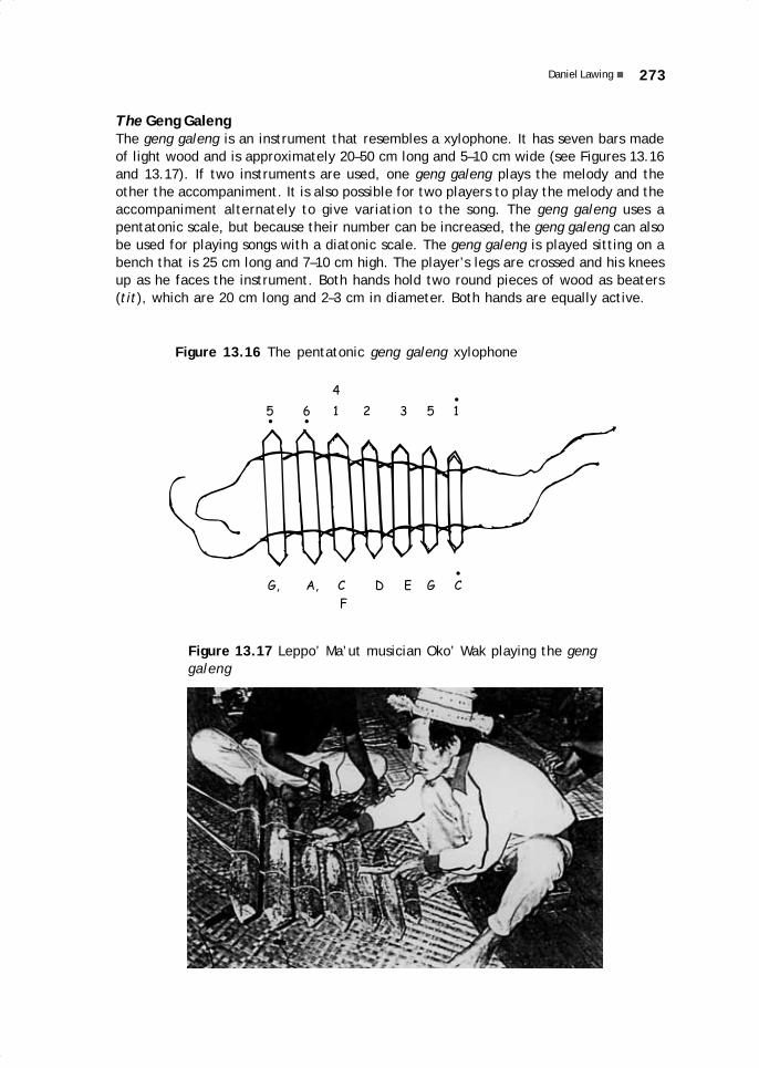
273Daniel Lawing
Figure 13.17 Leppo’ Ma’ut musician Oko’ Wak playing the genggaleng
The Geng GalengThe geng galeng is an instrument that resembles a xylophone. It has seven bars madeof light wood and is approximately 20–50 cm long and 5–10 cm wide (see Figures 13.16and 13.17). If two instruments are used, one geng galeng plays the melody and theother the accompaniment. It is also possible for two players to play the melody and theaccompaniment alternately to give variation to the song. The geng galeng uses apentatonic scale, but because their number can be increased, the geng galeng can alsobe used for playing songs with a diatonic scale. The geng galeng is played sitting on abench that is 25 cm long and 7–10 cm high. The player’s legs are crossed and his kneesup as he faces the instrument. Both hands hold two round pieces of wood as beaters(tit), which are 20 cm long and 2–3 cm in diameter. Both hands are equally active.
Figure 13.16 The pentatonic geng galeng xylophone
G, A, C C
F
D E G
5 6 1 1
4
2 3 5
13 May28.p65 6/11/03, 11:10 AM273
Black

274 FOLK SONGS OF THE KENYAH LEPPO’ MA’UT
The music of the geng galeng is often heard during the planting season, from thetime when the fields are burned until the end of the harvest. Since former times, thismusical instrument has been made for playing during leisure time (initially it was notintended to accompany songs and dances); It was made from dry pieces of wood leftover from the burning of the fields. It was usually played by men. Today, it is oftenused to accompany dancing or singing, along with the sambi’. It can even be combinedwith the sound of the guitar, of empty bottles, or of the ribs of palm leaves. The genggaleng can be used for entertaining people who are spending the night in the fields(referred to as todo), especially at weeding time and when harvesting. In the fields,the geng galeng is not only played for entertainment, but also to chase away pestanimals (pigs, deer, monkeys, birds, and others) that threaten the crops.
13 May28.p65 6/11/03, 11:10 AM274
Black

References andselected literature
Abdoellah, Oekan, et al. 1993 Communities and Forest Management in East Kalimantan:Pathway To Environmental Stability. International and Area Studies, Berkeley.
Abdurrahman, S.H. 1978 Kedudukan Hukum Adat dalam Rangka Pembangunan Nasional.Penerbit Alumni, Bandung.
Abdurrahman, S.H. 1984a Hukum Adat Menurut Peraturan Perundang-undanganIndonesia. Cendana Press, Jakarta.
Abdurrahman, S.H. 1984b Kedudukan Hukum Adat dalam Perundang-undangan AgrariaRepublik Indonesia. Akademika Pressindo, Jakarta.
Abdurrahman, S.H., M.H. 1990 Kedudukan Hukum Adat dalam Kerangka Hukum Nasional.Paper to Seminar Adat Masyarakat Dayak se-Kabupaten Kutai, Tenggarong, 9–11November 1990.
Abidin, Z. 1987 Dasar Pengetahuan Ilmu Tanaman. Angkasa, Bandung.Acciaioli, G. 1985 Culture as art: from practice to spectacle in Indonesia. Canberra
Anthropology 8: (1–2): 148–172.Adiwirata, S. 1983 Pengertian Hukum Adat Menurut Undang-undang Pokok Agraria.
Penerbit Alumni, Bandung.Alcorn, J. et al. 1990 Deforestation and What We Can Learn From Indians. American
Anthropological Association, New Orleans.Aliana, Z.A. et al. 1992 Sastra Lisan Bahasa Melayu Belitung. Pusat Pembinaan dan
Pengembangan Bahasa, Departemen Pendidikan dan Kebudayaan, Jakarta.Alisjahbana, S. T. 1974 Values as Integrating Forces in Personality, Society and Culture:
Essay of a New Anthropology. University of Malaya Press, Kuala Lumpur.Aliza Diniasti 1986 Pola hias gores pada gerabah di beberapa situs paleometalik di
Indonesia. In: Pertemuan Ilmiah Arkeologi IV 1986 vol. IIB, 83–88. Puslit Arkenas,Departemen Pendidikan dan Kebudayaan, Jakarta.
Angguk Lamis 1995 Penguasaan tanah berdasarkan hukum adat pada masyarakat KenyahLeppo’ Ma’ut di Long Alango. Report. Culture & Conservation, Kayan MentarangConservation Project, WWF and Direktorat Jenderal Pelestarian Alam danPerlindungan Hutan, Jakarta.
14new June 9.p65 6/11/03, 10:48 AM275
Black
276 REFERENCES AND SELECTED LITERATURE
Anonymous 1977 Population and Social Structure. Report No. 8. Transmigration AreaDevelopment Project, Samarinda.
Anonymous 1982 Pertanahan dalam Era Pembangunan Indonesia. Departemen PeneranganRepublik Indonesia, Jakarta.
Anonymous 1988 Hasil seminar Peranan Hukum Adat dalam Menunjang PembangunanMenghadapi Era Tinggal Landas. Panitia, Seminar Peranan Hukum Adat, FakultasHukum, Universitas Tanjungpura, Pontianak.
Anonymous 1989 Proposal Pembangunan Wilayah Perbatasan Kalimantan Timur (RencanaPembangunan dan Pemanfaatan Potensi Lahan Hutan Wilayah Perbatasan dalam RangkaMemperoleh Dana Bantuan Luar Negeri). Pemerintah Daerah Propinsi Tingkat IKalimantan Timur, Samarinda.
Anonymous 1990a Bentuk-bentuk Peralatan Hiburan dan Kesenian. Balai Pustaka, Jakarta.Anonymous 1990b Kalimantan Timur Dalam Angka. Kantor Statistik Propinsi Kalimantan
Timur, Samarinda.Anonymous 1990c Pemanfaatan Hutan dan Pembangunan Pedesaan. Asosiasi Pengusaha
Hutan Indonesia. Manggala Wanabakti, Jakarta.Anonymous 1992 Penelitian Suku Terasing Kenyah Kalimantan Timur. Report. Direktorat
Sejarah dan Nilai Tradisional, Direktorat Jenderal Kebudayaan, Departemen Pendidikandan Kebudayaan, Jakarta.
Apuy La’ing Kelong n.d. Sejarah Perpindahan Kenyah Badeng. Manuscript. Tanjung Selor.Ardans, H.M. 1993 Materi Ceramah Gubernur Kepala Daerah Tingkat I Kalimantan Timur.
Pentaloka Dosen Kewiraan. Samarinda.Arensberg, C. M. 1971 Introducing Social Change: A Manual for Community Development.
Aldine-Altherton, Chicago.Arman, Syamsuni 1989 Perladangan Berpindah dan Kedudukannya dalam Kebudayaan
Suku-suku Dayak di Kalimantan Barat. Suara Almamater, Universitas Tanjungpura,Pontianak.
Aryandini Novita and Krisprihartini S. 1995 Analisis Temuan Alat Batu dan Gerabah dariApau Ping 1991–1993. Report. Culture & Conservation, Kayan Mentarang ConservationProject, WWF and Direktorat Jenderal Pelestarian Alam dan Perlindungan Hutan,Jakarta.
Atan Hamju and Armilla Windawati 1978 Pengetahuan Seni Musik. Aries Lima, Seri Teoridan Lagu. Jakarta.
Atmadja, N. B. 1993 Pengelolaan Hutan Wisata Kera Sangeh oleh Desa Adat Sangeh.Ekonesia 1 (1): 1–22.
Bachsan Mustafa, S.H. 1984 Hukum Agraria dalam Perspektif. Remaja Karya, Bandung.Bahari Sindju, H. 1993 Konsep pemilikan tanah pada suku Dayak Kanayatan. Kalimantan
Review 5: 13–18.Baier, M. 1979 Zur Steinsetzung und Steinbearbeitung Innerborneos. Tribus 28: 70–82.Baier, M. 1987 Megalithische Monumente des Bahau-Gebiets (Kecamatan Pujungan/
nordliches Zentralborneo). Tribus 36: 117–128.Baier, M. 1992 Steinsarkophage und Urnendolmen. Tribus 41: 161–175.Barbour, M.G., Burk, J.H. and Pitts, W.D. 1980 Terrestrial Plant Ecology. The Benjamin/
Cummings Publishing Company, Menlo Park, California.Barne, K. 1958 Listening to the Orchestra. Dent and Sons, London.
14new June 9.p65 6/11/03, 10:48 AM276
Black
277REFERENCES AND SELECTED LITERATURE
Barth, F. 1987 Cosmologies in the Making. Cambridge University Press, Cambridge.Barth, F. 1989 The analysis of culture in complex societies. Ethnos 3–4: 120–142.Beattie, J. 1977 Other Cultures: Aims, Methods and Achievements in Social Anthropology.
Routledge and Kegan Paul, London.Beer, J. de, and McDermott, M. 1989 The Economic Value of Non Timber Forest Products
in Southeast Asia with Emphasis on Indonesia, Malaysia and Thailand. TheNetherlands Committee for IUCN. Amsterdam.
Bellon, M.R. 1991 The ethnology of maize variety management: A case study from Mexico.Human Ecology 19: 389–418.
Benedict, R. 1966 Pola-pola Kebudayaan. Translated by Sumantri Martodipoero. DianRakyat, Bandung.
Bennett, J. W. 1976 The Ecological Transition: Cultural Anthropology and HumanAdaptation. Pergamon Press, New York.
Bennett, J. W. 1980 Human ecology as human behavior: A normative anthropology ofresource use and abuse. In: Altman, I. et al. (eds) Human Behavior and Environment:Advances in Theory and Research, 243–277. Plenum Press, New York.
Beratha, I.N. 1982 Masyarakat Desa dan Pembangunan Desa. Ghalia Indonesia, Jakarta.Berdichewsky, B. (ed.) 1979 Anthropology and Social Change in Rural Areas. Mouton,
New York.Berelson, B. 1971 Content Analysis in Communication Research. Hafner Publishing
Company, New York.Birkeland, P.W. 1974 Pedology, Weathering, and Geomorphological Research. Oxford
University Press, Oxford.Black, J. 1985 The Lastposten: Eastern Kalimantan and the Dutch in the nineteenth and
early twentieth centuries. Journal of Southeast Asian Studies 16 (2): 281–291.Bloch, M. 1991 Language, anthropology and cognitive science. Man 26: 183–198.Bloch, M. 1992 What Goes Without Saying. The Conceptualization of Zafimaniry Society.
In: Kuper, A. (ed.) Conceptualizing Society, 127–146. Routledge, London.Blust, R.A. 1972 Report of linguistic field work undertaken in Sarawak. Borneo Research
Bulletin 4(1): 12–14.Bodley, J.H. 1976 Anthropology and Contemporary Human Problems. Cummings, Menlo
Park, CA.Borofsky, R. 1987 Making History: Pukapukan and Anthropological Constructions of
Knowledge. Cambridge University Press.Boster, J.S. 1986 Exchange of varieties and information between Aguaruna manioc
cultivators. American Anthropologist 88: 428–436.Bourdelon, G. 1957 Les Dayak. 16-mm film.Brechin, S.R., Wilshusen, P.R., Fortwangler, C.L. et al. 2002 Beyond the square wheel:
toward a more comprehensive understanding of biodiversity conservation as socialand political process. Society and Natural Resources 15 (1): 41–64.
Brookfield, H.C., Potter, L. and Byron, Y. 1995 In Place of the Forest: Environmentaland Socio-Economic Transformation in Borneo and the Eastern Malay Peninsula.Tokyo: United Nations University Press.
Brosius, J.P. 1986 River, forest and mountain: the Penan Gang landscape. Sarawak MuseumJournal 36(57): 173–184.
14new June 9.p65 6/11/03, 10:48 AM277
Black

278 REFERENCES AND SELECTED LITERATURE
Brosius, J.P. 1992 The Axiological Presence of Death Among the Penan Gang of Sarawak,Malaysia. Ph.D. dissertation in Anthropology, University of Michigan, Ann Arbor.University Dissertation Publications.
Brosius, P. 2001 Results of the Workshop on Conservation and Community. An Initiativeof the Conservation and Community Working Group, Anthropology and EnvironmentSection, American Anthropological Association. Unpublished manuscript.
Brosius, P., Lowenhaupt Tsing, A. and Zerner, C. 1998 Representing communities:histories and politics of community-based natural resource management. Societyand Natural Resources 11: 157–168.
Brush, S., and Stabinsky, D. (eds.) 1995 Valuing Local Knowledge: Indigenous Peopleand Intellectual Property Rights. Island Press, Washington, DC.
Budi Harsono, S.H. 1982 Hukum Agraria Indonesia. Himpunan Peraturan Perundang-undangan Peraturan Hukum Tanah. Djambatan, Jakarta.
Bunde, Y. P. 1995 Pola Penguasaan Hak Atas Tanah pada Masyarakat Kenyah Bakung diLong Apan Baru. Report. Culture & Conservation, Kayan Mentarang ConservationProject, WWF and Direktorat Jenderal Pelestarian Alam dan Perlindungan Hutan,Jakarta.
Bushar Muhammad, S.H. 1981 Azas-Azas Hukum Adat (Suatu Pengantar). 3rd ed. PradnyaParamita, Jakarta.
Bushar Muhammad, S.H. 1985 Pokok-pokok Hukum Adat. Pradnya Paramita, Jakarta.Caldecott, J.O. 1988 Hunting and Wildlife Management in Sarawak. IUCN, Cambridge.Caldecott, J.O. 1990 Eruptions and migrations of bearded pig populations. Bongo 18: 2–
12.Catford, J.C. 1965 A Linguistic Theory of Translation. Oxford University Press, London.Cense, A.A., and Ühlenbeck, E.M. 1958 Critical Survey of Studies on the Languages of
Borneo. Martinus Nijhoff, Gravenhage.Cernia, M. M. 1988 Unit-unit Alternatif Organisasi Sosial untuk Mendukung Strategi
Penghutanan Kembali. In: Cernea, M.M. (ed.) Mengutamakan Manusia di dalamPembangunan, 341–375. Translated by Basilius Bengo Teku. Penerbit UniversitasIndonesia, Jakarta.
Chambers, R. 1994 The origins and practice of participatory rural appraisal. WorldDevelopment 22(7): 953–969.
Chang, T.T., Sharma, S.D., Adair, C.R. and Perez, A.T. 1972 Manual for Field Collectorsof Rice. International Rice Research Institute, Los Baños.
Charon, Joel M. 1979 Symbolic Interaction. Prentice Hall, New York.Chartier, D. and Sellato, B. 1998 La Prise en Compte des Pratiques et des Usages
Autochtones: Réalité Efficiente ou Construction Occidentale à Visée Néolibérale.Interférences Entre Chercheurs et Opérateurs/Bailleurs de Fonds. Paper to SecondConference on ‘Dynamiques Sociales et Environnement.’ Bordeaux, France,September 1998.
Chartier, D. and Sellato, B. 2003 Les savoir-faire traditionnels sont-ils au service de laconservation de la nature ou au service des ONG internationales d’environnement?In: Rodary, E. (ed.) Dynamiques sociales et environnement. Karthala, Paris.
Chin, S.C. 1985 Agriculture and resource utilization in a lowland rainforest Kenyahcommunity. Sarawak Museum Journal Special Monograph No. 4.
Clayre, B. M. 1970 Focus: a preliminary survey of some languages of eastern Malaysia.Sarawak Museum Journal 18 (36-37): 193–219.
14new June 9.p65 6/11/03, 10:48 AM278
Black

279REFERENCES AND SELECTED LITERATURE
Clayre, I.F.C.S 1970 Some notes on Sa’ban. Work in Progress 4: 112–119. Department ofLinguistics, Edinburgh University.
Cohn, J. 1988 Culture and conservation. Bioscience 38 (7): 450–453.Colfer, C. 1981 Women, men and time in the forests of East Kalimantan. Borneo Research
Bulletin 13 (2): 75–85.Colfer, C. 1983 Change and indigenous agroforestry in East Kalimantan. Borneo Research
Bulletin 15 (1): 3–21.Colfer, C. 1993 Shifting Cultivators of Indonesia: Marauders or Managers of the Forest?
(with Dudley, R.G. and in collaboration with Hadikusumah, H., Rusydi, Sakuntaladewi,N. and Amblani). Community Forestry Case Study Series No. 6. Food and AgricultureOrganization (FAO), Rome.
Colfer, C. et al. 1988 An indigenous agricultural model from West Sumatra: a source ofscientific insight. Agricultural Systems 26: 191–209.
Colson, E. 1979 In good years and in bad: Food strategies of self-reliant societies.Journal of Anthropological Research 35: 18–29.
Conklin, B. and Graham, L. 1995 The shifting middle ground: Amazonian Indians andeco-politics. American Anthropologist 97 (4): 695–710.
Conklin, H. 1957 Hanunoo Agriculture. Food and Agriculture Organization (FAO) UnitedNations, Rome.
Conley, W. W. 1973 The Kalimantan Kenyah: A Study of Tribal Conversion in Terms ofDynamic Cultural Themes. Presbyterian and Reformed Publishing Company, Nurley,New York.
Conley, W. W. 1974 Kenyah cultural themes and their interrelationships. Sarawak MuseumJournal 22 (43): 304–309.
Coomans, M. 1987 Manusia Daya, Dahulu, Sekarang, Masa Depan. Gramedia, Jakarta.Crain, J.B. 1970 The Lun Dayeh of Sabah, East Malaysia: Aspects of Marriage and
Social Exchange. Ph.D. thesis, Cornell University. University Microfilms Interna-tional, Ann Arbor.
Crain, J.B. 1978 The Lun Dayeh. In: King, V.T. (ed.) Essays on Borneo Societies, 123–142. Hull Monographs on South-East Asia, No. 7. Oxford University Press, London.
Damus, D. 1992 Pengetahuan tentang Varietas Padi dan Tipe Budidayanya pada MasyarakatDayak Hulu Sungai Bahau, Kalimantan Timur. Paper to the Second BiennialInternational Conference of the Borneo Research Council, Kota Kinabalu, July 1992.
Damus, D. 1995 Pengetahuan tentang Varietas Padi dan Tipe Budidayanya pada MasyarakatDayak Hulu Sungai Bahau. Report. Culture & Conservation, Kayan MentarangConservation Project, WWF and Direktorat Jenderal Pelestarian Alam danPerlindungan Hutan, Jakarta.
Davis, K. 1949 Human Society. MacMillan, New York.Davis, S. and Ebbe, K. (eds.) 1995 Traditional Knowledge and Sustainable Development.
Proceedings of a conference held at the World Bank, Washington, D.C. September27–28, 1993. The World Bank, ESD. Washington, D.C.
Devung, G. S. 1985 Laporan. Report.Devung, G. S. 1993 Kelompok Suku Dayak Kenyah di Sungai Alan: Suatu Kasus Perubahan
Kebudayaan. Report. Departemen Pendidikan dan Kebudayaan, Samarinda.Devung, G. S. 1996 Praktik dan Pranata Tradisional Pemanfaatan dan Pengelolaan Sumber
Daya Hutan di Daerah Sungai Bahau, Kalimantan Timur. Magister thesis, ProgramStudi Antropologi, Program Pasca Sarjana Universitas Indonesia, Jakarta.
14new June 9.p65 6/11/03, 10:48 AM279
Black

280 REFERENCES AND SELECTED LITERATURE
Devung, G. S. and Michael, S.E., M.S. 1990 Potensi Adat Masyarakat Dayak Bahau untukPengembangan Program Kepariwisataan dan Pembangunan Daerah. Paper to SeminarAdat Dayak Se-Kabupaten Kutai, Tenggarong, 9–11 November 1990.
Devung, G. S. et al. 1984–85 Penelitian Suku Terasing Kenyah Kalimantan Timur (KelompokSuku Dayak Kenyah di Sungai Alan. Suatu Kasus Perubahan Kebudayaan). Report. ProyekInventarisasi dan Dokumentasi Kebudayaan Daerah, Direktorat Sejarah dan NilaiTradisional, Departemen Pendidikan dan Kebudayaan, Jakarta.
Dixon, A., Roditi, H. and Siverman, L. 1991 From Forest To Market. A Feasibility Study ofthe Development of Selected Non Timber Forest Product from Borneo for the U.S.Market. Volume I: The Report. Project Borneo, Cambridge, Massachussetts.
Dody Johanjaya, Anggara Yonathan, and Yoga Prima Subandono 1995 Inventorisasi KuburanTempayan Dolmen Di Daerah Hulu Sungai Bahau. Report. Culture & Conservation,Kayan Mentarang Conservation Project, WWF and Direktorat Jenderal PelestarianAlam dan Perlindungan Hutan, Jakarta.
Douglas, R.S. 1911 A comparative vocabulary of the Kayan, Kenyah and Kelabit dialects.Sarawak Museum Journal 1 (1): 146–148.
Dove, M. 1985a Swidden Agriculture in Indonesia: The Subsistence Strategies of theKalimantan Kantu. Mouton, Berlin.
Dove, M. R. (ed.) 1985b Peranan Kebudayaan Tradisional Indonesia dalam Modernisasi.Yayasan Obor Indonesia, Jakarta.
Dove, M. 1988a The Real and Imagined Role of Culture in Development. Case Studiesfrom Indonesia. University of Hawaii Press, Honolulu.
Dove, M. R. 1988b Sistem Perladangan di Indonesia: Suatu Studi Kasus Dari KalimantanBarat. Gadjah Mada University Press, Yogyakarta.
Dove, M. 1992 Foresters’ beliefs about farmers: a priority for social science researchin social forestry. Agroforestry Systems 17: 13–41.
Dove, M. R. 1993 Uncertainty, humility, and adaptation in the tropical forest: Theagricultural augury of the Kantu’. Ethnology 40: 145–167.
Dove, M. and Kammen, D. 1997 The epistemology of sustainable resource use: Managingforest products, swiddens, and high-yielding variety crops. Human Organization56 (1): 91–101.
Dove, M. and Tri Nugroho. 1994 Review of ‘Culture and Conservation’ 1991–1994.Report. A Subproject Funded by the Ford Foundation, World Wide Fund for Nature,Kayan Mentarang Nature Reserve Project in Kalimantan, Indonesia. FordFoundation, Jakarta.
Dransfield, J. 1979 A manual of the rattans of the Malay Peninsula. Forestry Rec. 29.Forestry Dept., West Malaysia.
Dresden, S. 1952 Algemene Muziekleer. J.B. Wolters, Jakarta.Duff, R. 1970 Stone Adzes of Southeast Asia. Canterbury Museum, Christchurch.Dunsmore, S. 1985 Iban Pottery. Occasional Paper No. 5, Sarawak Museum, Kuching.Eghenter, C. 1995 Knowledge, Action, and Planning: A Study of Long-distance Migrations
among the Kayan and Kenyah of East Kalimantan, Indonesia. Ph.D. thesis, RutgersUniversity.
Eghenter, C. 1997 Cultural Dimensions of Forest Management in and around the KayanMentarang Conservation Area, East Kalimantan. Final Report on training, fieldwork,and dissemination activities of the Culture and Conservation program, 1995–1997. WWF and Ford Foundation. Jakarta.
14new June 9.p65 6/11/03, 10:48 AM280
Black

281REFERENCES AND SELECTED LITERATURE
Eghenter, C. 1999a Research Strategies, Conservation Objectives, and CommunityParticipation: The Third Phase of the Culture and Conservation Program, KayanMentarang Project, WWF-I. In: King, V.T. (ed.) Rural Development and SocialScience Research: Cases from Borneo. Borneo Research Council Proceedings Series6: 35–45. Williamsburg, VA.
Eghenter, C. 1999b Migrants’ practical reasonings: the social, political, and environmentaldeterminants of long-distance migrations among the Kayan and Kenyah of the interiorof Borneo. Sojourn 14 (1): 1–33.
Eghenter, C. 2000a What is Tana Ulen good for? Considerations on indigenous forestmanagement, conservation, and research in the Interior of Indonesian Borneo.Human Ecology 28 (3): 331–357.
Eghenter, C. 2000b Mapping Peoples’ Forests: The Role of Mapping in Planning Community-based Management of Conservation in Indonesia. Biodiversity Support Program.Washington DC.
Eghenter, C. 2000c Histories of Conservation or Exploitation? Case Studies from theInterior of Indonesian Borneo. Paper to IIAS/BRC International Seminar,Environmental Change in Native and Colonial Histories of Borneo: Lessons fromthe Past, Prospects for the Future. Leiden, The Netherlands, 11–12 August 2000.
Eghenter, C. 2001 Towards a causal history of a trade scenario in the interior of EastKalimantan, Indonesia, 1900–1999. Bijdragen Tot de Taal-, Land- en Volkenkunde157 (4): 739–769.
Eghenter, C. 2002 Planning for Community-based Management of Conservation Areas:Indigenous Forest Management and Conservation of Biodiversity in the KayanMentarang National Park, East Kalimantan, Indonesia. In: Chatty, D. and Colchester,M. (eds.) Conservation and Mobile Indigenous Peoples. Displacement, ForcedSettlement and Sustainable Development. Refugee Studies Programme. BerghahnPublishers, London.
Eghenter, C. and Sellato, B. (eds.) 1999 Kebudayaan dan Pelestarian Alam. PenelitianInterdisipliner di Pedalaman Kalimantan. World Wide Fund for Nature Indonesia,Jakarta.
Ellen, R.F. 1986 What Black Elk left unsaid. On the illusory images of green primitivism.Anthropology Today 2 (6): 8–12.
Erd, Th. van den 1988 Ragi Cerita. BPK Gunung Mulia, Jakarta.Evans, I. H.N. 1955 Bajau pottery. Sarawak Museum Journal 6 (5): 297–300.Fischer, L.S. and Gramberg, H. 1910 Tochten naar Boven-Boeoloengan en de Apo-Kajan.
Tijdschrift van het Koninklijk Ned. Aardrijkskundig Genootschap 27: 263–306.Fisher, A.B. 1980 Small Group Decision Making. McGraw-Hill, New York.Foster, G. M. 1962 Traditional Cultures and The Impact of Technological Change. Harper
and Row, New York.Fox, J. J. (ed.) 1992 The Heritage of Traditional Agriculture among the Western
Austronesians. The Australian National University, Canberra.Franz, J.F. von 1988 Population Development in East Kalimantan 1971–1987. Technical
Cooperation for Area Development (TAD), Technical Report No. 88–10. Samarinda.Freeman, D. 1970 Report on the Iban. London School of Economics Monographs on
Social Anthropology. The Athlone Press, London.Freeman, J.D. 1955 Iban Agriculture: A Report on the Shifting Cultivation of Hill Rice
by the Iban of Sarawak. HMSO, London.
14new June 9.p65 6/11/03, 10:48 AM281
Black
282 REFERENCES AND SELECTED LITERATURE
Freeman, J. D. 1957 Iban pottery. Sarawak Museum Journal 8 (10): 153–176.Fujisaka, S. 1986 Pioneer shifting cultivation, farmer knowledge, and an upland
ecosystem: Co-evolution and systems sustainability in Calminoe, Philippines.Philippine Quarterly of Culture and Society 14: 137–164.
Fujisaka, S. 1987 Filipino upland farmers: informal ethnoscience for agriculturaldevelopment research. Philippine Studies 35: 403–419.
Fujisaka, S., Elliot, P., Jayson, E. and Dapusala, A. 1992 Where There Has Been No‘Green Revolution’: Farmers’ Upland Rices and Related Knowledge In Mindanao,Philippines. Paper to the Sustainable Upland Agriculture Workshop, Baguio,Philippines, December 1992.
Galvin, A.D. 1967 Kenyah Vocabulary Lepo’ Tau. Manuscript.Galvin, A.D. 1975 Tribal authority among the Kenyahs. Sarawak Museum Journal 23
(44): 91–94.Guelke, L. 1982 Historical Understanding in Geography. Cambridge University Press,
Cambridge.Guerreiro, A.J. 1992 Some aspects of change among the Baluy Kayan. Sarawak Museum
Journal 43 (64): 47–105.Guerreiro, A. and Sellato, B. 1984 Traditional migration in Borneo: the Kenyah case.
Borneo Research Bulletin 16 (1): 12–28; 16 (2): 76–81.Gun Kila 1949 Sebuah Cerita Mengenai Perjalanan Hidup Suku Kenyah Apau Kayan Pada
Umumnya, Khususnya Lepo’ Tau dan Lepo’ Timai. Manuscript. Rewritten by UluiTanyit (1969) and Lencau Ingkong (1988).
Gunadi Nh. [Nitihaminoto] 1983 Penelitian gerabah berhias pantai selatan Jawa Tengah,Jawa Timur. In: Rapat Evaluasi Hasil Penelitian Arkeologi I 1982, vol. IIA, 146–150.Puslit Arkenas, Departemen Pendidikan dan Kebudayaan, Jakarta.
Haar Bzn., B. ter 1980 Asas-asas dan Susunan Hukum Adat. 5th ed. Translated by K. Ng.Soebakti Poesponoto. Pradnya Paramita, Jakarta.
Hakim, N. et al. 1986 Dasar-dasar Ilmu Tanah. Universitas Lampung, Bandar Lampung.Hanye, P. 1995 Sastra Lisan pada Masyarakat Kenyah Bakung di Long Apan Baru. Report.
Culture & Conservation, Kayan Mentarang Conservation Project, WWF and DirektoratJenderal Pelestarian Alam dan Perlindungan Hutan, Jakarta.
Hardjowigeno, S. 1993 Klasifikasi Tanah dan Pedogenesis. Akademika Pressindo, Jakarta.Harrisson, T. 1955 The distribution and general character of native pottery in Borneo.
Sarawak Museum Journal 6 (5): 301–306.Harrisson, T. 1959a World Within. A Borneo Story. Cresset Press, London.Harrisson, T. 1959b More ‘megaliths’ from inner Borneo. Sarawak Museum Journal 9
(13–14): 14–20.Harrisson, T. 1959c The Kelabits and Muruts. In: Harrisson, T. (ed.) The Peoples of
Sarawak, 57–71. Gov. Printing Office, Kuching.Harrisson, T., and O’Connor, S.J. 1970 Gold and Megalithic Activity in Prehistoric and
Recent West Borneo. Data Paper No. 77. Southeast Asia Program, Department ofAsian Studies, Cornell University, New York.
Headland, T. 1997 Revisionism in ecological anthropology. Current Anthropology 38(4): 605–630.
Healy, K. 1994 The recovery of cultural resources for development. In: 1994 Festival ofAmerican Folklife Program, 14–19. Smithsonian Institution and National Park Service,Washington, D.C.
14new June 9.p65 6/11/03, 10:48 AM282
Black

283REFERENCES AND SELECTED LITERATURE
Hein, A.R. 1890 Die Bildende Künste bei den Dajaks auf Borneo. Alfred Hölder, Vienna.Henoch Merang 1970 Sejarah Apo Kayan. Akademi Pemerintahan Dalam Negeri,
Samarinda.Hildebrand, H. K. 1982 Die Wildbeutergruppen Borneos. Münchner Ethnologische
Abhandlungen, Vol. 2. Institut für Völkerkunde und Afrikanistik, MünchnerUniversitätsschriften. Minerva Publikation, München.
Hilman Hadikusuma, S.H. 1984 Ensiklopedi Hukum Adat dan Adat Budaya Indonesia.Penerbit Alumni, Bandung.
Hilman Hadikusuma, S.H. 1987 Hukum Kekerabatan Adat. Fajar Agung, Jakarta.Hilman Hadikusuma, S.H. 1988 Hukum Waris Adat. 2nd ed. Penerbit Alumni, Bandung.Hoffman, C. F. 1985 Punan Liar di Kalimantan: Alasan Ekonomi. In: Dove, M.R. (ed.)
Peranan Kebudayaan Tradisional Indonesia dalam Modernisasi, 123–162. YayasanObor, Jakarta.
Holsti, O. R. 1969 Content Analysis for the Social Sciences and Humanities. Addison-Wesley Publishing Co., Reading, Massachussetts.
Hong, E. 1987 Natives of Sarawak. Survival in Borneo’s Vanishing Forest. InstitutMasyarakat Malaysia, Pulau Pinang.
Honigmann, D. 1959 The World of Man. Harper & Row, New York and Evanston.Hose, C. 1988 (1926) Natural Man. A Record of Borneo. Oxford University Press, Singapore.Hose, C. and McDougall,W. 1966 (1912) The Pagan Tribes of Borneo. McMillan, London.
2 vols.Hudson, A.B. 1978 Linguistic relations among Bornean peoples with special reference
to Sarawak: An interim report. Studies in Thirld World Societies 3: 1–44.Humardani, G. 1981 Masalah-masalah Dasar Pengembangan Seni Tradisionil. Aksi,
Surakarta.Iman Sudiyat 1981 Hukum Adat. Sketsa Azas. Liberty, Yogyakarta.Iman Sudiyat 1982 Asas-asas Hukum Adat. Bekal Pengantar. Liberty, Yogyakarta.Ingerson, A.E. 1997 Comment on T. Headland’s ‘Revisionism in ecological anthropology’.
Current Anthropology 38 (4): 615–616.Ipoi Datan 1989 A brief ethnography of the Lun Bawang of Sarawak. Sarawak Museum
Journal 40 (61), Special Issue No. 4, Part III, pp. 143–156.Irene A. Muslim, S.H. 1991 Peradilan Adat pada Masyarakat Daya di Kalimantan Barat.
Speech (Pidato Pengukuhan Guru Besar), 15 June 1991. Fakultas Hukum, UniversitasTanjungpura, Pontianak.
Jacobus E. Frans L., S. 1988 Watas dan Hak Ulayat dan Hak-hak Serupa Itu dalamPandangan Masyarakat Hukum Adat di Kalimantan Barat. Biro PSE, Keuskupan AgungKatolik, Pontianak.
Jacobus E. Frans L., S. 1995 Hak Milik Adat atas Tanah Pada Masyarakat Suku BangsaDayak Kenyah di Kecamatan Long Pujungan. Report. Culture & Conservation, KayanMentarang Conservation Project, WWF and Direktorat Jenderal Pelestarian Alamdan Perlindungan Hutan, Jakarta.
Jessup, T. C. 1981 Why do Apo Kayan shifting cultivators move? Borneo Research Bulletin13: 16–32.
Jessup, T. C. 1991 Keberlangsungan (Persistensi) dan Perubahan Dalam KebiasaanBerladang di Apau Kayan, Kalimantan Timur. Unpublished report, Kayan MentarangConservation Project, WWF and Direktorat Jenderal Pelestarian Alam danPerlindungan Hutan, Jakarta.
14new June 9.p65 6/11/03, 10:48 AM283
Black

284 REFERENCES AND SELECTED LITERATURE
Jessup, T.C. 1992 Persistence and change in the practice of shifting cultivation in theApo Kayan, East Kalimantan, Indonesia. In: Fox, J.J. (ed.) The Heritage ofTraditional Agriculture among the Western Austronesians, 21–32. Research Schoolof Pacific Studies (Comparative Austronesian Project) and Department ofAnthropology, Australian National University, Canberra.
Jessup, T. C. 1993a Longhouses of East Kalimantan. Kalimantan Review II (3): 16–20.Jessup, T. C. 1993b The Kayan Mentarang Nature Reserve: nature conservation by and
for the people in East Kalimantan. Conservation Indonesia 9 (3): 16–22.Jessup, T.C. n.d.1 Preliminary Report on Migration and Trading. Manuscript.Jessup, T.C. n.d.2 Appendix to Notes on Migration and Settlement. Manuscript.Jessup, T.C., and Mackie, C. 1984 A response to Guerreiro and Sellato on Kenyah
migration. Borneo Research Bulletin 16 (2): 81–84.Jessup, T.C., and Peluso, N.L. 1986 Minor forest product as common property resources
in East Kalimantan, Indonesia. In: Proceedings of the Conference on Common PropertyResources Management, April 21–26, 1985, 505–531. National Academy Press,Washington, D.C.
Jessup, T.C. and Sellato, B. 1990 Field Project in Oral Tradition and Social Forestry inEast Kalimantan, Indonesia. A proposal to the Ford Foundation by the World WideFund for Nature (October). WWF-I, Jakarta.
Jessup, T.C. and Sellato, B. 1993 Culture and Conservation in East Kalimantan. Reporton the First Phase of Training and Field Work, 1991–1992, in the Kayan MentarangNature Reserve and Vicinity. WWF/IP (February). WWF-I, Jakarta.
Jessup, T.C. and Sellato, B. 1995 Cultural Dimensions of Forest Management In andAround the Kayan Mentarang Conservation Area, East Kalimantan, Indonesia. Aproposal to the Ford Foundation from the World Wide Fund for Nature IndonesiaProgramme (July). WWF-I, Jakarta.
Jessup, T.C., Soedjito, H. and Kartawinata, K. 1993 Konsep Cagar Biosfir Kayan Mentarang:Pendekatan Baru Untuk Pengembangan Konservasi di Kalimantan Timur. Manuscript.WWF and Direktorat Jenderal Pelestarian Alam dan Perlindungan Hutan, Jakarta.
Jiuhardi and Trivena 1990 Adat Suku Dayak Kenyah. Paper to Seminar Adat Dayak se-Kabupaten Kutai, Tenggarong, 9–11 November 1990.
Johannes, R.E. 1981 Words of the Lagoon: Fishing and Marine Lore in the Palau Districtof Micronesia. University of California Press, Berkeley.
Johnson, A. 1974 Ethnoecology and planting practices in a swidden agricultural system.American Ethnologist 1: 87–101.
Kanyan, C. 1995 Pola Penguasaan Hak Atas Tanah pada Masyarakat Leppo’ Ke di ApauPing. Report. Culture & Conservation, Kayan Mentarang Conservation Project, WWFand Direktorat Jenderal Pelestarian Alam dan Perlindungan Hutan, Jakarta.
Karina Arifin 1994 Archaeological Remains in the Kayan Mentarang Area, East Kalimantan.Paper to the Indo-Pacific Prehistoric Association Meeting, Chiang Mai, Thailand.
Karina Arifin 1995 Etnoarkeologi di Kayan Mentarang: Hasil Survei Arkeologi dan Etnografi.Report, Culture & Conservation, Kayan Mentarang Conservation Project, WWF andDirektorat Jenderal Pelestarian Alam dan Perlindungan Hutan, Jakarta.
Kartawinata, K., Jessup, T.C. and Soedjito, H. 1992 The Proposed Kayan MentarangBiosphere Reserve: A New Approach to Conservation and Development in EastKalimantan. Paper to the Second Biennial International Conference of the BorneoResearch Council, Kota Kinabalu, Sabah, Malaysia, 13–17 July 1992.
14new June 9.p65 6/11/03, 10:48 AM284
Black

285REFERENCES AND SELECTED LITERATURE
Keesing, F. M. 1958 Cultural Anthropology: The Science of Custom. Rinehart and Co.,New York.
King, V. T. (ed.) 1978 Essays on Borneo Societies. Hull Monographs on South-East Asia.No. 7. Oxford University Press, Oxford.
King, V. T. 1978 Revitalization movements in Kalimantan. Indonesia Circle 17: 14–27.King, V. T. 1985 Kedudukan Sosial dan Perubahan Sosial di Kalangan Suku Maloh,
Kalimantan Barat. In: Dove, M.R. (ed.) Peranan Kebudayaan Tradisional IndonesiaDalam Modernisasi, 241–286. Yayasan Obor Indonesia, Jakarta.
King, V. T. 1993 The Peoples of Borneo. Blackwell, Oxford.King, V.T. 2002 Anthropology, Development and Borneo: A Problematic Relationship.
Paper to the Seventh Biennial International Conference of the Borneo ResearchCouncil. Universiti Malaysia Sabah, Kota Kinabalu, 15–18 July 2002.
Kleymeyer, Charles 1994 Cultural traditions and community-based conservation. In:Western, D., Wright, R.M. and Strum.S. (eds.) Natural Connections: Perspectivesin Community-Based Conservation, 323–346. Island Press, Washington, D.C.
Koentjaraningrat 1960 Beberapa Pokok Anthropologi Sosial. Yayasan Penerbit FakultasEkonomi Universitas Indonesia. Dian Rakyat, Jakarta.
Koentjaraningrat 1983 Metode-metode Penelitian Masyarakat. Gramedia, Jakarta.Koentjaraningrat 1990 Metode-metode Penelitian Masyarakat. Gramedia Pustaka Utama,
Jakarta.Koesnoe, Moh., S.H. 1988 Beberapa Masalah Adat yang Berhubungan dengan Pembebasan
Hak Atas Tanah. Paper to Seminar Hukum Adat, Fakultas Hukum, UniversitasTanjungpura, Pontianak, 12–14 December 1988.
Kalimantan Resource Center (Pusat Kebudayaan dan Alam Kalimantan) 1997 Tekena’Laking Kuyang Ngan Lenjau. Kisah Orang-Hutan dan Harimau. Kalimantan ResourceCenter (Pusat Kebudayaan dan Alam Kalimantan)/PKAK, Samarinda.
Krech, D. et al. 1967 Individual in Society. McGraw-Hill, San Francisco.Kreps, C. 1998 Museum-making and indigenous curation in Central Kalimantan. Museum
Anthropology 22 (1): 5–17.Kroeber, A.L. 1948 Anthropology. Harcourt, Brace and World, New York and Burlingham.Krohn, W. O. 1991 (1927) In Borneo Jungles. Among the Dyak Headhunters. Oxford
University Press, Singapore.Kusbini 1953 Seni Musik. Yayasan Pembangunan, Jakarta.Lah Jau Uyo 1989 Kayan people of Sarawak. Sarawak Museum Journal 40 (61): 57–87.Lahjie, A.M. and Seibert, B. 1988 Prosiding Seminar Agroforestry untuk Pengembangan
Daerah Pedesaan di Kalimantan Timur. Fakultas Kehutanan, Universitas Mulawarman,Samarinda, and GTZ.
Lambert, D.H. 1985 Swamp Rice Farming: The Indigenous Pahang Malay AgriculturalSystem. Boulder and Westview Press, London.
LeBar, F.M. 1970 Note. Legend, culture history, and geomorphology in the Kelabit-Kerayan Highland of north central Borneo. Journal of the Royal Asiatic Society,Malaysian Branch 43 (1): 183–185.
LeBar, F.M. 1972 Kelabitic Murut. In: LeBar, F.M. (ed.) Ethnic Groups of Insular SoutheastAsia, volume 1: Indonesia, Andaman Islands, and Madagascar, 158–163. HRAFPress, New Haven.
Lento 1980 Belajar Seni Musik Praktis. Aries Lima, Jakarta.
14new June 9.p65 6/11/03, 10:48 AM285
Black

286 REFERENCES AND SELECTED LITERATURE
Lewis, R. 1987 Ringkasan Sejarah Gereja Kemah Injil Indonesia 1928–1987. Kalam Hidup,Bandung.
Lieth, H. and Wegner, M.J.A. 1989 Tropical Rain Forest Ecosystem (Biogeographical AndEcological Studies). Ecosystems of the World No. 14B. Elsevier, New York.
Lightfoot, C. et al. 1991 Households, Agrosystems and Rural Resources Management - AGuidebook for Broadening the Concepts of Gender and Farming Systems. BangladeshAgricultural Institute (BARI), Dhaka.
Liman Lawai 1995 Sejarah Suku-suku Kenyah di Apau Kayan dengan Perhatian Khususpada Sejarah dan Struktur Masyarakat Suku Kenyah Leppo’ Tau. Report. Culture& Conservation, Kayan Mentarang Conservation Project, WWF and DirektoratJenderal Pelestarian Alam dan Perlindungan Hutan, Jakarta.
Lumholtz, C. S. 1991 Through Central Borneo. Oxford University Press, Singapore. [Firsted.: New York: Charles Scribner’s Sons, 1920, 2 vols.]
Machlis, J. 1978 Introduction to Contemporary Music. Queens College, New York.MacKinnon, J. and MacKinnon, K. 1990 Pengelolaan Kawasan Yang Dilindungi Di Daerah
Tropik. Translated by Harry Harsono Amir. Gadjah Mada University Press, Yogyakarta.Manguin, P.Y. 1995 Report on a survey of archaeological sites, Sungai Bahau, February-
March 1992. In: Sellato, B. The Ngorek: Lithic and Megalithic Traditions in theBahau Area and an interdisciplinary Sketch of Regional History, pp. 73–83. Culture& Conservation, Kayan Mentarang Conservation Project, WWF and DirektoratJenderal Pelestarian Alam dan Perlindungan Hutan, Jakarta.
Manguin, P.Y. and Sellato, B. 1997 The Last Traditional Potter of Borneo. 22-mm videofilm. Culture & Conservation, Kayan Mentarang Conservation Project, WWF andDirektorat Jenderal Pelestarian Alam dan Perlindungan Hutan, Jakarta and Institutde Recherche sur le Sud-Est Asiatique, Centre National de la Recherche Scientifique,Aix-en-Provence, France.
Martin Lenjau 1995 Keragaman Kerajinan Tangan Dari Rotan Serta Kegunaannya di DesaLong Alango. Report. Culture & Conservation, Kayan Mentarang Conservation Project,WWF and Direktorat Jenderal Pelestarian Alam dan Perlindungan Hutan, Jakarta.
Martin, G. 1997 Editorial. People and Plants Handbook 3: 1–2.Mayberry-Lewis, D. 1994 Forward: Culture and Development. In: Kleymeyer, C. (ed.)
Cultural Expressions and Grassroots Development, ix–xvi. Lynne Reiner Publishers,Boulder.
McCay, B. and Vayda, A.P. 1992 A Question-Based Approach to Research in EcologicalAnthropology: Lessons from Applied Research in Fisheries, Forestry, andConservation. Paper to the Annual Meeting of the American AnthropologicalAssociation, San Francisco, December 1992.
McNeely, J. and Pitt, D. (eds.) 1985 Culture and Conservation: The Human Dimensionin Environmental Planning. Croom Helm, London.
Mering Ngo, T.H.G. 1988 Luma’ Umaa’: Suatu Kajian Sistem Perladangan Ulang AlikOrang Kayan Di Desa Padua, Kecamatan Putussibau, Kabupaten Kapuas Hulu, PropinsiKalimantan Barat. Unpublished BA thesis, Department of Anthropology, UniversitasIndonesia.
Mering Ngo, T.H.G. 1989 Antara pemilik dan pemanfaat: kisah penguasaan lahan orangKayan di Kalimantan Barat. Prisma 4: 73–86.
Mering Ngo, T.H.G. 1991 Ambiguity in property rights: lesson from the Kayan of Kalimantan.Antropologi Indonesia 49: 79–89.
14new June 9.p65 6/11/03, 10:48 AM286
Black

287REFERENCES AND SELECTED LITERATURE
Misra, K.C. 1974 Manual of Plant Ecology. Oxford and IBH Publ. Co., New Delhi.Momberg, F. 1992 Indigenous Knowledge Systems: Potentials for Social Forestry
Development. Institute for Geography, Freie Universität, Berlin.Momberg, F., Puri, R.K. and Jessup, T.C. 1995 Gaharu Rush in the Kayan Mentarang:
Supporting Local Tenure for Conservation. Manuscript.Morgan, S.H., et al. 1996 Kamus Bahasa Kenyah Leppo’ Bakung - Indonesia. Kalimantan
Resource Center (Pusat Kebudayaan dan Alam Kalimantan)/PKAK, Samarinda.Morrison, A. 1955 Murut pottery. Sarawak Museum Journal 6 (5): 295–296.Mubyarto 1992 Mencari Model Penanganan Terpadu Kebijaksanaan Pemukiman Perambah
Hutan. LP2IS, FISIP Universitas Indonesia, Jakarta.Mubyarto, Sulistiyo, and San Afri Awang (eds.) 1992 Perekonomian Rakyat Kalimantan.
Aditya Media, Yogyakarta.Mubyarto et al. 1991a Prosiding Seminar Nasional Pengembangan Perekonomian Rakyat
Kalimantan di Pontianak. Yayasan Agro Ekonomika, Jakarta.Mubyarto et al. 1991b Kajian Sosial Ekonomi Desa-Desa di Perbatasan Kalimantan Timur.
Aditya Media, Yogyakarta.Müller-Dombois, D. and Ellenberg, D.H. 1974 Aims and Methods of Vegetation Ecology.
John Wiley & Sons, New York.Muul, I. 1993 Tropical forests, Integrated Conservation Strategies and the Concept of
Critical Mass. MAB Digest No 15. Division of Ecological Sciences, Man and theBiosphere, UNESCO, Paris.
Nazir Foead 1997 Ecology of the Upper Bahau Grasslands in East Kalimantan: ATraditional Ecosystem Management for Pest Control? In: Sørensen, K.W. and Morris,B. (eds.) People and Plants of Kayan Mentarang, 113–122. WWF and UNESCO,London.
Needham, R. 1972 Punan-Penan. In: LeBar, F.M. (ed.) Ethnic Groups of Insular SoutheastAsia. Vol.1: Indonesia, Andaman Islands and Madagascar. Human Relations AreaFiles Press, New Haven.
Ngindra, F. 1995a Pemenuhan Kebutuhan Makanan pada Suku Dayak Kenyah Bakung.Report. Culture & Conservation, Kayan Mentarang Conservation Project, WWF andDirektorat Jenderal Pelestarian Alam dan Perlindungan Hutan, Jakarta.
Ngindra, F. 1995b Upacara Agama Bungan pada Suku Kenyah Bakung. Report. Culture &Conservation, Kayan Mentarang Conservation Project, WWF and Direktorat JenderalPelestarian Alam dan Perlindungan Hutan, Jakarta.
Nicolaisen, J. 1976 The Penan of the Seventh Division of Sarawak; past present andfuture. Sarawak Museum Journal 24: 34–61.
Nida, Eugene A., and R. Taber 1969 The Theory and Practice of Translation. Leiden: E.J.Brill.
Nieuwenhuis, A.W. 1901 Mededeelingen over het vervolg der Commissiereis naarCentraal-Borneo. Tijdschrift van het Koninklijk Ned. Aardrijkskundig Genootschap18: 1013–1073.
Nieuwenhuis, A.W. 1904–1907 Quer durch Borneo. Brill, Leiden. 2 vols.Njau Anau 1995 Sejarah Suku Kenyah Leppo’ Ké dan Nyibun di Kecamatan Long Pujungan.
Report. Culture & Conservation, Kayan Mentarang Conservation Project, WWF andDirektorat Jenderal Pelestarian Alam dan Perlindungan Hutan, Jakarta.
Norman Edwin 1989 Cooking pots from Bakekau. Voice of Nature 72: 31–33.
14new June 9.p65 6/11/03, 10:48 AM287
Black

288 REFERENCES AND SELECTED LITERATURE
Oka, H.I. 1988 Origin of Cultivated Rice. Japan Scientific Societies Press, Tokyo.Orlove, B.S. and Brush, S. 1996 Anthropology and the conservation of biodiversity.
Annual Review of Anthropology 25: 329–352.Ostrom, E. 1992 Crafting Institutions for Self-Governing Irrigation Systems. Institute
for Contemporary Studies Press, San Francisco.Padoch, C. 1988 Agriculture in interior Borneo: shifting cultivation and alternatives.
Expedition 1: 18–28.Padoch C. and Peluso, N.L. (eds.) 1996 Borneo in Transition. People, Forests,
Conservation, and Development. Kuala Lumpur: Oxford University Press.Parker, P. and King, T. 1990 Guidelines for Evaluating and Documenting Traditional Cultural
Properties. National Register Bulletin No. 38. National Park Service, Department ofthe Interior, Washington, D.C.
Parlindungan, A.P., S.H. 1989 Pembebasan Tanah Menurut Versi U.U.P.A. dalamPembangunan Daerah dan Nasional. Paper to Seminar Peranan Hukum Adat, FakultasHukum, Universitas Tanjungpura, Pontianak, 12–14 December 1989.
Parlindungan, A.P., S.H. 1991 Komentar atas Undang-undang Pokok Agraria. MandarMaju, Bandung.
Payne, Junaidi, Francis, C. M. and Phillips, K. 1985 A Field Guide to The Mammals ofBorneo. The Sabah Society with WWF Malaysia. K.L., Malaysia.
Pelkey, N. 1995 Please stop the PRA RRA Rah. OUT of the SHELL (Coastal ResourcesResearch Network News) 5 (1): 17–24.
Peluso, N. 1995 Whose woods are these? Counter-mapping forest territories inKalimantan, Indonesia. Antipodes 27 (4): 383–406.
Pemberton, J. 1994 On the Subject of ‘Java’. Cornell University Press, Ithaca.Persoon, G. and van Est, D. 1998 Co-Management of Natural Resources: The Concept
and Aspects of Implementation. Paper to the IIAS/NIAS Workshop on Co-management of Natural Resources in Asia: a Comparative Perspective. Cabagan,Isabela (Philippines), 16–18 September 1998.
Pfeffer, P. 1959 Biologie et migrations du sanglier de Bornéo (Sus barbatus Muller 1869).Mammalia 23: 277–303.
Pfeffer, P. 1990 Bivouacs à Bornéo. [First ed. 1963] Flammarion, Paris.Pfeffer, P. and Caldecott, J.O. 1986 The bearded pig (Sus barbatus) in East Kalimantan
and Sarawak. JMBRAS 59: 81–100.Piazzini, G. 1960 The Children of Lilith - A French exploration into the up-river country
of Borneo. Hodder and Stoughton, London.Pickett, S.T.A. and White, P.S. 1985 The Ecology of Natural Disturbances and Patch
Dynamics. Academic Press.Pimbert, M. and Pretty, J. 1994 Participation, People and the Management of National
Parks and Protected Areas: Past Failures and Future Promises. Draft discussionpaper. United Nations Research Institute, Social Development and InternationalInstitute for Environment and Development, and World Wide Fund for Nature (April).
Piper, J. M. 1992 Bamboo and Rattan Traditional Uses and Beliefs. Images of Asia,Oxford University Press, New York.
Poerwadarminta, W.J.S. 1966 Kamus Umum Bahasa Indonesia. Balai Pustaka, Jakarta.Poffenberger, M. (ed.) 1990 Keepers of the Forest, Land Management Alternatives in
Southeast Asia. Ateneo de Manila University Press, Manila.
14new June 9.p65 6/11/03, 10:48 AM288
Black

289REFERENCES AND SELECTED LITERATURE
Poffenberger, M. et al. 1990 Community Participation for Conservation Area Managementin The Cyclops Mountains, Irian Jaya, Indonesia. In: Poffenberger M. (ed.) Keepersof the Forest, Land Management Alternatives in Southeast Asia, 237–252. Ateneode Manila University Press, Manila.
Prain, G., Uribe, F. and Scheidegger, U. 1992 The friendly potato: Farmer selection ofpotato varieties for multiple uses. In: Moock, J.L. and Rhoades, R.B. (eds.) Diversity,Farmer Knowledge, and Sustainability, 52–68. Cornell University Press, Ithaca.
Prentice, D.J. 1970 The linguistic situation in northern Borneo. In: Wurm, S.A. andLaycock, D.C. (eds.) Pacific Linguistic Studies in Honour of Arthur Capell, 369–408.Pacific Linguistics Series C13.
Puri, R.K. 1992 Mammals and Hunting on the Lurah River: Recommendations forManagement of Faunal Resources in the Cagar Alam Kayan-Mentarang. Preliminaryreport to Project Kayan-Mentarang. WWF Indonesia Programme, Jakarta, Indonesia.
Puri, R.K. 1993 Three Burial Sites with Human Remains. Manuscript.Puri, R.K. 1997 Hunting Knowledge of the Penan Benalui of East Kalimantan, Indonesia.
A dissertation submitted to the Graduate Division of the University of Hawaii inpartial fulfillment of the requirements for the Degree of Doctor of Philosophy inAnthropology. Unpublished Ph.D. Dissertation. University of Hawaii, Departmentof Anthropology.
Puri, R. K. 1998 Assessment of the Biodiversity of the Bulungan Research Forest inEast Kalimantan: An Introduction to the Ethnoecology of the Punan Tubu’. Report,CIFOR, Bogor.
Puri, R. K. 2001 Bulungan Ethnobiology Handbook. Center for International ForestryResearch (CIFOR), Bogor.
Puri, R.K., Damus, D. and Sirait, M. 1991 Report Survey Ulu Bahau untuk Proyek CagarAlam Kayan Mentarang. Unpublished report. Kayan Mentarang Conservation Project,WWF and Direktorat Jenderal Pelestarian Alam dan Perlindungan Hutan, Jakarta.
Ray, S.H. 1913 The languages of Borneo. Sarawak Museum Journal 1 (4).Redford, K.H. 1991 The ecologically noble savage. Cultural Survival Quarterly 15 (1): 46–
48.Redford, K. and Padoch, C. (eds.) 1992 Conservation of Neotropical Forests. Working
from Traditional Resource Use. Columbia University Press, New York.Richards, P. 1986 Coping with Hunger: Hazard and Experiment in an African Rice-Farming
System. Allen and Unwin, London.Richards, P. 1989 Agriculture as a Performance. In: Chambers, R., Pacey, A. and Thrupp,
L.A. (eds.) Farmer First: Farmer Innovation and Agricultural Research, 39–43.Intermediate Technology Publications.
Richards, P. 1992a Rice Biodiversity Conservation and Plant Improvement in Sierra Leone.Paper to the CTA/IBPGR/KARI/UNEP Conference, Nairobi, October 1992.
Richards, P. 1992b Rural development and local knowledge: The case of rice in centralSierra Leone. Etnwicklungsethnologie 1: 26–40.
Richards, R.J. 1992 The structure of narrative explanation in history and biology. In:Nitecki, M.H. and Nitecki, D.V. (eds.) History and Evolution, 19–53. State Universityof New York Press, Albany.
Riwut, T. 1979 Kalimantan Membangun. Palangka Raya.Rohadi, J. S. 1990 Relasi Sesama Ciptaan. Suatu Studi Mengenai Tingkah Laku Manusia Atas
Hutan. Unpublished thesis, Sekolah Tinggi Teologia, Jakarta.
14new June 9.p65 6/11/03, 10:48 AM289
Black

290 REFERENCES AND SELECTED LITERATURE
Roodenburg, W.P. 1935 Memorie van Overgave van de Onderafdeling Apau Kajan.Manuscript.
Rosaldo, R. 1980a Doing oral history. Social Analysis 4: 89–99.Rosaldo, R. 1980b Ilongot Headhunting 1883–1974: A Study in Society and History. Stanford
University Press, Palo Alto.Roth, H. L. 1968 (1896) The Natives of Sarawak and British North Borneo. University of
Malaya Press, Singapore. 2 vols.Rousseau, J. (ed.) 1974 The peoples of central Borneo. Sarawak Museum Journal Special
Issue No. 22.Rousseau, J. 1979 Kayan stratification. Man 14: 215–236.Rousseau, J. 1988 Central Borneo: A bibliography. Special Monograph, Sarawak Museum
Journal. Sarawak Museum, Kuching.Rousseau, J. 1990 Central Borneo. Ethnic Identity and Social Life in a Stratified Society.
Clarendon Press, Oxford.Rudes, R.R. 1965 A General Description of Peoples and Places on the Kajan River of
East Kalimantan, Indonesia. Manuscript, July 1965.Rufinus, A. 1995 Sistem Kebahasaan Lepo’ Bakung di Apan Baru, Long Pujungan. Report.
Culture & Conservation, Kayan Mentarang Conservation Project, WWF and DirektoratJenderal Pelestarian Alam dan Perlindungan Hutan, Jakarta.
Saad, M. S. 1967 Catatan Kecil Sekitar Penelitian Kesusastraan: Penelitian Cerita Rekaan.In: Bahasa dan Kesustraan Indonesia Sebagai Cermin Manusia Indonesia Baru. GunungAgung, Jakarta.
Saleh Adiwinata, S.H. 1983 Pengertian Hukum Adat Menurut Undang-undang PokokAgraria. Penerbit Alumni, Bandung.
Sandin, Benedict 1980 The Living Legends, Borneans Telling their Tales. Dewan Bahasadan Pustaka Malaysia, Cawangan Sarawak, Kuching.
Santoso Sugondho 1983 Hasil penerapan metode analisis gerabah dalam penelitianarkeologi. In: Rapat Evaluasi Hasil Penelitian Arkeologi I 1982, vol. IIA, 126–145.Puslit Arkenas, Departemen Pendidikan dan Kebudayaan, Jakarta.
Sapardi 1992 Pengaruh Proyek Perusahaan Inti Rakyat Perkebunan Terhadap EkonomiRumah Tangga Peladang. Universitas Indonesia, Jakarta.
Sarbino 1992 Pedoman Praktikum Dasar-dasar Agronomi. Fakultas Pertanian, UniversitasTanjungpura, Pontianak.
Sarief, S.E. 1988 Konservasi Tanah dan Air. Pustaka Buana, Bandung.Sather, C. 1972 Tidong. In: LeBar, F.M. (ed.) Ethnic Groups of Insular Southeast Asia,
volume 1: Indonesia, Andaman Islands, and Madagascar, 167–168. HRAF Press,New Haven.
Sather, C. 1990 Trees and tree tenure in Paku Iban society: the management of secondaryforest resources in a long-established Iban community. Borneo Review 1 (1): 16–40.
Scheffelaar, P.C.J. 1931 Memorie van Overgave van de Onderafd. Apau Kajan. Manuscript.Schneeberger, W.F. 1979 Contributions to the ethnology of central northeast Borneo
(Parts of Kalimantan, Sarawak and Sabah). Studia Ethnologica Bernensia, No. 2.The University of Bern, Bern.
Schrire, C. (ed.) 1984 Past and Present in Hunter-Gatherer Studies. Academic Press,London.
14new June 9.p65 6/11/03, 10:48 AM290
Black

291REFERENCES AND SELECTED LITERATURE
Sejati Foundation 1994 Dayak and Biodiversity. Cultural Survival and NatureConservation in Remote Interior Kalimantan. 16 mm film (transferred to Hi-8video), 15 minutes. World Wide Fund for Nature, UNESCO, and Yayasan Sejati,Jakarta.
Sellato, B. 1987 Note Préliminaire sur les Sociétés à Maison à Bornéo and Maisons etOrganisation Sociale en Asie du Sud-Est. In: Macdonald, C. (ed.) De la Hutte auPalais, Sociétés à Maison en Asie du Sud-est Insulaire, 15–44, 195–207. Editions duCNRS, Paris.
Sellato, B. 1989a Proposal of guidelines for a project on oral traditions in Kalimantan,Indonesia, for the Ford Foundation, November. Jakarta.
Sellato, B. 1989b Hornbill and Dragon. Elf Aquitaine, Jakarta.Sellato, B. 1990 Project on Oral Traditions in Kalimantan. Report to the Ford Foundation,
April. Jakarta.Sellato, B. 1992a Cultural community-development projects in Kayan Mentarang.
Repopulation and ethno-cultural identity: Two major factors in community-development projects and nature conservation. Memo to WWF/IP, Jakarta.
Sellato, B. 1992b A proposal for an interdisciplinary project in archaeology, ethnohistory,comparative linguistics, and palaeoecology in the upper Bahau river area, EastKalimantan. Paper to the Second Biennial International Conference of the BorneoResearch Council, Kota Kinabalu, July 1992.
Sellato, B. 1993 Salt in Borneo. In: Le Roux, P. and Ivanoff, J. (eds.) Le Sel de la Vie enAsie du Sud-Est, 263–284. Grand Sud No. 4. Prince of Songkla University, Patani.
Sellato, B. 1994a The Culture and Conservation Program in the Kayan MentarangConservation Area. Borneo Research Bulletin 26: 54–68.
Sellato, B. 1994b Nomads of the Borneo Rainforest. The Economics, Politics, and Ideologyof Settling Down. University of Hawai’i Press, Honolulu.
Sellato, B. 1994c Forêts tropicales et sociétés traditionnelles à Bornéo: Vers une histoirerégionale ‘en continu’ de l’environnement et des systèmes de subsistance. EcologieHumaine 12 (2): 3–22.
Sellato, B. 1994d Social Organization, Residence Patterns, and Ethnolinguistic Boundariesin East Kalimantan. Paper to the Third Biennial International Conference of theBorneo Research Council, Pontianak, July 1994.
Sellato, B. 1995a Four Upstream Kenyah Settlements in a Changing World, Long PujunganDistrict: A Preliminary Social and Demographic Survey. Report. Culture &Conservation, Kayan Mentarang Conservation Project, WWF & Direktorat JenderalPelestarian Alam dan Perlindungan Hutan, Jakarta.
Sellato, B. 1995b The Kenyah Dialects of Long Pujungan District: A ProvisionalAssessment. Report. Culture & Conservation, Kayan Mentarang ConservationProject, WWF & Direktorat Jenderal Pelestarian Alam dan Perlindungan Hutan,Jakarta.
Sellato, B. 1995c The Ngorek: Lithic and Megalithic Traditions in the Bahau Area andan Interdisciplinary Sketch of Regional History. Report. Culture & Conservation,Kayan Mentarang Conservation Project, WWF & Direktorat Jenderal PelestarianAlam dan Perlindungan Hutan, Jakarta.
Sellato, B. 1995d Cultural Community Development Projects in Long Pujungan District,Kayan Mentarang. Report. Culture & Conservation, Kayan Mentarang ConservationProject, WWF and Direktorat Jenderal Pelestarian Alam dan Perlindungan Hutan,Jakarta.
14new June 9.p65 6/11/03, 10:48 AM291
Black
292 REFERENCES AND SELECTED LITERATURE
Sellato, B. 1995e (ed.) Culture & Conservation in East Kalimantan, Jakarta: WorldWide Fund for Nature Indonesia Programme. 5 vols.
Sellato, B. 1996a Culture and conservation in East Kalimantan. IndonesianEnvironmental History Newsletter 8: 11–12.
Sellato, B. 1996b Stone nutcrackers and other recent finds of lithic industry in interiornortheastern Kalimantan. Sarawak Museum Journal 50 (71): 39–65.
Sellato, B. 1997a The Last Traditional Potter’s Dying Art in Long Pujungan District. In:Sörensen, K.W. and Morris, B. (eds.) People and Plants of Kayan Mentarang, 237–240. WWF/IP and UNESCO, London.
Sellato, B. 1997b Dayak Kenyah Ritual Sunhats with Resist-dye Technique in Long PujunganDistrict. In: Sörensen, K.W. and Morris, B. (eds.) People and Plants of KayanMentarang, 229–234. WWF/IP and UNESCO, London.
Sellato, B. 1997c Agricultural Practices, Social Organization, Settlement Patterns, andEthnogenetic Processes in East Kalimantan. In: K.W. Sörensen and B. Morris (eds.)London: WWF/IP and UNESCO, pp. People and Plants of Kayan Mentarang, 27–58.
Sellato, B. 1999 L’Ethnologue entre l’Écologiste et le Bon Sauvage. De l’Usage de laRecherche en Sciences Humaines pour la Praxis des ONG et le DéveloppementDurable. In: Bahuchet, S. et al., (eds.) L’Homme et la Forêt Tropicale, 89–98.Editions de Bergier, Chateauneuf-de-Grasse, France.
Sellato, B. 2001 Forest Resources and People in Bulungan. Elements for a History ofSettlement, Trade, and Social Dynamics in Borneo, 1880–2000. Center forInternational Forestry Research (CIFOR), Bogor.
Sellato, B. 2002 Non-timber forest products and trade in eastern Borneo. Bois & forêtsdes tropiques 271: 37–50.
Sellato, B. in press 1. Social organization, settlement patterns, and ethnolinguisticprocesses of group formation: The Kenyah and Putuk in East Kalimantan. In:Martin, P.W.(ed.) Language Issues in Borneo, 1–48. Borneo Research Council,Williamsburg, VA.
Sellato, B. in press 2 Culture, History, Politics and the Emergence of Provincial Identitiesin Kalimantan. In: Charras, M. (ed.) Beyond the State. Essays on Spatial Structurationin Insular Southeast Asia. CNRS, Paris.
Sellato, B., and Jessup, T.C. 1994 Culture and Conservation in East Kalimantan. Reportof Interim Activities [to the Ford Foundation] by the World Wide Fund for NatureIndonesia Programme, December. Jakarta.
Setyati, S. 1987 Dasar-dasar Agronomi. Swadaya, Jakarta.Setyawati, I. 1991 Variasi Pengetahuan Pertanian dan Praktek Pengendalian Hama Padi
di Kalangan Petani Pedesaan Jawa. Unpublished BA Thesis, Fakultas Ilmu Sosial danIlmu Politik, Universitas Indonesia. Jakarta.
Setyawati, I. 1995 Knowledge and Use of Rice Varieties in Apau Ping, Long PujunganDistrict. Culture & Conservation, Kayan Mentarang Conservation Project, WWFand Direktorat Jenderal Pelestarian Alam dan Perlindungan Hutan, Jakarta.
Shipley, J. T. et al. 1962 Dictionary of World Literature. Littlefield, Adams and Co.,Catterson, New Jersey.
Sierevelt, A.M. 1927 Memorie van Overgave van de Onderafd. Apau Kajan. Manuscript.Sierevelt, A.M. 1929 Oudheden in Apo-Kajan. Oudheidkundig Verslag 1929, 162–164.Sillitoe, P. 1998 The development of indigenous knowledge. Current Anthropology 39
(2): 223–252.
14new June 9.p65 6/11/03, 10:48 AM292
Black

293REFERENCES AND SELECTED LITERATURE
Sirait, M. et al. 1994 Mapping customary land in East Kalimantan, Indonesia: a toolfor forest management. Ambio 23 (7): 411–417.
Sirait, M. T. 1995 Rotan, Pengelolaannya dan Kegunaannya pada Masyarakat Desa LongUli. Report. Culture & Conservation, Kayan Mentarang Conservation Project, WWFand Direktorat Jenderal Pelestarian Alam dan Perlindungan Hutan, Jakarta.
Siti Susiarti 1992 Pengetahuan Tumbuhan Obat and Racun di Desa Apau Ping danSekitarnya di Kecamatan Pujungan, Kalimantan Timur. Unpublished report. BalitbangBotani, Puslitbang Biologi, LIPI, Bogor.
Sloan, C. 1975 A study of the Punan Busang, III: Punan hunting methods. Malayan NatureJournal 28: 146–151.
Soedjito, H. and Kartawinata, K. 1994 Long-term Ecological Research: Top Priority forAchieving Sustainable Forest Management in Indonesia. Report. LIPI, Bogor,February 1994.
Soeharto, M. 1982 Belajar Notasi Balok. Gramedia, Jakarta.Soemardjan, S. and Soelaiman Soemardi 1964 Setangkai Bunga Sosiologi. Yayasan Badan
Penerbit Fakultas Ekonomi Universitas Indonesia.Soemarwoto, O. 1991a Indonesia dalam Kancah Isu Lingkungan Global. Gramedia Pustaka
Utama, Jakarta.Soemarwoto, O. 1991b Interaksi manusia dan lingkungan: Faktor kritis dalam
pembangunan berkelanjutan. Prisma 1: 14–23.Soerjono Soekanto 1985 Meninjau Hukum Adat Indonesia. Suatu Pengantar untuk Mempelajari
Hukum Adat. Edisi ke-3. Rajawali, Jakarta.Soerjono Soekanto, Eddie T. Hendro, and Th. Sarjito 1984 Antropologi Hukum. Proses
Pengembangan Ilmu Hukum Adat. Rajawali, Jakarta.Soetardjo Kartohadikusumo 1953 Desa. Dian Rakyat, Jakarta.Sörensen, W.K., and Morris, B. (eds.) 1997 People and Plants of Kayan Mentarang. WWF/
IP and UNESCO, London.Soriente, A. 1999 Situasi Kebahasaan di Kecamatan Long Pujungan. In: Eghenter, C. and
Sellato, B. (eds.) Kebudayaan dan Pelestarian Alam. Penelitian interdisipliner dipedalaman Kalimantan, 465–483. WWF/IP, Jakarta.
Soriente 2002 A Classification of Kenyah Variants in Sarawak and Kalimantan. Ph.D.thesis, Fakulti Sains Sosial dan Kemanusiaan, Universiti Kebangsaan Malaysia,Bangi, Malaysia.
Southwell, C. H. 1990 Kayan-English Dictionary. 2nd ed. Sarawak Literary Society, Kuching.Sperling, L. 1992 Farmer Participation and the Development of Bean Varieties in Rwanda.
In: Moock, J.L. and Rhoades, R.B. (eds.) Diversity, Farmer Knowledge, andSustainability, 96–111. Cornell University Press, Ithaca.
Sponsel, L.E. 1997 Comment on T. Headland’s ‘Revisionism in ecological anthropology’.Current Anthropology 38 (4): 619–622.
Sponsel, L. Headland, T. and Bailey, R. 1996 Tropical Deforestation: The HumanDimension. Columbia University Press, New York.
Spradley, J. 1980 Participant Observation. Holt, Rinehart, and Winston, New York.Sri Munawarah 1995 Struktur Kebahasaan Kenyah Bakung di Desa Long Apan Baru. Report.
Culture & Conservation, Kayan Mentarang Conservation Project, WWF and DirektoratJenderal Pelestarian Alam dan Perlindungan Hutan, Jakarta. 34p.
14new June 9.p65 6/11/03, 10:48 AM293
Black

294 REFERENCES AND SELECTED LITERATURE
Stockdale, M.C. 1992 People and Rattan in Upper Bahau Area. Unpublished report. KayanMentarang Conservation Project, WWF and Direktorat Jenderal Pelestarian Alamdan Perlindungan Hutan, Jakarta.
Stokhof, W.A.L. (ed.) 1983–86 Holle’s Lists: Vocabularies in the Languages of Indonesia.Pacific Linguistics Series D, No. 69, vol. I and vol. VIII. Australian National University,Canberra.
Surojo Wignjopuro, S.H. 1982 Pengantar dan Azas-azas Hukum Adat. 4th ed. GunungAgung, Jakarta.
Suryawinata, Zuchridin 1989 Terjemahan: Pengantar Teori dan Praktek. ProyekPengembangan Lembaga Pendidikan Tenaga Kependidikan, Direktorat JenderalPendidikan Tinggi, Departemen Pendidikan dan Kebudayaan, Jakarta.
Sutarman, G. 1993 Manajemen Lahan di Abad 21. Translated by Lal, R. and Force, R.J.In: Soil Management in the 21st Century. Suara Almamater UNTAN, Pontianak.
Sutlive, V. H. Jr. 1978 The Iban of Sarawak. AHM Publishing Corporation, ArlingtonHeights, Illinois.
Syahirsyah 1995 Suksesi Vegetasi, Perladangan Daur Ulang dan Pengetahuan MasyarakatKenyah di Hulu Sungai Bahau. Report. Jakarta; Culture & Conservation, KayanMentarang Conservation Project, WWF and Direktorat Jenderal Pelestarian Alamdan Perlindungan Hutan.
Syahirsyah 1997 Local knowledge in relation to secondary forest land and the utilizationof forest resources. In: Sörensen, W.K. and Morris, B. (eds.) People and Plants ofKayan Mentarang, 101–112. WWF/IP and UNESCO, London.
Sylado, R. 1989 Menuju Apresiasi Musik. Penerbit Angkasa, Bandung.Tillema, H.F. 1937 Primitieve pottenbakers. Natuur en Techniek 7: 449–451.Tillema, H.F. 1938 Apo-Kajan; Een filmreis naar en door Centraal-Borneo. Van Munster,
Amsterdam.Tillema, H.F. 1989 A Journey among the Peoples of Central Borneo in Words and Pictures.
King, V.T. (ed.). Oxford University Press, Singapore.Tjitradjaja, I. 1993 Differential access to resources and conflict resolution in a forest
concession in Irian Jaya. Ekonesia 1 (1): 58–69.Tjitradjaja, I. et al. 1994 Kajian Pengembangan Institusi Masyarakat di Dalam dan
Sekitar Hutan: Kasus Pengelolaan Hutan Damar di Krui, Lampung Barat. ProgramStudi Antropologi, Program Pasca Sarjana Universitas Indonesia, dan AdministratorPusat Perhutanan Sosial, Direktorat Jenderal Pengusahaan Hutan, DepartemenKehutanan Republic of Indonesia, Jakarta.
Tonkin, E. 1992 Narrating Our Pasts. The Social Construction of Oral History. CambridgeUniversity Press, Cambridge.
Tulung Anye’ 1989 Mengenal: Suku Dayak Kenyah Menerima Pendidikan Agama danPerkembangannya. Manuscript.
Ukur, F. 1971 Tantang Djawab Suku Dayak. BPK Gunung Mulia, Jakarta.Uluk, A., Sudana, M. and Wollenberg, E. 2001. Ketergantungan Masyarakat Dayak
terhadap Hutan di Sekitar Taman Nasional Kayan Mentarang. CIFOR, Bogor.Urquhart, I.A.N. 1950 Some notes on jungle Punans in Kapit District. Sarawak Museum
Journal 5(3): 495–533.Vansina, J. 1980 Memory and Oral Tradition. In: Miller, J. (ed.) The African Past Speaks,
262–279. Dawson-Archon, Folkestone, UK.
14new June 9.p65 6/11/03, 10:48 AM294
Black

295REFERENCES AND SELECTED LITERATURE
Vansina, J. 1985 Oral Tradition as History. University of Wisconsin Press, Madison.Vaughan, D.A. 1980 Report of Trip to South and Central Kalimantan, 15 July–29 July
1978. Report.Genetic Resources Program, IRRI.Vaughan, D.A. and Chang, T.T. 1992 In situ conservation of rice genetic resources.
Economic Botany 46: 368–383.Vayda, A.P. 1992 Report on Kayan Mentarang Consultancy, July–August 1992. Report.
Kayan Mentarang Conservation Project, WWF and Direktorat Jenderal PelestarianAlam dan Perlindungan Hutan, Jakarta.
Vayda, A.P. 1993 Report on a Visit to the WWF Kayan Mentarang Project with ParticularReference to the Sub-Project on Culture and Conservation, June–July 1993.Unpublished report. Kayan Mentarang Conservation Project, WWF and DirektoratJenderal Pelestarian Alam dan Perlindungan Hutan, Jakarta.
Vayda, A.P. 1997 Managing Forests and Improving the Livelihoods of Forest-DependentPeople. Working Paper No. 16. CIFOR, Bogor.
Vayda, A.P., McCay, B.J. and Eghenter, C. 1991 Concepts of process in social scienceexplanations. Philosophy of the Social Sciences 21 (3): 318–331.
Vollenhoven, C. van 1918–1933 Het Adatrecht van Nederlandsch Indië. Brill, Leiden. 3vol.
Voss, J. 1992 Conserving and increasing on-farm genetic diversity: Farmer managementof varietal bean mixture in Central Africa. In: Moock, J.L. and Rhoades, R.B.(eds.) Diversity, Farmer Knowledge, and Sustainability, 34–51. Cornell UniversityPress, Ithaca.
Vredenbregt, J. 1978 Metode dan Teknik Penelitian Masyarakat. Gramedia, Jakarta.Wadley, R. n.d. Ethics of Access, Boundary Keeping and Forest Resource Management
in Indonesian Borneo: Potential Tools for Conservation Work among Mobile Peoples.Manuscript.
Wadley, R., Colfer, C. and Hood, I. 1997 Hunting primates and managing forests: thecase of Iban forest farmers in Indonesian Borneo. Human Ecology 25 (2): 243–271.
Wahyudi, W.R. 1985 Beberapa Metode Analisis Tembikar di Indonesia BerdasarkanPenelitian Tahun 1973–1983. Unpublished BA thesis, Jurusan Arkeologi, FakultasSastra, Universitas Indonesia.
Wakijo Adiwijaya 1978 Seni Suara dan Teori Musik Praktis. Hasmar, Medan. 3 volumes.Walchren, E.W.F. van, 1907 Eene reis naar de Bovenstreken van Boeloengan (midden-
Borneo). Tijdschrift van het Koninklijk Nederlandsch Aardrijkskundig Genootschap24: 755–844.
Wantjik Saleh, K. 1982 Hak Anda Atas Tanah. 4th ed. Ghalia Indonesia, Jakarta.Warren, M., Slikkerveer, L. J. and Brokensha, D. 1995 The Cultural Dimensions of
Development: Indigenous Knowledge Systems. Intermediate Technology Publica-tions Ltd., London.
Watson, G.A. 1984 Utility of Rice Cropping Strategies in Semuda Kecil Village, CentralKalimantan, Indonesia. In: Workshop on Research Priorities in Tidal Swamp Rice,49–67. International Rice Research Institute, Los Baños.
Wells, M. 1995 Biodiversity Conservation and Local Development Aspirations: NewPriorities for the 1990s. In: Peerings, C.A. et al. (eds.) Biodiversity Conservation,319–333. Kluwer Academic Publishers, Amsterdam.
14new June 9.p65 6/11/03, 10:48 AM295
Black
296 REFERENCES AND SELECTED LITERATURE
Wells, M. and Brandon, K. 1992 People and Parks. Linking Protected Area Managementwith Local Communities. World Bank, WWF, and USAID, Washington D.C.
Western, D., Wright, R.M. and Strum, S.C. (eds.) 1994 Natural Connections: Perspectiveson Community-Based Conservation. Island Press, Washington, D.C.
Whitmore, T.C. 1972–84 Tree Flora of Malaya. Oxford University Press, London. 4 vols.Whitmore, T.C. 1984 Tropical Rain Forests of the Far East. Clarendon Press, Oxford.Whitmore, T.C. 1985 (1973) Palms of Malaya. Oxford University Press, London.Whittier, H. L. 1973 Social Organization and Symbols of Social Differentiation: An
Ethnographic Study of The Kenyah Dayak of East Kalimantan (Borneo). UnpublishedPh.D. dissertation, Michigan State University, East Lansing.
Whittier, H. L. 1978a The Kenyah. In: King, V.T. (ed.) Essays on Borneo Societies, 92–122. Hull Monographs on South-East Asia No. 7. Oxford University Press, Oxford.
Whittier, H. L. 1978b Concepts of adat and cosmology among the Kenyah Dayak ofBorneo. Sarawak Museum Journal 26: 103–113.
Whittier, H.L. and Whittier, Patricia R. 1974 The Apo Kayan area of East Kalimantan.Sarawak Museum Journal 22 (43): 5–15.
Whittier, Herbert L. 1974 Some Apo Kayan megaliths. In: The Peoples of Central Borneo.J. Rousseau (ed.) special issue of the Sarawak Museum Journal 22 (43): 369–381.
Whittier, P.R. 1981 Systems of Appellation among the Kenyah Dayak of Borneo. Unpub-lished Ph.D. dissertation, Michigan State University, East Lansing.
Widjaja, E.A., and Jessup, T.C. 1986 Short description of indigenous rice from EastKalimantan, Indonesia. FAO/IBPGR Plant Genetic Resources Newsletter 67: 44–45.
Williams, J.T., Zamora, A.B., Saxena, S., Dhawan, V., Banik, R.L., Ramanuja Rao,I.V., Lakshmana, A.C., Fu Maoyi, Watanabe, M., Wan Razali Mohd., Stockdale,Mary C. 1994. Constraints to Production of Bamboo and Rattan. Report of aConsultative Meeting held in Bangalore, India, 9-13 May 1994. InternationalNetwork for Bamboo and Rattan (INBAR) Khoday Biotek.
Wilshusen, P.R., Brechin, S.R., Fortwangler, C.L. et al. 2002 Reinventing a squarewheel: Critique of a resurgent ‘protection paradigm’ in international biodiversityconservation. Society and Natural Resources 15 (1): 17–40.
Wollenberg, E. 2001. Incentives for collecting gaharu (fungal-infected wood of Aquilariaspp.; Thymelaeaceae) in East Kalimantan. Economic Botany 55 (3): 444–456.
Wollenberg, E., Nawir, A.A., Uluk, A. and Pramono, H. 2001. Income is Not Enough:The Effect of Economic Incentives on Forest Product Conservation. CIFOR, Bogor.
Wong, M., and Manokraman, M. 1985 Proceedings of the Rattan Seminar, 2–4 October1984, Kuala Lumpur, Malaysia. Rattan Information Centre, Forest Research Institute,Kepong, Malaysia.
World Bank 1996 The World Bank Participation Sourcebook. World Bank, ESD. Washington,D.C.
Wulffraat, S. and Samsu 2000 An Overview of the Biodiversity of Kayan MentarangNational Park. WWF Indonesia Kayan Mentarang Project, Samarinda.
Wurm, S.A., and S. Hattori (eds.) 1983 Language Atlas of the Pacific Area, Part II:Japan Area, Taiwan (Formosa), Philippines, Mainland and Insular South-East Asia.Pacific Linguistics, Series C, No. 67. Australian Academy of the Humanities,Canberra; The Japan Academy, Tokyo.
14new June 9.p65 6/11/03, 10:48 AM296
Black

297REFERENCES AND SELECTED LITERATURE
WWF and Direktorat Jenderal Pelestarian Alam dan Perlindungan Hutan 1992 Hasil FieldSurvey. Report. Kayan Mentarang Conservation Project, WWF and DirektoratJenderal Pelestarian Alam dan Perlindungan Hutan, Jakarta.
WWF and Direktorat Jenderal Pelestarian Alam dan Perlindungan Hutan 1995 PemungutanGaharu di Apau Kayan: Permasalahan dan Konteksnya. Report. Kayan MentarangConservation Project, WWF and Direktorat Jenderal Pelestarian Alam danPerlindungan Hutan, Jakarta.
WWF/I and WWF-D 1996 Conservation Management and Community Development inthe Kayan Mentarang Nature Reserve, East Kalimantan, Indonesia. A proposal tothe Danish Agency of Development Assistance (DANIDA). Jakarta.
WWF-I 2000 Management Plan Kayan Mentarang National Park, East Kalimantan 2001–2025. Directorate of Forest Protection and Nature Conservation, Jakarta.
Yampolsky, P. 1995 Forces for Change in Regional Performing Arts in Indonesia. Bijdragen totde Taal-, Land- en Volkenkunde 151: 700–725.
Young, P. V. 1965 Scientific Social Surveys and Research. Modern Asia Editions, Charles E.Tuttle. Tokyo.
Zach, P. (ed.) 1988 East Kalimantan. Times Editions, Singapore.Zainie, C. 1969 Handcraft in Sarawak. Borneo Literature Bureau, Kuching.Zen, M.T. 1992 Prakata. In: L.R. Brown (ed.) Hari yang Keduapuluh Sembilan, ix–xxv.
Translated by Usica. Yayasan Obor Indonesia, Jakarta.Zerner, C. 1994 Through a green lens: The construction of customary environmental
law and community in Indonesia’s Maluku Islands. Law and Society Review 28(5): 1079–1121.
14new June 9.p65 6/11/03, 10:48 AM297
Black

ISBN 979-3361-02-6
SOCIAL SCIENCE RESEARCH
AND CONSERVATIO
N MANAG
EMENT IN TH
E INTERIOR O
F BORNEO
Edited by
Cristina E
ghenter, Bernard Sellato
and G. Sim
on Devung
Unravelling past and present interactionsof people and forests
Editors
Cristina EghenterBernard Sellato
G. Simon Devung
The Culture & ConservationResearch Program in KayanMentarang National Park, EastKalimantan, constituted a uniqueinterdisciplinary engagement in
central Borneo that lasted for six years(1991-97). Based on original ethnographic,ecological, and historical data, this volumecomprehensively describes the people andthe environment of this region and makesa rare contribution to the understanding of pastand present interactions between people andforests in central Borneo. Kayan Mentaranghas thus become one of the ethnographically bestknown protected areas in Southeast Asia.By pointing at the interface between researchand forest management, this book offers toolsfor easing the antagonism between applied andscholarly research, and building much neededconnections across fields of knowledge.
COVER Selato final 6/12/03, 1:20 AM1