Unlocking the Exploration Potential of the Barbados … Talks 2014/Houston2014... · Unlocking the...
42
Unlocking the Exploration Potential and Petroleum Prospectivity of Barbados’ Offshore Acreage Jamar White Director Natural Resources Department Division of Energy and Telecommunications – Government of Barbados
Transcript of Unlocking the Exploration Potential of the Barbados … Talks 2014/Houston2014... · Unlocking the...
Unlocking the Exploration
Potential and Petroleum
Prospectivity of Barbados’
Offshore Acreage
Jamar WhiteDirector
Natural Resources Department
Division of Energy and Telecommunications – Government of Barbados

Presentation Outline
• Executive Summary
• Regional Setting
• Onshore Geology
• Offshore Exploration
• Seismic Data
• Exploration Potential and Petroleum Prospectivity
• Future Plans
• Licence Blocks
Go
ve
rn
me
nt
o
f
Ba
rb
ad
os
-
Di
vi
si
on
o
f
En
er
gy
&
T
el
ec
om
mu
ni
ca
ti
on
s
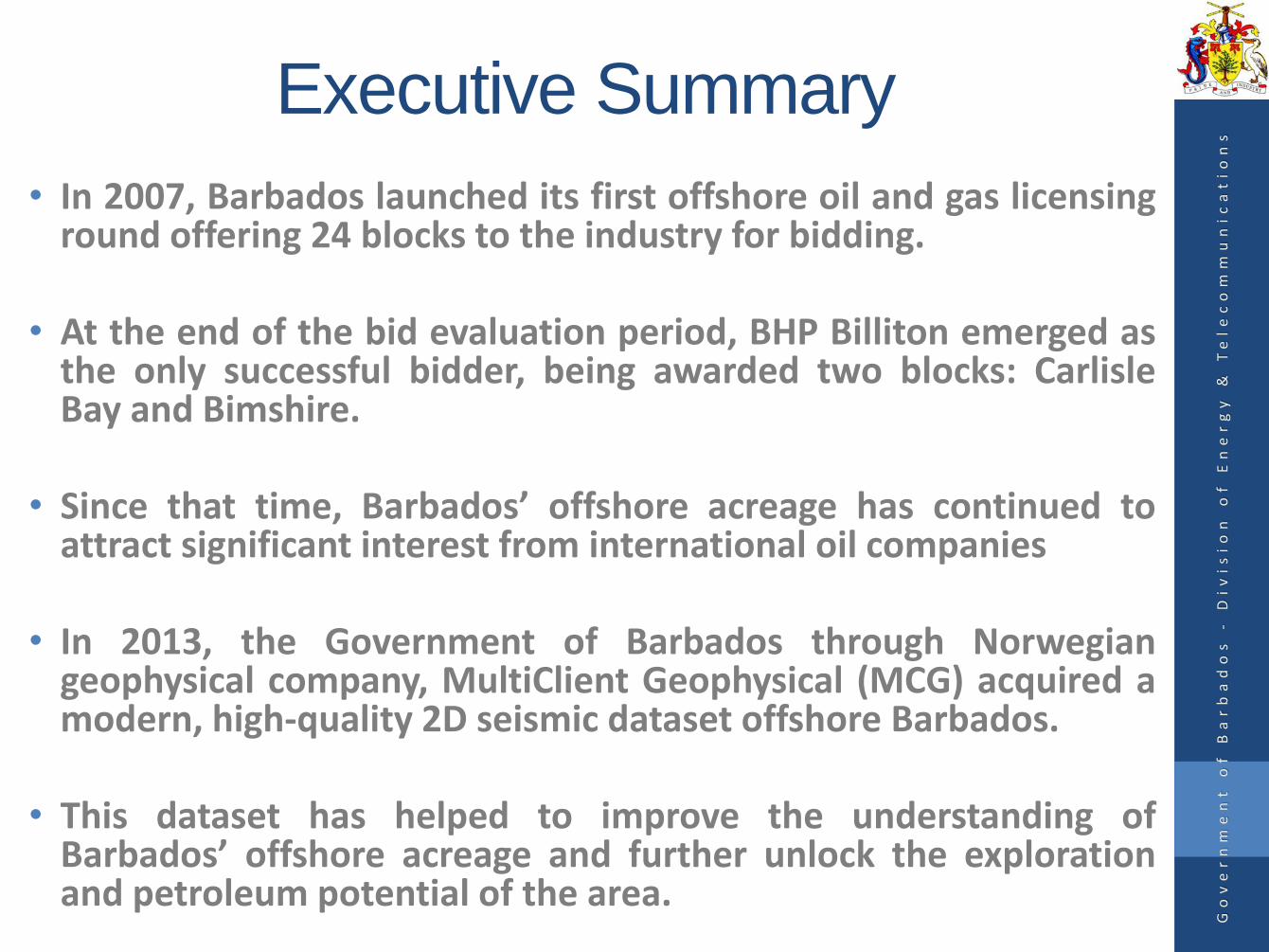
Executive Summary
• In 2007, Barbados launched its first offshore oil and gas licensinground offering 24 blocks to the industry for bidding.
• At the end of the bid evaluation period, BHP Billiton emerged asthe only successful bidder, being awarded two blocks: CarlisleBay and Bimshire.
• Since that time, Barbados’ offshore acreage has continued toattract significant interest from international oil companies
• In 2013, the Government of Barbados through Norwegiangeophysical company, MultiClient Geophysical (MCG) acquired amodern, high-quality 2D seismic dataset offshore Barbados.
• This dataset has helped to improve the understanding ofBarbados’ offshore acreage and further unlock the explorationand petroleum potential of the area.
Go
ve
rn
me
nt
o
f
Ba
rb
ad
os
-
Di
vi
si
on
o
f
En
er
gy
&
T
el
ec
om
mu
ni
ca
ti
on
s
Presentation Outline
• Executive Summary
• Regional Setting
• Onshore Geology
• Offshore Exploration
• Seismic Data
• Exploration Potential and Petroleum Prospectivity
• Future Plans
• Licence Blocks
Go
ve
rn
me
nt
o
f
Ba
rb
ad
os
-
Di
vi
si
on
o
f
En
er
gy
&
T
el
ec
om
mu
ni
ca
ti
on
s
Regional Setting
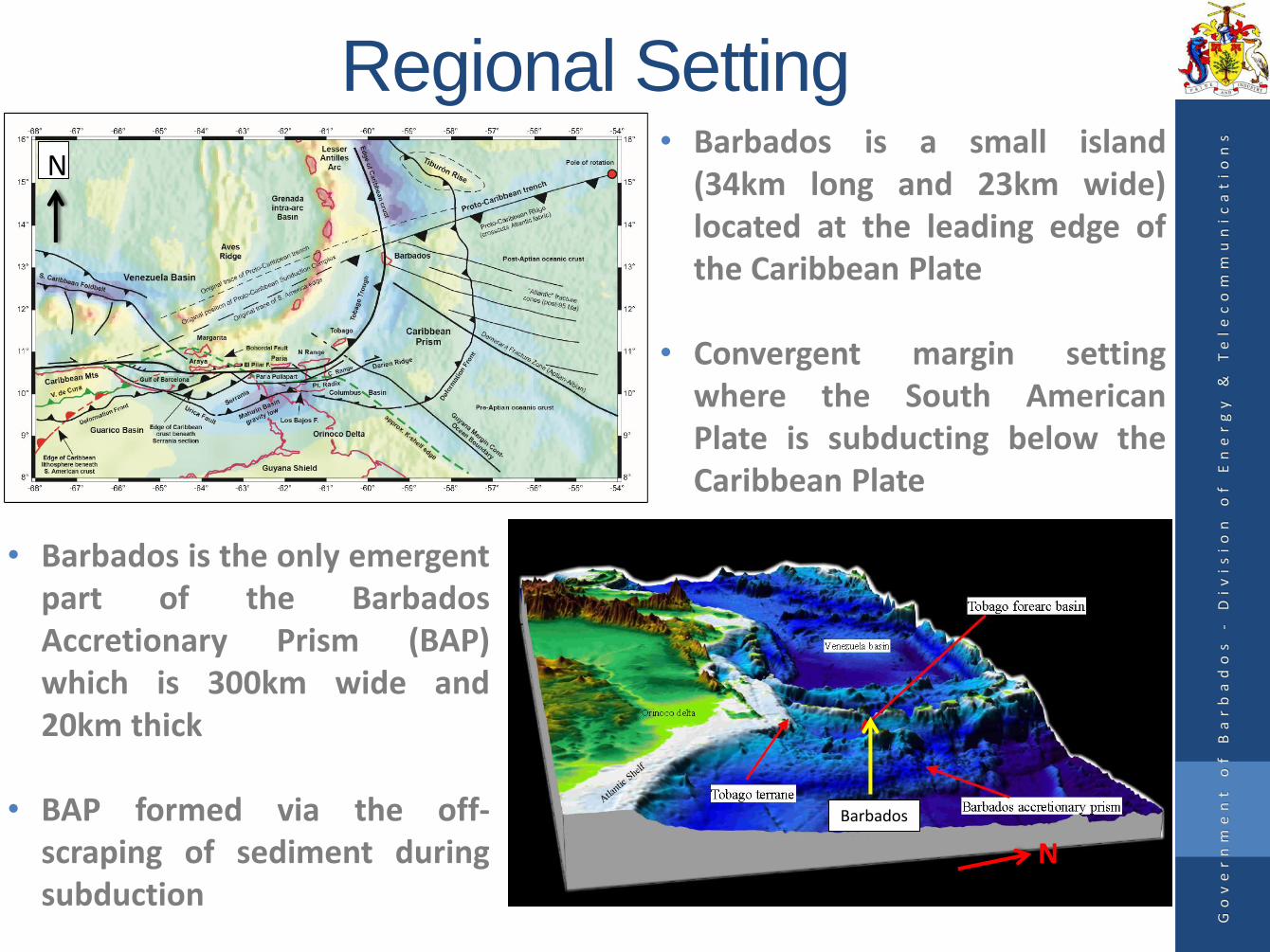
• Barbados is the only emergentpart of the BarbadosAccretionary Prism (BAP)which is 300km wide and20km thick
• BAP formed via the off-scraping of sediment duringsubduction
N
N
Go
ve
rn
me
nt
o
f
Ba
rb
ad
os
-
Di
vi
si
on
o
f
En
er
gy
&
T
el
ec
om
mu
ni
ca
ti
on
s
Barbados
• Barbados is a small island(34km long and 23km wide)located at the leading edge ofthe Caribbean Plate
• Convergent margin settingwhere the South AmericanPlate is subducting below theCaribbean Plate
Abyssal Plain
Tobago Trough
Outer Deformation Front
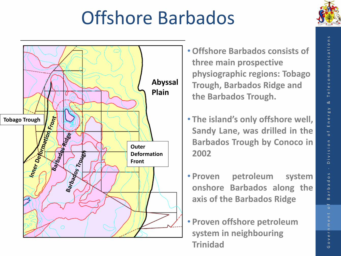
Offshore Barbados
• Offshore Barbados consists of three main prospective physiographic regions: Tobago Trough, Barbados Ridge and the Barbados Trough.
• The island’s only offshore well,Sandy Lane, was drilled in theBarbados Trough by Conoco in2002
• Proven petroleum systemonshore Barbados along theaxis of the Barbados Ridge
• Proven offshore petroleum system in neighbouring Trinidad G
ov
er
nm
en
t
of
B
ar
ba
do
s
-D
iv
is
io
n
of
E
ne
rg
y
&
Te
le
co
mm
un
ic
at
io
ns

Presentation Outline
• Executive Summary
• Regional Setting
• Onshore Geology
• Offshore Exploration
• Seismic Data
• Exploration Potential and Petroleum Prospectivity
• Future Plans
• Licence Blocks
Go
ve
rn
me
nt
o
f
Ba
rb
ad
os
-
Di
vi
si
on
o
f
En
er
gy
&
T
el
ec
om
mu
ni
ca
ti
on
s

Stratigraphy
Go
ve
rn
me
nt
o
f
Ba
rb
ad
os
-
Di
vi
si
on
o
f
En
er
gy
&
T
el
ec
om
mu
ni
ca
ti
on
s
Middle Miocene to Middle Eocene
Seals

Onshore Geology and Exploration•80% of the island is cappedby Quaternary Limestone
•This cap has been eroded inthe NE to expose theunderlying Tertiary units ofthe Scotland Formation, JoesRiver and OceanicFormations
•Early oil wells were drilled inthis area during the 1800’s
•Hydrocarbons currentlybeing produced from theWoodbourne field in the SE.
Chaderton, Wood & Mann 2005 Go
ve
rn
me
nt
o
f
Ba
rb
ad
os
-
Di
vi
si
on
o
f
En
er
gy
&
T
el
ec
om
mu
ni
ca
ti
on
s
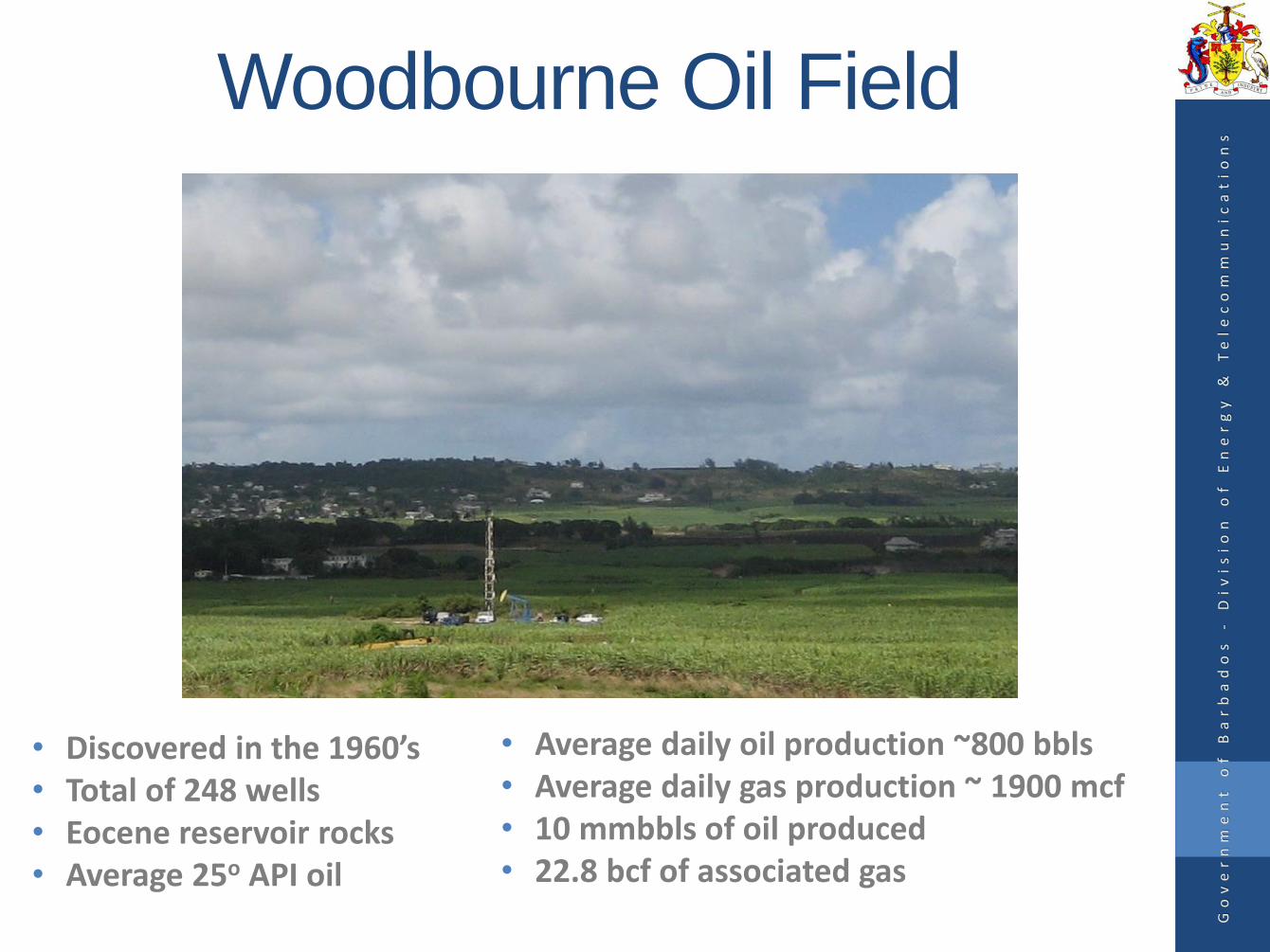
Woodbourne Oil Field
• Discovered in the 1960’s• Total of 248 wells• Eocene reservoir rocks• Average 25o API oil
• Average daily oil production ~800 bbls• Average daily gas production ~ 1900 mcf• 10 mmbbls of oil produced• 22.8 bcf of associated gas
Go
ve
rn
me
nt
o
f
Ba
rb
ad
os
-
Di
vi
si
on
o
f
En
er
gy
&
T
el
ec
om
mu
ni
ca
ti
on
s

Biomarker Studies
• Geochemistry of Woodbourne oils comparable to that of the Upper Cretaceous La Luna source rock
• Hydrocarbons generated from an oil prone Type II kerogen
• Source intervals have not been penetrated by onshore wells
Go
ve
rn
me
nt
o
f
Ba
rb
ad
os
-
Di
vi
si
on
o
f
En
er
gy
&
T
el
ec
om
mu
ni
ca
ti
on
s
Presentation Outline
• Executive Summary
• Regional Setting
• Onshore Geology
• Offshore Exploration
• Seismic Data
• Exploration Potential and Petroleum Prospectivity
• Future Plans
• Licence Blocks
Go
ve
rn
me
nt
o
f
Ba
rb
ad
os
-
Di
vi
si
on
o
f
En
er
gy
&
T
el
ec
om
mu
ni
ca
ti
on
s
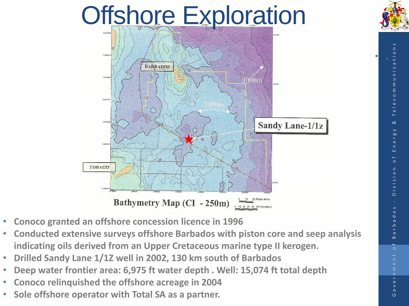
• Conoco granted an offshore concession licence in 1996• Conducted extensive surveys offshore Barbados with piston core and seep analysis
indicating oils derived from an Upper Cretaceous marine type II kerogen. • Drilled Sandy Lane 1/1Z well in 2002, 130 km south of Barbados• Deep water frontier area: 6,975 ft water depth . Well: 15,074 ft total depth• Conoco relinquished the offshore acreage in 2004 • Sole offshore operator with Total SA as a partner. G
ov
er
nm
en
t
of
B
ar
ba
do
s
-D
iv
is
io
n
of
E
ne
rg
y
&
Te
le
co
mm
un
ic
at
io
ns
• .
Offshore Exploration
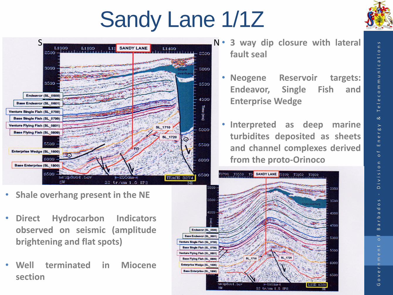
Sandy Lane 1/1ZNS • 3 way dip closure with lateral
fault seal
• Neogene Reservoir targets:Endeavor, Single Fish andEnterprise Wedge
• Interpreted as deep marineturbidites deposited as sheetsand channel complexes derivedfrom the proto-Orinoco
• Shale overhang present in the NE
• Direct Hydrocarbon Indicatorsobserved on seismic (amplitudebrightening and flat spots)
• Well terminated in Miocenesection
Go
ve
rn
me
nt
o
f
Ba
rb
ad
os
-
Di
vi
si
on
o
f
En
er
gy
&
T
el
ec
om
mu
ni
ca
ti
on
s
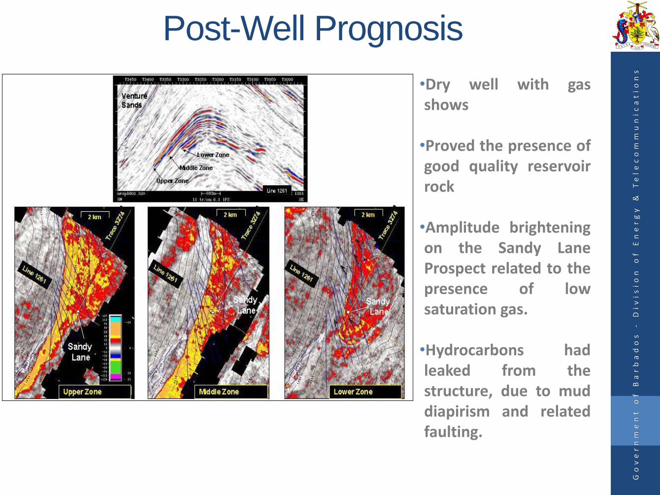
Post-Well Prognosis
•Dry well with gasshows
•Proved the presence ofgood quality reservoirrock
•Amplitude brighteningon the Sandy LaneProspect related to thepresence of lowsaturation gas.
•Hydrocarbons hadleaked from thestructure, due to muddiapirism and relatedfaulting.
Go
ve
rn
me
nt
o
f
Ba
rb
ad
os
-
Di
vi
si
on
o
f
En
er
gy
&
T
el
ec
om
mu
ni
ca
ti
on
s
Presentation Outline
• Executive Summary
• Regional Setting
• Onshore Geology
• Offshore Exploration
• Seismic Data
• Exploration Potential and Petroleum Prospectivity
• Future Plans
• Licence Blocks
Go
ve
rn
me
nt
o
f
Ba
rb
ad
os
-
Di
vi
si
on
o
f
En
er
gy
&
T
el
ec
om
mu
ni
ca
ti
on
s

Older Seismic Data
Go
ve
rn
me
nt
o
f
Ba
rb
ad
os
-
Di
vi
si
on
o
f
En
er
gy
&
T
el
ec
om
mu
ni
ca
ti
on
s
• 11,970 km of 2D seismic
• 500 sq. km of 3D seismic
• Good coverage over the Barbados and Tobago Troughs with less extensive coverage over the Barbados Ridge
• 8,030 km of long offset 2D seismic
• 11,500m Streamer Length
• Wavefield Inseis acquired by CGG Veritas; subsequently acquired by Spectrum ASA
Conoco-Barbados 1999 and 2000 Surveys
Wavefield-Inseis 2007 Survey

New Seismic Dataset• Acquired in 2013 by Norwegian
geophysical company MultiClient Geophysical
• Modern long offset 2D seismicdataset: 6,876 km
• Streamer length: 10,500 m
• Record Length: 14 seconds
Go
ve
rn
me
nt
o
f
Ba
rb
ad
os
-
Di
vi
si
on
o
f
En
er
gy
&
T
el
ec
om
mu
ni
ca
ti
on
s
Presentation Outline
• Executive Summary
• Regional Setting
• Onshore Geology
• Offshore Exploration
• Seismic Data
• Exploration Potential and Petroleum Prospectivity
• Future Plans
• Licence Blocks
Go
ve
rn
me
nt
o
f
Ba
rb
ad
os
-
Di
vi
si
on
o
f
En
er
gy
&
T
el
ec
om
mu
ni
ca
ti
on
s

Offshore Plays
• Offshore Barbados consists of 4 main plays which were originally classified by Conoco
• Reservoir rocks included Neogene turbidites and Paleogene submarine fans
• Barbados Trough believed to have the highest prospectivity and lowest risk plays
• Barbados Ridge and Inner Deformation Front Plays were viewed as high risk plays
Go
ve
rn
me
nt
o
f
Ba
rb
ad
os
-
Di
vi
si
on
o
f
En
er
gy
&
T
el
ec
om
mu
ni
ca
ti
on
s
Barbados Trough Neogene PlayPrimary – Discovery Bay4-way closureAmplitude support at 1070Pliocene/Miocene SandsMain Risk – Charge/HC Type
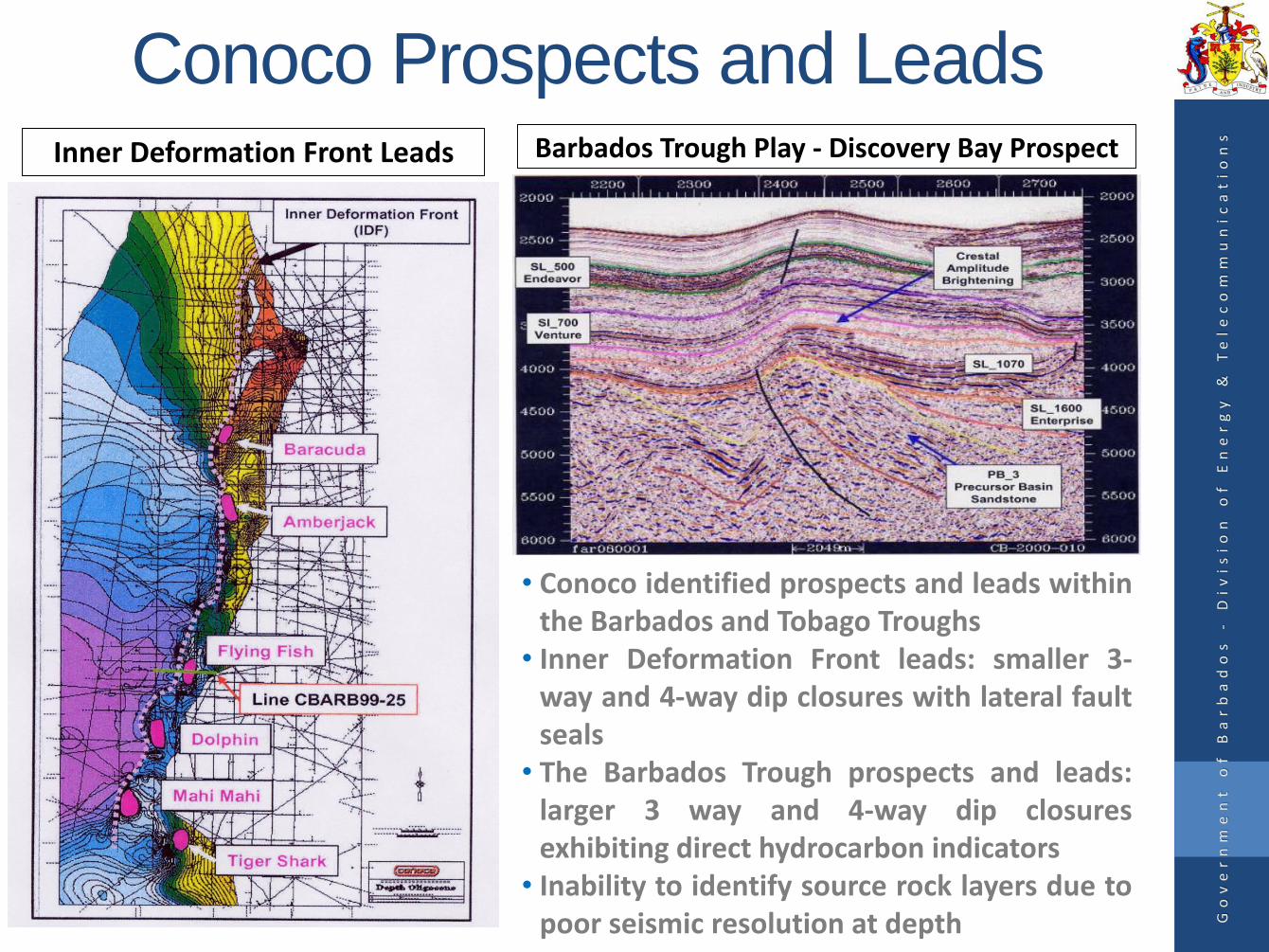
Conoco Prospects and Leads
• Conoco identified prospects and leads withinthe Barbados and Tobago Troughs
• Inner Deformation Front leads: smaller 3-way and 4-way dip closures with lateral faultseals
• The Barbados Trough prospects and leads:larger 3 way and 4-way dip closuresexhibiting direct hydrocarbon indicators
• Inability to identify source rock layers due topoor seismic resolution at depth
Inner Deformation Front Leads Barbados Trough Play - Discovery Bay Prospect
Go
ve
rn
me
nt
o
f
Ba
rb
ad
os
-
Di
vi
si
on
o
f
En
er
gy
&
T
el
ec
om
mu
ni
ca
ti
on
s
MultiClient Geophysical Seismic
Dataset • Improved outlook for the prospectivity and exploration
potential of the Tobago Trough and Barbados Ridge.
• Identification of a number of undiscovered leads andprospective areas.
• Ability to map deeper horizons which were poorly imaged inprevious seismic vintages.
• Structural and stratigraphic traps with new play concepts
• Possibility for source rock modelling.
Go
ve
rn
me
nt
o
f
Ba
rb
ad
os
-
Di
vi
si
on
o
f
En
er
gy
&
T
el
ec
om
mu
ni
ca
ti
on
s

Tobago Trough
• Mapping of acoustic basement and recognition of deep basins• Identification of new leads (structural and stratigraphic closures)• Imaging of deeper horizons
Go
ve
rn
me
nt
o
f
Ba
rb
ad
os
-
Di
vi
si
on
o
f
En
er
gy
&
T
el
ec
om
mu
ni
ca
ti
on
s
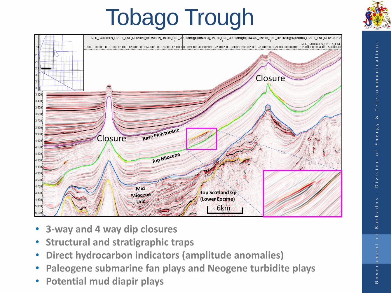
Closure
Closure
Top Scotland Gp(Lower Eocene)
• 3-way and 4 way dip closures • Structural and stratigraphic traps• Direct hydrocarbon indicators (amplitude anomalies)• Paleogene submarine fan plays and Neogene turbidite plays• Potential mud diapir plays G
ov
er
nm
en
t
of
B
ar
ba
do
s
-D
iv
is
io
n
of
E
ne
rg
y
&
Te
le
co
mm
un
ic
at
io
ns
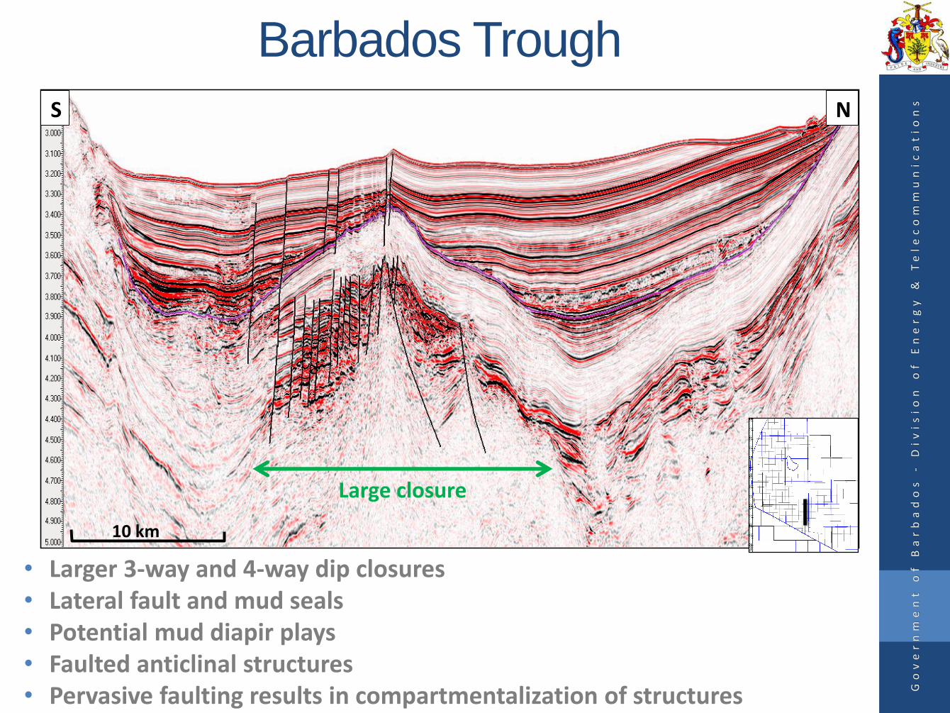
Tobago Trough
6km
NS
Large closure
10 km
Go
ve
rn
me
nt
o
f
Ba
rb
ad
os
-
Di
vi
si
on
o
f
En
er
gy
&
T
el
ec
om
mu
ni
ca
ti
on
s
Barbados Trough
• Larger 3-way and 4-way dip closures• Lateral fault and mud seals• Potential mud diapir plays• Faulted anticlinal structures• Pervasive faulting results in compartmentalization of structures
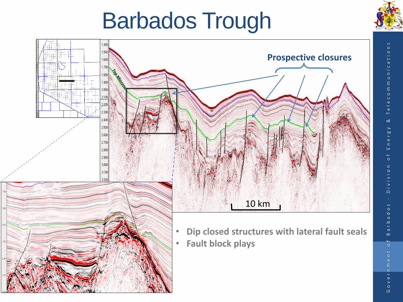
Barbados Trough
Go
ve
rn
me
nt
o
f
Ba
rb
ad
os
-
Di
vi
si
on
o
f
En
er
gy
&
T
el
ec
om
mu
ni
ca
ti
on
s
• Dip closed structures with lateral fault seals• Fault block plays
Prospective closures
10 km

Miocene/Eocene lowstand fan/wedge in Barbados Trough
S N
Miocene DHI
5km
Go
ve
rn
me
nt
o
f
Ba
rb
ad
os
-
Di
vi
si
on
o
f
En
er
gy
&
T
el
ec
om
mu
ni
ca
ti
on
s
Barbados Ridge and Barbados Trough
• Direct hydrocarbon indicators• Broad anticlinal structures• Prospective reservoir intervals in low stand fan/wedge basin fill sediments• Structural and stratigraphic traps
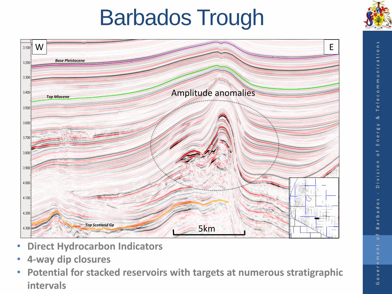
Barbados Trough
Base Pleistocene
Top Miocene
Top Scotland Gp
Amplitude anomalies
W E
5km
Go
ve
rn
me
nt
o
f
Ba
rb
ad
os
-
Di
vi
si
on
o
f
En
er
gy
&
T
el
ec
om
mu
ni
ca
ti
on
s
• Direct Hydrocarbon Indicators • 4-way dip closures• Potential for stacked reservoirs with targets at numerous stratigraphic
intervals
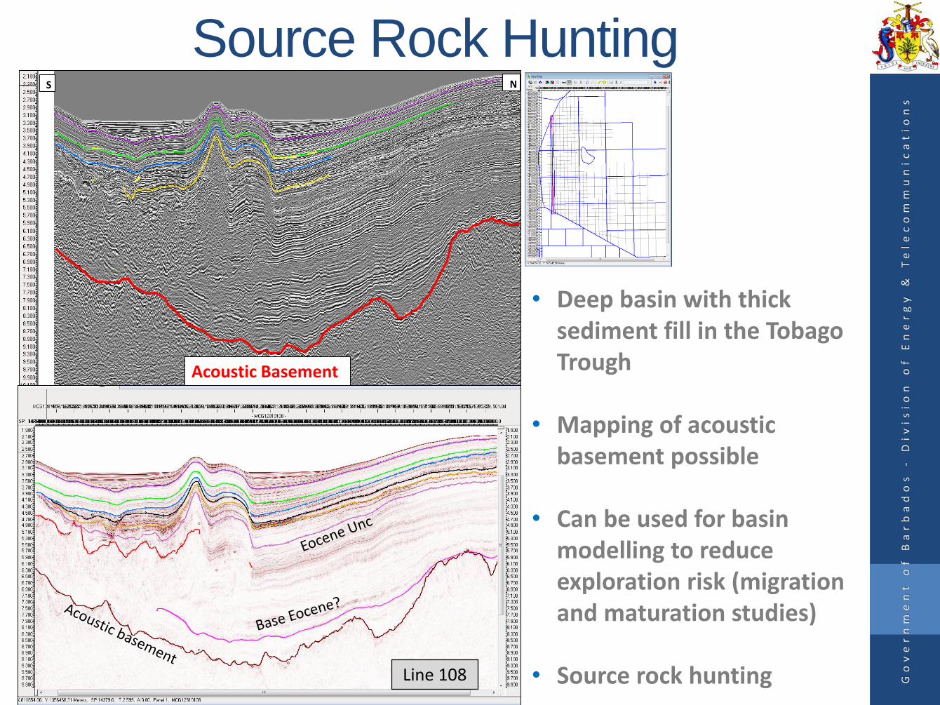
Source Rock Hunting
• Deep basin with thick sediment fill in the Tobago Trough
• Mapping of acoustic basement possible
• Can be used for basin modelling to reduce exploration risk (migration and maturation studies)
• Source rock hunting
NS
Acoustic Basement
Line 108 Go
ve
rn
me
nt
o
f
Ba
rb
ad
os
-
Di
vi
si
on
o
f
En
er
gy
&
T
el
ec
om
mu
ni
ca
ti
on
s
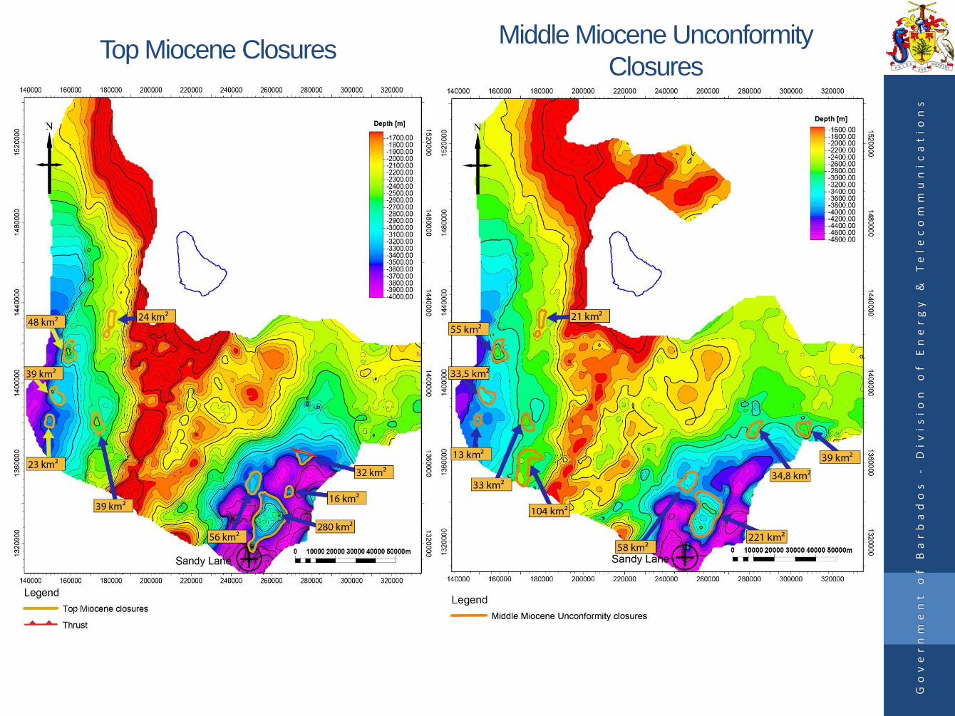
Top Miocene Closures
Go
ve
rn
me
nt
o
f
Ba
rb
ad
os
-
Di
vi
si
on
o
f
En
er
gy
&
T
el
ec
om
mu
ni
ca
ti
on
s
Middle Miocene Unconformity
Closures
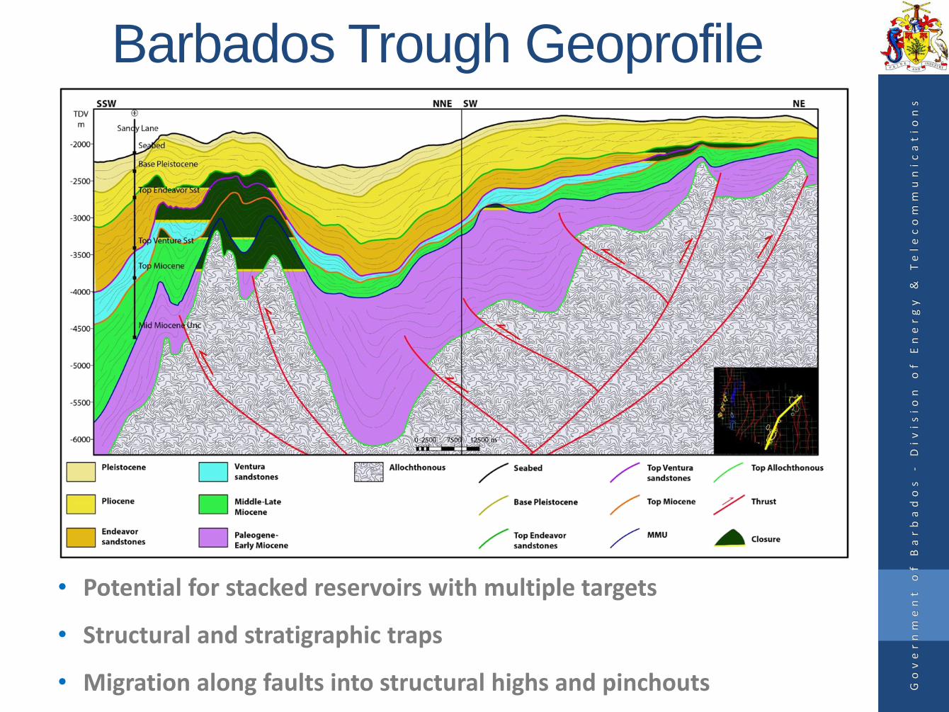
Barbados Trough Geoprofile
• Potential for stacked reservoirs with multiple targets
• Structural and stratigraphic traps
• Migration along faults into structural highs and pinchouts Go
ve
rn
me
nt
o
f
Ba
rb
ad
os
-
Di
vi
si
on
o
f
En
er
gy
&
T
el
ec
om
mu
ni
ca
ti
on
s

Tobago Trough Geoprofile
Go
ve
rn
me
nt
o
f
Ba
rb
ad
os
-
Di
vi
si
on
o
f
En
er
gy
&
T
el
ec
om
mu
ni
ca
ti
on
s
• Potential for stacked reservoirs with multiple targets• Migration along faults, then updip via a fill and spill model• Structural and stratigraphic traps

Offshore Prospectivity
• Underexplored frontier area
• Structural and stratigraphic closures identified at numerous stratigraphic levels
• Good prospectivity throughout the Barbados Trough, Barbados Ridge and Tobago Trough
• Direct hydrocarbon indicators
• Good quality reservoir rock
Go
ve
rn
me
nt
o
f
Ba
rb
ad
os
-
Di
vi
si
on
o
f
En
er
gy
&
T
el
ec
om
mu
ni
ca
ti
on
s

Presentation Outline
• Executive Summary
• Regional Setting
• Onshore Geology
• Offshore Exploration
• Seismic Data
• Exploration Potential and Petroleum Prospectivity
• Future Plans
• Licence Blocks
Go
ve
rn
me
nt
o
f
Ba
rb
ad
os
-
Di
vi
si
on
o
f
En
er
gy
&
T
el
ec
om
mu
ni
ca
ti
on
s
Future Plans
• Reprocessing of Conoco seismic
• Attribute and amplitude analysis
• AVO studies
• Basin modelling and source rock analysis
• Additional seismic interpretation programmes
• Regional seismic surveys and infill lines
• Biostratigraphic analysis to further constrain the
ages of offshore units
Go
ve
rn
me
nt
o
f
Ba
rb
ad
os
-
Di
vi
si
on
o
f
En
er
gy
&
T
el
ec
om
mu
ni
ca
ti
on
s
Future Licensing Campaigns
• The Offshore Petroleum Legislation was amendedand subsequently proclaimed in 2013, allowing forthe award of offshore licences via bid rounds ordirect negotiations.
• Government is currently preparing pre-qualificationcriteria and bidding guidelines which will be utilizedfor the next licensing campaign.
• This information will be disseminated to the industryin the coming months and will outline a clear processfor the future award of licences.
Go
ve
rn
me
nt
o
f
Ba
rb
ad
os
-
Di
vi
si
on
o
f
En
er
gy
&
T
el
ec
om
mu
ni
ca
ti
on
s
Presentation Outline
• Executive Summary
• Regional Setting
• Onshore Geology
• Offshore Exploration
• Seismic Data
• Exploration Potential and Petroleum Prospectivity
• Future Plans
• Licence Blocks
Go
ve
rn
me
nt
o
f
Ba
rb
ad
os
-
Di
vi
si
on
o
f
En
er
gy
&
T
el
ec
om
mu
ni
ca
ti
on
s
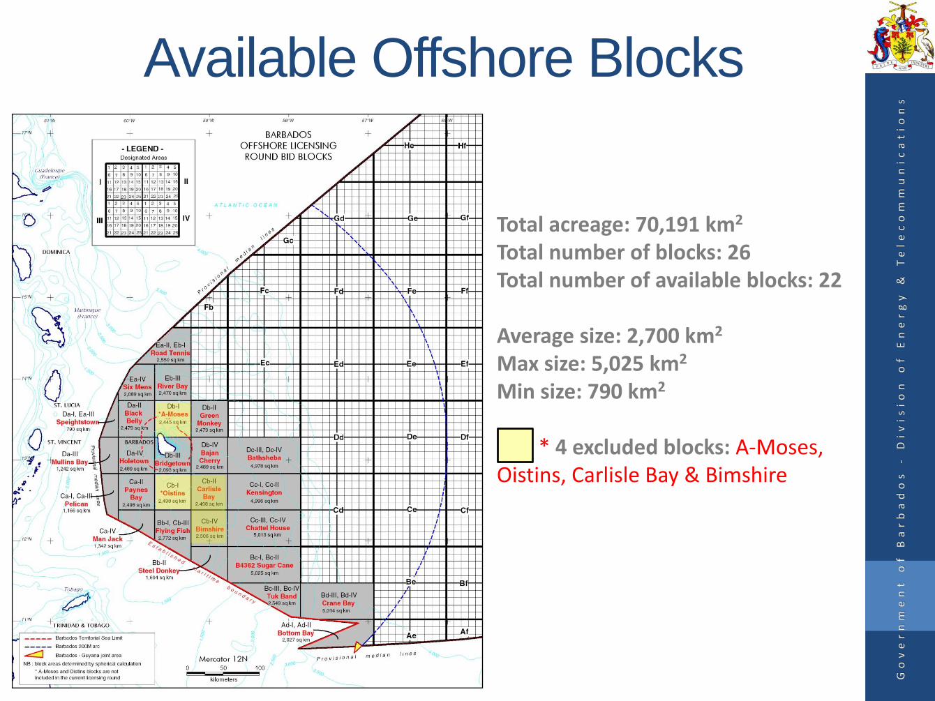
Total acreage: 70,191 km2
Total number of blocks: 26Total number of available blocks: 22
Average size: 2,700 km2
Max size: 5,025 km2
Min size: 790 km2
* 4 excluded blocks: A-Moses, Oistins, Carlisle Bay & Bimshire
Go
ve
rn
me
nt
o
f
Ba
rb
ad
os
-
Di
vi
si
on
o
f
En
er
gy
&
T
el
ec
om
mu
ni
ca
ti
on
s
Available Offshore Blocks

License BlocksBlock Name sq. km
Ea-II, Eb-I Road Tennis 2,550 Ea-IV Six Mens 2,089Eb-III River Bay 2,470Da-I, Ea III Speightstown 790 Da-II Black Belly 2,479Db-I A-Moses* 2,445Db-II Green Monkey 2,479Da-III Mullins Bay 1,242Da-IV Holetown 2,489Db-III Bridgetown 2,093 Db-IV Bajan Cherry 2,489 Ed-III, Ed-IV Bathsheba 4,978Ca-I, Ca-III Pelican 1,166
* Unavailable Blocks
Block Name sq. km
Ca-II Paynes Bay 2,498Cb-I Oistins* 2,498 Cb-II Carlisle Bay* 2,498 Cc-I, Cc-II Kensington 4,996 Ca-IV Man Jack 1,342 Bb-I, Cb-III Flying Fish 2,772 Cb-IV Bimshire* 2,506 Cc-III, Cc-IV Chattel House 5,013Bb-II Steel Donkey 1,694Bc-I, Bc-II B 4362 Sugar Cane 5,025Bc-III, Bc-IV Tuk Band 2,549Bd-III, Bd-IV Crane Bay 5,014Ad-I, Ad-II Bottom Bay 2,027
Bid Blocks

Contact InformationAAPG International Pavilion Booth #: 552
Mr. Jamar White – Director, Natural Resources
Email: [email protected]
Tel: (246) 434 2507
Website: www.energy.gov.bb
Division of Energy and Telecommunications
Trinity Business Centre
Country Road
St. Michael
Barbados
West Indies
Go
ve
rn
me
nt
o
f
Ba
rb
ad
os
-
Di
vi
si
on
o
f
En
er
gy
&
T
el
ec
om
mu
ni
ca
ti
on
s

Special Thanks
MultiClient Geophysical
Exploro Geoservices
Go
ve
rn
me
nt
o
f
Ba
rb
ad
os
-
Di
vi
si
on
o
f
En
er
gy
&
T
el
ec
om
mu
ni
ca
ti
on
s

Go
ve
rn
me
nt
o
f
Ba
rb
ad
os
-
Di
vi
si
on
o
f
En
er
gy
&
T
el
ec
om
mu
ni
ca
ti
on
s
Thank You