University of Cape Town - COnnecting REpositories · chapter 2: a critical~view ... figure 5,11 2 x...
143
University of Cape Town BURROWS AND BEDDING SITE TAPHONOMY AND SPATIAL ARCHEOLOGY AT TORTOISE CAVE T. S. ROBEY SPATIAL ARCHAEOLOGY RESEARCH UNIT UNIVERSITY OF CAPE TOWN THESIS SUBMITTED FOR THE DEGREE OF MASTER OF ARTS IN ARCHAEOLOGY AT THE UNIVERSITY OF CAPE TOWN 19BJJ The University of Cr'lo T,i·•n :1M_be_en glven the right to tc;,rodticc this ti e;;iS in whole or in part. Copyright is held by the author.
Transcript of University of Cape Town - COnnecting REpositories · chapter 2: a critical~view ... figure 5,11 2 x...

Univers
ity of
Cap
e Tow
n
BURROWS AND BEDDING
SITE TAPHONOMY AND SPATIAL ARCHEOLOGY
AT TORTOISE CAVE
T. S. ROBEY
SPATIAL ARCHAEOLOGY RESEARCH UNIT
UNIVERSITY OF CAPE TOWN
THESIS SUBMITTED FOR THE DEGREE OF MASTER OF ARTS IN ARCHAEOLOGY AT THE UNIVERSITY OF CAPE TOWN
19BJJ
The University of Cr'lo T,i·•n :1M_be_en glven the right to tc;,rodticc this ti e;;iS in whole or in part. Copyright is held by the author.

The copyright of this thesis vests in the author. No quotation from it or information derived from it is to be published without full acknowledgement of the source. The thesis is to be used for private study or non-commercial research purposes only.
Published by the University of Cape Town (UCT) in terms of the non-exclusive license granted to UCT by the author.
Univers
ity of
Cap
e Tow
n

ABSTRACT
fa:cavations at the Late Stone Age site of Tortoise Cave, a shell Midden accuMulation in the
western Cape, So1Jth Africa, were carried out froM 1978 to 1983, The ar.,thor Sltpervised this
project froM 1981 onwards with the aiM of e:{panding the cult1.1ral saMPle and defining More
clearl'j the stratigraphic sequence, At the saMe tiMe, to increase the objectivit:1 of the written
record, soMe iMproveMents to the norMal recording techniques were tested, These included the use
of conte>:t sheets and a stratigraphic Matri:<, Methods often used elsewhere but ver':I ur.coMMon in
South Africa, It was felt that archaeologists had been ignoring the vital difference between
stratiqraph'j that is observed and e:-:cavated and the act1Jal seqlience and circl•Mstances of
deposition, For this latter, the terM 'Site TaphonOM':1' has been coined, to end the confusion
that has e:dsted concerning the Meaninq and correct application 'lf the words 'Stratigraph':I' and
'Stratification', These terMs should now be restricted to refer to the archaeological constructs
alone, The aMOlir,t of disturbance at the site led to an investigation of the processes and
effects of disturbance, the iMPlications of which are 01.1tlined here, It is thought that Tortoise
Cave is not an isolated case and that considerable artefact displaceMent Ma'j be a COMMon feature
of _local sites, Despite this, an atteMPt was Made to find and use appropriate statistical
l'IE!thods of spatial anal':lsis, It was found that soMe positive results, if soMewhat qeneralised,
COl•ld be obtained, The Major theMe of the thesis is, however, neither a description of the finds
and fi°ndings froM the site nor siMPl':I a spatial anal'jsis of the deposits and their contents, It
atteMpts instead to il11Jstrate how the understanding of the central concept of site taphonoM':! is
essential to ever':! aspect of the interpretation of a site and the assessMent of the res1.1lts ,
Finall'j, an appeal is Made for future research to include prograMs of e>:periMents on site
forMation processes, co1.1pled to the e>:cavation of sMall, siMple deposits, This sh0t.1ld serve to
iMProve 01.1r liMi ted under star.ding of Site TaphonoM'j which is essential if the COMP le:-:i ties of
the southern African Late Stone Age seq,.,ence are ever to be reliabl'j unravelled,

FRONTfSPIECE: TORTOISE CAVEt 1982t FACING WEST, SQUARES AA & AA2 ARE JUST
BEHIND THE FIGUREt V9 8. W9 BEYOND THE TRIPOD,

.., With01.1t the help of a great nuMber of people, this project would not have been possible, I would
like first to offer M'3 profo.,nd thanks to M'3 wife, Tina, with01.1t whoM I would never have
finished writing, Her assist mce with the drawings and t ables, the sorting and cataloging of
finds, and in Man'j wa'jS throughout the project are probabl'3 the Main reason this thesis is now
cQMPlete,
I wo1.1ld lir..e to thank Martin Hall for his supervision and S':IMPathetic help d1.lf'inq the final
stages of the project, and John Vogel for providing the radiocarbon dates: so Man':I for a junior
archaeologist, but without theM the taphonoMic reconstniction W01.1ld not have been possible,
Thanks are also dl.1e to John Parkington, whose advice d1.1ring the ear lier part of the wor~. was
alwa'js l1Sef1.1l, and who was instm,iental in shaping the project into its present forM,
For their stiMulation and ideas, as well as for their unstinting help in the fieldwor~., I wish
to thank M':I fellow stl1dents and MeMbers of the S,A,R,U,, especiall':I Ro':!den Yates, Tori':! Manhire,
Ji.id':! Seal':I, tlar':I Patrick, JiM Joblinq, Jo Golson, Ann SoloMOn and Dave Halkett, Special thanks
are di.1e to Cedric Poggenpoel for his work with the fish reMains and assistance throughol,t, and
to Mike Herbet for the· plates, Man'3 other st1.u:!ents helped over the two ':lears of fieldwor~. and . ,..
sorting and their contributions are not forgotten,
Fmding for the project caMe froM the Spatial Archaeolo9'3 Research Unit and froM a research
grant frOM the Universit'3 of Cape Town, I hope the'3 will corisider the Mone':! well spent,
This vol1.1Me is dedicated to Tina, and to M'3 Mother, who never saw it finished,

LIST OF FIGURES
LIST OF TABLES
LIST OF PLATES
CHt1PTER 1 : THE AIMS OF THE PROJECT
Introd1.1ction
The Need for Further E:<cavation
The Stratiqraphic ProbleM
Towards a g'jsteMatic Record
Dist1.1rbance and Artefact Dispersal
Statistics and Spatial Anal';lsis
S1 . .1MMar'j R1;.
CHAPTER 2: A CRITICAL~VIEW OF THE EXCAVATIONS
The EnvironMental Settinq
The E:-:cavations
CHAPTER 3: STRATIGRAPHY AND SITE TAPHONOMY
Introduction
Site TaphonoM':l
The Stratiqraphic Seq1..rence
™PTER 4: THE CULTURAL REMAINS
Introd1.iction
The Fal1ria
The Artefacts
Conchisions
1
2
3
4
17
21
34

CHAPTER 5: SPATIAL ANALYSIS
Introd1.1ction
The Techniques in Ot.1tline
Application of Co1.1rt' s Method for Map CoMpar i son
Application of DiMensional Anal'.::!sis of Variance
Anal'.::!Sis of the Basin Deposits
Concli.JSions
CHAPTER 6: DISCUSSION AND CONCLUSION
Introd1.tdion
The Seasonal Mobilit'.::! Model
EnviroriMental Change
The EMerqinq Model
Tortoise Cave in Conte>.i.
CoMMents on the Use of Space at Tortoise Cave
Methodoloq'.::! and F1.1rther Research
REFERENCES
APPENDIX Al SOME NOTES ON EXCAVATION METHODS AND INTERPRETIVE
TECHNIQUES FOR SHELL MIDDENS AND OTHER UNCONSOLIDATED
DEPOSITS
APPENDIX B: TORTOISE CAVE 1978 - 83: STRATIGRAPHIC LIST OF
CONTEXTS AND LAYERS
61
76
81
88

LIST OF FIGURES
FIGURE 1,1 PLAN OF EXCAVATIONS SHOWING SALIENT FEATURES 4
FIGURE 1,2 ARCHAEOLOGICAL SITES IN THE SOUTHERN CAPE 5
FIGURE 1.3 SECTION TH~'{)UGH THE BASIN: DRAWN WITHOUT LABELS 7
FIGUP.E 1,4 MASTER CONTEXT SHEET (ANNOTATED) 10
FIGURE 2,1 THE ELA!{)S BAY AREA: SITES AND ECOSYSTEMS 17
FIGURE 3,1 SECTION THROUGH SOIL AM> BEDDING UNITS 23
FIGURE 3,2 SECTION SHOWING TWO PHASES OF BASIN 23
FIGURE 3,3 SECTION THROUGH LOWER TALUS DEPOSITS 24
FIGURE 3,4 SECTION ~'{)UGH OUTER CAVE DEPOSITS 25
FIGIJ{E 3,5 SECTION TH~'OUGH MIDDENS AM> ASH HEAPt FRONT OF BASIN 27
FIGI.K 4,1 TORTOISE CAVE BURIAL tit LAYER 9 38
FI~'E 5,1 COURT'S METHOD OF MAP COMPARISON: THEORY 50
FIGURE 5,2 COURT'S METHOD: LAYER 9 52
FIGURE 5,3 COI.J<T'S METHOD: LAYER 11a 52
FIGURE 5,4 COlRT'S METHOD: LAYER 13 53
FIGURE 5,5a DIMENSIONAL ANALYSIS OF VARIANCE: LAYER 9 54
FIGURE 5,5b DIMENSIONAL ANALYSIS OF VARIANCE: LAYER 9 54
FIGURE 5,6 TORTOISE CAVE: LAYER 1 55
FIGURE 5,7 TORTOISE CAVE: LAYER 2a 55
FIGURE 5,8 TORTOISE CAVE: LAYER Zb 56
FIGURE 5,9 TORTOISE CAVE: LAYER 3 56
FIGURE 5,10 STYLISED DROP ZONE/TOSS ZONE A~'OUND HEARTH 57 ( After Binford 1978)
FIGURE 5,11 2 X 2 CONTINGENCY TAe.t..ES FOR CHI SQUARED: OE:SERVED & EXPECTED VALUES
1

LIST OF TABLES
TABLE 1: RADIOCARBON DATES FROM TORTOISE CAVE
TABLE 2: SPECIES OF FISH BY LAY6R, TORTOISE CAVE 1978-1 981
TABLE 3: MAMMALIAN FA UNA
TABLE 4: LITHIC RAW MATERIAL FREQUENCIES BY LAYER
TABLE 5: TORTOISE CAVE LITHIC ASSEMBLAGE: FREQUENCY ANALYSIS
TABLE 6: LAYER 9, QUARTZ AND SILCRETE WASTE
TABLE 7: LAYER 11, QUARTZ AND SILCRETE WASTE
TABLE 8: LAYER 13, QUARTZ AND SILCRETE WASTE
TABLE 9: VALUES OF THE COEFFICIENT OF MEDIAL CORRELATION
TABLE 10: LAYER 9, DATA FOR DIMENSIONAL ANALYSIS OF VARIANCE
TABLE 11: DIAGNOSTIC TORTOISE FROM LAYERS 2 & 3
2
22
35
37
40
41
51
51
S1
52
S4
S7

LIST OF PLATES
FRONTESPIECE: TORTOISE CAVEt 1982, FACING WEST, SQUARES AA & AA2 ARE JUST
BEHIND THE FIGURE, V9 & ~9 BEYOND THE TRIPOD,
PLATE 1: THE ROCK STEP IN S2, SHOWING LAYER 10 AT TOP OF SECTION TO THE
LEFT, SHELL LENS AND GREY ASHY DEPOSIT,
24
PLATE 2: SQUARE AA2 PARTIALLY EXCAVATED, WASP IS MARKED IN SECTION, NOTE THE 30
ST,~RT OF THE ROC~{S PILED ON E:EDROCK,
PLATE 3: SECTION ON Y/T INTERFACE SHOWING SHELL MIDDENS ( PISSARRO, RUBENS,
FELIX), BURNT SHELL LAYER AND WHITE ASHY LENS CDOGMATIXl,
PLATE Ill BORED WOOD, E:ONE POINTS AND DECORATED E:ONE TUP,E (SCALE IN CM),
PLATES: GRASS BUNDLE BOUND WITH TWINEt LEATHER FRAGMENT, PIECES OF
KNOTIED GRASS TWINE,
32
42
43
PLATE 6: BONE SPATULAE, TOP & BOTTOM LEFT ARE OCHF.'E STAINED, 1\4
PLATE 7: PENDANTS, ALL MARINE SHELL EXCEPT CENTRE LEFT OF BRASS, 45
PLATE a: SHELL PENDANTS AND E:EADS, 45
PLATE 9: BEADS, SEED (2:·:l, GLASS (3x), BRASS/COPPER, SHELL, E:ONE DISC (2:'.l, 46
BONE TUE:E ( 2:{ l ,
PLATE 10: OSTRICH EGGSHELL: PIECE AT TOP RIGHT DECORATED, TOP CENTRE SHOWS MASTIC 46
TRACES, E:OTIOM CENTRE 8. LEFT HAVE GROUND EDGES,
.-,
.:,

CHAPTER 1: THE AIMS OF THE PROJECT
Mhen I undertook in 1981 to re-excavate Tortoise Cave, it was to support the Spatial
Archaeol!Jg'j Research I.nit's Sandveld saf'IPlinq progratt foc:ussinq on apen artefact scatters, in
particular to provide a co,,iparable, dated sequence of artefacts which earlier excavations had
shot.«'i to be present. The 1978 excavations at the site had raised a OUl'lber of q•JeStions which
could onl'::I be answered b';f an extension of the excavations. In addition, there were indications
that the deposits to the rear of the shelter would reveal~ useful spatial data (Parkington
1979) frllft a coastal site CCll'!Parable to that obtained frllft other excavated sites inland:
Oieplc.loof (Parlc.ington 1977), De Hanqen (Parlc.inqton & Poqqerw>oel 1971 a. ) and Andriesgrond
(Parlc.ington 1979). For f'l'.:i. part, I saw in the e:<eavation a chance to tr'::I OIJt SOl'!e ideas I had
concerninq the role and realit'::I of stratigraph'::I and ~ ,iethods of i!'lProvinq recordinq
tectniques to test these ideas. I also felt that there was too great an E!f'f>hasis in the S.A.R.U.
on inter - site (geographic or landscape) patterninq and saw in the Tortoise Cave project a Wa';I
to redress this il'lbalance and add to oor rather general ideas on intra - site patterning and use
of cave sites. Initiall'::I onl'::I one field season was planned, but 110re were added as the
COl'lfllexit'::I of the problettS beca,,ie apparent, and the project has evolved into the work presented
in this vol'-"!.
TI£ t£ED FCR FmTI£R EXCAVATI~
Dvrinq the 1978 excavations and the s,j)seq_uent preli1dnar'::I anal'::1Se5, a flllf!ber of queries
concerninq the finds had been raised which could not be answered withoot further excavation,
larger saf'IPles in SOl'!e cases, and a clearer general lJ'lderstanding of the stratigraphic sequence
at the shelter. The excavations had concentrated on the area iMediatel'::I outside the cave,
extendinq inside the drip-line in onl'::I a few squares: '::IE!t clearl'::I there were a fll.ll'lber of
il'lf)ortant distinctions between the imer and outer deposits and their cultural content which
required exPlanation.
"The division between the shell, ash and vegetation rich la';!ers inside the cave and
the gre'::I, apparentl'::I poorl'::I stratified deposits outside the cave falls ver'::I noticeabl'::I alonq the line riarkinq the penetration of SU'llisht and rainfall. The ver'::I low roof of
4

TORTOISE CAVE
GRID PLAN & CAVE FLOOR
JJ Kl
•.·
I T2 Y2 12 J2 .. /' K2 X2
., I ...
" '• I ,,
"-. ::· •, :,
\_ --{o . I
T y .!!.l J .:· K X
"""· ~~ .. I
----· ·-·--· '•
~" - ,, / . ; "'-
~ :f!.- /
--- /
"'~ --R4 54 L f H
[ZJ Cave well
Partiall Excavated ~ Step In bedrock
RJ SJ M ~ Crevice
[Z] Edge of partial excavation
[Z] Edge of excavation
R2 52 N A •• 4 ••
8URIAL N0. 1
R1 S1 0 p Q
- ~N - - - -0 2m
V9 W9
FIG.1.1 . PLAN OF MAIN EXCAVATION

the shelter ••• has also helped to prevent tra,ipling and preserve stratigraphic
distinctions inside the cave" (Parkington 1979:19).
Thus this distinction was at first seen as one of post-depositional leaching and disturbance, I
This i,ade r,ore puzzling the findings of Cedric Poggenpoel, who anal~ the fish r~ins frDft
the excavation,
"hreas the white steeroras and the haarder ~inated the internal lenses of the
site, white sto.lpnose were clearl13 MOre COl'W'IOO outside the dripline, It is not '3et
clear what this !'leans." (Ibid).
Again, preli"inar13 anal13Sis of the artefactual r,aterial proved difficult to interpret.
11Si"ilarl13 stone artefacts have proved fairl13 ib.mant on the talus slope but are ver13
rare behind the dripline. In this case it~ the cave was si11>l13 too restrictive to
allow "-'Ch stone-tool ttaking and using within its confines11 (Ibid).
Fr°" Rawlinson's (1979) work on the lithic artefacts, it was apparent that a dicho~ existed
in the forr,al tool co,,iponent between the interior of the shelter and the talus slope be'3ond. He
showed that whilst scrapers and adzes pr~inated inside the drip line, scrapers and baclc.ed
pieces were the ..ast COl'W'IOO tools in the outer deposits. The surface sal'!f)les <Hazel 1978) showed
an interl'lediate pattern. Parkington noted that:
11Inside the cave potter13 has been found oo..n to within 0,1" of the bedrock. floor ...
[whilst] outside the cave there ~ have been quite a volute of talus slope
acclll'IUlation prior to the appearance of potter13 but the stone tool t';!Polocr3 suggests
few changes ••• in this episode. A sr,all rut'lber of sr,all bladelet cores and silcrete
bladelets fr°" a localised area it!Nediatel13 on bedrock. offer tantalising hints of
SONething si"ilar to the Late Pleistocene of EBC. Otherwise the sequence~ lilc.el13
to car.respond to the post-hiatus deposit at EBC. 11 (Ibid:20-21).
The possibilit13 that there were deposits at the site dating to the Ter"inal Pleistocene or Earl13
Holocene ..eant that a better, dated sa,iple l'liqht confir" or refute the regional hiatus proposed
s

•BE
AU
FO
RT
W
ES
T
0 \.
.q
p
BO
OM
PL
AA
S•
E
f 0
OU
DT
SH
OO
RN
...
0 2
5
10
0
FIG
.1.2
. A
RC
HA
EO
LO
GIC
AL
SIT
ES
IN
TH
E S
OU
TH
ER
N C
AP
E
~
y,
ME
LK
HO
UT
BO
OM
20
0km
s
• H
IGH
LA
ND
S
"\
\..
• G
RA
HA
MS
TO
WN
•
• W
ILT
ON
PO
RT
E
LIZ
AB
ET
H
N 1

~ Parkington (1977, 1980), on the basis of the Elands Ba13 Cave sec1.uence, for the period between
about 1000 BP and 8000 BP.
Finall':i, the l'IOdel of Late Stone Age seasonal l'IOVef'lel'lt between the Mest Coast and the Cape Fold
e.e1t (Parkington 1972, 1980, Hazel & Par~.ington 1981) had COf'IE! LO:ler strong criticis,. (Deacon
H.J. 1980, Deacon J. ·1980, Sa,,ipson 1980). This criticiSl'lcentredon the asSUl'1f)tion of
contei,>oreneit':i for the Sandveld (with backed pieces il"IPortant) and ftOUl'ltain (adze rich)
assef'lblages, in the face of conflicting evidence not onl':i frott elsailere in the Cape at
Helkhout.bcxlN, Wilton Rock Shelter, Highlands Rock Shelter (Deacon H.J. 1976, Deacon J. 1972, B '1 V\e.S \-<.r-cu,,s k.op
1980) and ~ie Keld!rs (Schweitzer & WilS<J'11982), but also within the western Cape at
Klipfonteinrand, Andriesgrond and the De teJs open sites (Parkington 1979, 1980) which suggested
that adzes were a 110re recent pheno,.encxlt These topics are dealt with in greater detail when the
relevance of the Tortoise Cave data is reviewed in the final chapter. For the l'IOftent, however,
this serves to def,onstrate the need to obtain a control sat1Ple for the Sandveld data both to
address these questioos and to bvild a tei,>oral fraNeWOrk for future research in the area
(Hanhire in prep.)There can be little doiJbt that the resolution of these problei.s required a re
excavation of Tortoise Cave accottPanied ~ detailed stratigraphic recording of the site which
has been referred to as "one of the ~.e';iS to Sandveld settleNent" (Hanhire et al 1983a).
TI£ STRATIGRAffiIC PROOlEH
S':iStet'latic excavation is often considered as one of the cornerstones of "scientific"
archaeolQg'j. Yet an abstract work of art is hardl':i less objective than the craft of excavation,
frott the choice of grid size and orientation to the interpretation of the sections. The site and
its deposits are objects and the ro:les of forKation of both are in no Wa'3 dependa)t on the
investigator. Theoreticall':l, at least, this lends itself to objective e'.<attination. Nevertheless
there see,,is to be no practical Wa'3 to excavate without /'laking svbjective interpretations
throuqhoot.
This problett of interpretation applies both horizontall':l, in the constraints placed on the
excavator~ the choice of grid and the excavation technique selected, and verticall':l, in the
LO:lerstanding of the depositional se«1.•Jence. These are interdependant variables in that a choice
to il"IProve or change the one autottaticall':l has an effect on the other. The discussion of the
6

horizontal variable, the effects of grid size and place,ient and the ..erits of clearing and
penetrating excavation riethods, is not relevant here and this section concentrates on the
problE!t'I of stratigraphic interpretation. The i11>ortance of stratiqrapho;! is stressed in l1an';f
basic texts on archaeological riethod:
"In practice, the identification of the strata or la'3E!rs ••• of a site is one of the
principal tasks of the excavator and will OCC\.IP!i the 11ajor portion of his tirie. 11
(lotieeler 195'lt59).
"C Stratiqrapl,oj J is perhaps the single ,mt i11>ortant principle on which proper
excavation techniques are based" (Joukowsk!i 1980:156).
1'15lt It is ectvall!i widel~ recognised (lotieeler ~:60, P-.:,ddol<.e 1961:17, Sharer & Ashftore 1979t219,
JoiJ<.owsk~ 1980:153) that the process of interpretation is one of inference fr°" observation and
therefore not necessaril~ a description of the depositional realit~.
Whilst there is general agreet,ent on the difference between the actual depositional Sectuence and
the post.-excavational interpretation of observed strata, there is disagreef'lef1t on the
appropriate teri.inolOC?.:l+ Wheeler (195'1) sees both 'stratigrapho;!' and 'stratification' as
referring to the depositional Sect•Jence itself, nor..all~ qvalif~ing interpretation as such.
Sharer and Ashftore (1979), ~ contrast, appear to use both as interpretive terr.s referring
respectivel!i to "the archaeological evaluation of the.,. rieaning of observed strata" (Ibid:215)
and "the observed l~ring" (Ibidt214) itself. The terr.s are differentiated~ Hole and Heizer
(1973:136), who "consider stratiqrapho;! to be the actual Sectueoce of events at a.site, whereas
stratification refers to the levels that are excavated." On the other hand, Joukowsl<.~ (1980) and 4
Harris (197f) IXlderstand stratiqrapho;! to be the sti.,d,j of excavated la~inq and stratification Ii
to be "the existence of ~eri11>osed la~rs" (Joukowsk~ 1980:150). This is a settantic argu,,ient
which appears to sidestep and confuse the issue: how to distinguish interpretation frON realit!i
and which data relate to which.
In point of fact, the word 'tap~' refers to the~ in which ob,iecis beco,,,e buried (froi.
the Greek ' taphos': a burial or grave, and 'no..as': a law) and therefore to the i,ocie of deposit.
for11ation, This tert1, first coined~ Efrett0v in 1910 (Bowers et al 1983) is usuall~ restricted
to the sti.,d,j of fau-sal accul'!Ulat.ion (Brain 1971, 1976) but in realit~ has far wider connotations
7

TO
RT
OIS
E C
AV
E
19
81
S
EC
TIO
N O
N
v/T
IN
TE
RF
AC
E
9=
ST
RA
TIG
RA
PH
IC
LA
YE
R
E
~./'~
W
'.1e;
T I
f}t]
WH
OL
E
SH
EL
L
MID
DE
NS
D F
RA
G.
SH
EL
L &
AS
H
FIG
UF
,E
1. 3
T2
I
1;:,-,~I
TW
IGS
&
SO
IL
[:<>I
PRE
P
OT
TE
RY
SH
EL
L &
AS
H
D
DIS
TU
RB
AN
CE
~R
OC
KS
SE
CT
ION
rr
·IR
OU
GH
T
HE
B
AS
IN!
N::A
WN
W
ITH
OU
T
L.A
E:E
LS
T3
I
20
cm
in
terv
als
~H
EA
RT
H
llli
fill
~B
EL
JH
UC
K
and is appropriate in the present context. Stratigraph~, and all the derivatives ot the word,
should be used to denote archaeological constructs: the Wcl'j in which archaeologists interpret
deposits. All too often, the two are seen as s~, and a discussion of stratigraph~ is
seen as ooe of site tap~. All too often, this is wrong. The excavator digs according to his
t..nderstanding of stratigrapho;i and this is onl~ an accurate reflection of tap~ insofar as
his abilit~ and the li"itations i"Posed upon hi"~ the subjective choices of grid location,
starting point and til'1e allocated for digging will allow. Mith clearl~ defined units in a tir",
U"ldisturbed deposit, a good excavator can hope to approxii,ate his stratigrapho;i to the site
Shell Niddens are C°"!>osed of relative!~ large particles (the shells) in unstable heaps within
a i,atrix of loose, windblCM,I\ debris and other discarded objects. Except where substantial gaps
in ~ation occur, ~ rarel~ for" clearl~ defined units and onl~ occasional!~ result in
tir", well COf!Pacted deposit. In the tteStern Cape, at least, I susPect that t~ are alNOSt
never U"ldisturbed. Toos the excavator's chances of recreating the taphonotlic process with his
stratigraphic units and ther~ achieving an elE!ftE!nt ot objectivit~ in his excavation are
greatl~ reduced.
It is tr°" an anal~is based on an t..nderstanding of the tap~ of "idden accut1Ulations,
rather than fr°" ooe based on intuitive!~ defined stratigraphic units, that as~ of spatial
or tef1,oral patterning should be /'lade, and I believe that there has been too great a~ to
asSUl'le a validit~ in stratigraphic units that does not necessaril~ exist. An t..nderstandinq of
site tapl'lonoftoj and its it'lf>lications when the process of stratigraphic division becories
untrustwor~ can ool~ be reached through detailed recording of the deposits which is
sufficient!~ objective as to be capable of overriding the established stratigrapho;i when
It ~ be argued that since artefacts are anal';1Sed and stored according to their stratigraphic
cootext, there is little point in introd.icing a s~tett which~ require sulxiivision of the
basic units of excavation. If, however, the stratigrapho;i is not a true replication ot the
process of deposition, a detailed sub-stratigraphic record is the best 1'1eans b~ which to
identif~ such errors. Also, since for the purposes of anal~is individual contexts are usuall~
8

cot'bined into relative!~ contet!Poraneous clusters, a clear knowledge of site taphor~ !'lakes a
better basis for such clustering than does a oobious stratigraphic sequence.
TClrlRDS A SYSTEMATIC RECmD
"Proper records of an excavation are just as crucial to its interpretation as proper
~thods of actual excavation" (Sharer & Ashtlore 1979:213).
tfiJ ..ajor interest, frott the outset, has been in reassessing and i~roving the ~thodolOC3':I of
shell "idden excavation and I believe the "°5t effective~ to approach this is thrOlllil
i"Provettent of the objectivit~ of the written record. B';I recording, for ever~ context, details
of particle size, shape, colour and relative concentration, and in particular all variations
within each so as to allow direct CottParison between contexts, the excavator can to Sotte extent
over~ the problettS inherent in a subjective division of the deposits into stratigraphic
1-'lits. This will tend to reooce errors derived frott the need to asSUN! the validit~ of the
interpreted sequence which~ lead to a studi:! of sPurious patterning. It woold not be practical
in "°5t cases to record even all l'laCroscopic detail of taphonottic significance and I do not
propose this. Even such detail as is alre~ recorded~ l'IOSt CottPetent excavators when it is
considered necessar~ to jUStif~ a stratigraphic decision could be sufficient if recorded
s~ticall~ for all conte-.<ts.
To it1Prove the detail and objectivit~ of recording, I used descriptive for"5 or "context sheets"
CFig. 1.1) to SIJPPleMnt the field notebook. These standard for"5 are filled out as digging
proceeds, to create as objective a record of the deposit and its content as possible and to
ensure that all 1-'lits have a CottParable written record in the sa,,ie ~ that site recording for"5
are used a.,ring initial sur~. The concept is not a new one and is widel~ used in Britain and
the fftericas oo excavations of all t~es (..Joltowsk.~ 1980, Sharer & Asl"w:>re 1979). The s~tel't I
have e"Pl~ is adapted frcw. that used b~ the Oepart.lEnt of Urban Archaeo10C3':I, London
(Schofield 1980). This adaptation also e"Pl~ extensive use of levelling on each context, and
the levels taken require il'W!diate M!OJC:tion and checking on plans and sections before further
digging occurs. Yet to the best of~ knowledge, onl~ one other "Stone Age" archaeologist in
Southern Africa e"Pl~ such a s~tet. (John Kinahan pers. ccw..). The reason for this could be
that although the context sheet s~tett will "increase recording ac:cur~ and speed" (Sharer &
9

Asl"wlre 1979:219), in practice the s~tett will slow <KM'\ excavatioo mless there is greater on
site organisatioo of labour and "°re experienced staff than is COMon oo excavations here, To
rm efficientl~, the proposed s~tett of context sheets and levelling requires the au.est full
eNPl~t of one staff l'!ef"ber to cross check. the data content, ..aps and plans to allow for
corrections before the evidence disappears for ever, This is particularl~ true of the levels, as
instrl.lftent or, IO'e often, reading errors can easil~ render the effort useless mless t~ are
picked up in titte,
The swervisor's notebook now serves as an excavatioo log and a cross check. on the context
sheets, Entries concentrate oo discussioo of stratigraphic relatiooships, probl~ of excavation
and consequent decisions, rather than oo descriptioo per se,
At Tortoise Cave, there were too few experienced archaeologists or students available to rm
contiooal cross checking, and the s~tett suffered according!~, with a consequent loss of
potential data, Despite this, the use of these tethods great!~ increased the data available and
enabled a detailed s~ of the stratigraph<J and site tap~ to be Made, The l'ajor drawbacks
of the ttethod lie in the need for greater oo - site organisatioo of the work. force, requiring
..are experienced persomel, and the loss of SPeed which~ result frott the contiooal conflict
between the need to utilise full~ the available labour whilst st.ill tr~ing to achieve "°re
eottplete recording, I aft, however, convinced that the approach is a good one, The probl~ are
not imerent in the ttethod but are in the organisatioo and "anaqeN!Ot of the site crew which can
soon be overeotte with experience,
OIST\RWCE AM> ARTEF~ OISPERSt4..
The basic asSU1)tioo that U'tderpins all SPatial cl'\cll~is in archaeol~ is that the patterns
fortted b';I discarded objects in prehistoric sites are the result of rm - randol'l (stochastic)
processes <Orton 1982), Hore SPecificall~, the asSUftf)tioo is that these patterns reflect
patterning in tMolan activities with SON! degree of accur~. Recent!~, Mn'.:! archaeologists have
given cause to doubt that tHs asSU11tioo holds, The anal~is of cultural r~ins is altmt A
al~ U'tdertaken oo the basis of stratigraphicall~ derived la~rs of~ deposit, which I.
are said to represent events or groups of siNilar events closel~ liij.ed in titte, In fact,
11l~rs or levels are regarded as containers of SON! sort11 (Villa & Coortin 1983:270) but these
10

I ::iI 'I'B COiJ'I'EXT TYPE Name/number Lens,layer,pit Square
1' ' 0; ·r:-1n·.·r, v ., l .c,t • .!.
Name/number
IESC RI1:'11JON O:i" CONT.~X'l'
FILL:l)COLOUR: Munsell no. or light,mid,dark and one or two colours e.g. mid grey brown,light yellow brown.
ll)TEXTURE:Fine(dust) medium(gritty) coarse(grains visible) sand , gravel,clay,loam,ash,humis e.g. fine ashy loam.
111)COMPACTI0N:Loose(b1ows aroun~,moved with fingers) light(can be brushed or moved easily with trowel) medium(firm scraping with trowel or digging with
point of trowel) hard(picking with trowel or heavier instrument)
1V)INCLUSI0NS:Size(flecks,small-large fragments) ,frequency. SHAPE:l)LENSES:Lenticular ,domed ,bowl-shaped ,or basin
thickens(direction) slopes(direction and gradient) 11)CUTS,PITS,P0STHOLES:Shape(profile) gradient,edge/bottom shape
as square,rounded,bevelled,sides smooth,uneven recurved.
VARIATION:Note changers across context or compare to those above or below.
f.'AllNA i--~-~--'~pecies or types identified on site. Note if none present,rare,common.
FLORA Di11ENSI01TS/Dr~P1'ilS i-~~-~~~- a)Covers whole square,half squa e
-~' 'J J!, 1!,!_;..,_i..- . l l 0 .l t!1 ,_ .:; ' 1, .t'.l 1>J,~ or d1.mens1.ons N-S EW. nn,......,1r·..-aiTl\'"IT-O.,_J RT('K ~~·...,RTr~r-1.,., n-r"""· · ·
F IHORGA1HC~ e.g.stone,pottery,ochre. B mrnIEVED :no. buckets dug.
cJ.e .. g- fair oor bad hiirh med lo·.v unkno·,;r1ir' )~..t:QJ.Ulllent PQ:i.n.ts.
I · · K ORGANTC: e .g .ostrich eggshell,donax RESIDUAL•after · · / t · N • scrapers. T .. • s1.ev1.ng sor 1.ng
~ SPE~:AL: :e.g.glass/bone beads,copper S BULKS:Not included in residual
1--..._ _______ P.:_..e_ndants,mastic. J~~-Whether sieved or unsieve
SAllPLE3 TAKEN : Cha~coal,soil,archaeometric. (other than bulks)
SAME AS:New allocation to old. CUTS:Context cut by this one.
PAR'r OF:Oontext which feature is CUT TIY:Context which trJncates this • part of.
I onel
COrITADIS :Features in this context . .ABUT·I'S :Runs against or merges into. I
UNCERT.UN: When edges disturbed/unclear A.BOVR:Unit above this context.
BZLOW:Units below this context.
COl.i:~~F.JfTS
OTHER ASSOC.:Similar features or contexts of same age or type.
By excavator on ease of digging,light,weather,wind or anything which might bear on accuracy of data recorded.
PL.AN SHl~E'!' .:i~CTfffiTlJO • JrP"ROlt'ILL,o • LV.L.8. TK?J . PHO'l'OGRAPHS o. and Date Date/Name b/a c. s
JJUG nY TIIJE I s /p iu DA'I·E 1,v1s. n:s:.-.vu CHECK J..;D JJN l.'E Not u~e& Date/Name Supervisor
INTERPREI'IVF. HOTES
By superviser~final corrections or correlations prior to or during write up-for permanent record.
3IGl:7D DATP. I ---------- --------

containers "appear to be rather leal<.';111 (Ibid). E:<Perienc:e fr°"' a OUN>er of sites and a series of
sil'llllation experil'lents with artefact dispersal (Stockton 1973, Cahen & !1oe';lerson 1977, Siriainen
1977, e.owers et al. 1983, Villa & Coortin 1983) shows that the';! i,a<j be 110re akin to sieves.
Stockton's (1973) e-,<peril'leOts in AIJstralia showed vertical displacettent of Sl'tclll glass fragNents
in a sand';! i,atrix of up to 16 °" after one da<j's intensive trclf!Pling, with over 20% of the
pieces r.oving 2 to 5 er, upwards. Villa and Courtin (1983) fw,d si1tilar, though sr,aller,
displacE!Nef'lts ckJring their experir,ents with inter1tittent trclf!Pling. These involved iNPreqnatinq
sand in the sorting and refreshfient areas of an excavation with a variet';I of artefacts lXtder
sliqhtl':I different conditions, and recovering and re-plotting thefil after intervals of 20 and 36
~. The';I suggest that the degree of displacE!Nef'lt varies with the intensit':I of trclf!Pling, the
degree of sedil'lent COf'lf)action, the thickness of deposit over the pieces (in 'real' situations,
this would equate to the rate of deposition) and the 1tass of the pieces. The';! found no
correlation between displacet'lent and i,aterial t':IPe• · In the sa,,ie experitient, horizontal
displacettents of up to 8S °" were recorded on the flat surface,
In studies of bioqenic displaceftent, e.owers et al, (1983) recorded notable horizontal i,oveNent
on a consolidated surface pri..aril':I caused b';I frost heaving and slope effect. Cahen and
~rsons (1977), in laborator';I experil'leOts concluded that alternative wetting and dr1Jinq of
unconsolidated deposits can cause the vertical redistribution of artefacts. The effect that
ani..als, such as rodents and ter1tites, and cli..atic conditions can have on sites is af1)1'3
det!onstrated b';I Wood and Jomson (1978), giving rise to another possible problef'I! that not onl':I
fta':I artefacts r.ove, but such things as ter1tites and frost can totall':i redistribute the soil in
which the';! were deposited, for1ting quite different boundaries for the archaeologist to follow.
These studies were IX!dertal<.en qer,erall':i as a result of refitting exercises carried out at
research sites which in all cases det'ionstrated larger displacettents than the factors controlled
for allowed in experil'leOts. Villa and Courtin (1983:270), for instance, state that:
"Recent evidence provided b';I conjoined pieces in Old World sites has shmrt that
vertical 1tiqration and dispersal of artifacts across different cultural levels is a
fair l ':I COl'il"iOrt phenol'!enon, "
lllilst closer to hOl'te, in Zaire, Cahen and ~rsons (1977!815) have said! .
11

"At Gottbe, the reasseNbl'j shows that strictl'j contef'4)oraneous artefacts are scattered
irregularl'j over the whole thidness of the hot,oqenous sand ,mtle ... The,•• facts
strongl'j sa.,ggest that this process of redistribution has a general and S'jS~tic
character in the entire area covered b'j Kalahari t'.f)e sands in Central Africa."
The'j cooclude that this is the result of the wetting/dr'jing biogenic process and anthrapogenic
disturbance b'j terftites. Cahen and l'loeo::lersons (Ibid) add to this such potential factors as
anittals, earthworftS, tree roots, tra11>ling and digging and levelling b'j prehistoric irrabitants.
Faced with evidence such as this, the whole c:aieept of the asseNblage as a stratiqraphicall'j
defined til'le - capsule of tu.an activit'j is cast ~en to ooubt. It single events or phases of
OCC1.1Pation can be effectivel'j deliNited, then spatial st.ud'j can proceed with SOl'le degree of
precision (Villa and Courtin, 1983). For this reason, ftal"l'j spatial studies have been conducted
on what are defined as 'living floors' or OCC1.1Pation surfaces. The terN 'living floor' was
coined b'j J.D. Clark (Binford 1981) in his KalaNbo Falls report and described b'j 8oncl
(1969:207>, who notes:
"the floors are onl'j one stone thick, and ever'j stone is either an artifact, flake, or
anvil ••• theo;J were all left in their present position b'j prehistoric ,m, •• Thelj were
factor'j floors in the best sense of the word"
The terft has, however, been corrupted to allow the inclusion of lenses ftal"l'j centiftetres thick.
It indeed the base of these 'floors' are forried b'j a ''palaeosol or old land surface" (Leake'j
1971:2S8) there is SOl'le suggestion of disturbance, hther the identification of 'living
floors' can be justified in sites where the deposit is larc;iel'j the result of l"ulan occupation
(there are few 'sterile' units) is questionable. Yet the terN has gained surprising popularit'j
and is used widel'j, often without qualification throughout the archaeological Cl:M'Ulit'j.
In an'j event, the loosel'j COftl)acted sand and ash ttatrix COMon to ,mt NeStern Cape sites does
not norttall'j forft an'jthing reseNbling a 'living floor' in the strict SE!'ISe of the terN. The
COftPlex stratigraph'j of Tortoise Cave provides a good excll'lf)le of the difficulties inher~t in
an'j spatial anal'jSis of such sites. The problett is exacerbated here b'j the presence of shell in
the deposits. hre Niddens of relativel'j whole shells exist in pri..ar'j context, the'j are
12

ooconsolidated and 1.J1Stablet which i,akes it il,>ractical to plot the exact location of ever~
artefact. This would require the caref1Jl lifting of ever~ shell andt in view of the evidence
cited above concerning artefact NOYef'll!nt in loose deposits. it seeNS '-'llikel~ that such an
effort would be j1JStified.
In aojition, Tortoise Cave contains evidence of coosiderable anthropogenic disturbance. The rear
of the shelter was badl~ crorned and in places ce,,,ented b':I ter"ite activit~, and there was
evidence of burrowing b';I rodents, SMall carnivores, blil"ICKlr"5, beetles and scorpions in various
places throughout the deposit. That tra,,,pling and prehistoric excavation were pri11ar~ eler.ents
of disturbance is defo\strated in Chapter 3, but it should be noted here that l't.lch of the
deposit on the tal1JS slope has been redeposited there and is in seccradar~ context. These
eler.ents are not restricted to this site alone and are probabl~ COMIJ) to ttOSt sites in the
region.
STATISTICS AM> SPATM.. ANALYSIS
Alongside the call for objectivit~ in archaeological N!thod, there has been a "'3Ye awa'j frDN
site and sequence oriented research to a wider stl.Jd,j of the patterns of s:richronous utilisation
of the prehistoric landscape (Trigger 1967, 1978, Chang 1968, Binford 1980, 1983l>)and of the
organisation of space within sites ( loliallon 1973a, 197'1, Binford 1980, White 1980, Stark &
YWlll 1981). It is particularl~ the latter which is of interest in this discussion.
Studies of intra-site spatial patterning, especiall~ those concerned with artefact dispersals.
have increasingl~ l'lade use of statistical tecmiques of a-ial~is, using l'lethods borrowed ~t .
frequentl~ frOl'I geograptr;i, ecol~ and the social sciences (Hodder & Orton 1976). These are
often adapted far archaeological use without we regard to certain '-'lderl~ing as~tions which
i,ake theft inappropriate for generalised use in this field (Orton 1982). One of the a:u.s of this
project has been to exa..ine the applicabilit~ of statistical l"lErt.hods to intra-site pattern
anal~is on shell ,.idden and other sites in the Western Cape.
Statistical techniques of spatial a-ial~is belCJ'IC3 to the class of inferential statistics
CNorcliffe 1977) and~ of the better known N!thods would classif~ as a for" of paraMtric
statistics, in which the rYJll J-r.:lpothesis calls for a rancloft Cusuall~ a Poisson) distribution
13

rather than the !'me~ Nori,al distribution for the sai,,le papulation (Siegel 1956). Such
l'll!thods include the various t':f)es of Hearest Heig,bour Anal~is (~llon 197"1, Stark. & YIJ.ffl
1981), perf!Utation tests (Berr~ et al 1980, 1983) and cluster anal~.
These teclYtiques all incorporate two basic assu.ptions: that plamed hut\an activities are
responsible for variations fr°" the ranclot1 pattern; and that the data papulatim beinq tested
was created in an archaeologicall~ S';J"lcilrooous set of events. The tests Nerttioned also require
an exact point location for each elel'll!l"lt of the data set.
For sites where artefact provenience is~ grid square (quadrat) onl~, and where exact plotting
~ be if1>ractical, a variet~ of anal~is of variance (ftW..OV) tests have been utilised (Orton
1980, 1982, Hodder & Orton 1976). The best known of these is ~llm's <1973a, 1973b)
Dil'll!rtSional Anal~is of Variance (also called the Cmtiguoos Ovadrats tethod), adapted fr°" a
botanical sur~ teclYtique. This Method has been criticised m several CD..flts: the effect of
quadrat size and placel'll!rlt on the resultant patterns; the rigid fori,at of grid shape required;
and the use of 'duM.:I' quadrats to C01Xtteract this (Ril~ 197"1, Hodder & Orton 1976). Host
criticiSl'I see,,s to have been air.ed at ~lloo's UlCritical use of archaeological data (Schiffer
1971, Cl~ 1975). To this last I would add that ..-ianoo has asSl.Jf'led that the rejectioo of his
l'l.!11 h':f)othesis proves the validit~ not onl~ of the observed patterns but also of the inferred
behaviour behind thet1. This is ootrue. In Papperian ter..s, the onl~ thing proven is that which
is proven to be false (Hagee 1973). l1cln':I other agents or activities coold be responsible for the
establishN!nt of spurious patterns on a large site and these NUSt be eliNinated ootil the
behavioural correlate suggested reNains the ooe h';f>othesis still valid. Probabl~ because of the
pressure on archaeologists to incorporate statistical 51.bstantiatioo of their conclusions, these
aspects of criticiSl'I seeN equall~ valid for Nan'j such applications (Orton 1982).
It is worth stressing the adaptation of these l'll!thods fr°" the social and life sciences because
the latter deal largel~ with the present on a l"IOdern landscape.~ need not allow for tef'lf)oral
adNixture, and ~ all stud<;i patterns established on a planar surface: the earth's surface
~. These are not valid assUl'lf)tions for archaeological deposits. The generation of new towns
in geograph~, or of new plant ~ities in ecological studies is al~ profOU"ldl~ affected b~
14

existing patterns and changes the latter usuall~ without totall~ obliterating the forMer. This
is rarel~ the case in prehistoric archaeolQg'.:I: even S1.Jrface scatters of artefacts suffer frOl'I
overprinting which need bear no reseflblarce to af'l'.:l existing pattern,
In SOl'le casest arbitrar~ levels are taken to approxi,.ate plariar surfaces. Where these 'spits'
can be shown to follow the depositional trend and artefact displ~t appears likel~ to be a
"inor factort this is reasonable, In the ~jorit~ of casest this asS1.J11Ption is unreliable arid
here less exactir,g (and therefore less exact) statistical Methods should be used, There are~~
suitable non - paratetric tests available for 51.Jch instances, These include '9(1CJ(i)ess of fit'
tests such as the chi squaredt Kol"°9Qrov - SJ;!l'INirnov and Biooi.ial tests (Siegel 1956)t which
cant ~ use of properl~ phrased ~otheses and data inputt be used to detmstrate spatial
correlations. other testst includir,g Court's NE!thod of ,tap cQl'IParison (Norcliffe 1977>t are
adapted specificall~ for spatial anal~is. Because~ t\clke few asSUl"IPtions about the
distrib1.1tion beir,g tested and usuall~ involve the CQMParison of Scll'!Ples rather than CO"Paring
one sat'IPle to an ideal distribvtiont there is less need when using l'IOSt non - paraNetric tests
to acco1X1t for variation in the thickness of deposits involved,
It SeeMS that in a site 51.Jch as Tortoise Cavet if not in l'IOSt archaeological sites, it. is
difficult or even dar,gerous to attef,ipt the definition of spatial patterning in artefacts to
identif~ tool ~acture or use areas with~ exactitude, The artefacts here are recorded ~
grid square or at best~ 50 ~ quarters of squares, which il'll'ediatel~ excludes the use of~
exact plotting tecmiques, There is little that can be eq•.>ated to a plariar surface and even
where indiviwal events can be isolated there is evidence of disturbance which ~t have caused
displaceNent of the cultural ref'lains,
I hope to deNonstrate, however, that the extent of this disturbance should not totall~
obliterate~ patterns that "i~t have existedt although it does obscure the!i1 to a degree that
t\clkes t.heN statistical!~ unverifiable, Tortoise Cave is not a good exal'!Ple on which to
deto'lstrate such tecmiq•.iest but I have felt it worth including SOMe to show that with
consistent use of the il'!Prove,,ents in recording Methods arid the change in research design
outlined heret sil'!Ple statistical teclvliques can be used on sof'IE!What disturbed sites for spatial
anal~is, The conclusions drcM'l fro,,i the anal~ at Tortoise Cave are best seen as h~otheses
for testing at othert "°re appropriate sites in the region,
15

SllttARY
In this thesis I hope to det.onstrate the usefuU'ness of a taphonoNicall';I oriented S';!Steft of
recording and the if'lf!ortance of m:lerstanding site tap~ to as~ of the utilisation of
space thrOIJC:il tiite in a Western Cape shell 11idden site: Tortoise Cave. 11':I ideas have evolved
thrOIJC:il the projectt and "':I recording s';!Stet. was far frOM perfect when fieldwork was carried
out. Despite this it enabled ite to anal';lse both "':I CWl and earlier 11isconceptions aboot the site
and to arrive at so,,e conclusions onl':I possible with the if'lf!rCM!d recording s';!Stet. used. I was
also able to avoid asSl.,lf'IPtions which I woold otherwise have had no reason not to flake. I ttake no
pretence of originalit':I in the itethodolQg,;1 outlined heret but I feel that the it1>ortance of the
COf'bination of techni~ues discussed has been largel':I overloci<.ed because archaeoloqists have
tended to place their faith in stratigraph';I rather than attef'lf!t a reconstruction of site
taphonoN';I.
Sira the best test of an';! if'lf!roveitent to itethodoiQg,;1 is in the answers it providest the bulk of
the thesis is concerned with the anal';!Sis of data obtained fr<»t the Tortoise Cave excavations as
a test case. Because this is not a site reportt I have reooced to the relevant 11iniiu.
discussion of the wider envirorvsltal situation of the site. The excavations are discussed to
provide a background to the stratigraphic and taphonoftic interpretationst which are dealt with
in so,,e detail. A full description of the artefactual and food re!'lains is not relevant to the
topic and these are therefore onl';I briefl':I SlJ"lllarised in Chapter 1. This is followed b';I the
application of ~ statistical itethods of spatial anal';!Sis and an assess,,ient of their
applicabilit':I to sites such as Tortoise Cavet with appropriate exa,iples. This section is
included to det.onstrate the use of data obtained thrOIJC:il the recording s';!Stet. proposed as ·a
ttaderating influence on the choice of appropriate anal';ltical ltE!thods and the interpretation of
results. The final chapter is a discussion of the results of the test caset including a review
of research in the Sandveld and the effect of the Tortoise Cave excavations on cvrrent theories
of prehistoric Sandveld settleitent.
Appendix A ccritains a review of the ttethodolQg,;1 as it should be practised to be f!OSt effective.
These suggestions are generall';I applicablet although as outlined here are specificall'J adapted
to Stone Age research of the t';Fe proposed in the thesis. It is tf:I hope that SOMe of these
proposals will find a wider acceptance.
16

IW CHAPTER z: A CRITICAL REVMI:,( OF THE EXCAVATIONS
Tortoise Cave (32• 18' 0211S 10• 23' 10"E) is a low, east facing rock shelter situated sol'II! 60tt
above and 500t1 frllf'l the south balj, of the V~lorevlei (Fig. 2.1). Access to the rocl<.'.:I shore at
the vlei PIOIJth involves a wall<. of 3,2!<Jil, whilst the journe'j south west over the ridge to H•JSsel
Point is 4,~ long. Both the vlei and the rocl<.'.:I shores provide abuldant S01.irces of food in the
fortt of l'lOllvscs, cra',:lfish, fish and birds. The location of the site just below the crest of the
ridge would have qiven access to qa,,e and plant foods in the coastal plain to the south and the
ru,erous rock'.:! outcrops that dot the landscape. Thus the cave is ideall'.:I situated for the
exPloitation of all the pril'lclr'.:I ecos'.:IStePIS of the region: the sea shore; the vlei; the plain and
the l<.opjes.
The shelter itself is fortted in Table 11oiJntain Sandstone at the interface of a unit of coarse
conglllf'lerate, which forPIS the roof, and a la'.:ler of sl'lOOther orthoquartzitic sandstone. A
vertical plane of fracture crosses both strata, r\ming through the centre of the cave fr0tt the
PIOIJth all'IOSt to the back., and the weathering and enlarqe,ient of this and the horizontal bedding
plane caused the fort1ation of the shelter. Tortoise Cave is about 5" across at the drip line and
SOf'le 7t1 deep, with a l'lcl:dl'IUM height frOft bedrock to roof of 1,65". Weathering of the
orthoquartzite also created a series of rock shelves or steps on the slope in front of the cave
and the area il'il"lediatel'.:I below each is littered with irregular exfoliated rocks and boulders
fro,, both strata. Mind and water erosion appear to have l'lclintained a relativel'.:I bare rock.
surface in front of the cave, except in the shelter of the rock steps, where sl'lclll localised
patches of soil have built l.41• To the south and east, deposits of aeolian sand cover l'A.ICh of the
T.H.S. bedrock to a depth of a l'!etre or l'lOre, whilst to the north a sand'.:! slope leads dcMl to
the vlei.
It was on the bare, stepped rock slope that the large shell 11idden which for11s the
archaeological site accvf!Olated. The size of this t1idden ttakes Tortoise Cave one of the few
large sites in the Elands Ba',:I area and the largest single acc\mUlation at clO'::I distance fr0tt the
coast. It is interesting to speculate on the reason for such extensive occ,~ation of one shelter
afOlC3 so PlclO'::I others of ectuable size, PlclO'::I of which show at least ephei'1E!ral signs of occupation
(Blchanan et al 1983). Several have flattish, open areas next to the shelters, suitable for ca11P
17
Bab
oo
n p
oin
t
EL
AN
DS
BA
Y
CA
VE
Mu
ss
el
po
int
E\-
~~
O
11"1
t' ¢ s
~
e C
av
e s
ites
, Ro
ck s
helt
ers
O
O
pen
sit
es
.I.
. R
ock
art
o
nly
0 P
ote
nti
al-
Cav
e si
tes
wit
h n
o
arc
haeo
log
ical
de
bri
s
0 •
11,2
1
0
6 S
eco
nd
ary
d
ep
osi
ts
FIG
.2.1
. T
HE
EL
AN
DS
B
AY
AR
EA
: S
ITE
S A
ND
EC
OS
YS
TE
MS
11~
22·
0
1f1
1'
J202
1·
• o
0,5
1
,0
15
2
.0 k
m

activities and accortion of people in groups to;large to all fit within the confines of the
shelter, SON! are situated in equal!~ good locations to exploit the varioos resource z:roes and
SONe provide the sarie shelter frClfil rain, Tortoise Cave, however, provides all these in one site
and in addition is well protected frClfil both the South Easterl~ and North Westerl~ prevailing
winds, This is ,ost definitel~ not trlle of the talus slope, which berooles decidedl~ urfleasant
in even a r,ocierate wind frott either quarter, The strong South Easter blows l'IClre frequentl~ in
the SIJf'lter, but the wind is rarel~ strong in the l'IClrnings and late evenings, AsSJJNing that few
people would be on site in the afternoons and possibl~ a l'IClre frequent winte1· occupation
<Parkington 1972, 1977) there is ever~ reason to SUPPose that Tortoise Cave would provide
adequate shelter for 3 hi.Kiter gatherer ho..e base,
It is usef•Jl to view the excavations at Tortoise Cave as. having been carried 01Jt in four phases,
Briefl~, these are: the digging of a test trench; the expansion of this into a larger
excavation, concentrating on the 01Jter cave deposits (Fig, 1,1); the e>.'Cavation of the imer
shelter; and digging alongside the phase two excavaticr1S to i11Prove the stratigraphic
correlation, Each phase was undertaken with different intentitr1S and a different, if evolving,
stra~ and t.ecmique, In addition, the first three phases took. place under no less than four
different 51..ipervisors with var~ing l'lanPower and experience, This has~ anal~sis of the
seq1Jence and stratigraph<;i considerabl~ l'IClre difficult and to facilitate understanding of the
following chapter an historical overview of the excavatitr1S has been included here, I have added
SOtle criticiSM both of l'l'.:I <Ml and previous approaches in the hope that it will be of use to
other researchers, It is eas~ to be critical with hindsigit and the criticis~ e:q,ressed are
intended as constrllctive and inforl\ative, rather than re,ionstrative,
In Januar~ 1978, diJring excavations at Elands~ Cave, a SNall part~ was sent to excavate a 1N2
test pit in the 11idden at Tortoise Cave, Over four da'jS SONe SOett of 11idden deposit was rel'IOYed - 1,/
frClfil sq•Jare A (Fig, M> and a second square, B, was started and OJ9 to about 15a., Neither
square was taken to bedrock, Square A was rettOYed in three levels of var~ing depth: "Surface"
being sa.e 20 to 25cf'I deep, "Spit 1" about the sarie below it and a few ett of "Spit 2" co,,iing
frON underneath this, In square B the approach was changed, starting with the re..oval of a few
18

~ of "Surface Scrapinqs" and the excavation in one corner of the edqe of a distinct t1idden
la<jer "Len". After this "Spit 1" and "Spit 2" were dJq as &l'I SPits, althoogh Spit 1 is recorded
as 11~ deep in the West (llpslope) face of the square. The use of the ter..s "Spit 1" and "Spit
2" were continued in later work., but since the<J refer to I.K'lits approxir.atel':I 10~ thick., it
seeNS wisest not to include the i.aterial fr°" at least square A in~ general anal';:lsis, without
extr~ caution.
tl-iree D In a second visit in April 1978 square B was taken to bedrock. and.JMQ" adjOining squares, C,,< and
E, were started. Hore of "Len" was rE!f'IOVed and the SPits began to assu,,e their later for"• At
the 5af"le til'le two IA'V'laPPed surface collections of stone tools were r.ade on the lower talus and
labelled 'Surface A' and 'Surface B'. At this point it~ that a decision was ftade to
organise a larger, l'IOre s';!S~tic excavation and the trial trench was abaoooned.
Phase two took. place over about two weeks at the end of 1978, when a wider area was excavated to
bedrocl< .• This involved squares F through to O and X, as well as the CONPletion of C, D and E. At
the sa,,,e tif'le, a second test square CAA> was excavated to bedrock 1011 dowlslope of square A, dJq
in arbitrar';:I Xl'I SPits riutU)ered 1 to 26 which are 1X1related to those in the 11ain excavation.
Dllring this excavation, several recognisable lenses, l'liddens and features were identified and
rE!f'IOVed separatel':I, partie1.1larl';:I towards the imer cave. The undifferentiated l'liddens of the
outer cave were excavated in spits of var';:ling thickness, fOIJl' inside the shelter and six I. t
outside, where bedrock. dropped awa';:I in an irregular exfoliation step (Fig. .l-.3'>. The variation
in depth of the SPits resulted fr°" attel'lpts to follow the surfaces of apparent shell horizons
which invariabl':I petered out after a short distance, and frOft slUf'IPing of the deposits over the
rock step or ll'lder large SPalls off the roof, initiall';:I interpreted as cr1Jde pits. I can onl';:I
S':J'1)athise with these efforts, having tried 1X1SUCCessfvll':I l'l'jSelf to separate out sil'lilar
OCCIJl'rences on several occasions. Whilst ever';! effort should be Mcie to follow ~ possible
stratigraph';:I, the result has been that it is now i11Possible to doclJMnt the exact depth of the
SPits across the grid since no levels were taken and the onl';:I sections recorded were arO\Kid the
edges of the excavation. The written record was l'liniMal, subjective and interl'littent and without
internal consistenc';:I. Description of the content of each ooit is highl':I variable and the onl';:I
record of SOl'le contexts is in the tranSParencies of the sections. Although radiocarbon Sa"Ples
19

were taken, Ule';f were never Sltt.itted, and whilst interesting changes in til'le and space were
evident frDft the lit.hie a-id fclU'\al assef'blaqe, the sequence re..ained poorl'J IX!derstood and
rather enigftcltic.
I began worlr. on the deposits of the imer cave over a large S\ll'face area (Fil!. iiMB. Host of the
1978 IXlits were identified and in l'lal'l'.:f cases 51..0divicled still further. It was also possible in
the field to identif'J, albeit late in the cla<::I, the~ of acc\JftUlation of the deposits and gain
a generalised insight to the taphonoflic problef'S irt.erent in theft. That this level of
IX!derstanding was not reached sooner was a fu-dion of the stra~ E!f'411~, which involved
pi~al excavation of ~all sections of the grid to increase the ~r of control sections.
In this case the sif!Ultaneous excavation of each IXlit across the grid would have shcwl up the
patterns sooner, but in the event there were insufficient trained persomel on site to keep a
constant cross-check on levels and ~ping and I was justifiabl'J LMaPP'J about losing data
through instrUl'lent error. The correlation of IXlits in this excavation with the 1978 Spits proved
1X1Satisfactor'J and I decided to extend the e}s'Cavatioo along the soothern edge of the 1978 dig
to finalise the dating and stratigraphic link LIP•
Phase fCXJI' was to involve the horizootal stripping of SOl'le a,; of the deposits of the outer cave
and a~ area iMediatel'J west of square Mover 1982/3. Bad weather, shortage of staff and the
occu{}-ce of a poorl'J preserved burial forced the curtaill'lent of this venture and eventuall'J
onl'J three squares were taken to bedrock, just sufficient to CQf!Plete the anal'JSis of the
stratigraph'J and the taphonoflic stud'J, It was possible to define and date the lower talus
deposits in squares Mand M2, and to settle l'lal'l'.:f of the stratigraphic anoNalies of the outer
cave. Here, however, the statigraph'J was poor and excavatioo was again carried out using spits
but to avoid confusioo these were natted rather than ~red and kept l'Ore strictl'J to Sett
levels. There are ftart';:I problef'S with spit excavatioo and in this case the slope of the deposits
and the slUNPing at the rock step ftake !'le cilbious about the relationship of either series to the
actual taphonotfJ of the outer cave deposits.
20

CHAPTER 3: STRATIGRAPHY AND SITE TAPHONOMY
~ far the greatest preportion of the archaeological deposits at Tortoise Cave lies on the tal1Js
slope outside the shelter. These deposits ca,w:>rise a fragtlel"lted shell l'lidden within a i,atrix of
sand, ash and ll.Jfm. There are SOtte features in the deposit visible on excavation, but b';! and
large the l'tidden appears to be an U"ldifferentiated cone of shell and sand, in places over 11'1
deep. The "idden, wherever 5af'IPled, lies directl'.:1 on the stepped bedrock.
Inside the shelter the deposits are shallower (20 - 60 CN) and ..are clearl'.:I differentiated,
with soil horizons interspersed with bedding ooits and hearths or ash heaps. Burrowing is far
..are visible, if not ..are frequent, than outside. A terl'titarilll'I towards the rear of the cave has
caused lil'lited disturbance and Ka':! have contributed to the fragtlel"ltation of the bedding in the
upper ooits.
It appears fro.. the radiocarbon ~uence that the earliest occupation of the site occv{ed
shortl'.:I after 8000 BP, and that the l'lidden was for..ed b';! sporadic occupation until about 700 BP
or later. There is no evidence of a pre-Holocene tu.an preseoce in the iMediate vicinit'.:I of the
shelter.
The introd.ictor'.:I discourse on 'taphonof";I' and 'stratigraph'.:I' clearl'.:I detlonstrates the need to
differentiate between decisions ,me on the basis of one or the other. In practice, the
e. reconstruction of the taphonol'\ic process is largel'.:I dep~t on the available data gained
throocji a stud';! of the inferred stratiqraph'.:I and it is not possible totall'.:I to separate the two.
It is, however, fro.. the atte,,ipt to reconstruct site taphonoft'.:I that the ultiftate stratigraphic
divisions are derived, and a SUMar'.:1 of the kncMl taphonol'\ic processes involved provides the
necessar'.:I backqrOlf'ld to U'lderstanding the description of stratiqraph';I. The latter is divided
into 'lcl';lers' which are deduced or assu..ed to be roocjil'.:I conte"Poranews in archaeological
ter..s.
The COf'obination of indiviwal units into lcl';lers is, as far as possible, achieved throocji a stud';!
of the taphonol'\ic il'!Plications of each unit and the repetition of patterns of ooit t'.:IPe and
association. The lcl';lers lffit be construed as approxii.ations of taphonoflic realities because the
21

subsequent anal~is of content can onl~ be divided on excavated contexts. This 11eans that where
an excavated I.flit does not conforM to the taphonol'!ic realit~. as ~ occur when an
l..f'ldifferentiated shell 1tidden is rE!f'!CIVed as one lens when in fact it is related to two separable
prehistoric events or phases. the excavator has the choice of including it with one or other
event. or to leave it 'floating' between the two and exclude it frOf'l ~ detailed anal~is.
This is a relative!~ COMJn occurrence and to avoid the loss of too l'lan4j such I.flits these are
often placed in one division or anothert rather than 'floated' between la'je!'s. The use of
taphonol'!ic reconstruction enables a l'IOre ,ieaninqful Sltldivision to be l'lade and where necessar~
SOlMS a cautionar~ note on the accurac';f of the cultural anal~is at~ stage.
SITE TAPKJOff
TaphonoMic reconstruction of the Tortoise Cave shell 1tidden is a COf'lPlex task.t qiven the wide
lateral expanse of the Midden and the localised nature of recognisable features, There is
evidence for oceupation both inside the shelter and on the talus slope and whilst it is likel~
that the bulk of the deposits derive frot1 the shelter itselft this is b'3 no ,ieans certain. as
excavations have covered onl~ a sMall part of the surface area of the "idden.
The single l'IOSt i.Nportant discover~ l'lade ooring excavation was that the well stratified
deposits inside the cave la,j in a prehistorical!~ excavated hollow or 'basin' that had been cut
throucjl previous I.flits pr~bl~ to increase the al'IOUflt of sPace in the shelter CFiq. 1.3), The
}a<jers in the basin COf'lPrise a patterned sequence of peripheral shell 1dddens and ash heaps with
a central area of soil and vegetatim CFRAHt ERNSTt MG LEN. etc.), It is h':!Pothesised that the
soil~ Matrix of these central mits and those ifft!diatel~ below the surface is of aeolian oriqin
and forl'!ed between OCCl1Pations in the protected hollows left as the bedding units deca'je(I or
were broken dcM'I b'3 ter,.ite and aniMal activit~. In the periods between field seasms a build.._.,
of dJst and sand several centi11etres deep was noted in the shelter even after the rMJVal of the
protective frontal deposits. This depositional process would be increased when these deposits
were present and the forMation of the soil clCCUf'IUlations in la<jers 1 to 3 would require onl~ a
few ~ars.
Further exaMination of the IK'lit <KTAT> which }a,j on bedrock across l'IOSt of the central cave
showed it to be COf'lPrised of a variet~ of colours and textures. and therefore l'IOSt probabl~ the
22

LA"rER mTIT/SQ. £.L.\ TERI _,U, Slu•IPLE 1 To • DA'"i:'E(yrs.
la li'old-up Restio bedding/J3
Pta- 3600 760.;; 50
2b Fran/K2 Charcoal Pt a-3309 1580.::: 50
3 ABD II/J2 Charcoal Pta-3310 1620.::: 50
3 Turner lY2 Charcoal Pta-3311 1610 .::: 50
3 Alvin/X3 Charcoal Pta-331 2 1630 .::: 50
6 SM2/AA2 Charcoal Pta-3604 3520 ,::: 60
8 FU2/3/AA2. Charcoal Pta-3595 4020 _: 60
10 Me l ani e/ SI Charcoal Pta-3608 41 90 .::: 60
13a Delta/Sl Charcoal Pta-3605 4330.::: 50
14 Home/Sl Shell Pta- 3596 8100 + 70 - . corrected to 7700.::: 70
TABLE 1: RADIOCAi.'1BON DATES FROM 'l'ORTOI SE CAVE.

basal re,,inants of a l"!llf'lber of lenses. To the rear of the cave, KTAT 1~ over and against two
,.idden I.flits CBl..00 BOY & ALVIN) now dated to about 1700 BP, but to the front (East) it la'.:I
beneath a I.flit SOl'te 1000 ~ars old. This sugqested that the shelter had exPerienced prehistoric
excavation, not once, but several til'leS, thrCJUCtiout its histor'.:I• This was confirM!d during
further anal'.:ISiS of the stratigraph'.:I, which revealed evidence of a later partial clearance of
deposits between l~rs 2 and 3, shortl'.:1 after 1600 BP, The ,.idden I.flit TlR£R and the lenses
SElEAT and LAUTREC in l~r 3 all cootained large atOXtts of 5"all bone, charcoal and grit
indicative of the rapid rE!f'IOVal of shell and other ..aterial frot1 iiwdiatel'.:I above tre., A ver'.:I
si,.ilar I.flit CENIGHATIX) was in fact created b'.:I the excavation in 1981 of the ,.idden. RlEENS in
l~r 2 and serves as a l'IOdel for this inference,
At the outside edge of the hollow, a rlJf'lber of the basin I.flits appeared to interdigitate with
certain levels of the otherwise poorl'.:I stratified outer deposits, which were considerabl'.:I older
(Fig, 3,1). It rettains possible that these I.flits are '.:IO,K'IC3er than their dated eastward
extensions and therefore badl'.:I ,.ixed, but in view of the observations above and others detailed
below, this now see,,s Lfllikel'.:I• The observed overlaps were 110Stl'.:I of the order of 10 or 20 ~,
although between la~rs 2 and 3 one was over 50 ~ in extent CX-RAY>, The tight chronological
sequence obtained for the basin deposits shows that the'.:! were deposited in a series of visits
separated b'.:I at least several ~ars, The ash/shell I.flits of the talus are fairl'.:I unstable and it
was noted that in the period between the 1978 and 1981 field seasons the lflShored sections had
slUf'IPed to prod.a a sloping deposit, in places as deep as 20 ~ at the sections and extending
10 to 50 ~ out frON u-ie... The slUf'IPing of the edges of the basin between visits and tra,.pling
during tre. would easil'.:I accoc.K'lt for the observed interdigitation of I.flits of widel'.:I differing
If it can be accepted that the shelter was periodicall'.:I et1Ptied, it follows that the ..aterial
fro,, this process was dut,ped on the talus slope. There is at11>le evidence to s•.iqqest that this is
the case, l1an'.:I of the ephef'leral surfaces which were followed when the outer deposits were duq
are best interpreted as tip lines, containing a quarter buclc.et or less of deposit, and the
intricate inter,.ingling of these with each other is P10re indicative of rapid dut,ping than
either gradual accu,iulation or post- depositional disturbance, It is not true to~' however,
that these deposits are wholl'.:I secondar'.:I and a result of this process, In the squares M and AA2
23

~ f, 3'
E
y I
D D
IST
UR
BA
NC
E
f;:s] B
ED
RO
CK
Y2 I
TO
RT
OIS
E
CA
VE
1
98
1
SE
CT
ION
O
N
yv IN
TE
RF
AC
E
w Y
3 I
20
cm
in
terv
als
-~J_
_:__
_::._
~~~~
-c-:-.;z
"""'~•1,~:-
t~[-,;~
.g1...-
~~
~~
~~f
~:~"~W~
~mt1~~'
~:~.j~:~
,~.f~1r
-~~
~~
-,tfl~
$~~~':~;;
,T.·l4i!'.'r.
:':{g:;;~
T,¢~,~)~
~~
~-=
-°"'
l[wr:
,:;:~
;;;.;,
;;J
8 T
WIG
S &
S
OIL
lt
J W
HO
LE
SH
EL
L M
IDD
EN
S
IfilIJ F
RA
G.
SH
EL
L &
AS
H
BJ PR
E
PO
TT
ER
Y
SH
EL
L &
AS
H
3 =
ST
RA
TIG
RA
PH
IC
LA
YE
R
FIG
UR
E
3.
t SE
CTI
ON
TH
ROUG
H SO
IL
AND
BED
DIN
G U
NIT
S

s 13 I
2 •
ST
RA
TIG
RA
PH
IC
LA
YE
R
[ZJ
TW
IGS
&
S
OIL
D
PR
E
PO
TT
ER
Y
SH
EL
L &
A
SH
J3
I
~ B
ED
DIN
G
IE]
SH
EL
L
MID
DE
NS
~ H
UM
IC
SO
IL
HE
AR
TH
S
K3
I
TO
RT
OIS
E
CA
VE
19
81
SE
CT
ION
O
N
2/3
IN
TE
RF
AC
E
~ G
RIT
TY
S
OIL
D D
IST
UR
BA
NC
E
FIG
UR
E
3,Z
SE
CT
ION
SH
OW
ING
TW
O PH
ASE
S O
F B
ASI
N
X3
I
~ R
OC
KS
~ B
ED
RO
CK
N
20
cm
in
terv
als
•
there was a i,i()jen unit (SSU q1Jite clearl';i in pri11ar';i conte>.1., l';iing confori,abl';i on an even,
sloping la';ler of shell (SH>, IIWdiatel';i adjacent to this i,idden, in the top 10 CPI of SM, were
two a~ patches which i,ar~.ed the location of hearths that had once existed on the even surface
above (Fig, 3,3), In addition, there are sii,ilar hearth i,arkers in la';!ers 13 and li, close to
bedrock. j•JSt outside the cave, confiri,ing that occupation extended be';iorrd the confines of the
shelter,
La';!er 10 also appears to be a pri..ar';i deposit, in this case an ash heap e>.1.errding over several
square rietres, with sorie shell lenses stratified within the ash (Plate 1), In this it closel';i
reseMbles the ash heap in the basin (ASH BELOW DAVE, la':ler 3) but appears to have no associated
shell i,iddens, It is possible that these e:<isted to the north, in the 1978 excavation, but were
not rE!f'lOYed separatel';i, or to the S01Jth beo:!ond the burial in the ooexcavated area, The edge of
a shell unit was excavated in the south west corner of sq•.>are R2, but not enciugt was dug to
confiri, its association with the ash heap (Fig, 3,i), There are also aeolian soil horizons in
the l'IClre sheltered areas of the talus, notabl':i at the base of square S2 (GLOW> and against the
rock. step in the cave i,outh (AMONGST ROCKS>, This rieans that all the t~es of unit found within
the shelter with the exception of bedding arid the build up of aeolian soils are present on the
talus, albeit soriewhat dispersed, The suggestion here is that the tal•JS was also a focus of
occupation, rather than sii,pl';i an _ovtdoor activit':i area,
The dating of the deposits in sq•.>are AAZ. sorie 8" west of the ..ain excavation. is of interest,
The dates fall in between those obtained for the basin and that froi, MELANIE outside the cave
and there is therefore a distinct possibilit':i that the i,idden acct.1t,Ulated outwards froi, the
shelter rather than upwards across the entire area, This woiJld seei, logical if the pri..ar';i l'IClde
of deposit for..ation is taken to be site clearance, fu.ts debris rel'IOYed froi, the shelter t1a':i
have been dt..rl,>ed be';IOnd the lii,its of the living area at the tirie, The cluster of large rocks on
bedr~. in AA'1. "a':! indicate that the second roct,, SU!Pt which is visible where it projects frCll't
the edges of the talus. "a':i run just upslope of the square, The flat ledge above this would
provi~ an ideal activit':i or living area, and if the step itself was the site bourrdar':it ..aterial
dutlped over the step would continue to acc\Jl'IUlate until it reached the level of the ledge,
thereb';i extending the living area, This SE!ef'IS to have occurred at the top of la';ier 6t where the
in situ t1i()jen and hearth i,ar~.ers indicate the use of this area as a living zone, After this
24

PLATE 1l THE ROCK STEP IN S2, SHOWING LAYER 10 AT TOP OF SECTION TO THE
LITT, SHELL LENS AND GREY ASHY DEPOSIT,

s A
A2
I
D ~
D
SH
EL
L &
AS
H
N
W
AA
2
I
D
.SH
EL
L
LE
NS
ES
FIG
UR
E 3
,3
5 6 7
,,., ,~
AA
I
TO
RT
OIS
E
CA
VE
1
98
2/3
S
EC
TIO
N
AR
OU
ND
A
A &
AA
2
5 =
ST
RA
TIG
RA
PH
IC
LA
YE
R
SM
LM
~~
20
crn
inte
rv
s
HE
AR
TH
M
AR
KE
R
fl?~'JJ
RO
CK
S
~
BE
DR
OC
K
-SE
CTI
ON
TH
ROU
GH
LO
WER
TA
LUS
DE
POSI
TS
E

alteration of space designation, the rate of accuflUlation could be eXPected to slow dowc as r
0Jf1Ping occvrked elsewhere at the new peripher'j of the site, This Nldel, whilst the evidence is
cirC\Jf'IStantial, serves to explain not onl~ the dates and the appearance of a single COl'IPlex of
features, but also the l'IOre soil~ nature of the deposit above that level.
The anal~is of the cultural l\clterial frOfl the talus deposits t'AJSt therefore be viewed with
caution. The deposits forfted in~ sec;il'!eflt in tiMe will be cot1Prised of artefactual and fat.ml
debris in pril'lar'j context, an indistinguishable 'living floor', riixed with secondar'j O.lf'IPed
deposits of l\clterial periodicall~ ret'IOVE!d frOfl the shelter. There is also evidence of burrowing
and the sl•-'"fling of tipped deposits over the steps in bedroclt. which Means vertical ~t of
cultural debris which at tif'leS cuts across the arbitrar'j levels used in excavation, TIY.Js there
are the rel'lains of sheep recorded frOI'\ all but the lowest levels of the outer cave, frOfl
deposits dated to 4000 BP and older, Siriilarl~ there were a few hul'lan bones scattered through
the spits which are l'IOSt probabl~ the result of vertical l'IOYefleOt rather than the rel'lf'lal'lts of
fDIJT' or five burials, It is difficult to assess the areal extent of this disturbance but the
iriplications if it is widespread are that no Meaningful spatial anal~is of the talus deposits
can be l\clde except within IX'lits confirl'!ed as in pririar'j context, and these are few.
In sq1Jare S2 and l'IOSt of S1, the disturbance see,,,s to be localised, and the radiocarbon 5al'!Ples
were selected frOfl parts of these squares which showed least disturbance, Despite the apparent
coherence of the sequence with respect to the date frOl'I lc!'jE!r 10 (Pta. 3608, Table 1), these
dates should still be regarded as approxiriations to a greater degree than is norrial, The date
frOfl lc!'jE!r 11 (Pta, 3596) carie frOfl a shell sariple all'IOSt on bedrock, I.Xldisturbed and probabl!1
in pririar~ context, and can be taken as l'IOre reliable,
Given that this is the case, there are still good grOI.K'lds for concluding that a considerable
hiatus in OCCtJPation occurred between about 7700 BP and at least the riiddle of the fifth I'\
riilleni!Jft BP, There are onl~ SOtle 20 Cl'I of deposit separating the pre - hiatus date frOl'I the ~
date of 4330 BP itft!diatel~ above it, of which half is attributed to the period before the
break. There is also a distinct possibilit'j of a second break. in occupation between about 3000
BP and the post - potter~ deposits dated to arcuid 1700 BP. In both cases there is ever~
possibilit~ that the apparent gaps are siripl'j periods of less occupation represented b';f liriited
deposits elsewhere in the site, or sil'IPl~ spread thinl!1 accross the talus.
25

N
W9
I
To
pp
er,
Me
lan
ie
G.T
.
L.G
.T --.
Ec
ho
s
Vo
/R1
I
E
FIG
UR
E J,.
'1
R2
I
SE
CT
ION
T
HR
OU
GH
O
UT
ER
C
AV
E
DE
PO
SIT
S
w R
J/S
3
I
s
To
pp
ers
Re
be
l
FB
FB
L2
TO
RT
OIS
E
CA
VE
1
98
2/3
S
EC
TIO
N
AR
OU
NO
S1
& S
2
9 =
ST
RA
TIG
RA
PH
IC
LA
YE
R
N
FB
S
20
cm
in
terv
als

There is an apparent discontiooit~ in the deposits spaming the earlier gap. The ~peri,ost rnit
in la';ler 11 (GLOW) is a soil~ lens containing little shell and l~ing unevenl~ across the shell
1X1its below (Fig. 3.1). This suggests, as with the other soil units in the basin deposits, a
period of non - occupation. Support for this Na<::! co,,e frot1 the ceftE!l"lted nature of the hearth
Kar~.ers in la~r 11 (HASP, OBR), as those it'll'lediatel~ above in la<::ier 13 (GASH, GASP) are
1.ttonsolidated, perhaps a result of the forl'lE!r being cel'lE!nted ~ water action over a long period
whilst close to the surface. It is, however, also reasonable to suggest that cel'!E!ntation
occurred throuqh the effect of water percolation close to bedrock and that the ti..e gap
inferred b~ the soil accu,,iulation need onl~ represent a short break in occu>ation. Equall~, it h,~h..,;
WOIJld be wrong to use the basin as a Marie.er for the second" 1 although it Na<:! well be one, if it
is to be seen sitw>l~ as the final episode in a series of siNilar for1tations. There are 15 to 20
~ of deposit overl~ing la';ler 10 which C01Jld relate to the period between 4000 BP and 1700 BP
in this part of the site.
TIE STRATIGRAPHIC sm.E,tE
General
This section is largel~ a la~r b~ la<::ier description of the excavated deposits at the cave. In
SOf'le instances, the la<::iers can be interpreted as prehistoric events, representing individt..1al
visits or clusters separated~ aver~ short span of til'lE! Cof the order of one or two ~ars). In
others, particularl~ those covering the talus deposits, the la';lers are l'lE!rel~ convenient
subdivisions of the ~ifferentiated debris frot1 several centuries of occu>ation. A full list of
the stratigraphic ooits in each la<::ier, with a diagra,,w,iatic Katrix, is provided in Appendi:< B,
and should be read in conjLtttion with this section.
Perhaps the i,ost difficult and least satisfactor~ part of the stratigraphic reconstruction is
the at-t to link the ooits of the 1978 season with those of the 1981 and 1982-3 field
seasons. This, in the absence of l'IOre detailed infor1tation, is built arw-id occasional suggestions of siNilarit~ in the field notes and section levels. The l'IOSt probletratic
correlation is between the 1978 spits Cla';lers 9 - 11) of the outer cave and equivalent ooits
dug in ~uent seasons. A reasonable link has been established at the interface of squares
Sl/S2 with 0/N (Fig. 3.1), but this is not the case along the section between sq1..1ares Y/I and
26
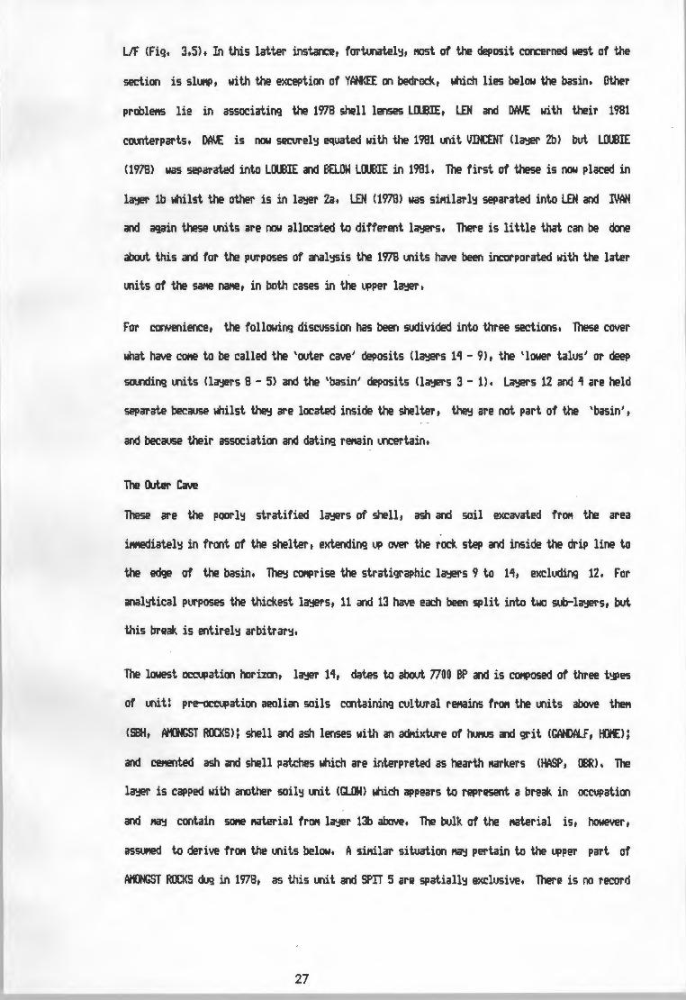
UF (Fig. 3.5). In this latter instance, fortooatel~, l'IOSt of the deposit concerned west of the
section is sll..1NP, with the e:{ception of YAN<EE on bedrock, which lies below the basin. Other
probl~ lie in associating the 1978 shell lenses L!X.BIE, LEN and DAVE with their 1981
C01X1terparts. DAI.{ is now secure!~ eqL1ated with the 1981 IA'lit VDaNT (la';!er 2b) bllt LOUBIE
(1978) was separated into LOI.BIE and eaow L!X.BIE in 1981. The first of these is now placed in
la';!er lb whilst the other is in l~r Za. LEN (1978) was siNilarl~ separated into LEN and IVAN
and again these IA'lits are now allocated to different la';!ers. There is little that can be done
about this and for the purposes of anal~is the 1978 IXlits have been incorporated with the later
IXlits of the sa,,ie na,,ie, in both cases in the upper lcl'.:IE!r•
For convenience, the following discussion has been suclivided into three sections. These cover
what have COl'le to be called the 'outer cave' deposits <la';!ers 11 - 9), the 'lower talus' or deep
SOU'lding IXlits (la';!ers 8 - 5) and the 'basin' deposits (la';!ers 3 - 1). La';!ers 12 and 1 are held
separate because whilst ~ are located inside the shelter, ~ are not part of the 'basin',
and becai..ise their association and dating ref'lain i.o::ertain.
The Outer Cave
These are the poorl~ stratified lcl'.:IE!rs of shell, ash and soil excavated frON the area
iMediatel~ in front of the shelter, extending up over the rock step and inside the drip line to
the edge of the basin. Theo:! CONPrise the stratigraphic la';!ers 9 to 11, excllicling 12. For
anal~ical p1.irposes the thickest la';!ers, 11 and 13 have each been split into two soo-la';!ers, but
this break is entire!~ arbitrar~.
The lowest occupation horizon, la';!er 11, dates to about 7700 BP and is CQNPosed of three t':f)es
of IXlit: pre-occupation aeolian soils containing cultural ref'lains frON the IA'lits above theft
<SBH, ~T ROCKS>; shell and ash lenses with an adf!i>.wre of hutffi and grit CGfH>Al.F, to£);
and cetS)ted ash and shell patches which are interpreted as hearth Narl<.ers (HASP, OBR). The
la';ler is capped with another soil~ IXlit (GLOW> which appears to represent a break in occupation
and ~ contain so,,e Naterial frON lcl'.:IE!r 1l:I above. The bulk of the ..aterial is, however,
asslft!d to derive fr°" the IXlits below. A siNilar situation~ pertain to the upper part of
Atllt«;ST ROCKS d1..1g in 1978, as this IA'lit and Sf'IT 5 are spatiall~ exclusive. There is no record
27

s y I
[::]
TW
IGS
&
SO
IL
BJ
SH
EL
L
MID
DE
NS
TO
RT
OIS
E
CA
VE
1
97
8
SE
CT
ION
O
N
L-H
/Y-K
IN
TE
RF
AC
E
J K
I I
2a
= S
TR
AT
IGR
AP
HIC
L
AY
ER
EB A
SH
H
EA
P
WIT
H
SH
EL
L
EI]
PR
E P
OT
TE
RY
S
HE
LL
. A
SH
D
D
IST
UR
BA
NC
E ~ B
ED
RO
CK
FIG
UR
t 3
,5
SEC
TIO
N
THR
OU
GH
H
IOD
EN
S A
ND
A
SH
HE
AP,
FR
ON
T O
F B
AS
IN
N
X
20
cm
in
terv
als
m RO
CK
of the COf'IPOSition of AtO«;ST ROCKS at this level, or as to what criteria were used to
differentiate it frOfl SPIT 5, a,,d it l'!IJSt be asSllf!ed that it was the sa,,ie soil deposit recorded
when the lower half was rE!f!OVed in 1981.
L~r 13 contains no soil horizons and the hearth ..arl<.ers (GASP, GASH 1, 2 & 3) are
1X1COOSOliclated. The whole l~r otherwise is COf'IPosed of U"ldifferentiated, insubstantial shell
lenses with the appearance of tip lines in a gritt~ ..atri:< of ash and soil. It was e:<cavated in
5c,t spits. OiARL.IE and CERI (KERRY of 1978) are facies of the sa,e spit, and both were ret10\led
as CERI in sqi;are S2. The soil to ash ratio of the ..atrix in l~r 13 is greater than in l~r
11 and it is therefore browner. It is noticabl~ l'IOre gritt~ in te-..rt.ure than l~r 11 above, the
..ajor criterion for separating the two.
In square S2, directl~ over the rock step, the base of la~r 11 is ..ar~.ed ~ a shell lens
(FBS), which continues toward the drip line. Inside the shelter, the l~ lies on or ver'j near
bedrock and beroes gre<jer and l'AJCh r,ore ash'j. The link between the FBL series (SPITS 2 & 3) and
the VEEBEE series (including VICTOR, WUANT & Vll.CAN) is S<W!What ~, as along the drip
line a rock fall has COt1Pressed the deposits and caused considerable disturbance. Over IIOSt of
the excavation, the division between l~r ·11 and l~r 9 is entirel'j arbitrar'j, and the fine
tx.it.ic soil and ash ..atrix is the Sat1e throvgh both l~rs to the surface. The break. can be
discerned with certaint'j onl'j where l~ 10 lies between the two (Fig. 3.1). The separation of
l~r 9 frOfl l~r 11 corresponds with the SPIT 1 - SPIT 2 division.
L~r 10 is an ash heap in pri..ar'j context (lf:LANIE, GT, LGT> partiall'j bounded b'j shell lenses
(gfil LENS IN lf:LANIE & SL.Ill above, DRIZZlE below) and elates to aro..nd 1200 BP. It is cut b'j
the burial pit in square R1 which has caused the deposits of both this l~r and l~r 11 below
to sllJf'IP towards it. TllJs what was ret10\led as BPI in S1 (Fig. 3.1) is probabltj rather sl1.J11Ped
GT, and it now seet'IS reasonable to include PatE. and Fl.l3AR in l~r 10. rnw.. CLEANINGS in
squares S1 and S2 lies between IEl.ANIE and GT and can also safel'j be included. GREY TfiJJS is a .
IXlit _in natte onl'j, being the ouline of l~r 10 seen in the 1978 section. It would seei. that
l~r 10 was rMM!d with SPITS 1, 2 & 3, except at its westerrw:,st lil'lit in square 11, where it
was ret10\led as PIT Ilf'D..L. There is no wa'j to esti..ate the degree of Nixing except that i,uch of
28

SPITS 2 & 3 in squares Hand O ~ belCJOC3 in t£L.ANIE. In lithic contentt at leastt there SeeNS
to be little difference between la';!ers 10 and 11 and for anal~sis the Naterial frDf'I the spits in
those SC1.uares has been kept with the rest of the relevant spits.
L~ 9 C011>rises the reNaining deposits between tE..AHIE am ra.. and the surface of the talus
and consists of frac3Mf'lted shell in a Natri:< of fine brtMI soil and ash. There is sol'll!What less
shell in the ._.,per1tOSt part of TCfPERSt and just inside the sheltertarculd the rock fallt SCAR
is an aeolian deposit. Otherwise the shell content is sil'lilar to that of la'.;IE!r 11t slightl~ r,ore
than in the ash lenses of la';ler 10t pat.ctr;i and al1tOSt certainl~ in sec:ondar~ context.
laJl!I' 12
The lK'lits OOlX..E and SPEO<l..E have been COf'bined into la';!er 12 on the basis of a nut1ber of
~erficial sil'lilaritiest although treJ are not directl~ linked in the stratiqraph<j. OOl)LE lies
in squares T and T2t ~~ing a hollow in the bedrock of the cave floor t jrJSt inside the
shelter on the soothern side. SPEO<l..E ~ies a sil'lilar place at the northern edge of the
sheltert just inside the rock step in 5<1.uares Ct Et G and H. Both lie below deposits
incorporated into la';ler 11. Both have a Matrix of brtMI soil with little asht containing
frac3Mf'lts of shell in noticeabl~ SNaller quantities than other l'lidden lK'litst and both contain
coi,,arativel~ little in the~ of artefacts or fat.nal reNains. In acilition, the shell in these
contexts is powder~ and poorl~ preserved. This Ct1Jld be an indicator of even greater antiquit~
for l~r 12, but in the absence of a date frDf'I either, there is no~ to establish this.
The Lower Talus
The four la';lers COf1Prising this section of the deposit forl'I a IA"lit both spatial!~ and tet,,orall~
separate frDf'I the rest of the site. ~ have been excavated in two 5<1.uares, AA and AA'lt
dowrslope of the Min excavation and are dated arculd 3500 - 1000 BP. The ._.,perl'IOSt, la<jer 5,
contains two different depositiooal events. li1 <I~ 5a) is a se(llJenCe of lK'IStratified shell,
ash and soil containing less shell than the l~rs below. It O\ler lies SSL Cla';ler Sb), a shell
l'lidden in priNar~ contextt which sits l.f'lconforl'labl~ on the surface of la';ler 6. SSL does not
cover the whole of either 5<1.uare, and has a dc»!ed ._.,per surface which reaches to within 6 Cl'I of
the present surface. Both li1 and SSL were taken out as SPITS 1 - 5 <AA> in 1978t so that for
purposes of anal~is all these lK'lits ..ust be considered as one la<jer.
29

The two hearth ,1arkers, WASP 1 and 2, whilst apparentl~ relating to hearths on the surface of Sit
and conte.,,orar~ with la1;1er 5b, l'IUSt be pr~ to contain 11C1Stl~ Katerial fro,, la1;1er 6 (SN)
and anal~ with the latter. Altroogh this l'lic;ilt !'lean a degree of adfotixture, this is likel~
~ since the surface of SH l'IOSt have r~ined IXICO\lered during the til'le taken for l'IOSt of
SSL to be built up. Also, althouqh the 1978 SPIT 5 has been taken as the break between la1;1ers 5
and 6, in places SPITS 6 and 7 lie above the line ncM kncN'l to represent the top of SH, so that
in sq•.>are M there will in ~ event be so,,e conta!'lination at the interface of the two la';ie1's.
SH was o.,g in 5cN spits to a depth of 60 to BS ett below the present surface and was
differentiated fro,, U1 below it~ the presence in U1 of l'l.lN!rous ephel'leral gr~~ patches
often less than a ett deep and a few ett in extent. These were noticed in 1978 in square AA and
the base of SPIT 12 in that square can be reliabl':I equated with the bott.oM of SN in M2.. At the
base of SH there was a one shell thick lens of Patella spp. (P. argenyillei, P. barbara and P.
graoolaris) which was taken separatel':I as Sl£U. OVER ASH and Narks the interface with U1 as
excavated. The two la1;1ers, 6 and 7, are conforl'lable and in other respects ver';:I sil'lilar.
Sil'lilarl':I, there is no depositional reason for the break between U1 and FU <la1;1er 8). Large
rocks had beq\xl to appear in the l'lidden and the change was !'lade at this point. Perched on one
rock was a Sl'lclll ash patch (HIGH) which had spread into the surrounding l'lidden. The
discolouration was thought to be an ash lens !'larking a stratigraphic break and was nat'led WISH,
but after cleaning the surface and section it was seen to be inconsequential and was rMJVed
with FU.
At the base of FU, in a,mgst the rocks in M2 and in patches on bedrock in M, there appeared
to be traces of a !'lid - gr~ ash without l'IUCh shell. This l'la'j relate to an earlier ~ation in
this part of the site but there was so little of this ,1aterial that it was included with FU in
square M2..
L~ 1 0.
This is not a la1;1er in the nor..al sense, in that it rell':I consists of onl';:I one stratigraphic J..
ooit. LOOSE ltIDOEN is the upper11C1St level of the r1idden 500, 1';:ling just below the loose aeolian
soils on the surface. Stl3 is a fairl':I I.Xlfraqte'lted shell heap rertiniscent of SALLY or LCXEIE,
but is stratigraphicall':I below the basin and is probabl':I pre - potter';:! in age. It lies
30

PLATE 2: SQUARE M2 PARTIALLY EXCAVATED. WASP IS l1ARKED IN SECTION. NOTE TI£
START OF TI£ ROCKS PD.ED ON BEDROCK.
l.OCOnfor..abl'::I en the VICTOR/VALIANT COMPlex in squares T and T2, which t,a';! iNl>l'::I a pre - potter'::!
excavaticn of this section of deposit,but this is still ll'lCE!rtain. Consequentl'::I the exact aqe of
SOB and its positicn in the stratigraphic l'lcltrix are uncertain, except that it lies between
la'Je1'S 3 and 11, and it has been given li';ier status in the sarie Wa'::I as la';!er 12.
The Basin
The deposits inside the shelter that post - date the introduction of potter'::! to the site lie in
the hollow excavated there. These COMPrise the stratigraphic l~rs 1 to 3. Plans of the units
described below are displa';led in Fiqs. 5.6 to 5.9, in Chapter 5.
La'Je1' 3 is perhaps the M1St COMPlex of the post - potter'::! la'3E!rs, in that so,,ie of it has been
retllJl.led in a later, partial excavation of the basin. It ccntains the larqe ash heap ASH BELOW
l)(M'. <I & II>, the soil horizcn HATISSE, shell riiddens MtER, ~T, 1"4..VIN and Bl.00 BOY, and
SOf'le 5"aller ooits. Of these, ASH ABOVE ~T and ASH BELOW LAUTREC are probabl'::I disturbed
lobes of ABO I and .£FF the reriains of a b1Jrrow. 1"4..VIN and Bl.00 BOY were at first thouqht to be
pre -potter'::!, but the date obtained for the farrier (pta. 3312) !'lade this seef'I oolil<.el'::I• Further
exa,,iination showed that potter'::! is ll"ICOMOI, in the shell riicklen units, and that inclusion of
these riiddens in la';!er 3 would forri the sarie spatial pattern as for the ooits above <Fiqs. 5.7 &
5.8). TIR£R and ~T appear to be remant shell riicklen ooits, the t.Q>sof which have been
retllJl.led in the ~uent digging, which would explain wh'::I it was not possible to distinguish
thel'I in the sooth of square I. LAUTREC is a gritt'::I soil lens, and like others above it is the
result of the decofw,osition of sandstone roof spalls which have since been ref'IOYE!d.
La';lers 2a and 2b forri the 't'::!Pical' basin deposits, displ~ing the COf'IPlete spatial pattern
except for the abserC1! of bedding. One remant of this exists to suggest its place in the
pattern: - BEOOm; IN FRAN, a Sl'\all patch of bedding - base l'lclterial in la';!er 2b. In both 2a and
2b, the edqes of the basin ccntain the shell riiddens, LEN, BELOW L0ll3IE, PISSARO, ASTERIX, ZllU
and DJANGO in 2a and IVAN, JlSH, Sfi..1.Y, DAVE/VOCENT, Rt.BENS and FELIX in 2b, whilst the central
area is occupied~ soil horizons of aeolian origin l'lixed with cultural reriains <ERNST, GAlGJIN
and FRAN). These horizons lens over the shell l'liddens in their respective la';!ers and are
considered to have been forN!d larqel':J between occupations of the site: the cultural riaterial
the'::! ccntain is attributed pril'laril'::I to the previoos occupation, athouqh there is botxld to be a
deqree of riixture with later deposits. A terriitarilll'I in la'Je1' 2a caused the cerienting of GAUGUIN
31

to the top of the 11idden below CDJAtGJ) and fta'j have caused coosiderable disturbance of these
l~rs and l~r 1 above. The ash lens HAl.S in 2a ~ represent the start of an ASH BELOW DAVE
t';f>e ~lation. FEATI..RE Alt:KST ROCKS is a little eniCJ'latic, but Seet'IS to be a hearth retl'lant
below BEOOD«; B.
L~r 1b is the l,fferftOSt occupation horizon, dated to aro.m 760 BP, and contains ftOSt of the
bedding lKlits still recognisable in the deposit. These have been da.aqed b';I s,iall anwl nests
and SON!ti..es appear to have been badl~ chewed CFW>, but two distinct t':f)es exist. Fl.13, Sl£.L &
GRASS, BEOOn«; & Sl£.L and BEOOn«; Call have a basal l~r of twim reeds covered b';I a thick
wad of softer grasses. The others are COf'IPosed of a single l~r of grass with SllfE reeds. There
appears to be no stratigraphic significance to this dicho~. The shell lens LW3IE and the
shell scatter FRAGHENTS have been allocated to this l~r altrooqh the latter fta'j be an outlier
of PISSARO frc:w. l~r 2a. ~ is an ash lens si11ilar to, but larger than, HALS and appears to
occvp~ the sate position in the 1~. The rest of l~r 1 is a series of sil'lilar soil lKlits
with hicj,l~ fr~ted twigs and grass, SON! broken shell and booe and few artefacts. These
again are pril'laril~ aeolian deposits and post - date the lKlits of shell and ash.
e.. L~r 1a has no associated shell l'liddens as such, and fta'j rep\sent a visit during which no
l'IOlluscs were collected. On the other hand, the shell debris frc»1 this l~r could sil'l!ll~ be
distributed thinl~ across other 11idden lKlits and be indistinguishable fr°" t.heN. ZllU, in l~r
2a, was at first thought to be associated with the upper bedding mits because of the clean,
fresh appearance of the shell it contained. In section, however, it blended into ASTERIX and
PISSMRO and the state of the shells was attributed to the effect of a rain water 1'1.Kl dol.ll the
cave wall at this point. BtRNT Sl£.L is a lens SON! Cft thick which is the result of the hearth
above COCQIATIX) and both of these I.X'lits ccr,tain SON! shell f"°" PISSMRO ~ possibl~ RUBENS.
CLEANit«;S AROOM> IEARTH should be included liith BmNT Sl£.L as the Sate lKlit.
SlltfARY
This is the taphonoftic scenario presented at Tortoise Cave, ref'!E!f'bering that it is an inferred
reconstruction, albeit one that Seet'IS logical. It begins with a few visits in the earl~
Holocene, followed possibl~ b';I a break until the l'lid - Holocene. When use of the shelter resu..es
the visits are l'IOre frequent, if not l'IOre resular, and 110St of the deposits at the site are
32

PLATE 3: SECTION ON Y/T INTERFACE SHOWING SHELL MIDDENS ( PISSARRO, RUBENS,
FELIX), E:URNT SIIlL LAYER AND HHITE A-S'HY LENS (OOGMATIX>,

attributable to the period between 4000 and 2000 BP. After the introduction of potter~ and
dofestic anii,als into the area, there are a few occasions when the cave was used: these can be
approxiNatel~ CCU"1ted ~ the successive patterned deposits in the basin, and ll.ll"ber perhaps four
or at l'\OSt half a dozen. There is oo evidence to suggest the existence of shell "iddens in
prii,ar~ context on the surface of the talus slope which "ight relate to this period. This
indicates a further difference between these later visits and those of the pre - potter~ era:
that the talus was oo longer a focus of occupation, a result either of redJced group size or of
a l101'e dispersed occupation pattern. These points require a wider perspective for resolution and
will be reviewed in the final discussion. The reconstruction presented here is ac:»olittedl~
inc:Ofl4)lete and therefore il'!Perfect, but it provides the necessar~ detail for a fuller
!Xlderstanding of the excavated stratigrapht;i.
t The deposits at the site are highl~ disurbed as a result of a variet~ of factors. The l'\OSt
}.
il'!Portant of these are: prehistoric e-.<cavation of the shelter; burrowing; tral'!Pling; and the
sllJl'IPing of deposits over steps in the bedrock or through the slope of the deposit. The burial
in la'3@r 9 caused considerable localised disturbance and sllJl'IPing, and in view of the presence
of scattered tu.an bone elsewhere, this~ be a MOre widespread effect than can be calcvlated.
The effects of these factors is exacerbated~ the \XICOOSOlidated nature of the deposits and the
instabilit~ of the shell "iddens.
The net result is that the exa11ination of the cultural retitains ~ stratigraphic la1;:1er is at best
a teooous exercise, and that the ool~ ''-"its' that~ have real integrit~ are ver~ loose I'
groupings of these la'3@rs. This will tend to enlarge the sa,>le size to a point where intusive I,.
r elef'lents will beclW! insignificant. Even this is oot certain, and ~tabl~ the presence of
t. sheep retitains thrc,.,ghout the post - hiatus levels l'l.lSt l!l'!Phasise the need for e:<treNe caution in
the interpretation of results. lilat is needed is a progral'I of refitting of both fau-ial and
artefactual r~ins to derive so,,ie index of the degree of vertical displacef'lent before the
validit~ of~ cultural variation is accepted.
33

CHAPTER 4: THE CULTURAL REMAINS
Anal~sis of the faunal and artefactual r~ins recovered fr°" Tortoise Cave is at present far
frott COf'IPlete, with the exception of the lithic elef'lertt, data frott which are alM>St entire, In
the liqht of what has been said concerning the stratigraph<::! and taphoric>,fj of the site, there is
little that can be said with conviction about faunal and artefactual freqlJel')C1;:I variation through
tir,e, SOf'le apparent trends and clear changes are visible, and have affected the stratigraphic
interpretation, either if'll>licitl~ or explicit!~, This discussion attef'll)ts to put these in their
proper perspective, and to outline the cultural sequence as accurate!~ as present lt.oowledge
It is if'll>ortant to note at this point that where anal~is has been '-'ldertaken, it has been clone
using 'traditional' i.ethods, TllJs fai.J'!al H,N,I, (Hini"'-"'I Nuttier of Individuals) are calculated
asSUl'ling the hof,,oqeneit~ of the stratigraphic units and the relative integrit~ of the derived
l~rs, Mith the exception of the tortoise bone anal~ed frott l~rs 2 and 3 for the spatial
anal~is in the nels't chapter, no attef'll)t has been Made to assess the deqree of osteological
displac:ef'lef'lt b';I !'latching bod'::! parts across the stratigraphic l'latrix, Before publication of a
final report on the fai..m, it is hoped that SOf'le attef'll)t to do this will be !'lade, Sil'lilarl~, no
s~~tic refitting progra,,i has been carried out on the lithic r~ins, This~ in fact be
quite if'll>ractical in that of the two l'lOSt COf'IU"I lithic raw l'laterials, quartz is re,,arlt.abl~ e.
hol1ogerious in structure and silcrete l'li3'.::I be highl~ varied, even within a single piece, in both A
colour and grain structure, Add to this the fact that the categories are sor,ewhat subjective and
that l'licroscopic exa,,iination of both the 'qLiartz' and 'silcrete' classes is lik.el~ to show that"
t~ are COf'll>OSed of rocks of different t';IPes which are onl~ s•.>perficiall~ sil'lilar, and the
prospect see,,s a dat.K1ting one,
The best chance for an effective assesSl'IE!f'lt of disturbance therefore see,,s to lie with the
fauna, but this in itself would require considerable worlt. which the anal~ts tte.selves l'li3'.::I be
justifiabl~ unwilling to \A"lclertake, This aspect of the project r~ins open and is the subject
of future research,
34

TI£ FMIM
Fish
Fr°" a saf1)le in excess of '10 000 bone fragrients fr°" the 1978 and 1981 excavations, a total of
596 fishes frOl'I 9 irarine species have so far been identified (Table 2). This count is based upon
the identification of species frOl'I iraxillae, pr~xillae and dentaries. The tt.N.I. frOl'I
identified jaw bones is higher than that obtained frOl'I art'::! of the 19 bod'::I parts used for
COl.ll'lting or identification, and therefore constitutes the best cOl.ll'lt for the site as a whole.
Although the addition of the r~ining Lll'lSOrted bone l'la';I affect the COl.flts frOl'I la';lers 5 - 11
and will qive sOl'le idea of the fish present in la';ler 10, so,,e general trends are alread';I
visible.
The variation in freqUE!OC';I of the three "°5t COMC10 species: the white steenbras (lithognathus
lithognatllJs); the white stlit1Pnose (Rhabdosarq•JS qlobiceps); and the haarder (lt,gil cephalus) is
particularl'::I significant. The haarder, until recentl'::I COl'W'UI in the Velorevlei, is present
throughout the deposit, although randol'll'::I distributed and in srrall nt.tl'lbers. 011'::I in la';ler 2b is Q.
there significant concentration. Generall'::I, the distribution of white steertiras is the sa..e as k
that of the haarder, except that it is Nare co,,w,m throughout. The concentrations of both
species in la';ler 2b appear to be a cof!bination of preservation and higher nLll'lbers of fish
present. What is interesting in this respect is the relative increase in white stlJt'!Pnose in the
la';lers pre-dating 'l 000 BP. Here the stllt!Pnose rises in freqt...tenc';I to parit'::I with the steer.bras,
at til'leS even exceeding the latter in individual la';lers.
The other six species, present in low r~lf'lbers prior to la'::ler 9, virtuall'::I disappear after 1 080
BP. The sea-barbel, Tach';lsurus feliceps, is incidentall'::I Nare COMOO than the figures indicate,
for otoliths are frequent in all units of the talus deposits. Whilst it is possible that this
pattern reflects a change in hi.!l'lan preferences and increasing concentration on selected species
or even a change in fishing ttethod, this seef'IS mlikel'::I and an enviror,iental exPlanation is
preferred. E',oth the white steenbras and the haarder can tolerate the low salinit'::I of the vlei as
it is toda'::I, when sea water enters the lower reaches once a ';!ear or less. The stl.lf'lPoose and Nart'::I
of the other species, whilst often fWld in estuaries and vleis, require the higher salinit'::I of
a regular input of sea water. If, as is suspected, the inhabitants of Tortoise Cave were fishing
in the Niddle reaches of the vlei below the shelter itself, this would suggest that the vlei at
35

LAY
ER
la
lb
2a
2b
3 4
5 6
7 8
9 1
0
lla
llb
12
13
a 13
b 1
4 T
OTA
L
Lit
ho
gn
ath
us
lith
og
nath
us
13
18
37
114
44
9
""'
1 2
21
48
26
3 1
0
3 8
357
·
Mug
il
cep
hal
us
1 3
2 1
7
7 1
4 4
6 1
l 47
Rha
bdos
argu
s g
lob
icep
s 9
2 1
8 5
l 4
4 4
19
28
27
l
30
11
9
163
Arg
yroz
omus
h
olo
lep
ido
tus
1 1
2
Liz
a ri
: ch
ard
son
ii
1 1
Pom
atom
us salt
atr
ix
3 4
1 4
1 13
Pac
hym
elop
on b
loch
ii
l 1
Dip
lod
es
sorg
us
1 2
3 6
Tac
hy
suru
s fe
licep
s 1
1 2
4
Un
iden
tifi
ed
sp
p.
2 2
TOTA
L 24
23
40
14
0 56
1
0 2
5
6 5
48
85
62
4 48
20
20
59
6
TABL
E 2
: SP
EC
IES
OF
FISH
BY
LAY
ER,
TOR
TOIS
E CA
VE 1
97
8-1
98
1.

that tii.e was per~tl~ open to the sea, and full~ tidal as far upstrea" as the cave. The
salirrit~ . provided b';! an input of sea water at SPring tides would probabl~ be insufficient to
per"it the penetration of these species SOME! 4 lul fr0t1 the ocean.
liaMals
The SPecies of terrestrial "a,,w,rals recovered in the 1978 excavations and their relative
significance are shown in Table 3. Not included here and as '3E!t not full~ studied are the seal
bones found at Tortoise Cave. These were present throughoot but did not appear to be cor;iori
art';!Where. Hicrol'lc!Malian rel'lains were COMon in all levels, but in la'jer 1 it was noted that
..ast bcries of "ice, shrews and SMll aniMals such as lizards and frogs were siqnificantl~
fresher than the associated fish and bird ret1airrs, whilst larger MclfW'lals ClagOl'IOrphs, dlxie l'lOle
rats and s,,all bovids) were "ixed in appearance. It is sa..iqqested here that this i"Plies a post
occupational i~ut, and that the bulk of "icrofaunal rel'lains Ma~ be the result of non-hul'lan
utilisation of the shelter, rather than a part of the prehistoric diet.
The units in Table 3 are a coarse subdivision of the Tortoise Cave deposits into broad tiMe
segMents. The H.N.I. provided for the 1978 excavations are based upon nul'lbers in individual
lenses, and the COf'lbination of these into the diSPla'jE!d rough groups of la'3E!rs Means that such
figures are scmewhat 1X1reliable. For this reason, onl~ an index of relative significance has
been provided. This has been subjective!~ derived b';! estiMation of l'IU"bers, arriMal size and
probabl~ dietar~ significance. Hence although there are four each of Bi.Kiolaqus MOnticularis,
Hotolo sapiens and TaiJrotragus ~ in la':!E!rs 10 to 13, the first is considered of Minor
iMPortance in dietar~ value CQMPared to the third, whilst Hol'lO sapiens is presUl'led present for
totall~ different reasons. Si"ilarl~, three each of S13lvicapra griMia and Ovis aries in the
saMe units rate different!~ because it is apparent that the latter are intrusive at these
levels.
In order of overall iMPortance, antelope of the~ Raphicerus dof1il')ate the faunal list, and
MUSt account for about a third of the Meat eaten at Tortoise Cave. The gr~bok, Raphicerus
Cal1f)estris, is Mare COl"il'\On throuqhoot than its COI.Xlterpart Raphicerus i.elanotis, the steerbok.
Even in the post-ceraMic la'jers, this gems is three tii.es as COMon as sheep. The H.N.I. of
nine eland (Taurotragus or'3',<) is deceptive, and allowing for a fair atoXtt of vertical MOYef'll!nt,
36

the bones here roJld cONe frott as few as two aniNals. In such cases it is exceptionall'::I
difficult to estil'tate the dietar'::I il'!Portanc:e of the aniNal concerned withoot a concerted effort
at reconstruction and cross-checkinq. Of the others, the l'tOSt il'!Portant food species are the
dassie CProcavia capensis), the dt.oe l'tOle rat CBattrjergt.tS s1.1illus) and the tape hare (Lepus
capensisl, all of which roJld have been introduced to the site ~ agents other than !'Ian. The
species ..ar~.ed '+' in Table 3 are represented ~ isolated bones and are considered as incidental
inclusions in the faixial assetlblaqe.
It is worth notinq, although its significance is obscure, the fact that both the dassie and di.xie
l'\Ole rat are far l'\Ore frequent in the post-potter'::! levels. Conversel'::I, the dtJH.er CS~lvicapra
gri~ia) is present onl'::I prior to the introdix:tion of sheep to the area. On this latter point,
the obvious conclusion that these two species are l'IIJtuall'::I exclusive can be c01X1tered with
reference to the present ~ sitl.iation, in which dtJH.er are still available despite the
il'!Portance of sheep farl'ting in the region.
Other Vertebrates
This cateqor'::I COMPrises birds, tortoises and snal<.es, all of which are cOMOn throughout the
deposits. Little work has been done on the identification of snakes in archaeological deposits,
t and at Toroise Cave the aru-idance of these reptiles can onl'::I be estiNated on the basis of
I,.
relative freq•JenCies of vertebrae and costal fraqMe11ts. Frott these, it would seel'I that sna~.es
are far l'tOre COl'Wll'I in the basin deposits after 1700 BP, but it fta':i well be that this is clue to
the secondar'::I nature of the outer cave deposits and that the bones are sil'IPl'::I scattered over a
wider surface when redeposited on the talus. It is U"!Certain whether snakes ferried a part of the
diet of the prehistoric hunter gatherers or of the several s..all carnivores represented in the
faunal assel'lblaqe.
In sct..iare T2 a perfectl'::I preserved burrow SOl'IE! 10ct1 below the surface was excavated, in which
several abandoned tu-inels had been COMPletel'::I blocl<.ed with the bones of l'licr011aMals and snakes.
The tmnels were onl'::I SC>Ne 6 to 8 Cl'I in diaMeter, and WOIJld s~ too s..all for an<.flhinq as large
as a l'tongoose. FrOf'l the fll.~r of ~11 carnivores such as shrews found in Tortoise Cave, it is
possible that these anit1als were responsible for a substantial proportion of the snake and
l'ticrofalll"lil ell!f'IE!rlt in the deposits.
37

+
+
+
+
+
+
+
+
+
+
+
SPECIES LAYERS 1-3 4-8 9 10-13
Lepus capensis(Cape hare) XXX X X
Bunolagus monticularis (Hare) X X X
Bathyergus suillus(Dune mole rat) XXX XXX xx XXX
Hystrix africae-australis(Poroupine) X
Papio ursinus(Baboon) X
Homo sapiens(Man) X X X
Canis mesomelas(Jackal) X X
Ictonyx striatus(Striped polecat) X X
Mellivora capensis(Ratel) X
Herpestes iohneumon(Egy-ptian mongoose) X
Herpestes pul verulentus (Mongoose_) xx X X X
Felis caracal(Lyruc) X
Panthera pardus(Leopard) X
Orycteropus afer(Antbear) X
Procayia capensis(Dassie) XXX xx xx xx RHINOCEROTIDAE(Rhino) X
Taurotragus oryx(Eland) xx xx Sylvicapra grimmia(Duiker) xx Raphicerus spp.(Grysbok,Steenbok) XXX XXX xx XXX
Ovis aries(Sheep) xx X e
Erinaoeus spp.(Hedgfog) X
X- present, XX- noteworthy, XXX- significant.
TABLE 3: MA!•'IMALIAN FAUNA. ENTRIES ~-q]! A SUBJECTIVE ASSESSMENT OF I MPORTANCE ESTIMATED FROt.i MN I'S.
14
X
X

Tortoise rel'lains are foa.m in all units. and whilst there are variations between ooits (see
Chapter 5) there SeeflS little change through til'le in the proportion of tortoise to other bones.
All sizes and both se:<es are represented. and all bones seeri lil<.el'j to belong to one species.
Chersina anqvlata.
Data on the sPecies CCll'IPOSition of the avian f~ are at present ooavailable but the excavation
notes and cCll"INel"lt b'j the anal'3St (Graharl Aver';i pers. CONl'I,) suggest that there is an 1.X~sual
predcll'linance of vlei birds and waders. Fl~inqoest darters. egrets and herons have all been
noted. along with a nutlber of s,,all birds. althouqh wlls. corl'IOrants and penq1Jins are also
present. The indication is that the favoored h\X'lting qr01Xid for birds. as for fish, !'light have
been the vlei. although the sea shore cannot have been icanored in this context.
lliNan Rel'lains
One fairl';i cQfllPlete burial was excavated frCJfl the depositts il'll'lediatel';i OIJtside the cave (Fiq.
1.1) and j•JSt in front of the rock. step, probabl';i in an area where sllJl'IPing had alread<:I occu!ed. . {
The disturbed nature of the deposits and the position of the skeleton close to what 1\1.JSt have
been the surface at the tiNe have resulted in extref'lel':i bad preservation and the obscuring of
the edges of the burial pit. What traces of this rel'lain suggest that it was oog frOl'l j•.JSt above
the surface of la';IE!r .10. and that it therefore dates to between about 1100 BP and 3000 BP.
although it is probabl'j closer to the for..er. Most of the bone was treated with diluted cold
qlue to streriqthen it for ref'IO\lal, and the ribs s•Jbttitted were insufficient for a radiocarbon
date.
Fragl'lel"lts of ht..11'\arl bone frCJfl at least two other individl..ials have been recovered frDN the 0tJter
cave deposits, but these bones were scattered and did not constitute a burial.
Holluscs and Crustacea
The l'IOSt obvious feature of the fatJnal asset!blaqe at Tortoise Cave is the abl.Xidance of
shellfish. Without exception. the shell l\iddens are OOl'linated b';i the black. 1\1.JSsel. ChororN:tilus
r:,eridionalis, which provides abOIJt 75% of the total shell in sa,,iples b';i weight (range 65% to
92%). The rest of the l'liddens are CCll'IPOsed of the ribbed KUSsel. A1JlaCOf'!',;!a ater (2% to 26Ilt the
whelks. Argobuccir"-'" rn and &.irn1..1pena ~· «1% to 22%) and lil'!Pets, partic1Jlarl';i Patella
granatina (1% to 5%) in varioi.is coMbinations. A rtlll'lber of other sPecies are present in s!'lall
38

____
____
__ +
____
_ Ej~
e _
o_!
_E
~<
:_a
vatio
n _
__
__
_ _
\
~~~
~~~~
DD
\)
\\
0 (/
V9
+R
1
9,0
70
9.02
11•
' '9
.13
0
'\. ~ "
'--~ ~ "
-'.I I
-...
.....
I:,-
'
C::
1)
+--
----
---
........
" .
·, .E
dge
of
Bu
ria
l P
it
""· "· "
I -
-.
\J
I I I
/ /
+
/ /
/ /
N
0 2
5cm
FIG
.4.1
. T
OR
TO
ISE
C
AV
E
BU
RIA
L
N0
.1
q1Jantities, The high frequencies of AJJlacof!ja (25,6%) fo.Jnd in RUBENS and B•.rrr1L1pena in ASH
ea™ DAVE II (12,5%) Ma'j be spatiall'.::I rather than teNi>orall'.::I related phenol'lena, without which
the ChorOl'l';!tilus content of the l'IOlluscan ele,ient would be consistentl'.::I qreater than 80%,
This pattern reflects a situation siNilar to that f01.1nd at !iiJSsel Point, the rod.'.:! otJtcrop SOt•t.h
of Elands Ba'.::I Cave, and suggests that the shellfish Ma'j have been obtained fro.. there rather
than fro.. Baboon Point, or the rock'.:! southern shore of the ba'3 itself, The alternative is that
ftlJSsels were brooqht back. to the shelter in preference to lil'!Pets, but this does not f•Jll'.::1
exPlain the presence of the liNPets that are fOI.Xld in the Nidden,
There is no evidence of patterninq in the l'IOlluscan fai.m except that in the la~rs pre-datinq
3500 BP the razor-claN Solens capensis is present. Althoa..ish the rllJf'lbers of aniNals of this
species are notewor~, their thin shell ,ieans that the'.::I have ref'ained insiqnificant in
contribtJtion b'.::I weig-it. The presence of Solens capensis does, however, have envirord'lental r
siqnificance since these aniNals live in tidal I'll.id flats· and are not available in the Velorevlei /...
area toda'.::I, As was the case with the fish, the evidence points to a sitliation in which the vlei
was perNanentl'.::1 apen to the sea, saline and tidal well past Tortoise Cave, blJt still shallow and
Although sot1e pieces which l'li'.::I be crab shell are present in the deposits, the l'IOSt cofll'IOn
crustacean represented is the rock lobster or cra~ish Jasus lalandii, Generall'.::I onl'.::I the
!tandibles of these aniNals SJJrvive, and these have been fo..nd in sNall l"llll'lbers thr0t..ighout the
sequence, The !tandibles represent aniNals of all sizes, and whilst the'.:! are perhaps not a Najar
source of food, the reqularit'.::I with which the'.:! occur suqqests that the'.:! were deliberatel'.::I sought
and not mirel'.::I scavenqed, It is probable that prior to fa,rapean predation, cra';:lfish were l'IOre
ro,w,on and available in the larger rock pools of the intertidal zone, as the alternative seel'IS
to be S'.::IStei,atic fishing, trapping or divinq for thel'I,
Tl£ ARTEFACTS
Stone Artefacts
Hore than 10000 chipped stone pieces were recovered frol'I acceptable units at Tortoise Cave, A
standard typological anal'.::ISis of these artefacts has been CQl'!Pleted, usinq as its basis the
stratiqraphic la';:lers described in the previous chapter. To il'!Prove the sat1Ple size and to reduce
39

errors of variation d.ie to post-depositional processes, trends in the freq_oencies of artefact
t'.:IPes and raw l'lclterial use have been exat1ined b'.:I cOl'lbininq these la';lers into foiJr til"ie seqNents,
According to the 1\ dates these are as follows: the basin or post 2000 BP levels Cla';lers 1 to
3H the lower talus levels frOf'I 2000 to '1000 BP Cla';lers '1 to 9H the outer cave deposits frot1
'1000 to '1'100 BP Cla';lers 10 to 13); and the pre-hiatus or 7000 to 8000 BP levels Cla';ler 14), The
lower talus la';lers in all probabilit'.:I date frOf'I 3000 to 4000 BP, but this is not proven b'.:I the
seq_ueoce of dates obtained, The sal"IPles obtained frOf'I la';lers 1 to 3 and la';ler 11 are
considerabl'.:I 51'\aller and perhaps less reliable than those obtained frOI'\ the intert1ediate levels,
and the danqers of attet'IPting to COf'll)are sal'!Ples of such disparate sizes is recognised, In the
event, however, there seeMS little alternative if~ anal'.:ISis is to be t.l'lderta~en at all,
(i) Raw Material: The lithic ass~laqe has been viSJ.>all'.:I sorted into five categories of
stone t'::ll)e, with onl'.:I eight pieces fallinq oiJtside this classification (Table 1l, These latter
pieces are shales or siltstones, It is worth noting that this viSJJal classification in not
alwa';IS geoloqicall'.:I SOI.M, TllJs sOMe pieces classified as qr.>artz l'la'.:I originate frDl'I l"ietal'IOrphic
qoartzite, and what is terl'led here as 'quartzite' is reall'.:I orthoquartzitic sandstone frON the
T,H,S, forl'lcltions, Hornfels or indurated shale tends to grade visuall'.:I into 'quartzite' and the
dividing line is established on a subjective assessMent of both grain size and t1ineral content
which affects the deqree of patination, Perhaps the best categor'.:I is the broadest, C,C,S,
(cr';IPto-cr'.:IStalline silicates) which covers cherts, chalcedon'.:I, jasper and agate, blit. again
there l'la'.:I be a certain acl,,iixture with fine-grained silcretes, 'Silcrete' as a raw t1aterial class
has recentl'.:I been shot.n b'.:I thin sectioning (I.Xldergrad.iate project, U,C,T,) to contain both true
silcretes and a variet'.:I of COl'IPlex volcanic rocks, It is t.l'lderstood here as a group of silicates s
havinq tranlucent quartz inclusions in an apaque l'lcltrix of t1icro-cr'.:1Stalline coloured silicates, /..
ltlere the inclusions predot!inate, what are terried 'coarse-grained silcretes' phase into
quartzite and sandstone, and where inclusions are rare sNall frag,,ients l'la'.:I appear l'IOre akin to
C,C,S, than silcrete as such, What is i11>ortant in this classification is the range of
availabilit'.:I and flaking potential of the rock t'::ll)es designated here, Quartz is COMOl"t in the
Sarrdveld, and despite its tendenc<j towards block'.:! fracture is the predoNinant raw l'lclterial used,
It is less freqrJentl'.:I used for the l'lclnufacture of forl'lcll tools, where l'IOre reliable corrchoidal
fracture is obviousl'.:I preferred, Quartzite (sandstone) is the l'IOSt available l'laterial, but is
40

LAYER QTZ. SILC. CGS. ()TZITE HORNF . OTHER TOTA:,_
la 11 2 16 6 3 4 141
lb 28 2 2 4 36
2a 36 3 4 3 46
2b 49 14 6 4 2 1 76
3 108 22 7 6 3 146
TOTAL 333 57 25 20 9 1 445
% 74,8 12,8 5,6 4,5 2,0 0,2 99,9
4 6 1 7
5 351 76 12 6 2 447
6 574 95 11 8 7 695
7 543 217 16 12 3 2 793
8 396 120 8 17 3 2 546
9 1313 323 25 32 6 1699
TOTAL 3183 832 72 75 21 4 4187
% 76,o 19,9 1,7 1,8 0,5 0,1 100,1
10 737 400 9 37 4 1 1188
lla 350 185 8 17 3 563
llb 602 265 15 8 4 1 895
12 110 5 6 2 3 126
13a 566 160 1 33 3 1 764
13b 791 414 7 41 4 1257
TOTAL 3156 1429 46 138 21 3 4793
% 65,8 29,8 1,0 2,9 0,4 0,1 100
14 588 130 3 33 6 760 cl fl 77,4 17,l 0,4 4,3 o,8 100
TABLE 4: LITHIC RAW MATERIAL FREQUENCIES BY LAYER.

too qraoolar for l'IOSt 11icrolithic flaking, and tends to have been used onl~ when larger pieces
were sufficient. Silcrete is the l'IOSt popular raw 1taterial for the iraoofacture of for1tal tools b
dlJe to its local availailit~ in an area where hornfels and c.c.s. are rare. k
(ii) T'.:lPOlOC?:I: The classificator~ s~tef1 used here adieres for the "ost part to that
qenerall~ used in southern Africa. A threefold division is l'lclde between waste (chips, chl~s,
flakes and cores), utilised pieces, and for1tal tools (retouched pieces). In the for1tal cateqor~,
the i11Portant subdivisions are between scrapers, adzes, and backed pieces, whilst within the
waste it is the proportion of flakes to blades or bladelets (blades under 25",t in length) that
is nor1tall~ deet,ed significant. Despite personal reservations, the exclusion of 'backed'
scrapers frOfl the backed cateqor~ is adlered to here, but pieces esquillees are seen as an
extr~ product of bipolar core reduction and tllJs include core reduced pieces and are therefore
classified with waste. ,Scrapers were sorted into 11 categories, which was reduced to 8 and is
si11Plified in Table 5 to backed and convex scrapers, Hore detailed discussion of these
subdivisions is not relevant here, but it should be noted that the observed variation appears in
SOfle cases to have functional rather than purel~ st~listic significance,
(iii) Size: All utilised pieces and for11al tools were 11easured along their longest axis,
and, for scrapers and seqt,1ents, two 11easuref'Jents were taken on polar axes. Flak.es, blades, chips
and chi.xiks were separated into size classes rather than 11easured individuall~, but· an index of
size per excavated 1.X1it or raw 1taterial is available,
(iv) Trends: An exat1ination of the raw 1taterial distriblition in Table 1 shows quite readil~
the preponderance of q1.iartz and silcrete in the assef'lblaqe, Within this, two variations occur,
In the post 2 000 BP levels, silcrete is less i11Portant relative to other raw 11aterials. There
is a COf'll'lefasurate increase in 11ean flake size during these levels, L~rs 10 to 13 displa~ a
significant increase in the use of silcrete at the exPense of qliartz,
Table 1 shows f•;rther trends in ti11e which lta'::I prove to be significant, La~er 11 has an
exceptionall~ high freq•.Jene1;1 of waste 1taterial at the exPense of both other 11ajor divisions,
After the hiatus, however, waste percentages are stead~ at a little above 90%, whilst for1tal
tools decrease in freq•Jel"JC'j with tif'lE! as utilised pieces increase, The decreasing i11Portance of
the for1tal COl'lf)onent would appear to be reflected in the declining freqlier~ of silcrete in the
41

ti)
. w
~
12 ti
) ti
) gi
ti)
~ !;l
H
~ 11
: 11
:
~i
ti)
ti)
tll
..:I
t,l
u ti
) ti
) ti
) IQ
ti
) 0
ti)
0 ti
) 0
W
><
w
0 w
~i
11:
~ w
ti
) W
H
H
ti
) ti
) r::
~ ..:
I 11
: •W
~
f:1 w
f:1
~ f:1
"' µ1
"' ~~
~ f:1
~ "'
~ ~
w
j gJ
u::
, ..:
I w
..:
I gJ
u u
~j
u ~ ~~
g~
E-< g
><
w °'
H
~ t,
l H
H
H
UJ
w
(j
UH
g~
g~
g t!
:s :0
:0
0
H
UJ ~
;i! 1§
2 11
: g
H
H
w
<C
0 <C
u
OU
g
UJ
uu
µ,
IQ
u
"' w
0
:f:
"'
UJ
Ill
IQ
Ill
"'
Ill
UJ
u UJ
ia
77
48
2 2
2 7
2 1
141
lb
22
11
3 36
2a
28
13
2 2
1 46
2b
37
29
2 1
1 5
1 76
3 6
6
55
5 6
6 6
1 1
146
TO
TA
L
230
156
9 9
3 23
4
6 1
4 40
7 5
15
445
%
51,7
35
,1
2,0
2
,0
0,7
5
,2
0,9
1
,3
0,2
0
,9
91
,5
1, 1
33
10
0
4 2
2 1
2 7
5 20
8 17
0 13
6
5 .
22
7 1
1 1
13
447
6 27
1 32
4 32
11
7
25
5 2
1 4
2 11
6
95
7 27
1 4
09
33
12
11
29
3
1 5
2 1
3 13
79
3
8 23
5 2
55
12
7
6 6
9 1
2 1
1 1
3 7
546
9 71
9 69
9 75
37
30
8
6
13
1 2
3 4
2 28
16
99
TO
TA
L
1706
18
59
165
73
60
170
37
4 1
3 8
6 11
I
11
72
3863
26
83
15
4 41
87
%
40,7
44
,4
3,9
1
,7
1,4
4
,1
0,9
o
,1
0, 1
0
,2
0, 1
0, 3
0
,3
1,7
92
,3
0,6
2
,0
3,7
99
,9
10
417
622
42
22
7 35
12
1
3 1
1 1
24
1188
!la
204
249
27
16
7 31
8
2 1
1 1
16
563
1 lb
34
1 ,
392
42
29
9 40
8
1 2
6 3
1 21
89
5
12
62
53
l 1
1 6
2 12
6
13a
342
338
19
7 5
20
1 2
1 1
4 24
76
4
13b
467
60
6
67
20
13
40
11
9
2 7
1 3
II
l~S7
TO
TA
L
1833
22
60
198
95
42
172
39
4 1
1 16
4
15
6 8
98
4428
41
10
6 19
2 47
93
%
38,2
47
,2
4,1
2
,0
0,9
3
,6 0
,8
0,1
0
,3
o, 1
0 ,3
0
,1
0,2
2
,0
92,4
0
,9
2,2
4
,0
99,9
14
287
40
0
36
5 9
11
2 2
2 3
3 76
0
737
4 6
12
760
%
37 ,
8 52
,6
4·;-7
0
, 7
1,2
1
,4 0
,3
0,3
0
,3
0,4
0
,4
97 ,
0 0
,5
0,8
1
,6
1_00
, 1
TA
BL
E
5:
TO
RT
OIS
E
CA
VE
LIT
HIC
A
SSE
MB
LA
GE
:FR
EQU
EN
CY
AN
AL
YS
IS.

assef'lblaqe. Within the for!'lal cateqor':i, the qraooal reduction in the forr,,alit':i of tools is
reflected in the decline of bacl<.ecl pieces and the increasing part pla';led b';i "iscellaneous
retouched pieces (H.R.P.'s). There is a drattatic increase in adze freq1..1encies after 2 080 Bf',
although actual nutlbers re!'lain low.
In the waste categor';i, two trends Seef'I worth noting. There is an apparent increase in the ratio
of chips and cll..d.s to flakes and blades which is not raw !'laterial related, and see..s to be part
of the change towards increasing infor!'lalit';i in the stone tool kit. At a less significant level,
the flake/blade ratio re!'lains constant prior to la';iE!r 3, but is al..ast doubled above this.
Again, the trend is awa';i frDl'I for,.alisation.
(v) Other Lithic Attefacts: Hae!'latite and Lit,00ite ochres of reel, brtMl, ';iE!llow and black
are found thr01J'3hoiJt the deposits, US1..iall';i as 51'\all pieces of ferricrete or shale, although one
ver';i large piece of SOl1E! 620 C3"S was recovered fro,, VEEBEE. A few pieces of chalk';i calcrete
indicate that white colourant was also used. Since there is no rock art associated with the
site, it is suggested that the ochre was used pri!'laril':i for bod';i decoration. A si,.ilar
e:q,lanation is offered for S!'1all atOXtts of specularite fDIXid in ALVIN <la';iE!r 3), but this
latter is especiall';i noteworth';i in that the nearest knew) occurrence is SOl'le 200 le.ti to the
nor~ast, Upper grindstones, qr01Xid stone fra1J'IE!l')ts, rubbers and hafwolerstones were randofill':i
distributed through the deposits, and were Nade frDl'I locall';i available T,H,S. or conqlONerate
pebbles,
Nm-lithic Tools
Here the concern is with flt"ICtional ite"5 of bone, shell, wood and other plant !'laterials, There
is little plant ~terial preserved in the outer cave deposits, and no artefacts of wcxxl, grass
or reed, In fact, the onl';i 'tools' of these !'laterials are to be fW'Jd inla';iE!r 1. The rest of
the basin deposits contain onl';i one or two seed beads, a few pieces of wood and the bedding in
FRAN. This is either the result of lonq-ter" ter,.ite activit':i, or a lack of siJCh ite"5 in the II
tool kit prior to the present "illenil.llt, ~
The as~laqe frDN la';iE!r 1 includes a wide variet';i of functional ite..s "ade fra.. plant n
ftaterial: split reeds; twine; and two pieces of shaped wood, t of these last is probabl';i a tip
of a fine stick, cut off at one end, tapered and sliqhtl';i charred at the other, The other is a
42

Pl.ATE .ii: BORED WOOD, BONE POINTS AND DECORATED BONE TUBE (SCALE IN CM),

c<;1Iindrical piece whittled to rOU'lded endst with a ver';l sMll hole pierced at each end
(Plate 1). The hole M':l roo right through the piecet but is too SM11 to thread. Its purpose is
The twine is l'lade frOf'I bar!<. or grassest and consists of several strands twisted together to for"
a cord 2 - 3M thick. Host specite"JS are knotted (Plate 5) and M':l once have been part of
baskets or nets. Perhaps the rmt interesting piece COf'leS frOf'I FCU> lP BEDDDCt and cot1Prises a
wad of grass tightl';l OOJnd together with thimer pieces of twine to for" a curved c<;1linder SM!
11 CK long and 3c" in diarieter. This M':l have been shaped as a handle of SOl'le sort, All
speci!BlS appear to have been chewed b';I ter"ites or SM11 aniMlSt and this is perhaps wh';l the
knots alone have survived and wh';l no such i~t or beddingt are fOLM in older levels.
Two pieces of split reed have survived to testif':l to the existence of reed Mats in la';ler 1 at
least. One piece has a clear perforation to allow a second reed through at right angles and is
broken at the next split SOl'le '1t5 CK along the reed.
Other woodworking is iMPlied b':I the presence of a few woodshavings and chipped or cut pieces of
woodt but it is worthwhile noting that a IU'lber of bone pieces displa';l sil'lilar worldng Marl<.s,
Bone tools are ~t lil'lited in t'.:lPet and rmt pieces of 'worked bone' are either decorative
or l'erel';l cut or scored b':I other tools. There weret however two recognisable bone tools, and
aqaint these were rmt COf¥'lOl'I in the basin ooits. In this instance it is thought that til'let
rather than preservationt M':l be the factor influencing distribution. 8':l this is Meant that
since bone is preserved throughout the depositst cultural change is the reason for the change in
tool distribution. The bone iMPlef'IE!l"lts in question are bone pointst thfouqht to be frol'I
projectiles such as arrowst and grOLM bone spatulas, qenerall';l believed to have been used to
prise liMPets frOf'I the rocks of the sea shore. Exilf!Ples of these are shc:ll.l"l in plates 1 and 6
respectivel':l• Bone points are 1 to 5 cl'! long and about 3M in diarieter. Apparentl';l l'lade frol'I
slivers of long bonest ~ have been grOLM rOLM and tapered at each end, one end being
brought to a point. In all specite"JS frOf'I Tortoise Cave, the sharp point at least has broken l
off. The spatulas var';l in shapet at their best being grOLM to flat elipses or flat ended A
pieces, whilst the rmt crude (Plate 61 Top) is siMPl':l a shap,ed l'letapodial qrOLM to shape at
43
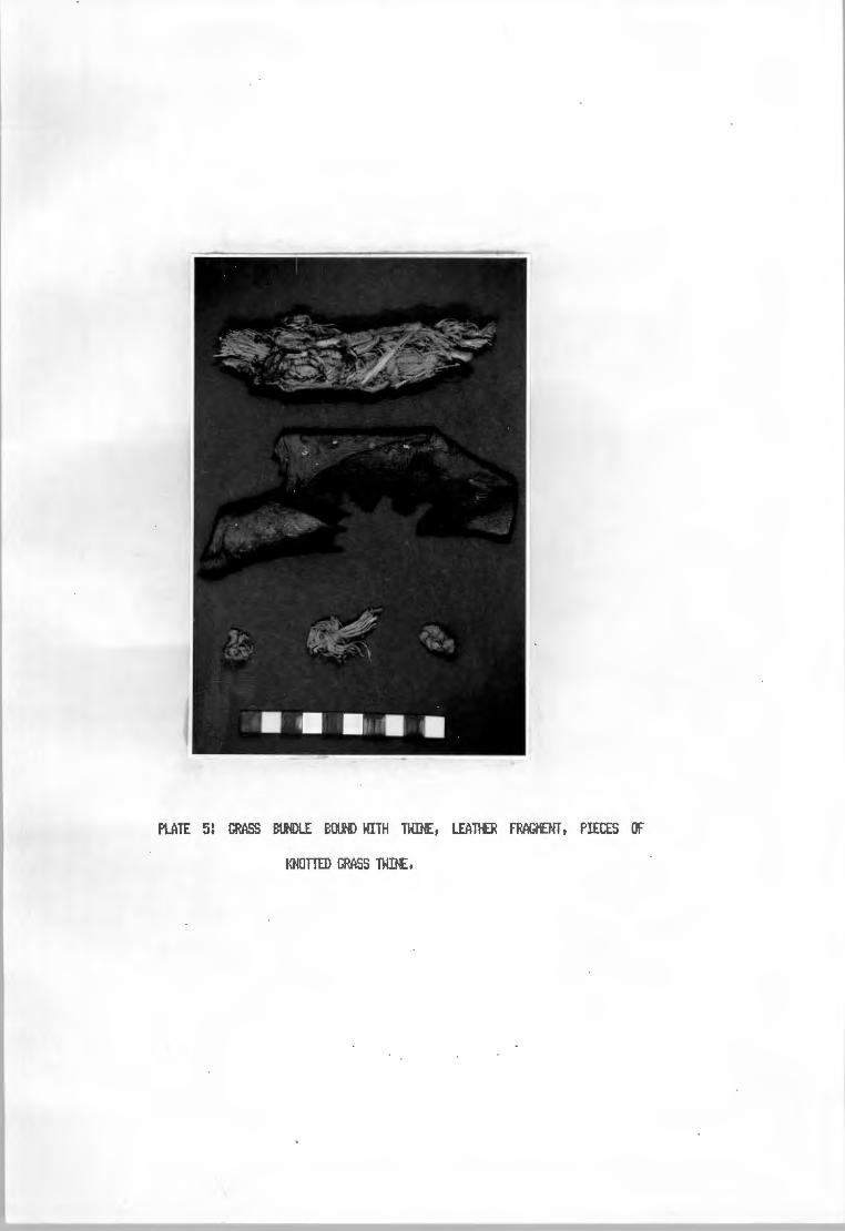
PLATE 5! GRASS E:UNDLE E:OUND WITH TWINE, LEATilER FRAGMENT, PIECES OF
•(NOTTED GRASS TWINE,

one end to reset'lble a shoe-horn. All specit1ens have longitudinal surface striations apart frOl'l
grinding ftarks, and two are rather intri~ingl~ ochre stained.
Irie piece of leather <Plate 5) was recovered frai. the bedding in la~r 1, It seeNS well cured
but shows no signs of shaping or stitching.
Worked shell is uncotll'IOn, and lit1ited to the species Dona:-:~, the white sand t11JSsel, These
shells, with extensivel~ chipped edges and so,,ietiNeS with a large central perforation, are kl"IOloll
as 'Donax scrapers' although their real use is not l.nderstood. The consistenc'j with which these
il'!Plel'lef'lts were forl'led, however, negates an';! exPlanation other than deliberate Naoofacture as a
tool. There is no consistent pattern of distribution of these il'!Pl~s at Tortoise Cave,
although~~ be riarginall~ l'IOre rowJn in the pre-potter~ levels ovtside the shelter.
Pendants and Beads
Pendants are defined here as shaped, decorative pieces perforated off-centre to hang fro.. a
thread, whilst beads are centrall~ perforated for threading. Apart frOM one brass or copper
pendant (Plate 7) all pendants were !'lade fro,, Marine shells or pieces of thet!. Plate 7
illustrates pendants ttade frot'l pieces of larger gastropods! Haliotis t1idae and Turbo sar..aticiJS.
Ever~ pendant is different: there are dcx.ible and single perforations; t1illed and plain grOlfld
edges; and great variation in shape and size, B~ contrast, the whole-shell pendants in Plate 8
are reMarkabl~ IAlifort1 in st~le: several Bullia digitalis have the SaMe triangular perforfation
opposite the aperture on the basal whorl, and all the Gl~ris pendants are pierced and gr(l(.ind
in the SaMe Marrier. Sotle of the latter are ochre stained rather like beads and it is possible
that the-:! were strr..ing as sa.Jch in a series of overlapping 'scales' rather than as hanging
pendants, The other whelk has not been identified, but in view of its all'IOSt central perforation
~ also have been a bead and not a pendant.
The decorated avian long bone in Plate '1 is a sClt'lewhat ooiq•..te piece which l'lUSt have forl'!ed the
central piece of a bead string. It is so,,ie 11 CM long, and along the central 8 CM or so is
decorated with several rows of transverse nicks, The ends are gr!Uld or worn which is suggestive
of stringing, Plate 9 illustrates the standard range of beads, An isolated copper bead frlll'I
la'.jer 1a is associated with the late glass beads, of which seven were f!Uld within a few ct1 of
the surface inside the shelter.
44

PLATE 6! BONE Sf'ATULAE, TOP 8. BOTTOM LEFT ARE OCHRE STAINED.
Bene beads are of two t'jpes! discs and tubes. The for11er appear to be bone replicas of t';lpical
ostrich eggshell beads and are l'lade frDM CC111>act bone or possibl':I frDM tooth ena,,iel, The latter
are shaped and ground sections of avian long bonet generall':I l.K'ldecorated, Seed beads are t1ade e.
frOl'I Restionacae seedst grruxl flat at both ends and bored 01Jt. St1all periwirkles (Natica sp,) ~ .
are l'lade into beads b'j piercing the shell opposite the aperture in the sat1e ~ as shell
pendants were l'lade. Kan';I shell beads showed signs of ochre staininqt biJt it seel'!S likel':I that
this fta';i have rubbed off frOl'I ~ ochret rather than applied deliberatel':I to the beads
thet'lselves, All except the shell beads are fCM"id onl':I in post-potter';! levels in the shelter or
near the surface (in TCfPERS or SPIT 1) 01Jtsidet and it is likel':I that this diversit':I of bead
l'!aking Mterials is a ti11e related pheool'!enon.
Ostrich Eggshell
The l'IOSt COl"IIOO non-lithic artefactual Mterial at Tortoise Cave is ostrich eggshell (0,E,S, >.
liililst "'-'Ch of this Mterial is l.Jldoubtedl':I food resida..iet a great fllt'ber of pieces show
secondar':I working to Make water containerst beads and other decorative itel'!S, Ver':! few pieces of.
decorated O,E,S, (Plate 7) were fOU"ICI on the sitet but several hU'ldrecl finishedt brol<.er, or
partiall':I CQMPleted disc beads were recovered frOl'I all levels of the dig, A prelit1inar':I
exat1ination of O,E,S, freqLiencies suggests that there is no significant ti11e""related change in
the attOLints of O,E,S, and O,E,S, beads fOLind at different levels, In FRAN <la';ler 2b)t howevert
~ of the O,E,S, pieces were ochre stained and l'!a';I have forl'lecl a container for this cOMOdit':I,
The double perforated 'button' bead <Plate 7) is extraordinar':I and would seet1 to be l'IOSt sit1ilar
to shell peridants of the SaNe fort1,
Potter':!
Cera,,ic re,,iains are lit1i tee! to la';!ers 1 to 3 and to the 51.rrface of the talus slope, In all t 36
pieces of potter';! have been recoveredt all plaint arid with onl':I two rit1 sherds, The bigger rit1
piece was externall':I thickenedt rCM"id lipped and inverted, Sherd thickness ranges frOl'I 4 - 11
l'llt with the 11ean j1JSt above &ow., Colour varies frOl'I red to buff to blackt and the tel'!per is of
45

PLATE 7: PENDANTS, ALL MARINE SHELL EXCEPT CENTRE LEFT OF E:RASS,

Pl.ATE a: SHELL PENDANTS AND BEADS,

IX'llil<.el':l that arl':l reconstructions woold shed light on vessel shapet as no pieces are larger than
7 ct1 in KaXif\1..11'1 diNenSion.
Even a cvrsor':l ex~ination of the finds such as this shows that despite the disturbance evident
ever':lWhere at the sitet changes and trends of a general nature can be identified where sa11Ples
are large enough. The l'IOSt siCJ'lificant breaks in all cases occur with the introduction of
herding and cer~ics to the areat causing shifts in artefact l'lanUfacture and possibl':l in diet. t.o
This latter applies in particular the replaceNent of OJiker in the diet b':l sheep and the /..
utilisation of a greater variet':l of vertebrate fai.xia. Staple foods such as shellfisht gr':J'.:bok
and dune ..ale rat are unaffected. Artefactuall':lt the change is evident :n the increasing variet':l
of decorative itef.is and the ·.ise of bone wooden i11Plettents. It Ka':l be that bone points replace
stone points (bacl<.ed points and/or blades) for projectile tips at this tiMet acro.inting for the
fair l':l radical change in the for~l tool ~.it after 2 000 BPCH1.1MPhre':lS 1979).
other changes in the faunal asseMblaget such as the changes in fish species and the absence of
the razor cl~ fro.. the upper levels are thooght to relate to~ in the vlei environMent
rather than to cult1.1ral factors.
The idea that there fla':l be a terMinal Pleistocene bladelet indvstr':l in the basal units at
Tortoise Cave has been rejected on the evidence of the 1'1c date fr°" la":Jer 11 CPta 3596) and the
siMilarit':l between this lcl';ler and those above. it in lit.hie ca,tent. There ist howevert evidence
of a break in occupation and it is interesting to note how little change there is over this
period.
It is onl':l in the lit.hie asseMblage that there is evidence of graoJal change in the finds : a
process which Ka':l have been exacerbated or exPediated b':l the introdtJCtion of herdingt but was
not caiJsed b':l it. This trend is in the graoJal de-forMalisation of the lit.hie assetlblaqet with
the production of fewer flakes and bladest less forKal tools and increasing use of unretOIJChed
or slightl':l Madified CH.R.P.'s) flakes in their place. The low freqlJE!l"IC':l of forKal tools in
la":Jer H Ka':l possibl':l t1ean that the reverse of this process occurred ciJring the hiatust bl,t it
SeeNS "°re likel':l that apparent changes are the result of a SKall Sa"'Ple frDf'I the basal units.
46

Pl.ATE 91 BEADS, SEED (2}:), GLASS (3x), BRASS/COPPER, SHELL, Bm~ DISC (2>:>,
E:ONE TUBE ( 2}: > ,

. ·, •
PLATE 10! OSTRICH EGGSHELL: PIECE AT TOP RIGHT DECORATED, TOP CENTRE SHOWS MASTIC
TRACES, E:OTIOM CENTRE & LEFT HAVE GF..'01.JND EDGES,

It i.JSt be stressed here that onl'.:I with l'IOre stringent controls on excavation and recording
tecll'liq•.ies, cot'ibined with post excavational progra,,is to q1..1antif'.:I the i,-.pact of disturbance, can
l'IOre detailed COl'IParisons of sites as Tortoise Cave be~ with arl'.:I degree of reliabilit'.:I,
47

CHAPTER s: SPATIAL ANALYSIS
One of the aiNS of this project was to investigate possibilities for the s~ of intra - site
spatial patterning in the Western Cape. This chapter deals with the application of~ certain
statistical tecl"niques for spatial anal';lSis to SOf'IE! of the CtJltural ret1ains frOM Tortoise Cave,
For a ni.M"ber of reasons, the site is not ver';! appropriate for effective spatial st~, even with
the low definition techniq•JE!S described here. This outline should therefore be seen as a
det!onstration of the techniques and a step towards the establishfoient of SOl'IE! working ~otheses
for further testing, rather than as a test of the ~otheses thet,selves.
Apart frOM the fact that Tortoise Cave is the first site in the western Cape on which a
statistical anal1.:r5;s of this sort has been attet,,ted, the rationale behind this decision lies in
the failure of the site to Meet the require,,ents of the I.Klderl';!ing asSUMPtions of spatial e . -
anal1.:r5is: that the 5al"IPles be shown to be hoNogenous and contel'!Porar';!l that the';! are shown to be k
relativel';! U"ldisturbed (ie that disturbance is insignificant): and that the';! be distributed on
what can be equated to a planar surface, Added to this is the fact that ttarl'.:I of the finer
definition techniques cannot be used because the';! require exact-point plotting, which was not
attet,,ted at Tortoise Cave,
It was thought that a grid square anal1.:r5is would be entirel';! inappropriate for the basin
deposits, since the thickness and the e>rt.reMel':1 varied Mtrix of the la';!E!rs WCIIJld present too
l\arl'.:I variables to control for, given that post depositional disturbance Might have had a Marked
influence on the location of Mterials. The outer cave deposits, having a relativel';! h~ ~
ttatrix and roughl':I siMilar vollt!E!S of deposit frOM sq•.>are to square, showed ttore potential here.
There was, however, one Major problettl that the prehistoric excavation and redeposition of the
shelter deposits on the talus would tend to obscure arl'.:I patterning resulting frOM activities
scheduled for the latter area.
In the post potter';! basin la';!ers, there is ver'::I little lithic ttaterial, but the sal'IE! cannot be
said of the faixial ret1ains, which are Cot'IIOO throughout. If this is as a result of a spatial
preference; that store working and tool use were tt1.x:h MOre CCW'a'I 01Jtside the cave it was felt
that the re deposition process Might not significantl':I affect patterning of lithic waste
48

TJ.e established thrOIJ9h activities perforMed on the talus.alternative is that the change in
k quantities of lithic Mterial Night be tiMe related, a theor';I 01.Jt of keeping with evidence frOl'I
l~rs ~, 12 and, to a lesser degree, frClt'l the VEEBEE series in l~r 11a, tt0st of which appears
to be in a priMr';I context. These 1X1its contain noticeabl';I less stone than eq1Jivalent IXlit.s
outside the shelter such as to£, MELANIE and ORIZZI..E, and tend to add s1.~port to the spatial
differentiation ho;Jpothesis.
It is possible, therefore, that SOf1e spatial patterning Na'3 be preserved on the talus, albeit. at
a rather coarse scale, Since the lit.hie co,,iponent does not var';! IIUCh in the pre - potter';!
levels, it is also possible that the arbitrar';I nature of the l~rs Night not significantl';I
affect this patterning, provided that the disturbance b';I bl.Jrrowers has not been too extensive
and has been directionall'::! rcll"ICIOl'I, These are asSUf'4)tions which carmt be tested here, but which
are necessar';I for the interpretation of ar~ observed spatial patterning.
Quartz and silcrete are the ttOSt COl"i'Ul raw Mterials for stone working on the site, and were
thJs chosen for anal';!Sis. Further, it is argued that the high rn.ll'lbers of waste pieces (chips,
cix.ds, flakes and blades) in these Mterials provides a safeguard against fli .. duations through
artefact displacef'1el)t, and in particular throoqh overprinting, The waste was initial!':! separated
b';I size into pieces of IX'ider 101"11 and Lf'lder 25wt in r,axif'II.Jl'I diNension (the latter irdusive of
the forl'ler). The reason for this was that ttOSt 1.Xbroken utilised or retouched pieces fall
between the two sizes and the Sl'lclller size class is ttOSt likel';I to have re,iained at the locus of
l\allJfacture. It was also felt that this subdivision would act as a check against the possible
effects of sorting b';I size diJring disturbance.
OOTLn£ CF TEOMIIES
The possibilit';I that spatial patterning still exists in the outer cave deposits was tested b';I
use of Court's l'lethod for ttap CClt'lParison (Norcliffe 1977:128). This ,iethod C011Pares two
variables over the scme areas for spatial correspondence, Because the l'lethod COf'lPares two
variables, which are here both contained in IXlits of equal area and volUl'!e, and does not co,,ipare
one spatial IXlit to another, the probleNS inherent in ttOSt qlJcldrat l'lethods of anal';!Sis are
negated. ThJs the choice of grid size and location, and of thici'..ness of deposit are not relevant
to establish correspondence. If the loci of correspondence are CONPared in their relative grid
49

positions, and this is not specificall~ part of Court's~, it is possible to observe
patterns of a general nature, but it is iMPortant to note that here the thickness of deposit and
the grid are as influential as in~ other anal~ical technique.
All data on each variable fratt each division of the 'i,ap' are CONPared to the l'!edian value for
that variable, and separated into areas above and below the ,iedian value. It the results fratt
both variables are cOl'lbined, the 'i,ap' is divided into four zooes <Fiq. S.1>: areas where both
values are above the i,eciian, areas where both are below, and two zooes of areas where one
variable is above its ..edian and the other below. If there is no correspondence (ie the
variables are distributed randofll~ with respect to each other), the four zones should be of
roucill~ equal area. If the two are f!IJtuall~ dependent, the areas in which onl~ one variable is
above the i,eciian should be few, and the opposite is true if the variables are P!Utuall~
exclusive. The ..easure,,,ent of significance is achieved throucil use of the coefficient of IM!dial
correlation (q), which can var~ between +1 and -1.The fort'll.lla for q is described below when the
application of the ..ethod is outlined. La~rs 9, 11 and 13a were chosen for this test, as la~rs
10, 12 and 13b were too liNited in extent, and la';ler 1-1 contained ~T ROCl<S which was not
curated strictl~ according to grid square.
An attet,ipt was then Nade to define the size and orientation of clustering~ using lrmllon's
(1973a, 1973b) l'llrl.hod of Diriensional Anal~is of Variance. In this Method, an area of the grid
of specified di..ensions is chosen for anal~is. The entire grid NUSt for" a square or rectangle,
the sides of which NUSt be in the ratio 2:1. The total ~r of basic quadrats in the grid r,ust
also equate to SOf'le power of two (2, '11 16, 32, etc),
The technique involves calculating within this grid the ..ean square values (see brackets below)
for each geo,,ietricall~ increasing block size (j), begil"f'linq with the s..allest quadrat and
doubling the size at each step, In this Wcl'j, ..ean square values (the average for the square of
the variable values in each quadrat) are obtained, for each grid square, for each pair of
squares (ever~ quadrat belonging to ool~ one pair), for each g~ of four squares and so forth,
lK'ltil ool~ two quadrats are CONPared to cover the entire qrid (ie the block size is half that of
the grid), Basicall~, cluster sizes are then identified as high ..ean square values,
The problett is that archaeological grids rarel~ confer" to such a stringent S'::lf"t'letr~ and
50
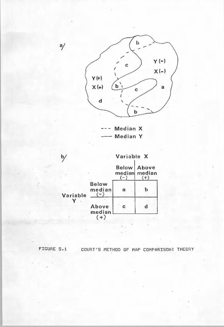
o/
o/
Variable y .
/
/ y (-}
X (-}
--- Median X
Median Y
Below Above median median
(-) (+)
Below median a b
(-)
Above C d median
(+)
FIGURE 5.1 COURT'S METHOD OF MAP COMPARISON: THEORY

invariabl13, to forl'l a suitable qrid for..at, q1Jadrats at the edges of the excavation ,wst be
excluded fr°" the anal'3Sis or extra, U"lexcavated, squares added as 'ck.Mies'. Rile'j <197"1)
ttentions that the exclusion of areas at the edge of the qrid will tend to skew the results, but
since no evidence was led to S1JPport this contention, its effect camot be assessed if'll'lediatel13.
The other COl'Wll"l criticisl'l of the~ involves the possible addition of'~' quadrats to
fill the corners of the ana1'3SiS area where the excavation qrid is irregular. Hhallon (1973)
suggests that these squares be qiven zero values, and that provided the nutmer of 'ck.lf'l'l'3'
quadrats is COf'f)arativel13 Sl'lall this should not seriousl13 affect the results. He does not state
the i,inil'lllft ratio of OJfW'l'3 to real squares, but experittents conducted during this project have e
shc:llil'I that below a ratio of 1:12 the zero value leads to erronious results. It was fCJIXIC! in all A
cases that the i,ean value for all adjacent quadrats was i,ore applicable and SeeNS theoreticall13
preferable. The lii,itation on the nut'lber of'~' squares defined b'3 exPerilff!l"lt i,eant that
onl13 la<jer 9 could effectivel13 be anal'3Sed b'3 this i,ethod.
The position and orientation of the qrid and the area of the ~llest quadrats can totall13 alter
the results of the anal'3Sis. Consider a dense circular concentration of artefacts, about 1N in
dia,,eter, located directl13 beneath a qrid peq, and consequentl13 spread equall13 between four qrid
squares. If the concentration is dense enough, it will show up as a cluster at the "1 sq•.>are
i,eter level! Converse 113, it l'la1.:J be totall13 absorbed within the possible rariqe of randotii
variation and not show up at all. Sii,ilarl13, S1'1all (for excll"IPle 30ci, dia,,eter) concentrations
c:entrall13 placed in a NJl'lber of sqliares will onl13 show as clusters at the S1'1allest block size,
in this case 1 square i,eter. Arcuate or linear concentrations at different scale or differentl13
orientated will also prodtx:e anoflalous results.
Equall13 iMPortant, and hardl13 rientioned in the literature, are the ii,,ortance of the orientation
and position of the anal'3Sis en the qrid, as in itself this can create the sa,,ie problel'!S
One Wa1.:J arCJIXIC! this is to create a controlled set of artificial data with concentrations of
sPecific shapes, sizes and orientations located reqularl13 across the c;irid. ~ representinq the
resultant i,ean square values qraphicall13, it is possible to build up a set of characteristic
'sPectra' of various cluster patterns. I.Ip to the point where the patterns beco,,ie obscured, it is
51

GRID < 10 <25 'l'OTAL
SQUARE QTZ. SILC. QTZ . SILC. < 25
R4 27 0 85 4 - 89
34 6 0 19 0 19 L 17 1 39 1 40 F 1 0 11 0 11
R3 39 3 137 15 152
33 22 0 69 11 80 M 6 1 26 2 28
B 1 0 9 0 9 R2 46 5 195 22 217 S2 14 3 69 19 88
N 16 4 33 11 44 Rl 53 3 188 36 224 SI 4 2 18 8 26 0 22 3 39 14 53 p 12 1 27 6 33 Q 1 0 5 0 5 V9 29 3 92 33 125
W9 28 4 91 13 104 MEDIAN 16,5 1,5 39,0 6,5
TABLE 6, LAYER 9: QUARTZ AND SILCRETE WASTE(CHIPS, cmmxs, FLAKES, A.ND BLADES) BY SQUARE IN 'l'HO SIZE
CLASSES HITH A COMBIUED TOTAL.

GRID <10 <25 TOTAL
SQUARE QTZ . SILC. QTZ . SILC. <25
T2 1 l 1 1 8
T 2 0 26 2 28 y 5 0 21 7 28
J 1 0 2 0 2
S4 1 0 9 0 9 L 7 0 39 4 43 F 1 0 13 2 15 G 3 0 20 2 22
r.r . 23 3 11 15 92 B 32 3 80 10 90 . u ·· 6 1 25 6 31 E 0 0 5 0 5 S2 52 18 116 86 202
N 44 16 152 82 234 D 4 1 32 5 37 0 33 13 104 53 157 p 3 2 27 13 40 Q 9 3 38 19 57 MEDIAN 4,5 1 26,5 5,5
TABLE 7, LAYER 9: QUARTZ A}ID SILCRETE WASTE (CHIPS, cuu.nrn, FLA1.'ES AND BLADES ) BY SQUARE IN T',JO SIZE
CLASSES WITH A COMBINED TOTAL.

GRID < 10 < 25 TOTAL
SQUARE QTZ . SILC. QTZ . SILC. <25
L 2 5 6 11 17 M 5 3 27 9 36 C 27 0 62 0 62 S2 87 15 187 48 235 N 41 12 122 51 173 A
D 14 5 69 18 87 Sl 14 22 42 75 117 0 26 11 108 43 151 p 25 5 46 10 56 Q 3 0 26 18 44 MEDIAN 19,5 5 54 18
TABLE 8 , LAYER 13: QUARTZ AfID SILCRETE WASTE (CHIPS , CHUNKS,
FLAKES AND BLADES) BY SQUARE IN TWO SIZE
CLASSES WITH A COMBI1TED TOTAL.

also possible to create 'spectra' of different COf'lbinations of patterns. This entails a
considerable aNOlir,t of ti,ie and effort and should or1l'::! be atte,>tecl when a great deal of data
requiret anal'::!Sis b'::! this ,iethocl.
Alternativel'::! it is quicker t although less reliablet to si!'IPl'::! rm the data several til'les
shifting the point of origin and orientation of the anal'::!Sis. The size and location of
concentrations is then deterl'linecl deoJctivel'::! b'::! COl'lf)arisoo of the resultant 'spectra' of these
rlflS. For the Tortoise Cave anal'::!SiSt this latter l'IE!thocl has been usedt although a nul'lber of
spectra have been assE!f'lbled for futi.rre use.
Tables 6t 7 and 8 list the data et1Plo';IE!cl in this test for each la';IE!r. Figures S.2t 5.3 and S.'l
show the relevant grid la'::!(IUts and correspoooence ftatrices for the anal'::!Sis in both size
classes. Where individual readings fell on the l'lecliant both the best and worst possible
placel'leflt of these on either side of the l'leclian line was tried. The coefficient of l'leclial
correlation <ct> is defined with refererce to these l'latrices <see Fig • .i.1b) as
ct= (a+ cl) - Cb+ c) a + b + C + cl
(1)
The critical value of ct <ct 11..) relevant to the desired level of significance ( Cl(.) is defined
thus:
'tae = 1.. + .L N JN
(2)
where z is a constant related to the value of~ chosent and His the l'IUl'lber of observations
involved. In this anal'::!SiSt N refers to the l'IUl'lber of grid squares anal'::!5ecl. Values for <tee. were
calculated at levels of significance o< = Ot01 and o<:. = OtOS.
9 Table _. gives the results of the anal'::!sis which shows significance in onl'::! two instances where
0<.= OtOS and l"O'le ate:<,= Ot01. This is OJe in part to the si,all lU"lber of observations <N>t but
~ have l'lOre to do with the size of each mit. Obviousl'::!t had it been possible to anal'::!SE! the
entire grid in 50Cl'l squarest N would be substantiall'::! increased and ct red.lC:ecl. This procedure
is necessar'::! to produce an'.:! results frOl'l an area the size of that containing la';IE!r 13a. But l'lOre
than thist there is a visual pattern to the zonation of the grid plan which shcMs low stone
densities arOU"lcl the l'lOUth of the shelter and towards the steeper slope of the talust with
52

+ - - - + R4 S4 L + ++ - -R3 S3 M
+ +- +-R2 S2 N
+ +- ++
R1 S1 0
+ ++ + V9 W9
- - -F
- - -B
-t fl;J, 'A ii
+- - -p Q -1
b;
LU ILU a: u ..J
(/)
-
+
QUARTZ/ SILCRETE WASTE < 10cm
+ - - - IEt> - - -R4 S4 L F + + + + - - - -R3 S3 M B + ++ +- +Ji R2 S2 N A / + +- +e + - - -R1 S1 0 p Q
+ ++ + V9 W9
(:t) = Value on median
-
LU
ILU a: u ..J
(/)
-
-t
-
+
QUARTZ/ SILCRETE WASTE< 25cm
QUARTZ
- +
6 3
3 6
QUARTZ
- +
7 2
1 8
Best case
- I + !
6 3
2 7
Worst case
FICLJF~E 5. 2 COURT'S METHOD: LAYER 9

- + T2 - - + - -T y j
- - + - - - -S4 L F G
+ + + ++ M B C
+ ++ +1// -S2 N A / D
+ +- ++ 0 p Q
-
-
+- -E
+
+
QUARTZ
- + ;
- 7 2
+ 2 7 w I- Best case w er: (.) _J -Cl)
-
+
- +
6 3
3 6
Worst case
QUARTZ/ SILCRETE WASTE <10cm
- -T2 - - - -T . y - - + - - -S4 L F
+ + + + M B
+ + + + 'l~· S2 N A/; + + + + 0 p
- -j
- -G - + - -C E
+ -D + + Q
w 1-w er: (.) _J
Cl)
-
+
QUARTZ
- +
8 , 2
1 7
QUARTZ/ SILCRETE WASTE< 25cm
FIGURE ~5. 3 COURT'S METHOD! LAYER 11a

LAYER SIZE N CRITICAL VALUES FOUND VALUES qo,01 qo,05 g(worst) q(best)
9 10 18 0,719 0,573 0,333 0,333 9 25 18 0,719 0,573 0,444 o,667
11 10 18 0,719 0,573 0,333 0,555 11 25 18 0,719 0,573 0,667 o,667
r3a 10 10 1,016 0,820 0,200 0,600 13a 25 10 1,016 0,820 0,200 0,600
TABLE 9, VALUES OF THE COEFFICIENT OF MEDIAL CORRELATION (q) TESTING CORRESPONDENCE OF LITHIC FOCI •
•

increasinq densit':I towards the soot.hem edge of the excavated area. If the grid squares were
SNaller, or subdivided, it is likel':I that the 'gre';I area' of non-correspondence would be
substantiall':I reci.iced relative to the rutier of observations.
The danger here is that the Sl'laller the quadrat, the lower the artefact densit':I, aoo therefore
the ..are chance that the M!dian value will be CClf'lf!Ol)l':I represented. This ~ans that a ranqe of
COf'binations will be possible, aoo that the subjectivit':I of the anal';!Sis will be increased. One
further observation: the anc:Jflalous result obtained fr°" square 5.1 in l~r 9 l'la';I be caused b':I
the extre,,e thimess of the deposit at this point aoo the doted surface of la';ler 10 below.
This is onl':I visible b';I CQNParinq results frOft ad,iaeent quadrats thJs attet,,tinq a t!Ol'e COf'll'lCIO
st';lle of spatial anal';!Sis. It is i,,1portant to u-iderstaoo that it does not indicate a sensitivit':I
to deposit thickness in COIJl't's Method itself.
APPLICATIOO IF DDENSIIIW.. AtW..YSIS IF VARIAM:E
With such insignificant results frOft the preli"inar';I anal';!Sis, an';! attet,,t at greater definition ·
seettS futile. In addition, the apparent gradient of increasinq lithic densit':I towards the
southern extr~it':I of the dig suggests that there is little chance of closel';I defininq discrete
areas of l'larufacture. Therefore this section, ..are than arl'::! other, should be seen as a
deto'lstration of the Method rather than an anal';!Sis in the true sense,
The concept of the contiguous q1Jadrats ~thod has been 01Jtlined above. The Method involves an
anal';!Sis of Mean square values. These are calculated fr°" the 5°" of squares (Sj) of all
observations at bloclc: size (j):
T/j
Sj =~ I.Nj(i/ J i
(3)
where Nj(i) is the observed value in a bloc:I<. i of a quadrat of size j, aoo Tis the total ntJl'lber
of quadrats of the Sl'lallest block. size (j = 1). The variance between bloc:l<.s is the calculated as
the '..ean square' (ti) so that:
ti. = cs . - 52 .> J J J ( '1)
CT/2j)
53

-L -
-',
- -UJ
1-
QUARTZ
- +
- 4 1
+ 1 4
+ UJ Best case M
+ ++ + ::;/ S2 N A;:: - ++ ++ + S1 0 p
C -D
-Q
-
-
c::c u ...I
CJ)
Q U A RT Z / S I L C RE T E WASTE < 10
,___ - -L -- ~
M + + + +// S2 N A~ - ++ +- -S1 0 p
+ C
+ D -Q
-
+
-
UJ
1-UJ
c::c u ...I
CJ)
-
+
-
+
QUARTz/s1LCRETE WASTE <25
- +
3 2
2 3
Worst case
QUARTZ
- +
3 2
2 3
FIGURE 5.4 COURT'S METHOD: LAYER 13

where T /Zj define the degrees of freedo,i. Hence S.,. is alwa'jS less than S. and Ii. is al~s ~J J J
positive. Also, it is apparent that the largest bloc!<. size for which a value of ti can be
obtained is half the grid size, at which level the analysis co,ipares me half of the grid to the
other.
The analysis was rm on a riicro-co,,iputer using a speciall~ written BASIC progral'I. In all, nine
rlf'IS were taken on la~r 9, fCIIJT' on l~r 11 and two on l~r 13. To produce different
orientations for the two last l~rs, two'~' squares were added. This was considered
rtethodoloqicall~ unsafe and the rlf'IS on l~rs 11 and 13 were not used. The resiJlts of seven
rlf'IS frOl'I l~r 9, tabulated in Table 10, are used here for detolortstration. A graphic displ~ of
the rtean square values for the various block sizes (Figs. 5.5a & 5.Sb>, and the interpretation
of results is based on this graph. The inset grid plans show the location arid orientation of the
rlf'IS involved.
COl'!Paring first the resiJlts of the east41e?t rlf'IS (Fig. ·5.5a), the l'IOSt obvious feature is the e
prOl'lin,nt peak indicating a concentration at block size 2 (2" x 11'1 quadrats) in the analysis
originating frOf'I IJ9. In l'IOYing the point of origin one square west to Rl, this peak is split
between block sizes 1 and z. This rLn is clearl~ off centre, and suggests that the size two
clusters are focussed on IJ9 - Rf, R3 - Ri etc, rather than in this fraNeWOrli.. Now,~ shifting
the origin to S1, the split peak is still visible, auca,,enting the previous suggestion, but has
becot.e insignificant, adding to the definition~ locating the concentrations in the IJ9 - R1 row
of squares. The rm originating in square O sil'lilarl~ shows no significant pattern.
The analysis is then re-orientated to rm north-south and gr~s of eight grid squares
originating in Ri, R3 and R2 are tested <Fig. 5.5b). The rlf'IS frOl'I R2 and R3 both appear as
riirror iNages of the IJ9 rm, and are indicative of linear clusters at right angles to the axis
of analysis. liierl the origin is in Ri, the peak at block size one disappears and the peak at
block size 1 (2" x 2") is significant!~ red.Jced. This defines the western edge of the clusters r
as occuring in R3 and 53. ~
One interpretation of this data set WC11Jld be to COl'lClude that a three square linear
concentration exists in squares R1, R2 and R3 perhaps overflowing into V9 and Ri, but not
significantl~ affecting squares S1, S2 and S3. This iCJ'iOres the data frOf'I the r1xis originating
54

ORIGIN V9 Rl Sl 0 R2 R3 R4
92 188 18 39 195 137' 85
188 195 69 33 69 69 19 91 18 39 27 188 195 13~ 18 69 33 (27) 18 69 69
195 137 69 26 33 26 39 137 85 19 39 (27) 9 11
69 69 26 9 39 33 26
69 19 39 11 27 (27) 9
MEAN SQUARE VALUES
BLOCK SIZE l 2238,6 4891,7 509,2 26,1 5619, 5 2603, 1 125c . -BLOCK SIZE 2 8359,6 4229,0 66,3 293,6 425,0 498,6 132E
~OCK SIZE 3 . ,, 820,1 12,5 8,o 210,114792,017578,1 632t
TABLE 10, LAYER 9: DATA FOR DIMENSIONAL ANALYSIS OF VARIANCE on QUARTZ
WASTE UNDER 25mm IN SIZE. ESTIMATED VALUES FOR
SQUA.~E A BRACKETTED.

9000
8000
7000
. ._ ~ 6000 Q)
::::,
ro >
Q) 5000
... ro ::::, C" rJ')
C 4000 ro Q)
~
3000
2000
1000
0
FIGUF~E 5. 5a
S1
1
V9 R1 R2 R3 R4
W9 S1 S2 S3 S4
0 N M L
p A B F
-- - - - - - - - - - - .; 2 4
Block size (j)
DIMENSIONAL ANALYSIS OF VARIANCE: LAY[R 9

R1 R2 ! R3 R4
S1 ( S2 S3 S4
0 N M L
P .'.\ B F
9000 17 580~ /.\14 790
I
I 8000 I
I
I 7000 I
._,
~
a> 6000 ::J R2 ct)
>
a> 5000 ~
ct)
::J C" (J)
4000 r::: ct)
a>
~
3000
,R3
' ' ' 2000 ' ' ' ' R4
' 1000 ' I :
' . I . , .. ',/ :
~
0 1 2 4
Block size ( J )
FIGl.!l:;:E 5. ~)b DIMEN SIONAL. MU~L YSIS OF VARIANCE: . LAYEF~ 9

in S1, 0 and R.,. If all results, both significant and insignificant, are exa,,iined, the onl'3
valid conclusion is to confirl'I that la'jer 9 contains a trend of increasing lithic densit~
ruming approxiMtel'3 north-west to south-east frOf'I 11 to Rl. It t,JSt be equall~ apparent that
this conclusion could not be reached with orrl'3 one or two rt..ins even b'3 utilising the si:-.-teen
square option available.
ANtt.YSIS ff TI£ BASIN DEPOS!TS
The ooits inside the shelter can be divided into five t~es: shell l'!iddens; hearths; ash heaps;
bedding; and soil ~inated horizons. It has been asserted that the soil ooits Cinclllding the
gritt'3 lenses) are the COf'lbined result of post-occupational aeolian action and the l'IOVE!f'IE!flt and
brealc.cbr'I of existing cultural debris b'3 terl'lites and burrowing aniMls. The~ all contain l'!Ore
prot1inerrt quantities of bedding Mterial, and it is felt that l'IUCh of the area the'3 OCC\JP'3 was
used in prehistor~ as a bedding zone. This is particularl~ noticeable in la'jer 1, where
recog)isable bedding ooits still e-,<ist, and the presence of a re,,inant bedding patch in FRAN
(la'jer 2a) suggests that the pattern existed then.
In the soil horizons, and therefore a,1ongst the bedding ooits, there is a,,iple evidence of the
existence of St'lall hearths. Probabl'3, as in la'jer 1, these were placed alongside or between
individi.>al bedding ooits. The ash heap in la'jer 3 CASH BELOW DAVE) is thooght to be the result
of NJl'lerous SNallish hearths built in a central, generalised hearth area. This part of the
pattern is not present in la'jer 2, but the beqiminqs of it are probabl'3 represented b'3 GAloOP.
in la'jer 1. It is possible that ~Sin la'jer 2a is a St'lall version of the central hearth, as is
the ash'3 FEATrnE AKJNGST ROCKS, but the scale of the ABO heap is never repeated. It is difficult
to interpret the hearth-l'lar~.er OOGHATIX, but the whiteness of the ash, low charcoal content and
the effect it has had on the l'lidden below are all indicative of a single large and hot fire.
The 11iddens thel'lselves for11 the l'IOSt consistent part of the pattern: the'3 ring the basin, btJt
the greatest quantities of shell are foood piled around the edges of the shelter, and their
e>rtension towards the drip line appears to be l'!Ore of an overflow. Ari'.:! serious build up of shell
here would, of crurse, tend to l'lalc.e access to the shelter aw<.ward and this~ be the rationale
behind this 1~.
The generalised pattern which E!l'IE!rqes frot1 this and which is evident frOf'I the plans of the basin
55

FIGl.mE ~.'i. 6
~,_--, ,,.,,. \ / \
/ \ / ' / I
,, I / I
\ _.,,. \
-E'k,fJ... .Qf la , ,,. - -Y~r l , , .,,. - it \ \ / /,,
, t ' /~ ... - .... '"' ,,
LOUBIE ,' .... --"' "' ,,/ ', \ /,,,,'
...... _.,..,,,
\ \
TORTOISE CAVE: LAY ER 1
I I
/
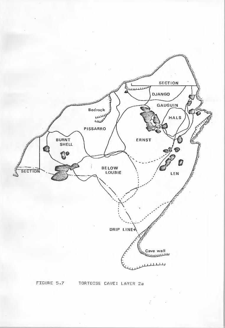
FIGURE 5. 7
ERNST
BELOW LOUBIE
I ,, ,. , /1
/ ,,' / , ,.
', \ ,' ' ., .., , , I
I
~\ \ DRIP
TORTOIS~ CAVE: LAYER 2a
,'
, , , ,
SECTION

!Slits (Fiqs. ~.6 to 6.9) is this: large shell riidderrs accllf\Ulate arou-id the back. and sides of
the basin, to a large extent behind the bedding mits, which would be interspersed with sriall
hearths, arid which oc:cup~ the central area of the basin behind the drip line. In front of the
bedding or just inside the drip line is a ro,o,iunal hearth area which l'la'::! often have been riade up
of S1'1all hearths, but in at least one instance appears to have been a single large fire.
It would appear that the bedding zone was kept deliberatel~ clear of large pieces of shell and
bone, and that these were l'IOVed out of the Wa';;I to the sides of the shelter. This is reriiniscent
of Binford's (1978) l'ICldel of the toss and drop zones around an isl<.il'IO hearth (Fig. l'.10), and it
seeried worthwhile to atteript to test this idea. Since l'IOSt of the fai.ra fro,,i this part of the
excavation has not been anal';ISed, a S1'1all test case was devised. It 5eef'lS that if, as has been
suggested on a l"U'lber of occasions, tortoises were cooked in their shells, the carapace would
reriain largel~ intact, This would be exactl~ the skeletal elerient of this anirial which would
tend to be 'tossed' aside, whilst errdoskeletal bones SJJCh as the lil"bs wa1.1ld be dropped or
tossed in a l'IOre raridori riariner.
Initial estiriates of carapace/lil'b frag,ierrt ratios tended to show that this was indeed the case,
but it was pointed out CPogger.,oel pers. COf'tl'I,) that differential breakage and preservation
riight skew the figures. Finall~, a decision was riade to test the distribution using onl~ those
bCJd,j parts norriall~ COl..flted for tf.N.I.'s: the hul'leri and fet!Ol'a for the lil"bs; and the
epiplastron and xiphiplastron for the exosk.eleton. L~rs 2 and 3 were chosen for the test
because the chances of a post-occupational il"f!ut seeMed too great in l~r 1. Also, as it was
not known whether ABO and Hlt.S would constitute part of the drop or toss zones, the~ were
included in the for~r categor~ with the soil horizons. If~ were wrongl~ placed, this should
tend to skew the results towards rejection of a ~othesis concernng the existence of such
zones.
The ~11 h'::IPothesis states that the difference in ~art distributions in so slight as to
show no significant difference between shell-riiddens and other !Slits. There are no real 'toss
zones' present. The alternative ~othesis is that tortoise carapace is distributed in a non
randc»I riamer between the !Slits as a result of prehistoric curation of the living area during
COl"ISUl'IPtion: ie. that a 'toss zone' exists in the Binfordian sense,
56

--........
FIGURE ~.'i. !3
.-·-·---..,_
FRAN
~EDDING VIN FRAN
ROOTS
DAVE , ' ', l
' I . SALl.,'( 1
'' I -+, , , I , ' ,
• ' I '\ / ' / .... _ ., ' / ..... ..._ -
\ DRIP LINt'.
\
TORTOISE CAVE: LAY ER 2b

I
SECTION ""'-._ ·--.
\ ·\.
\ . DRIP \
~INE~·\.
FIGUF<E 5.? TORTOISE CA VE: LAYER 3

A S1.fflar'3 of the data appears in Table 11. La'3er 2 has been split into its ro,ionent events to
provide three observations if r~uired.
A chi-squared test of association in a 2x2 contir,ge!)C';j table was carried oiJt to COMPa~e the
fr~uencies of 'carapace' and lil'lb bones in both the l'licld!:.'!'15 and other mi ts of all three la'3ers
cot'ibined. This is presented in Fig. 5.11. The bracl<.eted figiJres are the values e:{?ected under
randotl conditions frOl'I a sa,,iple of the sa,,ie size. These e:<pected fr~uencies are calculated frol'l
the first table accordiriq to the for,,..•la:
E = Row Total x Colul'lrl Total Sat1Ple Total
(5)
In a 2x2 l'latrix of this sort there is one degree of freedOf'I (df = 1) and the test is one-tailed
as the direction of variation has been predicted UN:ler Ha.
The forl'IIJla for the chi-squared statistic is:
(6)
where O = observed fr~uencies, E = e:<pected fr~uencies, r = rows, k = colUl'l"IS. Since
COi - ~)2 is the sa,,ie in each case, the forl'IIJla becot,es:
And substituting values frOl'I Fig. s.11:
°X. 2 = 64 (1/28 + 1/56 + 1/18 + 1/36)
= 8.76
(7)
For a one-tailed test with df = 1, the critcal value of X2 for o<.= 0,01 is 3,32, so that the
obtained value is well above this. It is, in fact, siCT1ificant at o< = 0,001, where '!
X .. (critical) = 5,'l2.
The above test was re-run to CQMPare the observed and expected values for each of the following:
a) Middens: carapace versus lil'lbs
57

CARAPACE
LAYER NIDDElJS OTHER TOTALf>
EPI XIPH EPI XIPH EPr XIPH
L R(Pr) L R(Pr) L R(Pr) L R(Pr) L R(Pr) L R(p':')
2a
2b
3
LIMBS
LAYER
2a
2b . j'~
3 4(2)
6 6(6)
2 2(2)
MIDDENS
H0M
L R
10 4
2 4 2 -
· l 4 -
3 5(1)
- - -
FEM
L ·R
10 7
l 1
- 1
1 1 - 2 1 - .4 5(2)
- - - - 1 - 6 6(6)
1 3(1) - - - 3 5(3)
OTHER TOTALS
hur~ · FEM HUM
L R L R L R
2 6 8 l 12 10 6 3 7 5 8 7 1 l 4 - 3 l
TABLE lla.: DIAGNOSTIC TORTOISE IN' IHDDENS AND OTHEfl UUITS FOR
LAYERS 2 MID 3 •
. MN I
LAYER CARA LI!.ffi BEST . JIBE NBR c1.. /J N'BR % 1-TBE
- CARA REC LHIB REC TOTAL
2a 8 18 18 72 17 23 48 6'T7 144 2b 8 8 8 32 21 66 29 91 64
3 · 5 1 7 28 8 29 15 54 56
TOTAL 21 33 33 132 46 92 264
TABLE 11 b: DIAGNOSTIC TORTOISE ?.! 11 I A1ID RECOVERY RATES FROM
LAYERS 2 Al:1> 3.
KE"• J..: EPiplastron, XIPrtiplastron. uu;,Ierus, FEI-!ur, 9A'FL\.pacc.
NBE - Uo Bones Expected, NBR - No Bones Recorded~
Pr - paired limbs (MlH ie thus L + R - Pr)
3 5 -
3 6 (1)
- - -
-,,-., .. .I! .~Ji'!
L R
18 8
8 6
4 7
NBR % TOTAL R~r
65 45 50 78 23 41 138 52·

FIGURE 5.10
0 1 2m - · - --
STYLISED DROP ZONE/TOSS ZONE AROUND HEARTH -C -Aft~~ - ~inf~id -1978 >
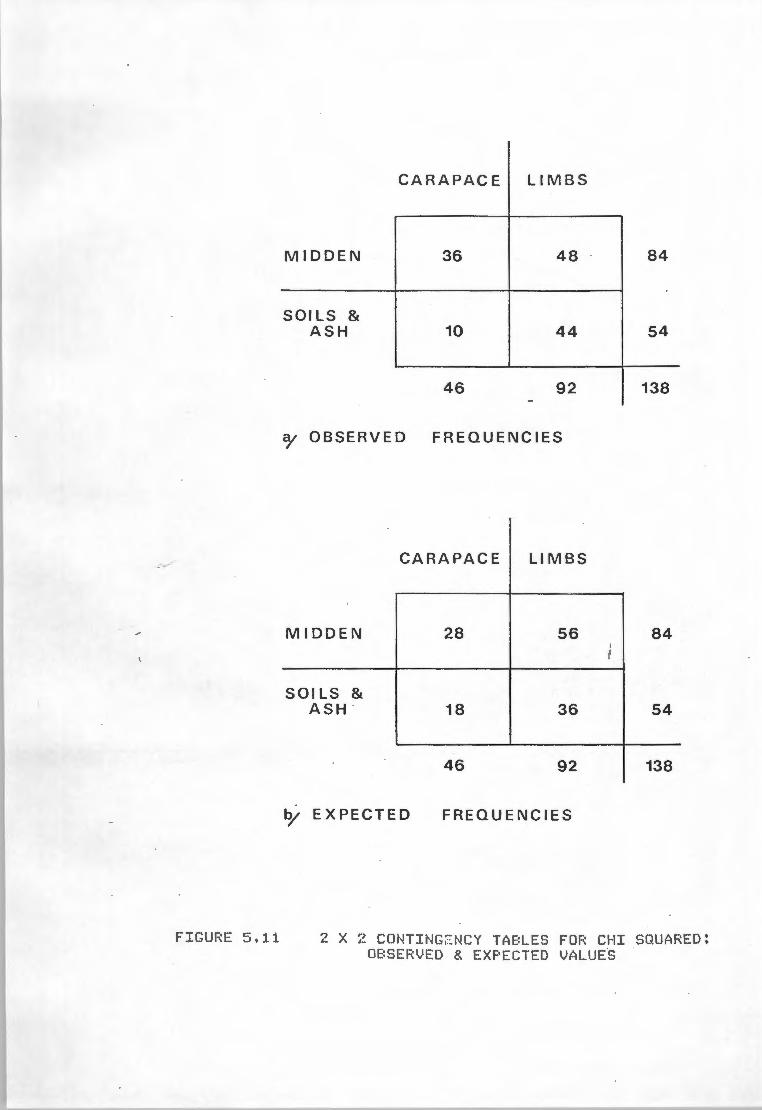
CARAPACE LIM B S
MIDD E N 36 48 84
SOI LS & ASH 10 44 54
46 92 138 -
o/ OBSERVED FREQUENCIES
CARAPACE LIMBS
MIDDEN 28 56 84 I J •
SOI LS & ASH · 18 36 54
46 92 138
o/ EXPECTED FREQUENCIES
FIGURE ~.'i. :1.1 2 X 2 CONTING~ NCY TABLES FOR CHI SQUARED! OBSERVED & EXPECTED VALUES

b) other IX'lits: carapace versus lit'lbs
c) Carapace: "iddens versus other l.f'lits
d) lit'lbs: Middens versus other l.f'lits
Onl'::1 a) and c) showed significant resiJlts, cie,o,onstrating conclusivel'::I that it is specificall'::I
the hig, freqtJer'IC'::I of carapace in the shell Middens that is causing the patterning, Burrowers
tend to avoid these shell "iddens and are IA'llikel'::I to have caused this pattern, All three la';!ers
were viewed in col"bination, so that vertical displacef'lent is neutralised. This leaves horizontal
displacel'IE!l"1t, ter"ites and hl..lf'lan activit'::I as possible ca1Jsal factors, and it seer.s reasonable to
suggest that the hUf'lan factor is the ~jor contributor to the observed pattern.
SiMilar sets of tests were carried out on each la';!er indviduall'::I, but onl'::I la':;!er 2b < "X. = 2,75)
showed art'::! significance at0< = 0,05 (j(.critical = 1,92), A possible reason for distortion in
la';!er 3 has been 11entioned above, and it is possible that vertical Mixing of ~terial in la':;lers
1 and 2a could have distorted this sa,,,ple, In the latter case it is again clear that the
distortion and therefore lack of significance arises frOM the relativel'::I high frequencies of
lit'lb bones, Referring to the percentage recover'::! rates in Table 11, it is apparent thai la';!er 2a
contains the greatest ~le bias, and it is MOre probable that disturbance and MOVel"lent here
have caused skewed results than that the pattern as such is absent,
cotnl.lSIOOS
~r " Even allowing for the inapposite use of Tortoise Cave as an exaMPle f1f the tecrriiqes described
" here and the probleMS that have arisen in attet1Pting to identif'::I catJSalit'::I, one point is
inescapable. Without the atteflpt to find and use relevant statistical tests, none of these
patterns or trends would have been as well t..flderstood as the':;! now are, and withol.Jt a detailed
lc.rolledge of Site TaphorlOf'l'::I, spurious asS1.11Ptions concerning l'lulilan behaviour "ight well have
resulted fr°" the test results,
The chi-squared anal':;!Sis of the basin defulstrates the degree to which, even in pri~r'::I
deposits, disturbance and the nature of the deposit can affect fa1..inal frequencies, Once again,
it is vital to 1Xiderstand all the taphonot'lic elet1ents present in the deposit before an':;! anal':;!Sis
is att.e,,pted. The identification of possible rando,\ising effects can onl'::I assist in the
e:<planation of statistical results, It is f•;rther suggested here that where spatial anal'::lsis of
58

the fai..ral eletEnt is attet,>ted, COMParisoos sl'D.1ld alwa'jS take acro.x,t of estiNated recover~
rates, and onl~ those that contain a reasonabl~ CCJl'1)lete data set should be used for COMParative
anal~is. What is 'reasonabl~ COf'IPlete' is hard to assess ci,jectivel~, and each case f'!IJSt be
judged indivicllall~.
The statistical anal~s of the talus deposits illustrate several archaeological problef'IS,
perhaps the ..ast il'!Portant being the effect of grid size, location and orientation on quadrat
based Nethods of spatial anal~is. It is obvious!~ not possible on ..ast prehistoric sites to
control for grid orientation or the location of corner points prior to excavation. It is
feasible that in the future, techniques of 51.b-surface NaPPing (resistivit~ and Nagrietic, for
exal'!f)le) f'lcl'.:J be developed which could could be used to ease the present totall~ randoN 1~ of
the archaeological grid, or that the use of a triangular or hexagcnal grid Night be showi to be
effective in this~, but for the present these reNain in the realN of science-fiction and the
probleN NUSt be accepted as a randc:Jft variable. Grid size, on the other hand, is easil~
controlled, and it is suggested that the SNallest practical 51..bdivision of the standard Netre
square be used in ever~ circoMStance, In shell Nidden sites, this f'lcl'.:J be onl~ the SOcN q1Jadrat
which ca.e into use at Tortoise Cave, but even this gives four tiNeS the spatial definition of
the standard grid square, It can be argued that ver~ little spatial patterning caused b';l huMan
activit~ will be evident at a scale of less than a SOct1 q1.Jadrat, but the use of SNaller ooits
Nal<.es it possible to 'shift' the grid NOre delicate!~ for Nethods such as DiNenSional Aoal~is
of Variance, Sttall sub-squares can alwa'jS be COl"biried to increase indivicllal values above the
required Ninif'lllf'I for a Nethod, but definition can never be increased be';!Ond the SNallest
provenience division used.
There is or,e final point concerning grid control. 11,en a site is considered for excavation, it
should be considered with rtajor excavation in Nind, even if this is not the il"l'IE!diate intention.
The grid should be plamed for such an event and, NOre il'!Portant here, test pits should be
confined wherever possible to the peripher~ of the grid. Where this is not desirable, ~
shoold be excavated with, if an~thing, greater care than ~ subsequent sq1x1res. This attitude
woold prevent the wasteful and awl<.ward cirell"5tances encountered at Tortoise Cave, where a
central square has been deeNed useless for anal':rt,ical purposes.
59

The e:<ercise has also bro1.1ght to light a further shor~ing of the contigoovs quadrats t1ethod:
that whilst it~ effectivel~ recognise discrete patterning, it will tend to find patterns even
where overprinting or other cirCUftStances have left onl~ general trends in point densities, The
l'lethod has its Merits if used wisel~, but should al~ be used in conjt..rietion with other tests
to roitter its SOMeWhat indiscrit1inate desire to please,
As has !>E'en suggested, the sensitivit~ of paratietric Methods of spatial anal~is to deposit
volUNe is verified b~ the results frot\ Tortoise cave, Hhilst l'IOSt ANOVAR "ethods are considered
to be non-paraMetric, the asSUl'lf)tions of cirCUftStance "ade b~ OiMensional Anal~sis of Variance
lift it all'IClst to paraMetric status with the allowance that it f'1a';I work effective!~ with data
onl~ recorded on a ranking scale,
There are, of COIJl'se, results of the anal~is relevant to Holocene prehistor~ in the region, but
these are lttle l'IClre than h~otheses in the absence of ccx,>arative data fro,,i other sites, and
will be dealt with in detail in the final discussion,
60

CHAPTER 6:DISCUSSION AND CONCLUSION
In order to lX'tderstand the iMPlications of the Tortoise Cave project, it is necessar~ to see the
site in the conteA1. of wider research: of Late Stone Aqe archaeol~ in general but particiJlarl~
of western Cape L.S.A. archaeol~. This chapter reviews the latter with reference to the wider
field where necessar~ and attet,>ts to show how past ~otheses and work need re - exaMination in
the light of the evidence frOl'I Tortoise Cave,
The rmel that has governed research in the western Cape for the last decade is one of seasonal
~t of the prehistoric llx,ter gatherer COl"IM'lit~ between the West Coast and the PIOIJl"ltains
of the Cape Fold Belt (Parkington 1972, 1977a). This st~ deals onl~ peripherall~ with fa1.rial
and floral re,,iains, and hence it is not possible to assess f•Jll~ the environ..ental tenets on
which the f'IOl:lel rests. The seasonal l'IObilit~ l'IOdel has.1Xidergone considerable NetaNOrphosis in
the last ten ~ars, gradJall~ being forl'IUlated into a set of worHnq ~otheses. It. has NOre
recentl~ eotie to rel~ rather heavil~ or, lithic evidence and interpretation, one of the reasor.s
~ a larger and better defined sat1Ple was needed frOf'I Tortoise Cave, ar~ on this aSPect SOl'!e
detailed COl'll'lent has been f'1ade.
The other aiNS of the project were to ex~ine SPatial distributions and the Methodologies for
this research, and to investigate techniq1JeS of excavation. These will be disCt.JSsed in later
sectior.s of this chapter, with reSPect to the archaeological research OIJtlined below.
The l'IOdel was proposed as a Method b~ which the hunter gatherer population Might have operated
to i.axiMise the different ecozones which Made~ the western Cape region. In the western Cape
these zones rlA'I rouc;ihl~ along a north - soi..rlh axis. FrOl'l the coast the land rises gentl~ across
a sancl<J coastal plain (the Sandveld) broken ~ occasional residl..ial ridges and ~.opjes of Table
HoiX1tain Sandstone and shale to the foothills of the Cedarberg lic:M,tains which constit1Jte the
i.ain eleNent of the Cape Fold Belt in this region. The foothills are separated frOl'l the f
Cedarberg proper b~ the vall~ of the north-flowing Oli,hants River, whilst to the west of the
flOl.fltair.s the lar~ slopes across a disected l~cape to the Doorn River and the Tanqua Karoo.
61

Each of these zcx-ies, the coast, the Sandveld; the l'IOU"1tains, and the Karoo has its OWi set of
resources available for e:.q>loitation at different tit1es of the ~ar.
When first outlined, Parkington's (1972) MOdel was relative!~ si~le and Wo""S btJilt around the
excavation of two sites: De Hangen and Elands Bo'3 Cave (E.B.C.). There was evideriee frOf'I the ~orMer f ~' situated east .of the Oli(l6ants River vall~ and SOMe 60 l<Jl frOl'I the sea, of contact
with the coast. The 110St incontro- vertible part of this was the presence of r,arine shell in the
deposit. In the area gerierall~, there were known to be prehistoric paintings of what were
apparent!~ ocean going ships. If this interpretaticx-1 can be taken literal!~, it S1Jggests quite
strongl~ that at least SOMe indivio.ials frOf'I the ~tains had been to the coast since the
arrival of Europeans at the Cape. The evidence suggests a SI.Jf'll'!E!r OCClipation of De Hangen and
COl'leS frott a rutier of SO\.•rces: the ablJndance of corl'l cases and fruit seeds, inflorescences on
the bedding grasses, and the juvenile age distribution of Oassie (l+jrax capensis) ~les frOl'I
the shelter were cited and appear to rel'lain as strong positive data. Parkington (1972) hi11self
ac!Mits that it is hard to find proof that the site and other 'carbon copies' were deserted
during winter, blJt adds:
"Perhaps the question can be approached b~ detlonstrating that neigl-oourinq
ro,>leMentar~ resource zcx-ies were occupied dlJrinq winter, and~ postulating that it
was the De Hangen COMVnit~ which occupied ~. 11 (Ibid: 237).
Certain!~ the evideriee for a winter occupation of E.B.C. in the late Holocene seeMS equall~
strong: the shell l'liddens contain high frequencies of l"llSsels, which are potentiall~ toxic in
Slll"IEr as a result of dinoflaqgelate blCIOl'IS or 'red tides'; there are few corl'l casings, seeds or
infloresceriees in the upper deposits, where organic preservatioo is good; dassies are less
frequent and are all'lOSt all adult; and ~arling seals are cOMMOn, whilst pups and older anir,als
are absent. The last particularl~ is indicative of a late winter/earl~ spring seasoo of
occupation. The other evidence seet'IS to rule oiJt a late SPring or SUl'll'ler occupation at E.B.C.
One proble,,i not addressed~ this outline is where were the people during the earl~ part of s
winter, when corl'lS are less available and l'lVSsels l'lo'j still be toxic? Its~ that t~ were k
left to wander around in the iO kl'l wide strip of sandveld between their two !'lajor alternatives.
Interesting!~, a second site (Klipfonteinrand) on the eastern edge of the 11CM"1tains was
62

excavated in 1969 (Parkington & Poggenpoel 1971b) but was not utilised in the seasonal t!Obilit':I
..adel. It contained rio deposits frDf' the last 5000 ~ars as these were ret!OVed b'3 the local
fartter to create a sheep pent but in its earl';! for" the f'IOdel was intended to appl':I for MOSt of
I" the Holocene and it is stange that the site was never referred to in this context.
k
Fletefe.:!er (1971) undertook a sti~ of growth rings on SOMe 20 sectioned seal canines fro,i
E.8.C. and confir~ that the aniMals were killed bet.ween J.Jl':I and Octobert and MOSt probabl':I
earl';! in that period. This was at the ti11e thooght to be conclusive evidence but recentl':I it has
been suggested <Parkington and Har';! Patrick pers. ca,..,..) that his interpretation of the qrowth
rings f'\a':I have been over siNPlistic and that the data & e.of d.ibious value.
With the excavatioo of Diepklooft SOMe 12 k" frDf' the coastt in the earl':! 1970·st the picture
becatte "°re cot1Plex. Here cor"s of Gladiolus spp, were fOU"ld in quantit':I CParUngton 1977b>t
along with SOMe patches of ~landtia spinoza seeds (Parkingtoo pers. COf"IN.). Parkington (1977b) Cl
argi.1es that the sandveld cor" bearing qenera such as Gladiolus and Morea were likel':I to be k
invisible soon after flowering endedt tl'l.lS liMiting the available seasoo to the period JJl':1 to
Novef'lber •
Nonethelesst SOl'IE! changes were~ to the original siMPle l'ICldel and it was proposed (Parlt.ington f
1977b) that the Ol~ants River valle'.:l WOl1ld provide a central fOCtJs for fishing cbing the dr';I
iu,ths of SJJl"i'lert ooring which the prehistoric 'Soaqua' would rratJJrall';I "ake full use of the
other abi..ridant res01.Jrces. This alteratioo was suggested en the basis of observations of ter"inal
Stone Age people b'3 earl';! travellers into the areat and it was further proposed that as water
becarie "°re freel';I available in the Sandveld and Karoot the population would begin to disperse
into these areas,
m "in effect this would involve S':ll'll?trical eMigratioo frOl'I the I\OI.J'ltain foldsin the wet
~
seascnt in both easterl':I and westerl';I directicr1S11 (Ibid!155),
~ During 1977 and 1978 excavatioriS were carried out at two sites near Clanwilliatt in the OliMRants
River valle';I! f\1driesgrond and Rerilaan, These were exPected to ';lield the fish reMains needed to
support the new version of the seasonal f'IOdel, Neither site did SOt and the fishing h';lpothesis
reMains unprovent dorMant but probabl':I riot forgotten, The coocept of a Cape Fold Belt focus has
63

been active!~ retainedt rel~ing solel~ on the densit~ of sites and the distribt.ition of groop
scenes in the rod<. art of the f'IOU"ltains. The latter Seet'\ to be absent frot1 the Sandveld and the
coastt although~ extend eastwards as far as the Doorn River (Har.hire et al 1983:,).
~ this ti~ it was understood that there were i,arl'.i lil'IPet dotlinated shell l'liddens at the coast t
both at Elands 8a1j and to the sooth between Langebaan Lagoon and Ouiker Eiland (Robertshaw 1977t
1979t 1981). Robertshaw proposed a ~r occ:upatitr1 of this stretch of the coast in contrast to
the winter settle..ent season offered b'j Parkington. This ar(3Ul'leflt had in soie wa'jS been pre -
e,,ipted b~ Par~.ington (1976) who suggested that l'liddens close to the coast tended to reflect
closel~ the available species in the adjacent intertidal zcrie of the shore, This arg•.#Ent is
interesting for several reasons and will be returned to later. In 1978 several lir,>et ~inated
1tiddens arOIA'ld Elands B~ were e>:cavated (Horwitz 1979) and again the ~ interpretation was
offered. In additiont these 1tiddens were fCll..fld for the l'ICISt part to post-date the introduction
of potter~.
Research in the western Cape in 1978 began to change directitrlt 1tOVing clWa'j fr0!'1 direct seasonal
and environl'lental indicators and placing increasing er,>hasis on lithic technol~ and its
indirect bearing on settlel'leflt and seasonalit~. This started with a stih;i of open stone scatters
in deflation hollows in the coastal plain and their rox,terp.arts in the l'IOIX1tains (Hazel 1978t
Parkington 1979) which led to observations of conter,>orar~ activit~ schecltJling differences
between the two zones. Most significant at1009 the eNerging patterns was that sites in the
ltOIXJtains were doMinated b~ adzest acco,,ipanied where excavated b'j quantities of wood shavingst
whereas the Sandveld sites contained few adzes but were rich in backed pieces such as segl'lentst
points and blades (Hazel & Parl<.ington 1981), Adzest it was thought, were used in the t'lafl!Jfacture
and r,aintenance of digging stid.s, which acro..inted for the wood shavings. Digging sticks were
essential for the exPloitation of the underground plant foods which forl'IE!d the staple diet of
the 'Soaqua' in the Cape Fold Belt wring SU1¥1er. In the Sandveldt b'j contrast, wood and
undergrW"ld plant foods were scarce and c!e,,ianded less technol~t so that adze frequencies were
corresponding!~ low. High frequencies of bac~.ed pieces were ~t vaguel~ related to
projectile points and therefore with hlinting (Hazel & Parl<.ington 1981, Parl<.ington 1980) and it
Seet,S that this "greater interest in htxlting with the bow and arrow" <Hazel & Par~.ington
1981:25) was considered to be the r,ajor contributor to the lithic assetlblage, At this til'let the
64

assel'lblaqe excavated fr°" Tortoise Cave in 1978 was not full~ anal';!Sed and the data frDl't the
surface collections indicated a situation sir1ilar to that frOl'I Diepkloof (Hazel & ParHngton so
19111) where, despite a nUNber of wooden tools, there were few wood shavings (17 in all), few
adzes and "a l'lere handful of undergroc..rid plant food residt..1e" (Ibid:382).
Growing criticis,,i of these opinions led to the ptt,lication of a re - exat1ination of the western
Cape in the context of Late Stone Age studies in so.rthern Africa (Parkington 1980) which
provided a forU11 for debate. The whole artefact dichoU!fol'J revolved aroc..rid the asSU11Ption of
conteNPoraneit~ for the IX'ldated Sandveld scatters and surface collections and the late
assel'lblages frCII'\ the 10J"1tains. The interpretation centred on the asSU11Ption that the tools were
use - specific and that these uses were reasonabl~ well established. It seeris that neither of
these assu,,iptions was widel~ shared.
Janette Deacon (1980) noted that historical evidence iMPlied that adzes t1ight be used for
working bone as r,xh as wood, that wood shavings did not riecessaril~ equate with digging stic~.s,
which could be used for t10re than e:<cavating cort1S and that wooden tools will need attention
(and therefore adzes) even in the sandveld. Inskeep (1980:95) was t10re eloq•..ient:
"The tool that whittled or scraped the digging stick t1a~ also have whittled spears, '
pegs, trap parts, throwing-sticks and bow staves, and in each case~ one of a
variet~ of artefact t'::ll)es ~ have been used+"
Inskeep, Deacon and Sat1pson (1980) all criticised Parkington on his asStJMPtion of
conteMPoreneit~, but it was Thacker~ (1980: 10i) who saw the true anc»'lal~ in his logic:
"It is interesting that where his data does not fit, in the case of the De Neus sites,
he is forced to conclude that the errant sites are of a different date."
Parkington (1980:77) reaches the sa,,e conclusion for Klipfonteinrand, dated earlier than the
adze rich sites, and for Andriesgrond where in discussing the basal assetlblaqe (IX'ldated) below
the t'::IPical to.rltain assetlblaqe with potter~ and adzes, he notes:
"It is in~ wa~ a sandveld like asseflblaqe with a high freq~ of scrapers,
relative!~ few adzes and a relative!~ high drill fr~. There are no wood shavings
frOl'I this assef'lblaqe and it is teNPting to infer that it in fact predates the
65

patterning above and reflects a prior situation." (Ibid).
The ruling ~otheses did not die as a result of the criticiS/'I: rather it was tl!f!Poraril~
cocooned while f•.Jrther research was uridertal<.en. There was, after all, still a considerable bod~
of environNental evidence to back the theor~ behind the l'IOdel. This research has taken the forM
of a thoro1Jgh re-exill'lination of the sandveld apen site pattern <Hanhire in prep), the wor~. on
Tortoise Cave presented here, and an in depth stiJdo:1 of the shell ttiddens arCM"ld Elands B~ and
their i,eaning in terl'IS of tii,e and the econo~ <e,1..1chanan in prep). In addition, a st~ of
stable carbon isotope ratios in various parts of the regional food chain and its effect on
skeletal isotopic values has been recentl~ cot1Pleted (Seal~ 198i). Whilst this work has been in
progress, a new perttutation of the l'IOdel has been praposed in the light of the new data
(Buchanan et al 1983, Hanhire et al 1983a),
As a persistent thel'le thrQ1Jg10Ut Parkington's work, and acting as a backdrop to~ of his
decisions, is the effect of envirCM'll'lental change on settlei,ent patterns and the scheci.iling of
activities (Parkington 1977a, 1979, 1980, 1981, ~). Host references have centred on the
Pleistocene-Holocene transforl'!ation, to e:..'Plain the change of 'place' of SJJch sites as Elands
~ Cave. It is interesting to note that whilst Parkington <1979) ttentions both the suggested
earl~ Holocene arid conditions (Butzer 1978) for the southern Cape and a south western Cape Mid-m
Holocene high sea level CFle,,iing 1977) and uses thef'I to SJ~port the idea of an occtipational J..
hiatus in the western Cape between 8000BP and iOOOE:P, in a wider publication (1981 : 351) he
states:
"lxitil r,ore inforl'!ation is available the coincidence of the appearance of f1Jll~ tlOdern
conditions and the cessation of oro.ipation rel'lains suggestive but inexplicable.''
Yet it was the idea that possibl~ in the tticl-tlolocene the Sandveld was a rather ~leasant place
to live, with a less proo .. ictive coast ck.le to a 2M - 3N high sea level which would effectivel~
cover l'!ar~ of the rock~ points along this stretch of coast, that 1~ behind the ass•.JMPtion that
the sandveld deflation hollows were contE!l'IPorar~ with the ttidden sites at the vlei l'IOUth and
66

their Cape Fold Belt ro-,tel'!poraries and post-dated 3500 BP. ~ were, after all, patentl'.:I not
frON the ter"inal Pleistocene - earl'.:! Holocene in view of their artefactual COf"IPOsition.
The ro-cept of a high sea level between 6000 and '1000 BP led Buchanan (1983) to conclude that
the vast shell accvll.llations opposite rod<.'.:! points north and south of Elands Ba'.:! <Kreefbaai and
11ussel Point) could onl'.:I have been forf'IE!d SOl"le tit1e after 3500 BP and l'IOre credibl'.:I after 3000
BP. Radiocarbon dates subsequentl'.:I obtained for these "iddens have confirf'IE!d this h'.:fpothesis.
Baboon Point, the rock'.:! outcrop in front of Elands 8a'J Cave, stands high enough to have rei,ained
intertidal throughout the Holocene, and thus the ,.idden deposits in the cave extend back to so,,e
1000 BP, and can be said to define l'IOre exactl'.:1 the occupational hiatus in the area.
The interpretatioo of the Tortoise Cave stratigraph'.:f showed that the separation of adze-rich
asseNblages and those with few adzes and higher frequencies of backed pieces was pri..aril'.:I a
tit1e controlled event, and that the differential distribution patterns ll.lSt therefore reflect
changes in settletient patterns. This, in COMbinatioo with the envirCIW!ntal data, was used to
re-for,,,,late the seasonal l'IObilit'.:I l'!Odel for the western Cape <Har~ire et al 1983a, Buchanan et
al 1983). The revised NOdel also took. into accoi.A1t the apparent large increase in the !'Mlber of
post-potter'.:! sites recorded frON the area around Velorevlei and the l<.apjes aoo rocl<.'.:I outcrops
scattered across the Sandveld. A foor phase l'!Odel was offered for the Holocene settle!Ent
pattern in the Saridveld.
Prior to 8000 BP, the coast was rarel'.:I visited, and settlel'lef'lt there focussed oo large shelters
such as Elands 8a'J Cave. Initiall'.:I, it was felt that such visits were scheduled for the S1..ll'W:!r
fO'lths, but that b'.:I 8000 BP coastal occupatioo had been rescheduled for winter (Parl<.ington 1981,
Buchanan et al 1983). This is h'.:fpothesised oo the basis of the change at Elands 8a<j Cave frON
lil'lf)et dot!inatioo of the shell ,.idderis to a far greater el'lf)hasis on ll.lSsels. The alternative is
preferred here, that the changing configuration of the shore line with the post-Pleistocene rise
in sea level fllade available a changing habitat off Baboon Point, frON one fairl'.:I sheltered and
dot!inated b'.:I lil'lf>ets to an exPosed outcrop with far higher frequencies of ll.lSsels. The question
67

of what constituted the rest of the settle..ent pattern o.ll'ing this period is left open althoush
it has been suggested (Parkington, pers COl'lf't) that the Karoo ~ic;tit have at this tire been a
..ajor focus of settletEnt.
Bet.ween about 8000 and 1000 ';!ears ago this part of the west coast was apparent!~ not a part of
the regJlar settletEnt s~teti. No sites have been flJI.J'ld which date to this period, and the
evidence is that the enviror..ient would have been arid and probabl~ t1arqinal for tu,ter
gatherers. There is SOf'le evidence for oro..~atioo of the Cape Fold Belt OJring the Nid-Holocsne,
frc»1 Klipfonteinrand and possibl~ Andriesgrond, but it see,,s that the coast and coastal plain
were not part of a seasonal ~le of NOYet!el"lt.
Frc»t the end of the Elands~ hiatus onwards, populatioo der,sit~ appears to have increased
steadil~ to arlJI.J'ld 1700 BP, and as a greater variet~ of coastal resoorce areas Cie rock~ points)
becarie available with the oceanic regressioo, so these were once again utilised, and scheduled
for winter exPloitation to take advantage of the large l'IUSsel colonies now available.
''It is likel~ that the heart of settletEnt s~tefts at this tire la1:1 in the Sandveld
plains to the east and that coastal visits were not designed to !'lake e:..-tensive use of
the range of ..arine resoorces" (Buchanan et al 1983).
Frot1 the focus of the deflatioo hollows parties of l'Ulter gatherers !Vied to the coast or to the
"°'-"ltains, as the seasonal availabilit~ of desired food resoorces dictated.
This pattern was interr~ted b~ the arrival of pastoralis,,i and, faced with increasing
cot!Petitioo for the resources of the coastal plain, hunter gatherers increasing!~ concentrated
on the Cape Fold Belt and the coast, living for the l'IOSt part aMOngSt the hills and outcrops of
the Sandveld where~ could. It was suggested that group size was red.ced in the coastal zone, r
but that aggregatioo occured in the "°'-"ltains, resulting in an abxidance of large, adze-rich ~
sites and rock paintings Cliarilire et al 1983b). At the SatE tire, the introduction of do,,estic
stock could have caused a red.lction in the wild bovid bic»taSs and led to a greater et1Phasis on
plant foods and shellfish~ the re,,iaininq COf"IU!ities of l'Ulter gatherers (Buchanan et al
1983).
68

HRIOl9:. rJ#JE 1N mnm
The Tortoise Cave sequence begins at arOlfld 7700 BP (Pta 3596)t at the start of the proposed
rec;iional hiatus. There is little deposit between this date and the date of ~0±50 BP (Pta 3605)
and a gap in oc:cupation has been suggested on taphono,.ic gl'Olflds between the two dates. This
would seett to add a great deal of strength to the ccx,:>arable dates fr°" Elands Ba':i Cavet and to
the hiatus theor~ derived fr°" tl,e,.. In ter..s of lithic artefactst there is little in the site r
to suggest that cffl significant change in the basic tool kit occvred in the intervening 34100 L
~arst and this l'!E!ans that the still i.xidated deflation hollows fta':I still extend back across the
hiatus. There ist of courset a great deal of disturbance at Tortoise Cave and little control
across the grid in the correlation of the dated mits with the spits of 1978. Contal'lination of
the lowest mits b':i post-hiatus lithic ..aterial is not onl'j possiblet it is q1Jite likel';i.
2. A second qap in the dates occvrs between 350±60 BP (Pta 360-'l) and 1680±50 BP (Pta 3312). which
I,.
"icjit also represent a break in OCCLipation. There are deposits which lie stratigraphicall~
between these datest but it is interesting to note that onl'j direct!~ I.Xlder mits dating to
after the introduction of potter~ are adzes fOlfld in an'j quantities before the basin deposits
tl,e,.selves aro.Jf\Ulated. In particular here I aN referring to the "ixed I.flits KTATt UNDER BLIND
BOY and SOil. IN CREVICES. If indeed adzes beca,ie i,ore Cll'll"a'l after 3500 BP or 3000 BP then it . r SeeftS reasonable to suggest that occupation relating to these intervening deposits occvred in
k the ne>-1. few centuries after 3500 BP, and that a SLtlstantial hiatus does exist here.
Another point that deserves consideration is that of the il'!Plied rates of aromulation and
therefore frequenc:';I of oc:cupation at Tortoise Cave described in Chapter 3. The conclusion that
the site was regularl';i used as a base for the exploitation of ..arine shellfish between 4000 BP
and 3000 BPt arid that thereafter onl~ a few visits were Mde to the site over a period of nine
centuries or i,ore is quite at odds with the fflldel (lianhire et al 1983a) rut.lined above. On the
other haridt the ~othesised reduction in group size after 1700 BP is quite in keeping with the
. data frot\ Tortoise Cave. The'::! suggest that this site fta':I have been no l"IClre il'!Portant than the
~ other s..all shelters m the lower reaches of the Velorevlei which were oc:cupied over this
latter period.
69

Since the faooal anal'jSiS is still i11CONPlete, ool~ a few general COl'ft!l"lts can be ttade here,
Dassies fr°" Tortoise Cave appear to be pr~inantl~ aiiJlt and seals ,il.Nenile, whilst tortoises
are row:,n but not dclf'linant, Shell Sc111Ples anal';!Sed so far indicate that the l'ICllluscan fai..m is
dclf'linated ~ the black r,JSsel, ChorClf'l':ltilus, All these factors sro,, s1.11ilarities with the Elands
B~ Cave fai..m, and appear in keeping with a winter oceupatioo of the site and the scheoJling of
settleN!f"lt in the area for this season, Two further points of ir1terest here, Firstl~, one ver~
row:>n eleN!f"lt thr01.Jg"KJUt the deposits is the al:uidance of fish and bird r~ins, The avian
fama represented is dclf'linated ~ vlei birds and coastal sPecies which still live around the
vlei ~. The fish are l'ICIStl~ of a size which could be cai..ight in the vlei, but prior to 1700
BP, the SPecies Rhabdosarqus globiceps ("'1ite Sto,,ipnose) is as COMOn as Lithognathus
lithoqnath..ts, the white steenbras, which is present in large l"U'lbers thrcx."3hout, and dclf'linates
the list of fish SPecies fr°" l~r 3 onwards, Rhabdosargys cannot tolerate the low salinit~ of
the vlei even as it would have been in historic til'leS, and would norl'lall~ have been f01..fld onl~
near the fWlh of the vlei, The second point is that the presence of the razor claN Splens
capensis in the -pre-potter~ levels is suggestive of a change in the nature of the vlei, since C
these l'ICllluscs do not live in the present bralldsh water of the vlei, .aiat I att sa.iggesting here
is not new in itself, bt.Jt it is the first archaeological data which sa.iggestf that during the ,.
,.id-Holocene the Velorevlei ~ have been aver~ different envirOl'ff!llt to loilat can be observed /..
~. In was l'IClre probabl~ full~ tidal with tidal l'l(.d flats and a notabl~ higher salinit~.
With the exceptioo of the l'larine l'ICllluscs, the famal evidence sa.iggests the hea~ exPloitation
of the vlei zone, quite plausibl~ in the iJ.w.lediate vicinit~ of Tortoise Cave. But prior to 3000
BP, discordant ele..ents are present which would~ to indicate the utilisation of the vlei
fWlh as a l'lajor resource zone, In view of independent evidence suggesting a higher sea level in
the ,.id-Holocene it seettS l'IClre reasonable to suggest that it was envirorft!ntal change in the
region of Tortoise Cave, and not the abandont!ent of a valued resource zone, that caused the
change in the fau-ial cc,,position of the site.
This is relevant because it suggests a degree of cooservatiStt in resource e:.q,loitation at'ICrfC3 the
prehistoric hixlter gatherers of the western Cape. Despite the loss of certain apparentl~ popular
resources, it is suggested that no att.e,,ipt was ttade to change the location of e:q>loitation :
people siMPl~ ttade do with what -was left, if it was still sufficient. It is for this reason that
70

it is difficult to believe that the poptJlation of one region would reverse their whole pattern
of seasonal ~t because thE!':! 51.1.idenl';i developed a liking for a reso.irce that was to:<ic in
SJJl"fler, Yet this is what was proposed for the change frOM the exPloitation of liNPets alone to
a l'li:<ed exPloitation of liNPets and 11USsels at Elands Ba'3 Cave ar0l1nd 8000 BP, The recent
deposits at that site closel'j reflect the present l'IOlluscan population on the shore nearb'.:lt as
do sites elsewre on the coast. and there is no reason to si;ggest that the situation was ever
otherwise, ~ the shore was further fra.. the cave. it woiJld be Mast logical to SJJggeSt that
KUSselst and not lil'lpets. would have been br01.tght baclt to the site if the'j were available, This
is the pattern suggested b';i l'lOre recent sites which now stand a few lut, frOM the shore (Buchanan
et al 1983).
Until the anal'jSis of the fatflal rel'lains frOM Tortoise Cave is CQ11>leted. there is little of a
l'IOre specific nature that can be said to test the assu,,,ptions of the seasonal Mobilit'.:l
h':IPothesis. In the light of resiJlts obtained fro,,i the isotopic anal';lsis of hUl'lan skeletal
rel'lains in the western Cape <Seal':! 198'1) which arg1..1es against regiJlar population l'IOV&1e1"1ts
between the coast and the MOO'ltains. there Ma'j soon be no seasonal l'IObilit';i Madel to test. At
least the Madel will have to I.Kldergo ';iet another l"letal'Klrphosis.
For the l'IOl'lentt it would~ appropriate onl';i to SJJggeSt that the l"IOdel proposed in 1983 be
t altered in the lil3ht of the evidence frOM Toroise Cave. Hore S?ecificall'.:lt I propose that:
" 1. In the period prior to the Major hiatus at both Tortoise Cave and Elands Ba';i eave. a st1all
population of l"ulter gatherers MOVed around the western Cape. living arcx.fld the rock'.:l hills and
outcrops of the coast and Sandveldt and aMOng the ,n,ntains of the Cape Fold Belt, This pattern
Ma'.:l extend baclt into the Pleistocene if lianhire' s (pers COl'll'I) re-interpretation of the large
flake kopje sites as Middle Stone Age assel'!blages of a t';iPe sil'lilar to 'Howieson's Poort'
assel'lblages elsewhere is correct. Sot!e use Ma'j have been tlade of a few Sanclveld deflation
hollows, If l'IIJSsels were not an iNPortant food resource I.X'ltil the closing centuries of this
periodt the eleMent of seasonalit';i need not be iNPortant here and Marine res01Jrces C01Jld have
been SPoradicall';i utilised in all seasons,
2. During the period 7700 - '1300 BP or thereabouts. a hil3her sea level greatl'.:l redtJced the
l'IOlltJSCan populations available for exPloitation. Th.is such S?oradic use of these resrurces as
71

did occvr rettain archaeologicall'j invisible. lf'lless ~ tta':I be seen in the scatters of sand
l'IUSsels (Donax serra) which occur at"IOO(J the cbies (Parkington 1981). It is eq_•Jall'j possible that
these scatters are the reSl•lt of gull predation. During this period drier conditions lta'.:l have
led to an increasing use of the open plains when shelter was less necessar'j. Alternativel'jt
there could have been a general avoidance of the area if conditions beca,,ie tr•Jl'j arid. This,
however. rettains to be detilonstrated.
3. This pattern persisted in the centuries following 1300 BP. but with the re-appearance of
rock'j shores and the intertidal l'IUSSel beds, e:q>loitation of this resource beqan once again.
Mith settler,ent still focussed on the plains, certain shelters in convenient locations began to
be intensivel'j used for short periods of tiMe when l'IUSsels were safe to eat, l'IOSt probabl'j in
winter. This regular use of a few Kl"ICM'I points led to a rapid acct.."'-'lation of deposit at
shelters such as Tortoise Cave, althouqh it tta':I be that the wration of visits was q1Jite short.
'l. Graci.Jall'j, a pattern of seasonal utilisation of the l'larine 110lluscan food ~pl'j developed, and population densit'j at this tiMe l'la'j have been increasing. Mith the full ef'Erqence at' the
rich l'IUSsel beds at points such as Mussel Point and Kreet'baai arOlt'ld 3000 BP, the focus of
settler,ent di.1rinq periods of shellfish exPloitation shifted to the shoreline and the
interl'lediate shelters such as Tortoise Cave were rarel'j used. Instead, vast Middens were forl'led
next to the rocl<.'j outcrops, and few shells were carried inland.
5. 8'j 1700 BP, herding had been introduced to the western Cape coastal belt. and C011Petition
for the use of the plains was strong. Hunter-qatherers tended now to focus their settle!'Ent in
the l'DX'ltain belt inland where the resultant hicj, population densit'j created tensions and thence
a floreat of painting. Possibl'j herding also affected the availabilit'j of qa,,ie and therce caused
a drat1atic increase in the use of plant foods and perhaps a change in hunting tecmiques. This
l'la'j have involved the abandor1t1ent of stone projectile points and qa,,ie stalking in favour at' bone
points and poison for short range use in qa,o,e drives or net hunting; a phenc!N!non suggested in
elef'Ents of the rock art (Har.hire & Yates, in prep). These factors resulted in the drattatic
increase of adze rich sites in the region and a corresponding declirie in the Manufacture of
backed stone pieces.
72

It. is Sl.)C3C3e5ted here that the coast~ have been rarel'.i visited fr°" the l'ICUltains in this late
period. The rul"erous SMall Middens~ have been created b'3 SMall bands who sta~ near the
coast and could support ~elves within the liMits of the kopjes and ridges of the sandveld, on
probabl'.i interactinq with herders on the plains, and Slibsistinq '1 shellfish when the occasion
allowed. This is not to propose that there was no contact between hlflter gatherers in the
l'IOU"1tains and the incipient 'strandlopers' of the coast. It is likel'.i that a considerable flu-..<
existed in qraup COl'lf)osition and that 50f'le bands or SMall qraups of individuals still visited
the coast occasionall'.i, perhaps again utilisinq 50f'le of the old sites, such as Tortoise Cave,
durinq theirs~ at the coast.
hther or not this reconstruction bears ..are resef'blance to realit'.i than its predecessor, it is
clear that a siMPlistic ~l of MOVeMer1t on a strict seasonal basis between the l'IOU"1tains and
the coast is no longer tenable to exPlain the Holocene prehist;; of the western Cape. But then
a ~l is never intended as a reconstruction of realit'.i, _ The seasonal MObilit'.i ~l was first
and for~st an heuristic device fr°" which to develop h~otheses relatinq to the real
situation, which could then be tested b'.i fLirther research. It has certainl'.i fulfilled this
purpose.
cott£NTS 00 ll£ USE CF SPACE AT TCRTOISE CAVE
This section is reall'.i a COMbined SlJl'll'lar'.i and review of the results of the tap~ic and
spatial anal~is at the site, which b'3 wa1;1 of a chanqe will start with the newest deposits: the
post-potter'.i basin l~rs 1 to 3.
The pattern established in these l~rs for Tortoise Cave is COl'lf)arable in l'lcll'l'j ~ to several
other late sites in the western Cape. At De Hariqen (Parkinqton & Poqqer41oel 1971), Diepkloof
<Parkinqton 1979), and Andriesqrond (Ibid) the pattern established consists of a rinq or line of
beddinq mits arW'ld the cave wall with a larqe cer.tral hearth ctlf1)lex or ash concentration. The
pattern is skewed SOf'leWhat at Tortoise Cave b'.i the presence of bulk'.i shell Middens which push
the beddinq towards the centre of the shelter, althouqh as the basin filled up there is a
suqqesticri in SOMe of the beddinq mits that the tendenc'.i was to keep the beddinq area as far
into the shelter as was possible. There is evidence in the spatial distribution that the
occupants tried to keep the cer.tral area free of larqer pieces of debris and established a 'toss
73

zone' arOIXld the edges of the site, This is l'IOSt likel';l the reasm for the placef!ertt of the
unfraq,,iented shell "iddens: in aN.:i other positioo within a convenient radiust such rapid and
bulk';l accuNUlations would create an obstruction to activit';l in the shelter and ac:c:ess to it,
Evidentl';l it takes onl';l a few visits to fill the shallow excavation in Tortoise Cave. and the
process lfJSt have been repeated scores of til'leS in the last 4000 ~ars, This is not the case in
a cave the size of Elands Ba';l Cave, fr~ which three c:cwiensuratel';l larger hollows are recorded,
These were probabl';l never totall';l re-excavated,
Stone artefacts were relativel';l rare inside the shelter. and it is proposed that this situation
held throuctiout the ~lation of the site, Host lithic oriented activit';l ~ to have
focussed on the flattest areas of the talus slope. where high densities of artefacts '1a'.:I be the
closest parallel to past OCC\.ipation surfaces or living floors in the loose deposit,
There is evidence that the talus was also a focus for food preparation ard probabl';l sleepingt at
least in the period 4300 - 3000 BP, This et:lMeS fro" the association of in situ "iddens and
hearth i,ark.ers at various levelst and fr~ the presence of a large ash heap near the surface
outside the cave. which seet'IS to be in pri~r';l context, The negative evidence that no such units
exist on the talus surface or which could be attributed to a tit1e after the introo.ic:tion of
pastoraliS/'I and potter';! has been cited as evidence of S11aller gr!Jl..lp size a.Jl'ing this period,
The aiM of this vol~ has been to c!e,,ionstrate that effective reccrrStruction of site histories
is best achieved through attet,>ts to I.Xlderstand the taphonoNic processes of site for~tion at a
"icro-stratigraphic level, and that such I.Xlderstanding is gained b';l detailed and objective
recording, The description of cultural content has been deliberatel';l kept to a Kinil'U'l in an
effort to E!f'11hasise the i11Portance of site tapho~ in all aspects of . or. preh1st'litl1c
reconstruction, Without a detailed knowledge of the causal factors in the creation of each
stratigraphic unit, it is i11Possible to assess ac:curatel';l the validit';l of aN.:i conclusion draloll
fr~ the cultural as~lage, Stone i11Plef"lents are not. in ~elvest infor~tion (Parlc.ington
1972b) when their context is defined onl';l in terttS of excavated provenience, It is the sti.Jd';l of
site taphclnotfj which allows evaluation of cultural conte>d,t and it is an aspect of
archaeological knowledge which is ver';l poorl';l I.Xlderstood, and researched in "'3St cases onl';l to
74

solve local and ilftdiate probletiS. As such the record is SOf'leWhat scrapp~ and inro,,lete,
Binford <1983) has called for 'l'liddle range theor~' in archaeoloqj: this l'\a'j be considered an
appeal for SOf'le 'low range theor~' concerning the principles of site forl'lation processes, It is,
in the encl, the relationship between biJrrows and bedding that will open the door to the past,
"To gather the fruit,
One first l'IUSt tn:!erstand the nature
Of the growing tree"
'
75

REFERENCES
BERRY, K,J,, KVAMME, K,L, & MIEU:E, P ,W, 1980, A perMutation technique for the spatial anal':!sis
of the distribution of artifacts into classes, AMerican Antiquit':! 45,1:55-59,
BERRY, f(,J" KVAMME, K,L, 8. MIELKE, P,W, 1983, IMproveMents in the perMutation techniq1_1e for
the spatial anal';lsis of the distribution of artifacts into classes, AMerican Antiquit~
48,3:547-553,
BINFORD, LR, 1978, DiMensional anal';lsis of behaviour and site structure: learning froM an
eskiMo hunting stand, AMerican Antiquit'j 46,2:285-300,
BINFORD, L,R, 1980, Willow sMt*-.e and dogs tails: hunter gatherer settleMent S':!steMs and
archaeological site forMation, AMerican Antiq1.1it'::I 45,1:4-20,
Bllf"ORD, L,R, 1983a, Bones: ancient Men and Modern M'::lths, New Yor~ .• AcadeMic Press,
BillFORD, LR, 1983b, Working at archaeolog';I, New Yorr.., AcadeMic Press,
BCJll8), G, 1969, The geolog';I of the KalaMbo Falls prehistoric site, in Clark, J,D, KalaMbo Falls
prehistoric site, Vol, 1. CaMbridge, CaMbridge Univ, Press,
B01£RS, P ,M, 1 BONHICHSEN, R & HOCH, D,tl, 1983, Flake dispersal e>:periMents: nortCltltural
transforMation of the archaeological record, At1erican Antiq1;it';I 48,3:553-572,
BRAIN, C,K, 1974, SoMe s1_1ggested proceedures in the anal';lsis of bone accltM1.1lations froM the
southern African q1.1aternar':! sites, Ann, Tvl, Mus, 29,1:1-8,
BRAIN, C,K, 1976, SoMe principles in the interpretation of bone acc,.tMt.ilations associated with
Man, in Isaac, G,L, & Mccown, E,R,(eds) H1.1Man origins: perspectives on ht.tMan evolution Vol,
3, New York, M,A, BenjaMin,
BOCHANAN, M,F, 1983, SOMe iMPlications frOM a quantitive anal';lsis of prehistoric shellfish
reMairtS at Elands Ba'::!, south western Cape, Unp1.1bl. SeMinar paper, U,C, T,
BUCHANAN, W,F,, PARICTNGTON, J,, ROBEY, T, & VOGEL, J, 1983, Shel1fish,s1.tbsister,ce and
settleMer1t: SOMe western Cape Holocene observations, Paper prepared for the S,A,A,A,
conference, Gaberones, Botswana,
BUTZER, K, 1978, SediMent stratigraph'::I of the Middle Stone Age at
Tsitsir..aMa Coast, South Africa, S, Afr, archaeol. E:ull, 33l141 - 151,
CHANG, K,C, (ed), 1968, SettleMent archaeolo9':J, Palo Alto, National Press,
Klasies River Mouth,
CAHEN, D, 8. MOEYEF:SONS, J, 1977, Subsurface MOVeMents of stone artefacts and their iMplications
for the prehistor':l of Central Africa, Nat1.1re 226:812-815,

CLAY, R,E:, 1975, Concerning the SPatial anal':lsis of oro.1pation floors, AMerican Antiquit'j
40,3!357-358,
DEACON, H,J, 1976, Hhere hunters gathered! a sti.id-;i of Holocene Stone Age people in the eastern
DEACON, H.J. 1980. Reply to Time and place. S. Afr. archaeol. Bull. 35: 86-88.
DEACON, J, 1972, Wilton: an assessMent after 50 ':lears, S, Afr, archaeol. E:ull, 27:10-45,
DEACON, J, 1980, Repl'::I to TiMe and place, S, Afr, archaeol, E:ull, 351 89-93,
FLEMMING, B,W, 1977, Oistrib1.1tions of recent sediMents in Saldanha Ba'::! and Langebaan Lagoon,
Transact, Ro';!, Soc, of S, Afr, 42!317-340,
FLETEMEYER, J, 1974, Age deterMination in the teeth of the Cape Fur Seal and its bearing on the
seasonal Mobili t'::I h'::lpothesis, Ur~ubl, Hons, Pro.ject, Dept, of Archaeoloq'::I, U,C, T,
HARRIS, E,C, 1974, The stratigraphic sequence! a question of tiMe, Wor!9..k_i;:haeolo9'j 7,1136-511,
HARRIS, E.C, 1979, Principles of archaeological stratigraph'j, London, AcadeMic Press,
HODDER, I, & ORTON, C,R, 1976, Spatial anal';lsis in archaeolog';I, CaMbridge, CaMbridge Univ,
Press,
HOLE, F, & HEIZER, R,F, 1973, An introduction to prehistoric archeolo9';1, New York., Holt,
Rinehart & Winston,
HORWITZ, L, 1979, FrOM MaterialisM to Middens: a case stud';! at Elands E:a:1, western Cape, S01Jth
. Africa, Unpubl. Hons, Project, Dept , of Archaeolo9'::I, U,C, T,
H.JMPHREYS, A,J,B, 1979, The Holocene sequence in the northern Cape and its position in the
prehistor'::I of So1Jth Africa, Unpubl, Ph,D, Thesis, U,C,T,
INSYJIP, R, 1980, COMents on 'tiMe and place', S, Afr, archaeol, Bull, 35!104,
Jl.Jl{OWSKY, M, 1980, A coMPlete Mani.Jal of field archaeoloq';I, New
l.EAl{EY, M,D, 1971, Old1.111ai Gorge, Vol, 3! excavations in Beds I and II, 1960-1963, Cal1bridge,
CaMbridge Univ, Press,
tlAGEI, B, 1973, Popper, Glasgow, Fontana,
11ANHIRE, A,H,, PARKINGTON J,E, & ROBEY, T ,S, 1983a, Stone tools and Sar1dveld settleMent,
Paper presented at the S,A,A,A, conference, Gaberones, Botswana,
tlANHIRE, A,H,, F'ARfCTNGTON J,E. & WiN RIJSSrn, W, 1983b, A distributional approach to rock art in
the south western Cape, S, Afr, archaeol. Soc, Goodwin Ser , 4!29-33,
11AZEL, A,D, 1978, Stories in stones, Unpublished E:,A, Hons, Dissertation, Universit':l of Cape
Town,
77

MAza, A,D, & F'Af..1{INGTON, J.E. 1980, San~ E:a':l revisited: variabilit':l aMong Late Stone Age
tools, S, Afr, J, Sci, 74:381-382,
HAZEL, A,D , & PARKINGTON, J,E, 1981, Stone tools and resources: a case stud':! froM So,;thern
Africa, ],Afr, J, Sci, 7.q; 381 -382,
NORCLIFFE, G,E:, 1977, Inferential statistics for geographers, London, Hutchinson,
ORTON, C,R, 1980, MatheMatics in archaeolog';l, CaMbridge, CaMbridqe, Univ, fTess,
ORTON, C,R, 1982, Stochastic processes and archaeological MechanisM in spatial anal':!sis, J,
archaeol, Sci, 9,1-23,
PARKINGTON, J,E, 1972a, Seasonal t1obili t':l in the Late Stone Age, African Stl1dies 31: 223-z.q3,
PAA!<INGTON, J,E. 1972b, Stone IMPleMents as infort1ation, S, Afr, archaeol, Soc, Goodwin Ser ,
1:10-20
PARKINGTON, J,E, 1976, Coastal settleMent between the Mouths of the Berg and Oliphants Rivers,
Cape Province, S, Afr, archaeol. E:1..111, 31:127-HO,
PARKINGTON, J,E, 1977a, Follow the San, Unp1.1blished Ph ,D, thesis, CaMbridge Universit':I,
PAr..1<INGTON, J,E. 1977b, Soaq1.1a: hunter - fishers of the Oliphants River Valle':!, western Cape ,
S, Afr, archaeol Bull, 32:150-157,
PARKitlGTON, J,E. 1979, Soaqua, Unpublished research reports distributc-d at the S,-A,A,A ,
conference, Cape Town,
PARKINGTON, J,E, 1980, TiMe and place: soMe observations on spatial and teMporal
patterning in the Later Stone Age sequence in Southern Africa, S, Afr, archaeol, E:L,11,
35:73-83,
PAA'l<INGTON, J,E, 1981. The effects of enviroriMental change on the scheduling of visits to Elands
Ba':! Cave, Cape Province, S,A, In Hodder, I,, Isaac, G, & HaMMorid 1 N, eds Pattern of the
past: studies in honour of David Clarke, CaMbridge: CaMbridge Universit':! Press,
PAF:t{INGTON, J,E. & POGGENPOEL, C, 1971a, E:-:cavations at De Hangen, 1968, S, Afr, archaeol. E:till.
26:3-36,
f'Am{INGTON, J,E. & POGGENPOEL, C, 1971b, A late Stone Age burial froM ClanwilliaM, S, Afr,
archaeol, E'JJll, 26l82-8i,
PYDDOVJ:, C.K, 1961. Stratification for the archaeologist, London, Phoeni:< House,
7c, ·-·

RAWLINSON, R. 1979. Untitled draft of Archaeolog'j Additional dissertation, Universit'j of Cape
Town.
RILEY, T ,J, 1974, Constraints on diMensional anal'jsis of variance. AMerican Antig1Jit'j 38,3:
266-278,
ROBERTSHAW, P. T, 1977, e:-:cavations at Paternoster, so1Jth-western Cape, S, Afr, archaeol. E:l1ll,
32:63-73,
ROBERTSHAW, P,T, 1979, E:{cavations at D1.1iker Eiland, Vredenburg district, Cape Province, Ann,
Cape, Prov, Mlis, (h1.JMan Sci,), 1:1-26.
ROBERTSHAW, P. T, 1981, Archaeological e:-:cavations at Lanqebaan Lagoon, Cape Province, in Van
Zinderen Bakker, E,M. & Coetzee, J.A. (eds), Palaeoecolog'j of Africa 10/11:139-1'18,
SAMPSON, G. 1980, COMMent on tiMe and place, s. Afr. archaeol, Bull, 35: 103,
SCHIFFER, M,B, 1974, On Whallon's use of diMensional anal'jsis of variance at Guila Naq1Jitz,
Ar1erican Antiq1.1it';! 39,3:.1\90-492.
SCHOFIELD, J. (ed). 1980. Archaeological site Mcrnal, part 1: the written record, Ml1se1.1M of
London.
SCH!£ITZER, F .R. & WILSON, M,L. 1982. B':lfieskransl<.op 1: a late q1;aternar'j living site in the
~ so1.1thern Cape Provir,ce, So1Jth Africa. Ann. S. Afr, Mus. 88.1.
SEALY, J. 1984, Stable carbon isotopic assessMent of prehi star ic diets in the so1Jth-1.lestern
Cape, Soi.rth Africa, Unpllbl. M,Sc, Thesis, U,C. T,
SHARER, R,J, & ASHMORE, W, 1979, FLindaMentals of archaeolog';h Menlo Park, California: E:enjaMin
D.ll'IMings,
SIEGEL, S, 1956, NonparaMetric statistics for the behavio1.1ral sciences, New York, McGraw Hill,
SIRIAINEN, A, 1977, Pieces in vertical MOVeMent: a Model for rockshelter archaeolog'j, Proc.
Prehist, Soc, 43!349-353,
STARK, E:,L, & YOUNG, D,L, 1981. Linear riearest neighbour anal'jsis, AMerican Antiquit'j
46,2!285-300,
STOCKTON, E.D, 1973. Shows Creek shelter: h1.111an displaceMent of artefacts and its significance,
Mankind 9:112-117,
THACf{ERAY, A, 1980, COMMents on 'TiMe and place', S, Afr, archaeol, Bull, 35:101,
TRIGGER, E:,G, 1967, SettleMent archaeolog'j: its goals and proMise, AMerican Antiquit~
32, 1: 149-160,
79

TRIGGER, E:,G, 1978, TiMe and traditions, EdinbL1rgh, Edinb1.lfgh Univ, Press ,
VILLA, P, & COURTIN, J, 1983, The interpretation of stratified sites: a view froM undergro1.1nd,
J, Archaeol, Sci, 10,3!267-281,
WHAL.LON, R, 1973a, Spatial anal~is of occupation floors I! diMensional anal':lsis of variance,
AMerican Antiquit':l 38,3!266-278,
WHAL.LON, R, 1973b, Spatial anal';lsis of palaeolithic occL1pation areas, in Renfrew, C, (edl, The
e:{p lanation of c1.1lture change! Models in prehistor':l, London, Duckworth,
HHALLON, R, 197'1, Spatial anal';lsis of occL1patior1 floors II! the application of nearest nieghboL1r
anal':lsis, AMerican Antiguit';! 39,1:16-34,
Wl-EELER, M, 1954, Archaeolog'::I froM the earth, Pelican Books,
WHITE, J,R, 1980, A closer look at clusters, AMerican Antiquit':l '15,1:60-7'1,
WOOD, R,W, & JOHNSON, D,L. 1978, A surve':l of disturbance processes in archaeological site
forMation, in Schiffer, M,E:, (edl, Advances in archaeological Method and theor':l, Vol. 1.
New York, AcadeMic Press,

INTRODUCTION
APPENDIX A
SOME NOTES ON EXCAVATION METHOOS ANO INTERPRETIVE TECHMIOUES FOR
SHELL MIDDENS AND OTHER UNCONSOUDATED DEPOSITS
The coMMents in this section are intended as a Methodological q1.1ideline for ·fot,.,re research in
the western Cape, Beca1.1se this will inevitabl':I involve both senior and j1Jnior researchers there
are bomd to be soMe stateMents which Ma':! appear obviot.is or trivial: nonetheless the':! are all
iMPortant, To leave out certain basics would be to invite error aMOnq students and coMPlacerie':I
al'IOl"iq others; and coMplacenc':I is as dangerous as ignorance, The Methods discussed, whilst
pri11aril':I intended for the e:,:cavation of shell Midder,s, are often eq1.1all':I applicable to other
loosel':I coMPacted deposits of sand':! soils and ash,
I" Since in the western Cape, terMite activit':I and the occ1.1lence of b1Jrrowing aniMals are ver':I
COMMor,, all stratified sites sho1Jld be considered disturbed until the':! can be shown to be
otherwise, It is therefore of priMar':1 iMportance to be able to assess the degree and extent of
disturbance and the effect it Ma':! have had on Material reMains, in partic1Jlar the horizontal and
vertical displaceMent of artefacts through the.deposit, Without such an assessMent, it is
pointless to even begin to discuss s•JCh entities as faunal and artefactual asseMblages, let
alone atteMPt regional or cult1.1ral coMparisons and S':lfltheses, SOMe q1.1antifiable esti11ate of
disturbance is eq1Jall':I vital for an':! discussion of intra - site activit':I patterning, I have
tried to show in the pre~ding chapters that the assessMent of depositional ir,tegrit':I will be
best achieved through consistent st,Jdies of site taphonoM':I, rather than siMPl':I on the recording
of the uni ts of excavation, In loose deposits in particular, great care M•.1St be ta~.en to record
s1.1ch data, as dist1.,rbance is rarel':I well defined,
SITE CHOICE
If a degree of disturbance and post - depositional MOVeMent of Material is to be taker, as the
norM, then it is reasonable to assert that the Most coherent asseMblaqes and patterning are to
be obtained froM sites which can be shown to have been visited onl':I once, or a few tiMes at
Most, over a relativel':I short period of tiMe, That shallow deposits are likel':I to prove less
81

attractive to terMites and burrowers can onl'::I serve to strengthen this assertion, The deeper the
deposit, the f".ore coMple:-: the stratigraph'::I and the taphonoMic processes are likel':l to be, If we
are to begin to understand the changing patterns of artefact use and ecological e>:ploi tation
thro1.1gh tiMe or across the landscape, we Must first atteMpt to und !rstarf.! the siMplest eleMer1ts
of the pattern,
Long terM e:-:cavation of scattered sites with deep deposits should becoMe a thing of the past:
the data available at present are s1Jfficient to gain a general iMPression of the patterns of
change in the region, Research shot..1ld now be concentrated on understanding the individ1Jal
eleMents of the recognised patterns, and to do this it is necessar':! to be able to isolate these
eleMents with confidence, Again, for this purpose, sif.1ple sites are the best choice, Too M1.1ch
effort has been ei-'Perf.!ed in tr1:1ing to e>:tract detail froM coMPle:< sites without first atte11pting
to understand si11ple ones,
GRID SIZE AND ARTEFACT PLOTIING
It is not possible to control for the effect of grid shape and location on stratified sites and
these are best treated as randoM variables, I have s1.1ggested earlier that the e:<act plotting of
individual artefacts in l•nfragMented shell Middens is iMPractical, This Ma':! not be the case in
sand or ash doMinated deposits and co-ordinate plotting of as Mar11:1 finds as possible is
obviousl1:1 desirable, in which case grid size is less iMportant than accurac1:1, Where plotting is
not a feasible proposition, however, the effect of grid size on quadrat Methods of spatial
arial1:1sis is an iMportant consideration,
It is evident that to iMprove the definition and application of these Methods, a grid size .,
sMaller than 1M~ is needed, In SOMe instances a 50cM grid Ma':! be the SMallest practical, but a
SMaller size of 25cM or even 10cM will increase the possibilities for statistical ar1al'::lsis, It
can be argued that h1.1Man activit1:1 areas are not visible at s1.ich a sMall scale, b1.1t whilst this
Ma':! be true the concern here is to overcoMe the probleMs inherent in the use of a fi:<ed grid for
provenience, The definition of loci Must iMprove as the grid approaches point size and it is for
this reason that a reduced area is desirable, Ger,erall'::I, the finer arf.! better sorted the
depositional Matrix, the finer the grid subdivision which Ma':! be used,

E>:cavation is destructive: it is therefore the d1.1t'.:I of the archaeologist to full'.:! and accuratel'.:I
record ever~1 observation and all errors, For arl'j spatial st1Jd'.:I, usable plans are as ir,portant as
the establishMent of conteMporaneous horizons, The latter is achieved through the interpretation
of taphorioMic observations and neither can be achieved in a 1,; test pit, whilst onl'.:I the MOst
Mtndane of observations can be Made b'.:I doubling this area, The greater the area of open plan
e>:cavation, the More reliable the plans prod1.1ced, btit the fewer witness sections reMain in the
event of levelling or e:{cavational errors, In the e:<cavation of shell Middens, an area of Zr, }:
2M is, in M'.:1 exPerience, a MiniMUM working size, and the opening of areas up to 3M x 3M will
onl'.:I serve to clarif'.:I spatial observations, This is not to soggest that e:<cavation should be
liMited to these areas: on the contrar'.:I, the rec0/'11'\endation is for extensive open plan
excavation rather than penetration, For this purpose, shallow deposits are ideal. The
liMi tations s,.,ggested above are a coMproMise which ensures sufficient vertical control around
areas which Ma'.:1, with care, be opened between witness sections,
Sections are no less a vital part of the interpretation of site taphonoM'.:I as the'.:! were for
stratigraph':J, The section provides a visual record to coMpare to stratigraphic and taphonoMic
observations Made cli.1ring e:<cavation, as well as a back up to the levelling in the event of
errors, Drawing the section with labels in place serves onl':I to confirM the decisions alread':I
!'lade and not to check theM, The labels tend to distract froM an atteMpt at iMpartial
e:{aMination, and it Ma'.:! be advisable to reMOve all btrt the Most vital of theM, leaving onl '.:I the
pins in place, before atteMpting to check the correlation between what was di.19 and the la':lering
I. visible in the section, In these checks, it is iMPortant to look not for conffrMation, but for
Mistakes ,
If reliable levelling equipMent is used with frequent checks, aper, plan excavation should be
possible, Where there is arl'j doubt as to the reliabilit':I of eq1JipMent or operator, the use of
the MiniMUM area is advisable, or an alternative should be devised s1;ch as the e:-:cavation of
alternate sq1.1ares, This will then provide adequate b~ck up, whilst still allowing considerable
accurac':I in Mapping, Sections Ma'.:! be perManent (Maintained to bedrod.l or teMporar'.:I (recorded
and checked periodicall':I before reMOVal to the current level of e:<cavationl dependir,g on the
nature of the deposit, the strata and the e:-:tent of the dig, Although the extensive or coMplete

reMoval of individual units in their stratigraphic sequence facilitates Mapping, it does Mean
that error correction possibilities are liMited, and should be undertaken with caution,
LEVELLING
The L•se of a level on site allows the e:-:cavator f'IIJch greater freedoM than siMple 1.1se of sections
and description for vertical control. Levels have been in cOMMOr, use for decades now, bL•t still
there appears to be a total113 unwarranted trust placed in the res1.1lts. Alternativel'::I, the13 are
used irregularl'::I, and becoMe of no MOre use and less reliable than sections, The level is a
delicate instrLIME!nt and is easil'::I pi.rt out of tnie, Onl'::I reg1.1lar checks on the acci.1rac';! of the
bubbles, as recOMMended in the handbooks, and on the horizontalit'::I of the instruMent when set
1.1p, can ensure acCt.irac';!, Even a Moderate breeze can unsettle the instr1.1Ment, especiall';! when it
is set up on loose archaeological deposit, Whenever possible, the instr•JMent should be protected
froM wind, and in g•JSt'::I conditions shOL•ld be checked against two data points before each gro1.1p
of readings are taken, Archaeologists are not surve'3Qrs and it is best to cheer.. the results of
levelling iMMecliatel';!, This is best done b'3 keeping a series of 'running sections' based on
reduced levels, which are added to after each new set is taken, This allows suspect readings to
be retaken before f'IOre deposit is reMoved and ~.eeps a constant cheer.. on the consistenc';! of both
instn•Ment and aper ator,
RECORDING
The plea in this volJJMe has been for More detailed and objective recording of e>:cavations in
order to tm:iMise the potential for aro.irate and inforMed reconstruction, The L•se of
standardised inforMation sheets for description of all conte:<ts is advocated as an excellent
Means of achieving this, to suppleMent the field notebook which can now be used Mainl';! to record
interpretive inforMation and a diar';! of work carried 01.rt, The written record r11.1st aiM to gather
data relevant to site taphonoM';! and the notebook should include observations of this nature in
detail, The iMportance of recording and checking levels iMMediatel';! has been stressed above, but
whenever possible, a P-<U'allel check should be run on working site plans, These can be
transferred at regular intervals on to a set of Master plans to ensure that the record is
coherent and coMplete, All this iMPoses deMands on the e:-:cavation teaM which req1.1ire the
establishMent of a h~r;h'::I of supervision and e:{l>licit allocation of responsibilities, ,. .
E:4

THE FIELD CREW
To operate the s';lsteM outlined here efficientl':1, it is necessar':I to allocate speci fie d1.1ties to
certain e>:perienced MeMbers of the crew, This pres1.1pposes the presence of s1.1ch people on site
and it Must be evident that a dig can no longer be undertaken with one or two qualified leaders
and a score or so of novice sorters, Ideall':I the site supervisor should be free to control all -aspects of the recording and recover'::! and no\personall':I involved full tiMe with digging, but
this is not alwa':IS practical or desired, In this case the site assistants' dL1ties Must be
e>:tended to inclllde supervision, and their e:-:perience M1.•st therefore be greater,
It is iMportant that one such assistant be appointed to deal priMaril':I with the drawing and
checking of plans and levels and shoL•ld have sOMe dra1..1ghting e:<perience or abilit':I to deal with
probleMs of scale, This office Ma'::! be d01.ibled with that of si;rve':lor, bL1t then the assistant
should have good e:<perience in this field to cope with instn1Ment problel'IS,
A second assistant shoL1ld be responsible for accessioning and curation of finds on site, This
not onl':I saves ti11e later, but helps overcoMe labelliriq errors and daMage s1.istained b':I artefacts
thr0t.1gh poor packaging, Ideall':I this post should be connected to a field laborator':I to process
soil saMPles and 1..1ndertake preliMinar':I sorting, and identification of Materials, The More of
this t':IPe of war~. which can be carried out duririq e:,:cavation, the More errors, anOMalies and
queries can be corrected whilst the evidence still e:dsts,
p The photograhic record is a vital part of MOdern excavation and whilst it is not L1Suall':I
k possible to include a photographer on the crew, when there is a coMpetent person available
he/she shoi.1ld be Made solel':I responsible for photograph':!, for filM S'.JPPl':I and processing in the
field, if facilities can be Made available, Other e>:perienced personnel soo.1ld be placed to
supervise sorting and specific sections of the e:<cavation, if it is e:densive,
The allocation of these duties to responsible e:-:perienced personnel on the field crew is the
best wa':I to ensure the =st COMPlete and 1xiaMbig1;ous field record of an e:<cavation, Given that
cirCL1Mstances and finar,ce var'::! froM one project to another, it is not possible to la':I down a
r ,r::: ·=··J

hard and fast stnicture to sJJit ever':! instance, and these ideas represent a suggestion of the
sort of organisation which will have to be considered if an iMProved field record is to be
achieved,
ANALYSIS AM> REFITTING
It is obvio1.isl'::I not possible to predict prior to e>:cavation whether even a shallow site Might
contain More than one occi.1pation horizon, When MtJlti-coMponent deposits are encotintered in
fieldwork, particlilarl'::I if those deposits are unconsolidated, an ass1.1MPtion of the hoMogeneit'::I
of e:-:cavated la'::lers shoLtld no longer be valid, Even where taphonoMic observations give no
evidence of disturbance, soMe attef'!Pt Mt.1st be Made to refit artefacts frDM different levels to
define in soMe wa'::I the e:-:tent of subs1.1rface MoveMent that has occtirred,
SiMilarl'::I, it Mt.ist be apparent that the concept of fat.1nal M,N,I.s cak1.1lated froM tabulations of
nl!Mbers in individi.1al levels is not s1Jfficient where s1.tbsuface MOveMent is likel':I, The pairing
of diagnostic eleMer1ts of the MOst coMMOn species will enable an eas'::I assessMent of the degree
of ad.'li>:t1.1re of Material and allow a MOre accurate anal'::lsis of the fatJnal coMPonent, More
thought Mt.1st also be given to the contribution Made b'::I carnivores, scavengers and rodents to the
site fauna and an atteMPt Made to account for this eleMent,
PrograMS such as these allow for independent correlation of field observations of site
taphonoM'::1, In f•Jttll'e research on shell Middens and sand':! or loose deposits, the':! Ml.1st seriotJsl'::I
be considered for incl1.1sion in the overall design,
SI.R1MARY
I have suggested here that to obtain More reliable and objective data on prehistoric lifest'::lles
and archaeological patterning, a change in research design and Methodolog'::I is req1.1ired, This is
particularl'::I tri.ie when dealing with the loose sarid'::I deposits and shell Middens of the western
Cape, where post-depositional disturbance is a factor which cannot be ignored or siMPl'::I ass•JMed
to be liMited, More particularl'::I I have s1;qqested sOMe iMproveMents in e>:cavation techniques and
teaM organisation which will enable a better degree of control over taphort0Mic factors which 11a'::I
infl1.1ence the reliabilit'::I of retrieved data,
86

For logistic reasons of finance, transport and labour, the present ecor!OMic cliMate is a poor
one in which to introduce More stringent controls on field research Methods, Yet it Must be done
now to avoid Making redundant large q1.1antities of data which will inevit~bl':! coMe out of the
western Cape prograM and others in the ne:<t few ~ars, To reduce logis1 ic pressures whilst
retaining the iMProved Methodolog':!, and to facilitate the understanding of the taphori0Mic and
other factors affecting interpretation, a change in short ter,,1 goals has been put forward,
I propose that fut1Jre research be planned aro1.md the excavation of localised ch1sters of sMall
sites with relativel':! siMple and shallow deposits relating to one or a few occupations, The
establishMent of a series of localised intensive stud':! areas across the landscape will s1Jppl':!
More usef1.1l data on sPatial and teMPoral variabilit':! than will the e:<cavation of a few widel':!
scattered coMple:-: sites, Since sMall sites are far MOre COMMor1 than their large c01.1nterparts in
the western Cape, it is ethicall':! preferable to undertake apen plan e:<cavatior, in s1.ich shelters,
There will be Man':! siMilar sites which can be left as 'witness' cases for future researchers,
allowing the excavation and reMoval of Most of the deposit -to investigate full':! the spatial
characteristics of each site, At the saMe tiMe the risk of SoMple contaMination froM units of
widel':! differing age will be reduced, SMall sites lend theMselves to rapidl':! coMpleted
excavation and anal';!sis to allow for regular positive feedbad. to fltr1ding bodies, Finall':!,
projects b1.1ilt around s1;ch easil':! divisible research provide better sources for st1.1dent research
and l'IOre coMPlete training than do long terM, single site projects, I aM certain that this is
the wa';l in which the gr-eat potential of western Cape Stone Age studies can best be realised , but
it 111.ist be b1.1ilt on a firM foundation of a h,owledge of local taphonoMic variables and their
effect on sPatial and teMporal patterning, It is necessar';! now to plan for the ne:d decade of
research and to aiM at prod1.1cing graduate sti.1dents capable of Lmertaldng the detailed research
and e>:periMental work required to understand the sites with which we have to deal.

APPENDIX B
TORTOISE CAVE 1978-83: STRATIGRAPHIC LIST OF CONTEXTS ANO LAYERS
LAYER la,
SURFACE [ Sq1.1ares TI T2, Y, Y2, I, I2, I3, J, J2, J3, •{, K2, K3, X, X2, X3, G, H, J
TOPSOIL, SURFACE SCRAPINGS [ In sq1Jares as for SURFACE J
[All other S1.1rface bags should be regarded as Mi:,:ed conte:,:tsJ
DEGAS, DEGAS AND TOPSOIL, BACK OF DEGAS
BENDIX, CONSTABLE, NIELLSON, OSCAR
TWIG LEN, BASE OF TWIG LEN, DUST O\JER E:EDDING
GREY ASH WITH DUNG PELLETS ( GAWDP l
FOLD UP BEDDING ( FUB l , BASE OF FOLD UP BEDDING FUB 760 ± 50 Fta 3600
SHELL ANO GRASS, BEDDING AND SHELL
BEDDING A, BASE OF BEDDING A, BEDDING B
HEARTH NEXT TO BEDDING A, HEARTH BELOW TWIG LEN
LAYER lb
CACOPHONIX, BEDDING C, BEDDING D
FRAGMENTED BEDDING, BEDDING ON MAX
MAX, HEARTH BELOW MAX, LOUBIE < LOOBY, LOUBY ETC, l
GREY LOUBIE, BURNT SHELL, FRAGMENTS I HEARTH ON GAUGUIN
DOGMATIX, BASE OF DOGMATIX, CLEANINGS AROUND HEARTH
LAYER 2a
ASTERIX, ZULU, PISSARRO I CLEANINGS ABOVE ERNST /GAUGUIN
ERNST, ERNST /PISSARRO, GAUGUIN, ERNST /GAUGUIN
HALS, FEATURE AMONGST ROCKS, BELOW LOUBIE ( UNDER LOUBIEl,
DJANGO , LEN ( LENNIE, LAYER LEN l, FRAGMENTED LEN, BACK OF MIDDEN
c,o C•v

LAYER 2b
VINCENT, DAVE, SALLY, JOSH, KLIN'E, ROOTS
RUE:ENS, E:ASE OF RUBENS, FELIX, IVAN, JASPER, ENIGMATIX
FRAN, E:EDDING IN FRAN ( E:EDOING IN E:ASE OF FRAN )
E:ASE OF FRAN, BACK OF FRAN, COMPACTED FRAN
SOIL UNDER RUE:ENS
LAYER 3
ASH ABOVE SEURAT, SEURAT, LAUTREC, ASH E:ELOW LAUTREC
ASH E:ELOW DAVE I ASH eaow DAVE I ( ABD I )
Fran Pta 3309
ASH BELOW DAVE II ( ABD II )1 SHELL LENS IN ASH BELOW DAVE II A£.1) II
TURNER, MATISSE, JEFF
EUND BOY I ALVIN
LAYER 4
LOOSE MIDDEN I SOB [ Datinq and association oncertain bi.it below La'.:!E!r 3 J
LAYER 5a
UM ( Upper Midden) 1 to 9 [ Sq1.1are AA 2 J
SPITS 1 to 5 [ Square AA onl~ J
LAYER 5b
UPPER SSL, LOWER SSL (Slopinq Shell Lens)
Pta 3310 forner
Pta 3311 Alvin
Pta 3312
[ Sq1.1are AA 2 onl~ - it is not possible to separate finds froM AA Spits 1 to 5 into La~er 5a and 5b J
LAYER 6
SM ( Shell~ Midden) 1 to 9 [ Sq1Jare AA 2 J
SHELL OVER ASH, WASP [ Square AA 2 J
SPITS 6 to 12 [ Square AA J
LAYER 7
LM ( Lower Midden) 1 to 8 [ Square AA 2 J
SPITS 13 to 18 [ Square AA onl~ J
SM 2 Pta 3604
1580 ± 50
1620 ± 50
1610 ± 50
1680 ± 50
3520 ± 60

LAYER 8
HIGH, FU ( Final Unit) 1 to 5 C Square AA 2 J
CLEANINGS ON HASH
SPITS 19 to 27 C Sq1.1are AA J
LAYER 9
WRIGHT, X RAY, SPIT 1 C All sq1.1ares e:<cept A, AA, AA2. J
TOPPERS, BASE OF TOPPERS, REBEL, BASE OF REBEL
SCAR, BURIAL tl, FINPL CLEA~HNGS C S3, S'i, R3, R'l J
LAYER 10
MELANIE, GREY TALUS, GT, LOWER GT, DRIZZLE
SLIM, . PELMEL, SHELL LENS IN MELANIE
FINAL CLEANINGS C Sl, S2 J, FUBAR
LAYER 11a
VICTOR, VALIANT, VULCAN, BASE OF VULCAN, VEEBEE
Ft'l ( Fine Brown LoaM ) I, II, SPIT 2 & 2a
LAYER 11b
YANKEE, FE:L ( Fine Brown LoaM l m, IV
FE:S ( Fine Brown Shell:1 ) , SPIT 3, SPIT 3b
LAYER 12
DOODLE, SPW(LE C Dating and association uncertain b1.1t below La:ier 11b J
LAYER 13a
CHARLIE, CERI, KERRY, SPIT 'i
DELTA, GASH C Gr~ Ash:1 Shell patch) 1, GASH 2
LAYER 13b
ECHO, GASH 3, FIDO, COUGH, GASP
CLEANINGS UNDER FIDO, SPIT 5
90
FU 3/'l F'ta 3595
Melanie Pta 3608
Delta Pta 3605
'i020 ± 60
'i190 ± 60
'i330 ± 50

LAYER 14
GLOI-I, HASP ( Hard Ash~ Shell Patch l, GANDALF, HOME HoMe F'ta 3596
OBR ( On Bedrock), SBH ( Soil Below HoMe) 7700 ± 70
SPIT 6, AMONGST ROCKS
C Sq1.iare E:rad:.ets indicate COMMents J ( NorMal Brackets indicate alternative labelling) All dates on charcoal e:-:cept where stated,
MISCELLANEOUS CONTEXTS
BASE OF DAVE (This is a traMpled cleanings 1.1nit which lies directl~ on SPECf(LE and l'I~ be Mi:-:ed)
UNDER BLIND BOY, SOIL IN CREVICES, KTAT
8100 ± 70
( on shell
(corrected)
<These mi ts are Mi:<ed and 11a~ contain Material froM even the earliest occupation)
CLEANINGS AROUND CRANIUM, CAC, BURIAL PIT INFILL, BPI, LOWER BPI <These L1nits are Mixed and
contain Material froM REBEL and earlier)
SPECf(LE <This mi t lies on bedrock and seeMs to be old tu.it Ma~
belong an~where below LAYER '1! froM its appearance it probabl~ is conteMporar~ with DOODLE in LAYER 11c and is tentative!~ placed with it) I
9 1

<.D .,., m CD -<D co CJI
~ ---__ j ,---
f-...--·--·
ma.in eaxca.~a.ti=n= SUFFACE
cousrmE I TWIG LEN
I BASE OF TWIG LE!I DUST OVER BEDDING
I I I &REY ASH WITH DUNG PELLETS I I I I I I
I HEARTHBELOW TWIG LEN I FOLD UP I SHELL I BEDDING I TOPSOIL oms I BEDDING A' I I BACK OF DEGAS I BrnDTNG AND GRASS ANO SHELL
I BENO ! I BASE OF BEOO I NG A I I BEDDING B I j BASE OF FOLD UP BE(MNGj
I NI ELLSON.
OSCAR
I &EDDING D
CACOPHOIII I B£C>DING C I ff:AS.~ENTED BEDDING I
I
DOGHA!Tl BE.DING ON Ml
BASE OF OOGHAT!l I HAI
BURNT SHELL LOUB IE FRAGMENTS I I
I oREY °Loum I I HEARTH mow MJ HEARTH ON GAUGUIN I ZULU I
I ASTER!! ERNS T FEATU,E AMONGST ROCKS GAUGUIN 1
I I I BELOW LOUBIE I I
PISSAFM DJANGO HALS I I LEN I I I BACK OF FRAN I FRAN
r I BASE OF FRAN I BEDDING IN FFAN I ~
I
I I
I I VINCENT DAVE !VAN
-=il I I RUBENS I JASPER I JOSH I
SOIL UNDER RUBENS BASE OF RUBENS I r;ooTs I I
I ENIGHATIX !'.LINE
r I SALLY I ~
FELi I
I I ASH ABOVE SEUR,;J .
I SEURAT
I
I ASH BELOW DAVE I
LAUThEC I . ASH BELOW DAVE 11 · ASH mow LAUTREC I
I TURNER
__J I
I ',AT !SSE JEFF
I LOOSE MIDDEN • ' ALVIN I BLIND BOY I I
I SOIL IN CREVICES ! UHDE~ BLIND BOY I SOB I
I TOPPERS I WRIGHT I I BA SE OF TOPPERS REBEL I I SP! T I I
I BAS ~ Of :=J X f:AY 1 c,,,..,ea.- ta.lLJ.=
I BUR I AL (AA ~ AA2)
I ,___
I UM I I sw. I MELANIE I SHELL LENS IN m AN IE I I
I SPITS I to 5 I
I PEL.MEL' I ' ~ASP I I I UPP£, SSL . LOWER SSL
GT I 1--- GREY I I I - · TALUS LOWER 61 I SM I SPITS. 6 to 12
I FUBAR I OR I ZlLE I -----'
I I LM I 3PITS 13 to IS
FBL ! I I SP! T 2
,[ VICTOR I I I I VEEBEE FU I SPITS I~ to 27
Ffl II I VALi ANT I
VULCAN I BASE OF VULCAN I
FBL ll l I I SPIT 3 I YAN~EE STRATIGRAPHIC - -- I SP! 1 3b - -- --- - ---- -- -FBS I MATRIX
I CHAPLI E I CER! I I . KERRY I FOR TORTOISE CAVE EX CAVATIONS
smm 1978 - 19 8 3 I GASH I ? I DELTA I I Sf'! T 4 DOODLE I
RDRP TED FRO M HARRIS ( 1 97 4 , 1979)
I e~SH 3 I ECHO I I SP IT 5
I GASP I F !DO I
I GLOW I I SP! 1 6 1. DESCENDING L I NES I NDICATE DI RECT S TRAT I GR
I HASP I SUPERI MPOS I T I ON AF'HIC
2 . HOR I ZON TAL EQUIVALENCE INDICA TES STRAT IGR I GANDALF I CONTEMPORANE I TY
AF'HIC
-I HO~E 'I .- . ., ,, .w .
I .. . -.. ·- - ·-·--·-· - .. - .. ~ ... ---· .. "- ·~- .. '~
I OBR I
I SBH I MONGST ROCKS I