United States Environmental Protection Agency · i CONTENTS Section Page ACRONYMS AND...
393
CALFED—CACHE CREEK STUDY Task 5C2: Final Report FINAL ENGINEERING EVALUATION AND COST ANALYSIS FOR THE SULPHUR CREEK MINING DISTRICT COLUSA AND LAKE COUNTIES, CALIFORNIA Prepared by: Tetra Tech EM Inc. 10670 White Rock Road, Suite 100 Rancho Cordova, California 95670 (916) 852-8300 September 2003 SDMS DOCID# 1106041
Transcript of United States Environmental Protection Agency · i CONTENTS Section Page ACRONYMS AND...

CALFED—CACHE CREEK STUDY Task 5C2: Final Report
FINAL ENGINEERING EVALUATION AND COST ANALYSIS
FOR THE SULPHUR CREEK MINING DISTRICT
COLUSA AND LAKE COUNTIES, CALIFORNIA
Prepared by:
Tetra Tech EM Inc. 10670 White Rock Road, Suite 100 Rancho Cordova, California 95670
(916) 852-8300
September 2003
SDMS DOCID# 1106041

i
CONTENTS Section Page ACRONYMS AND ABBREVIATIONS ....................................................................................................xi EXECUTIVE SUMMARY .................................................................................................................... ES-1 1.0 INTRODUCTION ........................................................................................................................1-1 2.0 BACKGROUND ..........................................................................................................................2-1
2.1 DISTRICT LOCATION AND TOPOGRAPHY.............................................................2-1
2.1.1 Hydrogeology .....................................................................................................2-2 2.1.2 Hydrology ...........................................................................................................2-2 2.1.3 Climate................................................................................................................2-3 2.1.4 Vegetation and Wildlife......................................................................................2-4 2.1.5 Significant Historical and Archeological Features .............................................2-5 2.1.6 Population and Land Use....................................................................................2-5
2.2 REGIONAL GEOLOGIC SETTING..............................................................................2-5
2.2.1 Regional Tectonic Setting...................................................................................2-5 2.2.2 Regional Occurrence of Mercury........................................................................2-6
2.3 ABBOTT AND TURKEY RUN MINES........................................................................2-6 2.4 CENTRAL AND EMPIRE GROUP .............................................................................2-10 2.5 MANZANITA MINE ....................................................................................................2-13 2.6 CHERRY HILL AND WEST END MINES .................................................................2-15 2.7 WIDE AWAKE MINE..................................................................................................2-16 2.8 ELGIN MINE ................................................................................................................2-18 2.9 CLYDE MINE...............................................................................................................2-21 2.10 RATHBURN-PETRAY MINE GROUP.......................................................................2-23
3.0 SUMMARY OF INVESTIGATIONS..........................................................................................3-1
3.1 WATERSHED-SCALE MONITORING ........................................................................3-1
3.1.1 Cache Creek........................................................................................................3-1 3.1.2 Bear Creek ..........................................................................................................3-4 3.1.3 Sulphur Creek .....................................................................................................3-6 3.1.4 Harley Gulch.......................................................................................................3-8
3.2 MINE-SPECIFIC INVESTIGATIONS.........................................................................3-10
3.2.1 Abbott and Turkey Run Mines .........................................................................3-10 3.2.2 Central and Empire Mines ................................................................................3-11 3.2.3 Manzanita Mine ................................................................................................3-12 3.2.4 Cherry Hill and West End Mines......................................................................3-13 3.2.5 Wide Awake Mine ............................................................................................3-14 3.2.6 Elgin Mine ........................................................................................................3-15 3.2.7 Clyde Mine .......................................................................................................3-16 3.2.8 Rathburn-Petray Mine Group ...........................................................................3-17

CONTENTS (Continued) Section Page
ii
3.3 FIELD INSPECTION....................................................................................................3-18
3.3.1 Abbott and Turkey Run Mines .........................................................................3-18 3.3.2 Central and Empire Mines ................................................................................3-25 3.3.3 Manzanita Mine ................................................................................................3-25 3.3.4 Cherry Hill and West End Mines......................................................................3-25 3.3.5 Wide Awake Mine ............................................................................................3-27 3.3.6 Elgin Mine ........................................................................................................3-27 3.3.7 Clyde Mine .......................................................................................................3-28 3.3.8 Rathburn-Petray Mine Group ...........................................................................3-29 3.3.9 Sulphur Creek ...................................................................................................3-29
3.4 POLLUTANT LOADING ESTIMATES......................................................................3-30 3.5 CONCEPTUAL SITE MODELS ..................................................................................3-38
4.0 SUMMARY OF MINING IMPACTS TO WATERSHED..........................................................4-1
4.1 WATER QUALITY DEGRADATION ..........................................................................4-1 4.2 HUMAN HEALTH IMPACTS .......................................................................................4-3 4.3 ECOLOGICAL IMPACTS..............................................................................................4-5
4.3.1 Ecological Risk Screening ..................................................................................4-6 4.3.2 Mercury Accumulation in Biota .........................................................................4-7
4.4 SUMMARY OF MINE SITE IMPACTS........................................................................4-8
5.0 SUMMARY OF APPLICABLE AND RELEVANT OR APPROPRIATE
REGULATIONS AND OTHER FACTORS AFFECTING MINE MITIGATION.....................5-1 5.1 REGULATORY REQUIREMENTS...............................................................................5-1 5.2 CHEMICAL SPECIFIC ARARS AND TBCS................................................................5-3
5.2.1 Groundwater ARARs and TBCs.........................................................................5-3 5.2.2 Surface Water ARARs........................................................................................5-5 5.2.3 Ore Piles, Tailings, Waste Rock Pile ARARs ..................................................5-10
5.3 LOCATION-SPECIFIC ARARS AND TBCS..............................................................5-10
5.3.1 Archeological and Historic Preservation Act ...................................................5-10 5.3.2 Fish and Wildlife Coordination Act..................................................................5-10 5.3.3 Migratory Bird Treaty Act ................................................................................5-11 5.3.4 Clean Water Act Section 404............................................................................5-11 5.3.5 Endangered Species Act of 1973 ......................................................................5-11 5.3.6 California Natural Resource Laws....................................................................5-11

CONTENTS (Continued) Section Page
iii
5.4 ACTION-SPECIFIC ARARS AND TBCS ...................................................................5-12 5.4.1 Lake County and Colusa County Air Pollution Control District Regulations ..5-12 5.4.2 Clean Water Act, NPDES Permit Requirements ..............................................5-12 5.4.3 Clean Water Act, NPDES Permit Requirements for Stormwater Discharges ..5-13 5.4.4 Section 10 of the Rivers and Harbors Act ........................................................5-13
5.5 MINE WASTE REGULATIONS..................................................................................5-13
5.5.1 California Exclusion of Mining Waste from Regulation as Hazardous Waste.5-14 5.5.2 Federal Surface Mining Control and Reclamation Act.....................................5-15 5.5.3 California Surface Mining and Reclamation Act of 1975 ................................5-15 5.5.4 California Mining Waste Regulations ..............................................................5-16
5.6 OTHER ISSUES............................................................................................................5-20
5.6.1 Property Ownership ..........................................................................................5-20 5.6.2 Water Rights .....................................................................................................5-21
6.0 MITIGATION OBJECTIVES AND GOALS ..............................................................................6-1
6.1 PRELIMINARY MITIGATION OBJECTIVES.............................................................6-1 6.2 PRELIMINARY MITIGATION GOALS.......................................................................6-2
7.0 IDENTIFICATION AND SCREENING OF RESPONSE ACTIONS,
TECHNOLOGY TYPES, AND PROCESS OPTIONS ...............................................................7-1 7.1 IDENTIFICATION OF GENERAL RESPONSE ACTION, TECHNOLOGIES,
AND PROCESS OPTIONS.............................................................................................7-1 7.1.1 No Action............................................................................................................7-2 7.1.2 Institutional Controls ..........................................................................................7-2 7.1.3 Engineering Controls ..........................................................................................7-6 7.1.4 Excavation And Treatment ...............................................................................7-11 7.1.5 In-place Treatment............................................................................................7-15 7.1.6 Treatment of Surface Water and Groundwater .................................................7-16
7.2 TECHNOLOGY SCREENING SUMMARY AND DEVELOPMENT OF
MITIGATION ALTERNATIVES.................................................................................7-20 8.0 DETAILED ANALYSIS OF MITIGATION ALTERNATIVES ................................................8-1
8.1 ALTERNATIVE 1: NO ACTION..................................................................................8-3
8.1.1 Effectiveness.......................................................................................................8-3 8.1.2 Implementability.................................................................................................8-4 8.1.3 Costs ...................................................................................................................8-4

CONTENTS (Continued) Section Page
iv
8.2 ALTERNATIVE 2: INSTITUTIONAL CONTROLS ...................................................8-4 8.2.1 Effectiveness.......................................................................................................8-6 8.2.2 Implementability.................................................................................................8-7 8.2.3 Costs ...................................................................................................................8-7
8.3 ALTERNATIVE 3: SURFACE AND INSTITUTIONAL CONTROLS.......................8-9
8.3.1 Effectiveness.....................................................................................................8-12 8.3.2 Implementability...............................................................................................8-14 8.3.3 Costs .................................................................................................................8-14
8.4 ALTERNATIVE 4: CONTAINMENT WITH EARTHERN COVER OR
EARTHERN COVER AND GEOMEMBRANE LINER, SURFACE AND INSTITUTIONAL CONTROLS...................................................................................8-16 8.4.1 Effectiveness.....................................................................................................8-19 8.4.2 Implementability...............................................................................................8-22 8.4.3 Costs .................................................................................................................8-23
8.5 ALTERNATIVE 5: EXCAVATION AND ON-SITE DISPOSAL IN A GROUP
B MINE WASTE REPOSITORY, SURFACE AND INSTITUTIONAL CONTROLS ..................................................................................................................8-23 8.5.1 Effectiveness.....................................................................................................8-28 8.5.2 Implementability...............................................................................................8-32 8.5.3 Costs .................................................................................................................8-32
8.6 ALTERNATIVE 6: EXCAVATION AND OFF-SITE DISPOSAL IN GROUP
B MINE WASTE REPOSITORY, SURFACE AND INSTITUTIONAL CONTROLS ..................................................................................................................8-34 8.6.1 Effectiveness.....................................................................................................8-36 8.6.2 Implementability...............................................................................................8-39 8.6.3 Costs .................................................................................................................8-40
8.7 ALTERNATIVE 7: SOLIDS REMOVAL AND ON- OR OFF-SITE
DISPOSAL, LEAVE HISTORIC FACILITIES INTACT, INSTITUTIONAL CONTROLS ..................................................................................................................8-42 8.7.1 Effectiveness.....................................................................................................8-43 8.7.2 Implementability...............................................................................................8-45 8.7.3 Costs .................................................................................................................8-46

CONTENTS (Continued) Section Page
v
8.8 ALTERNATIVE 8: DEMOLITION OF FACILITIES, OVEREXCAVATION, ON- OR OFF-SITE DISPOSAL, SURFACE AND INSTITUTIONAL CONTROLS ..................................................................................................................8-46 8.8.1 Effectiveness.....................................................................................................8-48 8.8.2 Implementability...............................................................................................8-51 8.8.3 Costs .................................................................................................................8-51
8.9 ALTERNATIVE 9: EXCAVATE AND ON- OR OFF-SITE DISPOSAL,
SURFACE AND INSTITUTIONAL CONTROLS ......................................................8-51 8.9.1 Effectiveness.....................................................................................................8-54 8.9.2 Implementability...............................................................................................8-56 8.9.3 Costs .................................................................................................................8-57
8.10 ALTERNATIVE 10: REVEGETATE FLOODPLAIN TO REDUCE
SEDIMENT RUNOFF, GRADE AND VEGETATE STREAM BANKS TO STABILIZE STREAM CHANNEL ..............................................................................8-57 8.10.1 Effectiveness.....................................................................................................8-61 8.10.2 Implementability...............................................................................................8-63 8.10.3 Costs .................................................................................................................8-63
8.11 ALTERNATIVE 11: DIVERSION, PASSIVE PRECIPITATION, OPTIONAL
AERATION, INSTITUTIONAL CONTROLS.............................................................8-65 8.11.1 Effectiveness.....................................................................................................8-66 8.11.2 Implementability...............................................................................................8-68 8.11.3 Costs .................................................................................................................8-69
8.12 ALTERNATIVE 12: DIVERSION, PASSIVE ZERO VALENCE IRON
REACTOR AND PRECIPITATION, OPTIONAL AERATION, INSTITUTIONAL CONTROLS...................................................................................8-69 8.12.1 Effectiveness.....................................................................................................8-72 8.12.2 Implementability...............................................................................................8-74 8.12.3 Costs .................................................................................................................8-75
8.13 ALTERNATIVE 13: IN CHANNEL FLASHBOARD DAM, DIVERSION,
PASSIVE ZERO VALENCE IRON REACTOR, AERATION, AND PRECIPITATION..........................................................................................................8-75 8.13.1 Effectiveness.....................................................................................................8-79 8.13.2 Implementability...............................................................................................8-82 8.13.3 Costs .................................................................................................................8-82
CONTENTS (Continued) Section Page
vi
8.14 ALTERNATIVE 14: IN CHANNEL FLASHBOARD DAMS WITH INTEGRAL AERATION STRUCTURES....................................................................8-84 8.14.1 Effectiveness.....................................................................................................8-86 8.14.2 Implementability...............................................................................................8-88 8.14.3 Costs .................................................................................................................8-89
8.15 ALTERNATIVE 15: SEQUENCES OF IN CHANNEL FLASHBOARD DAMS WITH INTEGRAL PASSIVE ZERO VALENCE IRON REACTORS AND AERATION SCREENS ................................................................................................8-89 8.15.1 Effectiveness.....................................................................................................8-93 8.15.2 Implementability...............................................................................................8-95 8.15.3 Costs .................................................................................................................8-96
9.0 COMPARATIVE ANALYSIS OF MITIGATION ALTERNATIVES .......................................9-1
9.1 COMPARATIVE ANALYSIS OF MITIGATION ALTERNATIVES..........................9-1 9.2 SUMMARY OF MINE-SPECIFIC FINDINGS ...........................................................9-23
9.2.1 Abbott Mine......................................................................................................9-23 9.2.2 Turkey Run Mine..............................................................................................9-28 9.2.3 Wide Awake Mine ............................................................................................9-31 9.2.4 Empire Mine .....................................................................................................9-34 9.2.5 Cherry Hill Mine...............................................................................................9-36 9.2.6 West End Mine .................................................................................................9-38 9.2.7 Manzanita Mine ................................................................................................9-41 9.2.8 Central Mine .....................................................................................................9-43 9.2.9 Elgin Mine ........................................................................................................9-46 9.2.10 Clyde Mine .......................................................................................................9-48 9.2.11 Rathburn Mine ..................................................................................................9-49 9.2.12 Rathburn-Petray Mine.......................................................................................9-51 9.2.13 Petray-South Mine ............................................................................................9-54 9.2.14 Petray-North Mine ............................................................................................9-55 9.2.15 Sulphur Creek and Hydrothermal Springs........................................................9-58
9.3 RECOMMENDED MINE-SPECIFIC MITIGATION STRATEGIES.........................9-64
9.3.1 Abbott Mine......................................................................................................9-65 9.3.2 Turkey Run Mine..............................................................................................9-74 9.3.3 Wide Awake Mine ............................................................................................9-76 9.3.4 Empire Mine .....................................................................................................9-77 9.3.5 Cherry Hill Mine...............................................................................................9-78 9.3.6 West End Mine .................................................................................................9-79 9.3.7 Manzanita Mine ................................................................................................9-80 9.3.8 Central Mine .....................................................................................................9-82

CONTENTS (Continued) Section Page
vii
9.3.9 Elgin Mine ........................................................................................................9-83 9.3.10 Clyde Mine .......................................................................................................9-85 9.3.11 Rathburn Mine ..................................................................................................9-85 9.3.12 Rathburn-Petray Mine.......................................................................................9-86 9.3.13 Petray-South Mine ............................................................................................9-88 9.3.14 Petray-North Mine ............................................................................................9-89 9.3.15 Sulphur Creek and Hydrothermal Springs........................................................9-91
REFERENCES ......................................................................................................................................... R-1 Appendices A DESIGN ASSUMPTIONS AND COST ESTIMATES

viii
TABLES Table Page ES-1 MERCURY LOAD REDUCTION AND PROJECTED COSTS ............................................. ES-3 3-1 RANGE OF MERCURY CONCENTRATIONS IN CACHE CREEK .......................................3-2 3-2 RANGE OF MERCURY CONCENTRATIONS IN BEAR CREEK..........................................3-5 3-3 RANGE OF MERCURY CONCENTRATIONS IN SULPHUR CREEK AND NEARBY
SPRINGS ......................................................................................................................................3-6 3-4 RANGE OF MERCURY CONCENTRATIONS IN HARLEY GULCH AND NEARBY
TURKEY RUN SPRING..............................................................................................................3-8 3-5 WATER QUALITY PARAMETERS MEASURED DURING FIELD INSPECTION
SAMPLING IN THE SULPHUR CREEK MINING DISTRICT ..............................................3-19 3-6 ANALYTICAL RESULTS FOR FIELD INSPECTION WATER SAMPLING IN THE
SULPHUR CREEK MINING DISTRICT .................................................................................3-21 3-7 WASTE EXTRACTION TEST RESULTS FROM FIELD INSPECTION SAMPLING IN THE SULPHUR CREEK MINING DISTRICT.........................................................................3-23 3-8 RANGE OF MERCURY LOADS IN CACHE CREEK............................................................3-30 3-9 MERCURY, SEDIMENT, AND SULFATE LOADS FROM THE SULPHUR CREEK MINING DISTRICT...................................................................................................................3-32 4-1 ESTIMATED MERCURY LOADS.............................................................................................4-2 4-2 COMPARISON OF TOTAL MERCURY TO RISK-BASED HUMAN HEALTH SCREENING VALUES ...............................................................................................................4-4 4-3 COMPARISON OF TOTAL MERCURY TO RISK-BASED ECOLOGICAL SCREENING
VALUES.......................................................................................................................................4-6 5-1 EPA MAXIMUM CONTAMINANT LEVELS...........................................................................5-6 5-2 CALIFORNIA MAXIMUM CONTAMINANT LEVELS ..........................................................5-7 5-3 EPA CALIFORNIA TOXICS RULE WATER QUALITY CRITERIA......................................5-7 5-4 EPA AMBIENT WATER QUALITY CRITERIA ......................................................................5-8 5-5 EPA EFFLUENT LIMITATIONS FOR ACTIVE MERCURY MINES.....................................5-9 6-1 PRELIMINARY MITIGATION GOALS FOR SOLID MEDIA ................................................6-2 6-2 PRELIMINARY MITIGATION GOALS FOR SURFACE WATER .........................................6-3 6-3 BACKGROUND OR AMBIENT MERCURY CONCENTRATIONS IN SURFACE WATER
AND HYDROTHERMAL SPRINGS..........................................................................................6-4 7-1a GENERAL RESPONSE ACTIONS, TECHNOLOGY TYPES, AND PROCESS OPTIONS FOR SOLID MEDIA IN THE SULPHUR CREEK MINING DISTRICT..................................7-3 7-1b GENERAL RESPONSE ACTIONS, TECHNOLOGY TYPES, AND PROCESS OPTIONS FOR AQUEOUS MEDIA IN THE SULPHUR CREEK MINING DISTRICT...........................7-4 7-2a TECHNOLOGY SCREENING COMMENTS SUMMARY FOR SOLID MEDIA IN THE SULPHUR CREEK MINING DISTRICT ...................................................................7-21 7-2b TECHNOLOGY SCREENING COMMENTS SUMMARY FOR AQUEOUS MEDIA IN THE SULPHUR CREEK MINING DISTRICT ...................................................................7-24 7-3 MITIGATION ALTERNATIVE SUMMARY FOR THE SULPHUR CREEK MINING DISTRICT...................................................................................................................7-26 8-1 SUMMARY OF COSTS FOR ALTERNATIVE 2......................................................................8-8 8-2 SUMMARY OF COSTS FOR ALTERNATIVE 3....................................................................8-15 8-3 SUMMARY OF COSTS FOR ALTERNATIVE 4....................................................................8-24

ix
TABLES (continued) Table Page 8-4 SUMMARY OF COSTS FOR ALTERNATIVE 5....................................................................8-33 8-5 SUMMARY OF COSTS FOR ALTERNATIVE 6....................................................................8-41 8-6 SUMMARY OF COSTS FOR ALTERNATIVE 7....................................................................8-47 8-7 SUMMARY OF COSTS FOR ALTERNATIVE 8....................................................................8-52 8-8 SUMMARY OF COSTS FOR ALTERNATIVE 9....................................................................8-58 8-9 SUMMARY OF COSTS FOR ALTERNATIVE 10..................................................................8-64 8-10 SUMMARY OF COSTS FOR ALTERNATIVE 11..................................................................8-70 8-11 SUMMARY OF COSTS FOR ALTERNATIVE 12..................................................................8-76 8-12 SUMMARY OF COSTS FOR ALTERNATIVE 13..................................................................8-83 8-13 SUMMARY OF COSTS FOR ALTERNATIVE 14..................................................................8-90 8-14 SUMMARY OF COSTS FOR ALTERNATIVE 15..................................................................8-97 9-1 COMPARATIVE ANALYSIS OF ALTERNATIVES FOR SOLID MEDIA ............................9-3 9-2 COMPARATIVE ANALYSIS OF ALTERNATIVES FOR PROCESSING FACILITIES AND BUILDINGS .......................................................................................................................9-6 9-3 COMPARATIVE ANALYSIS OF ALTERNATIVES FOR MOBILE SEDIMENT..................9-9 9-4 COMPARATIVE ANALYSIS OF ALTERNATIVES FOR SURFACE AND
HYDROTHERMAL WATERS..................................................................................................9-12 9-5 SUMMARY OF COSTS FOR SOLID MEDIA.........................................................................9-16 9-6 SUMMARY OF COSTS FOR PROCESSING FACILITIES AND BUILDINGS....................9-18 9-7 SUMMARY OF COSTS FOR MOBILE SEDIMENT ..............................................................9-21 9-8 SUMMARY OF COSTS FOR SURFACE AND HYDROTHERMAL WATERS ...................9-24 9-9a RECOMMENDED INTERIM MITIGATION ALTERNATIVES............................................9-66 9-9b RECOMMENDED FINAL MITIGATION ALTERNATIVES.................................................9-67 9-10a SUMMARY OF RECOMMENDED INTERIM MITIGATION ALTERNATIVE COSTS.....9-69 9-10b SUMMARY OF RECOMMENDED FINAL MITIGATION ALTERNATIVE COSTS..........9-70 9-11 MERCURY LOAD REDUCTION AND PROJECTED COSTS ..............................................9-71
FIGURES Figure Page 1-1 SITE LOCATION MAP...............................................................................................................1-2 1-2 MINES AND IMPACTED WATERSHEDS ...............................................................................1-3 1-3 CACHE CREEK WATERSHED AND ADJACENT BAY-DELTA SYSTEM..........................1-4 2-1 MINE FEATURES, ABBOTT AND TURKEY RUN MINES....................................................2-8 2-2 MINE FEATURES, WILBUR SPRINGS AREA MINES.........................................................2-12 2-3 MINE FEATURES, ELGIN MINE............................................................................................2-19 2-4 MINE FEATURES, CLYDE MINE...........................................................................................2-22 2-5 MINE FEATURES, RATHBURN MINE..................................................................................2-24 2-6 MINE FEATURES, PETRAY AND RATHBURN-PETRAY MINES.....................................2-25 3-1 SAMPLE LOCATIONS, ABBOTT AND TURKEY RUN MINES..........................................3-24 3-2 SAMPLE LOCATIONS, WILBUR SPRINGS AREA MINES.................................................3-26 3-3 SAMPLE LOCATIONS, ELGIN MINE....................................................................................3-28

x
FIGURES (continued)
Figure Page 3-4 ESTIMATED ANNUAL MERCURY CONTRIBUTIONS TO THE WATERSHED BY
FEATURE, ABBOTT AND TURKEY RUN MINES...............................................................3-34 3-5 ESTIMATED ANNUAL MERCURY CONTRIBUTIONS TO THE WATERSHED BY
FEATURE, WILBUR SPRINGS AREA MINES ......................................................................3-35 3-6 ESTIMATED ANNUAL MERCURY CONTRIBUTIONS TO THE WATERSHED BY
FEATURE, ELGIN AND CLYDE MINES ...............................................................................3-36 3-7 ESTIMATED ANNUAL MERCURY CONTRIBUTIONS TO THE WATERSHED BY
FEATURE, RATHBURN-PETRAY MINES ............................................................................3-37 3-8 CONCEPTUAL SITE MODEL, ABBOTT MINE ....................................................................3-42 3-9 CONCEPTUAL SITE MODEL, TURKEY RUN MINE...........................................................3-44 3-10 CONCEPTUAL SITE MODEL, EMPIRE MINE......................................................................3-47 3-11 CONCEPTUAL SITE MODEL, WIDE AWAKE MINE ..........................................................3-48 3-12 CONCEPTUAL SITE MODEL, CHERRY HILL MINE ..........................................................3-50 3-13 CONCEPTUAL SITE MODEL, WEST END MINE ................................................................3-52 3-14 CONCEPTUAL SITE MODEL, MANZANITA MINE ............................................................3-53 3-15 CONCEPTUAL SITE MODEL, CENTRAL MINE..................................................................3-55 3-16 CONCEPTUAL SITE MODEL, ELGIN MINE ........................................................................3-56 3-17 CONCEPTUAL SITE MODEL, CLYDE MINE .......................................................................3-58 3-18 CONCEPTUAL SITE MODEL, RATHBURN MINE ..............................................................3-60 3-19 CONCEPTUAL SITE MODEL, RATHBURN-PETRAY MINE..............................................3-62 3-20 CONCEPTUAL SITE MODEL, PETRAY-SOUTH MINE ......................................................3-63 3-21 CONCEPTUAL SITE MODEL, PETRAY-NORTH MINE......................................................3-65 3-22 CONCEPTUAL SITE MODEL, SULPHUR CREEK ...............................................................3-66 8-1 CONCEPTUAL DESIGN, ALTERNATIVE 3..........................................................................8-18 8-2 CONCEPTUAL DESIGN, ALTERNATIVES 5 AND 6...........................................................8-26 8-3 CONCEPTUAL DESIGN, ALTERNATIVES 13, 14, AND 15 ................................................8-78

xi
ACRONYMS AND ABBREVIATIONS
oC degrees Celsius oF degrees Fahrenheit µg/L Microgram per liter µS/cm microSiemen per centimeter amsl above mean sea level APCD Air pollution control district ARAR Applicable or relevant and appropriate requirement ATV all-terrain vehicle AWQC Ambient water quality criteria BAT Best available technology Bay-Delta San Francisco Bay – Sacramento/San Joaquin Delta BLM U.S. Bureau of Land Management BPT Best practicable control technology CBDA California Bay-Delta Authority CCR California Code of Regulations CERCLA Comprehensive Environmental Response, Compensation, and Liability Act CFR Code of Federal Regulations cfs cubic feet per second CGS California Geologic Survey cm centimeter cm/sec Centimeter per second CNDDB California Natural Diversity Database CSM Conceptual site model CWA Clean Water Act CY cubic yard District Sulphur Creek Mining District EE/CA Engineering evaluation/cost analysis EPA U.S. Environmental Protection Agency ERP Ecosystem Restoration Program ESA Endangered Species Act EP Extraction procedure toxicity test GCL Geosynthetic clay liner g/day gram per day gpm Gallon per minute GVS Great Valley Sequence kg kilogram kg/yr kilogram per year LCRS Leachate collection and recovery system LCS Leachate collection system

xii
ACRONYMS AND ABBREVIATIONS (continued) MCL Maximum contaminant level MCLG Maximum contaminant level goal MDBM Mount Diablo Base and Meridian mg/kg Milligram per kilogram mg/L Milligram per liter mil One thousandth of an inch mV milliVolts NCP National Oil and Hazardous Substances Pollution Contingency Plan ng/L nanogram per liter NPDES National Pollutant Discharge Elimination System O&M Operation and maintenance OSHA Occupational Safety and Health Administration pH Negative logarithm of the hydrogen ion concentration ppm Parts per million PMO Preliminary mitigation objective PMG Preliminary mitigation goal PRG Preliminary remediation goal RCRA Resource Conservation and Recovery Act RWQCB Regional Water Quality Control Board, Central Valley Region SDWA Safe Drinking Water Act SJSUF San Jose State University Foundation SMCRA Surface Mining Control and Reclamation Act SMARA California Surface Mining and Reclamation Act SPLP Synthetic Precipitation Leaching Procedure STLC Soluble threshold limit concentration SWRCB State Water Resources Control Board TBC To be considered TDS Total dissolved solids Tetra Tech Tetra Tech EM Inc. TMDL total maximum daily load TPCA Toxic Pits Control Act USBM United States Bureau of Mines USC United States Code USGS Unites States Geological Survey WET Waste extraction test WQO Water quality objective ZVI Zero valence iron
ES-1
EXECUTIVE SUMMARY
Tetra Tech EM Inc. (Tetra Tech) performed this engineering evaluation/cost analysis (EE/CA) under
contract to the San Jose State University Foundation (SJSUF) with technical direction from the California
Department of Conservation, California Geologic Survey (CGS). This work is being performed in
support of SJSUF’s U.S. Bureau of Reclamation Cooperative Agreement Number 99FC200241,
identified as “Assessment of Ecological and Human Health Impacts of Mercury in the Bay-Delta
Watershed.” This cooperative agreement is part of the California Bay-Delta Authority (CBDA)
(formerly CALFED) Ecosystem Restoration Program (ERP). The ERP is intended to improve water
quality of the San Francisco Bay-Sacramento/San Joaquin Delta (Bay-Delta). Multiple abandoned mines
and geothermal springs in the Sulphur Creek Mining District (District) discharge mercury to the Cache
Creek watershed, a tributary to the Bay-Delta. Implementation of mitigation alternatives identified in this
EE/CA is intended to result in a relatively rapid decrease in the mercury load in surface water and
sediment from the District to the Cache Creek watershed. A decrease in mercury load to surface water
and sediment from mining sources may ultimately result in a decrease of mercury in fish tissue close to
mining sources and a slow, gradual mercury reduction in fish stocks throughout the Bay-Delta.
The purpose of this EE/CA is to present a detailed analysis of mine-site mitigation alternatives that
CBDA, regulatory agencies, and the scientific community can use for decision-making. This EE/CA
presents background information (Section 2); summarizes prior investigations (Section 3); Summarizes
mining impacts to the watershed (Section 4); describes applicable or relevant and appropriate
requirements (ARAR) (Section 5); identifies preliminary mitigation objectives and goals (Section 6);
identifies and screens response actions, technology types, and process options (Section 7); provides a
detailed analysis of mitigation alternatives (Section 8); and describes a comparative analysis of mitigation
alternatives (Section 9).
The data and background information utilized in this EE/CA is based on and builds on the work of CGS
and other investigators. This EE/CA identifies, screens, and evaluates technologies that may be
implemented to reduce mercury loads to the Cache Creek watershed from the mine sites and thermal
springs.
Recommended mitigation strategies that can be used by property owners and other stakeholders to reduce
contaminant loads at each mine site are described in the remainder of this executive summary. The reader
is referred to the sections identified above for a detailed explanation of how these mitigation strategies

ES-2
were identified. Mitigation strategies are presented for both interim and final mitigation activities. The
focus of interim mitigation activities is on mercury load reduction in support of and consistent with
attainment of preliminary mitigation objectives (PMO) and preliminary mitigation goals (PMG) over the
long term. Final mitigation activities address both mercury load and risk reduction and meet regulatory
requirements in support of site closure. The scope of and decision to implement a mitigation strategy
should be made by each property owner in conjunction with CBDA and other stakeholders.
In order to assist the property owner and other stakeholders in the selection of the most cost-effective
method of mercury load reduction in each watershed, interim and final mitigation alternatives have been
ranked on Table ES-1 (9-11) in order of anticipated load reduction and projected costs. A detailed
description of mitigation strategy components, including assumptions used to support cost estimates, is
presented on the Appendix A CDROM by mine site.
Abbott Mine
Contaminated media at Abbott Mine include waste rock, tailings, tailings covered roads, mine cuts, waste
around the perimeter of and within processing facilities, and contaminated sediment within drainage
swales, ditches, and Harley Gulch. The estimated mercury load from Abbott Mine is 0.8 to 3.5 kg/yr or
34.3 % of the total mine related mercury load of 1.2 to 10.2 kg/yr to Harley Gulch. An interim action is
warranted at the Abbott Mine to reduce mercury loading to Harley Gulch.
Interim Mitigation Strategy. The recommended interim mitigation strategy to reduce mercury loading
from tailings, waste rock, processing facilities, and mobile sediment at Abbott Mine (Alternatives 3 and
9) is to consolidate and regrade the main tailings pile to reduce slope failure and control runoff; install a
culvert in Harley Gulch to prevent erosion of the main tailings pile; reduce erosion on mine cuts by
controlling run-on with interception trenches and runoff with waterbars; install water bars on tailings-
covered roads to prevent further erosion; buttress toes of over steep high walls using waste rock pulled
back up onto each cut; excavate mobile sediments from drainage channels and Harley Gulch and
consolidate with regraded tailings; install velocity breaks in drainage channels to prevent headward
erosion; and restore disturbed surfaces and excavated channels. Mine shafts will be plugged and the site
perimeter fenced to limit access to high walls, structures, and restored surfaces. It is anticipated that the
average long-term mercury reduction to the Harley Gulch watershed resulting from the proposed interim
mitigation strategy would be up to 1.75 kg/year or 17.1% for the watershed as a whole. The estimated
cost to implement this mitigation strategy is $1,871,674, of which $1,095,976 is capital costs and $62,506

TABLE ES-1 MERCURY LOAD REDUCTION AND PROJECTED COSTS
SULPHUR CREEK MINING DISTRICT (Page 1 of 2)
Anticipated
Long-Term Mercury Reduction (Kg/year)
Total Volume of Erodible Mine Waste and Area Mitigated
Projected
Cost
Waste Source
Interim Mitigation Strategy
Final Mitigation Strategy
Medium Up to 3.5 174,022 CY
9.8 AC $4,906,002 Abbott --- Alternatives
5, 7, and 9 Solids, Sediment, and Processing Facilities
and Equipment Up to 1.75 83,409 CY
9.1 AC $1,871,674 Abbott Alternatives
3 and 9 --- Solids and Sediment
Up to 6.7 13,424 CY 9.4 AC
$980,075 Turkey Run --- Alternatives 6, 8, and 9
Solids, Sediment, and Processing Facilities
Up to 0.44 10,014 CY 3.2 AC
$1,016,171 Wide Awake Not Recommended
Alternatives 4, 7, and 9
Solids, Sediment, and Processing Facilities
and Equipment Up to 0.04 5,748 CY
0.5 AC $36,230 Empire Not
Recommended Alternative 8 Processing
Equipment Up to 3.35 4,578 CY
13.3 AC $725,598 Turkey Run Alternatives
3 and 9 --- Solids and Sediment
Up to 9.3 (load value uncertain)
4,227 CY 1.88 AC
$618,253 Elgin Alternatives 5 and 8
Alternatives 5 and 8
Solids and Processing Equipment
Up to 1.1 3,722 CY 0.75 AC
$384,424 West End Alternatives 5 and 9
Alternatives 5 and 9
Solids and Sediment
Up to 1 811 CY 0.5 AC
$198,888 Cherry Hill --- Alternatives 6 and 8
Solids and Processing Facilities
Up to 1 609 CY 0.5 AC
$143,944 Cherry Hill Alternative 6 --- Solids
Up to 0.02 166 CY 2.0 AC
$297,795 Central Not Recommended
Alternatives 3 and 8
Solids and Processing Equipment
Up to 4.9 150 CY 2.6 AC
$358,400 Manzanita --- Alternative 6 Solids
Up to 3.25 150 CY 1.5 AC
$343,258 Manzanita Alternative 3 --- Solids

TABLE ES-1 MERCURY LOAD REDUCTION AND PROJECTED COSTS
SULPHUR CREEK MINING DISTRICT (Page 2 of 2)
Anticipated
Long-Term Mercury Reduction (Kg/year)
Total Volume of Erodible Mine Waste and Area Mitigated
Projected
Cost
Waste Source
Interim Mitigation Strategy
Final Mitigation Strategy
Medium Up to 0.22 (mercury) Up to 12,000 (sulfate) Unknown for sediment
62,686,460 L; Unknown for sediment
$12,885,507 Sulphur Creek --- Alternatives 10 and 15
Surface water and Sediment
Up to 0.006 (mercury) Up to 120,000 (sulfate)
29,959,200 L $937,499 Turkey Run Spring
Alternative 12 Alternative 12 Surface water and Precipitates
Up to 0.08 (mercury) Up to 6,600 (sulfate)
35,530,460 L $2,629,248 Elgin Springs Not Recommended
Alternative 12 Surface water and Precipitates
Up to 0.04 (mercury) Up to 2,800 (sulfate)
7,358,400 L $918,216 Blank Spring Not Recommended
Alternative 12 Surface water and Precipitates
Unknown quantity eroding from floodplain
and stream banks
Unknown $1,924,619 Sulphur Creek Alternative 10 --- Sediment
Not Warranted 0 CY $0 Clyde Not Recommended
Not Recommended
Solids
Not known if sediment reaches Bear Creek
6,546 CY 1.5 AC
$365,977 Rathburn Not Recommended
Alternative 4 Solids
Not known if sediment reaches Bear Creek
95,896 CY 4 AC
$2,906,752 Rathburn-Petray --- Alternatives 5 and 9
Solids and Sediment
Not known if sediment reaches Bear Creek
95,896 CY 5.1 AC
$612,915 Rathburn-Petray Alternatives 3 and 9
--- Solids and Sediment
Not known if sediment reaches Bear Creek
4,980 CY 3.7 AC
$490,884 Petray-North --- Alternatives 5 and 9
Solids, Sediment, and Processing Equipment
Not known if sediment reaches Bear Creek
4,857 CY 3.2 AC
$427,018 Petray-North Alternatives 3 and 9
--- Solids and Sediment
Not known if sediment reaches Bear Creek
400 CY 4.1 AC
$155,397 Petray-South Not Recommended
Alternative 3 Solids
Notes: AC = Acre CY = Cubic Yard Kg/yr = Kilogram per year
ES-5
is yearly O&M costs (present worth $775,698) for a conservative 30-year design life. and can be
reviewed by selecting: “Abbott Mine,” “Alternative 3,” or “Alternative 9,” and the “cost estimate
assumptions” link.
Final Mitigation Strategy. The recommended final mitigation strategy to reduce both mercury loading
and human health and ecological risk from tailings, waste rock, processing facilities, and mobile sediment
at Abbott Mine (Alternatives 5, 7 and 9) is to construct an on-site Group B mine waste repository, install
a culvert in Harley Gulch to prevent undercutting of the repository, excavate the waste material from the
different source areas, and place the waste material in the on-site repository; reduce erosion on mine cuts
by controlling run-on with interception trenches and runoff with waterbars; install water bars on tailings-
covered roads to prevent further erosion; buttress toes of over steep high walls using waste rock pulled
back up onto each cut; excavate mine waste from the perimeter of the mill and other processing facilities
and place in on site repository; excavate mobile sediments from drainage channels and Harley Gulch
place in on site repository; install velocity breaks in drainage channels to prevent headward erosion; and
restore disturbed surfaces and excavated channels. Mine shafts will be plugged and the site perimeter
fenced to limit access to high walls, structures, and restored surfaces. It is anticipated that the average
long-term mercury reduction to the Harley Gulch watershed resulting from the proposed mitigation
strategy would be up to 3.5 kg/year or 34.3% for the watershed as a whole, and attain human health and
ecological PMGs. This estimate does not include the expected load reduction to be obtained by removal
of waste from the perimeter of processing facilities. The estimated cost to implement this mitigation
strategy is $4,906,002, of which $4,249,215 is capital costs and $52,924 is yearly O&M costs (present
worth $656,787) for a conservative 30-year design life.
Turkey Run Mine
Contaminated media at Turkey Run Mine include exposed cuts, waste rock, ore, tailings covered roads,
waste around the perimeter of the ore bins, and contaminated sediment within drainage swales, ditches,
and a tributary to Harley Gulch. The estimated mercury load from Turkey Run Mine is 0.42 to 6.7 kg/yr
or 65.7 % of the total mine related mercury load of 1.2 to 10.2 kg/yr to Harley Gulch. An interim action
is warranted at the Turkey Run Mine to reduce mercury loading to Harley Gulch.
Interim Mitigation Strategy. The recommended interim mitigation strategy to reduce mercury loading
from exposed cuts, waste rock, tailings covered roads, and contaminated sediment within drainage swales,
ditches, and a tributary to Harley Gulch (Alternatives 3 and 9) is to consolidate waste rock along drainage

ES-6
channel and ore adjacent to the ore bin with waste rock above ore bin to isolate waste rock from contact
with stormwater runoff; reduce erosion on mine cuts by controlling run-on with interception trenches and
runoff with waterbars; install water bars on tailings-covered roads to prevent further erosion; buttress toes
of over steep high walls using waste rock pulled back up onto each cut; route runoff around waste rock on
the ore bin pad to the drainage channel below the mine site; excavate mobile sediments from the lower
drainage channel and haul to and place on the pad above the ore bin; terrace lower drainage channel banks
to reduce lateral erosion; install velocity breaks in the lower drainage channel to prevent headward
erosion; and restore disturbed surfaces and excavated channels. The adit at the rear of the ore bin pad will
be plugged and the site perimeter fenced to limit access to high walls, ventilation adit, and restored
surfaces. It is anticipated that the average long-term mercury reduction to the Harley Gulch watershed
resulting from the proposed mitigation strategy would be up to 3.35 kg/year or 32.9% for the watershed as
a whole. The estimated cost to implement this mitigation strategy is $725,598, of which $363,420 is
capital costs and $29,184 is yearly O&M costs (present worth $362,178) for a conservative 30-year
design life.
Final Mitigation Strategy. The recommended final mitigation strategy to reduce both mercury loading
and human health and ecological risk from exposed cuts, waste rock, ore, tailings covered roads, waste
around the perimeter of the ore bins, and contaminated sediment within drainage swales, ditches, and a
tributary to Harley Gulch (Alternatives 6, 8 and 9) is to excavate the waste rock from the different source
areas in the lower portion of the mine site, and haul and place the excavated in the Abbott Mine Group B
mine waste repository; reduce erosion on mine cuts by controlling run-on with interception trenches and
runoff with waterbars; install water bars on tailings-covered roads to prevent further erosion; buttress toes
of over steep high walls using waste rock pulled back up onto each cut; demolish the ore bin and shed,
excavate ore and waste rock from the pad above the ore bin, and haul and place waste in the Abbott Mine
Group B mine waste repository; route runoff around excavated areas to the drainage channel below mine
site; excavate mobile sediments from the lower drainage channel and haul to and place in the Abbott
Mine Group B mine waste repository; terrace lower drainage channel banks to reduce lateral erosion;
install velocity breaks in the lower drainage channel to prevent headward erosion; and restore disturbed
surfaces and excavated channels. The adit at the rear of the ore bin pad will be plugged and the site
perimeter fenced to limit access to high walls, ventilation adit, and restored surfaces. It is anticipated that
the average long-term mercury reduction to the Harley Gulch watershed resulting from the proposed
mitigation strategy would be up to 6.7 kg/year or 65.7% for the watershed as a whole, and attain human
health and ecological PMGs. This estimate does not include the expected load reduction to be obtained
by removal of ore bin and waste from within and around the perimeter of the ore bin. The estimated cost

ES-7
to implement this mitigation strategy is $980,075, of which $551,397 is capital costs and $34,543 is
yearly O&M costs (present worth $428,678) for a conservative 30-year design life.
Wide Awake Mine
Contaminated media at Wide Awake Mine include mine cuts, waste rock, tailings, waste around the
perimeter of and within processing facilities, and contaminated sediment within drainage swales, ditches,
and a tributary to Sulphur Creek. The estimated mercury load from Wide Awake Mine is 0.02 to 0.44
kg/yr or 2.4 % of the total mine related mercury load of 4.4 to 18.6 kg/yr to Sulphur Creek. An interim
action is not warranted at the Wide Awake Mine to reduce mercury loading to Sulphur Creek.
Final Mitigation Strategy. The recommended final mitigation strategy to reduce both mercury loading
and human health and ecological risk from mine cuts, waste rock, tailings, waste around the perimeter of
and within processing facilities, and contaminated sediment within drainage swales, ditches, and a
tributary to Sulphur Creek (Alternatives 4, 7 and 9) is to excavate and consolidate mine waste along creek
with the upper and lower waste rock pile; grade consolidated waste to prevent erosion by adjacent creek;
place a GCL, a drainage layer, and an earthen cover over the graded mine waste at each location; protect
consolidated and covered waste by constructing a dry dam in the creek above the mine site and installing
riprap along the toe of each waste rock pile; reduce erosion on mine cuts by controlling run-on with
interception trenches and runoff with waterbars and velocity breaks; excavate mine waste around the
perimeter of processing facilities, leaving historical features intact, and consolidate with main waste rock
pile; excavate mobile sediments from the creek adjacent to the main waste rock pile, between the main
and lower waste rock piles, adjacent to the lower waste rock pile near bottom of canyon, and sediment
from the basin above Wilbur Springs Road; consolidate excavated sediment with waste in the main waste
rock pile; and restore disturbed creek bed and channel banks. The site perimeter will be fenced to limit
access to high walls, processing facilities, historic shaft, and restored surfaces. It is anticipated that the
average long-term mercury reduction to the Sulphur Creek watershed resulting from the proposed
mitigation strategy would be up to 0.44 kg/year or 2.4% for the watershed as a whole, and attain human
health and ecological PMGs. This estimate does not include the expected load reduction to be obtained
by removal of waste from the perimeter of processing facilities. The estimated cost to implement this
final mitigation strategy is $1,016,171, of which $545,282 is capital costs and $37,944 is yearly O&M
costs (present worth $470,889) for a conservative 30-year design life.
ES-8
Empire Mine
Contaminated media at Empire Mine includes waste around the perimeter of and within a retort. The
estimated mercury load from Empire Mine is 0.04 to 0.06 kg/yr or 0.32 % of the total mine related
mercury load of 4.4 to 18.6 kg/yr to Sulphur Creek. An interim action is not warranted at the Empire
Mine to reduce mercury loading to Sulphur Creek because the site is vegetated and no erosion is
occurring.
Final Mitigation Strategy. The recommended final mitigation strategy to reduce both mercury loading
and ecological risk from waste around the perimeter of and within a retort at Empire Mine (Alternative 8)
is to demolish the old furnace/retort and excavate mine waste from beneath and around the perimeter of
the old furnace/retort, haul debris and waste to and place in the West End Mine Group B mine waste
repository, and to protect the restored surface by controlling run-on with a waterbar and revegetating the
disturbed surface. The site perimeter will be fenced to limit access to mine waste and restored surfaces.
It is anticipated that the average long-term mercury reduction to the Sulphur Creek watershed resulting
from the proposed mitigation strategy would be up to 0.04 kg/year or 0.21% for the watershed as a whole,
and attain the ecological PMG. The estimated cost to implement this final mitigation strategy is $36,230,
of which $13,356 is capital costs and $1,843 is yearly O&M costs (present worth $22,874) for a
conservative 30-year design life. A detailed description of final mitigation strategy components is
presented on the Appendix A CDROM and can be reviewed by selecting: “Empire Mine,” “Alternative
8,” and the “cost estimate assumptions” links.
Cherry Hill Mine
Contaminated media at Cherry Hill Mine include waste rock adjacent to Sulphur Creek and waste around
the perimeter of the old mill foundation. The estimated mercury load from Cherry Hill Mine is up to 1
kg/yr or 5.4 % of the total mine related mercury load 4.4 to 18.6 kg/yr to Sulphur Creek. An interim
action is warranted at the Cherry Hill Mine to reduce mercury loading to Sulphur Creek.
Interim Mitigation Strategy. The recommended interim mitigation strategy to reduce mercury loading
from waste rock on the Sulphur Creek floodplain (Alternative 6) is to excavate, haul, and place waste
rock in the West End Mine Group B mine waste repository; and grade excavation to control erosion.
Adits will be grated and the site perimeter fenced to limit access to high walls above adits and to protect
restored areas. It is anticipated that the average long-term mercury reduction to the Sulphur Creek

ES-9
watershed resulting from the proposed mitigation strategy would be up to 1 kg/year or 5.4% for the
watershed as a whole. The estimated cost to implement this mitigation strategy is $143,944, of which
$51,470 is capital costs and $7,452 is yearly O&M costs (present worth $92,474) for a conservative 30-
year design life.
Final Mitigation Strategy. The recommended final mitigation strategy to reduce both mercury loading
and ecological risk from waste rock on the Sulphur Creek floodplain and waste around the perimeter of
the old mill foundation (Alternatives 6 and 8) is to excavate, haul, and place waste rock in the West End
Mine Group B mine waste repository; grade excavation to control erosion; demolish the old mill
foundation, excavate soil and mine waste from beneath and around the perimeter of the demolished
foundation; haul the waste material to the West End Mine Group B mine waste repository; and install a
water bar above the excavated area. Adits will be grated and the site perimeter fenced to limit access to
high walls above adits and to protect restored areas. It is anticipated that the average long-term mercury
reduction to the Sulphur Creek watershed resulting from the proposed mitigation strategy would be up to
1 kg/year or 5.4% for the watershed as a whole, and attain the ecological PMG. This estimate does not
include the expected load reduction to be obtained by removal of the old mill foundation and waste from
around the perimeter of the foundation. The estimated cost to implement this mitigation strategy is
$198,888, of which $81,689 is capital costs and $9,444 is yearly O&M costs (present worth $117,199) for
a conservative 30-year design life.
West End Mine
Contaminated media at West End Mine include waste rock adjacent to and contaminated sediment within
Sulphur Creek. The estimated mercury load from West End Mine is 0.002 to 1.1 kg/yr or 5.9 % of the
total mine related mercury load 4.4 to 18.6 kg/yr to Sulphur Creek. An interim action is warranted at the
West End Mine to reduce mercury loading to Sulphur Creek.
Interim and Final Mitigation Strategy. The recommended interim and final mitigation strategy to
reduce both mercury loading and ecological risk from waste rock adjacent to and contaminated sediment
within Sulphur Creek (Alternatives 5 and 9) is to construct an on-site Group B mine waste repository,
excavate the waste rock from below the adits, and place the waste rock in the on-site repository; and
excavate waste rock from Sulphur Creek drainage channels and place in on site repository; and restore
disturbed surfaces and stream bank. Adits will be grated and the site perimeter fenced to limit access to
the repository and restored surfaces. It is anticipated that the average long-term mercury reduction to the

ES-10
Sulphur Creek watershed resulting from the proposed mitigation strategy would be up to 1.1 kg/year or
5.9% for the watershed as a whole, and attain the ecological PMG. The estimated cost to implement this
mitigation strategy is $384,424, of which $165,266 is capital costs and $17,659 is yearly O&M costs
(present worth $219,158) for a conservative 30-year design life.
Manzanita Mine
Contaminated media at Manzanita Mine include mine cuts, waste rock, tailings within the Sulphur Creek
floodplain, and contaminated sediment within drainage swales, ditches, and Sulphur Creek. The
estimated mercury load from Manzanita Mine is 0.3 to 6.5 kg/yr or 34.9 % of the total mine related
mercury load of 4.4 to 18.6 kg/yr to Sulphur Creek. The mercury load estimate does not include the
tailings within the Sulphur Creek floodplain. An interim action is warranted at the Manzanita Mine to
reduce mercury loading to Sulphur Creek.
Interim Mitigation Strategy. The recommended interim mitigation strategy to reduce mercury loading
from mine cuts and waste rock at Manzanita Mine (Alternative 3) is to install an earthen berm directly
above the upper cut to redirect water away from the cuts; install water bars on cuts to route water away
from the edge of the steep cuts and into diversion trenches; excavate diversion trenches to route water
from upper cuts around the waste rock area and into sediment detention basins located on the floodplain
on the east and west side of Manzanita Mine; install velocity breaks in the upper part of the drainage
between Manzanita and Central mines; install riprap in the drainage channel crossing the floodplain
below the mine to prevent erosion of mine waste contained in the floodplain. The upper shaft will be
plugged with earthen fill, the adit grated, and the site perimeter fenced to limit access to high walls, steep
cuts, and upper glory hole. It is anticipated that the average long-term mercury reduction to the Sulphur
Creek watershed resulting from the proposed mitigation strategy would be up to 3.25 kg/year or 17.5%
for the watershed as a whole. The estimated cost to implement this interim mitigation strategy is
$343,258, of which $150,666 is capital costs and $15,519 is yearly O&M costs (present worth $192,592)
for a conservative 30-year design life.
Final Mitigation Strategy. The recommended final mitigation strategy to reduce both mercury loading
and human health and ecological risk from mine cuts and waste rock at Manzanita Mine (Alternative 6) is
to excavating, hauling, and placing waste in the West End Mine Group B mine waste repository and
grading disturbed surfaces; install an earthen berm directly above the upper cut to redirect water away
from the cuts; install water bars on cuts to route water away from the edge of the steep cuts and into
ES-11
diversion trenches; excavate diversion trenches to route water from upper cuts around the waste rock area
and into sediment detention basins located on the floodplain on the east and west side of Manzanita Mine;
install velocity breaks in the upper part of the drainage between Manzanita and Central mines; install
riprap in the drainage channel crossing the floodplain below the mine to prevent erosion of mine waste
contained in the floodplain. The upper shaft will be plugged with earthen fill, the adit grated, and the site
perimeter fenced to limit access to high walls, steep cuts, and upper glory hole. It is anticipated that the
average long-term mercury reduction to the Sulphur Creek watershed resulting from the proposed
mitigation strategy would be up to 4.9 kg/year or 26.3% for the watershed as a whole, and attain human
health and ecological PMGs. The estimated cost to implement this final mitigation strategy is $358,400,
of which $160,442 is capital costs and $15,951 is yearly O&M costs (present worth $197,958) for a
conservative 30-year design life.
Central Mine
Contaminated media at Central Mine include mine cuts, waste rock, tailings, and waste around the
perimeter of processing facilities. The estimated mercury load from Central Mine is 0.003 to 0.03 kg/yr
or 0.16 % of the total mine related mercury load of 4.4 to 18.6 kg/yr to Sulphur Creek. An interim action
is not warranted at the Central Mine to reduce mercury loading to Sulphur Creek.
Final Mitigation Strategy. The recommended final mitigation strategy to reduce both mercury loading
and ecological risk from mine cuts, waste rock, tailings, and waste around the perimeter of processing
facilities at Central Mine (Alternatives 3 and 8) is to excavate and place tailings on the upper mine cut;
construct a earthen berm around tailings on upper cut; grade lower bench to drain water back toward the
inside of the cut; install water bars on the upper and lower bench; install riprap in the drainage that runs
from the upper bench to the lower bench and the drainage from the lower bench to the channel passing
between Manzanita and Central mines; install velocity breaks in the channel passing between Manzanita
and Central mines; demolish the rotary furnace and separate furnace/retort; excavate mine waste from
beneath and around the perimeter of the demolished structures; place the waste material on the upper
bench adjacent to the tailings; and restore disturbed surfaces. The site perimeter will be fenced to limit
access to high walls, mine waste, and excavated areas to protect restored surfaces. It is anticipated that
the average long-term mercury reduction to the Sulphur Creek watershed resulting from the proposed
mitigation strategy would be up to 0.02 kg/year or 0.11% for the watershed as a whole, and attain the
ecological PMG. This estimate does not include the expected load reduction to be obtained by removal of
the retort and separate furnace/retort and waste from beneath and around the perimeter of this processing
ES-12
equipment. The estimated cost to implement this final mitigation strategy is $297,795, of which $135,089
is capital costs and $13,111 is yearly O&M costs (present worth $162,706) for a conservative 30-year
design life.
Elgin Mine
Contaminated media at Elgin Mine include waste rock, tailings, and waste around the perimeter of and
within processing facilities. The estimated mercury load from Elgin Mine is 3.9 to 9.3 kg/yr or 50.0 % of
the total mine related mercury load 4.4 to 18.6 kg/yr to Sulphur Creek. However, there is some
uncertainty related to the calculation of maximum load due to problems in the application of the soil loss
equations. Regardless of this factor, an interim action is warranted at the Elgin Mine to reduce mercury
loading to Sulphur Creek.
Interim and Final Mitigation Strategy. The recommended interim and final mitigation strategy to
reduce both mercury loading and human health and ecological risk from waste rock, tailings, and waste
around the perimeter of and within processing facilities at Elgin Mine (Alternatives 5 and 8) is to
construct an on-site Group B mine waste repository; rehabilitate haul roads between the on-site repository
and the waste rock pile and tailings pile; excavate waste rock and tailings, haul to, and place waste in the
on-site Group B mine waste repository; grading disturbed surfaces; demolish the remains of the shaker
tables and furnace/retort; excavate mine waste around the perimeters and under the processing equipment
and structures; and place the debris and mine waste in the on-site Group B mine waste repository;
excavate diversion ditches above the excavated areas to prevent storm water run-on to the restored
surfaces; excavate a diversion ditch above the repository to prevent storm water run-on; install water bars
on the haul roads to reduce erosion. The upper adit will be grated and the lower adit plugged with earthen
fill. The site perimeter will be fenced to limit access to the repository, high walls, and excavated areas to
protect restored surfaces. It is anticipated that the average long-term mercury reduction to the Sulphur
Creek watershed resulting from the proposed mitigation strategy would be up to 9.3 kg/year or 50% for
the watershed as a whole, and attain human health and ecological PMGs. This estimate does not include
the expected load reduction to be obtained by removal of waste from the perimeter of processing
facilities. The estimated cost to implement this mitigation strategy is $618,253, of which $389,364 is
capital costs and $18,443 is yearly O&M costs (present worth $228,889) for a conservative 30-year
design life.

ES-13
Clyde Mine
Contaminated media at Clyde Mine include tailings and exploration cuts. The estimated mercury load
from Clyde Mine is 0.04 to 0.07 kg/yr or 0.37 % of the total mine related mercury load of 4.4 to 18.6
kg/yr to Sulphur Creek. An interim action is not warranted at the Clyde Mine to reduce mercury loading
to Sulphur Creek. In addition, implementation of a mitigation action at Clyde Mine is not required
because 1) mercury concentrations detected in mine waste at Clyde Mine do not exceed human health or
ecological PMGs; and 2) given the low concentration of total mercury, leachate is not expected the STLC
value. The decision not to implement a mitigation action should be made by the property owner in
conjunction with CBDA and other stakeholders. However, the tailings are eroding into a tributary to
Sulphur Creek and may pose a solids loading concern if left unchecked.
Rathburn Mine
Contaminated media at Rathburn Mine include waste rock and the scattered remains of a probable brick
retort. Drainage at the site is flat to slightly inward to the mine pit. Therefore, no mercury load to the
tributary to Bear Creek is anticipated. An interim action is not warranted at the Rathburn Mine to reduce
mercury loading to the tributary to Bear Creek.
Final Mitigation Strategy. The recommended final mitigation strategy to reduce both mercury loading
and ecological risk from waste rock at Rathburn Mine (Alternative 4) is to grade waste rock and place an
earthen cover over the graded mine waste; install a trench around the perimeter of the waste rock pile to
divert water away from the covered waste rock and into the mine pit; install water bars along the upper
bench to direct water into the pit; install water bars across the mine pit floor to prevent sheet flow across
the pit; construct a sediment detention basin in the swale east of the site that feeds a tributary to Bear
Creek. The volume of debris at the location of a probable brick retort is inconsequential and will be
addressed during the grading and covering of the waste rock. The site perimeter and mine pit will be
fenced to limit access to high walls, covered waste rock, and restored surfaces. Drainage at the site is flat
to slightly inward to the mine pit. Therefore, no mercury load reduction to the tributary to Bear Creek is
anticipated. However, it is anticipated that implementation of this final mitigation strategy would attain
the ecological PMG. The estimated cost to implement this mitigation strategy is $437,556, of which
$180,076 is capital costs and $14,980 is yearly O&M costs (present worth $185,901) for a conservative
30-year design life.

ES-14
Rathburn-Petray Mine
Contaminated media at Rathburn-Petray Mine include waste rock and contaminated sediment within
drainage swales and tributaries to Bear Creek. The estimated mercury load from Rathburn-Petray Mine is
0.7 to 19.7 kg/yr. An interim action is warranted at the Rathburn-Petray Mine to reduce mercury loading
to the tributary to Bear Creek. However, it is not known how long sediment remains in the drainage
swales and the down gradient tributaries to Bear Creek or if the sediment actually has actually migrated to
Bear Creek. Therefore, the interim action should take a lower precedence in comparison to other mine
sites if it is determined that sediment has not migrated to Bear Creek.
Interim Mitigation Strategy. The recommended interim mitigation strategy to reduce mercury loading
from waste rock and contaminated sediment within drainage swales and tributaries to Bear Creek
(Alternatives 3 and 9) is to grade site to route runoff into mine pit; install an earthen berm in the
southwest corner of the pit to slow discharge and settle sediment; install water bars on haul road on face
of waste rock pile; excavate a diversion trench at the top of the waste rock pile to minimize flow of water
onto and erosion of the pile face; grade a drainage swale at the toe of the waste rock slope to capture
mobile sediment; excavate mobile sediment from the northern and eastern drainage swales; haul sediment
to and placed in the on-site Group B mine waste repository; construct a sediment detention basin in the
eastern and northern tributaries to Bear Creek; divert water from trench and drainage swale into sediment
detention basins; and restore drainage swales. The site perimeter will be fenced to limit access to high
walls, mine pit, and waste rock pile. It is anticipated that implementation of this interim mitigation
strategy would reduced the load of mercury to the tributary to Bear Creek though to what extent is
unknown. The estimated cost to implement this interim mitigation strategy is $612,915, of which
$283,299 is capital costs and $26,561 is yearly O&M costs (present worth $329,616) for a conservative
30-year design life.
Final Mitigation Strategy. The recommended final mitigation strategy to reduce both mercury loading
and ecological risk waste rock and contaminated sediment within drainage swales and tributaries to Bear
Creek (Alternatives 5 and 9) is to construct a Group B mine waste repository within the existing mine pit;
excavate, haul, and place waste rock in the on-site repository; grade disturbed surfaces; excavate a
diversion trench at the top of the regraded slope to minimize flow of water onto disturbed soil; grade a
drainage swale at the toe of the regraded slope to capture mobile sediment; excavate mobile sediment
from the northern and eastern drainage swales; haul sediment to and placed in the on-site Group B mine
waste repository; construct a sediment detention basin in the eastern and northern tributaries to Bear
ES-15
Creek; divert water from trench and drainage swale into sediment detention basins; and restore drainage
swales. The site perimeter will be fenced to limit access to high walls, the on-site repository, and restored
surfaces. It is anticipated that implementation of this final mitigation strategy would reduce the load of
mercury to the tributary to Bear Creek though to what extent is unknown, and attain the ecological PMG.
The estimated cost to implement this final mitigation strategy is $2,906,752, of which $2,446,448 is
capital costs and $37,092 is yearly O&M costs (present worth $460,304) for a conservative 30-year
design life.
Petray-South Mine
Contaminated media at Petray-South Mine includes waste rock/ overburden. Drainage at the site is flat to
slightly inward to the mine cut; however, stormwater runoff can discharge from the mine cut to a drainage
swale to the north. The estimated mercury load from Petray-South Mine is 0.4 to 0.8 kg/yr. An interim
action is not warranted at the Petray-South Mine to reduce mercury loading to the tributary to Bear Creek.
Final Mitigation Strategy. The recommended final mitigation strategy to reduce both mercury loading
and ecological risk from waste rock/ overburden at Petray-South Mine (Alternative 3) is to excavate and
haul waste rock/overburden from north side of pit; construct a berm with waste rock/overburden on east
side of pit to stop drainage from pit; and install water bars on pit floor to prevent sheet flow across the pit.
The site perimeter will be fenced to limit access to high walls, the mine pit, and restored surfaces. It is
anticipated that implementation of this final mitigation strategy would reduce the load of mercury to the
tributary to Bear Creek though to what extent is unknown, and attain the ecological PMG. The estimated
cost to implement this mitigation strategy is $155,397, of which $51,493 is capital costs and $8,373 is
yearly O&M costs (present worth $103,904) for a conservative 30-year design life.
Petray-North Mine
Contaminated media at Petray-North Mine include waste rock and contaminated sediment within a
drainage swale and a tributary to Bear Creek. The estimated mercury load from Petray-North Mine is
0.04 to 3.8 kg/yr. An interim action is warranted at the Petray-North Mine to reduce mercury loading to
the tributary to Bear Creek. However, it is not known how long sediment remains in the drainage swale
and the down gradient tributary to Bear Creek or if the sediment actually has actually migrated to Bear
Creek. Therefore, the interim action should take a lower precedence in comparison to other mine sites if
it is determined that sediment has not migrated to Bear Creek.

ES-16
Interim Mitigation Strategy. The recommended interim mitigation strategy to reduce mercury loading
from waste rock and contaminated sediment within a drainage swale and a tributary to Bear Creek
(Alternatives 3 and 9) is to install a velocity break across the middle of the pit to slow runoff; grade a
portion of the waste rock slope and excavate a trench at the bottom of the waste rock slope to divert
runoff to a sediment detention basin; place riprap at the toe of the waste rock slope to prevent
undercutting by a tributary to Bear Creek; excavate mobile sediment from the tributary to Bear Creek east
of the mine and the swale draining the mine pit; place the sediment in the mine pit; construct sediment
detention basins within a swale draining the pit and within the tributary to Bear Creek; and restore
disturbed surfaces, swale draining the pit, and the tributary to Bear Creek. The volume of waste rock
located at the ore loading chute is inconsequential and will be addressed by consolidation with waste rock
in the mine pit. The site perimeter will be fenced to limit access to high walls, the mine pit, and restored
surfaces. It is anticipated that implementation of this interim mitigation strategy would reduced the load
of mercury to the tributary to Bear Creek though to what extent is unknown. The estimated cost to
implement this interim mitigation strategy is $427,018, of which $178,023 is capital costs and $20,064 is
yearly O&M costs (present worth $248,995) for a conservative 30-year design life.
Final Mitigation Strategy. The recommended final mitigation strategy to reduce both mercury loading
and human health and ecological risk from waste rock and contaminated sediment within a drainage
swale and a tributary to Bear Creek (Alternatives 5 and 9) is to construct a Group B mine waste repository
within the existing mine pit; excavate, haul, and place waste rock in the on-site Group B mine waste
repository; install a velocity break across the middle of the pit to slow runoff; excavate a trench at the
bottom of the waste rock excavation and divert runoff to a sediment detention basin; excavate mobile
sediment from the tributary to Bear Creek east of the mine and the swale draining the mine pit; place the
sediment in the on-site Group B mine waste repository; construct sediment detention basins within a
swale draining the pit and within the tributary to Bear Creek; and restore disturbed surfaces, swale
draining the pit, and the tributary to Bear Creek. The volume of waste rock located at the ore loading
chute is inconsequential and will be addressed by consolidation with waste rock in the on-site repository.
The site perimeter will be fenced to limit access to high walls, the mine pit, and restored surfaces. It is
anticipated that implementation of this final mitigation strategy would reduce the load of mercury to the
tributary to Bear Creek though to what extent is unknown, and attain human health and ecological PMGs.
The estimated cost to implement this mitigation strategy is $568,863, of which $284,974 is capital costs
and $22,876 is yearly O&M costs (present worth $283,889) for a conservative 30-year design life.
ES-17
Sulphur Creek and Hydrothermal Springs
Recommended interim and final mitigation strategies for Sulphur Creek, Turkey Run Spring, Blank
Spring, and Elgin Springs are presented below.
Sulphur Creek
Contaminated media in Sulphur Creek include surface water, chemical precipitates, and mobile and
floodplain sediment. The estimated mercury load in surface water discharging from Sulphur Creek to
Bear Creek is 0.173 to 0.292 kg/yr or 1.48% of the total mine related mercury load of 4.4 to 18.6 kg/yr
that discharges to Bear Creek. The estimated sulfate load in surface water discharging from Sulphur
Creek to Bear Creek is 8,349 to 15,984 kg/yr or 9.1 % of the known sulfate load of 59,069 to 175,067
kg/yr that discharges from the SCMD. An interim action is not warranted to reduce mercury and sulfate
loading to Sulphur Creek.
Up to 72,800 ton/yr of sediment is estimated to erode from the Sulphur Creek watershed. The quantity of
sediment that actually reaches Sulphur Creek is not known. In addition, mine waste has been observed in
eroded stream banks along Sulphur Creek between the Cherry Hill and Central mines. The mercury load
from erosion of the floodplain has not been estimated. Mercury in Bear Creek sediments increases from
0.30 mg/kg above the confluence with Sulphur Creek to 12.9 mg/kg below the confluence. An interim
action is warranted to reduce mercury loading from Sulphur Creek floodplain sediments to Bear Creek.
Interim Mitigation Strategy. The recommended interim mitigation strategy to reduce mercury loading
and human health and ecological risk from eroding mine waste in the Sulphur Creek floodplain
(Alternative 10) is to contour grade, place hydroseed and mulch, and place straw wattles to stabilize the
Sulphur Creek floodplain and tributary channels crossing the floodplain to control sheet erosion grade
channel banks along Sulphur Creek between West End and Central Mines to a maximum 1:1 slope; place
gabions along a portion of the channel to reduce scour; install geogrid along remainder of the channel
banks to hold vegetation; plant vegetation and hydroseed channel banks; place riprap wing deflectors in
the channel to control stream velocity and scour; install velocity breaks in each channel above and on the
Sulphur Creek floodplain; place jute matting and hydroseed banks of channels crossing the Sulphur Creek
floodplain; excavate a portion of the Sulphur Creek floodplain adjacent to Manzanita Mine and
redistribute to create a new meander pattern within Sulphur Creek; grade stream channel and banks along
new meander pattern to a maximum 1:1 slope; place gabions along a portion of the stream banks along

ES-18
the new meander to reduce scour; install geogrid along remainder of new channel bank to hold vegetation;
plant vegetation and hydroseed channel banks; and place riprap wing deflectors in channel to control
stream velocity and scour; excavate the sediment bar at the confluence of Sulphur and Bear Creeks; and
use sediment to create a portion of the new meander adjacent to the Manzanita Mine.. It is anticipated
that implementation of this interim mitigation strategy would reduce the mercury load discharging from
Sulphur Creek to Bear Creek; however, an estimate of anticipated load reduction cannot be provided
because the mercury load in sediment and the erosion rate of the floodplain and stream banks have not
been quantified. The mercury load in Bear Creek sediment increases forty-three fold below the
confluence with Sulphur Creek. Quantification of the mercury load in sediment and the erosion rate of
the Sulphur Creek floodplain and stream banks may show that this interim action could provided the
greatest mercury load reduction in the entire SCMD. The estimated cost to implement this interim
mitigation strategy is $1,924,619, of which $897,034 is capital costs and $82,802 is yearly O&M costs
(present worth $1,027,585) for a conservative 30-year design life.
Final Mitigation Strategy. The recommended final mitigation strategy to reduce both mercury and
sulfate loading and human health and ecological risk from eroding mine waste in the Sulphur Creek
floodplain (Alternatives 10 and 15) is to stabilize the floodplain and channel as described in the interim
strategy. The recommended final mitigation strategy to reduce both mercury and sulfate loading and
ecological risk from surface water discharge from Sulphur Creek to Bear Creek is to conduct a treatability
study prior to design; design the treatment system; construct access/maintenance roads to the dam sites;
construct a flashboard dam within Sulphur Creek below the confluence with Elbow Spring to capture
metal sulfide generated by hydrothermal springs; install a zero-valent iron (ZVI) reactor adjacent to the
creek to extend sulfide removal; construct a second flashboard dam within Sulphur Creek below Central
Mine to capture metal sulfide precipitate formed after the iron reduced water is returned to the creek;
construct a third flashboard dam in Sulphur Creek below the Wilbur Hot Springs to capture metal sulfide;
install a ZVI reactor adjacent to the creek to extend sulfide removal; construct a fourth flashboard dam
and aeration structure at the exit of canyon to capture metal sulfide precipitate formed after the iron
reduced water is returned to the creek, to oxidize the water, and to promote formation of metal
oxyhydroxide precipitate; and construct a fifth dam above the confluence of Sulphur and Bear Creeks to
capture metal oxyhydroxides precipitate formed below the fourth dam aeration structure. Operations and
maintenance includes removal of accumulated sediment and precipitates; replacement of spent iron; and
performance monitoring. Sediment and precipitates will be disposed of in an off-site permitted facility
located within the state of California. It is anticipated that the average long-term mercury and sulfate
reduction from Sulphur Creek to Bear Creek resulting from the proposed mitigation strategy would be up

ES-19
to 0.22 kg/year and 12,000 kg/year (sulfate), and attain the ecological PMG in below the confluence with
Bear Creek. The mercury load reduction from the capture of chemical precipitates is unknown. The final
mitigation strategy to reduce mercury loading from eroding mine waste in the Sulphur Creek floodplain is
described above under the interim mitigation strategy. The estimated cost to implement the final
mitigation strategy for surface water and mobile sediments is $12,885,507, of which $1,568,788 is capital
costs and $911,902 is yearly O&M costs (present worth $11,316,719) for a conservative 30-year design
life.
Turkey Run Hydrothermal Spring
Contaminated media at Turkey Run Spring includes surface water and chemical precipitates. The
estimated mercury load in surface water discharging from Turkey Run Spring to Harley Gulch is 0.005 to
0.006 kg/yr or 0.059 % of the total mine related mercury load of 1.2 to 10.2 kg/yr that discharges to
Harley Gulch. The estimated sulfate load in surface water discharging from Turkey Run Spring to Harley
Gulch is 50,720 to 159,083 kg/yr or 90.9 % of the known sulfate load of 59,069 to 175,067 kg/yr that
discharges from the SCMD. An interim action is not warranted to reduce mercury loading to Harley
Gulch. However, an interim action is warranted to reduce sulfate loading and the potential for
methylation of mercury in Harley Gulch sediments.
Interim and Final Mitigation Strategy. The recommended interim and final mitigation strategy to
reduce sulfate loading from surface water discharge at Turkey Run Spring (Alternative 12) is to conduct a
treatability study prior to designing treatment system; design the treatment system; construct a diversion
box to capture spring flow; install a ZVI reactor to help extend the period of mercury and sulfide removal
from spring water; and install a vault for metal sulfide settling. Operations and maintenance includes
removal of accumulated sediment and precipitates; replacement of spent iron; and performance
monitoring. Sediment and precipitates will be disposed of in an off-site permitted facility located within
the state of California. The spring perimeter will be fenced to limit access to the spring, diversion
structure, and treatment vault area. It is anticipated that the average long-term mercury and sulfate
reduction to Harley Gulch resulting from the proposed mitigation strategy would be up to 0.006 kg/year
and 120,000 kg/year (sulfate), and attain the ecological PMG. The mercury load reduction from the
capture of chemical precipitates is unknown. The estimated cost to implement this mitigation strategy is
$937,4996, of which $202,064 is capital costs and $59,261 is yearly O&M costs (present worth $735,435)
for a conservative 30-year design life.
ES-20
Blank Hydrothermal Spring
Contaminated media at Blank Spring includes surface water and chemical precipitates. The estimated
mercury load in surface water discharging from Blank Spring to Sulphur Creek is 0.0007 to 0.052 kg/yr
or 0.467 % of the total mine related mercury load of 4.4 to 18.6 kg/yr that discharges to Sulphur Creek.
The estimated sulfate load in surface water discharging from Blank Spring to Sulphur Creek is 153 to
3,723 kg/yr or 2.13 % of the known sulfate load of 59,069 to 175,067 kg/yr that discharges from the
SCMD. An interim action is not warranted to reduce mercury or sulfate loading to Sulphur Creek.
Final Mitigation Strategy. The recommended final mitigation strategy to reduce both mercury and
sulfate loading and ecological risk from surface water discharge at Blank Spring (Alternative 12) is to
conduct a treatability study prior to designing treatment system; design the treatment system; divert storm
water around Blank Spring and treatment system; construct a diversion dam in the channel below the
spring to capture spring flow; install a ZVI reactor to help extend the period of mercury and sulfide
removal from spring water; install a vault for metal sulfide settling; construct an above grade, rock lined
aeration channel to oxidize iron and sweep other metals from spring water; and install a vault for metal
oxyhydroxide precipitate settling. Operations and maintenance includes removal of accumulated
sediment and precipitates; replacement of spent iron; and performance monitoring. Sediment and
precipitates will be disposed of in an off-site permitted facility located within the state of California. The
spring perimeter will be fenced to limit access to the spring, aeration channel, and treatment vault area.
It is anticipated that the average long-term mercury and sulfate reduction to Sulphur Creek resulting from
the proposed mitigation strategy would be up to 0.04 kg/year and 2,800 kg/year (sulfate), and attain the
ecological PMG. The mercury load reduction from the capture of chemical precipitates is unknown. The
estimated cost to implement this final mitigation strategy is $918,216, of which $261,483 is capital costs
and $52,920 is yearly O&M costs (present worth $656,732) for a conservative 30-year design life.
Elgin Hydrothermal Springs
Contaminated media at Elgin Springs includes surface water and chemical precipitates. The estimated
mercury load in surface water discharging from Elgin Springs to Sulphur Creek is 0.057 to 0.10 kg/yr or
0.509 % of the total mine related mercury load of 4.4 to 18.6 kg/yr that discharges to Sulphur Creek. The
estimated sulfate load in surface water discharging from Elgin Springs to Sulphur Creek is 6,822 to 8,749
kg/yr or 4.99 % of the known sulfate load of 59,069 to 175,067 kg/yr that discharges from the SCMD.
An interim action is not warranted to reduce mercury or sulfate loading to Sulphur Creek.

ES-21
Final Mitigation Strategy. The recommended final mitigation strategy to reduce both mercury and
sulfate loading and ecological risk from surface water discharge and chemical precipitates at Elgin
Springs (Alternative 12) is to conduct a treatability study prior to designing treatment systems; design two
treatment systems; rebuild the berm around existing spring pool at the caved adit; route the caved adit
spring flow down natural stream course and aerate water; construct a flashboard dam at the bottom of the
canyon to capture caved adit spring creek flow and chemical precipitates; construct a concrete drain along
the toe of the travertine slope to capture caved adit spring discharge; construct a concrete drain along the
toe of the travertine slope to capture hot tub spring discharge; install ZVI reactors to help extend the
period of mercury and sulfide removal from spring water; and install vaults for metal sulfide settling.
Operations and maintenance includes removal of accumulated sediment and precipitates; replacement of
spent iron; and performance monitoring. Sediment and precipitates will be disposed of in an off-site
permitted facility located within the state of California. The spring perimeter will be fenced to limit
access to the spring, adit, and treatment vault area. It is anticipated that the average long-term mercury
and sulfate reduction to Sulphur Creek resulting from the proposed mitigation strategy would be up to
0.08 kg/year and 6,000 kg/year (sulfate), and attain the ecological PMG. The mercury load reduction
from the capture of chemical precipitates is unknown. The estimated cost to implement this final
mitigation strategy is $2,629,248, of which $359,258 is capital costs and $182,916 is yearly O&M costs
(present worth $2,269,991) for a conservative 30-year design life.
1-1
1.0 INTRODUCTION
Tetra Tech EM Inc. (Tetra Tech) performed this engineering evaluation/cost analysis (EE/CA) under
contract to the San Jose State University Foundation (SJSUF) with technical direction from the California
Department of Conservation, California Geologic Survey (CGS). This work is being performed in
support of SJSUF’s U.S. Bureau of Reclamation Cooperative Agreement Number 99FC200241,
identified as “Assessment of Ecological and Human Health Impacts of Mercury in the Bay-Delta
Watershed.” This cooperative agreement is part of the California Bay-Delta Authority (CBDA)
(formerly CALFED) Ecosystem Restoration Program (ERP). The ERP is intended to improve water
quality of the San Francisco Bay-Sacramento/San Joaquin Delta (Bay-Delta). Multiple abandoned mines
and geothermal springs in the Sulphur Creek Mining District (District) discharge mercury to the Cache
Creek watershed, a tributary to the Bay-Delta. Implementation of mitigation alternatives identified in this
EE/CA is intended to result in a relatively rapid decrease in the mercury load in surface water and
sediment from the District to the Cache Creek watershed. A decrease in mercury load to surface water
and sediment from mining sources may ultimately result in a decrease of mercury in fish tissue close to
mining sources and a slow, gradual mercury reduction in fish stocks throughout the Bay-Delta.
The purpose of this EE/CA is to present a detailed analysis of mine-site mitigation alternatives that
CBDA, regulatory agencies, and the scientific community can use for decision-making. This EE/CA
identifies, screens, and evaluates technologies that may be implemented to reduce mercury loads to the
Cache Creek watershed from the mine sites and thermal springs. This EE/CA presents background
information, waste characteristics and impacts, applicable or relevant and appropriate requirements
(ARAR), preliminary mitigation objectives and goals, and the development, screening, and detailed and
comparative analysis of mitigation alternatives. The data and background information utilized in this
EE/CA is based and builds on the work of CGS and other investigators.
The District is located in Lake and Colusa counties approximately 20 miles west of Williams, California
(Figure 1-1). The District contains 14 inactive mine sites sporadically mined for mercury and/or gold
between the 1860s and 1970s (Figure 1-2). This area includes Sulphur Creek watershed and adjoining
portions of Bear Creek watershed to the north and Harley Gulch watershed to the south. These
watersheds are components of the larger Cache Creek watershed that drains into the Yolo Bypass
(Figure 1-3). Mines in the District have been previously identified as major sources for total and
bioavailable mercury within the Cache Creek watershed. Consequently, mercury load-reduction actions
here may lead to a reduction of total and bioavailable mercury entering the Bay-Delta system via

The GeysersSteam Field
MayacamasMercury District
McLaughlinGold Mine
Knoxville MercuryDeposit
Sulphur CreekMercury District
[
Sulphur BankMercury Mine
Clearlake Oaks
Abbott and Turkey Run Mines
Source: Society of Economic Geologist 1993Not to Scale
Clear Lake
Clearlake
[
Wilbur Springs Mines
U:\Sulphur_creek\mxd_files\fig1_site_location.mxd 04/02/03 KJJ
FIGURE 1-1
SITE LOCATION MAPSULPHUR CREEK MINING DISTRICT
Tetra Tech EM Inc.

#*
#*
ÇÇ
ÇÇÇ
Ç
ÇÇÇ
Ç
Ç
ÇÇ
Ç
Wilbur Springs
Elgin
Clyde
Abbott
Empire
Central
Rathburn
West EndManzanita
Turkey Run
Rathburn-Petray
Wide Awake
Cherry Hill
Petray North
Petray South
Bear Creek
Sulphur Creek
Harley-Gulch
U:\Sulphur_creek\DOC\mxd\fig01-02_impacted_wsheds.mxd 04/28/03 KJJ
0 10.5Miles
¯
FIGURE 1-2
MINES AND IMPACTED WATERSHEDS
Tetra Tech EM Inc.
SULPHUR CREEK MINING DISTRICT
EXPLANATION
Source: Churchill and Clinkenbeard, 2002
Ì#*
MINE SITE
USGS GAUGE STATION
TRIBUTARY STREAM
MAJOR STREAM
WATERSHEDS
BEAR CREEK
SULPHUR CREEK
HARLEY GULCH
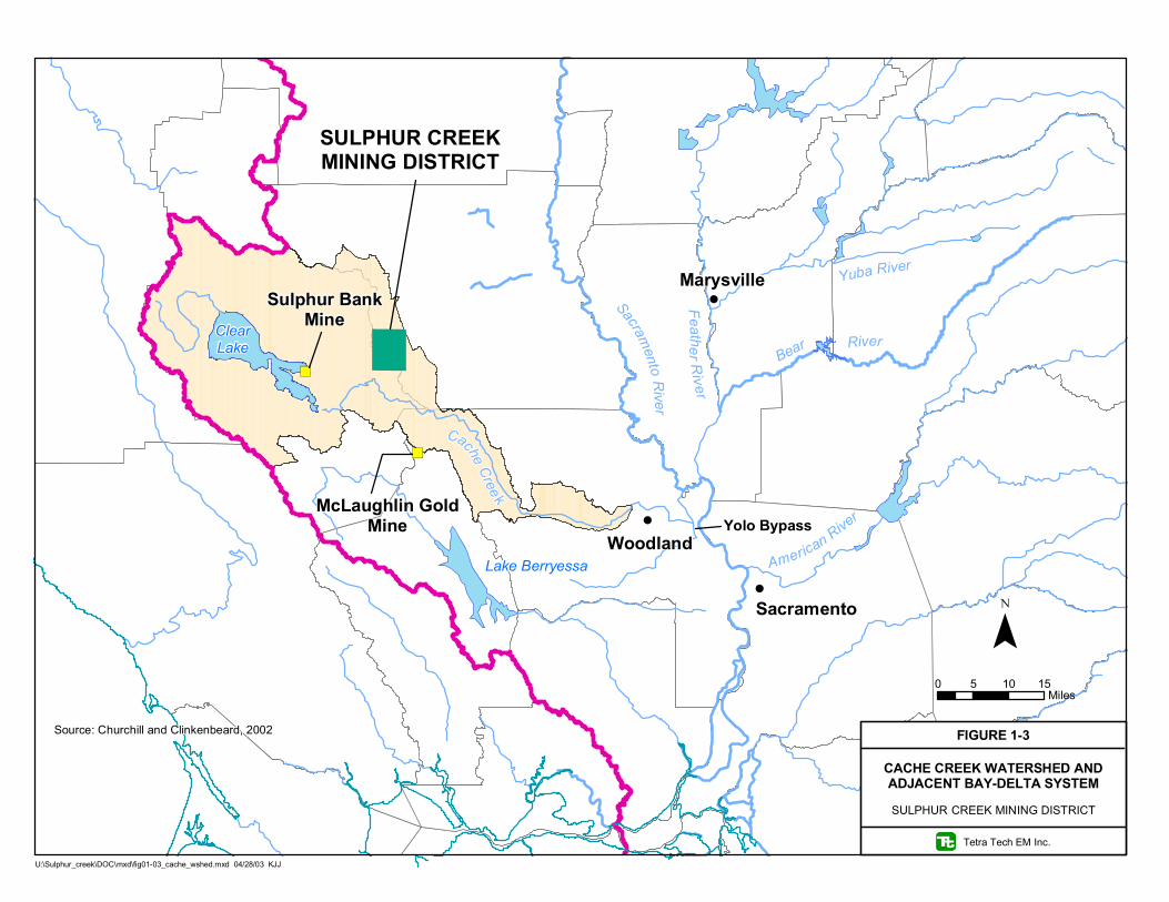
!
!
!
")
")
SULPHUR CREEKMINING DISTRICT
Yolo Bypass
Sulphur BankMine
McLaughlin GoldMine
Sacramento R
iver
Yuba River
American River
Bear River
Cache Cree k
ClearLake
Lake Berryessa
Feather River
Sacramento
Woodland
Marysville
U:\Sulphur_creek\DOC\mxd\fig01-03_cache_wshed.mxd 04/28/03 KJJ
0 5 10 15Miles
¯FIGURE 1-3
CACHE CREEK WATERSHED ANDADJACENT BAY-DELTA SYSTEM
Tetra Tech EM Inc.
SULPHUR CREEK MINING DISTRICT
Source: Churchill and Clinkenbeard, 2002

1-5
the Yolo bypass and Prospect Slough.
Mercury is present at District mine sites in a variety of sources: waste rock, tailings, ore piles; in-place
native soil and rock; and disturbed native soil and rock exposed by mining. All of these sources may be
subject to surface erosion by runoff during storm events. At some sites, local thermal-spring waters may
contact and leach mercury from one or more of these solid materials to local streams, may precipitate
mercury-containing compounds in spring pools and local streams, and may contribute dissolved mercury
to the watershed. The close proximity of mine waste to natural hydrothermal springs complicates
differentiation of the source of mercury (natural vs. mine-related). This EE/CA identifies specific
engineering controls that could reduce the migration of mercury to surface water from those mines where
offsite mercury movement is likely to occur and possible controls for mercury and sulphur in the
discharge from hydrothermal springs.
This EE/CA is organized into nine sections, of which a person familiar with the District may wish to
focus on Sections 8 and 9. The contents of Sections 2.0 through 9.0 are briefly described below.
Section 2.0, Background - briefly describes the District and associated mine site histories, climate,
geology and soils, hydrology and hydrogeology, vegetation and wildlife, significant historical and
archeological features, and land use and population.
Section 3.0, Summary of Investigations - summarizes watershed monitoring, previous mine-specific
investigations, presents a conceptual site model (CSM) for each mine site; and provides pollutant-loading
estimates for each mine site or group of mine sites, as appropriate.
Section 4.0, Summary of Mining Impacts to the Watershed - summarizes the human health, ecological
(environmental resources, wildlife, and others), and water quality impacts associated with the mines in
their current (pre-mitigation) state; and provides a summary of the ongoing total maximum daily load
(TMDL) development for mercury in the Cache Creek watershed (receiving water for the District).
Section 5.0, Summary of ARARs and Other Factors Affecting Mitigation - presents the California
state and federal ARARs (chemical-, location-, and action-specific), which may be applicable during
mitigation. These regulations may apply at a site when actions to reduce the mercury load begin. TMDL
reduction, historical and cultural resources preservation, endangered and special status species protection,
and property and water rights evaluation are also discussed.

1-6
Section 6.0, Mitigation Objectives and Goals - presents the preliminary mitigation objectives and goals.
Section 7.0, Identification and Screening of Response Actions, Technology Types, and Process
Options - identifies and describes general response actions, technologies, and process options; screens
technologies, and develops mitigation alternatives.
Section 8.0, Detailed Analysis of Mitigation Alternatives - presents the detailed analysis of mitigation
alternatives using effectiveness, implementability, and cost criteria.
Section 9.0, Comparative Analysis of Mitigation Alternatives - presents a comparative analysis of
mitigation alternatives for consistency with the effectiveness, implementability, and cost criteria;
summarizes analysis findings for each mine site; and presents a recommended mitigation strategy for each
mine site.

2-1
2.0 BACKGROUND
Background information pertinent to the EE/CA is discussed in the following sections. This information
includes project setting, site history, geology and soils, and hydrogeology and hydrology. The site
location, topography, and ownership; climate; vegetation and wildlife; and land use and population, and
regional geology are discussed below.
2.1 DISTRICT LOCATION AND TOPOGRAPHY
The District is located in Lake and Colusa counties approximately 20 miles west of Williams, California
(Figure 1-1). The District is located within the eastern side of the Coast Range geomorphic province of
California, about 8 miles west of the western margin of California’s central valley. The Coast Range
geomorphic province consists of northwest trending ridges between the Pacific Ocean and California’s
central valley. This portion of the Coast Range is dominated by moderately steep- to steep-slopes and
summits with steep narrow valleys. The District encompasses an area of about 22 square miles.
The District contains 14 inactive mine sites sporadically mined for mercury and/or gold between the
1860s and 1970s. These inactive mines include: Abbott, Turkey Run, Empire, Wide Awake, Cherry Hill,
West End, Manzanita, Central, Elgin, Clyde, Rathburn, Rathburn-Petray, Petray-South, and Petray-North.
This area includes the Sulphur Creek watershed and adjoining portions of the Bear Creek watershed to the
north in Colusa County and the Harley Gulch watershed to the south located in Lake County. These
watersheds are components of the larger Cache Creek watershed that drains into the Yolo Bypass.
Two of the mines within the District, Abbott and Turkey Run, are located in Lake County at the head of
Harley Gulch, along State Highway 20 about 24 miles west of Williams, California. The Abbott and
Turkey Run mines are located in Sections 31and 32, Township 14 North, Range 5 West, Mount Diablo
Base and Meridian (MDBM) and range in elevation between 1,678 to 1,992 feet above mean sea level
(amsl). The Abbott and Turkey Run mines are contained in an area at the head of Harley Gulch that
comprises about 424 acres.
Six of the mines within the District are located in the Wilbur Hot Springs hydrothermal area. The Wilbur
Hot Springs hydrothermal area is located in Colusa County within the Sulphur Creek watershed about
1-1/3 miles northeast of Harley Gulch. Mines within this area include the Empire, Wide Awake,
Manzanita, and Central mercury mines and the Cherry Hill and West End gold mines. These mines are
2-2
located in Sections 28 and 29, Township 14 North, Range 5 West, MDBM and range in elevation
between 1,400 to 1,640 feet amsl. The mines comprise a cumulative area of about 465 acres within the
Sulphur Creek watershed. Several of the mines are adjacent to and within 60 vertical feet of Sulphur
Creek. Two other mines, the Elgin mercury mine and the Clyde gold mine, are located about 3 miles
northwest of the Wilbur Hot Springs hydrothermal area, within the West Fork Sulphur Creek watershed.
Elgin Mine is located in Section 13, Township 14 North, Range 6 West, MDBM and comprises an area of
about 62 acres. Clyde Mine is located in Section 12, Township 14 North, Range 6 West, MDBM and
comprises an area of about 70 acres. The Elgin and Clyde Mines range in elevation from about 1,460 feet
and 1,600 feet amsl.
The remaining four mines with the District, Rathburn, Rathburn-Petray, Petray-South, and Petray-North,
are located in the Bear Creek watershed in Colusa County between 3 and 5 miles north of Harley Gulch.
These four mercury mines are located in Sections 6 and 7, Township 14 North, Range 5 West, MDBM
and comprises an area of about 248 acres. These four mines range in elevation between 2,200 to
2,400 feet amsl.
2.1.1 Hydrogeology
Little information is available pertaining to the hydrogeology surrounding the mines in Harley Gulch,
Sulphur Creek, and Bear Creek. There are no water wells reported in the California Department of Water
Resources database, located within 1 mile of the District. The groundwater beneath the District is
primarily hydrothermal in nature. Harley Gulch is fed by the Turkey Run hydrothermal spring. Sulphur
Creek is fed by Elgin, Blank, Elbow, Wilbur, and many unnamed hydrothermal springs emanating from
the bed of the creek, including springs fed by baseflow in stream gravels adjacent to the West End Mine.
Jones Fountain of Life, a geysering geothermal well, also contributes flow to Sulphur Creek. Bear Creek
receives input from several saline springs including Cook’s and Oil Springs. Flows from these saline
springs are generally low and range from 1.5 gallon per minute (gpm) to 6 gpm. The springs associated
with each mine are discussed in greater detail below.
2.1.2 Hydrology
The District lies within the 1,095 square mile Cache Creek watershed in the Coast Range of California.
In 2000 and 2002, the United States Geological Survey (USGS) measured an average flow of about 1,300
cubic feet per second (cfs) and a recorded peak flow of 4,300 cfs in Cache Creek (USGS 2002). These

2-3
flows were measured by the USGS as part of the CALFED study during relatively dry years (2000 and
2001). In addition, flow in Cache Creek is controlled by releases from Indian Valley Reservoir and Clear
Lake for irrigation during the summer growing season, and by runoff from precipitation during the winter
months. Releases from Clear Lake and Indian Valley Reservoir are curtailed to increase storage during
the winter months. Cache Creek flows into the Sacramento River, a major tributary to the Bay-Delta.
The upper Cache Creek basin is naturally divided into three sub-basins: Main stem (Cache Creek), North
Fork (Cache Creek), and Bear Creek. Creeks within the District contribute flow to the main stem of
Cache Creek and to Bear Creek. Based on a topographic watershed distribution, the District is divided
into the three watersheds that include Harley Gulch, Sulphur Creek, and Bear Creek. There are no dams
on Harley Gulch, Sulphur Creek or Bear Creek.
Harley Gulch is an ephemeral stream that drains a 5.1 square-mile area and flows into the main stem of
Cache Creek (Foe and Croyle 1998) about 1.5 miles below the main stem Cache Creek-North Fork of
Cache Creek confluence. Average summer flow in Harley Gulch for the period April 2000 through
September 2000 was 0.58 cfs. Average winter flow for the period January 2000 through March 2000 was
1 cfs with a peak flow during this period of 19 cfs (USGS 2002). These flows were measured by the
USGS in the relatively dry 2000 and 2001 water years as part of the CALFED study.
Sulphur Creek drains a 10-square-mile area and flows into Bear Creek, a tributary to Cache Creek (Foe
and Croyle 1998). Sulphur Creek is locally spring feed and has an average base summer flow of about
0.3 cfs, predominantly from springs. Peak flows of up to 81 cfs were recorded for Sulphur Creek in
February of 1963 (USGS 2002).
Bear Creek drains a 92-square-mile area and flows into Cache Creek. Bear Creek is locally spring fed
with tributaries that include Sulphur Creek and has an average base summer flow of about 500 cfs,
predominantly from springs at Holsten Chimney Canyon about four miles above Cache Creek. Peak
flows of up to 9,800 cfs have been recorded for this gauging station (USGS 2002).
2.1.3 Climate
Based on 45 years of meteorological data from the Western Regional Climate Center in Clear Lake,
California, the Sulphur Creek District receives an average of approximately 27 inches (68.6 centimeters
[cm]) of precipitation each year. Most of the precipitation is rain, but an occasional snowstorm occurs
during the winter months. The majority of the rain falls between November and March. The average
2-4
minimum temperature is 41.1 degrees Fahrenheit (oF) (5.1 degrees Celsius [oC]), and the average
maximum temperature is 72.4oF (22.4oC).
2.1.4 Vegetation and Wildlife
Vegetation in the District consists of an interior live oak plant community characterized by shrub oak,
interior live oak, chaparral, manzanita, forbs, shrubs, and grasses. In general, the mine sites within the
District are sparsely vegetated with exotic invasive plants present in disturbed areas. The District is
habitat for elk, mule deer, coyotes, and mountain lion. One California state threatened species, Indian
valley brodiaea (Brodiaea coronaria ssp rosea), was identified in the area of the Rathburn-Petray mine
group. No other threatened or endangered species have been identified in the area.
An inventory of plant and wildlife species of special concern has not been compiled for the District;
however, the California Department of Fish and Game Natural Diversity Database (CNDDB) was
reviewed for the District and surrounding areas. The CNDDB (2002) identified the following plant and
animal species within or with ranges that could overlap the District:
• Foothill yellow-legged frog (Rana boylii)
• Cooper’s hawk (Accipiter cooperii)
• Golden eagle (Aquila chrysaetos)
• Prairie falcon (Falco mexicanus)
• Townsend’s western big-eared bat (Corynorhinus townsendii townsendii)
• Northwestern pond turtle (Clemmys marmorata marmorata)
• Wilbur springs minute moss beetle (Ochthebius reticulates)
• Wilbur springs shore fly (Paracoenia calida)
• Wilbur springs shorebug (Saldula usingeri)
• Big-scale balsamroot (Balsamorhiza macrolepis var macrolepis)
• Hall’s harmonia (Harmonia hallii)
• Jepson’s milk-vetch (Astragalus rattanii var jepsonianus)
• Cobb mountain lupine (Lupinus sericatus)
• Two-carpellate western flax (Hesperolinon bicarpellatum)
• Adobe lilly (Fritillaria pluriflora)

2-5
2.1.5 Significant Historical and Archeological Features
Properties of the District are not listed on the National Register of National Historic Landmarks.
However, the mines were developed beginning in the 1800s, and Native Americans may have resided in
or used the area prior to mining. To ensure that significant historical and archeological features are not
disturbed, consultation with the State Historic Preservation Officer at the Office of Historic Preservation,
Department of Parks and Recreation, P.O. Box 942896, Sacramento, CA 94296-0001, (916) 653-6624
should be made prior to and during removal action planning.
2.1.6 Population and Land Use
The nearest community to the Sulphur Creek District is the town of Williams about 24 miles east, with a
population of about 4,100 (Williams Police Department 2003). However, the Wilbur Hot Springs Resort
is the year round home of up to 7 residents (Wilbur Hot Springs Resort 2003). The resort is located on
the north bank of Sulphur Creek about 1 mile east of the Central Mine. There are no known year-round
residents near any of the other mines. The primary land uses in the area include cattle grazing, recreation,
and fire wood harvest.
2.2 REGIONAL GEOLOGIC SETTING
The regional geology section includes discussion of the tectonic setting, stratigraphy, structural setting,
hydrothermal system, and occurrence of mercury for the region.
2.2.1 Regional Tectonic Setting
The northern California Coast Range east of the San Andreas Fault comprises the Great Valley Sequence
(GVS) and the Franciscan Complex. These two geologic units are separated by a regional thrust fault
referred to as the Coast Range thrust. The upper plate of the Coast Range thrust is considered to represent
a fragmented portion of oceanic crust or ophiolite of Late Jurassic age (Bailey and others 1970;
McLaughlin and Pessagno 1978), overlain depositionally by moderately deformed marine sedimentary
rocks of the GVS. The lower plate of the Coast Range thrust is composed of rock referred to as the
Franciscan Complex.

2-6
There is evidence (volcanic landforms, recent volcanic rocks, ash deposits in Clear Lake, and
hydrothermal springs) that shallow magma chambers have been present under the Geysers-Clear Lake
volcanic field since 1.1 million years ago. A shallow magma chamber, defined by geophysical evidence,
underlies the Geysers-Clear Lake volcanic field at the present time. The current chamber is the ultimate
heat source for the Sulphur Creek thermals springs, the Geysers geothermal system, the Sulphur Bank
hydrothermal system, and other thermal areas within this region (Hearn and others 1981).
2.2.2 Regional Occurrence of Mercury
Mercury ore deposits in the region consist of two different types, those associated with serpentinite, and
those associated with hydrothermal or hot spring systems. The mercury mines associated with
serpentinite occur in silica-carbonate rock resulting from the interaction of bicarbonate rich hydrothermal
solutions and serpentinite. These reactions presumably lead to the deposition of mercury minerals
(Barnes and others 1973). The mercury mines associated with hydrothermal systems are associated with
rock altered by reaction with acidified bicarbonate-poor hydrothermal solutions. The discovery and
development of these mercury ore deposits began in the mid-1800s. Significant mercury mining districts
are located to the southeast and west of the District. These districts include the Mayacamas and
Knoxville mercury districts and the Sulphur Bank Mercury Mine. The mercury-gold ores of the Sulphur
Creek and Knoxville mercury districts are unusual in that they contain abundant hydrocarbons.
The regional geologic units have been subjected to regional strain due to movement of tectonic plates.
The strain is manifested in the complex fold and fault geometry of the region. Regional faults localize the
expression of the hydrothermal systems. Chemical interaction between the hydrothermal solutions and
the rocks present resulted in the origin of the mercury and gold-mercury ore deposits that were developed
in the District.
2.3 ABBOTT AND TURKEY RUN MINES
Mining History and Production. The Abbott and Turkey Run mines are also know by the names of the
Abbott Group, Boggess Mine, Boggess Shaft, Black Dike Claim, Destinelle (Disturnelle) Mine, Excelsior
Prospect, and Wilbur-Springs-Abbott Mine. The Abbott Mine was discovered in 1862, and initial
production commenced in 1870 and continued until 1879. The property was idle from 1879 to 1889
when production resumed until 1906. The next operating period was from February 1916 through March
1917. Limited intermittent production also occurred between 1917 and 1940. Operations were resumed

2-7
in 1941 and continued through 1946 (Wiebelt 1949). The United States Bureau of Mines (USBM) is
reported to have conducted a diamond-drilling program on the property between 1948 and 1963
(USBM 1965). Minor production of mercury occurred in the early 1950’ and early 1960’s. The final
year of production was 1971.
The Abbott and Turkey Run mines produced about 30,880 flasks of mercury (one flask equals 76 pounds)
from initial mining through 1940 with an additional 6,600 flasks produced from 1941 to 1946. In 1944,
the Abbott Mine was the most important producer in Lake County and ranked third in the United States
(Wiebelt 1949). Total production is estimated to range between 50,000 and 60,000 flasks (Churchill and
Clinkenbeard 2002; Rytuba 1993).
Mine Workings. The Abbott Mine consists of extensive underground workings that include a series of
shafts, tunnels, open cuts, and glory holes, all located along the main ore-bearing zone. Operations were
from the 200- and 300-foot levels of the main vertical shaft, and from the Glory Hole, Ventilation and
Turkey Run adits (Figure 2-1). Mine workings extend for about 3,000 feet laterally and to a maximum
depth of about 500 feet below ground surface (USBM 1965) and the underground workings of the two
mines are connected (Churchill and Clinkenbeard 2002). Crawford (1894 and 1896) indicates that the
expense of timbering was reduced by backfilling the stopes with waste materials, but it is not known for
how long this practice continued, nor what quantity of mine waste was used as fill.
Presently Abbott Mine adits and shafts are blocked or caved and the head frames have collapsed or been
removed. The open cuts remain accessible to foot traffic and minor road repair would make them
accessible by vehicle. Presently at Turkey Run Mine, each lower adit is collapsed and water is
discharging from the collapsed adit northwest of the ore bin. The steel doors and concrete bulkhead at the
ventilation adit are in good condition.
Ore Processing Facilities. The ore processing or milling facilities at Abbott and Turkey Run mines
varied during their operation history and have included a 6 to 10 ton Knox & Osburne furnace and a 6 to
10 ton Hughes furnace (1890s) (Watts 1893a); a 48 ton Scott furnace (1913) (Bradley 1916a); a 45 ton
rotary furnace and two “D” retorts (Wiebelt 1949); and two 45 ton rotary furnaces and two “D” retorts
with two banks of vertical pipe condensers (USBM 1965).

P
CHECK DAM
GLORY HOLEGULCH DIVERSION
GLORY HOLE
!(
MAIN SHAFT
REMAINS OFBRICK FURNACE
!(
ORE BIN
UPPER ADIT
LOWER ADIT
VENTILATIONADIT
OFFICE
SHOP
ì
P
P
ì
P
P
GRIZZLY
MILL
FOUNDATION
ORE BIN / CONVEYOR
U:\Sulphur_creek\mxd_files\fig2-01_abbot_turkeyrun.mxd 07/11/03 KJJ
0 500250Feet
¯
EXPLANATION
TAILINGSWASTE ROCK
CUT
FOUNDATION
DIVERSIONSPRING
CAVED SHAFTMINEADITCAVED ADIT
PU
Ì
ìP
FIGURE 2-1
MINE FEATURES
Tetra Tech EM Inc.
ABBOTT AND TURKEY RUN MINESSULPHUR CREEK MINING DISTRICT
ìP

2-9
At the Abbott Mine, the primary grizzly (ore sizing grate) is present above the main mill and a single
rotary furnace is present in the mill along with two oil fired “D” retorts with two banks of vertical pipe
condensers. A concrete foundation and ore bin with a conveyor belt system are present east of the main
mill and east of this ore bin is another concrete foundation that appears to have held an older crusher or
mill. West of the main mill are the minor remains of a small brick furnace. No crushing or milling
facilities were observed at the Turkey Run Mine, however, the remains of an ore bin are present adjacent
to the lower adit. The mill at the Abbott Mine may be of historical significance.
Mine Waste Material. The most significant volume of mine waste material at the Abbott Mine is
tailings from the most recent milling operation. The main tailings pile is estimated to contain 165,000
cubic yard (CY) and two smaller tailings piles northwest of the main pile are estimated to contain about
7,700 CY. In addition, a small tailings pile exists to the east of the main tailings pile around the
foundation of a former mill or crusher. Waste rock or overburden is also present at numerous open cuts
near the top of the ridge and may amount to 7,400 CY. Open cuts above the Abbott Mine Glory Hole
area contain an estimated 3,200 CY of waste rock cast onto the slope below the open cuts.
Ore from the Turkey Run Mine was reportedly transported to the Abbott Mine for processing. With the
exception of tailings used as road metal, tailings piles have not been identified at the Turkey Run Mine.
There is also a small ore pile that may contain up to 370 CY beneath the ore bin at the Turkey Run Mine.
Open cuts above the Turkey Run Mine contain an estimated 114,000 CY of waste rock cast onto the
slopes below the cuts. The waste rock piles at the lower Turkey Run adit, including the road pile, are
estimated to contain about 12,900 CY.
Tailings were used as road material on most of the roads at Abbott and Turkey Run mines and have an
estimated average thickness of 12 inches. Churchill and Clinkenbeard (2002) estimated that 14,000 CY
of tailings cover approximately 6,200 feet of road as well as the bench between the main tailings pile and
the remains of a small brick furnace located to the west.
Geology. Bedrock at the Abbott and Turkey Run mines consists of shale, mudstone, sandstone, and
occasional conglomerate of the GVS. Lenses of serpentinite are also present. The lower contact of the
main ore lens varies in dip from 45 degrees to the southwest near the surface to nearly vertical at depth.
The dip along the upper contact is 60 degrees to the southwest and 80 degrees at the 300-foot level.
Small dike-like bodies of silicified serpentinite gouge which do not exceed 100 feet in thickness run in the
hanging wall parallel to the upper contact of the main lens. The ore is hosted in a silica-rich variety of

2-10
silica-carbonate rock composed of opal, chalcedony, quartz, magnesite, and a few veinlets of calcite
(Moisseeff 1966).
The principal ore mineral mined was cinnabar and metacinnabar was also reported in minor amounts
(Moisseeff 1966). Watts (1893a) also reported the occurrence of minor amounts of tiemannite. Native
mercury has not been identified as an ore mineral at the Abbott and Turkey Run mines. Sulfide minerals
associated with the ore include marcasite, pyrite, and native sulphur. Minor gold has also been reported.
The occurrence of post mining silky epsomite efflorescence was also reported by Watts (1893a).
Hydrocarbons were fairly common in some parts of the mine and Moisseeff (1966) reported that “A
noteworthy feature of the Ansel ore shoot was the presence of considerable amounts of solid and liquid
hydrocarbons” and “the amounts of gaseous hydrocarbons were also large enough to be considered a fire
hazard and required strong ventilation.”
Slope Stability. Current slope conditions are generally stable around the site. However, tension fractures
in tailings just below the mill and cracks in the lower portion of the concrete slab and foundation of the
mill indicate unstable slope conditions below the mill. A small landslide is also present down slope of the
Glory Hole and a larger landslide of about 2 acres is present below the southern portion of the open cut at
the Turkey Run Mine. This large landslide is moving toward Highway 20. In addition, local steep cuts in
serpentinite may also be less stable than the undisturbed surrounding ground.
Springs. At least one thermal spring was intersected in the workings of the Abbott Mine. The discharge
was estimated at approximately 16.8 gpm (Crawford 1894, 1896). White and others (1963) indicated the
thermal spring discharge at the Abbott Mine was about 25 gpm with a temperature of about 91.4°F. This
spring discharge is no longer present at the Abbott Mine and may have been redirected through
underground workings to discharge from the Turkey Run Mine. A flowing spring was observed
emanating from the collapsed lower adit at the Turkey Run Mine. Flow from the Turkey Run spring is
estimated to be about 15 gpm.
2.4 CENTRAL AND EMPIRE GROUP
Mining History and Production. Historically there may have been several mine openings that are now
considered the Central and Empire mines. Other historical names include Dewey, Little Giant, Mercury
Queen, Mercury King, Hidden Treasure, the Mercury Mine, and the Sulphur Creek Mine. The Empire
Mine was located in the 1870s and the Central Mine was discovered in 1891. Watts (1893b) reported

2-11
63 flasks of mercury produced from Empire Mine ore that was processed at the Buckeye Mine (later
called the Wide Awake Mine). Bradley (1918) reports that the Central and Empire group was operated in
conjunction with the Abbott Mine between 1890 and the early 1900s and it is possible that the ore mined
during this period was processed at the Abbott Mine. The USBM (1965) reported that significant
production did not take place from the Central and Empire group until 1926 when about 107 flasks were
produced. A small amount of mercury production is also reported for 1942 (USBM 1965). Total
reported production is estimated at 174 flasks.
Mine Workings. The workings of the Central and Empire mines are now caved but are reported to
include several hundred feet of underground drifts and crosscuts. The workings of the Central Mine
consisted of four short adits, the highest about 400 feet above Sulphur Creek. The Empire Mine may
have included at least three adits that where up to 150 feet long (Moisseeff 1966) (Figure 2-2).
There are no visible indications of the underground workings at the Central Mine. A rotary furnace and a
brick retort occupies the area where the mine symbol appears on the USGS topographic map. There are
also two open cuts above this location that comprise about 0.5 acres. There is one depression that may be
the remnant of one of the adits at the Empire Mine. There is no waste rock pile immediately below the
depression and there is no drainage from it.
Ore Processing Facilities. The remains of a small rotary furnace and a brick retort are present at the
Central Mine and a small brick retort is present at the Empire Mine. The rotary furnace and the brick
retort may be of historical significance. It is reported that in the early days of operation (1800s), ore was
concentrated by sluicing, which may have resulted in the loss of cinnabar to the creek.
It is possible that prior to 1926 all ore mined from the Central and Empire group was processed at the
Buckeye Mine or the Abbott Mine. In 1926, the small rotary furnace was installed at the Central Mine
but was not successful and all of the ore mined was processed in pipe retorts adjacent to the furnace
(Ransome and Kellogg 1939).
Mine Waste Material. Waste rock piles with conspicuous topographic relief are absent at the Central
and Empire Mines. However, the slopes above and below the Central mine have a local hummocky
appearance and are covered with thick grasses that may conceal small waste piles. In addition, the ground
upon which the brick retort is located may be composed of a mixture of tailings and waste rock and may
contain up to 1,000 CY. In addition, up to 1,000 CY of overburden or waste rock may be present below

Ì
WEST END MINE
Ì
ROTARY FURNACE / BRICK RETORT
BRICK RETORT
JONES FOUNTAIN OF LIFE
!(
!(
!(MILL FOUNDATION
ÌCHERRY HILL MINE
Sulphur
ì
P ìP
KNOX-OSBORNEFURNACE
!(!(
BRICK RETORT "D"!(
ROTARY FURNACE
!(
SCOTTFURNACE
!(
CONCRETEFOUNDATION
Ìì
Pì
P
ìP
ì
P
ì
P
ìP
U:\Sulphur_creek\mxd_files\fig2-02_wilbur_mines.mxd 07/11/03 KJJ
0 1,000500Feet
¯
FIGURE 2-2
MINE FEATURES
Tetra Tech EM Inc.
WILBUR SPRINGS AREA MINESSULPHUR CREEK MINING DISTRICT
EXPLANATION
WASTE ROCK
DIVERSION
ROAD
MINEÌ
ADIT
CAVED SHAFTU
OPEN SHAFT
OPEN CUT
ìP
Ì
TAILINGS

2-13
the cuts above the rotary furnace. Waste rock is also exposed in the slope below the retort at the Empire
Mine but it is inconspicuous due to the vegetation. The total volume of this pile may be up to 5,600 CY
(Churchill and Clinkenbeard 2002).
Geology. Bedrock at the Central and Empire group consists of shale, mudstone, sandstone, and
occasional conglomerates of the GVS. Lenses of detrital serpentinite are also present. The mineralized
zone is reported to be 25 to 30 feet wide and extend to a depth of 50 feet (USBM 1965). Cinnabar occurs
erratically in narrow white clayey seams and stringers in silicified and brecciated serpentinite or leached
silica-carbonate rock near the serpentinite-shale contact. Cinnabar is the only ore mineral reported to
occur in the Empire Mine (Moisseef 1966).
Slope Stability. The local hummocky appearance of the slope below the open cut at the Central Mine
may be related to soil creep. The open cuts are in serpentinite and these slopes may be prone to failure if
saturated by heavy rain of long duration. Storm water runoff has eroded several gullies into the bench of
the lower open cut. These gullies are head cutting and may create instability in the bench that could lead
to slope failure.
Springs. There are no reported springs emanating from the workings of the Central or Empire Mines.
2.5 MANZANITA MINE
Mining History and Production. There are several mine workings included in the Manzanita Mine.
The Manzanita Mine has produced both mercury and gold. The mine was discovered in 1863 and
operated as a gold mine until 1891. Cinnabar was produced as a by-product during gold production. The
mine was intermittently active between 1902 and 1942 and is reported to have produced more than 2,500
flasks of mercury during this time (USBM 1965). The mine may have operated in conjunction with the
Cherry Hill Mine in the 1920s. No records separating gold and mercury production are available prior to
1900 (Ransome and Kellogg 1939).
Mine Workings. The Manzanita group has numerous adits and shafts, most of which are now caved and
inaccessible. Ore has also been mined using open cut methods (Figure 2-2).

2-14
Currently there is one open adit about 45 feet above the floodplain and there are several small open cuts,
no more than 50 feet in depth between the adit and the top of the hill. Near the top of the hill is an open
vertical shaft of unknown depth.
Ore Processing Facilities. Ore processing methods have been variable and dependant on the commodity
being sought. Ores of gold and mercury at this site were typically concentrated by mechanical methods
prior to metal recovery. Irelan (1888) reports that a ten-stamp mill was used to crush the ore and the pulp
was concentrated in blanket sluices followed by two combination pans using sodium amalgam and
bluestone amalgam. Watts (1893b) reports that three 5-foot Huntington mills, seven Victor concentrators,
three 5-foot amalgamating pans, two 8-foot settlers, a No. 1 Gates crusher, and a 65 horse-power engine
and boiler were operated for gold and mercury extraction. Averill (1943) reports that a pilot plant for
processing Manzanita ore was erected at the Wide Awake Mine, which is included in the description of
the Wide Awake ore processing facilities.
There are no remnants of mill structures at the Manzanita Mine. There appear to be tailings exposed in
the north stream bank of Sulphur Creek and there is a concrete foundation that may have been part of a
crushing facility and stamp battery west of the adit.
Mine Waste Material. Waste rock piles are sparse and are limited to the lower portion of the hill below
the area of argillic alteration. Tailings are not conspicuous at the surface near the mine but tailings appear
to be exposed in the bank of Sulphur Creek above Jones Fountain of Life and may be buried in the flood
plain along Sulphur Creek. According to Watts (1893b), pan amalgamation is reported to have been used
to recover gold and may have resulted in native mercury or amalgam being present in the tailings.
Waring (1915) indicates that tailings from the mercury mill are present in the streambed below Jones
Fountain of Life. The volume of tailings is estimated to be about 23,000 CY.
Geology. Bedrock at the Manzanita group consists of shale, mudstone, sandstone, and conglomerates of
the GVS. At Manzanita Mine, the host rocks are faulted, fractured and hydrothermally altered (leached)
(USBM 1965). Gold occurs as specks in leached zones, probably liberated by the oxidation of pyrite or
marcasite (Moisseeff 1966). Cinnabar is the main mercury mineral but metacinnabar is also reported to
occur. Watts (1893b) reported that cinnabar could be panned from the soil on the higher portions of the
hill. Other sulfide minerals reported to occur include marcasite, pyrite, stibnite, and native sulfur.
Moisseeff (1966) reports the occurrence of the zeolite minerals epistilbite and chabazite and quartz and

2-15
calcite are gangue minerals. Bitumen is also reported to occur and apparently created a problem for some
of the gold processing operations.
Slope Stability. The slopes at Manzanita Mine are not hummocky appearance like the slope below the
open cut at Central Mine to the east. This is likely due to the GVS bedrock at Manzanita Mine versus the
serpentinite at Central Mine. There do not appear to be any slope stability issues with the open cuts or
glory holes at Manzanita Mine.
Springs. No springs were observed emanating from the workings of the Manzanita Mine. Though
gasses emanate from the adit. In addition, multiple unnamed hydrothermal springs emanate from the
streambed of Sulphur Creek below Manzanita Mine. Jones Fountain of Life, a geysering geothermal
well, is located opposite the mine on the south side of Sulphur Creek. Elbow Springs emanates from the
streambed of Sulphur Creek downstream of Jones Fountain of Life.
2.6 CHERRY HILL AND WEST END MINES
Mining History and Production. Gold production records for the Cherry Hill Mine are fragmentary.
Gold production records are not available for West End Mine as this mine was likely operated in
conjunction with Cherry Hill Mine. There is no evidence that either mine produced mercury.
Mine Workings. The Cherry Hill Mine workings consist of two short adits that have a maximum length
of about 100 feet. The West End mine workings consist of three adits, the extent of which is unknown
(Figure 2-2). The workings at the Cherry Hill Mine are open and accessible. The adits at the West End
Mine are equipped with grates to prevent access by humans.
Ore Processing Facilities. Ore processing facilities at the Cherry Hill mine consisted of a stamp mill
with coarse gold recovery tables (Watts 1893b). There is no reported processing operation at the West
End Mine. West End ore was reported to be very siliceous and similar in milling quality to Cherry Hill
ore and it is inferred that processing of West End ore was done in the Cherry Hill stamp mill. Currently,
only various pieces of iron from the mill and concrete foundations remain at Cherry Hill Mine. The mill
foundations may be of historical significance.
Mine Waste Material. Currently, there is no mine waste rock pile outside of the short adits at Cherry
Hill. There is small waste rock pile (about 578 CY) on the Sulphur Creek floodplain about 500 feet

2-16
northeast of the adits. This pile is of unknown origin. There is currently a waste rock pile at the West
End Mine that may contain up to 3,600 CY of waste rock (Churchill and Clinkenbeard 2002). Assays
obtained during this study indicated gold concentrations of up to 0.30 ounces per ton.
Geology. Bedrock at the Cherry Hill and West End mines consists of mudstone, siltstone, sandstone, and
conglomerate of the basal GVS (Pearcy and Petersen 1990). Mineralogy is relatively simple in that
electrum and cinnabar are the primary ore minerals with adularia, silica, and carbonate, the dominant
gangue minerals. Adularization is strongest at West End Mine, where alteration has largely obscured
bedding and laminations. Sulfide minerals include pyrrhotite, pyrite, and marcasite. Various liquid and
solid hydrocarbons are also present (Pearcy and Petersen 1990).
Slope Stability. Slope failures or collapse of mine workings were not observed at the Cherry Hill Mine
or West End Mine.
Springs. No springs were observed emanating from adits at the Cherry Hill Mine or West End Mines.
2.7 WIDE AWAKE MINE
Mining History and Production. The Wide Awake Mine has other historical names that include Wide
Awake Consolidated, Buckeye, Buckeye Quicksilver, and Jefferson. The Wide Awake Mine was
discovered in the 1870s and may have originally been known as the Buckeye Mine, a name retained until
the 1890s, at which time it was renamed the Wide Awake Mine. Production during the 1870s is
estimated to be 1,800 flasks of mercury. A small amount of production is reported during the 1890s and
early 1900s. Some production may also have occurred in 1932 and 1943 (USBM 1965). Total
production is on the order of 1,800 flasks.
Mine Workings. Early production was from shallow workings and later, in the 1870s, vertical shafts
with levels at 190, 290, and 390-feet were sunk. During shaft dewatering Blank Spring, a small local
thermal spring to northwest of Wide Awake Mine, stopped flowing (Figure 2-2).
Open shafts were not observed. However, there is a concrete foundation next to a slight depression that is
surrounded by mercury condensor piping in the dry creek bed to the west of the Scott Furnace. This may
be the location of a shaft. Several small open cuts are present along the eastern margin of the drainage.

2-17
Ore Processing Facilities. Ore processing facilities in the 1870s included a Knox-Osborne 10-ton
furnace and two small retorts. In the early 1900s, a 24-ton Scott ore furnace was installed and scarcely
used before the mine ceased to operate. Averill (1943) reports that in a pilot plant at the Manzanita Mine
ore was concentrated on a Wilfley table and treated in a 15-foot rotary furnace with an outside diameter of
30-inches and an inside diameter of 20 inches. The rotary furnace had a 4- ton per day capacity and was
heated with butane.
Currently, remains of the Knox-Osborne furnace and the two small retorts are present. Much of the 24-
ton Scott furnace and the rotary furnace with condenser coils remain largely intact. The rotary furnace,
Scott furnace and brick retorts may be of historical significance.
Mine Waste Material. The total volume of waste rock at the Wide Awake has been estimated to be
about 8,000 CY (Churchill and Clinkenbeard 2002).
Tailings are present over an area of approximately 1.25 acres and are estimated to have an average
thickness of 10 feet and contain about 20,000 CY. Waste rock exposed in the eastern stream bank below
the rotary furnace may contain up to 11,000 CY.
Geology. Bedrock at the Wide Awake Mine consists of shale, mudstone, sandstone, and conglomerates
of the GVS. Lenses of detrital serpentinite also occur at the Wide Awake Mine. According to the USBM
(1965) cinnabar is the primary ore mineral but metacinnabar has also been identified. Cinnabar occurs in
opalized and altered serpentinite breccia along a serpentinite-shale contact. The mineralized zone strikes
northwest and dips to the southwest and is traceable on the surface for about 1 mile. The mineable vein
on the 190-foot level was reported to be 5 to 16 feet in width (USBM 1965).
Slope Stability. There does not appear to be any slope stability issues with the open cuts at the Wide
Awake Mine.
Springs. The structure controlling Blank Spring was apparently encountered while sinking one of the
shafts. Flow rates from the shaft were not recorded, but a temperature of 103° F was reported. According
to Waring (1915), discharge from the spring intercepted in the shaft was about 4 gpm.

2-18
2.8 ELGIN MINE
Mining History and Production. The Elgin Mine is also known as the Elgin prospect or the New Elgin
Mine. Elgin Mine was discovered in the 1870s and at least 52 flasks were produced in 1875 (Mining and
Scientific Press 1875). Some development work and small production is also reported for the period 1892
to 1893, 1905, and 1916 (Ransome and Kellogg 1939). Ore produced has had an average grade of about
1.8 percent mercury (Huguegin 1917).
Mine Workings. The workings of the Elgin Mine include three adits, about 500 feet of inaccessible
underground workings, and two disturbed surface areas. Watts (1893b) reported one adit about 400 feet
above the creek and 180-feet long and a second adit about 70-feet above the previous adit with a length of
about 110 feet. High rock temperatures and hot water encountered during mining are reported to have
made underground mining difficult (Watts 1893b)
Currently the main adit is collapsed and thermal waters flow from the collapsed adit into a man-made
pool and then through a steep drainage to Sulphur Creek. Southeast of the main adit are two other adits,
one of which is caved, and the other is open (Figure 2-3). No springs or drainage were observed flowing
from these adits. Above the main adit, to the northwest and southeast are small open cuts that comprise
about 1 acre. Numerous springs and seeps discharge from fractures on the steep slopes below the mine
workings.
Ore Processing Facilities. Ore processing prior to 1903 was performed with an 800 pound per day
retort. Forstner (1903) indicated that a 10-pipe retort was in use on the property. Bradley (1916a)
reported that the mine was equipped with a retort furnace and used a Griffin mill and Colorado bumping
tables to concentrate the cinnabar. Huguenin (1917) reported that one Fitzgerald furnace and a one-ton
per day mill, as well as a practically dismantled crusher and concentrator tables were on site.
Three in place McFarland shaker or bumping tables are present and the remains of three others are in the
drainage below the main adit and the remains of a retort are present in the bottom of the drainage on the
west side of Sulphur Creek. The shaker tables may be of historical significance.
Mine Waste Material. Waste rock piles still exist below and around the open cuts. The total volume of
waste rock at the Elgin has been estimated to be between 1,000 and 4,100 CY (Churchill and
Clinkenbeard 2002). The hot spring pool outside of the collapsed main adit is likely constructed on top of

HOT TUB SPRING
SPRING POOL
!( McFARLAND TABLES
!(RETORT
U:\Sulphur_creek\mxd_files\fig2-03elgin.mxd 07/11/03 KJJ
0 400200Feet
¯
EXPLANATION
WASTE ROCK
SPRING
ADIT
CAVED ADIT
P
FIGURE 2-3
MINE FEATURES
Tetra Tech EM Inc.
DISTURBED AREA
ELGIN MINESULPHUR CREEK MINING DISTRICT

2-20
mine waste. The mine waste extends down the drainage for a distance of about 200 feet below the pool.
Discrete waste rock piles were not observed below the adits to the southeast of the collapsed main adit.
However, there are very small, vegetated hummocky piles associated with the adits to the southeast of the
main adit that may contain up to 500 CY. A small volume of tailings (less than 100 CY) is present near
the remnants of a brick furnace on the west side of Sulphur Creek.
Geology. Bedrock at the Elgin Mine consists of shale of the GVS and serpentinite. The serpentinite
trends northwest to southeast and the ore occurs in silicified, leached serpentinite along the upper contact
with shale. The mineralized zone contains opal, aragonite, magnesite, chabazite and a bituminous
mineral. The ore is concentrated along small faults that cut the serpentinite (USBM 1965; Moisseeff
1966). Cinnabar is the only mercury mineral reported to occur. Pyrite and native sulfur have also been
reported and it is reported that sulfur is so abundant that attempts were made to operate the mine for
sulfur rather than mercury (Moisseeff 1966). A small amount of gold was also reported to have been
produced (Fairbanks 1894). Siliceous sinter that resembles the siliceous sinter at the Geysers was also
reported (Waring 1915).
Slope Stability. There do not appear to be any slope stability issues with the open cuts or the waste rock
piles at the Elgin Mine. The west side of the Sulphur Creek drainage is very steep below the mine
workings and there is no evidence of slope failure on these slopes.
Springs. Numerous springs were observed in the Elgin Mine area. At least one of these has been
intersected by the underground mine workings and is now emanating from the collapsed main adit
described above. This flow is collected in a man-made pool about 60 feet from the collapsed adit before
it enters a steep drainage, which conducts the hydrothermal waters to Sulphur Creek. Flow from the
collapsed main adit was reported to be about 28 gpm with a temperature of 138°F (Bradley 1916b). Flow
from the collapsed main adit into the pool was observed at about 20 gpm during this study. Considerable
flour sulfur is being deposited along the edges of the stream. In addition, there are numerous springs
emanating from outcrops near the hot tub. Combined flow from the hot tub springs is estimated to be
about 45 gpm and a portion of this flow is routed into the hot tub. Overland flow from these springs was
not observed entering Sulphur Creek, when the site was visited in October 2002, and appears to infiltrate
the alluvial valley fill at the base of the slope below the mine.
2-21
2.9 CLYDE MINE
Mining History and Production. The presence of gold bearing quartz veinlets was recognized at the
Clyde mine in the 1870s (Watts, 1893b). In 1886 or 1887 a shaft was sunk to a reported depth of 146
feet. Gold production was reported to be “$200 per day” (Watts, 1893b). Drifts from the shaft were
reportedly driven at depths of 60 and 90 feet. In 1888 a timbered adit and associated crosscut and two
winzes were advanced below the earlier workings. In 1890 another shaft was located south east of the
original workings, but was abandoned when “much water” was encountered (Watts, 1893b).
Mine Workings. Currently the workings of the Clyde Mine group include three adits that are open or
partially caved at the portals and contain standing water. There are also bulldozer cuts or trenches west
and southeast of the adits. In addition there is a storm water retention pond southeast of the adits (see
Figure 2-4).
Ore Processing Facilities. In the 1880s, gold ore was processed on site in a 3.5-foot Huntington mill
(Watts, 1893b).
Mine Waste Material. Tailings piles eroding into the creek may contain up to 15,500 CY and the small
piles related to the bulldozer trenches may contain a total of 1,450 CY (Churchill and Clinkenbeard
2002). Tailings piles from the adits are small and may total 2,000 CY. Tailings used to construct the
storm water pond may contain up to 10,000 CY.
Geology. The bedrock at the Clyde Mine is serpentinite.
Slope Stability. Slope stability issues were not observed with the adits or cuts. However, the storm
water pond levee has been breeched and will continue to erode into the drainage during storm events. In
addition a depression located along the strike of the lower most adit may be a collapse feature related to
underground workings.
Springs. There were no springs observed at the Clyde Mine during this study but flow up to 10 gpm was
observed in the drainage immediately below the adits. Freshwater springs above the mine are responsible
for this flow.

ADIT1
ADIT-3
ADIT-2
U:\Sulphur_creek\mxd_files\fig2-04_clyde.mxd 07/07/03 KJJ
0 500250Feet
¯
EXPLANATION
STORM WATERBASIN
SPRING
ADIT
P
FIGURE 2-4
MINE FEATURES
Tetra Tech EM Inc.
CLYDE MINESULPHUR CREEK MINING DISTRICT

2-23
2.10 RATHBURN-PETRAY MINE GROUP
Mining History and Production. The Rathburn, Rathburn-Petray, and Petray Mines correspond to some
but possibly not all of the old claims and prospects listed in historical reports that include the Old
Kentucky claim, Kentucky Mine, Last Resort claim, May Day claim, Juniper claim, Juniper Mine, Juniper
Mercury Mine, Laurel claim, Ukiah, Petray, Petray prospect, and Farris claim. Limited information is
currently available regarding which claims and prospects cited in the reports correspond to the four
surface mines now present at this location. It is believed that the Rathburn Mine was the largest producer
before 1900, during which time it was an underground mine. The initial discovery date is not known,
however, the mine is reported to have worked intermittently prior to 1892. The greatest activity is
reported from 1892 to 1893 and included the production of over 100 flasks of mercury. Minor production
also occurred in the late 1960’s and early 1970’s.
Mine Workings. The original workings of the mine group included numerous shafts and adits. None of
the underground workings were observed in this study and they are presumed to be collapsed or have
been removed by subsequent surface mining operations. These surface operations included shallow
surface mining and exploration trenches, presumably during the 1950’s and 1960’s (see Figures 2-5 and
2-6). The California State Department of Public Health (1973) indicates that in 1971 the Petray open pit
mine was active only in June and July, that the ore was treated by rotary furnace at the Abbott Mine. The
California State Department of Public Health also reported that the mine was closed as of July 1972.
The Rathburn Mine contains a small open pit of about 0.45 acres. The Rathburn-Petray Mine pit
comprises about 3.7 acres. The Petray-South pit comprises about 4.1 acres and the Petray-North pit
comprises about 3.1 acres.
Ore Processing Facilities. Ore processing consisted of small retorts in the early days and a furnace was
constructed, presumably in the early 1890s, but was not successful (Watts 1893b). Nothing is recorded
about the processing facilities used in the 1960s and 1970s. It is assumed that ore mined in the 1960s was
taken to the Abbott Mine for processing (Churchill and Clinkenbeard 2002). Scattered bricks are present
at the Rathburn Mine suggesting the presence of a retort or furnace at that location. There is no other
evidence of ore processing elsewhere in the mine group. The remains of an apparent hopper foundation
are present northwest of the Petray-South pit. There are no structures of historical significance.

U:\Sulphur_creek\mxd_files\fig2-05_rathburn.mxd 07/07/03 KJJ
0 200100Feet
¯
EXPLANATION
WASTE ROCK
CUT / PIT
PROSPECT
FIGURE 2-5
MINE FEATURES
Tetra Tech EM Inc.
D
RATHBURN MINESULPHUR CREEK MINING DISTRICT

PETRAY NORTH
PETRAY SOUTH
RATHBURN-PETRAY
!(CRUSHER SITE
U:\Sulphur_creek\mxd_files\fig2-06_rathburn_petray.mxd 07/07/2003 KJJ
0 500250Feet
¯
EXPLANATION
WASTE ROCK
CUT / PIT
SPRINGP
FIGURE 2-6
MINE FEATURES
Tetra Tech EM Inc.
PROSPECTD
PETRAY AND RATHBURN-PETRAY MINESSULPHUR CREEK MINING DISTRICT

2-26
Mine Waste Material. Several waste rock piles exist around the perimeters of the pits. The Rathburn
Mine may contain up to 6,500 CY of waste rock. The eastern waste rock pile at Rathburn-Petray Mine
may consist of up to 80,000 CY and the pit berm pile may contain up to 15,000 CY. Several waste rock
piles at the Petray-South Mine may contain a total of 7,400 CY. The Petray-North pit waste rock pile
may contain up to 4,300 CY (Churchill and Clinkenbeard 2002).
Geology. Bedrock at the Rathburn-Petray Mine Group consists of serpentinite and the ore occurs in
silicified fractures in the serpentinite. Cinnabar is the only reported mercury ore mineral (Churchill and
Clinkenbeard 2002).
Slope Stability. The eastern waste rock pile at the Rathburn-Petray mine is located on a steep slope.
Activity that disturbs this slope would likely lead to slope failure. The north side of the Petray-North pit
coincides with a fault zone and is unstable. A portion of the north pit wall has failed. There does not
appear to be any slope stability issues with the open cuts or the waste rock piles at the Rathburn or Petray-
South mines.
Springs. Springs have not been identified at any of the mines in the Rathburn-Petray Group.

3-1
3.0 SUMMARY OF INVESTIGATIONS
This section summarizes the findings of watershed-scale monitoring (Slotton and Ayers 2001,
Domagalski and Alpers 2000), mine-specific investigations (Suchanek and Others 2000, Churchill and
Klinkenbeard 2002), and the recent field inspection within the District; presents a CSM for each mine site
in the District; and provides pollutant loading estimates for individual mines, springs, and creeks in and
receiving water from the District.
3.1 WATERSHED-SCALE MONITORING
A study is currently underway to assess the ecological and human health impacts of mercury in the Bay-
Delta Watershed. Work includes compiling previous hydrochemical and biological investigations from
associated tributary watersheds, and designing and conducting studies to evaluate the mercury cycle from
various sources to the Bay-Delta. Preliminary findings indicate Cache Creek watershed is a major source
of mercury to the Bay-Delta, and mercury loads can be traced up the Cache Creek watershed to tributaries
including Bear Creek, Sulphur Creek, and Harley Gulch. These sub-basins drain active hydrothermal
springs and vents, soils naturally enriched in mercury, and abandoned mercury and gold mines in the
District (Regional Water Quality Control Board, Central Valley Region [RWQCB] 2001). Therefore, the
upper Cache Creek watershed, specifically the Bear Creek, Sulphur Creek, and Harley Gulch drainages,
are of particular interest in the ongoing Bay-Delta mercury investigation.
3.1.1 Cache Creek
The Cache Creek watershed encompasses approximately 1,095 square miles, and drains the Coast Range
mountains on the western edge of the Sacramento Valley. USGS has divided the watershed into upper
and lower basins, at the town of Rumsey (Domagalski and Alpers 2000). The upper Cache Creek basin is
largely undeveloped chaparral and shrub oak habitat, where the primary land use is as rangeland (Foe and
Croyle 1998). Large areas in the upper basin are highly erosive, and the upper 33-mile reach from Clear
Lake to Rumsey has a steep average gradient of 27 feet per mile (RWQCB 2001). With such a steep
gradient, sediment is constantly transported down the watershed in all but the lowest flow conditions (Foe
and Croyle 1998). Population centers in the upper Cache Creek basin include the towns of Clearlake and
Rumsey. The upper basin is further divided into three sub-basins: the North Fork of Cache Creek, Cache
Creek main stem, and Bear Creek. Flow in the North Fork and Cache Creek main stem is controlled by
dams impounding Indian Valley Reservoir and Clear Lake, respectively. The combined storage capacity

3-2
of the two reservoirs is 393,000 acre-feet, 80 percent of which is within Clear Lake (RWQCB 2001).
Storm runoff is captured in the winter and spring for irrigation use in the summer.
The lower Cache Creek basin extends from the town of Rumsey to the Cache Creek Settling Basin, near
the city of Woodland. The settling basin was designed to trap suspended sediment and minimize flooding
in the Yolo Bypass during flood events. Land in the lower Cache Creek basin is intensively farmed with
row crops, orchards, and rice (Foe and Croyle 1998). The gradient is much lower than in the upper basin,
averaging 6 feet per mile over a 30-mile stretch, and sediment transported from upstream is generally
deposited as the gradient decreases (RWQCB 2001). The lower Cache Creek basin is more populous than
the upper basin, including the towns of Guinda, Brooks, Capay, Esparto, and the Rumsey Rancheria in
Capay Valley. An inflatable dam is used at Capay, and during the irrigation season, flow is diverted to
the Winters and Adams canals. During peak irrigation, Cache Creek below the Capay Dam is mostly dry
(Foe and Croyle 1998).
Previous studies have measured mercury concentrations throughout the Cache Creek watershed.
Investigations conducted during base flow and peak storm flow conditions have documented that mercury
concentration increases up to two orders of magnitude during large runoff events (Foe and Croyle 1998).
Total and methyl mercury concentrations varied significantly between creek reaches within the Cache
Creek watershed. Mercury concentration ranges at selected Cache Creek monitoring points are
summarized in Table 3-1 below. Maximum concentrations represent peak storm flow conditions;
mercury concentrations are near the minimum concentrations for most of the year.
TABLE 3-1. RANGE OF MERCURY CONCENTRATIONS IN CACHE CREEK
Range of Total Mercury Range of Methyl Mercury
Location Concentrations (ng/L) Concentrations (ng/L)
North Fork Cache Creek 1 to 1,381 0.0244 to 0.17
Cache Creek (main stem) 0.3 to 35 0.02 to 0.4
Cache Creek above Confluence with
Bear Creek 4 to 3,939 Not reported
Cache Creek at Rumsey 2 to 2,887 0.04 to 0.9
Flow into Cache Creek Settling Basin 2 to 1,295 0.0887 to 0.576
Discharge from Cache Creek
Settling Basin 7 to 985 0.204 to 0.443

3-3
Flow into Cache Creek Settling Basin 2 to 1,295 0.0887 to 0.576
Cache Creek at Rumsey 2 to 2,887 0.04 to 0.9
Cache Creek above Confluence with
Bear Creek 4 to 3,939 Not reported
North Fork Cache Creek 1 to 1,381 0.0244 to 0.17
Cache Creek (main stem) 0.3 to 35 0.02 to 0.4
Notes: ng/L = Nanogram per liter Data sources: Foe and Croyle (1998), Domagalski and Alpers (2000), Slotton and Ayers (2001).
Additional water sampling was conducted in upper Cache Creek basin tributaries to identify specific
mercury sources. Total mercury concentrations were generally lowest in the Cache Creek main stem,
which is fed by controlled releases from Clear Lake. Flow in the North Fork of Cache Creek is controlled
by discharges from Indian Valley Reservoir, and mercury concentrations were similarly low during low
flow conditions. However, mercury concentrations in the North Fork of Cache Creek increased by as
much as two orders of magnitude during storm events. Benmore Canyon Creek and Grizzly Creek are
ephemeral tributaries to the North Fork, each draining 7- to 8-square mile watersheds on the western
slope of the District. Neither watershed is known to contain mines or hydrothermal springs, but mercury
concentrations in Benmore Canyon Creek and Grizzly Creek ranged from 2,000 to 3,000 ng/L during
storm events (RWQCB 2001). Storm runoff discharges from Benmore Canyon and Grizzly creeks had
mercury concentrations 12 times greater than the North Fork of Cache Creek above these tributaries
(RWQCB 2001). This mercury likely originates from suspension of natural mercury containing soils with
normal background mercury levels.
The highest mercury concentrations in Cache Creek were measured below Cache Creek Canyon, a limited
access reach between the confluence of the North Fork and main stem and downstream of Bear Creek.
Limited data from this inaccessible reach of Cache Creek suggest Davis Creek and Harley Gulch may be
significant mercury inputs to Cache Creek in Cache Creek Canyon (Foe and Croyle 1998; RWQCB
2001). Davis Creek drains the Knoxville gold and mercury mining district, downstream from the Reed,
Harrison, and McLaughlin mines. Though a reservoir was constructed in the 1980s on Davis Creek to
capture sediment and reduce mercury transport, residual mercury-bearing sediment below the reservoir
may still contribute mercury to Cache Creek (RWQCB 2001). The Harley Gulch drainage is discussed in
detail in Section 3.1.4.
3-4
Mercury concentrations were found to be significantly greater during peak storm flows relative to base
flow conditions. During peak flows, most mercury was particulate bound, and dissolved mercury
concentrations were only a fraction of total mercury concentrations (Foe and Croyle 1998). The relative
percentage of dissolved mercury generally increased during low flow conditions when less particulate-
bound mercury was mobilized. Particulate-bound mercury was mobilized by overland sheet flow during
storms, and appeared to be relatively non-reactive, with minimal methylation (Domagalski 2001;
Suchanek and others 2000). The low reactivity and methylation is attributed to the state of mercury in
Cache Creek during peak flow periods; the majority of mercury occurs as non-soluble cinnabar
(Domagalski 2001). Mercury concentrations in Cache Creek suspended sediments from sampling
locations near mine sites ranged from 0.2 to 0.7 parts per million (ppm) during base flow conditions, and
from 1.8 to 14.5 ppm during storm runoff (Foe and Croyle 1998; Domagalski 2001). Mercury
concentration in suspended sediments increased as surface runoff carried particulate-bound mercury into
the upper basin, and existing mercury-containing sediments within usually low energy environments were
remobilized.
Biological studies in Cache Creek have documented elevated mercury concentrations in aquatic
organisms. Tissue analysis on fish collected from the lower Cache Creek watershed below Rumsey have
documented tissue mercury concentrations as high as 1.5 ppm (RWQCB 2001). The U.S. Environmental
Protection Agency (EPA) criterion for human protection is 0.3 ppm, and the results of tissue sampling
warranted concern.
3.1.2 Bear Creek
Though the Bear Creek drainage is significantly smaller than the North and main stem Cache Creek
drainages, Bear Creek collects drainage from a number of identified mercury sources (Foe and Croyle
1998). Sulphur Creek, a tributary to Bear Creek, collects drainage from the Clyde, Elgin, West End,
Cherry Hill, Wide Awake, Manzanita, Central, and Empire mines. Additional unnamed tributaries within
the Bear Creek watershed collect drainage from the Rathburn and Petray mines. Bear Creek was
therefore identified as a potentially significant source of mercury within the upper Cache Creek basin. A
summary of mercury concentrations measured in the Bear Creek watershed is presented in Table 3-2
below. As with Cache Creek water samples, mercury concentrations are generally at the lower end of the
concentration range except during peak storm flow conditions.

3-5
TABLE 3-2. RANGE OF MERCURY CONCENTRATIONS IN BEAR CREEK
Range of Total Mercury Range of Methyl Mercury
Location Concentrations (ng/L) Concentrations (ng/L)
Bear Creek above confluence
with Cache Creek 3.5 to 1,290 0.153 to 0.580
Bear Creek below confluence
with Sulphur Creek 10 to 1,596 0.15 to 1.5
Bear Creek above confluence
with Sulphur Creek 63 to 500 Not reported
Upper Bear Creek 0.6 to 39 0.05 to 0.21
Notes: ng/L = Nanogram per liter Data sources: Foe and Croyle (1998), Domagalski and Alpers (2000), Slotton and Ayers (2001), Goff and others (2001).
In general, water samples from Bear Creek watershed had relatively high dissolved mercury
concentrations, possibly released by hydrothermal springs. Available data show that Bear Creek methyl
mercury concentrations were generally similar in magnitude to concentrations in Cache Creek. Water and
sediment sampling along Bear Creek detected mercury concentrations that were similar to or significantly
greater than samples collected from the North Fork and main stem of Cache Creek. Total mercury
concentrations in Bear Creek water samples were as high as 1,290 ng/L above the confluence with Cache
Creek during peak storm runoff conditions. Mercury concentrations increased by an order of magnitude
below the confluence with Sulphur Creek, indicating much of the mercury in Bear Creek originates in the
Sulphur Creek drainage. Mercury concentrations in Bear Creek suspended sediments ranged from 4.2 to
8.4 ppm during low flow conditions, which is an order of magnitude greater than mercury concentrations
in Cache Creek sediments (Foe and Croyle 1998). Mercury concentrations in Bear Creek sediments
during storm flow conditions ranged from 1.9 to 12.7 ppm, nearly equal to concentrations in Cache Creek
sediments under the same flow conditions. Creek sediment samples collected in May 1994 showed
mercury concentration increased from 0.30 ppm in Bear Creek above Sulphur Creek to 12.9 ppm below
Sulphur Creek (Goff and others 2001). Water and sediment sampling results indicate Bear Creek is a
major source of mercury to Cache Creek, and much of the mercury in Bear Creek comes from Sulphur
Creek.
Biological studies in the Cache Creek watershed have documented significantly higher mercury
concentrations in fish and benthic invertebrates within the Bear Creek drainage than in Cache Creek.

3-6
Mercury bioaccumulation in adult piscivorous fish was far greater in the middle reach of Bear Creek than
in upper Bear Creek, the North Fork of Cache Creek, and Cache Creek downstream at Rumsey (Slotton
and Ayers 2001). Tributaries draining the District enter Bear Creek beginning above the middle reach
aquatic organism sampling location. The same study found that total mercury concentrations in benthic
invertebrates in the middle reach of Bear Creek range from 0.83 to 3.17 ppm (dry weight), compared to a
general range of 0.05 to 0.5 ppm in Bear and Cache Creek reaches upstream or significantly downstream
from identified contaminant sources. Methyl mercury concentrations in benthic invertebrates in the
middle reach of Bear Creek had a range of 0.70 to 3.25 ppm, compared to a general range of 0.023 to 0.26
ppm.
3.1.3 Sulphur Creek
The Sulphur Creek watershed encompasses approximately 10 square miles, making it the largest tributary
to Bear Creek. The Sulphur Creek drainage area includes inactive mercury (Elgin Wide Awake,
Manzanita, Central, and Empire) and gold mines (Clyde, West End, and Cherry Hill), active hydrothermal
springs (Wilbur, Elbow, Elgin, and Blank), a geysering geothermal well (Jones Fountain of Life), and
naturally mineralized geologic materials. Because of these known mercury-bearing features, the Sulphur
Creek drainage has been an area of extensive study. Mercury concentrations detected in the Sulphur
Creek drainage are summarized in Table 3-3 below.
TABLE 3-3. RANGE OF MERCURY CONCENTRATIONS IN SULPHUR CREEK AND NEARBY SPRINGS
Range of Total Mercury Range of Methyl Mercury
Location Concentrations (ng/L) Concentrations (ng/L) Sulphur Creek above confluence withBear Creek 400 to 8,402 0.2 to 4 Sulphur Creek near Wilbur Spring 528 to 1,560 0.0611 to 2.46 Wilbur Springs 1,500 to 6,700 Not reported Elbow Springs 6,900 to 61,000 Not reported Jones Fountain of Life 22,000 to 24,300 Not reported Blank Spring 6,900 Not reported Elgin Springs 700 to 11,000 Not reported Notes: ng/L = Nanogram per liter Data Sources: Foe and Croyle (1998), Domagalski and Alpers (2000), Suchanek and others (2000), Goff and others (2001),
Barnes and others (1973).

3-7
Aqueous mercury concentrations in Sulphur Creek are among the highest in the Cache Creek watershed,
and remain elevated during non-peak flow periods. Active hydrothermal springs constantly discharge
into Sulphur Creek, with mercury concentrations ranging from 700 to 61,000 ng/L (Goff and others 2001;
Suchanek and others 2000). Jones Fountain of Life is a geysering well located near Sulphur Creek, and
Goff (2001) and Suchanek and others (2000) reported mercury concentrations in the fountain discharge of
22,000 and 24,300 ng/L. Dissolved mercury concentrations in Sulphur Creek were significantly higher
than in the Cache Creek watershed in general, and dissolved mercury comprised as much as 90 percent of
the total mercury in Sulphur Creek (Suchanek and others 2000). Dissolved mercury appears to be
released by the active hydrothermal system, whereas particulate-bound mercury in the upper Cache Creek
basin comes from sediments and mercury-bearing mine waste mobilized into the creek during storm
runoff. Drainage from the Elgin Mine was found to contain 11,000 ng/L total mercury, but neither
filtered or methyl mercury analyses were performed (Rytuba 2000). Similar to total and dissolved
concentrations, methyl mercury concentrations in Sulphur Creek were among the highest reported for the
Cache Creek watershed. Methyl mercury concentrations were as high as 4 ng/L in Sulphur Creek above
the confluence with Bear Creek (Slotton and Ayers 2001). It should be noted that samples from Sulphur
Creek above all the mines except the Elgin Mine contained 340 ng/L total mercury, 226 ng/L dissolved
mercury (66.5 percent of the total mercury), and 1.13 ppm mercury in creek sediments (Suchanek and
others 2000).
As is the case in aqueous samples, Sulphur Creek watershed sediment samples show highly elevated
mercury concentrations. Five Sulphur Creek sediment samples collected in May 1994 contained 0.94 to
141 ppm mercury (Goff and others 2001). The lowest concentration was measured in sediments collected
near Manzanita Mine, and the highest concentration was measured adjacent to Wilbur Springs. Seven
sediment and muck samples collected adjacent to hydrothermal springs contained 22 to 229 ppm mercury.
Similarly, analysis of black precipitates from the same springs reported by Peters (1991) contained 27 to
214 ppm mercury. Sulphur Creek sediment above the confluence with Bear Creek contained 7.62 ppm
total mercury, and 0.244 ppm methyl mercury (Slotton and Ayers 2001). A hydroxylamine HCl leaching
study by Churchill and Clinkenbeard (2002) on mud collected near the Blank Spring vent measured a
mercury concentration of 0.5 ppm in the leachate, which was 5 percent of the total mercury in the solid
sample (10 ppm). Leaching analysis performed on Sulphur Creek bank alluvium upstream of the
Manzanita Mine and Jones Fountain of Life resulted in a leachate mercury concentration of 8.2 ppm, or
2.9 percent of the total mercury in the solid sample (280 ppm). However, this leaching experiment used a
leachate solution with a pH of less than 1, and overestimates actual mercury leaching potential under
natural conditions.

3-8
Biological studies in Sulphur Creek documented strikingly high mercury bioaccumulation in benthic
invertebrates (Slotton and Ayers 2001). Total mercury concentrations in Sulphur Creek benthic
invertebrates ranged from 0.62 ppm to 25.4 ppm, compared to a general range of 0.05 to 0.5 ppm in Bear
and Cache Creek reaches upstream or significantly downstream from identified contaminant sources.
Methyl mercury concentrations in benthic invertebrates in Sulphur Creek ranged from 0.11 to 4.1 ppm,
compared to a general range of 0.023 to 0.26 ppm.
3.1.4 Harley Gulch
Harley Gulch is an ephemeral stream that drains a 5.1 square-mile area and flows into Cache Creek in the
Cache Creek Canyon (Foe and Croyle 1998). The west branch of Harley Gulch drains a 0.6 square-mile
area, and runs immediately below the Abbott and Turkey Run mines. The east branch drains a 2.1-acre
area on the southern margin of the District. Discharge from the Turkey Run Spring flows from the
Turkey Run Mine into the west branch of Harley Gulch. Though the temperature and total dissolved
solids (TDS) content in the Turkey Run Spring are lower than measured in other hydrothermal springs in
the District, the groundwater discharge in the Abbott and Turkey Run mine area is thought to originate
from the same hydrothermal source (Barnes and others 1973, Goff and others 2001). Harley Gulch is one
of the few tributaries within this reach of Cache Creek that can be easily accessed and sampled during
storm events. Because of its proximity to known mercury sources and its accessibility for sampling,
previous investigations have been conducted on this small Cache Creek tributary. Results of water
sampling in the Harley Gulch drainage are summarized in Table 3-4 below.
TABLE 3-4. RANGE OF MERCURY CONCENTRATIONS IN HARLEY GULCH AND NEARBY TURKEY RUN SPRING
Range of Total Mercury Range of Methyl Mercury
Location Concentrations (ng/L) Concentrations (ng/L)
Harley Gulch West 2,070 to 359,448 Not reported
Harley Gulch East 59 to 925 Not reported
Harley Gulch (combined) 29 to 831 0.0667 to 7.76
Turkey Run Spring 10 to 200 0.005 to 0.009
Notes: ng/L = Nanogram per liter Data sources: Foe and Croyle (1998), Domagalski and Alpers (2000), Suchanek and others (2000), Goff and others (2001),
Rytuba (2000).

3-9
Aqueous mercury concentrations in the west branch of Harley Gulch are the highest reported in the Cache
Creek watershed. Though mercury concentrations are significantly lower in the east branch of Harley
Gulch, mercury levels are elevated relative to waters in the upper Cache Creek basin that do not collect
drainage from known mineralized areas. A relatively small proportion (50 percent to less than
10 percent) of mercury in Harley Gulch occurs in the dissolved state (Suchanek and others 2000;
Domagalski and Alpers 2000). The low dissolved proportion may be attributed to greater particulate-
bound mercury mobilized from the Abbott and Turkey Run mines, and relatively small contributions from
hydrothermal springs during runoff. Mercury concentrations in Turkey Run Spring range from 4 to
404 ng/L, and the dissolved fraction comprises as much as 61 percent of the total mercury (Suchanek and
others 2000). Drainage from and adjacent to Abbott and Turkey Run mine tailings piles contained 1,650
to 6,350 ng/L total mercury, 94 to 99 percent of which was particulate-bound. It should be noted that
samples from the west branch of Harley Gulch above the mines contained 181 ng/L total mercury,
29.8 ng/L dissolved mercury (16.5 percent of the total mercury), and 0.85 ppm mercury in creek
sediments (Suchanek and others 2000).
As is the case in aqueous samples, Harley Gulch watershed sediment samples show highly elevated
mercury concentrations. Three Harley Gulch sediment samples collected in May 1994 contained 1.88 to
92.3 ppm mercury (Goff and others 2001). The lowest concentration was measured in sediments
collected near Turkey Run Spring, and the highest concentration was measured downstream in the west
branch of Harley Gulch. Mercury concentrations in Harley Gulch sediments reported by Foe and Croyle
(1998) ranged from 27.0 to 53.6 ppm in the west branch, 0.2 to 0.5 ppm in the east branch, and 1.7 to 16.3
ppm above the confluence with Cache Creek. A hydroxylamine HCL leaching study performed by
Churchill and Clinkenbeard (2002) on two mud samples collected in the west branch of Harley Gulch
downstream from the mines measured mercury concentrations of 0.5 and less than 0.1 ppm, which was
1.7 and less than 0.18 percent of the total mercury in the solid samples (31.1 and 56.1 ppm, respectively).
However, this leaching experiment used a leachate solution with a pH of less than 1, and overestimates
actual mercury leaching potential under natural conditions.
Biological studies in Harley Gulch documented high mercury bioaccumulation in benthic invertebrates
(Slotton and Ayers 2001). Total mercury concentrations in Sulphur Creek benthic invertebrates ranged
from 4.11 ppm to 8.67 ppm, compared to a general range of 0.05 to 0.5 ppm in Bear and Cache creeks
reaches upstream or significantly downstream from identified contaminant sources. Methyl mercury
concentrations in benthic invertebrates in Harley Gulch ranged from 1.06 to 2.84 ppm, compared to a
general range of 0.023 to 0.26 ppm.

3-10
3.2 MINE-SPECIFIC INVESTIGATIONS
Investigations mentioned in the section above have traced mercury sources in the Cache Creek watershed
directly to the District. Additional studies have been conducted at individual mine sites within the mining
district to characterize mine site conditions. Results from mine-specific investigations are summarized in
the sections below. General mine site descriptions, including mining history, ore processing procedures,
geology, and mine workings, are provided in Section 2.0
3.2.1 Abbott and Turkey Run Mines
Abbott Mine, including the adjacent Turkey Run Mine, was the most significant mercury producer in the
District. Total mercury production estimates are as high as 60,000 flasks from 1862 to 1971 (Churchill
and Clinkenbeard 2002). As the largest producer, the Abbott and Turkey Run mines had the most
extensive processing facility and largest waste piles of any mines within the District. Results from a
preliminary study indicate that the Abbott and Turkey Run mines include 96 percent of the tailings
remaining in the mining district (Churchill and Clinkenbeard 2002). The disturbed surface area for the
Abbott and Turkey Run mines is approximately 45 acres (Churchill and Clinkenbeard 2002).
Churchill and Clinkenbeard (2002) carried out extensive solid materials sampling at the Abbott and
Turkey Run mines. Mercury concentrations were measured at 29 locations at the Abbott Mine, and at 15
locations at the Turkey Run Mine. Results showed mercury concentrations of 50 to 670 ppm in soil and
waste materials near furnaces, 20 to 1,530 ppm in tailings piles, 1,370 to 3,510 ppm in ore samples, 80 to
1,720 ppm in waste rock or unidentified material piles, and less than 1 to 520 ppm in background soils
and sediments. Goff (2001) reported a mercury concentration of 80,300 ppm in a sample from the Turkey
Run Mine ore pile. High mercury concentrations in local background samples confirm the significance of
natural halos of anomalous mercury levels in areas of mercury and gold mineralization. The study
reported an average gold concentration of 0.009 ounce per ton in Abbott Mine tailings piles. One sample
each of tailings, mine site soil, waste rock, and ore were sampled and analyzed for pH and metals
leachability. Material pH values were 7 to 8 standard units, and leaching procedures mobilized only 0.06
to 0.2 percent of the total mercury within the samples. Churchill and Clinkenbeard (2002) calculated that
a maximum of 13,000 kilograms (kg) of mercury remains in the Abbott Mine waste piles, of which
12,000 kg is in the largest tailings pile. An additional 5,400 kg of mercury remains at the Turkey Run
Mine, of which 5,000 kg is in the ore bin pile. In comparison, the upper foot of natural soil in the Abbott

3-11
Mine and Turkey Run Mine geochemical anomaly was estimated to contain 140 to 940 kg mercury, or 0.7
to 5 percent of the mercury in the mining-related piles.
Churchill and Clinkenbeard (2002) conducted a leaching study on waste rock, calcined tailings, and ore
samples from the Abbott and Turkey Run mines. Leachates from the waste rock, tailings, and ore
samples contained 0.1, less than 0.1, and 1.0 ppm mercury, which was 0.06, less than 0.2, and 0.07
percent of the total mercury in the solid samples (160, 60, and 1,370 ppm, respectively). However, this
leaching experiment used a leachate solution with a pH of less than 1, and overestimates actual mercury
leaching potential under natural conditions.
Aqueous mercury sampling at the Turkey Run Mine found that mercury concentrations increased
significantly when spring discharge contacted mine wastes (Rytuba 2000). Hydrothermal water
discharging from the underground mine workings had 32 and 5 ng/L of total and dissolved mercury, and
9 and 2 ng/L of total and dissolved methyl mercury. After contacting calcined tailings downstream,
mercury and methyl mercury concentrations increased by approximately two orders of magnitude. The
high sulfate concentration in spring discharge (2,020 milligram per liter [mg/L]) enhanced the ability of
sulfate-reducing bacteria to methylate mercury dissolved from the tailings (Rytuba 2000).
To summarize, the Abbott and Turkey Run mines were found to contain the largest amount of mercury
containing mine waste within the District (Churchill and Clinkenbeard 2002). The toe of the large
tailings pile, which contains elevated mercury concentrations, is being undercut by stream erosion.
Mercury-enriched soil and sediment in cuts and roads is washed downhill into the creek during storm
runoff. Though natural processes have enriched soil and sediment with mercury, mining activities
increased sediment exposure to erosion, resulting in increased potential for mercury mobilization from the
site. A hydrothermal spring discharges from the site, releasing mercury into Harley Gulch. Under current
site conditions, spring discharge flows through mercury-bearing mine wastes, where it mobilizes and
methylates significant quantities of mercury.
3.2.2 Central and Empire Mines
Central and Empire mines are significantly smaller than the Abbott and Turkey Run Mine complex. Total
historical mercury production was estimated at 174 flasks (Churchill and Clinkenbeard 2002). A small
processing facility remains at Central Mine, and a small retort remains at Empire Mine. Churchill and
Clinkenbeard (2002) report that the processing facilities at the Central and Empire mines had limited

3-12
success recovering mercury, and much of the ore was transported to the Abbott or Wide Awake mines for
processing. The volume of calcined tailings remaining at the Central and Empire mines comprises only
0.08 percent of the tailings remaining in the District.
Churchill and Clinkenbeard (2002) conducted solid materials sampling at Central and Empire mines.
Mercury concentrations were measured at six locations at Central Mine, and at two locations at Empire
Mine. Results showed mercury concentrations of 150 to 420 ppm in soil and waste materials near ore
processing units, and 30 ppm in calcined tailings piles. The study reported a gold concentration of
0.006 ounce per ton in a tailings pile at Central Mine. Churchill and Clinkenbeard (2002) calculated that
less than 3 kg of mercury remains in the small calcined tailings pile at Central Mine, and 700 kg of
mercury remains in two waste piles at Empire Mine. The geochemical anomaly in the Wilbur Spring
area, encompassing Central, Empire, Wide Awake, Cherry Hill, West End, and Manzanita mines, was
estimated to contain 860 to 5,800 kg of mercury in upper foot of natural soil and bedrock across a 120-
acre area.
The Central and Empire mines pose a minimal threat for mercury release into Sulphur Creek. The
established vegetation and relatively long distance from the mine sites to tributary creeks minimize the
potential for sheet flow transport. Little mining-related wastes or enriched sediments remain onsite,
though increased exposure and instability of the piles likely increased mercury mobility from the site.
3.2.3 Manzanita Mine
No records are available to specifically document Manzanita Mine mercury and gold production
(Churchill and Clinkenbeard 2002). The underground workings are open and accessible. The volume of
mine waste remaining at Manzanita Mine comprises only 0.13 percent of the mine waste remaining in the
District.
Churchill and Clinkenbeard (2002) conducted solid materials sampling at the Manzanita Mine. Mercury
concentrations were measured at 11 locations. Results showed mercury concentrations of 6 to 560 ppm in
soil and waste materials near locations believed to be former ore processing units, and 25 to 260 ppm in
background soils and sediments. Analysis of solid samples showed sediment in Sulphur Creek adjacent
to Manzanita Mine had a pH of 7, and mine site soils had a pH of approximately 4 to 5. Leaching
procedures performed on altered clay material from the Manzanita Mine mobilized only 0.1 to 0.4 percent
of the total mercury within the sample. The mercury mass remaining at the mine was not calculated. The

3-13
geochemical anomaly in the Wilbur Spring area, encompassing Central, Empire, Wide Awake, Cherry
Hill, West End, and Manzanita mines, was estimated to contain 860 to 5,800 kg of mercury in natural soil
and bedrock across a 230-acre area.
Churchill and Clinkenbeard (2002) conducted a leaching study on argillically-altered material near the
former retort site and from the cut bank along Sulphur Creek adjacent to the Manzanita Mine. Leachates
from the retort site and creek bank samples contained 0.6 and 0.5 ppm mercury, which was 0.1 and 0.4
percent of the total mercury in the solid samples (560 and 130 ppm, respectively). However, this leaching
experiment used a leachate solution with a pH of less than 1, and overestimates actual mercury leaching
potential under natural conditions.
Churchill and Clinkenbeard (2002) identified Sulphur Creek bank erosion and discharge from nearby
Elbow Spring and Jones Fountain of Life as the primary sources of mercury contamination from the
Manzanita Mine area. The hydrothermal springs are natural features unrelated to mining activity.
However, bank sediments near the Manzanita Mine are made up in part of waste rock from mining
activity.
3.2.4 Cherry Hill and West End Mines
Cherry Hill and West End mines were the site of gold and mercury extraction and processing. Specific
gold and mercury production records for these two mines are not available. Though high-grade veins
remain in the area, their small size and sparse distribution make gold extraction uneconomic under current
conditions.
Churchill and Clinkenbeard (2002) conducted solid materials sampling at the Cherry Hill and West End
mines. Mercury concentrations were measured at six locations at Cherry Hill Mine, and at three locations
at West End mine. Results showed mercury concentrations of 47 to 300 ppm in waste piles, and less than
1 to 280 ppm in background soils and sediments. A study by Pearcy and Petersen (1990) found
background mercury concentrations of up to 6,000 ppm. Churchill and Clinkenbeard (2002) reported a
gold concentration of 0.731 ounce per ton in a waste rock sample from the West End Mine, which are one
to three orders of magnitude greater than the samples from other sites within the District. Veins in this
mining area commonly contain multiple ounces of gold per ton (Rytuba 1993), and sulfide precipitates in
nearby hydrothermal springs contain up to 12 ppm gold and 200 ppm mercury (Pearcy and Petersen
1990). Analysis of solid samples showed sediment in Sulphur Creek adjacent to the Cherry Hill Mine

3-14
had a pH of 7 to 8, and waste rock at the West End Mine had a pH of approximately 6 to 7 (Churchill and
Clinkenbeard 2002). Hydroxylamine HCL leaching of a sample of bank alluvium along Sulphur Creek
mobilized 2.9 percent of the total mercury within the sample, which are one to two orders of magnitude
greater than mercury leachability in most mining-related materials at Sulphur Creek district mines. Two
small piles at Cherry Hill mine were estimated to contain a total of 5 kg of mercury, and a waste pile at
the West End Mine was estimated to contain 1,400 kg of mercury.
Average mercury concentrations in the background geologic units in the Cherry Hill area were estimated
at 0.1 ppm in the mudstone and siltstone and sandstone and conglomerate units, and 0.2 ppm in the
serpentinite (Pearcy and Petersen 1990). Hydrothermal processes enriched the background geologic
units, and a naturally enriched halo was defined in areas where mudstone and siltstone and sandstone and
conglomerate units exceeded 1.6 ppm mercury and serpentinite exceeded 3.2 ppm mercury. The
geochemical anomaly in the Wilbur Spring area, encompassing the Central, Empire, Wide Awake, Cherry
Hill, West End, and Manzanita mines, was estimated to contain 860 to 5,800 kg of mercury in the upper
one-foot of natural soil and bedrock across a 120-acre area.
Of the two sites, West End Mine poses a greater threat for mercury release than does Cherry Hill Mine
(Churchill and Clinkenbeard 2002). Mercury-bearing material from West End Mine waste pile may erode
into Sulphur Creek. Surface erosion from Cherry Hill Mine provides little or no material to Sulphur
Creek.
3.2.5 Wide Awake Mine
The Wide Awake Mine is intermediate in size and production relative to other Sulphur Creek district
mines. Approximately 1,800 flasks of mercury were produced, almost entirely during the 1870s
(Churchill and Clinkenbeard 2002). In the 1870s a vertical shaft intercepted hydrothermal fluids, cutting
off Blank Spring and requiring pumping to operate the underground mine workings. Though mining
operations at the Wide Awake Mine were limited after encountering the hydrothermal fluids, the furnace
onsite appears to have been used to process ore from the Empire Mine and possibly from the Manzanita
Mine. In addition, a small rotary furnace may have been used in a failed attempt to process ore from the
Manzanita mine in the 1940s. The volume of tailings remaining at Wide Awake Mine comprises 2.70
percent of the tailings remaining in the District. Though the site has a much smaller volume of tailings
than the Abbott and Turkey Run site, the Wide Awake Mine tailings volume is greater than piles at the
Manzanita, Central and Empire, Elgin, and Rathburn mines combined.

3-15
Churchill and Clinkenbeard (2002) sampled solid materials at the Wide Awake Mine. Mercury
concentrations were measured at fifteen locations. Results showed mercury concentrations of less than 10
to 1,040 ppm in soil and waste materials near furnaces, 10 to 40 ppm in calcined tailings piles, 5 to 220
ppm in waste rock or unidentified material piles, and 2 ppm in background weathered bedrock. The study
reported an average gold concentration of 0.044 ounce per ton in three calcined tailings and waste rock
samples. Analysis of mine site soil and calcined tailings samples showed both had a pH of 7. A
Hydroxylamine HCl leaching procedure performed on soil below the condenser site and brick fragments
and soil at the base of the furnace mobilized 6 and 21 percent of the total mercury within the respective
samples. These values represented the highest mercury mobility of all the leaching analyses in the
District during this study. An estimated 400 kg of mercury remains at the Wide Awake Mine, almost
entirely within the mixed calcine and waste pile. The geochemical anomaly in the Wilbur Spring area,
encompassing Central, Empire, Wide Awake, Cherry Hill, West End, and Manzanita mines, was
estimated to contain 860 to 5,800 kg of mercury in the upper one foot of natural soil and bedrock across a
120-acre area.
Churchill and Clinkenbeard (2002) obtained a Hydroxylamine HCl leach analysis of brick fragments and
soil at the base of the Scott furnace and soil at the site of the former condensers at the Wide Awake Mine.
Leachates from the furnace and condenser soils contained 94 and 61 ppm mercury, which was 21 and 6
percent of the total mercury in the solid samples (440 and 1,040 ppm, respectively). However, this
leaching experiment used a leachate solution with a pH of less than 1, and overestimates actual mercury
leaching potential under natural conditions. Leachate mercury concentrations from the two Wide Awake
Mine samples were one to two orders of magnitude greater than mercury concentrations in all other
leachate samples.
Past mining activities have likely increased mercury mobility from the Wide Awake Mine by placing
mercury-bearing materials in piles subject to erosion. Mercury may be released to Sulphur Creek by
erosion from waste piles into a small creek tributary to Sulphur Creek.
3.2.6 Elgin Mine
The Elgin mine was relatively small compared to other Sulphur Creek district mines. Available
production records indicate at least 52 flasks of mercury were produced from the Elgin Mine in 1875, and
smaller production occurred in the 1890s and early 1900s (Churchill and Clinkenbeard 2002). Sulfur was
also produced at the Elgin Mine. The total disturbed surface area for the Elgin was estimated at 5 acres.

3-16
The volume of tailings remaining at Elgin Mine comprises only 0.06 percent of the tailings remaining in
the District.
Churchill and Clinkenbeard (2002) sampled solid materials at the Elgin mine. Mercury concentrations
were measured at nine locations at the Elgin Mine. Results showed mercury concentrations of less than
20 to 3,030 ppm in soil and waste materials near ore processing units, 7 to 290 ppm in waste rock, and 5
to 330 ppm in background soil, sediment, and hydrothermal spring deposits. The study found an average
gold concentration of 0.019 ounce per ton in five samples, including waste rock, calcined tailings, soil at
the retort site, and hydrothermal spring deposits. Spring discharge and sediment containing mixed
hydrothermal spring deposits and waste rock both had a pH equal to or greater than 9. The mercury mass
estimated in two Elgin Mine waste piles was 320 to 1,400 kg, almost entirely within the larger waste rock
pile. The geochemical anomaly in the Elgin Mine area was estimated to contain 34 to 226 kg of mercury
in the upper foot of natural soil across a 5-acre area, or approximately 11 to 16 percent of the mercury
contained in mining-related piles onsite.
Churchill and Clinkenbeard (2002) obtained a Hydroxylamine HCl leach analysis for one waste rock
sample from Elgin Mine, collected near a travertine deposit and saturated with cooled hydrothermal
spring water. Leachate from the sample contained 1.8 ppm mercury, which was 0.6 percent of the total
mercury in the solid sample (290 ppm). However, this leaching experiment used a leachate solution with
a pH of less than 1, and overestimates actual mercury leaching potential under natural conditions.
Mercury-bearing material from open cuts, mine waste piles, and soils at the former retort site at the Elgin
Mine may erode into a Sulphur Creek tributary during storm runoff conditions. Hydrothermal springs
discharge from the site, releasing naturally elevated mercury concentrations into the Sulphur Creek
watershed. Under current site conditions, spring discharge flows through mercury-bearing mine wastes,
where it may mobilize additional quantities of mercury.
3.2.7 Clyde Mine
The Clyde mine produced a small amount of gold and is relatively small compared to other Sulphur Creek
district mines. The total disturbed surface area for the Clyde mine was estimated at 15 acres.
Churchill and Clinkenbeard (2002) sampled solid materials from three locations at the Clyde mine. .
Results showed mercury concentrations of 6.6 to 40 ppm in soil and waste materials. The mercury mass

3-17
estimated in the gold recovery tailings pile and three trench waste rock piles at Clyde Mine was
approximately 140 kg, almost entirely within the gold recovery tailings pile. The Clyde Mine
geochemical anomaly was estimated to contain 157 kg of mercury in the upper foot of soil and rock
across a 15-acre area, slightly more than remaining in mining-related piles onsite.
Tailings from gold recovery operations are eroding into the small creek at the site.
3.2.8 Rathburn-Petray Mine Group
The Rathburn-Petray Mine Group covers a large surface area relative to other Sulphur Creek district
mines (93 acres), and total mercury production was not well documented (Churchill and Clinkenbeard
2002). The volume of calcined tailings remaining at Rathburn Mine comprises only 0.77 percent of the
tailings remaining in the District.
Churchill and Clinkenbeard (2002) sampled solid materials at the Rathburn and Petray mines. Mercury
concentrations were measured at 10 locations at the Rathburn Mine, and at 10 locations at the Petray
Mine. Results showed mercury concentrations of 470 ppm in soil within the scattered remains of a
probable brick retort, 43 ppm in a single tailings pile, 80 to 1,070 ppm in waste rock or unidentified
material piles, 23 to 43 ppm in background soils, 0.18 ppm in regional (unmineralized) serpentinite
bedrock, and 14,270 ppm in an ore vein. The study found maximum gold concentrations of 0.002 ounce
per ton in one tailings and two waste rock samples. Waste rock and sediment pH was measured to be 7
standard units. A preliminary mercury mass estimated for the Rathburn – Petray Mine Group showed a
range of 6,000 to 22,000 kg, nearly all of which is contained within the Rathburn site. The geochemical
anomaly in the Rathburn – Petray Mine Group was estimated to contain 292 to 1,950 kg of mercury in the
upper foot of soil and rock across a 93-acre area, or approximately 5 to 9 percent of the mercury
remaining in mining-related piles onsite.
Churchill and Clinkenbeard (2002) conducted a Hydroxylamine HCl leach analysis on one waste rock
sample from the Rathburn-Petray Mine. Leachate from the sample contained 1.8 ppm mercury, which
was 2 percent of the total mercury in the solid sample (90 ppm). However, this leaching experiment used
a leachate solution with a pH of less than 1, and overestimates actual mercury leaching potential under
natural conditions.

3-18
Mercury-bearing materials are released from the Rathburn and Petray mines to adjacent ravines, but it is
uncertain at this time if the material is transported to Bear Creek (Churchill and Clinkenbeard 2002).
Sources for the eroded material includes cuts and mine pits, mine waste piles, and soil at former ore
processing sites.
3.3 FIELD INSPECTION
Tetra Tech conducted field inspections to collect information necessary to complete the EE/CA. Field
inspection included site visits that occurred between July 23, 2002 and October 17, 2002, water quality
parameter measurements, and limited water and solid matrix sampling and analysis. Photographs taken
during field investigations are presented in Appendix C. Results from the field inspections at individual
mine sites are presented in the sections below, and analytical results are presented in Tables 3-5 through
3-7.
Water samples were collected from hydrothermal springs and Sulphur Creek to obtain a full range of
metals and water quality characteristics necessary to evaluate potential water treatment technologies.
While the focus of this work is on reduction of mercury loads to the Cache Creek watershed, information
about other metals, and major ions (for example sulfate, chloride, bicarbonate, calcium, sodium, etc) is
also necessary.
Samples of mine waste were necessary to conduct waste extraction tests (WET) to evaluate mine waste
classification in accordance with California regulations. Analysis of the WET extracts also supports
evaluation of potential threats to water quality posed by leaching of mine wastes. The WET tests were
conducted using distilled water as the leaching solution to mimic the effects of leaching by infiltrating
precipitation.
3.3.1 Abbott and Turkey Run Mines
Tetra Tech collected one water sample from Turkey Run Spring (Figure 3-1). The spring was discharging
at 13.3 gpm at the time of sampling, and discharge had a pH of 6.3. Water temperature and specific
conductance were low relative to other springs, and discharge was strongly reducing (oxidation/reduction
potential of -301 milliVolts [mV]). Aqueous metal and anion concentrations were generally low relative
to other spring samples, with the exception of a high sulfate concentration. Water quality parameter
measurements and laboratory analytical results are presented in Tables 3-5 and 3-6, respectively.
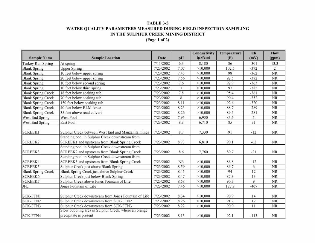
TABLE 3-5WATER QUALITY PARAMETERS MEASURED DURING FIELD INSPECTION SAMPLING
IN THE SULPHUR CREEK MINING DISTRICT(Page 1 of 2)
Conductivity Temperature Eh FlowSample Name Sample Location Date pH (µS/cm) (F) (mV) (gpm)
Turkey Run Spring At spring 7/11/2002 6.3 8,180 86 -301 13.3Blank Spring Upper Spring 7/23/2002 7.07 >10,000 102.5 -372 2Blank Spring 10 feet below upper spring 7/23/2002 7.45 >10,000 98 -362 NRBlank Spring 20 feet below upper spring 7/23/2002 7.56 >10,000 92.5 -382 NRBlank Spring 10 feet below second spring 7/23/2002 7.6 >10,000 92.9 -363 NRBlank Spring 10 feet below third spring 7/23/2002 7 >10,000 97 -385 NRBlank Spring Creek 18 feet below soaking tub 7/23/2002 7.8 >10,000 95.4 -361 NRBlank Spring Creek 70 feet below soaking tub 7/23/2002 8 >10,000 90.4 -352 NRBlank Spring Creek 150 feet below soaking tub 7/23/2002 8.11 >10,000 92.6 -320 NRBlank Spring Creek 40 feet below BLM fence 7/23/2002 8.23 >10,000 88.7 -289 NRBlank Spring Creek 35 feet above road culvert 7/23/2002 8.26 >10,000 89.5 -281 NRWest End Spring West Pool 7/23/2002 7.95 6,950 83.6 5 NRWest End Spring East Pool 7/23/2002 8.3 6,710 85 31 NR
SCREEK1 Sulphur Creek between West End and Manzanita mines 7/23/2002 8.7 7,330 91 -12 NR
SCREEK2Standing pool in Sulphur Creek downstream from SCREEK1 and upstream from Blank Spring Creek 7/23/2002 8.73 6,810 90.1 -62 NR
SCREEK3Standing pool in Sulphur Creek downstream from SCREEK2 and upstream from Blank Spring Creek 7/23/2002 8.6 7,760 80.7 -21 NR
SCREEK4Standing pool in Sulphur Creek downstream from SCREEK3 and upstream from Blank Spring Creek 7/23/2002 NR >10,000 86.8 -12 NR
SCREEK5 Sulphur Creek just above Blank Spring 7/23/2002 8.59 >10,000 86.7 6 NRBlank Spring Creek Blank Spring Creek just above Sulphur Creek 7/23/2002 8.45 >10,000 94 12 NRSCREEK6 Sulphur Creek just below Blank Spring 7/23/2002 8.47 >10,000 87.3 13 NRSCREEK7 Sulphur Creek above Jones Fountain of Life 7/23/2002 8.58 >10,000 90.3 9 NRJFL Jones Fountain of Life 7/23/2002 7.46 >10,000 127.8 -407 NR
SCK-FTN1 Sulphur Creek downstream from Jones Fountain of Life 7/23/2002 8.34 >10,000 90.9 14 NRSCK-FTN2 Sulphur Creek downstream from SCK-FTN2 7/23/2002 8.26 >10,000 91.2 12 NRSCK-FTN3 Sulphur Creek downstream from SCK-FTN3 7/23/2002 8.22 >10,000 90.9 11 NR
SCK-FTN4Slow bubbling area in Sulphur Creek, where an orange precipitate is present 7/23/2002 8.15 >10,000 92.1 -113 NR

TABLE 3-5WATER QUALITY PARAMETERS MEASURED DURING FIELD INSPECTION SAMPLING
IN THE SULPHUR CREEK MINING DISTRICT(Page 2 of 2)
Conductivity Temperature Eh FlowSample Name Sample Location Date pH (µS/cm) (F) (mV) (gpm)
SCK-FTN5Head of oxbow pool 10 feet downstream from SCK-FTN4 7/23/2002 8.14 >10,000 96.8 -200 NR
SCK-FTN6 Instream spring; Manzanita waste rock 7/23/2002 7.75 >10,000 99.1 -327 NRSCK-FTN7 Instream spring, above Jones Fountain of Life 7/23/2002 7.5 >10,000 95.9 -333 NRSCKFTN8 Downstream of Jones Fountain of Life 7/23/2002 8.02 >10,000 95.6 -14 NRSulphur Creek Above bridge/below store 8.12 >10,000 98.2 -18 NRSCKDS Sulphur Creek above Bear Creek 7/25/2002 8.54 >10,000 72.9 -39 NRNotes:
µS/cm = MicroSiemen per centimeterEh = Oxidation-reduction potentialF = Degrees Fahrenheitgpm = Gallon per minutemV = MilliVoltNR = Not recorded>10,000 = Greater than 10,000. Out of range of water quality meter.Sample locations shown on Figures 3-1 and 3-2.

TABLE 3-6
ANALYTICAL RESULTS FOR FIELD INSPECTION WATER SAMPLING IN THE SULPHUR CREEK MINING DISTRICT(Page 1 of 2)
Sample Location DateTurkey Run Spring 7/11/2002 2,350 1,320 10.7 10 U 20* U 1,260 11 149 3.4 J 1.5 U 40.3 0.093 U 0.3 U 47,300 2.9 J 0.34 U 4.1 J 302Blank Spring 7/23/2002 5,440 8,760 55.8 50 U 100 U 500 U 18,500 104 28.5 J 155 23.5 2,980 0.44 J 1.8 J 4,120 2.2 J 0.34 U 3.3 J 32.5 JJones Fountain of Life 7/23/2002 6,860 12,200 50 U 63 U 130 U 630 U 25,400 25 27.8 J 122 1.5 U 1,100 0.51 J 0.84 J 3,360 1.7 J 0.34 U 2.6 J 52SCK-FTN-7 7/23/2002 5,290 10,000 65.6 63 U 130 U 838 21,900 80 54 J 18.6 1.5 U 1,580 0.095 J 1 J 17,800 3.8 J 0.34 U 4.4 J 202SCK-FTN-8 7/23/2002 5,500 10,400 64.2 63 U 130 U 956 23,700 84 1,250 40 1.5 U 1,360 0.18 J 0.86 J 21,300 5 0.34 U 5.6 J 2,880SCREEK-4 7/23/2002 3,820 6,710 58.1 50 U 100 U 665 14,900 32 24.8 J 13.4 1.5 U 1,440 0.093 U 0.93 J 38,700 3.9 J 0.34 U 4.4 J 215West End Spring 7/23/2002 1,100 2,050 10.3 10 U 20 U 196 3,610 53 103 5.4 J 1.9 J 258 0.22 J 0.44 J 82,700 4.1 J 1.7 J 14.4 260SCKDS 7/25/2002 5,160 10,900 68 63 U 130 U 945 23,500 100 108 26.3 1.5 U 1,160 0.14 J 0.75 J 18,000 2.9 J 0.34 U 9.1 J 258EL-BMW 10/16/2002 5,940 11,700 112 100 U 200* U 1,430 27,800 27 NA 42.9 5 U NA NA NA NA 1.2 J NA NA NAEL-RD 10/16/2002 6,070 13,100 144 100 U 200* U 1,690 30,000 68 NA 35.7 5 U NA NA NA NA 2.8 J NA NA NAEL-SP 10/16/2002 6,320 12,000 128 100 U 200* U 1,550 26,200 8 NA 44.4 5 U NA NA NA NA 0.64 J NA NA NAPBW001 (method blank) 10/16/2002 2 U 0.2 U 0.04 U 0.05 U 0.1* U 0.5 U 10 U 4 U NA 3.6 U 1.5 U NA NA NA NA 0.44 U NA NA NA
Alkalinity Chloride Nitrate as N Nitrite as N Phosphate as P Sulfate TDS TSS Aluminum Antimony Arsenic Barium Beryllium Cadmium Calcium Chromium Cobalt Copper Ironmg/L mg/L mg/L mg/L mg/L mg/L mg/L mg/L µg/L µg/L µg/L µg/L µg/L µg/L µg/L µg/L µg/L µg/L µg/L

TABLE 3-6
ANALYTICAL RESULTS FOR FIELD INSPECTION WATER SAMPLING IN THE SULPHUR CREEK MINING DISTRICT(Page 2 of 2)
Sample LocationTurkey Run SpringBlank SpringJones Fountain of LifeSCK-FTN-7SCK-FTN-8SCREEK-4West End SpringSCKDSEL-BMWEL-RDEL-SPPBW001 (method blank)
1.2 U 70,000 95.6 0.039 U 0.83 U 1.5 J 48,500 3.1 J 0.91 J 12,400 0.85 U 0.48 U 0.68 U1.2 U 45,200 8.4 0.039 U 2 J 0.69 J 525,000 11.7 1.2 J 6,760,000 0.85 U 1.8 J 5.2 J1.2 U 26,100 4.5 J 0.8 0.83 U 0.41 U 612,000 11 0.9 U 8,640,000 0.85 U 0.62 J 3.4 J1.2 U 69,700 125 0.039 U 0.83 U 3.4 J 536,000 13.9 0.9 U 8,080,000 0.85 U 5.4 J 6.4 J1.2 U 64,300 234 0.087 J 0.83 U 7.6 514,000 11.4 0.9 U 7,790,000 0.85 U 7.1 J 15.61.2 U 95,800 488 0.039 U 0.98 J 7.3 322,000 8.9 J 0.91 J 5,420,000 0.85 U 4.5 J 6.1 J3.8 J 118,000 805 0.039 U 5.4 9.7 37,400 2.5 U 2.7 J 1,470,000 0.85 U 4.1 J 10.91.2 U 80,700 83.1 0.039 U 0.83 U 7.4 585,000 11.3 0.9 U 8,390,000 0.85 U 5 J 32NA NA NA 9.8 NA 2.6 J NA NA NA NA NA NA NANA NA NA 13.8 NA 46.5 NA NA NA NA NA NA NANA NA NA 8.6 NA 0.9 J NA NA NA NA NA NA NANA NA NA 0.015 U NA 0.9 U NA NA NA NA NA NA NA
Notes:
* = Orthophosphate as Pµg/L = Microgram per literJ = Estimatedmg/L = Milligram per literNA = Not analyzedTDS = Total dissolved solidsTSS = Total suspended solidsU = Not detected
Sample locations shown on figures 3-1 and 3-2.
Lead Magnesium Manganese Mercury Molybdenum Nickel Potassium Selenium Silver Sodium Thallium Vanadium Zincµg/L µg/L µg/L µg/L µg/L µg/L µg/L µg/L µg/L µg/L µg/L µg/L µg/L

TABLE 3-7
WASTE EXTRACTION TEST RESULTS FROM FIELD INSPECTION SAMPLING IN THE SULPHUR CREEK MINING DISTRICT
(Page 1 of 1)
Location
Sample Number
Description
Mercury (µg/L)
Nickel (µg/L)
Arsenic (µg/L)
Antimony (µg/L)
Chromium (µg/L)
AWR-1 Waste rock west of ore hopper 1.1 9,430 <5 6.5J 2.6JAWT White tailings 204 6.8 <5 43.4 40.8OTS Tailings below old brick retort 0.32J 24.9 <5 11.8 7.5
Abbott Mine
TSS Red tailings below furnace 7.1 33.4 <5 16.3 16.6TR-Serp Waste rock south west of ore bin 0.25J 6.1 <5 4.1J 2.4JTRPRU Waste rock from pad west of spring 0.72 37 <5 2.5J 3.5JTRPRV Duplicate of TRPRU 0.53 21.3 <5 4.0J 2.5J
Turkey Run Mine
TR-ORE From ore bin 0.47 3,760 <5 7.8J 4.0JWAT-1 Tailings below brick retort 0.17J 9.1 5.1 107 6.1WAWR Waste rock from vicinity of 1940s
rotary furnace 0.85 9.8 24.6 79.2 9.2
Wide Awake Mine
WAWR-3 Waste rock downstream of mine 21 102 7.4 79.8 33.3West End Mine WE Waste rock at Sulfur Creek 204 433 813 728 437Unknown Mine UM-1 Waste rock from cut 2.1 5,980 6.1 <10 2,380Manzanita Mine MANZ Waste rock below adit 2.7 664 3.6J 3.3J 21.8
ELT Waste Rock at upper part of mine 252 33.8 4.4J <10 112ELT-3 Tailings beneath retort on flood plain 25.4 52 10.8 5.1J 45.7
Elgin Mine
ELT-4 Colluvium and mine waste below upper part of mine on flood plain
3.3 55.6 4.8J 7.7J 17.2
Water Quality Goal From: Compilation of Water Quality Goals, RWQCB, 2000
0.050 100(MCL) 0.018 6(MCL) 50 (MCL)
Soluble Threshold Limit Concentration
California Hazardous Waste Criteria, CCR Title 22, section 66261.24
200 20,000 5,000 15,000 5,000
Notes: µg/L = Microgram per liter MCL = Maximum contaminant level CCR = California Code of Regulations RWQCB = Regional Water Quality Control Board, Central Valley Region Water quality goals are maximum contaminant levels indicated by (MCL), US EPA National Recommended Ambient Water Quality Criteria (Arsenic), and the California Toxics Rule Criteria (Mercury).

Q
CheckDam
Glory HoleGulch Diversion
AWR-1
TR-PRU
TR-SERP TR-ORE
TSS-3
OTS-2
OTS-1
TSS-2TSS-1
TURKEY RUN SPRING
U:\Sulphur_creek\mxd_files\fig3-01_abbot_turkeyrun.mxd 03/21/03 KJJ
0 500250Feet
¯
EXPLANATION
TAILINGSWASTE ROCK
CUT
FOUNDATION
DIVERSIONSPRING
CAVED SHAFTMINEADITCAVED ADIT
PU
Ì
ìP
FIGURE 3-1
MINE FEATURESAND SAMPLE LOCATIONS
Tetra Tech EM Inc.
ABBOTT AND TURKEY RUN MINESSULPHUR CREEK MINING DISTRICT
ìP
SAMPLELOCATION

3-25
Tetra Tech collected four solid matrix samples from both the Abbott and Turkey Run mines (eight
samples total), and submitted the samples for WET analyses. Arsenic, antimony, chromium, mercury,
and nickel concentrations in leachates were all below the soluble threshold limit concentration (STLC),
with the exception of a sample from the white tailings pile at the Abbott Mine. This Abbott Mine tailings
sample was one of only 3 leachate samples that exceeded the STLC. WET analysis results are presented
in Table 3-7.
3.3.2 Central and Empire Mines
Additional analytical data beyond that compiled by Churchill and Clinkenbeard (2002) were not required
at the Central and Empire mines, and samples were not collected.
3.3.3 Manzanita Mine
Tetra Tech collected one solid matrix sample from the waste rock pile below the adit (Figure 3-2).
Analysis of a WET leachate showed that arsenic, antimony, chromium, mercury, and nickel
concentrations were all below the STLC. WET analytical results are presented in Table 3-7.
3.3.4 Cherry Hill and West End Mines
Tetra Tech measured water quality parameters at two pools in Sulphur Creek immediately upstream of the
West End Mine, and collected one water sample from upstream from West End Mine (Figure 3-2). Water
quality parameter measurements showed the spring was slightly alkaline (pH of 7.95 to 8.3), and had a
low temperature and specific conductance relative to other springs sampled during this investigation. The
oxidation-reduction potential was neutral to slightly oxidizing (Eh = 5 to 31 mV); other springs sampled
downstream were strongly reducing. Calcium, chromium, copper, magnesium, manganese, molybdenum,
nickel, and silver concentrations in the West End Spring sample were among the highest measured in the
District, but all other metals and anion concentrations were among the lowest measured. Water quality
parameter measurements and laboratory analytical results are presented in Tables 3-5 and 3-6,
respectively.
Tetra Tech collected one solid matrix sample from waste rock at Sulphur Creek at the West End Mine
(see Figure 3-2). Analysis of a WET leachate showed that mercury exceeded the STLC, but antimony,

WAT 1
WAWR-3
Ì
UM-1
SULPHUR CREEK
JONES FOUNTAINOF LIFE
MANZWE
SCKFTN 8
SCKFTN 7
SCKFTN 6SCKFTN 5
SCKFTN 4SCKFTN 3
SCREEK 7
SCREEK 6SCREEK 5SCREEK 4
SCREEK 3
SCREEK 1
WAWRBLANK SPRING
SCKDS
WEST END SPRING EAST POOL
WEST END SPRINGWEST POOL
SCREEK 2
BLANK SPRINGCREEK
SCKFTN 1
SCKFTN 2
U:\Sulphur_creek\mxd_files\fig3-02_wilbur_mines.mxd 03/21/03 KJJ
0 1,000500Feet
¯
EXPLANATION
WASTE ROCK
DIVERSION
ROAD
MINEÌ
ADIT
CAVED SHAFTU
OPEN SHAFTÌ
C
OPEN CUT
FIGURE 3-2
MINE FEATURESAND SAMPLE LOCATIONS
Tetra Tech EM Inc.
WILBUR SPRINGS AREA MINESSULPHUR CREEK MINING DISTRICT
SAMPLELOCATION

3-27
chromium, and nickel concentrations were all below the STLC. WET analysis results are presented in
Table 3-7.
3.3.5 Wide Awake Mine
Tetra Tech collected three solid matrix samples from Wide Awake Mine, including tailings below the
brick retort, waste rock near the 1940s rotary furnace, and waste rock downstream from the mine
(Figure 3-2). Analysis of WET leachates from the three samples showed that antimony, arsenic,
chromium, mercury, and nickel concentrations were all below the STLC. WET analytical results are
presented in Table 3-7.
3.3.6 Elgin Mine
Tetra Tech collected water samples from Elgin Spring at the spring pool discharge point, below the mine
waste, and downstream from the mine below the road along the west fork of Sulphur Creek. The Elgin
Mine is shown on Figure 3-3. Metals and anion concentrations in the three water samples were among
the highest measured in the District. Concentrations generally increased in the downstream direction,
suggesting that contaminants were mobilized through contact with solid materials at the mine site. Water
quality parameter measurements and laboratory analytical results are presented in Tables 3-5 and 3-6,
respectively.
Tetra Tech analyzed three solid matrix samples from Elgin Mine, including waste rock from the upper
portion of the mine, tailings beneath the retort on the flood plain, and colluvium and mine waste on the
flood plain below the upper part of the mine. Analysis of WET leachates from the three samples showed
that antimony, arsenic, chromium, mercury, and nickel concentrations were all below the STLC, with the
exception of the mercury concentration in the leachate from the upper waste rock sample. This Elgin
Mine waste rock sample exceeded the STLC. WET analytical results are presented in Table 3-7.
3.3.7 Clyde Mine
Additional analytical data beyond that compiled by Churchill and Clinkenbeard (2002) were not required
at the Clyde mine, and samples were not collected.

ELT-4ELT-1
EL-RD
ELGIN SPRING
EL-SP
ELT-3
U:\Sulphur_creek\mxd_files\fig3-03elgin.mxd 03/21/03 KJJ
0 400200Feet
¯
EXPLANATION
WASTE ROCK
SAMPLELOCATION
SPRING
ADIT
CAVED ADIT
P
FIGURE 3-3
MINE FEATURESAND SAMPLE LOCATIONS
Tetra Tech EM Inc.
DISTURBED AREA
ELGIN MINESULPHUR CREEK MINING DISTRICT

3-29
3.3.8 Rathburn-Petray Mine Group
Additional analytical data beyond that compiled by Churchill and Clinkenbeard (2002) were not required
at the Rathburn, Rathburn-Petray, and Petray Mines, and samples were not collected.
3.3.9 Sulphur Creek
Tetra Tech measured field water quality parameters (pH, specific conductance, Eh, and temperature) at 16
locations along Sulphur Creek (Figure 3-2). These measurements were conducted in July when the flow
was dominated by hydrothermal water. Creek flow in the reach upstream from Blank Spring Creek is
discontinuous, and sampling in this reach was performed in pools of standing water. Field water quality
parameter measurements show that Sulphur Creek has a slightly alkaline pH, very high specific
conductance (greater than 10,000 microSiemens per centimeter [µS/cm]), and elevated temperature.
Creek water is strongly reducing in proximity to hydrothermal spring discharges, but becomes less
reducing with distance downstream from the springs. Laboratory analytical results from four Sulphur
Creek samples showed highly elevated concentrations of most metals and anions. Sulphur Creek
chemistry is similar to Blank Spring and Jones Fountain of Life chemistry, indicating that base flow is
predominantly hydrothermal spring discharge. Field water quality parameter measurements and
laboratory analytical results are presented in Tables 3-5 and 3-6, respectively.
Tetra Tech measured field water quality parameters at 11 locations at Blank Spring and along Blank
Spring Creek. The pH in Blank Spring was neutral (7.07), and increased in the downstream direction
(Figure 3-2). The specific conductance was greater than 10,000 µS/cm at each sampling point along the
creek. Spring discharge was strongly reducing (Eh = -362 to -385 mV), but Blank Spring Creek was
slightly oxidizing (Eh = 12 mV) above its confluence with Sulphur Creek. Water quality parameter
measurements in Sulphur Creek above and below the confluence with Blank Spring Creek showed a
minimal water quality impact from Blank Spring Creek. Analysis of one water sample from Blank Spring
showed moderate to high metal and anion concentrations relative to other water samples in the District.
Arsenic and barium concentrations were the highest measured in water in the District.

3-30
3.4 POLLUTANT LOADING ESTIMATES
Studies documenting mercury contamination in the Cache Creek watershed have also estimated mercury
loads to the Bay-Delta. These loads are based on surface water mercury concentrations and creek flow
estimates. Loads from each mercury mine have also been estimated.
Though the Sacramento River watershed is 23 times larger than the Cache Creek watershed (16 million
acres versus 0.7 million acres), water year 1995 data show that Cache Creek exported 1.5 times more
mercury than did the Sacramento River (980 kg versus 640 kg) (Foe and Croyle 1998). During wet years,
Cache Creek may contribute as much as half of the total mercury into the Bay-Delta (RWQCB 2001).
Comparing mercury data from one critically dry water year (1994) and two wet water years (1995 and
1996) showed that flow conditions significantly affect the mercury export. Cache Creek exported 0.6 kg
of mercury into the Cache Creek Settling Basin in 1994, and 980 and 221 kg in 1995 and 1996,
respectively (Foe and Croyle 1998). The same study estimated that mercury loads during peak storm
flow conditions are on the order of 5,000 to 100,000 gram per day (g/day), compared to 100 to
1,000 g/day under winter non-storm conditions, and 10 to 50 g/day from April through October, when
Cache Creek flow is at its lowest levels. Nearly the entire mercury load during wet water years
(98 percent) occurred through the period of January through April, when storm runoff mobilized
particulate-bound mercury from the upper Cache Creek basin. Mercury load ranges at selected Cache
Creek monitoring points are summarized in Table 3-8 below.
TABLE 3-8. RANGE OF MERCURY LOADS IN CACHE CREEK
Total Mercury Methyl Mercury
Location Load (kg/yr) Load (kg/yr)
Discharge from Cache Creek Settling Basin 1 to 680 0.16 to 1.9
Flow into Cache Creek Settling Basin 0.7 to 22,900 0.013 to 2.44
Cache Creek at Rumsey 2.9 to 23,200 0.095 to 0.24
Cache Creek above Confluence with Bear Creek 4.7 to 19,700* Not reported
North Fork Cache Creek 0.05 to 2,467 0.0021 to 0.16
South Fork Cache Creek 0.04 to 115 0.0004 to 0.22
Notes: kg/yr = Kilogram per year * = Value is of questionable quality, and represents maximum upper boundary estimate. Data sources: Foe and Croyle (1998), and Domagalski and Alpers (2000).
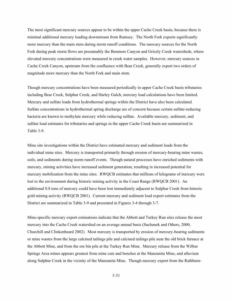
3-31
The most significant mercury sources appear to be within the upper Cache Creek basin, because there is
minimal additional mercury loading downstream from Rumsey. The North Fork exports significantly
more mercury than the main stem during storm runoff conditions. The mercury sources for the North
Fork during peak storm flows are presumably the Benmore Canyon and Grizzly Creek watersheds, where
elevated mercury concentrations were measured in creek water samples. However, mercury sources in
Cache Creek Canyon, upstream from the confluence with Bear Creek, generally export two orders of
magnitude more mercury than the North Fork and main stem.
Though mercury concentrations have been measured periodically in upper Cache Creek basin tributaries
including Bear Creek, Sulphur Creek, and Harley Gulch, mercury load calculations have been limited.
Mercury and sulfate loads from hydrothermal springs within the District have also been calculated.
Sulfate concentrations in hydrothermal spring discharge are of concern because certain sulfate-reducing
bacteria are known to methylate mercury while reducing sulfate. Available mercury, sediment, and
sulfate load estimates for tributaries and springs in the upper Cache Creek basin are summarized in
Table 3-9.
Mine site investigations within the District have estimated mercury and sediment loads from the
individual mine sites. Mercury is transported primarily through erosion of mercury-bearing mine wastes,
soils, and sediments during storm runoff events. Though natural processes have enriched sediments with
mercury, mining activities have increased sediment generation, resulting in increased potential for
mercury mobilization from the mine sites. RWQCB estimates that millions of kilograms of mercury were
lost to the environment during historic mining activity in the Coast Range (RWQCB 2001). An
additional 0.8 tons of mercury could have been lost immediately adjacent to Sulphur Creek from historic
gold mining activity (RWQCB 2001). Current mercury and sediment load export estimates from the
District are summarized in Table 3-9 and presented in Figures 3-4 through 3-7.
Mine-specific mercury export estimations indicate that the Abbott and Turkey Run sites release the most
mercury into the Cache Creek watershed on an average annual basis (Suchanek and Others, 2000,
Churchill and Clinkenbeard 2002). Most mercury is transported by erosion of mercury-bearing sediments
or mine wastes from the large calcined tailings pile and calcined tailings pile near the old brick furnace at
the Abbott Mine, and from the ore bin pile at the Turkey Run Mine. Mercury release from the Wilbur
Springs Area mines appears greatest from mine cuts and benches at the Manzanita Mine, and alluvium
along Sulphur Creek in the vicinity of the Manzanita Mine. Though mercury export from the Rathburn-

TABLE 3-9
MERCURY, SEDIMENT, AND SULFATE LOADS FROM THE SULPHUR CREEK MINING DISTRICT(Page 1 of 2)
Total Mercury Methyl Mercury Sediment SulfateLoad (kg/yr) Load (kg/yr) Load (kg/yr) Load (kg/yr)
0.0015 4.8 x 10⁻⁴ -- --0.071to 603 4.8 x 10⁻⁴ to 0.16 Up to 2.7 x 10⁸ --0.30 to 39 3.3 x 10⁻⁴ to 0.062 -- --
0.51 to 160 -- -- --0.018 to 2.3 7.3 x 10⁻⁵ to 0.004 -- --0.60 to 765 8.8 x 10⁻⁴ to 0.23 -- --
1.3 x 10⁻⁶ to 0.058 -- -- 4.5 x 10¹⁰ to 1.5 x 10¹¹
6.9 x 10⁻⁴ to 0.051 -- -- 9.1 x 10⁷ to 3.3 x 10⁹
0.002 to 0.032 -- -- 9.1 x 10⁷ to 1.8 x 10⁸
4.0 x 10⁻⁴ to 0.004 -- -- up to 9.1 x 10⁷
9.8 x 10⁻⁴ -- -- 9.1 x 10⁷ to 1.8 x 10⁸
0.014 to 0.062 -- -- 1.1 x 10⁹ to 2.8 x 10⁹
0.055 to 0.095 -- -- --4.0 x 10⁻⁴ -- -- 4.5 x 10⁸
0.18 to 0.30 -- -- 4.7 x 10¹⁰ to 1.6 x 10¹¹
0.8 to 3.5 -- 14,000 to 16,300 --0.42 to 6.7 -- 28,600 to 30,400 --
1.22 to 10.2 -- 42,500 to 46,700 --0.0028 to 0.034 -- 480 to 970 --
0.04 to 0.06 -- 270 to 360 --0.3 to 6.5 -- 4,500 to 49,900 --
None* -- None* --0.002 to 1.1 -- Up to 1,630 --0.02 to 0.44 -- 360 to 7,300 --0.4 to 8.2** -- 5,700 to 60,100 --
Wide Awake MineSum of Wilbur Springs Area Mines
Empire MineManzanita MineCherry Hill MineWest End Mine
Abbott MineTurkey Run MineSum of Abbott and Turkey Run MinesCentral Mine
WilburElgin – MainElgin – Orange TubSum of Load from Springs***
Blank SpringJones Fountain of Life
UnnamedElbow
Location
Sulphur Creek WatershedHarley Gulch
SPRINGS
UPPER CACHE CREEK BASIN
MINE SITES
Upper Bear CreekBear Creek above the confluence with Cache CreekSulphur Creek at Wilbur Springs
Sum of Bear Creek, Sulphur Creek, and Harley Gulch
Turkey Run Spring
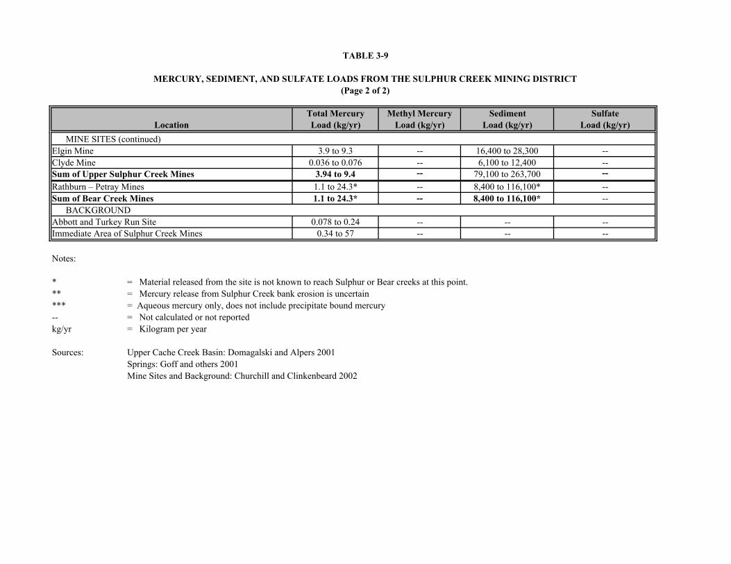
TABLE 3-9
MERCURY, SEDIMENT, AND SULFATE LOADS FROM THE SULPHUR CREEK MINING DISTRICT(Page 2 of 2)
Total Mercury Methyl Mercury Sediment SulfateLoad (kg/yr) Load (kg/yr) Load (kg/yr) Load (kg/yr)Location
3.9 to 9.3 -- 16,400 to 28,300 --0.036 to 0.076 -- 6,100 to 12,400 --
3.94 to 9.4 -- 79,100 to 263,700 --1.1 to 24.3* -- 8,400 to 116,100* --
Sum of Bear Creek Mines 1.1 to 24.3* -- 8,400 to 116,100* --
0.078 to 0.24 -- -- --0.34 to 57 -- -- --
Notes:
* = Material released from the site is not known to reach Sulphur or Bear creeks at this point.** = Mercury release from Sulphur Creek bank erosion is uncertain*** = Aqueous mercury only, does not include precipitate bound mercury-- = Not calculated or not reportedkg/yr = Kilogram per year
Sources: Upper Cache Creek Basin: Domagalski and Alpers 2001Springs: Goff and others 2001Mine Sites and Background: Churchill and Clinkenbeard 2002
Rathburn – Petray MinesSum of Upper Sulphur Creek Mines
Abbott and Turkey Run SiteImmediate Area of Sulphur Creek Mines
Elgin MineClyde Mine
BACKGROUND
MINE SITES (continued)

FIGURE 3-4
ESTIMATED ANNUAL MERCURYCONTRIBUTIONS TO THE WATERSHED
BY FEATURE
ABBOTT AND TURKEY RUN MINESSULPHUR CREEK MINING DISTRICT
Tetra Tech EM Inc.

FIGURE 3-5
ESTIMATED ANNUAL MERCURYCONTRIBUTIONS TO THE WATERSHED
BY FEATURE
WILBUR SPRINGS AREA MINESSULPHUR CREEK MINING DISTRICT
Tetra Tech EM Inc.

FIGURE 3-6
ESTIMATED ANNUAL MERCURYCONTRIBUTIONS TO THE WATERSHED
BY FEATURE
ELGIN AND CLYDE MINESSULPHUR CREEK MINING DISTRICT
Tetra Tech EM Inc.
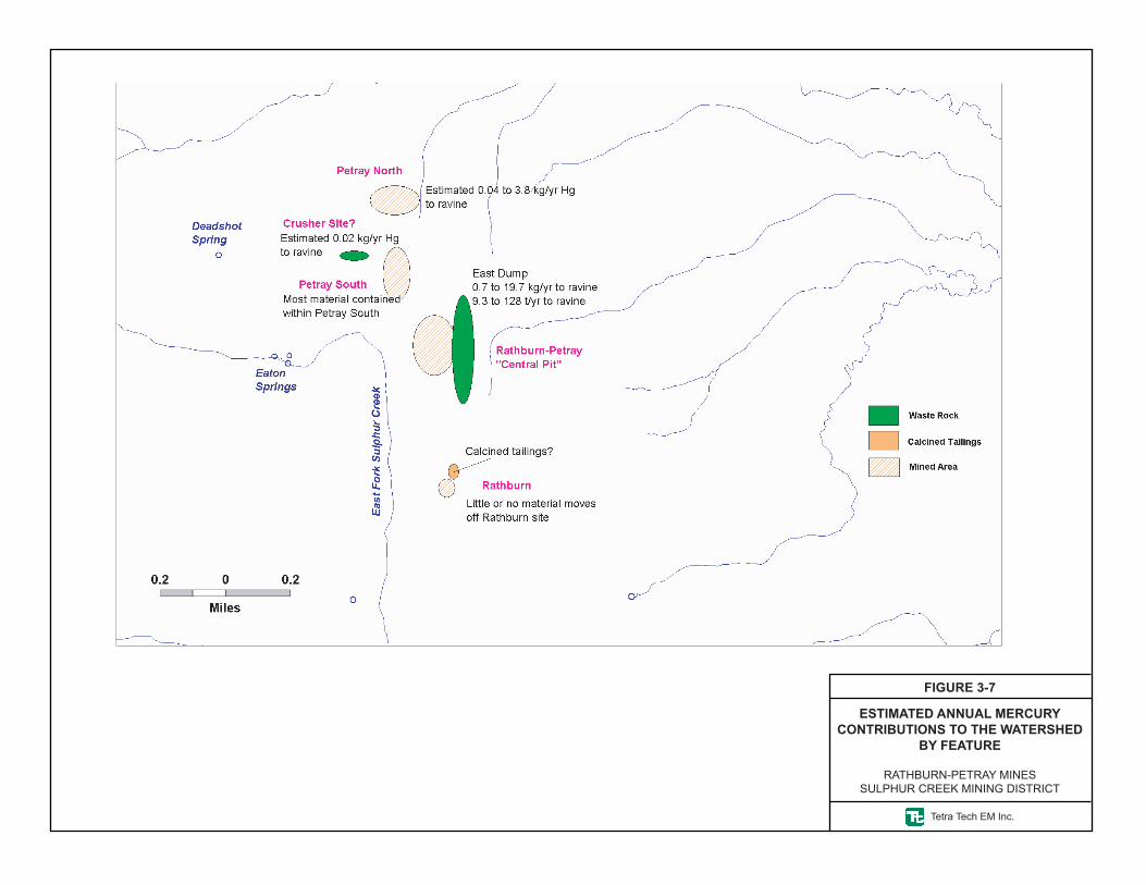
FIGURE 3-7
ESTIMATED ANNUAL MERCURYCONTRIBUTIONS TO THE WATERSHED
BY FEATURE
RATHBURN-PETRAY MINESSULPHUR CREEK MINING DISTRICT
Tetra Tech EM Inc.

3-38
Petray Mine Group appears relatively high, it is uncertain how much, if any, of the released material
reaches Bear Creek.
Annual mercury load estimates from the Sulphur Creek mines range from 5.1 to 77 kg/yr, and are one to
two orders of magnitude greater than loads from natural hydrothermal springs based on dissolved mercury
contents (0.18 to 0.30 kg/yr). However, it should be noted that mercury loads from the Sulphur Creek
mines are similar in magnitude to background mercury loads in the immediate area of the Sulphur Creek
mines (0.34 to 57 kg/yr) (Churchill and Clinkenbeard 2002). The combined annual mercury load in
Sulphur Creek, Bear Creek, and Harley Gulch is estimated to be 5.6 to 134 kg/yr, indicating that the
District mines are a significant but not dominant source of mercury to Cache Creek.
3.5 CONCEPTUAL SITE MODELS
This section presents the conceptual site models (CSM) developed for mines in the District. CSMs are
used to identify primary release mechanisms for mercury from each mine site to surface water. Primary
sources are identified, and primary release mechanisms are identified that mobilize mercury to the
environment. In addition the CSM identifies secondary sources and secondary pathways for mercury
release. The CSMs also show the completed source to receptor pathways present at each mine site.
Interruption of completed pathways is the goal of mitigation strategies. Thus, the CSMs aid in identifying
the media or pathways at each site that should be considered for mitigation.
Five primary mechanisms for mercury release into surface water from mine sites are identified in the
CSMs:
1. Storm water runoff that can erode and transport mercury containing mine waste to surface water.
2. Water-rock interactions between hydrothermal fluids and mercury containing mine wastes.
3. Slope failure and transport of mercury containing mine waste to surface water.
4. Suspension of particulates containing mercury in air
5. Volatilization of elemental mercury and diffusion into the air.
The CSMs identify eight potential primary sources of mercury:
1. Waste Rock - Mercury is released from waste rock through erosion by storm water runoff or slope failure; water-rock interaction, airborne particles and dust, and volatilization.
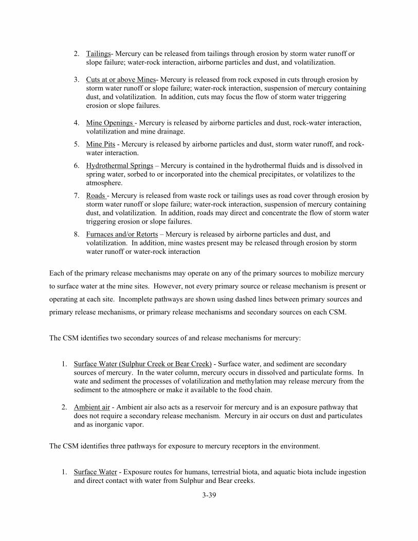
3-39
2. Tailings- Mercury can be released from tailings through erosion by storm water runoff or slope failure; water-rock interaction, airborne particles and dust, and volatilization.
3. Cuts at or above Mines- Mercury is released from rock exposed in cuts through erosion by
storm water runoff or slope failure; water-rock interaction, suspension of mercury containing dust, and volatilization. In addition, cuts may focus the flow of storm water triggering erosion or slope failures.
4. Mine Openings - Mercury is released by airborne particles and dust, rock-water interaction,
volatilization and mine drainage.
5. Mine Pits - Mercury is released by airborne particles and dust, storm water runoff, and rock-water interaction.
6. Hydrothermal Springs – Mercury is contained in the hydrothermal fluids and is dissolved in spring water, sorbed to or incorporated into the chemical precipitates, or volatilizes to the atmosphere.
7. Roads - Mercury is released from waste rock or tailings uses as road cover through erosion by storm water runoff or slope failure; water-rock interaction, suspension of mercury containing dust, and volatilization. In addition, roads may direct and concentrate the flow of storm water triggering erosion or slope failures.
8. Furnaces and/or Retorts – Mercury is released by airborne particles and dust, and volatilization. In addition, mine wastes present may be released through erosion by storm water runoff or water-rock interaction
Each of the primary release mechanisms may operate on any of the primary sources to mobilize mercury
to surface water at the mine sites. However, not every primary source or release mechanism is present or
operating at each site. Incomplete pathways are shown using dashed lines between primary sources and
primary release mechanisms, or primary release mechanisms and secondary sources on each CSM.
The CSM identifies two secondary sources of and release mechanisms for mercury:
1. Surface Water (Sulphur Creek or Bear Creek) - Surface water, and sediment are secondary sources of mercury. In the water column, mercury occurs in dissolved and particulate forms. In wate and sediment the processes of volatilization and methylation may release mercury from the sediment to the atmosphere or make it available to the food chain.
2. Ambient air - Ambient air also acts as a reservoir for mercury and is an exposure pathway that
does not require a secondary release mechanism. Mercury in air occurs on dust and particulates and as inorganic vapor.
The CSM identifies three pathways for exposure to mercury receptors in the environment.
1. Surface Water - Exposure routes for humans, terrestrial biota, and aquatic biota include ingestion and direct contact with water from Sulphur and Bear creeks.
3-40
2. Sediment - Exposure routes for humans, terrestrial biota, and aquatic biota include ingestion and direct contact with sediments from Sulphur and Bear creeks.
3. Air - Exposure routes for humans and terrestrial biota include inhalation of, ingestion of, and
direct contact with mercury vapors and airborne mercury-laden particulates.
Receptors for mercury from the District include area residents, site visitors, recreational users, and
terrestrial and aquatic biota. From the perspective of mercury load to the Cache Creek
watershed, the surface water and sediment pathways are believed to be the most significant. This
pathway operates most effectively at those locations where mine wastes are adjacent to streams. At these
locations, erosion by storm water and slope failure is capable of transporting significant quantities of
mercury laden mine waste to the adjacent streams. Of lesser importance is the leaching of mercury from
mine wastes by infiltrating precipitation or interaction with hydrothermal spring discharge, and
subsequent discharge to surface water.
Volatilization of mercury transports mercury from mine wastes, mine openings, road surfaces containing
mine wastes, hydrothermal springs, and naturally-enriched rocks and soils in and around the mines to the
atmosphere. Others have documented this pathway from the primary and secondary sources at other mine
sites and hydrothermal springs (Gustin and others, in press; Navarro-Flores and others 2000; Ferrara and
others 2000). However, the impacts of this pathway on water quality within the Cache Creek watershed
are not clear based on existing information. Current thinking regarding this pathway is that volatilized
mercury is dominantly composed of elemental mercury with a relatively low proportion of reactive
gaseous mercury. Elemental mercury is thought to be fairly stable in the atmosphere being transported
large distances from the source. Any reactive gaseous mercury is thought to sorb readily on solids (dust,
plants, soil) or dissolve in water and be deposited within the watershed. This pathway has not been
characterized within the District. Nevertheless, we assume this pathway is operating. Lack of
characterization for this pathway does not pose a difficulty to the engineering analysis because the
evaluated technologies would operate to reduce such emissions. Recent work by Coolbaugh and others
(2002) implies that vegetating a given soil would result in reducing the atmospheric mercury flux from
the soil. Similarly, because the atmospheric mercury flux is typically proportional to the mercury content
of the soil, covering or capping mine wastes with low mercury soil would also be expected to reduce
atmospheric mercury flux. Capping or covering the soils would also drastically decrease interaction with
sunlight, which has been shown to dramatically increase mercury emissions from some soils (Gustin and
others 2002). In addition, mercury emission measurements from other mines (including the Sulphur Bank
Mercury Mine Superfund Site) have shown that although mercury is emitted to the atmosphere by

3-41
hydrothermal springs and mine wastes, the breathing zone concentrations do not approach exposure limits
that would pose a risk or hazard to humans at these sites.
CSMs for each of the mine sites within the District are described below. The completed pathways shown
in the CSMs identify the features that will be evaluated in the detailed analysis. The volatilization
pathway was described above and will not be discussed for specific sites.
Abbott Mine. Primary sources at the Abbott Mine are a tailings pile adjacent to Harley Gulch, waste
rock, cuts above the mine, roads covered with tailings, mine openings, a brick furnace, a rotary furnace
and retort, and a processing facility (Figure 3-8). Tailings and waste rock are susceptible to erosion from
uncontrolled runoff. Roads and cuts above the mine concentrate storm water runoff onto the tailings pile
and nearby slopes contributing to slope failure and erosion. Dust particles can also originate from the
tailings. A white efflorescent material coating tailings particles along the north bank of Harley Gulch is
evidence that water-rock interaction may also mobilize chemicals from the tailings through interaction of
infiltrating precipitation with the tailings. The potential significance of such water-rock interaction is
confirmed by analysis of WET leachates from the tailings. Analyses of WET leachate from the red oxide
coated tailings resulted in detection of 0.32 to 1.1 micrograms per liter (µg/L) mercury. However, a
sample of white colored tailings yielded a WET leachate concentration of 204 µg/L mercury. The white
tailings occur intermixed with the red oxide coated tailings.
Road surfaces were covered with tailings during mining. The tailings on road surfaces were observed to
be up to 2 feet thick, although the average thickness was less than one foot. Erosion of road surfaces,
generation of dust, and rock-water interaction in tailings on roads may result in mobilization of mercury.
Cuts above the mine contain waste rock. Erosion of this material by storm water runoff, involvement in
slope failures, or generation of dust could mobilize mercury.
Glory Hole Gulch separates the Abbot and Turkey Run Mines. Upper Glory Hole Gulch has been
diverted to flow across the lower Turkey Run Mine property. Lower Glory Hole Gulch (below the point
where upper Glory Hole Gulch is diverted toward the Turkey Run Mine) flows into two basins, a smaller
upstream basin and a larger basin on top of the tailings pile. A small dry dam directs water from the
upstream basin into a swale that flows along the east side of a road at the top of the tailings pile. This
water crosses the road and flows across the tailings to Harley Gulch. Erosion of tailings and transport of
eroded material likely mobilizes mercury to Harley Gulch.

PRIMARY SOURCES
PRIMARY RELEASEMECHANISMS
SECONDARY SOURCES
SECONDARY RELEASE
MECHANISMS
PATHWAY
Tailings
Roads
Slope Failure
Rock-Water Interaction
Stormwater Runoff
Particles/Dust
Air
Methylation
Surface Water
Sediment
Air
Harley Gulch
Ingestion
Dermal
Inhalation
Ingestion
Dermal
Inhalation
Ingestion
Dermal
Inhalation
Inhalation
Ingestion
Inhalation
Volatilization
Waste Rock
Retorts and
Furnaces
Mine Openings
Volatilization
Cuts Above Mine
Are
a R
esid
ent
Vis
itor
Terr
estri
al
Aqu
atic
Human Biota
EXPOSURE RECEPTOR ROUTE
Dashed lines indicate an incomplete pathway.
Figure 3-8
Conceptual Site Model Abbott Mine
Sulphur Creek Mining District
3-43
The condensers, rotary furnace, brick furnace, and processing facility consist of brick, wood frame,
concrete, and iron structures. These structures are located on or adjacent to the tailings. The condenser
tubes could not be safely inspected for the presence of mercury. However, the channels beneath the
condenser tubes were clean and visually free of mercury. Bats were observed within the rotary furnace.
Condenser tubes and furnaces typically contain residual elemental mercury that can volatilize, or be
discharged to soil. These structures also pose an attractive nuisance in that trespassers may be attracted to
them and could be exposed to residual mercury.
Mine openings consist of a collapsed shaft above the furnace and condenser tubes, a shaft approximately
100 yards west of the retort, and the ‘glory hole’ in a cut on the slope above the tailings pile. Mine
openings can emit volatilized mercury or dust particles containing mercury. No evidence for drainage
was observed at the mine openings.
Other wood framed structures are present at the Abbot Mine on the cut above the rotary furnace, and
approximately 200 yards to the west above the old brick furnace. These wood framed structures are not
known to contain mercury, and are not thought to affect the migration of mercury.
Mercury mobilized by storm water runoff, slope failure, or water rock interaction from mine wastes at the
Abbott Mine would enter the west fork of Harley Gulch. The west fork of Harley Gulch is an intermittent
stream that flows through a marsh and eventually to Harley Gulch and Cache Creek. Mercury deposited
in marsh sediments could become methylated and enter the food web. Thus, the pathways from the
tailings pile adjacent to Harley Gulch, waste rock, cuts above the mine, roads covered with tailings, a
brick furnace, a rotary furnace and retort, and a processing facility to receptors are complete at the Abbott
Mine.
Turkey Run Mine. Primary sources at Turkey Run Mine are waste rock and ore near the hydrothermal
spring above Harley Gulch, waste rock associated with cuts above the mine, roads covered with tailings,
mine openings, an ore bin, and a hydrothermal spring (Figure 3-9). The waste rock is susceptible to
erosion from uncontrolled runoff. Roads and cuts above the mine concentrate storm water runoff onto
associated waste rock and nearby slopes contributing to slope failure and erosion. Dust particles can also
originate from the waste rock. Diversion of upper Glory Hole Gulch to drain across the mine wastes at
the lower Turkey Run Mine has enhanced erosion of waste rock by storm water runoff. The potential for
water-rock interaction to mobilize mercury is thought to be minimal based on analysis of WET leachates

PRIMARY SOURCES
PRIMARY RELEASEMECHANISMS
SECONDARY SOURCES
SECONDARY RELEASE
MECHANISMS
PATHWAY
Hydrothermal Spring
Roads
Slope Failure
Rock-Water Interaction
Stormwater Runoff
Particles/Dust
Air
Methylation
Surface Water
Sediment
Air
Harley Gulch and Glory Hole Gulch
Ingestion
Dermal
Inhalation
Ingestion
Dermal
Inhalation
Ingestion
Dermal
Inhalation
Inhalation
Ingestion
Inhalation
Volatilization
Waste Rock
Ore Bin and Ore
Mine Openings
Volatilization
Cuts Above Mine
Are
a R
esid
ent
Vis
itor
Terr
estri
al
Aqu
atic
Human Biota
EXPOSURE RECEPTOR ROUTE
Discharge
Dashed lines indicate an incomplete pathway.
Figure 3-9
Conceptual Site Model Turkey Run Mine
Sulphur Creek Mining District

3-45
from the waste rock and ore near the ore bin. Analyses of WET leachates resulted in detection of 0.45 to
0.72 µg/L mercury.
Road surfaces were covered with tailings during mining. The tailings on road surfaces were observed to
be up to 2 feet thick, although the average thickness was less than 1 foot. Erosion of road surfaces,
generation of dust, and rock-water interaction in tailings on roads may result in mobilization of mercury.
Cuts above the mine contain waste rock. Waste rock below the cuts is on very steep slopes subject to
slope failure and erosion. An active landslide creeping down slope toward Highway 20 is present in the
drainage to the east of the ore bin. One of the cuts concentrates storm water runoff onto waste rock and
this active landslide.
The ore bin and nearby shed consist of wood frame and sheet metal structures. The ore bin contains ore
and is located adjacent to waste rock. These structures pose an attractive nuisance as shown by the
graffiti on the ore bin. Trespassers attracted to them could be exposed to residual mercury.
Mine openings consist of a collapsed adit west of the ore bin from which the hydrothermal spring
discharges, a collapsed adit in the drainage above the ore bin, a collapsed adit east of Glory Hole Gulch at
the west end of the upper mine cuts, and a ventilation tunnel below the upper mine cuts. The ventilation
tunnel has a concrete collar and closed iron doors. Mine openings can emit volatilized mercury or dust
particles containing mercury. No evidence for drainage (sediment aprons, incised channels, wrack lines)
was observed at the mine openings except for the thermal water at the collapsed adit.
The hydrothermal spring is located directly below a collapsed adit. This spring is considered to be mine
drainage by Rytuba (2000). Water from the spring flows through mine wastes eroded from waste rock
piles located west of the drainage. This water contains up to 0.2 µg/L dissolved mercury (Goff and others
2001; Rytuba 2000). However, interaction of this water with mine wastes mobilizes mercury to Harley
Gulch with mercury up to 0.87 µg/L (Rytuba 2000).
Mercury mobilized by storm water runoff, slope failure, or water rock interaction from mine wastes at the
Turkey Run Mine would enter Harley Gulch. Harley Gulch is an intermittent stream and flows through a
marsh and eventually to Cache Creek. Mercury deposited in marsh sediments could become methylated
and enter the food web. Thus, the pathways from the waste rock, cuts above the mine, roads covered with
tailings, and the ore bin are complete at the Turkey Run Mine. In addition, the interaction of
3-46
hydrothermal water from the spring with mine wastes also completes a pathway for mercury to surface
water.
Empire Mine. Primary sources at the Empire Mine are waste rock, tailings and a retort (Figure 3-10).
The mine wastes are located on the slope below the retort. The mine wastes are covered with vegetation
and not readily visible for direct observation. A collapsed shaft (no longer open) is located on the slope
above the retort. An adit is visible above the main access road south of Sulphur Creek, though this adit
(labeled “lost mine” on a hand lettered sign) may not be on the Empire Mine property. Evidence for
drainage such as incised channels, rills, or sediment aprons were not observed at Empire Mine openings.
Cuts are absent at the Empire Mine. Roads at the Empire Mine are not covered with tailings.
The retort is a brick structure containing two ‘D’ shaped ovens, a fuel tank, and associated piping.
Retorts and furnaces may contain residual elemental mercury that can volatilize, or be discharged to soil.
This structure also poses an attractive nuisance in that trespassers may be attracted to them and could be
exposed to residual mercury.
Complete pathways for migration of mercury from primary sources to Sulphur Creek do not appear to be
present at the Empire Mine.
Wide Awake Mine. Primary sources at the Wide Awake Mine are waste rock and tailings; mine cuts
above the two-story brick furnace, the two-story brick furnace, a 1940s vintage rotary furnace, a retort
above the tailings, and two older three to four feet tall brick furnaces on the flood plain of the unnamed
tributary to Sulphur Creek (Figure 3-11). Mine openings were not observed at Wide Awake Mine, and
roads were not covered using tailings. The waste rock and tailings are susceptible to erosion from
uncontrolled runoff. The potential for water-rock interaction to mobilize mercury from tailings is thought
to be minimal based on analysis of WET leachates from the tailings downstream of the two-story furnace
and waste rock near the 1940s rotary furnace. Analyses of WET leachates resulted in detection of 0.17
µg/L to 0.85 µg/L mercury from these locations. However, water rock interaction likely mobilizes
mercury based on detection of 21 µg/L mercury in a WET leachate sample from waste rock
approximately 250 feet downstream from the 1940s furnace.
Cuts above the mine contain waste rock. Evidence for significant erosion by runoff from these cuts such
as incised channels, rills, or sediment aprons were not observed. The cuts also contain sparse volunteer
vegetation. However, these cuts do drain to tailings and could contribute to erosion and slope failure.

PRIMARY SOURCES
PRIMARY RELEASEMECHANISMS
SECONDARY SOURCES
SECONDARY RELEASE
MECHANISMS
PATHWAY
Tailings
Roads
Slope Failure
Rock-Water Interaction
Stormwater Runoff
Particles/Dust
Air
Methylation
Surface Water
Sediment
Air
Sulphur Creek
Ingestion
Dermal
Inhalation
Ingestion
Dermal
Inhalation
Ingestion
Dermal
Inhalation
Inhalation
Ingestion
Inhalation
Volatilization
Waste Rock
Retorts and
Furnaces
Mine Openings
Volatilization
Cuts Above Mine
Are
a R
esid
ent
Vis
itor
Terr
estri
al
Aqu
atic
Human Biota
EXPOSURE RECEPTOR ROUTE
Figure 3-10
Conceptual Site Model Empire Mine
Sulphur Creek Mining District Dashed lines indicate an incomplete pathway.

PRIMARY SOURCES
PRIMARY RELEASEMECHANISMS
SECONDARY SOURCES
SECONDARY RELEASE
MECHANISMS
PATHWAY
Tailings
Roads
Slope Failure
Rock-Water Interaction
Stormwater Runoff
Particles/Dust
Air
Methylation
Surface Water
Sediment
Air
Sulphur Creek
Ingestion
Dermal
Inhalation
Ingestion
Dermal
Inhalation
Ingestion
Dermal
Inhalation
Inhalation
Ingestion
Inhalation
Volatilization
Waste Rock
Retorts and
Furnaces
Mine Openings
Volatilization
Mine Cuts
Are
a R
esid
ent
Vis
itor
Terr
estri
al
Aqu
atic
Human Biota
EXPOSURE RECEPTOR ROUTE
Dashed lines indicate an incomplete pathway.
Figure 3-11
Conceptual Site Model Wide Awake Mine
Sulphur Creek Mining District

3-49
Retorts and furnaces present at Wide Awake Mine are present in two general areas. An older brick
furnace now three to four feet tall, is located on the floodplain of the unnamed tributary to Sulphur
Creek. This furnace consists of brush covered brick structures. A two-story brick furnace is located on
the east side of the unnamed tributary to Sulphur Creek. This furnace was originally enclosed within a
wooden building and appears to have been used very little based on the lack of large quantities of ash and
tailings near the structure. A smaller brick retort with two ‘D’ ovens is present north of the two-story
furnace on a pile of mixed waste rock and tailings. Farther down stream to the south is a more modern
(1940s) rotary furnace and associated condenser tubes. This 1940s furnace does not appear to have been
used much based on the very small quantity of tailings present. Retorts and furnaces typically contain
residual elemental mercury that can volatilize, or be discharged to soil. These structures also pose an
attractive nuisance in that trespassers may be attracted to them and could be exposed to residual mercury.
Mercury mobilized by storm water runoff, slope failure, or water rock interaction from mine wastes at
Wide Awake Mine would enter the unnamed intermittent tributary to Sulphur Creek. The unnamed
tributary to Sulphur Creek flows past retorts, furnaces, tailings, and waste rock, and eventually to Sulphur
Creek. Thus, the pathways from the waste rock, tailings, retorts and furnaces are complete at the Wide
Awake Mine.
Cherry Hill Mine. Primary sources observed at the Cherry Hill mine are waste rock on the floodplain of
Sulphur Creek, a former stamp mill site used for gold recovery, and mine openings (Figure 3-12). Waste
rock is present north of the Cherry Hill Mine, though its relationship to the Cherry Hill Mine is not clear.
Waste rock could be eroded by winter season flood flows in Sulphur Creek. The waste rock was not
sampled as part of this work, but water rock interaction could possibly mobilize mercury based on the
mercury content of the waste rock (350 milligrams per kilogram [mg/kg]). The mine openings consist of
a number of adits in a hillside above the Sulphur Creek floodplain. Evidence for drainage such as incised
channels, rills, or sediment aprons were not observed at openings of the Cherry Hill Mine. The former
mill site could contain elemental mercury used to amalgamate gold during ore crushing, however no
evidence for elevated mercury contents was detected by sampling (Churchill and Clinkenbeard 2002).
The erosion of mercury containing waste rock on the flood plain of Sulphur Creek is a completed
pathway at Cherry Hill Mine.

PRIMARY SOURCES
PRIMARY RELEASEMECHANISMS
SECONDARY SOURCES
SECONDARY RELEASE
MECHANISMS
PATHWAY
Tailings
Roads
Slope Failure
Rock-Water Interaction
Stormwater Runoff
Particles/Dust
Air
Methylation
Surface Water
Sediment
Air
Sulphur Creek
Ingestion
Dermal
Inhalation
Ingestion
Dermal
Inhalation
Ingestion
Dermal
Inhalation
Inhalation
Ingestion
Inhalation
Volatilization
Waste Rock on Floodplain
Mill Site
Mine Openings
Volatilization
Cuts Above Mine
Are
a R
esid
ent
Vis
itor
Terr
estri
al
Aqu
atic
Human Biota
EXPOSURE RECEPTOR ROUTE
Figure 3-12
Conceptual Site Model Cherry Hill Mine
Sulphur Creek Mining District Dashed lines indicate an incomplete pathway.

3-51
West End Mine. Primary sources at the West End Mine are waste rock and mine openings (Figure
3-13). Retorts, furnaces, and tailings were not observed at the West End Mine, consistent with the
reported history as a gold mine, and processing of ore at other nearby mills (Cherry Hill or Manzanita)
(Churchill and Clinkenbeard 2002). Roads at the West End Mine are not covered with tailings. Waste
rock covers the slope from the adits to the channel of Sulphur Creek. Water rock interaction likely
mobilizes mercury from waste rock based on detection of 204 µg/L mercury in a WET extract. The waste
rock forms the east bank of Sulphur Creek at the mine site and is eroded by Sulphur Creek during winter
high flows.
A grate to prevent access by humans sealed one mine opening at the West End Mine. Evidence for
drainage such as incised channels, rills, or sediment aprons were not observed at West End Mine
openings.
Complete pathways for migration of mercury from primary sources at West End Mine include erosion of
mine wastes by Sulphur Creek or storm water runoff, and water rock interaction between infiltrating
storm water and waste rock.
Manzanita Mine. Primary sources of mercury at Manzanita Mine are waste rock and tailings on the
flood plain of Sulphur Creek, waste rock on the slope below the mine and above Sulphur Creek, cuts
above the mine, and mine openings (Figure 3-14). Retorts and furnaces have been removed from the
mine site, and roads are not covered with mine waste. Waste rock and tailings on the flood plain are
subject to erosion by Sulphur Creek during winter season high flows. Waste rock above the flood plain of
Sulphur Creek is subject to erosion by storm water runoff from the slopes above the waste rock. Water
rock interaction may mobilize mercury based on the detection of 2.7 µg/L mercury in WET leachate from
waste rock on the slope below the adit and above the flood plain of Sulphur Creek. Cuts above the mine
and roads concentrate storm water runoff creating rills and gullies that erode mine wastes and in place
mercury enriched soils.
Mine openings include a shaft and adit approximately 30 feet in elevation above the flood plain, and a
shaft at the top of the hill above Manzanita Mine. The adit above the flood plain emits hydrothermal
gases based on the presence of hydrogen sulfide gas identified by odor. Evidence for drainage such as
incised channels, rills, or sediment aprons were not observed at openings of the Manzanita Mine.

PRIMARY SOURCES
PRIMARY RELEASEMECHANISMS
SECONDARY SOURCES
SECONDARY RELEASE
MECHANISMS
PATHWAY
Tailings
Roads
Slope Failure
Rock-Water Interaction
Stormwater Runoff
Particles/Dust
Air
Methylation
Surface Water
Sediment
Air
Sulphur Creek
Ingestion
Dermal
Inhalation
Ingestion
Dermal
Inhalation
Ingestion
Dermal
Inhalation
Inhalation
Ingestion
Inhalation
Volatilization
Waste Rock
Retorts and
Furnaces
Mine Openings
Volatilization
Cuts Above Mine
Are
a R
esid
ent
Vis
itor
Terr
estri
al
Aqu
atic
Human Biota
EXPOSURE RECEPTOR ROUTE
Figure 3-13
Conceptual Site Model West End Mine
Sulphur Creek Mining District Dashed lines indicate an incomplete pathway.
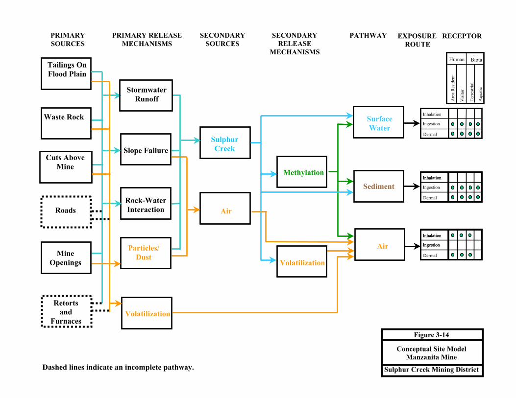
PRIMARY SOURCES
PRIMARY RELEASEMECHANISMS
SECONDARY SOURCES
SECONDARY RELEASE
MECHANISMS
PATHWAY
Tailings On Flood Plain
Roads
Slope Failure
Rock-Water Interaction
Stormwater Runoff
Particles/Dust
Air
Methylation
Surface Water
Sediment
Air
Sulphur Creek
Ingestion
Dermal
Inhalation
Ingestion
Dermal
Inhalation
Ingestion
Dermal
Inhalation
Inhalation
Ingestion
Inhalation
Volatilization
Waste Rock
Retorts and
Furnaces
Mine Openings
Volatilization
Cuts Above Mine
Are
a R
esid
ent
Vis
itor
Terr
estri
al
Aqu
atic
Human Biota
EXPOSURE RECEPTOR ROUTE
Figure 3-14
Conceptual Site Model Manzanita Mine
Sulphur Creek Mining District Dashed lines indicate an incomplete pathway.

3-54
Mercury mobilized by storm water runoff and erosion, slope failure, or water rock interaction from mine
wastes or in-place mercury enriched soils at the Manzanita Mine would enter Sulphur Creek. Thus,
pathways from the waste rock and tailings to Sulphur Creek are complete at the Manzanita Mine.
Central Mine. Primary sources of mercury at the Central Mine are waste rock associated with mine cuts
and a small volume of tailings near a rotary furnace and retort on the slope below the mine (Figure 3-15).
Roads associated with the Central Mine are not covered with tailings. Water rock interaction is not likely
to mobilize mercury because of the low mercury contents of waste rock at the mine cuts.
Retorts and furnaces are present on the slope between the Central and Manzanita mines above the Sulphur
Creek flood plain. The rotary furnace is located in a partially collapsed wood frame structure. The retorts
consist of brick edifices containing iron ovens and associated piping. A small volume of tailings is
located on the slopes below the rotary furnace and retorts. Retorts and furnaces typically contain residual
elemental mercury that can volatilize, or be discharged to soil. These structures also pose an attractive
nuisance in that trespassers may be attracted to them and could be exposed to residual mercury.
Mine cuts and roads concentrate storm water runoff creating rills and gullies that erode waste rock and in
place mercury enriched soils. Mine cuts consist of two open cuts on the slopes above the Sulphur Creek
flood plain. Runoff from the upper of the two cuts flows across the lower cut and creates rills and gullies
in waste rock where it flows off of the lower cut.
Mercury mobilized by storm water runoff and erosion of waste rock, tailings, or in-place mercury
enriched soils at Central Mine would enter Sulphur Creek. Thus, pathways from the waste rock and
tailings to Sulphur Creek are complete at the Central Mine.
Elgin Mine. Primary sources present at Elgin Mine are waste rock, hydrothermal springs, tailings, a
retort, and mine openings (Figure 3-16). Roads at Elgin Mine are not covered with waste rock, except for
the road through the upper mine area. Water rock interactions are likely to mobilize mercury from mine
wastes based on detection of 252 µg/L mercury in a WET extract from waste rock from the upper mine,
25.4 µg/L mercury in a WET extract from tailings at the retort, 3.3 µg/L mercury in a WET extract from
sediments including waste rock from the channel below the upper mine.

PRIMARY SOURCES
PRIMARY RELEASEMECHANISMS
SECONDARY SOURCES
SECONDARY RELEASE
MECHANISMS
PATHWAY
Tailings
Roads
Slope Failure
Rock-Water Interaction
Stormwater Runoff
Particles/Dust
Air
Methylation
Surface Water
Sediment
Air
Sulphur Creek
Ingestion
Dermal
Inhalation
Ingestion
Dermal
Inhalation
Ingestion
Dermal
Inhalation
Inhalation
Ingestion
Inhalation
Volatilization
Waste Rock
Retorts and
Furnaces
Mine Openings
Volatilization
Cuts Above Mine
Are
a R
esid
ent
Vis
itor
Terr
estri
al
Aqu
atic
Human Biota
EXPOSURE RECEPTOR ROUTE
Figure 3-15
Conceptual Site Model Central Mine
Sulphur Creek Mining District Dashed lines indicate an incomplete pathway.

PRIMARY SOURCES
PRIMARY RELEASEMECHANISMS
SECONDARY SOURCES
SECONDARY RELEASE
MECHANISMS
PATHWAY
Tailings At Old Retort
Roads
Slope Failure
Rock-Water Interaction
Stormwater Runoff
Particles/Dust
Air
Methylation
Surface Water
Sediment
Air
Sulphur Creek
Ingestion
Dermal
Inhalation
Ingestion
Dermal
Inhalation
Ingestion
Dermal
Inhalation
Inhalation
Ingestion
Inhalation
Volatilization
Waste Rock Above Spring
Retort
Mine Openings
Volatilization
Hydrothermal Spring
Are
a R
esid
ent
Vis
itor
Terr
estri
al
Aqu
atic
Human Biota
EXPOSURE RECEPTOR ROUTE
Discharge
Figure 3-16
Conceptual Site Model Elgin Mine
Sulphur Creek Mining District Dashed lines indicate an incomplete pathway.

3-57
Waste rock at the upper mine site is subject to erosion by storm water. In addition, discharge from a
hydrothermal spring is pooled directly on waste rock and flows through waste rock toward the west fork
of Sulphur Creek.
A hydrothermal spring discharges from a collapsed adit at the upper mine. Sampling of the hydrothermal
fluids before and after contact with mine wastes indicates that interaction between hydrothermal fluids
and waste rock mobilizes mercury. Other hydrothermal springs discharge across a broad area of the
lower mine property but do not appear to contact mine waste. A collapsed adit in the lower mine area
appears to contain another spring based on presence of green vegetation in the late summer, however no
above ground flow was observed. The flow from this spring appears to be captured for use in a hot tub by
the current property owner.
Mine openings consist of at least two collapsed adits. The collapsed adits both contained hydrothermal
springs. Evidence for drainage such as incised channels, rills, or sediment aprons was not observed at the
Elgin Mine openings.
The remnants of a retort are present on the Sulphur Creek floodplain below the mine site. These remnants
consist of a brick foundation, part of an iron door, and a small volume of tailings located within 100 feet
of the stream channel. The retort site could be inundated during winter flooding which could lead to
erosion and transport of mercury containing material.
Completed pathways at the Elgin Mine are discharge of hydrothermal fluids, water rock interactions
between hydrothermal fluids or infiltrating storm water and mine wastes, erosion by storm water runoff,
and slope failure.
Clyde Mine. Primary sources for mercury at Clyde Mine are mine cuts and mine openings (Figure 3-17).
Ponds were constructed in tailings from a gold recovery operation at the Clyde Mine but were dry at the
time of site inspection. Sampling of pond sediments resulted in detections of low concentrations of
mercury (Churchill and Clinkenbeard 2002). Tailings present at Clyde Mine consists of rock and soil
displaced during exploration work and contains no visual evidence such as bleaching, presence of clay or
quartz, or veins for the presence of mineralization. In addition, tailings contains only low concentrations
of mercury similar to background (Churchill and Clinkenbeard 2002). Ambient or near background
concentrations of mercury in potential mine wastes indicate a low chance that water rock interaction
would mobilize mercury from the Clyde Mine. Roads at the Clyde Mine are not covered with tailings.
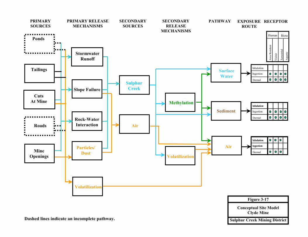
PRIMARY SOURCES
PRIMARY RELEASEMECHANISMS
SECONDARY SOURCES
SECONDARY RELEASE
MECHANISMS
PATHWAY
Ponds
Roads
Slope Failure
Rock-Water Interaction
Stormwater Runoff
Particles/Dust
Air
Methylation
Surface Water
Sediment
Air
Sulphur Creek
Ingestion
Dermal
Inhalation
Ingestion
Dermal
Inhalation
Ingestion
Dermal
Inhalation
Inhalation
Ingestion
Inhalation
Volatilization
Tailings
Mine Openings
Volatilization
Cuts At Mine
Are
a R
esid
ent
Vis
itor
Terr
estri
al
Aqu
atic
Human Biota
EXPOSURE RECEPTOR ROUTE
Figure 3-17
Conceptual Site Model Clyde Mine
Sulphur Creek Mining District Dashed lines indicate an incomplete pathway.

3-59
Cuts at the Clyde Mine consist of exploration trenches excavated during exploration for ore. These cuts
do not appear to concentrate runoff in a way that leads to slope failure or enhanced erosion of mercury-
laden material.
Mine openings consist of three adits. The two upper adits are partially collapsed. Water is visible within
the two upper adits, however no evidence such as incised channels, rills, or sediment aprons for flow of
water out of the adits was present. The material partially blocking each of the upper adits appears to
prevent discharge of water from the adits. The lower adit, adjacent to a small stream, is open. It is
possible that this adit drains to the unnamed stream during the rainy season.
Complete pathways at the Clyde Mine include erosion of tailings from pond berms by storm water runoff,
and failure of these berms (one berm contains a rill that will likely cause it to fail into a nearby unnamed
stream); and erosion and transport of waste rock by storm water.
Rathburn Mine. Primary sources for mercury at the Rathburn Mine are waste rock, the scattered
remains of a probable brick retort, and the mine pit (Figure 3-18). The potential for water rock interaction
to mobilize mercury at this site is assumed to be minimal based on low mercury content reported by
Churchill and Clinkenbeard (2002). Waste rock consists of rock removed from the shallow pit and
deposited on the pit edge. Roads at the Rathburn Mine are not covered with mine waste. Most of the
runoff from this site enters the open pit. However, a cut extending uphill to the west of the pit conducts
runoff to a north-south road leading out of the pit. Runoff from this exploration cut and from a waste
rock pile east of the road could enter a small swale that forms the headwaters of an intermittent tributary
to Bear Creek.
The scattered bricks on the east side of the pit suggest the remains of a brick retort. Ash associated with
the brick foundation contains up to 350 mg/kg mercury. Runoff from this area could reach a swale that
forms the headwaters of an intermittent tributary to Bear Creek.
Completed pathways at the Rathburn Mine are erosion and transport of waste rock by runoff from waste
rock and a cut east of the pit, and erosion and transport of ash by runoff from the retort foundation.
However, Bear Creek is approximately 2.8 stream miles from the site. The likelihood for significant
quantities of mine waste to be transported out of the pit is small, and potable groundwater is not known in
the area. Thus, the chance for mercury loads to impact Bear Creek is thought to be small.

PRIMARY SOURCES
PRIMARY RELEASEMECHANISMS
SECONDARY SOURCES
SECONDARY RELEASE
MECHANISMS
PATHWAY
Tailings
Roads
Slope Failure
Rock-Water Interaction
Stormwater Runoff
Particles/Dust
Air
Methylation
Surface Water
Sediment
Air
Bear Creek
Ingestion
Dermal
Inhalation
Ingestion
Dermal
Inhalation
Ingestion
Dermal
Inhalation
Inhalation
Ingestion
Inhalation
Volatilization
Waste Rock
Retort Remains
Mine Pit
Volatilization
Cuts Above Mine
Are
a R
esid
ent
Vis
itor
Terr
estri
al
Aqu
atic
Human Biota
EXPOSURE RECEPTOR ROUTE
Figure 3-18
Conceptual Site Model Rathburn Mine
Sulphur Creek Mining District Dashed lines indicate an incomplete pathway.
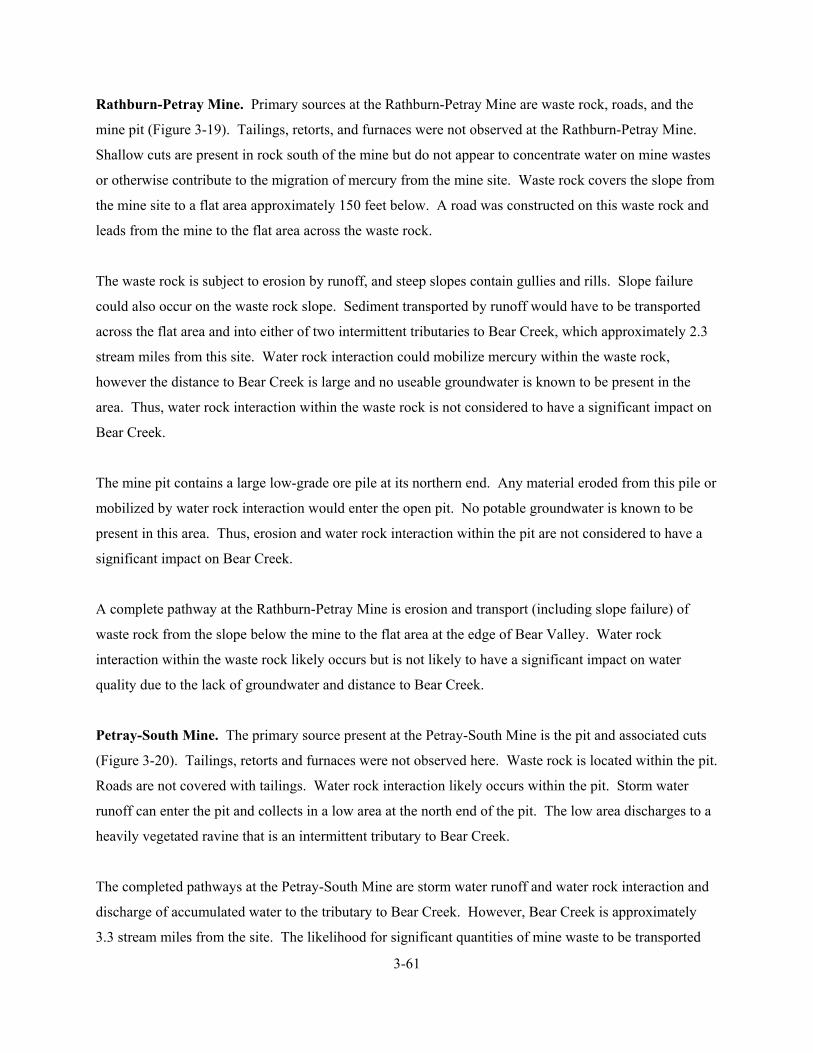
3-61
Rathburn-Petray Mine. Primary sources at the Rathburn-Petray Mine are waste rock, roads, and the
mine pit (Figure 3-19). Tailings, retorts, and furnaces were not observed at the Rathburn-Petray Mine.
Shallow cuts are present in rock south of the mine but do not appear to concentrate water on mine wastes
or otherwise contribute to the migration of mercury from the mine site. Waste rock covers the slope from
the mine site to a flat area approximately 150 feet below. A road was constructed on this waste rock and
leads from the mine to the flat area across the waste rock.
The waste rock is subject to erosion by runoff, and steep slopes contain gullies and rills. Slope failure
could also occur on the waste rock slope. Sediment transported by runoff would have to be transported
across the flat area and into either of two intermittent tributaries to Bear Creek, which approximately 2.3
stream miles from this site. Water rock interaction could mobilize mercury within the waste rock,
however the distance to Bear Creek is large and no useable groundwater is known to be present in the
area. Thus, water rock interaction within the waste rock is not considered to have a significant impact on
Bear Creek.
The mine pit contains a large low-grade ore pile at its northern end. Any material eroded from this pile or
mobilized by water rock interaction would enter the open pit. No potable groundwater is known to be
present in this area. Thus, erosion and water rock interaction within the pit are not considered to have a
significant impact on Bear Creek.
A complete pathway at the Rathburn-Petray Mine is erosion and transport (including slope failure) of
waste rock from the slope below the mine to the flat area at the edge of Bear Valley. Water rock
interaction within the waste rock likely occurs but is not likely to have a significant impact on water
quality due to the lack of groundwater and distance to Bear Creek.
Petray-South Mine. The primary source present at the Petray-South Mine is the pit and associated cuts
(Figure 3-20). Tailings, retorts and furnaces were not observed here. Waste rock is located within the pit.
Roads are not covered with tailings. Water rock interaction likely occurs within the pit. Storm water
runoff can enter the pit and collects in a low area at the north end of the pit. The low area discharges to a
heavily vegetated ravine that is an intermittent tributary to Bear Creek.
The completed pathways at the Petray-South Mine are storm water runoff and water rock interaction and
discharge of accumulated water to the tributary to Bear Creek. However, Bear Creek is approximately
3.3 stream miles from the site. The likelihood for significant quantities of mine waste to be transported

PRIMARY SOURCES
PRIMARY RELEASEMECHANISMS
SECONDARY SOURCES
SECONDARY RELEASE
MECHANISMS
PATHWAY
Tailings
Roads
Slope Failure
Rock-Water Interaction
Stormwater Runoff
Particles/Dust
Air
Methylation
Surface Water
Sediment
Air
Bear Creek
Ingestion
Dermal
Inhalation
Ingestion
Dermal
Inhalation
Ingestion
Dermal
Inhalation
Inhalation
Ingestion
Inhalation
Volatilization
Waste Rock
Retorts and
Furnaces
Mine Pit
Volatilization
Cuts Above Mine
Are
a R
esid
ent
Vis
itor
Terr
estri
al
Aqu
atic
Human Biota
EXPOSURE RECEPTOR ROUTE
Figure 3-19
Conceptual Site Model Rathburn-Petray Mine
Sulphur Creek Mining District Dashed lines indicate an incomplete pathway.

PRIMARY SOURCES
PRIMARY RELEASEMECHANISMS
SECONDARY SOURCES
SECONDARY RELEASE
MECHANISMS
PATHWAY
Roads
Slope Failure
Rock-Water Interaction
Stormwater Runoff
Particles/Dust
Air
Methylation
Surface Water
Sediment
Air
Bear Creek
Ingestion
Dermal
Inhalation
Ingestion
Dermal
Inhalation
Ingestion
Dermal
Inhalation
Inhalation
Ingestion
Inhalation
Volatilization
Waste Rock
Mine Pit and Cut
Volatilization
Cuts Above Mine
Are
a R
esid
ent
Vis
itor
Terr
estri
al
Aqu
atic
Human Biota
EXPOSURE RECEPTOR ROUTE
Figure 3-20
Conceptual Site Model Petray-South Mine
Sulphur Creek Mining District Dashed lines indicate an incomplete pathway.

3-64
out of the pit is small, and potable groundwater is not known in the area. Thus, the chance for mercury
loads to impact Bear Creek is thought to be small.
Petray-North Mine. Primary sources at the Petray-North Mine are waste rock, the mine pit and an ore-
loading chute (Figure 3-21). Retort, furnace and tailings were not observed at the Petray-North Mine. An
exploration cut is present on the north wall of the pit, but is considered to be part of the pit for the
purposes of this CSM. Roads at the Petray-North Mine are not covered with tailings.
The pit is internally draining in that runoff and precipitation within the pit will collect on the pit bottom
prior to flowing out of the pit to the east. A road conducts runoff into the pit at its southeast end. Waste
rock is present on the pit floor, and covers the slope between the east end of the pit and an intermittent
tributary to Bear Creek below the east end of the pit. During the rainy season, runoff can erode and
transport waste rock out of a portion of the pit and into the intermittent stream. In addition, the
intermittent stream appears to be eroding and transporting waste rock from the slope below the east end of
the pit. Water rock interaction is presumed to occur within the pit and waste rock due to infiltration of
seasonal rainfall.
The ore-loading chute is a collapsed wood frame and sheet metal structure located between the Petray-
South and Petray-North mines. Runoff from this facility would enter the intermittent tributary that flows
past the east end of the Petray-North pit.
Complete pathways at the Petray-North Mine are water rock interaction, erosion and transport by storm
water runoff, and slope failure in waste rock. In addition, erosion and transport of mercury containing
sediment from the vicinity of the ore chute could occur. These pathways could result in transport of
mercury or mercury containing sediment through intermittent tributaries to Bear Creek. However, Bear
Creek is approximately 3.1 stream miles from the site. The likelihood for significant quantities of mine
waste to be transported out of the pit is small, and potable groundwater is not known in the area. Thus,
the chance for mercury loads to impact Bear Creek is thought to be small.
Sulphur Creek. This discussion of a CSM for Sulphur Creek is applicable to the reach between the
West End Mine and the confluence with Bear Creek. Primary sources for mercury include flood plain
deposits, in-stream sediments, hydrothermal springs, and shallow groundwater (Figure 3-22). Water
discharging from hydrothermal springs (including Blank Spring) contains mercury (dissolved and on or in
particulates/precipitates). This mercury directly enters Sulphur Creek.

PRIMARY SOURCES
PRIMARY RELEASEMECHANISMS
SECONDARY SOURCES
SECONDARY RELEASE
MECHANISMS
PATHWAY
Tailings
Roads
Slope Failure
Rock-Water Interaction
Stormwater Runoff
Particles/Dust
Air
Methylation
Surface Water
Sediment
Air
Bear Creek
Ingestion
Dermal
Inhalation
Ingestion
Dermal
Inhalation
Ingestion
Dermal
Inhalation
Inhalation
Ingestion
Inhalation
Volatilization
Waste Rock
Ore Loading Chute
Mine Pit
Volatilization
Cuts Above Mine
Are
a R
esid
ent
Vis
itor
Terr
estri
al
Aqu
atic
Human Biota
EXPOSURE RECEPTOR ROUTE
Figure 3-21
Conceptual Site Model Petray-North Mine
Sulphur Creek Mining District Dashed lines indicate an incomplete pathway.
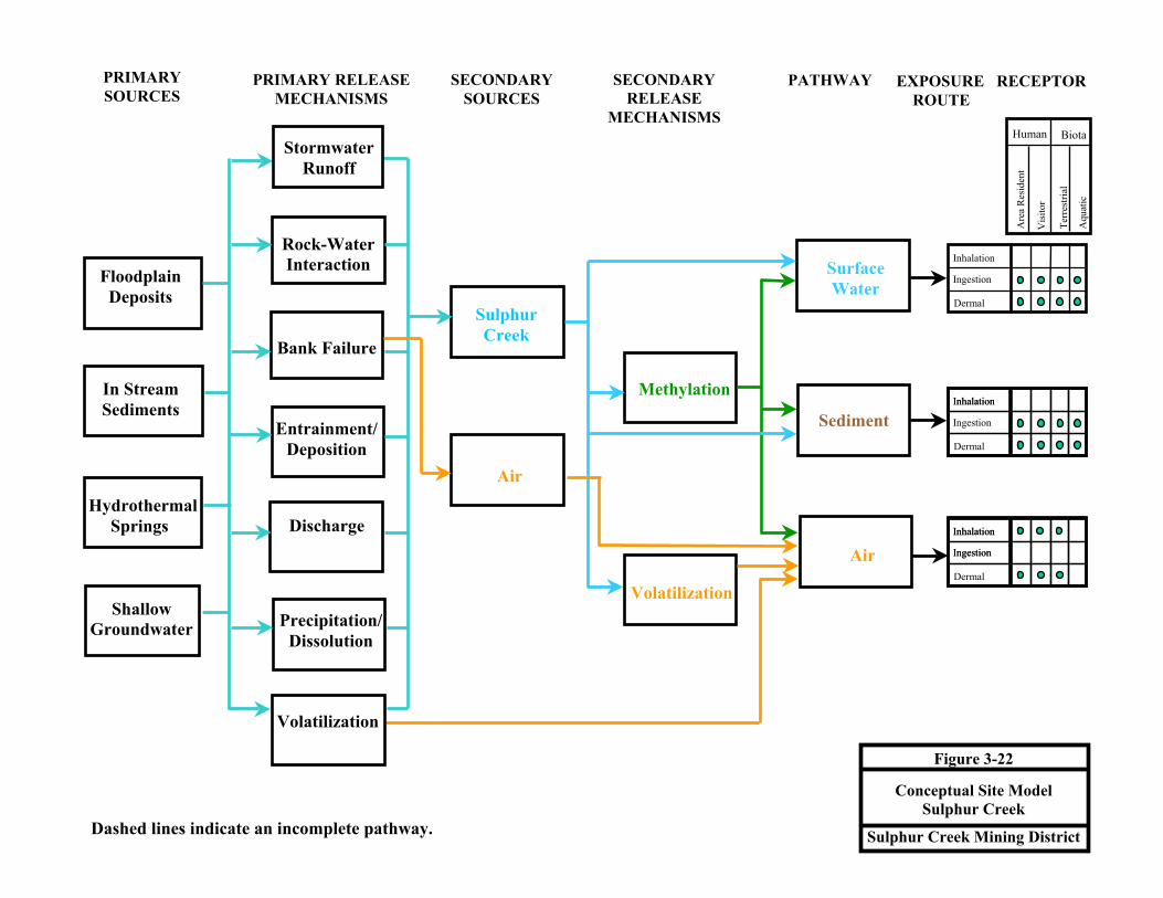
PRIMARY SOURCES
PRIMARY RELEASEMECHANISMS
SECONDARY SOURCES
SECONDARY RELEASE
MECHANISMS
PATHWAY
Floodplain Deposits
Shallow Groundwater
Bank Failure
Rock-Water Interaction
Discharge
Air
Methylation
Surface Water
Sediment
Air
Sulphur Creek
Ingestion
Dermal
Inhalation
Ingestion
Dermal
Inhalation
Ingestion
Dermal
Inhalation
Inhalation
Ingestion
Inhalation
Volatilization
In Stream Sediments
Entrainment/ Deposition
Hydrothermal Springs
Stormwater Runoff
Are
a R
esid
ent
Vis
itor
Terr
estri
al
Aqu
atic
Human Biota
EXPOSURE RECEPTOR ROUTE
Precipitation/ Dissolution
Volatilization
Figure 3-22
Conceptual Site Model Sulphur Creek
Sulphur Creek Mining District Dashed lines indicate an incomplete pathway.

3-67
Flood plain deposits consist of sediments deposited during winter season floods that may contain mercury
originating from mining activity or natural sources. Erosion of these flood plain deposits would release
mercury into the watershed. Dissolution of mercury through water rock interaction could also mobilize
mercury from flood plain deposits.
In-stream sediments include particles eroded from mine waste and stream deposits, and chemical
precipitates from hydrothermal waters. Chemical precipitates from hydrothermal waters accumulate in
the channel of Sulphur Creek during dry seasons, and are eroded and transported downstream during
rainy season flood events. Sediments from mine waste and stream deposits are also eroded and
transported during rainy season flood events.
Shallow groundwater is the non-hydrothermal water present in alluvial deposits. This shallow
groundwater could interact with mercury containing flood plain deposits, dissolving and transporting
mercury to Sulphur Creek.
Completed pathways in Sulphur Creek include erosion and bank failure of flood plain deposits; water
rock interactions between shallow groundwater and mercury containing sediments in flood plain deposits;
direct discharge of hydrothermal springs; accumulation of chemical precipitates and subsequent erosion
or dissolution.

4-1
4.0 SUMMARY OF MINING IMPACTS TO WATERSHED
Recent studies have determined that large amounts of mercury are transported annually into the Cache
Creek watershed from abandoned mines in the District (Churchill and Clinkenbeard 2002; Suchanek
2002; Foe and Croyle 1998; Slotton and Ayres 2001). This mercury load to the watershed degrades water
quality and likely contributes to threats to human health and the environment. Ultimately, mercury from
the District enters the Bay-Delta system contributing to the accumulation of mercury in the regional food
web. In addition to water quality impacts, the mercury contained in mine wastes at each site poses
potential threats to human health and ecological receptors. These impacts are discussed below.
4.1 WATER QUALITY DEGRADATION
Sulphur Creek, Bear Creek and Harley Gulch drain the District and are tributaries to Cache Creek. Cache
Creek is identified by the RWQCB as an impaired water body due to mercury under Section 303D of the
Clean Water Act (CWA). RWQCB is currently developing a TMDL for mercury in the Cache Creek
watershed. Sampling of surface water from Sulphur Creek, Bear Creek and Harley Gulch by Foe and
Croyle (1998) has documented that a significant part of the mercury load to Cache Creek originates from
these tributaries draining the District under high runoff conditions. Thus, mines in the District appear to
contribute a significant proportion of the mercury impairing water quality in Cache Creek. However, this
conclusion is confounded by observations from Domagalski and Alpers (2000) that show the mercury
concentrations from Sulphur Creek, Bear Creek and Harley Gulch are diluted in upper Cache Creek to the
point that no clear influence of the mercury from upper Cache Creek is apparent on the mercury
concentrations measured in lower Cache Creek. This apparent conflict may be resolved by evaluating
mercury contents of sediment stored in the Cache Creek watershed. Because much of the mercury
released from the mine sites is in particulate form (Foe and Croyle 1998), it is possible that much of the
mercury load from the District becomes entrained in sediment before reaching the lower Cache Creek
watershed.
Additional recent work in Cache Creek has resulted in estimation of mercury loads from each mine site to
adjacent streams. Churchill and Clinkenbeard (2002) estimated loads from District mines based on
available mercury concentration data and application of the universal soil loss equation (Renard and
others, 1977). Suchanek and others (2000) estimated mercury loads from the Harley Gulch and Sulphur
Creek watersheds. These mercury-loading estimates are compared in Table 4-1 below.

4-2
TABLE 4-1. ESTIMATED MERCURY LOADS
Mine Site
Water Body
Mercury Load a
(kg/year)
Mercury Load b
(kg/year)
Abbott Harley Gulch 0.8 to 3.5
Turkey Run Harley Gulch 0.42 to 6.7
Harley Gulch Subtotal 1.22 to 10.2
0.1 to 35
Wide Awake Sulphur Creek 0.02 to 0.44
West End Sulphur Creek 0.002 to 1.1
Cherry Hill Sulphur Creek 0 to 1
Manzanita Sulphur Creek 0.3 to 6.5
Empire Sulphur Creek 0.04 to 0.06
Central Sulphur Creek 0.003 to 0.03
Elgin Sulphur Creek 3.9 to 9.3
Clyde Sulphur Creek 0.04 to 0.07
Sulphur Creek Subtotal 4.4 to 18.6
0.5 to 160
Rathburn Bear Creek 0.7 to 19.7
Petray Bear Creek 0.5 to 4.6
Bear Creek Subtotal 1.2 to 24.3
Not reported
Total Load 6.8 to 53.1 0.6 to 195
Notes:
a = Churchill and Clinkenbeard (2002)
b = Suchanek and Others (2000)
kg/year = kilograms per year
Thus the estimated total mercury load to the watersheds from mine sites is approximately 0.6 to
195 kg/year (Churchill and Clinkenbeard 2002, Suchanek and others 2000). Churchill and Clinkenbeard
(2002) also estimated the non-mining related mercury load to the Cache Creek watershed. Their estimate

4-3
of the non-mining mercury load attributed to erosion of regional background soil, natural mercury
enriched soils, and discharge from hydrothermal springs is from 4.94 to 98 kg/year. Current estimates of
mercury loads show that mercury loads from abandoned mines are approximately one-half the total
mercury load from the upper Cache Creek watershed.
4.2 HUMAN HEALTH IMPACTS
Mine wastes present at each of the mine sites contain mercury that may pose a threat to human health due
to exposures through recreation or work at the mine sites. For example, recreational exposure can occur
during hiking, camping, hunting, or rock collecting at or near the mine sites. This evaluation of potential
human health impacts is conducted to support evaluation of ARARs that may be pertinent to any of the
load reduction techniques identified in this EE/CA. This evaluation is based on comparison of mercury
concentrations reported in soil, mine waste and water to human health screening values. This risk
evaluation is based on the mercury consisting of cinnabar in soil, waste rock, tailings and ore; and
cinnabar and elemental mercury in tailings. This type of risk evaluation likely overestimates the potential
risks to human health.
Exposure to mercury during recreational activity can be through direct contact of skin with mercury
containing material, inhalation of volatile elemental mercury or particulates containing mercury, and/or
incidental ingestion of mercury containing particles. The CSMs show these potential exposures to
humans. To evaluate potential risks to human health, the mercury concentration data from each site was
compared to local and regional background values and risk based screening values. Risk based screening
values used in this evaluation are preliminary mitigation goals prepared in accordance with EPA Region 9
procedures and risk based screening values prepared by the U.S. Bureau of Land Management (BLM)
(1996). Table 4-2 compares the average and maximum mercury concentrations measured in mine wastes
at each mine site to these screening values.
In general, exceeding a screening value does not imply that a significant risk exists if the site
concentration and screening values are of the same order of magnitude. For example, none of the sites
pose a significant risk to all-terrain vehicle (ATV) drivers, or surveyors under the assumptions used by
BLM to evaluate these exposure scenarios. However, exceeding a screening value by several times may
indicate the need to evaluate site risks based on realistic assumptions to ensure that significant risks are
not present. For example, camping at a mine site may pose risks. Site-wide mine waste average
concentrations exceed local and regional background concentrations at each site. Background

4-4
TABLE 4-2. COMPARISON OF TOTAL MERCURY TO RISK-BASED
HUMAN HEALTH SCREENING VALUES
Mine Site
Average Mercury
Concentration
(mg/kg)
Mine Waste Mercury
Concentration Range
(mg/kg)1
Site Background
Concentration Range
(mg/kg)1
Abbott 189 (n = 21) 10 to 1,530 2 to 520
Turkey Run 570 (n = 8) 20 to 1,720 0.12 to 390
Wide Awake 175 (n = 12) 5.0 to 1,040 2.37 to 90
West End 295 (n = 2) 290 to 300 4.91 (one sample)
Cherry Hill 182 (n = 3) 47.2 to 280 1.23 to 57
Manzanita 252 (n = 5) 62.6 to 560 5.93 to 130
Empire 103 (n = 2) 56.4 to 150 NA
Central 88 (n = 6) 3.25 to 420 NA
Elgin 690 (n = 5) 20 to 3,030 120 to 330
Clyde 23.5 (n = 2) 6.67 to 40 4.98 (one sample)
Rathburn 254 (n = 8) 42.7 to 990 42.6 (one sample)
Petray 310 (n = 7) 26.6 to 1,070
(outlier 14,270 )
2.98 to 30
Regional
Background1 0.17 (n = 11) 0.10 to 0.31
NA
Camper 40 NA
Worker 60 NA
Surveyor 480 NA
BLM Screening
Values
ATV Driver 550 NA
EPA Region 9
PRG (EPA 2002)
Industrial Worker
115
NA
Notes: mg/kg = Milligram per kilogram NA = Not available PRG = Preliminary remediation goal BLM = Bureau of Land Management EPA = U.S. Environmental Protection Agency 1 = Churchill and Clinkenbeard (2002) n = number of sample Values in bold type are average values that exceed more than one screening value.
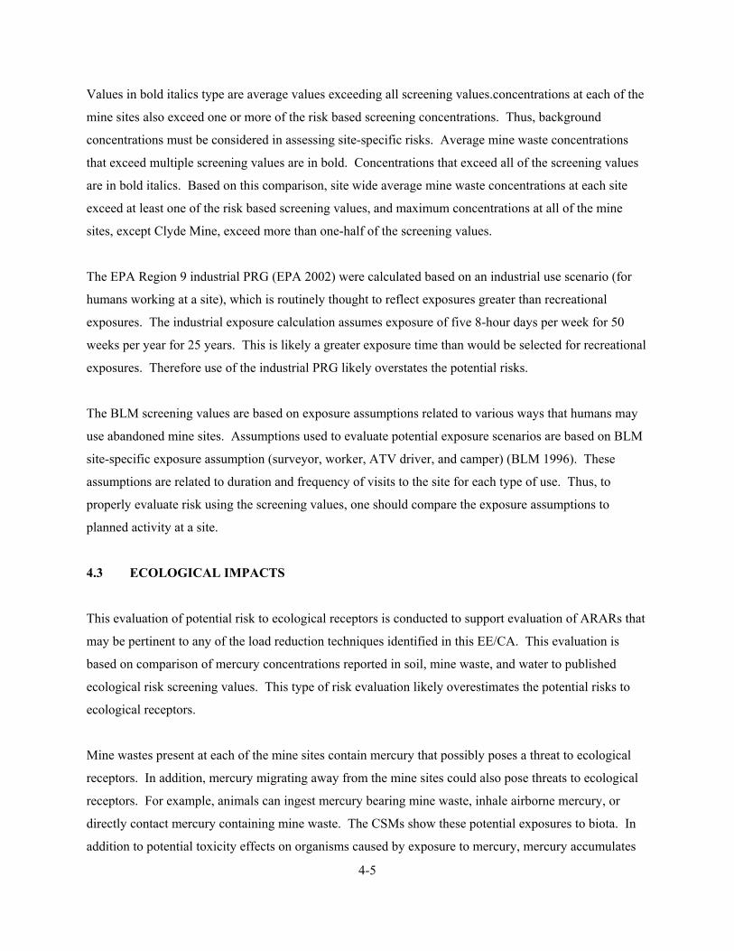
4-5
Values in bold italics type are average values exceeding all screening values.concentrations at each of the
mine sites also exceed one or more of the risk based screening concentrations. Thus, background
concentrations must be considered in assessing site-specific risks. Average mine waste concentrations
that exceed multiple screening values are in bold. Concentrations that exceed all of the screening values
are in bold italics. Based on this comparison, site wide average mine waste concentrations at each site
exceed at least one of the risk based screening values, and maximum concentrations at all of the mine
sites, except Clyde Mine, exceed more than one-half of the screening values.
The EPA Region 9 industrial PRG (EPA 2002) were calculated based on an industrial use scenario (for
humans working at a site), which is routinely thought to reflect exposures greater than recreational
exposures. The industrial exposure calculation assumes exposure of five 8-hour days per week for 50
weeks per year for 25 years. This is likely a greater exposure time than would be selected for recreational
exposures. Therefore use of the industrial PRG likely overstates the potential risks.
The BLM screening values are based on exposure assumptions related to various ways that humans may
use abandoned mine sites. Assumptions used to evaluate potential exposure scenarios are based on BLM
site-specific exposure assumption (surveyor, worker, ATV driver, and camper) (BLM 1996). These
assumptions are related to duration and frequency of visits to the site for each type of use. Thus, to
properly evaluate risk using the screening values, one should compare the exposure assumptions to
planned activity at a site.
4.3 ECOLOGICAL IMPACTS
This evaluation of potential risk to ecological receptors is conducted to support evaluation of ARARs that
may be pertinent to any of the load reduction techniques identified in this EE/CA. This evaluation is
based on comparison of mercury concentrations reported in soil, mine waste, and water to published
ecological risk screening values. This type of risk evaluation likely overestimates the potential risks to
ecological receptors.
Mine wastes present at each of the mine sites contain mercury that possibly poses a threat to ecological
receptors. In addition, mercury migrating away from the mine sites could also pose threats to ecological
receptors. For example, animals can ingest mercury bearing mine waste, inhale airborne mercury, or
directly contact mercury containing mine waste. The CSMs show these potential exposures to biota. In
addition to potential toxicity effects on organisms caused by exposure to mercury, mercury accumulates

4-6
in biota within the District. Ecological risk screening of mines in the District and mercury accumulation
in downstream biota is discussed below.
4.3.1 Ecological Risk Screening
To evaluate potential risks to ecological receptors, mercury concentration data from each site were
compared to risk based screening values. Risk based screening values used in this evaluation are risk
based screening values prepared by the BLM (1996). The BLM screening values are for specific
ecological receptors (for example mule deer). In general, exceeding a screening value does not imply that
a significant risk exists if the site concentration and screening values are of the same order of magnitude.
However, exceeding a screening value by several times may indicate the need to evaluate site risks based
on realistic assumptions to ensure that significant risks are not present. For example, average mine waste
concentrations at each site are significantly elevated compared to the screening concentration for a Robin.
The exposure scenario used to estimate this screening value assumes the Robin lives and feeds
exclusively at the site. Thus, if the Robin only used the site part of the time, the screening value would
overestimate the risk (i.e., the screening value would be too low).
Table 4-3 below compares the average and maximum mercury concentration measured in mine wastes at
each mine site to these screening values. Mine waste average concentrations exceed local and regional
background concentrations at each site. However, background concentrations at each site also exceed one
or more of the ecological risk based screening values. Thus, background concentrations must be
considered in assessing site-specific mitigation goals. Average mine waste concentrations that exceed all
of the screening values are in bold italics. Based on this comparison, the average mine waste mercury
concentration at each site poses a potential risk to the selected ecological receptors.
TABLE 4-3. COMPARISON OF TOTAL MERCURY TO RISK-BASED
ECOLOGICAL SCREENING VALUES
Mine Site
Average Mercury
Concentration
(mg/kg)
Mine Waste Mercury
Concentration Range
(mg/kg)1
Site Background
Concentration Range
(mg/kg)1
Abbott 189 (n = 21) 10 to 1,530 5 to 520
Turkey Run 570 (n = 8) 20 to 1,720 0.12 to 390

4-7
Wide Awake 175 (n = 12) 5.0 to 1,040 2.37 to 90
West End 295 (n = 2) 290 to 300 4.91 (one sample)
Cherry Hill 182 (n = 3) 47.2 to 280 1.23 to 57
Manzanita 252 (n = 5) 62.6 to 560 5.93 to 130
Empire 103 (n = 2) 56.4 to 150 NA
Central 88 (n = 6) 3.25 to 420 NA
Elgin 690 (n = 5) 20 to 3,030 120 to 330
Clyde 23.5 (n = 2) 6.67 to 40 4.98 (one sample)
Rathburn 254 (n = 8) 42.7 to 990 42.6 (one sample)
Petray 310 (n = 7) 26.6 to 1,070
(outlier 14,270 )
2.98 to 30
Regional
Background 0.17 (n = 11) 0.10 to 0.31
NA
Deer Mouse 2 NA
Cotton Tail 15 NA
Mule Deer 9 NA
Cattle 45 NA
Elk 11 NA
Mallard 4 NA
BLM
Screening
Values
Robin 1 NA
Notes: 1 = Churchill and Clinkenbeard (2002) mg/kg = Milligram per kilogram NA = Not available BLM = Bureau of Land Management
4.3.2 Mercury Accumulation in Biota
Accumulation of mercury from mines in the District is a complex process. Mercury released from mine
wastes is mostly inorganic mercury in cinnabar or elemental mercury bound to solid particles. This
inorganic mercury becomes methylated before it is readily accumulated in animal tissues. The chemical
conditions and reactions necessary to transform inorganic mercury to more bioavailable methyl mercury
are currently the subject of significant research efforts. Nevertheless, evidence for the accumulation of
mercury in aquatic organisms is available. For example Slotton and others (2001) reported that
Hydropsyche (caddis fly larva) in Harley Gulch near the Abbott and Turkey Run mines contained about

4-8
19 times as much mercury as Hydropsyche downstream at the confluence of Harley Gulch and Cache
Creek. Similarly, Hydropsyche in Bear Creek at the confluence with Sulphur Creek contained more
mercury than Hydropsyche downstream at the confluence of Bear and Cache creeks. Slotton and others
(2001) also reported that the highest mercury bioaccumulation factors in the Cache Creek watershed
derived in their study were for biota near mines in Harley Gulch and Sulphur Creek. These observations
appear to demonstrate that mercury from the mine sites in the District is accumulating in biota.
4.4 SUMMARY OF MINE SITE IMPACTS
Cache Creek is an impaired water body due to mercury loads. Mines in the District are a source for
mercury to surface water, and provide a significant load of mercury to the Cache Creek watershed. This
observation should be considered in light of estimates of the mercury load from regional soils and
geologic materials not disturbed by mining, which are of the same order of magnitude as the mercury load
from the mine sites (Churchill and Clinkenbeard 2002).
Based on comparison to EPA and BLM risk-based human health screening criteria, mercury present in
mine wastes at District mines potentially poses a health risk to humans that may camp, collect rocks, or
hike around the mines. Based on comparison to risk based ecological screening criteria, mercury present
in mine wastes potentially poses a threat to ecological receptors and livestock residing in the vicinity of
District mines. However, evaluation of risks to humans and biota from the mine sites must also consider
that natural background concentrations of mercury in soil and rock not disturbed by mining also exceed
one or more of the risk screening criteria. Humans or biota may not be as readily exposed to mercury
contained in these undisturbed natural materials as to mercury contained within mine wastes. Available
data show that aquatic biota near the District mines accumulate more mercury than similar biota at a
distance from the mines (Slotton and others, 2001). The perceived impacts of District mines to water
quality, human health, and ecological receptors are the basis for evaluating potential mitigation
alternatives at the mine sites.

5-1
5.0 SUMMARY OF APPLICABLE AND RELEVANT OR APPROPRIATE REGULATIONS AND OTHER FACTORS AFFECTING MINE MITIGATION
This section identifies and evaluates potential federal and State of California ARARs that might impact
the development, selection, and implementation of mitigation alternatives. Section 5.1 summarizes the
definitions and concepts pertinent to ARAR determinations. The three categories of ARARs, chemical-,
location- and action-specific, are described in Sections 5.2, 5.3, and 5.4, respectively. Section 5.5 follows
the ARAR discussion and provides an analysis of the exemption of mining wastes from regulation as a
hazardous waste under Section 3001(a)(3)(A)(ii) of the Resource Conservation and Recovery Act
(RCRA) (also known as the Bevill Amendment) and under the California Health and Safety Code,
Section 25143.1(b)(1) and (2). Section 5.6 discusses other issues including property ownership and water
rights considerations. ARARs contain requirements for District mines, proposed mitigation alternatives,
or mercury that must be met though they may not relate directly to reduction of mercury loading to the
watershed.
5.1 REGULATORY REQUIREMENTS
Implementation of mitigation alternatives as the final action at District mines must meet regulatory
requirements. However, if the planned mitigation is not the final action at the mine site, then the
mitigation alternative must support and be consistent with attainment of requirements over the long term.
Such regulatory requirements include federal or more stringent state environmental standards,
requirements, criteria, or limitations that are determined to be legally ARAR.
Applicable requirements are those cleanup standards, standards of control, and other substantive
environmental protection requirements, criteria, or limitations promulgated under federal or state law that
specifically address the situation at a site. The requirement is applicable if the jurisdictional prerequisites
of the law or regulation directly address the circumstances at the site. An applicable federal requirement
is an ARAR. An applicable state requirement is an ARAR only if it is more stringent than federal
ARARs.
If the requirement is not legally applicable, then the requirement is evaluated to determine whether it is
relevant and appropriate. Relevant and appropriate requirements are those cleanup standards, standards
of control, and other substantive environmental protection requirements, criteria, or limitations
promulgated under federal or state law that, while not applicable, address problems or situations similar to

5-2
the circumstances of the proposed response action and are well suited to the conditions of the site (EPA
1988). A requirement must be determined to be both relevant and appropriate to be considered an ARAR.
The criteria for determining relevance and appropriateness, as listed in 40 Code of Federal Regulation
(CFR) Section 300.400(g)(2), are:
• The purpose of the requirement and the purpose of remediation
• The medium regulated or affected by the requirement and the medium contaminated or affected at the site
• The substances regulated by the requirement and the substances found at the site
• Any variances, waivers, or exemptions of the requirement and their availability for the circumstances at the site
• The type of place regulated and the type of place affected by the release or action
• The type and size of structure or facility regulated and the type and size of structure or facility affected by the release or contemplated by the action
• Any consideration of use or potential use of affected resources in the requirement and the use or potential use of the affected resources at the site
A requirement may be “applicable” or “relevant and appropriate,” but not both. Identification of ARARs
is done on a site-specific basis and involves a two-part analysis: first, a determination whether a given
requirement is applicable; then, if it is not applicable, a determination whether it is nevertheless both
relevant and appropriate. When the analysis determines that a requirement is both relevant and
appropriate, such a requirement must be complied with to the same degree as if it were applicable.
To qualify as a state ARAR a state requirement must be:
• A state law
• An environmental or facility siting law
• Promulgated (of general applicability and legally enforceable)
• Substantive (not procedural or administrative)
• More stringent than the federal requirement
• Identified in a timely manner
• Consistently applied
To constitute an ARAR, a requirement must be substantive. Therefore, only the substantive provisions of
requirements identified as ARARs in this analysis are considered to be ARARs. Permits are considered
5-3
to be procedural or administrative requirements. Provisions of generally relevant federal and state
statutes and regulations that were determined to be procedural or nonenvironmental, including permit
requirements, are not considered to be ARARs.
Nonpromulgated advisories or guidance issued by federal or state governments are not legally binding
and do not have the status of ARARs. Such requirements may, however, be useful, and are “to be
considered” (TBC). TBC requirements complement ARARs but do not override them. They are useful
for guiding decisions regarding cleanup levels or methodologies when regulatory standards are not
available.
Three categories of ARARs are recognized to assist in their identification. The three categories are
(1) chemical-specific, (2) location-specific, (3) and action-specific ARARs. Though some requirements
do not fall neatly into this classification. These categories are described in the following sections.
5.2 CHEMICAL SPECIFIC ARARS AND TBCS
Chemical-specific ARARs are generally health- or risk-based numerical values or methodologies applied
to site-specific conditions that result in the establishment of a cleanup level. The three media of concern
within the District are:
• Groundwater • Surface water • Ore piles/tailings/waste rock piles
Potential ARARs for these media are evaluated below.
5.2.1 Groundwater ARARs and TBCs
The identification of ARARs for groundwater depends on whether the groundwater is a potential drinking
water source. Under EPA’s Guidelines for Groundwater Classification, groundwater is considered a
potential drinking water source unless the there is insufficient quality (TDS concentrations are over
10,000 mg/L) or quantity (yield is less than 150 gallons per day). Under the State of California’s Sources
of Drinking Water Policy, State Water Resources Control Board (SWRCB) No. 88-63, groundwater is
considered a potential drinking water source if the TDS levels are below 3,000 mg/L (specific
conductance of 5,000 µS/cm) and the yield is more than 200 gallons per day.

5-4
The average TDS of the regional groundwater in the District is above 10,000 mg/L, and the specific
conductance of regional groundwater exceeds 5,000 µS/cm (Goff 2000). Thus, using these guidelines,
regional groundwater is not considered a potential drinking water source. Accordingly, drinking water
standards have not been identified as potential ARARs.
No federal ARARs for groundwater have been identified. The following regulations are potential state
ARARs for groundwater underlying the site:
• RWQCB Basin Plan water quality objectives
• SWRCB Resolution 68-18, Statement of Policy With Respect to Maintaining High Quality Waters in California
• SWRCB Resolution 92-49, Policies and Procedures for Investigation and Cleanup and Abatement of Discharges under California Water Code Section 13304
Each of these potential ARARs is discussed below.
5.2.1.1 Central Valley Water Quality Control Plan (Basin Plan):
The Basin Plan for the Central Valley was prepared and implemented by the Central Valley RWQCB to
protect and enhance the quality of waters in the region. The Basin Plan establishes location-specific
beneficial uses and water quality objectives (WQO) for surface water and groundwater of the region. The
Basin Plan includes both numeric and narrative WQOs. The WQOs are intended to protect the beneficial
uses of the water of the region and to prevent nuisance.
The Basin Plan contains the following pertinent narrative WQOs for groundwater:
Chemical Constituents: “Groundwater shall not contain chemical constituents in concentrations that adversely affect beneficial uses.”
Toxics: “Groundwater shall be maintained free of toxic substances in concentrations that produce detrimental physiological responses in human, plant, animal, or aquatic life associated with designated beneficial uses.”
5-5
5.2.1.2 SWRCB Resolution 68-16
Resolution 68-16, Statement of Policy With Respect to Maintaining High Quality Waters in California,
establishes the policy that high quality waters of the state “shall be maintained to the maximum extent
possible” consistent with the “maximum benefit to the people of the state.” It requires the maintenance of
high quality waters until it has been demonstrated that any change will be consistent with maximum
benefit to the people of the state, will not unreasonably affect beneficial uses of such water, and will
comply with applicable water quality control policies. It further requires that any discharge of waste to
high quality waters comply with requirements resulting in best practicable treatment or control to prevent
pollution or nuisance.
5.2.1.3 SWRCB Resolution 92-49
SWRCB Resolution 92-49 contains policies and procedures that the regional boards apply to all
investigations and cleanup and abatement activities for all types of discharges subject to California Water
Code Section 13304. Section III.G of the Resolution requires attainment of background water quality, or
if background cannot be restored, the best water quality that is reasonable.
5.2.2 Surface Water ARARs
As with groundwater, the identification of surface water ARARs also hinges on the beneficial uses of the
water. In the Basin Plan, the existing beneficial uses for Harley Gulch, Sulphur Creek, and Bear Creek
are not specifically identified. However, the basin plan identifies a beneficial use of municipal domestic
supply for water bodies not specifically identified unless the criteria of Resolution 88-63 are exceeded.
Harley Gulch is an intermittent stream and is not expected to yield enough water to support domestic use
in accordance with Resolution 88-63. Sulphur Creek contains water with a specific conductivity of more
than 5,000 µS/cm and TDS greater than 10,000 mg/L and exceeds federal and state criteria for drinking
water. Bear Creek meets the federal and state criteria for sources of drinking water, and is a tributary to
Cache Creek for which the beneficial uses of municipal domestic supply, agriculture, recreation, warm
freshwater habitat, spawning, and wildlife habitat. Potential federal surface water ARARs for Bear Creek
are the Safe Drinking Water Act (SDWA) and the CWA. Potential state ARARs for Bear Creek are the
State of California maximum contaminant levels (MCL), the Basin Plan, and Resolutions 68-16 and 92-
49.

5-6
5.2.2.1 Safe Drinking Water Act
The SDWA, 42 United States Code (USC) Section 300(f) et seq., sets limits on the concentrations of
certain hazardous materials in drinking water. MCLs are applied at the tap to water that is delivered
directly to 25 or more people or to 15 or more service connections. Under the SDWA, EPA has also
designated maximum contaminant level goals (MCLG), which are health-based goals, generally more
stringent than MCLs. Comprehensive Environmental Response, Compensation, and Liability Act
(CERCLA) Section 1211(d)(2)(B) provides that CERCLA response actions “shall require a level of
standard or control which at least attains MCLGs established under the Safe Drinking Water Act.”
Section 300.430(f)(5) of the National Oil and Hazardous Substances Pollution Contingency Plan (NCP)
provides that remedial actions must generally attain MCLs or non-zero MCLGs if water is a current or
potential source of drinking water.
EPA has adopted the following MCL (40 CFR 141.62(b)) and MCLG (40 CFR 141.51) for mercury in
surface water of Bear and Cache Creeks:
TABLE 5-1. EPA MAXIMUM CONTAMINANT LEVELS
Substance MCL MCLG
Mercury 0.002 mg/L 0.002 mg/L
Notes: MCL = maximum contaminant level MCLG = maximum contaminant level goal mg/L = milligram per liter
5.2.2.2 State Safe Drinking Water Act
The state of California has adopted primary and secondary MCLs for public drinking water under the
California SDWA of 1976. Some state MCLs may be more stringent than the corresponding federal
MCL, in which case the state MCL would generally be the ARAR. The MCLs are set forth in Title 22
California Code of Regulation (CCR) Sections 64431 and 64449(a). The MCL for mercury in surface
water in Bear and Cache creeks are:

5-7
TABLE 5-2. CALIFORNIA MAXIMUM CONTAMINANT LEVELS
Substance Primary MCL Secondary MCL
Mercury 0.002 mg/L None
Notes: MCL = maximum contaminant level mg/L = milligram per liter
5.2.2.3 Clean Water Act Water Quality Standards
On December 22, 1992, EPA promulgated federal water quality standards under the authority of CWA
Section 303(c)(2)(B) to establish water quality standards where the State of California had failed to do so.
Priority toxic pollutants for California inland surface waters are contained in 40 CFR Section 131.38(a).
Criteria for the toxic priority pollutants found in Harley Gulch and Bear Creek are shown in Table 5-3.
These criteria do not apply to it because Sulphur Creek does not contain fresh water.
TABLE 5-3. EPA CALIFORNIA TOXICS RULE WATER QUALITY CRITERIA
Freshwater Human Health
Substance
Maximum
Concentration
(µg/l)
Continuous
Concentration
(µg/l)
Consumption of water
and organisms
(µg/l)
Consumption of
organisms
(µg/l)
Mercury NA NA 0.0501 0.0511
Notes:
µg/l = micrograms/liter
NA = Not available
1 = Total recoverable concentrations
5.2.2.4 Clean Water Act Ambient Water Quality Criteria
Section 121 of CERCLA states that remedial actions shall attain federal water quality criteria where they
are relevant and appropriate under the circumstances of the release. Ambient water quality criteria
(AWQC) are non-enforceable guidance developed by EPA and used by the state to establish water quality
standards. Generally, AWQC are considered potentially relevant and appropriate for surface water

5-8
considered a potential source of drinking water only in the absence of promulgated MCLs or MCLGs.
However, if the surface water’s designated beneficial use includes protection of aquatic life, the AWQC
may be more stringent than the MCL or MCLG. The AWQC for the chemicals of concern within Harley
Gulch and Bear Creek are listed in Table 5-4. These criteria do not apply to Sulphur Creek because it
does not contain fresh water.
TABLE 5-4. EPA AMBIENT WATER QUALITY CRITERIA
Freshwater Human Health
Substance
Maximum
Concentration
(µg/L)
Continuous
Concentration
(µg/L)
Consumption of water
and organisms
(µg/L)
Consumption
of Organisms
(µg/L)
Mercury 1.41 0.771 0.0512 0.0502
Note:
µg/L = micrograms per liter
1 = Dissolved concentrations
2 = Total Recoverable Concentrations
5.2.2.5 Clean Water Act Effluent Limitations
There are no effluent limitations specifically identified for inactive mercury mines. There are limitations
for active mercury mines, which are found at 40 CFR Section 440.40- 440.45. Because the problems of
mine drainage from abandoned mercury mines from the District are similar to the problems of active
mercury mines, these effluent limitations are potentially relevant and appropriate. The CWA established
effluent limitations according to whether the discharge is from a new or existing source and whether the
pollutant is conventional, toxic, or a non-conventional, not-toxic pollutant. Existing sources were initially
required to achieve best practicable control technology (BPT) and later best available technology (BAT)
economically achievable. The BPT and BAT limits at mercury mines are as follows:

5-9
TABLE 5-5. EPA EFFLUENT LIMITATIONS FOR ACTIVE MERCURY MINES
Effluent Limitations
Effluent
Characteristic
Maximum for any
1 Day (mg/L)
Average daily values for 30 days
(mg/L)
Total suspended solids 30 20
Mercury 0.002 0.001
Nickel 0.2 0.1
pH Within the range of 6.0
to 9.0
Within the range of 6.0 to 9.0
Notes:
mg/L = milligram per liter
5.2.2.6 Basin Plan
The Basin Plan identifies MCLs as the standard for surface water drinking water sources. The Basin Plan
also includes narrative WQOs for surface water within the region. The WQOs potentially pertinent to
implementation of mitigation alternatives at mines in the District are as follows:
Suspended material: Waters shall not contain suspended material in concentrations that cause nuisance or adversely affect beneficial uses.
Toxics: Water shall be maintained free of toxic substances in concentrations that produce detrimental physiological responses in human, plant, animal, or aquatic life
In addition to these narrative water quality objectives, Cache Creek is identified as an impaired basin
under Section 303(d) of the CWA. Water quality in Cache Creek is impaired due to mercury and toxicity
from an unknown source. The impairment due to mercury will be addressed through establishing a
TMDL for mercury. When adopted, the TMDL will identify a numerical target for mercury and will
identify an implementation plan to achieve the target. The numerical target and Basin Plan should be
considered in any plans for implementation of mitigation alternatives at mines in the District.

5-10
5.2.3 Ore Piles, Tailings, Waste Rock Pile ARARs
No federal or state chemical-specific ARARs have been identified for the ore piles, tailings, and waste
rock piles at the abandoned mine sites.
5.3 LOCATION-SPECIFIC ARARS AND TBCS
Location-specific ARARs are restrictions on the concentrations of hazardous substances on the conduct of
activities solely because they are in specific locations. Special locations include floodplains, wetlands,
historic places, and sensitive ecosystems or habitats. The Archeological and Historic Preservation Act,
the Fish & Wildlife Coordination Act, CWA Section 404, and various California natural resource laws are
potential ARARs. Each is summarized below.
5.3.1 Archeological and Historic Preservation Act
Properties in the District are not listed in the National Register of National Historic Landmarks.
However, these sites were developed beginning in the 1800s and may contain archeological or historic
resources. The Archeological and Historic Preservation Act, 16 USC Section 469, establishes procedures
to provide for preservation of historical and archeological data which might be destroyed through
alteration of terrain as a result of a federal construction project or a federally licensed activity or program.
If any response action would cause irreparable loss or destruction of significant scientific, prehistoric,
historical, or archeological data, it will be necessary to follow the procedures in the statute to provide for
data recovery and preservation activities. To ensure that significant historical and archeological features
are not disturbed, consultation with the State Historic Preservation Officer at the Office of Historic
Preservation, Department of Parks and Recreation, P.O. Box 942896, Sacramento, California 94296-
0001, (916) 653-6624 should be made prior to mitigation planning.
5.3.2 Fish and Wildlife Coordination Act
The Fish and Wildlife Coordination Act, 16 USC Section 661 et seq., was enacted to protect fish and
wildlife when federal actions result in the control or structural modification of a natural stream or body of
water. The statute requires federal agencies to take into consideration the effect that water-related
projects would have upon fish and wildlife and then take action to prevent loss or damage to these
resources.

5-11
5.3.3 Migratory Bird Treaty Act
The Migratory Bird Treaty Act, 16 USC Section 703, establishes federal responsibility for the protection
of international migratory bird resources. It prohibits at any time, using any means or manner, the
pursuit, hunting, capturing, killing or attempting to take, capture, or kill any migratory bird.
5.3.4 Clean Water Act Section 404
Section 404 of the CWA, 33 USC Sections 1251 et seq., regulates the discharge of dredged or fill material
into waters of the United States, including wetlands. Regulations implementing the permitting
requirements are found in 40 CFR parts 230 and 231. One of the guiding principles is to avoid
degradation and destruction of wetlands to the extent possible.
5.3.5 Endangered Species Act of 1973
The Endangered Species Act (ESA) of 1973 (16 USC Section 1531–1543) provides a means for
conserving various species of fish, wildlife, and plants that are threatened with extinction. The ESA
defines an endangered species and provides for the designation of critical habitats. Under the ESA,
actions may not jeopardize the continued existence of any listed species or cause the destruction or
adverse modification of critical habitat. Under Section 7(a) of the ESA, federal agencies must carry out
conservation programs for listed species. The Endangered Species Committee may grant an exemption
for agency action if reasonable mitigation and enhancement measures such as propagation,
transplantation, and habitat acquisition and improvement are implemented. Consultation regulations at
50 CFR Section 402 are administrative in nature and therefore not ARARs. However, they may be TBCs
to comply with the substantive provisions of the ESA. Rare, threatened, and endangered species and
species of special concern reported to be present in the vicinity of the District are identified in Section 2.0
of this report.
5.3.6 California Natural Resource Laws
Threatened or endangered species have been identified at some of the mine sites. One California
threatened species: Indian valley brodiaea (Brodiaea coronaria ssp rosea) has been reported at the area of
the Rathburn-Petray Mine. Fifteen California species of special concern (9 wildlife and 6 plant) have
been identified within the area around the District (CNDBB 2002). The substantive provisions of
5-12
California Fish and Game Code Section 2080 are potential ARARs for proposed mine mitigation. Mine
mitigation should be designed to minimize potential effects on these endangered species.
In addition, other California Fish and Game code provisions protect aquatic and wildlife species and their
habitat and are evaluated as potential ARARs. California Fish and Game Code Section 3005 prohibits the
taking of any mammal or bird with poison. Fish & Game Code Section 5650 makes it unlawful to
“deposit in, permit to pass into, or place into waters of the state . . . substance or material deleterious to
fish, plant life, or bird life.”
5.4 ACTION-SPECIFIC ARARS AND TBCS
Action-specific ARARs are technology- or activity-based requirements or limitations on actions taken
with respect to hazardous substances. These requirements are triggered by the particular mitigation
activities selected. This section summarizes the general action-specific ARARs for the alternatives. A
more detailed discussion of the action-specific ARARs as they apply to each alternative is included in
Section 7.0, as part of the detailed analysis of the alternatives.
For alternatives that involve the excavation or extraction, treatment and/or disposal of contaminated
media, the following sections present the regulations evaluated as ARARs.
5.4.1 Lake County and Colusa County Air Pollution Control District Regulations
Lake County and Colusa County Air Pollution Control Districts (APCD) rules and regulations include
standards for particulate emissions and for nuisances. Specifically, rules that set standards for discharges
of particulate matter from sources other than combustion sources; and prohibit the discharge of air
contaminants causing nuisances.
5.4.2 Clean Water Act, NPDES Permit Requirements
The CWA contains permit requirements for discharges to waters of the United States. For those
alternatives that would involve discharge to surface water, the substantive requirements of 40 CFR Part
122 are potential ARARs.

5-13
5.4.3 Clean Water Act, NPDES Permit Requirements for Stormwater Discharges
Any on-site discharge of storm water runoff associated with construction of the proposed action must
meet the substantive requirements of the General National Pollutant Discharge Elimination System
(NPDES) Permit for Stormwater Discharges Associated with Construction Activity, Order No. 99-08-
DWQ, issued by the SWRCB pursuant to is delegated authority under the CWA. In addition, the
substantive requirements of the General Permit for Stormwater Discharges associated with Industrial
Activities, Order No. 97-03-DWQ, may be potential ARARs because inactive mines are considered to be
an industrial activity for purposes of the permit.
5.4.4 Section 10 of the Rivers and Harbors Act
Section 10 of the Rivers and Harbors Act, 33 USC Section 403, prohibits the unauthorized obstruction or
alteration of any navigable water of the United States. Structures or work in, above, or under navigable
waters are regulated under Section 10. The permit requirements are contained in 33 CFR parts 320-322.
These regulations require an examination into the impact on the public interest of the proposed activity.
5.5 MINE WASTE REGULATIONS
All of the waste streams noted above are the result of mineral extraction or beneficiation at the various
mine sites, or are residues from treatment of such wastes. Under the RCRA Section 3001(a)(3)(A)(ii),
42 USC 6921(a)(3)(A)(ii) (also known as the "Bevill Amendment"), EPA has exempted most mining
wastes from regulation as hazardous waste. Exempted waste includes waste from the extraction and
beneficiation of minerals, and some mineral processing wastes (See 40 CFR Section 261.4(b)(7)).
Under the Bevill exclusion, many solid wastes that would otherwise be characteristically hazardous would
not qualify as hazardous wastes. The Bevill exclusion, codified at 40 CFR Part 261.4(b)(7), provides
that "[s]olid waste from the extraction, beneficiation and processing of ores and minerals (including coal),
including phosphate rock and overburden from the mining of uranium ore [are not hazardous wastes].
For purposes of this paragraph, beneficiation of ores and minerals is restricted to the following activities:
crushing, grinding, washing, dissolution, crystallization, filtration, sorting, sizing, drying, sintering,
pelletizing, briquetting, calcining to remove water and/or carbon dioxide, roasting in preparation for
leaching...gravity concentration, magnetic separation, electrostatic separation, floatation [sic], ion

5-14
exchange, solvent extraction, electrotwinning, precipitation, amalgamation, and heap, dump, vat, tank,
and in situ leaching."
The waste sources and potential waste sources at abandoned mines in the District are:
• Tailings (calcine) piles
• Waste rock piles
• Ore piles
• Retorts, furnaces, and condenser systems
• Rock and soil disturbed by mining
• Native (in place) rock exposed by mining
Although treatment residues from treating mine waste streams are residues of extraction or beneficiation
wastes and therefore subject to the Bevill exemption, they would also be exempt under the criteria EPA
uses to determine which residues of processing wastes would be excluded. EPA explained in the
preamble to the final mining waste exclusion rule for processing wastes that Bevill-excluded waste
"should include pollution control residuals that meet the high volume and low hazard criteria required for
excluded wastes." 54 Federal Regulation 36592, 36621 (September 1, 1989). EPA determines low
hazard in one of two ways: (1) a pH test and (2) a mobility and toxicity test. The pH test requires that the
residue have a pH of between 1 and 13.5 to be exempt. The mobility and toxicity test requires that
mineral processing waste constituents be extracted from the waste using Method 1312, the Synthetic
Precipitation Leaching Procedure (SPLP), and the extract is to be evaluated in the same manner and
against the same regulatory level as in the extraction procedure toxicity test (EP).
5.5.1 California Exclusion of Mining Waste from Regulation as Hazardous Waste
California's Health and Safety Code recognizes the Bevill exclusion, so that wastes which would
otherwise be regulated by the California Hazardous Waste Control Law, the California analogue to
RCRA, are instead subject only to the requirements of the Toxic Pits Control Act (TPCA) and the
requirements of California Water Code Section 13172, detailed in 27 CCR Section 22470 et seq. Under
Health and Safety Code Section 25143.1(b)(1 & 2),
"Wastes from the extraction, beneficiation, and processing of ores and minerals that are not
subject to regulation under Subchapter III (commencing with Section 6921) of Chapter 82 of
5-15
Title 42 of the United States Code are exempt from the requirements of this chapter, except the
requirements of Article 9.5 (commencing with Section 25208) and Chapter 6.8 (commencing
with Section 25300). The wastes subject to this subdivision are subject to Article 9.5 (com-
mencing with Section 25208) and Chapter 6.8 (commencing with Section 25300) if the wastes
would otherwise be classified as hazardous wastes pursuant to Section 25117 and the regulations
adopted pursuant to Section 25141."
5.5.2 Federal Surface Mining Control and Reclamation Act
The Surface Mining Control and Reclamation Act (SMCRA), 30 USC Section 1201 et seq., establishes a
nationwide program for the protection of human health and the environment from the adverse effect of
surface coal mining operations. Although SMCRA addressed abandoned coal mines, it may be relevant
and appropriate to cleanup of other types of mining sites. In its CERCLA Compliance with Other Laws
Manual, EPA explained that SMCRA may be relevant and appropriate at (1) sites with sulfide-containing
geologic materials and there is a release or threat of release of acid and at (2) sites subject to erosion and
thus releases are contaminated by heavy metals. The following regulations, which provide guidelines for
post-mining rehabilitation and reclamation of surface mines (Part 816) and underground mines (Part 817)
may be potentially relevant and appropriate:
• 30 CFR 816.43/817.43 – standard for diversions of flow from disturbed areas
• 30 CFR 816.56/817.56 – post mining rehabilitation of sedimentation ponds, diversions,
impoundments
• 30 CFR 816.97/817.97 – protection of fish and wildlife
• 30 CFR 816.111/817.11, 816.114/817.114, and 816.116/817.116 – revegetation requirements
• 30 CFR 816.132/817.132 – standards for cessation of operations
5.5.3 California Surface Mining and Reclamation Act of 1975
Pursuant to the California Surface Mining and Reclamation Act (SMARA), the California Department of
Conservation, Office of Mine Reclamation has adopted reclamation standards for mining operations in
Article 9, Title 14. These standards do not apply to operations that completed reclamation prior to
5-16
January 15, 1993 or had an approved reclamation plan prior to January 15, 1993. Pertinent requirements
include provisions of the follow regulations:
• 14 CCR 3703 –protection standards for wildlife habitat
• 14 CCR 3704 - performance standard for backfilling, re-grading, slope stability, and
recontouring
• 14 CCR 3705 – performance standards for revegetation
• 14 CCR 3706 – performance standards for drainage, diversion structures, waterways, and
erosion control
• 14 CCR 3710 – performance standards for stream protection
• 14 CCR 3713 – performance standards for closure of surface openings
5.5.4 California Mining Waste Regulations
Pursuant to Water Code Section 13172, the state of California has adopted regulations designed to address
the management of mining waste. These regulations are found at 27 CCR 22470-22510. The regulations
establish three groups of mining waste:
• Group A – mining waste that the must be managed as hazardous waste provided the RWQCB
finds that such mining wastes pose a significant threat to water quality
• Group B – mining wastes that consist of or contain hazardous wastes that qualify for a
variance, provided that the RWQCB finds that such mining wastes pose a low risk to water
quality, or mining wastes that consist of or contain nonhazardous soluble pollutants of
concentrations which exceed water quality objectives for, or could cause, degradation of
waters of the state
• Group C – wastes from which any discharge would be in compliance with the applicable
water quality control plan, include water quality objectives other than turbidity
Classification of the mining waste as hazardous under the Hazardous Waste Control Act is used to
determine which group designation is appropriate. Based upon the mine waste characteristics and the

5-17
available range of design criteria, the mine wastes within the District would not "pose a significant threat
to water quality." (27 CCR Section 22480(b)(2)). Accordingly, the wastes should not be classified as
Group A, even if they were otherwise classified as hazardous waste under state criteria. The wastes
would be classified as Group B or C, depending upon whether or not the wastes "consist of or contain
hazardous wastes" or "consist of or contain nonhazardous soluble pollutants of concentrations which
exceed water quality objectives for, or could cause, degradation of the waters of the state.” (27 CCR
Section 22480(b)(2)(A and B)). The mining wastes from the District are appropriately classified as
Group B or Group C wastes. Those wastes that yield WET extract concentrations of mercury above the
STLC are considered Group B mine wastes (WET extract concentrations above the STLC demonstrate
the wastes consist of or contain hazardous waste). Those wastes that yield WET extract concentrations of
mercury below the STLC are considered Group C mine wastes. This is because the groundwater within
the District and surface water in Sulphur Creek are of poor quality due to naturally elevated TDS. Thus,
the threat of water quality degradation by wastes properly removed from proximity to surface water is
believed to be minimal. The regulations contain specific requirements on siting, construction,
monitoring, and closure and post-closure maintenance of existing and new units. These requirements are
ARARs for alternatives that involve the creation of an on-site disposal unit or closure of existing units.
Design and Siting under California Water Code Section 13172. Under state regulations
governing the design of mining waste disposal units, the RWQCB imposes specific requirements on
siting, construction, monitoring, and closure and post-closure maintenance of existing and new Group B
or C disposal units.
Factors that may be considered in classifying the waste as Group B or C include the following:
(1) that a waste contains hazardous constituents only at low concentrations,
(2) that a waste has no or low acid-generating potential, and
(3) that because of its intrinsic properties, a waste is readily containable by less stringent measures (27 CCR Section 22480(c)).
Under state regulations governing the design of mining waste disposal units, the RWQCB imposes
specific requirements on siting, construction, monitoring, and closure and post-closure maintenance of
existing and new units. Depending upon whether the wastes are Group B or Group C, and whether the
units are existing or new, the disposal of the wastes will be subject to the following restrictions.

5-18
1. New Group B Units:
• Shall not be located on Holocene faults.
• Shall be outside areas of rapid geologic change, but may be located there if containment structures are designed and constructed to preclude failure.
• Flood protection--protect from 100-year peak stream flow.
• Construction standards--for waste piles, the pile must be underlain with a single clay liner (at least 1 x 10⁻⁶ permeability); surface impoundments and tailings ponds must be underlain with a double liner, both layers of which have at least 1 x 10⁻⁶ permeability); a blanket-type leachate collection and recovery system (LCRS) is required (the liner and LCRS for tailings ponds must be able to withstand the ultimate weight of the wastes to be placed there).
• Precipitation and drainage controls--one 10-year, 24-hour storm; precipitation that is not diverted shall be collected and managed through the required LCRS, unless the collected fluid does not contain indicator parameters or waste constituents in excess of applicable water quality standards.
• Monitoring--comply with conditions of 27 CCR Section 20385-20430.
2. New Group C Units:
• May be located on Holocene faults if displacement will not allow escape of wastes or cause irreparable damage to containment structures.
• Shall be outside areas of rapid geologic change, but may be located there if containment structures are designed and constructed to preclude failure.
• Flood protection--preclude increased sediment in surface water (mining wastes shall not be placed in perennial, intermittent, or ephemeral stream channels unless provision is made to divert runoff around the waste in a non-erosive manner.
• Construction standards--none, no LCRS.
• Precipitation and drainage controls--one 10-year, 24-hour storm.
3. Existing Group B Units:
• Flood Protection--protect from 100-year peak stream flow.
• Construction standards--same as for new Group B units.
• Precipitation and drainage controls--one 10-year, 24-hour storm; precipitation that is not diverted shall be collected and managed through a required LCRS, unless the collected fluid does not contain indicator parameters or waste constituents in excess of applicable water quality standards.
• Monitoring--comply with conditions of 23 CCR Section 20385-20430.

5-19
4. Existing Group C Units:
• Flood protection--retrofit as needed to protect surface water quality.
• Construction standards--none, no LCRS.
• Precipitation and drainage controls--one 10-year, 24-hour storm.
More detailed requirements, including specific requirements for installation of clay liners, are contained
in 27 CCR Section 22490.
Closure Requirements. Closure requirements for disposal sites (including mine waste repositories) are
identified at 27 CCR Section 21090. These closure requirements specify the following prescriptive
requirements:
• Final cover slopes cannot be steeper than 1:3 (horizontal to vertical) without a site-specific slope stability report.
• Slopes in the final cover shall have a minimum 15-foot wide bench for every 50 feet of vertical height.
• Foundation layer for the final cover shall consist of at least 2 feet of material compacted to the maximum attainable compaction at optimum moisture contents.
• Low Hydraulic Conductivity layer above the foundation layer with a hydraulic conductivity of 1 x 10⁻⁶ centimeter per second (cm/sec) or less
• Erosion resistant layer consisting of one foot of soil with vegetation, or a cover of material that can mechanically resist erosion (for example cobbles).
Alternatives to these prescriptive requirements may be proposed based on site specific engineering
information, and in accordance with the variances described below.
Variances. Exemptions from some provisions of the construction standards are based on a dry unit or the
presence of no, little, or poor groundwater (27 CCR Section 22470(b and c). The dry unit liner/ leachate
collection system (LCS) exemption under 27 CCR Section 22470(b) is based on a clear demonstration
that leachate will not form or escape from the mining unit. In this case the unit can be exempted from
requirements for a liner or LCS.
Under 27 CCR Section 22470(c), Group B wastes may be exempt from liner and LCRS if a
comprehensive hydrogeologic investigation demonstrates that natural conditions or containment
5-20
structures will prevent lateral hydraulic interconnection with natural geologic materials containing
groundwater suitable for agricultural, domestic, or municipal use and (1) there are only minor amounts of
groundwater underlying the area, or (2) the discharge is in compliance with the applicable water quality
control plan. The unit would remain subject to requirements for siting, precipitation and drainage
controls, and groundwater, unsaturated zone and surface water quality monitoring.
In addition, 27 CCR Section 20080(b and c) provide for consideration of engineered alternatives to the
prescriptive construction and closure standards of 27 CCR. Alternatives are to be considered when a
demonstration is made that the prescriptive standard is not feasible and there is a specific engineered
alternative that is consistent with the performance goal of the prescriptive standard, and affords equivalent
protection against water quality impairment. Feasibility of the prescriptive standard is evaluated by
determining if compliance would be unnecessarily burdensome and cost substantially more than
engineered alternatives; or the prescriptive standard is impractical and will not promote attainment of
applicable performance standards. In evaluating the feasibility, all relevant technical and economic
factors such as present and projected costs, and the extent to which groundwater resources would be
affected should be considered.
Summary. If the waste is considered Group B and the waste is disposed of into an existing unit such as
an existing waste rock pile at one of the sites, the unit must meet requirements for the Group B
precipitation and drainage controls. In addition, the unit must be located outside of the 100-year flood
plain. It will be necessary to conduct monitoring in accordance with 27 CCR Section 20385-20430. A
new unit is subject to the liner and LCRS requirements outlined above, unless the unit qualifies for a
variance, described above. In addition, the unit should be closed in accordance with the closure
standards under 27 CCR Section 22090 or an alternative final cover design.
5.6 OTHER ISSUES
Other issues that could affect potential mine mitigation in the District are property ownership and water
rights. These issues are briefly discussed below.
5.6.1 Property Ownership
Blank Spring, the Rathburn-Petray, Rathburn, and Clyde mines are located on BLM land. Other
hydrothermal springs and mines in the District are privately owned. Thus, any mitigation activity must be

5-21
coordinated with the landowners. The private landowners currently retain any liability due to the water
quality impacts of mines and mine wastes on their property. However, it is possible that organizations
conducting mitigation activities at the privately owned mines could also incur liability under the CWA.
Such liability could originate from failure of attempted mitigation to attain numerical water quality
objectives.
5.6.2 Water Rights
Activities to manage solids and sulfate in Sulphur Creek may involve slowing the flow of water from
Sulphur Creek during summer months. While these activities are not intended to consume water,
potential impacts of delayed flows should be evaluated and communicated to water right holders.
6-1
6.0 MITIGATION OBJECTIVES AND GOALS
The goal of this EE/CA is to develop and select mitigation strategies that will reduce the mercury loading
to the Cache Creek watershed from abandoned mines in the District. This EE/CA was prepared using a
methodology and criteria similar to those identified in the NCP. The NCP criteria require that an action
mitigate threats to human health and the environment (including water quality) and comply with ARARs
(Section 5.0). CBDA requires that all actions undertaken by their programs will comply with pertinent
regulations. Thus, preliminary mitigation objectives (PMO) and preliminary mitigation goals (PMG)
have been developed for implementation of mitigation actions at mines within the District in
consideration of the ARARs describe in Section 5. The mitigation objectives and goals identified in this
EE/CA are typical of those used for mitigation activities at abandoned mine sites. If planned mitigation
activities are not the final action at a mine site, then the mitigation alternative selected must support and
be consistent with attainment of PMOs and PMGs over the long term. However, interim mitigation
activities must comply with location- and action-specific ARARs. Mitigation objectives and goals may
be refined and updated as additional information becomes available.
6.1 PRELIMINARY MITIGATION OBJECTIVES
PMOs for mines in the District include the following:
1. Reduce mercury loads from mine wastes to surface water.
2. Protect beneficial uses of surface and ground waters from degradation due to runoff, erosion, and mercury loading from mine wastes
3. Reduce risk due to exposure to mercury bearing mine waste through ingestion and inhalation to acceptable levels for recreational visitors and terrestrial biota.
In addition to these PMOs, reduction of mercury and sulfate loading from natural hydrothermal springs in
Sulphur Creek and at the Turkey Run Mine was considered. These hydrothermal springs are a natural
source for mercury and sulfate to the watershed, and the loading of mercury and sulfate from
hydrothermal springs is not adequately constrained to define verifiable objectives. For this reason a
specific PMO for hydrothermal springs has not been developed. Nevertheless, options for reducing
mercury loads from hydrothermal sources are included in the EE/CA because some workers have
hypothesized that the chemistry of hydrothermal mercury is more amenable to methylation. In addition,

6-2
sulfate may contribute to increased methylation in aquatic systems (Ullrich and others 2001), and the
springs at Sulphur Creek contribute a significant sulfate load to the watershed.
6.2 PRELIMINARY MITIGATION GOALS
PMG for solid media and surface water are based on protection of human health and ecological receptors.
Implementing mitigation alternatives guided by these goals is also expected to result in significant
reduction of mercury loads to surface water from District mines. PMG for solid media in District mines
are identified in Table 6-1, and for surface water in Table 6-2 below.
TABLE 6-1. PRELIMINARY MITIGATION GOALS FOR SOLID MEDIA
Chemical of
Potential Concern
Human Health
Screening
Concentration
Unit
Source
Ecological
Screening
Concentration
Unit
Source
Mercury 480 mg/kg A 45 mg/kg a
Notes:
a = U.S. Bureau of Land Management (BLM). 1996. Risk Management Criteria for Metals at BLM Mining
Sites. Technical Notes 390 revised. December. mg/kg = Milligrams per kilogram
The risk based screening concentrations for mercury are below site specific background values.
Therefore, mine wastes containing mercury above background concentrations will be included in mine
mitigation activities. However, background concentrations will not be used to guide the limits of mine
mitigation. Instead, mine wastes containing mercury above background concentrations (Section 4.0
above) will be mitigated, and natural materials not impacted by mining will be left undisturbed. In
addition, mine wastes located so as to be readily eroded and transported to surface water, or that leach
mercury above the concentrations detected in hydrothermal springs will be included in any mine
mitigation.
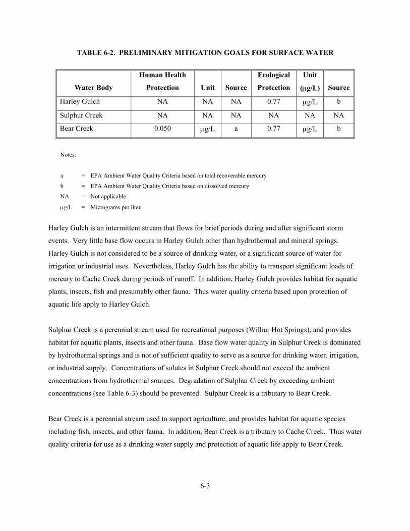
6-3
TABLE 6-2. PRELIMINARY MITIGATION GOALS FOR SURFACE WATER
Water Body
Human Health
Protection
Unit
Source
Ecological
Protection
Unit
(µg/L)
Source
Harley Gulch NA NA NA 0.77 µg/L b
Sulphur Creek NA NA NA NA NA NA
Bear Creek 0.050 µg/L a 0.77 µg/L b
Notes:
a = EPA Ambient Water Quality Criteria based on total recoverable mercury
b = EPA Ambient Water Quality Criteria based on dissolved mercury
NA = Not applicable
µg/L = Micrograms per liter
Harley Gulch is an intermittent stream that flows for brief periods during and after significant storm
events. Very little base flow occurs in Harley Gulch other than hydrothermal and mineral springs.
Harley Gulch is not considered to be a source of drinking water, or a significant source of water for
irrigation or industrial uses. Nevertheless, Harley Gulch has the ability to transport significant loads of
mercury to Cache Creek during periods of runoff. In addition, Harley Gulch provides habitat for aquatic
plants, insects, fish and presumably other fauna. Thus water quality criteria based upon protection of
aquatic life apply to Harley Gulch.
Sulphur Creek is a perennial stream used for recreational purposes (Wilbur Hot Springs), and provides
habitat for aquatic plants, insects and other fauna. Base flow water quality in Sulphur Creek is dominated
by hydrothermal springs and is not of sufficient quality to serve as a source for drinking water, irrigation,
or industrial supply. Concentrations of solutes in Sulphur Creek should not exceed the ambient
concentrations from hydrothermal sources. Degradation of Sulphur Creek by exceeding ambient
concentrations (see Table 6-3) should be prevented. Sulphur Creek is a tributary to Bear Creek.
Bear Creek is a perennial stream used to support agriculture, and provides habitat for aquatic species
including fish, insects, and other fauna. In addition, Bear Creek is a tributary to Cache Creek. Thus water
quality criteria for use as a drinking water supply and protection of aquatic life apply to Bear Creek.

6-4
Background or ambient mercury concentrations must also be considered in evaluating mitigation
objectives. For example it is not practical to attempt to assess mitigation effectiveness by comparing
surface water mercury concentrations to the water quality criteria identified in Table 6-2, if background or
ambient concentrations exceed these criteria. Table 6-3 summarizes the background or ambient mercury
content of surface water and hydrothermal springs in the District. If background or ambient mercury
concentrations exceed the water quality criteria identified above at a mine site, then background or
ambient concentrations should be used as the PMO for surface water at that site.
TABLE 6-3. BACKGROUND OR AMBIENT MERCURY CONCENTRATIONS IN
SURFACE WATER AND HYDROTHERMAL SPRINGS
Location
Total Mercury
(µg/L)
Filtered Mercury
(µg/L)
Harley Gulch West Above Abbott Mine 0.181 0.03
Harley Gulch East 0.029 to 0.925 NA
Sulphur Creek Above Mine Sites 0.340 0.226
Turkey Run Spring 0.010 to 0.200 NA
Wilbur Springs 1.5 to 6.7 NA
Elbow Springs 6.9 to 61.0 NA
Jones Fountain of Life 22.0 to 24.3 NA
Blank Spring 6.9 NA
Elgin Springs 0.70 to 11.0 NA
Notes: µg/L = Micrograms per liter Data Sources: Foe and Croyle 1998, Domagalski and Alpers 2001, Suchanek and others 2001, Goff 2001, Barnes 1973.

7-1
7.0 IDENTIFICATION AND SCREENING OF RESPONSE ACTIONS, TECHNOLOGY TYPES, AND PROCESS OPTIONS
Fourteen different mines on six different properties are located within the District. The mines organized
by property ownership include the Abbott and Turkey Run mines; Wide Awake Mine; Empire, Cherry
Hill, West End, Manzanita, and Central mines; Elgin mine; Clyde, Rathburn, and Rathburn-Petray mines;
and Petray-South and Petray-North mines. The Clyde, Rathburn, and Rathburn-Petray mines are located
on land administered by the BLM. All other mines are located on private property. The selection of the
appropriate mitigation alternative(s) for each mine within the District will depend on the following: 1) the
scope of the proposed mitigation action; 2) the nature and types of waste and source materials; 3) the
waste and source material location; 4) the concentration of metals and other contaminants in the waste
and source materials, 5) the volume of waste and source materials, 6) the relative metals load contributed
by each waste and source material area, 7) the effectiveness of the potentially applicable technology and
process options; and 8) property ownership.
The mitigation alternative selection process involves four steps that include: 1) identification and
description of general response actions, technologies, and process options; 2) initial technology screening
and alternative development; 3) detailed analysis of alternatives; and 4) comparative analysis of
alternatives. The identification and description of general response actions, technologies, and process
options are presented in Section 7.1. The results of the initial technology screening and alternative
development process for mines within the District are described in Section 7.2. The detailed analysis of
alternatives is presented in Sections 8.0. The comparative analysis of alternatives and presentation of the
recommended site strategy are presented in Section 9.0.
7.1 IDENTIFICATION OF GENERAL RESPONSE ACTION, TECHNOLOGIES, AND PROCESS OPTIONS
The first step in the mitigation alternative selection process is identifying and describing general response
actions that may satisfy the mitigation objectives. General response actions are then progressively refined
into technology types and process options. The process options are then screened in Section 7.2 and the
retained technologies and process options are combined into potential mitigation alternatives. The
purpose of the initial screening is to eliminate process options that are not feasible from further
consideration and retain those process options that are potentially feasible.
7-2
In order to facilitate the identification and screening of potentially applicable response actions,
technologies, and process options, six sources of contamination have been identified for mines within the
District: ore, mill waste, tailings, waste rock, mine-contaminated stream and wetland sediment, and
hydrothermal springs and associated precipitates. General response actions, technologies, and process
options potentially capable of meeting the mitigation objectives for these six sources of contamination are
identified in Tables 7-1a and 7-1b for solid and aqueous media, respectively. Response actions for solid
media include: no action, institutional controls, engineering controls, excavation and treatment, and in
place treatment. Response actions for hydrothermal springs and associated streams, and mine-
contaminated stream and wetland sediment include: no action, institutional controls, engineering controls,
and treatment. The following paragraphs describe the general response actions, technologies, and process
options for solid and aqueous media at mines within the District.
7.1.1 No Action
Under the no action option, no mitigation would occur at a mine. The no action response is a stand-alone
response that is used as a baseline against which other mitigation alternatives are compared. The no
action alternative will be retained through the detailed analysis of alternatives.
7.1.2 Institutional Controls
Institutional controls would not reduce mercury loading from the District, but can be used to protect
human health and the environment by precluding future access to, or development of, affected areas when
an action is taken. In addition, these restrictions may be used to protect an implemented action.
Potentially applicable institutional controls consist of land use, water use, and access restrictions.
Land use restrictions, comprised of zoning, deed restrictions, or environment control easements would
limit potential future uses of the land that could result in unacceptable risks due to human exposure to
mine contamination or loss of action integrity.
Zoning. Zoning would be implemented to control present and future land uses on or around waste and
source areas consistent with the potential hazards present, the nature of mitigation implemented, and
future land-use patterns. The objective of zoning would be to prevent public or private misuse of waste
and source areas that could jeopardize the effectiveness of mitigation activity or pose an unacceptable
potential for human exposure to the contaminants present in the waste and source areas.
TABLE 7-1a
GENERAL RESPONSE ACTIONS, TECHNOLOGY TYPES, AND PROCESS OPTIONS FOR SOLID MEDIA IN THE SULPHUR CREEK MINING DISTRICT
(Page 1 of 1)
General Response Action
Technology Type
Process Options
No Action
None
None
Institutional Controls
Access Restrictions
Fencing/Barrier
Land Use Control
Engineering Controls
Surface Controls
Consolidation
Grading
Revegetation
Erosion and Flood Control
Containment
Earthen Cover
Earthen Cover with Geomembrane Liner
On-Site Disposal
Earthen Cover
Earthen Cover with Geomembrane Liner
Group B
Mine Waste Repository
Off-Site Disposal
Solid Waste Landfill
Group B
Mine Waste Repository
Class 1 Repository
Excavation and Treatment
Fixation/Stabilization
Cement/Silicates
Reprocessing
Milling/Smelting
Physical/Chemical Treatment
Soil Washing
Acid Extraction
Alkaline Leaching
Thermal Treatment
Rotary Kiln
Vitrification
In-Place Treatment
Physical/Chemical Treatment
Soil Flushing
Solidification/ Stabilization
Thermal Treatment
Vitrification
TABLE 7-1b
GENERAL RESPONSE ACTIONS, TECHNOLOGY TYPES, AND PROCESS OPTIONS FOR AQUEOUS MEDIA IN THE SULPHUR CREEK MINING DISTRICT
(Page 1 of 1) General Response Action
Technology Type
Process Options
No Action
None
None
Institutional Controls
Access Restrictions
Fencing/Barrier
Land Use Control
Water Use Control Engineering Controls
Surface and Subsurface
Controls Flashboard Dam/
Diversion Structure
Surface/Subsurface Diversion
Treatment Biological Treatment Constructed Wetland
Anaerobic Biocell
Physical/Chemical Treatment Coagulation, Clarification, and
Filtration
Neutralization and Precipitation
Oxidation and Precipitation
Zero Valence Iron Reactor
Reverse Osmosis/ Nano-Filtration
Adsorption
Ion Exchange

7-5
Deed Restrictions. Restrictions would be used to prevent the transfer of property without notification of
limitations on the use of the property or requirements related to preservation and protection of the
effectiveness of implemented mitigation alternative. Both elements are intended to limit the potential for
human exposure to waste and source area contamination.
Environmental Control Easements. Environmental control easements are an enforceable easement
mechanism for imposing restrictions on the use of a site and requiring performance of operations and
maintenance activities that may help protect public health, safety, and welfare and the environment. The
easement mechanism is intended to be used at sites that contain or may contain hazardous wastes or
substances that may threaten public health, safety or welfare or the environment if certain uses are
permitted on these sites or if certain activities are not performed on these sites. Protection of public
health, safety, or welfare or the environment may be enhanced by the application and enforcement of
certain restrictions on the future use of the site or requirements for performance of certain activities.
Water use restrictions would limit potential future uses of surface water and groundwater that could result
in unacceptable risks due to human exposure to mine contamination or loss of action integrity. Surface
and ground water use restrictions may be necessary to limit potential future uses of groundwater and
surface water fed by naturally occurring hydrothermal springs due to elevated metals and salts in surface
water and groundwater not associated with mining activity.
Access restrictions typically include physical barriers, such as fencing, that could prevent both human and
wildlife access to a mine to preclude exposure to site solid and aqueous waste contamination; open shafts,
adits, and pits; processing facilities and structures; and to protect the integrity of the action. Fencing can
be installed around the perimeter of waste and source areas to prevent human and animal access to the
areas. Posted warnings would identify the potential hazards present at the waste and source areas to deter
trespass and misuse.
Institutional controls could be implemented as a stand-alone action, or in combination with other
alternatives. A local government or a cognizant state or federal agency would likely enforce institutional
controls that are developed as part of a mitigation alternative for a mine. Therefore, these entities must be
involved in developing and eventually implementing any institutional controls.
This type of action does not, in itself, achieve a specific cleanup goal. Considering the contaminant
concentrations present and loads migrating from the District, institutional controls alone are not

7-6
considered adequate to mitigate potential water quality, human health, and ecological impacts. However,
institutional controls will be considered in conjunction with other mitigation alternatives.
7.1.3 Engineering Controls
Engineering controls are used primarily to reduce the mobility of, and exposure to, contaminants. These
goals are accomplished by creating a barrier that prevents direct exposure and transport of waste from the
contaminated source to the surrounding media. Engineering controls do not reduce the volume or toxicity
of the hazardous material. Engineering controls for solid media typically applied include containment
and capping, revegetation, run on and runoff control, and disposal in a repository. These engineering
controls are discussed in the following subsections.
7.1.3.1 Surface Controls
Surface control measures are used primarily to reduce contaminant mobility, and limit direct exposure.
Surface controls may be appropriate in more remote areas where direct human contact is not a primary
concern (human receptors are not living or working directly on or near the site). Surface control process
options include consolidation, grading, erosion control and protection, revegetation, run-on and runoff
controls, detention or infiltration basins and traps, and flood control and protection. These process
options are usually integrated as a single mitigation alternative.
Consolidation. Consolidation involves grouping similar waste types in a common area for subsequent
management or treatment. Excavation during consolidation is accomplished with standard earthmoving
equipment including scrapers, bulldozers, excavators, loaders, and trucks. Consolidation is especially
applicable when multiple waste sources are present at a mine and one or more of the sources require
removal from particularly sensitive areas (that is, flood plain, over steep slope, slide area, erosive area, or
heavy traffic area) or when treating one large combined waste source in a particular location, rather than
several smaller waste sources dispersed throughout an area. Precautionary measures, such as stream
diversion or isolation, would be necessary for excavating materials contained in Harley Gulch and
Sulphur Creek and its tributaries. Containment and treatment of water encountered during excavation
may also be necessary.
Grading. Grading is the general term for techniques used to reshape the ground surface to reduce slopes,
manage surface water infiltration and runoff, restore eroded areas, and to aid in erosion control. The

7-7
spreading and compaction steps used in grading are routine construction practices. The equipment and
methods used in grading are similar for all surfaces, but will vary slightly depending on the waste location
and the surrounding terrain. Equipment may include bulldozers, scrapers, graders, and compactors.
Periodic maintenance and regrading may be necessary to eliminate depressions formed as a result of
settlement, subsidence, or erosion.
Erosion control and protection. Erosion control and protection includes using erosion-resistant
materials, such as mulch, natural or synthetic fabric mats, gabions, velocity breaks, and riprap to reduce
the erosion potential at the surface of the contaminated medium. The erosion-resistant materials are
placed in areas susceptible to surface water erosion (concentrated flow or overland flow) or wind erosion.
Proper erosion protection design requires knowledge of drainage area characteristics, average slopes, soil
texture, vegetation types and abundance, and precipitation data.
Revegetation. Revegetation involves adding soil amendments to the waste surface to provide nutrients,
organic material, and neutralizing agents and improve the water storage capacity of the contaminated
media, as necessary. Revegetation will provide an erosion-resistant cover that protects the ground surface
from surface water and wind erosion and reduces net infiltration through the contaminated medium by
increasing evapotranspiration processes. Revegetation can also reduce the potential for direct contact. In
general, revegetation includes the following steps: (1) selecting appropriate plant species, (2) preparing
seed bed, which may include deep application of soil amendments to provide acid buffering and enhance
vegetation, as necessary, (3) seeding and planting, and (4) mulching and/or chemical fertilizing.
Revegetation would likely take place during the fall of the year. A native seed mixture would be used for
revegetation due to high salt and metals content in soil.
Run-on and Runoff Controls. Run-on controls, including water control bars, berms, ditches, and piping
would be constructed to divert upstream surface water flow around and away from potential waste and
source areas. Run-on controls would limit the amount of water entering the waste and source areas to that
which falls as precipitation directly on the area. Run-on controls would also prevent direct contact of
flowing water in streams or overland flows with the waste and source material. Run-on control
construction would be used to reduce the potential for erosion and transport of solid waste and source
material away from the area. Run-on controls would also be used to divert surface water flow in order to
minimize infiltration into waste and source areas. Runoff controls, including drains, ditches, and piping,
would be constructed to convey impacted water away from waste and source areas, and any transported
sediments to an infiltration basin. Runoff control construction would be used to reduce transport of

7-8
contaminated materials into nearby creeks and to control leaching and migration of metals from
contaminated materials into surface water. French drains would also be used to collect shallow
groundwater and leachate generated during rainwater percolation through waste materials.
Detention and Infiltration Basins and Traps. Sediment movement would be controlled through the
construction of a detention basin or series of detention basins. Detention basins would serve to retain
storm flows while controlling releases at an established flow rate to match the conveyance capacity of the
down gradient stream. Detention basins would allow some of the storm-water suspended sediments to
settle out of the water. Infiltration basins would serve to retain and isolate surface waters that contact
waste and source areas and prevent future migration of sediment. The impounded water would likely be
reduced in volume through evaporation and direct infiltration into the subsurface rock mass, although care
would have to be taken to minimize infiltration of contaminated water. Infiltration basins would be sized
to retain a specific storm event. Sediment traps would most likely be constructed in conjunction with
diversion ditches or channels to intercept and retain sediments produced from a source area. These
sediment dams or traps could include sedimentation basins constructed within or outside of stream
channels where sedimentation would occur.
Flashboard Dams and Diversion Structures. Flashboard dams would be constructed within the stream
channel for the purpose of diverting water for off-stream treatment, allowing metal sulfide and metal
oxyhydroxide precipitates to form and settle, capturing mobile contaminated sediment, and maintaining
stable creek flow. The flashboard dams would operate during low to moderate flows. The flashboards
would be removed from the dam by the end of October prior to the onset of seasonal rains and will be
replaced in April after threat of flooding has passed. The flashboard dam would consist of a rectangular
concrete weir keyed into the stream bank or into reinforced earthen dikes constructed perpendicular to the
stream bank. Removable boards would drop into slots within the concrete weir to control flow.
Diversion structures would be used to capture hydrothermal spring flow for treatment. The diversion
structure would operate year round. The diversion structure would consist of an open ended concrete box
keyed into the formation around the spring with a gate valve or flashboard to regulate flow.
Flood control and protection. Flood control and protection includes using diversion ditches and berms,
detention basins, velocity breaks, dry dams, and vegetated flood plains to reduce the erosive force of
water during periods of high intensity precipitation and runoff. Harley Gulch is highly susceptible to
flash flooding due to over steep slopes and a narrow, confined channel. Flood control is required in
Harley Gulch to prevent erosion of tailings along the creek and resuspension of potentially contaminated

7-9
sediment in the meadow area east of the Abbott and Turkey Run mines. Sulphur Creek and its tributaries
are less susceptible to flash flooding due to a relatively large flood plain; however, the catchment area is
much larger and generates more sustained high velocity events. Flood control is required on Sulphur
Creek to prevent erosion of tailings and waste rock along the creek, resuspension of contaminated
sediment on the floodplain, and scouring of metals laden sediment in the creek bedload. Inspection of
eroded banks along Sulphur Creek show multiple flood events with up to 4 feet of sediment deposited in
the last 150 years.
Surface controls are considered a feasible option for all waste and source types at mines in the District
and will be retained for further consideration as a mitigation alternative, or in conjunction with other
alternatives.
7.1.3.2 Containment
A containment approach leaves waste materials in place and uses an earthen cover or engineered cap to
reduce or eliminate mobility of, and exposure to, the contaminated medium. Containment source control
measures can be used to divert surface water from the contaminated medium and to minimize infiltration
(and subsequent formation of leachate) of surface water/precipitation into the underlying contaminated
medium. Infiltration can be reduced or prevented by physical barriers (geomembranes) or by increasing
evapotranspiration processes. The physical covering or capping of wastes during containment reduces or
eliminates contaminant mobility and the potential health risk that may be associated with exposure to the
contaminated media.
Cover or cap design may vary in complexity from a simple earthen cover to a multilayered cap designed
to meet substantive California requirements. Factors to consider in cover or cap design include physical
conditions of the contaminated media, topography, slope stability, leachability, site hydrogeology,
precipitation, depth to groundwater, groundwater quality, groundwater use, and applicable groundwater
standards. Stringent cover or cap performance standards may not always be appropriate, particularly in
instances where the toxicity of the contaminated medium is relatively low, where the cover or cap is
intended to be temporary, where there is very low precipitation, or where the waste is not leached by
infiltrating rain water. Specific cover or cap design should also consider the desired land use following
cover or cap construction.
7-10
Containment is considered a standard construction practice. Equipment and construction methods
associated with containment are readily available, and design methods and requirements are well
understood. Containment is considered a feasible option for all waste and most source types at mines in
the District and will be retained for further consideration as a mitigation alternative or in combination
with other alternatives.
7.1.3.3 On-Site Disposal
Permanent, on-site disposal is used as a source control measure and is similar to containment. The
objectives of on-site disposal are the same as for containment, except that disposal includes excavation
and consolidation of waste into a single, usually smaller area, and may involve installing physical barriers
(geomembranes or geosynthetic clay liners [GCL]) beneath as well as above the waste. This added
barrier may be needed to provide additional protection of groundwater from potential leachate
contamination.
On-site disposal options may be applied to treated or untreated contaminated materials. As materials are
excavated and moved during this process, treatment may become a cost-effective option. The design
configuration of an on-site repository would depend on the toxicity and type of material requiring
disposal. The design could range in complexity from an earthen cover to a Group B mine waste
repository.
Factors to consider in design include physical condition of the contaminated media, topography, slope
stability, leachability, site hydrogeology, precipitation, depth to groundwater, current groundwater
quality, area groundwater use, and applicable groundwater standards. Stringent cover or cap performance
standards may not always be appropriate, particularly in instances where the toxicity of the contaminated
medium is relatively low, where there is very low precipitation, or where the waste is not leached by
infiltrating rainwater. Desired land use following cover or cap construction should also be considered in
cover or cap design.
Mine waste material can be excavated using conventional earth-moving equipment and accepted
hazardous materials handling procedures. Steep slopes in the waste rock and tailings areas may require
use of specialized equipment or construction methods. Precautionary measures, such as stream diversion
or isolation, would be necessary for excavating materials along Harley Gulch or material contained in the

7-11
flood plain of Sulphur Creek and its tributaries. Containment and treatment of water encountered during
excavation and drying of excavated material may also be necessary.
A potential on-site Group B mine waste repository is considered a feasible option for all waste types and
will be retained for further consideration as a mitigation alternative or in combination with other
alternatives.
7.1.3.4 Off-Site Disposal
Off-site disposal involves placing excavated contaminated material in an engineered waste repository at a
permitted facility located outside a mine. Off-site disposal would involve placement in either an off-site
location owned by the same party who owns the mine or at an appropriate permitted facility outside the
District. Off-site disposal options may be applied to pretreated or untreated contaminated materials.
Materials failing to meet the leachability criteria, if disposed of outside the District, would require
disposal in a permitted Class 1 facility, depending on level of hazard. Conversely, less mobile and less
toxic materials could be disposed of outside the District in a permitted solid waste landfill in compliance
with other applicable laws.
Materials disposed of at a Group B mine waste repository located within the District may not be required
to meet the leachability criteria because the quality of surface water and groundwater in the District is
actually worse than the quality of any leachate generated. The surface water and groundwater in the
District are hydrothermal and have limited beneficial use (see Section 5.0).
Excavation and disposal at an off-site Class 1 repository located outside the District is considered too
costly an alternative for wastes at mines in the District due to the large volume of waste involved and the
high cost for transportation and disposal. The closest off-site Class 1 repository location is Kettleman
Hills.
7.1.4 Excavation And Treatment
Excavation and treatment incorporate the removal of mine waste and subsequent treatment through a
specific treatment process that chemically, physically, or thermally results in a reduction of contaminant
toxicity and volume. Treatment processes have the primary objective of either: (1) concentrating the

7-12
metal contaminants for additional treatment or recovery of valuable constituents, or (2) reducing the
toxicity of the hazardous constituents.
Excavation can be completed using conventional earth-moving equipment and accepted hazardous
materials-handling procedures. Precautionary measures, such as stream diversion or isolation, would be
necessary for excavating materials along Harley Gulch or contained in the flood plain of Sulphur Creek
and its tributaries. Containment and treatment of water encountered during excavation may also be
necessary.
7.1.4.1 Fixation and Stabilization
Fixation and stabilization technologies are used to treat materials by physically encapsulating them in an
inert matrix (stabilization) and chemically altering them to reduce the mobility and toxicity of their
constituents (fixation). These technologies generally involve mixing materials with binding agents under
prescribed conditions to form a stable matrix. Fixation and stabilization are established technologies for
treating inorganic contaminants. The technologies incorporate a reagent or combination of reagents to
facilitate a chemical and physical reduction of the mobility of contaminants in the solid media. Lime/fly
ash-based treatment processes and pozzolan/cement-based treatment processes are potentially applicable
fixation and stabilization technologies. Stabilized material must still be disposed of in an on- or off-site
facility.
Excavation and subsequent fixation and stabilization treatment are not considered feasible options for
mines in the District because the large volume of waste present makes the treatment cost prohibitive.
Other feasible options can provide equal protectiveness.
7.1.4.2 Reprocessing
Reprocessing involves excavating and transporting the waste materials to an existing permitted mill
facility for processing and economic recovery of target metals. Applicability of this option depends on
the willingness of an existing permitted facility to accept and process the material and dispose of the
waste. Although reprocessing at active facilities has been conducted in the past, permit limitations,
CERCLA liability, and process constraints all limit the feasibility of this process option.

7-13
With the exception of potential gold-bearing waste rock at the West End Mine, reprocessing is not
considered feasible at mines in the District due to the low value of recoverable metals in the majority of
the waste material and the high cost of transportation and reprocessing. Other feasible options can
provide equal protectiveness.
7.1.4.3 Physical and Chemical Treatment
Physical treatment processes use physical characteristics to concentrate constituents into a relatively small
volume for disposal or further treatment. Chemical treatment processes act through the addition of a
chemical reagent that removes or fixates the contaminants. The net result of chemical treatment processes
is a reduction of toxicity and mobility of contaminants in the solid media. Chemical treatment processes
often work in conjunction with physical processes to wash the contaminated media with water, acids,
bases, or surfactant. Potentially applicable physical and chemical treatment process options include soil
washing, acid extraction, and alkaline leaching.
Soil washing. Soil washing is an innovative treatment process that consists of washing the contaminated
medium (with water) in a heap, vat, or agitated vessel to dissolve water-soluble contaminants. Soil
washing requires that contaminants be readily soluble in water and sized sufficiently small so that
dissolution can be achieved in a practical retention time. Dissolved metal constituents contained in the
wash solution are precipitated as insoluble compounds, and the treated solids are dewatered before
additional treatment or disposal. The precipitates form a sludge that would require additional treatment,
such as dewatering or stabilization before disposal.
Acid extraction. Acid extraction applies an acidic solution to the contaminated medium in a heap, vat, or
agitated vessel. Depending on temperature, pressure, and acid concentration, varying quantities of the
metal constituents present in the contaminated medium would be solubilized. A broader range of
contaminants can be expected to be acid soluble at ambient conditions using acid extraction versus soil
washing; however, sulfide compounds may be acid soluble only under extreme conditions of temperature
and pressure. Dissolved contaminants are subsequently precipitated for additional treatment and disposal.
Alkaline leaching. Alkaline leaching is similar to acid extraction in that a leaching solution (in this case,
ammonia, lime, or caustic soda) is applied to the contaminated medium in a heap, vat, or agitated vessel.
Alkaline leaching is potentially effective for leaching most metals from the contaminated media.

7-14
Excavation and subsequent physical and chemical treatment are not considered feasible options because
the large volume of waste and relatively low treatment goal makes treatment cost prohibitive. Other
feasible options can provide equal protectiveness.
7.1.4.4 Thermal Treatment/Vitrification
Under thermal treatment technologies, heat is applied to the contaminated medium to volatilize and
oxidize metals and render them amenable to additional processing and to vitrify the contaminated medium
into a glass-like, nontoxic, nonleachable matrix. Potentially applicable moderate-temperature thermal
processes, which volatilize metals and form metallic oxide particulates, include the fluidized bed reactor,
the rotary kiln, and the multihearth kiln. Potentially applicable high-temperature thermal treatment
processes include vitrification. All components of the contaminated medium are melted and volatilized
under high temperature vitrification. Volatile contaminants and gaseous oxides of sulfur are driven off as
gases in the process, and the nonvolatile, molten material that contains contaminants is cooled and, in the
process, vitrified.
Thermal treatment technologies can be applied to wet or dry contaminated medium; however, the
effectiveness may vary somewhat with variable moisture content and particle size. Crushing may be
necessary as a pretreatment step, especially for large and variable particle sizes, such as the materials in
waste rock piles. Moderate-temperature thermal processes should be considered only as pretreatment for
other treatment options. This process concentrates the contaminants into a highly mobile (and potentially
more toxic) form. High-temperature thermal processes immobilize most metal contaminants into a
vitrified slag that would require proper disposal. The volatile metals would be removed or concentrated
into particulate metal oxides, which would likely require disposal as hazardous waste. Thermal treatment
costs are extremely high compared to other potentially applicable mitigation technologies.
Excavation and subsequent thermal treatment are not considered feasible options because of the lack of
infrastructure necessary to deliver high voltage electricity to the site, treated waste and byproducts would
still require on- or off-site disposal, and the large volume of waste makes treatment cost prohibitive.
Other feasible options can provide equal protectiveness.

7-15
7.1.5 In-place Treatment
In-place treatment involves treating the contaminated medium where it is currently located. In-place
technologies reduce the mobility and toxicity of the contaminated medium and may reduce exposure to
the contaminated materials; however, they allow a lesser degree of control, in general, than ex situ
treatment options.
7.1.5.1 Physical and Chemical Treatment
Potentially applicable in-place physical and chemical treatment technologies include soil flushing,
stabilization, and solidification.
Soil flushing. Soil flushing is an innovative process that injects an acidic or basic reagent or chelating
agent into the contaminated medium to solubilize metals. The solubilized metals are extracted using
established dewatering techniques, and the extracted solution is then treated to recover metals or is
disposed of as aqueous waste. Low-permeability materials or stratified waste may hinder proper
circulation, flushing solution reaction, and ultimate recovery of the solution. Currently, soil flushing has
been demonstrated only at the pilot scale.
Stabilization and solidification. In-place stabilization and solidification are similar to conventional
stabilization in that a solidifying agent (or combination of agents) is used to create a chemical or physical
change in the mobility and toxicity of the contaminants. The in-place process uses deep-mixing
techniques to allow maximum contact of the solidifying agents with the contaminated medium.
In-place physical and chemical treatment is not considered a feasible option because of limited
demonstrated success, and the large volume of waste makes the treatment cost prohibitive. Other feasible
options can provide equal or greater protectiveness.
7.1.5.2 Thermal Treatment
In-place vitrification is an innovative process used to melt contaminated solid media in place to
immobilize metals into a glass-like, inert, nonleachable solid matrix. Vitrification requires significant
energy to generate sufficient current to force the solid medium to act as a continuous electrical conductor.
This technology is seriously inhibited by high moisture content. Gases generated by the process must be

7-16
collected and treated in an off-gas treatment system. In-place vitrification has been demonstrated only at
the pilot scale, and treatment costs are extremely high compared to other treatment technologies.
In-place thermal treatment is not considered a feasible option because of the lack of infrastructure
necessary to deliver high voltage electricity to the site, and the large volume of waste makes the treatment
cost prohibitive. Other feasible options can provide equal or greater protectiveness.
7.1.6 Treatment of Surface Water and Groundwater
Treatment of surface water and groundwater involves specific processes that biologically, physically, or
chemically result in a reduction of contaminant toxicity, mobility, and volume. Treatment processes have
the primary objective of either: (1) concentrating the metal contaminants for additional treatment or
disposal, (2) reducing the mobility of metal contaminants, or (3) reducing the toxicity of the hazardous
constituents.
7.1.6.1 Biological Treatment
Treatment of metal-contaminated surface water and groundwater could be accomplished with the use of
constructed wetlands or a biocell. Standard constructed wetlands have both an aerobic and anaerobic
component, while biocells have only the anaerobic component and focus on stimulating the growth of
sulfate reducing bacteria. Biological treatment of mercury at mines and in springs and streams in the
District is not practical because of the potential for creation of mercury methylating environments.
Constructed wetlands and biocells generally do not require the continuous application of chemicals, tend
to require less maintenance, and tend to be more cost effective than many active water treatment systems.
Both wetland and biocell systems can have technologies added to the front (pretreatment stage) of the
primary system, or to the back (post-treatment/polishing stage) of the system to enhance and improve
efficiency or performance. Wetland and biocell systems are still highly innovative and their overall
effectiveness is often uncertain. The implementation of wetland and biocell systems is not appropriate for
some sites due to the large physical area needed to construct a system. Wetland and biocell systems have
been applied at mines where the volume of contaminated water is low, the receiving water bodies have a
high capacity for dilution, or variations in the quality of the effluent discharge are acceptable.

7-17
Constructed Wetlands. Constructed wetlands are designed to mimic chemical conditions in natural
areas such as marshes, bogs, wet meadows, peat lands, and swamps. Constructed wetlands can be
designed to remove metals from contaminated water by the reduction of metals through bacterial sulfate-
reduction reactions. The metals are removed as a precipitate within the wetlands, or collected in a settling
basin. Wetlands can also be used to reduce concentrations of suspended solids in creeks and storm water
runoff. Constructed wetlands depend on plant growth to feed the carbon cycle necessary for year round
growth. Therefore, any site, contaminant, or water characteristic that limits plant growth would limit use
of a constructed wetland. Precipitate generated would contain high concentrations of metals requiring
expensive disposal.
Anaerobic Biocells. Biocell systems are anaerobic systems that typically include a layer of organic
material (for example, wood chips or manure) that is placed over a drainage layer. Biocell systems are
designed to remove metals from contaminated water by the reduction of metals through bacterial sulfate-
reduction reactions. The biocell system design can include a downflow or upflow configuration,
perforated drain lines within a lined pond, and various types of organic layers. The metals are removed as
a precipitate within the biocell, or collected in a settling basin. Precipitate generated would contain high
concentrations of metals requiring expensive disposal.
Several pre- and post-wetland and biocell alterations can be added to both anaerobic and aerobic systems.
Anoxic limestone drains, open-channel limestone drains, physical oxygenation or mixing, and natural
oxidation structures are used to improve performance. The anoxic limestone drains may be added to the
front end of a biocell system to add alkalinity. The open channel limestone drains can be included on the
front end to add alkalinity or after the wetland as a polishing unit. Physical oxygenation apparati include
corrugated piping with ports and vents, which can physically entrain oxygen into the waters, while natural
oxidation structures include constructed boulder/ripple systems, laminar flow stretches, or simple
spillways that naturally entrain atmospheric oxygen into the water.
7.1.6.2 Physical and Chemical Treatment
Treatment of metal-contaminated surface water and groundwater could be accomplished by a variety of
physical and chemical treatment processes including coagulation, clarification, filtration, neutralization
and precipitation, oxidation and precipitation, zero valence iron (ZVI) reactor, reverse osmosis or nano-
filtration, adsorption, and ion exchange. In many cases a combination of these processes would be
required to achieve the desired level of heavy metal removal from water.
7-18
Coagulation, Clarification, and Filtration. Coagulation, clarification, and filtration are the process
steps used in traditional water treatment to remove suspended solids. During coagulation, chemicals are
added to the water to promote the formation of floc, or small particles of suspended solids. Under
clarification the heavier of these particles settle out. During filtration the remaining particles are filtered
from the water by passing the water through a layer of fine sand. This process is an effective method for
removing suspended solids containing metals. The process would not be particularly effective in the
removal of dissolved metals. However, the process could be modified to increase the rate of metal
removal through the addition of other steps such as neutralization or oxidation. Precipitate generated
would contain high concentrations of metals requiring recycling or expensive disposal.
Neutralization and Precipitation. Neutralization followed by precipitation of metal hydroxides is an
effective method of removing dissolved metals from water. Neutralization results in the formation of
metal hydroxides, which will precipitate in the solution and are then removed by gravitational settling or
filtration. Neutralization is accomplished through the addition of lime, caustic soda or soda ash.
Neutralization may also reduce sulfate through precipitation of gypsum. After metal removal, it may be
necessary to lower the pH of the highly alkaline treated water. Precipitate generated would contain high
concentrations of metals requiring recycling or expensive disposal.
Oxidation and Precipitation. Oxidation followed by precipitation of metal hydroxides is an effective
method of removing dissolved metals from water. Oxidation results in the formation of metal hydroxides,
which will precipitate in the solution and are then removed by gravitational settling or filtration.
Oxidation is accomplished through aeration or by the addition of chemical oxidants such hydrogen
peroxide, chlorine, or potassium permanganate. Passive aeration would be used for surface and ground
waters in the District. Oxidation would not remove excess sulfate. Precipitate generated would contain
high concentrations of metals requiring recycling or expensive disposal.
Zero Valence Reactor. Substantial research, pilot, and full-scale efforts have been initiated over the past
few years to identify reactive materials that can be used to treat the many mine contaminants found in
surface and ground waters. The reactive media most successfully deployed to date has been ZVI. The
process involves the transfer of electrons from iron with a zero valence state to a target metal or anion
with a higher valence state, thereby reducing or lowering the valence state of the target metal or anion.

7-19
Metals in surface water and groundwater within the District occur primarily in their reduced state when
discharged from the hydrothermal system. Sulfur is a key anion in the hydrothermal system. Metal
sulfides tend to precipitate in close proximity to the hydrothermal springs. However, as the water
becomes oxidized, sulfide oxidizes to sulfate and metals precipitation slows dramatically. Excess sulfate
is then available for participation with sulfate-reducing bacteria in the mercury methylation cycle. The
ZVI process would be used maintain or create a reducing environment that would extend the period of
time that sulfides would remain in solution for reaction with dissolved metals. The more sulfide removed
from solution, the less sulfate will be available for participation in the mercury methylation cycle.
The ZVI treatment process would involve gravity feeding surface or groundwater through an above or
below grade reaction tank containing ZVI, allowing sufficient contact time for the reduction of target
metals and anions, and precipitation of metals in a settling basin or tank. The spent iron in the reaction
tank and precipitate in the settling tank would contain high concentrations of metals requiring recycling or
disposal.
Reverse Osmosis and Nano-Filtration. Reverse osmosis and nano-filtration are physical and chemical
processes in which hydraulic pressure is used to reverse the osmosis process by forcing water from a
concentrated solution through a semipermeable membrane into a dilute solution. Dissolved metals are
retained in the concentrated solution, known as reject. Reverse osmosis and nano-filtration are effective
methods of removing dissolved metals from water. Reverse osmosis and nano-filtration do, however,
require a substantial investment in energy to generate the hydraulic pressures required to reverse the
osmosis process. In addition, the reject solution would contain high concentrations of metals requiring
recycling or expensive disposal.
Adsorption and Ion Exchange. Adsorption is the process in which material dissolved in water
accumulates on the surface of solids brought into contact with the water. The rate of removal is a
function of the surface area of the solids, so materials with a large surface area in proportion to the
volume of solid tend to be highly sorbent. Perhaps the best example of this type of material is activated
carbon. Adsorption has been shown to be a partially effective method of removing dissolved metals.
The adsorption material must be periodically replaced or regenerated. The spent adsorption material may
contain high concentrations of metals, which may require expensive disposal.
Ion exchange is the process in which ions held by electrostatic forces to a surface of a solid are exchanged
for ions of similar charge in a solution in which the solid (resin) is immersed. As solution flows through

7-20
a resin bed, ion exchange occurs. Selective ion exchange uses specially selected resins to remove or
reduce specific contaminants (such as metals and sulfate) from water. Selective ion resins are unaffected
by other dissolved solids in the feed stream. The exchange resin must be periodically replaced or
regenerated. The spent resin would contain high concentrations of metals, which would require recycling
at an off-site milling facility or expensive disposal.
7.2 TECHNOLOGY SCREENING SUMMARY AND DEVELOPMENT OF MITIGATION ALTERNATIVES
After identifying potential mitigation technologies and process options, the technologies and process
options are subjected to initial screening, which is the second step in the mitigation alternative
development process. The purpose of technology and process option screening is to evaluate the
identified options based on the NCP criteria of effectiveness, implementability, and relative costs, and
eliminate technologies and process options to reduce the number of alternatives developed and carried
forward for detailed analysis. A technology or process option can be eliminated from further
consideration if they do not meet the effectiveness or implementability criteria. Also, a technology or
process option can be eliminated if its cost is substantially higher than other technologies or process
options, and at least one other technology or process option is retained that offers equal protectiveness.
This second level of technology and process option screening is effective as a method of reducing the
number of alternatives developed for subsequent detailed analysis. A summary of the initial screening of
response actions, technologies, and process options for solid and aqueous media are provided in Tables
7-2a and 7-2b, respectively.
The response actions, technologies, and process options that were retained have been combined into the
mitigation alternatives shown in Table 7-3. Mitigation alternatives were divided between solids,
processing facilities, sediment, and surface water due to the diversity of remediation issues within the
District. Processing facilities and mine waste contained inside and around the immediate perimeter of
structures are evaluated separately because a finding of historical significance has not been determined.
Because the number of alternatives is not unreasonably high, and since none of these alternatives could
obviously be eliminated through an additional screening step, all of these alternatives will be carried
through to the detailed analysis in Section 8.0.

TABLE 7-2a TECHNOLOGY SCREENING COMMENTS SUMMARY
FOR SOLID MEDIA IN THE SULPHUR CREEK MINING DISTRICT (Page 1 of 3)
General
Response Actions
Technology
Process Options
Description
Screening Comment No Action None Not applicable No action. Not applicable. Institutional Controls
Access Restrictions
Fencing/Barrier Install fences around waste areas, shafts, and adits to limit access.
Potentially effective in conjunction with other technologies; readily implementable.
Land Use Control Implement restrictions to control current and future land use.
Potentially effective in conjunction with other technologies; readily implementable.
Engineering Controls
Surface Controls
Consolidation, Grading, Revegetation, Erosion Protection, Flood Protection
Combine similar waste types in a common area; level out waste piles to reduce slopes for managing surface water infiltration, runoff, and erosion; manage flood flows to reduce the erosive force of water; add amendments to waste and seed with appropriate vegetative species to establish an erosion-resistant ground surface.
Potentially effective in conjunction with other process options assuming waste does not contain high concentrations of phytotoxic chemicals; limits direct exposure; readily implementable.
Containment Earthen Cover Apply inert waste rock, overburden, or soil and establish vegetative cover to stabilize surface; waste materials are left in place.
Surface infiltration and runoff potential would be reduced, but not prevented; leachate could be generated; limits direct exposure; readily implementable.
Earthen Cover with Geomembrane Liner
Install geomembrane with waste rock, overburden, or soil over surface; waste materials are left in place.
Surface infiltration and runoff potential would be significantly reduced, or eliminated; no leachate collection system; limits direct exposure; readily implementable.
On-Site Disposal
Earthen Cover Excavate waste materials and deposit on site, apply inert waste rock, overburden, or soil and establish vegetative cover to stabilize surface.
Surface infiltration and runoff potential would be reduced, but not prevented; leachate could be generated; limits direct exposure; readily implementable.
Earthen Cover with Geomembrane Liner
Excavate waste materials and deposit on site, install geomembrane with waste rock, overburden, or soil over surface.
Surface infiltration and runoff potential would be significantly reduced, or eliminated; no leachate collection system; limits direct exposure; readily implementable.
Group B Mine Waste Repository
Excavate waste materials and deposit on site in a constructed Group B mine waste repository.
Surface infiltration, runoff potential, and leachate generation would be effectively eliminated; leachate collection system or engineered alternative may be required; limits direct exposure; readily implementable if space available for repository construction.
Off-Site Disposal
Group B Mine Waste Repository
Excavate waste materials and deposit off site in a constructed Group B mine waste repository.
Surface infiltration, runoff potential, and leachate generation would be effectively eliminated; leachate collection system or engineered alternative may be required; limits direct exposure; readily implementable if site available for repository construction.

TABLE 7-2a TECHNOLOGY SCREENING COMMENTS SUMMARY
FOR SOLID MEDIA IN THE SULPHUR CREEK MINING DISTRICT (Page 2 of 3)
General
Response Actions
Technology
Process Options
Description
Screening Comment Engineering Controls (Continued)
Off-Site Disposal (Continued)
Solid Waste Landfill
Excavate and dispose of nonhazardous solid wastes permanently in a state regulated solid waste landfill.
Potentially effective for nonhazardous materials or nonhazardous residues from other treatment process options; readily implementable, but transportation would be cost prohibitive.
Class 1 Repository Excavate and dispose of wastes permanently in a Class 1 Repository.
Potentially effective, and readily implementable; but transportation would be cost prohibitive.
Excavation And Treatment
Fixation/ Stabilization
Cement/Silicates Incorporate hazardous constituents into non-leachable cement or pozzolan solidifying agents.
Extensive treatability testing required; proper disposal of stabilized product would be required; potentially implementable, but cost-prohibitive.
Reprocessing Milling Ship wastes to existing milling facility for economic extraction of metals.
Not effective for mercury as a facility is not located in the area.
Physical/ Chemical Treatment
Soil Washing
Separate hazardous constituents from solid media via dissolution and subsequent precipitation.
Effectiveness is questionable; potential exists to increase mobility by providing partial dissolution of contaminants; more difficulty encountered with wider range of contaminants.
Acid Extraction Mobilize hazardous constituents via acid leaching and recover by subsequent precipitation.
Effectiveness is questionable; potential exists to increase mobility by providing partial dissolution of contaminants; sulfides would be acid soluble only under extreme conditions of temperature and pressure.
Physical/ Chemical Treatment
Alkaline Leaching Use alkaline solution to leach contaminants from solid media in a heap, vat, or agitated vessel.
Effectiveness is questionable; potential exists to increase mobility by providing partial dissolution of contaminants.
Thermal Treatment
Fluidized Bed Reactor/Rotary Kiln/Multihearth Kiln
Concentrate hazardous constituents into a small volume by volatilization of metals and formation of metallic oxides as particulates.
Further treatment is required to treat process by-products; potentially implementable, but cost prohibitive.
Vitrification Use extremely high temperature to melt and/or volatilize all components of the solid media; the molten material is cooled and, in the process, vitrified into a nonleachable form.
Further treatment is required to treat process by-products; not implementable as electrical infrastructure not available to support load; cost prohibitive.
In-Place Treatment
Physical/ Chemical Treatment
Stabilization Stabilize waste constituents in place when combined with injected stabilizing agents.
Extensive treatability testing required; potentially implementable, but cost prohibitive.

TABLE 7-2a TECHNOLOGY SCREENING COMMENTS SUMMARY
FOR SOLID MEDIA IN THE SULPHUR CREEK MINING DISTRICT (Page 3 of 3)
General
Response Actions
Technology
Process Options
Description
Screening Comment In-Place Treatment (Continued)
Physical/ Chemical Treatment (Continued)
Solidification Use solidifying agents in conjunction with deep soil mixing techniques to facilitate a physical or chemical change in mobility of the contaminants.
Extensive treatability testing required; potentially implementable, but cost prohibitive.
Soil Flushing Acid/base reagent or chelating agent injected into solid media to solubilize metals; solubilized reagents are subsequently extracted using dewatering techniques.
Effectiveness not certain; potential exists to increase mobility by providing partial dissolution of contaminants; innovative process currently in its pilot stage.
Thermal Treatment
Vitrification Subject contaminated solid media to extremely high temperature in place; during cooling, material is vitrified into non-leachable form.
Difficulties may be encountered in establishing adequate control; not implementable as electrical infrastructure not available to support load; cost prohibitive.
Note: Eliminated alternatives are shaded.

TABLE 7-2b TECHNOLOGY SCREENING COMMENTS SUMMARY
FOR AQUEOUS MEDIA IN THE SULPHUR CREEK MINING DISTRICT (Page 1 of 2)
General
Response Actions
Technology
Process Options
Description
Screening Comment No Action None Not applicable No action. Not applicable. Institutional Controls
Access Restrictions Fencing/Barrier Install fences around springs and creeks to limit access.
Partially effective, public exposure to spring can be controlled but it is impractical to fence creeks; readily implementable.
Land Use Control Implement restrictions to control current and future land use.
Partially effective, public exposure to springs and creeks on cooperating landowners can be controlled; readily implementable.
Water Use Control Implement restrictions to control current and future water use.
Effective for on- and off-site waters; springs and creeks have no beneficial uses due to naturally high metals and salt content; readily implementable.
Engineering Controls
Surface and Subsurface Controls
Flashboard Dam/ Diversion Structure
Install flashboard dam in creek to capture mobile sediment and allow for precipitation to occur. Install diversion structures at hydrothermal springs to capture water for treatment or bypass.
Effective for capturing mobile sediment, reducing downstream entrainment of sediment, and maintaining a steady influent flow necessary for water treatment processes. Very effective in conjunction with other technologies. Readily implementable.
Surface and Subsurface Diversions
Install surface drains to capture and divert run-on/run-off. Install underdrains to intercept groundwater (reduce waste contact) and seepage (infiltration through mine waste).
Effective for reducing stormwater run-on; directing mine waste and hydrothermally-impacted water for settling or treatment; reducing generation of leachate associated with groundwater flow through mine waste; and for capture of leachate for treatment. Very effective in conjunction with other technologies. Readily implementable.
Treatment Biological Treatment
Constructed Wetland Concentrates metals on organic material and reduced sulfate to sulfide to generate metal sulfide precipitate.
Process moderately effective at metals removal. Process is passive, gravity fed, does not rely on a constant flow, and is able to operate for extended periods without maintenance. However, process may lead to methylation of mercury due to presence of sulfate reducing bacteria and excess carbon. Also high metals and salt content in waters may limit plant growth necessary for carbon regeneration.
Anaerobic Biocell Concentrates metals on organic material and reduced sulfate to sulfide to generate metal sulfide precipitate.
Process moderately effective at metals removal. Process is passive, gravity fed, does not rely on a constant flow, and is able to operate for extended periods without maintenance. However, process may lead to methylation of mercury due to presence of sulfate reducing bacteria and excess carbon. Also high metals and salt content in waters may limit bacterial activity necessary for sulfate reduction.
Physical/Chemical Treatment
Coagulation, Clarification, and Filtration
Concentrate metals in floc after coagulent addition, metal floc settles out or is separated using a fine sand filter.
Process moderately effective at metals precipitate removal, but not very effective a dissolved metals removal. Effectiveness is also questionable given dosage variability required to address changing influent chemistry and flow. In addition, process is not readily implementable due to lack of electrical infrastructure.
Note: Eliminated alternatives are shaded.

TABLE 7-2b TECHNOLOGY SCREENING COMMENTS SUMMARY
FOR AQUEOUS MEDIA IN THE SULPHUR CREEK MINING DISTRICT (Page 2 of 2)
General
Response Actions
Technology
Process Options
Description
Screening Comment Treatment Physical/Chemical
Treatment Neutralization and Precipitation
Dissolved metals are neutralized causing formation of metal precipitate, precipitate settles out or is separated using a fine sand filter.
Process moderately effective at metals removal, given pH and redox dependency of precipitation. Effectiveness is also questionable given dosage variability required to address changing influent chemistry and flow. In addition, process is not readily implementable due to lack of electrical infrastructure.
Oxidation and Precipitation
Dissolved metals are oxidized by passive aeration causing formation of metal precipitate, precipitate settles out or is separated using a fine sand filter.
Process moderately effective at metals removal relying on aeration process to modify redox conditions necessary for formation of precipitate. Process is passive, gravity fed, does not rely on a constant flow, and is able to operate for extended periods without maintenance. Readily implementable.
Zero Valent Iron Reactor
Concentrates metals on reduced iron surfaces, creates reducing conditions for extended metal sulfide precipitation.
Process very effective at metals removal and maintaining reduced conditions for sulfide removal. Process is passive, gravity fed, does not rely on a constant flow, and is able to operate for extended periods without maintenance.
Reverse Osmosis/ Nano-Filtration
Uses hydraulic pressure to force water from a concentrated solution through a semipermeable membrane into a dilute solution. Dissolved metals are retained in the concentrated solution.
Process very effective at metals removal. High metals and salt content of water may rapidly plug membrane. Effectiveness is also questionable given operational variability required to address changing influent chemistry and flow. In addition, process is not readily implementable due to lack of electrical infrastructure.
Adsorption Concentrates metals on carbon surfaces. Process partially effective at removing select metals. High metals and salt content of water may rapidly coat adsorptive material, requiring frequent bed changes. Readily implementable.
Ion Exchange Concentrates metals and sulfate on exchange resins.
Process very effective at metals removal. However, high metals and salt content of water may rapidly blind exchange resin, requiring frequent regeneration or bed changes. Readily implementable.
Note: Eliminated alternatives are shaded.

TABLE 7-3 MITIGATION ALTERNATIVE SUMMARY
FOR THE SULPHUR CREEK MINING DISTRICT (Page 1 of 1)
Alternative Number Alternative Description Contaminated Medium Mine or Source
Alternative 1 No Action All media All Alternative 2 Institutional controls All media All Alternative 3 Surface and institutional controls Exposed cuts and trenches; tailings
cover roads; tailings, waste rock, and ore piles
Abbott, Turkey Run, Wide Awake, Manzanita, Central, Clyde, Rathburn, Rathburn-Petray, Petray-South, Petray-North
Alternative 4 Containment with earthern cover or earthern cover and geomembrane liner, surface and institutional controls
Exposed cuts and trenches; tailings cover roads; tailings, waste rock, and ore piles
Turkey Run, Wide Awake, Rathburn
Alternative 5 Excavation and on-site disposal in a Group B mine waste repository, surface and institutional controls
Exposed cuts and trenches; tailings cover roads; tailings, waste rock, and ore piles
Abbott, Wide Awake, West End, Elgin, Rathburn, Rathburn-Petray, Petray-North
Alternative 6 Excavation and off-site disposal in Group B mine waste repository, surface and institutional controls
Exposed cuts and trenches; tailings cover roads; tailings, waste rock, and ore piles
Turkey Run, Cherry Hill, Manzanita, Central, Rathburn
Alternative 7 Solids removal and on- or off-site disposal, leave historic facilities intact, institutional controls
Processing facilities and buildings Abbott, Turkey Run, Wide Awake, Central
Alternative 8 Demolition of facilities, overexcavation, on- or off-site disposal, surface and institutional controls
Processing facilities and buildings Abbott, Turkey Run, Empire, Wide Awake, Cherry Hill, Central, Elgin
Alternative 9 Excavate and on- or off-site disposal, restore channel, surface and institutional controls
Mobile sediment Abbott, Turkey Run, Wide Awake, West End, Manzanita, Rathburn-Petray, Petray-North
Alternative 10 Revegetate floodplain to reduce sediment runoff, grade and vegetate stream banks to stabilize stream channel
Floodplain and stream bank sediment Sulphur Creek and tributaries
Alternative 11 Diversion, passive precipitation, optional aeration, institutional controls
Hydrothermal Spring Turkey Run Spring, Elgin Springs, Blank Spring
Alternative 12 Diversion, passive zero valence iron reactor and precipitation, optional aeration, institutional controls
Hydrothermal Spring Turkey Run Spring, Elgin Springs, Blank Spring
Alternative 13 In channel flashboard dam, diversion, passive zero valence iron reactor, aeration, and precipitation.
Surface water Lower Sulphur Creek
Alternative 14 In channel flashboard dams with integral aeration structures Surface water and Hydrothermal Spring Sulphur Creek and Blank Spring
Alternative 15 Sequences of in channel flashboard dams, passive zero valence iron reactors and aeration structures
Surface water and Hydrothermal Spring Sulphur Creek and Blank Spring

8-1
8.0 DETAILED ANALYSIS OF MITIGATION ALTERNATIVES
The third step in the mitigation alternative selection process for each mine in the District is the detailed
analysis. The purpose of the detailed analysis is to evaluate mitigation alternatives for their effectiveness,
implementability, and cost in reducing mercury loading to the Cache Creek watershed from mine waste in
the District. The mitigation alternatives that were retained after the technology and process option
identification and screening processes performed in Section 7.0 are included in the detailed analysis.
As suggested in “Guidance on Conducting Non-Time Critical Removal Actions Under CERCLA”
(EPA 1993), mitigation alternatives that were retained after the technology and process option
identification and screening processes have been evaluated individually against the following three broad
criteria: effectiveness, implementability, and cost. Descriptions of the qualitative evaluation criteria are
provided in the following paragraphs.
Effectiveness Evaluation
During an evaluation of the effectiveness of a mitigation alternative, the ability of the alternative to
protect human health and the environment is reviewed (EPA 1993). Protection is achieved by reducing
the toxicity, mobility, and/or volume (e.g. mercury load) of the contaminated waste over a short- and
long-term time frame while complying with ARARs. Effectiveness will be evaluated from a final
mitigation action perspective. However, the ability of a mitigation alternative to address both mercury
load and risk reduction will be evaluated.
Effectiveness relates to the potential of an alternative to achieve the mitigation objectives considering the
chemical and physical characteristics of the source and the site conditions. Potential impacts to human
health and the environment during the construction and implementation phase as well as the reliability of
the process with respect to the site conditions are also considered. For the purposes of this evaluation,
effectiveness is considered as low, moderate, high, or uncertain.
Implementability Evaluation
During an evaluation of the implementability of a mitigation alternative, the technical and administrative
feasibility of constructing, operating, and maintaining the alternative is measured (EPA 1993). Technical

8-2
feasibility takes into account whether or not the mitigation alternative is applicable to the site and can be
properly constructed and operated at the site. The evaluation considers long-term operation, maintenance,
and monitoring of the implemented alternative. Administrative feasibility considers regulatory approval
and scheduling restraints, as well as the availability of disposal services, disposal locations, and the
necessary construction expertise and equipment. For the purposes of this evaluation, implementability is
considered as easy, moderately difficult, or difficult.
Cost Evaluation
The types of costs that will be assessed include the following:
• Capital costs, including both direct and indirect costs
• Annual operation and maintenance (O&M) costs, including long-term effectiveness monitoring cost
• Net present worth of capital, O&M costs, and periodic costs
These engineering costs are estimates that are expected to be within plus 50 to minus 30 percent of the
actual project cost (based on year 2003 dollars). Changes in the cost elements are likely to occur as a
result of new information and data collected during the mitigation design. The present worth of each
mitigation alternative provides the basis for the cost comparison. The present worth cost represents the
amount of money that, if invested in the initial year of the mitigation at a given rate, would provide the
funds required to make future payments to cover all costs associated with the mitigation over its planned
life.
The present worth analysis will be performed on all mitigation alternatives using a 7 percent discount rate
(historical average) over a period of 30 years. Inflation and depreciation were not considered in preparing
the present worth costs. Appendix A contains detailed cost estimate spreadsheets developed using
Remedial Action Cost Engineering and Requirements (RACER) software (including 2003 update) for
applicable mines under each alternative. Assumptions used in preparing the cost estimate spreadsheets
are also provided in Appendix A by applicable mine under each alternative.
The final step of this analysis is to conduct a comparative analysis of the mitigation alternatives. The
comparative analysis, presented in Section 9.0, will discuss each alternative’s relative strengths and
weaknesses with respect to each of the criteria. Once completed, the analysis will be used to prepare

8-3
mine-specific findings that can be used by CBDA to evaluate the need for mercury load reduction, the
anticipated load reduction for each mitigation alternative, and the most appropriate mitigation alternative
for each media. The summary of findings will be used to develop mitigation strategies that can be used
by CBDA to reduce mine-specific contaminant loads (if warranted).
8.1 ALTERNATIVE 1: NO ACTION
Under the no action alternative, no mitigation would occur at a mine. Consequently, potential water
quality, human health, and ecological impacts associated with mine contamination are assumed to remain
unchanged. The no action response is a stand-alone response that is used as a baseline against which
other mitigation alternatives are compared. The no action alternative is applicable to all media at mine
sites, hydrothermal springs, and Sulphur Creek. The no action alternative will be retained through the
detailed analysis of alternatives.
8.1.1 Effectiveness
The no action alternative is considered to have no effectiveness for achieving PMOs. Contaminant
migration to and load in groundwater, surface water, sediment, and air would be unchanged. This
alternative would provide no control of exposure to contaminated materials and no reduction in risk to
human health or the environment.
A comprehensive list of federal and state ARARs for mines in the District is presented in Section 5.0.
ARARs are divided into contaminant-specific, location-specific, and action-specific requirements. Under
the no action alternative, no contaminated materials or loads would be treated, removed, or actively
managed. Consequently, no ARARs apply to the no action alternative.
Under the no action alternative, no controls or long-term measures would be placed on the contaminated
materials at the site; consequently, this alternative provides no long-term effectiveness. Therefore, the no
action alternative is not effective at reducing contaminant loads or minimizing risks from exposure to site
wastes. The no action alternative would provide no reduction in toxicity, mobility, or volume of the
contaminated materials. In the short-term, the no action alternative would pose no additional threats to
the community or the environment than exist under the current site conditions.

8-4
8.1.2 Implementability
The no action alternative would be readily implementable and administratively feasible. No permits
would be required to implement this alternative. No services or materials would be needed for the
implementation of the no action alternative.
8.1.3 Costs
There are no foreseen costs associated with the no action alternative.
8.2 ALTERNATIVE 2: INSTITUTIONAL CONTROLS
Institutional controls would not reduce mercury loading from the District, but can be used to protect
human health and the environment by precluding future access to, or development of, affected areas when
an action is taken. In addition, these restrictions may be used to protect an implemented action.
Potentially applicable institutional controls consist of land use, water use, and access restrictions. Land
use restrictions, comprised of zoning, deed restrictions, or environment control easements would limit
potential future uses of the land that could result in unacceptable risks due to human exposure to mine
contamination or loss of action integrity. A detailed discussion of land use restrictions is presented in
Section 7.1.2.
Water use restrictions would limit potential future uses of surface water and groundwater that could result
in unacceptable risks due to human exposure to mine contamination or loss of action integrity. Surface
and ground water use restrictions may be necessary to limit potential future uses of groundwater and
surface water fed by naturally occurring hydrothermal springs due to elevated metals and salts in surface
water and groundwater not associated with mining activity.
Access restrictions typically include physical barriers, such as fencing, grates, and earthen or cement
plugs for mine openings that could prevent both human and wildlife access to a mine site to preclude
exposure to contaminants in solid waste, in processing facilities and buildings, in mobile sediment, and in
surface and hydrothermal waters; physical threats related to shafts, adits, pits, and high walls; and to
protect the integrity of the action. Alternative 2 would involve erecting a 6-foot-tall, chain-link fence
with three barbed wire strands at the top of the fence around physical mine hazards and a 5-foot-tall three

8-5
strand barbed wire range fence around the mine site perimeter. One gate would be installed at a mine site
entrance to allow access for authorized personnel. Signs would be posted around the fenced perimeter to
warn unauthorized personnel that the area may be hazardous and to identify the potential hazards present
to deter trespass and misuse. Steel grates would be used to keep humans and large animals from entering
or falling into shafts and adits. The grates would allow passage of small animals, birds, and bats for
shelter and nesting purposes. Earthen or cement plugs would be used at select locations instead of grates
to keep humans and animals from entering or falling into shafts and adits. The plugs would only be used
where evidence of small animal usage is not evident.
Institutional controls could be implemented as a stand-alone action, or in combination with other
alternatives. The local government or a cognizant state or federal agency would likely enforce
institutional controls that are developed as part of an alternative for mines in the District. Therefore, these
entities must be involved in developing and eventually implementing any institutional controls.
This type of action does not, in itself, achieve a specific cleanup goal. Considering the contaminant
concentrations present and loads migrating from the District, institutional controls alone may not be
adequate to mitigate potential human health, ecological, and water quality impacts at a mine site or the
District as a whole. However, institutional controls will be considered both alone and in conjunction with
other reclamation alternatives for each mine site, hydrothermal spring, and Sulphur Creek. Site-specific
process options are described below.
Alternative 2: Site-Specific Process Options
Mine Source Process Options All mines Chemical and
physical hazards Fence site perimeter using range fence with signage; implement land use and water use controls (where applicable) to limit human exposure to mine contamination
Abbott Mine openings, and structures
Plug shafts and adits; fence high walls and mill structures
Turkey Run Mine openings Plug upper adit, fence high walls and ventilation adit Wide Awake
Mine openings, and structures
Fence shaft, high walls, and processing structures
Cherry Hill Mine openings Fence highwalls and grate adits West End Mine openings Grate adits Manzanita Mine openings Fence high walls, grate adit, and plug shaft

8-6
Alternative 2: Site-Specific Process Options (continued)
Mine Source Process Options Central Mine openings,
and structures Fence high walls, retort, and rotary furnace
Elgin Mine openings Grate one adit and plug second adit Clyde Mine openings Fence site perimeter Rathburn Physical hazard Fence pit high wall Rathburn-Petray
Physical hazard Fence pit high wall
Petray-South Physical hazard Fence pit high wall Petray-North Physical hazard,
and structures Fence pit high wall
8.2.1 Effectiveness
Alternative 2 would not reduce mercury load in groundwater, surface water, sediment, and air; however,
limiting access to mine waste would provide some protection of human health and the environment. This
alternative is not fully protective of human health and the environment since surface water, sediment,
groundwater, and air (dust) remain potential exposure pathways for contaminants. Because this
alternative would provide limited effectiveness for most ecological receptors and would not inhibit any
ongoing contaminant migration, the alternative is considered to have low overall effectiveness for
achieving PMOs.
Implementation of institutional controls alone at a mine may not meet federal and state contaminant-
specific ARARs for degradation of water quality due to the uncontrolled release of contaminant laden
sediment to surface waters and leaching of waste and release of contaminants to groundwater and surface
water. The natural poor quality of groundwater and the ephemeral nature of surface water in the Harley
Gulch watershed preclude application of contaminant-specific drinking water quality standards.
However, discharge of sediment-laden runoff and leachate to Harley Gulch would likely cause
contaminant loading and exceedence of AWQC. The naturally poor quality of surface water and
groundwater in the Sulphur Creek watershed, due to hydrothermal springs, preclude application of
contaminant-specific drinking water quality standards and AWQC. However, Sulphur Creek would
continue to be a major source of contaminant loading to the Cache Creek watershed. The discharge of
sediment-laden runoff and leachate to surface water and groundwater in the Bear Creek watershed would
likely cause contaminant loading and exceedence of MCLs and AWQC.
8-7
Location-specific ARARs are expected to be met without any conflicts. Design and placement of grates
and plugs will consider use of mine shafts and adits by threatened and endangered species. Contacts with
appropriate agencies regarding historical, cultural, and archeological remains would be required.
Construction of grates and plugs would meet the standards for closure of surface openings contained in
the SMARA.
Under the institutional controls alternative, fencing, grates, and plugs would have to be maintained to
ensure it continues to perform as designed; consequently, long-term inspection and maintenance would be
required. The long-term effectiveness of fencing, grates, and plugs would be enhanced by proper
installation to ensure the stability under storm conditions and runoff. Occupational Safety and Health
Administration (OSHA) requirements would be met by requiring appropriate safety training for all on-site
workers during the construction phase.
Waste toxicity, mobility, and volume are not reduced under the institutional controls alternative. Short-
term risks of exposure to contaminated material would be a potential for the site worker during
installation of the fencing, grates, and plugs. Therefore, on-site workers must be adequately protected by
using appropriate personal protective equipment and by following proper operating and safety procedures.
8.2.2 Implementability
Institutional controls such as fencing, grates, and plugs would be easy to implement within one field
season; however, institutional controls such as land and water use restrictions would be more difficult to
implement. Equipment, materials, and labor for fencing, grates, and plugs would be available through the
local market. Implementing additional mitigation alternatives, if necessary, could be achieved after
removing the fencing, grates, and plugs. As previously stated, institutional controls would not be reliable
without proper maintenance.
8.2.3 Costs
The total present worth cost for Alternative 2, institutional controls, is summarized in Table 8-1. A cost
summary, detailed costs, and assumptions used in developing the cost estimate for each mine are
presented in Appendix A. The total present worth cost includes the present value of 30 years on annual
maintenance and monitoring costs, in addition to the capital costs. These engineering costs are estimates

TABLE 8-1 SUMMARY OF COSTS FOR ALTERNATIVE 2
SULPHUR CREEK MINING DISTRICT (Page 1 of 1)
Mine
Capital Costs Yearly O&M
Costs Present Worth of
O&M Costs Total Present
Worth Abbott $62,602 $1,704 $21,144 $83,745 Turkey Run $57,664 $1,660 $20,602 $78,266 Wide Awake $48,627 $1,580 $19,610 $68,236 Empire $9,295 $1,232 $15,292 $24,587 Cherry Hill $37,837 $1,485 $18,425 $56,262 West End $37,552 $1,482 $18,394 $55,946 Manzanita $69,939 $1,769 $21,949 $91,888 Central $42,779 $1,528 $18,968 $61,747 Elgin $37,631 $1,483 $18,403 $56,034 Clyde $38,048 $1,487 $18,448 $56,497 Rathburn $26,166 $1,381 $17,144 $43,310 Rathburn-Petray $42,515 $1,526 $18,939 $61,454 Petray-South $32,839 $1,441 $17,877 $50,716 Petray-North $44,175 $1,541 $19,121 $63,296
O&M = Operation and maintenance Present worth of O&M costs based on 30-year life at rate of 7 percent Design assumptions and detailed cost estimates are presented in Appendix A.

8-9
that are expected to be within plus 50 to minus 30 percent of the actual project cost (based on year 2003
dollars). Changes in the cost elements are likely to occur as a result of new information and data
collected during the mitigation design.
8.3 ALTERNATIVE 3: SURFACE AND INSTITUTIONAL CONTROLS
Under this alternative surface controls in combination with institutional controls would be used primarily
to reduce contaminant mobility (e.g. mercury loading) and limit direct exposure to contaminants. Surface
controls may be appropriate in more remote areas where direct human contact is not a primary concern
(human receptors are not living or working directly on or near the site). Surface controls are considered a
feasible alternative for exposed cuts and trenches; waste covered roads; tailings, waste rock, and ore piles;
slumps and slides; high walls; pits; and immobile sediment. Surface control process options include
consolidation, grading, erosion control and protection, revegetation, run-on and runoff controls, detention
or infiltration basins and traps, and flood control and protection. An overview of each process option is
presented in Section 7.1.3.1. Institutional controls limit direct exposure through the application of land
use, water use, and access restrictions (see Alternative 2).
Alternative 3 is applicable to all mine sites except for the Empire, Cherry Hill, West End, and Elgin
mines. This alternative was not retained for Empire Mine because the mine waste is well vegetated and is
not eroding. This alternative was not retained for Cherry Hill Mine because the mine waste is located on
the flood plain and cannot be isolated from Sulphur Creek using surface controls. This alternative was not
retained for the West End Mine because the toe of the waste rock slope is in Sulphur Creek, and cannot be
isolated from Sulphur Creek using surface controls. In addition the waste rock is too loose and over steep
to effectively stabilize using surface controls. Alternative 3 was not retained for the Elgin Mine because
contaminant mobility cannot be controlled using surface controls due to the high leaching potential of the
waste rock. Site-specific process options for Alternative 3 are described below.
Alternative 3: Site-Specific Process Options
Mine Source Process Options Abbott Exposed cuts and
trenches Buttress toes of over steep high walls, erosion control and protection, install velocity breaks to slow runoff, revegetate
Tailings covered roads
Install velocity breaks and sediment detention basins in upper Glory Hole Gulch diversion to slow runoff and capture sediment, stabilize toe of slide above grizzly, erosion control, revegetate

8-10
Alternative 3: Site-Specific Process Options (continued)
Mine Source Process Options
Abbott (continued)
Tailings Stabilize toe of slope by routing Harley Gulch through box culvert, route upper dry dam discharge away from tailings, grade tailings to remove over steep slopes, divert water from upper benches away from tailings, install erosion control and protection features, revegetate
Waste rock Grading of over steep slopes, stabilize toes of slides and slumps, erosion control and protection, revegetation
Mine Openings Plug shafts Institutional
Controls Install fencing around site perimeter, hazardous structures, and high walls; post signage
Turkey Run Exposed cuts and trenches
Buttress toes of over steep high walls, erosion control and protection, revegetation
Tailings covered roads
Install velocity breaks above ore bin and route runoff around ore bin to creek below mine site, install erosion control and protection features, revegetate
Waste rock Install velocity breaks and culvert pipe in lower Glory Hole Gulch diversion above mine site and route runoff to creek below mine site; consolidate waste rock from lower creek with waste rock above ore bin; revegetate
Ore pile Consolidate ore from around ore bin with waste rock above ore bin, install erosion control and protection features, revegetate
Mine Openings Plug adit at the rear of the ore bin pad with earthen fill Institutional
Controls Install fencing around site perimeter, hazardous structures, and high walls; post signage
Wide Awake
Exposed cuts and trenches
Erosion control and protection, revegetate
Tailings Install dry dam above mine, grade to reduce creek erosion, erosion control and protection, revegetate
Waste rock Erosion control and protection, revegetate Institutional
Controls Install fencing around site perimeter, hazardous structures, high walls, and shaft; post signage
Manzanita Exposed cuts and trenches, access roads
Water velocity breaks, erosion control and protection, revegetate
Waste rock Grading, divert runoff from upper cuts around waste rock, install sediment detention basins, revegetate
Mine Openings Grate shaft and adit Immobile
Sediment Erosion control and protection along creek crossing floodplain
Institutional Controls
Fence site perimeter, high walls, and upper glory hole

8-11
Alternative 3: Site-Specific Process Options (continued)
Mine Source Process Options
Central Exposed cuts and trenches
Erosion control and protection, revegetate
Tailings Consolidate on upper bench, erosion control and protection, revegetate
Waste rock Erosion control and protection Institutional
Controls Fence site perimeter, high walls, and hazardous structures
Clyde Exposed Cuts Grade cuts to reduce runoff, construct berm at end of cut to capture runoff
Tailings Grade tailings area to direct runoff away from creek, terrace over steep slope above creek and revegetate
Institutional Controls
Fence site perimeter
Rathburn Mine Pit Divert runoff from cut into pit; erosion control and protection, revegetate pit
Waste rock Divert runoff from waste rock into pit, erosion control and protection, revegetate
Institutional Controls
Fence site perimeter and mine pit
Rathburn-Petray
Mine Pit Grading, revegetation
Road Cut Through Waste Rock
Erosion control and protection, revegetation
Waste rock Excavate a diversion trench at top of waste rock pile to minimize flow of water onto waste rock slope; install sediment detention basin in tributary on north side of waste rock pile to receive diverted water from top of slope; excavate a swale at toe of waste rock slope to divert runoff to tributary east of waste rock pile; install sediment detention basins in tributary east of waste rock pile to receive diverted water from swale; revegetate
Institutional Controls
Fence site perimeter and pit high wall
Petray-South Mine Pit and Cut Grading of waste rock/overburden, erosion control and protection in pit, revegetate pit and cut
Institutional Controls
Fence site perimeter and pit high wall
Petray-North Mine Pit Erosion control and protection in pit, install sediment detention basin in swale within pit, revegetate bench and pit
Waste rock Grading, erosion control and protection, install sediment detention basin in creek below waste rock pile, revegetate
Institutional Controls
Fence site perimeter, high wall, and hazardous structures

8-12
8.3.1 Effectiveness
The implementation of this alternative would provide an additional level of protection beyond that
provided by institutional controls alone (Alternative 2) by reducing contaminant loading to creeks in the
District and subsequent human and ecological exposure to contaminated surface water and sediment,
reducing run-on and runoff of surface water and subsequent erosion and leaching of metals to surface
water and groundwater, and reducing the risk of airborne exposure to dust. Run-on and runoff controls
and revegetation would stabilize waste material by providing additional erosion protection and decreasing
the infiltration of precipitation and surface water that may leach contaminants to surface water and
groundwater. Fencing of mine sites and installation of grates and plugs would provide additional
protection of human health and the environment by limiting access to waste and site hazards. Fencing
would also minimize potential surface control damage from circumstances such as surface erosion from
unauthorized vehicle traffic, and to promote and protect plant growth.
Surface controls (run-on and runoff measures and sedimentation basins) would reduce contaminant
loading of surface water and sediment from the mine sites to Harley Gulch, Sulphur Creek, and Bear
Creek. Surface controls would also decrease the infiltration of precipitation and surface water that may
leach contaminants to surface water and groundwater. The threat of human and ecological exposure due
to on-site ingestion of waste material, dermal contact with waste, and inhalation of dust containing mine
waste would remain. Institutional controls (fencing, grates, and plugs) would limit access to physical
hazards and on-site human and ecological exposure pathways. The permanence of surface controls alone
for reducing waste migration to surface water and the threat of human health and ecological exposure is
highly dependent on maintenance activities. Alternative 3 would provide a moderate degree of mercury
load reduction and protection of human health and the environment.
Construction of surface controls would reduce contaminant loads but would not meet federal and state
contaminant-specific ARARs for degradation of water quality due to leaching of waste and release of
leachate to groundwater and surface water. The quality of groundwater and the ephemeral nature of
surface water in the Harley Gulch watershed preclude application of contaminant-specific drinking water
quality standards. However, discharge of leachate to Harley Gulch would likely cause contaminant
loading and exceedence of AWQC. The naturally poor quality of surface water and groundwater in the
Sulphur Creek watershed, due to hydrothermal springs, preclude application of contaminant-specific
drinking water quality standards and AWQC. However, discharge of leachate to Sulphur Creek would

8-13
add to the contaminant load. Leachate discharging from mine waste in the Bear Creek watershed would
likely cause contaminant loading and exceedence of MCLs and AWQC.
Location-specific ARARs are expected to be met without any conflicts. Design and placement of grates
and plugs will consider use of mine shafts and adits by threatened and endangered species. Contacts with
appropriate agencies regarding historical, cultural, and archeological remains would be required.
The mining wastes addressed by this alternative were derived from the beneficiation and extraction of
ores and are assumed to be exempt from federal government regulation through RCRA as hazardous
waste. Construction of surface controls would meet the standards for diversion of flow from disturbed
areas and revegetation requirements contained in the SMCRA and the SMARA. In addition, standards
for drainage, diversion structures, waterways, and erosion control; and closure of surface openings
contained in the SMARA would also be met. Stormwater generated during construction activities will be
managed in accordance with the CWA. Lake County and Colusa County APCD’s nuisance dust
suppression and control requirements are applicable for construction and earth-moving activities
associated with this alternative for the control of fugitive dust emissions; these requirements would be
met through water application to roads receiving heavy vehicular traffic and to construction or excavation
areas, if necessary. OSHA requirements would be met by requiring appropriate safety training for all on-
site workers during the construction phase.
Long-term monitoring and maintenance would be required, especially cleanout of sedimentation basins
and revegetation of slopes since waste surfaces are susceptible to erosion. Sediment removed from on-
site collection basins will be placed on bermed mine cuts. Berms, water control bars, and ditches should
also be repaired as necessary. Selecting the appropriate plant species for revegetation, including some
metal and salt tolerant plant species in the revegetation seed mixture, would enhance the long-term
effectiveness of surface controls. Revegetation areas must be maintained until a vegetative cover has
been established or lack of viability demonstrated. In addition, institutional controls would be required to
prevent land uses incompatible with the mitigation alternative. Specifically, land uses that would
compromise surface control structures and vegetated surfaces should be precluded.
The objective of this alternative is to reduce contaminant mobility (e.g. mercury loading); the volume or
toxicity of the contaminants would not be physically reduced. Run-on and runoff controls would stabilize
waste sources and reduce contaminant loading from surface water, leachate, and wind erosion with an

8-14
increased risk reduction compared to institutional control measures alone (Alternative 2). The mobility of
the contaminants would be reduced to an extent that would result in an overall risk reduction from all
pathways and exposure routes.
The construction phase for Alternative 3 would likely be accomplished within one field season; therefore,
impacts associated with construction would likely be short term and minimal. On-site workers would be
adequately protected by using appropriate personal protective equipment and by following proper
operating and safety procedures. However, short-term air quality impacts to the surrounding environment
may occur due to the waste requiring grading or consolidation and grading. Control of fugitive dust
emissions would be provided by applying water to surfaces receiving heavy vehicular traffic or in
excavation areas, as needed.
8.3.2 Implementability
Alternative 3 is both technically and administratively feasible, and could be implemented within one field
season. Excavation, grading, consolidation, and slope stabilization require conventional construction
practices; materials and construction methods are readily available. Design methods, construction
practices, and engineering requirements for installation of berms, ditches, drains, box culverts, velocity
breaks, water control bars, and sedimentation basins are well documented and understood. Equipment,
materials, and labor would be available through the local market.
Installation of a surface controls within a creek would likely require special construction techniques such
as diverting surface water and potentially dewatering excavation areas. Consolidating wastes excavated
from roads and from small isolated piles would require the use of heavy equipment including scrapers,
loaders, dozers, and haul trucks. Controlling fugitive dust emissions and storm water discharge during
excavation and grading activities would be required. This type of mitigation alternative could be
supplemented in the future with additional alternatives such containment measures.
8.3.3 Costs
The total present worth cost for Alternative 3, surface and institutional controls, is summarized in Table
8-2. A cost summary, detailed costs, and assumptions used in developing the cost estimate for each mine

TABLE 8-2 SUMMARY OF COSTS FOR ALTERNATIVE 3
SULPHUR CREEK MINING DISTRICT (Page 1 of 1)
Mine
Capital Costs Yearly O&M
Costs Present Worth of
O&M Costs Total Present
Worth Abbott $1,003,851 $53,256 $660,908 $1,664,759 Turkey Run $286,841 $20,622 $255,922 $542,763 Wide Awake $127,011 $14,473 $179,608 $306,619 Manzanita $150,666 $15,519 $192,592 $343,258 Central $63,752 $10,755 $133,467 $197,219 Clyde $97,612 $10,412 $129,218 $226,830 Rathburn $43,636 $8,945 $111,008 $154,644 Rathburn-Petray $139,177 $15,011 $186,285 $325,462 Petray-South $51,493 $8,373 $103,904 $155,397 Petray-North $100,402 $11,456 $142,167 $242,569
O&M = Operation and maintenance Present worth of O&M costs based on 30-year life at rate of 7 percent Design assumptions and detailed cost estimates are presented in Appendix A.

8-16
are presented in Appendix A. The total present worth cost includes the present value of 30 years on
annual maintenance and monitoring costs, in addition to the capital costs. These engineering costs are
estimates that are expected to be within plus 50 to minus 30 percent of the actual project cost (based on
year 2003 dollars). Changes in the cost elements are likely to occur as a result of new information and
data collected during the mitigation design.
8.4 ALTERNATIVE 4: CONTAINMENT WITH EARTHERN COVER OR EARTHERN COVER AND GEOMEMBRANE LINER, SURFACE AND INSTITUTIONAL CONTROLS
Containment of wastes combined with surface and institutional controls is used primarily to reduce the
mobility of and exposure to contaminants. Some minor consolidation of similar wastes may be conducted
as part of this alternative to address small isolated volumes of waste. The physical covering of wastes
during containment reduces erosion of waste and the potential health risk that may be associated with
exposure (direct contact or airborne releases of particulates) to the contaminated media. Installing a
geomembrane liner under the cover also reduces infiltration of water and the subsequent leaching of
contaminants. Surface and institutional controls are used to reduce contaminant mobility and limit direct
exposure to contaminants in those areas where containment is not employed.
Containment is considered a feasible alternative for tailings, waste rock, and ore piles, and for the waste
covered roads (after excavation and consolidation). Containment of the waste would involve grading,
construction of an earthen cover (Group C waste), or an earthen cover with a flexible geomembrane liner
(Group B waste), and implementation of surface and institutional control measures. Installation of a
geomembrane liner under the earthen cover would be necessary where metals in the mine waste are
leachable.
The containment steps would generally include the following: (1) consolidating and regrading the
materials, (2) placement and compaction of a minimum of 6 inches of fill on top of the waste,
(3) placement of an additional 12 inches of fill material on top of the compacted fill, and if required, a 30-
thousandth of an inch (mil) flexible geomembrane liner and drainage layer on top of the compacted fill,
and (4) grading and revegetating the disturbed areas and the cover. Surface control measures will be used
to divert surface water away from the cover and to minimize infiltration (and subsequent formation of
leachate) of surface water and precipitation into the underlying contaminated waste. Infiltration would be
further reduced or prevented by a geomembrane liner and by increasing evapotranspiration processes
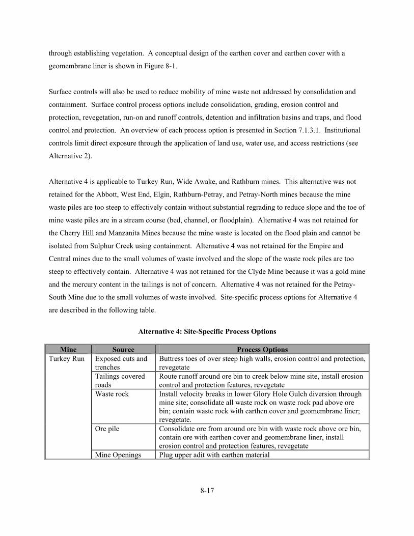
8-17
through establishing vegetation. A conceptual design of the earthen cover and earthen cover with a
geomembrane liner is shown in Figure 8-1.
Surface controls will also be used to reduce mobility of mine waste not addressed by consolidation and
containment. Surface control process options include consolidation, grading, erosion control and
protection, revegetation, run-on and runoff controls, detention and infiltration basins and traps, and flood
control and protection. An overview of each process option is presented in Section 7.1.3.1. Institutional
controls limit direct exposure through the application of land use, water use, and access restrictions (see
Alternative 2).
Alternative 4 is applicable to Turkey Run, Wide Awake, and Rathburn mines. This alternative was not
retained for the Abbott, West End, Elgin, Rathburn-Petray, and Petray-North mines because the mine
waste piles are too steep to effectively contain without substantial regrading to reduce slope and the toe of
mine waste piles are in a stream course (bed, channel, or floodplain). Alternative 4 was not retained for
the Cherry Hill and Manzanita Mines because the mine waste is located on the flood plain and cannot be
isolated from Sulphur Creek using containment. Alternative 4 was not retained for the Empire and
Central mines due to the small volumes of waste involved and the slope of the waste rock piles are too
steep to effectively contain. Alternative 4 was not retained for the Clyde Mine because it was a gold mine
and the mercury content in the tailings is not of concern. Alternative 4 was not retained for the Petray-
South Mine due to the small volumes of waste involved. Site-specific process options for Alternative 4
are described in the following table.
Alternative 4: Site-Specific Process Options
Mine Source Process Options
Turkey Run Exposed cuts and trenches
Buttress toes of over steep high walls, erosion control and protection, revegetate
Tailings covered roads
Route runoff around ore bin to creek below mine site, install erosion control and protection features, revegetate
Waste rock Install velocity breaks in lower Glory Hole Gulch diversion through mine site; consolidate all waste rock on waste rock pad above ore bin; contain waste rock with earthen cover and geomembrane liner; revegetate.
Ore pile Consolidate ore from around ore bin with waste rock above ore bin, contain ore with earthen cover and geomembrane liner, install erosion control and protection features, revegetate
Mine Openings Plug upper adit with earthen material

FIGURE 8-1
CONCEPTUAL DESIGNALTERNATIVE 4
SULPHUR CREEK MINING DISTRICT
Tetra Tech EM Inc.
WASTE
EARTHEN COVER AND GEOMEMBRANE LINER
12" FILL MATERIAL
GEOCOMPOSITEDRAINAGE FABRIC
GEOMEMBRANE LINER
6" COMPACTED SAND OR FILL MATERIAL
6" AMENDED FILL FOR REVEGETATION
A BOTTOM LINER AND LEACHATE COLLECTION RECOVERY SYSTEM IS NOT USED BECAUSE GROUNDWATER IS IMPACTED BY HYDROTHERMAL SYSTEM.
NOTE:

8-19
Alternative 4: Site-Specific Process Options
Mine Source Process Options
Turkey Run (continued)
Institutional Controls
Install fencing around site perimeter, hazardous structures, and high walls; post signage
Wide Awake
Exposed cuts and trenches
Erosion control and protection, revegetate
Tailings Install dry dam above mine, grade tailings to reduce creek erosion, contain tailings/waste rock with earthen cover and geomembrane liner, erosion control and protection, revegetate
Waste rock Install dry dam above mine, contain waste rock with earthen cover and geomembrane liner, consolidate small waste rock pile below the rotary furnace with large tailings/waste rock pile, erosion control and protection, revegetate
Institutional Controls
Install fencing around site perimeter, hazardous structures, high walls, and shaft; post signage
Rathburn Mine Pit Divert runoff from cut into pit; erosion control and protection, revegetate pit
Waste rock Consolidate small amount of tailings at retort with waste rock, contain waste rock/tailings with earthen cover, divert runoff from covered waste rock/tailings pile into pit, revegetate
Institutional Controls
Fence site perimeter and pit
8.4.1 Effectiveness
The implementation of Alternative 4 would provide an additional level of protection beyond that provided
by surface and institutional controls (Alternative 3) by further reducing contaminant loading to creeks in
the District, further reducing infiltration of surface water and subsequent leaching of metals to surface
water and groundwater, further reducing the threat of human and ecological exposure to waste material
and contaminated surface water and sediment, and further reducing the risk of airborne exposure to dust.
Containing waste and subsequent revegetation and run-on and runoff controls would stabilize the cover
surface by providing additional erosion protection. If contaminants may leach from mine waste, then a
geomembrane liner will be placed under the earthen cover to decrease the infiltration of precipitation and
subsequent leachate generation. Fencing of mine sites and grating or plugging of shafts and adits would
provide additional protection of human health and the environment by limiting access to physical hazards.
Fencing would also minimize potential cover damage from circumstances such as surface erosion from
unauthorized vehicle traffic, and promote and protect plant growth.

8-20
Surface controls (run-on and runoff measures and sedimentation basins) would reduce contaminant
loading to surface water and sediment from intact waste at the mine site (if any) to Harley Gulch, Sulphur
Creek, and Bear Creek. The geomembrane liner (if required) would reduce precipitation infiltration into
the waste material; therefore leachate should not be generated. The threat of human and ecological
exposure due to ingestion of waste material, dermal contact, and inhalation of dust would remain in those
areas (if any) where contaminated material is left in place and is not covered. Institutional controls
(fencing, grates, and plugs) would limit access to physical hazards and human and ecological exposure to
any waste that remains uncovered. The permanence of surface controls for reducing the remaining waste
migration to surface water and groundwater is highly dependent on maintenance activities. Alternative 4
would provide a moderate to high degree of mercury load reduction and protection of human health and
the environment.
Containment of waste, construction of surface controls, and implementation of institutional controls
would likely meet federal and state contaminant-specific ARARs for degradation of water quality.
Leaching and release of contaminants to groundwater and surface water would be significantly reduced
because the primary waste sources of concern would be physically isolated using an earthen cover or
earthen cover with a geomembrane liner (if required) and erosion of any remaining uncovered waste
(reduced volume) would be managed using run-on and runoff controls. The geomembrane liner would
reduce the generation of leachate and surface controls would reduce migration of contaminants from
sources not contained with a cover; therefore, surface water in Harley Gulch and Sulphur Creek would
not be degraded by leachate; and surface water and groundwater in the Bear Creek watershed would not
be degraded by leachate. Erosion controls, covering of mine waste, and control of leachate will reduce
contaminant loading and potentially facilitate attainment of ARARs (MCLs or AWQC).
Location-specific ARARs are expected to be met without any conflicts. Design and placement of grates
and plugs would consider use of mine shafts and adits by threatened and endangered species. Contacts
with appropriate agencies regarding historical, cultural, and archeological remains would be required.
The mining wastes addressed by this alternative were derived from the beneficiation and extraction of
ores and are assumed to be exempt from federal government regulation through RCRA as hazardous
waste. Waste consolidation, containment, and construction of surface controls would meet the standards
for diversion of flow from disturbed areas and revegetation requirements contained in the SMCRA. In
addition, standards for backfilling, regrading, slope stability, and recontouring; drainage, diversion
8-21
structures, waterways, and erosion control; closure of surface openings; and revegetation contained in the
SMARA would also be met. Mine waste would be managed as a Group B or C waste (depending on
leachability). Stormwater generated during consolidation and construction activities will be managed in
accordance with the CWA. Lake County and Colusa County APCD’s nuisance dust suppression and
control requirements are applicable for construction and earth-moving activities associated with
Alternative 4 for the control of fugitive dust emissions; these requirements would be met through water
application to roads receiving heavy vehicular traffic and to construction or excavation areas, if necessary.
OSHA requirements would be met by requiring appropriate safety training for all on-site workers during
the construction phase.
Under Alternative 4, the cover would have to be inspected to ensure that the vegetation becomes
established and continues to perform as designed. Consequently, long-term monitoring and maintenance
would be required, especially of the fencing and revegetated slopes of the mine site since the disturbed
surfaces are susceptible to erosion. The waste cover would be the component most vulnerable to any
damage or degradation that might occur. The cover would be susceptible to settlement, surface water
ponding, erosion, and disruption of cover integrity by vehicles, deep-rooting vegetation, and burrowing
animals. The actual design life of the cover is not certain; however, since the cover would be periodically
inspected, the required maintenance could be determined and implemented. The long-term effectiveness
of containing the waste in place would be enhanced by determining the proper cover design and
appropriate grading layout, and by selecting the appropriate plant species for revegetation. In addition,
institutional controls would be required to prevent land uses incompatible with the mitigation alternative.
Specifically, land uses that would compromise the waste cover should be precluded.
Long-term monitoring and maintenance of surface controls would also be required, especially cleanout of
sedimentation basins and revegetation of slopes and excavated areas since waste surfaces are susceptible
to erosion. Sediment removed from on-site collection basins will be placed on bermed mine cuts. Berms,
water control bars, and ditches should also be repaired as necessary. The selection of appropriate plant
species for revegetation, including some hardy metal and salt tolerant plant species in the revegetation
seed mixture, would enhance the long-term effectiveness of surface controls. Revegetation areas must be
maintained until a vegetative cover has been established or lack of viability demonstrated. In addition,
institutional controls would be required to prevent land uses incompatible with the surface controls.
Specifically, land uses that would compromise surface control structures and vegetated surfaces should be
precluded.

8-22
The objective of this alternative is to reduce contaminant mobility (e.g. mercury loading); the volume or
toxicity of the contaminants would not be physically reduced. Containing the waste would stabilize these
sources, and reduce contaminant mobility from surface water runoff, precipitation infiltration and leachate
generation, and dust generation compared to surface and institutional controls alone (Alternative 3). Run-
on and runoff controls would stabilize the waste cover and any remaining uncovered waste material, and
reduce contaminant mobility from surface water and wind erosion. The mobility of the contaminants
would be reduced to an extent that would result in an overall risk reduction from all pathways and routes
of exposure.
The construction phase of Alternative 4 at each mine site would likely be accomplished within one field
season; therefore, impacts associated with construction would likely be short term and minimal. Short-
term risks of exposure to contaminated material would be a potential for the site worker during fencing
installation; excavation, consolidation, grading, and cover installation; and construction of run-on and
runoff controls. Therefore, on-site workers must be adequately protected by using appropriate personal
protective equipment and by following proper operating and safety procedures. Short-term air quality
impacts to the surrounding environment may occur during waste consolidation and grading. Control of
fugitive dust emissions would be provided by applying water to surfaces receiving heavy vehicular traffic
or in excavation areas, as needed. Short-term risks of physical injury during construction activities would
also exist, as well as off site from increased truck traffic required to transport construction material to a
mine.
8.4.2 Implementability
Alternative 4 is both technically and administratively feasible, and could be implemented within one field
season. The consolidation, regrading, and revegetation require conventional construction practices;
materials and construction methods are readily available. It is assumed that clean fill material for the
earthen cover and sand used in leveling and liner construction is available from a local source (within
15 miles). Also, design methods and requirements are well documented and understood. Installation of
an earthen cover or an earthen cover with a geomembrane liner would require the services of a contractor
experienced in the proper installation of specialized caps and liners.
Consolidating and containing the waste materials in place would require the use of heavy equipment
including scrapers, loaders, dozers, and haul trucks. The heavy equipment required to perform these tasks

8-23
can be operated on slopes with a maximum slope of approximately 2 to 1, and some of the waste piles at
mines in the District approach this slope. This type of mitigation alternative could be supplemented in the
future with additional alternatives such as groundwater control measures. However, future removal of the
materials would be more costly after a cover has been installed.
Components or factors which could potentially prolong the implementation of this alternative as planned
include: (1) locating a local source of sand for liner placement and fill material for cover construction,
(2) controlling fugitive dust emissions and storm water discharge during mitigation activities, and
(3) shortened construction season due to inclimate weather. However, these concerns are applicable to
other mitigation alternatives being considered.
8.4.3 Costs
The total present worth cost for Alternative 4, containment with earthen cover or earthen cover and
geomembrane liner, and surface and institutional controls, is summarized in Table 8-3. A cost summary,
detailed costs, and assumptions used in developing the cost estimate for each mine are presented in
Appendix A. The total present worth cost includes the present value of 30 years on annual maintenance
and monitoring costs, in addition to the capital costs. These engineering costs are estimates that are
expected to be within plus 50 to minus 30 percent of the actual project cost (based on year 2003 dollars).
Changes in the cost elements are likely to occur as a result of new information and data collected during
the mitigation design.
8.5 ALTERNATIVE 5: EXCAVATION AND ON-SITE DISPOSAL IN A GROUP B MINE WASTE REPOSITORY, SURFACE AND INSTITUTIONAL CONTROLS
Excavation and placement of wastes in an on-site Group B mine waste repository at applicable sites
combined with surface and institutional controls is used primarily to reduce mobility of and exposure to
contaminants. Excavation and consolidation of waste is used primarily to reduce the area of exposure.
The physical containment of waste, between a lower GCL and an upper geomembrane liner, reduces
contact between water and mine waste and subsequent generation of leachate, and the potential health risk
that may be associated with exposure (direct contact or airborne releases of particulates) to the
contaminated media. Installation of a GCL at the base of the repository and a geomembrane liner under
the cover is necessary because (1) metals in the mine waste are leachable; (2) the metals concentration in
leachate exceeds metals concentrations in surface water and groundwater; or (3) the mine waste is

TABLE 8-3 SUMMARY OF COSTS FOR ALTERNATIVE 4
SULPHUR CREEK MINING DISTRICT (Page 1 of 1)
Mine
Capital Costs Yearly O&M
Costs Present Worth of
O&M Costs Total Present
Worth Turkey Run $494,785 $29,820 $370,063 $864,848 Wide Awake $448,473 $28,691 $356,059 $804,532 Rathburn $180,076 $14,980 $185,901 $365,977
O&M = Operation and maintenance Present worth of O&M costs based on 30-year life at rate of 7 percent Design assumptions and detailed cost estimates are presented in Appendix A.

8-25
immediately adjacent to a creek. Surface controls are used to divert surface water away from the
repository and to reduce contaminant mobility and limit direct exposure to contaminants in those areas
where excavation and on-site disposal in a repository is not employed.
Excavation and on-site disposal in a Group B mine waste repository is considered a feasible alternative
for tailings, waste rock, and ore piles, and for the waste covered roads. Constructing the on-site
repository would involve: (1) excavating and preparing the repository subgrade; (2) stockpiling of clean,
native soils for later use in the repository cover; (3) installing a GCL and a LCRS; (4) excavating,
consolidating, and compacting the waste materials in the repository; (5) covering the waste with 6 inches
of compacted fill, a 30-mil thick geomembrane liner, a drainage layer, and an additional 12-inches of
cover material, and (6) revegetating the repository cover and the disturbed areas. A lined basin for
collection and evaporation of leachate, if generated, would be constructed downgradient of the repository.
Surface control measures would be used to divert surface water away from the cover and to minimize
infiltration of surface water and precipitation into the underlying contaminated waste. Increasing
evapotranspiration processes through establishing vegetation would further reduce infiltration.
Precautionary measures, such as stream diversion or isolation, would be necessary for excavating
materials contained on a flood plain. Containment and treatment of water encountered during excavation
may also be necessary. A conceptual design of a Group B waste repository is shown in Figure 8-2.
Surface control measures will be used to divert surface water away from the repository, to minimize the
potential for infiltration surface water and precipitation into the consolidated mine waste, and to reduce
runoff and erosion from the repository cover and excavated areas. Surface control process options
include grading, erosion control and protection, revegetation, run-on and runoff controls, detention and
infiltration basins and traps, and flood control and protection. An overview of each surface process
option is presented in Section 7.1.3.1. Institutional controls limit direct exposure through the application
of land use, water use, and access restrictions (Alternative 2).
Alternative 5 is applicable to the Abbott, Wide Awake, West End, Elgin, Rathburn, Rathburn-Petray, and
Petray-North mines. This alternative was not retained for the Turkey Run mine due to inadequate space
for a repository at the lower mine area and the likelihood of slope failure on the already over-steep slopes
along the upper mine cuts. This alternative was not retained for the Empire, Cherry Hill, and Manzanita
mines due to inadequate space for an on site repository or the likelihood of Sulphur Creek flooding a
repository placed at the lower portions of Cherry Hill and Manzanita mines. This alternative was not
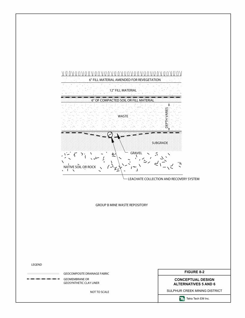
LEGEND
GEOCOMPOSITE DRAINAGE FABRIC
NOT TO SCALE
GEOMEMBRANE ORGEOSYNTHETIC CLAY LINER
WASTE
DEP
TH V
ARI
ES
LEACHATE COLLECTION AND RECOVERY SYSTEM
12" FILL MATERIAL
6" FILL MATERIAL AMENDED FOR REVEGETATION
SUBGRADE
GRAVEL
NATIVE SOIL OR ROCK
GROUP B MINE WASTE REPOSITORY
6" OF COMPACTED SOIL OR FILL MATERIAL
FIGURE 8-2
CONCEPTUAL DESIGNALTERNATIVES 5 AND 6
SULPHUR CREEK MINING DISTRICT
Tetra Tech EM Inc.

8-27
retained for the Central Mine because the volume of tailings was not sufficient to justify construction of
an on-site repository. This alternative was not retained for the Clyde Mine because it was a gold mine
and the mercury content in the tailings is not of concern. This alternative was not retained for the Petray-
South Mine due to the small volumes of waste involved. Site-specific process options for Alternative 5
are described below.
Alternative 5: Site-Specific Process Options
Mine Source Process Options Abbott Exposed cuts and
trenches Buttress toes of over steep high walls, erosion control and protection, install velocity breaks to slow runoff, revegetate
Tailings covered roads
Install velocity breaks and sediment detention basins in upper Glory Hole Gulch diversion to slow runoff and capture sediment, stabilize toe of slide above grizzly, erosion control and protection features, revegetate
Tailings Rehabilitate mine haul roads; route Harley Gulch through box culvert; route upper dry dam discharge away from tailings; construct Group B mine waste repository on flat below mill; grade slopes; erosion control and protection; revegetate
Waste rock Grading of over steep slopes, stabilize toes of slides and slumps, erosion control and protection, revegetation
Mine Openings Plug shafts Institutional
Controls Install fencing around site perimeter, hazardous structures, and high walls; post signage
Wide Awake
Exposed cuts and trenches
Erosion control and protection, revegetate
Tailings Rehabilitate access road; construct temporary haul road; construct Group B mine waste repository west of creek; grade slopes; erosion control and protection; remove haul road; revegetate
Waste rock Erosion control and protection, revegetate Institutional
Controls Install fencing around site perimeter, hazardous structures, high walls, and shaft; post signage
West End Waste Rock Construct temporary haul road, construct Group B mine waste repository on slope northwest of mine, excavate tailings and haul to on-site repository, remove temporary haul road, revegetate
Mine Openings Grate adits Institutional
Controls Fence site perimeter
Elgin Tailings Rehabilitate haul road, excavate and haul tailings to repository on upper bench, grade slopes, erosion control and protection, revegetate

8-28
Alternative 5: Site-Specific Process Options
Mine Source Process Options Elgin (continued)
Waste rock Divert runoff from upper watershed around repository site, construct Group B mine waste repository on upper bench, grade slopes, install erosion control and protection features, revegetate.
Mine Opening Grate one adit and plug second adit Institutional
Controls Fence site perimeter
Rathburn Mine Pit Divert runoff from cut and bench away from pit; revegetate pit and repository cover
Waste rock Rehabilitate pit haul road, construct Group B mine waste repository inside mine pit, grade slopes, install trench below waste rock excavation, install sediment detention basin in swale that feeds a tributary to Bear Creek, revegetate
Institutional Controls
Fence site perimeter and pit
Rathburn-Petray
Mine Pit Revegetation
Road Cut Through Waste Rock
Road will be eliminated because waste rock will be place in on-site repository
Waste rock Rehabilitate pit haul road, construct Group B mine waste repository inside mine pit, grade slopes, diversion trench at top of waste rock excavation area to minimize flow of water onto regraded area; install sediment detention basin in tributary on north side of waste rock excavation area; cut a swale at toe of regraded slope to divert runoff; install sediment detention basins in swale that feed Bear Creek; revegetate
Institutional Controls
Fence site perimeter and pit high wall
Petray-North Mine Pit Erosion control and protection in pit, sediment detention basin in creek below pit, revegetate
Waste rock Construct pit haul road, construct Group B mine waste repository inside mine pit, grade slopes, trenching, install sediment detention basin in swale below excavation area, revegetate
Institutional Controls
Fence site perimeter, high wall, and hazardous structures
8.5.1 Effectiveness
The implementation of Alternative 5 would provide an additional level of protection beyond that provided
by containment with earthen cover or earthen cover and geomembrane liner, and surface and institutional
controls (Alternative 4) by essentially eliminating leachate generation and migration to creeks in the
District and the threat of human and ecological exposure to contaminants in leachate through

8-29
encapsulation of Group B mine waste at applicable sites. Revegetation and run-on and runoff controls
would stabilize the repository cover surface by providing additional erosion protection. The
geomembrane liner under the earthen cover will decrease the infiltration of precipitation that could leach
metals from the waste to groundwater and surface water. A GCL will ensure that groundwater does not
contact waste material placed in the repository. Surface water and groundwater quality would not be
degraded because the mine waste is encapsulated. Fencing of mine sites and grating and plugs shafts and
adits would provide additional protection of human health and the environment by limiting access to
physical hazards. Fencing would also minimize potential cover damage from circumstances such as
surface erosion from unauthorized vehicle traffic, and to promote and protect plant growth.
Isolating the waste would provide environmental protection by reducing the infiltration of precipitation
and migration of leachate to groundwater and surface water, and by reducing erosion of mine waste into
surface water. Surface controls (run-on and runoff measures and sedimentation basins) would reduce
contaminant loading to surface water and sediment from in place waste at the mine site (if any) to Harley
Gulch, Sulphur Creek, and Bear Creek. The threat of direct human and ecological exposure would be
minimized by this alternative. The potential for ingestion and inhalation of dust would also be
minimized. The threat of human and ecological exposure due to ingestion of waste material, dermal
contact, and inhalation of dust would remain in those areas (if any) where contaminated material is left in
place. Institutional controls (fencing, grates, and plugs) would limit access to physical hazards and
human and ecological exposure to any waste that remains in place. Alternative 5 provides a high degree
of mercury load reduction and protection of human health and the environment.
Excavation and placement of wastes in an on-site Group B mine waste repository combined with surface
and institutional controls would meet federal and state contaminant-specific ARARs for degradation of
water quality. Leaching and release of contaminants to groundwater and surface water would be
eliminated because the mine waste would be physically isolated from the environment. Erosion of any
remaining uncovered waste (reduced volume) would be managed using run-on and runoff controls. The
geomembrane liner would control the generation of leachate and the LCRS would control the discharge of
leachate; therefore, surface water in Harley Gulch and Sulphur Creek would not be degraded by leachate
and surface water and groundwater in the Bear Creek watershed would not be degraded by leachate.
Erosion controls, covering of mine waste, and control of leachate will reduce contaminant loading and
potentially facilitate attainment of ARARs (MCLs or AWQC).

8-30
Location-specific ARARs are expected to be met without any conflicts. Design and placement of grates
and plugs would consider use of mine shafts and adits by threatened and endangered species. Contacts
with appropriate agencies regarding historical, cultural, and archeological remains would be required.
The mining wastes addressed by this alternative were derived from the beneficiation and extraction of
ores and are assumed to be exempt from federal government regulation through RCRA as hazardous
waste. Waste consolidation, containment, and construction of surface controls would meet the standards
for diversion of flow from disturbed areas and revegetation requirements contained in the SMCRA. In
addition, standards for backfilling, regrading, slope stability, and recontouring; drainage, diversion
structures, waterways, and erosion control; closure of surface openings; and revegetation contained in the
SMARA would also be met. Waste would be managed as a Group B waste subject to the design and
siting criteria specified under Water Code Section 13172. Stormwater generated during consolidation and
construction activities will be managed in accordance with the CWA. Lake County and Colusa County
APCD’s nuisance dust suppression and control requirements are applicable for construction and earth-
moving activities associated with this alternative for the control of fugitive dust emissions; these
requirements would be met through water application to roads receiving heavy vehicular traffic and to
construction or excavation areas, if necessary. OSHA requirements would be met by requiring
appropriate safety training for all on-site workers during the construction phase.
Under Alternative 5, the cover would have to be inspected to ensure that the vegetation becomes
established and continues to perform as designed. Consequently, long-term monitoring and maintenance
would be required, especially of the fencing and revegetated slopes of the mine site since the disturbed
surfaces are susceptible to erosion. The long-term effectiveness and permanence of the repository is
dependent upon proper maintenance, including long-term monitoring and routine inspections, to ensure
that the system performs as designed. The repository cover would be the component most vulnerable to
any damage or degradation that might occur. Multi-layered covers are susceptible to ponding of surface
water, erosion, settlement, and disruption of the cover integrity by vehicles, deep-rooting vegetation, and
burrowing animals. The actual design life of the repository is not certain; however, since the repository
would be periodically inspected, the required maintenance could be determined and implemented.
Selecting the appropriate plant species for revegetation would enhance the long-term effectiveness of
containing the waste in place. In addition, institutional controls would be required to prevent land uses
incompatible with the site. Specifically, land uses that would compromise the repository cover should be
precluded.
8-31
Long-term monitoring and maintenance of surface controls would also be required, especially cleanout of
sedimentation basins and revegetation of slopes and excavated areas since disturbed surfaces are
susceptible to erosion. Sediment removed from on-site collection basins will be placed on bermed mine
cuts. Berms, water control bars, and ditches should also be repaired as necessary. The selection of
appropriate plant species for revegetation, including some hardy metal and salt tolerant plant species in
the revegetation seed mixture, would enhance the long-term effectiveness of surface controls.
Revegetation areas must be maintained until a vegetative cover has been established or lack of viability
demonstrated.
The objective of this alternative is to reduce contaminant mobility (e.g. mercury loading); the volume or
toxicity of the contaminants would not be physically reduced. Consolidating and containing the waste in
a repository would reduce the number of sources, minimize contaminant mobility from surface water
runoff, minimize precipitation infiltration and leachate generation, and eliminate dust generation through
the use of impermeable liners that encapsulate the mine waste. Run-on and runoff controls would
stabilize the repository cover and any remaining in place waste, and reduce contaminant mobility from
surface water and wind erosion. The mobility of the contaminants will be reduced to an extent that would
result in an overall risk reduction from completed pathways and routes of exposure.
The construction phase of Alternative 5 would likely be accomplished within one field season; therefore,
impacts associated with construction would likely be short term and minimal. Short-term risks of
exposure to contaminated material would be a potential for the site worker during installation of the
fencing; excavation, hauling, consolidation, and constructing of the repository GCL and cap; and
construction of run-on and runoff controls. Therefore, on-site workers must be adequately protected by
using appropriate personal protective equipment and by following proper operating and safety procedures.
Short-term air quality impacts to the surrounding environment may occur due to the relatively large
volumes of waste requiring consolidation and hauling to the on-site repository. Control of fugitive dust
emissions would be provided by applying water to surfaces receiving heavy vehicular traffic or in
excavation areas, as needed. Short-term risks of physical injury during construction activities would also
exist, as well as off site from increased truck traffic required to transport construction material.

8-32
8.5.2 Implementability
Alternative 5 is both technically and administratively feasible, and could be implemented within one field
season. Excavation, consolidation, and construction of a lined repository with a multi-layered cover is
considered a conventional construction practice; materials and construction methods are readily available.
It is assumed that clean fill material for the earthen cover and sand and gravel used in leveling and LCRS
construction is available from a local source (within 15 miles). Also, design methods and requirements
are well documented and understood. Construction of the repository may require the services of a
contractor experienced in the proper component installation procedures.
Excavation, consolidation, and construction of the repository would require the use of heavy equipment
including scrapers, loaders, dozers, and haul trucks. The heavy equipment required to perform these tasks
can be operated on slopes with a maximum steepness of approximately 2 to 1, and some of the waste piles
at mines in the District approach this steepness.
Components or factors which could potentially prolong the implementation of this alternative as planned
include: (1) locating an alternate source of sand and gravel used in leveling and LCRS construction and
fill material for cover construction, (2) controlling fugitive dust emissions and storm water discharge
during mitigation activities, and (3) shortened construction season due to inclimate weather. However,
these concerns are applicable to other mitigation alternatives being considered.
8.5.3 Costs
The total present worth cost for Alternative 5, excavation and on-site disposal in a Group B mine waste
repository, surface and institutional controls, is summarized in Table 8-4. A cost summary, detailed
costs, and assumptions used in developing the cost estimate for each mine are presented in Appendix A.
The total present worth cost includes the present value of 30 years on annual maintenance and monitoring
costs, in addition to the capital costs. These engineering costs are estimates that are expected to be within
plus 50 to minus 30 percent of the actual project cost (based on year 2003 dollars). Changes in the cost
elements are likely to occur as a result of new information and data collected during the mitigation design.

TABLE 8-4 SUMMARY OF COSTS FOR ALTERNATIVE 5
SULPHUR CREEK MINING DISTRICT (Page 1 of 1)
Mine
Capital Costs Yearly O&M
Costs Present Worth of
O&M Costs Total Present
Worth Abbott $4,086,351 $41,323 $512,824 $4,599,175 Abbott + Other Sites (a)
$4,190,705 $42,247 $524,281 $4,714,985
Wide Awake $467,602 $25,857 $320,890 $788,493 West End $146,855 $11,670 $144,831 $291,686 West End + Other Sites (b)
$514,937 $27,951 $346,872 $861,809
Elgin $228,900 $15,299 $189,866 $418,766 Rathburn $273,255 $17,261 $214,212 $487,467 Rathburn-Petray $2,302,326 $25,542 $316,973 $2,619,299 Rathburn-Petray + Other Sites (c)
$2,427,079 $26,645 $330,668 $2,757,748
Petray-North $156,377 $12,092 $150,058 $306,435
(a) = The incremental cost for disposal of waste from the Turkey Run Mine at the Abbott Mine Group B mine waste repository is included under the cost estimate for the Turkey Run Mine. (b) = The incremental costs for disposal of waste from the Empire, Cherry Hill, Manzanita, and Central mines at the West End Mine Group B mine waste repository is included under the cost estimates for the individual mines. (c) = The incremental costs for disposal of waste from the Rathburn Mine at the Rathburn-Petray Mine Group B mine waste repository is included under the cost estimates for the individual mines. O&M = Operation and maintenance Present worth of O&M costs based on 30-year life at rate of 7 percent Design assumptions and detailed cost estimates are presented in Appendix A.

8-34
8.6 ALTERNATIVE 6: EXCAVATION AND OFF-SITE DISPOSAL IN GROUP B MINE
WASTE REPOSITORY, SURFACE AND INSTITUTIONAL CONTROLS
Wastes from individual mines will be excavated, hauled to, and placed in an off-site Group B mine waste
repository located at the Abbott Mine in the Harley Gulch watershed, the West End Mine in the Sulphur
Creek watershed, and the Rathburn-Petray Mine in the Bear Creek watershed as described in Section 8.5.
Excavation and placement of mine waste in an off-site repository, in combination with surface and
institutional controls, is used primarily to eliminate mobility of and exposure to contaminants at
individual mines and to reduce the total area of waste exposure within the District. The physical
containment of waste at the off-site repository, between a lower GCL and an upper geomembrane liner,
reduces contact between water and mine waste and the potential health risk that may be associated with
exposure (direct contact or airborne releases of particulates) to the contaminated media. Installation of a
GCL at the base of the repository and a geomembrane liner under the cover is necessary because
(1) metals in the mine waste are leachable; (2) the metals concentration in leachate exceeds metals
concentrations in surface water and groundwater; and (3) the mine waste is immediately adjacent to a
creek. Surface controls are used to divert surface water away from the repository and to reduce
contaminant mobility and limit direct exposure to contaminants in those areas where excavation and on-
site disposal in a repository is not employed.
Excavation and off-site disposal of waste in a Group B mine waste repository is considered a feasible
alternative for tailings, waste rock, and ore piles, and for the waste covered roads. Constructing the off-
site repository would involve: (1) excavating and preparing the repository subgrade; (2) stockpiling of
clean, native soils for later use in the repository cover; (3) installing a GCL and a LCRS; (4) excavating,
hauling, consolidating, and compacting the waste materials in the repository; (5) covering the waste with
6 inches of compacted fill, a 30-mil thick geomembrane liner, a drainage layer, and an additional 12-
inches of cover material, and (6) revegetating the off-site repository cover and the disturbed areas at the
mine site. A lined basin for collection and evaporation of leachate, if generated, would be constructed
downgradient of the repository. Precautionary measures, such as stream diversion or isolation, would be
necessary for excavating materials contained on a flood plain. Containment and treatment of water
encountered during excavation may also be necessary. A conceptual design of a Group B waste
repository is shown in Figure 8-2.

8-35
Surface control measures will be used to divert surface water away from the repository cover and to
reduce runoff and erosion from excavated and backfilled areas. Surface control process options include
grading, erosion control and protection, revegetation, run-on and runoff controls, detention and infiltration
basins and traps, and flood control and protection. An overview of each surface process option is
presented in Section 7.1.3.1. Institutional controls limit direct exposure through the application of land
use, water use, and access restrictions (Alternative 2).
This alternative is applicable to the Turkey Run, Cherry Hill, Manzanita, Central, and Rathburn mines.
This alternative is not applicable to the Abbott, West End, and Rathburn-Petray mines because the Group
B mine waste repository at each of these mines will receive wastes from other mines with the same
property owner. This alternative is not applicable to the Wide Awake, Elgin, and Petray-North mines
because of property ownership issues. This alternative was not retained for the Empire Mine because the
mercury content in the waste rock is not of concern. This alternative was not retained for the Clyde Mine
because it was a gold mine and the mercury content in the tailings is not of concern. This alternative was
not retained for the Petray-South Mine due to the small volumes of waste involved. Site-specific process
options for Alternative 6 are described below.
Alternative 6: Site-Specific Process Options
Mine Source Process Options Turkey Run Exposed cuts and
trenches Buttress toes of over steep high walls, erosion control and protection, revegetate
Tailings covered roads
Route runoff around ore bin pad to creek below mine site, install erosion control and protection features, revegetate
Waste rock Rehabilitate access road, excavate waste rock and haul to Abbott Mine repository, install velocity breaks and culvert pipe in lower Glory Hole Gulch diversion above mine site, grade slopes, revegetate
Ore pile Excavate ore/waste rock and haul to Abbott Mine repository, install erosion control and protection features, revegetate.
Mine Openings Plug upper adit Institutional
Controls Fence site perimeter, high walls, and hazardous structures
Cherry Hill Waste Rock Excavate waste rock and haul to West End Mine repository, revegetate
Mine Openings Grate adits Institutional
Controls Fence site perimeter and high walls
Manzanita Exposed cuts and trenches, access roads
Water velocity breaks, erosion control and protection, revegetate

8-36
Alternative 6: Site-Specific Process Options
Mine Source Process Options Manzanita (continued)
Waste rock Construct temporary haul road, excavate waste rock and haul to West End Mine repository, divert runoff from upper cuts around waste rock, sediment detention basins, remove temporary haul road, revegetate
Mine Opening Plug shaft and grate adit Institutional
Controls Fence site perimeter, high walls, and upper glory hole
Exposed cuts and trenches
Erosion control and protection, revegetate
Tailings Construct temporary haul road, excavate tailings and haul to West End Mine repository, remove temporary haul road, grade slopes, revegetate
Central
Waste rock Erosion control and protection Institutional
Controls Fence site perimeter, high walls, and hazardous structures
Rathburn Mine Pit Divert runoff from cut and bench away from pit; revegetate pit Waste rock Rehabilitate haul roads, excavate and haul waste rock to Rathburn-
Petray Mine repository, grade slopes, install trench below waste rock excavation, install sediment detention basin in swale that feeds a tributary to Bear Creek, revegetate
Institutional Controls
Fence site perimeter and pit
8.6.1 Effectiveness
The implementation of this alternative would provide an additional level of protection beyond that
provided by containment with excavation and placement of wastes in an on-site Group B mine waste
repository combined with surface and institutional controls (Alternative 5) by reducing the majority of
mine waste exposure to just to a single repository for a property owner. Revegetation and run-on and
runoff controls would stabilize the repository cover surface by providing additional erosion protection.
The geomembrane liner under the earthen cover will decrease the infiltration of precipitation that could
leach metals from the waste to groundwater and surface water. A GCL will ensure that groundwater does
not contact waste material placed in the repository. Surface water and groundwater quality would not be
degraded because the mine waste is encapsulated. Fencing of mine sites and installation of grating and
plugs for shafts and adits would provide additional protection of human health and the environment by
limiting access to physical hazards. Fencing would also minimize potential cover damage from
circumstances such as surface erosion from unauthorized vehicle traffic, and to promote and protect plant
growth.
8-37
Isolating the waste would provide environmental protection by reducing the infiltration of precipitation
and migration of leachate to groundwater and surface water, and by reducing erosion of mine waste into
surface water. Surface controls (run-on and runoff measures and sedimentation basins) would reduce
contaminant loading to surface water and sediment from in place waste at the mine site (if any) to Harley
Gulch, Sulphur Creek, and Bear Creek. The threat of direct human and ecological exposure would be
further minimized by consolidation of the majority of the mine waste in just to a single repository for a
property owner. Two of the repositories will be constructed where surface water and groundwater is
already degraded by hydrothermal waters, while the other will be constructed inside an existing dry mine
pit. The threat of human and ecological exposure due to ingestion of waste material, dermal contact, and
inhalation of dust would remain in those areas (if any) where contaminated material is left in place.
Institutional controls (fencing, grates, and plugs) would limit access to physical hazards and human and
ecological exposure to any waste that remains in place. Surface controls (run-on and runoff measures and
sedimentation basins) would reduce contaminant loading to surface water and sediment from in place
waste at the mine site (if any) to Harley Gulch, Sulphur Creek, and Bear Creek. Alternative 6 provides a
high degree of mercury load reduction and protection of human health and the environment.
Excavation and placement of wastes in an off-site Group B mine waste repository combined with surface
and institutional controls would meet federal and state contaminant-specific ARARs for degradation of
water quality. Leaching and release of contaminants to groundwater and surface water would be
eliminated because the mine waste would be physically isolated from the environment. Erosion of any
remaining uncovered waste (reduced volume) would be managed using run-on and runoff controls. The
geomembrane liner would control the generation of leachate and the LCRS would control the discharge of
leachate; therefore, surface water in Harley Gulch and Sulphur Creek would not be degraded by leachate
and surface water and groundwater in the Bear Creek watershed would not be degraded by leachate.
Erosion controls, covering of mine waste, and control of leachate will reduce contaminant loading and
potentially facilitate attainment of ARARs (MCLs or AWQC).
Location-specific ARARs are expected to be met without any conflicts. Design and placement of grates
and plugs would consider use of mine shafts and adits by threatened and endangered species. Contacts
with appropriate agencies regarding historical, cultural, and archeological remains would be required.
The mining wastes addressed by this alternative were derived from the beneficiation and extraction of
ores and are, therefore, assumed to be exempt from federal government regulation through RCRA as
8-38
hazardous waste. Waste consolidation, containment, and construction of surface controls would meet the
standards for diversion of flow from disturbed areas and revegetation requirements contained in the
SMCRA. In addition, standards for backfilling, regrading, slope stability, and recontouring; drainage,
diversion structures, waterways, and erosion control; closure of surface openings; and revegetation
contained in the SMARA would also be met. Waste would be managed as a Group B waste subject to the
design and siting criteria specified under Water Code Section 13172. Stormwater generated during
consolidation and construction activities will be managed in accordance with the CWA. Lake County and
Colusa County APCD’s nuisance dust suppression and control requirements are applicable for
construction and earth-moving activities associated with this alternative for the control of fugitive dust
emissions; these requirements would be met through water application to roads receiving heavy vehicular
traffic and to construction or excavation areas, if necessary. OSHA requirements would be met by
requiring appropriate safety training for all on-site workers during the construction phase.
Under Alternative 6, the cover would have to be inspected to ensure that the vegetation becomes
established and continues to perform as designed. Consequently, long-term monitoring and maintenance
would be required, especially of the fencing and revegetated slopes of the mine site since the disturbed
surfaces are susceptible to erosion. The long-term effectiveness and permanence of the repository is
dependent upon proper maintenance, including long-term monitoring and routine inspections, to ensure
that the system performs as designed. By consolidating multiple sources of waste into one repository for
a property owner, substantial O&M and monitoring costs saving will be recognized. The repository cover
would be the component most vulnerable to any damage or degradation that might occur. Multi-layered
covers are susceptible to ponding of surface water, erosion, settlement, and disruption of the cover
integrity by vehicles, deep-rooting vegetation, and burrowing animals. The actual design life of the
repository is not certain; however, since the repository would be periodically inspected, the required
maintenance could be determined and implemented. Selecting the appropriate plant species for
revegetation would enhance the long-term effectiveness of containing the waste in place. In addition,
institutional controls would be required to prevent land uses incompatible with the site. Specifically, land
uses that would compromise the repository cover should be precluded.
Long-term monitoring and maintenance of surface controls would also be required, especially cleanout of
sedimentation basins and revegetation of slopes and excavated areas since disturbed surfaces are
susceptible to erosion. Sediment removed from on-site collection basins will be placed on bermed mine
cuts. Berms, water control bars, and ditches should also be repaired as necessary. The selection of

8-39
appropriate plant species for revegetation, including some hardy metal and salt tolerant plant species in
the revegetation seed mixture, would enhance the long-term effectiveness of surface controls.
Revegetation areas must be maintained until a vegetative cover has been established or lack of viability
demonstrated.
The objective of Alternative 6 is to reduce contaminant mobility (e.g. mercury loading); the volume or
toxicity of the contaminants would not be physically reduced. Consolidating and containing the majority
of mine waste in one repository for a property owner would greatly reduce the number of sources,
minimize contaminant mobility from surface water runoff, minimize precipitation infiltration and leachate
generation, and eliminate dust generation through the use of impermeable liners that encapsulate the mine
waste. Run-on and runoff controls would stabilize the repository cover and any remaining in place waste,
and reduce contaminant mobility from surface water and wind erosion. The mobility of the contaminants
is expected to be reduced to an extent that would result in an overall risk reduction from completed
pathways and routes of exposure.
The construction phase of this alternative would likely be accomplished within one field season;
therefore, impacts associated with construction would likely be short term and minimal. Short-term risks
of exposure to contaminated material would be a potential for the site worker during installation of the
fencing; excavation, hauling, consolidation, and constructing of the repository GCL and cap; and
construction of run-on and runoff controls. Therefore, on-site workers must be adequately protected by
using appropriate personal protective equipment and by following proper operating and safety procedures.
Short-term air quality impacts to the surrounding environment may occur due to the relatively large
volumes of waste requiring hauling, consolidation, and placement in off-site repositories. Control of
fugitive dust emissions would be provided by applying water to roads and surfaces receiving heavy
vehicular traffic or in excavation areas, as needed. Short-term risks of physical injury during construction
activities would also exist, as well as off-site from increased truck traffic required to haul waste to the
repositories and transport construction material.
8.6.2 Implementability
Alternative 6 is both technically and administratively feasible, and could be implemented within one field
season. However, the property from which the mine waste is excavated and the off-site repository
property must be owned by the same entity to avoid negotiation of contaminant liability issues.

8-40
Excavation, hauling, consolidation, and construction of a lined off-site repository with a multi-layered
cover are considered a conventional construction practices; materials and construction methods are
readily available. It is assumed that clean fill material for the earthen cover and sand and gravel used in
leveling and LCRS construction is available from a local source (within 15 miles). Also, design methods
and requirements are well documented and understood. Construction of the repository may require the
services of a contractor experienced in the proper component installation procedures.
Excavation, consolidation, and construction of the repository would require the use of heavy equipment
including scrapers, loaders, dozers, and haul trucks. The heavy equipment required to perform these tasks
can be operated on slopes with a maximum steepness of approximately 2 to 1, and some of the waste piles
at mines in the District approach this steepness.
Components or factors which could potentially prolong the implementation of this alternative as planned
include: (1) locating an alternate source of sand and gravel used in leveling and LCRS construction and
fill material for cover construction, (2) controlling fugitive dust emissions and storm water discharge
during mitigation activities, (3) hauling of mine waste from mines with the same property owner to a
Group B mine waste repository with the same property owner, and (4) shortened construction season due
to inclimate weather. However, these concerns are applicable to other mitigation alternatives being
considered.
8.6.3 Costs
The total present worth cost for Alternative 6, excavation and off-site disposal in a Group B mine waste
repository, surface and institutional controls, is summarized in Table 8-5. The cost for expansion of each
off-site Group B mine waste repository to accommodate the additional volume of waste has been
apportioned to each contributing mine site. A cost summary, detailed costs, and assumptions used in
developing the cost estimate for each mine are presented in Appendix A. The total present worth cost
includes the present value of 30 years on annual maintenance and monitoring costs, in addition to the
capital costs. These engineering costs are estimates that are expected to be within plus 50 to minus 30
percent of the actual project cost (based on year 2003 dollars). Changes in the cost elements are likely to
occur as a result of new information and data collected during the mitigation design.

TABLE 8-5 SUMMARY OF COSTS FOR ALTERNATIVE 6
SULPHUR CREEK MINING DISTRICT (Page 1 of 1)
Mine
Capital Costs Yearly O&M
Costs Present Worth of
O&M Costs Total Present
Worth Turkey Run $420,534 $23,776 $295,055 $715,589 Cherry Hill $51,470 $7,452 $92,474 $143,944 Manzanita $160,442 $15,951 $197,958 $358,400 Central $78,282 $8,637 $107,191 $185,472 Rathburn $199,873 $14,016 $173,933 $373,805
O&M = Operation and maintenance Present worth of O&M costs based on 30-year life at rate of 7 percent Design assumptions and detailed cost estimates are presented in Appendix A.

8-42
8.7 ALTERNATIVE 7: SOLIDS REMOVAL AND ON- OR OFF-SITE DISPOSAL, LEAVE HISTORIC FACILITIES INTACT, INSTITUTIONAL CONTROLS
Under this alternative, all mine features of potential historical significance would remain intact. If after a
historical and cultural resources survey has been conducted, mine features are not found to be of historical
significance, then the features could be demolished as described under Alternative 8. If mine features are
of historical significance, then mine wastes located around the perimeter of historic ore and tailings
handling, processing, and support facilities would be excavated and disposed of in an on- or off-site
Group B mine waste repository. Excavation and placement of mine waste in an on- or off-site repository,
in combination with surface and institutional controls, is used primarily to reduce mobility of and
exposure to contaminants. Any mine waste removed from the perimeter of a mine feature will be
replaced with imported soil, which will be graded, revegetated, and protected against erosion until
vegetation is reestablished. The volume of mine waste associated with most of the mine features alone is
insufficient to justify construction of an on- or off-site repository. If this alternative is selected, all mine
wastes would be hauled to and placed in an on- or off-site repository described in Alternatives 5 or 6,
respectively.
This alternative is applicable to the Abbott, Turkey Run, Wide Awake, and Central mines. This
alternative was not retained for the Empire, Cherry Hill, Elgin, and Petray-North mines as mine features
are not likely of historical significance. This alternative was not retained for the West End, Manzanita,
Clyde, Rathburn-Petray, and Petray-South mines as there are no processing facilities or support buildings
present. Site-specific process options for Alternative 7 are described below.
Alternative 7: Site-Specific Process Options
Mine Source Process Options Abbott Grizzly, crusher,
furnace, condenser, support buildings and foundations, fines processing silo, fines furnace, old retort area
Rehabilitate mine haul roads, remove mine waste from perimeter of structures, haul mine waste to on-site repository, fill excavation with imported soil and grade, install erosion control and protection features, revegetate, fencing

8-43
Alternative 7: Site-Specific Process Options
Mine Source Process Options Turkey Run Ore bin, shed Rehabilitate mine haul road to Abbott Mine, remove mine
waste from perimeter of structures, haul mine waste to Abbott Mine repository, fill excavation with imported soil and grade, install erosion control and protection features, revegetate
Wide Awake Ore bin, grizzly, crusher, furnaces, condenser, three stand alone retorts, other support foundations
Construct temporary haul road to on-site repository, remove mine waste from perimeter of structures, haul mine waste to on-site repository, fill excavation with imported soil and grade, install erosion control and protection features, remove temporary haul road, revegetate, fencing
Central Furnace, separate furnace/retort
Construct temporary haul road, remove mine waste from perimeter of structures, haul mine waste to West End Mine repository, fill excavation with imported soil and grade, install erosion control and protection features, remove temporary haul road, revegetate, fencing
8.7.1 Effectiveness
The implementation of Alternative 7 would provide an additional level of protection beyond that provided
by institutional controls alone (Alternative 2) by reducing the mobility of waste to creeks in the District,
by reducing human and ecological ingestion and dermal contact exposure to mine processing waste, and
by reducing the risk of airborne exposure to dust. Removal of waste from the perimeter of processing
facilities and placement of waste in an on- or off-site repository (Alternatives 5 or 6, respectively) would
minimize generation of leachate and human and ecological exposure to the processing waste.
Revegetation and run-on and runoff controls would stabilize the disturbed areas around the processing
facilities by providing erosion protection. Fencing of structures would provide additional protection of
human health and the environment by limiting access to physical hazards. Fencing would also minimize
potential damage to revegetation efforts on the disturbed areas. Alternative 7 provides a moderate to high
degree of mercury load reduction and protection of human health and the environment; however, waste
would remain within and beneath historic structures.
Excavation and placement of processing waste in an on- or off-site Group B mine waste repository
combined with surface and institutional controls at processing facilities would reduce contaminant
loading and meet federal and state contaminant-specific ARARs for degradation of water quality.
Leaching and release of contaminants to groundwater and surface water would be eliminated because the
mine waste would be physically isolated from the environment. The geomembrane liner would control

8-44
the generation of leachate and the LCRS would control the discharge of leachate from the Group B mine
waste repository; therefore, surface water in Harley Gulch and Sulphur Creek would not be degraded by
leachate and surface water and groundwater in the Bear Creek watershed would not be degraded by
leachate. Containment of mine waste will reduce contaminant loading and potentially facilitate
attainment of ARARs (MCLs or AWQC).
Location-specific ARARs are expected to be met without any conflicts. Design and placement of grates
and plugs would consider use of mine shafts and adits by threatened and endangered species. Contacts
with appropriate agencies would be required to ensure that mitigation activities around the processing
facilities do not impact historical, cultural, and archeological remains.
The mining wastes addressed by this alternative were derived from the beneficiation and extraction of
ores and are, therefore, assumed to be exempt from federal government regulation through RCRA as
hazardous waste. Restoration of excavated areas would meet the revegetation requirements contained in
the SMCRA. In addition, standards for backfilling, regrading, slope stability, and recontouring; drainage,
diversion structures, waterways, and erosion control; closure of surface openings; and revegetation
contained in the SMARA would also be met. Processing waste would be managed as a Group B waste
subject to the design and siting criteria specified under Water Code Section 13172. Stormwater generated
during consolidation and construction activities will be managed in accordance with the CWA. Lake
County and Colusa County APCD’s nuisance dust suppression and control requirements are applicable
for construction and earth-moving activities associated with this alternative for the control of fugitive dust
emissions; these requirements would be met through water application to roads receiving heavy vehicular
traffic and to construction or excavation areas, if necessary. OSHA requirements would be met by
requiring appropriate safety training for all on-site workers during the construction phase.
Under Alternative 7, the disturbed areas around processing facilities would have to be inspected to ensure
that the vegetation becomes established and continues to control erosion. The selection of appropriate
plant species for revegetation, including some hardy metal and salt tolerant plant species in the
revegetation seed mixture, would enhance the long-term effectiveness of surface controls. Long-term
monitoring and maintenance would be required for the fencing and revegetated areas, since the disturbed
surfaces are susceptible to erosion. Institutional controls would be required to prevent land uses
incompatible with the in place processing facilities. Specifically, land uses that would compromise the
revegetation process or damage historic structures should be precluded.
8-45
The objective of Alternative 7 is to reduce contaminant mobility (e.g. mercury loading); the volume or
toxicity of the contaminants would not be physically reduced. Removal of waste from the perimeter of
processing facilities would minimize contaminant mobility to surface water and groundwater, the threat to
human and ecological exposure, and dust generation. The mobility of the contaminants is expected to be
reduced to an extent that would result in an overall risk reduction from completed pathways and routes of
exposure.
The construction phase of this alternative would likely be accomplished within one field season;
therefore, impacts associated with construction would likely be short term and minimal. Short-term risks
of exposure to contaminated material would be a potential for the site worker during excavation, hauling,
and disposal of process waste in an on- or off-site repository; revegetation; and installation of fencing.
Therefore, on-site workers must be adequately protected by using appropriate personal protective
equipment and by following proper operating and safety procedures. Short-term air quality impacts to the
surrounding environment may occur during waste excavation, hauling, and placement in an on- or off-site
repository. Control of fugitive dust emissions would be provided by applying water to roads and surfaces
receiving heavy vehicular traffic or in excavation areas, as needed. Short-term risks of physical injury
during construction activities would also exist, as well as off-site from increased truck traffic required to
haul waste to the off-site repository and transport construction material.
8.7.2 Implementability
Alternative 7 is both technically and administratively feasible, and could be implemented within one field
season. Excavation, hauling, and disposal of processing waste in an on- or off-site repository are
considered a conventional practice. It is assumed that clean fill material for the excavation is available
from a local source (within 15 miles). Excavation, hauling, and placement of waste in an on- or off-site
repository would require the use of heavy equipment including scrapers, loaders, dozers, and haul trucks.
Equipment, materials, and labor would be available through the local market.
Components or factors which could potentially prolong the implementation of this alternative as planned
include: (1) locating an alternate source of fill material for the open excavation, (2) controlling fugitive
dust emissions and storm water discharge during mitigation activities, (3) waiting for the construction of
an on- or off-site Group B mine waste repository, and (4) shortened construction season due to inclimate
weather. However, these concerns are applicable to other mitigation alternatives being considered.

8-46
8.7.3 Costs
The total present worth cost for Alternative 7, solids removal and on- or off-site disposal, leave historic
features intact, institutional controls, is summarized in Table 8-6. A cost summary, detailed costs, and
assumptions used in developing the cost estimate for each mine are presented in Appendix A. The total
present worth cost includes the present value of 30 years on annual maintenance and monitoring costs, in
addition to the capital costs. These engineering costs are estimates that are expected to be within plus 50
to minus 30 percent of the actual project cost (based on year 2003 dollars). Changes in the cost elements
are likely to occur as a result of new information and data collected during the mitigation design.
8.8 ALTERNATIVE 8: DEMOLITION OF FACILITIES, OVEREXCAVATION, ON- OR OFF-SITE DISPOSAL, SURFACE AND INSTITUTIONAL CONTROLS
Under this alternative, ore and tailings handling, processing, and support facilities will be demolished and
the materials from building demolition along with mine wastes located within, under, and around the
perimeter of the buildings will be excavated and disposed of in an on- or off-site Group B mine waste
repository.
Building demolition and excavation of mine waste combined with placement of mine waste in an on- or
off-site Group B mine waste repository, is used primarily to reduce mobility of and exposure to
contaminants. After removal of the mine feature and surrounding mine waste, the site will be backfilled
with imported soil, graded, revegetated, and protected against erosion until vegetation is reestablished.
The volume of demolition debris and mine waste associated with mine features alone is insufficient to
justify construction of an on- or off-site Group B mine waste repository. If this alternative is selected, all
demolition debris and mine wastes would be handled and placed in an on- or off-site Group B mine waste
repository described in Alternatives 5 and 6, respectively. Placement of demolition debris in an on- or
off-site repository was retained as a process option due to the long haul distance to an off-site solid waste
landfill and the cost of cleaning and wipe sampling building surfaces.
Alternative 8 is applicable to the Abbott, Turkey Run, Wide Awake, Empire, Cherry Hill, Central, Elgin,
and Petray-North mines. This alternative was not retained for the West End, Manzanita, Clyde,
Rathburn-Petray, and Petray-South Mines because there are no processing facilities or support buildings
present. Site-specific process options for Alternative 8 are described below.

TABLE 8-6 SUMMARY OF COSTS FOR ALTERNATIVE 7
SULPHUR CREEK MINING DISTRICT (Page 1 of 1)
Mine
Capital Costs Yearly O&M
Costs Present Worth of
O&M Costs Total Present
Worth Abbott $70,739 $2,351 $29,173 $99,912 Turkey Run $34,685 $2,032 $25,215 $59,900 Wide Awake $54,514 $2,207 $27,392 $81,906 Central $23,823 $1,936 $24,023 $47,846
O&M = Operation and maintenance Present worth of O&M costs based on 30-year life at rate of 7 percent Design assumptions and detailed cost estimates are presented in Appendix A.
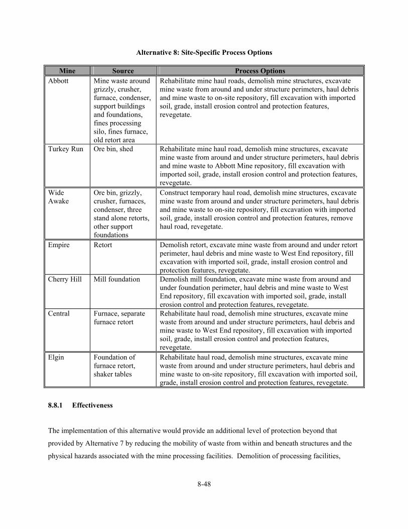
8-48
Alternative 8: Site-Specific Process Options
Mine Source Process Options Abbott Mine waste around
grizzly, crusher, furnace, condenser, support buildings and foundations, fines processing silo, fines furnace, old retort area
Rehabilitate mine haul roads, demolish mine structures, excavate mine waste from around and under structure perimeters, haul debris and mine waste to on-site repository, fill excavation with imported soil, grade, install erosion control and protection features, revegetate.
Turkey Run Ore bin, shed Rehabilitate mine haul road, demolish mine structures, excavate mine waste from around and under structure perimeters, haul debris and mine waste to Abbott Mine repository, fill excavation with imported soil, grade, install erosion control and protection features, revegetate.
Wide Awake
Ore bin, grizzly, crusher, furnaces, condenser, three stand alone retorts, other support foundations
Construct temporary haul road, demolish mine structures, excavate mine waste from around and under structure perimeters, haul debris and mine waste to on-site repository, fill excavation with imported soil, grade, install erosion control and protection features, remove haul road, revegetate.
Empire Retort Demolish retort, excavate mine waste from around and under retort perimeter, haul debris and mine waste to West End repository, fill excavation with imported soil, grade, install erosion control and protection features, revegetate.
Cherry Hill
Mill foundation Demolish mill foundation, excavate mine waste from around and under foundation perimeter, haul debris and mine waste to West End repository, fill excavation with imported soil, grade, install erosion control and protection features, revegetate.
Central Furnace, separate furnace retort
Rehabilitate haul road, demolish mine structures, excavate mine waste from around and under structure perimeters, haul debris and mine waste to West End repository, fill excavation with imported soil, grade, install erosion control and protection features, revegetate.
Elgin Foundation of furnace retort, shaker tables
Rehabilitate haul road, demolish mine structures, excavate mine waste from around and under structure perimeters, haul debris and mine waste to on-site repository, fill excavation with imported soil, grade, install erosion control and protection features, revegetate.
8.8.1 Effectiveness
The implementation of this alternative would provide an additional level of protection beyond that
provided by Alternative 7 by reducing the mobility of waste from within and beneath structures and the
physical hazards associated with the mine processing facilities. Demolition of processing facilities,

8-49
removal of waste from beneath, within, and around the perimeter of processing facilities, and placement
of waste in an on- or off-site repository (Alternatives 5 or 6, respectively) would minimize generation of
leachate and human and ecological exposure to the processing waste. Revegetation and run-on and runoff
controls would stabilize the excavated areas by providing erosion protection. Fencing would be required
to minimize potential damage to revegetation efforts on the disturbed areas. Alternative 8 provides a high
degree of mercury load reduction and protection of human health and the environment.
Demolition of processing facilities, and excavation and placement of processing waste in an on- or off-
site Group B mine waste repository combined with surface and institutional controls would reduce
contaminant loading and meet federal and state contaminant-specific ARARs for degradation of water
quality. Leaching and release of contaminants to groundwater and surface water would be eliminated
because the mine waste would be physically isolated from the environment. The geomembrane liner
would control the generation of leachate and the LCRS would control the discharge of leachate from the
Group B mine waste repository; therefore, surface water in Harley Gulch and Sulphur Creek would not be
degraded by leachate and surface water and groundwater in the Bear Creek watershed would not be
degraded by leachate. Containment of mine waste will reduce contaminant loading and potentially
facilitate attainment of ARARs (MCLs or AWQC).
Location-specific ARARs are expected to be met without any conflicts. Design and placement of grates
and plugs would consider use of mine shafts and adits by threatened and endangered species. Contacts
with appropriate agencies would be required to ensure that processing facilities identified for demolition
are not of historical, cultural, or archeological interest.
The mining wastes addressed by this alternative were derived from the beneficiation and extraction of
ores and are, therefore, assumed to be exempt from federal government regulation through RCRA as
hazardous waste. Restoration of excavated areas would meet the revegetation requirements contained in
the SMCRA. In addition, standards for backfilling, regrading, slope stability, and recontouring; drainage,
diversion structures, waterways, and erosion control; closure of surface openings; and revegetation
contained in the SMARA would also be met. Processing waste would be managed as a Group B waste
subject to the design and siting criteria specified under Water Code Section 13172. Stormwater generated
during consolidation and construction activities will be managed in accordance with the CWA. Lake
County and Colusa County APCD’s nuisance dust suppression and control requirements are applicable
for construction and earth-moving activities associated with this alternative for the control of fugitive dust

8-50
emissions; these requirements would be met through water application to roads receiving heavy vehicular
traffic and to construction or excavation areas, if necessary. OSHA requirements would be met by
requiring appropriate safety training for all on-site workers during the construction phase.
Under this alternative, the excavated areas would have to be inspected to ensure that the vegetation
becomes established and continues to control erosion. The selection of appropriate plant species for
revegetation, including some hardy metal and salt tolerant plant species in the revegetation seed mixture,
would enhance the long-term effectiveness of surface controls. Long-term monitoring and maintenance
would be required for the fencing and revegetated areas, since the disturbed surfaces are susceptible to
erosion. Institutional controls would be required to prevent land uses that would compromise the
revegetation process.
The objective Alternative 8 is to reduce contaminant mobility (e.g. mercury loading); the volume or
toxicity of the contaminants would not be physically reduced. Demolition of processing facilities and
excavation of processing waste would minimize contaminant mobility to surface water, the threat to
human and ecological exposure, and dust generation. The mobility of the contaminants is expected to be
reduced to an extent that would result in an overall risk reduction from completed pathways and routes of
exposure.
The construction phase of Alternative 8 would likely be accomplished within one field season; therefore,
impacts associated with construction would likely be short term and minimal. Short-term risks of
exposure to contaminated material would be a potential for the site worker during excavation, hauling,
and disposal of process waste in an on- or off-site repository; revegetation; and installation of fencing.
Therefore, on-site workers must be adequately protected by using appropriate personal protective
equipment and by following proper operating and safety procedures. Short-term air quality impacts to the
surrounding environment may occur during waste excavation, hauling, and placement in an on- or off-site
repository. Control of fugitive dust emissions would be provided by applying water to roads and surfaces
receiving heavy vehicular traffic or in excavation areas, as needed. Short-term risks of physical injury
during construction activities would also exist, as well as off-site from increased truck traffic required to
haul waste to the off-site repository and transport construction material.

8-51
8.8.2 Implementability
Alternative 8 is both technically and administratively feasible, and could be implemented within one field
season. Excavation, hauling, and disposal of demolition debris and processing waste in an on- or off-site
repository are considered a conventional practice. It is assumed that clean fill material for the excavation
is available from a local source (within 15 miles). Excavation, hauling, and placement of demolition
debris and processing waste in an on- or off-site repository would require the use of heavy equipment
including scrapers, loaders, dozers, and haul trucks. Equipment, materials, and labor would be available
through the local market.
Components or factors which could potentially prolong the implementation of this alternative as planned
include: (1) locating an alternate source of fill material for the open excavation, (2) controlling fugitive
dust emissions and storm water discharge during mitigation activities, (3) waiting for the construction of
an on- or off-site Group B mine waste repository, and (4) shortened construction season due to inclimate
weather. However, these concerns are applicable to other mitigation alternatives being considered.
8.8.3 Costs
The total present worth cost for Alternative 8, demolition, over excavation, on- or off-site disposal,
surface and institutional controls, is summarized in Table 8-7. A cost summary, detailed costs, and
assumptions used in developing the cost estimate for each mine are presented in Appendix A. The total
present worth cost includes the present value of 30 years on annual maintenance and monitoring costs, in
addition to the capital costs. These engineering costs are estimates that are expected to be within plus 50
to minus 30 percent of the actual project cost (based on year 2003 dollars). Changes in the cost elements
are likely to occur as a result of new information and data collected during the mitigation design.
8.9 ALTERNATIVE 9: EXCAVATE AND ON- OR OFF-SITE DISPOSAL, SURFACE AND
INSTITUTIONAL CONTROLS
Under this alternative, mobile sediment containing mine waste discharged into ditches and creeks at or
adjacent to a mine would be excavated and disposed of in an on- or off-site Group B mine waste
repository. This alternative must be implemented in conjunction with other alternatives that prevent
continued migration of mine waste to sediment. Excavation and placement of mobile sediment in an on-
or off-site repository, in combination with surface and institutional controls, is used primarily to reduce

TABLE 8-7 SUMMARY OF COSTS FOR ALTERNATIVE 8
SULPHUR CREEK MINING DISTRICT (Page 1 of 1)
Mine
Capital Costs Yearly O&M
Costs Present Worth of
O&M Costs Total Present
Worth Abbott $290,400 $4,294 $53,288 $343,688 Turkey Run $54,284 $2,205 $27,367 $81,651 Wide Awake $125,226 $2,833 $35,155 $160,381 Empire $13,356 $1,843 $22,874 $36,230 Cherry Hill $30,219 $1,992 $24,725 $54,944 Central $71,337 $2,356 $29,239 $100,576 Elgin $160,464 $3,144 $39,023 $199,487
O&M = Operation and maintenance Present worth of O&M costs based on 30-year life at rate of 7 percent Design assumptions and detailed cost estimates are presented in Appendix A.

8-53
mobility of and exposure to contaminants. The volume of mobile sediment to be excavated from ditches
and creeks at a mine alone is insufficient to justify construction of an on- or off-site repository. If this
alternative is selected, excavated sediment would be handled and placed in an on- or off-site repository
for mine wastes described in Alternatives 5 and 6, respectively.
This alternative would seek to remove mobile sediment from ditches and creeks; restore disturbed creek
banks and creek bed; and revegetate disturbed creek banks. Disturbed creek banks will be graded at no
more than a 1 to 1 slope and stabilized using buried gabions or vegetated geogrids as appropriate.
Dispersed sheet flow above disturbed creek banks will be reduced by terracing or benching the slope that
follows topographic contours or by a rake or harrow pulled perpendicularly to the slope. In either case, a
set of parallel ridges will be constructed that follow the contours of the land surface and greatly reduce
sheet erosion. Native vegetation will be used for replanting the creek banks due to ambient elevated salt
and metals content of surface waters and soil. Erosion features will be repaired yearly and disturbed
slopes and banks will be reseeded or replanted until vegetation is established.
This alternative is applicable to the Abbott, Turkey Run, Wide Awake, West End, Manzanita, Rathburn-
Petray, and Petray-North mines. This alternative does not apply to the Empire, Cherry Hill, Central, and
Rathburn mines because waste from these sites has not reached a creek on or adjacent to the site. This
alternative does not apply to the Petray-South Mine because waste at this site stays primarily within the
cut and little if any waste has migrated to a nearby drainage swale. This alternative was not retained for
the Elgin Mine as the creek below the mine is too steep to accumulate sediment in enough quantity for
removal. This alternative was not retained for the Clyde Mine because it was a gold mine and the
mercury content in the eroding tailings is not of concern. However, the tailings are eroding into a
tributary to Sulphur Creek and may pose a solids loading concern if left unchecked. Mobile sediment in
Sulphur Creek and tributaries will be addressed as part of maintenance activities in Alternatives 13, 14,
and 15. Site-specific process options for Alternative 9 are described below.
Alternative 9: Site-Specific Process Options
Mine Source Process Options Abbott Mobile sediment in
Glory Hole Gulch and Harley Gulch at mine
Excavate sediment, haul sediment to and place in the on-site repository, restore stream channel and banks
Turkey Run Mobile sediment in Rehabilitate mine haul road, excavate sediment, haul sediment

8-54
two creeks passing through and below mine site
to and place in the Abbott Mine repository, restore stream channel and banks
Wide Awake Mobile sediment in creek passing through and below mine site
Construct temporary haul road, excavate sediment, haul sediment to and place in the on-site repository, restore stream channel and banks, remove haul road
West End Mobile sediment in the stream bank adjacent to Sulphur Creek
Construct temporary haul road, excavate sediment, haul sediment to and place in the on-site repository, restore stream channel and banks, remove haul road
Manzanita Mobile sediment in the Sulphur Creek floodplain and in a channel on floodplain
Construct temporary haul road, excavate sediment, haul sediment to the West End Mine repository, restore floodplain, drainage channels, and north bank of Sulphur Creek, remove haul road
Rathburn-Petray Mobile sediment in two swales below waste rock pile
Construct temporary haul road, excavate sediment, haul sediment to and place in the on-site repository, restore stream channel and banks, remove haul road
Petray-North Mobile sediment in swale and creek below mine
Rehabilitate haul road, excavate sediment, haul sediment to and Construct temporary haul road, excavate sediment, haul sediment to and place in the on-site repository, restore stream channel and banks, remove haul road
8.9.1 Effectiveness
The implementation of Alternative 9 would provide an additional level of protection beyond that provided
by institutional controls alone (Alternative 2) by reducing contaminant loading from and human and
ecological ingestion and dermal contact exposure to contaminated sediment in drainage swales, ditches,
and creeks. Excavation of contaminated sediment and placement of sediment in an on- or off-site
repository (Alternatives 5 or 6, respectively) would minimize generation of leachate and human and
ecological exposure to the excavated sediment. Stream bank and channel stabilization, run-on and runoff
controls, and revegetation would stabilize the excavated areas. Fencing would be used to minimize
potential damage to stabilization and revegetation efforts on the restored areas. Alternative 9 provides a
high degree of mercury load reduction and protection of human health and the environment.
Excavation of contaminated sediment from creeks and swales and placement of sediment in an on- or off-
site Group B mine waste repository combined with surface and institutional controls would meet federal
and state contaminant-specific ARARs for degradation of water quality. Sediment would no longer
provide a source for on-going contaminant loading to surface water. Leaching and release of

8-55
contaminants to groundwater and surface water would be eliminated because the contaminated sediment
would be physically isolated from the environment. The geomembrane liner would control the generation
of leachate and the LCRS would control the discharge of leachate from the Group B mine waste
repository; therefore, surface water in Harley Gulch and Sulphur Creek would not be degraded by
leachate and surface water and groundwater in the Bear Creek watershed would not be degraded by
leachate. Containment of mine waste will reduce contaminant loading and potentially facilitate
attainment of ARARs (MCLs or AWQC). Location-specific ARARs are expected to be met without any
conflicts.
The contaminated sediments addressed by this alternative were derived from the beneficiation and
extraction of ores or from naturally mercury enriched soils and spring precipitates and are, therefore,
assumed to be exempt from federal government regulation through RCRA as hazardous waste.
Restoration of excavated areas would meet the revegetation requirements contained in the SMCRA. In
addition, standards for backfilling, regrading, slope stability, and recontouring; drainage, diversion
structures, waterways, and erosion control; stream protection; and revegetation contained in the SMARA
would also be met. Contaminated sediment would be managed as a Group B waste subject to the design
and siting criteria specified under Water Code Section 13172. Stormwater generated during construction
activities will be managed in accordance with the CWA. Lake County and Colusa County APCD’s
nuisance dust suppression and control requirements are applicable for construction and earth-moving
activities associated with this alternative for the control of fugitive dust emissions; these requirements
would be met through water application to roads receiving heavy vehicular traffic and to construction or
excavation areas, if necessary. OSHA requirements would be met by requiring appropriate safety training
for all on-site workers during the construction phase.
Under Alternative 9, the disturbed stream channel and banks would have to be inspected to ensure that
short-term erosion controls are functioning and that the vegetation becomes established to ensure long-
term erosion control. The selection of appropriate plant species for revegetation, including some hardy
metal and salt tolerant plant species in the revegetation seed mixture, would enhance the long-term
effectiveness of surface controls. Long-term monitoring and maintenance would be required for the
fencing and revegetated areas, since the disturbed surfaces are susceptible to erosion. Institutional
controls would be required to prevent land uses that would compromise the revegetation process.
8-56
The objective of Alternative 9 is to reduce contaminant mobility (e.g. mercury loading); the volume or
toxicity of the contaminants would not be physically reduced. Excavation of contaminated sediment
would remove an on-going source of contaminant loading to surface water, and reduce the threat to
human and ecological exposure due to ingestion and dermal contact. The mobility of the contaminants in
surface water will be reduced to an extent that would result in an overall risk reduction from completed
pathways and routes of exposure.
The construction phase of Alternative 9 would likely be accomplished within one field season; therefore,
impacts associated with construction would likely be short term and minimal. Short-term risks of
exposure to contaminated material would be a potential for the site worker during excavation, hauling,
and disposal of contaminated sediment in an on- or off-site repository; stream channel and bank
restoration and revegetation; and installation of fencing. Therefore, on-site workers must be adequately
protected by using appropriate personal protective equipment and by following proper operating and
safety procedures. Short-term air quality impacts to the surrounding environment may occur during
sediment excavation, hauling, and placement in an on- or off-site repository. Control of fugitive dust
emissions would be provided by applying water to roads and surfaces receiving heavy vehicular traffic or
in excavation areas, as needed. Short-term risks of physical injury during construction activities would
also exist, as well as off-site from increased truck traffic required to haul waste to the off-site repository
and transport construction material.
8.9.2 Implementability
Alternative 9 is both technically and administratively feasible, and could be implemented within one field
season. Excavation, hauling, and disposal of contaminated sediment in an on- or off-site repository are
considered a conventional practice. Stream channel and stream bank restoration will require a contractor
that specializes in restoration techniques. It is assumed that clean fill material for the excavation is
available from a local source (within 15 miles). Excavation, hauling, and placement of contaminated
sediment in an on- or off-site repository would require the use of heavy equipment including scrapers,
loaders, dozers, and haul trucks. Equipment, materials, and labor would be available through the local
market.
Components or factors which could potentially prolong the implementation of this alternative as planned
include: (1) diverting water around or pumping water out of the excavation, (2) locating an alternate

8-57
source of fill material for the open excavation, (3) controlling fugitive dust emissions and storm water
discharge during mitigation activities, (4) waiting for the construction of an on- or off-site Group B mine
waste repository, and (5) shortened construction season due to inclimate weather or heavy runoff.
However, these concerns are applicable to other mitigation alternatives being considered.
8.9.3 Costs
The total present worth cost for Alternative 9, excavate and on- or off-site disposal and institutional
controls of mobile sediment, is summarized in Table 8-8. A cost summary, detailed costs, and
assumptions used in developing the cost estimate for each mine are presented in Appendix A. The total
present worth cost includes the present value of 30 years on annual maintenance and monitoring costs, in
addition to the capital costs. These engineering costs are estimates that are expected to be within plus 50
to minus 30 percent of the actual project cost (based on year 2003 dollars). Changes in the cost elements
are likely to occur as a result of new information and data collected during the mitigation design.
8.10 ALTERNATIVE 10: REVEGETATE FLOODPLAIN TO REDUCE SEDIMENT RUNOFF, GRADE AND VEGETATE STREAM BANKS TO STABILIZE STREAM CHANNEL
Under this alternative, floodplain deposits in the Sulphur Creek watershed that contain contaminated
sediment would be stabilized by improving the type and density of vegetative cover, controlling water
run-on and runoff, and stabilizing the stream channel to reduce lateral channel migration. Control of
water run-on and runoff and channel stabilization reduces mechanical erosion of contaminated sediment
into Sulphur Creek and subsequent availability for biotic methylation. Leaching of mercury from
floodplain sediments to shallow groundwater and Sulphur Creek would not be controlled. Establishing
vegetative cover reduces or eliminates the potential human and ecological risk that may be associated
with exposure (direct contact or airborne releases of particulates) to the contaminated sediment.
Sulphur Creek and its tributaries are streams with little to no base flow that respond very rapidly to
precipitation events. The west fork of Sulphur Creek below Elgin Mine is deeply incised and well
confined. Sulphur Creek above the West End mine is poorly confined and meanders through a well-
vegetated meadow. Sulphur Creek and its floodplain between the West End and Central mines is
moderately incised, with a disturbed to destroyed meander pattern. The channel is eroding laterally into
recent floodplain deposits and mine waste. The channel bed and substrate are armored with mineral

TABLE 8-8 SUMMARY OF COSTS FOR ALTERNATIVE 9
SULPHUR CREEK MINING DISTRICT (Page 1 of 1)
Mine
Capital Costs Yearly O&M
Costs Present Worth of
O&M Costs Total Present
Worth Abbott $92,125 $9,250 $114,790 $206,915 Turkey Run $76,579 $8,562 $106,256 $182,835 Wide Awake $42,295 $7,046 $87,438 $129,733 West End $18,411 $5,989 $74,327 $92,738 Manzanita $1,389,111 $70,066 $869,525 $2,258,636 Rathburn-Petray $144,122 $11,550 $143,331 $287,453 Petray-North $77,621 $8,608 $106,828 $184,449
O&M = Operation and maintenance Present worth of O&M costs based on 30-year life at rate of 7 percent Design assumptions and detailed cost estimates are presented in Appendix A.

8-59
deposits from hydrothermal springs within the stream channel. Because downcutting is limited, stream
energy is focused laterally into contaminated floodplain deposits. The channel is developing a meander
pattern within the floodplain to expend stream energy. This alternative would seek to stabilize the
existing meander pattern, reduce the slope of and vegetate existing stream banks, and provide additional
energy dissipation through placement of appropriate structures within the stream. In addition, the surface
of the existing floodplain will be protected using flow dissipation structures and vegetation.
The stream reach between the West End and Manzanita mines has lost its meander pattern. A meander
pattern is necessary to dissipate stream energy so that erosion of the stream banks and floodplain, which
contain natural and mine-related mercury is controlled. Therefore, stream bank material excavated from
lower reaches and imported soil will be used to recreate a meander pattern. The meander pattern will be
stabilized using in-stream boulders, wing deflectors, and grade controls. Stream banks will be graded at
no more than a 1 to 1 slope and stabilized using buried gabions and vegetated geogrids. Native vegetation
will be used for replanting the stream banks due to ambient elevated salt and metals content of surface
waters and soil.
The overall topography of the floodplain will be graded to minimize the uncontrolled flow of runoff
toward the restored stream channel. Channelized flow will be diverted into ditches or swales cut into the
soil that more closely follow the level contours of the land. Dispersed sheet flow will be reduced by
terracing or benching the slope that follows topographic contours or by a rake or harrow pulled
perpendicularly to the slope. In either case, a set of parallel ridges will be constructed that follow the
contours of the land surface and greatly reduce sheet erosion. Native vegetation will be used for
replanting the floodplain due to ambient elevated salt and metals content of surface water, groundwater,
and soil.
The stream reach between the Manzanita and Central mines exhibits a meander pattern that has been
modified by mine wastes at the Manzanita Mine. Alternative 9 proposes excavation of mine waste from
the Sulphur Creek floodplain adjacent to the Manzanita Mine. If Alternative 9 is selected as part of the
Manzanita Mine action, then imported soil will be used to recreate the meander pattern in the floodplain
adjacent to the Manzanita Mine. If Alternative 9 is not selected, then a portion of the mine waste along
the stream bank will be excavated and covered with imported soil (no greater than 1 to 1 slope). In either
case, the meander pattern will be stabilized using in-stream boulders, wing deflectors, and grade controls.
Stream banks will be graded at no more than a 1 to 1 slope and stabilized using buried gabions and

8-60
vegetated geogrids. Native vegetation will be used for replanting the stream banks due to salt and metals
content of surface waters and soil.
As an integral part of surface water treatment and sediment collection proposed in Alternatives 14 and 15,
flashboard dams may be installed in this stream reach. The flashboard dams will capture sediment at low
to moderate flow. The flashboards and captured sediment will be removed prior to winter flows. The
dams will reduce stream grade and dissipate stream energy at their outfall during low flow operations.
The dams will dissipate stream energy during winter flows with intact keys (boards removed) that behave
similar to wing deflectors.
The overall topography of the existing floodplain will be graded to minimize the uncontrolled flow of
runoff toward the restored stream channel as described above. If Alternative 9 is selected as part of the
action, then imported soil will be used to recreate the meander pattern in the floodplain adjacent to the
Manzanita Mine and graded and vegetated as described above.
The stream reach between the Central Mine and the confluence of Sulphur and Bear creeks is confined in
a gradually narrowing, channel incised in bedrock. Minimal sediment deposition has occurred in this
reach, except at the confluence of Sulphur and Bear creeks. The sediment bar present at the confluence of
the two creeks will be excavated and used as fill for an upstream meander pattern. Collection of sediment
transported out of the Sulphur Creek watershed during future low to moderate flows is addressed under
Alternatives 14 and 15.
Alternative 10 is applicable to Sulphur Creek and the lower reaches of Sulphur Creek tributaries below
adjacent mines. This alternative was not retained for Harley Gulch below the Abbott and Turkey Run
mines because its floodplain and stream banks are vegetated and stable. Over steep and eroding banks
overrun by mine tailings at the Abbott Mine are addressed under Alternatives 3 through 6.
Alternative 10 will reduce mobility of and limit exposure to contaminants in floodplain sediment along
Sulphur Creek using vegetation to control dust, sheet erosion, and scouring during flooding. Alternative
10 will also reduce mobility of and limit exposure to contaminants in stream bank sediment using
grading, erosion control and protection, flood control and protection, and revegetation process options to
stabilize the stream channel, slow erosion processes during normal flows, and control bank calving,

8-61
undercutting, and scouring during flooding. Institutional controls will be used to limit direct exposure
through the application of land use restrictions.
8.10.1 Effectiveness
The implementation Alternative 10 would reduce contaminant loading to Sulphur Creek by stabilizing
mine waste deposited in the Sulphur Creek floodplain and reduce the potential human and ecological risk
associated with ingestion, dermal contact, and dust inhalation exposure to contaminated sediments in the
floodplain. Contaminated sediment in the floodplain would be stabilized by improving the type and
density of vegetative cover, by controlling water run-on and runoff, and by reducing lateral channel
migration. Control of water run-on and runoff and channel stabilization reduces mechanical erosion of
contaminated sediment into Sulphur Creek and subsequent availability for biotic methylation of mercury.
Fencing would be used to minimize potential damage to stabilization and revegetation efforts. The threat
of human and ecological exposure due to ingestion of contaminated sediment, dermal contact, and
inhalation of dust would remain as contaminated sediment is left in place, though the exposure pathways
are substantially controlled. Leaching of mercury from floodplain sediments to shallow groundwater and
Sulphur Creek would not be controlled. Alternative 10 provides a moderate degree of mercury load
reduction and protection of human health and the environment.
Stabilization of the Sulphur Creek flood plain and channel would control contaminated sediment loading
to surface water, but would not address leaching of contaminated sediment and release of leachate to
groundwater and surface water. However, the naturally poor quality of surface water and groundwater in
the Sulphur Creek watershed, due to hydrothermal springs, preclude application of contaminant-specific
ARARs. Any mitigation alternative implemented to control contaminated sediment loading to Sulphur
Creek will increase the potential for attaining MCLs and AWQC in Bear Creek into which Sulphur Creek
discharges.
Location-specific ARARs are expected to be met without any conflicts. Planning and design of
floodplain and channel stabilization features would consider use or presence of threatened and
endangered species in these areas. Contacts with appropriate agencies would be required to ensure that
planned actions would not impact a feature or area of historical, cultural, or archeological interest. A
CWA Section 404 permit may be required for channel stabilization efforts.

8-62
The contaminated sediments addressed by this alternative were derived from the beneficiation and
extraction of ores or from naturally mercury enriched soils and spring precipitates and are, therefore,
assumed to be exempt from federal government regulation through RCRA as hazardous waste.
Stabilization of the Sulphur Creek floodplain and channel would meet the revegetation, diversions of
flow, and protection of fish and wildlife requirements contained in the SMCRA. In addition, standards
for backfilling, regrading, slope stability, and recontouring; drainage, diversion structures, waterways, and
erosion control; stream protection; protection of wildlife habitat; and revegetation contained in the
SMARA would also be met. Permitting under Section 10 of the Rivers and Harbors Act may be required
for in channel stabilization efforts. Stormwater generated during construction activities will be managed
in accordance with the CWA. Lake County and Colusa County APCD’s nuisance dust suppression and
control requirements are applicable for construction and earth-moving activities associated with this
alternative for the control of fugitive dust emissions; these requirements would be met through water
application to roads receiving heavy vehicular traffic and to construction or excavation areas, if necessary.
OSHA requirements would be met by requiring appropriate safety training for all on-site workers during
the construction phase.
Under Alternative 10, the stabilized floodplain, channel, and channel banks would have to be inspected to
ensure that erosion controls are functioning and that the vegetation becomes established to ensure long-
term erosion control on the floodplain and channel banks. The selection of appropriate plant species for
revegetation, including some hardy metal and salt tolerant plant species in the revegetation seed mixture,
would enhance the long-term effectiveness of surface controls. Long-term monitoring and maintenance
would be required for the fencing and revegetated areas, since the disturbed surfaces are susceptible to
erosion. Long-term monitoring and maintenance would also be required to ensure stability of in-stream
boulders, wing deflectors, and grade controls. Institutional controls would be required to prevent land
uses that would compromise the revegetation and channel stabilization processes.
The objective of Alternative 10 is to reduce contaminant mobility (e.g. mercury loading); the volume or
toxicity of the contaminants would not be physically reduced. Floodplain, channel, and channel bank
stabilization would reduce an on-going source of contaminated sediment loading to surface water, and
reduce the threat to human and ecological exposure due to ingestion, dermal contact, and inhalation of
dust. The mobility of the contaminants to surface water will be reduced to an extent that would result in
an overall risk reduction from completed pathways and routes of exposure.

8-63
The construction phase of this alternative would likely be accomplished within one field season;
therefore, impacts associated with construction would likely be short term and minimal. Short-term risks
of exposure to contaminated material would be a potential for the site worker during floodplain, channel,
and channel bank restoration and revegetation, and installation of fencing. Therefore, on-site workers
must be adequately protected by using appropriate personal protective equipment and by following proper
operating and safety procedures. Short-term air quality impacts to the surrounding environment may
occur during minor excavation and grading. Fugitive dust emissions will be controlled by applying water
to disturbed areas, as needed. Short-term risks of physical injury during construction activities would also
exist.
8.10.2 Implementability
Alternative 10 is both technically and administratively feasible, and could be implemented within one
field season. Channel and channel bank stabilization will require a contractor that specializes in stream
restoration techniques. Design methods, construction practices, and engineering requirements for channel
and channel bank stabilization are well documented and understood. It is assumed that clean fill material,
where required, is available from a local source (within 15 miles). Equipment, materials, and labor would
be available through the local market.
Components or factors which could potentially prolong the implementation of this alternative as planned
include: (1) diverting water around work areas, (2) locating an alternate source of fill material,
(3) controlling fugitive dust emissions and storm water discharge during mitigation activities, and
(4) shortened construction season due to inclimate weather or heavy runoff. However, these concerns are
applicable to other mitigation alternatives being considered.
8.10.3 Costs
The total present worth cost for Alternative 10, revegetate floodplain to reduce sediment runoff, and grade
and vegetate stream banks to stabilize Sulphur Creek stream channel is summarized in Table 8-9. A cost
summary, detailed costs, and assumptions used in developing the cost estimate for each mine are
presented in Appendix A. The total present worth cost includes the present value of 30 years on annual
maintenance and monitoring costs, in addition to the capital costs. These engineering costs are estimates
that are expected to be within plus 50 to minus 30 percent of the actual project cost (based on year 2003

TABLE 8-9 SUMMARY OF COSTS FOR ALTERNATIVE 10
SULPHUR CREEK MINING DISTRICT (Page 1 of 1)
Mine
Capital Costs Yearly O&M
Costs Present Worth of
O&M Costs Total Present
Worth Sulphur Creek and Tributaries
$897,034 $82,803 $1,027,585 $1,924,619
O&M = Operation and maintenance Present worth of O&M costs based on 30-year life at rate of 7 percent Design assumptions and detailed cost estimates are presented in Appendix A.
8-65
dollars). Changes in the cost elements are likely to occur as a result of new information and data
collected during the mitigation design.
8.11 ALTERNATIVE 11: DIVERSION, PASSIVE PRECIPITATION, OPTIONAL AERATION, INSTITUTIONAL CONTROLS
Under this alternative, metals in surface water from hydrothermal springs would be removed using an on-
site, passive treatment system (metals precipitation with or without aeration). Passive treatment of metals
is used primarily to reduce mobility of and exposure to contaminants in surface waters. Mobility of and
exposure to contaminants in precipitate are controlled by placing treatment precipitate in a permitted
disposal facility located within the state of California (dependent on waste classification). The physical
covering of precipitate at the off-site permitted facility eliminates the potential health risk that may be
associated with exposure (direct contact or airborne releases of particulates) to the contaminated media.
Surface control measures will be used at the off-site permitted facility to divert surface water away from
the cover. A geomembrane liner would be used to minimize infiltration (and subsequent formation of
leachate) of surface water and precipitation into the underlying contaminated waste.
The on-site, passive treatment system is comprised of a water diversion structure, diversion piping, and a
large holding basin or below grade vault to extend hydraulic residence time for metals precipitation. A
gravity aeration step (rock tumble) may be added depending on the amount and species of iron and sulfur
present, the oxidation state of the water, and the amount of heavy metals removal required. A treatability
study will be required prior to design to assess reduced metals removal rate, aeration rate required for
metal oxyhydroxide generation, oxidized metals removal rate, hydraulic residence time required for
settling, and quantity of solids generated. The steps for constructing the on-site treatment system include
the following: (1) constructing an access and maintenance road to the treatment system site, (2)
constructing a flow diversion structure at the hydrothermal spring, (3) constructing either concrete lined
open channel embedded with rocks (aeration tumble) or a diversion pipeline, (4) constructing either a
lined above grade settling basin or a below grade segmented vault (site space limitations), (5) revegetating
any area disturbed by construction, (6) fencing treatment areas, (7) annual flushing precipitate out of the
rock tumble or pipeline, and (8) annual removal of precipitate from the basin or vault.
The treatment process will generate a precipitate that contains elevated levels of metals. The precipitate
will be removed from the settling basin periodically and placed in an off-site permitted disposal facility.
Mobility of and exposure to contaminants in the precipitate will be controlled through encapsulation. An

8-66
institutional control will be used to limit access to the treatment system and direct exposure to
hydrothermal waters through the application of land use, water use, and access restrictions. Monitoring of
system influent and effluent is required to document metals load reduction. Samples will be analyzed for
total and dissolved metals and total suspended solids.
Alternative 11 is applicable to Turkey Run Spring, Blank Spring, and the Elgin Springs. This alternative
was not retained for Harley Gulch below the Abbott and Turkey Run mines because the hydrothermal
water will be treated at its source (Turkey Run Spring). Surface water and hydrothermal springs
associated with Sulphur Creek are addressed under Alternatives 13, 14, and 15. Site-specific process
options for Alternative 11 are described below.
Alternative 11: Site-Specific Process Options
Mine/ Spring Source Process Options Turkey Run Spring
Hydrothermal Spring
Conduct treatability study, construct access/maintenance road, a flow diversion structure, a below grade diversion and return pipelines, and a below grade segmented vault; revegetate soil disturbed by construction; fence and place signage around the spring, diversion structure, and vault area; flush pipeline, remove accumulated sediment periodically, and conduct performance monitoring
Elgin Springs Hydrothermal Spring
Conduct treatability study; reinforce existing spring pool; route flow down natural stream course; construct drains and a flashboard dam at base of canyon; install below grade diversion and return pipelines install below grade segmented vaults for precipitate settling adjacent to creek; revegetate soil disturbed by construction; fence and place signage around the spring and vaults; flush pipeline, remove accumulated sediment from basin periodically, and conduct performance monitoring
Blank Spring Hydrothermal Spring
Conduct treatability study, construct access/maintenance road, storm water flow diversion around spring, a flashboard dam, a diversion and return pipeline, a below grade settling vault, a lined open channel filled with rocks for aeration, and a second below grade settling vault; revegetate soil disturbed by construction; fence and place signage around the aeration channel and vaults; flush channel and pipeline, remove accumulated sediment from basins periodically, and conduct performance monitoring
8.11.1 Effectiveness
The implementation of Alternative 11 would provide an additional level of protection beyond that
provided by institutional controls (Alternative 2) by reducing loading of metals from natural hydrothermal
springs to Harley Gulch and Sulphur Creek watersheds and by reducing the threat of human and

8-67
ecological ingestion and dermal contact exposure to metals in natural hydrothermal spring water and
associated precipitates. Discharge from the hydrothermal springs is naturally occurring; therefore, the
threat of human and ecological exposure at the springs is of secondary concern in comparison to reduction
of metals loading to the watershed.
Passive treatment of metals in natural hydrothermal water would generate and capture metal precipitate.
Mobility of and exposure to metals in precipitate are controlled by placing treatment precipitate in an off-
site permitted facility. The physical covering of precipitate at the off-site permitted facility eliminates the
generation of leachate and the potential health risk that may be associated with exposure (direct contact or
airborne releases of particulates) to the contaminated media. Surface control measures will be used at the
off-site permitted facility to divert surface water away from the cover. A geomembrane liner would be
used to minimize infiltration (and subsequent formation of leachate) of surface water and precipitation
into the underlying contaminated waste. Fencing of the area surrounding the hydrothermal springs would
provide additional protection of human health and the environment by limiting exposure and access to
physical hazards. Fencing would also minimize potential tampering with the passive treatment system.
The permanence of the mitigation alternative is highly dependent on maintenance activities. Alternative
10 provides a moderate degree of mercury load reduction and protection of human health and the
environment.
Contaminant-specific ARARs for degradation of water quality are not applicable to discharges from the
hydrothermal springs because the springs are naturally occurring and are not caused by mining activities.
However, the goal is to reduce the total load of metals discharging from the hydrothermal springs in
support of the on-going development of the mercury TMDL for the Cache Creek watershed. The
anticipated load reduction by implementation of this alternative would be less than the anticipated load
reduction by Alternative 12.
Location-specific ARARs are expected to be met without any conflicts. Contacts with appropriate
agencies regarding historical, cultural, and archeological remains would be required.
Discharges from the hydrothermal springs are naturally occurring and are not caused by mining activities;
therefore, action-specific ARARs for mining waste are not applicable. However, management of the
treatment precipitate as a Group B mining waste may be relevant and appropriate due to its similarity to
mine-contaminated sediment. Therefore, treatment precipitate would be placed in an off-site permitted
8-68
facility subject to the design and siting criteria specified under Water Code Section 13172. Stormwater
generated during construction activities will be managed in accordance with the CWA. Lake County and
Colusa County APCD’s nuisance dust suppression and control requirements are applicable for
construction and earth-moving activities associated with this alternative for the control of fugitive dust
emissions; these requirements would be met through water application to roads receiving heavy vehicular
traffic and to construction areas, if necessary. OSHA requirements would be met by requiring appropriate
safety training for all on-site workers during the construction phase.
Under Alternative 11, long-term monitoring and maintenance would be required and includes annual
flushing of precipitate out of the rock tumble or pipeline and annual removal of precipitate from the
settling basin or vault. The precipitate would be placed in an off-site permitted facility. Monitoring of
system influent and effluent is required to document metals load reduction. Samples will be analyzed for
total and dissolved metals and total suspended solids. In addition, institutional controls will be used to
limit access to the treatment system and direct exposure to hydrothermal waters through the application of
land use and access restrictions.
The construction phase of Alternative 11 would likely be accomplished within one field season; therefore,
impacts associated with construction would likely be short term and minimal. These potential short-term
impacts would be mitigated during the construction phase. On-site workers would be adequately
protected by using appropriate personal protective equipment and by following proper operating and
safety procedures. Control of fugitive dust emissions would be provided by applying water to surfaces
receiving heavy vehicular traffic or in construction areas, as needed. Short-term risks of physical injury
during construction activities would also exist, as well as off site from increased truck traffic required to
transport construction material to the treatment system.
8.11.2 Implementability
Alternative 11 is both technically and administratively feasible, and could be implemented within one
field season. Treatment system installation will require conventional construction practices; materials and
construction methods are readily available. Equipment, materials, and labor would be available through
the local market. Constructing the treatment system would require the services of a contractor
experienced in the proper component installation procedures.
8-69
A bench scale treatability study will be required to demonstrate the technology effectiveness, to assess
reduced metals removal rate, aeration rate required for metal oxyhydroxide generation, oxidized metals
removal rate, hydraulic residence time required for settling, and quantity of solids generated. The
treatment system would not remain reliable without the proper maintenance. This type of mitigation
alternative could be supplemented in the future with additional treatment systems in series for higher
removal efficiency, if required.
Components or factors which could potentially prolong the implementation of this alternative as planned
include: (1) diverting water around work areas, (2) a shortened construction season due to inclimate
weather or heavy runoff, and (3) waiting for waste acceptance at a permitted facility. However, these
concerns are applicable to other mitigation alternatives being considered.
8.11.3 Costs
The total present worth cost for Alternative 11, diversion, passive precipitation, optional aeration, and
institutional controls for treatment of water in Turkey Run Spring, Elgin Springs, and Blank Spring is
summarized in Table 8-10. A cost summary, detailed costs, and assumptions used in developing the cost
estimate for each mine are presented in Appendix A. The total present worth cost includes the present
value of 30 years on annual maintenance and monitoring costs, in addition to the capital costs. These
engineering costs are estimates that are expected to be within plus 50 to minus 30 percent of the actual
project cost (based on year 2003 dollars). Changes in the cost elements are likely to occur as a result of
new information and data collected during the mitigation design.
8.12 ALTERNATIVE 12: DIVERSION, PASSIVE ZERO VALENCE IRON REACTOR AND PRECIPITATION, OPTIONAL AERATION, INSTITUTIONAL CONTROLS
Under this alternative, metals and sulfur compounds in surface water from hydrothermal springs would be
removed using an on-site, passive treatment system. This alternative differs from Alternative 11 through
reduction and precipitation of metals and anions using a zero valence iron reactor. Passive treatment of
metals and sulfur compounds is used primarily to reduce mobility of and exposure to contaminants in
surface waters. Removal of excess sulfur from hydrothermal waters may be necessary to reduce biotic
methylation of mercury. Mobility of and exposure to contaminants in precipitate are controlled by
placing treatment precipitate in a permitted disposal facility located within the state of California
(dependent on waste classification). The physical covering of precipitate at the off-site permitted facility
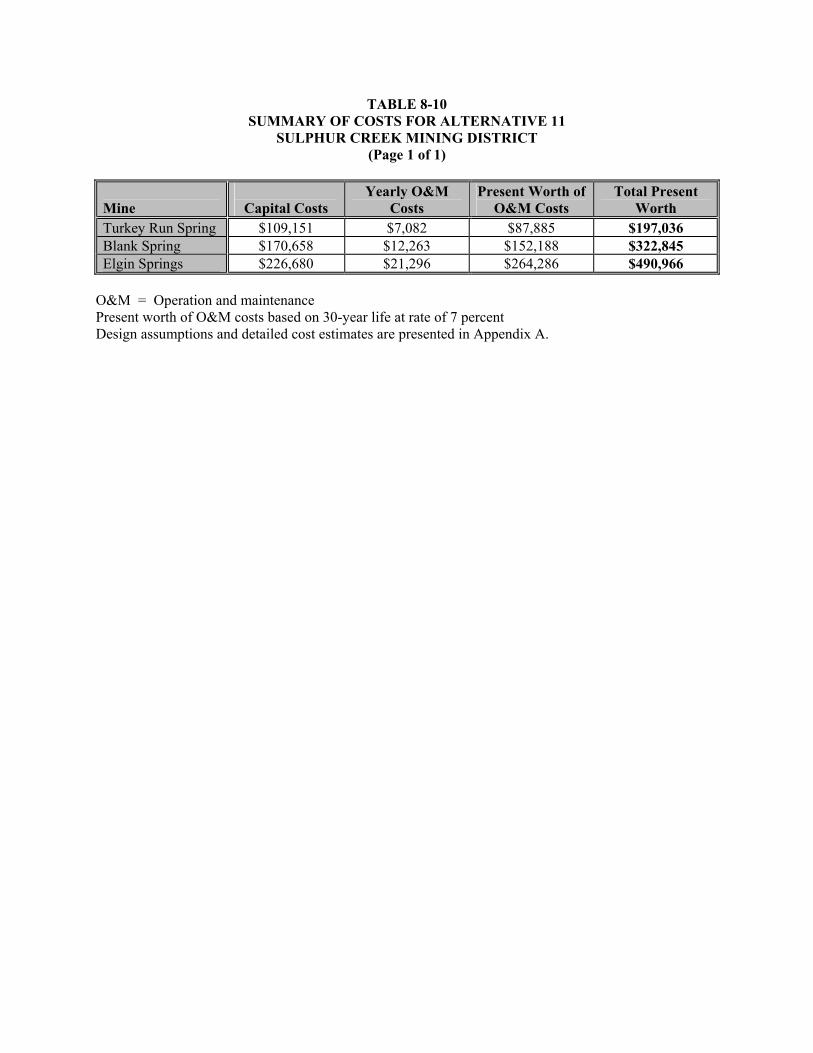
TABLE 8-10 SUMMARY OF COSTS FOR ALTERNATIVE 11
SULPHUR CREEK MINING DISTRICT (Page 1 of 1)
Mine
Capital Costs Yearly O&M
Costs Present Worth of
O&M Costs Total Present
Worth Turkey Run Spring $109,151 $7,082 $87,885 $197,036 Blank Spring $170,658 $12,263 $152,188 $322,845 Elgin Springs $226,680 $21,296 $264,286 $490,966
O&M = Operation and maintenance Present worth of O&M costs based on 30-year life at rate of 7 percent Design assumptions and detailed cost estimates are presented in Appendix A.

8-71
eliminates the generation of leachate and the potential health risk that may be associated with exposure
(direct contact or airborne releases of particulates) to the contaminated media. Surface control measures
will be used at the off-site permitted facility to divert surface water away from the cover. A
geomembrane liner would be used to minimize infiltration (and subsequent formation of leachate) of
surface water and precipitation into the underlying contaminated waste.
The on-site, passive treatment system is comprised of a water diversion structure, diversion piping, a
gravity fed ZVI reactor (containing iron filings) for creating a reduced, iron rich water, and a large
holding basin or below grade vault to extend hydraulic residence time for metals and metal sulfide
precipitation. A gravity aeration step (rock tumble) may be added depending on the amount and species
of iron and sulfur present, the oxidation state of the water, and the amount of heavy metals removal
required. A treatability study will be required prior to design to assess ZVI reactor hydraulic residence
time required for metal reduction, soluble iron concentration, sulfide removal rate, reduced metals
removal rate, aeration rate required for metal oxyhydroxide generation, oxidized metals removal rate,
hydraulic residence time required for each settling step, ZVI consumption before replacement, and
quantity of solids generated. The steps for constructing the on-site treatment system include the
following: (1) constructing an access or maintenance road to the treatment system site, (2) constructing a
flow diversion structure at the hydrothermal spring, (3) constructing a diversion pipeline, (4) constructing
an above or below grade ZVI reactor (depending on site space limitations), (5) constructing either a lined
above grade settling basin or a below grade segmented vault (depending on site space limitations),
(6) constructing an optional concrete lined open channel embedded with rocks (aeration tumble),
(7) constructing either an optional lined above grade settling basin or a below grade segmented vault
(depending on site space limitations) for additional precipitate settling, (8) revegetating any area disturbed
by construction, (9) fencing treatment areas, (10) periodic replacement of reactive ZVI media in reactor,
(11) annual flushing precipitate out of the rock tumble or pipeline, and (12) annual removal of precipitate
from the basin or vault.
The treatment process will generate a precipitate that contains elevated levels of metals and metal
sulfides. The precipitate will be removed from the settling basin periodically and placed in an off-site
permitted facility. Mobility of and exposure to contaminants in the precipitate will be controlled through
encapsulation. An institutional control will be used to limit access to the treatment system and direct
exposure to hydrothermal waters through the application of land use, water use, and access restrictions.

8-72
Alternative 12 is applicable to Turkey Run Spring, Elgin Springs, and Blank Spring. This alternative was
not retained for Harley Gulch below the Abbott and Turkey Run mines because the hydrothermal water
will be treated at its source (Turkey Run Spring). Surface water and hydrothermal springs associated with
Sulphur Creek are addressed under Alternatives 13, 14, and 15. Site-specific process options for
Alternative 12 are described below.
Alternative 12: Site-Specific Process Options
Mine/ Spring Source Process Options Turkey Run Spring
Hydrothermal Spring
Conduct treatability study, construct access/maintenance road; construct a flow diversion structure, a below grade diversion and return pipeline, a below grade ZVI reactor, and a below grade segmented vault for metal sulfide settling; revegetate soil disturbed by construction; fence and place signs around the spring, diversion structure, and vault area; flush pipeline, replace reactive ZVI, remove accumulated sediment periodically, conduct performance monitoring
Elgin Springs Hydrothermal Spring
Conduct treatability study; reinforce and line existing spring pool; route flow down natural stream course; construct drains and a flashboard dam at base of canyon; install below grade diversion and return pipelines; install below grade ZVI reactors and below grade segmented vaults for metal sulfide settling; revegetate soil disturbed by construction; fence and place signage around the spring and vaults; flush pipeline, replace reactive ZVI, remove accumulated sediment from basin periodically, and conduct performance monitoring
Blank Spring Hydrothermal Spring
Conduct treatability study; construct access/maintenance road, storm water flow diversion around spring, a spring flow diversion structure, diversion and return pipelines, a below grade ZVI reactor, a below grade segmented vault for metal sulfide settling, a lined open channel filled with rocks for aeration, and a below grade segmented vault for metal oxyhydroxide settling; revegetate soil disturbed by construction; fence and place signage around the aeration channel and reactor/vault areas; flush pipeline and channel, replace reactive ZVI, remove accumulated sediment from vault and basin periodically, and conduct performance monitoring
8.12.1 Effectiveness
The implementation of Alternative 12 would provide an additional level of protection beyond that
provided by passive precipitation and aeration (Alternative 11) by reducing loading of metals and sulfate
from natural hydrothermal springs to Harley Gulch and Sulphur Creek watersheds and by reducing the
threat of human and ecological ingestion and dermal contact exposure to metals in natural hydrothermal
spring water and associated precipitates. Removal of excess sulfur from hydrothermal waters may be

8-73
necessary to reduce biotic methylation of mercury. Discharge from the hydrothermal springs is naturally
occurring; therefore, the threat of human and ecological exposure at the springs is of secondary concern in
comparison to reduction of metals and sulfate loading to the watershed.
Passive treatment of metals and sulfate in natural hydrothermal water would generate and capture metal
precipitate. Mobility of and exposure to metals in precipitate are controlled by placing treatment
precipitate in an off-site permitted facility. The physical covering of precipitate at the off-site permitted
facility eliminates the generation of leachate and the potential health risk that may be associated with
exposure (direct contact or airborne releases of particulates) to the contaminated media. Surface control
measures will be used at the off-site permitted facility to divert surface water away from the cover. A
geomembrane liner would be used to minimize infiltration (and subsequent formation of leachate) of
surface water and precipitation into the underlying contaminated waste. Fencing of the area surrounding
the hydrothermal springs would provide additional protection of human health and the environment by
limiting exposure and access to physical hazards. Fencing would also minimize potential tampering with
the passive treatment system. The permanence of the mitigation alternative is highly dependent on
maintenance activities. Alternative 12 provides a moderate to high degree of mercury load reduction and
protection of human health and the environment. In addition, Alternative 12 reduces sulfate loading and
the potential for biotic methylation of mercury.
Contaminant-specific ARARs for degradation of water quality are not applicable to discharges from the
hydrothermal springs because the springs are naturally occurring and are not caused by mining activities.
However, the goal is to reduce the total load of metals discharging from hydrothermal springs in support
of the on-going development of the mercury TMDL for the Cache Creek watershed. Sulfate load
reduction may also reduce the amount of available methyl mercury by removing the energy source for
sulfate reducing bacteria. The anticipated load reduction by implementation of this alternative would be
greater than the anticipated load reduction by Alternative 11.
Location-specific ARARs are expected to be met without any conflicts. Contacts with appropriate
agencies regarding historical, cultural, and archeological remains would be required.
Discharges from the hydrothermal springs are naturally occurring and are not caused by mining activities;
therefore, action-specific ARARs for mining waste are not applicable. However, management of the
treatment precipitate as a Group B mining waste may be relevant and appropriate due to its similarity to

8-74
mine-contaminated sediment. Therefore, treatment precipitate would be placed in an off-site permitted
facility subject to the design and siting criteria specified under Water Code Section 13172. Stormwater
generated during construction activities will be managed in accordance with the CWA. Lake County and
Colusa County APCD’s nuisance dust suppression and control requirements are applicable for
construction and earth-moving activities associated with this alternative for the control of fugitive dust
emissions; these requirements would be met through water application to roads receiving heavy vehicular
traffic and to construction areas, if necessary. OSHA requirements would be met by requiring appropriate
safety training for all on-site workers during the construction phase.
Under Alternative 12, long-term monitoring and maintenance would be required and includes periodic
replacement of reactive ZVI media in reactor, annual flushing of precipitate out of the rock tumble or
pipeline, and annual removal of precipitate from the settling basin or vault. The precipitate would be
placed in an off-site permitted facility. Monitoring of system influent and effluent is required to
document metals and sulfate load reduction. Samples will be analyzed for total and dissolved metals,
total suspended solids, and sulfate. In addition, institutional controls will be used to limit access to the
treatment system and direct exposure to hydrothermal waters through the application of land use and
access restrictions.
The construction phase of Alternative 12 would likely be accomplished within one field season; therefore,
impacts associated with construction would likely be short term and minimal. These potential short-term
impacts would be mitigated during the construction phase. On-site workers would be adequately
protected by using appropriate personal protective equipment and by following proper operating and
safety procedures. Control of fugitive dust emissions would be provided by applying water to surfaces
receiving heavy vehicular traffic or in excavation areas, as needed. Short-term risks of physical injury
during construction activities would also exist, as well as off site from increased truck traffic required to
transport construction material to the treatment system.
8.12.2 Implementability
Alternative 12 is both technically and administratively feasible, and could be implemented within one
field season. Treatment system installation will require conventional construction practices; materials and
construction methods are readily available. Equipment, materials, and labor would be available through

8-75
the local market. Constructing the treatment system would require the services of a contractor
experienced in the proper component installation procedures.
A bench scale treatability study will be required to demonstrate the technology effectiveness, to assess
iron reactor hydraulic residence time required for metal reduction, soluble iron concentration, sulfide
removal rate, reduced metals removal rate, aeration rate required for metal oxyhydroxide generation,
oxidized metals removal rate, hydraulic residence time required for each settling step, ZVI consumption
before replacement, and quantity of solids generated. The treatment system would not remain reliable
without the proper maintenance. This type of mitigation alternative could be supplemented in the future
with additional treatment systems in series for higher removal efficiency, if required.
Components or factors which could potentially prolong the implementation of this alternative as planned
include: (1) diverting water around work areas, (2) a shortened construction season due to inclimate
weather or heavy runoff, and (3) waiting for waste acceptance at a permitted facility. However, these
concerns are applicable to other mitigation alternatives being considered.
8.12.3 Costs
The total present worth cost for Alternative 12, diversion, passive ZVI reactor and precipitation, optional
aeration, and institutional controls for treatment of water in Turkey Run Spring, Elgin Springs, and Blank
Spring is summarized in Table 8-11. A cost summary, detailed costs, and assumptions used in developing
the cost estimate for each mine are presented in Appendix A. The total present worth cost includes the
present value of 30 years on annual maintenance and monitoring costs, in addition to the capital costs.
These engineering costs are estimates that are expected to be within plus 50 to minus 30 percent of the
actual project cost (based on year 2003 dollars). Changes in the cost elements are likely to occur as a
result of new information and data collected during the mitigation design.
8.13 ALTERNATIVE 13: IN CHANNEL FLASHBOARD DAM, DIVERSION, PASSIVE ZERO VALENCE IRON REACTOR, AERATION, AND PRECIPITATION
Under this alternative, metals and sulfur compounds in surface water from Sulphur Creek would be
removed using a passive treatment system. Passive treatment of metals and sulfur compounds is used
primarily to reduce mobility of and exposure to contaminants in surface waters. Removal of excess sulfur
from hydrothermal waters may be necessary to reduce biotic methylation of mercury. Mobility of and

TABLE 8-11 SUMMARY OF COSTS FOR ALTERNATIVE 12
SULPHUR CREEK MINING DISTRICT (Page 1 of 1)
Mine
Capital Costs Yearly O&M
Costs Present Worth of
O&M Costs Total Present
Worth Turkey Run Spring $202,064 $59,261 $735,435 $937,499 Blank Spring $261,483 $52,920 $656,732 $918,216 Elgin Springs $359,258 $182,916 $2,269,991 $2,629,248
O&M = Operation and maintenance Present worth of O&M costs based on 30-year life at rate of 7 percent Design assumptions and detailed cost estimates are presented in Appendix A.

8-77
exposure to contaminants in precipitate are controlled by placing treatment precipitate in a permitted
facility located within the state of California (dependent on waste classification). The physical covering
of precipitate at the off-site permitted facility eliminates the generation of leachate and the potential
health risk that may be associated with exposure (direct contact or airborne releases of particulates) to the
contaminated media. Surface control measures will be used at the off-site permitted facility to divert
surface water away from the cover. A geomembrane liner would be used to minimize infiltration (and
subsequent formation of leachate) of surface water and precipitation into the underlying contaminated
waste.
The passive treatment system is comprised of a water diversion structure (flashboard dam); gravity fed
diversion piping; a gravity fed below grade ZVI reactor (containing iron filings) for creating a reduced,
iron rich water; a gravity fed below grade vault to extend hydraulic residence time for metal sulfide
precipitation; a gravity fed rock tumble for creating an oxygen and carbonate rich water; and a gravity fed
below grade vault for removing oxidized iron and metals as they precipitate in a sweep floc. The
diversion and treatment system will operate during low to moderate flows. The flashboards will be
removed from the dam by the end of October prior to the onset of seasonal rains and will be replaced in
April after threat of flooding has passed. A treatability study will be required prior to design to assess
ZVI reactor hydraulic residence time required for metal reduction, soluble iron concentration, sulfide
removal rate, reduced metals removal rate, aeration rate required for metal oxyhydroxide generation,
oxidized metals removal rate, hydraulic residence time required for each settling step, and quantity of
solids generated. The steps for constructing the on-site treatment system include the following:
(1) constructing an access/maintenance road to the diversion and treatment system site, (2) constructing a
flashboard dam within the Sulphur Creek canyon, (3) constructing a gravity diversion pipeline from
flashboard dam to ZVI reactor, (4) constructing a below grade ZVI reactor vault on upper bench,
(5) constructing a below grade segmented vault on upper bench for metal and metal sulfide precipitation,
(6) constructing a concrete lined open channel embedded with rocks (aeration tumble) between upper and
lower bench, (7) constructing a below grade segmented vault on lower bench for sweep floc formation
and precipitation, (8) revegetating any area disturbed by construction, (9) fencing treatment areas,
(10) periodic replacement of reactive ZVI media in reactor, (11) annual flushing precipitate out of the
rock tumble or pipeline, and (12) annual removal of precipitate from the vaults. A conceptual design of
the treatment system is shown in Figure 8-3.

FIGURE 8-3
ALTERNATIVES 13, 14, 15SULPHUR CREEK MINING DISTRICT
Tetra Tech EM Inc.
DIVERSION PIPE OUTLET
EARTHENDAM
EARTHENDAM
FLASHBOARDS
CONCRETE
BROADCRESTED
WEIR
NOTE: For Alternative 13, ZVI effluent settles out in off-stream basin or vault. For Alternative 14, ZVI reactor is not used. For Alternative 15, eachflashboard dam with ZVI reactor is followed by a flashboard damwith a rock tumble.
SETTLING POOL
FLASHBOARDS
EARTHENDAM
EARTHENDAM
ROCKTUMBLE
(AS REQUIRED)
STR
EA
M B
AN
K
DIVERSION
RETURN
ZVIREACTOR
(ASREQUIRED)
BELOW GRADEMIXINGZONE
FLASHBOARD DAM WITH OPTIONAL AERATIONAND ZERO VALENCE IRON REACTOR (ZVI)
STR
EA
M B
AN
K
PROFILE VIEW
PLAN VIEW

8-79
The treatment process will generate a precipitate that contains elevated levels of metals and metal
sulfides. The precipitate will be removed from the settling vaults periodically and placed in an off-site
permitted facility. Mobile sediment captured behind the flashboard dam in Sulphur Creek will also be
removed as part of routine maintenance of the treatment system proposed under this alternative. The
sediment will also be placed in an off-site permitted facility. Mobility of and exposure to contaminants in
the precipitate and captured sediment will be controlled through encapsulation. An institutional control
will be used to limit access to the treatment system and direct exposure to surface water through the
application of land use, water use, and access restrictions.
Alternative 13 is applicable to Lower Sulphur Creek below Wilbur Hot Springs. This alternative was not
retained for the Harley Gulch or Sulphur Creek watershed because the hydrothermal waters will be
treated at their source springs. Treatment of hydrothermal springs in these watersheds is addressed under
Alternatives 11 and 12.
8.13.1 Effectiveness
The implementation of Alternative 13 would provide an additional level of protection beyond that
provided by institutional controls (Alternative 2) by reducing loading of metals and sulfate from natural
hydrothermal springs within Sulphur Creek, by reducing mobility of contaminated sediment in Sulphur
Creek, and by reducing the threat of human and ecological ingestion and dermal contact exposure to
metals in natural hydrothermal spring water, spring water precipitates, and contaminated sediment.
Removal of excess sulfur from the hydrothermal spring fed Sulphur Creek water may be necessary to
reduce biotic methylation of mercury. Discharge from the hydrothermal springs is naturally occurring;
therefore, the threat of human and ecological exposure to metals from spring water is of secondary
concern in comparison to reduction of metals and sulfate loading to Sulphur Creek. Mine-related sources
of contaminated sediment will be controlled through implementation of mine-specific mitigation
alternatives described in Sections 8.3 through 8.9. Stabilization of contaminated sediment in the Sulphur
Creek floodplain (Alternative 10) will reduce the amount of sediment captured and requiring disposal.
Passive treatment of metals and sulfate in natural hydrothermal water would generate and capture metals
precipitate and mobile contaminated sediment moving through Sulphur Creek. Mobility of and exposure
to metals in precipitate and contaminated sediment are controlled by placing treatment precipitate and
contaminated sediment in an off-site permitted facility. The physical covering of precipitate and

8-80
contaminated sediment at an off-site permitted facility eliminates the generation of leachate and the
potential health risk that may be associated with exposure (direct contact or airborne releases of
particulates) to the contaminated media. Surface control measures will be used at an off-site permitted
facility to divert surface water away from the cover. A geomembrane liner would be used to minimize
infiltration (and subsequent formation of leachate) of surface water and precipitation into the underlying
contaminated waste. Fencing of the area surrounding the off-stream treatment system would provide
additional protection of human health and the environment by limiting exposure and minimize potential
tampering with the passive treatment system. The permanence of the mitigation alternative is highly
dependent on maintenance activities.
Contaminant-specific ARARs for degradation of water quality are not applicable to discharges from the
hydrothermal spring fed Sulphur Creek because the springs are naturally occurring and are not caused by
mining activities. However, the goal is to reduce the total load of metals discharging from Sulphur Creek
in support of the on-going development of the mercury TMDL for the Cache Creek watershed. Sulfate
load reduction may also reduce the amount of available methyl mercury by removing the energy source
for sulfate reducing bacteria. The capture of contaminated sediment moving within Sulphur Creek is an
additional form of mercury load reduction to the Bear Creek and Cache Creek watersheds. Alternative 13
provides a moderate to high degree of mercury load reduction and protection of human health and the
environment. In addition, Alternative 13 reduces sulfate loading to and the potential for biotic
methylation of mercury in Bear and Cache Creeks, but does not address methylation within Sulphur
Creek. The anticipated load reduction by implementation of this alternative would be greater than the
anticipated load reduction by Alternative 14 (aeration only), but less than Alternative 15 (multiple ZVI
and aeration steps).
Location-specific ARARs are expected to be met without any conflicts. Contacts with appropriate
agencies regarding historical, cultural, and archeological remains would be required. Notification under
the Fish and Wildlife Coordination Act may be required for flashboard dam installation and operation.
Discharges from the hydrothermal springs feeding Sulphur Creek are naturally occurring and are not
caused by mining activities; therefore, action-specific ARARs for mining waste are not applicable.
However, management of the treatment precipitate as a Group B mining waste may be relevant and
appropriate due to its similarity to mine-contaminated sediment. Therefore, treatment precipitate would
be placed in an off-site permitted facility subject to the design and siting criteria specified under Water

8-81
Code Section 13172. Contaminated sediment captured behind the flashboard dam will be managed as a
Group B waste and placed in an off-site permitted facility. Installation of a flashboard dam and diversion
of a portion of creek flow to the off-stream treatment system would meet the standards for diversions of
flow and protection of fish and wildlife requirements contained in the SMCRA. In addition, standards for
drainage, diversion structures, waterways, and erosion control; stream protection; and protection of
wildlife habitat contained in the SMARA would also be met. Permitting under Section 10 of the Rivers
and Harbors Act may also be required for flashboard dam installation and operation. Stormwater
generated during construction activities will be managed in accordance with the CWA. Lake County and
Colusa County APCD’s nuisance dust suppression and control requirements are applicable for
construction and earth-moving activities associated with this alternative for the control of fugitive dust
emissions; these requirements would be met through water application to roads receiving heavy vehicular
traffic and to construction areas, if necessary. OSHA requirements would be met by requiring appropriate
safety training for all on-site workers during the construction phase.
Under this alternative, long-term monitoring and maintenance would be required and includes seasonal
removal of the flashboards from the dam to allow passage of winter flows, periodic replacement of
reactive ZVI media in reactor, annual flushing precipitate out of the rock tumble or pipeline, and annual
removal of precipitate from the vaults. The precipitate and captured sediment would be placed in an off-
site permitted facility. Monitoring of system influent and effluent is required to document metals and
sulfate load reduction. Samples will be analyzed for total and dissolved metals, total suspended solids,
and sulfate. In addition, institutional controls will be used to limit access to the treatment system and
direct exposure to hydrothermal waters through the application of land use and access restrictions.
The construction phase of this alternative would likely be accomplished within one field season;
therefore, impacts associated with construction would likely be short term and minimal. These potential
short-term impacts would be mitigated during the construction phase. On-site workers would be
adequately protected by using appropriate personal protective equipment and by following proper
operating and safety procedures. Control of fugitive dust emissions would be provided by applying water
to surfaces receiving heavy vehicular traffic or in excavation areas, as needed. Short-term risks of
physical injury during construction activities would also exist, as well as off site from increased truck
traffic required to transport construction material to the treatment system.

8-82
8.13.2 Implementability
This alternative is both technically and administratively feasible, and could be implemented within one
field season. Flashboard dam construction will require conventional construction practices. Treatment
system construction would require the services of a contractor experienced in the proper component
installation procedures. Equipment, materials, and labor would be available through the local market.
A bench scale treatability study will be required to demonstrate the technology effectiveness, to assess
ZVI reactor hydraulic residence time required for metal reduction, soluble iron concentration, sulfide
removal rate, reduced metals removal rate, aeration rate required for metal oxyhydroxide generation,
oxidized metals removal rate, hydraulic residence time required for each settling step, and quantity of
solids generated. The treatment system would not remain reliable without the proper maintenance. This
type of mitigation alternative could be supplemented in the future with additional treatment systems in
series for higher removal efficiency, if required.
Components or factors which could potentially prolong the implementation of this alternative as planned
include: (1) diverting water around work areas, (2) a shortened construction season due to inclimate
weather or heavy runoff, (3) permitting required for installation and operation of the flashboard dam, and
(4) waiting for waste acceptance at an off-site permitted facility. However, these concerns are applicable
to other mitigation alternatives being.
8.13.3 Costs
The total present worth cost for Alternative 13, in channel flashboard dam, diversion, passive ZVI reactor,
aeration, and precipitation for treatment of water in Sulphur Creek is summarized in Table 8-12. A cost
summary, detailed costs, and assumptions used in developing the cost estimate for each mine are
presented in Appendix A. The total present worth cost includes the present value of 30 years on annual
maintenance and monitoring costs, in addition to the capital costs. These engineering costs are estimates
that are expected to be within plus 50 to minus 30 percent of the actual project cost (based on year 2003
dollars). Changes in the cost elements are likely to occur as a result of new information and data
collected during the mitigation design.

TABLE 8-12 SUMMARY OF COSTS FOR ALTERNATIVE 13
SULPHUR CREEK MINING DISTRICT (Page 1 of 1)
Mine
Capital Costs Yearly O&M
Costs Present Worth of
O&M Costs Total Present
Worth Lower Sulphur Creek
$548,826 $703,235 $8,727,146 $9,275,973
O&M = Operation and maintenance Present worth of O&M costs based on 30-year life at rate of 7 percent Design assumptions and detailed cost estimates are presented in Appendix A.

8-84
8.14 ALTERNATIVE 14: IN CHANNEL FLASHBOARD DAMS WITH INTEGRAL AERATION STRUCTURES
Under this alternative, metal precipitates in hydrothermal spring water and metal precipitates and
contaminated sediment in hydrothermal spring fed Sulphur Creek would be removed using passive
aeration and physical barriers. Surface water aeration and removal of metal precipitates and sediment is
used primarily reduce mobility of and exposure to contaminants in surface waters. This alternative will
also reduce entrainment of stream bank and floodplain sediments by reducing stream velocities. This
alternative will not remove excess sulfur, necessary to reduce biotic methylation of mercury, from surface
water. Mobility of and exposure to contaminants in precipitates and contaminated sediment are
controlled by placing precipitates and contaminated sediment in a permitted facility located within the
state of California (dependent on waste classification). The physical covering of precipitate and
contaminated sediment at an off-site permitted facility eliminates the generation of leachate and the
potential health risk that may be associated with exposure (direct contact or airborne releases of
particulates) to the contaminated media. Surface control measures will be used at an off-site permitted
facility to divert surface water away from the cover. A geomembrane liner would be used to minimize
infiltration (and subsequent formation of leachate) of surface water/precipitation into the underlying
contaminated waste.
The passive treatment system is comprised of a sequence of flashboard dams and flashboard dams with
integral aeration structures (rock covered spillway) constructed within a stream, with intervening
quiescent pools for precipitate formation and settling. The flashboard dams will operate during low to
moderate flows. The flashboards will be removed from the dam by the end of October prior to the onset
of seasonal rains and will be replaced in April after threat of flooding has passed. A treatability study will
be required prior to design to assess reduced metals removal rate, aeration rate required for metal
oxyhydroxide generation, oxidized metals removal rate, hydraulic residence time required for settling,
and quantity of solids generated. The steps for constructing and operating the treatment system include
the following: (1) constructing access or maintenance roads to each flashboard dam, (2) constructing the
flashboard dams, (3) constructing aeration structure on the dam spillways (concrete embedded with
rocks), (4) revegetating any area disturbed by construction, (5) annual removal of precipitates and
sediment captured behind each flashboard dam, and (6) annual cleaning and repair of aeration structures.
A conceptual design of both a flashboard dam and flashboard dam with an integral aeration structure is
shown in Figure 8-3.

8-85
The treatment process will generate a precipitate and capture contaminated sediment that contains
elevated levels of metals oxyhydroxides. The precipitate and captured sediment will be removed from
behind each flashboard dam prior to seasonal flashboard removal and placed in an off-site permitted
facility. Exposure to and mobility of contaminants in the captured precipitates and sediment will be
controlled through encapsulation.
Alternative 14 is applicable to Blank Spring and Sulphur Creek and its tributaries adjacent to and below
mines in the Sulphur Creek watershed. This alternative was not retained for Turkey Run Spring or Elgin
Springs tributaries because the canyons are too steep for quiescent flow. Hydrothermal waters at these
two springs are addressed under Alternatives 11 and 12. Site-specific process options for Alternative 14
are described below.
Alternative 14: Site-Specific Process Options
Spring/Creek Source Process Options Sulphur Creek Hydrothermal
Springs Conduct treatability study; construct the first flashboard dam in Sulphur Creek below the confluence with Elbow Spring to capture metal sulfide generated at Jones Fountain of Life, Elbow Spring, and the unnamed springs within Sulphur Creek between Manzanita Mine and Elbow Spring; install an aeration structure below first dam to oxidize the surface water and promote formation of metal oxyhydroxide compounds; construct a second flashboard dam in Sulphur Creek below Central Mine to capture metal oxyhydroxides precipitate formed below the first dam; construct a third flashboard dam at the entrance to Sulphur Creek Canyon below the Wilbur Hot Springs to capture metal sulfide generated at Wilbur Hot Springs; install an aeration structure below the third dam to oxidize the surface water and promote formation of metal oxyhydroxide compounds; construct a fourth flashboard dam in Sulphur Creek at the exit of Sulphur Creek Canyon to capture metal oxyhydroxides precipitate formed below the third dam; revegetate soil disturbed by construction; place signage along the channel; remove accumulated sediment from behind the dams annually; and conduct performance monitoring.
Blank Spring Hydrothermal Spring
Conduct a treatability study; construct a storm water flow diversion above the spring to route runoff around the treatment area; construct the first flashboard dam in the creek below the last spring to capture metal sulfide generated from all of the springs along the creek; install an aeration structure below the first dam to oxidize the surface water and promote formation of metal oxyhydroxide compounds; construct a second flashboard dam downstream to capture metal oxyhydroxides precipitate formed below the first dam; place signage along the channel; remove accumulated sediment from behind the dams annually; and conduct performance monitoring.

8-86
8.14.1 Effectiveness
The implementation of Alternative 14 would reduce loading of metals from Blank Spring (natural
hydrothermal) and the natural hydrothermal springs that feed Sulphur Creek, reduce mobility of
precipitate and contaminated sediment in Sulphur Creek and the Blank Spring tributary, and reduce the
threat of human and ecological ingestion and dermal contact exposure to metals in natural hydrothermal
spring water, spring water precipitates, and contaminated sediment. Discharge from the hydrothermal
springs is naturally occurring; therefore, the threat of human and ecological exposure to metals from
spring water is of secondary concern in comparison to reduction of metals loading to Sulphur Creek and
the Blank Spring tributary. Mine-related sources of contaminated sediment will be controlled through
implementation of mine-specific mitigation alternatives described in Sections 8.3 through 8.9.
Stabilization of contaminated sediment (Alternative 10) in the Sulphur Creek floodplain will reduce the
amount of sediment captured and requiring disposal.
Passive treatment of metals in natural hydrothermal water would generate and capture metals precipitate
and mobile contaminated sediment moving through Sulphur Creek and the Blank Spring tributary.
Mobility of and exposure to metals in precipitate and contaminated sediment are controlled by placing
treatment precipitate and contaminated sediment in an off-site permitted facility. The physical covering
of precipitate and contaminated sediment at an off-site permitted facility eliminates the generation of
leachate and the potential health risk that may be associated with exposure (direct contact or airborne
releases of particulates) to the contaminated media. Surface control measures will be used at the off-site
permitted facility to divert surface water away from the cover. A geomembrane liner would be used to
minimize infiltration (and subsequent formation of leachate) of surface water and precipitation into the
underlying contaminated waste. The permanence of the mitigation alternative is highly dependent on
maintenance activities.
Contaminant-specific ARARs for degradation of water quality are not applicable to discharges from
Blank Spring or the hydrothermal spring fed Sulphur Creek because the springs are naturally occurring
and are not caused by mining activities. However, the goal is to reduce the total load of metals
discharging from Blank Spring and Sulphur Creek in support of the on-going development of the mercury
TMDL for the Cache Creek watershed. The capture of contaminated sediment moving within Sulphur
Creek is an additional form of load reduction to the Bear Creek and Cache Creek watersheds. Alternative
14 provides a moderate to high degree of mercury load reduction and protection of human health and the

8-87
environment. Alternative 14 does not reduce sulfate loading to and the potential for biotic methylation of
mercury in Sulphur Creek. The anticipated load reduction by implementation of this alternative would be
less than the anticipated load reduction by Alternative 13 (ZVI and aeration) and Alternative 15 (multiple
ZVI and aeration steps).
Location-specific ARARs are expected to be met without any conflicts. Contacts with appropriate
agencies regarding historical, cultural, and archeological remains would be required. Notification under
the Fish and Wildlife Coordination Act may be required for flashboard dam installation and operation.
Discharges from Blank Spring and hydrothermal springs feeding Sulphur Creek are naturally occurring
and are not caused by mining activities; therefore, action-specific ARARs for mining waste are not
applicable. However, management of the treatment precipitate as a Group B mining waste may be
relevant and appropriate due to its similarity to mine-contaminated sediment. Therefore, treatment
precipitate would be placed in an off-site permitted facility subject to the design and siting criteria
specified under Water Code Section 13172. Contaminated sediment captured behind the flashboard dams
will be managed as a Group B waste and placed in an off-site permitted facility. Installation of flashboard
dam and aeration structures would meet the standards for diversions of flow and protection of fish and
wildlife requirements contained in the SMCRA. In addition, standards for drainage, diversion structures,
waterways, and erosion control; stream protection; and protection of wildlife habitat contained in the
SMARA would also be met. Permitting under Section 10 of the Rivers and Harbors Act may also be
required for flashboard dam installation and operation. Stormwater generated during construction
activities will be managed in accordance with the CWA. Lake County and Colusa County APCD’s
nuisance dust suppression and control requirements are applicable for construction and earth-moving
activities associated with this alternative for the control of fugitive dust emissions; these requirements
would be met through water application to roads receiving heavy vehicular traffic and to construction
areas, if necessary. OSHA requirements would be met by requiring appropriate safety training for all on-
site workers during the construction phase.
Under Alternative 14, long-term monitoring and maintenance would be required and includes seasonal
removal of the flashboards from the dams to allow passage of winter flows, annual removal of
precipitates and sediment captured behind each flashboard dam and annual cleaning and repair of aeration
structures. The precipitate and captured sediment would be placed in an off-site permitted facility.

8-88
Monitoring of system influent and effluent is required to document metals load reduction. Samples will
be analyzed for total and dissolved metals and total suspended solids.
The construction phase of this alternative would likely be accomplished within one field season;
therefore, impacts associated with construction would likely be short term and minimal. These potential
short-term impacts would be mitigated during the construction phase. On-site workers would be
adequately protected by using appropriate personal protective equipment and by following proper
operating and safety procedures. Control of fugitive dust emissions would be provided by applying water
to surfaces receiving heavy vehicular traffic or in excavation areas, as needed. Short-term risks of
physical injury during construction activities would also exist, as well as off site from increased truck
traffic required to transport construction material to the treatment system.
8.14.2 Implementability
This alternative is both technically and administratively feasible, and could be implemented within one
field season. Flashboard dam construction will require conventional construction practices. Equipment,
materials, and labor would be available through the local market.
A bench scale treatability study will be required to demonstrate the technology effectiveness, to assess
reduced metals removal rate, aeration rate required for metal oxyhydroxide generation, oxidized metals
removal rate, hydraulic residence time required for settling, and quantity of solids generated. The
treatment system would not remain reliable without the proper maintenance. This type of mitigation
alternative could be supplemented in the future with additional treatment systems in series for higher
removal efficiency, if required.
Components or factors which could potentially prolong the implementation of this alternative as planned
include: (1) diverting water around work areas, (2) a shortened construction season due to inclimate
weather or heavy runoff, (3) permitting required for installation and operation of the flashboard dams, and
(4) waiting for waste acceptance at an off-site permitted facility. However, these concerns are applicable
to other mitigation alternatives being considered.

8-89
8.14.3 Costs
The total present worth cost for Alternative 14, in channel flashboard dams with integral aeration
structures for treatment of water in Sulphur Creek and Blank Spring is summarized in Table 8-13. A cost
summary, detailed costs, and assumptions used in developing the cost estimate for each mine are
presented in Appendix A. The total present worth cost includes the present value of 30 years on annual
maintenance and monitoring costs, in addition to the capital costs. These engineering costs are estimates
that are expected to be within plus 50 to minus 30 percent of the actual project cost (based on year 2003
dollars). Changes in the cost elements are likely to occur as a result of new information and data
collected during the mitigation design.
8.15 ALTERNATIVE 15: SEQUENCES OF IN CHANNEL FLASHBOARD DAMS WITH INTEGRAL PASSIVE ZERO VALENCE IRON REACTORS AND AERATION SCREENS
Under Alternative 15, metal precipitates in hydrothermal spring water and metal precipitates and
contaminated sediment in hydrothermal spring fed Sulphur Creek would be removed using passive
aeration and physical barriers. Passive treatment of metals and sulfur compounds and removal of metal
precipitates and contaminated sediment is used primarily to eliminate mobility of and exposure to
contaminants in surface waters. Removal of excess sulfur from hydrothermal waters may be necessary to
reduce biotic methylation of mercury. This alternative will also reduce entrainment of stream bank and
floodplain sediments by reducing stream velocities. Mobility of and exposure to contaminants in
precipitates and contaminated sediment are controlled by placing precipitates and contaminated sediment
in a permitted facility located within the state of California (dependent on waste classification). The
physical covering of precipitate and contaminated sediment at the off-site permitted facility eliminates the
generation of leachate and the potential health risk that may be associated with exposure (direct contact or
airborne releases of particulates) to the contaminated media. Surface control measures will be used at the
off-site permitted facility to divert surface water away from the cover. A geomembrane liner would be
used to minimize infiltration (and subsequent formation of leachate) of surface water/precipitation into
the underlying contaminated waste.
The passive treatment system is comprised of a sequence of flashboard dams constructed within a stream,
with intervening quiescent pools for precipitate formation and settling. The upstream flashboard dams
will be used to capture mobile contaminated sediment. The integral ZVI reactors (containing iron filings)
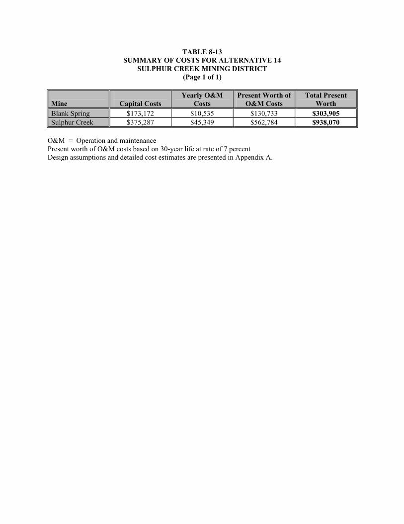
TABLE 8-13 SUMMARY OF COSTS FOR ALTERNATIVE 14
SULPHUR CREEK MINING DISTRICT (Page 1 of 1)
Mine
Capital Costs Yearly O&M
Costs Present Worth of
O&M Costs Total Present
Worth Blank Spring $173,172 $10,535 $130,733 $303,905 Sulphur Creek $375,287 $45,349 $562,784 $938,070
O&M = Operation and maintenance Present worth of O&M costs based on 30-year life at rate of 7 percent Design assumptions and detailed cost estimates are presented in Appendix A.

8-91
will create reduced, iron rich water necessary for metal sulfide precipitation. Only a portion of the water
behind the upstream flashboard dams will be routed through the ZVI reactor (long contact time) to obtain
reduced, iron rich water. The remaining water will pass over the flashboard and mix with the reduced,
iron rich water. The downstream flashboard dams with integral aeration structures (rock covered
spillway) will be used for oxidation of excess iron and other metals. The flashboard dams will operate
during low to moderate flows. The flashboards will be removed from the dam by the end of October prior
to the onset of seasonal rains and will be replaced in April after threat of flooding has passed. A
treatability study will be required prior to design to assess ZVI reactor hydraulic residence time required
for metal reduction, ratio of iron reduced water to creek water to maintain reduced conditions, soluble
iron concentration, sulfide removal rate, reduced metals removal rate, aeration rate required for metal
oxyhydroxide generation, oxidized metals removal rate, hydraulic residence time required for each
settling step, and quantity of solids generated. The steps for constructing and operating the treatment
system include the following: (1) constructing access or maintenance roads to each flashboard dam,
(2) constructing flashboard dams with integral ZVI reactors to capture upstream contaminated sediment
and promote downstream metal sulfide generation, (3) constructing flashboard dams with integral
aeration structures (dam spillway embedded with rocks) to capture upstream metal sulfide sediment and
promote downstream metal oxyhydroxide generation, (4) constructing flashboard dams to capture metal
oxyhydroxide sediment, (5) revegetating any area disturbed by construction, (6) annual removal of
precipitates and sediment captured behind each flashboard dam, (7) periodic replacement of reactive ZVI
media in reactor, and (8) cleaning and repair of aeration structures. A conceptual design of each type of
flashboard dam is shown in Figure 8-3.
The treatment process will capture mobile contaminated sediment, metal sulfide precipitate, and a metal
oxyhydroxide precipitate. The precipitates and contaminated sediment will be removed from behind each
flashboard dam prior to seasonal flashboard removal and placed in an off-site permitted facility. Mobility
of and exposure to contaminants in the captured sediment and precipitates will be controlled through
encapsulation.
Alternative 15 is applicable to Blank Spring and Sulphur Creek and its tributaries adjacent to and below
mines in the Sulphur Creek watershed. This alternative was not retained for Turkey Run Springs or Elgin
Springs as the canyons are too steep for quiescent flow. Hydrothermal waters at these two springs are
addressed under Alternatives 11 and 12. Site-specific process options for Alternative 15 are described
below.

8-92
Alternative 15: Site-Specific Process Options Spring/Creek Source Process Options Sulphur Creek Hydrothermal
Springs Conduct treatability study; construct first flashboard dam and adjacent ZVI reactor at the confluence of Sulphur Creek and Elbow Spring to capture upstream sediment and metal sulfide precipitate generated at Jones Fountain of Life, Elbow Spring, and the unnamed springs within Sulphur Creek between Manzanita Mine and Elbow Spring and to introduce reduced iron downstream, which will promote additional metal sulfide precipitation; introduction of reduced iron will also increase the length of the reduced zone below the dam, in turn promoting additional metal sulfide precipitation; construct a second flashboard dam in Sulphur Creek between Elbow Spring and the Central Mine to capture metal sulfide generated below the first dam; construct a third flashboard dam and adjacent ZVI reactor at the entrance to Sulphur Creek Canyon to capture metal sulfide generated at Wilbur Hot Springs, to introduce reduced iron downstream, and to extend the reduced zone for additional metal sulfide precipitation; construct a fourth flashboard dam in Sulphur Creek at the exit of the canyon to capture metal sulfide precipitate formed below the third dam; install an aeration structure below the fourth dam to oxidize the surface water and promote formation of metal oxyhydroxide compounds; construct a fifth flashboard dam in Sulphur Creek above the confluence of Sulphur and Bear Creeks to capture metal oxyhydroxide precipitate formed below the fourth dam; revegetate soil disturbed by construction; fence and place signage around ZVI reactors; replace ZVI annually; remove accumulated sediment from vaults and behind the dams annually; and conduct performance monitoring.
Blank Spring Hydrothermal Spring
Conduct treatability study; construct a storm water flow diversion above the spring to route runoff around the treatment area; construct the first flashboard dam and adjacent ZVI reactor in the creek below the last spring to capture metal sulfide generated from all of the springs along the creek and to introduce reduced iron downstream, which will promote additional metal sulfide precipitation; introduction of reduced iron will also increase the length of the reduced zone below the dam, in turn promoting additional metal sulfide precipitation; construct a second flashboard dam downstream to capture metal sulfide generated below the first dam; install an aeration structure below the second dam to oxidize the surface water and promote formation of metal oxyhydroxide compounds; construct a third flashboard dam downstream to capture metal oxyhydroxide precipitate formed below the second dam; revegetate soil disturbed by construction; fence and place signage around ZVI reactor; replace ZVI annually; remove accumulated sediment from vault and behind the dams annually; and conduct performance monitoring.

8-93
8.15.1 Effectiveness
The implementation of this alternative would reduce loading of metals and sulfate from Blank Spring
(natural hydrothermal) and the natural hydrothermal springs that feed Sulphur Creek, reduce mobility of
precipitate and contaminated sediment in Sulphur Creek and the Blank Spring tributary, and reduce the
threat of human and ecological ingestion and dermal contact exposure to metals in natural hydrothermal
spring water, spring water precipitates, and contaminated sediment. Removal of excess sulfur from Blank
Spring and the hydrothermal spring fed Sulphur Creek water may be necessary to reduce biotic
methylation of mercury. Discharge from the hydrothermal springs is naturally occurring; therefore, the
threat of human and ecological exposure to metals from spring water is of secondary concern in
comparison to reduction of metals and sulfate loading to Sulphur Creek and the Blank Spring tributary.
Mine-related sources of contaminated sediment will be controlled through implementation of mine-
specific mitigation alternatives described in Sections 8.3 through 8.9. Stabilization of contaminated
sediment (Alternative 10) in the Sulphur Creek floodplain will reduce the amount of sediment captured
and requiring disposal.
Passive treatment of metals and sulfates in natural hydrothermal water would generate and capture metals
precipitate and mobile contaminated sediment moving through Sulphur Creek and the Blank Spring
tributary. Mobility of and exposure to metals in precipitate and contaminated sediment are controlled by
placing treatment precipitate and contaminated sediment in an off-site permitted facility. The physical
covering of precipitate and contaminated sediment at the off-site permitted facility eliminates the
generation of leachate and the potential health risk that may be associated with exposure (direct contact or
airborne releases of particulates) to the contaminated media. Surface control measures will be used at the
off-site permitted facility to divert surface water away from the cover. A geomembrane liner would be
used to minimize infiltration (and subsequent formation of leachate) of surface water/precipitation into
the underlying contaminated waste. The permanence and effectiveness of the mitigation alternative is
highly dependent on maintenance activities.
Contaminant-specific ARARs for degradation of water quality are not applicable to discharges from
Blank Spring or the hydrothermal spring fed Sulphur Creek because the springs are naturally occurring
and are not caused by mining activities. However, the goal is to reduce the total load of metals
discharging from Blank Spring and Sulphur Creek in support of the on-going development of the mercury
TMDL for the Cache Creek watershed. Sulfate load reduction may also reduce the amount of available

8-94
methyl mercury by removing the energy source for sulfate reducing bacteria. The capture of
contaminated sediment moving within Sulphur Creek is an additional form of load reduction to the Bear
and Cache Creek watersheds. Alternative 15 provides a high degree of mercury load reduction and
protection of human health and the environment. In addition, Alternative 15 reduces sulfate loading to
and the potential for biotic methylation of mercury in Sulphur, Bear, and Cache Creeks. The anticipated
load reduction by implementation of this alternative would be greater than the anticipated load reduction
by Alternative 14 (aeration only) and Alternative 13 (single step ZVI and aeration).
Location-specific ARARs are expected to be met without any conflicts. Contacts with appropriate
agencies regarding historical, cultural, and archeological remains would be required. Notification under
the Fish and Wildlife Coordination Act may be required for flashboard dam installation and operation.
Discharges from Blank Spring and hydrothermal springs feeding Sulphur Creek are naturally occurring
and are not caused by mining activities; therefore, action-specific ARARs for mining waste are not
applicable. However, management of the treatment precipitate as a Group B mining waste may be
relevant and appropriate due to its similarity to mine-contaminated sediment. Therefore, treatment
precipitate would be place in an off-site permitted facility subject to the design and siting criteria
specified under Water Code Section 13172. Contaminated sediment captured behind the flashboard dams
will be managed as a Group B waste and placed in an off-site permitted facility. Installation of flashboard
dam and aeration structures would meet the standards for diversions of flow and protection of fish and
wildlife requirements contained in the SMCRA. In addition, standards for drainage, diversion structures,
waterways, and erosion control; stream protection; and protection of wildlife habitat contained in the
SMARA would also be met. Permitting under Section 10 of the Rivers and Harbors Act may also be
required for flashboard dam installation and operation. Stormwater generated during construction
activities will be managed in accordance with the CWA. Lake County and Colusa County APCD’s
nuisance dust suppression and control requirements are applicable for construction and earth-moving
activities associated with this alternative for the control of fugitive dust emissions; these requirements
would be met through water application to roads receiving heavy vehicular traffic and to construction
areas, if necessary. OSHA requirements would be met by requiring appropriate safety training for all on-
site workers during the construction phase.
Under this alternative, long-term monitoring and maintenance would be required and includes seasonal
removal of the flashboards from the dams to allow passage of winter flows, annual removal of

8-95
precipitates and sediment captured behind each flashboard dam, periodic replacement of reactive ZVI
media in reactor, and cleaning and repair of aeration structures. The precipitates and captured sediment
would be placed in an off-site permitted facility. Monitoring of system influent and effluent is required to
document metals and sulfate load reduction. Samples will be analyzed for total and dissolved metals,
total suspended solids, and sulfate.
The construction phase of this alternative would likely be accomplished within one field season;
therefore, impacts associated with construction would likely be short term and minimal. These potential
short-term impacts would be mitigated during the construction phase. On-site workers would be
adequately protected by using appropriate personal protective equipment and by following proper
operating and safety procedures. Control of fugitive dust emissions would be provided by applying water
to surfaces receiving heavy vehicular traffic or in excavation areas, as needed. Short-term risks of
physical injury during construction activities would also exist, as well as off site from increased truck
traffic required to transport construction material to the treatment system.
8.15.2 Implementability
This alternative is both technically and administratively feasible, and could be implemented within one
field season. Flashboard dam construction will require conventional construction practices. Equipment,
materials, and labor would be available through the local market.
A bench scale treatability study will be required to demonstrate the technology effectiveness, to assess
ZVI reactor hydraulic residence time required for metal reduction, ratio of iron reduced water to creek
water to maintain reduced conditions, soluble iron concentration, sulfide removal rate, reduced metals
removal rate, aeration rate required for metal oxyhydroxide generation, oxidized metals removal rate,
hydraulic residence time required for each settling step, and quantity of solids generated. The treatment
system would not remain reliable without the proper maintenance. This type of mitigation alternative
could be supplemented in the future with additional treatment systems in series for higher removal
efficiency, if required.
Components or factors which could potentially prolong the implementation of this alternative as planned
include: (1) diverting water around work areas, (2) a shortened construction season due to inclimate
weather or heavy runoff, (3) permitting required for installation and operation of the flashboard dams, and

8-96
(4) waiting for waste acceptance at an off-site permitted facility. However, these concerns are applicable
to other mitigation alternatives being considered.
8.15.3 Costs
The total present worth cost for Alternative 15, sequences of in channel flashboard dams with integral
passive ZVI reactors and aeration screens for treatment of water in Sulphur Creek and Blank Spring is
summarized in Table 8-14. A cost summary, detailed costs, and assumptions used in developing the cost
estimate for each mine are presented in Appendix A. The total present worth cost includes the present
value of 30 years on annual maintenance and monitoring costs, in addition to the capital costs. These
engineering costs are estimates that are expected to be within plus 50 to minus 30 percent of the actual
project cost (based on year 2003 dollars). Changes in the cost elements are likely to occur as a result of
new information and data collected during the mitigation design.

TABLE 8-14 SUMMARY OF COSTS FOR ALTERNATIVE 15
SULPHUR CREEK MINING DISTRICT (Page 1 of 1)
Mine
Capital Costs Yearly O&M
Costs Present Worth of
O&M Costs Total Present
Worth Blank Spring $214,280 $49,038 $608,559 $822,839 Sulphur Creek $671,754 $829,100 $10,289,134 $10,960,888
O&M = Operation and maintenance Present worth of O&M costs based on 30-year life at rate of 7 percent Design assumptions and detailed cost estimates are presented in Appendix A.

9-1
9.0 COMPARATIVE ANALYSIS OF MITIGATION ALTERNATIVES
This section presents the mitigation alternatives retained for comparative analysis. The comparison
focuses on the effectiveness, implementability, and cost of each alternative. The following subsections
present a general comparative analysis of alternatives, a summary of mine-specific findings based on the
comparative analysis, and the recommended mine-specific mitigation strategies based on these findings.
9.1 COMPARATIVE ANALYSIS OF MITIGATION ALTERNATIVES
The final step of an EE/CA is to conduct a comparative analysis of the mitigation alternatives. The
analysis will discuss each alternative’s relative strengths and weaknesses with respect to each of the
comparison criteria. Once completed, the analysis will be used to prepare mine-specific findings (see
Section 9.2) that evaluate the need for mercury load reduction, the anticipated load reduction for each
mitigation alternative, and the most appropriate mitigation alternative for each media. The summary of
findings will be used to develop mitigation strategies (see Section 9.3) that can be used to reduce mine-
specific contaminant loads (if warranted). Mitigation strategies will be presented for both interim and
final mitigation activities. The focus of interim mitigation activities will be mercury load reduction in
support of, and consistent with, attainment of PMOs and PMGs over the long term. Final mitigation
activities will address both mercury load and risk reduction and meet regulatory requirements in support
of site closure. Both interim and final mitigation activities will comply with location- and action-specific
ARARs. The scope of and decision to implement a mitigation strategy should be made by the property
owner in conjunction with CBDA and other stakeholders.
The purpose of the comparative analysis is to compare the relative effectiveness, implementability, and
cost of the mitigation alternatives in reducing mercury loading to the Cache Creek watershed from mine
waste in the District. The effectiveness comparison will include consideration of the following criteria:
1) overall reduction of mercury load, 2) protectiveness of human health and the environment, 3)
compliance with ARARs, 4) long-term effectiveness and permanence, 5) reduction of toxicity, mobility,
and volume through treatment, and 6) short-term effectiveness of each alternative. Effectiveness will be
evaluated from a final mitigation action perspective; however, both mercury load and risk reduction will
be discussed. The implementability comparison will include consideration of the following criteria:
1) ability to construct and operate, 2) ease of implementing more action if necessary, 3) availability of
services and capacities, and 4) availability of equipment and materials to implement each alternative. The
cost comparison will include consideration of the estimated total present worth cost of each alternative.

9-2
Each criterion is presented and compared for each mitigation alternative for solid media, processing
facilities and buildings, mobile sediment, and surface and hydrothermal waters in Tables 9-1, 9-2, 9-3,
and 9-4, respectively.
Comparative Analysis Summary for Solids. Baseline conditions as represented by Alternative 1, the
no action alternative, would provide no reduction of mercury load, no control of exposure to the
contaminated materials, and no reduction in risk to human health or the environment. Mercury migration
to and load in groundwater, surface water, sediment, and air would be unchanged. Alternative 2 would
not reduce mercury load in groundwater, surface water, sediment, and air. In addition, off-site migration
of and human and ecological contact with mercury due to surface water and wind erosion, and leaching of
mercury to surface water and groundwater from mine waste would still occur. Therefore, Alternative 2
would not reduce mercury load or protect human health and the environment.
Alternative 3 would reduce mercury loading to creeks in the District by reducing run-on and runoff of
surface water and subsequent erosion and leaching of metals to surface water and groundwater.
Alternative 3 would also reduce the mobility of waste and subsequent human and ecological exposure to
contaminated surface water and sediment. Run-on and runoff controls and revegetation would stabilize
waste material by providing additional erosion protection and decreasing the infiltration of precipitation
and surface water that may leach contaminants to surface water and groundwater. The threat of human
and ecological exposure due to on-site ingestion of waste material, dermal contact with waste, and
inhalation of dust containing mine waste would remain and the permanence of surface controls is
dependent on maintenance activities. Alternative 3 would provide a moderate degree of mercury load
reduction and protection of human health and the environment.
Alternatives 3 and 4 would reduce the mobility of waste, contaminant loading to creeks in the District,
and human and ecological exposure to waste material. However, Alternative 4 is more effective than
Alternative 3 because an earthen cover with a geomembrane liner controls erosion of waste, generation of
leachate from waste material, and direct exposure to the waste. If Alternative 3 were implemented, the
potential for erosion of waste, generation of leachate from waste material, human and ecological exposure
due to on-site ingestion of waste material, dermal contact with waste, and inhalation of dust containing
mine waste would remain would remain. In addition, the permanence of surface controls alone
(Alternative 3) for reducing waste migration to surface water is highly dependent on maintenance
activities. Maintenance of the cover is required for permanence under Alternative 4. Alternative 4 would

TABLE 9-1 COMPARATIVE ANALYSIS OF ALTERNATIVES FOR SOLID MEDIA
SULPHUR CREEK MINING DISTRICT (Page 1 of 3)
Assessment Criteria
Alternative 1 No Action
Alternative 2 Institutional Controls
Alternative 3 Surface and Institutional Controls
Alternative 4 Containment with Earthen Cover or
Earthen Cover and Geomembrane Liner, Surface and Institutional Controls
Alternative 5 Excavation and On-Site Disposal
in a Group B Mine Waste Repository, Surface and Institutional Controls
Alternative 6 Excavation and Off-Site Disposal
in a Group B Mine Waste Repository, Surface and Institutional Controls
Overall Protectiveness Contaminant Load Reduction
No reduction in mercury load.
No reduction in mercury load.
Reduces mercury load to watershed by controlling run-on and runoff and subsequent erosion of mine waste.
Provides additional reduction of mercury load to watershed by covering mine waste. The cover prevents erosion of mine waste and migration to surface water. The cover also reduces (no liner) or eliminates (using a liner) infiltration and subsequent generation of leachate. Control of leachate may be necessary to prevent migration of aqueous mercury to surface water via the groundwater pathway.
Provides additional reduction of mercury load to watershed by consolidating and encapsulating mine waste in a repository. A cover is used to prevent erosion of mine waste and migration to surface water. An upper and lower liner is used to prevent contact of mine waste with precipitation and groundwater. Therefore, leachate generation is reduced and captured, if generated.
Reduces mercury load to watershed by consolidating and encapsulating waste from multiple mines at a single repository on the property. Does not provide additional reduction of mercury load in comparison to Alternative 5.
Public Health, Safety, and Welfare
No reduction in risk.
Direct contact with mine waste and physical hazards reduced, all other exposures remain.
Provides protection by reducing waste mobility to surface water and sediment, reducing leaching of metals to surface water and groundwater, and reducing the risk of airborne exposure to dust. The threat of human exposure due to on-site ingestion of waste material and dermal contact with waste would remain over the long term. The threat of exposure due to inhalation of dust containing mine waste would remain over the short term until vegetation is established.
Exposure associated with the mine waste would be greatly reduced. Provides additional protection over Alternative 3 by reducing the exposed area available for surface water infiltration and erosion and wind erosion. A geomembrane liner (if required) would reduce formation of leachate and degradation of surface and ground water quality. Provides additional reduction of contaminant loading to creeks. The threat of human exposure due to ingestion of waste material, dermal contact, and inhalation of dust would remain in those areas (if any) where contaminated material is left in place and is not covered.
Provides additional protection over Alternative 4 by eliminating the threat of human exposure to contaminants in leachate through encapsulation of Group B mine waste. Surface water and groundwater quality would not be degraded because the mine waste is encapsulated. The threat of human exposure due to ingestion of waste material, dermal contact, and inhalation of dust would remain in those areas (if any) where contaminated material is left in place and is not covered.
Provides additional protection over Alternative 5 by reducing the total area of mine waste exposure on the property to a single repository. Eliminates the threat of human exposure to contaminants in leachate through encapsulation of Group B mine waste. Surface water and groundwater quality would not be degraded because the mine waste is encapsulated. The threat of human exposure due to ingestion of waste material, dermal contact, and inhalation of dust would remain in those areas (if any) where contaminated material is left in place and is not covered.
Environmental Protectiveness
No protection offered.
Ecological exposures expected to be basically unchanged.
Provides protection by reducing waste mobility to surface water and sediment, reducing contaminant loading to creeks, and reducing leaching of metals to surface water and groundwater. The threat of ecological exposure due to on-site ingestion of waste material and dermal contact with waste would remain over the long term.
Exposure associated with the mine waste would be greatly reduced. Provides additional protection over Alternative 3 by reducing the exposed area available for surface water infiltration and erosion. A geomembrane liner (if required) would reduce formation of leachate and degradation of surface and ground water quality. Provides additional reduction of contaminant loading to creeks. The threat of ecological exposure due to ingestion of waste material and dermal contact would remain in those areas (if any) where contaminated material is left in place and is not covered.
Provides additional protection over Alternative 4 by eliminating the threat of ecological exposure to contaminants in leachate and by further reducing contaminant loading to creeks through encapsulation of Group B mine waste. Surface water and groundwater quality would not be degraded because the mine waste is encapsulated. The threat of ecological exposure due to ingestion of waste material and dermal contact would remain in those areas (if any) where contaminated material is left in place and is not covered.
Provides additional protection over Alternative 5 by reducing the total area of mine waste exposure on the property to a single repository. Eliminates the threat of ecological exposure to contaminants in leachate and by further reducing contaminant loading to creeks through encapsulation of Group B mine waste. Surface water and groundwater quality would not be degraded because the mine waste is encapsulated. The threat of ecological exposure due to ingestion of waste material and dermal contact would remain in those areas (if any) where contaminated material is left in place and is not covered.
Compliance with ARARs Chemical-Specific
None apply.
Chemical-specific ARARs would not be met.
Chemical-specific ARARs would not be met because of leaching of waste and release of leachate to groundwater and surface water.
Chemical-specific ARARs would likely be met, though leachate control, if generated, is not addressed.
Chemical-specific ARARs would be met.
Chemical-specific ARARs would be met.
Location-Specific
None apply.
Location-specific ARARs are expected to be met.
Location-specific ARARs are expected to be met.
Location-specific ARARs are expected to be met. Location-specific ARARs would be met.
Location-specific ARARs would be met.
Action-Specific
None apply.
None apply. Action-specific ARARs would be met. Action-specific ARARs would be met, though
waste which generates leachate would require disposal in an on- or off-site repository.
Action-specific ARARs would be met.
Action-specific ARARs would be met.

TABLE 9-1 COMPARATIVE ANALYSIS OF ALTERNATIVES FOR SOLID MEDIA
SULPHUR CREEK MINING DISTRICT (Page 2 of 3)
Assessment Criteria
Alternative 1 No Action
Alternative 2 Institutional Controls
Alternative 3 Surface and Institutional Controls
Alternative 4 Containment with Earthen Cover or
Earthen Cover and Geomembrane Liner, Surface and Institutional Controls
Alternative 5 Excavation and On-Site Disposal
in a Group B Mine Waste Repository, Surface and Institutional Controls
Alternative 6 Excavation and Off-Site Disposal
in a Group B Mine Waste Repository, Surface and Institutional Controls
Long-Term Effectiveness and Permanence Magnitude of Residual Risk
No reduction in COPC levels in any environmental media.
No reduction in COPC levels in any environmental media.
Ingestion of waste and dermal contact remain as significant risks. COPC levels in surface water reduced due to surface controls. COPC levels in groundwater reduced due to less infiltration. COPCs remain in leachate to surface water and groundwater and could contribute a significant load to creeks.
Ingestion of waste and dermal contact remain as a significant though somewhat reduced risk. COPC levels in surface water reduced due to surface controls. COPC levels in groundwater reduced due to less infiltration. COPC levels in surface water and groundwater are not expected to pose a risk or contribute a significant load to creeks.
Contaminated materials remain on site. Significant additional risk reduction over Alternative 4 as waste is isolated from receptors, surface water, and groundwater. Exposure associated with ingestion and dermal contact remains in those areas where contaminated material is not excavated.
Contaminated materials no longer remain on site. Additional risk reduction over Alternative 5 as waste is consolidated in a single repository on the property instead of at each mine site. Exposure associated with ingestion and dermal contact remains in those areas where contaminated material is not excavated.
Adequacy and Reliability of Controls
No controls implemented, no reliability.
Reliability of fence, grates, and plugs depend upon long-term maintenance.
Reliability of fencing, grates, plugs, surface controls, and revegetation depends upon long-term maintenance.
Reliability of cover and liner, fencing, grates, plugs, surface controls, and revegetation depend upon long-term maintenance.
Reliability of cover, upper liner, and lower GCL; fencing, grates, plugs; surface controls; and revegetation depend upon long-term maintenance.
Reliability of cover, upper liner, and lower GCL; fencing, grates, plugs; surface controls; and revegetation depend upon long-term maintenance.
Reduction of Toxicity, Mobility, and Volume through Treatment Treatment Process Used and Materials Treated
None. None. No treatment process. No treatment process. No treatment process. No treatment process.
Volume of Contaminated Materials Treated
None. None. No treatment process. No treatment process. No treatment process. No treatment process.
Expected Degree of Reduction
None. None. No treatment process. No treatment process. No treatment process. No treatment process.
Short-Term Effectiveness Protection of Community During Mitigation
Not applicable. Not applicable. Fugitive dust emissions control may be required during surface control construction.
Fugitive dust emissions control may be required during excavation, limited on-site consolidation, and surface control and cover construction.
Fugitive dust emissions control may be required during excavation, on-site consolidation, and repository construction. Increased truck traffic may be a concern during transport of construction material to the mine.
Fugitive dust emissions control may be required during excavation, off-site hauling, consolidation, and repository construction. Increased truck traffic may be a concern during transport of construction material to a mine and during transport of waste to the off-site repository.
Protection of On-Site Workers During Mitigation
Not applicable.
Expected to be sufficient. On-site workers must be adequately protected by using appropriate personal protective equipment and by following proper operating and safety procedures.
Expected to be sufficient. On-site workers must be adequately protected by using appropriate personal protective equipment and by following proper operating and safety procedures.
Expected to be sufficient. On-site workers must be adequately protected by using appropriate personal protective equipment and by following proper operating and safety procedures.
Expected to be sufficient. On-site workers must be adequately protected by using appropriate personal protective equipment and by following proper operating and safety procedures.
Expected to be sufficient. On-site workers must be adequately protected by using appropriate personal protective equipment and by following proper operating and safety procedures.
Time Until Mitigation Objectives are Achieved
Not applicable.
Does not meet all PMOs. Does not meet all PMOs due to potential
discharge of leachate to surface water and groundwater. Vegetation controls may take several years to become established.
Potential to meet all PMOs in one field season. Vegetation may take several years to become established. Leachable waste must be placed in a on- or off-site repository to meet PMOs.
Meets all PMOs in one field season. Vegetation may take several years to become established.
Meets all PMOs in one field season. Vegetation may take several years to become established.
Implementability Ability to Construct and Operate
No construction or operation involved
No difficulties anticipated. Equipment operation on steep slopes may be difficult. No other difficulties anticipated.
Requires contractor experienced in the proper installation of specialized covers and liners. Equipment operation on steep slopes may be difficult. No other difficulties anticipated.
Requires contractor experienced in the proper construction of repositories. Equipment operation on steep slopes may be difficult. No other difficulties anticipated.
Requires contractor experienced in the proper construction of repositories. Equipment operation on steep slopes may be difficult. No other difficulties anticipated.

TABLE 9-1 COMPARATIVE ANALYSIS OF ALTERNATIVES FOR SOLID MEDIA
SULPHUR CREEK MINING DISTRICT (Page 3 of 3)
Assessment Criteria
Alternative 1 No Action
Alternative 2 Institutional Controls
Alternative 3 Surface and Institutional Controls
Alternative 4 Containment with Earthen Cover or
Earthen Cover and Geomembrane Liner, Surface and Institutional Controls
Alternative 5 Excavation and On-Site Disposal
in a Group B Mine Waste Repository, Surface and Institutional Controls
Alternative 6 Excavation and Off-Site Disposal
in a Group B Mine Waste Repository, Surface and Institutional Controls
Implementability Ease of Implementing More Action if Necessary
This alternative does not inhibit other actions from taking place at the site.
Easily implemented, if additional action determined to be necessary (surface controls, excavation, consolidation, cover, or repository disposal)
Easily implemented, if additional action determined to be necessary (excavation, consolidation, cover, or repository disposal).
Waste materials located under earthen cover with liner not readily accessed without destroying cover. Other site activities outside of containment area easily implemented.
Waste materials located in on-site repository not readily accessed without destroying cover. Other site activities outside of repository area easily implemented.
Waste materials located in off-site repository not readily accessed without destroying cover. Other activities at mine sites outside of repository area easily implemented.
Availability of Services and Capacities
Not applicable. Available locally and within the state.
Available locally and within the state. Available locally and within the state. Available locally and within the state. Available locally and within the state.
Availability of Equipment and Materials
Not applicable. Available locally and within the state.
Available locally and within the state. Available locally and within the state. Available locally and within the state. Available locally and within the state.
ESTIMATED TOTAL PRESENT WORTH COST
See Table 9-5 See Table 9-5 See Table 9-5 See Table 9-5 See Table 9-5 See Table 9-5
Notes: ARAR Applicable or relevant and appropriate requirement COPC Chemical of potential concern GCL Geosynthetic clay layer PMO Preliminary mitigation objective

TABLE 9-2 COMPARATIVE ANALYSIS OF ALTERNATIVES FOR PROCESSING FACILITIES AND BUILDINGS
SULPHUR CREEK MINING DISTRICT (Page 1 of 3)
Assessment
Criteria Alternative 1
No Action Alternative 2
Institutional Controls Alternative 7
Solids Removal and On- or Off-Site Disposal, Leave Historic Facilities Intact, Institutional Controls
Alternative 8 Facility Demolition, Overexcavation, On- Or Off-Site Disposal, Surface And Institutional Controls
Overall Protectiveness Contaminant Load Reduction
No reduction in mercury load.
No reduction in mercury load.
Provides reduction of mercury load to watershed by excavation, consolidation, and covering or encapsulation of mine waste around the perimeter of facilities and processing equipment. Mine waste present under or within a facility would remain as a potential source of mercury.
Provides additional reduction of mercury load to watershed by demolition of facilities and processing equipment, excavation of all waste, consolidation, and covering or encapsulation of mine waste. No mine waste would remain intact.
Public Health, Safety, and Welfare
No reduction in risk.
Direct contact with mine waste and physical hazards reduced, all other exposures remain.
Provides additional protection over Alternative 2 by reducing human ingestion and dermal contact exposure to mine processing waste and by reducing the risk of airborne exposure to dust. Removal of waste from processing facilities and placement of waste in an on- or off-site repository would minimize long-term direct human exposure to the excavated processing waste.
Provides additional protection over Alternative 7 by reducing the physical hazards associated with the mine processing facilities. Demolition of processing facilities, removal of waste from beneath and around the perimeter of processing facilities, and placement of waste in an on- or off-site repository would minimize long-term direct human exposure to the excavated processing waste.
Environmental Protectiveness
No protection offered.
Ecological exposures expected to be basically unchanged.
Provides additional protection over Alternative 2 by reducing ecological ingestion and dermal contact exposure to mine processing waste and by reducing the mobility of waste to creeks. Removal of waste from processing facilities and placement of waste in an on- or off-site repository would minimize long-term direct ecological exposure to the excavated processing waste.
Provides additional protection over Alternative 7 by reducing the physical hazards associated with the mine processing facilities. Demolition of processing facilities, removal of waste from beneath and around the perimeter of processing facilities, and placement of waste in an on- or off-site repository would minimize long-term direct ecological exposure to the excavated processing waste.
Compliance with ARARs Chemical-Specific
None apply. Chemical-specific ARARs would not be met.
Chemical-specific ARARs would be met for processing waste placed in an on- or off-site repository.
Chemical-specific ARARs would be met for processing waste placed in an on- or off-site repository.
Location-Specific None apply. Location-specific ARARs are expected to be met.
Location-specific ARARs are expected to be met. Location-specific ARARs are expected to be met.
Action-Specific None apply. None apply. Action-specific ARARs would be met. Action-specific ARARs would be met.
Long-Term Effectiveness and Permanence Magnitude of Residual Risk
No reduction in COPC levels.
No reduction in COPC levels.
Surfaces inside of processing facilities may contain residual contaminants. Contaminated materials remain on site if placed in an on-site repository.
Additional risk reduction over Alternative 7 as processing facilities demolished and all waste placed in an on- or off-site repository.

TABLE 9-2 COMPARATIVE ANALYSIS OF ALTERNATIVES FOR PROCESSING FACILITIES AND BUILDINGS
SULPHUR CREEK MINING DISTRICT (Page 2 of 3)
Assessment
Criteria Alternative 1
No Action Alternative 2
Institutional Controls Alternative 7
Solids Removal and On- or Off-Site Disposal, Leave Historic Facilities Intact, Institutional Controls
Alternative 8 Facility Demolition, Overexcavation, On- Or Off-Site Disposal, Surface And Institutional Controls
Long-Term Effectiveness and Permanence Adequacy and Reliability of Controls
No controls implemented, no reliability.
Reliability of fence, grates, and plugs depend upon long-term maintenance.
Reliability of fencing, grates, and plugs; surface controls; and revegetation depend upon long-term maintenance.
Reliability of fencing, grates, and plugs; surface controls; and revegetation depend upon long-term maintenance.
Reduction of Toxicity, Mobility, and Volume through Treatment Treatment Process Used and Materials Treated
None. None. None. None.
Volume of Contaminated Materials Treated
None. None. None. None.
Expected Degree of Reduction
None. None. None. None.
Short-Term Effectiveness Protection of Community During Mitigation
Not applicable. Not applicable. Fugitive dust emissions control may be required during excavation and hauling to an on- or off-site repository. Increased truck traffic may be a concern during transport of waste to the off-site repository.
Fugitive dust emissions control may be required during demolition, excavation, and hauling to an on- or off-site repository. Increased truck traffic may be a concern during transport of waste to the off-site repository.
Protection of On-Site Workers During Mitigation
Not applicable. Expected to be sufficient. Workers protected using appropriate personal protective equipment and by following proper operating and safety procedures.
Expected to be sufficient. Workers must be adequately protected by using appropriate personal protective equipment and by following proper operating and safety procedures.
Expected to be sufficient. Workers must be adequately protected by using appropriate personal protective equipment and by following proper operating and safety procedures.
Time Until Mitigation Objectives are Achieved
Not applicable. Does not meet all PMOs. Meets all PMOs in one field season. Vegetation may take several years to become established.
Meets all PMOs in one field season. Vegetation may take several years to become established.

TABLE 9-2 COMPARATIVE ANALYSIS OF ALTERNATIVES FOR PROCESSING FACILITIES AND BUILDINGS
SULPHUR CREEK MINING DISTRICT (Page 3 of 3)
Assessment
Criteria Alternative 1
No Action Alternative 2
Institutional Controls Alternative 7
Solids Removal and On- or Off-Site Disposal, Leave Historic Facilities Intact, Institutional Controls
Alternative 8 Facility Demolition, Overexcavation, On- Or Off-Site Disposal, Surface And Institutional Controls
Implementability Ability to Construct and Operate
No construction or operation involved
No difficulties anticipated. Equipment operation on steep slopes may be difficult. Waste removal from inside processing facilities may require handwork. No other difficulties anticipated.
Equipment operation on steep slopes may be difficult. No other difficulties anticipated.
Ease of Implementing More Action if Necessary
This alternative does not inhibit other actions from taking place at the site.
Easily implemented, if additional action determined to be necessary (waste removal or facility demolition and waste removal).
Easily implemented, if additional action (facility demolition) determined to be necessary.
No additional action would be required.
Availability of Services and Capacities
Not applicable. Available locally and within the state.
Available locally and within the state. Available locally and within the state.
Availability of Equipment and Materials
Not applicable. Available locally and within the state.
Available locally and within the state. Available locally and within the state.
ESTIMATED TOTAL PRESENT WORTH COST
See Table 9-6 See Table 9-6 See Table 9-6 See Table 9-6
Notes: ARAR Applicable or relevant and appropriate requirement COPC Chemical of potential concern PMO Preliminary mitigation objective

TABLE 9-3 COMPARATIVE ANALYSIS OF ALTERNATIVES FOR MOBILE SEDIMENT
SULPHUR CREEK MINING DISTRICT (Page 1 of 3)
Assessment Criteria
Alternative 1 No Action
Alternative 2 Institutional Controls
Alternative 9 Excavate and On- or Off-Site Disposal,
Institutional Controls
Alternative 10 Revegetate Floodplain to Reduce Sediment
Runoff, Grade and Vegetate Stream Banks to Stabilize Stream Channel
Overall Protectiveness Contaminant Load Reduction
No reduction in mercury load.
No reduction in mercury load.
Provides reduction of mercury load to watershed by excavation, consolidation, and covering or encapsulation of contaminated stream sediment.
Reduces mercury load to watershed by controlling run-on and runoff and subsequent erosion of mine waste on top of the floodplain; by controlling erosion of channel banks using stabilization and vegetation; and by slow stream velocity to reduce bed and bank erosion.
Public Health, Safety, and Welfare
No reduction in risk. Direct contact with contaminated sediment reduced by site fencing, all other exposures remain.
Provides an additional protection over Alternative 2 by eliminating the threat of human exposure to contaminated sediment in creeks and swales by excavation and encapsulation. Surface water and groundwater quality would not be degraded because the mine waste is encapsulated.
Reduces potential human exposure to contaminated sediment in the floodplain. Threat of human exposure due to ingestion of contaminated sediment, dermal contact, and inhalation of dust would remain as contaminated sediment left in place.
Environmental Protectiveness
No protection offered. No reduction in metals load to watershed.
Ecological exposures expected to be basically unchanged.
Provides an additional protection over Alternative 2 by eliminating the threat of ecological exposure to and reducing contaminant loading from contaminated sediment in creeks and swales by excavation and encapsulation. Surface water and groundwater quality would not be degraded because the mine waste is encapsulated.
Reduces contaminant loading to Sulphur Creek through stabilization of floodplain, channel, and channel banks. Reduces potential ecological exposure to contaminated sediment in the floodplain. Threat of ecological exposure due to ingestion of contaminated sediment and dermal contact would remain as contaminated sediment left in place.
Compliance with ARARs Chemical-Specific None apply. Chemical-specific ARARs
would not be met. Chemical-specific ARARs would be met. None apply. However, decreased contaminant
loading to Sulphur Creek will increase potential attainment of ARARs in Bear Creek into which Sulphur Creek discharges.
Location-Specific None apply. Location-specific ARARs are expected to be met.
Location-specific ARARs are expected to be met.
Location-specific ARARs are expected to be met.
Action-Specific None apply. None apply. Action-specific ARARs would be met. Action-specific ARARs would be met. Long-Term Effectiveness and Permanence
Magnitude of Residual Risk
No reduction in COPC levels in any environmental media.
No reduction in COPC levels in any environmental media.
Residual risk should be minimal as contaminanted sediment is removed and encapsulated. Contaminated sediment remain on site if placed in an on-site repository.
Threat of human and ecological risk due to ingestion of contaminated sediment, dermal contact, and inhalation of dust would remain, though the exposure pathways are substantially controlled.
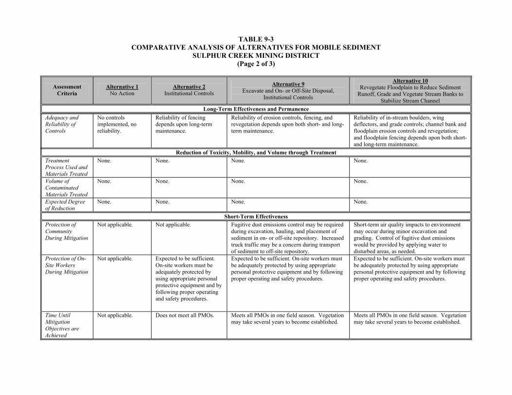
TABLE 9-3 COMPARATIVE ANALYSIS OF ALTERNATIVES FOR MOBILE SEDIMENT
SULPHUR CREEK MINING DISTRICT (Page 2 of 3)
Assessment Criteria
Alternative 1 No Action
Alternative 2 Institutional Controls
Alternative 9 Excavate and On- or Off-Site Disposal,
Institutional Controls
Alternative 10 Revegetate Floodplain to Reduce Sediment
Runoff, Grade and Vegetate Stream Banks to Stabilize Stream Channel
Long-Term Effectiveness and Permanence Adequacy and Reliability of Controls
No controls implemented, no reliability.
Reliability of fencing depends upon long-term maintenance.
Reliability of erosion controls, fencing, and revegetation depends upon both short- and long-term maintenance.
Reliability of in-stream boulders, wing deflectors, and grade controls; channel bank and floodplain erosion controls and revegetation; and floodplain fencing depends upon both short- and long-term maintenance.
Reduction of Toxicity, Mobility, and Volume through Treatment Treatment Process Used and Materials Treated
None. None. None. None.
Volume of Contaminated Materials Treated
None. None. None. None.
Expected Degree of Reduction
None. None. None. None.
Short-Term Effectiveness Protection of Community During Mitigation
Not applicable. Not applicable. Fugitive dust emissions control may be required during excavation, hauling, and placement of sediment in on- or off-site repository. Increased truck traffic may be a concern during transport of sediment to off-site repository.
Short-term air quality impacts to environment may occur during minor excavation and grading. Control of fugitive dust emissions would be provided by applying water to disturbed areas, as needed.
Protection of On-Site Workers During Mitigation
Not applicable. Expected to be sufficient. On-site workers must be adequately protected by using appropriate personal protective equipment and by following proper operating and safety procedures.
Expected to be sufficient. On-site workers must be adequately protected by using appropriate personal protective equipment and by following proper operating and safety procedures.
Expected to be sufficient. On-site workers must be adequately protected by using appropriate personal protective equipment and by following proper operating and safety procedures.
Time Until Mitigation Objectives are Achieved
Not applicable. Does not meet all PMOs. Meets all PMOs in one field season. Vegetation may take several years to become established.
Meets all PMOs in one field season. Vegetation may take several years to become established.

TABLE 9-3 COMPARATIVE ANALYSIS OF ALTERNATIVES FOR MOBILE SEDIMENT
SULPHUR CREEK MINING DISTRICT (Page 3 of 3)
Assessment Criteria
Alternative 1 No Action
Alternative 2 Institutional Controls
Alternative 9 Excavate and On- or Off-Site Disposal,
Institutional Controls
Alternative 10 Revegetate Floodplain to Reduce Sediment
Runoff, Grade and Vegetate Stream Banks to Stabilize Stream Channel
Implementability Ability to Construct and Operate
No construction or operation involved
No difficulties anticipated. No difficulties anticipated. Stream channel and stream bank restoration will require a contractor that specializes in restoration techniques.
No difficulties anticipated. Channel and channel bank stabilization and restoration will require a contractor that specializes in stream restoration techniques.
Ease of Implementing More Action if Necessary
This alternative does not inhibit other actions from taking place at the site.
Easily implemented, if additional action determined to be necessary (surface controls or excavation).
No additional action would be required. Easily implemented, if additional action determined to be necessary (excavation and disposal)
Availability of Services and Capacities
Not applicable. Available locally and within the state.
Available locally and within the state. Available locally and within the state.
Availability of Equipment and Materials
Not applicable. Available locally and within the state.
Available locally and within the state. Available locally and within the state.
ESTIMATED TOTAL PRESENT WORTH COST
See Table 9-7 See Table 9-7 See Table 9-7 See Table 9-7
Notes: ARAR Applicable or relevant and appropriate requirement COPC Chemical of potential concern PMO Preliminary mitigation objective

TABLE 9-4 COMPARATIVE ANALYSIS OF ALTERNATIVES FOR SURFACE AND HYDROTHERMAL WATERS
SULPHUR CREEK MINING DISTRICT (Page 1 of 3)
Assessment Criteria
Alternative 1 No Action
Alternative 2 Institutional Controls
Alternative 11 Diversion, Passive Precipitation,
Optional Aeration, Institutional Controls
Alternative 12 Diversion, Passive Zero Valence Iron Reactor and Precipitation, Optional
Aeration, Institutional Controls
Alternative 13 In Channel Flashboard Dam, Off Stream
Passive Zero Valence Iron Reactor, Aeration, and Precipitation
Alternative 14 In Channel Flashboard Dams Integral
Aeration Structures
Alternative 15 Sequences of In Channel Flashboard
Dams with Integral Passive Zero Valence Iron Reactors or Aeration Screens
Overall Protectiveness Contaminant Load Reduction
No reduction in mercury and sulfate loads.
No reduction in mercury and sulfate loads.
Reduces mercury load through generation and capture of chemical precipitates containing mercury. No reduction in sulfate load.
Reduces mercury and sulfate load by maintaining reducing conditions necessary for precipitation of metal sulfides, followed by creation of oxidizing conditions for precipitation of metals in iron sweep floc. Precipitates are captured in off-stream vaults.
Reduces mercury and sulfate load by maintaining reducing conditions necessary for precipitation of metal sulfides, followed by creation of oxidizing conditions for precipitation of metals in iron sweep floc. Precipitates are captured behind an in channel dam and off-stream vaults.
Reduces mercury load through generation and capture of chemical precipitates containing mercury behind in channel dams. No reduction in sulfate load.
Reduces mercury and sulfate load by maintaining reducing conditions necessary for precipitation of metal sulfides below in stream hydrothermal springs, followed by creation of oxidizing conditions for precipitation of metals in iron sweep floc. Precipitates are captured behind in channel dams.
Public Health, Safety, and Welfare
No reduction in risk.
Direct contact with hydrothermal waters and physical hazards reduced, all other exposures remain.
Provides additional protection over Alternative 2 by reducing the threat of human ingestion and dermal contact exposure to metals in natural hydrothermal spring water and associated precipitates. Treatment precipitate would be placed in an off-site permitted disposal facility.
Provides additional protection over Alternative 11 by further reducing the threat of human ingestion and dermal contact exposure to metals in natural hydrothermal spring water and associated precipitates. Treatment precipitate would be placed in an off-site permitted disposal facility.
Provides additional protection over Alternative 2 by reducing the threat of human ingestion and dermal contact exposure to metals in natural hydrothermal spring water, spring water precipitates, and contaminated sediment. Treatment precipitate would be placed in an off-site permitted disposal facility.
Provides additional protection over Alternative 2 by reducing the threat of human ingestion and dermal contact exposure to metals in natural hydrothermal spring water, spring water precipitates, and contaminated sediment. Treatment precipitate would be placed in an off-site permitted disposal facility.
Provides additional protection over Alternatives 13 and 14 by further reducing the threat of human ingestion and dermal contact exposure to metals in natural hydrothermal spring water, spring water precipitates, and contaminated sediment. Treatment precipitate would be placed in an off-site permitted disposal facility.
Environmental Protectiveness
No protection offered. No reduction in metals load to watershed.
Ecological exposures expected to be basically unchanged.
Provides additional protection over Alternative 2 by reducing loading of metals from natural hydrothermal springs to Harley Gulch and Sulphur Creek watersheds and by reducing the threat of ecological ingestion and dermal contact exposure to metals in natural hydrothermal spring water and associated precipitates. Treatment precipitate would be placed in an off-site permitted disposal facility.
Provides additional protection over Alternative 11 by further reducing loading of metals and sulfate from natural hydrothermal springs to Harley Gulch and Sulphur Creek watersheds and by further reducing the threat of ecological ingestion and dermal contact exposure to metals in natural hydrothermal spring water and associated precipitates. Removal of excess sulfur from hydrothermal waters is necessary to reduce biotic methylation of mercury. Treatment precipitate would be placed in an off-site permitted disposal facility.
Provides additional protection over Alternative 2 by reducing loading of metals and sulfate from natural hydrothermal springs in Sulphur Creek, by reducing mobility of contaminated sediment in Sulphur Creek, and by reducing the threat of ecological ingestion and dermal contact exposure to metals in natural hydrothermal spring water, spring water precipitates, and contaminated sediment. Removal of excess sulfur from the hydrothermal spring fed Sulphur Creek water is necessary to reduce biotic methylation of mercury. Treatment precipitate would be placed in an off-site permitted disposal facility.
Provides additional protection over Alternative 2 by reducing loading of metals from Blank Spring and the natural hydrothermal springs in Sulphur Creek, by reducing mobility of precipitate and contaminated sediment in Sulphur Creek and the Blank Spring tributary, and by reducing the threat of ecological ingestion and dermal contact exposure to metals in natural hydrothermal spring water, spring water precipitates, and contaminated sediment. Treatment precipitate would be placed in an off-site permitted disposal facility.
Provides additional protection over Alternatives 13 and 14 by further reducing loading of metals and sulfate from natural hydrothermal springs in Sulphur Creek, by further reducing mobility of contaminated sediment in Sulphur Creek, and by further reducing the threat of ecological ingestion and dermal contact exposure to metals in natural hydrothermal spring water, spring water precipitates, and contaminated sediment. Removal of excess sulfur from the hydrothermal spring fed Sulphur Creek water is necessary to reduce biotic methylation of mercury. Treatment precipitate would be placed in an off-site permitted disposal facility.
Compliance with ARARs Chemical-Specific
None apply.
Chemical-specific ARARs are not applicable. Total metals load to watershed would not be reduced.
Contaminant-specific ARARs are not applicable. However, total load of metals discharging from the springs will be reduced in support of the on-going development of the mercury TMDL for the Cache Creek watershed. Anticipated load reduction would be less than the load reduction by Alternative 12.
Contaminant-specific ARARs are not applicable. However, total load of metals and sulfate discharging from the springs will be reduced in support of the on-going development of the mercury TMDL for the Cache Creek watershed. Anticipated load reduction would be greater than Alternative 11 load reduction.
Contaminant-specific ARARs are not applicable. However, total load of metals and sulfate discharging from the spring fed Sulphur Creek will be reduced in support of the on-going development of the mercury TMDL for the Cache Creek watershed. Anticipated load reduction would be less than Alternative 15 load reduction.
Contaminant-specific ARARs are not applicable. However, total load of metals discharging from Blank Spring and spring fed Sulphur Creek will be reduced in support of the on-going development of the mercury TMDL for the Cache Creek watershed. Anticipated load reduction would be less than Alternative 15 load reduction.
Contaminant-specific ARARs are not applicable. However, total load of metals and sulfate discharging from Blank Spring and spring fed Sulphur Creek will be reduced in support of the on-going development of the mercury TMDL for the Cache Creek watershed. Anticipated load reduction would be greater than Alternatives 13 and 14 load reduction.
Location-Specific None apply.
Location-specific ARARs are expected to be met.
Location-specific ARARs are expected to be met.
Location-specific ARARs are expected to be met.
Location-specific ARARs are expected to be met without any conflicts. Notification under the Fish and Wildlife Coordination Act may be required for flashboard dam installation and operation.
Location-specific ARARs are expected to be met without any conflicts. Notification under the Fish and Wildlife Coordination Act may be required for flashboard dam installation and operation.
Location-specific ARARs are expected to be met without any conflicts. Notification under the Fish and Wildlife Coordination Act may be required for flashboard dam installation and operation.

TABLE 9-4 COMPARATIVE ANALYSIS OF ALTERNATIVES FOR SURFACE AND HYDROTHERMAL WATERS
SULPHUR CREEK MINING DISTRICT (Page 2 of 3)
Assessment Criteria
Alternative 1 No Action
Alternative 2 Institutional Controls
Alternative 11 Diversion, Passive Precipitation,
Optional Aeration, Institutional Controls
Alternative 12 Diversion, Passive Zero Valence Iron Reactor and Precipitation, Optional
Aeration, Institutional Controls
Alternative 13 In Channel Flashboard Dam, Off Stream
Passive Zero Valence Iron Reactor, Aeration, and Precipitation
Alternative 14 In Channel Flashboard Dams Integral
Aeration Structures
Alternative 15 Sequences of In Channel Flashboard
Dams with Integral Passive Zero Valence Iron Reactors or Aeration
Screens Compliance with ARARs
Action-Specific
None apply.
None apply. Action-specific ARARs would be met. Action-specific ARARs would be met. Action-specific ARARs would be met.
Permitting under Section 10 of the Rivers and Harbors Act may also be required for flashboard dam installation and operation.
Action-specific ARARs would be met. Permitting under Section 10 of the Rivers and Harbors Act may also be required for flashboard dam installation and operation.
Action-specific ARARs would be met. Permitting under Section 10 of the Rivers and Harbors Act may also be required for flashboard dam installation and operation.
Long-Term Effectiveness and Permanence Magnitude of Residual Risk
No risk or contaminant load reduction.
Some risk reduction, no contaminant load reduction.
Discharge from the hydrothermal springs is naturally occurring; therefore, the threat of human and ecological exposure to metals from spring water is of secondary concern in comparison to reduction of metals and sulfate loading to watershed. Anticipated load reduction would be less than the load reduction by Alternative 12. Does not reduce sulfate load.
Discharge from the hydrothermal springs is naturally occurring; therefore, the threat of human and ecological exposure to metals from spring water is of secondary concern in comparison to reduction of metals and sulfate loading to watershed. Anticipated load reduction would be greater than Alternative 11 load reduction.
Discharge from the hydrothermal springs that feed Sulphur Creek is naturally occurring; therefore, the threat of human and ecological exposure to metals from spring water is of secondary concern in comparison to reduction of metals and sulfate loading to Sulphur Creek. Anticipated load reduction would be less than Alternative 15 load reduction. Reduces sulfate load, while Alternative 14 does not.
Discharge from the hydrothermal springs is naturally occurring; therefore, the threat of human and ecological exposure to metals from spring water is of secondary concern in comparison to reduction of metals and sulfate loading to Sulphur Creek and the Blank Spring tributary. Anticipated load reduction would be less than Alternative 15 load reduction. Does not reduce sulfate load.
Discharge from the hydrothermal springs is naturally occurring; therefore, the threat of human and ecological exposure to metals from spring water is of secondary concern in comparison to reduction of metals and sulfate loading to Sulphur Creek and the Blank Spring tributary. Anticipated load reduction would be greater than Alternatives 13 and 14 load reduction.
Adequacy and Reliability of Controls
No controls implemented, no reliability.
Reliability of fenceing depends upon long-term maintenance.
Reliability of treatment system depends on annual flushing of precipitate out of the rock tumble or pipeline, annual removal of precipitate from the settling basin or vault, and monitoring of load reduction.
Reliability of treatment system depends on periodic replacement of reactive ZVI media in reactor, annual flushing of precipitate out of the rock tumble or pipeline, annual removal of precipitate from the settling basin or vault, and monitoring of load reduction.
Reliability of treatment system depends on seasonal removal of the flashboards from the dam to allow passage of winter flows, periodic replacement of reactive ZVI media in reactor, annual flushing precipitate out of the rock tumble or pipeline, annual removal of precipitate from the vaults, and monitoring of load reduction.
Reliability of treatment system depends on seasonal removal of the flashboards from the dams to allow passage of winter flows, annual removal of precipitates and sediment captured behind each flashboard dam, annual cleaning and repair of aeration structures, and monitoring of load reduction.
Reliability of treatment system depends on seasonal removal of the flashboards from the dams to allow passage of winter flows, annual removal of precipitates and sediment captured behind each flashboard dam, periodic replacement of reactive ZVI media in reactor, cleaning and repair of aeration structures, and monitoring of load reduction.
Reduction of Toxicity, Mobility, and Volume through Treatment Treatment Process Used and Materials Treated
None. None. Treatment system comprised of diversion structure and piping, a holding basin or vault to extend time for metals precipitation. An optional gravity rock tumble (aeration) may be added upstream of settling basin depending on redox chemistry.
Treatment system comprised of diversion structure and piping, a gravity fed ZVI reactor to create reduced, iron rich water, and a holding basin or vault to extend time for metals and metal sulfide precipitation. An optional gravity rock tumble (aeration) and seconding holding basin may be added downstream of first holding basin depending on redox and metals chemistry.
Treatment system comprised of diversion structure (flashboard dam) and diversion piping; a gravity fed below grade ZVI reactor to create reduced, iron rich water; a below grade vault to extend time for metal sulfide precipitation; a rock tumble (aeration); and second below grade vault for settling oxidized iron and metal precipitates.
Treatment system comprised of a sequence of flashboard dams and flashboard dams with integral aeration structures (rock covered spillway) constructed within stream, with intervening quiescent pools for precipitate formation and settling.
Treatment system comprised of a sequence of flashboard dams within stream, and intervening pools for precipitate formation and settling. Upstream flashboard dams with integral ZVI reactors will capture mobile contaminated sediment and create a reduced, iron rich discharge for metal sulfide formation. Downstream flashboard dams with integral aeration structures (rock covered spillway) will capture metal sulfide precipitates and create oxidizing conditions for metal oxyhydroxide precipitation.
Volume of Contaminated Materials Treated
None. None. Varies by location. Treatment of entire spring discharge.
Varies by location. Treatment of entire spring discharge.
Treatment of entire volume of Sulphur Creek during low flow season. Treatment does not occur during winter due to high flows.
Treatment of Blank Spring discharge. Treatment of entire volume of Sulphur Creek during low flow season. Sulphur Creek treatment does not occur during winter due to high flows.
Treatment of entire Blank Spring discharge. Treatment of entire volume of Sulphur Creek during low flow season. Sulphur Creek treatment does not occur during winter due to high flows.
Expected Degree of Reduction
None. None. Less metal load reduction than Alternative 12 because of oxidation state of spring water. Sulfate load is not addressed.
Greater metal and sulfate load reduction than Alternative 11 because of oxidation state of spring water is actively reduced.
Less metal and sulfate load reduction than Alternative 15 because of short contact time. Reduces sulfate load, while Alternative 14 does not.
Less metal load reduction than Alternative 15 because of short contact time and lack of reducing conditions. Does not reduce sulfate load.
Greater metal and sulfate load reduction than Alternatives 13 and 14 because of longer contact time and reducing conditions. Reduces sulfate load, while Alternative 14 does not.

TABLE 9-4 COMPARATIVE ANALYSIS OF ALTERNATIVES FOR SURFACE AND HYDROTHERMAL WATERS
SULPHUR CREEK MINING DISTRICT (Page 3 of 3)
Assessment Criteria
Alternative 1 No Action
Alternative 2 Institutional Controls
Alternative 11 Diversion, Passive Precipitation,
Optional Aeration, Institutional Controls
Alternative 12 Diversion, Passive Zero Valence Iron Reactor and Precipitation, Optional
Aeration, Institutional Controls
Alternative 13 In Channel Flashboard Dam, Off Stream
Passive Zero Valence Iron Reactor, Aeration, and Precipitation
Alternative 14 In Channel Flashboard Dams Integral
Aeration Structures
Alternative 15 Sequences of In Channel Flashboard
Dams with Integral Passive Zero Valence Iron Reactors or Aeration Screens
Short-Term Effectiveness Protection of Community During Mitigation
Not applicable. Not applicable. Fugitive dust emissions control may be required during grading and treatment system construction. Increased truck traffic may be a concern during transport of construction material to treatment areas.
Fugitive dust emissions control may be required during grading and treatment system construction. Increased truck traffic may be a concern during transport of construction material to treatment areas.
Fugitive dust emissions control may be required during grading, dam installation, and treatment system construction. Increased truck traffic may be a concern during transport of construction material to treatment areas.
Fugitive dust emissions control may be required during grading, dam installation, and treatment system construction. Increased truck traffic may be a concern during transport of construction material to treatment areas.
Fugitive dust emissions control may be required during grading, dam installation, and treatment system construction. Increased truck traffic may be a concern during transport of construction material to treatment areas.
Protection of On-Site Workers During Mitigation
Not applicable.
Expected to be sufficient. On-site workers must be adequately protected by using appropriate personal protective equipment and by following proper operating and safety procedures.
Expected to be sufficient. On-site workers must be adequately protected by using appropriate personal protective equipment and by following proper operating and safety procedures.
Expected to be sufficient. On-site workers must be adequately protected by using appropriate personal protective equipment and by following proper operating and safety procedures.
Expected to be sufficient. On-site workers must be adequately protected by using appropriate personal protective equipment and by following proper operating and safety procedures.
Expected to be sufficient. On-site workers must be adequately protected by using appropriate personal protective equipment and by following proper operating and safety procedures.
Expected to be sufficient. On-site workers must be adequately protected by using appropriate personal protective equipment and by following proper operating and safety procedures.
Time Until Mitigation Objectives are Achieved
Not applicable.
Does not meet all PMOs.
Meets applicable PMOs in one field season, not as effective over short term as Alternative 12 because sulfate loading is not addressed.
Meets applicable PMOs in one field season.
Meets applicable PMOs in one field season, not as effective over short term as Alternative 15 because potential mercury and sulfate load reduction is not as great.
Meets applicable PMOs in one field season, not as effective over short term as Alternatives 13 or 15 because sulfate loading is not addressed.
Meets applicable PMOs in one field season, most effective over short term because potential mercury and sulfate load reduction is greater than Alternatives 13 and 14.
Implementability Ability to Construct and Operate
No construction or operation involved.
No difficulties anticipated.
Treatment system would require the services of a contractor experienced in the proper component installation procedures. A bench scale treatability study will be required to demonstrate the technology effectiveness and operational parameters.
Treatment system would require the services of a contractor experienced in the proper component installation procedures. A bench scale treatability study will be required to demonstrate the technology effectiveness and operational parameters.
Flashboard dam installation will require conventional construction practices. Treatment system would require the services of a contractor experienced in the proper component installation procedures. A bench scale treatability study will be required to demonstrate the technology effectiveness and operational parameters.
Flashboard dam and aeration structure installation will require conventional construction practices. A bench scale treatability study will be required to demonstrate the technology effectiveness and operational parameters.
Flashboard dam and aeration structure installation will require conventional construction practices. ZVI reactor installation would require the services of a contractor experienced in ZVI reactor construction procedures. A bench scale treatability study will be required to demonstrate the technology effectiveness and operational parameters.
Ease of Implementing More Action if Necessary
This alternative does not inhibit other actions from taking place at the site.
Easily implemented, if additional action determined to be necessary (diversion and treatment, or instream treatment).
Easily implemented, if additional action determined to be necessary (diversion and other treatment technology, or instream treatment)
Easily implemented, if additional action determined to be necessary (diversion and other treatment technology, or instream treatment)
Easily implemented, if additional action determined to be necessary (instream treatment with other technology or diversion and off-stream treatment)
Easily implemented, if additional action determined to be necessary (instream treatment with other technology or diversion and off-stream treatment)
Easily implemented, if additional action determined to be necessary (instream treatment with other technology or diversion and off-stream treatment)
Availability of Services and Capacities
Not applicable. Available locally and within the state.
Available locally and within the state. Available locally and within the state. Available locally and within the state. Available locally and within the state. Available locally and within the state.
Availability of Equipment and Materials
Not applicable. Available locally and within the state.
Available locally and within the state. Available locally and within the state. Available locally and within the state. Available locally and within the state. Available locally and within the state.
ESTIMATED TOTAL PRESENT WORTH COST
See Table 9-8 See Table 9-8 See Table 9-8 See Table 9-8 See Table 9-8 See Table 9-8 See Table 9-8
Notes: ARAR Applicable or relevant and appropriate requirement TMDL Total maximum daily load PMO Preliminary mitigation objective ZVI Zero valence iron
9-15
provide a moderate to high degree of mercury load reduction and protection of human health and the
environment. However, mercury migration may occur if groundwater is in contact with the mine waste.
Therefore, Alternative 4 should only be used to address mine waste with leachable metals concentrations
below STLC values (Group C waste). If the leachable metals concentrations exceed STLC values, then
the mine waste (Group B waste) should be addressed by Alternative 5 or 6 (containment with an upper
and lower liner and a leachate collection and recovery system).
Alternatives 5 and 6 would both provide a higher level of mercury load reduction over Alternative 4 and
would eliminate the threat of human and ecological exposure to contaminants in leachate by
encapsulation of Group B mine waste in an on- or off-site repository. Surface water and groundwater
quality would not be degraded because the mine waste is encapsulated. Alternatives 5 and 6 are
considered more effective than Alternative 4 because encapsulation of waste would reduce the infiltration
of water, subsequent generation of leachate, and contain any leachate that is generated. Alternative 6 is
considered more effective than Alternative 5 because the majority of mine waste for a property owner is
consolidated in a single Group B mine waste repository. Both Alternatives 5 and 6 provide a high degree
of mercury load reduction and protection of human health and the environment.
Chemical-specific ARARs would be met for Alternatives 5 and 6 because the waste would be
encapsulated. Chemical-specific ARARs would likely be met under Alternative 4, though control of
leachate, if generated, is not addressed. Chemical-specific ARARs would not be met under Alternative 3
because leaching of waste and release of leachate to groundwater and surface water is not controlled.
Chemical-specific ARARs would not be met under Alternative 2 because release of contaminants to
surface water and groundwater would remain unchanged. Location- and action-specific ARARs are
expected to be met where applicable. No ARARs apply to Alternative 1.
Alternative 1 is the least expensive alternative at no cost, followed by Alternative 2, Alternative 3,
Alternative 4, and Alternative 5. Alternative 6 may be less costly than Alternatives 4 or 5, depending on
the number of mine sites sharing the capital and long-term O&M costs of an off-site Group B mine waste
repository. Specific costs for individual mines are presented in Table 9-5 and discussed in Section 9.2.
Comparative Analysis Summary for Processing Facilities and Buildings. Baseline conditions at
processing facilities and buildings as represented by Alternative 1, the no action alternative, would
provide no reduction of mercury load, no control of exposure to the contaminated materials, and no
reduction in risk to human health or the environment. Alternative 2 would not reduce mercury load in

TABLE 9-5 SUMMARY OF COSTS FOR SOLID MEDIA
SULPHUR CREEK MINING DISTRICT (Page 1 of 1)
Alternative 1
No Action
Alternative 2 Institutional Controls
Alternative 3 Surface and
Institutional Controls
Alternative 4
Containment, Surface and Institutional Controls
Alternative 5 Excavation and On-Site Disposal, Surface and Institutional Controls
Alternative 6 Excavation and Off-Site Disposal, Surface and Institutional Controls
Abbott Mine None $83,745 $1,664,759 Not applicable $4,714,985 $4,599,175 (A)
Not applicable
Turkey Run Mine None $78,266 $542,763 $864,848 Not applicable $715,589 (B) Wide Awake Mine None $68,236 $306,619 $804,532 $788,493 Not applicable Empire Mine None $24,587 Not applicable Not applicable Not applicable Not applicable Cherry Hill Mine None $56,262 Not applicable Not applicable Not applicable $143,944 (B) West End Mine None $55,946 Not applicable Not applicable $861,809
$291,685 (A) Not applicable
Manzanita Mine None $91,888 $343,258 Not applicable Not applicable $358,400 (B) Central Mine None $61,747 $197,219 Not applicable Not applicable $185,472 (B) Elgin Mine None $56,034 Not applicable Not applicable $418,766 Not applicable Clyde Mine None $56,497 $226,830 Not applicable Not applicable Not applicable Rathburn Mine None $43,310 $154,644 $365,977 $487,467 $373,805 (B) Rathburn-Petray Mine None $61,454 $325,462 Not applicable $2,757,748
$2,619,299 (A) Not applicable
Petray-South Mine None $50,716 $155,397 Not applicable Not applicable Not applicable Petray-North Mine None $63,296 $242,569 Not applicable $306,435 Not applicable
Notes: A: Cost without additional waste volume from other mines. B: Cost includes a proportionate share (based on volume) of the construction cost for the Abbott, West End, or Rathburn-Petray repository.

9-17
groundwater, surface water, sediment, and air. Direct human and ecological contact with contaminants
and physical hazards contained inside of and around the perimeter of processing facilities and buildings at
a mine would be controlled. However, off-site migration of and human and ecological contact with
mercury due to surface water and wind erosion, and leaching of mercury to surface water and
groundwater from mine waste would still occur. Therefore, Alternative 2 would not reduce mercury load
or protect human health and the environment.
Alternative 7, in combination with Alternatives 5 or 6 (on- or off-site disposal), would reduce mercury
loading and human and ecological ingestion, dermal contact, and inhalation exposure to contaminants
outside of mine facilities through excavation and disposal of waste at an on- or off-site Group B mine
waste repository. In addition, human and ecological exposure to contaminants inside of mine facilities
would be limited by perimeter fencing. Alternative 8, in combination with Alternatives 5 or 6 (on- or off-
site disposal), would provide a higher level of mercury load and exposure reduction than Alternative 7
through the demolition of the facilities, over excavation of foundations and perimeter waste, and disposal
of waste. Alternative 8 is more protective than Alternative 7 because all exposure pathways are addressed
through excavation and no residual waste would remain. Alternative 8 could not be implemented if the
mine’s facilities are considered to be of historical or cultural value. However, removal of waste from the
facility perimeter could be conducted as described under Alternative 7.
Both Alternatives 7 and 8, in conjunction with Alternatives 5 or 6, would comply with ARARs by
reducing waste mobility, reducing waste exposure area, reducing the potential for leaching of metals into
groundwater, and isolating the contaminated materials from contact with potential receptors. Chemical-
specific ARARs would not be met under Alternative 2 because release of contaminants to surface water
and groundwater would remain unchanged. Location- and action-specific ARARs are expected to be met
where applicable. No ARARs apply to Alternative 1.
Alternative 1 is the least expensive alternative at no cost, followed by Alternative 2, Alternative 7, and
Alternative 8. While Alternative 8 is the most expensive alternative, the long-term O&M costs associated
with perimeter fencing and surface controls (Alternative 7) indicate that Alternative 8 short-term capital
costs may be reasonable when viewed over the long term. Specific costs for individual mines are
presented in Table 9-6 and discussed in Section 9.2.
Comparative Analysis Summary for Mobile Sediment. Baseline conditions for mobile sediment as
represented by Alternative 1, the no action alternative, would provide no reduction of mercury load, no
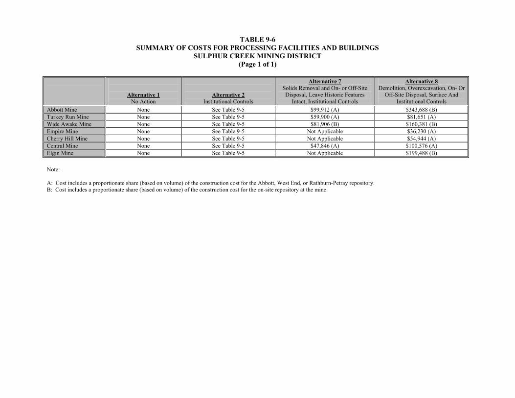
TABLE 9-6 SUMMARY OF COSTS FOR PROCESSING FACILITIES AND BUILDINGS
SULPHUR CREEK MINING DISTRICT (Page 1 of 1)
Alternative 1
No Action
Alternative 2 Institutional Controls
Alternative 7 Solids Removal and On- or Off-Site Disposal, Leave Historic Features
Intact, Institutional Controls
Alternative 8 Demolition, Overexcavation, On- Or
Off-Site Disposal, Surface And Institutional Controls
Abbott Mine None See Table 9-5 $99,912 (A) $343,688 (B) Turkey Run Mine None See Table 9-5 $59,900 (A) $81,651 (A) Wide Awake Mine None See Table 9-5 $81,906 (B) $160,381 (B) Empire Mine None See Table 9-5 Not Applicable $36,230 (A) Cherry Hill Mine None See Table 9-5 Not Applicable $54,944 (A) Central Mine None See Table 9-5 $47,846 (A) $100,576 (A) Elgin Mine None See Table 9-5 Not Applicable $199,488 (B)
Note: A: Cost includes a proportionate share (based on volume) of the construction cost for the Abbott, West End, or Rathburn-Petray repository. B: Cost includes a proportionate share (based on volume) of the construction cost for the on-site repository at the mine.

9-19
control of exposure to the contaminated materials, and no reduction in risk to human health or the
environment. Alternative 2 would not reduce mercury load in sediment, surface water, or groundwater.
Direct human and ecological exposure to contaminants in mobile sediment within the mine site perimeter
would be controlled; however, human and ecological contact with contaminants that are migrating off site
due to surface water erosion and leaching of contaminants from mobile sediment along stream banks and
floodplains to surface water and groundwater would still occur. Therefore, Alternative 2 would not
reduce mercury load or protect human health and the environment.
Alternative 9, in combination with Alternatives 5 or 6 (on- or off-site disposal), would reduce mercury
loading from and human and ecological ingestion, dermal contact, and inhalation exposure to
contaminated sediment within drainage swales, ditches, and creeks through excavation and disposal of
contaminated sediment. In addition, residual contaminated sediment mobility due to water erosion would
be controlled using instream and stream bank surface controls. Alternative 9 would not be implemented
for Sulphur Creek due to the enormous volume of potentially contaminated sediment contained within its
floodplain. Alternative 10 would reduce mercury loading and human and ecological ingestion, dermal
contact, and inhalation exposure to contaminated sediment within the Sulphur Creek floodplain through
the implementation of floodplain run-on and runoff and revegetation controls, channel bank stabilization
and restoration, and channel meander stabilization. Alternative 9 provides a higher level of mercury load
reduction than Alternative 10 due to the removal of leachable waste from the environment. Both
alternatives are protective of human health and the environment. A direct comparison between
Alternatives 9 and 10 was not conducted because the sources of contamination addressed by these
alternatives do not overlap.
Alternative 9, in conjunction with Alternatives 5 or 6, would comply with ARARs by reducing waste
mobility and loading, reducing waste exposure area, reducing the potential for leaching of metals into
groundwater, and isolating the contaminated materials from contact with potential receptors. Alternative
10 would comply with ARARs by reducing waste mobility and loading, reducing waste exposure area,
and stabilizing the creek channel to increase the isolation of contaminated materials from contact with
potential receptors. Alternative 10 does not address the interaction of shallow groundwater with
contaminated material; however, surface water and groundwater in the watershed is degraded by
hydrothermal water. Chemical-specific ARARs would not be met under Alternative 2 because release of
contaminants to surface water and groundwater would remain unchanged. Location- and action-specific
ARARs are expected to be met where applicable. No ARARs apply to Alternative 1.

9-20
Alternative 1 is the least expensive alternative at no cost, followed by Alternative 2, Alternative 9, and
Alternative 10. A cost comparison cannot be made between Alternatives 9 and 10 because each
alternative addresses different source areas. Specific costs for individual mines are presented in Table 9-7
and discussed in Section 9.2.
Comparative Analysis Summary for Hydrothermal Springs and Surface Water. Baseline conditions
at hydrothermal springs and in streams as represented by Alternative 1, the no action alternative, would
provide no reduction of mercury load, no control of exposure to the contaminated materials, and no
reduction in risk to human health or the environment. Mercury loading from hydrothermal springs and
associated chemical precipitates, and in surface water and stream sediment would be unchanged.
Alternative 2 would not reduce mercury load in surface water and sediment or prevent the mobilization of
chemical precipitates. Direct ecological receptor contact with contaminants in hydrothermal springs and
spring fed creeks in the District would be limited; however, ecological receptor contact with contaminants
that are migrating off site in surface water and sediment would still occur. Therefore, Alternative 2 would
not reduce mercury load or protect the environment.
Alternative 11 would reduce mercury loading from natural hydrothermal springs to the Harley Gulch and
Sulphur Creek watersheds and the threat of ecological ingestion and dermal contact exposure to metals in
natural hydrothermal spring water and associated precipitates through passive precipitation. Discharge
from the hydrothermal springs is naturally occurring; therefore, the threat of ecological exposure at the
springs is of secondary concern in comparison to reduction of metals loading to the watershed. Treatment
precipitate would be placed in an off-site permitted disposal facility.
Alternative 12 would further reduce mercury loading from natural hydrothermal springs to Harley Gulch
and Sulphur Creek watersheds and the threat of ecological ingestion and dermal contact exposure to
metals in natural hydrothermal spring water and associated precipitates through metals reduction and
precipitation. Alternative 12 would also remove excess sulfur from hydrothermal waters, which may be
necessary to reduce biotic methylation of mercury. Treatment precipitate would be placed in an off-site
permitted disposal facility. The anticipated load reduction by implementation of this alternative would be
greater than the anticipated load reduction by Alternative 11.
Alternative 13 would reduce mercury loading from the natural hydrothermal springs that feed Sulphur
Creek and the threat of ecological ingestion and dermal contact exposure to metals in surface water,
precipitates, and contaminated sediment through metals reduction, metals precipitation, and the

TABLE 9-7 SUMMARY OF COSTS FOR MOBILE SEDIMENT
SULPHUR CREEK MINING DISTRICT (Page 1 of 1)
Alternative 1
No Action
Alternative 2 Institutional Controls
Alternative 9
Excavate and On- or Off-Site Disposal, Institutional Controls
Alternative 10 Revegetate Floodplain to Reduce Sediment Runoff, Grade and Vegetate Stream Banks
to Stabilize Stream Channel Abbott Mine None See Table 9-5 $206,915 (B) Not Applicable Turkey Run Mine None See Table 9-5 $182,835 (A) Not Applicable Wide Awake Mine None See Table 9-5 $129,733 (B) Not Applicable West End Mine None See Table 9-5 $92,738 (B) Not Applicable Manzanita Mine None See Table 9-5 $2,258,636 (A) Not Applicable Rathburn-Petray Mine None See Table 9-5 $287,453 (B) Not Applicable Petray-North Mine None See Table 9-5 $184,449 (B) Not Applicable Sulphur Creek None See Table 9-5 Not Applicable $1,924,619
Note: A: Cost includes a proportionate share (based on volume) of the construction cost for the Abbott, West End, or Rathburn-Petray repository. B: Cost includes a proportionate share (based on volume) of the construction cost for the on-site repository at the mine.

9-22
capture of chemical precipitates and contaminated sediment in Sulphur Creek. Mine-related sources of
contaminated sediment will be controlled through implementation of mine-specific mitigation alternatives
described in Alternatives 3 through 9. Stabilization of contaminated sediment in the Sulphur Creek
floodplain (Alternative 10) will reduce the amount of sediment captured and requiring disposal. Captured
sediment and precipitates would be placed in an off-site permitted disposal facility. The anticipated load
reduction by implementation of this alternative would be greater than the anticipated load reduction by
Alternative 14 (aeration only), but less than Alternative 15 (multiple ZVI and aeration steps).
Alternative 14 would reduce mercury loading from Blank Spring (natural hydrothermal) and the natural
hydrothermal springs that feed Sulphur Creek and the threat of ecological ingestion and dermal contact
exposure to metals in natural hydrothermal spring water, spring water precipitates, and contaminated
sediment through capture of chemical precipitates and contaminated sediment in Sulphur Creek and the
Blank Spring tributary. However, Alternative 14 does not reduce sulfate loading to, or the potential for
biotic methylation of mercury, in Sulphur Creek. Mine-related sources of contaminated sediment will be
controlled through implementation of mine-specific mitigation alternatives described in Alternatives 3
through 9. Stabilization of contaminated sediment in the Sulphur Creek floodplain (Alternative 10) will
reduce the amount of sediment captured and requiring disposal. Captured sediment and precipitates
would be placed in an off-site permitted disposal facility. The anticipated load reduction by
implementation of this alternative would be less than the anticipated load reduction by Alternative 13
(ZVI and aeration) and Alternative 15 (multiple ZVI and aeration steps).
Alternative 15 would further reduce loading of mercury and sulfate from Blank Spring (natural
hydrothermal) and the natural hydrothermal springs that feed Sulphur Creek and the mobility of
precipitate and contaminated sediment in Sulphur Creek and the Blank Spring tributary using multiple
ZVI reactors, longer in stream contact and settling time, and additional dams to capture contaminated
sediment. Alternative 15 would also reduce the threat of ecological ingestion and dermal contact
exposure to metals in natural hydrothermal spring water, spring water precipitates, and contaminated
sediment. Mine-related sources of contaminated sediment will be controlled through implementation of
mine-specific mitigation alternatives described in Alternatives 3 through 9. Stabilization of contaminated
sediment in the Sulphur Creek floodplain (Alternative 10) will reduce the amount of sediment captured
and requiring disposal. Captured sediment and precipitates would be placed in an off-site permitted
disposal facility. The anticipated load reduction by implementation of this alternative would be greater
than the anticipated load reduction by Alternative 14 (aeration only) and Alternative 13 (single step ZVI
and aeration).

9-23
Chemical-specific ARARs are not applicable. However, the total load of mercury and sulfate discharging
from Blank Spring and spring fed Sulphur Creek will be reduced in support of the on-going development
of the mercury TMDL for the Cache Creek watershed. Alternative 15 would offer the greatest load
reduction for Sulphur Creek and Alternative 12 would offer the greatest load reduction for off-stream
hydrothermal springs. Alternatives 11, 13, and 14 would each also offer substantial load reductions.
Load reduction goal would not be met under Alternative 2 because contaminant concentration in surface
water would remain unchanged. Location- and action-specific ARARs are expected to be met where
applicable. No ARARs apply to Alternative 1.
Alternative 1 is the least expensive alternative at no cost, followed by Alternative 2, Alternative 11, and
Alternative 12 for hydrothermal springs. Alternative 1 is the least expensive alternative at no cost,
followed by Alternative 2, Alternative 14, Alternative 13, and Alternative 15 for spring fed Sulphur
Creek. The need for successively more complicated and costly alternatives would be determined after
treatability studies have been conducted to assess the effectiveness of each technology type at reducing
contaminant loads in each spring and creek. Specific costs for individual hydrothermal springs and spring
fed Sulphur Creek are presented in Table 9-8 and discussed in Section 9.2.
9.2 SUMMARY OF MINE-SPECIFIC FINDINGS
This section provides a summary of findings based on the comparative analysis of mitigation alternatives
for each mine. The summary of findings evaluates the need for mercury load reduction, the anticipated
load reduction for each mitigation alternative, and the most appropriate mitigation alternative for each
media. At those sites where the potential for load reduction is low and the waste at the mine does not
pose a human health or ecological threat, no action has been recommended. A comparison of costs for
each mitigation alternative is presented for solid media, processing facilities and buildings, mobile
sediment, and surface and hydrothermal waters in Tables 9-5, 9-6, 9-7, and 9-8, respectively. The
summary of findings will be used to develop mitigation strategies (see Section 9.3) that can be used to
reduce mine-specific contaminant loads (if warranted).
9.2.1 Abbott Mine
Contaminated media at Abbott Mine include waste rock, tailings, tailings covered roads, mine cuts, waste
around the perimeter of and within processing facilities, and contaminated sediment within drainage

TABLE 9-8 SUMMARY OF COSTS FOR SURFACE AND HYDROTHERMAL WATERS
SULPHUR CREEK MINING DISTRICT (Page 1 of 1)
Alternative 1 No Action
Alternative 2 Institutional Controls
Alternative 11 Diversion, Passive Precipitation,
Optional Aeration, Institutional Controls
Alternative 12
Diversion, Passive Zero Valence Iron Reactor and Precipitation, Optional
Aeration, Institutional Controls
Alternative 13
In Channel Flashboard Dam, Off Stream Passive Zero Valence Iron
Reactor, Aeration, and Precipitation
Alternative 14 In Channel Flashboard Dams Integral Aeration Structures
Alternative 15 Sequences of In Channel
Flashboard Dams with Integral Passive Zero Valence Iron Reactors
or Aeration Screens Turkey Run Spring None See Table 9-5 $197,036 $937,499 Not Applicable Not Applicable Not Applicable Blank Spring None See Table 9-5 $322,845 $918,216 Not Applicable $303,905 $822,839 Elgin Springs None See Table 9-5 $490,966 $2,629,248 Not Applicable Not Applicable Not Applicable Sulphur Creek None See Table 9-5 Not Applicable Not Applicable $9,275,973 $938,070 $10,960,888

9-25
swales, ditches, and Harley Gulch. Approximately 18 ton/yr of sediment is estimated to erode from the
174,000 CY of mine waste located immediately adjacent to and within Harley Gulch. The estimated
mercury load from Abbott Mine is 0.8 to 3.5 kg/yr or 34.3 % of the total mine related mercury load of 1.2
to 10.2 kg/yr to Harley Gulch. Abbott Mine contributes 12.2 % of the mine related mercury load from the
SCMD.
Mercury concentrations detected in mine waste at Abbott Mine exceed both human health and ecological
PMGs; ranging from 10 to 1,530 mg/kg at a mean concentration of 189 mg/kg (n=21). Therefore,
implementation of mitigation alternatives at Abbott Mine must also address risk reduction over the long
term. CBDA may implement an interim mitigation action to reduce mercury loading that does not attain
PMGs over the short term but that is consistent with attainment of PMGs over the long term. If CBDA
implements the final mitigation action at Abbott Mine, then the mitigation alternative must attain PMGs.
Mine waste adjacent to the mill at Abbott Mine was found to leach mercury at a concentration exceeding
its STLC value; therefore, the waste is considered a Group B mine waste. A Group B mine waste must be
managed to reduce the generation and migration of leachate to surface water and groundwater.
Groundwater beneath Abbott Mine is hydrothermal and not suitable for consumption. Harley Gulch is
ephemeral and is not considered to be a source of drinking water; however, Harley Gulch provides habitat
for aquatic plants, insects, and presumably other fauna. Therefore, implementation of the final mitigation
action at Abbott Mine must control the generation and migration of leachate to Harley Gulch.
Mitigation of mercury loading is warranted due to the very large volume (174,000 CY) of mine waste
located immediately adjacent to and within Harley Gulch, the large volume (18 ton/yr) of sediment
estimated to erode from the mine, the instability of the waste slope above Harley Gulch, the large surface
area of eroding mine cuts and tailings-covered roads in the upper area of the site, exceedence of human
health and ecological PMGs, and the potential for generation and migration of leachate containing
mercury to Harley Gulch. A comparative analysis of mitigation alternatives for reduction of mercury
loading to Harley Gulch is presented below by contaminated medium. The ability of each mitigation
alternative to reduce risk, reduce leachate generation and migration, attain PMGs, and meet regulatory
requirements is also evaluated.
Solids. Alternative 5 (excavation and on-site repository) provides the highest level of mercury load
reduction and greatest protection of human health and the environment, compliance with ARARs, long-
term effectiveness and permanence, reduction in mobility, and short-term effectiveness. Alternative 3

9-26
(surface and institutional controls) provides a moderate level of mercury load reduction, though the threat
of human and ecological exposure due to on-site ingestion of waste material, dermal contact with waste,
and inhalation of dust containing mine waste would remain. Reduction of mercury loading, mobility, and
long-term protection of human health and the environment by Alternative 3 is considered to be less than
Alternative 5 because the waste is not covered, allowing infiltration and leachate generation. Alternative
3 would not meet ARARs over the long-term because leaching of waste and release of leachate to
groundwater and surface water is not controlled. In addition, the permanence of surface controls alone
(Alternative 3) for reducing waste migration to surface water is highly dependent on maintenance
activities. Alternative 3 would be appropriate as an interim measure, while implementation of Alternative
5 would be considered a final action.
Alternative 2 (institutional controls) would not reduce mercury loading, but would inhibit direct human
and ecological exposure to contaminants and physical hazards at Abbott Mine by limiting access.
Alternative 2 would allow off-site migration of and human and ecological contact with contaminants due
to surface water and wind erosion, and leaching of and human and ecological contact with contaminants
to surface water and groundwater from mine waste. Therefore, Alternative 2 should not be considered for
an interim or final action as it does not reduce mercury loading, is not considered protective of human
health and the environment, and does not meet ARARs. Alternative 1 (no action) would provide no
reduction of mercury loading or risk to human health or the environment.
Alternative 4 (Containment) is not applicable at Abbott Mine because of the over steep tailings and waste
rock slopes. Alternative 6 (excavation and off-site repository) is not applicable at Abbott Mine because
of the prohibitive cost of hauling waste to an off-site repository. Instead, the smaller volume of mine
waste from the Turkey Run Mine would be hauled to the proposed on-site repository (Alternative 5) as
part of a final action.
Processing Facilities and Buildings. Alternative 8, in combination with Alternative 5 (on-site disposal),
provides the highest level of mercury load reduction and the greatest protection of human health and the
environment, compliance with ARARs, long-term effectiveness and permanence, reduction in mobility,
and short-term effectiveness. Alternative 7, in combination with Alternative 5 (on-site disposal), would
provide a moderate level of mercury load reduction. Mercury load reduction and protection of human
health and the environment under Alternative 8 is greater than Alternative 7 because all of the waste
(inside and outside buildings) is excavated and isolated from the environment. Alternative 8 is also more
protective because all exposure pathways have been eliminated, while Alternative 7 relies on fencing to

9-27
reduce exposure to waste and physical hazards inside of buildings. At Abbott Mine, Alternative 8 would
not likely be implemented because the mine’s facilities may be considered to be of historical or cultural
value. However, removal of waste from the facility perimeter could be conducted as described under
Alternative 7. Either alternative would be appropriate as an interim measure or final action; however,
implementation of Alternative 5 would be required as part of either action. The overall contribution of
load reduction from waste around the perimeter mine facilities is negligible in comparison to the volume
of waste at the site as a whole; therefore, mitigation should only be considered as part of site risk
reduction under the final action at Abbott Mine.
Alternative 2 (institutional controls) would not reduce mercury loading, but would inhibit direct human
and ecological exposure to contaminants and physical hazards contained inside of and around the
perimeter of processing facilities and buildings at Abbott Mine by limiting access. Alternative 2 would
allow off-site migration of and human and ecological contact with contaminants due to surface water and
wind erosion, and leaching of and human and ecological contact with contaminants to surface water and
groundwater from mine waste within and around the perimeter of mine facilities. Therefore, Alternative
2 should not be considered for an interim or final action as it does not reduce mercury loading, is not
considered protective of human health and the environment, and does not meet ARARs. Alternative 1 (no
action) would provide no reduction of mercury loading or risk to human health or the environment.
Mobile Sediment. Alternative 9 (excavation and on-site placement or disposal) provides the highest
level of mercury load reduction and the greatest protection of human health and the environment,
compliance with ARARs, long-term effectiveness and permanence, reduction in mobility, and short-term
effectiveness. Alternative 9 provides mercury load reduction and protection of human health and the
environment through removal of contaminated sediment from drainage swales, ditches, and creeks and
placement of the waste in isolated area or repository. If the excavated waste is found to be leachable, then
the final action must encapsulate the waste in an on-site Group B waste repository. Alternative 9 would
be appropriate as an interim measure or final action; however, a location for on-site placement of
excavated sediment would be would be required as part of the interim action.
Alternative 2 (institutional controls) would not reduce mercury loading, but would inhibit direct human
and ecological exposure to contaminants in mobile sediment within the mine perimeter by limiting access.
Alternative 2 would allow off-site migration of and human and ecological contact with contaminants due
to surface water erosion, and leaching of contaminants from mobile sediment along stream banks to
surface water and groundwater. Therefore, Alternative 2 should not be considered for an interim or final

9-28
action as it does not reduce mercury loading, is not considered protective of human health and the
environment, and does not meet ARARs. Alternative 1 (no action) would provide no reduction of
mercury loading or risk to human health or the environment.
9.2.2 Turkey Run Mine
Contaminated media at Turkey Run Mine include exposed cuts, waste rock, ore, tailings covered roads,
waste around the perimeter of the ore bins, and contaminated sediment within drainage swales, ditches,
and a tributary to Harley Gulch. Approximately 33 ton/yr of sediment is estimated to erode from the
13,000 CY of mine waste located immediately adjacent to and within a tributary to Harley Gulch. The
estimated mercury load from Turkey Run Mine is 0.42 to 6.7 kg/yr or 65.7 % of the total mine related
mercury load of 1.2 to 10.2 kg/yr to Harley Gulch. Turkey Run Mine contributes 23.3 % of the mine
related mercury load from the SCMD.
Mercury concentrations detected in mine waste at Turkey Run Mine exceed both human health and
ecological PMGs; ranging from 20 to 1,720 mg/kg at a mean concentration of 570 mg/kg (n=8).
Therefore, implementation of mitigation alternatives at Turkey Run Mine must also address risk reduction
over the long term. The property owner and other stakeholders may implement an interim mitigation
action to reduce mercury loading that does not attain PMGs over the short term but that is consistent with
attainment of PMGs over the long term. If the property owner and other stakeholders implements the
final mitigation action at Abbott Mine, then the mitigation alternative must attain PMGs.
Mine waste at Turkey Run Mine was not found to leach mercury at a concentration exceeding its STLC
value; therefore, the waste is considered a Group C mine waste. A Group C mine waste does not require
control of the generation and migration of leachate to surface water and groundwater. Therefore,
implementation of the final mitigation action at Turkey Run Mine does not require control the generation
and migration of leachate to the tributary to Harley Gulch.
Mitigation of mercury loading is warranted due to the moderate volume (13,000 CY) of mine waste
located immediately adjacent to and within a tributary to Harley Gulch, the large volume (33 ton/yr) of
sediment estimated to erode from the mine, downcutting of the Harley Gulch tributary into mine waste,
the large surface area of eroding mine cuts and tailings-covered roads in the upper area of the site, and
exceedence of human health and ecological PMGs. A comparative analysis of mitigation alternatives for
reduction of mercury loading to Harley Gulch is presented below by contaminated medium. The ability of

9-29
each mitigation alternative to reduce risk, attain PMGs, and meet regulatory requirements is also
evaluated.
Solids. Alternative 6 (excavation and off-site repository) provides the highest level of mercury load
reduction and the greatest protection of human health and the environment, compliance with ARARs,
long-term effectiveness and permanence, reduction in mobility, and short-term effectiveness. Alternative
6 provides additional protection over Alternative 4 because the waste from Turkey Run Mine is
consolidated with other mine waste in the Abbott Mine Group B mine waste repository and is isolated
from the environment. Alternative 6 would provide additional protection over Alternative 4 through
encapsulation of mine waste in an off-site repository. Surface water and groundwater quality would not
be degraded because the mine waste is encapsulated. Alternative 4 would provide additional load
reduction and protection over Alternative 3 (surface controls) by eliminating the threat of human health
and ecological exposure to contaminants by consolidating and covering the waste. Alternative 3 (surface
and institutional controls) provides a moderate level of mercury load reduction, though the threat of
human and ecological exposure due to on-site ingestion of waste material and dermal contact with waste
would remain.
Chemical-specific ARARs would be met under Alternatives 4 and 6 though control of on-site ingestion of
waste material, dermal contact with waste, and inhalation of dust. Alternative 3 does not meet ARARs
because human and ecological contact with the waste is not controlled. In addition, the permanence of
surface controls alone (Alternative 3) for reducing waste migration to surface water is highly dependent
on maintenance activities. Alternative 3 would be appropriate as an interim measure, while
implementation of Alternatives 4 or 6 would be considered a final action.
Alternative 2 (institutional controls) would not reduce mercury loading, but would inhibit direct human
health and ecological exposure to contaminants and physical hazards at Turkey Run Mine by limiting
access. Alternative 2 would allow off-site migration of and human and ecological contact with
contaminants due to surface water and wind erosion. Therefore, Alternative 2 should not be considered
for an interim or final action as it does not reduce mercury loading, is not considered protective of human
health and the environment, and does not meet ARARs. Alternative 1 (no action) would provide no
reduction of mercury loading or risk to human or ecological receptors.
Alternative 5 (excavation and on-site repository) is not applicable at Turkey Run Mine because of
insufficient space to construct an on-site repository.

9-30
Processing Facilities and Buildings. Alternative 8, in combination with Alternative 6 (off-site disposal),
provides the highest level of mercury load reduction and the greatest protection of human health and the
environment, compliance with ARARs, long-term effectiveness and permanence, reduction in mobility,
and short-term effectiveness. Alternative 7, in combination with Alternative 6 (off-site disposal), would
provide a moderate level of mercury load reduction. Mercury load reduction and protection of human
health and the environment under Alternative 8 is greater than Alternative 7 because all of the waste
(inside and outside of the ore bin) is excavated and isolated from the environment. Alternative 8 is also
more protective because all exposure pathways have been eliminated, while Alternative 7 relies on
fencing to reduce exposure to waste and physical hazards at the ore bin. At Turkey Run Mine,
Alternative 8 could be implemented because the mine’s structures would not likely be considered to be of
historical, cultural, and archeological value. Alternative 8 would be appropriate as an interim measure or
final action; however, implementation of Alternative 6 would be required as part of either action. The
overall contribution of load reduction from waste within and around the perimeter of the ore bin is
negligible in comparison to the volume of waste at the site as a whole; therefore, mitigation should only
be considered as part of site risk reduction under the final action at Turkey Run Mine.
Alternative 2 (institutional controls) would not reduce mercury loading, but would inhibit direct human
and ecological exposure to contaminants and physical hazards contained inside of and around the
perimeter of processing facilities and buildings at Turkey Run Mine by limiting access. Alternative 2
would allow off-site migration of and human and ecological contact with contaminants due to surface
water and wind erosion of mine waste within and around the perimeter of the ore bin. Therefore,
Alternative 2 should not be considered for an interim or final action as it does not reduce mercury
loading, is not considered protective of human health and the environment, and does not meet ARARs.
Alternative 1 (no action) would provide no reduction of mercury loading or risk to human health or the
environment.
Mobile Sediment. Alternative 9 (excavation and on-site placement or off-site disposal) provides the
highest level of mercury load reduction and the greatest protection of human health and the environment,
compliance with ARARs, long-term effectiveness and permanence, reduction in mobility, and short-term
effectiveness. Alternative 9 provides mercury load reduction and protection of human health and the
environment through removal of contaminated sediment from drainage swales, ditches, and creeks and
placement of the waste in isolated area or repository. If the excavated waste is found to be leachable, then
the final action must encapsulate the waste in the Abbott Mine Group B waste repository. Alternative 9

9-31
would be appropriate as an interim measure or final action; however, a location for on-site placement of
excavated sediment would be would be required as part of the interim action.
Alternative 2 (institutional controls) would not reduce mercury loading, but would inhibit direct human
and ecological exposure to contaminants in mobile sediment within the mine perimeter by limiting access.
Alternative 2 would allow off-site migration of and human and ecological contact with contaminants due
to surface water erosion, and leaching of contaminants from mobile sediment along stream banks to
surface water and groundwater. Therefore, Alternative 2 should not be considered for an interim or final
action as it does not reduce mercury loading, is not considered protective of human health and the
environment, and does not meet ARARs. Alternative 1 (no action) would provide no reduction of
mercury loading or risk to human health or the environment.
9.2.3 Wide Awake Mine
Contaminated media at Wide Awake Mine include mine cuts, waste rock, tailings, waste around the
perimeter of and within processing facilities, and contaminated sediment within drainage swales, ditches,
and a tributary to Sulphur Creek. Approximately 8 ton/yr of sediment is estimated to erode from the
8,800 CY of mine waste located immediately adjacent to and within the tributary to Sulphur Creek. The
estimated mercury load from Wide Awake Mine is 0.02 to 0.44 kg/yr or 2.4 % of the total mine related
mercury load of 4.4 to 18.6 kg/yr to Sulphur Creek. Wide Awake Mine contributes 1.53 % of the mine
related mercury load from the SCMD.
Mercury concentrations detected in mine waste at Wide Awake Mine exceed both human health and
ecological PMGs; ranging from 50 to 1,040 mg/kg at a mean concentration of 175 mg/kg (n=12).
Therefore, implementation of mitigation alternatives at Wide Awake Mine must also address risk
reduction over the long term. The property owner and other stakeholders may implement an interim
mitigation action to reduce mercury loading that does not attain PMGs over the short term but that is
consistent with attainment of PMGs over the long term. If the property owner and other stakeholders
implements the final mitigation action at Wide Awake Mine, then the mitigation alternative must attain
PMGs.
Mine waste at Wide Awake Mine was not found to leach mercury at a concentration exceeding its STLC
value; therefore, the waste is considered a Group C mine waste. A Group C mine waste does not require
control of the generation and migration of leachate to surface water and groundwater. Therefore,

9-32
implementation of the final mitigation action at Wide Awake Mine does not require control the generation
and migration of leachate to the tributary to Sulphur Creek.
Mitigation of mercury loading using an interim action is not warranted due to the anticipated small load
reduction. However, a final action may be required to address elevated human health and ecological risk
associated with contaminants in the moderate volume (8,800 CY) of mine waste located immediately
adjacent to and within a tributary to Sulphur Creek and the waste rock eroding from the mine cuts.
Because the scope of and decision to implement mitigation alternatives at Wide Awake Mine will be
made by the property owner in conjunction with The property owner and other stakeholders and other
stakeholders, a comparative analysis of mitigation alternatives for reduction of mercury loading to the
tributary to Sulphur Creek is presented below by contaminated medium. The ability of each mitigation
alternative to reduce risk, attain PMGs, and meet regulatory requirements is also evaluated.
Solids. Alternative 5 (excavation and on-site repository) provides the highest level of mercury load
reduction and the greatest protection of human health and the environment, compliance with ARARs,
long-term effectiveness and permanence, reduction in mobility, and short-term effectiveness. Alternative
5 would provide additional protection over Alternative 4 through encapsulation of mine waste in an on-
site repository. However, Alternative 5 may not be required because mercury in mine waste leachate is
below the STLC. Surface water and groundwater quality would not be degraded because the mine waste
is encapsulated. Alternative 4 would provide additional load reduction and protection over Alternative 3
(surface and institutional controls) by eliminating the threat of human health and ecological exposure to
contaminants by consolidating and covering the waste. Alternative 3 provides a moderate level of
mercury load reduction, though the threat of human and ecological exposure due to on-site ingestion of
waste material, dermal contact with waste, and inhalation of dust containing mine waste would remain.
Reduction of mercury loading, mobility, and long-term protection of human health and the environment
by Alternative 3 is considered to be less than Alternative 4 because the waste is not covered.
Chemical-specific ARARs would be met under Alternatives 4 and 5 though control of on-site ingestion of
waste material, dermal contact with waste, and inhalation of dust. Alternative 3 would not meet ARARs
over the long-term because human and ecological contact with the waste is not controlled. In addition,
the permanence of surface controls alone (Alternative 3) for reducing waste migration to surface water is
highly dependent on maintenance activities. Alternative 3 would be appropriate as an interim measure,
while implementation of Alternatives 4 or 5 would be considered a final action.

9-33
Alternative 2 (institutional controls) would not reduce mercury loading, but would inhibit direct human
and ecological exposure to contaminants and physical hazards at Wide Awake Mine by limiting access.
Alternative 2 would allow off-site migration of and human and ecological contact with contaminants due
to surface water and wind erosion, and leaching of and human and ecological contact with contaminants
to surface water and groundwater from mine waste. Therefore, Alternative 2 should not be considered for
an interim or final action as it does not reduce mercury loading, is not considered protective of human
health and the environment, and does not meet ARARs. Alternative 1 (no action) would provide no
reduction of mercury loading or risk to human health or the environment.
Alternative 6 (excavation and off-site repository) is not applicable at Wide Awake Mine because of
property ownership and liability issues.
Processing Facilities and Buildings. Alternative 8, in combination with Alternative 5 (on-site disposal),
provides the highest level of mercury load reduction and the greatest protection of human health and the
environment, compliance with ARARs, long-term effectiveness and permanence, reduction in mobility,
and short-term effectiveness. Alternative 7, in combination with Alternative 5 (on-site disposal), would
provide a moderate level of mercury load reduction. Mercury load reduction and protection of human
health and the environment under Alternative 8 is greater than Alternative 7 because all of the waste
(inside and outside buildings and processing equipment) is excavated and isolated from the environment.
Alternative 8 is also more protective because all exposure pathways have been eliminated, while
Alternative 7 relies on fencing to reduce exposure to waste and physical hazards inside of buildings and
around processing equipment. At Wide Awake Mine, Alternative 8 would not likely be implemented
because the mine’s buildings and processing equipment may be considered to be of historical or cultural
value. However, removal of waste from the building and processing equipment perimeters could be
conducted as described under Alternative 7. Either alternative would be appropriate as an interim
measure or final action; however, implementation of Alternative 5 would be required as part of either
action. The overall contribution of load reduction from waste around the perimeter mine facilities and
processing equipment is negligible in comparison to the volume of waste at the site as a whole; therefore,
mitigation should only be considered as part of site risk reduction under the final action at Wide Awake
Mine.
Alternative 2 (institutional controls) would not reduce mercury loading, but would inhibit direct human
and ecological exposure to contaminants and physical hazards contained inside of and around the
perimeter of buildings and processing equipment at Wide Awake Mine by limiting access. Alternative 2

9-34
would allow off-site migration of and human and ecological contact with contaminants due to surface
water and wind erosion of waste within and around the perimeter of buildings and processing equipment.
Therefore, Alternative 2 should not be considered for an interim or final action as it does not reduce
mercury loading, is not considered protective of human health and the environment, and does not meet
ARARs. Alternative 1 (no action) would provide no reduction of mercury loading or risk to human
health or the environment.
Mobile Sediment. Alternative 9 (excavation and on-site placement) provides the highest level of
mercury load reduction and the greatest protection of human health and the environment, compliance with
ARARs, long-term effectiveness and permanence, reduction in mobility, and short-term effectiveness.
Alternative 9 provides mercury load reduction and protection of human health and the environment
through removal of contaminated sediment from the tributary adjacent to and below the Wide Awake
Mine and placement of the waste in isolated area or repository. If the excavated waste is found to be
leachable, then the final action must encapsulate the waste in an on-site Group B waste repository.
Alternative 9 would be appropriate as an interim measure or final action; however, a location for on-site
placement of excavated sediment would be would be required as part of the interim action.
Alternative 2 (institutional controls) would not reduce mercury loading, but would inhibit direct human
and ecological exposure to contaminants in mobile sediment within the mine perimeter by limiting access.
Alternative 2 would allow off-site migration of and human and ecological contact with contaminants due
to surface water erosion, and leaching of contaminants from mobile sediment along stream banks to
surface water and groundwater. Therefore, Alternative 2 should not be considered for an interim or final
action as it does not reduce mercury loading, is not considered protective of human health and the
environment, and does not meet ARARs. Alternative 1 (no action) would provide no reduction of
mercury loading or risk to human health or the environment.
9.2.4 Empire Mine
Contaminated media at Empire Mine includes waste around the perimeter of and within a retort.
Approximately 0.41 ton/yr of sediment is estimated to erode from the retort area located 100 feet above
and 450 feet away from Sulphur Creek. The estimated mercury load from Empire Mine is 0.04 to 0.06
kg/yr or 0.32 % of the total mine related mercury load of 4.4 to 18.6 kg/yr to Sulphur Creek. Empire
Mine contributes 0.21 % of the mine related mercury load from the SCMD.

9-35
Mercury concentrations detected in mine waste at Empire Mine exceed the ecological PMG; ranging from
56.4 to 150 mg/kg at a mean concentration of 103 mg/kg (n=2). Therefore, implementation of mitigation
alternatives at Empire Mine must also address ecological risk reduction over the long term. The property
owner and other stakeholders may implement an interim mitigation action to reduce mercury loading that
does not attain the ecological PMG over the short term but that is consistent with attainment of the
ecological PMG over the long term. If the property owner and other stakeholders implements the final
mitigation action at Empire Mine, then the mitigation alternative must attain the ecological PMG.
It is not known if mine waste at Empire Mine leaches mercury at a concentration exceeding its STLC
value; however, given the low concentration of total mercury the waste should be considered a Group C
mine waste. A Group C mine waste does not require control of the generation and migration of leachate
to surface water and groundwater. In addition, groundwater beneath Empire Mine is hydrothermal and
surface water in Sulphur Creek is dominated by hydrothermal springs both of which are not of sufficient
quality to serve as a source for drinking water. Therefore, implementation of the final mitigation action at
Empire Mine does not require control the generation and migration of leachate to Sulphur Creek.
Mitigation of mercury loading using an interim action is not warranted due to the anticipated small load
reduction. However, a final action may be required to address ecological risk associated with
contaminants in and around the perimeter of the old furnace/retort located above Sulphur Creek. Because
the scope of and decision to implement mitigation alternatives at Empire Mine will be made by the
property owner in conjunction with CBDA and other stakeholders, a comparative analysis of mitigation
alternatives for reduction of mercury loading to Sulphur Creek is presented below. The ability of each
mitigation alternative to reduce risk, attain PMGs, and meet regulatory requirements is also evaluated.
Processing Facilities and Buildings. Alternative 8, in combination with Alternative 6 (off-site disposal),
provides the highest level of mercury load reduction and the greatest protection of the environment,
compliance with ARARs, long-term effectiveness and permanence, reduction in mobility, and short-term
effectiveness. Mercury load reduction and protection of the environment under Alternative 8 is greater
than Alternative 2 (institutional controls) because all of the waste (inside and outside of the retort) is
excavated and isolated from the environment. Alternative 8 is also more protective because all exposure
pathways have been eliminated, while Alternative 2 relies on fencing to reduce direct ecological exposure
to contaminants. Alternative 2 would allow off-site migration of and ecological contact with
contaminants due to surface water and wind erosion of waste within and around the perimeter of the
retort. At Empire Mine, Alternative 8 could be implemented because the retort would not likely be

9-36
considered to be of historical, cultural, and archeological value. Alternative 8 would be appropriate as an
interim measure or final action; however, implementation of Alternative 6 would be required as part of
either action. The overall contribution of load reduction from waste within and around the perimeter of
the retort is negligible in comparison to the volume of waste at the site as a whole; therefore, mitigation
should only be considered as part of site risk reduction under the final action at Empire Mine.
Alternative 1 (no action) would provide no reduction of mercury loading or risk to ecological receptors.
9.2.5 Cherry Hill Mine
Contaminated media at Cherry Hill Mine include waste rock and waste around the perimeter of the old
gold mill foundation. Approximately 9 ton/yr of sediment is estimated to erode from the site and the 609
CY of mine waste located on the floodplain immediately adjacent to Sulphur Creek. The estimated
mercury load from Cherry Hill Mine is up to 1 kg/yr or 5.4 % of the total mine related mercury load 4.4 to
18.6 kg/yr to Sulphur Creek. Cherry Hill Mine contributes 3.47 % of the mine related mercury load from
the SCMD.
Mercury concentrations detected in mine waste at Cherry Hill Mine exceed the ecological PMG; ranging
from 47.2 to 280 mg/kg at a mean concentration of 182 mg/kg (n=3). Therefore, implementation of
mitigation alternatives at Cherry Hill Mine must also address risk reduction over the long term. The
property owner and other stakeholders may implement an interim mitigation action to reduce mercury
loading that does not attain PMGs over the short term but that is consistent with attainment of PMGs over
the long term. If the property owner and other stakeholders implements the final mitigation action at
Cherry Hill Mine, then the mitigation alternative must attain PMGs.
The waste rock located on the floodplain immediately adjacent to Sulphur Creek was found to leach
mercury at a concentration exceeding its STLC value; therefore, the waste is considered a Group B mine
waste. A Group B mine waste must be managed to reduce the generation and migration of leachate to
surface water and groundwater. Groundwater beneath Cherry Hill Mine is hydrothermal and not suitable
for consumption. Water quality in Sulphur Creek is dominated by hydrothermal springs and is not of
sufficient quality to serve as a source for drinking water. However, Sulphur Creek is a perennial stream
that provides habitat for aquatic plants, insects and other fauna. Concentrations of solutes in Sulfur Creek
should not exceed the ambient concentrations from hydrothermal sources. Therefore, implementation of

9-37
the final mitigation action at Cherry Hill Mine must control the generation and migration of leachate from
the waste rock pile to Sulphur Creek.
Mitigation of mercury loading is warranted due to the proximity of waste rock to Sulphur Creek,
exceedence of the ecological PMG, and the potential for generation and migration of leachate containing
mercury to Sulphur Creek. A comparative analysis of mitigation alternatives for reduction of mercury
loading to Sulphur Creek is presented below by contaminated medium. The ability of each mitigation
alternative to reduce risk, reduce leachate generation and migration, attain PMGs, and meet regulatory
requirements is also evaluated.
Solids. Alternative 6 (excavation and off-site repository) provides the highest level of mercury load
reduction and the greatest protection of the environment, compliance with ARARs, long-term
effectiveness and permanence, reduction in mobility, and short-term effectiveness. Alternative 6 provides
additional protection over all other alternatives because the waste from Cherry Hill Mine is consolidated
with other mine waste in the West End Mine Group B mine waste repository and is isolated from the
environment. Alternative 3 (surface and institutional controls) is not applicable for the Cherry Hill Mine
because contaminant mobility from the waste rock (high leaching potential) cannot be controlled using
surface controls alone. Alternative 4 (Containment) is not applicable at Cherry Hill Mine because the
waste rock is located on top of the Sulphur Creek floodplain and the high leaching potential of the waste
rock. Alternative 5 (excavation and on-site repository) is not applicable at Cherry Hill Mine because of
proximity to Sulphur Creek, insufficient space to construct an on-site repository out of the floodplain, and
the volume of waste present is too small to justify repository construction. Alternative 6 would be
appropriate as either an interim or final action; however, construction of a Group B mine waste repository
at West End Mine would be required prior to implementation of Alternative 6.
Alternative 2 (institutional controls) would not reduce mercury loading, but would inhibit direct
ecological exposure to contaminants and physical hazards at Cherry Hill Mine by limiting access.
Alternative 2 would allow off-site migration of and ecological contact with contaminants due to surface
water and wind erosion, and leaching of and ecological contact with contaminants to surface water and
groundwater from mine waste. Therefore, Alternative 2 should not be considered for an interim or final
action as it does not reduce mercury loading, is not considered protective of the environment, and does
not meet ARARs. Alternative 1 (no action) would provide no reduction of mercury loading or risk to
human health or the environment.

9-38
Processing Facilities and Buildings. Alternative 8, in combination with Alternative 6 (off-site disposal),
provides the highest level of mercury load reduction and the greatest protection of the environment,
compliance with ARARs, long-term effectiveness and permanence, reduction in mobility, and short-term
effectiveness. Mercury load reduction and protection of the environment under Alternative 8 is greater
than Alternative 2 (institutional controls) because all of the waste (around the old mill foundation) is
excavated and isolated from the environment. Alternative 8 is also more protective because all exposure
pathways have been eliminated, while Alternative 2 relies on fencing to reduce direct ecological exposure
to contaminants. Alternative 2 would allow off-site migration of and ecological contact with
contaminants due to surface water and wind erosion of waste around the perimeter of the old mill
foundation. At Cherry Hill Mine, Alternative 8 could be implemented because the old mill foundation
would not likely be considered to be of historical, cultural, and archeological value. Alternative 8 would
be appropriate as an interim measure or final action; however, implementation of Alternative 6 would be
required as part of either action. The overall contribution of load reduction from waste within and around
the perimeter of the old mill foundation is negligible in comparison to the volume of waste at the site as a
whole; therefore, mitigation should only be considered as part of site risk reduction under the final action
at Cherry Hill Mine.
Alternative 1 (no action) would provide no reduction of mercury loading or risk to ecological receptors.
9.2.6 West End Mine
Contaminated media at West End Mine include waste rock and contaminated sediment within Sulphur
Creek. Approximately 1.77 ton/yr of sediment is estimated to erode from the 3,600 CY of mine waste
located immediately adjacent to and within Sulphur Creek. The estimated mercury load from West End
Mine is 0.002 to 1.1 kg/yr or 5.9 % of the total mine related mercury load of 4.4 to 18.6 kg/yr to Sulphur
Creek. West End Mine contributes 3.82 % of the mine related mercury load from the SCMD.
Mercury concentrations detected in mine waste at West End Mine exceed the ecological PMG; ranging
from 290 to 300 mg/kg at a mean concentration of 295 mg/kg (n=2). Therefore, implementation of
mitigation alternatives at West End Mine must also address ecological risk reduction over the long term.
The property owner and other stakeholders may implement an interim mitigation action to reduce
mercury loading that does not attain the ecological PMG over the short term but that is consistent with
attainment of the ecological PMG over the long term. If the property owner and other stakeholders

9-39
implements the final mitigation action at West End Mine, then the mitigation alternative must attain the
ecological PMG.
Mine waste immediately adjacent to and within Sulphur Creek at West End Mine was found to leach
mercury at a concentration exceeding its STLC value; therefore, the waste is considered a Group B mine
waste. A Group B mine waste must be managed to reduce the generation and migration of leachate to
surface water and groundwater. Groundwater beneath West End Mine is hydrothermal and not suitable
for consumption. Water quality in Sulphur Creek is dominated by hydrothermal springs and is not of
sufficient quality to serve as a source for drinking water. However, Sulphur Creek is a perennial stream
that provides habitat for aquatic plants, insects and other fauna. Concentrations of solutes in Sulfur Creek
should not exceed the ambient concentrations from hydrothermal sources. Therefore, implementation of
the final mitigation action at West End Mine must control the generation and migration of leachate from
the waste rock pile to Sulphur Creek.
Mitigation of mercury loading is warranted because waste rock is located immediately adjacent to and in
Sulphur Creek, the instability of the waste slope above Sulphur Creek, exceedence of the ecological
PMG, and the potential for generation and migration of leachate containing mercury to Sulphur Creek. A
comparative analysis of mitigation alternatives for reduction of mercury loading to Sulphur Creek is
presented below by contaminated medium. The ability of each mitigation alternative to reduce risk,
reduce leachate generation and migration, attain PMGs, and meet regulatory requirements is also
evaluated.
Solids. Alternative 5 (excavation and on-site repository) provides the highest level of mercury load
reduction and the greatest protection of the environment, compliance with ARARs, long-term
effectiveness and permanence, reduction in mobility, and short-term effectiveness. Alternative 5 would
reduce mercury loading and eliminate the threat of ecological exposure to contaminants in leachate
through encapsulation of mine waste in an on-site repository. Surface water and groundwater quality
would not be degraded because the mine waste is encapsulated. Alternative 3 (surface and institutional
controls) is not applicable for the West End Mine because contaminant mobility from the waste rock
(high leaching potential) cannot be controlled using surface controls alone. Alternative 4 is not applicable
at West End Mine because of the over steep waste rock slopes and high leaching potential of the waste
rock. Alternative 5 would be appropriate as an interim or final action.

9-40
Alternative 2 (institutional controls) would not reduce mercury loading, but would inhibit direct
ecological exposure to contaminants and physical hazards at West End Mine by limiting access.
Alternative 2 would allow off-site migration of and ecological contact with contaminants due to surface
water and wind erosion, and leaching of and ecological contact with contaminants to surface water and
groundwater from mine waste. Therefore, Alternative 2 should not be considered for an interim or final
action as it does not reduce mercury loading, is not considered protective of the environment, and does
not meet ARARs. Alternative 1 (no action) would provide no reduction of mercury loading or risk to the
environment.
Alternative 6 (excavation and off-site repository) is not applicable at West End Mine because this is the
only location where a repository could be constructed outside of the Sulphur Creek floodplain. Instead,
mine waste from the Cherry Hill, Manzanita, and Central mines would be hauled to the proposed on-site
repository.
Mobile Sediment. Alternative 9 (excavation and on-site placement) provides the highest level of
mercury load reduction and the greatest protection of human health and the environment, compliance with
ARARs, long-term effectiveness and permanence, reduction in mobility, and short-term effectiveness.
Alternative 9 provides mercury load reduction and protection of human health and the environment
through removal of contaminated sediment from drainage swales, ditches, and creeks and placement of
the waste in isolated area or repository. If the excavated waste is found to be leachable, then the final
action must encapsulate the waste in an on-site Group B waste repository. Alternative 9 would be
appropriate as an interim measure or final action.
Alternative 2 (institutional controls) would not reduce mercury loading, but would inhibit direct human
and ecological exposure to contaminants in mobile sediment within the mine perimeter by limiting access.
Alternative 2 would allow off-site migration of and human and ecological contact with contaminants due
to surface water erosion, and leaching of contaminants from mobile sediment along stream banks to
surface water and groundwater. Therefore, Alternative 2 should not be considered for an interim or final
action as it does not reduce mercury loading, is not considered protective of human health and the
environment, and does not meet ARARs. Alternative 1 (no action) would provide no reduction of
mercury loading or risk to human health or the environment.

9-41
9.2.7 Manzanita Mine
Contaminated media at Manzanita Mine include mine cuts, waste rock (150 CY), tailings within the
Sulphur Creek floodplain (23,800 CY), and contaminated sediment within drainage swales, ditches, and
Sulphur Creek. Approximately 55 ton/yr of sediment is estimated to erode from the mine cuts and waste
rock located above Sulphur Creek. An estimate of the erosion rate of tailings within the Sulphur Creek
floodplain is unavailable. The estimated mercury load from Manzanita Mine is 0.3 to 6.5 kg/yr or 34.9 %
of the total mine related mercury load of 4.4 to 18.6 kg/yr to Sulphur Creek. The mercury load estimate
does not include the tailings within the Sulphur Creek floodplain. Manzanita Mine contributes 22.6 % of
the mine related mercury load from the SCMD.
Mercury concentrations detected in mine waste at Manzanita Mine exceed both human health and
ecological PMGs; ranging from 62.6 to 560 mg/kg at a mean concentration of 252 mg/kg (n=5).
Therefore, implementation of mitigation alternatives at Manzanita Mine must also address risk reduction
over the long term. The property owner and other stakeholders may implement an interim mitigation
action to reduce mercury loading that does not attain PMGs over the short term but that is consistent with
attainment of PMGs over the long term. If the property owner and other stakeholders implements the
final mitigation action at Manzanita Mine, then the mitigation alternative must attain PMGs.
Waste rock on top of the floodplain below Manzanita Mine was not found to leach mercury at a
concentration exceeding its STLC value; therefore, the waste is considered a Group C mine waste. A
Group C mine waste does not require control of the generation and migration of leachate to surface water
and groundwater. Therefore, implementation of the final mitigation action at Manzanita Mine does not
require control the generation and migration of leachate to Sulphur Creek.
Mitigation of mercury loading is warranted due to the large volume (55 ton/yr) of sediment estimated to
erode from the mine, the large surface area of eroding mine cuts and tailings-covered roads in the upper
area of the site, downcutting and lateral erosion of tailings in the floodplain by Sulphur Creek, and
exceedence of human health and ecological PMGs. A comparative analysis of mitigation alternatives for
reduction of mercury loading to Sulphur Creek is presented below by contaminated medium. The ability
of each mitigation alternative to reduce risk, attain PMGs, and meet regulatory requirements is also
evaluated.

9-42
Solids. Alternative 6 (excavation and off-site repository) provides the highest level of mercury load
reduction and the greatest protection of human health and the environment, compliance with ARARs,
long-term effectiveness and permanence, reduction in mobility, and short-term effectiveness. Alternative
6 provides an additional level of protection because the waste from the Manzanita Mine is consolidated
with other mine waste in the West End Mine Group B mine waste repository and is isolated from the
environment. Alternative 3 (surface and institutional controls) provides a moderate level of mercury load
reduction, though the threat of human and ecological exposure due to on-site ingestion of waste material,
dermal contact with waste, and inhalation of dust containing mine waste would remain. Reduction of
mercury loading, mobility, and long-term protection of human health and the environment by Alternative
3 is considered to be less than Alternative 6 because the waste is not covered. Alternative 3 would not
meet ARARs over the long-term because waste rock would remain on the Sulphur Creek floodplain and
would be subject to erosion during flooding. In addition, the permanence of surface controls alone
(Alternative 3) for reducing waste migration to surface water is highly dependent on maintenance
activities. Alternative 3 would be appropriate as an interim measure, while implementation of Alternative
6 would be considered a final action.
Alternative 2 (institutional controls) would not reduce mercury loading, but would inhibit direct human
and ecological exposure to contaminants and physical hazards at Manzanita Mine by limiting access.
Alternative 2 would allow off-site migration of and human and ecological contact with contaminants due
to surface water and wind erosion. Therefore, Alternative 2 should not be considered for an interim or
final action as it does not reduce mercury loading, is not considered protective of human health and the
environment, and does not meet ARARs. Alternative 1 (no action) would provide no reduction of
mercury loading or risk to human health or the environment.
Alternative 4 (Containment) is not applicable at Manzanita Mine because the waste rock is located on top
of the Sulphur Creek floodplain. Alternative 5 (excavation and on-site repository) is not applicable at
Manzanita Mine because of proximity to Sulphur Creek and insufficient space to construct an on-site
repository anywhere else on site.
Mobile Sediment. Alternative 9 (excavation and off-site disposal) provides the highest level of mercury
load reduction and the greatest protection of human health and the environment, compliance with
ARARs, long-term effectiveness and permanence, reduction in mobility, and short-term effectiveness.
Alternative 9 provides mercury load reduction and protection of human health and the environment
through removal of contaminated sediment from drainage swales, ditches, and creeks and placement of

9-43
the waste in isolated area or repository. If the excavated waste is found to be leachable, then the final
action must encapsulate the waste in an off-site Group B waste repository. Alternative 9 would be
appropriate as an interim measure or final action; however, a location for off-site disposal of excavated
sediment would be would be required as part of either action. Alternative 9 may not be necessary if
Alternative 10, Sulphur Creek floodplain and stream bank stabilization, is implemented.
Alternative 2 (institutional controls) would not reduce mercury loading, but would inhibit direct human
and ecological exposure to contaminants in mobile sediment within the mine perimeter by limiting access.
Alternative 2 would allow off-site migration of and human and ecological contact with contaminants due
to surface water erosion, and leaching of contaminants from mobile sediment along stream banks to
surface water and groundwater. Therefore, Alternative 2 should not be considered for an interim or final
action as it does not reduce mercury loading, is not considered protective of human health and the
environment, and does not meet ARARs. Alternative 1 (no action) would provide no reduction of
mercury loading or risk to human health or the environment.
9.2.8 Central Mine
Contaminated media at Central Mine include mine cuts, waste rock, tailings, waste around the perimeter
of processing facilities, and contaminated sediment within drainage swales and ditches. Approximately
1.05 ton/yr of sediment is estimated to erode from the mine cuts and mine waste located above the
Manzanita Mine. The estimated mercury load from Central Mine is 0.003 to 0.03 kg/yr or 0.16 % of the
total mine related mercury load of 4.4 to 18.6 kg/yr to Sulphur Creek. Central Mine contributes 0.19 % of
the mine related mercury load from the SCMD.
Mercury concentrations detected in mine waste at Central Mine exceed the ecological PMG; ranging from
3.25 to 420 mg/kg at a mean concentration of 88 mg/kg (n=6). Therefore, implementation of mitigation
alternatives at Central Mine must also address risk reduction over the long term. The property owner and
other stakeholders may implement an interim mitigation action to reduce mercury loading that does not
attain the ecological PMG over the short term but that is consistent with attainment of the ecological
PMG over the long term. If the property owner and other stakeholders implements the final mitigation
action at Central Mine, then the mitigation alternative must attain the ecological PMG.
It is not known if mine waste at Central Mine leaches mercury at a concentration exceeding its STLC
value; however, given the moderate concentration of total mercury in tailings adjacent to the retort the

9-44
waste should be considered a Group B mine waste. A Group B mine waste must be managed to reduce
the generation and migration of leachate to surface water and groundwater. Groundwater beneath Central
Mine is hydrothermal and not suitable for consumption. Central Mine is located 260 feet above and 1050
feet away from Sulphur Creek and it is not likely that leachate would reach Sulphur Creek via surface
water flow. Therefore, implementation of the final mitigation action at Central Mine does not require
control the generation and migration of leachate to Sulphur Creek.
Mitigation of mercury loading using an interim action is not warranted due to the anticipated small load
reduction. However, a final action may be required to address ecological risk associated with
contaminants in the small volume of tailings (78 CY) and in waste rock eroding from the mine cuts.
Because the scope of and decision to implement mitigation alternatives at Empire Mine will be made by
the property owner in conjunction with CBDA and other stakeholders, a comparative analysis of
mitigation alternatives for reduction of mercury loading to Sulphur Creek is presented below by
contaminated medium. The ability of each mitigation alternative to reduce risk, attain PMGs, and meet
regulatory requirements is also evaluated.
Solids. Alternative 6 (excavation and off-site repository) provides the highest level of mercury load
reduction and the greatest protection of the environment, compliance with ARARs, long-term
effectiveness and permanence, reduction in mobility, and short-term effectiveness. Alternative 6 provides
an additional level of protection because the waste from the Central Mine is consolidated with other mine
waste in the West End Mine Group B mine waste repository and is isolated from the environment.
Alternative 3 (surface and institutional controls) provides a moderate level of mercury load reduction,
though the threat of ecological exposure due to on-site ingestion of waste material, dermal contact with
waste, and inhalation of dust containing mine waste would remain. Reduction of mercury loading,
mobility, and long-term protection of the environment by Alternative 3 is considered to be less than
Alternative 6 because the waste is not covered. Alternative 3 would meet ARARs over the long-term
because the small volume of tailings would be placed in a mine cut and protected with erosion control
measures. The permanence of surface controls alone (Alternative 3) for reducing waste migration to
surface water is highly dependent on maintenance activities. Alternatives 3 and 6 would be appropriate
for either an interim or final action.
Alternative 2 (institutional controls) would not reduce mercury loading, but would inhibit direct
ecological exposure to contaminants and physical hazards at Central Mine by limiting access. Alternative
2 would allow off-site migration of and ecological contact with contaminants due to surface water and

9-45
wind erosion. Therefore, Alternative 2 should not be considered for an interim or final action as it does
not reduce mercury loading, is not considered protective of the environment, and does not meet ARARs.
Alternative 1 (no action) would provide no reduction of mercury loading or risk to the environment.
Alternative 4 (Containment) is not applicable at Central Mine because of the over steep tailings slopes.
Alternative 5 (excavation and on-site repository) is not cost effective at Central Mine because the volume
of tailings present is too small to justify repository construction.
Processing Facilities and Buildings. Alternative 8, in combination with Alternative 6 (off-site disposal),
provides the highest level of mercury load reduction and the greatest protection of the environment,
compliance with ARARs, long-term effectiveness and permanence, reduction in mobility, and short-term
effectiveness. Alternative 7, in combination with Alternative 6 (off-site disposal), would provide a
moderate level of mercury load reduction. Mercury load reduction and protection of the environment
under Alternative 8 is greater than Alternative 7 because all of the waste (inside and outside processing
equipment) is excavated and isolated from the environment. Alternative 8 is also more protective because
all exposure pathways have been eliminated, while Alternative 7 relies on fencing to reduce exposure to
waste and physical hazards inside of and around processing equipment. At Central Mine, Alternative 8
could be implemented because the processing equipment would not likely be considered to be of
historical, cultural, and archeological value. Either alternative would be appropriate as an interim
measure or final action; however, implementation of Alternative 6 would be required as part of either
action. The overall contribution of load reduction from waste inside of and around the perimeter
processing equipment is negligible in comparison to the volume of waste at the site as a whole; therefore,
mitigation should only be considered as part of site risk reduction under the final action at Central Mine.
Alternative 2 (institutional controls) would not reduce mercury loading, but would inhibit direct
ecological exposure to contaminants and physical hazards contained within and around the perimeter of
processing equipment at Central Mine by limiting access. Alternative 2 would allow off-site migration of
and ecological contact with contaminants due to surface water and wind erosion of waste around the
perimeter of processing equipment. Therefore, Alternative 2 should not be considered for an interim or
final action as it does not reduce mercury loading, is not considered protective of the environment, and
does not meet ARARs. Alternative 1 (no action) would provide no reduction of mercury loading or risk
to ecological receptors.

9-46
9.2.9 Elgin Mine
Contaminated media at Elgin Mine include waste rock, tailings, waste around the perimeter of and within
processing facilities, and contaminated sediment within drainage swales, ditches, and Sulphur Creek.
Approximately 31.2 ton/yr of sediment is estimated to erode from the mine cuts and waste rock located
adjacent to and within a tributary to Sulphur Creek and tailings located immediately adjacent to Sulphur
Creek. The estimated mercury load from Elgin Mine is 3.9 to 9.3 kg/yr or 50.0 % of the total mine
related mercury load of 4.4 to 18.6 kg/yr to Sulphur Creek. Elgin Mine contributes 32.3 % of the mine
related mercury load from the SCMD. However, there is some uncertainty related to the calculation of
maximum load due to problems in the application of the soil loss equations.
Mercury concentrations detected in mine waste at Elgin Mine exceed both human health and ecological
PMGs; ranging from 20 to 3,030 mg/kg at a mean concentration of 690 mg/kg (n=5). Therefore,
implementation of mitigation alternatives at Elgin Mine must also address risk reduction over the long
term. The property owner and other stakeholders may implement an interim mitigation action to reduce
mercury loading that does not attain PMGs over the short term but that is consistent with attainment of
PMGs over the long term. If the property owner and other stakeholders implements the final mitigation
action at Elgin Mine, then the mitigation alternative must attain PMGs.
Waste rock at Elgin Mine was found to leach mercury at a concentration exceeding its STLC value;
therefore, the waste is considered a Group B mine waste. A Group B mine waste must be managed to
reduce the generation and migration of leachate to surface water and groundwater. Groundwater beneath
Elgin Mine is hydrothermal and not suitable for consumption. Water quality in Sulphur Creek is
dominated by hydrothermal springs and is not of sufficient quality to serve as a source for drinking water.
However, Sulphur Creek is a perennial stream that provides habitat for aquatic plants, insects and other
fauna. Concentrations of solutes in Sulfur Creek should not exceed the ambient concentrations from
hydrothermal sources. Therefore, implementation of the final mitigation action at Elgin Mine must
control the generation and migration of leachate from the waste rock pile to Sulphur Creek.
Mitigation of mercury loading is warranted due to the moderate volume (4,100 CY) of mine waste located
immediately adjacent to and within a tributary to Sulphur Creek, the large volume (31.2 ton/yr) of
sediment estimated to erode from the mine, the instability of the waste rock slope adjacent to and within a
tributary to Sulphur Creek, downcutting of the Sulphur Creek tributary into waste rock, the large surface
area of eroding mine cuts in the upper area of the site, exceedence of human health and ecological PMGs,

9-47
and the potential for generation and migration of leachate containing mercury to a tributary to Sulphur
Creek. A comparative analysis of mitigation alternatives for reduction of mercury loading to Sulphur
Creek is presented below by contaminated medium. The ability of each mitigation alternative to reduce
risk, reduce leachate generation and migration, attain PMGs, and meet regulatory requirements is also
evaluated.
Solids. Alternative 5 (excavation and on-site repository) provides the highest level of mercury load
reduction and the greatest protection of human health and the environment, compliance with ARARs,
long-term effectiveness and permanence, reduction in mobility, and short-term effectiveness. Alternative
5 would reduce mercury loading and eliminate the threat of human and ecological exposure to
contaminants in leachate through encapsulation of mine waste in an on-site repository. Surface water and
groundwater quality would not be degraded because the mine waste is encapsulated. Alternative 3
(surface and institutional controls) is not applicable for the Elgin Mine because contaminant mobility
from the waste rock (high leaching potential) cannot be controlled using surface controls alone.
Alternative 4 (containment) is not applicable at Elgin Mine because of the over steep waste rock slopes
and high leaching potential of the waste rock. Alternative 5 would be appropriate for either an interim or
final action.
Alternative 2 (institutional controls) would not reduce mercury loading, but would inhibit direct human
health and ecological exposure to contaminants and physical hazards at Elgin Mine by limiting access.
Alternative 2 would allow off-site migration of and human and ecological contact with contaminants due
to surface water and wind erosion, and leaching of and human and ecological contact with contaminants
to surface water and groundwater from mine waste. Therefore, Alternative 2 should not be considered for
an interim or final action as it does not reduce mercury loading, is not considered protective of the human
health and the environment, and does not meet ARARs. Alternative 1 (no action) would provide no
reduction of mercury loading or risk to human health and the environment.
Alternative 6 (excavation and off-site repository) is not applicable at Elgin Mine because of property
ownership and liability issues.
Processing Facilities and Buildings. Alternative 8, in combination with Alternative 5 (on-site disposal),
provides the highest level of mercury load reduction and the greatest protection of human health and the
environment, compliance with ARARs, long-term effectiveness and permanence, reduction in mobility,
and short-term effectiveness. Mercury load reduction and protection of human health and the

9-48
environment under Alternative 8 is greater than Alternative 2 (institutional controls) because all of the
waste around the perimeter of the furnace/retort foundation and shaker tables is excavated and isolated
from the environment. Alternative 8 is also more protective because all exposure pathways have been
eliminated, while Alternative 2 relies on fencing to reduce direct human and ecological exposure to
contaminants. Alternative 2 would allow off-site migration of and ecological contact with contaminants
due to surface water and wind erosion of waste around the perimeter of the furnace/retort foundation and
shaker tables. At Elgin Mine, Alternative 8 could be implemented because the furnace/retort foundation
and shaker tables would not likely be considered to be of historical, cultural, and archeological value.
Alternative 8 would be appropriate as an interim measure or final action; however, implementation of
Alternative 5 would be required as part of either action. The overall contribution of load reduction from
waste around the perimeter of the furnace/retort foundation and shaker tables is negligible in comparison
to the volume of waste at the site as a whole; therefore, mitigation should only be considered as part of
site risk reduction under the final action at Elgin Mine.
Alternative 1 (no action) would provide no reduction of mercury loading or risk to human or ecological
receptors.
9.2.10 Clyde Mine
Contaminated media at Clyde Mine include tailings and exploration cuts. Approximately 13.5 ton/yr of
sediment is estimated to erode from the exploration cuts and tailings located immediately adjacent to
Sulphur Creek. The estimated mercury load from Clyde Mine is 0.04 to 0.07 kg/yr or 0.37 % of the total
mine related mercury load of 4.4 to 18.6 kg/yr to Sulphur Creek. Clyde Mine contributes 0.24 % of the
mine related mercury load from the SCMD.
Mercury concentrations detected in mine waste at Clyde Mine do not exceed either human health or
ecological PMGs; ranging from 6.67 to 40 mg/kg at a mean concentration of 23.5 mg/kg (n=2).
Therefore, implementation of mitigation alternatives at Clyde Mine does not require risk reduction
because PMGs are already met.
It is not known if tailings at Clyde Mine leach mercury at a concentration exceeding its STLC value;
however, given the low concentration of total mercury the tailings should be considered a Group C mine
waste. A Group C mine waste does not require control of the generation and migration of leachate to
surface water and groundwater. In addition, groundwater beneath Clyde Mine is hydrothermal and

9-49
surface water in Sulphur Creek is dominated by hydrothermal springs both of which are not of sufficient
quality to serve as a source for drinking water. Therefore, implementation of the final mitigation action at
Clyde Mine does not require control the generation and migration of leachate to Sulphur Creek.
Mitigation of mercury loading using an interim action is not warranted due to the anticipated small load
reduction. In addition, a final action is not necessary to reduce risk or control leachate generation because
the mercury concentration in the tailings is below PMGs and likely below the STLC value. Because the
scope of and decision to implement mitigation alternatives at Clyde Mine will be made by the property
owner in conjunction with CBDA and other stakeholders, a comparative analysis of mitigation
alternatives for reduction of mercury loading to Sulphur Creek is presented below by contaminated
medium. The ability of each mitigation alternative to reduce risk, attain PMGs, and meet regulatory
requirements is also evaluated.
Solids. Alternative 3 (surface and institutional controls) provides a moderate level of mercury load
reduction and protection of the environment, compliance with ARARs, long-term effectiveness and
permanence, reduction in mobility, and short-term effectiveness. Alternative 2 (institutional controls)
would not reduce mercury loading, but would inhibit direct human and ecological exposure to physical
hazards at Clyde Mine by limiting access. Alternative 2 would allow off-site migration of contaminants
due to surface water and wind erosion. Reduction of mercury loading by Alternative 2 is considered to be
less than Alternative 3 because erosion is not controlled. However, both Alternatives 2 and 3 would meet
ARARs over the long-term because contaminant levels are below the PMGs. Alternative 2 should not be
considered for an interim or final action, as it does not reduce mercury loading. Alternative 1 (no action)
would provide no reduction of mercury loading or reduction of physical hazards. Alternative 3 would be
appropriate as either an interim or final action, though an action is not warranted.
Alternatives 4 (containment) and 5 (excavation and on-site repository) are not applicable at Clyde Mine
because of contaminant concentrations are below PMGs and the tailings are not believed to leach mercury
above the STLC.
9.2.11 Rathburn Mine
Contaminated media at Rathburn Mine include waste rock and the scattered remains of a probable brick
retort. Drainage at the site is flat to slightly inward to the mine pit. Therefore, no mercury load to the
tributary to Bear Creek is anticipated.

9-50
Mercury concentrations detected in mine waste at Rathburn Mine exceed the ecological PMG; ranging
from 38.6 to 470 mg/kg at a mean concentration of 183.8 mg/kg (n=3). Therefore, implementation of
mitigation alternatives at Rathburn Mine must also address risk reduction over the long term. The
property owner and other stakeholders may implement an interim mitigation action to reduce mercury
loading that does not attain the ecological PMG over the short term but that is consistent with attainment
of the ecological PMG over the long term. If the property owner and other stakeholders implements the
final mitigation action at Rathburn Mine, then the mitigation alternative must attain the ecological PMG.
It is not known if waste rock at Rathburn Mine leaches mercury at a concentration exceeding its STLC
value; however, given the low concentration of total mercury, mine waste should be considered a Group
C mine waste. A Group C mine waste does not require control of the generation and migration of
leachate to surface water and groundwater. Regardless of waste classification, groundwater beneath
Rathburn Mine is hydrothermal and any runoff from the site would drain toward the mine pit. Therefore,
implementation of the final mitigation action at Rathburn Mine does not require control the generation
and migration of leachate to the tributary to Bear Creek.
Mitigation of mercury loading using an interim action is not warranted because the site drains toward the
mine pit. However, a final action may be required to address ecological risk associated with contaminants
in the moderate volume of waste rock (6,500 CY). Because the scope of and decision to implement
mitigation alternatives at Rathburn Mine will be made by the property owner in conjunction with CBDA
and other stakeholders, a comparative analysis of mitigation alternatives for reduction of mercury loading
to Bear Creek is presented below. The ability of each mitigation alternative to reduce risk, attain PMGs,
and meet regulatory requirements is also evaluated.
Solids. Alternative 6 (excavation and off-site repository) provides the highest level of mercury load
reduction and the greatest protection of the environment, compliance with ARARs, long-term
effectiveness and permanence, reduction in mobility, and short-term effectiveness. Alternative 6 provides
additional protection over Alternative 5 because the waste from Rathburn Mine is consolidated with other
mine waste in the Rathburn-Petray Group B mine waste repository and is isolated from the environment.
Alternatives 5 and 6 would provide additional protection over Alternative 4 through encapsulation of
mine waste in an on- or off-site repository. Surface water and groundwater quality would not be degraded
because the mine waste is encapsulated. Alternative 4 would provide additional load reduction and
protection over Alternative 3 (surface controls) by eliminating the threat of ecological exposure to
contaminants by consolidating and covering the waste. Alternative 3 (surface and institutional controls)

9-51
provides a moderate level of mercury load reduction, though the threat of ecological exposure due to on-
site ingestion of waste material and dermal contact with waste would remain.
Chemical-specific ARARs would be met under Alternatives 4, 5, and 6 though control of on-site
ingestion of waste material, dermal contact with waste, and inhalation of dust. Alternative 3 does not
meet ARARs because ecological contact with the waste is not controlled. In addition, the permanence of
surface controls alone (Alternative 3) for reducing waste migration to surface water is highly dependent
on maintenance activities. Alternative 3 would be appropriate as an interim measure, while
implementation of Alternatives 4, 5, or 6 would be considered a final action.
Alternative 2 (institutional controls) would not reduce mercury loading, but would inhibit direct
ecological exposure to contaminants and physical hazards at Rathburn Mine by limiting access.
Alternative 2 would allow off-site migration of and ecological contact with contaminants due to surface
water and wind erosion. Therefore, Alternative 2 should not be considered for an interim or final action
as it does not reduce mercury loading, is not considered protective of the environment, and does not meet
ARARs. Alternative 1 (no action) would provide no reduction of mercury loading or risk to ecological
receptors.
The volume of debris at the location of a probable brick retort is inconsequential and will be addressed in
the same manner as the waste rock.
9.2.12 Rathburn-Petray Mine
Contaminated media at Rathburn-Petray Mine include waste rock and contaminated sediment within
drainage swales and tributaries to Bear Creek. Approximately 128 ton/yr of sediment is estimated to
erode from the 95,000 CY of waste rock located adjacent to two tributaries to Bear Creek. The estimated
mercury load from Rathburn-Petray Mine is 0.7 to 19.7 kg/yr. It is not known how long sediment remains
in the drainage swales and the downgradient tributaries to Bear Creek or if the sediment actually has
actually migrated to Bear Creek.
Mercury concentrations detected in waste rock at Rathburn-Petray Mine exceed the ecological PMG;
ranging from 80 to 170 mg/kg at a mean concentration of 130 mg/kg (n=3). Therefore, implementation of
mitigation alternatives at Rathburn-Petray Mine must also address risk reduction over the long term. The
property owner and other stakeholders may implement an interim mitigation action to reduce mercury

9-52
loading that does not attain the ecological PMG over the short term but that is consistent with attainment
of the ecological PMG over the long term. If the property owner and other stakeholders implements the
final mitigation action at Rathburn-Petray Mine, then the mitigation alternative must attain the ecological
PMG.
It is not known if mine waste at Rathburn-Petray Mine leaches mercury at a concentration exceeding its
STLC value; however, given the low concentration of total mercury in waste rock the waste should be
considered a Group C mine waste. A Group C mine waste does not require control of the generation and
migration of leachate to surface water and groundwater. Therefore, implementation of the final
mitigation action at Rathburn-Petray Mine does not require control the generation and migration of
leachate to the tributaries to Bear Creek.
Mitigation of mercury loading may be warranted due to the large volume (95,000 CY) of mine waste
located immediately adjacent to two tributaries to Bear Creek, the large volume (128 ton/yr) of sediment
estimated to erode from the mine, the instability of the waste slope above the two tributaries to Bear
Creek, and exceedence of the ecological PMG. However, the need for mitigation may not be warranted
or should take a lower precedence, if it is determined that sediment has not migrated to Bear Creek. A
comparative analysis of mitigation alternatives for reduction of mercury loading to the tributaries to Bear
Creek is presented below by contaminated medium. The ability of each mitigation alternative to reduce
risk, reduce leachate generation and migration, attain PMGs, and meet regulatory requirements is also
evaluated.
Solids. Alternative 5 (excavation and on-site repository) provides the highest level of mercury load
reduction and the greatest protection of the environment, compliance with ARARs, long-term
effectiveness and permanence, reduction in mobility, and short-term effectiveness. Alternative 5 would
reduce mercury loading and eliminate the threat of ecological exposure to contaminants through
encapsulation of mine waste. Surface water and groundwater quality would not be degraded because the
mine waste is encapsulated. Alternative 3 (surface and institutional controls) provides a moderate level of
mercury load reduction and protects the environment, though the threat of ecological exposure due to on-
site ingestion of waste material, dermal contact with waste, and inhalation of dust containing mine waste
would remain. Reduction of contaminant mobility and long-term effectiveness of Alternative 3 is
considered to be less than Alternative 5 because the waste is not covered, allowing surface water and
wind erosion. Alternative 3 would not meet ARARs over the long-term because ecological contact with
the waste is not controlled. In addition, the permanence of surface controls alone (Alternative 3) for
9-53
reducing waste migration to surface water is highly dependent on maintenance activities. Alternative 3
would be appropriate as an interim measure, while implementation of Alternative 5 would be considered a
final action.
Alternative 2 (institutional controls) would not reduce mercury loading, but would inhibit direct
ecological exposure to contaminants and physical hazards at Rathburn-Petray Mine by limiting access.
Alternative 2 would allow off-site migration of and ecological contact with contaminants due to surface
water and wind erosion. Therefore, Alternative 2 should not be considered for an interim or final action
as it does not reduce mercury loading, is not considered protective of the environment, and does not meet
ARARs. Alternative 1 (no action) would provide no reduction of mercury loading or risk to ecological
receptors.
Alternative 4 (Containment) is not applicable at Rathburn-Petray Mine because of the over steep waste
rock slopes. Alternative 6 (excavation and off-site repository) is not applicable at Rathburn-Petray Mine
because of the prohibitive cost of hauling waste to an off-site repository. Instead, mine waste from the
Rathburn Mine would be hauled to the proposed on-site repository.
Mobile Sediment. Alternative 9 (excavation and on-site placement) provides the highest level of
mercury load reduction and the greatest protection of human health and the environment, compliance with
ARARs, long-term effectiveness and permanence, reduction in mobility, and short-term effectiveness.
Alternative 9 provides mercury load reduction and protection of human health and the environment
through removal of contaminated sediment from drainage swales and tributaries and placement of the
waste in isolated area or repository. If the excavated waste is found to be leachable, then the final action
must encapsulate the waste in an on-site Group B waste repository. Alternative 9 would be appropriate as
an interim measure or final action; however, a location for on-site placement of excavated sediment
would be required as part of the interim action.
Alternative 2 (institutional controls) would not reduce mercury loading, but would inhibit direct human
and ecological exposure to contaminants in mobile sediment within the mine perimeter by limiting access.
Alternative 2 would allow off-site migration of and human and ecological contact with contaminants due
to surface water erosion, and leaching of contaminants from mobile sediment along stream banks to
surface water and groundwater. Therefore, Alternative 2 should not be considered for an interim or final
action as it does not reduce mercury loading, is not considered protective of human health and the

9-54
environment, and does not meet ARARs. Alternative 1 (no action) would provide no reduction of
mercury loading or risk to human health or the environment.
9.2.13 Petray-South Mine
Contaminated media at Petray-South Mine includes waste rock/ overburden. Drainage at the site is flat to
slightly inward to the mine cut; however, stormwater runoff can discharge from the mine cut to a drainage
swale to the north. The estimated mercury load from Petray-South Mine is 0.4 to 0.8 kg/yr. It is not
known how long sediment remains in the drainage swale and the downgradient tributary to Bear Creek or
if the sediment actually has actually migrated to Bear Creek.
Mercury concentrations detected in mine waste at Petray-South Mine exceed the ecological PMG;
ranging from 110 to 270 mg/kg at a mean concentration of 182 mg/kg (n=5). Therefore, implementation
of mitigation alternatives at Petray-South Mine must also address risk reduction over the long term. The
property owner and other stakeholders may implement an interim mitigation action to reduce mercury
loading that does not attain the ecological PMG over the short term but that is consistent with attainment
of the ecological PMG over the long term. If the property owner and other stakeholders implements the
final mitigation action at Petray-South Mine, then the mitigation alternative must attain the ecological
PMG.
It is not known if mine waste at Petray-South Mine leaches mercury at a concentration exceeding its
STLC value; however, given the low concentration of total mercury in waste rock the waste should be
considered a Group C mine waste. A Group C mine waste does not require control of the generation and
migration of leachate to surface water and groundwater. Therefore, implementation of the final
mitigation action at Petray-South Mine does not require control the generation and migration of leachate
to the tributary to Bear Creek.
Mitigation of mercury loading using an interim action is not warranted because the majority of the site
drains toward the mine cut. However, a final action may be required to address ecological risk associated
with contaminants in the small volume of waste rock (400 CY) and control minimal discharge from the
mine cut. Because the scope of and decision to implement mitigation alternatives at Petray-South Mine
will be made by the property owner in conjunction with CBDA and other stakeholders, a comparative
analysis of mitigation alternatives for reduction of mercury loading to the tributary to Bear Creek is
9-55
presented below by contaminated medium. The ability of each mitigation alternative to reduce risk, attain
PMGs, and meet regulatory requirements is also evaluated.
Solids. Alternative 3 (surface and institutional controls) provides a moderate level of mercury load
reduction and protection of human health and the environment, though the threat of human and ecological
exposure due to on-site ingestion of and dermal contact with waste rock/overburden, and inhalation of
dust would remain. Alternative 3 meets ARARs because surface water and groundwater would be
contained within the mine pit. Alternative 2 (institutional controls) would not reduce mercury loading,
but would inhibit direct human and ecological exposure to contaminants in waste rock/overburden at
Petray-South Mine by limiting access. Alternative 2 would not meet ARARs over the long-term because
ecological contact with the waste is not controlled. Therefore, Alternative 2 should not be considered for
an interim or final action as it does not reduce mercury loading, is not considered protective of the
environment, and does not meet ARARs. Alternative 1 (no action) would provide no reduction of
mercury loading or risk to the environment. Alternative 3 would be appropriate as either an interim or
final action.
Alternatives 4, 5, and 6 (containment, excavation and on-site repository, and excavation and off-site
repository) are not applicable at Petray-South Mine due to the small volume of waste present.
9.2.14 Petray-North Mine
Contaminated media at Petray-North Mine include waste rock and contaminated sediment within a
drainage swale and a tributary to Bear Creek. Approximately 15.1 ton/yr of sediment is estimated to
erode from the 4,400 CY of mine waste located immediately adjacent to and within a tributary to Bear
Creek. The estimated mercury load from Petray-North Mine is 0.04 to 3.8 kg/yr. It is not known how
long sediment remains in the drainage swale and the downgradient tributary to Bear Creek or if the
sediment actually has actually migrated to Bear Creek.
Mercury concentrations detected in mine waste at Petray-North Mine exceed both human health and
ecological PMGs; ranging from 3 to 1,070 mg/kg at a mean concentration of 281.7 mg/kg (n=5).
Therefore, implementation of mitigation alternatives at Petray-North Mine must also address risk
reduction over the long term. The property owner and other stakeholders may implement an interim
mitigation action to reduce mercury loading that does not attain PMGs over the short term but that is
consistent with attainment of PMGs over the long term. If the property owner and other stakeholders

9-56
implements the final mitigation action at Petray-North Mine, then the mitigation alternative must attain
PMGs.
It is not known if waste rock Petray-North Mine leaches mercury at a concentration exceeding its STLC
value; however, given the low concentration of total mercury, mine waste should be considered a Group
C mine waste. A Group C mine waste does not require control of the generation and migration of
leachate to surface water and groundwater. In addition, groundwater beneath Petray-North Mine is
hydrothermal and not suitable for consumption.
Mitigation of mercury loading is warranted due to the moderate volume (4,400 CY) of mine waste located
immediately adjacent to and within a tributary to Bear Creek, the large volume (15.1 ton/yr) of sediment
estimated to erode from the mine, the instability of the waste slope above the tributary to Bear Creek, and
exceedence of human health and ecological PMGs. However, the need for mitigation may not be
warranted or should take a lower precedence, if it is determined that sediment has not migrated to Bear
Creek. A comparative analysis of mitigation alternatives for reduction of mercury loading to the tributary
to Bear Creek is presented below by contaminated medium. The ability of each mitigation alternative to
reduce risk, attain PMGs, and meet regulatory requirements is also evaluated.
Solids. Alternative 5 (excavation and on-site repository) provides the highest level of mercury load
reduction and greatest protection of human health and the environment, compliance with ARARs, long-
term effectiveness and permanence, reduction in mobility, and short-term effectiveness. Alternative 3
(surface and institutional controls) provides a moderate level of mercury load reduction, though the threat
of human and ecological exposure due to on-site ingestion of waste material, dermal contact with waste,
and inhalation of dust containing mine waste would remain. Reduction of mercury loading, mobility, and
long-term protection of human health and the environment by Alternative 3 is considered to be less than
Alternative 5 because the waste is not covered, allowing infiltration and leachate generation. Alternative
3 would not meet ARARs over the long-term because leaching of waste and release of leachate to
groundwater and surface water is not controlled. In addition, the permanence of surface controls alone
(Alternative 3) for reducing waste migration to surface water is highly dependent on maintenance
activities. Alternative 3 would be appropriate as an interim measure, while implementation of Alternative
5 would be considered a final action.
Alternative 2 (institutional controls) would not reduce mercury loading, but would inhibit direct human
and ecological exposure to contaminants and physical hazards at Petray-North Mine by limiting access.

9-57
Alternative 2 would allow off-site migration of and human and ecological contact with contaminants due
to surface water and wind erosion, and leaching of and human and ecological contact with contaminants
to surface water and groundwater from mine waste. Therefore, Alternative 2 should not be considered for
an interim or final action as it does not reduce mercury loading, is not considered protective of human
health and the environment, and does not meet ARARs. Alternative 1 (no action) would provide no
reduction of mercury loading or risk to human health or the environment.
Alternative 4 (Containment) is not applicable at Petray North Mine because of the over steep waste rock
slopes and proximity to the creek. Alternative 6 (excavation and off-site repository) is not applicable at
Petray-North Mine because of property ownership and liability issues.
The volume of waste rock located at the ore loading chute is inconsequential and will be addressed in the
same manner as the waste rock.
Mobile Sediment. Alternative 9 (excavation and on-site placement) provides the highest level of
mercury load reduction and the greatest protection of human health and the environment, compliance with
ARARs, long-term effectiveness and permanence, reduction in mobility, and short-term effectiveness.
Alternative 9 provides mercury load reduction and protection of human health and the environment
through removal of contaminated sediment from drainage swale and tributary and placement of the waste
in isolated area or repository. If the excavated waste is found to be leachable, then the final action must
encapsulate the waste in an on-site Group B waste repository. Alternative 9 would be appropriate as an
interim measure or final action; however, a location for on-site placement of excavated sediment would
be would be required as part of the interim action.
Alternative 2 (institutional controls) would not reduce mercury loading, but would inhibit direct human
and ecological exposure to contaminants in mobile sediment within the mine perimeter by limiting access.
Alternative 2 would allow off-site migration of and human and ecological contact with contaminants due
to surface water erosion, and leaching of contaminants from mobile sediment along stream banks to
surface water and groundwater. Therefore, Alternative 2 should not be considered for an interim or final
action as it does not reduce mercury loading, is not considered protective of human health and the
environment, and does not meet ARARs. Alternative 1 (no action) would provide no reduction of
mercury loading or risk to human health or the environment.

9-58
9.2.15 Sulphur Creek and Hydrothermal Springs
A summary of findings based on the comparative analysis of mitigation alternatives for Sulphur Creek,
Turkey Run Spring, Blank Spring, and Elgin Springs is presented below.
Sulphur Creek
Contaminated media in Sulphur Creek includes surface water, chemical precipitates, and mobile and
floodplain sediment. The estimated mercury load in surface water discharging from Sulphur Creek to
Bear Creek is 0.173 to 0.292 kg/yr or 1.48% of the total mine related mercury load of 4.4 to 18.6 kg/yr
that discharges to Bear Creek. Sulphur Creek surface water discharge contributes 0.76% of the mine
related mercury load from the SCMD. The estimated sulfate load in surface water discharging from
Sulphur Creek to Bear Creek is 8,349 to 15,984 kg/yr or 9.1 % of the known sulfate load of 59,069 to
175,067 kg/yr that discharges from the SCMD.
Mercury concentrations detected in Sulphur Creek surface water, which discharges to Bear Creek, exceed
both ecological PMGs; ranging from 0.2 to 13.8 µg/L. Therefore, implementation of mitigation
alternatives for Sulphur Creek discharge must also address risk reduction over the long term. The relative
contribution of mine-related and natural hydrothermal spring discharges is not known.
Up to 72,800 ton/yr of sediment is estimated to erode from the Sulphur Creek watershed. The quantity of
sediment that actually reaches Sulphur Creek is not known. In addition, mine waste has been observed in
eroded stream banks along Sulphur Creek between the Cherry Hill and Central mines. The mercury load
from erosion of the floodplain has not been estimated. Mercury in Bear Creek sediments increases from
0.30 mg/kg above the confluence with Sulphur Creek to 12.9 mg/kg below the confluence.
It is not known if mine waste in the Sulphur Creek floodplain leaches mercury at a concentration
exceeding its STLC value. Groundwater beneath the Sulphur Creek floodplain is hydrothermal and not
suitable for consumption. Sulphur Creek is not considered to be a source of drinking water; however,
Sulphur Creek provides habitat for aquatic plants, insects, and presumably other fauna. Therefore, if the
mine waste in the floodplain is found to leach mercury above the STLC, then the final mitigation action
must reduce the generation of leachate.

9-59
Mitigation of mercury loading in surface water discharging from Sulphur Creek to Bear Creek is not
warranted due to the small potential load reduction; however, because the majority of the mercury is
contained in mobile and floodplain sediment, mitigation of mobile and floodplain sediments should be
addressed. Mitigation of sulfate loading in surface water discharging from Sulphur Creek to Bear Creek
is warranted to reduce the potential for methylation of mercury in stream sediments. A comparative
analysis of mitigation alternatives for reduction of mercury loading in sediment and mercury and sulfate
loading in surface water from Sulphur Creek to Bear Creek is presented below by contaminated medium.
The ability of each mitigation alternative to reduce risk, reduce leachate generation and migration, attain
PMGs, and meet regulatory requirements is also evaluated.
Mobile Sediment. Alternative 9 (excavation and off-site disposal) provides the highest level of mercury
load reduction and greatest protection of human health and the environment, contaminant load reduction,
compliance with ARARs, long-term effectiveness and permanence, reduction in mobility, short-term
effectiveness, and implementability. Alternative 9 provides mercury load reduction and protection of
human health and the environment through removal of contaminated sediment from the Sulphur Creek
floodplain and placement of the waste in off-site repository. Alternative 10 (floodplain and channel
stabilization) would provide a moderate level of mercury load reduction and protection of human health
and the environment, contaminant load reduction, long-term effectiveness and permanence, reduction in
mobility, and short-term effectiveness. However, alternative 10 would not control generation of leachate
if mine waste in the floodplain is found to be leachable. Alternative 9 should not be implemented for the
entire Sulphur Creek floodplain due to the enormous volume of potentially contaminated sediment
contained within the floodplain. However, the reach of Sulphur Creek between Cherry Hill and Central
mines could be address as part of Alternative 9 at Manzanita Mine.
Alternative 2 (institutional controls) would not reduce mercury loading, but would inhibit direct human
and ecological exposure to contaminants in mobile sediment within the floodplain by limiting access.
Alternative 2 would allow off-site migration of and human and ecological contact with contaminants due
to surface water erosion, and potentially leaching of contaminants from the floodplain to surface water.
Therefore, Alternative 2 should not be considered for an interim or final action as it does not reduce
mercury loading, is not considered protective of human health and the environment, and does not meet
ARARs. Alternative 1 (no action) would provide no reduction of mercury loading or risk to human
health or the environment.

9-60
Surface Water. Alternative 15 (sequences of flashboard dams with ZVI reactors, aeration, and
precipitation) provides the highest level of mercury and sulfate load reduction, sediment capture,
protection of the environment, long-term effectiveness and permanence, reduction in mobility, short-term
effectiveness, and implementability. Alternative 13 (off-stream ZVI reactor, aeration, and precipitation)
also provides a high level of mercury and sulfate load reduction and sediment capture. However,
contaminant load reduction and sediment capture under Alternative 15 is greater than Alternative 13
because the longer contact and settling times are offered by in stream treatment. Alternative 15 is also
more protective of the environment because contaminant load reduction and sediment capture takes place
near the source springs (less sulfate and mercury available for methylation), while Alternative 13 relies on
treatment of surface water and capture of sediment at the exit of the canyon downstream of the resort
area. Alternatives 13 and 15 are more protective of the environment than Alternative 14 (sequences of
flashboard dams with aeration and precipitation), because Alternative 14 does not reduce sulfate loads in
Sulphur Creek and to Bear Creek. Reduction of sulfate loading in the stream will limit the amount of
sulfate available to sulfate-reducing bacteria, which may result in a reduction in methylation of mercury
in the Sulphur and Bear Creek watersheds. Alternatives 14 and 15 may not be acceptable to resort
operations along Sulphur Creek. Alternatives 13 and 15 would be appropriate as an interim measure or
final action.
Alternative 2 (institutional controls) would not reduce mercury or sulfate loading, but would inhibit direct
ecological exposure to contaminants in surface water by limiting access. Alternative 2 would allow
ecological contact with contaminants that are migrating off site in surface water and sediment, and
precipitation and mobilization of metal precipitates. Therefore, Alternative 2 should not be considered for
an interim or final action as it does not reduce mercury or sulfate loading, is not considered protective of
the environment, and does not meet ARARs. Alternative 1 (no action) would provide no reduction of
contaminant loading or risk to the environment.
Turkey Run Hydrothermal Spring
Contaminated media at Turkey Run Spring includes surface water and chemical precipitates. The
estimated mercury load in surface water discharging from Turkey Run Spring to Harley Gulch is 0.005 to
0.006 kg/yr or 0.059 % of the total mine related mercury load of 1.2 to 10.2 kg/yr that discharges to
Harley Gulch. Turkey Run Spring discharge contributes 0.021 % of the mine related mercury load from
the SCMD. The estimated sulfate load in surface water discharging from Turkey Run Spring to Harley

9-61
Gulch is 50,720 to 159,083 kg/yr or 90.9 % of the known sulfate load of 59,069 to 175,067 kg/yr that
discharges from the SCMD.
Mercury concentrations detected in Turkey Run Spring is above the human health PMG and below the
ecological PMG at a concentration of 0.2 µg/L. However, Harley Gulch is ephemeral and not a source of
drinking water. In addition, the orifice muck around the spring does not contain mercury above human
health or ecological PMGs. Therefore, implementation of mitigation alternatives to address Turkey Run
Spring discharge is not required to address risk reduction.
Mitigation of mercury loading in Turkey Run Spring discharge to Harley Gulch is not warranted due to
the small potential load reduction. Mitigation of sulfate loading in surface water discharging from Turkey
Run Spring to Harley Gulch is warranted to reduce the potential for methylation of mercury in Harley
Gulch sediments. A comparative analysis of mitigation alternatives for reduction of mercury loading and
sulfate loading in Turkey Run Spring discharge to Harley Gulch is presented below. The ability of each
mitigation alternative to reduce risk, reduce leachate generation and migration, attain PMGs, and meet
regulatory requirements is also evaluated.
Alternative 12 (off-stream ZVI reactor, aeration, and precipitation) provides the highest level of mercury
and sulfate load reduction, chemical precipitates capture, and protection of human health and the
environment, contaminant load reduction, long-term effectiveness and permanence, reduction in mobility,
short-term effectiveness, and implementability. Alternative 11 (off-stream aeration and precipitation)
provides a moderate level of mercury load reduction and chemical precipitates capture. However,
Alternative 12 is more protective of human health and the environment than Alternative 11 because the
ZVI reactor reduces sulfur loads in Harley Gulch. Reduction of sulfur loading to Harley Gulch will limit
the amount of sulfate available to sulfate-reducing bacteria, which may result in a reduction in
methylation of mercury in the Harley Gulch watershed. Alternative 12 would be appropriate as an
interim measure or final action.
Alternative 2 (institutional controls) would not reduce mercury or sulfate loading, but would inhibit direct
human and ecological exposure to contaminants in surface water by limiting access. Alternative 2 would
allow human and ecological contact with contaminants that are migrating off site in surface water and
precipitation and subsequent mobilization of metal precipitates. Therefore, Alternative 2 should not be
considered for an interim or final action as it does not reduce mercury or sulfate loading, is not considered

9-62
protective of human health and the environment, and does not meet ARARs. Alternative 1 (no action)
would provide no reduction of contaminant loading or risk to human health or the environment.
Blank Hydrothermal Spring
Contaminated media at Blank Spring includes surface water and chemical precipitates. The estimated
mercury load in surface water discharging from Blank Spring to Sulphur Creek is 0.0007 to 0.052 kg/yr
or 0.467 % of the total mine related mercury load of 4.4 to 18.6 kg/yr that discharges to Sulphur Creek.
Blank Spring discharge contributes 0.14 % of the mine related mercury load from the SCMD. The
estimated sulfate load in surface water discharging from Blank Spring to Sulphur Creek is 153 to 3,723
kg/yr or 2.13 % of the known sulfate load of 59,069 to 175,067 kg/yr that discharges from the SCMD.
Mercury concentrations detected in Blank Spring are above the ecological PMG at concentrations ranging
from 1.3 to 7.0 µg/L. In addition, the orifice muck around the spring does not contain mercury above
ecological PMG. Sulphur Creek is not considered to be a source of drinking water; however, Sulphur
Creek provides habitat for aquatic plants, insects, and presumably other fauna. Therefore,
implementation of mitigation alternatives to address Blank Spring discharge is required to address
ecological risk reduction.
Mitigation of mercury loading in Blank Spring discharge to Sulphur Creek is not warranted due to the
small potential load reduction. Mitigation of sulfate loading in surface water discharging from Blank
Spring is warranted to reduce the potential for methylation of mercury in Sulphur Creek sediments. A
comparative analysis of mitigation alternatives for reduction of mercury loading and sulfate loading in
Blank Spring discharge to Sulphur Creek is presented below. The ability of each mitigation alternative to
reduce risk, reduce leachate generation and migration, attain PMGs, and meet regulatory requirements is
also evaluated.
Alternative 12 (off-stream ZVI reactor, aeration, and precipitation) provides the highest level of mercury
and sulfate load reduction, chemical precipitates capture, and protection of the environment, contaminant
load reduction, long-term effectiveness and permanence, reduction in mobility, short-term effectiveness,
and implementability. Alternative 15 (sequences of flashboard dams with ZVI reactors, aeration, and
precipitation) also provides a high level of mercury and sulfate load reduction. However, contaminant
load reduction under Alternative 12 is greater than Alternative 15 because the longer contact and settling
times are offered by off-stream treatment and aeration. Alternative 11 (off-stream aeration and
9-63
precipitation) and Alternative 14 (sequences of flashboard dams with aeration and precipitation) provide a
moderate level of mercury load reduction and chemical precipitates capture. However, Alternatives 12
and 15 is more protective of the environment than Alternatives 11 and 14 because the ZVI reactors reduce
sulfur loads to Sulphur Creek. Reduction of sulfur loading to Sulphur Creek will limit the amount of
sulfate available to sulfate-reducing bacteria, which may result in a reduction in methylation of mercury
in the Sulphur Creek watershed. Alternative 12 would be appropriate as an interim measure or final
action.
Alternative 2 (institutional controls) would not reduce mercury or sulfate loading, but would inhibit direct
ecological exposure to contaminants in surface water by limiting access. Alternative 2 would allow
ecological contact with contaminants that are migrating off site in surface water and precipitation and
subsequent mobilization of metal precipitates. Therefore, Alternative 2 should not be considered for an
interim or final action as it does not reduce mercury or sulfate loading, is not considered protective of the
environment, and does not meet ARARs. Alternative 1 (no action) would provide no reduction of
contaminant loading or risk to the environment.
Elgin Hydrothermal Springs
Contaminated media at Elgin Springs includes surface water and chemical precipitates. The estimated
mercury load in surface water discharging from Elgin Springs to Sulphur Creek is 0.057 to 0.10 kg/yr or
0.509 % of the total mine related mercury load of 4.4 to 18.6 kg/yr that discharges to Sulphur Creek.
Elgin Springs discharge contributes 0.28% of the mine related mercury load from the SCMD. The
estimated sulfate load in surface water discharging from Elgin Springs to Sulphur Creek is 6,822 to 8,749
kg/yr or 4.99 % of the known sulfate load of 59,069 to 175,067 kg/yr that discharges from the SCMD.
Mercury concentrations detected in Elgin Springs are above the ecological PMG at concentrations
ranging from 5.2 to 7.2 µg/L. The orifice muck around the spring contains mercury above the ecological
PMG. Sulphur Creek is not considered to be a source of drinking water; however, Sulphur Creek
provides habitat for aquatic plants, insects, and presumably other fauna. Therefore, implementation of
mitigation alternatives to address Elgin Springs discharge and chemical precipitates is required to address
ecological risk reduction.
Mitigation of mercury loading in Elgin Springs discharge to Sulphur Creek is not warranted due to the
small potential load reduction; however, the mercury contained in mobile chemical precipitates below

9-64
Elgin Springs should be addressed. Mitigation of sulfate loading in surface water discharging from Elgin
Springs is warranted to reduce the potential for methylation of mercury in Sulphur Creek sediments. A
comparative analysis of mitigation alternatives for reduction of mercury loading in chemical precipitates
and mercury loading and sulfate loading in Elgin Springs discharge to Sulphur Creek is presented below.
The ability of each mitigation alternative to reduce risk, reduce leachate generation and migration, attain
PMGs, and meet regulatory requirements is also evaluated.
Alternative 12 (off-stream ZVI reactor, aeration, and precipitation) provides the highest level of mercury
and sulfate load reduction, chemical precipitates capture, and protection of the environment, contaminant
load reduction, long-term effectiveness and permanence, reduction in mobility, short-term effectiveness,
and implementability. Alternative 11 (off-stream aeration and precipitation) provides a moderate level of
mercury load reduction and chemical precipitates capture. However, Alternative 12 is more protective of
the environment than Alternative 11 because the ZVI reactor reduces sulfur loads in Sulphur Creek.
Reduction of sulfur loading to Sulphur Creek will limit the amount of sulfate available to sulfate-reducing
bacteria, which may result in a reduction in methylation of mercury in the Sulphur Creek watershed.
Alternative 12 would be appropriate as an interim measure or final action.
Alternative 2 (institutional controls) would not reduce mercury or sulfate loading, but would inhibit direct
ecological exposure to contaminants in surface water by limiting access. Alternative 2 would allow
ecological contact with contaminants that are migrating off site in surface water and precipitation and
subsequent mobilization of metal precipitates. Therefore, Alternative 2 should not be considered for an
interim or final action as it does not reduce mercury or sulfate loading, is not considered protective of the
environment, and does not meet ARARs. Alternative 1 (no action) would provide no reduction of
contaminant loading or risk to the environment.
9.3 RECOMMENDED MINE-SPECIFIC MITIGATION STRATEGIES
This section presents the recommended mitigation strategies that can be used by property owners and
other stakeholders to reduce contaminant loads at each mine site (if warranted), including a discussion of
the anticipated load reduction, an overview of the proposed mitigation alternative for each medium, and
the associated implementation costs. Mitigation strategies are presented for both interim and final
mitigation activities. The focus of interim mitigation activities is on mercury load reduction in support of
and consistent with attainment of PMOs and PMGs over the long term. Final mitigation activities will
address both mercury load and risk reduction and meet regulatory requirements in support of site closure.

9-65
The scope of and decision to implement a mitigation strategy should be made by the property owner in
conjunction with CBDA and other stakeholders.
A summary of recommended interim and final mitigation strategies for each mine site is presented in
Tables 9-9a and 9-9b, respectively. The cumulative costs of recommended interim and final mitigation
strategies at each mine site are presented in Table 9-10a and 9-10b, respectively. In order to assist the
property owner and other stakeholders in the selection of the most cost-effective method of mercury load
reduction in each watershed, interim and final mitigation alternatives have been ranked on Table 9-11 in
order of anticipated load reduction and projected costs.
9.3.1 Abbott Mine
Contaminated media at Abbott Mine include waste rock, tailings, tailings covered roads, mine cuts, waste
around the perimeter of and within processing facilities, and contaminated sediment within drainage
swales, ditches, and Harley Gulch. The estimated mercury load from Abbott Mine is 0.8 to 3.5 kg/yr or
34.3 % of the total mine related mercury load of 1.2 to 10.2 kg/yr to Harley Gulch. An interim action is
warranted at the Abbott Mine to reduce mercury loading to Harley Gulch.
Mercury concentrations detected in mine waste at Abbott Mine exceed both human health and ecological
PMGs; therefore, implementation of a final mitigation action at Abbott Mine will also be required to
address risk reduction over the long term. Mine waste was found to contain leachable concentrations of
mercury above the STLC; therefore, implementation of the final mitigation action at Abbott Mine must
control the generation and migration of leachate to Harley Gulch.
The focus of the interim mitigation strategy will be mercury load reduction in support of and consistent
with attainment of PMOs and PMGs over the long term. The final mitigation strategy will address both
mercury load and risk reduction and meet regulatory requirements in support of site closure. The scope of
and decision to implement a mitigation strategy should be made by the property owner in conjunction
with CBDA and other stakeholders. Interim and final mitigation strategies are presented below.
Interim Mitigation Strategy. The recommended interim mitigation strategy to reduce mercury loading
from tailings, waste rock, processing facilities, and mobile sediment at Abbott Mine (Alternatives 3 and
9) is to consolidate and regrade the main tailings pile to reduce slope failure and control runoff; install a
culvert in Harley Gulch to prevent erosion of the main tailings pile; reduce erosion on mine cuts by Insert
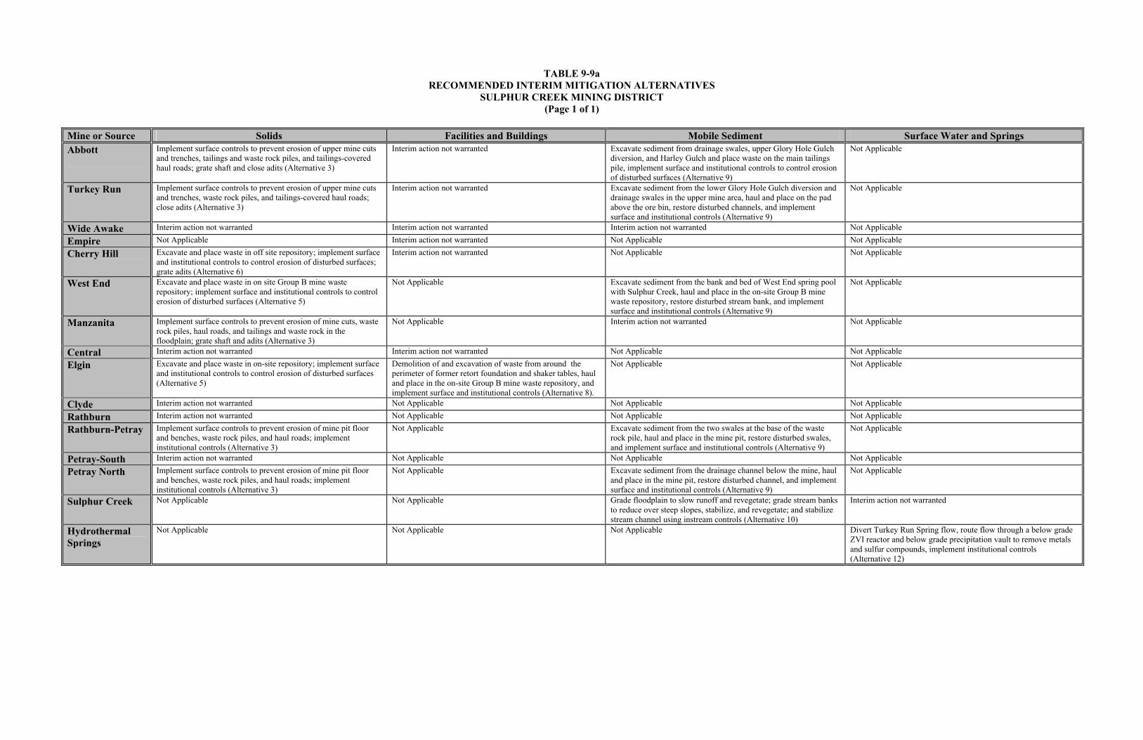
TABLE 9-9a RECOMMENDED INTERIM MITIGATION ALTERNATIVES
SULPHUR CREEK MINING DISTRICT (Page 1 of 1)
Mine or Source Solids Facilities and Buildings Mobile Sediment Surface Water and Springs Abbott
Implement surface controls to prevent erosion of upper mine cuts and trenches, tailings and waste rock piles, and tailings-covered haul roads; grate shaft and close adits (Alternative 3)
Interim action not warranted Excavate sediment from drainage swales, upper Glory Hole Gulch diversion, and Harley Gulch and place waste on the main tailings pile, implement surface and institutional controls to control erosion of disturbed surfaces (Alternative 9)
Not Applicable
Turkey Run Implement surface controls to prevent erosion of upper mine cuts and trenches, waste rock piles, and tailings-covered haul roads; close adits (Alternative 3)
Interim action not warranted Excavate sediment from the lower Glory Hole Gulch diversion and drainage swales in the upper mine area, haul and place on the pad above the ore bin, restore disturbed channels, and implement surface and institutional controls (Alternative 9)
Not Applicable
Wide Awake Interim action not warranted Interim action not warranted Interim action not warranted Not Applicable
Empire Not Applicable Interim action not warranted Not Applicable Not Applicable
Cherry Hill Excavate and place waste in off site repository; implement surface and institutional controls to control erosion of disturbed surfaces; grate adits (Alternative 6)
Interim action not warranted Not Applicable Not Applicable
West End Excavate and place waste in on site Group B mine waste repository; implement surface and institutional controls to control erosion of disturbed surfaces (Alternative 5)
Not Applicable Excavate sediment from the bank and bed of West End spring pool with Sulphur Creek, haul and place in the on-site Group B mine waste repository, restore disturbed stream bank, and implement surface and institutional controls (Alternative 9)
Not Applicable
Manzanita Implement surface controls to prevent erosion of mine cuts, waste rock piles, haul roads, and tailings and waste rock in the floodplain; grate shaft and adits (Alternative 3)
Not Applicable Interim action not warranted Not Applicable
Central Interim action not warranted Interim action not warranted Not Applicable Not Applicable
Elgin Excavate and place waste in on-site repository; implement surface and institutional controls to control erosion of disturbed surfaces (Alternative 5)
Demolition of and excavation of waste from around the perimeter of former retort foundation and shaker tables, haul and place in the on-site Group B mine waste repository, and implement surface and institutional controls (Alternative 8).
Not Applicable Not Applicable
Clyde Interim action not warranted Not Applicable Not Applicable Not Applicable
Rathburn Interim action not warranted Not Applicable Not Applicable Not Applicable
Rathburn-Petray Implement surface controls to prevent erosion of mine pit floor and benches, waste rock piles, and haul roads; implement institutional controls (Alternative 3)
Not Applicable Excavate sediment from the two swales at the base of the waste rock pile, haul and place in the mine pit, restore disturbed swales, and implement surface and institutional controls (Alternative 9)
Not Applicable
Petray-South Interim action not warranted Not Applicable Not Applicable Not Applicable
Petray North Implement surface controls to prevent erosion of mine pit floor and benches, waste rock piles, and haul roads; implement institutional controls (Alternative 3)
Not Applicable Excavate sediment from the drainage channel below the mine, haul and place in the mine pit, restore disturbed channel, and implement surface and institutional controls (Alternative 9)
Not Applicable
Sulphur Creek Not Applicable Not Applicable Grade floodplain to slow runoff and revegetate; grade stream banks to reduce over steep slopes, stabilize, and revegetate; and stabilize stream channel using instream controls (Alternative 10)
Interim action not warranted
Hydrothermal Springs
Not Applicable Not Applicable Not Applicable
Divert Turkey Run Spring flow, route flow through a below grade ZVI reactor and below grade precipitation vault to remove metals and sulfur compounds, implement institutional controls (Alternative 12)

TABLE 9-9b RECOMMENDED FINAL MITIGATION ALTERNATIVES
SULPHUR CREEK MINING DISTRICT (Page 1 of 2)
Mine or Source Solids Facilities and Buildings Mobile Sediment Surface Water and Springs Abbott
Excavate and place waste in on site repository; implement surface and institutional controls to control erosion of intact waste material and disturbed surfaces; grate shaft and close adits (Alternative 5)
Excavate around perimeter of facilities, place waste in on site Group B mine waste repository, leave historic facilities and features intact, and implement surface and institutional controls (Alternative 7)
Excavate sediment from drainage swales, upper Glory Hole Gulch diversion, and Harley Gulch and place waste in on site repository, implement surface and institutional controls to control erosion of disturbed surfaces (Alternative 9)
Not Applicable
Turkey Run
Excavate and place waste in Abbott Mine Group B mine waste repository; implement surface and institutional controls to control erosion of intact waste material and disturbed surfaces; close adits (Alternative 6)
Demolition of the ore bin and excavation of waste from around the perimeter of the ore bin, haul and place in the Abbott Mine Group B mine waste repository, and implement surface and institutional controls (Alternative 8)
Excavate sediment from the lower Glory Hole Gulch diversion and drainage from the upper mine area, haul and place in the Abbott Mine Group B mine waste repository, restore disturbed channels, and implement surface and institutional controls (Alternative 9)
Not Applicable
Wide Awake Install dry dam above mine to control erosion, consolidate and grade tailings and waste rock, place an earthen cover over consolidated mine waste, implement surface controls to reduce erosion cover and disturbed surfaces; close adits (Alternative 4)
Excavate waste from around the perimeter of the processing facilities, haul and place in on-site Group B mine waste repository, leave historic facilities and features intact, and implement surface and institutional controls (Alternative 7)
Excavate sediment from the creek passing through the upper mine site, lower mine site, and basin near Sulphur Creek, haul and place in on-site Group B mine waste repository, restore disturbed channels, and implement surface and institutional controls (Alternative 9)
Not Applicable
Empire Not Applicable Demolition of the retort and excavation of waste from around the perimeter of the retort, haul and place in the West End Group B mine waste repository, and implement surface and institutional controls (Alternative 8)
Not Applicable Not Applicable
Cherry Hill Excavate waste rock and place in West End Group B mine waste repository; implement surface and institutional controls to control erosion of disturbed surfaces; grate adits (Alternative 6)
Demolition of the mill foundation and excavation of waste from around the perimeter of the former mill foundation, haul and place in the West End Group B mine waste repository, and implement surface and institutional controls (Alternative 8)
Not Applicable Not Applicable
West End Excavate and place waste in on site Group B mine waste repository; implement surface and institutional controls to control erosion of disturbed surfaces (Alternative 5)
Not Applicable Excavate sediment from the bank and bed of West End spring pool with Sulphur Creek, haul and place in the on-site Group B mine waste repository, restore disturbed stream bank, and implement surface and institutional controls (Alternative 9)
Not Applicable
Manzanita Excavate and place waste in off site repository; implement surface and institutional controls to control erosion of intact waste material in floodplain; grate shaft and adits (Alternative 6)
Not Applicable Refer to Alternative 10 for Sulphur Creek Not Applicable
Central Implement surface controls to prevent erosion of upper mine cuts, overcast waste rock, tailings piles, haul roads; implement institutional controls (Alternative 3)
Demolition of and excavation of waste from around the perimeter of the furnace and furnace/retort, haul and place waste in the West End Group B mine waste repository, and implement surface and institutional controls (Alternative 8)
Not Applicable Not Applicable
Elgin Excavate and place waste in on-site repository; implement surface and institutional controls to control erosion of disturbed surfaces (Alternative 5)
Demolition of and excavation of waste from around the perimeter of the former retort foundation and shaker tables, haul and place in the on-site Group B mine waste repository, and implement surface and institutional controls (Alternative 8)
Not Applicable Not Applicable
Clyde No action is warranted Not Applicable Not Applicable Not Applicable
Rathburn Consolidate small amount of tailings at retort with waste rock, place an earthen cover over consolidated mine waste, implement surface controls to reduce erosion cover and disturbed surfaces; implement institutional controls (Alternative 4)
Not Applicable Not Applicable Not Applicable
Rathburn-Petray Excavate and place waste in on site repository; implement surface and institutional controls to control erosion of disturbed surfaces (Alternative 5)
Not Applicable Excavate sediment from the two swales at the base of the waste rock pile, haul and place in an on-site Group B mine waste repository, restore disturbed swales, and implement surface and institutional controls (Alternative 9)
Not Applicable
Petray-South Excavate and haul waste rock/overburden from north side of pit and place on east side of pit to stop drainage from pit, implement surface and institutional controls (Alternative 3)
Not Applicable Not Applicable Not Applicable
Petray North Excavate and place waste in on site repository; implement surface and institutional controls to prevent water discharge from pit and erosion of disturbed surfaces (Alternative 5)
Not Applicable Excavate sediment from the drainage channel below the mine, haul and place in the on-site Group B mine waste repository, restore disturbed channel, and implement surface and institutional controls (Alternative 9)
Not Applicable

TABLE 9-9b
RECOMMENDED FINAL MITIGATION ALTERNATIVES SULPHUR CREEK MINING DISTRICT
(Page 2 of 2) Mine or Source Solids Facilities and Buildings Mobile Sediment Surface Water and Springs Sulphur Creek Not Applicable Not Applicable Grade floodplain to slow runoff and revegetate; grade stream
banks to reduce over steep slopes, stabilize, and revegetate; and stabilize stream channel using instream controls (Alternative 10)
Construct sequences of flashboard dams within Sulphur Creek to capture mobile sediment and metal precipitates; route a portion of the flow captured behind dams through below grade ZVI reactors; return flow to creek to allow metal sulfide precipitation, aeration, and metal oxyhydroxide formation and precipitation; implement institutional controls (Alternative 15)
Hydrothermal Springs
Not Applicable Not Applicable Not Applicable Divert Turkey Run Spring flow, route flow through a below grade ZVI reactor and below grade precipitation vault to remove metals and sulfur compounds, implement institutional controls (Alternative 12) Divert Elgin Springs flow, route flow through a below grade ZVI reactor and below grade precipitation vault to remove metals and sulfur compounds, implement institutional controls (Alternative 12) Divert Blank Spring flow, route flow through a below grade ZVI reactor, an above grade aeration channel, and below grade precipitation vault to remove metals and sulfur compounds, implement institutional controls (Alternative 12)

TABLE 9-10a SUMMARY OF RECOMMENDED INTERIM MITIGATION ALTERNATIVE COSTS
SULPHUR CREEK MINING DISTRICT (Page 1 of 1)
Solids Facilities and Buildings Mobile Sediment Surface Water and Springs All Media
Mine
Recommended Alternative
Total Present Worth
Recommended Alternative
Total Present Worth
Recommended Alternative
Total Present Worth
Recommended Alternative
Total Present Worth
Total Present Worth
Abbott Alternative 3 $1,664,759 Not Warranted $0 Alternative 9 $206,915 Not Applicable Not Applicable $1,871,674 Turkey Run Alternative 3 $542,763 Not Warranted $0 Alternative 9 $182,835 Not Applicable Not Applicable $725,598 Wide Awake Not Warranted $0 Not Warranted $0 Not Warranted $0 Not Applicable Not Applicable $0 Empire Not Applicable Not Applicable Not Warranted $0 Not Applicable Not Applicable Not Applicable Not Applicable $0 Cherry Hill Alternative 6 $143,944 Not Warranted $0 Not Applicable Not Applicable Not Applicable Not Applicable $143,944 West End Alternative 5 $291,686 Not Applicable Not Applicable Alternative 9 $92,738 Not Applicable Not Applicable $384,424 Manzanita Alternative 3 $343,258 Not Applicable Not Applicable Not Warranted $0 Not Applicable Not Applicable $343,258 Central Not Warranted $0 Not Warranted $0 Not Applicable Not Applicable Not Applicable Not Applicable $0 Elgin Alternative 5 $418,766 Alternative 8 $199,487 Not Applicable Not Applicable Not Applicable Not Applicable $618,253 Clyde Not Warranted $0 Not Applicable Not Applicable Not Applicable Not Applicable Not Applicable Not Applicable $0 Rathburn Not Warranted $0 Not Applicable Not Applicable Not Applicable Not Applicable Not Applicable Not Applicable $0 Rathburn-Petray Alternative 3 $325,462 Not Applicable Not Applicable Alternative 9 $287,453 Not Applicable Not Applicable $612,915 Petray-South Not Warranted $0 Not Applicable Not Applicable Not Applicable Not Applicable Not Applicable Not Applicable $0 Petray-North Alternative 3 $242,569 Not Applicable Not Applicable Alternative 9 $184,449 Not Applicable Not Applicable $427,018 Sulphur Creek Not Applicable Not Applicable Not Applicable Not Applicable Alternative 10 $1,924,619 Not Warranted $0 $1,924,619 Turkey Run Spring Not Applicable Not Applicable Not Applicable Not Applicable Not Applicable Not Applicable Alternative 12 $937,499 $937,499 Blank Spring Not Applicable Not Applicable Not Applicable Not Applicable Not Applicable Not Applicable Not Warranted $0 $0 Elgin Springs Not Applicable Not Applicable Not Applicable Not Applicable Not Applicable Not Applicable Not Warranted $0 $0 $3,973,207 $199,487 $2,879,009 $937,499 $7,989,202

TABLE 9-10b SUMMARY OF RECOMMENDED FINAL MITIGATION ALTERNATIVE COSTS
SULPHUR CREEK MINING DISTRICT (Page 1 of 1)
Solids Facilities and Buildings Mobile Sediment Surface Water and Springs All Media
Mine
Recommended Alternative
Total Present Worth
Recommended Alternative
Total Present Worth
Recommended Alternative
Total Present Worth
Recommended Alternative
Total Present Worth
Total Present Worth
Abbott Alternative 5 $4,599,175 Alternative 7 $99,912 Alternative 9 $109,497 Not Applicable Not Applicable $4,906,002 Turkey Run Alternative 6 $715,589 Alternative 8 $81,651 Alternative 9 $111,571 Not Applicable Not Applicable $980,075 Wide Awake Alternative 4 $804,532 Alternative 7 $81,906 Alternative 9 $129,733 Not Applicable Not Applicable $1,016,171 Empire Not Applicable Not Applicable Alternative 8 $36,230 Not Applicable Not Applicable Not Applicable Not Applicable $36,230 Cherry Hill Alternative 6 $143,944 Alternative 8 $54,944 Not Applicable Not Applicable Not Applicable Not Applicable $198,888 West End Alternative 5 $291,686 Not Applicable Not Applicable Alternative 9 $92,738 Not Applicable Not Applicable $384,424 Manzanita Alternative 6 $358,400 Not Applicable Not Applicable Not warranted $0 Not Applicable Not Applicable $358,400 Central Alternative 3 $197,219 Alternative 8 $100,576 Not Applicable Not Applicable Not Applicable Not Applicable $297,795 Elgin Alternative 5 $418,766 Alternative 8 $199,487 Not Applicable Not Applicable Not Applicable Not Applicable $618,253 Clyde Not warranted $0 Not Applicable Not Applicable Not Applicable Not Applicable Not Applicable Not Applicable $0 Rathburn Alternative 4 $365,977 Not Applicable Not Applicable Not Applicable Not Applicable Not Applicable Not Applicable $365,977 Rathburn-Petray Alternative 5 $2,619,299 Not Applicable Not Applicable Alternative 9 $287,453 Not Applicable Not Applicable $2,906,752 Petray-South Alternative 3 $155,397 Not Applicable Not Applicable Not Applicable Not Applicable Not Applicable Not Applicable $155,397 Petray-North Alternative 5 $306,435 Not Applicable Not Applicable Alternative 9 $184,449 Not Applicable Not Applicable $490,884 Sulphur Creek Not Applicable Not Applicable Not Applicable Not Applicable Alternative 10 $1,924,619 Alternative 15 $10,960,888 $12,885,507 Turkey Run Spring Not Applicable Not Applicable Not Applicable Not Applicable Not Applicable Not Applicable Alternative 12 $937,499 $937,499 Blank Spring Not Applicable Not Applicable Not Applicable Not Applicable Not Applicable Not Applicable Alternative 12 $918,216 $918,216 Elgin Springs Not Applicable Not Applicable Not Applicable Not Applicable Not Applicable Not Applicable Alternative 12 $2,629,248 $2,629,248 $10,710,135 $654,706 $3,008,739 $15,445,851 $29,819,434

TABLE 9-11 MERCURY LOAD REDUCTION AND PROJECTED COSTS
SULPHUR CREEK MINING DISTRICT (Page 1 of 2)
Anticipated
Long-Term Mercury Reduction (Kg/year)
Total Volume of Erodible Mine Waste and Area Mitigated
Projected
Cost
Waste Source
Interim Mitigation Strategy
Final Mitigation Strategy
Medium Up to 3.5 174,022 CY
9.8 AC $4,906,002 Abbott --- Alternatives
5, 7, and 9 Solids, Sediment, and Processing Facilities
and Equipment Up to 1.75 83,409 CY
9.1 AC $1,871,674 Abbott Alternatives
3 and 9 --- Solids and Sediment
Up to 6.7 13,424 CY 9.4 AC
$980,075 Turkey Run --- Alternatives 6, 8, and 9
Solids, Sediment, and Processing Facilities
Up to 0.44 10,014 CY 3.2 AC
$1,016,171 Wide Awake Not Recommended
Alternatives 4, 7, and 9
Solids, Sediment, and Processing Facilities
and Equipment Up to 0.04 5,748 CY
0.5 AC $36,230 Empire Not
Recommended Alternative 8 Processing
Equipment Up to 3.35 4,578 CY
13.3 AC $725,598 Turkey Run Alternatives
3 and 9 --- Solids and Sediment
Up to 9.3 (load value uncertain)
4,227 CY 1.88 AC
$618,253 Elgin Alternatives 5 and 8
Alternatives 5 and 8
Solids and Processing Equipment
Up to 1.1 3,722 CY 0.75 AC
$384,424 West End Alternatives 5 and 9
Alternatives 5 and 9
Solids and Sediment
Up to 1 811 CY 0.5 AC
$198,888 Cherry Hill --- Alternatives 6 and 8
Solids and Processing Facilities
Up to 1 609 CY 0.5 AC
$143,944 Cherry Hill Alternative 6 --- Solids
Up to 0.02 166 CY 2.0 AC
$297,795 Central Not Recommended
Alternatives 3 and 8
Solids and Processing Equipment
Up to 4.9 150 CY 2.6 AC
$358,400 Manzanita --- Alternative 6 Solids
Up to 3.25 150 CY 1.5 AC
$343,258 Manzanita Alternative 3 --- Solids

TABLE 9-11 MERCURY LOAD REDUCTION AND PROJECTED COSTS
SULPHUR CREEK MINING DISTRICT (Page 2 of 2)
Anticipated
Long-Term Mercury Reduction (Kg/year)
Total Volume of Erodible Mine Waste and Area Mitigated
Projected
Cost
Waste Source
Interim Mitigation Strategy
Final Mitigation Strategy
Medium Up to 0.22 (mercury) Up to 12,000 (sulfate) Unknown for sediment
62,686,460 L; Unknown for sediment
$12,885,507 Sulphur Creek --- Alternatives 10 and 15
Surface water and Sediment
Up to 0.006 (mercury) Up to 120,000 (sulfate)
29,959,200 L $937,499 Turkey Run Spring
Alternative 12 Alternative 12 Surface water and Precipitates
Up to 0.08 (mercury) Up to 6,600 (sulfate)
35,530,460 L $2,629,248 Elgin Springs Not Recommended
Alternative 12 Surface water and Precipitates
Up to 0.04 (mercury) Up to 2,800 (sulfate)
7,358,400 L $918,216 Blank Spring Not Recommended
Alternative 12 Surface water and Precipitates
Unknown quantity eroding from floodplain
and stream banks
Unknown $1,924,619 Sulphur Creek Alternative 10 --- Sediment
Not Warranted 0 CY $0 Clyde Not Recommended
Not Recommended
Solids
Not known if sediment reaches Bear Creek
6,546 CY 1.5 AC
$365,977 Rathburn Not Recommended
Alternative 4 Solids
Not known if sediment reaches Bear Creek
95,896 CY 4 AC
$2,906,752 Rathburn-Petray --- Alternatives 5 and 9
Solids and Sediment
Not known if sediment reaches Bear Creek
95,896 CY 5.1 AC
$612,915 Rathburn-Petray Alternatives 3 and 9
--- Solids and Sediment
Not known if sediment reaches Bear Creek
4,980 CY 3.7 AC
$490,884 Petray-North --- Alternatives 5 and 9
Solids, Sediment, and Processing Equipment
Not known if sediment reaches Bear Creek
4,857 CY 3.2 AC
$427,018 Petray-North Alternatives 3 and 9
--- Solids and Sediment
Not known if sediment reaches Bear Creek
400 CY 4.1 AC
$155,397 Petray-South Not Recommended
Alternative 3 Solids
Notes: AC = Acre CY = Cubic Yard Kg/yr = Kilogram per year

9-73
controlling run-on with interception trenches and runoff with waterbars; install water bars on tailings-
covered roads to prevent further erosion; buttress toes of over steep high walls using waste rock pulled
back up onto each cut; excavate mobile sediments from drainage channels and Harley Gulch and
consolidate with regraded tailings; install velocity breaks in drainage channels to prevent headward
erosion; and restore disturbed surfaces and excavated channels. Mine shafts will be plugged and the site
perimeter fenced to limit access to high walls, structures, and restored surfaces. It is anticipated that the
average long-term mercury reduction to the Harley Gulch watershed resulting from the proposed
mitigation strategy would be up to 1.75 kg/year or 17.1% for the watershed as a whole. The estimated
cost to implement this mitigation strategy is $1,871,674, of which $1,095,976 is capital costs and $62,506
is yearly O&M costs (present worth $775,698) for a conservative 30-year design life. A detailed
description of mitigation strategy components is presented on the Appendix A CDROM and can be
reviewed by selecting: “Abbott Mine,” “Alternative 3,” or “Alternative 9,” and the “cost estimate
assumptions” link.
Final Mitigation Strategy. The recommended final mitigation strategy to reduce both mercury loading
and human health and ecological risk from tailings, waste rock, processing facilities, and mobile sediment
at Abbott Mine (Alternatives 5, 7 and 9) is to construct an on-site Group B mine waste repository, install
a culvert in Harley Gulch to prevent undercutting of the repository, excavate the waste material from the
different source areas, and place the waste material in the on-site repository; reduce erosion on mine cuts
by controlling run-on with interception trenches and runoff with waterbars; install water bars on tailings-
covered roads to prevent further erosion; buttress toes of over steep high walls using waste rock pulled
back up onto each cut; excavate mine waste from the perimeter of the mill and other processing facilities
and place in on site repository; excavate mobile sediments from drainage channels and Harley Gulch
place in on site repository; install velocity breaks in drainage channels to prevent headward erosion; and
restore disturbed surfaces and excavated channels. Mine shafts will be plugged and the site perimeter
fenced to limit access to high walls, structures, and restored surfaces. It is anticipated that the average
long-term mercury reduction to the Harley Gulch watershed resulting from the proposed mitigation
strategy would be up to 3.5 kg/year or 34.3% for the watershed as a whole, and attain human health and
ecological PMGs. This estimate does not include the expected load reduction to be obtained by removal
of waste from the perimeter of processing facilities. The estimated cost to implement this mitigation
strategy is $4,906,002, of which $4,249,215 is capital costs and $52,924 is yearly O&M costs (present
worth $656,787) for a conservative 30-year design life. A detailed description of mitigation strategy
components is presented on the Appendix A CDROM and can be reviewed by selecting: “Abbott Mine,”
“Alternative 5,” or “Alternative 7,” or “Alternative 9,” and the “cost estimate assumptions” link.

9-74
9.3.2 Turkey Run Mine
Contaminated media at Turkey Run Mine include exposed cuts, waste rock, ore, tailings covered roads,
waste around the perimeter of the ore bins, and contaminated sediment within drainage swales, ditches,
and a tributary to Harley Gulch. The estimated mercury load from Turkey Run Mine is 0.42 to 6.7 kg/yr
or 65.7 % of the total mine related mercury load of 1.2 to 10.2 kg/yr to Harley Gulch. An interim action
is warranted at the Turkey Run Mine to reduce mercury loading to Harley Gulch.
Mercury concentrations detected in mine waste at Turkey Run Mine exceed both human health and
ecological PMGs; therefore, implementation of a final mitigation action at Turkey Run Mine will also be
required to address risk reduction over the long term. Mine waste was not found to contain leachable
concentrations of mercury above the STLC; therefore, implementation of the final mitigation action at
Turkey Run Mine will not require control of the generation and migration of leachate to Harley Gulch.
The focus of the interim mitigation strategy will be mercury load reduction in support of and consistent
with attainment of PMOs and PMGs over the long term. The final mitigation strategy will address both
mercury load and risk reduction and meet regulatory requirements in support of site closure. The scope of
and decision to implement a mitigation strategy should be made by the property owner in conjunction
with CBDA and other stakeholders. Interim and final mitigation strategies are presented below.
Interim Mitigation Strategy. The recommended interim mitigation strategy to reduce mercury loading
from exposed cuts, waste rock, tailings covered roads, and contaminated sediment within drainage swales,
ditches, and a tributary to Harley Gulch (Alternatives 3 and 9) is to consolidate waste rock along drainage
channel and ore adjacent to the ore bin with waste rock above ore bin to isolate waste rock from contact
with stormwater runoff; reduce erosion on mine cuts by controlling run-on with interception trenches and
runoff with waterbars; install water bars on tailings-covered roads to prevent further erosion; buttress toes
of over steep high walls using waste rock pulled back up onto each cut; route runoff around waste rock on
the ore bin pad to the drainage channel below the mine site; excavate mobile sediments from the lower
drainage channel and haul to and place on the pad above the ore bin; terrace lower drainage channel banks
to reduce lateral erosion; install velocity breaks in the lower drainage channel to prevent headward
erosion; and restore disturbed surfaces and excavated channels. The adit at the rear of the ore bin pad will
be plugged and the site perimeter fenced to limit access to high walls, ventilation adit, and restored
surfaces. It is anticipated that the average long-term mercury reduction to the Harley Gulch watershed

9-75
resulting from the proposed mitigation strategy would be up to 3.35 kg/year or 32.9% for the watershed as
a whole. The estimated cost to implement this mitigation strategy is $725,598, of which $363,420 is
capital costs and $29,184 is yearly O&M costs (present worth $362,178) for a conservative 30-year
design life. A detailed description of mitigation strategy components is presented on the Appendix A
CDROM and can be reviewed by selecting: “Turkey Run Mine,” “Alternative 3,” or “Alternative 9,” and
the “cost estimate assumptions” links.
Final Mitigation Strategy. The recommended final mitigation strategy to reduce both mercury loading
and human health and ecological risk from exposed cuts, waste rock, ore, tailings covered roads, waste
around the perimeter of the ore bins, and contaminated sediment within drainage swales, ditches, and a
tributary to Harley Gulch (Alternatives 6, 8 and 9) is to excavate the waste rock from the different source
areas in the lower portion of the mine site, and haul and place the excavated in the Abbott Mine Group B
mine waste repository; reduce erosion on mine cuts by controlling run-on with interception trenches and
runoff with waterbars; install water bars on tailings-covered roads to prevent further erosion; buttress toes
of over steep high walls using waste rock pulled back up onto each cut; demolish the ore bin and shed,
excavate ore and waste rock from the pad above the ore bin, and haul and place waste in the Abbott Mine
Group B mine waste repository; route runoff around excavated areas to the drainage channel below mine
site; excavate mobile sediments from the lower drainage channel and haul to and place in the Abbott
Mine Group B mine waste repository; terrace lower drainage channel banks to reduce lateral erosion;
install velocity breaks in the lower drainage channel to prevent headward erosion; and restore disturbed
surfaces and excavated channels. The adit at the rear of the ore bin pad will be plugged and the site
perimeter fenced to limit access to high walls, ventilation adit, and restored surfaces. It is anticipated that
the average long-term mercury reduction to the Harley Gulch watershed resulting from the proposed
mitigation strategy would be up to 6.7 kg/year or 65.7% for the watershed as a whole, and attain human
health and ecological PMGs. This estimate does not include the expected load reduction to be obtained
by removal of ore bin and waste from within and around the perimeter of the ore bin. The estimated cost
to implement this mitigation strategy is $980,075, of which $551,397 is capital costs and $34,543 is
yearly O&M costs (present worth $428,678) for a conservative 30-year design life. A detailed description
of mitigation strategy components is presented on the Appendix A CDROM and can be reviewed by
selecting: “Turkey Run Mine,” “Alternative 6,” or “Alternative 8,” or “Alternative 9,” and the “cost
estimate assumptions” link.

9-76
9.3.3 Wide Awake Mine
Contaminated media at Wide Awake Mine include mine cuts, waste rock, tailings, waste around the
perimeter of and within processing facilities, and contaminated sediment within drainage swales, ditches,
and a tributary to Sulphur Creek. The estimated mercury load from Wide Awake Mine is 0.02 to 0.44
kg/yr or 2.4 % of the total mine related mercury load of 4.4 to 18.6 kg/yr to Sulphur Creek. An interim
action is not warranted at the Wide Awake Mine to reduce mercury loading to Sulphur Creek.
Mercury concentrations detected in mine waste at Wide Awake Mine exceed both human health and
ecological PMGs; therefore, implementation of a final mitigation action at Wide Awake Mine will be
required to address risk reduction over the long term. Mine waste was not found to contain leachable
concentrations of mercury above the STLC; therefore, implementation of the final mitigation action at
Wide Awake Mine will not require control of the generation and migration of leachate to Sulphur Creek.
The final mitigation strategy, if implemented, will address both mercury load and risk reduction and meet
regulatory requirements in support of site closure. The scope of and decision to implement a mitigation
strategy should be made by the property owner in conjunction with CBDA and other stakeholders. The
final mitigation strategy is presented below.
Final Mitigation Strategy. The recommended final mitigation strategy to reduce both mercury loading
and human health and ecological risk from mine cuts, waste rock, tailings, waste around the perimeter of
and within processing facilities, and contaminated sediment within drainage swales, ditches, and a
tributary to Sulphur Creek (Alternatives 4, 7 and 9) is to excavate and consolidate mine waste along creek
with the upper and lower waste rock pile; grade consolidated waste to prevent erosion by adjacent creek;
place a GCL, a drainage layer, and an earthen cover over the graded mine waste at each location; protect
consolidated and covered waste by constructing a dry dam in the creek above the mine site and installing
riprap along the toe of each waste rock pile; reduce erosion on mine cuts by controlling run-on with
interception trenches and runoff with waterbars and velocity breaks; excavate mine waste around the
perimeter of processing facilities, leaving historical features intact, and consolidate with main waste rock
pile; excavate mobile sediments from the creek adjacent to the main waste rock pile, between the main
and lower waste rock piles, adjacent to the lower waste rock pile near bottom of canyon, and sediment
from the basin above Wilbur Springs Road; consolidate excavated sediment with waste in the main waste
rock pile; and restore disturbed creek bed and channel banks. The site perimeter will be fenced to limit
access to high walls, processing facilities, historic shaft, and restored surfaces. It is anticipated that the

9-77
average long-term mercury reduction to the Sulphur Creek watershed resulting from the proposed
mitigation strategy would be up to 0.44 kg/year or 2.4% for the watershed as a whole, and attain human
health and ecological PMGs. This estimate does not include the expected load reduction to be obtained
by removal of waste from the perimeter of processing facilities. The estimated cost to implement this
final mitigation strategy is $1,016,171, of which $545,282 is capital costs and $37,944 is yearly O&M
costs (present worth $470,889) for a conservative 30-year design life. A detailed description of final
mitigation strategy components is presented on the Appendix A CDROM and can be reviewed by
selecting: “Wide Awake Mine,” “Alternative 4,” or “Alternative 7,” or “Alternative 9,” and the “cost
estimate assumptions” links.
9.3.4 Empire Mine
Contaminated media at Empire Mine includes waste around the perimeter of and within a retort. The
estimated mercury load from Empire Mine is 0.04 to 0.06 kg/yr or 0.32 % of the total mine related
mercury load of 4.4 to 18.6 kg/yr to Sulphur Creek. An interim action is not warranted at the Empire
Mine to reduce mercury loading to Sulphur Creek because the site is vegetated and no erosion is
occurring.
Mercury concentrations detected in mine waste at Empire Mine exceed the ecological PMG; therefore,
implementation of a final mitigation action at Empire Mine will be required to address risk reduction over
the long term. It is not known if mine waste at Empire Mine leaches mercury at a concentration
exceeding the STLC value; however, given the low concentration of total mercury, leachate is not
expected the STLC value. In addition, groundwater beneath Empire Mine is hydrothermal and surface
water in Sulphur Creek is dominated by hydrothermal springs both of which are not of sufficient quality
to serve as a source for drinking water. Therefore, implementation of the final mitigation action at
Empire Mine will not require control of the generation and migration of leachate to Sulphur Creek.
The final mitigation strategy, if implemented, will address both mercury load and risk reduction and meet
regulatory requirements in support of site closure. The scope of and decision to implement a mitigation
strategy should be made by the property owner in conjunction with CBDA and other stakeholders. The
final mitigation strategy is presented below.
Final Mitigation Strategy. The recommended final mitigation strategy to reduce both mercury loading
and ecological risk from waste around the perimeter of and within a retort at Empire Mine (Alternative 8)

9-78
is to demolish the old furnace/retort and excavate mine waste from beneath and around the perimeter of
the old furnace/retort, haul debris and waste to and place in the West End Mine Group B mine waste
repository, and to protect the restored surface by controlling run-on with a waterbar and revegetating the
disturbed surface. The site perimeter will be fenced to limit access to mine waste and restored surfaces.
It is anticipated that the average long-term mercury reduction to the Sulphur Creek watershed resulting
from the proposed mitigation strategy would be up to 0.04 kg/year or 0.21% for the watershed as a whole,
and attain the ecological PMG. The estimated cost to implement this final mitigation strategy is $36,230,
of which $13,356 is capital costs and $1,843 is yearly O&M costs (present worth $22,874) for a
conservative 30-year design life. A detailed description of final mitigation strategy components is
presented on the Appendix A CDROM and can be reviewed by selecting: “Empire Mine,” “Alternative
8,” and the “cost estimate assumptions” links.
9.3.5 Cherry Hill Mine
Contaminated media at Cherry Hill Mine include waste rock adjacent to Sulphur Creek and waste around
the perimeter of the old mill foundation. The estimated mercury load from Cherry Hill Mine is up to 1
kg/yr or 5.4 % of the total mine related mercury load 4.4 to 18.6 kg/yr to Sulphur Creek. An interim
action is warranted at the Cherry Hill Mine to reduce mercury loading to Sulphur Creek.
Mercury concentrations detected in mine waste at Cherry Hill Mine exceed the ecological PMG;
therefore, implementation of a final mitigation action at Cherry Hill Mine will also be required to address
risk reduction over the long term. Mine waste was found to contain leachable concentrations of mercury
above the STLC; therefore, implementation of the final mitigation action at Cherry Hill Mine must
control the generation and migration of leachate to Sulphur Creek.
The focus of the interim mitigation strategy will be mercury load reduction in support of and consistent
with attainment of PMOs and PMGs over the long term. The final mitigation strategy will address both
mercury load and risk reduction and meet regulatory requirements in support of site closure. The scope of
and decision to implement a mitigation strategy should be made by the property owner in conjunction
with CBDA and other stakeholders. Interim and final mitigation strategies are presented below.
Interim Mitigation Strategy. The recommended interim mitigation strategy to reduce mercury loading
from waste rock on the Sulphur Creek floodplain (Alternative 6) is to excavate, haul, and place waste
rock in the West End Mine Group B mine waste repository; and grade excavation to control erosion.

9-79
Adits will be grated and the site perimeter fenced to limit access to high walls above adits and to protect
restored areas. It is anticipated that the average long-term mercury reduction to the Sulphur Creek
watershed resulting from the proposed mitigation strategy would be up to 1 kg/year or 5.4% for the
watershed as a whole. The estimated cost to implement this mitigation strategy is $143,944, of which
$51,470 is capital costs and $7,452 is yearly O&M costs (present worth $92,474) for a conservative 30-
year design life. A detailed description of interim mitigation strategy components is presented on the
Appendix A CDROM and can be reviewed by selecting: “Cherry Hill Mine,” “Alternative 6,” and the
“cost estimate assumptions” link.
Final Mitigation Strategy. The recommended final mitigation strategy to reduce both mercury loading
and ecological risk from waste rock on the Sulphur Creek floodplain and waste around the perimeter of
the old mill foundation (Alternatives 6 and 8) is to excavate, haul, and place waste rock in the West End
Mine Group B mine waste repository; grade excavation to control erosion; demolish the old mill
foundation, excavate soil and mine waste from beneath and around the perimeter of the demolished
foundation; haul the waste material to the West End Mine Group B mine waste repository; and install a
water bar above the excavated area. Adits will be grated and the site perimeter fenced to limit access to
high walls above adits and to protect restored areas. It is anticipated that the average long-term mercury
reduction to the Sulphur Creek watershed resulting from the proposed mitigation strategy would be up to
1 kg/year or 5.4% for the watershed as a whole, and attain the ecological PMG. This estimate does not
include the expected load reduction to be obtained by removal of the old mill foundation and waste from
around the perimeter of the foundation. The estimated cost to implement this mitigation strategy is
$198,888, of which $81,689 is capital costs and $9,444 is yearly O&M costs (present worth $117,199) for
a conservative 30-year design life. A detailed description of mitigation strategy components is presented
on the Appendix A CDROM and can be reviewed by selecting: “Cherry Hill Mine,” “Alternative 6,” or
“Alternative 8,” and the “cost estimate assumptions” links.
9.3.6 West End Mine
Contaminated media at West End Mine include waste rock adjacent to and contaminated sediment within
Sulphur Creek. The estimated mercury load from West End Mine is 0.002 to 1.1 kg/yr or 5.9 % of the
total mine related mercury load 4.4 to 18.6 kg/yr to Sulphur Creek. An interim action is warranted at the
West End Mine to reduce mercury loading to Sulphur Creek.
9-80
Mercury concentrations detected in mine waste at West End Mine exceed the ecological PMG; therefore,
implementation of a final mitigation action at West End Mine will also be required to address risk
reduction over the long term. Mine waste was found to contain leachable concentrations of mercury
above the STLC; therefore, implementation of the final mitigation action at West End Mine must control
the generation and migration of leachate to Sulphur Creek.
The focus of the interim mitigation strategy will be mercury load reduction in support of and consistent
with attainment of PMOs and PMGs over the long term. The final mitigation strategy will address both
mercury load and risk reduction and meet regulatory requirements in support of site closure. The scope of
and decision to implement a mitigation strategy should be made by the property owner in conjunction
with CBDA and other stakeholders. The interim and final mitigation strategy is presented below.
Interim and Final Mitigation Strategy. The recommended interim and final mitigation strategy to
reduce both mercury loading and ecological risk from waste rock adjacent to and contaminated sediment
within Sulphur Creek (Alternatives 5 and 9) is to construct an on-site Group B mine waste repository,
excavate the waste rock from below the adits, and place the waste rock in the on-site repository; and
excavate waste rock from Sulphur Creek drainage channels and place in on site repository; and restore
disturbed surfaces and stream bank. Adits will be grated and the site perimeter fenced to limit access to
the repository and restored surfaces. It is anticipated that the average long-term mercury reduction to the
Sulphur Creek watershed resulting from the proposed mitigation strategy would be up to 1.1 kg/year or
5.9% for the watershed as a whole, and attain the ecological PMG. The estimated cost to implement this
mitigation strategy is $384,424, of which $165,266 is capital costs and $17,659 is yearly O&M costs
(present worth $219,158) for a conservative 30-year design life. A detailed description of mitigation
strategy components is presented on the Appendix A CDROM and can be reviewed by selecting: “West
End Mine,” “Alternative 5,” or “Alternative 9,” and the “cost estimate assumptions” link.
9.3.7 Manzanita Mine
Contaminated media at Manzanita Mine include mine cuts, waste rock, tailings within the Sulphur Creek
floodplain, and contaminated sediment within drainage swales, ditches, and Sulphur Creek. The
estimated mercury load from Manzanita Mine is 0.3 to 6.5 kg/yr or 34.9 % of the total mine related
mercury load of 4.4 to 18.6 kg/yr to Sulphur Creek. The mercury load estimate does not include the
tailings within the Sulphur Creek floodplain. An interim action is warranted at the Manzanita Mine to
reduce mercury loading to Sulphur Creek.
9-81
Mercury concentrations detected in mine waste at Manzanita Mine exceed both human health and
ecological PMGs; therefore, implementation of a final mitigation action at Manzanita Mine will also be
required to address risk reduction over the long term. It is not known if mine waste at Manzanita Mine
leaches mercury at a concentration exceeding the STLC value; however, given the low concentration of
total mercury, leachate is not expected the STLC value. In addition, groundwater beneath Manzanita
Mine is hydrothermal and surface water in Sulphur Creek is dominated by hydrothermal springs, both of
which are not of sufficient quality to serve as a source for drinking water. Therefore, implementation of
the final mitigation action at Manzanita Mine will not require control of the generation and migration of
leachate to Sulphur Creek.
The focus of the interim mitigation strategy will be mercury load reduction in support of and consistent
with attainment of PMOs and PMGs over the long term. The final mitigation strategy will address both
mercury load and risk reduction and meet regulatory requirements in support of site closure. Reduction
of mercury load and risk associated with tailings within the Sulphur Creek floodplain, and contaminated
sediment within drainage swales, ditches, and Sulphur Creek will be addressed by Alternative 10 as
described in Section 9.3.15. The scope of and decision to implement a mitigation strategy should be
made by the property owner in conjunction with CBDA and other stakeholders. Interim and final
mitigation strategies are presented below.
Interim Mitigation Strategy. The recommended interim mitigation strategy to reduce mercury loading
from mine cuts and waste rock at Manzanita Mine (Alternative 3) is to install an earthen berm directly
above the upper cut to redirect water away from the cuts; install water bars on cuts to route water away
from the edge of the steep cuts and into diversion trenches; excavate diversion trenches to route water
from upper cuts around the waste rock area and into sediment detention basins located on the floodplain
on the east and west side of Manzanita Mine; install velocity breaks in the upper part of the drainage
between Manzanita and Central mines; install riprap in the drainage channel crossing the floodplain
below the mine to prevent erosion of mine waste contained in the floodplain. The upper shaft will be
plugged with earthen fill, the adit grated, and the site perimeter fenced to limit access to high walls, steep
cuts, and upper glory hole. It is anticipated that the average long-term mercury reduction to the Sulphur
Creek watershed resulting from the proposed mitigation strategy would be up to 3.25 kg/year or 17.5%
for the watershed as a whole. The estimated cost to implement this interim mitigation strategy is
$343,258, of which $150,666 is capital costs and $15,519 is yearly O&M costs (present worth $192,592)
for a conservative 30-year design life. A detailed description of interim mitigation strategy components is

9-82
presented on the Appendix A CDROM and can be reviewed by selecting: “Manzanita Mine,”
“Alternative 3,” and the “cost estimate assumptions” link.
Final Mitigation Strategy. The recommended final mitigation strategy to reduce both mercury loading
and human health and ecological risk from mine cuts and waste rock at Manzanita Mine (Alternative 6) is
to excavating, hauling, and placing waste in the West End Mine Group B mine waste repository and
grading disturbed surfaces; install an earthen berm directly above the upper cut to redirect water away
from the cuts; install water bars on cuts to route water away from the edge of the steep cuts and into
diversion trenches; excavate diversion trenches to route water from upper cuts around the waste rock area
and into sediment detention basins located on the floodplain on the east and west side of Manzanita Mine;
install velocity breaks in the upper part of the drainage between Manzanita and Central mines; install
riprap in the drainage channel crossing the floodplain below the mine to prevent erosion of mine waste
contained in the floodplain. The upper shaft will be plugged with earthen fill, the adit grated, and the site
perimeter fenced to limit access to high walls, steep cuts, and upper glory hole. It is anticipated that the
average long-term mercury reduction to the Sulphur Creek watershed resulting from the proposed
mitigation strategy would be up to 4.9 kg/year or 26.3% for the watershed as a whole, and attain human
health and ecological PMGs. The estimated cost to implement this final mitigation strategy is $358,400,
of which $160,442 is capital costs and $15,951 is yearly O&M costs (present worth $197,958) for a
conservative 30-year design life. A detailed description of final mitigation strategy components is
presented on the Appendix A CDROM and can be reviewed by selecting: “Manzanita Mine,”
“Alternative 6,” and the “cost estimate assumptions” link.
9.3.8 Central Mine
Contaminated media at Central Mine include mine cuts, waste rock, tailings, and waste around the
perimeter of processing facilities. The estimated mercury load from Central Mine is 0.003 to 0.03 kg/yr
or 0.16 % of the total mine related mercury load of 4.4 to 18.6 kg/yr to Sulphur Creek. An interim action
is not warranted at the Central Mine to reduce mercury loading to Sulphur Creek.
Mercury concentrations detected in mine waste at Central Mine exceed the ecological PMG; therefore,
implementation of a final mitigation action at Central Mine will be required to address risk reduction over
the long term. It is not known if mine waste at Central Mine leaches mercury at a concentration
exceeding the STLC value; however, given the low concentration of total mercury, leachate is not
expected the STLC value. In addition, groundwater beneath Central Mine is hydrothermal and surface

9-83
water in Sulphur Creek is dominated by hydrothermal springs both of which are not of sufficient quality
to serve as a source for drinking water. Therefore, implementation of the final mitigation action at
Central Mine will not require control of the generation and migration of leachate to Sulphur Creek.
The final mitigation strategy, if implemented, will address both mercury load and risk reduction and meet
regulatory requirements in support of site closure. The scope of and decision to implement a mitigation
strategy should be made by the property owner in conjunction with CBDA and other stakeholders. The
final mitigation strategy is presented below.
Final Mitigation Strategy. The recommended final mitigation strategy to reduce both mercury loading
and ecological risk from mine cuts, waste rock, tailings, and waste around the perimeter of processing
facilities at Central Mine (Alternatives 3 and 8) is to excavate and place tailings on the upper mine cut;
construct a earthen berm around tailings on upper cut; grade lower bench to drain water back toward the
inside of the cut; install water bars on the upper and lower bench; install riprap in the drainage that runs
from the upper bench to the lower bench and the drainage from the lower bench to the channel passing
between Manzanita and Central mines; install velocity breaks in the channel passing between Manzanita
and Central mines; demolish the rotary furnace and separate furnace/retort; excavate mine waste from
beneath and around the perimeter of the demolished structures; place the waste material on the upper
bench adjacent to the tailings; and restore disturbed surfaces. The site perimeter will be fenced to limit
access to high walls, mine waste, and excavated areas to protect restored surfaces. It is anticipated that
the average long-term mercury reduction to the Sulphur Creek watershed resulting from the proposed
mitigation strategy would be up to 0.02 kg/year or 0.11% for the watershed as a whole, and attain the
ecological PMG. This estimate does not include the expected load reduction to be obtained by removal of
the retort and separate furnace/retort and waste from beneath and around the perimeter of this processing
equipment. The estimated cost to implement this final mitigation strategy is $297,795, of which $135,089
is capital costs and $13,111 is yearly O&M costs (present worth $162,706) for a conservative 30-year
design life. A detailed description of final mitigation strategy components is presented on the Appendix
A CDROM and can be reviewed by selecting: “Central Mine,” “Alternative 3,” or “Alternative 8,” and
the “cost estimate assumptions” link.
9.3.9 Elgin Mine
Contaminated media at Elgin Mine include waste rock, tailings, and waste around the perimeter of and
within processing facilities. The estimated mercury load from Elgin Mine is 3.9 to 9.3 kg/yr or 50.0 % of

9-84
the total mine related mercury load 4.4 to 18.6 kg/yr to Sulphur Creek. However, there is some
uncertainty related to the calculation of maximum load due to problems in the application of the soil loss
equations. Regardless of this factor, an interim action is warranted at the Elgin Mine to reduce mercury
loading to Sulphur Creek.
Mercury concentrations detected in mine waste at Elgin Mine exceed both human health and ecological
PMGs; therefore, implementation of a final mitigation action at Elgin Mine will also be required to
address risk reduction over the long term. Mine waste was found to contain leachable concentrations of
mercury above the STLC; therefore, implementation of the final mitigation action at Elgin Mine must
control the generation and migration of leachate to Sulphur Creek.
The focus of the interim mitigation strategy will be mercury load reduction in support of and consistent
with attainment of PMOs and PMGs over the long term. The final mitigation strategy will address both
mercury load and risk reduction and meet regulatory requirements in support of site closure. The scope of
and decision to implement a mitigation strategy should be made by the property owner in conjunction
with CBDA and other stakeholders. Interim and final mitigation strategies are presented below.
Interim and Final Mitigation Strategy. The recommended interim and final mitigation strategy to
reduce both mercury loading and human health and ecological risk from waste rock, tailings, and waste
around the perimeter of and within processing facilities at Elgin Mine (Alternatives 5 and 8) is to
construct an on-site Group B mine waste repository; rehabilitate haul roads between the on-site repository
and the waste rock pile and tailings pile; excavate waste rock and tailings, haul to, and place waste in the
on-site Group B mine waste repository; grading disturbed surfaces; demolish the remains of the shaker
tables and furnace/retort; excavate mine waste around the perimeters and under the processing equipment
and structures; and place the debris and mine waste in the on-site Group B mine waste repository;
excavate diversion ditches above the excavated areas to prevent storm water run-on to the restored
surfaces; excavate a diversion ditch above the repository to prevent storm water run-on; install water bars
on the haul roads to reduce erosion. The upper adit will be grated and the lower adit plugged with earthen
fill. The site perimeter will be fenced to limit access to the repository, high walls, and excavated areas to
protect restored surfaces. It is anticipated that the average long-term mercury reduction to the Sulphur
Creek watershed resulting from the proposed mitigation strategy would be up to 9.3 kg/year or 50% for
the watershed as a whole, and attain human health and ecological PMGs. This estimate does not include
the expected load reduction to be obtained by removal of waste from the perimeter of processing
facilities. The estimated cost to implement this mitigation strategy is $618,253, of which $389,364 is

9-85
capital costs and $18,443 is yearly O&M costs (present worth $228,889) for a conservative 30-year
design life. A detailed description of mitigation strategy components is presented on the Appendix A
CDROM and can be reviewed by selecting: “Elgin Mine,” “Alternative 5,” or “Alternative 8,” and the
“cost estimate assumptions” link.
9.3.10 Clyde Mine
Contaminated media at Clyde Mine include tailings and exploration cuts. The estimated mercury load
from Clyde Mine is 0.04 to 0.07 kg/yr or 0.37 % of the total mine related mercury load of 4.4 to 18.6
kg/yr to Sulphur Creek. An interim action is not warranted at the Clyde Mine to reduce mercury loading
to Sulphur Creek. In addition, implementation of a mitigation action at Clyde Mine is not required
because 1) mercury concentrations detected in mine waste at Clyde Mine do not exceed human health or
ecological PMGs; and 2) given the low concentration of total mercury, leachate is not expected the STLC
value. The decision not to implement a mitigation action should be made by the property owner in
conjunction with CBDA and other stakeholders. However, the tailings are eroding into a tributary to
Sulphur Creek and may pose a solids loading concern if left unchecked.
9.3.11 Rathburn Mine
Contaminated media at Rathburn Mine include waste rock and the scattered remains of a probable brick
retort. Drainage at the site is flat to slightly inward to the mine pit. Therefore, no mercury load to the
tributary to Bear Creek is anticipated. An interim action is not warranted at the Rathburn Mine to reduce
mercury loading to the tributary to Bear Creek.
Mercury concentrations detected in mine waste at Rathburn Mine exceed the ecological PMG; therefore,
implementation of a final mitigation action at Rathburn Mine will be required to address risk reduction
over the long term. It is not known if mine waste at Rathburn Mine leaches mercury at a concentration
exceeding the STLC value; however, given the low concentration of total mercury, leachate is not
expected the STLC value. In addition, groundwater beneath Rathburn Mine is hydrothermal, any runoff
from the site would drain toward the mine pit, and Bear Creek is approximately 2.8 miles from the site.
Therefore, implementation of the final mitigation action at Rathburn Mine does not require control the
generation and migration of leachate to the tributary to Bear Creek.

9-86
The final mitigation strategy, if implemented, will address both mercury load and risk reduction and meet
regulatory requirements in support of site closure. The scope of and decision to implement a mitigation
strategy should be made by the property owner in conjunction with CBDA and other stakeholders. The
final mitigation strategy is presented below.
Final Mitigation Strategy. The recommended final mitigation strategy to reduce both mercury loading
and ecological risk from waste rock at Rathburn Mine (Alternative 4) is to grade waste rock and place an
earthen cover over the graded mine waste; install a trench around the perimeter of the waste rock pile to
divert water away from the covered waste rock and into the mine pit; install water bars along the upper
bench to direct water into the pit; install water bars across the mine pit floor to prevent sheet flow across
the pit; construct a sediment detention basin in the swale east of the site that feeds a tributary to Bear
Creek. The volume of debris at the location of a probable brick retort is inconsequential and will be
addressed during the grading and covering of the waste rock. The site perimeter and mine pit will be
fenced to limit access to high walls, covered waste rock, and restored surfaces. Drainage at the site is flat
to slightly inward to the mine pit. Therefore, no mercury load reduction to the tributary to Bear Creek is
anticipated. However, it is anticipated that implementation of this final mitigation strategy would attain
the ecological PMG. The estimated cost to implement this mitigation strategy is $437,556, of which
$180,076 is capital costs and $14,980 is yearly O&M costs (present worth $185,901) for a conservative
30-year design life. A detailed description of the final mitigation strategy components is presented on the
Appendix A CDROM and can be reviewed by selecting: “Rathburn Mine,” “Alternative 4,” and the “cost
estimate assumptions” link.
9.3.12 Rathburn-Petray Mine
Contaminated media at Rathburn-Petray Mine include waste rock and contaminated sediment within
drainage swales and tributaries to Bear Creek. The estimated mercury load from Rathburn-Petray Mine is
0.7 to 19.7 kg/yr. An interim action is warranted at the Rathburn-Petray Mine to reduce mercury loading
to the tributary to Bear Creek. However, it is not known how long sediment remains in the drainage
swales and the down gradient tributaries to Bear Creek or if the sediment actually has actually migrated to
Bear Creek. Therefore, the interim action should take a lower precedence in comparison to other mine
sites if it is determined that sediment has not migrated to Bear Creek.
Mercury concentrations detected in mine waste at Rathburn-Petray Mine exceed the ecological PMG;
therefore, implementation of a final mitigation action at Rathburn-Petray Mine will be required to address

9-87
risk reduction over the long term. It is not known if mine waste at Rathburn-Petray Mine leaches mercury
at a concentration exceeding the STLC value; however, given the low concentration of total mercury,
leachate is not expected the STLC value. In addition, groundwater beneath Rathburn-Petray Mine is
hydrothermal and Bear Creek is approximately 2.3 miles from the site. Therefore, implementation of the
final mitigation action at Rathburn-Petray Mine does not require control the generation and migration of
leachate to the tributary to Bear Creek.
The focus of the interim mitigation strategy will be mercury load reduction in support of and consistent
with attainment of PMOs and PMGs over the long term. The final mitigation strategy will address both
mercury load and risk reduction and meet regulatory requirements in support of site closure. The scope of
and decision to implement a mitigation strategy should be made by the property owner in conjunction
with CBDA and other stakeholders. Interim and final mitigation strategies are presented below.
Interim Mitigation Strategy. The recommended interim mitigation strategy to reduce mercury loading
from waste rock and contaminated sediment within drainage swales and tributaries to Bear Creek
(Alternatives 3 and 9) is to grade site to route runoff into mine pit; install an earthen berm in the
southwest corner of the pit to slow discharge and settle sediment; install water bars on haul road on face
of waste rock pile; excavate a diversion trench at the top of the waste rock pile to minimize flow of water
onto and erosion of the pile face; grade a drainage swale at the toe of the waste rock slope to capture
mobile sediment; excavate mobile sediment from the northern and eastern drainage swales; haul sediment
to and placed in the on-site Group B mine waste repository; construct a sediment detention basin in the
eastern and northern tributaries to Bear Creek; divert water from trench and drainage swale into sediment
detention basins; and restore drainage swales. The site perimeter will be fenced to limit access to high
walls, mine pit, and waste rock pile. It is anticipated that implementation of this interim mitigation
strategy would reduced the load of mercury to the tributary to Bear Creek though to what extent is
unknown. The estimated cost to implement this interim mitigation strategy is $612,915, of which
$283,299 is capital costs and $26,561 is yearly O&M costs (present worth $329,616) for a conservative
30-year design life. A detailed description of interim mitigation strategy components is presented on the
Appendix A CDROM and can be reviewed by selecting: “Rathburn-Petray Mine,” “Alternative 3,” or
“Alternative 9,” and the “cost estimate assumptions” links.
Final Mitigation Strategy. The recommended final mitigation strategy to reduce both mercury loading
and ecological risk waste rock and contaminated sediment within drainage swales and tributaries to Bear
Creek (Alternatives 5 and 9) is to construct a Group B mine waste repository within the existing mine pit;
9-88
excavate, haul, and place waste rock in the on-site repository; grade disturbed surfaces; excavate a
diversion trench at the top of the regraded slope to minimize flow of water onto disturbed soil; grade a
drainage swale at the toe of the regraded slope to capture mobile sediment; excavate mobile sediment
from the northern and eastern drainage swales; haul sediment to and placed in the on-site Group B mine
waste repository; construct a sediment detention basin in the eastern and northern tributaries to Bear
Creek; divert water from trench and drainage swale into sediment detention basins; and restore drainage
swales. The site perimeter will be fenced to limit access to high walls, the on-site repository, and restored
surfaces. It is anticipated that implementation of this final mitigation strategy would reduce the load of
mercury to the tributary to Bear Creek though to what extent is unknown, and attain the ecological PMG.
The estimated cost to implement this final mitigation strategy is $2,906,752, of which $2,446,448 is
capital costs and $37,092 is yearly O&M costs (present worth $460,304) for a conservative 30-year
design life. A detailed description of final mitigation strategy components is presented on the Appendix
A CDROM and can be reviewed by selecting: “Rathburn-Petray Mine,” “Alternative 5,” or “Alternative
9,” and the “cost estimate assumptions” links.
9.3.13 Petray-South Mine
Contaminated media at Petray-South Mine includes waste rock/ overburden. Drainage at the site is flat to
slightly inward to the mine cut; however, stormwater runoff can discharge from the mine cut to a drainage
swale to the north. The estimated mercury load from Petray-South Mine is 0.4 to 0.8 kg/yr. An interim
action is not warranted at the Petray-South Mine to reduce mercury loading to the tributary to Bear Creek.
Mercury concentrations detected in mine waste at Petray-South Mine exceed the ecological PMG;
therefore, implementation of a final mitigation action at Petray-South Mine will be required to address
risk reduction over the long term. It is not known if mine waste at Petray-South Mine leaches mercury at
a concentration exceeding the STLC value; however, given the low concentration of total mercury,
leachate is not expected the STLC value. In addition, groundwater beneath Petray-South Mine is
hydrothermal and Bear Creek is approximately 3.3 miles from the site. Therefore, implementation of the
final mitigation action at Petray-South Mine will not require control of the generation and migration of
leachate to the tributary to Bear Creek.
The final mitigation strategy, if implemented, will address both mercury load and risk reduction and meet
regulatory requirements in support of site closure. The scope of and decision to implement a mitigation

9-89
strategy should be made by the property owner in conjunction with CBDA and other stakeholders. The
final mitigation strategy is presented below.
Final Mitigation Strategy. The recommended final mitigation strategy to reduce both mercury loading
and ecological risk from waste rock/ overburden at Petray-South Mine (Alternative 3) is to excavate and
haul waste rock/overburden from north side of pit; construct a berm with waste rock/overburden on east
side of pit to stop drainage from pit; and install water bars on pit floor to prevent sheet flow across the pit.
The site perimeter will be fenced to limit access to high walls, the mine pit, and restored surfaces. It is
anticipated that implementation of this final mitigation strategy would reduce the load of mercury to the
tributary to Bear Creek though to what extent is unknown, and attain the ecological PMG. The estimated
cost to implement this mitigation strategy is $155,397, of which $51,493 is capital costs and $8,373 is
yearly O&M costs (present worth $103,904) for a conservative 30-year design life. A detailed description
of mitigation strategy components is presented on the Appendix A CDROM and can be reviewed by
selecting: “Petray-South Mine,” “Alternative 3,” and the “cost estimate assumptions” link.
9.3.14 Petray-North Mine
Contaminated media at Petray-North Mine include waste rock and contaminated sediment within a
drainage swale and a tributary to Bear Creek. The estimated mercury load from Petray-North Mine is
0.04 to 3.8 kg/yr. An interim action is warranted at the Petray-North Mine to reduce mercury loading to
the tributary to Bear Creek. However, it is not known how long sediment remains in the drainage swale
and the down gradient tributary to Bear Creek or if the sediment actually has actually migrated to Bear
Creek. Therefore, the interim action should take a lower precedence in comparison to other mine sites if
it is determined that sediment has not migrated to Bear Creek.
Mercury concentrations detected in mine waste at Petray-North Mine exceed both human health and
ecological PMGs; therefore, implementation of a final mitigation action at Petray-North Mine will also be
required to address risk reduction over the long term. It is not known if mine waste at Petray-North Mine
leaches mercury at a concentration exceeding the STLC value; however, given the low concentration of
total mercury, leachate is not expected the STLC value. In addition, groundwater beneath Petray-North
Mine is hydrothermal and Bear Creek is approximately 3.1 miles from the site.
The focus of the interim mitigation strategy will be mercury load reduction in support of and consistent
with attainment of PMOs and PMGs over the long term. The final mitigation strategy will address both

9-90
mercury load and risk reduction and meet regulatory requirements in support of site closure. The scope of
and decision to implement a mitigation strategy should be made by the property owner in conjunction
with CBDA and other stakeholders. Interim and final mitigation strategies are presented below.
Interim Mitigation Strategy. The recommended interim mitigation strategy to reduce mercury loading
from waste rock and contaminated sediment within a drainage swale and a tributary to Bear Creek
(Alternatives 3 and 9) is to install a velocity break across the middle of the pit to slow runoff; grade a
portion of the waste rock slope and excavate a trench at the bottom of the waste rock slope to divert
runoff to a sediment detention basin; place riprap at the toe of the waste rock slope to prevent
undercutting by a tributary to Bear Creek; excavate mobile sediment from the tributary to Bear Creek east
of the mine and the swale draining the mine pit; place the sediment in the mine pit; construct sediment
detention basins within a swale draining the pit and within the tributary to Bear Creek; and restore
disturbed surfaces, swale draining the pit, and the tributary to Bear Creek. The volume of waste rock
located at the ore loading chute is inconsequential and will be addressed by consolidation with waste rock
in the mine pit. The site perimeter will be fenced to limit access to high walls, the mine pit, and restored
surfaces. It is anticipated that implementation of this interim mitigation strategy would reduced the load
of mercury to the tributary to Bear Creek though to what extent is unknown. The estimated cost to
implement this interim mitigation strategy is $427,018, of which $178,023 is capital costs and $20,064 is
yearly O&M costs (present worth $248,995) for a conservative 30-year design life. A detailed description
of interim mitigation strategy components is presented on the Appendix A CDROM and can be reviewed
by selecting: “Petray-North Mine,” “Alternative 3,” or “Alternative 9,” and the “cost estimate
assumptions” link.
Final Mitigation Strategy. The recommended final mitigation strategy to reduce both mercury loading
and human health and ecological risk from waste rock and contaminated sediment within a drainage
swale and a tributary to Bear Creek (Alternatives 5 and 9) is to construct a Group B mine waste repository
within the existing mine pit; excavate, haul, and place waste rock in the on-site Group B mine waste
repository; install a velocity break across the middle of the pit to slow runoff; excavate a trench at the
bottom of the waste rock excavation and divert runoff to a sediment detention basin; excavate mobile
sediment from the tributary to Bear Creek east of the mine and the swale draining the mine pit; place the
sediment in the on-site Group B mine waste repository; construct sediment detention basins within a
swale draining the pit and within the tributary to Bear Creek; and restore disturbed surfaces, swale
draining the pit, and the tributary to Bear Creek. The volume of waste rock located at the ore loading
chute is inconsequential and will be addressed by consolidation with waste rock in the on-site repository.
9-91
The site perimeter will be fenced to limit access to high walls, the mine pit, and restored surfaces. It is
anticipated that implementation of this final mitigation strategy would reduce the load of mercury to the
tributary to Bear Creek though to what extent is unknown, and attain human health and ecological PMGs.
The estimated cost to implement this mitigation strategy is $568,863, of which $284,974 is capital costs
and $22,876 is yearly O&M costs (present worth $283,889) for a conservative 30-year design life. A
detailed description of final mitigation strategy components is presented on the Appendix A CDROM and
can be reviewed by selecting: “Petray-North Mine,” “Alternative 5” or “Alternative 9,” and the “cost
estimate assumptions” link.
9.3.15 Sulphur Creek and Hydrothermal Springs
Recommended interim and final mitigation strategies for Sulphur Creek, Turkey Run Spring, Blank
Spring, and Elgin Springs are presented below.
Sulphur Creek
Contaminated media in Sulphur Creek include surface water, chemical precipitates, and mobile and
floodplain sediment. The estimated mercury load in surface water discharging from Sulphur Creek to
Bear Creek is 0.173 to 0.292 kg/yr or 1.48% of the total mine related mercury load of 4.4 to 18.6 kg/yr
that discharges to Bear Creek. The estimated sulfate load in surface water discharging from Sulphur
Creek to Bear Creek is 8,349 to 15,984 kg/yr or 9.1 % of the known sulfate load of 59,069 to 175,067
kg/yr that discharges from the SCMD. An interim action is not warranted to reduce mercury and sulfate
loading to Sulphur Creek.
Up to 72,800 ton/yr of sediment is estimated to erode from the Sulphur Creek watershed. The quantity of
sediment that actually reaches Sulphur Creek is not known. In addition, mine waste has been observed in
eroded stream banks along Sulphur Creek between the Cherry Hill and Central mines. The mercury load
from erosion of the floodplain has not been estimated. Mercury in Bear Creek sediments increases from
0.30 mg/kg above the confluence with Sulphur Creek to 12.9 mg/kg below the confluence. An interim
action is warranted to reduce mercury loading from Sulphur Creek floodplain sediments to Bear Creek.
Mercury concentrations detected in Sulphur Creek surface water, which discharges to Bear Creek, exceed
the ecological PMG; therefore, a mitigation action is required to address ecological risk associated with
Sulphur Creek discharge. It is not known if mine waste in the Sulphur Creek floodplain leaches mercury

9-92
at a concentration exceeding its STLC value. Groundwater beneath the Sulphur Creek floodplain is
hydrothermal and not suitable for consumption. Sulphur Creek is not considered to be a source of
drinking water; however, Sulphur Creek provides habitat for aquatic plants, insects, and presumably other
fauna. Therefore, if the mine waste in the floodplain is found to leach mercury above the STLC, then the
final mitigation action must reduce the generation of leachate.
The focus of the interim mitigation strategy will be mercury load reduction in support of and consistent
with attainment of PMOs and PMGs over the long term. The final mitigation strategy will address both
mercury and sulfate load reduction, and risk reduction, and meet regulatory requirements in support of
site closure. Sulfate load reduction may be necessary to reduce the potential for methylation of mercury
in stream sediments. The scope of and decision to implement a mitigation strategy should be made by the
property owner in conjunction with CBDA and other stakeholders. Interim and final mitigation strategies
for Sulphur Creek are presented below.
Interim Mitigation Strategy. The recommended interim mitigation strategy to reduce mercury loading
and human health and ecological risk from eroding mine waste in the Sulphur Creek floodplain
(Alternative 10) is to contour grade, place hydroseed and mulch, and place straw wattles to stabilize the
Sulphur Creek floodplain and tributary channels crossing the floodplain to control sheet erosion grade
channel banks along Sulphur Creek between West End and Central Mines to a maximum 1:1 slope; place
gabions along a portion of the channel to reduce scour; install geogrid along remainder of the channel
banks to hold vegetation; plant vegetation and hydroseed channel banks; place riprap wing deflectors in
the channel to control stream velocity and scour; install velocity breaks in each channel above and on the
Sulphur Creek floodplain; place jute matting and hydroseed banks of channels crossing the Sulphur Creek
floodplain; excavate a portion of the Sulphur Creek floodplain adjacent to Manzanita Mine and
redistribute to create a new meander pattern within Sulphur Creek; grade stream channel and banks along
new meander pattern to a maximum 1:1 slope; place gabions along a portion of the stream banks along
the new meander to reduce scour; install geogrid along remainder of new channel bank to hold vegetation;
plant vegetation and hydroseed channel banks; and place riprap wing deflectors in channel to control
stream velocity and scour; excavate the sediment bar at the confluence of Sulphur and Bear Creeks; and
use sediment to create a portion of the new meander adjacent to the Manzanita Mine.. It is anticipated
that implementation of this interim mitigation strategy would reduce the mercury load discharging from
Sulphur Creek to Bear Creek; however, an estimate of anticipated load reduction cannot be provided
because the mercury load in sediment and the erosion rate of the floodplain and stream banks have not
been quantified. The mercury load in Bear Creek sediment increases forty-three fold below the

9-93
confluence with Sulphur Creek. Quantification of the mercury load in sediment and the erosion rate of
the Sulphur Creek floodplain and stream banks may show that this interim action could provided the
greatest mercury load reduction in the entire SCMD. The estimated cost to implement this interim
mitigation strategy is $1,924,619, of which $897,034 is capital costs and $82,802 is yearly O&M costs
(present worth $1,027,585) for a conservative 30-year design life. A detailed description of interim
mitigation strategy components is presented on the Appendix A CDROM and can be reviewed by
selecting: “Sulphur Creek,” “Alternative 10,” and the “cost estimate assumptions” link.
Final Mitigation Strategy. The recommended final mitigation strategy to reduce both mercury and
sulfate loading and human health and ecological risk from eroding mine waste in the Sulphur Creek
floodplain (Alternatives 10 and 15) is to stabilize the floodplain and channel as described in the interim
strategy. The recommended final mitigation strategy to reduce both mercury and sulfate loading and
ecological risk from surface water discharge from Sulphur Creek to Bear Creek is to conduct a treatability
study prior to design; design the treatment system; construct access/maintenance roads to the dam sites;
construct a flashboard dam within Sulphur Creek below the confluence with Elbow Spring to capture
metal sulfide generated by hydrothermal springs; install a ZVI reactor adjacent to the creek to extend
sulfide removal; construct a second flashboard dam within Sulphur Creek below Central Mine to capture
metal sulfide precipitate formed after the iron reduced water is returned to the creek; construct a third
flashboard dam in Sulphur Creek below the Wilbur Hot Springs to capture metal sulfide; install a ZVI
reactor adjacent to the creek to extend sulfide removal; construct a fourth flashboard dam and aeration
structure at the exit of canyon to capture metal sulfide precipitate formed after the iron reduced water is
returned to the creek, to oxidize the water, and to promote formation of metal oxyhydroxide precipitate;
and construct a fifth dam above the confluence of Sulphur and Bear Creeks to capture metal
oxyhydroxides precipitate formed below the fourth dam aeration structure. Operations and maintenance
includes removal of accumulated sediment and precipitates; replacement of spent iron; and performance
monitoring. Sediment and precipitates will be disposed of in an off-site permitted facility located within
the state of California. It is anticipated that the average long-term mercury and sulfate reduction from
Sulphur Creek to Bear Creek resulting from the proposed mitigation strategy would be up to 0.22 kg/year
and 12,000 kg/year (sulfate), and attain the ecological PMG in below the confluence with Bear Creek.
The mercury load reduction from the capture of chemical precipitates is unknown. The final mitigation
strategy to reduce mercury loading from eroding mine waste in the Sulphur Creek floodplain is described
above under the interim mitigation strategy. The estimated cost to implement the final mitigation strategy
for surface water and mobile sediments is $12,885,507, of which $1,568,788 is capital costs and $911,902
is yearly O&M costs (present worth $11,316,719) for a conservative 30-year design life. A detailed

9-94
description of the final mitigation strategy components is presented on the Appendix A CDROM and can
be reviewed by selecting: “Sulphur Creek,” “Alternative 10,” “Alternative 15,” and the “cost estimate
assumptions” links.
Turkey Run Hydrothermal Spring
Contaminated media at Turkey Run Spring includes surface water and chemical precipitates. The
estimated mercury load in surface water discharging from Turkey Run Spring to Harley Gulch is 0.005 to
0.006 kg/yr or 0.059 % of the total mine related mercury load of 1.2 to 10.2 kg/yr that discharges to
Harley Gulch. The estimated sulfate load in surface water discharging from Turkey Run Spring to Harley
Gulch is 50,720 to 159,083 kg/yr or 90.9 % of the known sulfate load of 59,069 to 175,067 kg/yr that
discharges from the SCMD. An interim action is not warranted to reduce mercury loading to Harley
Gulch. However, an interim action is warranted to reduce sulfate loading and the potential for
methylation of mercury in Harley Gulch sediments.
Mercury concentrations detected in Turkey Run Spring are above the human health PMG and below the
ecological PMG. However, Harley Gulch is ephemeral and not a source of drinking water. In addition,
the orifice muck around the spring does not contain mercury above human health or ecological PMGs.
Therefore, a mitigation action is not required to address ecological risk associated with Turkey Run
Spring discharge.
The focus of the interim mitigation strategy will be sulfate load reduction; however, mercury load
reduction will also be obtained. The interim action will be the final action for Turkey Run Spring, as
regulatory requirements will be attained. The scope of and decision to implement a mitigation strategy
should be made by the property owner in conjunction with CBDA and other stakeholders. The interim
(same as final) mitigation strategy for Turkey Run Spring is presented below.
Interim and Final Mitigation Strategy. The recommended interim and final mitigation strategy to
reduce sulfate loading from surface water discharge at Turkey Run Spring (Alternative 12) is to conduct a
treatability study prior to designing treatment system; design the treatment system; construct a diversion
box to capture spring flow; install a ZVI reactor to help extend the period of mercury and sulfide removal
from spring water; and install a vault for metal sulfide settling. Operations and maintenance includes
removal of accumulated sediment and precipitates; replacement of spent iron; and performance
monitoring. Sediment and precipitates will be disposed of in an off-site permitted facility located within
9-95
the state of California. The spring perimeter will be fenced to limit access to the spring, diversion
structure, and treatment vault area. It is anticipated that the average long-term mercury and sulfate
reduction to Harley Gulch resulting from the proposed mitigation strategy would be up to 0.006 kg/year
and 120,000 kg/year (sulfate), and attain the ecological PMG. The mercury load reduction from the
capture of chemical precipitates is unknown. The estimated cost to implement this mitigation strategy is
$937,4996, of which $202,064 is capital costs and $59,261 is yearly O&M costs (present worth $735,435)
for a conservative 30-year design life. A detailed description of mitigation strategy components is
presented on the Appendix A CDROM and can be reviewed by selecting: “Turkey Run Spring,”
“Alternative 12,” and the “cost estimate assumptions” link.
Blank Hydrothermal Spring
Contaminated media at Blank Spring includes surface water and chemical precipitates. The estimated
mercury load in surface water discharging from Blank Spring to Sulphur Creek is 0.0007 to 0.052 kg/yr
or 0.467 % of the total mine related mercury load of 4.4 to 18.6 kg/yr that discharges to Sulphur Creek.
The estimated sulfate load in surface water discharging from Blank Spring to Sulphur Creek is 153 to
3,723 kg/yr or 2.13 % of the known sulfate load of 59,069 to 175,067 kg/yr that discharges from the
SCMD. An interim action is not warranted to reduce mercury or sulfate loading to Sulphur Creek.
Mercury concentrations detected in Blank Spring are above the ecological PMG. In addition, the orifice
muck around the spring does not contain mercury above ecological PMG. Sulphur Creek is not
considered to be a source of drinking water; however, Sulphur Creek provides habitat for aquatic plants,
insects, and presumably other fauna. Therefore, a mitigation action is required to address ecological risk
associated with Blank Spring discharge.
The final mitigation strategy, if implemented, will address both mercury and sulfate load reduction, and
risk reduction, and meet regulatory requirements in support of site closure. Sulfate load reduction is
necessary to reduce the potential for methylation of mercury in Sulphur Creek sediments. The scope of
and decision to implement a mitigation strategy should be made by the property owner in conjunction
with CBDA and other stakeholders. The final mitigation strategy for Blank Spring discharge is presented
below.
Final Mitigation Strategy. The recommended final mitigation strategy to reduce both mercury and
sulfate loading and ecological risk from surface water discharge at Blank Spring (Alternative 12) is to

9-96
conduct a treatability study prior to designing treatment system; design the treatment system; divert storm
water around Blank Spring and treatment system; construct a diversion dam in the channel below the
spring to capture spring flow; install a ZVI reactor to help extend the period of mercury and sulfide
removal from spring water; install a vault for metal sulfide settling; construct an above grade, rock lined
aeration channel to oxidize iron and sweep other metals from spring water; and install a vault for metal
oxyhydroxide precipitate settling. Operations and maintenance includes removal of accumulated
sediment and precipitates; replacement of spent iron; and performance monitoring. Sediment and
precipitates will be disposed of in an off-site permitted facility located within the state of California. The
spring perimeter will be fenced to limit access to the spring, aeration channel, and treatment vault area.
It is anticipated that the average long-term mercury and sulfate reduction to Sulphur Creek resulting from
the proposed mitigation strategy would be up to 0.04 kg/year and 2,800 kg/year (sulfate), and attain the
ecological PMG. The mercury load reduction from the capture of chemical precipitates is unknown. The
estimated cost to implement this final mitigation strategy is $918,216, of which $261,483 is capital costs
and $52,920 is yearly O&M costs (present worth $656,732) for a conservative 30-year design life. A
detailed description of final mitigation strategy components is presented on the Appendix A CDROM and
can be reviewed by selecting: “Blank Spring,” “Alternative 12,” and the “cost estimate assumptions” link.
Elgin Hydrothermal Springs
Contaminated media at Elgin Springs includes surface water and chemical precipitates. The estimated
mercury load in surface water discharging from Elgin Springs to Sulphur Creek is 0.057 to 0.10 kg/yr or
0.509 % of the total mine related mercury load of 4.4 to 18.6 kg/yr that discharges to Sulphur Creek. The
estimated sulfate load in surface water discharging from Elgin Springs to Sulphur Creek is 6,822 to 8,749
kg/yr or 4.99 % of the known sulfate load of 59,069 to 175,067 kg/yr that discharges from the SCMD.
An interim action is not warranted to reduce mercury or sulfate loading to Sulphur Creek.
Mercury concentrations detected in Elgin Springs are above the ecological PMG. In addition, orifice
muck around the spring contains mercury above the ecological PMG. Sulphur Creek is not considered to
be a source of drinking water; however, Sulphur Creek provides habitat for aquatic plants, insects, and
presumably other fauna. Therefore, a mitigation action is required to address ecological risk associated
with Elgin Springs discharge and chemical precipitates.
The final mitigation strategy, if implemented, will address both mercury and sulfate load reduction, and
risk reduction, and meet regulatory requirements in support of site closure. Sulfate load reduction is

9-97
necessary to reduce the potential for methylation of mercury in Sulphur Creek sediments. The scope of
and decision to implement a mitigation strategy should be made by the property owner in conjunction
with CBDA and other stakeholders. The final mitigation strategy for Elgin Springs discharge and
chemical precipitates is presented below.
Final Mitigation Strategy. The recommended final mitigation strategy to reduce both mercury and
sulfate loading and ecological risk from surface water discharge and chemical precipitates at Elgin
Springs (Alternative 12) is to conduct a treatability study prior to designing treatment systems; design two
treatment systems; rebuild the berm around existing spring pool at the caved adit; route the caved adit
spring flow down natural stream course and aerate water; construct a flashboard dam at the bottom of the
canyon to capture caved adit spring creek flow and chemical precipitates; construct a concrete drain along
the toe of the travertine slope to capture caved adit spring discharge; construct a concrete drain along the
toe of the travertine slope to capture hot tub spring discharge; install ZVI reactors to help extend the
period of mercury and sulfide removal from spring water; and install vaults for metal sulfide settling.
Operations and maintenance includes removal of accumulated sediment and precipitates; replacement of
spent iron; and performance monitoring. Sediment and precipitates will be disposed of in an off-site
permitted facility located within the state of California. The spring perimeter will be fenced to limit
access to the spring, adit, and treatment vault area. It is anticipated that the average long-term mercury
and sulfate reduction to Sulphur Creek resulting from the proposed mitigation strategy would be up to
0.08 kg/year and 6,000 kg/year (sulfate), and attain the ecological PMG. The mercury load reduction
from the capture of chemical precipitates is unknown. The estimated cost to implement this final
mitigation strategy is $2,629,248, of which $359,258 is capital costs and $182,916 is yearly O&M costs
(present worth $2,269,991) for a conservative 30-year design life. A detailed description of final
mitigation strategy components is presented on the Appendix A CDROM and can be reviewed by
selecting: “Elgin Springs,” “Alternative 12,” and the “cost estimate assumptions” link.
R-1
REFERENCES
Atwater, T., and Molnar, P. 1973. “Relative motion of the Pacific and North American plates deduced from sea floor spreading in the Atlantic, Indian, and South Pacific Oceans” in Kovach, R. L. and Nur, A., eds. Proceedings of the conference on tectonic problems of the San Andreas fault system: Stanford University Publications in the Geological Sciences. Volume 13. Pages 136-148.
Averill, C.V. 1943. Unpublished property report on the Manzanita mine, Colusa County, California:
Division of Mines and Geology property files, 2 p. Bailey, E. H., editor. 1966. “Geology of Northern California.” Bulletin 190, California Division of
Mines and Geology. Bailey, E. H., Blake, M., Jones, D., 1970. On-land Mesozoic Oceanic Crust I the California Coast
Ranges: U. S. Geological Survey Professional Paper 700-C, pages C70 through C81. Barnes, I., M.E. Hinkle, J.B. Rapp, C. Heropoulos, and W.W. Vaughn. 1973. Chemical Composition of
Naturally Occurring Fluids in Relation to Mercury Deposits in Part of North-Central California. United States Geological Survey Bulletin 1382-A. 19 Pages.
Bradley, W.W. 1916a. Lake County: in the Fourteenth Report of the State Mineralogist, California State
Mining Bureau, Report 14, p. 202-240. Bradley, W.W. 1916b. “Colusa County: in the Fourteenth Report of the State Mineralogist, California
State Mining Bureau, Report 14 Bradley, W.W. 1918. Quicksilver resources of California: California State Mining Bureau, Bulletin 78,
389 p. California Natural Diversity Database (CNDDB). 2002. Wilbur Springs Quadrangle. CNDDB Wildlife
and Habitat Data Analysis Branch, Department of Fish and Game. August 7. California Regional Water Quality Control Board, Central Valley Region (RWQCB). 2001. Clear Lake
TMDL for Mercury, Staff Report. Draft Final. November. Churchill, Ron and Clinkenbeard, John. 2002. Final Report for CALFED Project “An Assessment of
Ecological and Human Health Impacts of Mercury in the Bay-Delta Watershed,” Subtask 5C1: Assessment of the Feasibility of Remediation of Mercury Mine Sources in the Cache Creek Watershed. California Department of Conservation-Division of Mines and Geology.
Coolbaugh, M.F., M.S. Gustin, and J.J. Rytuba. 2002. Annual emissions of mercury to the atmosphere
from natural sources in Nevada and California. Environmental Geology. Volume 42. Pages 338-349.
Crawford, J.J. 1894. Quicksilver: in the Twelfth Report of the State Mineralogist, California State
Mining Bureau, Report 12, p. 358-372. Crawford, J.J. 1896. Quicksilver: in the Thirteenth Report of the State Mineralogist, California State
Mining Bureau, Report 13, p. 594-604.

R-2
Domagalski, J. 2001. Mercury and Methylmercury in Water and Sediment of the Sacramento River Basin, California. Applied Geochemstry, v. 16. Pages 1,667 to 1,691.
Domagalski, J.L. and Alpers, C.N. 2000. Progress Report for CALFED Project “An Assessment of
Ecological and Human Health Impacts of Mercury in the Bay-Delta Watershed,” Subtask 1C: Mercury Loads to the Sacramento-San Joaquin Delta from the Cache Creek Watershed and Yolo Bypass. U.S. Geological Survey.
Donnelly, J. M. 1977. “Geochronology and evolution of the Clear Lake volcanic field”. Ph.D. Thesis.
University of California, Berkeley. 48 pages. Donnelly-Nolan, J. M., B. C. Hearn, Jr., G. H. Curtis, and R. E. Drake. 1981. “Geochronology and
Evolution of the Clear Lake Volcanics.” U. S. Geological Survey Professional Paper 1141. Pages 47-60.
Ferrara, R., Mazzolai, B., Lanzillotta, E., Nucaro, E., and Pirrone, N. 2000. Volcanoes as emission
sources of atmospheric mercury in the Mediterranean basin. The Science of the Total Environment. Volume 259. Pages 115-121.
Foe, C. and B. Croyle. 1998. Mercury Concentrations and Loads from the Sacramento River and from
Cache Creek to the Sacramento-San Joaquin Delta Estuary. Staff Report to the Central Valley Regional Water Quality Control Board. June.
Fairbanks, H. W. 1894. “Review of our knowledge of the California Coast Ranges.” In Geological
Society of America Bulletin. Volume. 6. Forstner. W. 1903. The Quicksilver resources of California: California State Mining Bureau, Bulletin
27, 273 p. Goff, F. E., J. M. Donnelly, J. M. Thompson, and B. C. Hearn, Jr. 1976. “The Konocti Bay Fault Zone,
California: Potential Area for Geothermal Exploration”. Geological Society of America Abstracts with Programs. Volume 8. Pages 375-376.
Goff, F., J. M. Donelly, J. M. Thompson, and B. C. Hearn. 1977. “Geothermal prospecting in The
Geysers-Clear Lake area, northern California”. Geology. Volume 5. Pages 509-515. Goff, F. and C.J. Janik. 1993. “Gas Geochemistry and Guide for Geothermal Features in the Clear Lake
Region, California.” In Active Geothermal Systems and Gold-Mercury Deposits in the Sonoma-Clear Lake Volcanic Fields, California, and Society of Economic Geologists Guidebook Series. Edited by J.J. Rytuba. Volume 16. Pages 207-216.
Goff, F., Bergfeld, D., Janik, C., Counce, D., Stimac, J. 2001. Geochemical Data on Waters, Gases,
Rocks, and Sediments from The Geysers-Clear Lake Region, California (1991-2000). Los Alamos National Laboratory. December.
Gustin, M.S., Beister, H., and Kim, C. 2002. Investigation of the light-enhanced emission of mercury
from naturally enriched substrates. Atmospheric environment. Volume 36. Pages 3,241-3,254.

R-3
Gustin, M.S., Coolbaugh, M. F. , Engle, M. A., Fitzgerald, B. C., Keislar, R. E., Lindberg, S. E., Nacht, D. M., Quashnick, J., Rytuba, J. J., Sladek, C., Zhang, H., Zehner R. E. In Press. Atmospheric mercury emissions from mine wastes and surrounding geologically enriched terrains. Environmental Geology.
Hearn, B.C., Jr., Donnelly, J.M., and Goff, F.E. 1976. Preliminary geologic map and cross-section of the
Clear Lake volcanic field, Lake County, California: U.S. Geological Survey Open File Report 76-751.
Hearn, B.C., J.M. Donnelly-Nolan, and F. Goff. 1981. “The Clear Lake Volcanics: Tectonic Setting and
Magma Sources.” U.S. Geological Survey Professional Paper 1141. Pages 25-45. Huguenin, E. 1917. Unpublished property report on the Elgin Mine, Colusa County, California:
Division of Mines and Geology property files, 2 p. Irelan, William. 1888. Colusa County: in the Eighth Report of the State Mineralogist, California State
Mining Bureau, Report 8, p. 157-159. McLaughlin, R. J. 1981. “Tectonic Setting of Pre-Tertiary rocks and Its Relation of Geothermal
Resources in the Geysers-Clear Lake Area.” U. S. Geological Survey Professional Paper 1141. McLaughlin, R.J. and E.A. Pessagno, Jr., 1978. “Significance of Age Relationships Above and Below
Upper Jurassic Ophiolite in The Geysers-Clear Lake Region, California.” U.S. Geological Survey Journal of Research. Volume 1. Pages 475-486.
Mining and Scientific Press. 1875. The Colusa quicksilver mines: Mining and Scientific Press, V. 30,
No. 3, p. 33. Moisseeff, A.N. 1966. The geology and geochemistry of the Wilbur Springs quicksilver district, Colusa
and Lake counties, California: Stanford University, unpublished Ph.D. dissertation, 214 p. Navarro-Flores, A., Martinez-Frias, J., Font, X., Viladevall, M. 2000. Modeling of modern mercury
vapor transport in an ancient hydrothermal system: environmental and geochemical implications. Applied Geochemistry. Pages 281-294.
Pearcy, E.C., and Petersen, U. 1990. Mineralogy, Geochemistry, and Alteration of the Cherry Hill,
California Hot-Spring Gold Deposit. Journal of Geochemical Exploration, v. 36. Pages 143 to 169.
Peters, E.K. 1991. Gold-Bearing Hot Spring Systems of the Northern Coast Ranges, California.
Economic Geology, v. 86. Pages 1,519 to 1,528. Ransome, A.L., and J.L. Kellogg. 1939. Quicksilver resources of California: California Journal of
Mines and Geology, V. 35, No. 4, p. 353-486. Rytuba, James. 1993. Active Geothermal Systems and Gold-Mercury Deposits in the Sonoma-Clear
Lake Volcanic Fields, California. Society of Economic Geologists Guidebook Series, v. 16. Pages 262 to 283.

R-4
Rytuba, James. 2000. Mercury Mine Drainage and Processes that Control its Environmental Impact. The Science of the Total Environment, v. 260. Pages 57 to 71.
Slotton, D.G. and Ayers, S.M. 2001. Progress Report for CALFED Project “An Assessment of
Ecological and Human Health Impacts of Mercury in the Bay-Delta Watershed,” Subtask 5B: Mercury Bioaccumulation and Trophic Transfer in the Cache Creek Watershed. University of California Davis. September.
Slotton, D.G., Ayers, S.M., and Suchanek, T.H. 2001. Progress Report for CALFED Project “An
Assessment of Ecological and Human Health Impacts of Mercury in the Bay-Delta Watershed,” Effects of Wetland Restoration on the Production of Methyl Mercury in the San Francisco Bay-Delta System. University of California Davis. August.
Stimac, J., F. Goff, and K. Wohletz. 1997. “Thermal Modeling of the Clear Lake Magmatic System,
California; Implications for Conventional and Hot Dry Rock Geothermal Development”. Los Alamos National Laboratory. June
Suchanek, T.H., Slotton, D.G., and Nelson, D.C. 2000. Progress Report for CALFED Project “An
Assessment of Ecological and Human Health Impacts of Mercury in the Bay-Delta Watershed,” Subtask 5A: Source Bioavailability and Mine Remediation Feasibility in the Cache Creek Watershed. University of California Davis.
Ullrich, Susanne M. Tanton, Trevor W. and Abdrashitova, Svetlana A. Mercury in the Aquatic
Environment: A Review of Factors Affecting Methylation. Critical Reviews n Environmental Science and Technology. Volume 31. Issue 3. 2001.
U.S. Bureau of Land Management (BLM). 1996. Risk Management Criteria for Metals at BLM Mining
Sites. Technical Notes 390 revised. December. U.S. Bureau of Mines (USBM). 1965. Mercury potential of the United States: U.S. Bureau of Mines
Information Circular 8252, 376 p. U.S. Environmental Protection Agency (EPA). 1988. “CERCLA Compliance with Other Laws Manual,
Interim Final.” EPA/540/G-89/006. August. EPA. 1993. Guidance on Conducting Non-Time Critical Removal Actions Under CERCLA. EPA 540-
R-93-057. August. EPA. 2002. Region IX Preliminary Remediation Goals. San Francisco. United States Geological Survey (USGS). 2002. Stream flow data from waterdata.usgs.gov/ca/ Waring, G, A. 1915. “Springs of California” U.S. Geological Survey Water Supply Paper No. 338. Watts, W.L. 1893a. Lake County: in the Eleventh Report of the State Mineralogist, California State
Mining Bureau, p. 239-240. Watts, W.L. 1893b. Colusa County: in the Eleventh Report of the State Mineralogist, California State
Mining Bureau, Report 11, p. 179-194.

R-5
White, D.E., J.D. Hem, and G.A. Waring. 1963. Data of geochemistry, sixth edition, Chapter F.
chemical composition of subsurface waters: U.S. Geological Survey Professional Paper 440-F, 67 p.
Wiebelt, F.J. 1949. Investigation of the Abbott quicksilver mine, Lake County, California: U.S. Bureau
of Mines, Report of Investigations 4558, 11 p., 3 figures. Wilbur Hot Springs Resort. 2003. Personal communication with Meg Solaegui. Williams Police Department. 2003. Personal communication.

APPENDIX A
DESIGN ASSUMPTIONS AND COST ESTIMATES
(See Enclosed CD-ROM)

TTTaaaiii lll iiinnngggsss PPPiii llleee BBBeeelllooowww AAAbbbbbboootttttt MMMiiinnneee MMMiiilll lll OOOrrreee BBBiiinnn AAAttt TTTuuurrrkkkeeeyyy RRRuuunnn MMMiiinnneee
CCCooonnndddeeennnsssaaatttiiiooonnn TTTuuubbbeeesss AAAttt AAAbbbbbboootttttt MMMiiinnneee MMMiiilll lll RRRoootttaaarrryyy FFFuuurrrnnnaaaccceee aaattt AAAbbbbbboootttttt MMMiiinnneee MMMiiilll lll