UNITED STATES DISTRICT COURT SOUTHERN … · Lake Superior ... D. "Commercial fishing" means a...
104
UNITED STATES DISTRICT COURT WESTERN DISTRICT OF MICHIGAN SOUTHERN DIVISION ______________________ UNITED STATES OF AMERICA, Plaintiff, and Case No. 2:73 CV 26 BAY MILLS INDIAN COMMUNITY, SAULT STE. MARIE TRIBE OF Hon. Richard Alan Enslen CHIPPEWA INDIANS, GRAND TRAVERSE BAND OF OTTAWA AND CHIPPEWA INDIANS, LITTLE RIVER BAND OF OTTAWA INDIANS, and LITTLE TRAVERSE BAY BANDS OF ODAWA INDIANS, Intervening Plaintiffs, v. CONSENT DECREE STATE OF MICHIGAN, et al. , Defendants. __________________________________/ The parties, with the involvement of amici curiae, have engaged in extensive mediated negotiations to resolve their differences concerning allocation, management, and regulation of fishing in 1836 Treaty waters upon expiration of the Order of the Court entered in this case on May 31, 1985. These negotiations have resulted in this Consent Decree and related documents detailing how fishing in 1836 Treaty waters will be allocated, managed, and regulated by the parties for the next twenty years. The parties have executed a Stipulation for entry of this Decree, in which the amici have concurred. The Court approves the agreement of the parties as set forth in this Decree. THEREFORE, IT IS ORDERED AND DECREED:
Transcript of UNITED STATES DISTRICT COURT SOUTHERN … · Lake Superior ... D. "Commercial fishing" means a...

UNITED STATES DISTRICT COURT WESTERN DISTRICT OF MICHIGAN
SOUTHERN DIVISION ______________________
UNITED STATES OF AMERICA, Plaintiff, and Case No. 2:73 CV 26 BAY MILLS INDIAN COMMUNITY, SAULT STE. MARIE TRIBE OF Hon. Richard Alan Enslen CHIPPEWA INDIANS, GRAND TRAVERSE BAND OF OTTAWA AND CHIPPEWA INDIANS, LITTLE RIVER BAND OF OTTAWA INDIANS, and LITTLE TRAVERSE BAY BANDS OF ODAWA INDIANS, Intervening Plaintiffs, v. CONSENT DECREE STATE OF MICHIGAN, et al., Defendants. __________________________________/ The parties, with the involvement of amici curiae, have engaged in extensive mediated
negotiations to resolve their differences concerning allocation, management, and regulation of
fishing in 1836 Treaty waters upon expiration of the Order of the Court entered in this case on
May 31, 1985. These negotiations have resulted in this Consent Decree and related documents
detailing how fishing in 1836 Treaty waters will be allocated, managed, and regulated by the
parties for the next twenty years. The parties have executed a Stipulation for entry of this
Decree, in which the amici have concurred. The Court approves the agreement of the parties as
set forth in this Decree.
THEREFORE, IT IS ORDERED AND DECREED:

ii
CONTENTS I. INTRODUCTION ...................................................................................................................................... 1 II. DEFINITIONS............................................................................................................................................ 1 III. INTERTRIBAL AGREEMENTS............................................................................................................... 3 IV. COMMERCIAL FISHING ZONES ........................................................................................................... 4
A. Tribal Commercial Fishing Zones and Regulations ......................................................................... 4
1. Lake Michigan ....................................................................................................................... 4 a. Northern Lake Michigan Inter-Tribal Fishing Zone.................................................... 4 b. Bay de Noc Trap Net Zone.......................................................................................... 4 c. Little Traverse Tribal Zone ......................................................................................... 5 d. Lake Michigan Northern Development Zone.............................................................. 6 e. Grand Traverse Tribal Zone ........................................................................................ 6 f. Little River Tribal Zone .............................................................................................. 7 g. Lake Michigan Southern Development Zone.............................................................. 8
2. Lake Huron ............................................................................................................................ 9 a. Northern Lake Huron Inter-Tribal Fishing Zone......................................................... 9 b. Bay Mills Small Boat Zone ....................................................................................... 10 c. Sault Tribe Tribal Zone ............................................................................................. 11 d. Southern Lake Huron Trap Net Zone ........................................................................ 12
3. Lake Superior....................................................................................................................... 14 a. Lake Superior Inter-Tribal Fishing Zone .................................................................. 14 b. Western Lake Superior Trap Net Zone ..................................................................... 14
B. State Commercial Fishing Zones.................................................................................................... 14 C. Closed Commercial Fishing Zones................................................................................................. 15
V. RECREATIONAL FISHING ................................................................................................................... 18 VI. REGULATION OF THE FISHERY ........................................................................................................ 18
A. Tribal Regulation............................................................................................................................ 18 B. State Regulation ............................................................................................................................. 21 C. Gear Restrictions ............................................................................................................................ 21 D. Spawning Closures ......................................................................................................................... 22
VII. LAKE TROUT MANAGEMENT............................................................................................................ 23
A. Lake Trout Harvest......................................................................................................................... 23 B. Management of Lake Trout Harvest............................................................................................... 27 C. Lake Trout Refuges ........................................................................................................................ 28 D. MI-8................................................................................................................................................ 29 E. Retention of Lake Trout by Tribal Fishers ..................................................................................... 29
VIII. MANAGEMENT OF OTHER SPECIES................................................................................................. 29
A. Whitefish ........................................................................................................................................ 29
1. Shared Whitefish Harvest .................................................................................................... 29 2. Other Whitefish Fisheries .................................................................................................... 34
B. Salmon............................................................................................................................................ 34 C. Other Species.................................................................................................................................. 35
1. Species Authorized for Commercial Harvest....................................................................... 35 a. Bloater Chubs............................................................................................................ 36

iii
b. Lake Herring ............................................................................................................. 38 c. Menominee................................................................................................................ 38 d. Walleye ..................................................................................................................... 38 e. Yellow perch ............................................................................................................. 39 f. Other Species ............................................................................................................ 42
2. Species Not Authorized for Commercial Harvest................................................................ 43 IX. STOCKING .............................................................................................................................................. 43
A. Lake Committee Role..................................................................................................................... 43 B. TFC Review ................................................................................................................................... 43 C. Lake Trout Stocking....................................................................................................................... 44 D. Other Stocking Commitments ........................................................................................................ 44 E. Walleye Stocking in the Grand Traverse Tribal Zone.................................................................... 44
X. TRIBAL TRAP NET OPERATIONS ...................................................................................................... 45
A. State Commitment .......................................................................................................................... 45 B. Tribal Commitment ........................................................................................................................ 46 C. Gill Net Conversion Program......................................................................................................... 46 D. Trap Net Operations for Recently Reaffirmed Tribes .................................................................... 50 E. Selection of Trap Net Operations ................................................................................................... 50
XI. TRIBAL CHARTER BOAT OPERATIONS ........................................................................................... 51 XII. SUBSISTENCE FISHING ....................................................................................................................... 51 XIII. TECHNICAL FISHERIES COMMITTEE (TFC).................................................................................... 52
A. Creation .......................................................................................................................................... 52 B. Membership and Authority............................................................................................................. 52 C. Tasks and Responsibilities ............................................................................................................. 53
XIV. NOTICE AND CONSULTATION........................................................................................................... 54
A. Tribal Effort-Based Management................................................................................................... 54 B. Notice of Proposed Regulatory Actions ......................................................................................... 54 C. Parties Receiving Notice ................................................................................................................ 55 D. Local Consultation ......................................................................................................................... 56
XV. INFORMATION SHARING.................................................................................................................... 56
A. Biological Data............................................................................................................................... 56 B. Commercial Harvest....................................................................................................................... 56 C. Subsistence Harvest by Tribal Fishers............................................................................................ 57 D. Retail Sales Records ....................................................................................................................... 57 E. Tribally-licensed Fish Wholesaler Reports .................................................................................... 57 F. State-licensed Fish Wholesaler Reports ......................................................................................... 57 G. Recreational Harvest by State-licensed Fishers.............................................................................. 58 H. Recreational Harvest by Tribal Fishers .......................................................................................... 58 I. Tribal Charter Boat Harvest ........................................................................................................... 58 J. Salmon Weir Harvest ..................................................................................................................... 58 K. Consultant Permits ......................................................................................................................... 58 L. Environmental Contaminants ......................................................................................................... 58 M. Exotic Species ................................................................................................................................ 58

iv
XVI. INFORMATION GATHERING .............................................................................................................. 58 A. Lake Trout Rehabilitation............................................................................................................... 58 B. Assessment Fishing ........................................................................................................................ 59 C. Information to be Gathered ............................................................................................................ 60
XVII. JURISDICTION AND ENFORCEMENT................................................................................................ 60
A. Courts ............................................................................................................................................. 60 B. Enforcement Efforts ....................................................................................................................... 60
XVIII. EXECUTIVE COUNCIL ......................................................................................................................... 64 XIX. DISPUTE RESOLUTION ........................................................................................................................ 65
A. Negotiation ..................................................................................................................................... 65 B. Mediation ....................................................................................................................................... 66 C. Judicial Resolution ......................................................................................................................... 66
XX. FINANCIAL AND OTHER COMMITMENTS ...................................................................................... 67
A. Financial Commitments.................................................................................................................. 67
1. State Contributions .............................................................................................................. 67 2. Federal Contributions .......................................................................................................... 68
B. Other Commitments ....................................................................................................................... 69 XXI. RECONSIDERATION ............................................................................................................................. 70 XXII. DURATION.............................................................................................................................................. 71 XXIII. DISCLAIMERS........................................................................................................................................ 71 XXIV. ATTORNEY FEES AND COSTS............................................................................................................ 72 XXV. CONTINUING JURISDICTION.............................................................................................................. 72

1
CONSENT DECREE I. INTRODUCTION.
This Decree governs allocation, management, and regulation of State and Tribal fisheries in the 1836 Treaty waters during the term described in section XXII. The Tribes shall adopt the CORA Charter, Tribal Plan, and Tribal Code for management and regulation of their fisheries during this period. This Decree requires the Tribes to abide by the terms of these documents, as they may be amended from time to time in accordance with their terms. This Decree sets forth additional provisions to address Federal, State, and Tribal management and allocation concerns. In the event of a conflict, the provisions of this Decree shall control over the provisions of the CORA Charter, Tribal Plan, and Tribal Code.
II. DEFINITIONS.
A. "1836 Treaty waters" means all waters of Lake Huron, Lake Michigan, Lake Superior, and connecting waters, which are within the area ceded in Article First of the Treaty of March 28, 1836, 7 Stat. 491.
B. "BSD" means Biological Services Division, which is the biological staff of
CORA. C. "Break wall" means a man-made barrier that breaks the force of waves, as before
a harbor. D. "Commercial fishing" means a fishing activity engaged in for the purpose of sale
of fish or parts of fish. E. "CORA" means the Chippewa Ottawa Resource Authority, an organization
formed by the Tribes which has been delegated certain management and regulatory authority. "CORA Charter" means the Chippewa Ottawa Resource Authority Charter and Rules of Procedure of the Chippewa Ottawa Resource Authority attached as Appendix A, including any changes adopted in the future.
F. "Fisher Identification Number" means a unique number assigned by CORA to an
individual Tribal fisher for purposes of compiling commercial harvest data which is required to be used consistently over time in lieu of identification of that fisher by name on all required compilations.
G. "Gill net" means a wall of webbing held vertically in the water by weights and
floats, and designed to capture fish by means of entanglement.

2
H. "GLRC" means the Great Lakes Resources Committee, the committee of CORA
charged with promulgating Tribal fishing regulations for and making other management decisions concerning Tribal fishing in the 1836 Treaty waters.
I. "Grid" means a geographical unit based on ten (10) minutes of latitude by ten (10)
minutes of longitude and commonly used by Tribal, State, provincial, and federal governments for reporting fishery statistics. For the purpose of this Decree, the area of a grid shall include only those portions of a grid that are within the boundaries of the State of Michigan and the 1836 Treaty waters. Grids are shown on the grid maps included in Appendix C. (Maps 1., 2., and 3.)
J. "Harvest limit" means a limitation on harvest of lake trout, whitefish, or other
species established in this Decree. K. "HRG" means a harvest regulation guideline for whitefish and other species
developed in accordance with section III. of the Tribal Plan. L. "Impoundment net" means a net designed to capture fish by deflection and to
retain them in a live condition until removed (e.g., trap, pound, fyke, or hoop nets, etc.).
M. "Lake Superior Lake Trout Management Unit" means a geographical unit as
described in A Lake Trout Restoration Plan for Lake Superior (Great Lakes Fishery Commission, Ann Arbor, Michigan, 1996). For purposes of this Decree and for data compilation, the Lake Superior Lake Trout Management Units are aggregations of grids as outlined on the grid maps included in Appendix C. (Map 3.)
N. "Large mesh gill net" means a gill net having a diagonal stretch mesh
measurement of four and one-half (4.5) inches or greater. O. "MDNR" means the State of Michigan, Department of Natural Resources. P. "Mile" means statute mile. Q. "Parties" means the parties to United States v. Michigan, W. D. Mich. Case No.
2:73 CV 26, and does not include any person or entity granted amicus curiae status in the case.
R. "Pier" means a permanent man-made structure built for use by the public
extending from land out over the water. S. "Round weight" means the total weight in pounds of fish prior to any form of
processing, dressing, or eviscerating, and includes the weight of the head, entrails, and skin.

3
T. "Small mesh gill net" means a gill net having a diagonal stretch mesh
measurement of two and one-half (2.5) through three (3.0) inches. U. "State" means the State of Michigan and includes without limitation the MDNR
and the other defendants in this action. V. "Statistical district" means a geographical unit as described in Great Lakes
Fishery Commission Special Publication Number 2. For purposes of this Decree and for data compilation, the statistical districts are aggregations of grids as outlined on the grid maps included in Appendix C. (Maps 1. and 2.)
W. "Subsistence fishing" means a Treaty fishing activity solely to provide fish for
personal or family consumption and not for sale or exchange, but does not include recreational fishing as described in section V.
X. "TFC" means the Technical Fisheries Committee created in section XIII. Y. "Trap net" means an impoundment net consisting of a lead, heart, tunnel, and pot
or crib, the webbing of which is held on the lake bottom by leads and upright in the water by floats and held in place by anchors.
Z. "Tribal Code" means the Chippewa Ottawa Resource Authority Commercial,
Subsistence, and Recreational Fishing Regulations for the 1836 Treaty Ceded Waters of Lakes Superior, Huron, and Michigan, including any future changes adopted in accordance with the Tribal Plan and this Decree.
AA. "Tribal Plan" means the Management Plan for the 1836 Treaty Great Lakes
Waters adopted by the Tribes and attached to this Decree as Appendix B, including any future changes adopted in accordance with the Tribal Plan and this Decree.
BB. "Tribes" means the five (5) Tribes who are parties to this action and members of
CORA: the Bay Mills Indian Community ("Bay Mills"), Grand Traverse Band of Ottawa and Chippewa Indians ("Grand Traverse"), Little River Band of Ottawa Indians ("Little River"), Little Traverse Bay Bands of Odawa Indians ("Little Traverse"), and Sault Ste. Marie Tribe of Chippewa Indians ("Sault Tribe").
CC. "USFWS" means the United States Fish and Wildlife Service, Department of the
Interior. DD. "Whitefish management unit" means an aggregation of grids as outlined on the
grid maps included in Appendix C. (Maps 4., 5., and 6.) III. INTERTRIBAL AGREEMENTS.
4
In addition to stipulating to the entry of this Decree, the Tribes shall adopt the CORA Charter, Tribal Plan, and Tribal Code. Taken together, these three documents set forth how the Tribes will manage and regulate their fisheries cooperatively during the term of this Decree. These documents also contain commitments and agreements among the Tribes essential to that cooperation and the implementation of this Decree. The Tribes shall abide by the terms of the CORA Charter, Tribal Plan, and Tribal Code, including amendments adopted in accordance with the provisions of those documents and consistent with this Decree.
IV. COMMERCIAL FISHING ZONES.
A. Tribal Commercial Fishing Zones and Regulations. Subject to the provisions of this Decree, including its closures and restrictions, the following waters are open to Tribal commercial fishing:
1. Lake Michigan. (Map 7.)
a. Northern Lake Michigan Inter-Tribal Fishing Zone. (Map 7.)
(1) Description: Grids 115 through 118, 211 through 220, 310 through 320, 409 through 419, 509 through 516, 613, and the north half (N½) of 614, except for the southeast quarter (SE¼) of grid 314 and the south half (S½) of grid 415.
(2) Regulations: This zone shall be open to fishers from all Tribes
subject to the provisions of this Decree, the Tribal Plan, and the Tribal Code.
b. Bay de Noc Trap Net Zone. (Map 7.a.)
(1) Description: Grids 306, 308, 309, 406 through 408, and 506 through 508. For purposes of this Decree only, the parties reserving the issue of the location of the western boundary of 1836 Treaty waters in Lake Michigan, Tribal fishing is prohibited west of a line extending from the mouth of the Escanaba River in Delta County due east to the center of the shipping channel, thence due south to the Michigan-Wisconsin border, as shown on a map included in Appendix C. (Map 7.a.)
(2) Regulations: Subject to the provisions of this Decree, the Tribal
Plan, and the Tribal Code, the following regulations apply in this zone:

5
(a) Except as provided in sub. (d), below, Tribal commercial fishing by any method other than trap nets shall be prohibited.
(b) Each trap net operation shall be limited to fifteen (15) trap
nets. (c) Trap net fishing in this zone shall initially be limited to five
(5) trap net operations, including one (1) trap net operation from Little Traverse and four (4) trap net operations from Sault Tribe. Additional Sault Tribe trap net operations may be authorized in the future by CORA based on data collected during previous years.
(d) Notwithstanding the above, fishing for yellow perch in a
portion of grid 508 is permitted in accordance with section VIII.C.1.e.(1)(b).
c. Little Traverse Tribal Zone. (Map 7.b.)
(1) Description: Grids 517 through 519, the southeast quarter (SE¼) of grid 314, and the south half (S½) of grid 415.
(2) Regulations: Subject to the provisions of this Decree, the Tribal
Plan, and Tribal Code, the following regulations apply in this zone:
(a) Commercial fishing in grid 518 shall be:
i. Open to trap net fishing year round; ii. Open to large mesh gill net fishing as follows:
A) From October 1 through April 30 west of a line running from Townline Road on the south to the Stuttsmanville Road tower on the north; and
B) From May 1 through September 30 west of a
line from Nine Mile Point on the south to Seven Mile Point on the north.
(b) Large mesh gill net operations in the south half (S½) and
northeast quarter (NE¼) of grid 517 and that portion of grid 518 in which large mesh gill net commercial fishing is permitted shall not exceed 12,000 feet of large mesh gill net in the water at any time.

6
(c) Fishing for yellow perch in a portion of grid 518 is
permitted subject to the provisions of section VIII.C.1.e.
d. Lake Michigan Northern Development Zone. (Map 7.)
(1) Description: Grids 610 through 612, 709 through 711, 808 through 811, 908 through 910, and 1008 through 1010.
(2) Regulations: Subject to the provisions of this Decree, the Tribal
Plan, and Tribal Code, the following regulations apply in this zone:
(a) Grids 711, 811, 910, and 1010 shall be open to Grand
Traverse trap net operations targeting whitefish; provided, that the aggregate net effort shall not exceed twelve (12) nets in the water at any one time.
(b) Except as provided in sub. (a), above, tribal commercial
fishing in this zone shall be limited to a permit fishery targeting bloater chubs.
(c) Tribal commercial fishing for all other species shall be
prohibited.
e. Grand Traverse Tribal Zone. (Map 7.c.)
(1) Description: Grids 615, 616, 712 through 716, 812 through 816, 911 through 916, 1011, and the south half (S½) of grid 614.
(2) Regulations: Subject to the provisions of this Decree, the Tribal
Plan, and Tribal Code, the following regulations apply in this zone:
(a) Trap net operations. This zone is open to trap net
operations year round except for grids 915 and 916. (b) Large mesh gill net operations:
i. Grids 615, 616, 715, 716, the south half (S½) of grid 614, and the northern portion of grids 815 and 816 extending one (1) mile south from their northern boundary shall be open year round to large mesh gill net fishing.

7
ii. Grids 712 and 713 shall be open to large mesh gill net fishing from the day after Labor Day through June 15.
iii. Grid 714 shall be open to large mesh gill net fishing
from the day after Labor Day through April 30. iv. In grids 712, 713, and 714, large mesh gill nets shall
be set at depths of thirty (30) feet or deeper from January 1 through April 30 and from the day after Labor Day through September 30, except when fishing for salmon pursuant to section VIII.B.
v. In addition to the provisions of sub. iv., above, in
grids 712 and 713, large mesh gill nets shall be set at depths of fifty (50) feet or less from May 1 through June 15. After two years, if the average catch per unit of effort is more than fifteen (15) lake trout per thousand feet of net, Grand Traverse may conduct an assessment approved by the TFC to evaluate whitefish harvest outside of the depths authorized above during the period May 1 through June 15. If the assessment demonstrates that whitefish may be harvested at a greater depth with a reduced harvest of lake trout and without increasing the harvest of other salmonids, then Grand Traverse may move this fishery to that new depth, subject to the concurrence of the State and Grand Traverse. The assessment must be conducted by biological staff rather than commercial fishers.
(c) Small mesh gill net operations:
i. This zone shall be open to small mesh gill net fishing for chubs year round except for grids 915, 916, and the portion of grids 815 and 816 south of a line one (1) mile south of their northern boundary.
ii. Grids 615, 712, 713, 714, 715 (except for that portion
described in section VIII.C.1.d.[1][a]i.), 716, and the south half (S½) of grids 614 and 616 shall be open year round to small mesh gill net fishing for yellow perch and walleye.
f. Little River Tribal Zone. (Map 7.)
(1) Description: Grids 1107 through 1111, 1207 through 1211, 1306 through 1310, and 1406 through 1410.

8
(2) Regulations: Subject to the provisions of this Decree, the Tribal
Plan, and Tribal Code, the following regulations apply in this zone:
(a) Trap Net Operations:
i. For the first three (3) years in which Tribal trap net operations fish in this zone or in that portion of the Lake Michigan Southern Development Zone (see section IV.A.1.g.) which is within whitefish management unit WFM-07, such waters shall be open to up to two (2) Tribal trap net operations, not exceeding twelve (12) nets each;
ii. After three (3) years, the amount of Tribal effort
allowed in the waters described in sub. i., above, shall be subject to regulation by CORA in accordance with the Tribal Plan and this Decree, based on data collected during previous years.
(b) Chub Operations:
i. Tribal commercial fishing for chubs with small mesh gill nets is allowed in this zone.
ii. For the first three (3) years in which a Tribal small
mesh gill net operation fishes in this zone or in that portion of the Lake Michigan Southern Development Zone (see section IV.A.1.g.) which is within whitefish management unit WFM-07, such waters shall be open to up to two (2) small mesh gill net operations, not exceeding 24,000 feet of net each.
iii. After three (3) years, the amount of Tribal effort
allowed in the waters described in sub. ii., above, shall be subject to regulations by CORA in accordance with the Tribal Plan and this Decree based on data collected during previous years.
(c) Commercial fishing with large mesh gill nets is prohibited
in this zone.
g. Lake Michigan Southern Development Zone. (Map 7.)
9
(1) Description: All 1836 Treaty waters south of the northern boundary of the 1500 tier of grids.
(2) Regulations: Subject to the provisions of this Decree, the Tribal
Plan, and Tribal Code, the following regulations apply in this zone:
(a) Trap Net Operations:
i. For the first three (3) years in which a Tribal trap net operation fishes in the portion of the zone that is within whitefish management unit WFM-08, such waters shall be open to one (1) Tribal trap net operation, not to exceed twelve (12) nets;
ii. After three (3) years, the amount of Tribal effort
allowed in the waters described in sub. i., above, shall be subject to regulation by CORA in accordance with the Tribal Plan and this Decree, including harvest limits established by the TFC under section VIII.A.1., based on data collected during previous years.
(b) Chub Operations:
i. Tribal commercial fishing for chubs with small mesh gill nets is allowed in this zone.
ii. For the first three (3) years in which a Tribal small
mesh gill net operation fishes in the portion of the zone that is within whitefish management unit WFM-08, such waters shall be open to one (1) small mesh gill net operation, not exceeding 24,000 feet of net.
iii. After three (3) years, the amount of Tribal effort
allowed in the waters described in sub. ii., above, shall be subject to regulation by CORA in accordance with the Tribal Plan and this Decree based on data collected during previous years.
(c) Commercial fishing with large mesh gill nets is prohibited
in this zone.
2. Lake Huron. (Map 8.)
a. Northern Lake Huron Inter-Tribal Fishing Zone. (Map 8.)

10
(1) Description: Grids 202, 207 through 209, 301 through 309, 401 through 410, 504, and those portions of grids 505 and 506 which lie north of a line from Hammond Bay Harbor buoy to the northeast corner of grid 506, except for those portions of grids 303 and 304 closed to all commercial fishing as described in sub. C.5., below.
(2) Regulations: Subject to the provisions of this Decree, the Tribal
Plan, and the Tribal Code, the following regulations shall apply in this zone:
(a) Except as provided in sub. c., below, this zone shall be open
to fishers from all Tribes. (b) The area described in sub. C.6., below, shall be closed to
commercial fishing beginning the Friday before Memorial Day through Labor Day.
(c) The following restrictions apply to large mesh gill net
operations in that portion of Lake Huron grids 505 and 506 that lies north of the line described in sub. (1), above: (Map 8.a.)
i. Effort shall be restricted to a maximum of 8,500 feet
of net per vessel; and ii. Fishing shall be limited to depths of seventy-five (75)
feet or deeper from the Friday before Memorial Day through Labor Day.
b. Bay Mills Small Boat Zone. (Map 8.a.)
(1) Description: Those portions of grids 505 and 506 which lie south of a line from Hammond Bay Harbor buoy to the northeast corner of grid 506.
(2) Regulations: Subject to the provisions of this Decree, the Tribal
Plan, and Tribal Code, the following regulations apply in this zone:
(a) Commercial fishing shall be restricted to October 1 through
December 31, and subject to a spawning closure as described in section VI.D.
(b) Effort shall be limited to no more than ten (10) small boats
(twenty-six [26] feet or less) fishing a maximum of 6,000

11
feet of large mesh gill net per boat. This limitation includes any boat used for assessment purposes as described in sub. (f), below.
(c) Except as provided in sub. (f), below, nets must be set in
water seventy-five (75) feet deep or less. (d) All live lake trout shall be released. (e) Sault Tribe fishers shall not fish in this zone. (f) Commencing with the entry of this Decree, Bay Mills may
conduct an assessment fishery to evaluate the impact of large mesh gill net effort on lake trout in depths greater than seventy-five (75) feet during the period October 1 through December 31. The design of the assessment shall be determined by the TFC and shall be based upon the Northern Lake Huron Assessment previously conducted by the parties, except that no triggers for whitefish shall apply and the assessment shall be limited to one (1) vessel fishing a maximum of 6,000 feet of large mesh gill net. Based upon the results of this assessment, the TFC may approve fishing in this zone at depths greater than seventy-five (75) feet during the period October 1 through December 31.
(g) Commencing in 2006 the TFC shall determine a lake trout
harvest limit specifically for this small boat zone, as a component of the overall harvest limit for whitefish management unit MH-1. In addition to the restrictions above, this small boat zone shall thereafter be subject to the lake trout harvest limit and commercial effort limit provisions described in section VII.
c. Sault Tribe Tribal Zone. (Map 16.)
(1) Description: Those portions of Lake Huron within one (1) mile from shore and delineated by the following landmarks:
(a) St. Martin’s Bay zone - from Rabbit Back Point north and
east to Brulee Point. (b) Cordwood Point zone - from Cordwood Point south to a
point one-half (0.5) mile north of the Hammond Bay harbor light.

12
(2) Regulations: Subject to the provisions of this Decree, the Tribal Plan, and Tribal Code, the following regulations apply in this zone:
(a) The waters described in sub. (1), above, shall be the Sault
Tribe Tribal zone only during the salmon seasons set forth in section VIII.B.3.b. At all other times, these waters shall be part of the Northern Lake Huron Inter-Tribal Fishing Zone. See sub. a., above.
(b) Other restrictions are set forth in section VIII.B.3. (c) Bay Mills fishers shall not fish in the portion of this zone
described in sub. (1)(b), above.
(3) The Sault Tribe shall issue permits to Bay Mills fishers to fish for salmon in the St. Martin’s Bay zone described in sub. (1)(a), above, as follows:
(a) a minimum of five (5) permits per year in the years 2001
through 2005; (b) a minimum of two (2) permits per year in the years 2006
through 2008; and (c) thereafter, if the State elects to stock more than 250,000
chinook salmon in St. Martin’s Bay in any year, the minimum number of permits per year shall be as shown below:
Chinook Stocked Minimum Permits
250,000 or less 0 250,001 to 288,500 1 288,501 to 326,000 2 326,001 to 363,500 3 363,501 to 399,999 4
400,000 or more 5
The minimum number of permits shown above shall apply in the year that is three years after the year in which the corresponding stocking level is stocked. For example, if 350,000 chinook were planted in 2006, Bay Mills would receive a minimum of three (3) permits in 2009.
d. Southern Lake Huron Trap Net Zone. (Map 8.b.)

13
(1) Description: For purposes of this Decree only, the parties reserving the issue of the eastern boundary of the 1836 Treaty waters in Lake Huron, Grids 507 through 512, 606 through 611, 709, and those portions of grids 612, 613, 710, 711, and 810 which are north of a line from the mouth of the Thunder Bay River in a straight line northeast through the northeast corner of grid 711 to the international border, as shown on a map included in Appendix C.
(2) Regulations: Subject to the provisions of this Decree, the Tribal
Plan, and Tribal Code, the following regulations apply in this zone:
(a) Except as provided in sub. (e), below, Tribal commercial
fishing by any method other than trap nets shall be prohibited.
(b) Trap net fishing in this zone shall be open only to Bay Mills
and Sault Tribe trap net fishers. (c) A total of four (4) trap net operations shall initially be
authorized for this zone. Additional operations may be authorized in the future by CORA based on data collected in previous years.
(d) Each trap net operation will be limited to twelve (12) trap
nets within the zone. (e) Fishing for chubs with small mesh gill nets or small mesh
trap nets shall be permitted by fishers of any Tribe under rules to be developed by CORA.
(3) Bay Mills and Sault Tribe may authorize the Tribal fishers
permitted to fish in this zone to obtain permits from the State to fish with trap nets in those waters within the State of Michigan south of the southern boundary of this zone and north of a line from the tip of North Point on Thunder Bay in a straight line northeast parallel to the southern boundary of this zone to the international border, as shown on a map included in Appendix C. The State shall issue a permit for trap net fishing for whitefish in the area described above to any such fisher; provided, that the aggregate net effort allowed by all such permits shall not exceed sixteen (16) nets. The permits shall incorporate regulations from the Tribal Code applicable to these fishers in this zone, and may contain such other conditions as the State may impose. South of

14
the line described in sub. (1), above, the State shall have jurisdiction to enforce the permit conditions under State law.
3. Lake Superior. (Maps 9., 9.a., and 9.b.)
a. Lake Superior Inter-Tribal Fishing Zone. (Maps 9., 9.a., and 9.b.)
(1) Description: All water east of the western edge of grids 934, 1034, 1134, 1234, 1334, 1434, 1534, and 1634.
(2) Regulations: This zone shall be open to fishers from all Tribes
subject to the provisions of this Decree, the Tribal Plan, and the Tribal Code.
b. Western Lake Superior Trap Net Zone. (Maps 9., 9.a.)
(1) Description: All 1836 Treaty waters west of the western edge of grids 934, 1034, 1134, 1234, 1334, 1434, 1534, and 1634.
(2) Regulations: Tribal commercial fishing by any method other
than trap nets shall be prohibited.
B. State Commercial Fishing Zones. (Maps 10. and 11.)
1. State-licensed or permitted commercial fishing shall be prohibited in all 1836 Treaty waters except the following:
a. Those waters of Lake Superior west of the grids 1037, 1137, 1237,
1337, and 1437 and within a fifty (50) mile radius of Marquette or Munising, depending upon which is the state fisher’s home port. (Map 10.)
b. Those waters within a fifty (50) mile radius of Muskegon that are also
within whitefish management unit WFM-08; provided, that state licensed or permitted fishing in such waters shall be restricted to the current or future holders of the existing State licenses for fishing out of Muskegon. (Map 11.)
c. Those waters within a fifty (50) mile radius of Ludington that are also
within whitefish management unit WFM-07; provided, that State licensed or permitted fishing in such waters shall be restricted to chub fishing only and to the current or future holders of the existing State license for fishing out of Ludington. (Map 11.)
d. Those waters within a fifty (50) mile radius of Leland that are also
within whitefish management unit WFM-06. (Map 11.)

15
e. Those waters within a fifty (50) mile radius of Cedar River that are
also within whitefish management unit WFM-01. (Map 11.)
2. In addition to the foregoing, the State shall prohibit State-licensed or permitted commercial fishing outside 1836 Treaty waters but within whitefish management unit WFH-05. (Map 5.)
C. Closed Commercial Fishing Zones. All commercial fishing is prohibited in the
following areas:
1. The St. Marys River, east of a line extending from Point Aux Pins, Ontario, to Brush Point, Michigan, downstream to the Detour - Drummond Island ferry docks, including all of Potagannissing Bay from Hay Point (Drummond Island) west to Cherry Island and north to the international boundary. (Map 12.)
2. Lake Michigan grid 519 in Little Traverse Bay. (Map 7.b.) 3. Lake Michigan grids 915 and 916 in Grand Traverse Bay. (Map 7.c.) 4. Those portions of Lake Michigan grid 306 that lie within 1836 Treaty waters
and north of a line from the mouth of the Ford River to Peninsula Point. (Map 7.a.)
5. Those portions of Lake Huron grids 303 and 304 described as follows: The
Les Cheneaux channels, or entrances thereto, or waters adjacent thereto within a line drawn as follows: beginning at the southernmost point of land on the westerly side of McKay Bay; then southerly in a straight line to the northernmost point of Boot Island; then along the eastern shore of Boot Island to its southernmost point; then along the south shoreline of Boot Island to its westernmost point; then westerly in a straight line to the southernmost point of Government Island; then along the shoreline of Government Island to the point at which the distance between said island and LaSalle Island is the least, then westerly in a straight line to LaSalle Island; then along the eastern and southern shoreline of LaSalle Island to the point at which the distance between said island and Little LaSalle Island is the least; then westerly in a straight line to Little LaSalle Island; then westerly along the southern shoreline of Little LaSalle Island to its westernmost point; then westerly in a straight line to the eastern shore of Marquette Island; then along the southwestern shore of Marquette Island to Coats Point; then northwesterly to the southernmost part of Brulee Point, except that trap net fishing targeting whitefish shall be permitted in that portion of Lake Huron grid 303 within the area encompassed by a line from Coats Point on Marquette Island along the western shore of said island to Cube Point; then due west to the shore of Brulee Point; then southeasterly

16
along said shore to the southern tip of Brulee Point; then southeasterly to Coats Point on Marquette Island, as shown on a map included in Appendix C. (Map 13.)
6. For the period from the Friday before Memorial Day through Labor Day
only, those portions of Lake Huron grids 304 and 305 north of a line beginning at the southerly point of land on the easterly side of Dudley Bay (Cadogan Point); then running southwesterly in a straight line to the southeasterly end of Beaver Tail Point; then running westerly in a straight line to the southeasterly end of Whitefish Point in Mackinac County, as shown on a map included in Appendix C. (Map 13.)
7. Any area within one hundred (100) yards of any break wall or pier;
provided, that this prohibition shall not apply to salmon fishing authorized by section VIII.B.
8. Any area within a three-tenths (0.3) mile radius of the mouth of the
following streams; provided, that this prohibition shall not apply to salmon fishing authorized by section VIII.B.; and provided further, that the TFC may review and approve changes to the list of streams in this subsection 8., and may also provide for seasonal closures:
a. Lake Superior.
(1) Marquette County: Chocolay River and Sand River; (2) Alger County: Laughing Whitefish River, Autrain River, Anna
River, Mosquito River, Seven Mile Creek, and Hurricane River; (3) Luce County: Blind Sucker River, Big Two Hearted River, and
Little Two Hearted River; and (4) Chippewa County: Tahquamenon River and Pendills Creek.
b. Lake Huron.
(1) Mackinac County: Nunns Creek, Pine River, and Carp River; (2) Cheboygan County: Cheboygan River; (3) Presque Isle County: Ocqueoc River, Swan River, and Grand
Lake Outlet; (4) Alpena County: Thunder Bay River.
c. Lake Michigan.

17
(1) Delta County: Escanaba River, Days River, Tacoosh River,
Rapid River, Whitefish River, Ogontz River, Sturgeon River, Big Fishdam River, and Little Fishdam River;
(2) Schoolcraft County: Thompson Creek, Manistique River, and
Milakokia River; (3) Mackinac County: Crow River, Millecoquins River, Black
River, Paquin Creek, Cut River, and Brevoort River; (4) Emmet County: Carp Lake River and Bear River; (5) Charlevoix County: Pine River; (6) Antrim County: Elk River; (7) Grand Traverse County: Boardman River; (8) Leelanau County: Leland River; (9) Benzie County: Platte River and Betsie River; (10) Manistee County: Arcadia Lake Outlet, Portage Lake Outlet, and
Manistee River; (11) Mason County: Pere Marquette River; (12) Oceana County: Pentwater Lake Outlet, Silver Creek, and
Stoney Creek; (13) Muskegon County: White River and Muskegon River; and (14) Ottawa County: Grand River.
9. The following provisions for harbor closures shall apply:
a. The area within one-half (0.5) mile of the break walls at the Hammond Bay Harbor of Refuge; provided, that in that portion of this closure that lies within the Bay Mills Small Boat Zone described in sub. A.2.b.(1), above, the closure shall be reduced to three-tenths (0.3) mile during any period in which fishing in that zone is restricted to depths of seventy-five (75) feet or less. (Map 8.a.)
b. The area within two (2) miles of the break walls at Rogers City.
(Map 8.)

18
c. The TFC shall review and recommend on a case by case basis closures
for navigation or safety purposes within a radius not to exceed two (2) miles from the following harbors: Bay Harbor, Charlevoix, Arcadia, Onekema, Manistee, Presque Isle, and Rockport.
V. RECREATIONAL FISHING.
A. Recreational fishing by State-licensed fishers is permitted throughout the entire 1836 Treaty waters subject to State regulation.
B. Tribal members may engage in recreational fishing in the 1836 Treaty waters
under Tribal Code provisions or Tribal rules which incorporate or are substantially similar to the State recreational fishing rules. Tribal members engaged in recreational fishing must have a Tribal membership identification card in their possession, but no further license shall be required.
C. Creel survey.
1. The State shall estimate the recreational fishing harvest in 1836 Treaty waters from charter boat catch reports, a creel survey, and other appropriate data.
2. The creel survey methodology shall be adequate to measure the recreational
harvest in each unit in which a harvest limit calculation is required, or where an allocation of harvest opportunity is made, in this Decree. The State’s creel survey methodology shall be subject to periodic review by the TFC in accordance with the provisions of section XIII.C.8.
VI. REGULATION OF THE FISHERY.
A. Tribal Regulation.
1. The Tribal fishery in the 1836 Treaty waters shall be managed and regulated as provided in this Decree, the Tribal Plan and the Tribal Code. Neither the Tribal Plan nor the Tribal Code shall be extended, modified, or replaced without notice and consultation as required in this Decree.
2. Each of the Tribes shall adopt the CORA Charter and the Tribal Plan, and
CORA shall adopt the Tribal Code, as a part of the Tribes’ management and regulation of fishing by their members in the 1836 Treaty waters. Each of the Tribes shall manage its fishery and regulate its members in compliance with this Decree, the Tribal Plan, the Tribal Code, and decisions and orders of GLRC and the BSD Director made in accordance with the Tribal Plan.

19
3. Each of the Tribes shall promulgate regulations necessary to implement
those portions of the Tribal Plan and this Decree which apply to that particular Tribe only, or which affect it in ways that are not reflected in the Tribal Code.
4. Each of the Tribes may promulgate additional and different regulations
governing its members which are more restrictive than the provisions of the Tribal Code, provided that the regulations comply with the Tribal Plan and this Decree and do not involve matters that require uniformity among the Tribes.
5. The Tribal Code shall include the following license regulations:
"License and Registration Definitions and Restrictions: "(a) A commercial fishing captain license entitles the holder to operate a
fishing boat and to participate fully in all commercial fishing activities, including the capture and sale of all species pursuant to these Regulations. It further entitles the holder to employ helpers in such activities. Fees for such licenses may be set by individual Tribes. The license shall be valid during the calendar year for which it is issued.
"(b) A commercial fishing helper license entitles the holder to assist the
holder of a commercial fishing captain license in commercial fishing activities. Fees for such licenses may be set by individual Tribes. The license shall be valid during the calendar year for which it is issued.
"(c) A subsistence fishing license entitles the holder to engage in fishing
activities for subsistence purposes. Fees for such licenses may be set by individual Tribes. The license shall be valid during the calendar year for which it is issued.
"(d) A commercial fishing vessel registration is necessary in order for any
vessel to be utilized for commercial fishing. Anyone with a valid commercial fishing captain license may operate a properly registered commercial fishing vessel. Fees for such licenses may be set by individual Tribes.
"(e) A member of a Tribe who engages in recreational fishing shall not be
required to have in his or her possession a fishing license but must have tribal identification in his or her possession at all times.
"(f) No holder of a commercial fishing captain license, commercial fishing
helper license, or commercial fishing vessel registration shall fish as an employee of or for shares with a person not licensed to exercise treaty

20
fishing rights. This prohibition shall be liberally interpreted to prohibit a licensee from exercising treaty fishing rights for the benefit of non-Indians.
"License Regulations: "(a) No member of a Tribe sixteen (16) years of age or older may engage in
fishing activity within the Treaty ceded waters without having in his or her possession at all times a commercial fishing captain license countersigned under 25 C.F.R. Part 249, a commercial fishing helper license countersigned under 25 C.F.R. Part 249, or a subsistence license issued in accordance with these regulations, or, if engaged in recreational fishing, a tribal identification.
"(b) No member of a Tribe may allow a person who does not possess a
valid fishing license as required by subsection (a) of this section to aid or assist him or her while engaged in any fishing activity authorized by this Code; provided, however, that a validly licensed member of a Tribe may employ the consulting technical expertise of a non-member by obtaining a permit therefor from GLRC, which permit may not extend for more than one calendar year and may not be renewed for more than one additional year. Such permit shall list the name and address of the consultant, the type of fishing operation to which consultation will be provided, and the name and size of the vessel on which consultation will be provided. No such permit may be issued under any of the following circumstances:
"(1) The consultant has an ownership interest in the vessel which the
member seeks to utilize; or "(2) The consultant has an ownership interest in the fishing gear
which the member seeks to utilize; or "(3) The consultant’s payment for services from the member is based
on a percentage of the member’s proceeds from fishing activity.
"(c) The license, permit or identification required by subsections (a) and (b) of this section shall be shown to any Enforcement Officer who makes a request therefor.
"(d) Each boat which is used by a member of the Tribes for fishing activity
shall have affixed to it in a clearly visible manner the number of the commercial fishing vessel registration issued by a Tribe. Each snowmobile or off road vehicle which is used by a member of a Tribe for fishing activity shall have affixed to it in a clearly visible manner a

21
valid Tribal or State of Michigan snowmobile or off road vehicle registration.
"(e) Each boat which is used by a member of a Tribe for commercial
fishing activity must have on board at all times at least one person with a valid commercial fishing captain license."
B. State Regulation. The State shall manage and regulate the State commercial and
recreational fisheries in the 1836 Treaty waters as provided in this Decree. The State shall not change the management or regulation of its fishery without notice and consultation as required in this Decree.
C. Gear Restrictions.
1. Except as otherwise approved by the TFC, the following are the only types of gear which shall be permitted for commercial fishing activity:
a. Large mesh gill nets; b. Small mesh gill nets; c. Impoundment nets; d. Seines; and e. Hooks.
2. Trap nets shall have a four and one-half (4.5) inch (stretch) minimum pot mesh size, except:
a. Trap nets of four and one-quarter (4.25) inches pot mesh size or
greater may be used if they were used within 1836 Treaty waters prior to May 31, 2000.
b. Small mesh trap nets having a two and one-half (2.5) to three (3.0)
inch (stretch) pot mesh size may be used for fishing for yellow perch, chubs, or other appropriate species as authorized by CORA.
3. Commencing in 2002, nets shall be marked as follows:
a. All gill nets set in depths greater than fifteen (15) feet shall have a staff buoy at each end with at least four (4) feet exposed above the surface of the water with a red or orange flag no less than twelve (12) inches by twelve (12) inches bearing the license number of the fisher and affixed to the top of the staff.
22
b. Any gill net or portion of a gill net set in water less than fifteen (15) feet deep shall have: a red or orange float not less than one (1) gallon in size, or a red or orange PVC float that is at least six (6) inches by fourteen (14) inches in size, on each end that is in water less than fifteen (15) feet deep. The floats at the ends of the net shall bear the license number of the fisher. In addition, each such net shall also have either:
(1) An additional float of the size described above spaced every three
hundred (300) feet or less along the length of the net that is in water less than fifteen (15) feet; or
(2) Standard commercially available fluorescent orange floats at
least one and one-half (1.5) inches by four (4) inches in size along the corkline not less than every twelve (12) feet in water less than fifteen (15) feet.
c. All trap nets must be marked with a staff buoy on the pot with at least
four (4) feet exposed above the surface of the water with a red or orange flag no less than twelve (12) inches by twelve (12) inches bearing the license number of the fisher and affixed to the top of the staff. In addition, the king anchor and inside end of the lead shall be marked with a red or orange float not less than one (1) gallon in size.
4. The TFC shall conduct a review study to determine whether a ninety (90)
foot depth restriction for trap nets is appropriate and make recommendations to the parties concerning depth restriction regulations.
5. No Tribal commercial fisher shall use large mesh gill nets with mesh greater
than five and one-half (5.5) inches stretch measurement at any time in any 1836 Treaty waters except as follows:
a. When fishing for salmon under section VIII.B.; b. When fishing in Lake Superior Lake Trout Management Unit MI-8
using large mesh gill nets that were used in that area prior to May 31, 2000; or
c. As authorized by the TFC for species other than whitefish or lake
trout.
6. Tribal commercial fishing gear shall not be set in a manner which completely blocks or entirely prevents the free passage of fish into and out of streams that flow into 1836 Treaty waters.
D. Spawning Closures.

23
1. Except as otherwise determined by the TFC, all commercial fishing with
impoundment nets and large mesh gill nets shall be prohibited from November 6 through November 29 to protect spawning lake trout and whitefish. Trap nets may remain in the water during this period, but trap net tunnels must be tied closed.
2. Commercial fishing with small mesh gill nets in six (6) fathoms of water or
less shall be prohibited from October 15 through November 15. 3. The TFC shall examine lake trout spawning grounds and seasons and shall
determine additional closures as appropriate. 4. The TFC shall examine current spawning closures for walleye and yellow
perch and make recommendations to the parties for changes if appropriate. VII. LAKE TROUT MANAGEMENT.
A. Lake Trout Harvest.
1. Lake trout harvest shall be regulated by the parties in accordance with lake trout harvest and effort limits developed as provided in this section. Lake trout harvest limits shall apply to the total harvest of those lake trout strains used in calculating the harvest limits by commercial, Tribal subsistence, recreational, and commercial assessment fishers as provided in section XVI.B.2. The TFC shall devise a method for adjusting the total harvest of lake trout to reflect the harvest of those lake trout strains used to calculate the harvest limits.
2. Unless the parties agree otherwise, a lake trout harvest limit shall be set
annually on or before April 30 for the following lake trout management units, as shown on maps included in Appendix C:
a. Lake Huron statistical district MH-1. (Map 2.) b. Lake Huron statistical district MH-2. (Map 2.) c. Lake Michigan statistical districts MM-1, MM-2, and MM-3
(combined). (Map 1.) d. Lake Michigan statistical district MM-4. (Map 1.) e. Lake Michigan statistical district MM-5. (Map 1.)

24
f. Lake Michigan statistical districts MM-6 and MM-7 (combined). (Map 1.)
g. Lake Superior Lake Trout Management Unit MI-5. (Map 3.) h. Lake Superior Lake Trout Management Unit MI-6. (Map 3.) i. Lake Superior Lake Trout Management Unit MI-7. (Map 3.)
3. Unless the parties agree otherwise, lake trout harvest limits shall be based on the following target annual lake trout mortality rates:
a. Forty percent (40%) total annual mortality in MH-2; MM-1, MM-2,
and MM-3 (combined); and MM-6 and MM-7 (combined). b. Forty-five percent (45%) total annual mortality in MH-1, MM-4, MM-
5, MI-5, MI-6, and MI-7.
4. Lake trout shall be allocated approximately equally between the State and the Tribes, though the precise allocation varies from one area to another. When fully phased in under the provisions of this section, the allocation of lake trout harvest limits shall be as follows:
Management Unit Tribal Share State Share
MH-1 88% 12% MH-2 5% 95%
MM-1/MM-2/MM-3 90% 10% MM-4 55% 45% MM-5 40% 60%
MM-6/MM-7 10% 90% MI-5 5% 95% MI-6 50% 50% MI-7 70% 30%
5. The harvest and effort limits shall be calculated by a Modeling
Subcommittee of the TFC each year based upon data collected from the fisheries and appropriate statistical and mathematical modeling techniques. Methods used to calculate these limits, including combinations of management units, shall be periodically reviewed and revised by the Modeling Subcommittee. All changes in methods shall be subject to review and approval by the TFC. All parties shall submit their end-of-year data to the Modeling Subcommittee by March 1 for each gear type showing total catch and effort by management unit, catch by age, and such other data as the TFC may request. The TFC shall submit preliminary harvest and effort limits to the parties on or before March 31, and shall provide final harvest and effort limits by April 30.
25
6. After allocation in sub. 4., above, is fully phased in for a management unit,
changes in harvest limits from year to year shall not result in adjustments greater than a fifteen percent (15%) increase or decrease from the previous year in that unit, unless all parties agree that a greater change is appropriate.
7. Lake trout total annual mortality is currently higher than the target levels
defined in sub. 3., above, in some management units and lower than target levels in others. Subject to the provisions of sub. f., below, a variety of methods for calculating annual harvest and effort limits in different areas and time periods shall be used.
a. Subject to the provisions of sub. b., below, annual harvest limits based
on target annual mortality and target allocations as set forth in subs. 3. and 4., above, respectively, shall apply in the following units in the following years:
(1) MM-1, MM-2, and MM-3 (combined); MM-5; MM-6 and MM-7
(combined); MH-2; MI-5; and MI-7 for the period 2001 through 2020. (Maps 1., 2., and 3.)
(2) MI-6 for the period 2006 through 2020. (Map 3.) (3) MH-1 for the period 2012 through 2020. (Map 2.) (4) MM-4 for the period 2010 through 2020. (Map 1.)
b. The following phase-in to target levels based on reduction in harvest shall apply to Tribal harvest limits in MM-1, MM-2, and MM-3 (combined) for the period 2001 through 2005 in any year in which this phase-in method results in a higher commercial harvest limit than the method in sub. a., above; provided, that the Tribal harvest limit in MM-1, MM-2, and MM-3 (combined) shall not be less than 450,000 pounds round weight in any year during this period: (Map 1.)
(1) For the year 2001, the Tribes’ lake trout harvest limit shall be
their 1997 through 1999 average harvest, less the reduction in lake trout harvest projected from gill net conversions under section X.C.
(2) For the years 2002 through 2005, the Tribes’ lake trout harvest
limit shall be their prior year’s harvest limit, less the reduction in lake trout harvest projected from gill net conversions under section X.C. occurring since the calculation of the previous harvest limit.

26
c. Phase-in to target levels based on reduction in effort or change in regulations shall apply in years 2001 through 2005 in units MM-4, MH-1 (excluding the Bay Mills Small Boat Zone), and MI-6 as described below: (Maps 1., 2., and 3.)
(1) Commercial gill net effort limits for each year shall be
determined in each of these units as the 1997 through 1999 average commercial gill net effort less the cumulative gill net effort removed by conversion under section X.C. Commercial harvest limits for each year shall be derived annually based on that year’s commercial gill net effort limit, provided that such limits shall not be used to manage the fishery unless average catch per effort in commercial gill nets increases by twenty percent (20%) above the 1997 through 1999 average.
(2) Recreational harvest limits for each year shall be derived based
on the previous three-years’ average recreational effort adjusted for any changes in fishing regulations.
d. Phase-in to target levels based on an interim total annual mortality rate
of forty-seven percent (47%) and the percent allocations by year in the table below shall apply in unit MH-1 (including the Bay Mills Small Boat Zone) for the period 2006-2011: (Maps 2., 8., and 8.a.)
Year Tribal Share State Share 2006 92% 8% 2007 92% 8% 2008 91% 9% 2009 91% 9% 2010 90% 10% 2011 90% 10%
e. Phase-in to target levels in unit MM-4 shall be based on a Tribal share
of sixty percent (60%) and a State share of forty percent (40%) during the period 2006 through 2009. (Map 1.)
f. Unless all parties agree otherwise, lake trout harvest and effort limits
shall not be set to achieve total annual lake trout mortality rates lower than the target rates described in sub. 3., above.
8. Grand Traverse may pursue stocking of additional lake trout in units MM-4
and MM-5 as provided in section IX.B., and in that event, the State and Grand Traverse shall negotiate an allocation of the harvest resulting from that stocking. (Map 1.)
27
B. Management of Lake Trout Harvest. The State and the Tribes shall manage their respective fisheries in good faith to avoid exceeding their respective lake trout harvest limits as provided in sub. A., above, and reasonable commercial effort limits developed by the TFC based upon the lake trout harvest limits and catch per effort data. These requirements shall be enforced on a management unit by management unit basis. Lake trout harvest limits shall be applied as follows:
1. Lake trout harvest limits shall be calculated annually for each lake trout
management unit as provided in sub. A., above. The total harvest limit shall then be apportioned according to the lake trout allocation for the Tribes and the State in each management unit as described in sub. A., above.
2. Lake trout harvest shall be measured every year in each management unit by
appropriate, scientifically-based methods. As part of the process of calculating annual harvest limits for the upcoming year, the TFC shall compute the percent deviation between the previous year's harvest limit and the estimated harvest for each management unit. For example, if the State lake trout harvest limit was 20,000 pounds round weight and the estimated State harvest was 25,000 pounds round weight, there was a positive twenty-five percent (+25%) deviation. If the estimated State harvest was 15,000 pounds round weight, there was a negative twenty-five percent (-25%) deviation.
3. In addition, a three (3)-year running sum of deviations shall be computed for
both the State and the Tribes. For example, if the State's deviations in the last three (3) years were positive five percent (+5%), negative ten percent (-10%), and positive twelve percent (+12%), its three (3)-year running sum would be positive seven percent (+7%).
4. If, in any one (1) year, either the State's or the Tribes' deviation exceeds
positive fifteen percent (+15%), then:
a. The exceeding party’s (either the State or the Tribes collectively) harvest limit in the following year shall be reduced by the amount in pounds round weight by which its harvest exceeded its harvest limit for the one (1) year in question;
b. The other party’s harvest limit in the following year shall be increased
by the same amount whether or not the other party was also an exceeding party; and
c. The exceeding party shall take management action so that its harvest in
the following year does not exceed its harvest limit for that year as adjusted under this subsection 4.

28
5. If in any three (3) consecutive years either the State’s or the Tribes’ running sum of deviations exceeds positive fifteen percent (+15%), then:
a. The exceeding party’s (either the State or the Tribes collectively)
harvest limit in the following year shall be reduced by the amount in pounds round weight by which its harvest exceeded its harvest limit for the three (3) years in question;
b. The other party’s harvest limit in the following year shall be increased
by the same amount whether or not the other party was also an exceeding party; and
c. The exceeding party shall take management action so that its harvest in
the following year does not exceed its harvest limit for that year as adjusted under this subsection 5.
6. If in any year an adjustment in harvest limits is required under both sub. 4.
and sub. 5., above, the amount of the adjustment shall be the larger of the amounts calculated under those subsections.
7. In the event that the State or the Tribes are required to take management
action under sub. 4. or sub. 5., above, the State, CORA, or both, as appropriate, shall present a good faith proposal for such action to the TFC. In the event that the members of the TFC do not agree that the proposal is adequate to prevent the proposing party’s harvest from exceeding its harvest limit for the coming year, any party may invoke the dispute resolution process in section XIX.
8. It is the intent of this subsection B. that:
a. large deviations shall be rare and promptly addressed; b. the fishery shall not be overly regulated in response to minor
deviations caused by random fluctuations and imprecision in assessment methods; and
c. on average neither the State nor the Tribes shall exceed their
apportioned harvest opportunities.
C. Lake Trout Refuges.
1. The following areas shall be lake trout refuges:
a. In Lake Huron, grids 307 through 309, the north half (N½) of grid 407, and grids 408 through 410. (Map 2.)

29
b. In Lake Michigan, two (2) locations: (Map 1.)
(1) Grids 413, 414, 513, 514, 515, 516, and 613; the south half (S½) of grids 313, 314, and 415; the north half (N½) of grid 614; and the northwest quarter (NW¼) of grid 517.
(2) Grids 1606, 1607, 1706, 1707, 1806, 1807, 1906, and 1907.
2. No commercial or subsistence fishing with gill nets shall be permitted in any refuge. Commercial fishing with trap nets is permitted, but retention of lake trout shall be prohibited. Retention of lake trout caught by commercial, subsistence, or recreational fishers in any lake trout refuge shall be prohibited.
D. MI-8. In Lake Superior Lake Trout Management Unit MI-8, the lake trout
harvest limit, if any, shall be determined by CORA. (Maps 3. and 9.b.) E. Retention of Lake Trout by Tribal Fishers.
1. In trap net zones, as described in sections IV.A.1.b., IV.A.2.d., and IV.A.3.b., all Tribal trap net fishers shall be prohibited from retaining lake trout. All lake trout caught by such fishers shall be returned to the water whether dead or alive.
2. All Tribal trap net fishers who have converted their operations to trap net
operations at the expense of the State of Michigan, either as part of the gill net conversion program described in section X.C. or through any supplemental conversion program instituted while this Decree is in effect, shall be prohibited from retaining lake trout. All lake trout caught by such fishers shall be returned to the water whether dead or alive.
3. A lake trout bag limit not to exceed one hundred (100) pounds round weight
per vessel per day shall apply to all other Tribal trap net fishers. No undersized lake trout shall be retained.
4. All live, undersized lake trout caught by Tribal gill net fishers shall be
released. No more than fifteen (15) pounds round weight per vessel per day of undersized lake trout may be retained by Tribal gill net fishers.
VIII. MANAGEMENT OF OTHER SPECIES.
A. Whitefish.
1. Shared Whitefish Harvest.

30
a. Beginning in 2001, in the whitefish management units in which the State and the Tribes share commercial whitefish fisheries, which are listed in sub. b., below, whitefish harvest shall be regulated by the parties in accordance with whitefish harvest limits developed as provided in this subsection 1. Whitefish harvest limits shall apply to the total harvest by commercial, Tribal subsistence, recreational, and commercial assessment fishers as provided in section XVI.B.
b. A whitefish harvest limit shall be set annually in the following
whitefish management units, as shown on the maps included in Appendix C:
(1) Lake Michigan unit WFM-01; (Map 4.) (2) Lake Michigan unit WFM-06; (Map 4.) (3) Lake Michigan unit WFM-08; (Map 4.) (4) Lake Superior unit WFS-04; and (Map 6.) (5) Lake Superior unit WFS-05. (Map 6.)
c. Except as otherwise determined by the TFC, whitefish harvest limits shall be based on allowing a maximum of sixty-five percent (65%) total annual whitefish mortality within the various units.
d. Whitefish harvest limits shall be determined on an annual basis, but
with a lag period of one (1) year, for the upcoming year by the Modeling Subcommittee (i.e., in any given year the harvest limit for the upcoming year shall be based on the data collected during the year prior to the year in which the calculation is made). The whitefish harvest limits shall be calculated by the Modeling Subcommittee based upon data collected from the fisheries and appropriate statistical and mathematical modeling techniques. Methods used to calculate limits, including target annual mortality rates, shall be periodically reviewed and revised by the Modeling Subcommittee. All changes shall be subject to review and approval by the TFC. All parties agree to submit catch data to the Modeling Subcommittee by October 1. The TFC shall submit a preliminary calculation of the new harvest limit to the parties for the upcoming year by November 1 and a final calculation by December 1 of each year. For example, the whitefish harvest limit for 2002 will be based on whitefish data accumulated through 2000. The 2000 data shall be due on October 1, 2001.
e. WFM-08 Size Limit. After the first three (3) years of Tribal trap net
fishing pursuant to section IV.A.1.g.(2)(a)i., the TFC shall consider

31
whether a nineteen (19) inch minimum length limit is appropriate for Tribal commercial fishers in WFM-08. In the absence of consensus on the TFC to impose such a limit, any party may invoke the dispute resolution process, but the Tribes shall not be required to adopt such a limit unless it is necessary for conservation, as that term is used in Indian treaty rights law. (Map 4.)
f. Apportionment of Harvest. The commercial harvest in each of the
areas described in sub. b., above, shall be apportioned between the State and the Tribal fishers as follows:
(1) WFM-01: The State shall be entitled to harvest ten percent
(10%) of the whitefish harvest limit or 200,000 pounds round weight, whichever is less, and the Tribes shall be entitled to harvest the remainder of the whitefish harvest limit; provided, that in any year in which no State licensee participates in the fishery the Tribes shall be entitled to the entire whitefish harvest limit. (Map 4.)
(2) WFM-06: The State shall be entitled to harvest thirty percent
(30%) of the whitefish harvest limit or 65,000 pounds round weight, whichever is less, and the Tribes shall be entitled to harvest the remainder of the whitefish harvest limit; provided, that in any year in which no State licensee participates in the fishery the Tribes shall be entitled to the entire whitefish harvest limit. (Map 4.)
(3) WFM-08: The State shall be entitled to harvest forty-five percent
(45%) of the whitefish harvest limit or 500,000 pounds round weight, whichever is less, and the Tribes shall be entitled to harvest the remainder of the whitefish harvest limit; provided, that in any year in which only one (1) State licensee participates in the fishery the State’s share shall be twenty-two and one-half percent (22.5%) of the whitefish harvest limit or 250,000 pounds round weight, whichever is less, and the Tribes shall be entitled to the remainder of the whitefish harvest limit; and provided further, that in any year in which no State licensee participates in the fishery the Tribes shall be entitled to the entire whitefish harvest limit. (Map 4.)
(4) WFS-04: The State shall be entitled to harvest ten percent (10%)
of the whitefish harvest limit or 25,000 pounds round weight, whichever is less, and the Tribes shall be entitled to harvest the remainder of the whitefish harvest limit; provided, that in any year in which no State licensee participates in the fishery the

32
Tribes shall be entitled to the entire whitefish harvest limit. (Map 6.)
(5) WFS-05: The State shall be entitled to harvest sixteen percent
(16%) of the whitefish harvest limit or 130,000 pounds round weight, whichever is less, and the Tribes shall be entitled to harvest the remainder of the whitefish harvest limit; provided, that in any year in which no State licensee participates in the fishery the Tribes shall be entitled to the entire whitefish harvest limit. (Map 6.)
g. Management of the Shared Whitefish Harvest. The State and the
Tribes shall manage their respective fisheries in good faith to avoid exceeding their respective whitefish harvest limits as provided in sub. f., above. This requirement shall be enforced on a management unit by management unit basis as follows:
(1) Whitefish harvest limits shall be calculated annually for each
shared management unit. The total harvest limit shall be determined and then apportioned according to the whitefish allocation for the Tribes and the State in each shared management unit as described in sub. f., above.
(2) Whitefish harvest shall be measured every year in each shared
management unit by appropriate scientifically-based methods. As part of the process of calculating annual harvest limits for the upcoming year, the TFC shall compute the percent deviation between the previous year's harvest limit and the estimated harvest for each shared management unit. For example, if the State whitefish harvest limit was 20,000 pounds round weight and the estimated State harvest was 25,000 pounds round weight, there was a positive twenty-five percent (+25%) deviation. If the estimated harvest was 15,000 pounds round weight, there was a negative twenty-five percent (-25%) deviation.
(3) In addition, a five (5)-year running sum of deviations shall be
computed for both the State and the Tribes. For example, if the State's deviations in the last five (5) years were positive five percent (+5%), negative ten percent (-10%), zero percent (0%), negative seven percent (-7%), and positive twelve percent (+12%), its five (5)-year running sum would be zero percent (0%).
(4) If, in any one (1) year, either the State’s or the Tribes’ deviation
exceeds positive twenty-five percent (+25%), then:

33
(a) The exceeding party’s (either the State or the Tribes collectively) harvest limit in the following year shall be reduced by the amount in pounds round weight by which its harvest exceeded its harvest limit for the one (1) year in question;
(b) The other party’s harvest limit in the following year shall be
increased by the same amount whether or not the party was also an exceeding party; and
(c) The exceeding party shall take management action so that
its harvest in the following year does not exceed its harvest limit for that year as adjusted under this subsection (4).
(5) If, in any five (5) consecutive years, either the State’s or the
Tribes’ running sum of deviations exceeds positive twenty-five percent (+25%), then:
(a) The exceeding party’s (either the State or the Tribes
collectively) harvest limit in the following year shall be reduced by the amount in pounds round weight by which its harvest exceeded its harvest limit for the five (5) years in question;
(b) The other party’s harvest limit in the following year shall be
increased by the same amount whether or not the party was also an exceeding party; and
(c) The exceeding party shall take management action so that
its harvest in the following year does not exceed its harvest limit for that year as adjusted under this subsection (5).
(6) If in any year an adjustment in harvest limits is required under
both sub. (4) and sub. (5), above, the amount of the adjustment shall be the larger of the amounts calculated under those subsections.
(7) In the event that the State or the Tribes are required to take
management action under sub. (4) or sub. (5), above, CORA, the State, or both, as appropriate, shall present a good faith proposal for such action to the TFC. In the event that the members of the TFC do not agree that the proposal is adequate to prevent the opposing party’s harvest from exceeding its harvest limit in the coming year, any party may invoke the dispute resolution process in section XIX.

34
(8) It is the intent of this section that:
(a) large deviations shall be rare and promptly addressed; (b) the fishery shall not be overly regulated in response to
minor deviations caused by random fluctuations and imprecision in assessment methods; and
(c) on average, neither the State nor the Tribes shall exceed
their apportioned harvest opportunities.
2. Other Whitefish Fisheries. In all whitefish management units which are not shared whitefish units listed in sub. 1.b., above, the Tribes shall manage their commercial whitefish fisheries in accordance with the provisions set forth in section III. of the Tribal Plan. The Tribes shall not amend those provisions without the prior written agreement of the State and the United States.
B. Salmon.
1. A limited entry permit salmon fishery in Lake Michigan for Little Traverse fishers shall be authorized subject to the following restrictions: (Map 14.)
a. Salmon fishing by Little Traverse fishers shall be permitted within one
(1) mile from shore from Seven Mile Point in grid 518 north to McGulpin Point in grid 320, from August 1 through October 15.
b. Nets may be fished at the surface in this fishery from September 10
through October 15. At all other times during the salmon season in this salmon fishery, nets shall be set at least eight (8) feet below the surface.
2. A salmon fishery in Lake Michigan for Grand Traverse fishers is authorized
subject to the limitations of this subsection: (Map 15.)
a. Salmon fishing shall be permitted from September 15 through October 30 in grid 615, the south half (S½) of grid 614, and in that portion of grid 714 which is north of an east-west line commencing three-tenths (0.3) mile north of mouth of the Leland River.
b. Salmon fishing shall be permitted from the day after Labor Day
through October 30 in those portions of grids 715 and 815 within the boundaries of a line from the tip of Omena Point to buoy N"2" off Omena Point, then to buoy C"1" off Stony (Suttons) Point, and then due west to the intersection with the Leelanau Peninsula.

35
3. A salmon fishery in Lake Huron shall be authorized subject to the limitations of this subsection: (Map 16.)
a. Fishing for salmon by the Tribal commercial fishers is limited to the
Sault Tribe Tribal Zone described in section IV.A.2.c.(1). b. Salmon fishing shall be permitted from August 1 through October 15
in the St. Martin’s Bay zone, and from September 10 through October 15 in the Cordwood Point zone.
c. Nets may be fished at the surface at any time during the specified
salmon seasons in the areas described in subs. a. and b., above.
4. Except as provided in subs. 1., 2., and 3., above, commercial fishing for salmon is prohibited except for incidental harvest. The Tribes shall prohibit the retention of more than two hundred (200) pounds round weight per vessel per day of salmon caught as incidental catch in gill nets in waters and seasons not open to salmon fishing, and shall prohibit any retention of salmon caught in trap nets.
5. Salmon nets shall be marked in accordance with standards no less stringent
than the following:
a. Each gang of salmon nets shall be marked at each end with a staff buoy which extends a minimum of five (5) feet above the surface and which:
(1) is at least fifty percent (50%) reflective orange in color; (2) has affixed to the top one orange flag twelve (12) inches by
twelve (12) inches in size; and (3) has affixed the license number of the fisher.
b. Each gang of nets shall have attached along the top edge of the net orange PVC floats which are at least six (6) inches by fourteen (14) inches in size and which are evenly spaced along the length of the gang at intervals of not more than three hundred (300) feet of net.
6. Salmon nets shall be set in a manner that permits reasonable ingress and
egress by shoreline residents.
C. Other Species.
1. Species Authorized for Commercial Harvest.

36
a. Bloater Chubs. Subject to the provisions of this Decree, the Tribal Plan, and the Tribal Code:
(1) The TFC shall determine the availability of chub stocks and
establish harvest limits, if appropriate, in the shared zones identified in sub. (4), below. In all other waters open to Tribal commercial fishing, CORA shall determine the availability of chub stocks and regulate harvest in accordance with the Tribal Plan.
(2) Tribal commercial fishing for chubs with small mesh gill nets is
authorized; provided, that subject to the provisions of sub. (3), below, nets must be set in forty (40) fathoms of water or deeper.
(3) The TFC shall develop or approve an assessment protocol to
establish whether and in what areas chubs may be fished in waters less than forty (40) fathoms in a manner that does not impose significant biological problems for, or increased bycatch of, lake trout, whitefish, or other species. Based upon the assessment the TFC may authorize fishing in depths less than forty (40) fathoms in particular areas. If the TFC fails to reach consensus on a depth limitation, any party may seek resolution of the issue by invoking dispute resolution under section XIX., but the change shall not be made until the dispute is resolved. The TFC shall periodically review and assess the fishery to determine whether the current depth limitations are appropriate.
(4) Apportionment of Harvest. Beginning in 2001, in the following
areas, in which the chub fishery is shared between State and Tribal fishers, the harvest shall be allocated as follows:
(a) Whitefish management unit WFM-05: The State shall be
entitled to harvest five percent (5%) of the available harvest or 21,000 pounds dressed weight, whichever is less, and the Tribes shall be entitled to harvest the remainder of the harvestable surplus; provided, that in any year in which no State licensee participates in the fishery the Tribes may harvest the entire harvestable surplus. (Map 4.)
(b) Whitefish management unit WFM-06: The State shall be
entitled to harvest thirty-three percent (33%) of the available harvest or 127,000 pounds dressed weight, whichever is less, and the Tribes shall be entitled to harvest the remainder of the harvestable surplus; provided, that in any year in which only one State licensee participates in the fishery, the State shall be entitled to twenty-two percent

37
(22%) of the available harvest or 85,000 pounds dressed weight, whichever is less, and the Tribes shall be entitled to harvest the remainder of the available harvest; and provided further, that in any year in which no State licensee participates the Tribes may harvest the entire harvestable surplus. (Map 4.)
(c) Whitefish management unit WFM-07: The State shall be
entitled to harvest sixteen percent (16%) of the available harvest or 62,500 pounds dressed weight, whichever is less, and the Tribes shall be entitled to harvest the remainder of the harvestable surplus; provided, that in any year in which no State licensee participates in the fishery the Tribes may harvest the entire harvestable surplus. (Map 4.)
(d) Whitefish management unit WFM-08: The State shall be
entitled to harvest thirty-three percent (33%) of the available harvest or 125,000 pounds dressed weight, whichever is less, and the Tribes shall be entitled to harvest the remainder of the harvestable surplus; provided, that in any year in which only one State licensee participates in the fishery, the State shall be entitled to sixteen percent (16%) of the available harvest or 62,500 pounds dressed weight, whichever is less, and the Tribes shall be entitled to harvest the remainder of the available harvest; and provided further, that in any year in which no State licensee participates the Tribes may harvest the entire harvestable surplus. (Map 4.)
(e) Whitefish management unit WFS-04: The State shall be
entitled to harvest thirty-five percent (35%) of the available harvest or 17,000 pounds dressed weight, whichever is less, and the Tribes shall be entitled to harvest the remainder of the harvestable surplus; provided, that in any year in which no State licensee participates in the fishery the Tribes may harvest the entire harvestable surplus. (Map 6.)
(f) Whitefish management unit WFS-05: The State shall be
entitled to harvest twenty-nine percent (29%) of the available harvest or 39,000 pounds dressed weight, whichever is less, and the Tribes shall be entitled to harvest the remainder of the harvestable surplus; provided, that in any year in which only one State licensee participates in the fishery, the State shall be entitled to nineteen percent (19%) of the available harvest or 26,000 pounds dressed weight, whichever is less, and the Tribes shall be entitled to harvest

38
the remainder of the available harvest; and provided further, that in any year in which no State licensee participates the Tribes may harvest the entire harvestable surplus. (Map 6.)
b. Lake Herring. CORA shall manage the Tribal commercial harvest of
lake herring in accordance with the Tribal Plan. The State may request that the TFC review this fishery in the manner described in sub. f., below.
c. Menominee. CORA shall manage the Tribal commercial harvest of
menominee in accordance with the Tribal Plan. d. Walleye.
(1) Subject to the provisions of this Decree, the Tribal Plan, and the Tribal Code, the following waters are open to Tribal commercial fishing targeting walleye:
(a) Lake Michigan grids 116, 117, 118, 218, 219, 615, 712,
713, 714, 715, 716, and the south half (S½) of grids 614 and 616, subject to the following restrictions: (Maps 17. and 17.a.)
i. The area in grid 715 north and west of a line from the
tip of Northport Point in a direct line to R"2" Bell buoy off Northport Point, then due west to the shore, shall be closed to walleye fishing except from March 16 through April 23. Fishing for walleye during this period shall be limited to depths of twenty (20) feet or less using impoundment nets. All yellow perch shall be returned to the water dead or alive. (Map 17.a.)
ii. Small mesh gill nets shall be limited to two and three-
quarters (2.75) to three (3.0) inch stretch measure in the north half (N½) of grid 715 outside of the area described in sub. i., above. (Map 17.a.)
iii. Small mesh gill nets shall be set in waters ninety (90)
feet deep or less in grids 712, 713, and 714. (Map 17.a.)
iv. Small mesh gill nets shall be set in waters from twenty
(20) to ninety (90) feet deep in grids 615 and 716, the south half (S½) of grids 614 and 616, and the portion

39
of grid 715 outside the area described in sub. i., above. (Map 17.a.)
v. Nets set for walleye in grids 712, 713, 714, 715, 716,
615, and the south half (S½) of grids 614 and 616 shall be no more than six (6) feet in height and shall be set with the lead line on the bottom of the lake. (Map 17.a.)
vi. The TFC may periodically review and assess the
fishery in subs. iii. and iv., above, to determine whether the depth limitations are appropriate.
(b) Lake Huron grids 202, 301 through 306, and 401 through
403, except for those portions of grids 303 through 305 described in sections IV.C.5. and IV.C.6., as shown on a map included in Appendix C. (Map 18.)
(c) Lake Superior grid 1646. (Map 9.b.)
(2) Except as provided in sub. (1), above, and sub. (3), below, commercial fishing for walleye is prohibited.
(3) The Tribes shall:
(a) Prohibit possession of more than fifteen (15) pounds round weight of walleye per vessel per day in all 1836 Treaty waters not identified in sub. (1), above, and in closed seasons;
(b) Require that all walleye less than fifteen (15) inches long
caught in impoundment nets shall be returned to the water dead or alive; and
(c) Require that all walleye caught in trap net zones, as
described in sections IV.A.1.b., IV.A.2.d., and IV.A.3.b., shall be returned to the water dead or alive.
e. Yellow perch.
(1) Subject to the provisions of this Decree, the Tribal Plan, and the Tribal Code, the following waters are open to Tribal commercial fishing targeting yellow perch:
(a) Lake Michigan grids 116, 117, 118, 218, 219, 615, 712,
713, 714, 715, 716, and the south half (S½) of grids 614

40
and 616, subject to the following restrictions: (Maps 17. and 17.a.)
i. The area in grid 715 north and west of a line from the
tip of Northport Point in a direct line to R"2" Bell buoy off Northport Point, then due west to the shore, shall be closed to commercial fishing for yellow perch. (Map 17.a.)
ii. Small mesh gill nets shall be limited to two and three-
quarters (2.75) to three (3.0) inch stretch measure in the north half (N½) of grid 715 outside of the area described in sub. i., above. (Map 17.a.)
iii. Small mesh gill nets shall be set in waters ninety (90)
feet deep or less in grids 712, 713, and 714. (Map 17.a.)
iv. Small mesh gill nets shall be set in waters from twenty
(20) to ninety (90) feet deep in grids 615 and 716, the south half (S½) of grids 614 and 616, and the portion of grid 715 outside the area described in sub. i., above. (Map 17.a.)
v. Nets set for yellow perch in grids 712, 713, 714, 715,
716, 615, and the south half (S½) grids 614 and 616 shall be no more than six (6) feet in height and shall be set with the lead line on the bottom of the lake. (Map 17.a.)
vi. The TFC may periodically review and assess the
fishery in subs. iii. and iv., above, to determine whether the depth limitations are appropriate.
(b) The northeast quarter (NE¼) of Lake Michigan grid 508,
and a narrow strip of water along the eastern part of the northwest quarter (NW¼) of grid 508 near St. Martins Island and described as follows: commencing at the eastern shore of St. Martins Island at forty-five degrees thirty minutes (45º 30') north latitude; then southward along the shore of St. Martins Island to its southernmost tip; then due south to the intersection of the Michigan-Wisconsin border; then southeastward to the intersection with the eighty-six degrees forty minutes (86º 40') west longitude; then northward along said longitude to the intersection with forty-five degrees thirty minutes (45º 30') north latitude;

41
then westward along said latitude to the point of beginning. (Maps 7.a. and 17.)
(c) Lake Michigan grids 315 to 319 and that portion of grid
320 west of McGulpin Point except: (Map 17.b.)
i. St. James Harbor west of eighty-five degrees thirty minutes (85º 30') west longitude; and (Map 17.b.)
ii. In grid 318, that part east of a line from the
westernmost tip of Waugoshance Point to the southeast corner of the grid. (Map 17.b.)
(d) The portions of Lake Michigan grids 418 and 518 described
as follows: the area bounded by a line from the church spire at Middle Village southward to the line described in section IV.A.1.c.(2)(a)ii.A); then south along that line a distance of three (3) miles; then along a line paralleling the shore and three (3) miles from the shore to a point due west of the church spire at Middle Village; then east to the shore. The portion of this area in grid 418 shall be open to fishers from other Tribes as determined by Little Traverse in its discretion. (Map 17.c.)
(e) Lake Huron grids 202, 301 through 306, and 401 through
403, except for those portions of grids 303 through 305 closed to tribal commercial fishing under sections IV.C.5. and IV.C.6., as shown on a map included in Appendix C. (Map 18.)
(f) Lake Superior grid 1646. (Map 9.b.)
(2) The following seasonal closures shall apply in Lake Michigan:
(a) The north half (N½) of the southwest quarter (SW¼) of grid 316 shall be closed to yellow perch fishing from and including the Friday before Memorial Day through Labor Day; (Map 17.b.)
(b) In grid 318, the area east of a line from the westernmost tip
of Waugoshance Island to the southeast corner of grid 318 shall be closed to yellow perch fishing from and including December 1 through March 31. (Map 17.b.)
(3) Yellow perch fishing in the waters described in sub. (1)(c),
above, shall be subject to the following restrictions:

42
(a) Yellow perch fishing shall be pursued in water depths
between twenty (20) and ninety (90) feet. (b) Nets set for yellow perch shall be no more than six (6) feet
in height and shall be set with the lead line on the bottom of the lake.
(c) Until 2006 Little Traverse shall conduct a yellow perch
assessment fishery under the direction of the TFC. The protocol for such assessment shall be established based on lakewide yellow perch assessments being done under the auspices of the Yellow Perch Task Group (YPTG); however, the TFC may conduct additional assessments to supplement data gathered under the protocol developed by the YPTG.
(4) The TFC shall, if appropriate, determine commercial and
recreational harvest limits for yellow perch in the waters described in sub. (1), above.
(5) Except as provided in sub. (1), above, and sub. (6), below,
commercial fishing for yellow perch is prohibited. (6) The Tribes shall:
(a) Prohibit possession of more than fifteen (15) pounds round weight per vessel per day of yellow perch in all 1836 Treaty waters not identified in sub. (1), above, and in closed seasons;
(b) Require that all yellow perch less than eight (8) inches long
caught in impoundment nets be returned to the water dead or alive; and
(c) Require that all yellow perch caught in trap net zones, as
described in sections IV.A.1.b. (except for that portion described in sub. [2][d] of that section), IV.A.2.d., and IV.A.3.b., be returned to the water dead or alive.
f. Other Species. The commercial harvest of any other species is
authorized unless specifically prohibited in sub. 2., below. However, no party shall target such species without prior notice to the TFC. Any party may request that the TFC design a protocol for assessment of such species to determine the appropriate management of the species. The TFC shall develop appropriate management measures based upon

43
the assessment. If there is an issue of allocation between Tribal and State commercial fishers, there shall be a presumption in favor of the Tribal fishers.
2. Species Not Authorized for Commercial Harvest.
a. The following fish species shall not be targeted for harvest or offered for sale or exchange when taken as bycatch during commercial fishing activities: muskellunge (except in Lake Michigan), splake, brown trout, brook trout, rainbow (steelhead) trout, Atlantic salmon, largemouth and smallmouth bass, and northern pike. Retention of such species when taken as bycatch during commercial trap net fishing is prohibited. Retention of more than twenty-five (25) pounds round weight per vessel per day of such species as bycatch during commercial gill net fishing is prohibited.
b. The following fish species shall not be targeted for harvest or offered
for sale or exchange when taken as a bycatch during commercial fishing, and any catch shall immediately be returned to the water if alive or, if not alive, shall be turned in to the BSD, Tribal biological staff, or the nearest MDNR field office and shall not be retained in possession: lake sturgeon, muskellunge (Lake Michigan only), and any fish species listed as threatened or endangered under the Federal Endangered Species Act.
IX. STOCKING.
A. Lake Committee Role. The parties support the functions of the Lake Committee organized under the auspices of the Great Lakes Fishery Commission for each of the lakes containing 1836 Treaty waters. Lake trout reared by the federal government for stocking in the Great Lakes will continue to be stocked for lake trout rehabilitation. The State and the Tribes shall continue to use the Lake Committee process to oversee stocking practices of lakewide concern, such as lakewide stocking caps for certain species.
B. TFC Review. A party proposing to make any change from 1999 stocking plans or
activities shall provide notice to all other parties sufficient to allow for TFC review of the proposed change before it occurs. Changes requiring notice include:
1. A change in stocking site priority in terms of receiving available fish. 2. A change in the overall distribution plan for any species in terms of number
of fish assigned to each site (including eliminating or adding sites).
44
3. Stocking a new species, strain, or size class of fish at a location. 4. Any other change that would materially affect an allocation of harvest
opportunity set forth in this Decree. Within one (1) year after entry of this Decree, the TFC shall identify current stocking regimes and shall develop a standard format for new stocking proposals, including a problem/opportunity statement, description of expected results, and an evaluation plan. If a party objects to any other party's stocking proposal, that objection and rationale for the objection shall be made in writing. New stocking proposals that are not approved by the TFC shall not be implemented unless and until the party proposing the stocking prevails in dispute resolution. Each year, all parties shall prepare a table of stocking sites organized by species of fish that compares planned and accomplished stocking for the previous year.
C. Lake Trout Stocking. Because portions of the waters of northern Lakes Michigan and Huron that were formerly in deferred status are now subject to the lake trout harvest limits described in section VII., all parties shall support action by the Lake Committees for these lakes to alter stocking patterns immediately to reflect this expanded commitment to lake trout rehabilitation, including an immediate increase in stocking in MH-1 to the level recommended by the Lake Huron Committee and an increase in stocking in MM-1, MM-2, and MM-3 (combined) to a comparable level as soon as is feasible. In addition, the State and the Tribes shall resist changes in stocking that will have the effect of lowering a lake trout harvest limit established under section VII.
D. Other Stocking Commitments. Except as the parties may otherwise agree, the
following stocking commitments are not subject to review and approval under sub. B., above:
1. The State shall annually stock chinook salmon spring fingerlings in St.
Martin’s Bay of Lake Huron as follows:
a. 400,000 in 2001 and 2002; b. 300,000 in 2003 through 2005; and c. 250,000 in 2006 and thereafter until the expiration of this Decree.
2. The State shall provide and stock 100,000 yearling lake trout annually in MH-1 in Lake Huron beginning in 2002.
E. Walleye Stocking in the Grand Traverse Tribal Zone. Prior to continuing
stocking of walleye in the Grand Traverse Tribal zone, Grand Traverse shall submit a plan consistent with the standard format described in sub. B., above, for review by the TFC. The USFWS and MDNR shall consult with Grand Traverse

45
prior to submission of the plan. Walleye stocking under the submitted plan shall be reviewed by the TFC after four (4) years to determine whether the stocking should be continued, altered, or discontinued.
X. TRIBAL TRAP NET OPERATIONS.
A. State Commitment.
1. In order to reduce the amount of large mesh gill net effort of the Tribes who have participated in the fishery for some time, and to provide fishing opportunities to recently reaffirmed Tribes that do not involve the use of large mesh gill nets, the State shall assist the Tribes in obtaining trap net opportunities as described in this section.
2. As provided in section XX.A.1.a.(1), the State shall provide funding to
enable the Tribes to accomplish the following:
a. Acquire the State commercial fishing licenses necessary to reduce the State commercial harvest in WFM-01 to the level specified in section VIII.A.1.f.(1). All State licenses acquired under this subsection shall be immediately surrendered to the State.
b. Under the terms of the agreement described in sub. C.3.g.(2), below,
acquire a total of twelve (12) vessels and related equipment which shall be allocated as follows: two (2) to Little Traverse and ten (10) to meet the Tribal commitment described in sub. B., below. Each trap net operation shall include a suitable trap net vessel which meets all applicable standards of safety and seaworthiness; a minimum of twelve (12) large mesh trap nets; and other related equipment necessary to the operation; all of which shall be in good usable condition and shall have passed Tribal inspection. Any vessels and equipment remaining after the initial round of conversions shall be held and maintained by the Sault Tribe or CORA for use in further conversions by qualifying Tribal fishers consistent with the provisions of this section.
3. As provided in sections XX.A.1.a.(3) and XX.A.1.a.(5), the State shall
provide the funding to obtain the services of consultants to assist the Tribes or Tribal fishers in operating the trap net operations provided by this section.
4. As provided in section XX.A.1.a.(2), the State shall also fund conversions
under special circumstances proposals submitted to the State by a Tribe as provided in sub. C.2.b., below.
46
5. The State’s commercial licensees or permittees operating in the Lake Huron Trap Net Zone shall be relocated south of whitefish management unit WFH-05.
B. Tribal Commitment. The Sault Tribe shall accomplish removal of at least
fourteen (14) million feet of large mesh gill net effort from Lakes Michigan and Huron by 2003, based upon 1996 to 1998 effort data, through conversion as provided in sub. C., below, or other methods. Conversion by fishers from other Tribes shall count toward this commitment. Participation by individual Tribal members in the conversion program shall be voluntary.
C. Gill Net Conversion Program.
1. Of the trap net operations acquired from the State-licensed fishers in Bay de Noc, up to ten (10) shall be set aside for the gill net conversion program.
2. Criteria.
a. Fishers shall qualify for participation in the conversion program if they have fished an average of at least 500,000 feet of large mesh gill nets per year during the qualifying period of 1997 - 1999. Tribal fishers who have: fished trap nets during the period but have switched back to gill nets; acquired large mesh gill net operations from another fisher; or been absent from the fishery during a portion of the qualifying period for good cause, shall have their gill net effort adjusted or imputed upon a reasonable basis.
b. Notwithstanding the foregoing, fishers who present special
circumstances may be considered for inclusion in the conversion program on a case by case basis. The fisher’s Tribe shall submit a proposal for consideration of special circumstances to the State, which shall meet with the Tribe in good faith to consider the proposal. Examples of possible special circumstances include:
(1) Family operations that currently hold State and Tribal licenses. (2) Family operations involving two (2) or more licensees which fish
both trap and gill nets, or both large and small boats. (3) Two (2) or more small boat licensees who wish to combine in a
single trap net operation. (4) Individual fishers who fish both trap nets and large mesh gill nets
who wish to participate in the program.
3. Implementation.

47
a. Litigation over the implementation of the conversion process with or
among third parties or among the Tribes, including but not limited to the condition of the equipment exchanged, shall not be a basis for relief from the terms of this Decree.
b. The State, in its sole discretion and subject to the availability of funds,
may consider providing additional trap net operations, or funding, to convert additional Tribal large mesh gill net fishers on an ad hoc basis while this Decree is in effect. Consideration may be given to proposals prepared by a Tribe and forwarded to the MDNR, with copies sent to the other parties.
c. Upon acceptance of a conversion trap net operation, a converting
Tribal fisher shall convey ownership and title, free from any liens and encumbrances, and shall surrender possession to the State of the fisher’s gill net tug, all on-board equipment used in the operation of such vessel, and all of the fisher’s large mesh gill nets. A converting Tribal fisher who does not own a gill net tug and has qualified for conversion by fishing with a small boat shall convey and surrender the vessel he has used for fishing with gill nets. Upon acceptance of a state-funded conversion trap net operation, use or possession on the water of large mesh gill nets by a converted fisher shall be prohibited, except as provided in sub. e., below. Use or possession on the water of small mesh gill nets is prohibited on such state-funded conversion vessels, except for the taking of chubs and menominee as provided in this Decree.
d. The tugs surrendered to the State shall be accepted "as is" in the
condition they were in when last used by the fisher, except that the State shall be permitted to inspect and require that any tug which was acquired by a converting fisher on or after October 1, 1999, be brought up to acceptable marine standards.
e. A fisher who converts to trap nets under this subsection C. shall not
thereafter resume the use of large mesh gill nets except as follows:
(1) Subject to Tribal approval, after two (2) years of use of the trap net operation, the fisher may exchange license and gear with another Tribal licensee who represents at least sixty percent (60%) of the average large mesh gill net effort of the converted fisher during the years 1997 through 1999.
(2) Subject to Tribal approval, a converted fisher may acquire a large
mesh gill net operation and license if the fisher has sold his trap

48
net operation and retired from the fishery for a period of two (2) years.
f. A Tribal fisher who participates in the gill net conversion program
under this subsection C. may sell his or her trap net operation and transfer the fisher’s captain’s license as provided under current Tribal regulations. Anyone acquiring such a conversion trap net operation shall be subject to the same restrictions as the original conversion program participant.
g. The provisions of this section shall be implemented by the following
agreements:
(1) An escrow agreement or other suitable agreement to which the State, Little Traverse, Grand Traverse, and the Sault Tribe shall be parties that shall assure that the funds provided by the State to the Tribes for the acquisition of licenses and equipment are distributed in accordance with the terms of this section and that the State commercial fishing licenses acquired are in fact surrendered to the State along with a full and complete release of the State from any liability to the surrendering fisher.
(2) An agreement among the Sault Tribe, Little Traverse, Grand
Traverse, and the State-licensed commercial fishers selling their trap net fishing vessels and equipment and surrendering their State licenses that governs the timing, terms and conditions of the purchase, sale, and surrender. The agreement shall be approved by the State, which may also become a party to the agreement.
(3) An agreement between the Sault Tribe or Grand Traverse and a
Tribal fisher participating in the conversion program to which the State is a third party beneficiary which governs the timing, terms and conditions of the transfer of equipment in accordance with the provisions of subs. c. and d., above.
h. The Sault Tribe shall contribute the trap net vessel "PB-2", together
with any associated equipment still in its possession, for selection by one of its fishers in the conversion program in conjunction with the vessels and equipment acquired under sub. A.2.b., above.
4. Sault Tribe Provisions.
a. The Sault Tribe shall establish a new category of captain’s license, the trap net conversion license, and shall issue such a license to each participant in the conversion program. The license shall:

49
(1) Authorize fishing with trap nets, and with small mesh gill nets subject to the restrictions contained in sub. 3.c., above.
(2) Authorize trap net fishing in trap net zones and in all other open
waters, subject to the restrictions contained in this Decree, the Tribal Plan, and the Tribal Code.
(3) Restrict sale of the operation and transfer of license as provided
in subs. 3.e. and 3.f., above.
b. The Sault Tribe shall continue in effect its current regulations on large and small boat captain’s licenses, including the prohibitions on using more than one (1) vessel at a time and on upgrading from a small boat to a large boat license. In addition, the Sault Tribe shall adopt the following provisions:
(1) The number of large boat and small boat captain’s licenses shall
each be capped at the number outstanding on January 1, 2000. (2) Special permits authorizing the use of large mesh gill nets shall
be prohibited. (3) The number of large boat and small boat captain’s licenses issued
at any time shall be the number in each category outstanding on January 1, 2000, less the number replaced with trap net conversion licenses.
(4) A retired or inactive trap net conversion license shall not be
reissued as a large boat or small boat gill net captain’s license.
c. The following preferences shall apply in ranking Sault Tribe fishers for participation in the conversion program and selection of trap net operations:
(1) Those fishers who have fished in whitefish management unit
WFM-04 during the qualifying period and who have agreed to relocate their fishing effort to one (1) of the trap net zones created in sections IV.A.1.b. and IV.A.2.d.
(2) Fishers who do not meet the requirement of sub. (1), above, and
who have agreed to relocate to one (1) of the trap net zones identified in sub. (1).
(3) Additional qualifying conversions may be considered only after
these conversions have been completed.

50
d. A fisher participating in the conversion program who has agreed to move the trap net operation to one (1) of the trap net zones and has obtained a preference provided in sub. c., above, shall be required to fish within the trap net zone exclusively for a period of two (2) years after conversion. Tribal fishers who have not obtained a preference, or preference fishers after two (2) years of fishing, may fish in any waters open to Tribal fishing, subject to any restrictions on such fishing contained in the Tribal Plan or Tribal Code.
e. A converted trap fisher who had an average small mesh gill net effort
of over 950,000 feet per year for the years 1997 and 1998 may keep his or her gill net tug for the sole purpose of fishing small mesh gill nets for chubs and menominee.
5. Grand Traverse Provisions. Grand Traverse shall establish a new category
of captain’s license, the trap net conversion license, and shall issue such a license to each participant in the conversion program. The license shall:
a. Authorize fishing with trap nets, and with small mesh gill nets subject
to the restrictions contained in sub. 3.c., above. b. Authorize trap net fishing in all waters open to such fishing by Grand
Traverse fishers, subject to the restrictions contained in this Decree, the Tribal Plan, and the Tribal Code.
c. Restrict sale of the operation and transfer of license as provided in
subs. 3.e. and 3.f., above.
D. Trap Net Operations for Recently Reaffirmed Tribes.
1. Little Traverse. Little Traverse shall receive two (2) of the operations described in sub. A.2.b., above. These two (2) operations may also be used for fishing large mesh gill nets for salmon only and for fishing small mesh gill nets for all species permitted under this Decree.
2. Little River. The State shall provide funds to Little River as described in
section XX.A.1.b. which it may use for the purposes set forth in that section, including the acquisition of trap net operations.
E. Selection of Trap Net Operations. The selection of trap net operations by Sault
Tribe, Grand Traverse, and Little Traverse shall proceed as follows: qualifying Sault Tribe and Grand Traverse fishers shall be ranked in order of their average annual gill net effort in Lakes Michigan and Huron in the years 1997 through 1999. The ranking of Sault Tribe fishers shall be adjusted in accordance with the preferences set forth in sub. C.4.c., above. Fishers shall make their selections in
51
the order of their ranking, with Little Traverse selecting its operations in the fourth and seventh positions in the order of selection.
XI. TRIBAL CHARTER BOAT OPERATIONS.
A. Any Tribe which authorizes or conducts a charter boat operation shall adopt safety inspection standards for its charter operations substantially similar to those that exist under current State law for vessels carrying passengers for hire.
B. Customers of Tribal charter operations who are not members of one of the Tribes
shall be subject to applicable State law including, but not limited to, licensing requirements, rod limits, size and bag limits, daily possession limits, and seasons.
C. Any Tribe which authorizes or conducts a charter boat operation shall report its
charter boat harvest, including the number and weight of species caught by recreational fishers, and areas fished, to the State in accordance with provisions applicable to state-licensed charter boat operations, and the harvest shall be recorded by the State in accordance with those provisions.
XII. SUBSISTENCE FISHING.
A. The Tribes shall develop standardized subsistence fishing reporting and sampling systems.
B. Tribal fishers who engage in subsistence fishing shall obtain a subsistence fishing
license issued by their Tribe, and shall abide by all provisions of the Tribal Code and applicable Tribal regulations governing subsistence fishing. In addition, subsistence fishing with gill nets or impoundment nets requires a Tribal permit which shall be limited both in duration and in the area where the fishing may occur. A copy of any license or permit issued by a Tribe under this subsection shall be provided promptly to the BSD, which shall provide copies to the MDNR, Fisheries Division and MDNR, Law Enforcement Division.
C. Subsistence fishers shall be limited to one hundred (100) pounds round weight
aggregate catch of all species in possession and they may not sell or otherwise exchange for value any of the catch. Subsistence gill netting is limited to one (1) net of three hundred (300) feet or less per vessel per day, except that in the St. Marys River (as described in section IV.C.1.) a single gill net shall not exceed one hundred (100) feet in length. The tying together of single gill nets to form a gang of nets is prohibited. Subsistence nets shall be marked at each end with an orange float equivalent to at least a one (1) gallon jug in size bearing the Tribal ID number of the subsistence fisher.
D. Subsistence fishing is authorized in all 1836 Treaty waters, except:

52
1. Subsistence fishing with gill nets is prohibited in all lake trout refuges. 2. Subsistence fishing gear shall not be set in a manner which completely
blocks or entirely prevents the free passage of fish into and out of streams that flow into 1836 Treaty waters.
3. There shall be no subsistence fishing with nets:
a. Within one hundred (100) yards of any break wall or pier; or b. Within a three-tenths (0.3) mile radius of the mouth of the streams
listed in section IV.C.8.
E. In Little Bay de Noc, Lake Michigan, subsistence fishers shall not use gill nets or possess walleye beginning March 1 through May 15 in the waters of grid 306 north of an east-west line drawn through Saunders Point.
F. In Big Bay de Noc, Lake Michigan, subsistence fishers shall not use gill nets or
possess walleye beginning March 1 through May 15 in the waters of grids 308 and 309 north of a line from St. Vitals Point to the northernmost tip of Garden Bluff.
G. All subsistence fishers who engage in any fishing activity under this section must
file catch reports with their Tribe, which shall provide the reports to CORA. XIII. TECHNICAL FISHERIES COMMITTEE (TFC).
A. Creation. There shall be a Technical Fisheries Committee (TFC), which shall be the primary body for consultation and collaboration on biological issues under this Decree.
B. Membership and Authority. The membership of the TFC shall consist of the BSD
Director and one (1) biologist from each of the Tribes, the MDNR, and the United States, though additional representatives of each party may also attend and participate in TFC sessions. The TFC shall operate as a vehicle for discussion and exchange of information and viewpoints. Except as otherwise provided in this Decree, the TFC shall not act as a formal decision-making body. The TFC shall attempt to shape consensus on the matters and issues before it, and shall take no action and make no determination without the consensus of all its members. No party shall take any action that requires the approval of or a determination by the TFC unless and until the TFC provides the approval or makes the determination or the party prevails in the dispute resolution process. The foregoing provision does not apply to actions that are subject only to TFC review, recommendation, or both. As to such matters, lack of consensus on the TFC shall

53
not prevent a party from taking actions consistent with this Decree unless or until a party opposing the action prevails in dispute resolution.
C. Tasks and Responsibilities. In addition to the specific duties described elsewhere
in this Decree, the TFC shall have the following responsibilities:
1. Establish and update fish population models to be used for setting harvest limits under this Decree and by the Tribes in setting HRGs under the Tribal Plan. The work shall be performed by the Modeling Subcommittee, which shall build upon the work of the interagency modeling group that developed the models upon which sections VII. and VIII.A.1. are based.
2. Act as a forum for development and review of harvest limits, HRGs, effort-
based management issues, and discussion of similar biological matters. 3. Monitor the commercial, recreational, subsistence, and assessment harvest
of fish from the 1836 Treaty waters and make recommendations concerning in-season effort adjustments due to unanticipated increases in harvest activity.
4. Review and, upon request of the parties, recommend such fisheries
regulations as are biologically necessary to protect, preserve, or enhance the fishery resource within the 1836 Treaty waters.
5. Review, coordinate, and recommend biological research, monitoring, and
fishery assessment projects of the parties within 1836 Treaty waters. 6. Review, coordinate, and recommend programs related to environmental
damage and risks to the ecosystem, including habitat changes, forage base conditions, and exotic species.
7. Facilitate the exchange of information as provided in section XV. 8. Provide for review and continuous improvement of harvest estimating and
reporting systems to assure that each party is submitting valid harvest estimates or reports. The TFC shall review the methods of all harvest estimating and reporting systems to assure the designs of these systems provide:
a. estimates and reports that are sufficient to satisfy the requirements of
calculating harvest and effort limits as described in this Decree; and b. adequate coverage of management units defined by this Decree. Initial review of harvest estimating and reporting systems shall take place within two (2) years of the effective date of this Decree. Following the

54
initial review future reviews shall be scheduled at a minimum of every five (5) years. The parties shall make changes in their harvest estimating and reporting systems that materially improve the accuracy of those systems at reasonable cost.
XIV. NOTICE AND CONSULTATION.
A. Tribal Effort-Based Management.
1. Annual Report. The BSD shall provide a copy of the annual report and recommendations required by section III.C.1. of the Tribal Plan to the parties at the same time the report is provided to GLRC. Prior to submission of the report to GLRC, the BSD shall review and discuss its contents with the TFC.
2. Proposed Effort Modifications. By April 1 of any year in which GLRC
proposes to make any effort modifications as provided in section III.D. of the Tribal Plan, GLRC shall submit the proposed effort modifications to all parties for review and comment. If any party expresses concern about any aspect of the proposed modifications within fifteen (15) days thereafter, GLRC shall hold at least one consultative meeting to discuss the concerns prior to the proposed modifications taking effect. Prior to the consultative meeting the agency expressing concern shall provide a written explanation of the basis for its concerns, including any supporting data or analyses, together with any recommendations it may have to resolve their concerns. GLRC shall address the concerns raised in the consultative process before adopting the modifications and shall provide fifteen (15) days written notice of its final action to all parties before the modifications take effect. GLRC shall also follow this consultative procedure before making any in-season adjustments as provided in Tribal Plan section III.E.2.
B. Notice of Proposed Regulatory Actions.
1. As used in this section, "regulatory action" means the promulgation, adoption, enactment, modification, amendment, issuance, or rescission of:
a. Any provision of the Tribal Plan or Tribal Code, or any decision or
order by GLRC or the BSD Director authorized by the Tribal Plan or Tribal Code.
b. Any State law, rule, or administrative action or order relating to or
affecting fishing in the 1836 Treaty waters.
55
c. Any code, ordinance, rule, or administrative action or order of a particular Tribe relating to a matter agreed to by that Tribe under the Tribal Plan or this Decree.
2. Prior to taking any regulatory action, the party taking the action shall, to the
extent practicable and in good faith, provide written notice to the other parties of the proposed action as follows:
a. Except as provided in sub. A., above, if a change in a law, regulation,
or Tribal Plan provision, at least thirty (30) days notice. b. If an administrative action or order that is not an emergency order, at
least ten (10) days notice. c. If an emergency order as provided for in State or Tribal law, the most
expeditious notice practicable under the circumstances.
3. Upon the completion of any regulatory action, the party taking the action shall provide a copy of the action to all other parties within ten (10) days after the action is taken.
C. Parties Receiving Notice. All notices required by this Decree shall be provided to
the following individuals:
1. Tribal Chairperson, Bay Mills Indian Community. 2. Tribal Chairperson, Grand Traverse Band of Ottawa and Chippewa Indians. 3. Tribal Chairperson, Little River Band of Ottawa Indians. 4. Tribal Chairperson, Little Traverse Bay Bands of Odawa Indians. 5. Tribal Chairperson, Sault Ste. Marie Tribe of Chippewa Indians. 6. Executive Director, Chippewa Ottawa Resource Authority. 7. Director, Biological Services Division, Chippewa Ottawa Resource
Authority. 8. For the State of Michigan, the following officials:
a. Director, Michigan Department of Natural Resources. b. Native American Coordinator, Michigan Department of Natural
Resources.

56
c. Chief, Fisheries Division, Michigan Department of Natural Resources.
9. For the United States, the following officials:
a. Secretary of the Interior. b. Midwest Regional Director, Bureau of Indian Affairs. c. Region III Director, U. S. Fish and Wildlife Service.
D. Local Consultation. Upon request, CORA or the affected Tribe or Tribes shall meet from time to time with representatives of local sport fishing interests and local government officials to discuss matters of local concern regarding fishery user interaction.
XV. INFORMATION SHARING.
The parties agree to share with each other the following types of information: A. Biological Data. The Tribes, MDNR, USFWS, and the United States Geological
Survey shall share all biological data in their possession that is not protected by applicable law, including plans for, and results of, stocking, assessments, and other research and studies relating to the 1836 Treaty waters. Data provided by the parties shall be used only for fishery management. Absent approval by the producing party, any use of such data for peer-reviewed publication purposes is prohibited. Nothing in this subsection shall be construed as creating an exemption from disclosure under applicable law.
B. Commercial Harvest.
1. Each month, unless the TFC requires more frequent reporting, the Tribes and the State shall promptly share with the parties information concerning commercial harvest of Great Lakes species. The regulations of the parties shall require, at a minimum, the submission of the following data by individual commercial fishers: commercial harvest data for each fishing vessel; fisher license number; weight of species landed; location of fishing, by grid; type and amount of fishing gear; and date. CORA shall serve as the central repository for any information concerning Tribal commercial harvest in the 1836 Treaty waters.
2. Catch reports filed by individual Tribal fishers are confidential and protected
from disclosure by Tribal law. CORA shall provide Tribal member commercial harvest data, including round weight, using fisher identification numbers consistent from year to year for identifying individual fishers, but will not divulge the name of any reporting fisher or release a catch report
57
except as required by an order from the appropriate Tribal court. CORA may change a fisher identification number if the other parties concur in the change. Data from catch reports required by this subsection B. shall be provided to the parties and may be provided to other fisheries agencies for other bona fide scientific and management purposes.
C. Subsistence Harvest by Tribal Fishers. Tribal regulations shall require, at a
minimum, reporting by Tribal subsistence fishers of round weight of species landed; location of fishing, by grid; type and amount of fishing gear; and date. Data from the subsistence harvest reports of Tribal fishers shall be compiled by CORA and provided to the parties within six (6) months. Catch reports and fisher identifying data are confidential and protected as provided in sub. B.2., above. CORA shall also provide the parties with the results of all Tribal subsistence effort sampling.
D. Retail Sales Records. GLRC or the Tribes shall adopt regulations requiring
Tribally licensed commercial fishers to issue a bill of sale to any retail outlet purchasing fish from such fishers. The bill of sale shall contain the name of the Tribal fisher, the number and pounds, by species, of fish sold, the date of sale, and the signature of the fisher.
E. Tribally-licensed Fish Wholesaler Reports. GLRC or the Tribes shall require any
Tribally-licensed fish wholesaler to furnish written reports of all purchases of fish, indicating the name of the seller, the date, the seller’s license number, the number and pounds of each species sold, and the price paid for each species. Tribally-licensed wholesale fish dealers shall require identification from each seller of fish. A Tribally-licensed wholesale fish dealer shall purchase fish only from a State or Tribally licensed commercial fisher, or other legal source of fish. A copy of the report shall be mailed by the Tribally-licensed fish wholesaler to CORA by the tenth (10th) day of the month following the month in which the transaction occurred. Copies of these reports shall be provided to the MDNR, Fisheries Division, and USFWS within one (1) month of receipt.
F. State-licensed Fish Wholesaler Reports. A record of each purchase of fish shall
be provided signed by the seller and the buyer, indicating the name of the seller, the date, the seller’s identification number, the number and pounds of each species sold, and the price paid for each species. One copy shall be mailed to the MDNR by the tenth (10th) day of the month following the month in which the transaction occurred. Licensed wholesale fish dealers shall require identification from each seller of fish. A licensed wholesale fish dealer shall purchase fish only from a State or Tribally licensed commercial fisher, or other legal source of fish. The MDNR shall provide CORA and USFWS with copies of all reports of fish purchased by fish wholesalers licensed by the State within one (1) month of receipt.

58
G. Recreational Harvest by State-licensed Fishers. The MDNR shall provide to CORA and USFWS data on State-licensed recreational fishing and charter boat harvest, including the number and weight of species caught by recreational fishers, areas fished, and, to the extent that recreational harvest or effort is estimated, the methodology used to derive the estimate if requested.
H. Recreational Harvest by Tribal Fishers. CORA shall provide to MDNR and
USFWS such data as it possesses on Tribal recreational fishing. I. The Tribes shall report Tribal charter boat harvest, including the number and
weight of species caught by recreational fishers, and areas fished, to the State in accordance with provisions applicable to state-licensed charter boat operations.
J. Salmon Weir Harvest. Upon request, the MDNR shall provide to the other parties
data relating to the weir harvest of salmon within 1836 Treaty waters. K. Consultant Permits. The Tribes shall provide the MDNR and USFWS notice of
the issuance of any permit issued to a non-Tribal member consultant authorized to assist a Tribal fisher under the Tribal Plan and Tribal Code within forty-eight (48) hours of issuance.
L. Environmental Contaminants. Subject to the provisions of sub. A., above, the
Tribes, the State, USFWS, and the United States Geological Survey shall share with each other in a timely manner any data concerning environmental contaminant levels in fish in 1836 Treaty waters.
M. Exotic Species. Subject to the provisions of sub. A., above, the Tribes, the State,
USFWS, and the United States Geological Survey shall share with each other in a timely manner any data concerning exotic species intrusions into 1836 Treaty waters and shall cooperate under the federal Aquatic Nuisance Prevention and Control Act of 1990 and the National Invasive Species Act of 1996.
XVI. INFORMATION GATHERING.
A. Lake Trout Rehabilitation. The parties shall undertake an evaluation of the factors impeding successful lake trout rehabilitation, with frequent consultation and cooperation throughout the process. The following research subjects shall be considered by the parties:
1. The effects of abiotic and biotic factors on survival of lake trout early life
stages. Because high densities of adult spawning lake trout have been reached through rehabilitation, and egg deposition has been documented from these adult spawners, research is needed to address why early life stages are not surviving.
59
2. The success of recent developments to stock early life stages. 3. The effects of genetic diversity of lake trout on reproductive success,
spawning site preference, and biotic interactions. Stocking strategies (and stocking experiments) need to be designed to determine the mechanisms for maximizing phenotypic diversity in lake trout strains.
4. Early mortality syndrome (EMS) and other fish health concerns, to
understand how these may impact lake trout rehabilitation.
B. Assessment Fishing.
1. Assessment fishing in 1836 Treaty waters may be conducted by the professional or technical biological staff of the BSD, the Tribes, the MDNR, or the United States.
2. Assessment fishing may also be conducted by commercial fishers under
permit from CORA or the State, provided that such assessment has been reviewed by the TFC. Such assessment fishing by commercial fishers, except that conducted by the United States, shall be limited by the following, except as otherwise approved by the parties:
a. The commercial assessment harvest shall be included in the total
annual harvest of fish taken from a lake trout or whitefish management unit, as the case may be.
b. State-licensed commercial fishers shall not be permitted to conduct
assessment fisheries in areas otherwise closed to State-licensed commercial fishers.
c. Tribal commercial fishers shall not be permitted to conduct assessment
fisheries in areas otherwise closed to Tribal commercial fishing under section IV.C.
d. If an assessment conducted by commercial fishers will (1) harvest a
species in an area where commercial fishing for that species is prohibited or (2) utilize gill nets in an area where the commercial use of such gear is otherwise prohibited, the assessment shall be limited to a single operation using no more than 6,000 feet of large mesh gill net, small mesh gill net, or graded mesh gill net, as appropriate.
3. Assessment fishing may include assessment of commercial harvest
opportunities or other matters not strictly biological, and sale of the catch may be authorized.
60
C. Information to be Gathered. The TFC shall gather the following information and ensure that the biological and other information necessary for effort-based management decisions shall be available to the parties:
1. Harvest information from commercial, subsistence, and recreational fishers
and from wholesale fish dealers. 2. Age composition. 3. Length/weight composition. 4. Maturity/sex ratio. 5. Sea lamprey wounding and other lamprey-related data. 6. Agency assessment indexing, such as bycatch per unit of effort. 7. Fish stocking activities and plans. 8. Fish diet. 9. Fish health factors such as disease, contaminants, and nutritional
deficiencies (e.g., thiamine). XVII. JURISDICTION AND ENFORCEMENT.
A. Courts. Except as provided in section IV.A.2.d.(3), the courts of the Tribes shall have exclusive jurisdiction over enforcement of Tribal laws or regulations governing the fishing activities of Tribal members in 1836 Treaty waters. The State shall not enforce its fishing laws and regulations against Tribal members engaged in fishing activity within the 1836 Treaty waters. The State shall not require State registration of boats used for Tribal treaty fishing activity within 1836 Treaty waters.
B. Enforcement Efforts.
1. The State and the Tribes shall provide, support, and maintain adequately equipped law enforcement personnel and resources to provide for protection of the resource, insure regulatory compliance, prevent harassment and vandalism, and maintain public confidence.
2. Law Enforcement Committee.

61
a. Creation. There is established a Law Enforcement Committee as the primary body for consultation and collaboration on enforcement issues under this Decree.
b. Membership. The Law Enforcement Committee shall be composed of
the chief law enforcement officer or designee of each Tribe and the chief law enforcement officer or designee of the MDNR. In the event that the Bureau of Indian Affairs shall provide conservation law enforcement services to any of the Tribes, the Michigan Agency’s chief law enforcement officer or designee shall also be a member.
c. Ex officio members. One (1) or more representatives from the
USFWS, the United States Coast Guard, the United States Department of Justice, the Bureau of Indian Affairs, the Ontario Ministry of Natural Resources, and any other law enforcement agency deemed necessary may serve as ex officio members of the Committee. Ex officio members may provide information and assistance to the Committee, but shall not vote.
d. Advisory Group. There shall be established an Advisory Group
composed of one (1) non-governmental citizen of each Tribe and one (1) non-Tribal member non-governmental citizen representative for each of the Great Lakes comprising 1836 Treaty waters. Members of the Advisory Group shall be appointed by the Law Enforcement Committee. Members of the Advisory Group shall be invited to Law Enforcement Committee meetings and participate in discussions, but attendance shall be on a voluntary basis. Advisory Group members shall sign a confidentiality agreement precluding disclosure of information gathered at the Law Enforcement Committee meetings unless specific permission is granted by the Law Enforcement Committee to release information from the meeting.
e. Functioning of Law Enforcement Committee.
(1) The Law Enforcement Committee shall attempt to shape consensus on the matters and issues before it.
(2) The Committee shall appoint one (1) of its members as Chair
each year. The Chair shall be responsible for scheduling meeting locations, taking suggestions for agenda items, preparing and disseminating meeting agendas prior to meeting dates, and such other duties as the Committee shall decide.
(3) Law Enforcement Committee meetings shall be sponsored by the
member agencies on a rotating basis.

62
f. Law Enforcement Committee Duties.
(1) Each of the Tribes and the State shall commit one (1) position as available to work with a mutual-aid enforcement team pool each year. The team shall engage in group patrols at least eight (8) times per year. Patrols shall be scheduled by the Law Enforcement Committee.
(2) Annual work plans shall be created. Annual objectives in such
plans shall address at minimum the following:
(a) Public safety issues; (b) Enforcement priorities; (c) Standardized report forms; (d) Coordination of shared resources; (e) Identification of training needs and the provision of
identified training; (f) Protection of commercial gear from theft and vandalism; (g) Identification of areas of special law enforcement concerns;
and (h) Sharing of enforcement information.
(3) Meetings:
(a) The Law Enforcement Committee shall meet four (4) times yearly, each January, April, July, and October, and at such other times as the Chair receives a request from a member to schedule a meeting.
(b) Each meeting agenda shall include at minimum the
following:
i. Review and evaluation of the work plan and the activities of each member organization under the plan;
ii. Revision as necessary of the work plan; iii. Sharing of case disposition information from the
period since the last meeting of the Committee;
63
iv. Review, evaluation, and forwarding with
recommendations to CORA and MDNR of field suggestions for regulatory changes; and
v. Review and evaluation of field suggestions for
training needs.
(c) The first meeting of the year shall also include:
i. Preparation of the annual work plan; ii. Review of summary reports of all law enforcement
activities of member agencies of the Committee during the previous year;
iii. Review of training completed the previous year and of
proposed training for the current year; and iv. Review of the status of current law enforcement
resources and those to be made available during the current year.
(d) The April agenda shall also include at a minimum the
compiling, publishing, and disseminating to member agencies of a summary report of the information contained in the standardized report forms.
(4) The Law Enforcement Committee shall investigate and
recommend to CORA and MDNR improvements in marking and identification of fishing gear and equipment.
(5) Standard Complaint Handling Mechanism.
(a) A standard complaint handling mechanism shall be established.
(b) A twenty-four (24) hour, toll free "hotline" shall be
established for complaint calls relating to violations of fishing regulations, harassment of fishers, vandalism of fishing gear, and related matters. The "hotline" shall be monitored year round by the MDNR Report All Poaching communications room operator. The "eight hundred" ("800") line shall be funded by CORA.

64
(c) Each agency shall provide regularly updated call-out lists to expedite dispatch of complaints.
(d) Complaints shall be dispatched by radio, telephone, or other
electronic means to the officer closest to the complaint location, and shall be followed by a printed complaint form sent to the officer to whom the complaint was dispatched, and also to the agency licensing the subject involved in the complaint. It shall be the officer's responsibility to complete and return the complaint form to his or her agency and to contact the complainant listed on the form to advise that the complaint has been handled.
(6) The Law Enforcement Committee shall develop and implement a
standardized information system that shall allow the sharing of patrol plans, patrol activity records, patrol actions, and other law enforcement information, accessible to all authorized enforcement personnel, on as close to a real-time basis as necessary.
(7) The Law Enforcement Committee shall develop and implement a
common communications protocol for use between agencies. (8) Each law enforcement agency enforcing the Tribal Code shall
have written policies and procedures for investigating complaints made against officers enforcing the Tribal Code which shall include a written report to the complainant of disposition of the complaint.
3. Conservation officers of the MDNR may enforce the Tribal Code and any
additional regulations of the Tribes pertaining to the fishery in 1836 Treaty waters.
4. The Tribes shall provide to the MDNR documentation of each person issued
a commercial fishing license under 25 C.F.R. Part 249, a commercial fishing permit, or a subsistence fishing license.
5. The Sault Tribe shall dedicate at least one and one-half (1.5) full time
officers at St. Ignace for enforcement of commercial fishing regulations under this Decree, the Tribal Plan, and the Tribal Code, including patrols in the area between St. Ignace and Alpena. Bay Mills shall dedicate at least one-half (0.5) full time officer to this effort.
XVIII. EXECUTIVE COUNCIL.

65
A. There is created an Executive Council which shall consist of the chairpersons of the Tribes, the Director of the MDNR, and the Secretary of the Interior, or their duly authorized representatives.
B. The Executive Council shall meet and confer as necessary, but in no event less
than annually, to review the status of the fishery resource, the implementation of this Decree, and any other matters appropriate for consideration by the parties at the policy level.
C. The Executive Council shall provide a forum for policy-level discussion and
consultation, but it shall not have any decision-making authority unless otherwise expressly agreed by all of the parties.
XIX. DISPUTE RESOLUTION.
Any dispute arising out of or relating to this Decree shall be resolved by the procedures set forth in this section. A. Negotiation.
1. It is the intent of the parties that any dispute be resolved informally and promptly through good faith negotiations among the parties. Should any dispute or controversy arise, the steps outlined in this subsection will immediately be taken. However, matters identified in this Decree as requiring consent or agreement of all the parties shall not be subject to dispute resolution under this section.
2. If the dispute involves any matter within the tasks or responsibilities of the
TFC, the party raising the dispute shall first bring the matter before the TFC for discussion and an attempt to achieve consensus. If the TFC has not previously had the matter before it for discussion, the TFC shall be convened to discuss the dispute upon at least fifteen (15) days written notice to the members setting forth the particulars of the dispute. If the TFC fails to reach consensus on the matter, or if consensus on components of the dispute within the purview of the TFC does not resolve the entire dispute, any party may proceed with the next step in dispute resolution under this section.
3. Any party may initiate negotiation proceedings by sending written notice to
all other parties setting forth the particulars of the dispute, the provision of this Decree involved, and a suggested resolution of the problem. The recipient parties involved in the dispute must respond within ten (10) days of receipt with an explanation and response to the proposed solution, which response shall be sent to all other parties.

66
4. If correspondence does not resolve the dispute, the parties involved in the dispute and any other parties who desire to attend shall meet on at least one (1) occasion within fifteen (15) days after the response by the recipient parties and attempt to resolve the matter. If such a meeting does not produce a resolution, the parties may proceed with mediation or judicial resolution as further provided in this section.
B. Mediation. If the dispute is not resolved by informal negotiations among the
parties within fifteen (15) days or any mutually agreed extension of time after the first meeting of the parties, the parties may agree to attempt to resolve the matter by mediation. Unless the parties agree to a different mediation procedure, voluntary facilitative mediation shall be conducted as provided in W. D. Mich. L. R. 16.3.
C. Judicial Resolution.
1. If the parties do not agree to resolve the matter by mediation, or if mediation attempts are unsuccessful, a party or parties may seek relief from the Court as provided by the Federal Rules of Civil Procedure and the Local Rules of the Western District of Michigan.
2. A party desiring to initiate judicial resolution of the dispute shall file a
notice pleading with the Court containing a concise description of the matters in dispute, certification that the party seeking relief has complied with the dispute resolution procedures of this Decree, and a description of the relief requested. The other parties may file a responsive pleading within thirty (30) days.
3. Unless the parties agree that the dispute can be resolved by motion without
the need for discovery or an evidentiary hearing, they shall request a scheduling conference under W.D. Mich. L.R. 16.1 to establish a timetable for disposition of the dispute.
4. In the event of an emergency involving this Decree posing a threat of
immediate irreparable harm to the resource or a party, a party may seek immediate or temporary relief under Fed. R. Civ. P. 65 and applicable local court rules without following the procedural steps set forth in this section.
5. Except as provided in the CORA Charter and Tribal Plan, the Tribes have
not agreed to any restrictions upon their treaty rights other than those contained in this Decree. Accordingly, except as otherwise provided in section XXI.B. in all disputes brought before the Court, the Court shall grant relief against the Tribes only if their disputed action or failure to act violates:
a. A provision of this Decree; or
67
b. The standards applicable to the regulation of Indian treaty fishing
rights. XX. FINANCIAL AND OTHER COMMITMENTS.
A. Financial Commitments.
1. State Contributions. Subject to appropriation, the State shall contribute funding to the Tribes in the sum of $16,225,000, to be used as follows:
a. The sum of $14,300,000 for the purposes stated below. In the event
that the State fails to fulfill its obligations under this subsection a., the Tribes, acting through GLRC, may void this Decree upon not less than sixty (60) days' prior written notice to the other parties.
(1) $12,415,000 to be placed in an escrow account as provided in
section X.C.3.g.(1) to acquire the vessels and equipment and the surrender of licenses of certain State-licensed commercial fishers in whitefish management unit WFM-01 for the purposes provided for in sections X.A. and X.B.
(2) $1,400,000 to the Sault Tribe to fund special circumstances
conversions approved by the State as provided in sections X.A.4. and X.C.2.b.
(3) $175,000 to the Sault Tribe to fund consultants for the trap net
conversion operations of its Tribal fishers as provided in section X.A.3., of which Sault Tribe shall provide to Grand Traverse $30,000 per conversion for up to two (2) conversions of Grand Traverse fishers.
(4) $250,000 to Little Traverse which the Tribe shall use for the
development of access and docking sites. (5) $60,000 to Little Traverse to fund consultants for its trap net
operations as provided in section X.A.3.
b. The sum of $1,925,000 for Little River which the Tribe shall use for one (1) or more of the following purposes in its discretion:
(1) Acquisition, or assistance of Tribal members in the acquisition,
of trap net operations, including vessels and gear, and consultants to train Tribal members in the use of such vessels and gear;
68
(2) Acquisition, or assistance of Tribal members in the acquisition, of consultants to train Tribal members in the use of small mesh gill net operations;
(3) Payment of operating costs of assessment and law enforcement
activities, including costs for personnel, equipment, fuel, maintenance, and dock space;
(4) Acquisition, or the assistance of Tribal members in the
acquisition, of charter boat operations, including fishing gear and vessels;
(5) Construction of a dock, suitable road access, and support
buildings for authorized commercial fishing operations and for fisheries management, assessment, and law enforcement, and the equipment and furnishing of such facilities at or near Manistee;
(6) Construction of a dock and support buildings for authorized
commercial fishing operations on the White Lake channel access site described in section XX.B.1.; and
(7) Acquisition of suitable law enforcement and assessment vessels
and associated gear and equipment, to the extent the Tribe finds that the vessels, equipment, and gear provided by the State under sections XX.B.2. and XX.B.3. are inadequate for these purposes.
Because the funding provided under this subsection is not expected to be sufficient to fulfill all of the purposes set forth in this subsection b., Little River may use funding obtained under section XX.A.2. or funding obtained from other sources for any such purposes. In the event that the State does not provide the funding set forth in this subsection b. to Little River within sixty (60) days after the effective date of this Decree, Little River may void all restrictions in this Decree on the use of large mesh gill net operations in the Little River Tribal Zone described in section IV.A.1.f. and the Lake Michigan Southern Development Zone described in section IV.A.1.g. by written notice to all other parties of its election to do so.
2. Federal Contributions.
a. Subject to Congressional appropriation, the Department of the Interior shall provide $8,250,000 in funding to be distributed and used as follows:
(1) $1,000,000 to each of the Tribes for 1836 Treaty waters fishing-
related activities, including enforcement, training, and access;

69
(2) An additional $1,000,000 each to Little River and Little Traverse
for the purposes stated in sub. (1), above; (3) An additional $1,000,000 to Grand Traverse which the Tribe
shall use for the following purposes in its discretion:
(a) Acquisition or construction of fisheries-support buildings and/or access to implement this Decree. If an access site is acquired with these monies, the other Tribes which are parties to this Decree shall be allowed to use the site for access to the extent access is available. Grand Traverse shall have the first priority to utilize the available access at such site; or
(b) Assistance to current Tribal fishers in the acquisition or
maintenance of commercial fishing related gear, equipment, vessels, and training to implement this Decree, or assessment, stocking, and/or hatchery development; provided, that the use of these funds does not significantly increase new fishing effort in Lake Michigan.
(4) The sum of $250,000 for Little Traverse which the Tribe shall
use for the development of access and docking sites.
b. Funds provided under sub. a., above, shall not relieve the existing responsibility of the Department of the Interior for the continued support of Tribal programs.
c. In the event that the funding described is sub. a., above, is not
appropriated by the end of federal fiscal year 2002, the Tribes may jointly move the Court to void this Decree.
3. In the event that this Decree is voided under sub. 1.a. or 2.c., above, the
matter shall revert to the judicial process and the parties shall request a scheduling conference under W.D. Mich. L.R. 16.1 to establish a timetable for disposition of the resulting dispute.
B. Other Commitments.
1. The State and Little River shall enter into an agreement under which the State shall provide to Little River for the life of this Decree the use of a State-owned parcel on White Lake channel, formerly used by the United States Coast Guard, as an access site for Tribal fishing operations, at no charge to the Tribe.
70
2. The State shall provide one (1) assessment vessel and gear each to Little River and Little Traverse for use in such Tribes’ fisheries assessment work. The vessels shall meet all applicable standards for safety and seaworthiness, and the gear shall be in good usable condition. These vessels and gear shall not be used for commercial fishing with large mesh gill nets.
3. The State shall provide to Little River one (1) vessel suitable for law
enforcement use. The vessel shall meet all applicable standards for safety and seaworthiness.
4. The State shall provide four (4) small mesh gill net operations, three (3) to
Little River and one (1) to Little Traverse, including vessels and gear, which may be obtained by the State from the conversion program described in section X.C. The vessels shall meet all applicable standards for safety and seaworthiness, as evidenced by a marine inspection, and the gear shall be in good usable condition.
5. Fish Distribution Study. Notwithstanding any other provision of this
Decree, Little River may undertake a fish distribution study during the last five (5) years of this Decree, in the Little River Tribal Zone described in section IV.A.1.f. and the Lake Michigan Southern Development Zone described in section IV.A.1.g.
a. The study shall initially be performed with two (2) vessels, with up to
6,000 feet of large mesh gill net per vessel. If the Tribe determines that it is not obtaining sufficient data to meet the study's goals with this amount of effort, it may petition the TFC for authorization to increase effort to up to two (2) vessels with up to two (2) gangs of 6,000 feet of large mesh gill net for each vessel. If the TFC does not reach a consensus approving the Tribe’s request, the Tribe may invoke the dispute resolution process to obtain a determination whether additional feet of effort are needed, and may increase effort upon receipt of a favorable determination. The Tribe shall have the burden of establishing that additional feet of effort are needed, before the TFC and in the dispute resolution process.
b. The State shall provide onboard monitoring for twenty percent (20%)
of the study. The Tribe and USFWS will be responsible for providing onboard monitoring for the remainder of the study.
XXI. RECONSIDERATION.
A. Any party may request reconsideration of this Decree or any relevant section or portion of it in the event that any of the following circumstances occurs:
71
1. Unforeseen changes in circumstances arise not resulting from the fault of the requesting party that significantly frustrate a purpose of this Decree.
2. Material changes in circumstances arise not resulting from the fault of the
requesting party that significantly frustrate a purpose of this Decree. 3. One or more of the major assumptions upon which the lake trout
management regime contained in section VII. is premised proves to be or becomes materially incorrect through no fault of the requesting party, and as a consequence the requesting party has suffered a material and adverse change in fishing opportunity.
B. If a party wishes to request reconsideration under this section, it must provide a
written statement of the basis for reconsideration to all other parties. The matter shall then proceed under the dispute resolution provisions of section XIX. In such dispute resolution, if the Court determines that one of the circumstances described in sub. A., above, is present, the Court shall fashion relief under applicable Indian treaty rights law, including, but not limited to, the conservation and allocation principles under the 1836 Treaty. However, in fashioning relief, the Court shall consider the intent of the parties as reflected in this Decree and shall preserve the basic structure of this Decree and its benefits and obligations for all of the parties to the maximum extent practicable.
XXII. DURATION.
A. This Decree shall take effect upon its entry by the Court; provided, that there shall be no change in current regulations applicable to Tribal fishers until thirty (30) days after entry of this Decree or the adoption by CORA of the Tribal Code, whichever shall first occur. The Decree shall expire on the twentieth (20th) anniversary of its entry.
B. Upon expiration of this Decree, or if earlier terminated for any reason, the
provisions, restrictions, and conditions contained in it shall no longer govern the parties in any manner.
XXIII. DISCLAIMERS.
Neither this Decree nor the Tribal Plan is intended to identify, nor does either define, the maximum extent of the legal entitlement or authority of any of the parties under the 1836 Treaty or existing law. The allocation of harvest opportunities between the Tribes and the State, and the restrictions imposed by this Decree upon harvest, shall be effective for the duration of the Decree. The parties reserve all rights and claims they may have against each other with respect to regulatory issues or the allocation of harvest opportunities in the future, and nothing in this Decree shall limit, prejudice, or

72
otherwise affect the assertion of such rights or claims upon expiration of the Decree, or create a precedent for future allocation or regulation. Any use or construction of this Decree to limit, prejudice, or otherwise affect such rights or claims or to use such as precedent is unauthorized and improper.
XXIV. ATTORNEY FEES AND COSTS.
Each party shall be responsible for its own expenses incurred in procuring this Decree, including responsibility for its own attorney fees and costs.
XXV. CONTINUING JURISDICTION.
The Court shall retain continuing jurisdiction over this case for purposes of enforcing this Decree, the Tribal Plan, and the CORA Charter.
RICHARD ALAN ENSLEN Chief Judge DATED at Bay Mills Indian Reservation, MI:

1
Map 1. Consent Decree: sections VII.A.; VII.C.1.b.
#
#
#
#
#
#
#
#
#
#
#
#
#
#
#
#
#
#
#
308
607
806
906 907908
909 910
605
807 808809 811810
708707 709 711710704
608 611 614609 610 612 613
2705
406
506516511509 515510 512
417414411407 410 413412
317311
514
312
905
318
218217216
313
508
416
215
505
314
513
408
316
517
713
803
615
409
604
902
310
1204
911
616
2704
802
2002
2706
2603
812
214
1104
2604 2605 2606 2607
2504 25052506
2507 2508
2403 2404 24052406 2407 2408 2409
2503
2303 2304 2305 2306 2307 2308 2309 2310
2203 2204 2205 2206 2207 2208 2209 2210
2103 2104 2105 2106 2107
2608
2108 2109 2110
2509
2003 2004 2005 2006 2007 2008 2009 2010
1902 1903 1904 1905 1906 1907 1908 1909 1910
1802 1803 1804 18051806 1807 1808 1809
1703 1704 1705 1706 1707 1708 1709
1603 1604 1605 1606 1607 1608
714
1503 1504 15051506
1507 1508
1403 1404 14051406
1407 1408 1409
1304 1305 13061307 1308
1205 1206 1207 1208 1209
1105 1106 1107 1108 1109 1110
1005 1006 1007 1008 1009 1010
716
212
1309
712
1509
507
1702
901
213
1609
315
2402
1810
2202
1210
2302
306
703
219
415
211
2410
1303
518
804
1001
2111
815715
2102
116
706
2707
2011
1004
816
606
2211
319
1602
418
309
1011
405
117
11111911
813
912
2609
1710
2311
115
320
1410
916
118
15101310
2708
519
915
419
814
220
1211
MM-1 MM-2MM-3
MM-4
MM-5
MM-6
MM-7
504
Nahma
Escanaba
Petoskey
Harbor Springs
Charlevoix
Traverse City
Naubinway
Brevort
Manistee
Frankfort
Ludington
Pentwater
Grand Haven
Muskegon
Mackinaw City
Empire
Whitehall
Leland
Cedar River
MM-8
Figure 1. Lake Michigan Statistical Districts and Lake Trout Refuges (Smith, Buettner and Hile 1961, modified to conform to grid lines) (Sec. VII.A.).
N
EW
S
August 3, 2000Version 3.0
20 0 20 40 MilesMaps for general reference only: refer to text of Consent Decree for specific provisions.
Statistical Grid
Statistical District
State of Michigan Boundary
Lake Trout Refuge - Area description: Sec. VII.C.1.b. Fishing allowed pursuant to provisions of Decree.

2
Map 2. Consent Decree: sections VII.A.; VII.C.1.a.
#
#
#
#
#
#
#
#
#
#
#
#
#
210
618
209
425
213
411
211 212
927926925920919918917916915
828
914913
827
912911
826825824823819818817816815814813
727
812811
726725724723718717716715714713712711
626625624623622621620617616615614613612611610
525524520 523522521
710
515514513512511510
924
509508507
424
506
423422421410409408407406405404
609
214
910
302
929
303
722
820
928810
505
1915
304
321
516
412
608
526
729
627
420
921
306
719
1129
215
305
216
829
207
319
1916
1818181718161815
320 322
1718171717161715
1618161716161615
1310
1607
15181517151615151508
1418141714161415141414101409
132013181317131613151314131313121311
121912181217121612151214121312121211
112011191118111711161115111411131112
1027
1111
10221020101910181017101610151014101310121011
1917
1514
403
1507
1122
822
1210
14131411
413
1509
1026
1608
1028
1220
1128
307
1110
313
720
217
323
402
2016
1309
208
107
2015
308
930
721
108
324
1719
1010
1025
619607
1614
1819
317
414
1127
1419
206
1412
1619
14081519
1606
1918
517
923
519
1029
709
1714
109
316
1024909
105
314
418
218
1030
311 325301
310309
1506
629
312 318
809
315
1321
110
205
527
1708
518
1221
1126
419416
1609
415
1023
1814
104
2017
106
202
1510
730
504
401
219
1123
628606
1513
1308
1124
1709
1919
220
931
Oscoda
Alpena
Bay Port
Bay City
Cheboygan
Port Huron
Tawas City
Port Austin
Harrisville
Rogers City
Port Sanilac
Harbor Beach
Mackinaw City
MH-2
MH-3
MH-1
MH-4
MH-5
MH-6
Figure 2. Lake Huron Statistical Districts and Lake Trout Refuge (Smith, Buettner, and Hile 1961, modified to conform to grid lines) (Sec. VII.A.).
N
EW
S
August 3, 2000Version 3.0
20 0 20 40 Miles
Maps for general reference only:refer to text of Consent Decree for specific provisions.
Statistical Grid
Statistical District
State of Michigan BoundaryLake Trout Refuge - Area description: Sec. VII.C.1.a. Fishing allowed pursuantto provisions of the Decree.

3
Map 3. Consent Decree: section VII.A.
Figure 3. Lake Superior Lake Trout Management Units (Hansen [ED.] 1996) (Sec. VII.A.).
August 3, 2000Version 3.0
#
#
#
#
#
#
#
#
#
#
##
126
129
222226
227 229 230 233 234 235
322323
325 326 327 328 329 330 333 334
421422 424 425 426 427 428 429 430 431 432 433 434 435 436
518 519 524 525 526 527 528 529 530 531 532 533 534 535 536
618 623
0
624 625 626 627 628 629 630 631 632 633 634 635 636
714715 716 717 722 723 724 725 726 727 728 729 730 731 732 733 734 735 736 737 738 739 740 741 742 743 744
812 813 814 815 816 817 818 820 821 822 823 824 825 826 827 828 829 830 831 832 833 834 835 836 837 838839
840 841 842 844
908909 910 911 912 913 914 915 916 917 918 919 920 921 922 923 924 927 928 929 930 931 932 933 934 935 936 937 938 940 941 942
9441008 1009 1010 1011 1012 1013 1014 1015 1016 1017 1018 1019 1020 1021 1022 10231024
102610271028 1029 1030 1031 1032 1033 1034 1035 1036 1037 1038 1039 1040 1041 1042 1043
1107 1108 1109 1110 1111 1112 1113 1114 1115 1116 1117 1118 1119 1120 1126 1127 1128 1129 1130 1131 1132 1133 1134 1135 1136 1137 1138 1139 1140 1141 1142 1143 1144 11451146
1204 1205 1206 1207 1208 1209 1210 1211 1212 1213 1214 1215 1216 1217 12181223
1224 1225 1226 1227 1228 1229 1230 1231 1232 1233 1234 1235 1236 1237 1238 1239 1240 1241 1242 1243 1244 12451302 1304 1305 1307
13081309 13101311 1312 1313 1314 1317 1318
1323 1324 1325 13261328 1329 1330 1331 1332 1333 1334 1335 1336 1337 1338 1339 1340 1341 1342 1343 1344 1345 13461402 1403 1404 1405
1411 1412 1414 14231429 1430 1431 1432 1433 1434 1435 1436 1438 1439 1440 1441 1442 1443
144514471510 1511 1512
1532 1533 1534 15351536
1545
1632 16331634 1645 16460
223
320
419 423
619 637
811
1007
1045
11251122
1106
1121
1413
14241327
1444
1347
154615441530 1531
1644
926925
1316
720721
819
125
128127124
225 228 231 232
335324 331 332 336
418
520
420
521 523537
0
621622
522
617
718
620
719
939
843
943
1044
13031219 1220
13061315
1401
1410
1428 14461509
1409
1437
1647
1529
Paradise
Sault Ste Marie
Brimley
Grand Marais
Munising
Marquette
L'Anse
Jacobsville
Copper Harbor
Ontonagon
Black River HarborAu Sable Point
MI-1
MI-2
MI-3
MI-4
MI-5MI-6
MI-7MI-8
20 0 20 40 60 Miles
Statistical Grid
State of Michigan Boundary
Lake Trout Management Unit
Maps for general reference only:refer to text of Consent Decree for specific provisions.
N
EW
S

4
Map 4. Consent Decree: section VIII.A.
20 0 20 40 Miles August 3, 2000Version 3.0
N
EW
S
Figure 4. Lake Michigan Whitefish Management Units (Sec. VIII.A.).
#
#
#
#
#
#
#
#
#
#
#
#
#
#
#
#
#
#
#
WFM-01
WFM-02
WFM-03
WFM-04
WFM-05
WFM-06
WFM-07
407
WFM-08
WFM-00
WFM-09
308
607
806
906 907908
909 910
605
807 808809 811810
708707 709 711710704
608 611 614609 610 612 613
2705
406
506516511509 515510 512
417414411407 410 413412
317311
514
312
905
318
218217216
313
508
416
215
505
314
513
408
316
517
713
803
615
409
604
902
310
1204
911
616
2704
802
2002
2706
2603
812
214
1104
2604 2605 2606 2607
2504 25052506
2507 2508
2403 2404 24052406 2407 2408 2409
2503
2303 2304 2305 2306 2307 2308 2309 2310
2203 2204 2205 2206 2207 2208 2209 2210
2103 2104 2105 2106 2107
2608
2108 2109 2110
2509
2003 2004 2005 2006 2007 2008 2009 2010
1902 1903 1904 1905 1906 1907 1908 1909 1910
1802 1803 1804 18051806 1807 1808 1809
1703 1704 1705 1706 1707 1708 1709
1603 1604 1605 1606 1607 1608
714
1503 1504 15051506
1507 1508
1403 1404 14051406
1407 1408 1409
1304 1305 13061307 1308
1205 1206 1207 1208 1209
1105 1106 1107 1108 1109 1110
1005 1006 1007 1008 1009 1010
716
212
1309
712
1509
507
1702
901
213
1609
315
2402
1810
2202
1210
2302
306
703
219
415
211
2410
1303
518
804
1001
2111
815715
2102
116
706
2707
2011
1004
816
606
2211
319
1602
418
309
1011
405
117
11111911
813
912
2609
1710
2311
115
320
1410
916
118
15101310
2708
519
915
419
814
220
1211
504
Nahma
Escanaba
Petoskey
Harbor Springs
Charlevoix
Traverse City
Naubinway
Brevort
Manistee
Frankfort
Ludington
Pentwater
Grand Haven
Muskegon
Mackinaw City
Empire
Whitehall
Leland
Cedar River
Maps for general reference only: refer to text of Consent Decree for specific provisions.
State of Michigan Boundary
Whitefish Management Unit
Statistical Grid
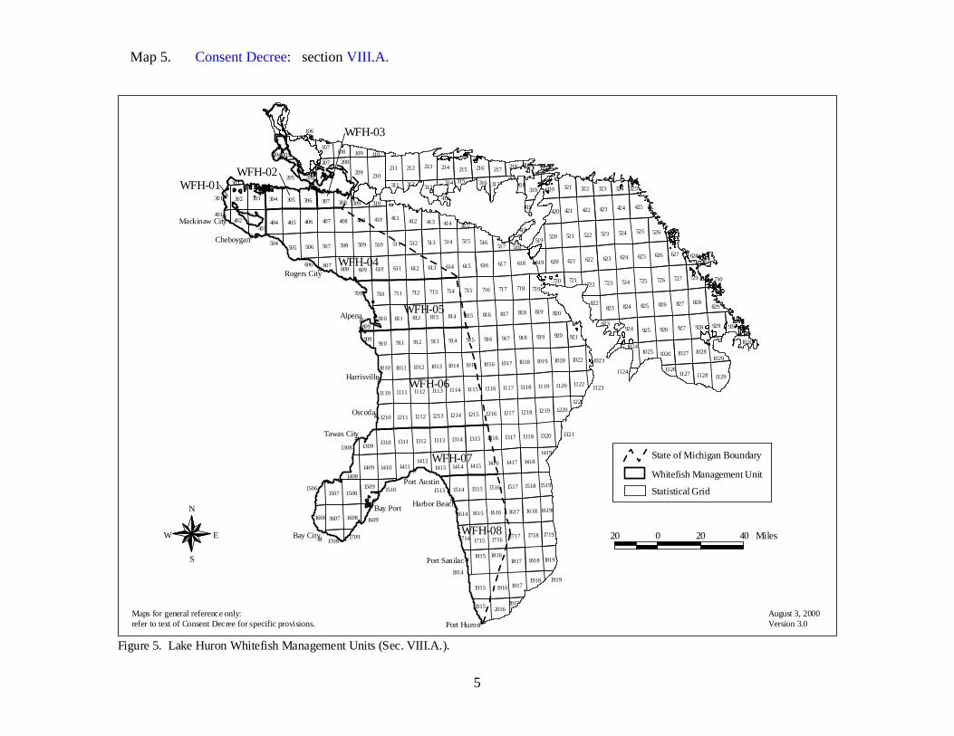
5
Map 5. Consent Decree: section VIII.A.
#
#
#
#
#
#
#
#
#
#
#
#
#
210
618
209
425
213
411
211 212
927926925920919918917916915
828
914913
827
912911
826825824823819818817816815814813
727
812811
726725724723718717716715714713712711
626625624623622621620617616615614613612611610
525524520 523522521
710
515514513512511510
924
509508507
424
506
423422421410409408407406405404
609
214
910
302
929
303
722
820
928810
505
1915
304
321
516
412
608
526
729
627
420
921
306
719
1129
215
305
216
829
207
319
1916
1818181718161815
320 322
1718171717161715
1618161716161615
1310
1607
15181517151615151508
1418141714161415141414101409
132013181317131613151314131313121311
121912181217121612151214121312121211
112011191118111711161115111411131112
1027
1111
10221020101910181017101610151014101310121011
1917
1514
403
1507
1122
822
1210
14131411
413
1509
1026
1608
1028
1220
1128
307
1110
313
720
217
323
402
2016
1309
208
107
2015
308
930
721
108
324
1719
1010
1025
619607
1614
1819
317
414
1127
1419
206
1412
1619
14081519
1606
1918
517
923
519
1029
709
1714
109
316
1024909
105
314
418
218
1030
311 325301
310309
1506
629
312 318
809
315
1321
110
205
527
1708
518
1221
1126
419416
1609
415
1023
1814
104
2017
106
202
1510
730
504
401
219
1123
628606
1513
1308
1124
1709
1919
220
931
Oscoda
Alpena
Bay Port
Bay City
Cheboygan
Port Huron
Tawas City
Port Austin
Harrisville
Rogers City
Port Sanilac
Harbor Beach
Mackinaw City
WFH-06
WFH-07
WFH-04
WFH-08
WFH-05
WFH-01
WFH-03
WFH-02
Figure 5. Lake Huron Whitefish Management Units (Sec. VIII.A.).
N
EW
S
August 3, 2000Version 3.0
20 0 20 40 Miles
Statistical Grid
Whitefish Management Unit
State of Michigan Boundary
Maps for general reference only:refer to text of Consent Decree for specific provisions.
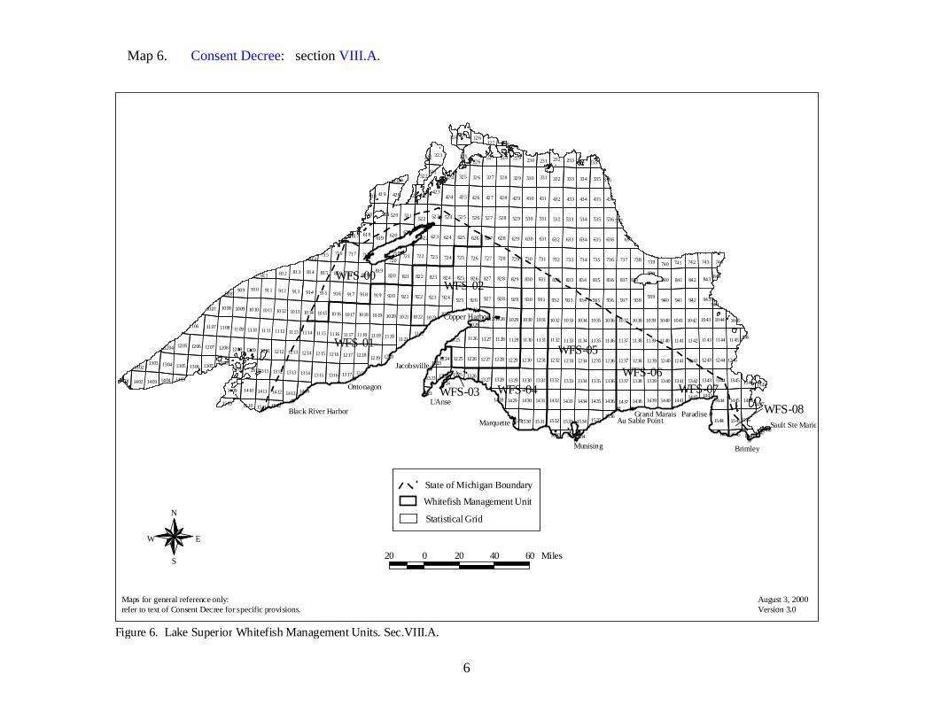
6
Map 6. Consent Decree: section VIII.A.
Figure 6. Lake Superior Whitefish Management Units. Sec.VIII.A.
N
EW
S
August 3, 2000Version 3.0
20 0 20 40 60 Miles
Statistical Grid
State of Michigan Boundary
Whitefish Management Unit
Maps for general reference only:refer to text of Consent Decree for specific provisions.
#
#
#
#
#
#
#
#
#
#
##
WFS-02
WFS-01 WFS-05
WFS-00
WFS-04WFS-06
WFS-07WFS-03WFS-08
L'Anse
Brimley
Paradise
Munising
Marquette
Ontonagon
Jacobsville
Grand Marais
Copper Harbor
Au Sable Point Sault Ste Marie
Black River Harbor
126
129
222226
227 229 230 233 234 235
322323
325 326 327 328 329 330 333 334
421 422 424 425 426 427 428 429 430 431 432 433 434 435 436
518 519 524 525 526 527 528 529 530 531 532 533 534 535 536
618 623
0
624 625 626 627 628 629 630 631 632 633 634 635 636
714715 716 717 722 723 724 725 726 727 728 729 730 731 732 733 734 735 736 737 738 739 740 741 742 743 744
812 813 814 815 816 817 818 820 821 822 823 824 825 826 827 828 829 830 831 832 833 834 835 836 837 838839
840 841 842844
908909 910 911 912 913 914 915 916 917 918 919 920 921 922 923 924 927 928 929 930 931 932 933 934 935 936 937 938 940 941 942
9441008 1009 1010 1011 1012 1013 1014 1015 1016 1017 1018 1019 1020 1021 1022 1023
1024
102610271028 1029 1030 1031 1032 1033 1034 1035 1036 1037 1038 1039 1040 1041 1042 1043
1107 1108 1109 1110 1111 1112 1113 1114 1115 1116 1117 1118 1119 1120 1126 1127 1128 1129 1130 1131 1132 1133 1134 1135 1136 1137 1138 1139 1140 1141 1142 1143 1144 11451146
1204 1205 1206 1207 1208 1209 1210 1211 1212 1213 1214 1215 1216 1217 12181223
1224 1225 1226 1227 1228 1229 1230 1231 1232 1233 1234 1235 1236 1237 1238 1239 1240 1241 1242 1243 1244 12451302 1304 1305 1307 1308
1309 13101311 1312 1313 1314 1317 13181323 1324 1325 1326
1328 1329 1330 1331 1332 1333 1334 1335 1336 1337 1338 1339 1340 1341 1342 1343 1344 1345 13461402 1403 1404 1405
1411 1412 1414 14231429 1430 1431 1432 1433 1434 1435 1436 1438 1439 1440 1441
1442 14431445
14471510 1511 1512
1532 1533 1534 15351536
1545
1632 16331634 1645 16460
223
320
419 423
619 637
811
1007
1045
11251122
1106
1121
1413
14241327
1444
1347
154615441530 1531
1644
926925
1316
720721
819
125
128127124
225 228231 232
335324 331 332 336
418
520
420
521 523537
0
621622
522
617
718
620
719
939
843
943
1044
13031219 1220
1306
13151401
1410
1428 14461509
1409
1437
1647
1529

7
Map 7. Consent Decree: sections IV.A.1.a.; IV.A.1.b.; IV.A.1.c.; IV.A.1.d.; IV.A.1.e.; IV.A.1.f.; IV.A.1.g. Maps: 7.a.; 7.b.; 7.c.
Figure 7. Lake Michigan Tribal Fishing Zones.
Maps for general reference only: refer to text of Consent Decree for specific provisions.
August 3, 2000Version 3.0
20 0 20 40 Miles
#
#
#
#
#
#
#
#
#
#
#
#
#
#
#
#
#
#
#
308
607
806
906 907908
909 910
605
807 808 809 811810
708707 709 711710704
608 611 614609 610 612 613
406
506 516511509 515510 512
417414411407 410 413412
317311
514
312
905
318
218217216
313
508
416
215
505
314
513
408
316
517
713
803
615
409
604
902
310
1204
911
616
802812
214
1104
1902 1903 1904 1905 1906 1907 1908 1909 1910
1802 1803 1804 1805 1806 1807 1808 1809
1703 1704 1705 1706 1707 1708 1709
1603 1604 1605 1606 1607 1608
714
1503 1504 15051506
1507 1508
1403 1404 14051406
1407 1408 1409
1304 1305 1306 1307 1308
1205 1206 1207 1208 1209
1105 1106 1107 1108 1109 1110
1005 1006 1007 1008 1009 1010
716
212
1309
712
1509
507
1702
901
213
1609
315
1810
1210
306
703
219
415
211
1303
518
804
1001
815715
116
706
1004
816
606
319
1602
418
309
1011
405
117
11111911
813
912
1710
115
320
1410
916
118
15101310
519
915
419
814
220
1211
504
Nahma
Escanaba
Petoskey
HarborSprings
Charlevoix
Traverse City
Naubinway
Brevort
Manistee
Frankfort
Ludington
Pentwater
GrandHaven
Muskegon
Empire
Whitehall
Leland
Cedar River
State of Michigan Boundary
Statistical Grid
Northern Lake Michigan Inter-Tribal Fishing Zone - Area description: Sec. IV.A.1.a.Open to commercial fishing pursuant to provisionsof Decree.
Bay de Noc Trap Net Zone - Area description: Sec. IV.A.1.b. Open to commercial fishingpursuant to provisions of Decree. See also Figure 7a.
Little Traverse Tribal Zone - Area description:Sec IV. A. 1.c. Open to commercial fishing pursuant to provisions of Decree. See also Figure 7b.
Lake Michigan Northern Development Zone - Area description: Sec. IV.A.1.d. Open tocommercial fishing pursuant to provisions of Decree.
Grand Traverse Tribal Zone - Area description:Sec. IV.A.1.e. Open to commercial fishing pursuant to provisions of Decree. See also Figure 7c.
Little River Tribal Zone - Area description: Sec. IV.A.1.f. Open to commercial fishing pursuant to provisions of Decree.
Lake Michigan Southern Development Zone - Areadescription: Sec. IV.A.1.g. Open to commercial fishing pursuant to provisions of Decree.
N
EW
S
MackinawCity

8
Map 7.a. Consent Decree: sections IV.A.1.b.; IV.C.4.; VIII.C.1.e.(1)(b).
#
#
#
#
#
#
#
##
# #
308
406
506511509 510
411407410
311
508505
408 409
310
507
306
211
309
405
504
Summer Is.
Washington Is.
St. Martin Is.
Peninsula Point
Mouth of Ford River
Mouth of Escanaba River
Center of Shipping Channel
Nahma
Garden
Fayette
Escanaba
Fairport
Gladstone
Cedar River
Negotiated Fishing Boundary
Area closed to all commercial fishingpursuant to Sec. IV.C.4.
Commercial perch fishing pursuant to Sec. VIII.C.1.e.(b)
Area open to Tribal trap netcommercial fishing pursuant to provisions of Decree.
Figure 7a. Bay de Noc Tribal Trap Net Zone Detail (Sec. IV.A.1.b.).
N
EW
S
August 3, 2000Version 3.0
5 0 5 10 MilesMaps for general reference only:refer to text of Consent Decree for specific provisions.

9
Map 7.b. Consent Decree: sections IV.A.1.c.; IV.C.2. Maps: 14.; 17.; 17.c.
#
#
#
#
#
#
#
#
516515
417414
317
514
318
416
314316
517
315
415
518
319
418
519
419
Beaver Is.
Petoskey
Charlevoix
Cross Village
Harbor Springs
Townline RoadNine Mile Point
Seven Mile Point
Stuttsmanville Road Tower
Area closed year round to all commercial fishing pursuant to Sec. IV.C.2.
Area open to trap nets year round and seasonal large mesh gill nets pursuant to Sec. IV.A.1.c. and other provisions of Decree.
Area open year round to trap nets pursuantto provisions of Decree.
Area open to trap nets and large mesh gill nets year round pursuant to provisions of Decree.
Figure 7b. Little Traverse Tribal Zone Detail (Sec. IV.A.1.c.). See also perch area detail maps, Figures 17, 17c, and salmon areadetail map, Figure 14.
N
EW
S
August 3, 2000Version 3.0
5 0 5 10 MilesMaps for general reference only:refer to text of Consent Decree for specific provisions.

10
Map 7.c. Consent Decree: sections IV.A.1.e.; IV.A.1.e.(2); IV.A.1.e.(2)(b); IV.C.3. Maps: 15.; 17.; 17.a.
#
#
#
#
#
#
#
#
#
910
811810
711710
611614
610 612 613
713
615
911
616
812
714
1010
716712
815
715
816
1011
813
912916915
814
N. Manitou Is.
S. Manitou Is. Leland
Empire
Norwood
Arcadia
Frankfort
Charlevoix
Glen Haven
Suttons Bay
Traverse City
Area closed year round to all commercial fishing pursuant to Sec. IV.C.3.
Area open to trap nets and gill nets year round pursuant to Sec. IV.A.1.e.(2) and other Decree provisions.
Area open to trap nets only year round.
Area open to large mesh gill nets pursuant to Sec. IV.A.1.e.(2)(b) and other Decree provisions.
Area open to large mesh gill nets pursuant to Sec. IV.A.1.e.(2)(b) and other Decree provisions.
Figure 7c. Grand Traverse Tribal Zone Detail (Sec. IV.A.1.e.). See also perch and walleye area detail maps, Figures 17, 17a, and salmon areadetail map, Figure 15.
N
EW
S
August 3, 2000Version 3.0
6 0 6 12 MilesMaps for general reference only:refer to text of Consent Decree for specific provisions.

11
Map 8. Consent Decree: sections IV.A.2.; IV.A.2.a.; IV.A.2.b.; IV.A.2.c.; IV.A.2.d.; IV.A.2.d.(3); IV.C.9. Maps: 8.a.; 8.b.; 12.; 13.; 16.; 18.
#
#
#
#
#
210209
213
411
211 212
813812811
713712711
613612611610
710
513512511510509508507506
410409
408407
406405404
609
302 303
810
505
304
412
608
306305
207
403
413
307
313
402
208
308
607
206
709
909
311
301 310309
312
809
205
202
504
401
606
Alpena
Cheboygan
Rogers City
Mackinaw City
Hammond Bay
Figure 8. Lake Huron Tribal Fishing Zones (Sec. IV.A.2.).
Northern Lake Huron Inter-Tribal Fishing Zone - Open to commercial fishing pursuant to area description Sec. IV.A.2.a. and provisions of Decree. See also Hammond Baydetail map, Figure 8a; perch/walleye detail map, Figure 18;salmon detail map, Figure 16; Les Cheneaux detail map,Figure 13; and St. Marys River detail map, Figure 12.
Bay Mills Small Boat Zone - Open to commercial fishing pursuant to area description Sec. IV.A.2.b. and provisions of Decree. See also Hammond Bay detail map, Figure 8a.
Sault Tribe Tribal Zone - Open to commercial fishing pursuant to area description Sec. IV.A.2.c. and provisions of Decree. See also salmon area detail map, Figure 16.
Southern Lake Huron Trap Net Zone - Open to commercial fishing pursuant to area description Sec. IV.A.2.d. and provisions of Decree. See also Hammond Bay detail map, Figure 8a; and Southern Lake Huron Trap Net Zone detail map, Figure 8b.
Hammond Bay and Rogers City Harbor closure - Area description and provisions in Sec. IV.C.9.
Area open to tribal trap nets via state permit pursuant to area description Sec. IV.A.2.d.(3) and other provisions of Decree.
State of Michigan boundaryAugust 3, 2000Version 3.0
Maps for general reference only:refer to text of Consent Decree for specific provisions.
N
EW
S
10 0 10 20 Miles

12
Map 8.a. Consent Decree: sections IV.A.2.a.(2); IV.A.2.b.(2); IV.C.9.a.
#
#
#506505
504
606
Rogers City
Bell Landing
Hammond BayHarbor of Refuge
Figure 8a. Hammond Bay Area Detail (Sec. IV.C.9.a.).
N
EW
S
August 3, 2000Version 3.0
Portion of Northern Lake Huron Inter-Tribal Fishing Zone open to commercial fishing pursuant to area description and provisions in Sec. IV.A.2.a.(2)
0.5 mile harbor closure
Bay Mills Small Boat Zoneopen to small boat large mesh gill net operations onlypursuant to area description and provisions in Sec. IV.A.2.b.(2)
0.3 mile harbor closure 4 0 4 8 Miles
Maps for general reference only:refer to text of Consent Decree for specific provisions.

13
Map 8.b. Consent Decree: sections IV.A.2.c.; IV.A.2.d.(2); IV.A.2.d.(3); IV.C.9.b.
#
#
813812811
713712711
613612611610
710
513512511510509508507506
609
810
608607
709
809
606
Rogers City
North Point
oy
Figure 8b. Southern Lake Huron Trap Net Zone Detail (Sec. IV.A.2.c.).
N
EW
S
August 3, 2000Version 3.0
Area open to commercial fishing pursuant to area description and provisions in Sec. IV.A.2.d.(2)
Area open to Tribal trap nets pursuant to area description and provisions in Sec. IV.A.2.d.(3)
Rogers City 2 mile harbor closure pursuant to area description and provisions in Sec. IV.C.9.b.
State of Michigan Boundary
10 0 10 20 Miles
Maps for general reference only:refer to text of Consent Decree for specific provisions.

14
Map 9. Consent Decree: sections IV.A.3.a.; IV.A.3.b.; IV.B.1.a. Maps: 9.a.; 9.b.
#
#
#
#
#
#
#
#
#
#
## Paradise
Sault Ste Marie
Brimley
Grand Marais
Munising
Marquette
L'Anse
Jacobsville
Copper Harbor
Ontonagon
Black River Harbor
126
129
222226
227 229 230 233 234 235
322323
325 326 327 328 329 330 333 334
421422 424 425 426 427 428 429 430 431 432 433 434 435 436
518 519 524 525 526 527 528 529 530 531 532 533 534 535 536
618 623
0
624 625 626 627 628 629 630 631 632 633 634 635 636
714715 716 717 722 723 724 725 726 727 728 729 730 731 732 733 734 735 736 737 738 739 740 741 742 743 744
812 813 814 815 816 817 818 820 821 822 823 824 825 826 827 828 829 830 831 832 833 834 835 836 837 838839
840 841 842 844
908909 910 911 912 913 914 915 916 917 918 919 920 921 922 923 924 927 928 929 930 931 932 933 934 935 936 937 938 940 941 942
9441008 1009 1010 1011 1012 1013 1014 1015 1016 1017 1018 1019 1020 1021 1022 10231024
102610271028 1029 1030 1031 1032 1033 1034 1035 1036 1037 1038 1039 1040 1041 1042 1043
1107 1108 1109 1110 1111 1112 1113 1114 1115 1116 1117 1118 1119 1120 1126 1127 1128 1129 1130 1131 1132 1133 1134 1135 1136 1137 1138 1139 1140 1141 1142 1143 1144 11451146
1204 1205 1206 1207 1208 1209 1210 1211 1212 1213 1214 1215 1216 1217 12181223
1224 1225 1226 1227 1228 1229 1230 1231 1232 1233 1234 1235 1236 1237 1238 1239 1240 1241 1242 1243 1244 12451302 1304 1305 1307 1308
1309 13101311 1312 1313 1314 1317 13181323 1324 1325 1326
1328 1329 1330 1331 1332 1333 1334 1335 1336 1337 1338 1339 1340 1341 1342 1343 1344 1345 13461402 1403 1404 1405
1411 1412 1414 14231429 1430 1431 1432 1433 1434 1435 1436 1438 1439 1440 1441
1442 14431445
14471510 1511 1512
1532 1533 1534 15351536
1545
1632 16331634 1645 16460
223
320
419 423
619 637
811
1007
1045
11251122
1106
1121
1413
14241327
1444
1347
154615441530 1531
1644
926925
1316
720721
819
125128127
124
225 228231 232
335324 331 332 336
418
520
420
521 523537
0
621622
522
617
718
620
719
939
843
943
1044
13031219 1220
1306
13151401
1410
1428 14461509
1409
1437
1647
1529 Au Sable Point
Figure 9. Lake Superior Tribal Fishing Zones (Sec. IV.B.1.A.). See also Zone Boundary Detail, Figure 9a and MI-8 detail map, Figure 9b.
N
EW
S
August 3, 2000Version 3.0
Statistical Grid
Lake Superior Inter-Tribal Fishing Zone - Area description and provisions: Sec. IV.A.3.a.Western Lake Superior Trap Net Zone - Area description and provisions: Sec. IV.A.3.b.
State of Michigan Boundary
20 0 20 40 60 Miles
Maps for general reference only:refer to text of Consent Decree for specific provisions.
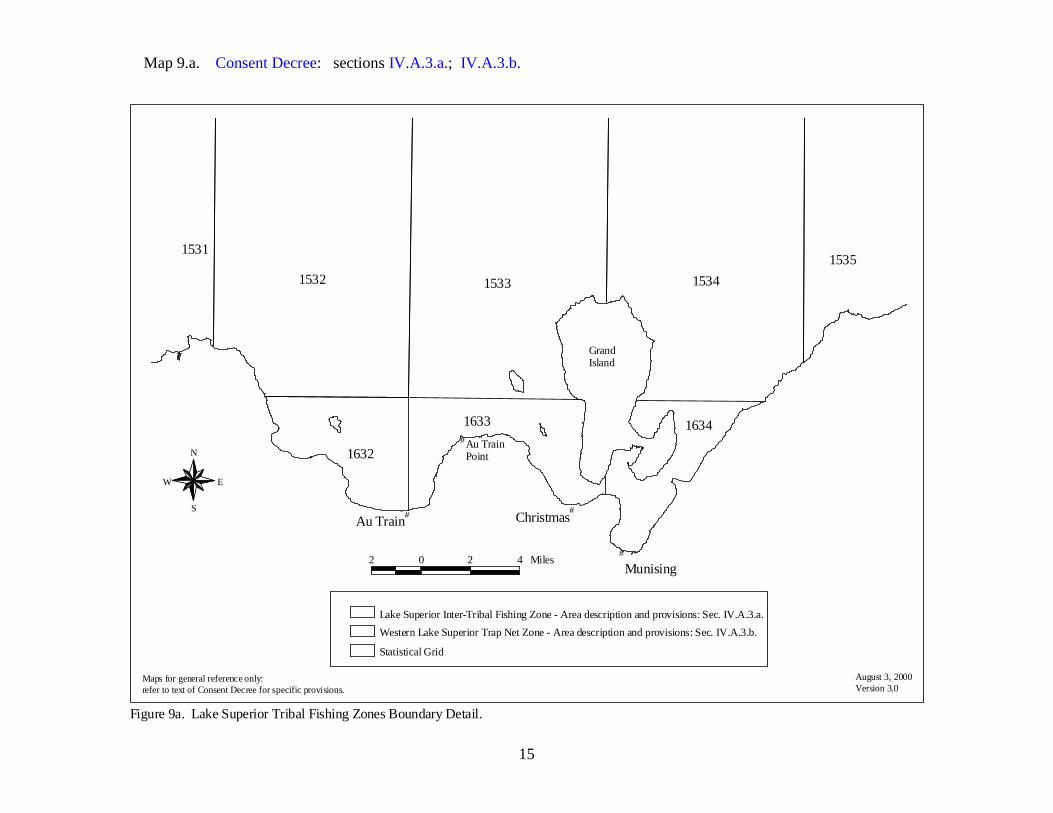
15
Map 9.a. Consent Decree: sections IV.A.3.a.; IV.A.3.b.
Figure 9a. Lake Superior Tribal Fishing Zones Boundary Detail.
August 3, 2000Version 3.0
Maps for general reference only:refer to text of Consent Decree for specific provisions.
#
1532 1533 15341535
1633
1632
1634
1531
Munising
GrandIsland
#
#
# ChristmasAu Train
Au TrainPointN
EW
S
Statistical Grid
Lake Superior Inter-Tribal Fishing Zone - Area description and provisions: Sec. IV.A.3.a.Western Lake Superior Trap Net Zone - Area description and provisions: Sec. IV.A.3.b.
2 0 2 4 Miles

16
Map 9.b. Consent Decree: sections IV.A.3.a.; VII.D.; VIII.C.1.d.(1)(c); VIII.C.1.e.(1)(f).
#
#
#
1242 1243 1244 1245
1342 13431344
1345
1346
14421443
1445
1447
1545
16451646
1444
1347
15461544
1644
1446
1647
Paradise
Sault Ste Marie
Brimley
Figure 9b. Lake Superior Management Unit-MI-8 detail; lake trout harvest pursuant to Sec.VII.D.
N
EW
S
August 3, 2000Version 3.0
5 0 5 10 Miles
Area also open to walleye and perch harvest pursuant to area description and provisionsin Sec.VIII.C.1.d.(1)(c) and Sec.VIII.C.1.e.(1)(f)
Area open to commercial fishing pursuant to Sec.IV.A.3.a.
Statistical Grid
Unit-MI-8
Maps for general reference only:refer to text of Consent Decree for specific provisions.
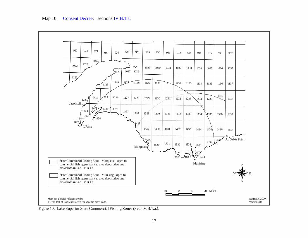
17
Map 10. Consent Decree: sections IV.B.1.a.
Figure 10. Lake Superior State Commercial Fishing Zones (Sec. IV.B.1.a.).
August 3, 2000Version 3.0
#
#
#
#
#
925 926 937936922 924923
935933 934927 930 932931928 929
1530
143714361430 14331429 143514341431 1432
1336 13371330 13331328 13351329 13341331 1332
123612371225 12271226 1233 12351230 12341228 1229 12321231
1136 11371127 113511331130 11341128 11321129 1131
10221036 103710351033 10341030 1032
102810311029
1126
15321531 1533 1534
1327
1224
1023
1125
1027
1323
1535
1326
1529
1428
1122
13251324
1024
1026
1536
16331632 1634
1423
1223
1424
L'Anse
Munising
Marquette
Jacobsville
Au Sable Point
N
EW
S
Maps for general reference only:refer to text of Consent Decree for specific provisions.
State Commercial Fishing Zone - Munising - open tocommercial fishing pursuant to area description and provisions in Sec. IV.B.1.a.
State Commercial Fishing Zone - Marquette - open to commercial fishing pursuant to area description and provisions in Sec. IV.B.1.a.
10 0 10 20 Miles

18
Map 11. Consent Decree: sections IV.C.2.; IV.C.3.; IV.C.4.; IV.B.1.b.; IV.B.1.c.; IV.B.1.d.; IV.B.1.e.
N
EW
S
#
#
#
#
#
#
#
#
#
#
#
#
#
#
#
#
#
#
#
308
607
806
906 907908
909 910
605
807 808 809 811810
708707 709 711710704
608 611 614609 610 612 613
406
506516511509 515510 512
417414411407 410 413412
317311
514
312
905
318
218217216
313
508
416
215
505
314
513
408
316
517
713
803
615
409
604
902
310
1204
911
616
802
2002
812
214
1104
2103 2104 2105 2106 2107 2108 2109 2110
2003 2004 2005 2006 2007 2008 2009 2010
1902 1903 1904 1905 1906 1907 1908 1909 1910
1802 1803 1804 1805 1806 1807 1808 1809
1703 1704 1705 1706 1707 1708 1709
1603 1604 1605 1606 1607 1608
714
1503 1504 15051506
1507 1508
1403 1404 14051406
1407 1408 1409
1304 1305 1306 1307 1308
1205 1206 1207 1208 1209
1105 1106 1107 1108 1109 1110
1005 1006 1007 1008 1009 1010
716
212
1309
712
1509
507
1702
901
213
1609
315
1810
1210
306
703
219
415
211
1303
518
804
1001
2111
815715
2102
116
706
2011
1004
816
606
319
1602
418
309
1011
405
117
11111911
813
912
1710
115
320
1410
916
118
15101310
519
915
419
814
220
1211
Nahma
Escanaba
Petoskey
HarborSprings
Charlevoix
Traverse City
Naubinway
Brevort
Manistee
Frankfort
Ludington
Pentwater
Grand Haven
Muskegon
Empire
Whitehall
Leland
Cedar River
504504
WFM-08
407
WFM-07
WFM-06
WFM-01
20 0 20 40 Miles August 3, 2000Version 3.0
Maps for general reference only: refer to text of Consent Decree for specific provisions.
Figure 11. Lake Michigan State Commercial Fishing Zones.
Area open to state commercial fishingpursuant to Sec. IV.B.1.b.-e.
State of Michigan Boundary
Area closed to all commercial fishingpursuant to Sec. IV.C.2.-4.
MackinawCity
Whitefish Management Unit
Statistical Grid

19
Map 12. Consent Decree: sections IV.C.1.
Figure 12. St. Marys River Closure (Sec. IV.C.1.).
##
##
207
306
208
206
307308
Hay Point
CherryIsland
DetourFerry Dock
Drum. Is.Ferry Dock
Drummond Island
N
EW
S
Southern Boundary of St. Marys River Closure
#
#
#
1646
1647 Sault Ste Marie, Michigan
Sugar Island
Sault Ste Marie, Ontario#
Brush Point
Point AuxPins, Ontario
N
EW
S
Northern Boundary of St. Marys River Closure
Statistical Grid
Area closed to commercial fishing pursuant to area description and provisions Sec. IV.C.1.
State of Michigan Boundary
August 3, 2000Version 3.0
Maps for general reference only:refer to text of Consent Decree for specific provisions.
Statistical Grid
Area closed to commercial fishing pursuant to area description and provisions Sec. IV.C.1.
State of Michigan Boundary
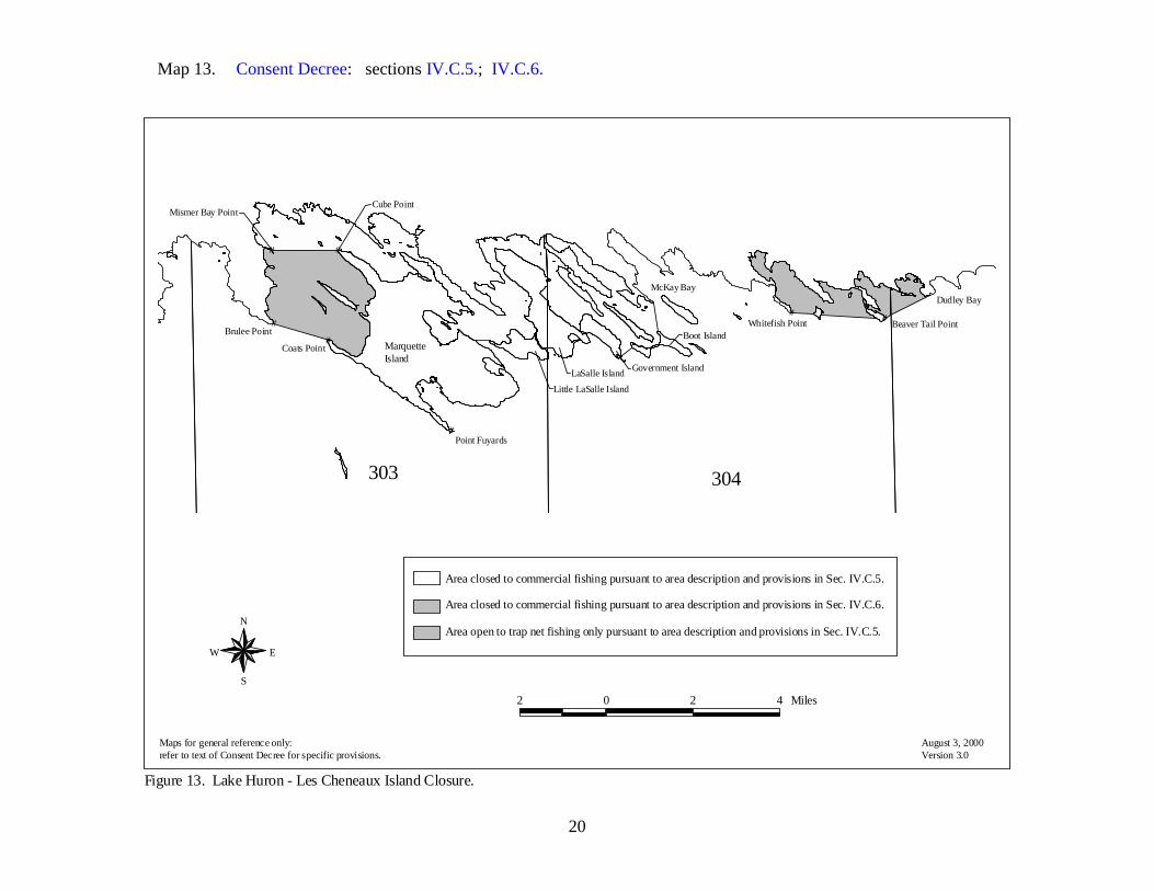
20
Map 13. Consent Decree: sections IV.C.5.; IV.C.6.
Figure 13. Lake Huron - Les Cheneaux Island Closure.
N
EW
S
August 3, 2000Version 3.0
#
#
#
##
##
303 304
McKay BayDudley Bay
Cube Point
Boot IslandCoats Point
Brulee Point
Point Fuyards
LaSalle Island
Whitefish Point
Mismer Bay Point
Government Island
Beaver Tail Point
Little LaSalle Island
Area closed to commercial fishing pursuant to area description and provisions in Sec. IV.C.5.
Area closed to commercial fishing pursuant to area description and provisions in Sec. IV.C.6.
Area open to trap net fishing only pursuant to area description and provisions in Sec. IV.C.5.
2 0 2 4 Miles
Maps for general reference only:refer to text of Consent Decree for specific provisions.
MarquetteIsland

21
Map 14. Consent Decree: sections VIII.B.1.; VIII.B.4.; VIII.B.5.; VIII.B.6.
#
#
#
#
#
417
317 318
517 518
319
418
320
519
419
Cross Village
Mackinaw City
Harbor Springs
McGulpin Point
Seven Mile Point
Salmon fishing is permitted pursuant to area descriptionand provisions in Sec. VIII.B.1. and Sec. VIII.B.4.-6.
Figure 14. Lake Michigan Little Traverse Bay Bands' Salmon Fishery Detail (Sec. VIII.B.1.).
N
EW
S
August 3, 2000Version 3.0
4 0 4 8 MilesMaps for general reference only:refer to text of Consent Decree for specific provisions.

22
Map 15. Consent Decree: sections VIII.B.; VIII.B.2.a.; VIII.B.2.b.; VIII.B.4.; VIII.B.5.; VIII.B.6.
#
#
#
#
#
#
6142 613
516515
512
514513 517
713
615 616
714716
2
51
815
715
816
813 814
Buoy N "2"
Suttons PointBuoy C "1"
Norwood
Charlevoix
Suttons Bay
Mouth ofLeland River
Salmon fishing is permitted pursuant to area descriptionand provisions in Sec. VIII.B.2.b. and Sec. VIII.B.4.-6.
Salmon fishing is permitted pursuant to area descriptionand provisions in Sec. VIII.B.2.a. and Sec. VIII.B.4.-6.
Figure 15. Lake Michigan Grand Traverse Band's Salmon Fishery Detail (Sec. VIII.B.).
N
EW
S
August 3, 2000Version 3.05 0 5 10 MilesMaps for general reference only:
refer to text of Consent Decree for specific provisions.

23
Map 16. Consent Decree: sections IV.A.2.c.; IV.A.2.c.(1)(a); IV.A.2.c.(1)(b); VIII.B.3.; VIII.B.4.; VIII.B.5.; VIII.B.6.
Figure 16. Sault Tribe Tribal Zone (Sec. IV.A.2.C.).
N
EW
S
August 3, 2000Version 3.0
#
#
#
#
404
302303 304
403
402
301
202
504
401
Brulee Point
Cordwood Point
Rabbit Back Point
Hammond Bay Harbor Light
Salmon fishing is permitted pursuant to area description andprovisions in Sec. IV.A.2.c(1)(b) and VIII.B.3.-6.Salmon fishing is permitted pursuant to area description andprovisions in Sec. IV.A.2.c(1)(a) and VIII.B.3.-6.
Lake Huron Statistical Grid
5 0 5 10 Miles
Maps for general reference only:refer to text of Consent Decree for specific provisions.
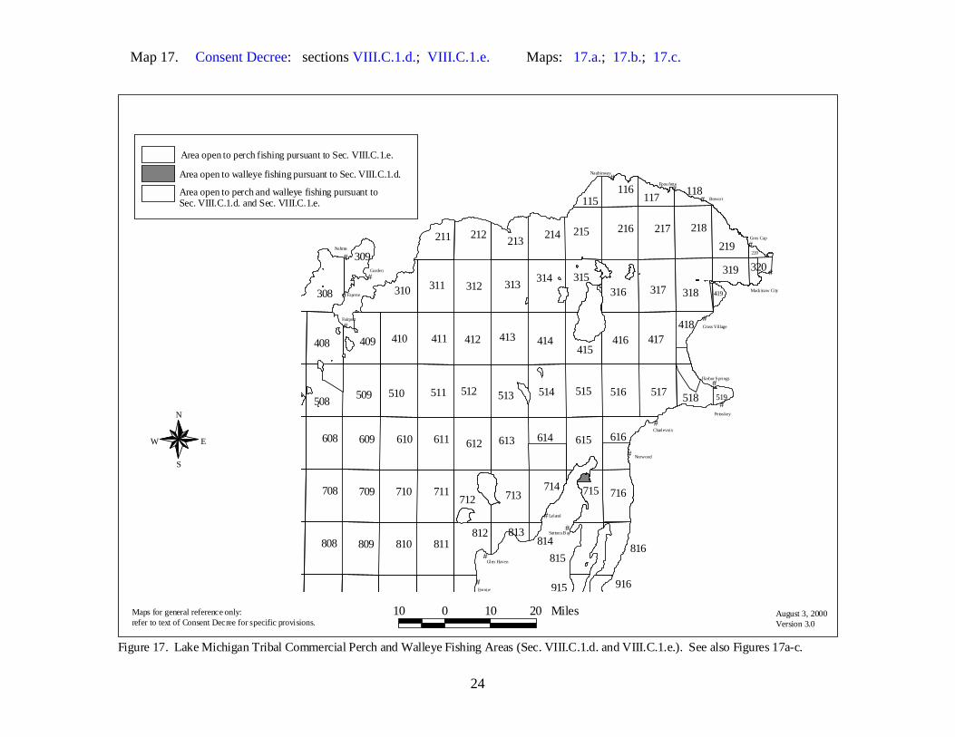
24
Map 17. Consent Decree: sections VIII.C.1.d.; VIII.C.1.e. Maps: 17.a.; 17.b.; 17.c.
Area open to perch fishing pursuant to Sec. VIII.C.1.e.
Area open to perch and walleye fishing pursuant toSec. VIII.C.1.d. and Sec. VIII.C.1.e.
Area open to walleye fishing pursuant to Sec. VIII.C.1.d.
Figure 17. Lake Michigan Tribal Commercial Perch and Walleye Fishing Areas (Sec. VIII.C.1.d. and VIII.C.1.e.). See also Figures 17a-c.
N
EW
S
August 3, 2000Version 3.0
#
#
#
#
#
#
#
#
#
#
#
#
##
#
#
#
#
308
808 809 811810
708 709 711710
608 611 614609 610 612 613
516511509 515510 512
417414411410 413412
317311
514
312 318
218217216
313
508
416
215
314
513
408
316
517
713
615
409
310
616
812
214
714 716
212
712
213
315
219
415
211
518
815
715
116
816
319
418
309
117
813
320
916
118
519
915
419
814
220Nahma
Garden
Leland
Empire
Fayette
Brevor t
Norwood
Petoskey
Gros Cap
Fairport
Naubinway
Epoufette
Charlevoix
Glen Haven
Suttons B ay
Cross Village
Mack inaw City
Harbor Springs
115
10 0 10 20 MilesMaps for general reference only:refer to text of Consent Decree for specific provisions.
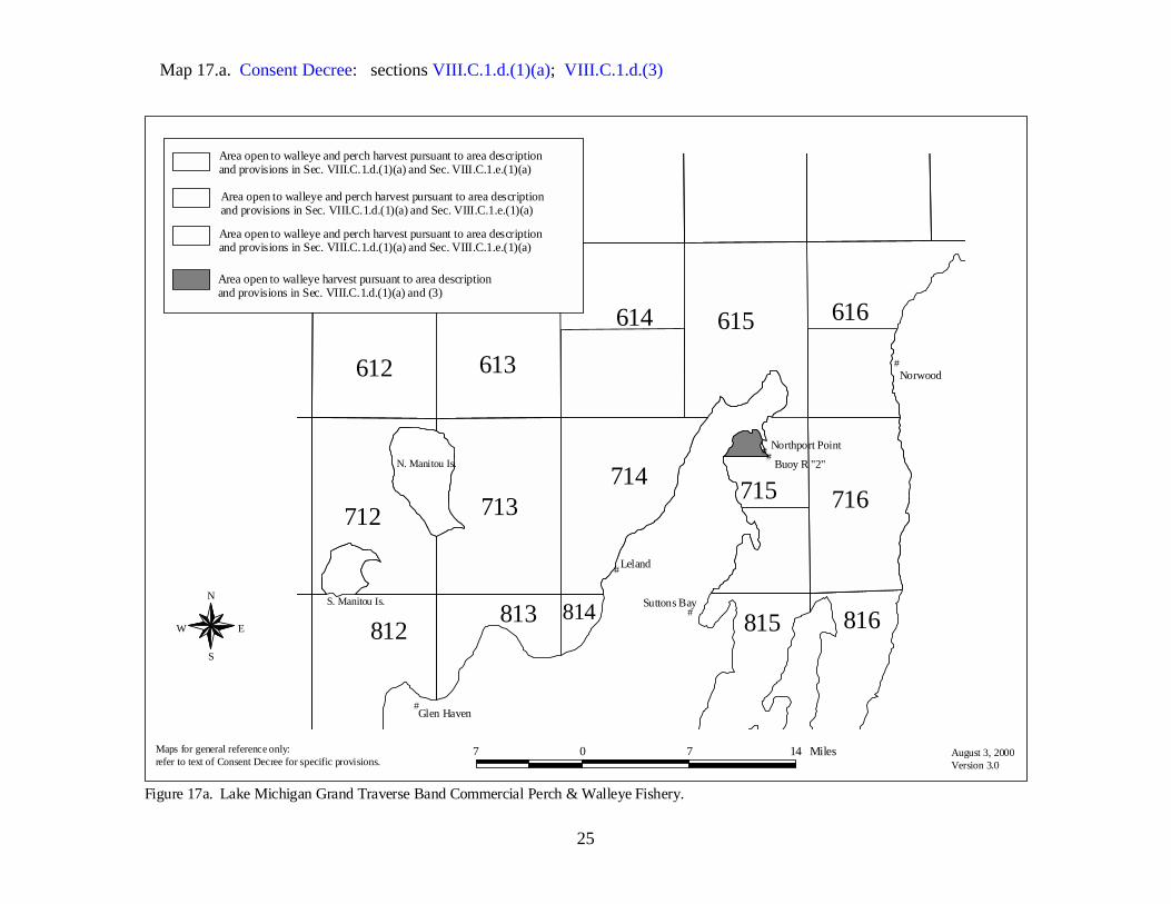
25
Map 17.a. Consent Decree: sections VIII.C.1.d.(1)(a); VIII.C.1.d.(3)
#
#
#
#
##
N. Manitou Is.
S. Manitou Is.
614
612 613
713
615 616
812
714716
712
815
715
816813 814
Buoy R "2"
Northport Point
Norwood
Glen Haven
Suttons Bay
Leland
Area open to walleye and perch harvest pursuant to area descriptionand provisions in Sec. VIII.C.1.d.(1)(a) and Sec. VIII.C.1.e.(1)(a)
Area open to walleye and perch harvest pursuant to area descriptionand provisions in Sec. VIII.C.1.d.(1)(a) and Sec. VIII.C.1.e.(1)(a)
Area open to walleye and perch harvest pursuant to area descriptionand provisions in Sec. VIII.C.1.d.(1)(a) and Sec. VIII.C.1.e.(1)(a)
Area open to walleye harvest pursuant to area descriptionand provisions in Sec. VIII.C.1.d.(1)(a) and (3)
Figure 17a. Lake Michigan Grand Traverse Band Commercial Perch & Walleye Fishery.
N
EW
S
August 3, 2000Version 3.0
7 0 7 14 MilesMaps for general reference only:refer to text of Consent Decree for specific provisions.

26
Map 17.b. Consent Decree: sections VIII.C.1.e.; VIII.C.1.e.(1)(c); VIII.C.1.e.(1)(c)i.; VIII.C.1.e.(1)(c)ii.; VIII.C.1.e.(2)(a); VIII.C.1.e.(2)(b); VIII.C.1.e.(3); VIII.C.1.e.(4); VIII.C.1.e.(5); VIII.C.1.e.(6).
#
#
#
#
#
#
#
417
317 318
218217216
416
215
316315
219
415
319
418
320
419
220
McGulpin Point
Waugoshance Point - WestW. Pt of Waugoshance Island
Brevort
Gros Cap
Cross Village
Mackinaw City
Closed areas pursuant to Sec. VIII.C.1.e.(1)(c)i.-iii.
Area closed to commercial perch fishing pursuant to area descriptionand provisions in Sec. VIII.C.1.e.(2)(b) and Sec. VIII.C.1.e.(3)-(6)
Area closed to commercial perch fishing pursuant to area descriptionand provisions in Sec. VIII.C.e.(2)(a) and Sec. VIII.C.1.e.(3)-(6)
Area open to commercial perch fishing pursuant to area descriptionin Sec. VIII.C.1.e.(1)(c) and provisions in Sec. VIII.C.1.e.(3)-(6)
Figure 17b. Lake Michigan Tribal Commercial Perch Fishery (Sec. VII.C.1.e.).
N
EW
S
August 3, 2000Version 3.0
7 0 7 14 MilesMaps for general reference only:refer to text of Consent Decree for specific provisions.

27
Map 17.c. Consent Decree: sections VIII.C.1.e.(1)(d).
#
#
#
#
#
#
#
#
#
516
417416
517518
418
519
Petoskey
Charlevoix
Cross Village
Harbor Springs
Townline Road
Nine Mile Point
Seven Mile Point
Stuttsmanville Road Tower
Middle Village - church spire
Area open to perch harvest pursuant to area description and provisions in Sec. VIII.C.1.e.(1)(d)
Figure 17c. Lake Michigan Tribal Commercial Perch Fishery.
N
EW
S
August 3, 2000Version 3.0
3 0 3 6 MilesMaps for general reference only:refer to text of Consent Decree for specific provisions.

28
Map 18. Consent Decree: sections VIII.C.1.d.(1)(b); VIII.C.1.e.(1)(e). Map: 13.
#
#
###
407406405404
302 303 304306305
403
307
402
301
202
504
401
Coats Point
Point Fuyards
LaSalle IslandDudley Bay
Brulee Point Whitefish Point
Figure 18. Lake Huron Tribal Commercial Perch and Walleye Fishing Areas. See also Les Cheneaux Island Closure detail map, Figure 13.
N
EW
S
August 3, 2000Version 3.0
Area open to perch and walleye harvest pursuant to area descriptionand provisions in Sec. VIII.C.1.d.(1)(b) and Sec. VIII.C.1.e.(1)(e)
6 0 6 12 Miles
Maps for general reference only:refer to text of Consent Decree for specific provisions.