UNIT 6: ADDITIONAL REGULATORY MEASURES
35
Additional Regulatory Measures 6-1 UNIT 6: ADDITIONAL REGULATORY MEASURES In this unit The NFIP encourages states and communities to implement flood-plain management programs that go beyond NFIP minimum requirements since local flood hazards vary and what makes sense in one state or community may not make sense in another. This unit begins with a discussion of the problems that can arise when regulations are so restrictive they effectively “take” people’s freedom to use their properties. Although NFIP minimum requirements have not been held by the Courts as a “taking”, it may become an issue in States and communities that adopt more restrictive regulations. It then describes some of the more common regulatory approaches that exceed the NFIP’s minimum standards that result in a better and more appropriate local floodplain management program. These include: • State required regulatory standards, • Higher local standards, • Regulations that address special flood hazards, and • Environmental protection regulations.
Transcript of UNIT 6: ADDITIONAL REGULATORY MEASURES

Additional Regulatory Measures 6-1
UNIT 6: ADDITIONAL REGULATORY MEASURES
In this unit The NFIP encourages states and communities to implement flood-plain management
programs that go beyond NFIP minimum requirements since local flood hazards vary and what makes sense in one state or community may not make sense in another. This unit begins with a discussion of the problems that can arise when regulations are so restrictive they effectively “take” people’s freedom to use their properties. Although NFIP minimum requirements have not been held by the Courts as a “taking”, it may become an issue in States and communities that adopt more restrictive regulations.
It then describes some of the more common regulatory approaches that exceed the NFIP’s minimum standards that result in a better and more appropriate local floodplain management program. These include:
• State required regulatory standards,
• Higher local standards,
• Regulations that address special flood hazards, and
• Environmental protection regulations.

Additional Regulatory Measures 6-2
CONTENTS
INTRODUCTION.........................................................................................................6-4
A. TAKING..................................................................................................................6-5
B. STATE REGULATORY STANDARDS ................................................................6-10
C. HIGHER REGULATORY STANDARDS ..............................................................6-12
Location Restrictions............................................................................................6-13 Highly hazardous areas ............................................................................................................ 6-13 Subdivision design .................................................................................................................... 6-13 Setbacks ................................................................................................................................... 6-15 Manufactured homes ................................................................................................................ 6-16 Natural areas............................................................................................................................. 6-16 Low-density zoning ................................................................................................................... 6-16
Building Requirements.........................................................................................6-17 Freeboard.................................................................................................................................. 6-17 Foundation standards ............................................................................................................... 6-18
Safety Requirements ...........................................................................................6-19 Critical facilities ......................................................................................................................... 6-19 Hazardous materials ................................................................................................................. 6-20 Dry land access......................................................................................................................... 6-20
Encroachment Standards ....................................................................................6-21
Compensatory Storage ........................................................................................6-22
Stormwater Management.....................................................................................6-23
Temporary Moratorium ........................................................................................6-24
D. FLOOD HAZARDS OF SPECIAL CONCERN .....................................................6-25
Coastal Erosion....................................................................................................6-25 Regulatory standards ................................................................................................................ 6-25
Tsunamis .............................................................................................................6-26 Regulatory standards ................................................................................................................ 6-26
Closed Basin Lakes .............................................................................................6-27 Regulatory standards ................................................................................................................ 6-27
Uncertain Flow Paths...........................................................................................6-28 Regulatory standards ................................................................................................................ 6-28
Dam Breaks .........................................................................................................6-29 Regulatory standards ................................................................................................................ 6-29
Ice Jams ..............................................................................................................6-30 Regulatory standards ................................................................................................................ 6-30

Additional Regulatory Measures 6-3
Mudflows..............................................................................................................6-30 Regulatory standards ................................................................................................................ 6-30
E. ENVIRONMENTAL PROTECTION MEASURES.................................................6-31
Strategies.............................................................................................................6-32
Federal Regulations.............................................................................................6-32
Wetland Protection...............................................................................................6-33
Rare and Endangered Species............................................................................6-33
On-Site Sewage Disposal ....................................................................................6-34
Facilities Sitting....................................................................................................6-34
Water Quality Restrictions ...................................................................................6-34
Special Designations ...........................................................................................6-35

INTRODUCTION 44 CFR 60.1(d) The criteria set forth in this subpart are minimum standards for the adoption of flood plain management regulations by flood-prone… communities. Any community may exceed the minimum criteria under this Part by adopting more comprehensive flood plain management regulations utilizing the standards such as contained in Subpart C of this part. In some instances, community officials may have access to information or knowledge of conditions that require, particularly for human safety, higher standards than the minimum criteria set forth in Subpart A of this part. Therefore, any flood plain management regulations adopted by a State or a community which are more restrictive than the criteria set forth in this part are encouraged and shall take precedence.
The NFIP regulatory standards are minimums. They may not be appropriate for every local situation or unique circumstances.
Therefore, states and communities are encouraged to enact more restrictive requirements where needed to better protect people and properties from the local flood hazard.
This unit reviews the more common approaches to this.
Many of these more restrictive requirements are eligible for credit under the Community Rating System (CRS), a program which provides insurance premium discounts to policyholders in communities with more restrictive flood-plain management programs (see Unit 9, Section C). Where CRS credit is provided, it is highlighted with this CRS logo.
Additional Regulatory Measures 6-4

Additional Regulatory Measures 6-5
A. TAKING
Why not simply tell people that they can’t build in the floodplain? If we did, we wouldn’t have to worry about new buildings getting flooded and the regulations would be simple to administer: Just say “No.”
While this regulatory standard appears desirable, it has one fatal legal problem: It could be a “taking.”
The Fifth Amendment to the Constitution states, “Nor shall property be taken for public use without just compensation.” The Constitution contains this provision because in England, the king could take property and use it for his own purpose—such as quartering troops or hunting— without compensation.
The term “taking” has come to mean any action by a government agency that relieves a person of his or her property without payment.
Government agencies possess the authority to acquire privately owned land. Under the power of eminent domain, they can acquire land without the owner’s agreement provided the acquisition clearly is for a demonstrably public purpose and official condemnation proceedings are followed. Some common examples of eminent domain actions are:
• Purchase of land for roads and public works projects.
• The development of public park land.
• Utility acquisition of rights of way for transmission lines, etc.
Courts have ruled that a taking may also occur when the government enacts a law, standard or regulation that limits the use of the land to the extent that the owner has been deprived of all of his or her economic interest in using the property. Thus, the government has “taken” the property under a legal provision known as inverse condemnation.
In cases where a court has found a taking, the governmental body has been required to compensate the property owner. Often, though, the regulations are retracted as applied to that property.
Usually, courts undertake a complicated balancing of public and private interests in deciding a taking issue. The courts will consider such factors as:
• Regulatory objectives.

Additional Regulatory Measures 6-6
• The harm posed by uncontrollable development.
• Reasonableness of the regulations.
• Severity of the economic impact upon the private property owner.
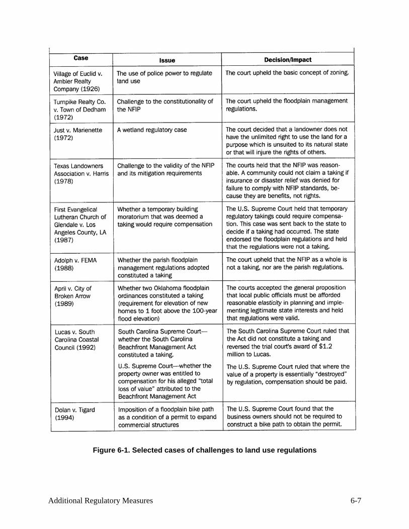
Figure 6-1. Selected cases of challenges to land use regulations
Additional Regulatory Measures 6-7

Additional Regulatory Measures 6-8
Very restrictive floodplain regulations and the regulatory standards of the NFIP have been challenged as a taking in a number of cases. Figure 6-1 summarizes important cases challenging the legality or constitutionality of NFIP or similar land use regulations.
Most NFIP criteria are performance standards that do not prohibit development of a floodplain site provided the performance standards are met. For example, development in the floodway is prohibited only if it increases flood heights. Permit applicants who can find a way to develop in the floodway without increasing the flood problem are permitted to do so. These performance-oriented standards of the NFIP have never been ruled as a taking. This is highly significant, given that more than 19,000 communities administer floodplain management ordinances.
Although it may be more costly to build according to the NFIP standards and, in some instances, it may not be economical to develop a property, the performance standard is a valid exercise of the police power because it is based on a legitimate public purpose: preventing flood damage. Floodway requirements in particular are defensible because they prevent the actions of one property owner from increasing flood damage to his or her neighbors.
The NFIP regulatory criteria have not lost a taking case because they allow any floodprone site to be built on as long as precautions are taken to protect new structures and neighboring property from flood damage. The owners are not denied all economic uses of their properties as long as their construction accounts for the level of hazard.
Some courts have supported regulatory standards that are more restrictive than NFIP regulations, such as complete prohibitions of new buildings or new residences in the floodway. These cases tied the prohibition to the hazard and the need to protect the public from hazards created by the development.
Regulations need to be reasonable. For example, a complete prohibition of development in a shallow flooding area where there is no velocity may not be considered as “reasonable” by a court.
The rationale does not always have to be tied to property damage. For example, in upholding the State’s prohibition of new buildings in the floodway, the Illinois Supreme Court noted that while buildings could be protected, the residents would be surrounded by moving water during floods, preventing access by emergency vehicles.
“The prohibition takes into consideration not only the concern about preventing further flooding, but also the concern about the need to provide disaster relief services and the need for
Additional Regulatory Measures 6-9
the expenditure of state funds on shelters and rescue services for victims of flooding.” (Beverly Bank v. Illinois Department of Transportation, September 19, 1991).
The lesson is that before your community enacts a regulatory provision that severely restricts the use of property, your community’s attorney should review the provision to be sure it will not be overturned as a taking. Regulatory standards that are reasonable, tied to the hazard and support public objectives should be upheld.
Additional Regulatory Measures 6-10
B. STATE REGULATORY STANDARDS
All states now allow communities to regulate development to the NFIP standards. Some states also require that their communities regulate to a higher standard for certain aspects of floodplain management.
This section reviews the more common state requirements. If your ordinance was based on a state model, you should be compliant with all state requirements as well as the NFIP standards.
According to a 1995 survey by the Association of State Floodplain Managers (ASFPM), 24 states have some kind of riverine standards more restrictive than those of the NFIP. Of those, 10 require that communities regulate to the higher standard; three states have opted to implement and enforce the higher standard directly; and 10 states use a combination of both approaches.
Eight states prohibit buildings or residences from their floodways at least in some areas. Twelve states allow less than the NFIP’s one-foot rise in the flood-way. States are more likely to regulate some or all of the floodways than the flood fringes, because they require more technical expertise than those that apply to the fringe and because the impacts of floodway development are more extensive, often going beyond local corporate limits.
The ASFPM survey found that 32 states have enacted some regulations governing shoreline development. For states with ocean or bay coasts, this regulatory authority is usually implemented under the state's coastal zone management program. All the Great Lakes states have lakeshore regulatory standards or permit programs, usually administered as part of state shoreland management programs.
Twenty-three states now have standards for their coastal high hazard areas that exceed those of the NFIP. Sixteen states regulate areas subject to coastal erosion. Sixteen states have regulations or standards to preserve or protect sand dunes and 16 states regulate or set higher standards for lakeshore areas.
Nineteen states have stricter building construction requirements than does the NFIP. The most common additional standard is freeboard (requiring new buildings to be elevated higher than the base (100-year) flood level). This standard may apply to all buildings in the floodplain or only to certain types, such as new jails, hospitals, nursing homes, mobile home parks, or hazardous materials facilities.
Here are some other common state regulatory requirements:

Additional Regulatory Measures 6-11
• 25 states either directly regulate the handling and storage of stormwater in their jurisdictions or establish standards that communities must meet.
• 30 states have regulations or standards for the control of erosion and sediment.
• 23 have either direct regulations or state standards to restrict or prohibit some or all development within a certain distance from bodies of water.
• 16 of those have setbacks for coastal and/or lakeshore areas.
• 14 states have special rules for areas that lie below dams or are protected by levees.
• 30 states have adopted measures to regulate hazardous materials in flood-plains
• 29 states have special public health standards that apply to floodplains
Twenty-four state governors have issued a directive to their state agencies on floodplain
management. Most of these were implemented to meet the minimum NFIP requirements but many go beyond them. Five states have wetlands policy set by executive order, five have orders on hazard mitigation or disaster recovery, and two states have other resource protection executive orders that affect flood-plains.
For more information on which states have which requirements, see Flood-plain Management 1995: State and Local Programs, Association of State Floodplain Managers, 1995.

Additional Regulatory Measures 6-12
C. HIGHER REGULATORY STANDARDS
FEMA has established minimum floodplain management requirements for communities participating in the NFIP. Communities must also enforce more restrictive State requirements. However, communities should seriously consider enacting regulations that exceed the minimum state and federal criteria.
In fact, the NFIP requires communities to at least consider additional measures which are found in 44 CFR 60.22, Planning Considerations for Floodprone Areas. They are summarized in Figure 6-2.
(a) The floodplain management regulations adopted by a community for floodprone areas should: (1) Permit only that development of floodprone areas which (i) is appropriate in light of the probability of flood damage (ii) is an acceptable social and economic use of the land in relation to the hazards involved (iii) does not increase the danger to human life (2) Prohibit nonessential or improper installation of public utilities and public facilities. (b) In formulating community development goals after a flood, each community shall consider: (1) Preservation of the floodprone areas for open space purposes (2) Relocation of occupants away from floodprone areas (3) Acquisition of land or land development rights for public purposes (4) Acquisition of frequently flood-damaged structures. (c) In formulating community development goals and in adopting floodplain management regulations, each community shall consider at least the following factors: (1) Human safety (2) Diversion of development to areas safe from flooding (3) Full disclosure to all prospective and interested parties (4) Adverse effects of floodplain development on existing development (5) Encouragement of floodproofing to reduce flood damage (6) Flood warning and emergency preparedness plans (7) Provision for alternative vehicular access and escape routes (8) Minimum retrofitting requirements for critical facilities (9) Improvement of local drainage to control increased runoff (10) Coordination of plans with neighboring community’s floodplain management programs (11) Requirements for new construction in areas subject to subsidence (12) Requiring subdividers to furnish delineations for floodways (13) Prohibition of any alteration or relocation of a watercourse (14) Requirement of setbacks for new construction within V Zones (15) Freeboard requirements (16) Requirement of consistency between state, regional (17) Requirement of pilings or columns rather than fill to maintain storage capacity
and local comprehensive plans (18) Prohibition of manufacturing plants or facilities with hazardous substances (19) Requirements for evacuation plans
Figure 6-2: NFIP planning considerations (44 CFR 60.22)

Additional Regulatory Measures 6-13
Some of the more common approaches taken by communities to better regulate floodplain
development are explained in this section.
LOCATION RESTRICTIONS Where the hazard is so severe that certain types of development should be prohibited, a
location restriction provision may be appropriate. Some communities prohibit some or all development in all or parts of their floodplains. A common approach is to prohibit particular structures in the floodway or areas exceeding certain flood depths or velocities.
Because this is the most restrictive higher regulatory provision, location restriction language has to be drafted carefully to avoid a taking challenge. Sometimes, a community can tie transfers of development rights or other benefits to a development that avoids the flood hazard area. These types of “win – win” situations benefit everyone and reduce the potential for challenging the ordinance.
Highly hazardous areas Prohibiting development makes sense in high hazard areas, where people are exposed to a
life-threatening situation even though buildings could be protected from flood damage. For example, it would be appropriate to prohibit development at the apex of an alluvial fan or along a narrow floodplain in a stream valley that is susceptible to flash flooding.
Subdivision design Undeveloped land, still in large tracts, offers the best opportunity to limit where certain types
of development will be located. When a developer wants to subdivide the land, communities have many tools to arrange the development so that buildings are kept out of the floodplain or at least the building sites are located in the least hazardous areas of the floodplain. This has two advantages over simply requiring the buildings to be protected from flooding:
• Buildings aren’t isolated by floodwaters, putting a strain on local emergency services to guard them or evacuate or rescue their occupants, and
• The neighborhood will have waterfront open space and recreation areas – a valuable amenity in most communities.
A housing development can be clustered, as shown in Figure 6-3, so the developer can sell the same number of home sites as a conventional subdivision. Check your state laws on whether cluster development can be mandated or just encouraged during the subdivision review process.

Additional Regulatory Measures 6-14

As explained in pages 17-25 of the American Planning Association’s Subdivision Design in Flood Hazard Areas, the planner’s toolbox contains other tools for encouraging developers to avoid floodplains. A density transfer can be used to, say, trade development rights with a flood-free site. Credits or bonuses can be given to increase the allowable density if the developer puts building sites on high ground or does not disturb a wetland.
The planned unit development (PUD) approach offers developers flexibility in planning the entire area. For example, a PUD may have a cluster development with houses closer together than allowed under normal zoning lot line setbacks.
Subdivision and planning regulations also can mandate that a certain portion of a development be set aside as open space for recreation or stormwater management purposes. Developers find that it is cheaper to put the open space in the floodplain than to put buildings there that have to incorporate the more expensive floodplain requirements. Linear parks and greenways that connect the open space areas through a community are becoming more and more popular and help sell new developments.
The Community Rating System credits land development criteria that discourage development in floodplains under Activity 430LD in the CRS Coordinator’s Manual and the CRS Application. See also CRS Credit for Higher Regulatory Standards for example regulatory language.
Setbacks Setbacks may be used to keep development out of harm’s way while at the same time
achieving other community purposes. Setback standards establish minimum distances that structures must be positioned—set back—from river channels and coastal shorelines. Setbacks can be defined by vertical heights or horizontal distances.
While floodplain boundaries are defined by vertical measures, horizontal set-backs also provide protection from flood damage, especially in coastal areas where the effects of waves decrease further inland.
For coastal shorelines, setback distances act as buffer zones against beach erosion. In riverine situations, setbacks prevent disruption to the channel banks and protect riparian habitat. Such setbacks are frequently created to serve as isolation distances to protect water quality, and stream and wetland resources.
Setbacks from watercourses have been used to minimize the effect of non-point sources of pollution caused by land development activities, timber harvesting and agricultural activities.
Additional Regulatory Measures 6-15

Solid waste landfills and on-site sewage disposal systems often are restricted within certain distances of a body of water.
The Community Rating System credits setbacks that prevent disruption to shorelines, stream channels and their banks under Activity 430, Section 431.g.2 in the CRS Coordinator’s Manual and the CRS Application. See also CRS Credit for Higher Regulatory Standards for example regulatory language.
Manufactured homes Many communities have adopted provisions prohibiting the placement of manufactured
(mobile) homes in the floodway. Check your ordinance. This used to be a minimum requirement of the NFIP and may still be on your books.
Natural areas The natural functions and values of floodplains coupled with their
hazardous nature have led communities to promote and guide the less intensive use and development of floodplains. More and more municipalities are requiring that important natural attributes such as wetlands, drainage ways and floodplain areas be set aside as open space as
a condition to approving subdivision proposals. The Community Rating System provides substantial credit for preserving floodplain areas as open space. If buildings and filling are prohibited, credit is found under Activity 420 Open Space Preservation, Section 421.a in the CRS Coordinator’s Manual and the CRS Application. If the area has been kept in or restored to its natural state, more credit is provided under Section 421.c.
Low-density zoning When a community prepares its land use plan and zoning ordinance, it should consider what
uses and densities are appropriate for floodplains. If buildings are not prohibited entirely, the community should zone its floodplains for agricultural or other low-density use to reduce the number of new structures. For example, it’s better to have a floodplain zoned for agricultural or conservation use with a minimum lot size of 20 or 40 acres than to allow four single-family homes to every acre. In some areas, “residential estate” zones with minimum lot sizes of two to five acres provide lots large enough that homes can be built out of the floodplain. Some states have land use planning laws that require local plans before enacting a zoning ordinance. Some—including Oregon, Florida, New Hampshire and Hawaii—mandate that local plans account for floods and other natural hazards.
Additional Regulatory Measures 6-16

The Community Rating System provides substantial credit for zoning floodplains with low-density uses under Activity 430LZ Low Density Zoning in the CRS Coordinator’s Manual and the CRS Application.
BUILDING REQUIREMENTS Freeboard
Freeboard is an additional height requirement above the base flood elevation (BFE) that provides a margin of safety against extraordinary or unknown risks. This reduces the risk of flooding and makes the structure eligible for a lower flood insurance rate.
While not required by the NFIP standards, your community is encouraged to adopt at least a one-foot freeboard to account for the one-foot rise built into the concept of designating a regulatory floodway and the encroachment requirements where floodways are not identified.
Other reasons for considering a freeboard are that it:
• Accounts for future increases in flood stages if additional development occurs in the floodplain.
• Accounts for future flood increases due to upstream watershed development.
• Acts as a hedge against backwater conditions caused by ice jams and debris dams.
• Reflects uncertainties inherent in flood hazard modeling, topography, mapping limitations and floodplain encroachments.
• Provides an added measure of safety against flooding.
• Results in significantly lower flood insurance rates due to lower flood risk.
Freeboard safety factors are common in the design of flood control projects and floodplain
development. Many communities have incorporated freeboard requirements into the elevation and floodproofing requirements stipulated by the NFIP. Freeboard requirements adopted by communities range from six inches to four feet.
When constructing a new elevated building, the additional cost of going up another foot or two is usually negligible. Elevating buildings above the flood level also reduces flood insurance costs for current and future owners.
Additional Regulatory Measures 6-17

Figure 9-3 shows the insurance rates for a post-FIRM single-family dwelling. Note that the higher the building is above the BFE, the lower the rate. These rates are based on the true or actuarial cost of insuring a building in the floodplain. By adding one foot of freeboard above the BFE, the cost for the first layer of coverage is reduced from 45 cents per $100 of coverage to 26 cents. This shows how the extra foot reduces the potential for flood damage.
The Community Rating System credits freeboard under Activity 430, Section 431.a in the CRS Coordinator’s Manual and the CRS Application. See also CRS Credit for Higher Regulatory Standards for example regulatory language.
Foundation standards Without a safe and sound foundation, an elevated building can suffer damage from a flood
due to erosion, scour or settling. The NFIP regulations provide performance standards for anchoring new buildings and foundation and fill placement standards for floodproofed buildings and V Zones.
However, the NFIP performance standards do not specify how a building’s foundations are to be constructed. Especially in areas where an engineer’s certificate is not required by the NFIP regulations, more specific foundation construction standards would help protect buildings from flood damage.
One option is to require that a registered professional engineer or architect certify the adequacy of elevated building foundations and the proper placement, compaction and protection of fill when it is used in building elevation. This is an ordinance requirement in the New Orleans area where subsidence threatens so many buildings.
The national model building codes address building foundations and the proper placement, compaction and protection of fill. You and your building department should review how these standards are enforced.
An alternative is to require a specific construction standard, such as requiring the V Zone standard for new structures in coastal AE and AH Zones. Coastal AE Zones are of particular concern, since they are subject to wave action of up to three feet in height and the NFIP A Zone construction standards do not address this hazard.
Additional Regulatory Measures 6-18

The Community Rating System credits foundation protection under Activity 430, Section 431.b in the CRS Coordinator’s Manual and the CRS Application. See also CRS Credit for Higher Regulatory Standards for example regulatory language.
SAFETY REQUIREMENTS Critical facilities
For some activities and facilities, even a slight chance of flooding poses too great a threat. These should be given special consideration when formulating regulatory alternatives and floodplain management plans.
The following are examples of the types of critical facilities that should be given special attention:
• Structures or facilities that produce, use, or store highly volatile, flammable, explosive, toxic and/or water-reactive materials.
• Hospitals, nursing homes and housing likely to have occupants who may not be sufficiently mobile to avoid injury or death during a flood.
• Police stations, fire stations, vehicle and equipment storage facilities, and emergency operations centers that are needed for flood response activities before, during and after a flood.
• Public and private utility facilities that are vital to maintaining or restoring normal services to flooded areas before, during and after a flood.
A critical facility should not be located in a floodplain. Communities often prohibit critical or
hazardous facilities or uses from the floodway, the V Zone, or the entire floodplain. While a building may be considered protected from the base flood, a higher flood or an error on the builder’s or operator’s part could result in a greater risk than the community is willing to accept.
If a critical facility must be located in a floodplain, then it should be designed to higher protection standards and have flood evacuation plans. The more common standards—freeboard, elevation above the 500-year floodplain and elevated access ramps—should be required.
According to Executive Order 11988, federal agencies must meet rigorous alternative site evaluations and design standards before funding, leasing or building critical facilities in the 500-year floodplain. Executive Order 11988 is discussed further in Section E of this unit.
Additional Regulatory Measures 6-19

The Community Rating System provides credits for prohibiting critical facilities from the 500-year floodplain or requiring them to be protected from damage by the 500-year flood in Activity 430. See the CRS Coordinator’s Manual and the CRS Application. See CRS Credit for Higher Regulatory Standards for example regulatory language.
Hazardous materials While prohibiting or protecting hazardous materials from the floodplain makes sense, it
would be wise to have specific standards in your ordinance. The following lists were taken from the Corps of Engineers’ Flood Proofing Regulations. The first is of items that are extremely hazardous or vulnerable to flood conditions so they should be prohibited from the SFHA or even the 500-year floodplain:
Acetone Ammonia Benzene Calcium carbide Carbon disulfide Celluloid Chlorine Hydrochloric acid
Prussic acid Magnesium Nitric acid Oxides of nitrogen Phosphorus Potassium Sodium Sulfur
The following items are sufficiently hazardous that larger quantities they should be
prohibited in any space below the base flood elevation
Acetylene gas containers Storage tanks Lumber /buoyant items
Gasoline Charcoal/coal dust Petroleum products
Larger quantities of the following items should be prohibited in any space below the
base flood elevation
Drugs Food products Matches/sulfur products
Soaps/detergents Tires
Dry land access Fire prevention, evacuation and rescue operations are common emergency response activities
associated with flooding. The effectiveness and success of these efforts greatly depend on readily available access. However, streets and roads are usually the first things to be inundated in the event of a flood.
Additional Regulatory Measures 6-20

To ensure access, some communities have enacted ordinance provisions requiring that all roads and other access facilities be elevated to or above the BFE. Some require elevation to within one foot of the BFE so at least fire and rescue equipment can travel on them during a flood.
While some local officials may feel that this approach is too restrictive, it is important to note that emergency response personnel die every year attempting to rescue flood-stranded citizens. Also, others may die or be seriously injured because they cannot be rescued in time.
Figure 6-4: Four people died in a 1978 flood in this critical facility.
This nursing home in Rochester, Minnesota, was isolated by high velocity floodwaters.
Because there was no dry land access, firefighters could not rescue the occupants.
Naturally, there are some areas with floodplains so extensive that a developer cannot be expected to connect his development to high ground. As with all regulatory standards, you must carefully weigh the local hazard, the regulation’s objectives, and the costs and benefits of meeting the standard before you draft new ordinance language.
The Community Rating System has credited dry land access provisions under Activity 430,
Section 431.i in the CRS Coordinator’s Manual and the CRS Application.
ENCROACHMENT STANDARDS Some states and communities are not comfortable with allowing development in the flood
fringe to increase flood heights by up to a foot. A one-foot increase in flood heights will increase
Additional Regulatory Measures 6-21

the potential for flood damage to floodprone buildings and affect properties that were otherwise not threatened by the base flood. This is especially true in flat areas where a one-foot increase can extend the floodplain boundary by blocks.
These states and communities require floodway mapping and encroachment studies to allow a smaller surcharge, usually 0.5 or 0.1 foot. Twelve states require that regulatory maps use a smaller floodway mapping surcharge than the NFIP’s one-foot minimum standard. This results in a wider floodway, but less potential for increased flood losses due to future development.
In Minnesota, one watershed district took another regulatory approach, enacting regulations that restricted encroachments in the flood fringe to 20 percent of the total floodplain area. In Washington State, some communities treat higher velocity and deeper flood fringe areas as floodways and make development in those areas comply with the floodway construction standards.
The Community Rating System credits more restrictive floodway mapping standards under Activity 410 Additional Flood Data, Section 411.c in the CRS Coordinator’s Manual and the CRS Application.
COMPENSATORY STORAGE The NFIP floodway standard in 44 CFR 60.3(d) restricts new development from obstructing
the flow of water and increasing flood heights. However, this provision does not address the need to maintain flood storage. Especially in flat areas, the floodplain provides a valuable function by storing floodwaters. When fill or buildings are placed in the flood fringe, the flood storage areas are lost and flood heights will go up because there is less room for the floodwaters. This is particularly important in smaller watersheds that respond sooner to changes in the topography.
For this reason, some communities adopt more restrictive standards that regulate the amount of fill or buildings that can displace floodwater in the flood fringe. One simple approach is to prohibit filling and buildings on fill—all new buildings must be elevated on columns or flow-through crawlspaces.
Check your statutory authority, because in some states buildings are allowed only if they are on fill. Some communities prefer buildings on fill because flood-waters do not come in contact with the building’s foundation and it provides a safe spot above flood levels outside the building walls. Additional Regulatory Measures 6-22

Another approach is to require compensatory storage to offset any loss of flood storage capacity. The developer is required to offset new fill put in the floodplain by excavating an additional floodable area to replace the lost flood storage area. This should be done at “hydraulically equivalent” sites—fill put in below the 10-year flood elevation should be compensated by removal of soil below that elevation elsewhere in the floodplain.
The Community Rating System credits both water quantity and water quality stormwater management regulations and plans under Activity 450 in the CRS Coordinator’s Manual and the CRS Application. See also CRS Credit for Stormwater Management for example regulatory language.
STORMWATER MANAGEMENT A floodplain management program in an urbanizing area must confront the increase in flood
flows caused by development within the watershed. As forests, fields and farms are covered by impermeable surfaces like streets, rooftops and parking lots, more rain runs off at a faster rate. In an urbanized area, the rate of runoff can increase fivefold or more.
Changes in the surface drainage system compound this problem. Stormwater runoff travels faster on streets and in storm drains than it did under pre-development conditions. As a result, flooding is more frequent and more severe (Figure 1-13). Efforts to reduce the impact of increased runoff that results from new development in a watershed are known as stormwater management.
One way to reduce the impact of stormwater from new development is to require the developer to restrict the rate at which the increased runoff leaves the property. The developer must build a facility to store stormwater runoff on the site.
Under stormwater detention, the stored water is held for release at a restricted rate after the storm subsides. Under stormwater retention, stormwater runoff is held for later use in irrigation or groundwater recharge, or to reduce pollution.
As an alternative to using a uniform standard for all areas, many communities regulate development according to a master plan that analyzes the combined effects of existing and expected development on stormwater and flood flows in the watershed. Such watershed-specific regulations may allow different amounts of runoff for different areas in order to control the timing of increased flows into the receiving streams.
Additional Regulatory Measures 6-23

Instead of requiring developers to build stormwater facilities on-site, a plan may require them to contribute funds for a regional facility. By planning the runoff from entire watersheds, this approach can be more effective in reducing increases in downstream flooding.
Stormwater management also has water quality aspects, and includes efforts to reduce erosion and the entry of sediment and pollutants into receiving streams.
The Community Rating System credits both water quantity and water quality stormwater management regulations and plans under Activity 450 in the CRS Coordinator’s Manual and the CRS Application. See also CRS Credit for Stormwater Management for example regulatory language.
TEMPORARY MORATORIUM Following a flood, a number of communities have imposed moratoriums on rebuilding in the
damaged area, effectively prohibiting floodplain development. Often, temporary measures are put in place after a flood to allow time to plan for acquisition, relocation, or redevelopment of the area, or to install flood control projects.
A temporary moratorium should specify when it will be lifted, such as “within three months or when the plan is completed, whichever is sooner.” An open ended moratorium may be viewed by a court as a taking, since the owner has no idea when he or she will be allowed to build or rebuild.
Additional Regulatory Measures 6-24

D. FLOOD HAZARDS OF SPECIAL CONCERN
The mapping and regulatory standards of the NFIP do not completely address every flood problem in the United States. Certain floodplains and flood-related hazards are more destructive and harder to map than riverine, coastal and shallow flooding.
Unit 1 introduced these flood hazards, so we won’t discuss them in detail here. This section reviews the more common regulatory standards appropriate to each hazard.
In addition to regulations, communities should address these special hazards in their planning, public information, hazard disclosure and flood warning programs.
More information on these hazards and the Community Rating System credit for mapping and managing them is found in CRS Credit for Special Hazard Areas.
COASTAL EROSION
Coastal erosion occurs to properties in the coastal floodplain and to properties on bluffs above the floodplain. Estimates are that 24 percent of the Atlantic, Pacific, Gulf of Mexico and Great Lakes coasts face significant erosion.
Special erosion rate maps are needed to regulate new construction to protect it from coastal erosion. Normally, 30-, 60- or 100-year erosion zones are used. Erosion zones are generally calculated by multiplying the annual rate of erosion times the number of years of protection to be provided.
The 30-year erosion zone is the area that will likely erode over the next 30 years. It is measured inland from a known point, such as the dune or vegetation line. Erosion zones are “moving targets.” They can change each year as the dune or vegetation line moves inland (or seaward). Erosion rates also vary over the years, moving at a faster or slower rate than the annual average.
Regulatory standards There are NFIP regulatory performance standards and planning considerations for erosion-
prone areas in 44 CFR 60.5 and 60.24, respectively. As with 44 CFR 60.3, the NFIP requirements are keyed to the type of hazard data provided by FEMA. Since there are no FEMA Additional Regulatory Measures 6-25

Additional Regulatory Measures 6-26
erosion-prone maps published yet, there are no NFIP requirements for managing erosion-prone areas. Therefore, Sections 60.5 and 60.24 should be viewed as advisory.
Several states have erosion management requirements. Their typical regulatory standards include:
• All new buildings must be located landward of the 30-year erosion zone
• All larger buildings must be located landward of the 60-year erosion zone
• Deeper pilings and special foundation provisions
• Traffic restricted on sand dunes and other protective features
For more information, contact your state’s coastal zone management office. See also
FEMA’s Coastal Construction Manual.
TSUNAMIS A tsunami is a wave or series of waves generated at sea or near shore by an earthquake,
volcano or landslide. Tsunamis can move as fast as 1,000 kilometers per hour from their point of origin, usually in the Pacific Ocean.
Tsunamis pose two special hazards: a short warning time and very deep flooding.
Tsunamis are hard to recognize at sea but when they reach shallow water, a wave builds up. The effect is more like a rise in sea level than a breaking wave. In narrow areas, where water is concentrated, the resulting water level can be very high, in some areas as much as 20 or 30 feet above normal tides.
Tsunami inundation areas generally are not mapped by FEMA because they are not considered a normal condition of flooding. However, recent federal-state efforts have improved the availability of maps and data for the Pacific states. For more information on tsunami maps, contact your state’s emergency management or coastal zone management office.
Regulatory standards The best regulatory approach is to use an estimated tsunami flood level or the BFE,
whichever is higher. Keeping new buildings out of the area that lies below that elevation, or protecting them from flood damage below that elevation, would be appropriate. If not all new buildings can be prohibited, at least critical facilities and/or high-occupancy buildings should be prevented from locating in the area that will have little advance warning of a flood.

Additional Regulatory Measures 6-27
A community should also tie development of a tsunami-prone area to the availability of a warning system. Without adequate warning, occupying such an area can be deadly.
See also CRS Credit for Management of Pacific and Caribbean Tsunami Hazards.
CLOSED BASIN LAKES Two types of lakes pose special hazards to adjacent development:
• Lakes with no outlets, like the Great Salt Lake, Utah, Devil’s Lake, North Dakota, and the Salton Sea, California; and
• Lakes with inadequate, regulated or elevated outlets, such as the Great Lakes and many glacial lakes.
These are referred to as “closed basin lakes.” Closed basin lakes are subject to large fluctuations in elevation that can persist for weeks, months or years.
Closed basin lakes were formed in almost every part of the United States:
• Glaciers scoured out lakes in the northern tier of states and Alaska.
• Tectonic action created lakes with no outlets (playas) in the western U.S.
• Channel migration formed oxbow lakes along the Mississippi and other large rivers.
• Sinkhole lakes formed where there are large limestone deposits at or near the surface and adequate surface water and rainfall to dissolve the lime-stone.
Regulatory standards As with tsunamis, the key to regulating these areas is to determine the appropriate regulatory
flood elevation that will likely be higher than the BFE. The elevation can be determined by studying historical or geological records, or identifying the elevation of the lowest point where water can leave.
Areas lower than the regulatory elevation should have construction standards that protect buildings and their occupants from prolonged flooding. Other than prohibiting new buildings entirely, the best approach is to require:
• Construction of new buildings on fill above the regulatory elevation. The fill should be engineered and placed to resist wave action.
• Protection of utilities

• Access from dry land.
• Alternatives to septic systems, which won’t work under water.
• Alternatives to on-site wells, which would be polluted when floodwater mixes with ground water.
For more information, see CRS Credit for Management of Areas
Adjacent to Closed Basin Lakes and Reducing Losses in High Risk Flood Hazard Areas: A Guidebook for Local Officials.
UNCERTAIN FLOW PATHS This hazard includes alluvial fans and moveable bed streams. They occur in hilly or
mountainous areas rich in sediments and where precipitation is not sufficient to carry the sediments downstream as rapidly as they accumulate. In the United States, these conditions exist primarily in the arid and semi-arid regions west of the Great Plains, although there are alluvial fans in Alaska and Appalachia.
Both types of uncertain flow path floodwaters carry large amounts of sediment which can fill in a channel or move it to a new location. Regulatory standards must address the three components of the hazard: velocity of the water, sediment and debris; the volume and movement of sediment and debris during floods; and the potential for channel migration during a flood.
Alluvial fans are currently designated on the FIRM as an AO Zone with Velocity. The NFIP AO Zone requirement that a building be elevated above the highest adjacent grade to the depth number may not be adequate as velocities and sediment loads increase.
Regulatory standards A good study may be able to identify the limits of channel migration and require new
buildings to be set back from that area. A permit applicant can be required to prepare such a study.
Otherwise, because the characteristics of the hazard is site-specific, many ordinances simply require the builder to have an engineer certify that the project will be protected. In alluvial fans, a subdivider can be required to install debris basins, channels and walls to keep debris and velocity flows away from houses.
Additional Regulatory Measures 6-28

For more information, see CRS Credit for Management of Areas with Uncertain Flow Paths and Reducing Losses in High Risk Flood Hazard Areas: A Guidebook for Local Officials.
DAM BREAKS Almost every state has a dam safety office that has identified high hazard dams. The
designation is based on both the height of the dam and the amount of development at risk downstream.
Should a dam give way, the area covered by the resulting flood downstream is called the dam breach inundation area. Dam breach analyses may have been done for some of the dams upstream of your community, in which case you can obtain a map of the area subject to inundation. (Check with your state dam safety office that the map was prepared using an approved method.)
Close to the dam, the dam breach inundation area is likely to be larger than the base floodplain. A regulatory program should encompass such areas outside the base floodplain. It should also take into account the lack of warning time a dam break would pose.
Regulatory standards Typical measures include:
• Prohibiting construction of buildings in the dam breach inundation area.
• Prohibiting siting of critical facilities in the dam breach inundation area.
• Requiring new buildings to be elevated above the BFE or the dam breach elevation, whichever is higher.
• Requiring dam owners to maintain their facilities.
• Requiring dam owners to establish warning systems if their dams are in danger of failing.
For more information, contact your state dam safety office or the Association of State Dam Safety Officials, Lexington, Kentucky.
Additional Regulatory Measures 6-29

CRS credit for dam failure regulations is provided in Activity 630 Dam Safety, Section 631.b of the CRS Coordinator’s Manual and the CRS Application.
ICE JAMS Ice jams form in several ways and at different times in winter and early spring. Damage from
ice jam flooding often exceeds that of clear water flooding because of higher surface elevations, rapid increases in flood elevations and physical damage caused by moving ice floes.
Regulatory standards FEMA and the Corps of Engineers have developed an ice jam flood study methodology (see
Appendix 3 of Flood Insurance Study Guidelines and Specifications for Study Contractors). If your community has a study done following this methodology, you should adopt the results as your regulatory flood elevation.
In the absence of such a detailed study, you should use the historic ice jam flood of record plus a foot or two of freeboard as your building protection level. Other standards should include requiring new buildings to be elevated on engineered fill or pilings, and prohibiting new buildings (or at least requiring them to be on fill) in the floodway or other defined area subject to ice floes.
For more information, contact the Corps of Engineers, which has ice jam expertise in its district offices and its Cold Regions Research and Engineering Laboratory in Hanover, New Hampshire.
See also CRS Credit for Management of Areas Subject to Ice Jam Floods.
MUDFLOWS Because mudflows may not occur in mapped floodplains, additional mapping may be
required. This requirement can be keyed to steeper slopes or areas with known unstable soils.
In addition to regulations, communities can undertake public information, fire control and other programs to prevent mudflow conditions from developing.
Regulatory standards Additional Regulatory Measures 6-30

If the hazard is not already mapped, developers in the identified areas of steeper slopes or unstable soils should be required to prepare flow hazard studies. Here are regulatory measures appropriate for areas with mudflow hazards or potential:
• Require designs that they work with natural flow channels, not cut across them.
• Require engineered foundations on compacted fill or pilings.
• Avoid locating buildings on or below steep slopes.
• Require debris basins, channels and walls to keep the debris away from houses.
• Require design, construction and drainage practices that direct runoff and debris away from unstable areas.
• Enforce grading and cut and fill standards that minimize disruption of natural drainage ways (Figure 6-5).
Figure 6-5. Los Angeles County’s hillside grading guidelines.
For more information, see Planning for Hillside Development.
E. ENVIRONMENTAL PROTECTION MEASURES
Flooding may not occur often enough in your area to be viewed as a problem in need of a solution. This may make it difficult to obtain the public and political support needed to carry out local floodplain management measures designed solely to reduce future flood losses.
Support often can be gained by associating flood loss reduction with broader community concerns and goals. A larger constituency for managing the community’s floodplains can be built if other interests realize that their needs can be met through their involvement and support in flood protection. This, in turn, brings more resources and expertise into play.
Additional Regulatory Measures 6-31

Additional Regulatory Measures 6-32
Then, too, designing and packaging funding proposals to meet a number of community goals can boost your chances of obtaining outside resources. One approach is to tie the need to manage the floodplain to protect your community’s economic well-being with the need to protect and maintain the natural resources and functions of the floodplain. These resources and functions can be of considerable benefit to the community, a benefit often unrealized or underestimated.
STRATEGIES Preservation and restoration are the two basic approaches to protecting a floodplain’s natural
resources. Preservation strategies focus on strict control or prohibition of development in sensitive or highly hazardous areas. Restoration strategies focus on actions to improve the quality or functioning of degraded floodplains.
It is not always possible — or necessary — to make a distinction between the two strategies.
Unit 1 contained an overview of the tools that can be used to preserve and protect a floodplain’s natural and cultural resources. They include:
• Floodplain, wetland and coastal barrier regulations.
• Development and redevelopment policies.
• Land acquisition and preservation.
• Information and education.
• Tax adjustments.
This section focuses on the development controls and regulatory standards you can use to
protect natural resources or minimize harm to them. These measures, used by all levels of government, are among the most effective means available for protecting natural resources of floodplains and reducing flood damage.
FEDERAL REGULATIONS Federal regulations and those in many states protect resources by limiting the ways, location
and extent to which these resources may be modified. Two federal regulations can have far-reaching impact:
• NEPA: When a federal agency proposes to fund a project located in a flood hazard area, the National Environmental Policy Act (NEPA) requires an evaluation of the project’s environmental impact as part of the decision-making process. The

Additional Regulatory Measures 6-33
evaluation should include the impact on flooding as well as water and air quality.
• EO 11988: Executive Order 11988 Floodplain Management requires federal agencies to check NFIP maps to see if a proposed project will be in a floodplain. If one is, the agency must follow an eight-step process to de-termine whether there is a feasible alternative to location in the floodplain. If not, the project must include flood damage reduction measures. In short, Federal agencies must meet the same or more restrictive development standards as do private property owners under the community’s NFIP regulations.
WETLAND PROTECTION The federal regulation that local permit officials see most often is the program established by
Section 404 of the Clean Water Act. Jointly administered by the Corps of Engineers and the U.S. Environmental Protection Agency, the Section 404 program regulates the discharge of dredged or fill material into U.S. waters, including adjacent wetlands.
The Section 404(b)(1) guidelines provide extensive environmental criteria for judging permit applications while emphasizing the need to prevent avoidable losses of aquatic resources, as well as the need to minimize adverse environmental impacts.
All coastal states and many inland states have their own wetlands regulations. Because inland wetlands generally receive less protection than coastal or “tidal” wetlands, many communities establish regulations that are more restrictive than the Federal or state programs.
The desire to reduce the cumulative impacts of wetland losses has led many jurisdictions to adopt a “no net loss of wetlands” policy. No net loss is addressed either in terms of acreage or the functional value of the wetlands. Despite these programs and other such efforts, as recent as 1989 it was estimated that the country was losing 300,000 – 450,000 acres of wetlands each year.
RARE AND ENDANGERED SPECIES Undeveloped floodplains may contain habitat for rare and endangered species of plants and
animals. On the federal level, the Endangered Species Act of 1973 directs federal agencies not to undertake or assist projects that would adversely affect any endangered species.
The Act also requires an “incidental take permit” when it appears that the habitat of a rare or endangered species will be “taken” or impacted by a non-federal activity. Communities should coordinate their permit review with this program which is administered by the U.S. Fish and Wildlife Service.

Additional Regulatory Measures 6-34
Many states have programs to identify rare and endangered species and to acquire or regulate tracts that are home to them. Some states and communities have sensitive areas regulations or a similar approach that protects such habitats.
ON-SITE SEWAGE DISPOSAL Most states and municipalities regulate the design, location and placement of on-site sewage
systems. Because the objective of such programs is to prevent surface and subsurface contamination, there are many requirements to selecting a proper site and designing a system that will work in a flood.
Less than desirable locations for on-site systems include areas with high groundwater tables, impervious soils, certain types of porous soils, and the potential for flooding. These characteristics often coincide with floodplains.
Regulations that restrict where septic systems can go often mean that a property owner cannot build in or near the floodplain.
FACILITIES SITTING Stringent government regulations restrict the siting of critical facilities —hazardous waste
facilities, nuclear power plants, hospitals, police and fire stations —in a floodplain area.
States and your community also may have siting regulations that discourage or prevent dangerous or hazardous development in floodplain areas. These include storage of hazardous materials, sanitary landfills and related activities.
WATER QUALITY RESTRICTIONS Since the enactment of the Clean Water Act in 1972 and related state legislation, more care is
being given to the regulation of direct discharges of pollutants into waterways. Federal and state point source regulations focus on wastewater treatment plants and industrial sites where polluted water is piped to a stream or lake at a single point.
Non-point sources of pollutants are harder to regulate. If stormwater is not collected and sent to a wastewater treatment plant, it flows directly into a body of water. On its way, stormwater collects sediments from soil erosion as well as road oil, pesticides, lawn treatment chemicals and other pollutants. There is no treatment facility to clean this runoff water.

Regulatory approaches for non-point sources include buffer zones or stream setbacks where there are on-site disposal systems, timber harvesting, tilling of soil, mining, or development in general. These requirements are often part of, or complement, state or local stormwater management regulations.
Figure 6-6: Buffer strips.
Source: Environmental Management: A Guide for Town Officials, Maine Department of Environmental Protection, 1992
SPECIAL DESIGNATIONS Stream corridors often possess special value for an area, region or state. These corridors are
given special designations—such as a wild or scenic river—and are afforded an extra level of recognition and protection.
While such programs are not necessarily regulatory in nature, they do encourage proper planning and land use control, discourage unwanted development, and guide federal and state actions.
The Community Rating System credits preserving areas for their natural functions under Activity 420 Open Space Preservation. Credit for prohibiting critical facilities in flood-plains and for prohibiting on-site sewage treatment, landfills and other hazardous use or threats to public health, is provided in Activity 430 Higher Regulatory Standards, respectively. Water quality regulations are credited in Activity 450 Stormwater management.
Additional Regulatory Measures 6-35


![Aerosol Transmissible Diseases Model Procedures …€¦ · Web viewWe will also use these additional control measures: [Describe any additional control measures here.] In the event](https://static.fdocuments.in/doc/165x107/5f178c1ff86d9d678249b0ab/aerosol-transmissible-diseases-model-procedures-web-view-we-will-also-use-these.jpg)