
Unit 5 - Geological resources and environmental geochemistry · 2008-01-04 · Unit 5 - Geological...
31
Unit 5 - Geological resources and environmental geochemistry Some people say: “If it isn’t grown, it has to be mined”. We depend on metal mining for many of the material goods that make our lives pleasant and convenient, but we get much more from the earth than metals, such things as petroleum resources and the related chemicals, industrial minerals, and the most precious of all commodities – clean water. Resources from the Earth 5.1 Metals and mining Mining has always been a major part of Canada’s economy. Canada has some of the largest metalliferous provinces and mineral deposits, and for the past 150 years Canada has been one of the most important suppliers of metals to the world. In order to understand the environmental impact of the exploitation of metal deposits it is necessary to understand both what makes a mineral deposit, and the geological nature of some of the important deposit types. Metals and mining Background levels and metal enrichment A metal deposit is a body of rock in which one or more metals has been enriched to the point of being economically viable for recovery. Some geological background levels for important metals are shown in Table 5.1, along with the typical grades necessary to make a viable deposit, and the corresponding concentration factors. Metal Typical background level* Typical economic grade* Concentration factor Copper 40 ppm 10,000 ppm 250 times Gold 0.003 ppm 6 ppm 2000 times Lead 10 ppm 50,000 ppm 5000 times Molybdenum 1 ppm 1000 ppm 1000 times Nickel 25 ppm 20,000 ppm 800 times Silver 0.1 ppm 1000 ppm 10,000 times Uranium 2 ppm 10,000 ppm 5000 times Zinc 50 ppm 50,000 ppm 1000 times Background levels and typical economic grades of some important metals * Background levels vary widely depending on the rock type. Grades also vary widely depending on economic and political conditions. The values shown here are broad approximations. It is clear that some very significant concentration must take place to form a mineable deposit. This concentration may occur during the formation of the host rock - as is the case with some magmatic and volcanogenic deposits - but in most cases the concentration occurs after the rock is formed, through a number of different types of processes. Some of these are discussed below. Metal concen- tration The grade at which a mineral deposit will be economically viable depends on a wide range of factors, including the following, which are arranged in approximate order of importance: Economic grade
Transcript of Unit 5 - Geological resources and environmental geochemistry · 2008-01-04 · Unit 5 - Geological...

Unit 5 - Geological resources and environmental geochemistry Some people say: “If it isn’t grown, it has to be mined”. We depend on metal mining for many of the material goods that make our lives pleasant and convenient, but we get much more from the earth than metals, such things as petroleum resources and the related chemicals, industrial minerals, and the most precious of all commodities – clean water.
Resources from the Earth
5.1 Metals and mining Mining has always been a major part of Canada’s economy. Canada has some of the largest metalliferous provinces and mineral deposits, and for the past 150 years Canada has been one of the most important suppliers of metals to the world. In order to understand the environmental impact of the exploitation of metal deposits it is necessary to understand both what makes a mineral deposit, and the geological nature of some of the important deposit types.
Metals and mining
Background levels and metal enrichment A metal deposit is a body of rock in which one or more metals has been enriched to the point of being economically viable for recovery. Some geological background levels for important metals are shown in Table 5.1, along with the typical grades necessary to make a viable deposit, and the corresponding concentration factors.
Metal Typical
background level*
Typical economic grade*
Concentration factor
Copper 40 ppm 10,000 ppm 250 times Gold 0.003 ppm 6 ppm 2000 times Lead 10 ppm 50,000 ppm 5000 times
Molybdenum 1 ppm 1000 ppm 1000 times Nickel 25 ppm 20,000 ppm 800 times Silver 0.1 ppm 1000 ppm 10,000 times
Uranium 2 ppm 10,000 ppm 5000 times Zinc 50 ppm 50,000 ppm 1000 times
Background levels and typical economic grades of some important metals
* Background levels vary widely depending on the rock type. Grades also vary widely depending on economic and political conditions. The values shown here are broad approximations.
It is clear that some very significant concentration must take place to form a mineable deposit. This concentration may occur during the formation of the host rock - as is the case with some magmatic and volcanogenic deposits - but in most cases the concentration occurs after the rock is formed, through a number of different types of processes. Some of these are discussed below.
Metal concen-tration
The grade at which a mineral deposit will be economically viable depends on a wide range of factors, including the following, which are arranged in approximate order of importance:
Economic grade

Malaspina University-College - Geology 312 – Environmental Geology – Steven Earle - 2005 2
• the current prices of the commodities being mined, • the size and grade of the deposit, • the depth of the deposit, the type of rocks in which it is found, and the shape
and spatial continuity of the ore zone (i.e. what type of mining method can be used),
• the taxes, business climate and environmental laws of the jurisdiction in which the deposit is situated,
• the proximity to infrastructure, including transportation, energy, labour force, and water and other raw materials, and
• the metallurgical characteristics of the ore (i.e. how easy it is to extract the metal).
Many of these factors vary dramatically over time, and a metal deposit that is economically viable today may be uneconomic within a few years - and vice versa. Furthermore, the labour, mining and environmental regulations, the taxes and the infrastructure vary significantly from place to place, so a deposit which is not viable in a place like British Columbia1, may be viable in another province, or in another country - like Peru or Indonesia.
Economic viability
Magmatic deposits A magmatic deposit is one in which the metal concentration takes place primarily during the formation and emplacement of the magma. Most of the nickel mined in the world comes from magmatic deposits such as those in Sudbury (Ontario), Thompson (Manitoba) and Voiseys Bay (Labrador). The magmas from which these deposits are formed are of mafic or ultra-mafic composition (they are derived from the mantle), and therefore they have relatively high nickel and copper contents to begin with (as much as 100 times that of normal rocks in the case of nickel). These elements are further concentrated within the magma as a result of addition of sulphur from partial melting of the surrounding rocks. The heavy nickel and copper sulphide minerals (pentlandite - (Fe,Ni)9S8 and chalcopyrite - CuFeS2) are then concentrated further still by gravity segregation (i.e. settling towards the bottom of the magma chamber). Associated minerals include pyrite, pyrrhotite and sphalerite, and in some cases there are significant concentrations of platinum-bearing minerals.
Magmatic deposits
Most of these types of deposits around the world are Precambrian in age - probably because the mantle was significantly hotter at that time and the necessary ultramafic magmas were more likely to exist close to the surface.
Volcanogenic massive sulphide deposits Much of the copper, zinc, lead, silver and gold mined in Canada comes from “massive sulphide” deposits associated with submarine volcanism (VMS deposits). Examples are the deposits at Kidd Creek, Ontario, at Flin Flon on the Manitoba-Saskatchewan border, and at Myra Falls (Buttle Lake) on Vancouver
Volcanogenic massive sulphide deposits
1 Compared to some places, including other provinces, British Columbia has fairly stringent environmental regulations, and both political and taxation environments which are not well-liked by the mining industry.
Unit 5 – Geological resources and environmental geochemistry
Malaspina University-College - Geology 312 – Environmental Geology – Steven Earle - 2005 3
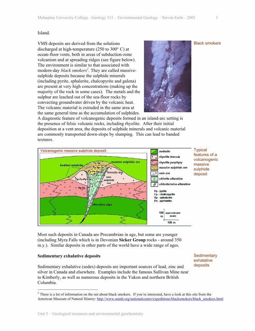
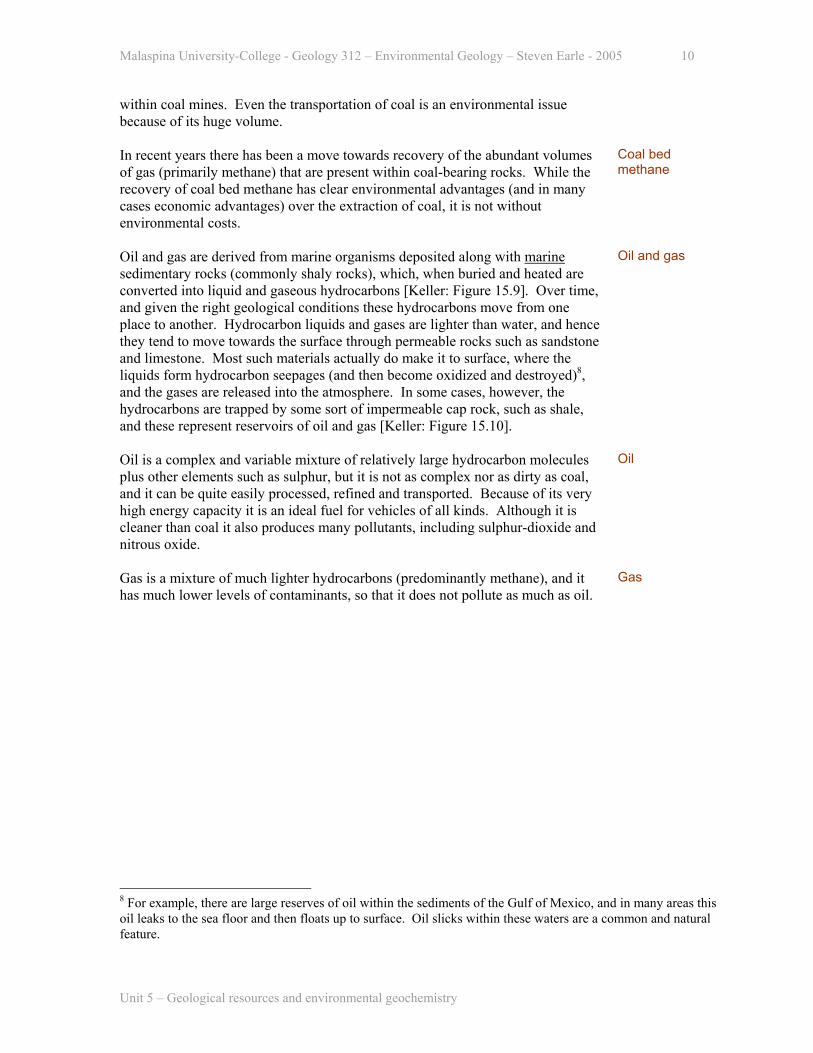
Island. VMS deposits are derived from the solutions discharged at high-temperature (250 to 300° C) at ocean-floor vents, both in areas of subduction-zone volcanism and at spreading ridges (see figure below). The environment is similar to that associated with modern-day black smokers2. They are called massive-sulphide deposits because the sulphide minerals (including pyrite, sphalerite, chalcopyrite and galena) are present at very high concentrations (making up the majority of the rock in some cases). The metals and the sulphur are leached out of the sea-floor rocks by convecting groundwater driven by the volcanic heat. The volcanic material is extruded in the same area at the same general time as the accumulation of sulphides. A diagnostic feature of volcanogenic deposits formed in an island-arc setting is the presence of felsic volcanic rocks, including rhyolite. After their initial deposition at a vent area, the deposits of sulphide minerals and volcanic material are commonly transported down-slope by slumping. This can lead to banded textures.
Black smokers
Typical features of a volcanogenic massive sulphide deposit
Most such deposits in Canada are Precambrian in age, but some are younger (including Myra Falls which is in Devonian Sicker Group rocks - around 350 m.y.). Similar deposits in other parts of the world have a wide range of ages.
Sedimentary exhalative deposits Sedimentary exhalative (sedex) deposits are important sources of lead, zinc and silver in Canada and elsewhere. Examples include the famous Sullivan Mine near to Kimberly, as well as numerous deposits in the Yukon and northern British Columbia.
Sedimentary exhalative deposits
Unit 5 – Geological resources and environmental geochemistry
2 There is a lot of information on the net about black smokers. If you’re interested, have a look at this site from the American Museum of Natural History: http://www.amnh.org/nationalcenter/expeditions/blacksmokers/black_smokers.html

Malaspina University-College - Geology 312 – Environmental Geology – Steven Earle - 2005 4
Sedex deposits have some similarities to VMS deposits, except that the host rocks are predominantly sedimentary as opposed to volcanic. They are also related to a source of heat on the ocean floor – but not as much heat as in VMS deposits, and they have high levels of sulphide minerals (galena, sphalerite, pyrrhotite, pyrite) and a banded texture. Copper levels are lower than at VMS deposits because the temperatures of the solutions are lower (150 to 250° C). Volcanic rocks are not present (except in small amounts in a few cases). The host rocks are continental shelf shales, siltstones and turbidites, although carbonates are present in some cases.
Porphyry deposits Porphyry deposits are the most important ores of copper and molybdenum in BC as well as in the western US and South America. Most porphyry deposits also include some gold, and in a few cases gold is the primary commodity. BC examples include several large deposits within the Highland Valley (southwest of Kamloops), various other deposits scattered around the central part of the province, and the now exhausted Island Copper deposit, at the northern end of Vancouver Island.
Porphyry deposits
Typical features of porphyry and epithermal vein type deposits
A porphyry deposit forms around a cooling porphyritic3 stock in the upper part of the crust. Metal enrichment results from convection of groundwater related to the
Porphyritic intrusions
3 The porphyritic texture of the intrusive bodies associated with “porphyry” deposits is indicative of emplacement of the magma at a high level in the crust, and also of a two-stage cooling history.
Unit 5 – Geological resources and environmental geochemistry

Malaspina University-College - Geology 312 – Environmental Geology – Steven Earle - 2005 5
heat of the stock (figure above). The host rocks, which commonly include the stock itself and the surrounding country rocks, are normally highly fractured and brecciated. During the ore-forming process some of the original minerals in these rocks get altered to potassium feldspar, biotite, and various clay minerals. The important ore minerals include chalcopyrite, bornite (Cu5FeS4) and pyrite (in copper rich ores) and molybdenite (MoS2) and pyrite (in molybdenum rich ores). Gold is present as minute flakes of native gold. This type of environment (i.e. around and above an intrusive body) is also favourable for the formation of other types of deposits - particularly vein-type gold deposits. Some of the gold deposits of British Columbia (such as in the Eskay Creek area adjacent to the Alaska Panhandle), and many of the other gold deposits situated all along the western edge of both South and North America are of the epithermal type shown in the figure above.
Veins
Limestone replacement deposits The so-called Mississippi Valley Type deposits are hosted by limestone, and are very important ores of lead and zinc. The most significant Canadian example is the Pine Point deposit south of Yellowknife (now mined out) but there are other similar deposits elsewhere in Canada. The most famous examples are in the Mississippi Valley area of the US.
Limestone replacement deposits
Typical features of a Mississippi Valley type lead-zinc deposit
Almost all Mississippi Valley type deposits are hosted by limestone. Limestone commonly has a high porosity level due to brecciation and solution cavity development (i.e. dissolution) (see figure above). The creation of open spaces in this type of rock may be associated with the process known as dolomitization, where the original calcite is transformed into dolomite. The deposits are formed at relatively low temperatures (around 100° C, even lower in some cases) from solutions percolating through the limestone. The ore minerals include sphalerite and galena along with pyrite.
Environmental impact of mining and mineral processing
Environ-mental impact of mining
Unit 5 – Geological resources and environmental geochemistry

Malaspina University-College - Geology 312 – Environmental Geology – Steven Earle - 2005 6
Mining always involves taking rock out of the ground and exposing it to conditions at surface. The rock is usually crushed and ground and then processed to separate the ore minerals (such as chalcopyrite) from the rest of the minerals. This initial processing normally takes place in a mill at the mine site, and the resulting concentrate is then sent to a smelter where the pure metal is separated out. The waste material from the mill is stored - usually at surface or in a tailings pond, but in some cases in the disused mine openings. Much of the material mined may be of a grade, which is too low to process, and this is also stored - usually on the surface. In some cases some of the waste material is returned to the empty mine adits or to an exhausted open pit. The two environmental issues which are most significant concerning mining are:
1) the exposure of sulphide-bearing rock to surface conditions and the inevitable oxidation of the sulphide minerals to produce acidic drainage, and 2) the potential for escape of toxic materials from tailings enclosures into surface drainages and/or groundwater.
Acidic drainage and metal contamination
Almost all ores contain sulphide minerals, and, as described above, most contain significant amounts of pyrite along with other ore-mineral sulphides. Inevitably a large amount of “waste rock” is mined along with the ore, and while this material may have very low levels of the ore-mineral sulphides, it is commonly quite rich in pyrite. Sulphide minerals are unstable under surface conditions and when they oxidize they react with water to form sulphuric acid. The oxidation is actually enhanced by naturally occurring bacteria including Thiobacillus ferrooxidans and others. {for more information see: http://www.osmre.gov/amdform.htm}
Sulphides in waste rock
Acid mine drainage at the Mt. Washington mine. Copper from the mine has contributed to a significant loss of fish on the Tsolum River.
The acidic nature of the water itself presents a serious environmental problem to plants and animals, but mine drainage water can also have very high levels of heavy metals, firstly because some of these are commonly present at relatively high levels in the mine rocks, and secondly because the acidic water is able to dissolve much higher than normal levels of metals just from background sources. These contaminants include lead, arsenic, copper, zinc, cadmium, mercury and
Heavy metal enrichment
Unit 5 – Geological resources and environmental geochemistry

Malaspina University-College - Geology 312 – Environmental Geology – Steven Earle - 2005 7
many others. In Canada mine operators are currently required to construct their facilities so that acidic and contaminated runoff can be contained, however in wet climates it can be very difficult to contain all of the water that comes in contact with the ore and waste rock. It is possible to treat acidic water by adding calcium carbonate or lime (CaO) as these will neutralize the acidity, and stabilize many of the heavy metals, but this procedure generates large volumes of sludge, which itself has to be dealt with. Furthermore, the waste piles around a mine may generate acidic drainage for decades after a mine is closed. Firstly, it is expensive to operate treatment plants for such long periods, and secondly there can be little guarantee that mine operators will continue to maintain such plants decades into the future. Other solutions are being used and investigated, including the permanent storage of waste rock in the disused mine openings, and storage under water (in artificial reservoirs), where its reactivity rate will be reduced to near zero.
Mine waste
The waste products from a mineral processing facility at a mine (i.e. mill tailings) are normally stored in specially constructed reservoirs, which are designed to ensure that no material leaks or spills into the surrounding environment. Apart from the occasional leak, these structures normally do their job while the mine and mill are in operation, and while regulations demand that they be engineered to last “forever”, or else completely decommissioned when the mine is exhausted, it is very difficult to predict what may happen 50 or 100 years into the future. The problem is that many of these facilities contain high levels of heavy metals, plus a very high potential for acidification.
Tailings ponds
Tailings pond at the Myra Falls Mine (Myra Ck. runs from right to left in the middle distance. The tailings are isolated from the creek by a constructed berm.)
The acid mine drainage issue is one of the most significant problems facing Canada’s mining industry, and while some research money is being spent in an effort to resolve it, there is a very long way to go. At present there are about 740 million tonnes of acid-generating waste rock at mine sites in Canada, plus 12,500 hectares of mill tailings. The estimated cost of dealing with all of this material ranges from $2 to $5 billion. Concern about acid drainage in a pristine wilderness area was one of the primary factors in the provincial government’s recent decision to block development of the valuable ($550 million) Windy Craggy deposit in northwestern BC. This decision was a major blow to mining in BC, and it was enough to make many mining companies stop exploration in BC altogether. However, until the acid drainage problem can be solved to the satisfaction of environmental organizations and governments, mining companies can expect to
Acid rock drainage in Canada
Unit 5 – Geological resources and environmental geochemistry

Malaspina University-College - Geology 312 – Environmental Geology – Steven Earle - 2005 8
face more of these kinds of decisions in BC and elsewhere in the world4. 5.2 Energy resources Canada has abundant energy resources, and - because our energy is relatively cheap, because we are relatively wealthy and because our climate is generally cool - we use more energy per capita than any other country. We have a choice of many different energy options, but almost all of these options have some negative environmental consequences. Almost all of the energy options discussed below are derived two primary initial sources, (a) the sun, and (b) the energy stored in radioactive elements within the earth (which in turn are derived from nuclear fusion reactions which took place in a pre-existing star).
Energy resources
Hydro In 1985 hydro accounted for 60% of the electricity generated in Canada, and around 95% of the electricity in British Columbia. The energy recovered in a hydroelectric system is derived from the sun through evaporation of water and precipitation in elevated regions. In some respects it can be considered to be environmentally benign, especially in the rare cases where electricity can be produced without the necessity to construct a dam. Where a dam has to be built (and a reservoir created) in order to provide the hydraulic head necessary to produce electricity, the environmental impact can be significant.
Hydro electricity
Some of the negative the aspects of hydro-electricity are as follows:
• loss of agricultural land and displacement of wildlife and people from flooded areas,
• disruption of geological equilibrium and creation of landslide and flooding potential5
• disruption of natural patterns of erosion and sedimentation, which can lead to erosion of sand bars and islands,
• disruption of fish migration routes, and • release of trace-elements (such as mercury) from flooded areas. • release of methane from reservoirs if vegetation is not removed before
flooding
Negative aspects of large hydro projects
4 Background information on acid rock drainage (ARD) is available at the website of the “Mine Environment Neutral Drainage” (MEND) programhttp://nrcan.gc.ca/mms/canmet-mtb/mmsl-lmsm/mend/default_e.htm The ARD issue is discussed in more detail in Unit 6. 5 For example, see the description of Vaiont Dam disaster on pages 146 and 147 of Keller. A similar situation exists at Lake Revelstoke, upstream from the Revelstoke Dam. There is potential for catastrophic failure of the Downie Slide, which could result in the over-flow, or even the collapse of the dam just outside of Revelstoke. Steps have been taken to reduce the risk that such a slide will take place.
Unit 5 – Geological resources and environmental geochemistry

Malaspina University-College - Geology 312 – Environmental Geology – Steven Earle - 2005 9
Fossil fuels In 1985 fossil fuels (primarily coal) accounted for 20% of the electricity produced in Canada, and about 5% of that produced in British Columbia (primarily natural gas in BC). Apart from coal- and gas-fired electrical stations, our primary use of fossil fuels is for transportation (cars, trucks, planes etc.). Three types of fossil fuels are important - coal, liquid petroleum and gas.
Fossil fuels
Coal forms in areas where dead organic material (primarily plant material) can build up to considerable thicknesses in a swampy environment and thus be preserved long enough to be buried [Keller: Figure 15.2]. Without the wet anoxic environment the organic material will become oxidized and will break down. These types of environments exist in slowly subsiding basins of continental interiors and on flat continental margins that are intermittently flooded during periods of subsidence (such as during deposition of the Nanaimo Group). Once the organic-bearing layer is buried and heated up, the process of coalification can take place. This involves dewatering, compaction and the loss of volatiles such as carbon dioxide and methane. The more extreme the conditions, the more pure and carbon-rich the coal will be. The stages of coalification are: lignite, bituminous and anthracite [Keller: Figure 15.3]. Beyond this the carbon will turn into graphite, which is not useful as a fuel.
Coal
Coal is primarily used as a source of heat for production of electricity, but it is also the source of the coke6 that is used in the steel industry. The environmental effects of burning coal are obvious and considerable. It produces a great deal of carbon dioxide, as well as smoke and ash. Large amounts of sulphur dioxide and nitrous oxide are released, and the former of these contributes significantly to the acid precipitation problem. While some of these environmental effects can be reduced by applying new technologies7, they cannot be eliminated. Coal also has high levels of many trace metals, including arsenic, selenium, lead, vanadium and uranium. For many of these elements the amounts released through the combustion of coal outweigh the emissions from all other industrial sources combined.
Environ-mental impacts of burning coal
Apart from the negative environmental impact of burning coal, the sheer volume of coal needed to produce electricity is an environmental factor in itself. Hundreds of Canadians have been killed in coal mine accidents, and thousands of others have died early and painful deaths because of the unhealthy conditions
Other aspects of the coal industry
6 Coke is normally produced by heating bituminous coal so that any remaining volatiles are driven off and the ash is fused with the carbon. It must be strong enough to remain whole during transport.
7 Various processes have been developed in the past few decades to decrease the environmental impact of coal burning. Firstly the coal can be “washed” prior to burning to reduce the levels of some of the combustion products (such as ash and sulphur). For example, sulphur-consuming bacteria can be used to reduce the sulphur level. Secondly, the process of combustion can be improved so that lower levels of byproducts are released. In fluidized bed combustion air is blown through a bed of sand heated to incandescent heat. The coal is introduced and it burns at a lower temperature than normal, the efficiency of combustion is higher, and lower levels of sulphur-dioxide and nitrous-oxide are released. Some of the sulphur can also be captured if limestone is included in the fluidized bed. Thirdly, various technologies (such as “scrubbers”) can be used at the post-combustion end of the process, primarily to reduce the amount of sulphur emitted
Unit 5 – Geological resources and environmental geochemistry
Malaspina University-College - Geology 312 – Environmental Geology – Steven Earle - 2005 10
within coal mines. Even the transportation of coal is an environmental issue because of its huge volume. In recent years there has been a move towards recovery of the abundant volumes of gas (primarily methane) that are present within coal-bearing rocks. While the recovery of coal bed methane has clear environmental advantages (and in many cases economic advantages) over the extraction of coal, it is not without environmental costs.
Coal bed methane
Oil and gas are derived from marine organisms deposited along with marine sedimentary rocks (commonly shaly rocks), which, when buried and heated are converted into liquid and gaseous hydrocarbons [Keller: Figure 15.9]. Over time, and given the right geological conditions these hydrocarbons move from one place to another. Hydrocarbon liquids and gases are lighter than water, and hence they tend to move towards the surface through permeable rocks such as sandstone and limestone. Most such materials actually do make it to surface, where the liquids form hydrocarbon seepages (and then become oxidized and destroyed)8, and the gases are released into the atmosphere. In some cases, however, the hydrocarbons are trapped by some sort of impermeable cap rock, such as shale, and these represent reservoirs of oil and gas [Keller: Figure 15.10].
Oil and gas
Oil is a complex and variable mixture of relatively large hydrocarbon molecules plus other elements such as sulphur, but it is not as complex nor as dirty as coal, and it can be quite easily processed, refined and transported. Because of its very high energy capacity it is an ideal fuel for vehicles of all kinds. Although it is cleaner than coal it also produces many pollutants, including sulphur-dioxide and nitrous oxide.
Oil
Gas is a mixture of much lighter hydrocarbons (predominantly methane), and it has much lower levels of contaminants, so that it does not pollute as much as oil.
Gas
8 For example, there are large reserves of oil within the sediments of the Gulf of Mexico, and in many areas this oil leaks to the sea floor and then floats up to surface. Oil slicks within these waters are a common and natural feature.
Unit 5 – Geological resources and environmental geochemistry

Malaspina University-College - Geology 312 – Environmental Geology – Steven Earle - 2005 11
All fossil fuels produce carbon dioxide when burned, but the amount of CO2 emitted per unit of energy produced varies widely. As shown on the figure to the right, natural gas (primarily methane) produces the least amount of CO2, followed by the liquid fuels (such as automotive fuel). Coal is the worst of the fossil fuels for CO2 production, but burning wood is worse still. The CO2 emission levels of the fuels are generally comparable to their rates of emission of other pollutants, such as nitrous oxide and sulphur dioxide. In other words, natural gas is relatively clean, while coal and wood are dirty.
Carbon dioxide emissions as a function of energy produced for different fuels
Each province of Canada has a different mix of electricity generating activities, and some are relatively “clean”, while others are dirty. The provincial rates of CO2 production as a function of energy produced are given on the figure to the right.
Provincial rates of carbon dioxide emission as a function of energy produced
Nuclear energy Nuclear
Unit 5 – Geological resources and environmental geochemistry
Malaspina University-College - Geology 312 – Environmental Geology – Steven Earle - 2005 12
Nuclear energy accounted for 13% of Canada’s electricity production in 1985, and the proportion is probably a little higher now. Most of the nuclear generation is in Ontario. None of British Columbia’s electricity is derived from this source.
energy
At present Canada is the world’s largest supplier of uranium, and all of the Canadian production now comes from several mines in northern Saskatchewan. The Saskatchewan deposits were formed at around 1300 m.y. ago. The uranium was dissolved out of rocks such as granite and gneiss and then transported along with groundwater through a large sandstone basin (the 200 by 400 km basin of the Athabasca Group sandstone, which is a very pure quartz sandstone). The water in this basin was largely oxidizing, and hence the uranium stayed in solution until it encountered more deeply circulating groundwater flowing through the underlying gneisses and schists. Some of these older rocks had relatively high levels of reducing agents, such as sulphides and graphite, and thus the deeply-circulating groundwater was strongly reducing. Mixing of the relatively shallow uranium-bearing water within the Athabasca sandstone and the deep reducing water in the older basement rocks led to the precipitation of uraninite (UO2) at the unconformity between the sandstone and the basement rocks. The Saskatchewan deposits are significantly larger, and at least 10 times higher grade than most of those in other parts of the world.
Uranium
Nuclear reactors do not produce greenhouse gases or other pollution, but they can, if improperly maintained or operated, lead to the release of potentially very dangerous radiation. This is what happened in 1986 at the Ukrainian Chernobyl reactor9. Nuclear wastes have a much smaller volume than those produced by thermal plants (e.g. coal), but the wastes are potentially much more hazardous. Perhaps the most difficult of the problems associated with nuclear energy is that some of the materials used by and produced by nuclear reactors can also be used to make atomic weapons.
Nuclear reactors
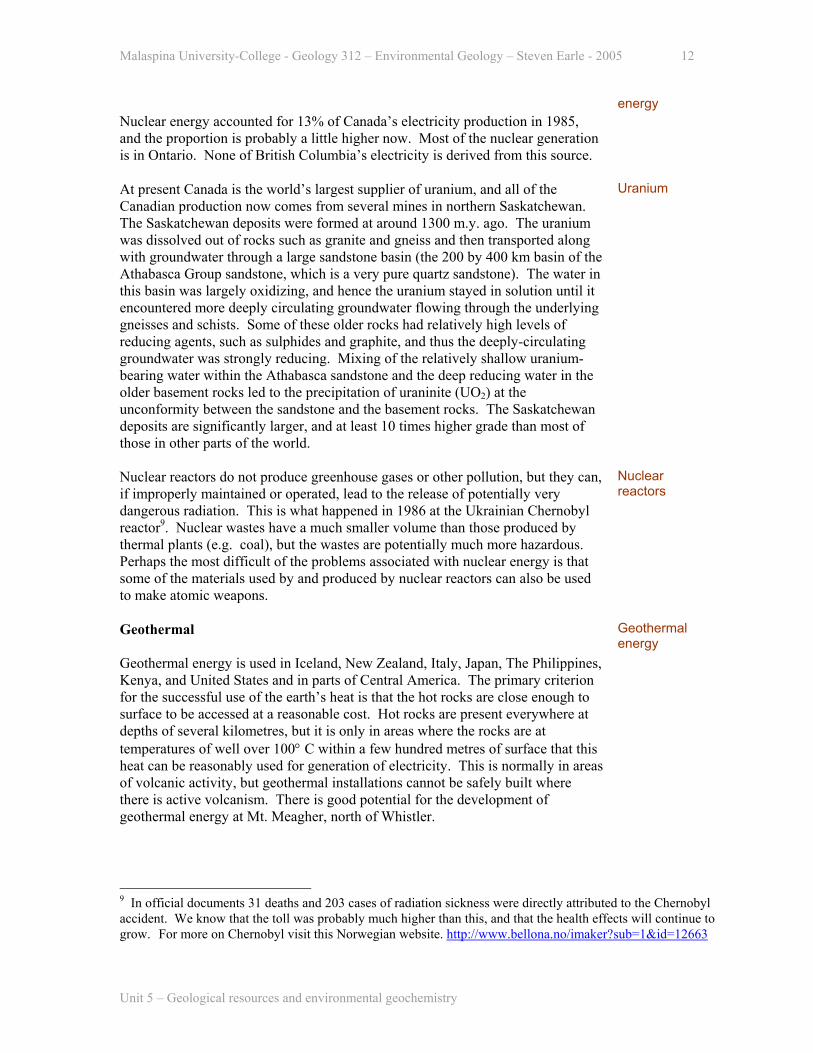
Geothermal Geothermal energy is used in Iceland, New Zealand, Italy, Japan, The Philippines, Kenya, and United States and in parts of Central America. The primary criterion for the successful use of the earth’s heat is that the hot rocks are close enough to surface to be accessed at a reasonable cost. Hot rocks are present everywhere at depths of several kilometres, but it is only in areas where the rocks are at temperatures of well over 100° C within a few hundred metres of surface that this heat can be reasonably used for generation of electricity. This is normally in areas of volcanic activity, but geothermal installations cannot be safely built where there is active volcanism. There is good potential for the development of geothermal energy at Mt. Meagher, north of Whistler.
Geothermal energy
9 In official documents 31 deaths and 203 cases of radiation sickness were directly attributed to the Chernobyl accident. We know that the toll was probably much higher than this, and that the health effects will continue to grow. For more on Chernobyl visit this Norwegian website. http://www.bellona.no/imaker?sub=1&id=12663
Unit 5 – Geological resources and environmental geochemistry
Malaspina University-College - Geology 312 – Environmental Geology – Steven Earle - 2005 13
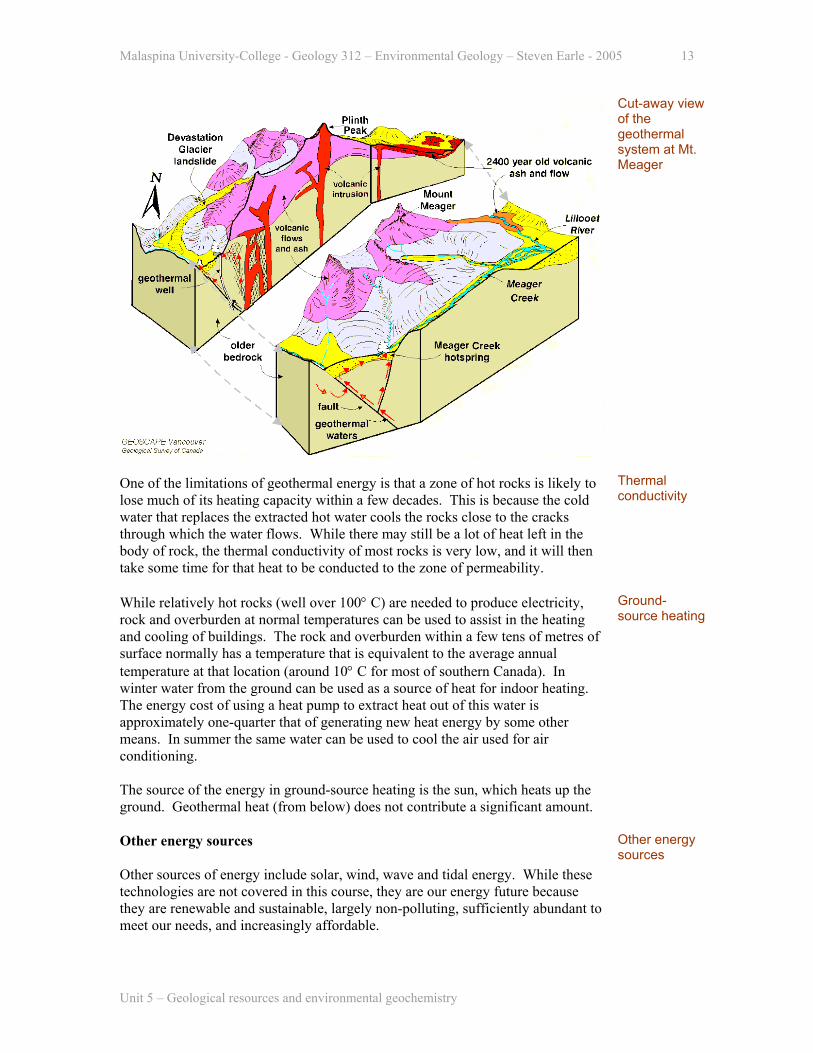
Cut-away view of the geothermal system at Mt. Meager
One of the limitations of geothermal energy is that a zone of hot rocks is likely to lose much of its heating capacity within a few decades. This is because the cold water that replaces the extracted hot water cools the rocks close to the cracks through which the water flows. While there may still be a lot of heat left in the body of rock, the thermal conductivity of most rocks is very low, and it will then take some time for that heat to be conducted to the zone of permeability.
Thermal conductivity
While relatively hot rocks (well over 100° C) are needed to produce electricity, rock and overburden at normal temperatures can be used to assist in the heating and cooling of buildings. The rock and overburden within a few tens of metres of surface normally has a temperature that is equivalent to the average annual temperature at that location (around 10° C for most of southern Canada). In winter water from the ground can be used as a source of heat for indoor heating. The energy cost of using a heat pump to extract heat out of this water is approximately one-quarter that of generating new heat energy by some other means. In summer the same water can be used to cool the air used for air conditioning. The source of the energy in ground-source heating is the sun, which heats up the ground. Geothermal heat (from below) does not contribute a significant amount.
Ground-source heating
Other energy sources Other sources of energy include solar, wind, wave and tidal energy. While these technologies are not covered in this course, they are our energy future because they are renewable and sustainable, largely non-polluting, sufficiently abundant to meet our needs, and increasingly affordable.
Other energy sources
Unit 5 – Geological resources and environmental geochemistry

Malaspina University-College - Geology 312 – Environmental Geology – Steven Earle - 2005 14
The cost of wind energy, for example, has dropped from more than 25¢ (US) per kWh in 1980 to around 5¢ today. That cost is continuing to drop as wind turbine sizes increase and the installation of wind energy systems continues grow dramatically.
The decreasing cost of wind energy
5.3 Groundwater If you dig a hole in the ground in a well-drained area you will likely first encounter a layer of moist organic and/or clay-rich soil. You will then pass into material in which the pore spaces are almost all dry (i.e. they are filled with air). This is called the unsaturated zone, and it may continue to be essentially dry for a few metres, tens of metres or even hundreds of metres in some dry regions. At some depth the amount of water will gradually increase, and eventually the pore spaces will be completely saturated with water. The line between saturated and unsaturated material is defined as the water table.
Relationships between the unsaturated zone, the capillary fringe and the water table
The zone of increasing water content just above the water table is known as the capillary fringe, because the water present here is being held in place by capillary action or surface tension. The water table is an undulating surface that generally reflects the topography - but is more subdued. Below the water table all of the pore spaces in the rock will be filled with water, but as the depth increases the amount of pore space will gradually decrease because of the increasing confining pressure.
Water table
What we call groundwater includes all of the water from the water table to the depth where there is no longer enough porosity for the rock to hold water. This lower limit will depend on the rock type, but in most cases it will be in the order of a few thousand metres. In terms of a resource, however, the practical limit for groundwater is no more than a few hundred metres, and is usually less. Apart from the difficulty in extracting water from significant depths, deep groundwater
Groundwater
Unit 5 – Geological resources and environmental geochemistry
Malaspina University-College - Geology 312 – Environmental Geology – Steven Earle - 2005 15
commonly has very high levels of dissolved constituents, and is not useful for most purposes. Groundwater makes up only about 1% of the total volume of water on the earth, but it comprises 22% of the supply of fresh water, and 98% of the supply of unfrozen fresh water (Monroe and Wicander, 1997). Groundwater is arguably one of the most valuable and vital of the earth’s resources.
The importance of groundwater
The amount of water which can be held within a body of rock or drift is determined by the porosity, and this varies from essentially nil in unfractured igneous or metamorphic rocks, to a few tens of per cent in a well-fractured rock or a porous sedimentary rock, to several tens of per cent in most drift deposits.
Porosity
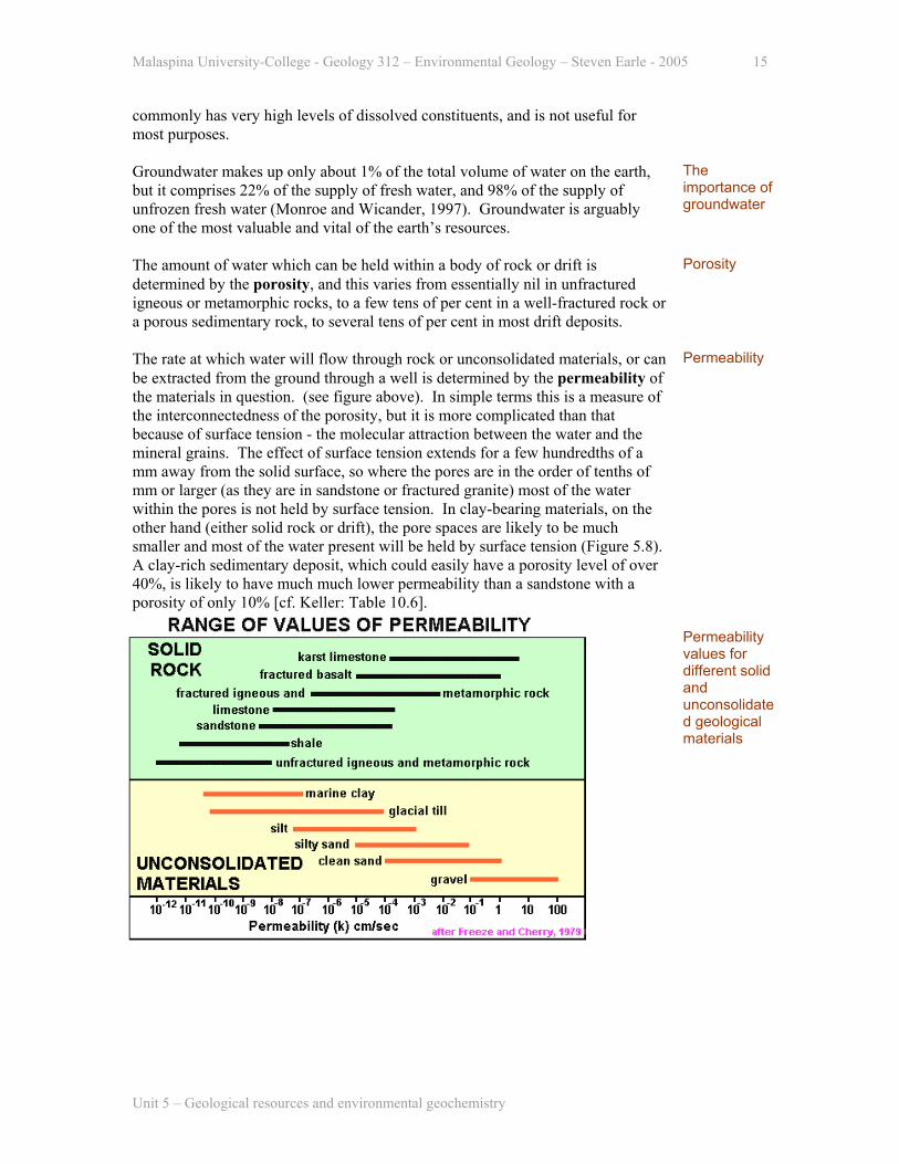
The rate at which water will flow through rock or unconsolidated materials, or can be extracted from the ground through a well is determined by the permeability of the materials in question. (see figure above). In simple terms this is a measure of the interconnectedness of the porosity, but it is more complicated than that because of surface tension - the molecular attraction between the water and the mineral grains. The effect of surface tension extends for a few hundredths of a mm away from the solid surface, so where the pores are in the order of tenths of mm or larger (as they are in sandstone or fractured granite) most of the water within the pores is not held by surface tension. In clay-bearing materials, on the other hand (either solid rock or drift), the pore spaces are likely to be much smaller and most of the water present will be held by surface tension (Figure 5.8). A clay-rich sedimentary deposit, which could easily have a porosity level of over 40%, is likely to have much much lower permeability than a sandstone with a porosity of only 10% [cf. Keller: Table 10.6].
Permeability
Permeability values for different solid and unconsolidated geological materials
Unit 5 – Geological resources and environmental geochemistry

Malaspina University-College - Geology 312 – Environmental Geology – Steven Earle - 2005 16
The role of surface tension in controlling the permeability of fine-grained versus coarse grained materials
A body of rock with relatively high permeability is described as an aquifer, while one with low permeability is an aquitard (or aquiclude). Well sorted sandstones are commonly very good aquifers, unless the degree of cementation is very high. Unfractured igneous or metamorphic rocks, or clay-rich materials are normally poor aquifers (or effective aquitards), The terms aquifer and aquitard are relative. A siltstone inter-layered with a sandstone could be considered as an aquitard, while the very same siltstone inter-layered with a shale could be considered to be an aquifer.
Aquifers and aquitards
For practical purposes, however, the important thing about an aquifer is whether or not it will transmit sufficient water to supply the needs of whoever drills a well into it.
As noted above, the water table is an undulating surface that roughly reflects the topography of the ground. On a hill or mountain the water table can be considerably farther below surface than it is in an adjacent valley. Within a valley occupied by a stream or a lake the water table is actually at surface, and the surface of the water represents the level of the water table at that point [Keller: Figure 10.5a]. The water table is not fixed. Its level moves up and down as a function of the amount of water being added to the ground by precipitation. The water table can also be significantly affected by the amount of water that is extracted in wells (see below under Groundwater extraction).
Water table
Another term for the water table is the potentiometric surface (a.k.a. pressure surface - see figure below and [Keller: Figure 10.7]), but there is an important difference between the terms water table and potentiometric surface. Whereas the water table represents the actual upper limit of the saturated zone in the ground, the potentiometric surface is the level to which the water would rise in an open well
Potentiometric surface The effect of confining beds on the potentiometric surface
Unit 5 – Geological resources and environmental geochemistry

Malaspina University-College - Geology 312 – Environmental Geology – Steven Earle - 2005 17
drilled at any location. In many situations the level of the water table and the potentiometric surface are the same, but under some geological situations they can be quite different. Water that is present in a confined aquifer (e.g. a sandstone layer sandwiched between two layers of shale) may be under pressure. In other words, if a well was drilled into that aquifer the water would rise significantly above the level of the aquifer, and may even flow out at surface. Such a flowing well is known as an artesian well. In fact any well in which the water rises above the level at which it is first encountered, is called artesian, even if it does not rise to surface.) An artesian situation exists where the potentiometric surface is higher than the water table, and this usually arises where there is a confined aquifer within a series of dipping beds.
Artesian wells
Groundwater flow Groundwater flows in response to gravity, but, unfortunately for those who would like to be able to understand groundwater, the nature of that flow is not simple. Within the unsaturated zone (above the water table) the water from rainfall percolates essentially straight down until it reaches the water table. Within the saturated zone water moves from an area where the elevation of the potentiometric surface is high to where it is low. In most cases this means from an area of recharge (usually an elevated area), to an area of discharge - a low area with a spring, stream or lake.
Groundwater flow
Idealized groundwater flow paths in an unconfined aquifer
In general, the more deeply the water goes, the slower it moves, and the longer a path it takes from recharge to discharge. Some very deep groundwater (e.g. thousands of metres deep) may have been in the ground for hundreds of thousands or even millions of years.
Deep groundwater
In addition to the effects of differences in potentiometric pressure, the flow of groundwater will be significantly controlled by variations in the permeability of the rocks through which it flows. The water will flow relatively quickly through
Flow paths affected by geology
Unit 5 – Geological resources and environmental geochemistry

Malaspina University-College - Geology 312 – Environmental Geology – Steven Earle - 2005 18
permeable rocks, more slowly through less permeable rocks, and almost not at all through the most impermeable rocks. Not surprisingly, the water will tend to be channelled along permeable horizons, and might change directions when it meets impermeable barriers. The rate of groundwater flow between any two points will be determined by the permeability of the aquifer, and the difference in elevation between the points versus the distance between the points (i.e. the gradient). One equation is relating these variables is as follows:
V = Ki
where V is the velocity of the water, K is the permeability and i is the gradient. This is known as Darcy’s law, after the French engineer Henri Darcy. Permeability levels can be expressed as a rate of motion (e.g. cm/sec). For example, consider a silty unconsolidated sand deposit with a permeability of 0.001 cm/sec, where the gradient of the potentiometric surface is 1 vertical metre per 100 horizontal metres - which is equivalent to 0.01. The theoretical flow rate would be 0.00001 cm/sec, which is equivalent to 0.86 cm/day or 3.15 m/year.
Groundwater flow rates Darcy’s law
These numbers are not unrealistic, in fact silt-rich unconsolidated sand is more permeable than most rocks, and a gradient of 0.01 is quite typical. It is clear, therefore, that groundwater flow rates are very slow. The highest flow rates are no more than around 250 m/year, and the lowest rates are in the order of mm/year.
To determine the amount of water flowing through a volume of rock we must multiply the velocity times the cross-sectional area of the aquifer, or at least of that part of the aquifer which we want to consider. Lets assume that this same aquifer is 10 m thick and we wish to calculate the volume of water flowing past a 5 m width. The cross-section area is 50 square metres or 500,000 square cm. The daily rate of flow through this area is 430,000 cubic cm, or 430 litres - which is roughly equivalent to two 45-gallon drums. [Please read through the section “Putting some numbers on groundwater flow” on pages 272 and 273 of Keller].
Flow volume
Groundwater extraction Groundwater is normally extracted by digging or drilling a well into an aquifer. The choice of where to drill can be based on geological considerations, or on guesswork. The observation that guesswork (e.g. dowsing) often produces favourable results can be explained by the fact that most aquifers are tabular bodies, with relatively consistent permeability levels. In other words, a well drilled into the aquifer at almost any location will produce generally similar results. The idea that there are underground rivers, or even parts of aquifers with very high flow rates, is largely a myth. Water will flow in streams within the large openings of a karst aquifer, but in clastic rocks most of the flow is along small fractures or through the tiny spaces between grains.
Groundwater extraction
Unit 5 – Geological resources and environmental geochemistry
Malaspina University-College - Geology 312 – Environmental Geology – Steven Earle - 2005 19
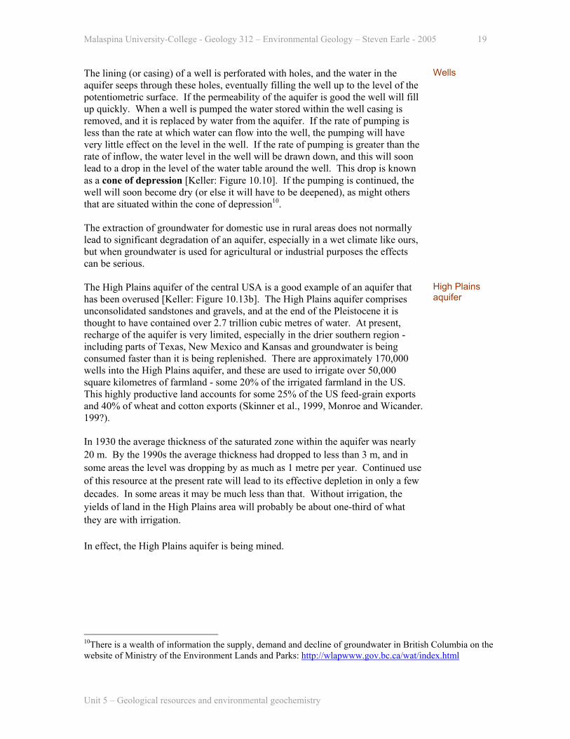
The lining (or casing) of a well is perforated with holes, and the water in the aquifer seeps through these holes, eventually filling the well up to the level of the potentiometric surface. If the permeability of the aquifer is good the well will fill up quickly. When a well is pumped the water stored within the well casing is removed, and it is replaced by water from the aquifer. If the rate of pumping is less than the rate at which water can flow into the well, the pumping will have very little effect on the level in the well. If the rate of pumping is greater than the rate of inflow, the water level in the well will be drawn down, and this will soon lead to a drop in the level of the water table around the well. This drop is known as a cone of depression [Keller: Figure 10.10]. If the pumping is continued, the well will soon become dry (or else it will have to be deepened), as might others that are situated within the cone of depression10.
Wells
The extraction of groundwater for domestic use in rural areas does not normally lead to significant degradation of an aquifer, especially in a wet climate like ours, but when groundwater is used for agricultural or industrial purposes the effects can be serious.
The High Plains aquifer of the central USA is a good example of an aquifer that has been overused [Keller: Figure 10.13b]. The High Plains aquifer comprises unconsolidated sandstones and gravels, and at the end of the Pleistocene it is thought to have contained over 2.7 trillion cubic metres of water. At present, recharge of the aquifer is very limited, especially in the drier southern region - including parts of Texas, New Mexico and Kansas and groundwater is being consumed faster than it is being replenished. There are approximately 170,000 wells into the High Plains aquifer, and these are used to irrigate over 50,000 square kilometres of farmland - some 20% of the irrigated farmland in the US. This highly productive land accounts for some 25% of the US feed-grain exports and 40% of wheat and cotton exports (Skinner et al., 1999, Monroe and Wicander. 199?).
High Plains aquifer
In 1930 the average thickness of the saturated zone within the aquifer was nearly 20 m. By the 1990s the average thickness had dropped to less than 3 m, and in some areas the level was dropping by as much as 1 metre per year. Continued use of this resource at the present rate will lead to its effective depletion in only a few decades. In some areas it may be much less than that. Without irrigation, the yields of land in the High Plains area will probably be about one-third of what they are with irrigation. In effect, the High Plains aquifer is being mined.
10There is a wealth of information the supply, demand and decline of groundwater in British Columbia on the website of Ministry of the Environment Lands and Parks: http://wlapwww.gov.bc.ca/wat/index.html
Unit 5 – Geological resources and environmental geochemistry
Malaspina University-College - Geology 312 – Environmental Geology – Steven Earle - 2005 20
Groundwater chemistry The chemistry of groundwater is largely a function of the type of rocks through which the water flows and the residence time within those rocks. Deep, slowly flowing groundwater tends to have high dissolved concentrations, while shallow and rapidly flowing groundwater tends to have low concentrations. The overall concentration of dissolved mineral substances within water is described as “total dissolved solids” or TDS, and is usually expressed in parts per million (ppm) or milligrams per litre (mg/l) - the two terms are equivalent.
Groundwater chemistry Total dissolved solids
The main factors that control the solubility of elements in both surface water and groundwater are pH and oxidation-reduction potential (ORP - often expressed as Eh). Most groundwaters have pH levels in the range 4 to 9, although some exceptions do occur. Low pH levels (less than 6) are generally associated with the oxidation of sulphide minerals - and the production of sulphuric acid. High pH levels (greater than 8) are commonly associated with the dissolution of carbonate rocks. Many minerals will be more soluble in acidic water than in alkaline water.
pH
The oxidation potential of water will be controlled by the extent to which the water has reacted with minerals such as sulphides, and other materials (such as organic matter) which can be oxidized and thus consume the oxygen present in the water. Deep groundwater is commonly very reducing (the opposite of oxidizing) because it has reacted with oxygen-consuming materials and has no contact with a source of oxygen (such as the atmosphere). As soon as this type of water comes into contact with the air its oxidation potential will increase significantly. Many minerals are more soluble in oxidizing water than in reducing water, but the iron minerals are a notable exception.
Oxidation potential
Like the Archean oceans, groundwater that is sufficiently reducing can have relatively high levels of dissolved ferrous (Fe2+) iron. The effect of this can be seen in some places where relatively deep-flowing groundwater comes to surface. The rapid increase in the oxidation potential of the water will lead to precipitation of rusty coloured iron-oxide deposits (i.e. Fe3+ minerals such as hematite or limonite), either around a spring where the water comes to surface or in the sink, bathtub or toilet of someone who uses the water. In fact it doesn’t take very much iron to have a noticeable effect on the water. The solubility of iron under oxidizing conditions is very low, and only a few tenths of a mg/l of Fe2+ dissolved in the reducing groundwater can create a clearly visible stain of Fe3+ minerals.
The effect of oxidation potential on iron solubility
Unit 5 – Geological resources and environmental geochemistry

Malaspina University-College - Geology 312 – Environmental Geology – Steven Earle - 2005 21
The major ions present in most groundwaters are the cations sodium, calcium, magnesium and potassium, and the anions chloride, bicarbonate and sulphate. Average levels of these ions in 100 well water samples from the Yellow Point area south of Nanaimo are shown on the diagram to the right. In this case the dominant ions are sodium, and bicarbonate. Waters from other aquifers would almost certainly have different characteristics.
Major cations and anions in ground-waters from 100 wells the Yellow Point area
The term hardness is used to refer to the concentration of calcium and magnesium in water, as these constituents impart certain undesirable properties, including a limitation of the effectiveness of soaps, and the tendency for the water to leave a scum on some surfaces, and an encrustation when heated. Hardness is generally expressed in terms of the concentration of CaCO3 in the water, where up to 60 mg/L is soft, 61 to 120 is moderately hard, 121 to 180 is hard and more than 180 mg/L is very hard. Hard waters are those that are derived from carbonate bearing rocks, including calcareous sandstones. Hardness can be reduced using a water softener, which has the effect of replacing the calcium and magnesium in the water with sodium.
Hardness
Groundwater contamination The primary sources for contamination of groundwater are domestic wastes (e.g. from septic tanks) and landfills, industrial sources (from resource extraction and from manufacturing), and agricultural wastes and chemicals.
Groundwater contamination
The most common pollutant in groundwater is nitrate. Nitrate can be derived from many different sources, notably farming (including both animal wastes and farm chemicals) and human wastes (septic tanks and sewage plants). High nitrate levels in drinking water are of particular concern to pregnant women as nitrate can cause a deficiency in the amount of oxygen reaching the foetus. Levels of more than 10 mg/l are considered to be dangerous.
Nitrate
The Abbotsford Aquifer in the Fraser Valley, which is used for domestic, agricultural and industrial purposes, comprises glacio-fluvial deposits (the Sumas Drift) that are approximately 40 m thick. It is an unconfined aquifer (i.e. it is exposed at surface). Much of the area of the aquifer is used for farming. Nitrates from fertilizer, septic tanks and particularly animal manure have contaminated the
Abbotsford Aquifer
Unit 5 – Geological resources and environmental geochemistry
Malaspina University-College - Geology 312 – Environmental Geology – Steven Earle - 2005 22
water over a wide area. 70% of 1526 groundwater samples taken from the Abbotsford Aquifer area in recent years had nitrate contents greater than the 10 mg/L Canadian drinking water guideline11. Other very significant groundwater pollutants are the volatile components in fuels, such as benzene, toluene, ethylene and xylene. Leaking underground storage tanks (USTs), especially those at gas stations, represent one of the most significant sources of groundwater contamination. In Canada and the US approximately one quarter of all USTs are leaking. When you consider that one cup of gasoline can contaminate enough water to fill an Olympic-sized swimming pool it’s easy to see the magnitude of the problem.
Groundwater contamination by fuels
The complex and highly toxic chemicals found in many of the insecticides and herbicides used in agriculture are also a serious source of groundwater pollution. Part of the problem is the very widespread application of these chemicals, and the result is that they can lead to contamination of a wide area. An increasing number of Canadian communities are banning the use of agricultural chemicals (including lawn and garden chemicals) within their boundaries.
Agricultural chemicals
Although the contamination of groundwater can be very serious, some of the effects of this contamination are reduced by natural processes taking place within the ground, such as adsorption of contaminants by clays and other minerals, and the natural breakdown of the contaminants themselves. In this respect, groundwater can be safer than surface water because these processes do not operate efficiently in surface drainage systems.
Natural decontam-ination of groundwater
5.4 Environmental geochemistry Apart from the eight major constituents (oxygen, silicon, aluminum, iron, magnesium, calcium, sodium and potassium) all rocks also contain small amounts of all of the other naturally occurring elements. Most of these trace elements are present in concentrations ranging from a few ppm to a few hundreds of ppm. Examples are copper, lead, zinc, arsenic, mercury, boron, fluorine, selenium, uranium and barium. Some of the trace elements are present at background concentrations of between 1 ppb and 1 ppm12. Examples are cadmium, gold, radium and platinum. Many of the elements, and especially those with atomic weights > 80, are present at even lower concentrations.
Environmental geochemistry
The background concentrations of a few selected trace elements in different types of rocks are listed in the table below. The important feature of this summary is
11 There is more information on the nitrate problem in the Abbotsford aquifer at this Environment Canada web site. http://www.ecoinfo.ec.gc.ca/env_ind/region/nitrate/nitrate_e.cfm 12 ppm = parts per million, ppb = parts per billion. These abbreviations usually refer to concentrations in solid materials (rocks, soils, food etc.), where 1 ppm means 1 mg of the element per 1 kg of the material . For concentrations in solution the term mg/l is common. 1 mg/l is essentially equivalent to 1 ppm
Unit 5 – Geological resources and environmental geochemistry
Malaspina University-College - Geology 312 – Environmental Geology – Steven Earle - 2005 23
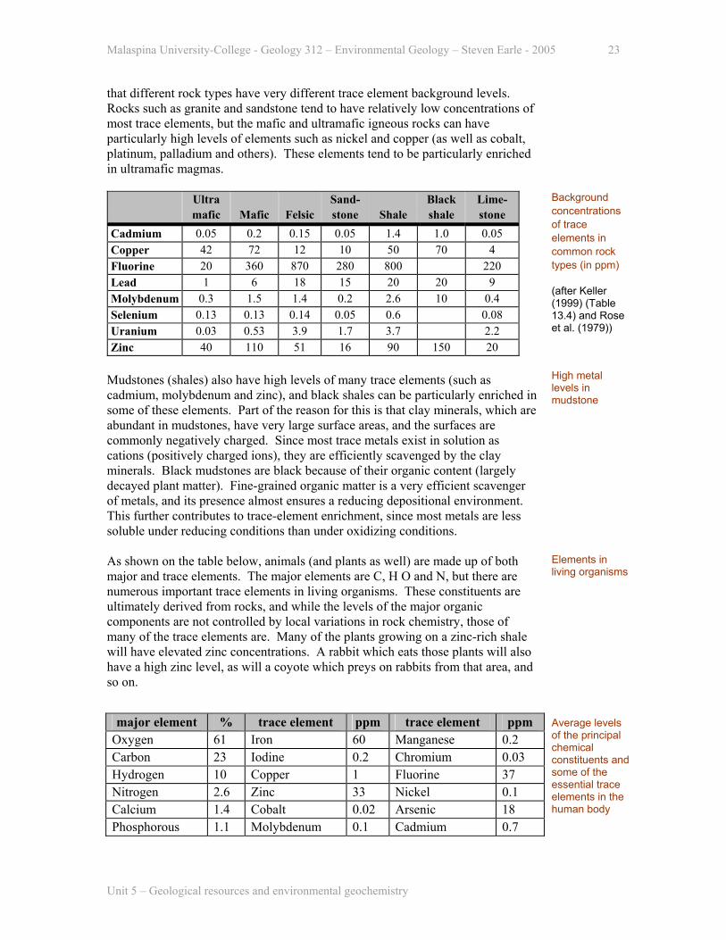
that different rock types have very different trace element background levels. Rocks such as granite and sandstone tend to have relatively low concentrations of most trace elements, but the mafic and ultramafic igneous rocks can have particularly high levels of elements such as nickel and copper (as well as cobalt, platinum, palladium and others). These elements tend to be particularly enriched in ultramafic magmas.
Ultra Sand- Black Lime- mafic Mafic Felsic stone Shale shale stone
Cadmium 0.05 0.2 0.15 0.05 1.4 1.0 0.05 Copper 42 72 12 10 50 70 4 Fluorine 20 360 870 280 800 220 Lead 1 6 18 15 20 20 9 Molybdenum 0.3 1.5 1.4 0.2 2.6 10 0.4 Selenium 0.13 0.13 0.14 0.05 0.6 0.08 Uranium 0.03 0.53 3.9 1.7 3.7 2.2 Zinc 40 110 51 16 90 150 20
Background concentrations of trace elements in common rock types (in ppm) (after Keller (1999) (Table 13.4) and Rose et al. (1979))
Mudstones (shales) also have high levels of many trace elements (such as cadmium, molybdenum and zinc), and black shales can be particularly enriched in some of these elements. Part of the reason for this is that clay minerals, which are abundant in mudstones, have very large surface areas, and the surfaces are commonly negatively charged. Since most trace metals exist in solution as cations (positively charged ions), they are efficiently scavenged by the clay minerals. Black mudstones are black because of their organic content (largely decayed plant matter). Fine-grained organic matter is a very efficient scavenger of metals, and its presence almost ensures a reducing depositional environment. This further contributes to trace-element enrichment, since most metals are less soluble under reducing conditions than under oxidizing conditions.
High metal levels in mudstone
As shown on the table below, animals (and plants as well) are made up of both major and trace elements. The major elements are C, H O and N, but there are numerous important trace elements in living organisms. These constituents are ultimately derived from rocks, and while the levels of the major organic components are not controlled by local variations in rock chemistry, those of many of the trace elements are. Many of the plants growing on a zinc-rich shale will have elevated zinc concentrations. A rabbit which eats those plants will also have a high zinc level, as will a coyote which preys on rabbits from that area, and so on.
Elements in living organisms
major element % trace element ppm trace element ppm Oxygen 61 Iron 60 Manganese 0.2 Carbon 23 Iodine 0.2 Chromium 0.03 Hydrogen 10 Copper 1 Fluorine 37 Nitrogen 2.6 Zinc 33 Nickel 0.1 Calcium 1.4 Cobalt 0.02 Arsenic 18 Phosphorous 1.1 Molybdenum 0.1 Cadmium 0.7
Average levels of the principal chemical constituents and some of the essential trace elements in the human body
Unit 5 – Geological resources and environmental geochemistry
Malaspina University-College - Geology 312 – Environmental Geology – Steven Earle - 2005 24
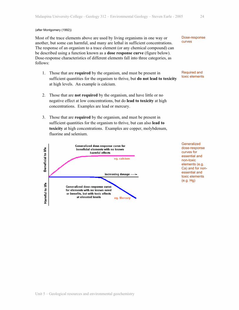
(after Montgomery (1992)) Most of the trace elements above are used by living organisms in one way or another, but some can harmful, and many are lethal in sufficient concentrations. The response of an organism to a trace element (or any chemical compound) can be described using a function known as a dose response curve (figure below). Dose-response characteristics of different elements fall into three categories, as follows:
Dose-response curves
1. Those that are required by the organism, and must be present in sufficient quantities for the organism to thrive, but do not lead to toxicity at high levels. An example is calcium.
2. Those that are not required by the organism, and have little or no
negative effect at low concentrations, but do lead to toxicity at high concentrations. Examples are lead or mercury.
3. Those that are required by the organism, and must be present in
sufficient quantities for the organism to thrive, but can also lead to toxicity at high concentrations. Examples are copper, molybdenum, fluorine and selenium.
Required and toxic elements
Generalized dose-response curves for essential and non-toxic elements (e.g. Ca) and for non-essential and toxic elements (e.g. Hg)
Unit 5 – Geological resources and environmental geochemistry

Malaspina University-College - Geology 312 – Environmental Geology – Steven Earle - 2005 25
Generalized dose-response curve for copper
Human dose response functions are known and well understood for only a small number of the elements.
Fluorine While it is widely accepted that fluorine is beneficial for development of teeth in children [Keller: Figure 13.4], the full range of fluorine health risks is not fully understood, and the addition of fluorine to water supplies is controversial. One of the significant issues is related to bone strength in adults. Some studies have shown that these effects can be used successfully to treat osteoporosis if the dosage is carefully controlled and if calcium is included in the regimen. If fluorine and calcium dosages are not controlled (as would be the case with fluoride-rich water) bone strength can be compromised (Murray and Ste-Marie, 1996). One of the persistent symptoms of the loss of bone strength due to fluorosis is an increased risk of hip fracture amongst the elderly (Nosal, 1998). The World Health Organization (1994) states that endemic, crippling skeletal fluorosis is associated with long term intake of water with fluoride levels of more than 10 mg/l. Whitford (1996) states that "crippling skeletal fluorosis occurs when 10 - 20 mg of fluoride have been ingested on a daily basis for at least 10 years".
Fluorine
A human dose-response curve for fluorine is given by Keller [Figure 13.3]. This curve does not take into account some of the recent research on the negative effects of fluorine levels at moderate dosages (e.g. between 2 and 6 ppm).
Teeth and bones consist primarily of apatite, which is a calcium phosphate mineral with minor amounts of fluorine, chlorine and hydroxide: Ca5(PO4)3(OH,F,Cl). The strength and hardness of tooth enamel, and its resistance to decay, and the strength of bone, are directly related to the fluorine proportion of the apatite. Up to a certain limit, the more fluorine, the harder and stronger the apatite.
Fluorine in teeth and bones
Unit 5 – Geological resources and environmental geochemistry

Malaspina University-College - Geology 312 – Environmental Geology – Steven Earle - 2005 26
Most ground and surfaces waters have fluoride (F-1) levels of considerably less than 1 mg/l, and the range in typical waters is probably between 0.1 and 0.5 ppm. Some surface waters are reported as having as much as 1 mg/l fluoride, and some groundwaters have as much as 50 mg/l fluoride. The incidence of such very high fluoride levels is commonly, but not always associated with volcanic activity (Hem, 1970) .
Fluoride in groundwater
In areas where water supplies have less than 1 mg/l fluoride (which is most areas without fluoridation) the incidence of tooth decay is two to four times higher than that in areas where the water supply has fluoride levels of 1 mg/l or greater. The optimum water supply fluoride levels for tooth and bone development are around 1 mg/l. Water with between 1 and 6 mg/l will still promote strong teeth and bones, but such high levels can also lead to discolouration and malformation of the teeth. Water-supply fluoride levels of above 6 mg/l can cause excessive bone growth and calcification of ligaments, and also skeletal weakening, especially in older people.
Fluoride and tooth decay
The fluoride contents of some Nanaimo Group groundwater sources in the eastern part of Vancouver Island are shown on Figure 5.13. Most of these levels are significantly higher than the background for natural waters, and some are sufficiently high to represent concern in terms of excess fluorine intake. Numerous domestic wells in this region have fluoride levels greater than 5 mg/l and several exceed 10 mg/l.
Distribution of fluoride-rich well waters on southeastern Vancouver Island
In spite of the well documented dental-health benefits of controlled fluoridation, there is a great deal of controversy about fluoridation, and in most countries (including most of western Europe) it is not used widely. Some authorities in these areas contend that we do not know enough about the long-term effects of fluoridation on humans and the environment.
Selenium Selenium is required in the diets of animals at a concentration of about 0.04 ppm, and is beneficial up to about 0.1 ppm, but at levels greater than about 4 ppm selenium is highly toxic. In spite of its high toxicity, selenium deficiency just as serious an agricultural problem as excess selenium.
Selenium
Some volcanic rocks have very high levels of selenium, and the soils in some Sources of l i
Unit 5 – Geological resources and environmental geochemistry

Malaspina University-College - Geology 312 – Environmental Geology – Steven Earle - 2005 27
volcanic areas (such as Hawaii) have several ppm selenium, as compared with less than 1 ppm for most soils. In volcanic emissions selenium is associated with sulphur, but whereas SO2 remains as a gas at low temperatures, SeO2 is a solid, and most volcanic selenium is deposited within a few tens of kilometres of the volcanic source. Selenium is also concentrated in shales, particularly in those that have high sulphide mineral contents (i.e. pyrite). The selenium that is directly derived from volcanism is normally quite insoluble, while that found in shales is more soluble. As a result selenium toxicity is more of a problem in areas underlain by shale, than in areas underlain by volcanic rocks, even where the volcanic rocks contain many times more selenium
selenium
A large part of the west-central United States and parts of Alberta, Saskatchewan and Manitoba are underlain by shale of Cretaceous age, and in many areas these rocks have relatively high selenium levels (see map)13. In some other parts of the world, notably in parts of China and New Zealand, selenium levels are so low as to be potentially harmful to both livestock and humans.
Western North America distribution of Cretaceous shale deposits with potential for high selenium levels
Selenium in soils can be mobilized by irrigation water. In central California irrigation run-off water, which flows back into an irrigation canal, has created serious selenium contamination in a wildlife refuge known as the Kesterton Reservoir. The situation is described in some detail in Keller [p. 508-511].
Kesterton, California
Cadmium Many of the heavy base metals, such as copper, lead, zinc and molybdenum are toxic at high levels, but none of these is as toxic as cadmium. Long-term (i.e. decades) cadmium intake of more than 10 micrograms per day can lead to kidney failure, and excess cadmium can also cause cancer and bone disease.
Cadmium
Although cadmium is very toxic, its average content in the crust is much lower than those of the other base metals. As shown above, cadmium is relatively enriched in shales. It is also significantly enriched in lead and zinc deposits, such as carbonate-hosted Mississippi Valley deposits. These types of deposits can have variable levels of lead and zinc, and it is in the zinc-rich parts that cadmium is
Unit 5 – Geological resources and environmental geochemistry
13 There is more on the selenium issue in soils of the western United States and in Canadian waterfowl at the following web sites: http://egj.lib.uidaho.edu/egj07/bauer.htm http://pubs.nrc-cnrc.gc.ca/cgi-bin/rp/rp2_abst_e?er_a99-009_7_ns_nf

Malaspina University-College - Geology 312 – Environmental Geology – Steven Earle - 2005 28
normally enriched. Soils normally have between 0.1 and 0.5 ppm cadmium. Soil samples collected around a region of lead and zinc mineralization in the Mendip Hills of Somerset, southwestern England show background cadmium levels in the 2 to 4 ppm range (Earle, 1982). In the vicinity of the village of Shipham (where zinc mining was carried out several hundreds of years ago), the average soil-sample cadmium level is 137 ppm, and the maximum level is 691 ppm. The discovery of these extremely high cadmium levels prompted a detailed survey of soils, especially of garden soils, throughout the Shipham area.
Somerset, UK
Epidemiological studies have not shown significantly high cancer rates in Shipham than elsewhere in Britain (Anon, 1982a), but the rate of cadmium intake by some residents is above the levels though to lead to kidney failure, providing that the subjects experience such high levels for approximately 50 years (Anon, 1982b). The mitigating factor for Shipham is that the cadmium is only significantly enriched in the soils, and not in the drinking water, and hence only those who have a large component of home-grown food in their diet are exposed to high cadmium intake. Knowledge of the problem has allowed such people to modify their diets. In 1982 there was some pressure for the government to replace the soils in some gardens.
Radon Radon is an inert but radioactive gas that is produced by the decay of uranium and thorium (primarily uranium). The most abundant radon isotope 222Rn, has a half-life of just less than 4 days. As an atom of radon decays it releases an alpha particle (2 neutrons and 2 protons - i.e. a helium nucleus) and an atom of 218Po (polonium). The polonium then decays to lead and then to bismuth, and after several additional transformations the final stable product is 206Pb (figure below). These subsequent decays all release either alpha or beta radiation (electrons), and some of them also emit gamma radiation (very high energy electromagnetic rays). Alpha, beta and gamma radiation are known as “ionizing radiation” because they have enough energy to ionize atoms and to split molecules within living cells. This process can damage DNA and lead to cancers.
Radon
In the case of radon, which is a gas, some of the radioactive decay takes place within the lungs, and thus the major health impact of radon exposure is lung cancer. The US Environmental Protection Agency (EPA) estimates that in the United States approximately 20,000 of the 140,000 annual lung-cancer deaths are related to exposure to radon gas. Most other lung cancers are caused by smoking, but it is also estimated that the combined effects of smoking and exposure to radon is about 10 times more dangerous than either of these factors in isolation.
Radon and lung cancer
In fact the numbers given by the EPA are nothing more than estimates, because there have been no comprehensive studies of the health risks of the relatively low levels of radon experienced by people in homes and offices. The risk factors have been extrapolated from cancer rates for miners who have been exposed to much higher radon levels than those that exist in buildings. It is not actually known for sure that the relatively low radon levels that the EPA is concerned about are
Unit 5 – Geological resources and environmental geochemistry

Malaspina University-College - Geology 312 – Environmental Geology – Steven Earle - 2005 29
dangerous at all, and in fact some people, who probably don’t know any better than the EPA, think that exposure to moderate levels of radon is good for you. 238U decays to 206Pb through a series of many transformations, with intermediate steps as elements such as radium, radon, polonium and bismuth. These transformations involve emission of either an alpha particle (2 protons and 2 neutrons) or a beta particle (1 electron). Some of the transformations also involve emission of high-energy electromagnetic radiation, known as gamma rays. All three types of nuclear radiation are known as “ionizing radiation” because they can strip electrons from atoms, or split molecules (including DNA molecules) into pieces. The results can lead to genetic mutations, cancer or even tissue burns in extreme cases.
Uranium decay series
Alpha particles can only travel a few centimetres through air, and only a few hundredths of millimetres through animal tissue. They can be stopped by as little as a sheet of paper or clothing. They are only dangerous if their source element (such as radon) is inhaled into the lungs. Beta particles can travel through metal foil or through heavy clothing, but would be stopped by dense wood or a metal sheet. Gamma rays are much more energetic than almost all other types of electromagnetic radiation (e.g. visible light, infrared light, microwaves) and they can only be stopped by a layer of concrete approximately 1 m thick, or a thick sheet of lead.
Alpha and beta particles and gamma rays
Simplified radioactive decay series for 238U and 235U
Radon is derived from uranium-bearing rocks and surficial materials. In an outdoor environment it is quickly dispersed and exists only at very low levels. Within buildings, especially buildings with limited ventilation, radon levels can become elevated. Radon levels are expressed in curies (a measure of
Radon in buildings
Unit 5 – Geological resources and environmental geochemistry

Malaspina University-College - Geology 312 – Environmental Geology – Steven Earle - 2005 30
radioactivity14) and the typical level for radon in a home or office is less than 1 pico-curie per litre (pCi/l). The EPA and Canada’s Ministry of Health are concerned about radon levels in excess of 4 pCi/L. The estimated health risk at 4 pCi/l is equivalent to the health risk of having more than 200 chest x-rays per year. At 40 pCi/l the risk is greater than that associated with smoking 2 packs of cigarettes per day. As shown in the table above, both granites and shales have relatively high uranium background levels, but there are other geological factors that control how much radon is likely to emanate from geological materials. These factors include the porosity and permeability, and also the degree of saturation with water. Radon gas will migrate slowly through open air spaces, but its rate of migration through water-filled spaces will be extremely slow. Radon is unlikely to move more than a few millimetres in saturated materials before it decays into polonium, and then into other solids that won’t go anywhere.
Sources of radon
Radon normally gets into a home through the basement, and the problem is exacerbated in situations where foundation walls and floors have cracks, or even worse if there is exposed soil or rock in the basement [Keller: Figure 13.15]. A building that is being heated acts like a chimney. Warm air rises and finds its way out through the roof, and this can cause air to be sucked in from the materials around the foundation. In some cases radon emanates from the materials used in construction. For many decades the cement manufactured in a particular part of Sweden was made using a uranium-rich shale, and many of the buildings constructed using this cement were found to have high radon levels. Some buildings have a large component of decorative rock (commonly granite) and this can be a source of radon. (In most cases the rock that makes up a fireplace would not be a massive enough source to contribute a significant amount of radon.) Radon can also be introduced from radon-rich groundwater, especially from a shower where a lot of water is being splashed around.
How radon gets into homes
References Anonymous, 1982a, Somerset cancer levels no higher than normal, New Scientist, V. 94, p. 647. Anonymous, 1982b, Cadmium no cause for complacency, New Scientist, V. 95, p. 484 Earle, S., 1982, Geological interpretation of the geochemistry of stream sediments, waters and soils in the Bristol district, with particular reference to the Mendip Hills, Somerset, PhD thesis, University of London. Hem, J., 1970, Study and Interpretation of the chemical characteristics of natural water, U.S.Geol. Surv. Prof. Paper, 1473. Keller, E., 1999, Environmental Geology (8th edition), Prentice-Hall Inc., Upper Saddle River, New Jersey, 562 p.
14 1 curie is the level of radiation emitted by 1 g of radium-226 - which undergoes 37 billion nuclear transitions per second. A pico-curie (pCi) is a trillionth (10-12) of a curie. Radon gas concentrations are also expressed in becquerels per cubic metre, where 1 pCi/l = 37 Bq/m3.
Unit 5 – Geological resources and environmental geochemistry

Malaspina University-College - Geology 312 – Environmental Geology – Steven Earle - 2005 31
Unit 5 – Geological resources and environmental geochemistry
Kohut, A and Hodge, W., 1985, Occurrence of fluoride in groundwaters along the eastern coast of Vancouver Island, unpublished report for the BC Ministry of the Environment, 19 p. Monroe, J. and Wicander, R., 1997, The Changing Earth – exploring geology and evolution, West/Wadsworth, Belmont, CA. Montgomery, C., 1992, Environmental Geology, W.C. Brown Publishers, Dubuque, Iowa. Murray, T. and Ste-Marie, L-G, 1996, Fluoride therapy for osteoporosis, Canadian Medical Association Journal; V. 155 (suppl): 949-954 Nosal, M., 1998, Biostatistical evidence of effects of fluoride on human health, in Report of the expert panel for water fluoridation review, City of Calgary and Calgary Regional Health Authority Rose, A., Hawkes, H. and Webb, J., 1979, Geochemistry in Mineral Exploration (2nd edition), Academic Press, London, 657 p. Skinner, B., Porter, S. and Botkin, D., 1999, The Blue Planet: an introduction to Earth System Science, John Wiley and Sons, New York, 552 p. Whitford ,G.M. 1996: The Metabolism and Toxicity of Fluoride, Basel: Karger. World Health Organization, 1994, Fluorides and oral health, WHO Technical Report Series - no. 846, 37 p.