Getting Started Guide - Cisco...Getting Started Guide - Cisco ... the .*
date post
20-Dec-2015Category
view
229download
5
UNIT 4 – WEATHER DYNAMICS

BOOK SECTIONS
• Chapter 13– Getting started, 13.1, 13.2, 13.3, 13.4, 13.6, 13.8,
13.9, 13.1, 13.13,
• Chapter 14– Getting started, 14.2, 14.3,14.5, 14.6
• Rest of Chapter 14, 15, 16– Class Oral Presentations

INTRODUCTION• WHY IS A STUDY OF WEATHER IMPORTANT
TO OUR LIVES?– PLANNING AHEAD • (ex: travel, recreational activity, work)
– SAFETY AND ENGINEERING• (ex: creating weather-resistant structures)
– ECONOMY• (ex: careers in meteorology and science)
– SCIENCE• Researching weather patterns and interactions

WHAT FACTORS AFFECT OUR WEATHER PATTERNS?
• GLOBAL– Global Warming – Ocean Currents– Air Masses– Seasons/Angle of
Sunlight– Earth’s rotation– Latitude– Longitude– Air Pressure
• LOCAL– Elevation/Topography– Proximity to Water– Distance Inland– Vegetation– Cloud Cover

SOME GENERAL TERMS• WEATHER DYNAMICS is the study of how
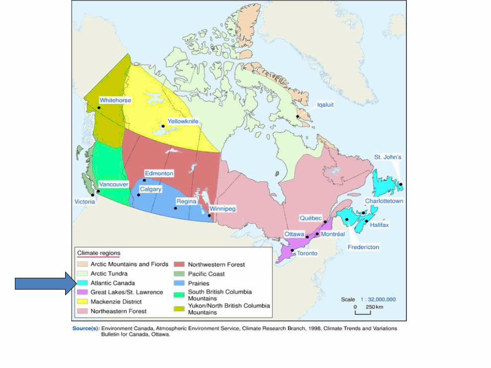
water and air cause weather patterns.• WEATHER– The short-range forecast; daily conditions.– Ex: temperature, precipitation, wind,
humidity, UV• CLIMATE– Long-term seasonal trends averaged from annual
data– Ex: In the Atlantic Canada Climate
region, winters are cold and summers are Warm

GLOBAL WEATHER PATTERNS
• 3 MAIN PARTS OF THE EARTH influence GLOBAL WEATHER:– ATMOSPHERE AIR– HYDROSPHERE WATER– LITHOSPHERE/GEOSPHERE LAND

SOME GLOBAL WEATHER TERMINOLOGY• GEOGRAPHY– The study of oceans, continents, countries, ocean
currents, and air currents.
• LONGITUDE– Vertical lines on maps/globes that show our
position EAST or WEST of the PRIME MERIDIAN line.
• LATITUDE– Horizontal lines on maps/globes that show our
position NORTH or SOUTH of the EQUATOR

PRIME MERIDIAN, GREENWICH, ENGLAND

Some Special Latitude Lines• ARCTIC CIRCLE:– 66.5oN, most Northern latitude to receive sun’s rays
on December 21st
• ANTARCTIC CIRCLE:– 66.5oS, most Southern latitude to receive sun’s rays
on December 21st
• TROPIC OF CANCER:– 23.5oN, most Northern latitude to receive sun’s
vertical rays on June 21st
• TROPIC OF CAPRICORN:– 23.5oS, most Northern latitude to receive sun’s
vertical rays on June 21st

Some Special Latitude Lines. . .
Be able to identify these on a test!

Latitude Lines and Seasons
On December 21st, NOTICE how the NORTHERN HEMISPHERE is TILTED AWAY from the SUN (Winter) and the SOUTHERN HEMISPHERE is TILTED TOWARD the SUN (Summer)
On JUNE 21st, NOTICE how the SOUTHERN HEMISPHERE is TILTED AWAY from the SUN (Winter) and the NORTHERN HEMISPHERE is TILTED TOWARD the SUN (Summer)
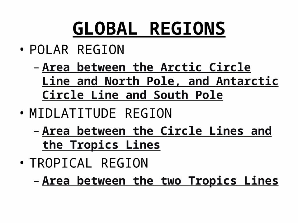
GLOBAL REGIONS• POLAR REGION– Area between the Arctic Circle Line and North
Pole, and Antarctic Circle Line and South Pole
• MIDLATITUDE REGION– Area between the Circle Lines and the Tropics
Lines
• TROPICAL REGION– Area between the two Tropics Lines

LATITUDE LINES AND GLOBAL REGIONS
POLAR REGION
MIDLATITUDE REGION
TROPICS REGION
ARCTIC CIRCLE
TROPIC OF CANCER
EQUATOR
TROPIC OF CAPRICORN
ANTARCTIC CIRCLE
N POLE
S POLE

HOMEWORK!!!
• Questions 1, 2, 4, 8 on page 502!!!

HOW IS ENERGY TRANSFERRED?
• As you already know, all of the earth’s energy initially comes from the SUN, with its steamy average temperature of 15,000,000oC, and its energy output of 3.83 x 10²³ kJ/s.

HOW IS ENERGY TRANSFERRED?
• Weather and climate patterns are based on the transfer of energy between and within air masses and water bodies.
• 4 METHODS OF ENERGY TRANSFER– RADIATION– CONDUCTION– CONVECTION– ADVECTION

1. RADIATION
• The transfer of energy in the form of WAVES.• This type of energy can travel through A
VACUUM (empty space) as opposed to through a MEDIUM (s, l, g).
• Examples of radiation waves include:– UV, visible light, gamma rays, etc.

RADIATION . . .

ELECTROMAGNETIC SPECTRUM• The complete set of radiation waves that can
travel through empty space.
Also SeeFigure 1 on page 505

2. CONDUCTION• The transfer of energy through the collision of
particles through solids.• Occurs in conductive materials (i.e., metals). • Small role in weather, bigger role in surface
heating.

CONDUCTION . . .

3. CONVECTION• The transfer of energy by the VERTICAL
movement of particles in FLUIDS.• Fluids are considered LIQUIDS or GASES.• Important for weather patterns.
• http://channel.nationalgeographic.com/series/earth-the-biography/3130/Videos
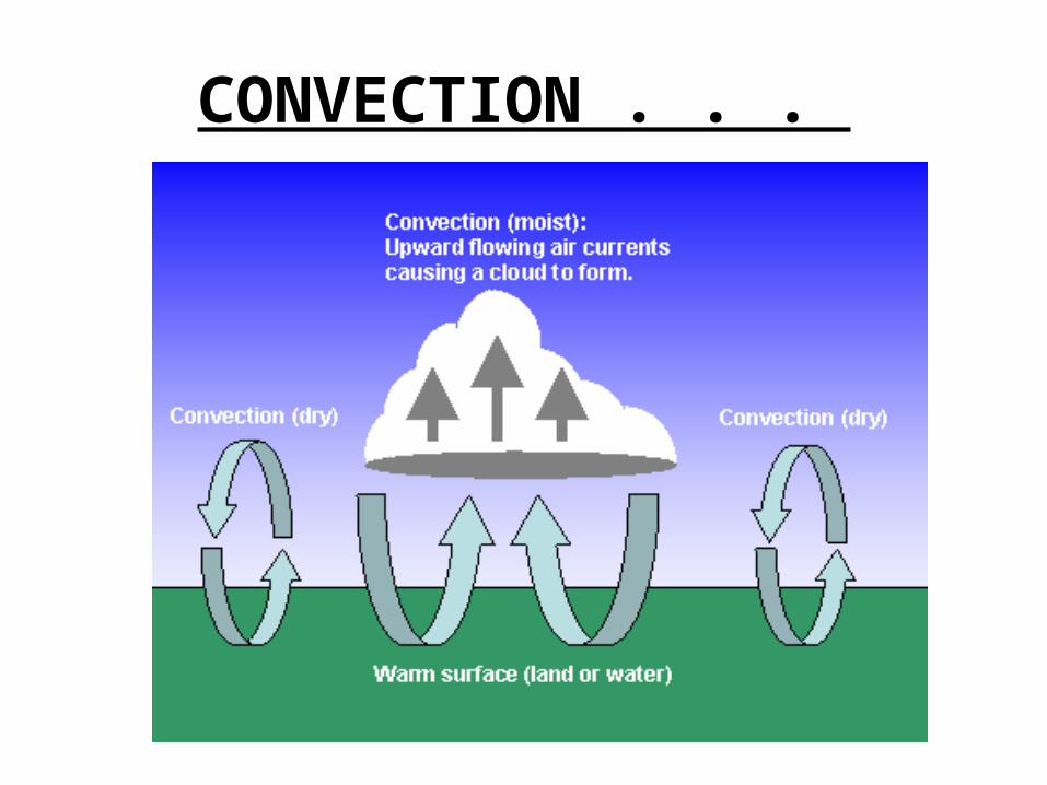
CONVECTION . . .

4. ADVECTION• The transfer of energy by the HORIZONTAL
movement of particles in fluids. • Important for weather patterns.• Ex: FOG

These forms of heat transfer do not always act alone!

THE ALBEDO EFFECT• Recall that ALBEDO is
an objects ability to reflect LIGHT.
• LIGHT-coloured objects have a HIGH albedo.
• DARK-coloured objects have a LOW albedo.

HOW MUCH OF THE SUN’S ENERGY IS REFLECTED?
• Refer to Figure 4 on p. 506 of your text.• If we count the Sun’s energy as starting with
100 %, then:– ____ is absorbed by land/oceans
– ____ is absorbed by clouds
– ____ is reflected by surface
– ____ is reflected by clouds

HEAT SINK• Any object or material that ABSORBS energy
and becomes WARMER.• A GOOD HEAT SINK is one that heats ups
SLOWLY, absorbing a LARGE amount of heat before it heats up, such as WATER.
• A POOR HEAT SINK increases its temperature QUICKLY when exposed to even a SMALL amount of heat, but it LOSES heat just as quickly, such as what happens with rocks, soil, or sand.

HEAT CAPACITY• A measure of the amount of heat energy A measure of the amount of heat energy
required to raise the temperature of required to raise the temperature of 1 gram1 gram of a substance by of a substance by 11ooCC..
• See See Figure 5Figure 5 on page 506 for a list of some on page 506 for a list of some heat capacities.heat capacities.– WATERWATER has a high heat capacity, meaning it has to has a high heat capacity, meaning it has to
absorb a lot of heat to increase in temperature.absorb a lot of heat to increase in temperature.– METALSMETALS has a low heat capacity, meaning it has a low heat capacity, meaning it
increases temperature with a relatively small increases temperature with a relatively small addition of heat.addition of heat.

HOMEWORK
• Q. 1, 2, 3, 4, 5, 6, 8 on p. 507.

THE EARTH’S SEASONS

THE EARTH’S SEASONS
• The earth rotates on its axis once a day in a COUNTERCLOCKWISE direction.
• The earth also orbits around the Sun elliptically and is tilted at an angle of 23.5o.
• The earth’s orbit around the Sun takes approximately 364.25 days.

THE EARTH’S SEASONS• Changes in the intensity of the Sun’s rays,
dues to daily and annual rotations, give us SEASONS.
• SOLSTICE– Points when the poles are tilted at their
MAXIMUM toward or away from sun.• EQUINOX– Sun’s rays strike Earth’s surface directly at
EQUATOR.– Day and night of roughly EQUAL length
everywhere on earth.

THE EARTH’S SEASONS
• SUMMER SOLSTICE– Northern hemisphere at MAXIMUM tilt TOWARD
sun. (YAY SUMMER!!!)– JUNE 21st is longest day of year.
• WINTER SOLSTICE– Northern hemisphere at MAXIMUM tilt AWAY
FROM sun. (BOO WINTER!!!)– DEC 21st is shortest day of year.


THE EARTH’S SEASONS
• VERNAL EQUINOX (SPRING EQUINOX)– Marks the first day of SPRING in the Northern
Hemisphere (AROUND MARCH 21)
• AUTUMNAL EQUINOX– Marks the first day of FALL in the Northern
Hemisphere.(AROUND SEPTEMBER 21)


THE ATMOSPHERE• http://video.google.ca/videose
arch?q=layers+of+the+atmosphere&hl=en&emb=0&aq=f#

What is the Atmosphere?
DEFINITION:• The blanket of air and water vapour that
surrounds the Earth.• If the earth were an ONION, the atmosphere
would be like the ONION PEEL. • It is about 500 km thick, containing 78% N , 21% O
, and some trace elements (ex: CO2, H2O, Ar).

LAYERS OF THE ATMOSPHERE• Defined according to ALTITUDE, or elevation
above sea level.• TROPOSPHERE– 8-16 km altitude, layer closest to earth’s surface– This layer is the most dense, meaning it contains
the most particles.– Weather occurs in this layer.– Temperature ranges from 20 to -50degrees
Celsius.– The tropopause is on the upper end of this layer.

LAYERS OF THE ATMOSPHERE• STRATOSPHERE– 16-50 km altitude– Very dry, temperature average is 10o degrees
Celsius.– This layer contains ozone, responsible for
absorbing UV radiation from the Sun.– Supersonic jets fly in this layer.
• MESOSPHERE– 50-80 km altitude– Temperature average is -75 degrees Celsius.

LAYERS OF THE ATMOSPHERE• THERMOSPHERE (IONOSPHERE)– 80-500 km altitude– Temperature average is 30o degrees Celsius.– Molecules and ions have high energy because
they are absorbing powerful waves from the SUN.– On earth, we can see the Aurora Borealis in the
Northern Hemisphere and the Aurora Australis in the Southern Hemisphere.

LAYERS OF THE ATMOSPHERE• EXOSPHERE– Outer layer converging with SPACE.– Thin layer, made up mostly of H and He particles.

AURORAS• The Sun ejects ionized particles into space that travel to the
Earth. Earth’s magnetic field deflects these particles toward the poles, creating massive magnetic storms. They vibrate, and when they return to the original state, light is emitted.

HOW DOES THE ATMOSPHERE SUPPORT LIFE?1. Molecules such as O2, N2, H2O, CO2 needed to
support life processes.2. Ozone, O3,needed to absorb harmful UV
rays.3. Water cycle necessary to replenish water in
atmosphere, land, and water bodies.4. Protection from meteors.5. Maintenance of ideal Temperature.6. Move energy around the Earth.

How did Life Begin?
• http://www.pbs.org/wgbh/nova/origins/

ATMOSPHERIC PRESSURE
• Defined as the pressure that air particles exert as gravity pulls them toward the centre of the earth
• Air pressure is greatest at sea level where air is most dense (i.e., thick)
• Air pressure decreases with altitude.– Thus, if you climb a mountain, the weight of the
air above you is less, and the pressure is less.

PRESSURE GRADIENT
• Another factor that affects air pressure is whether air is rising or falling.
• A pressure gradient is a measure of these changes in air pressure over set distance.
• Pressure gradients can be vertical or horizontal.
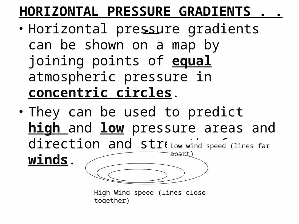
HORIZONTAL PRESSURE GRADIENTS . . . • Horizontal pressure gradients can be shown
on a map by joining points of equal atmospheric pressure in concentric circles.
• They can be used to predict high and low pressure areas and direction and strength of winds.
High Wind speed (lines close together)
Low wind speed (lines far apart)

HOW DO WE MEASURE AIR PRESSURE?HOW DO WE MEASURE AIR PRESSURE?• Air pressure is measured with an aneroid
barometer, (“aneroid” meaning “without water). – Figure 5, p. 512.
• Air pressure is measured in kPa, or kilopascals. 1 kPa = 1000 Pa.– If a barometer detects a :• low pressure system (less than 101.3 kPa), this is a sign
of poor weather.• High pressure system (greater than 101.3 kPa, this is a
sign of good weather.

HOW DO WE MEASURE AIR PRESSURE?HOW DO WE MEASURE AIR PRESSURE?

WINDS• Wind is the movement of air in the
atmosphere.– Some winds are local while others are prevailing.
• Local winds occur in a fairly small region. • Prevailing winds are wind patterns that affect
large regions around the world.

PREVAILING WINDS• In the early 1800s, SAILORS discovered that,
in certain areas, the winds blow in the same direction all of the time.

THE CORIOLIS EFFECT• The change of DIRECTIONof a moving object in a
constantly rotating system.• The rotation of the EARTH deflects moving air AND
water to the RIGHT of its initial direction in the Northern Hemisphere (opposite in the Southern Hemisphere).– Note:
• This direction of deflection is from the viewpoint of the starting position of WHAT IS BEING DEFLECTED (ex: plane, wind, etc.).
– FIGURE 2 - pg. 517– FIGURE 1 - pg. 525

THE CORIOLIS EFFECT
• http://www.classzone.com/books/earth_science/terc/content/visualizations/es1904/es1904page01.cfm
• http://www.youtube.com/watch?v=mcPs_OdQOYU

THE CORIOLIS EFFECT

THE CORIOLIS EFFECT

HOMEWORK!!!• 13.4 - Page 513, # 7, 8, 9• 13.6 – READ section first, then answer Page
519, # 1, 2, 3, 4.
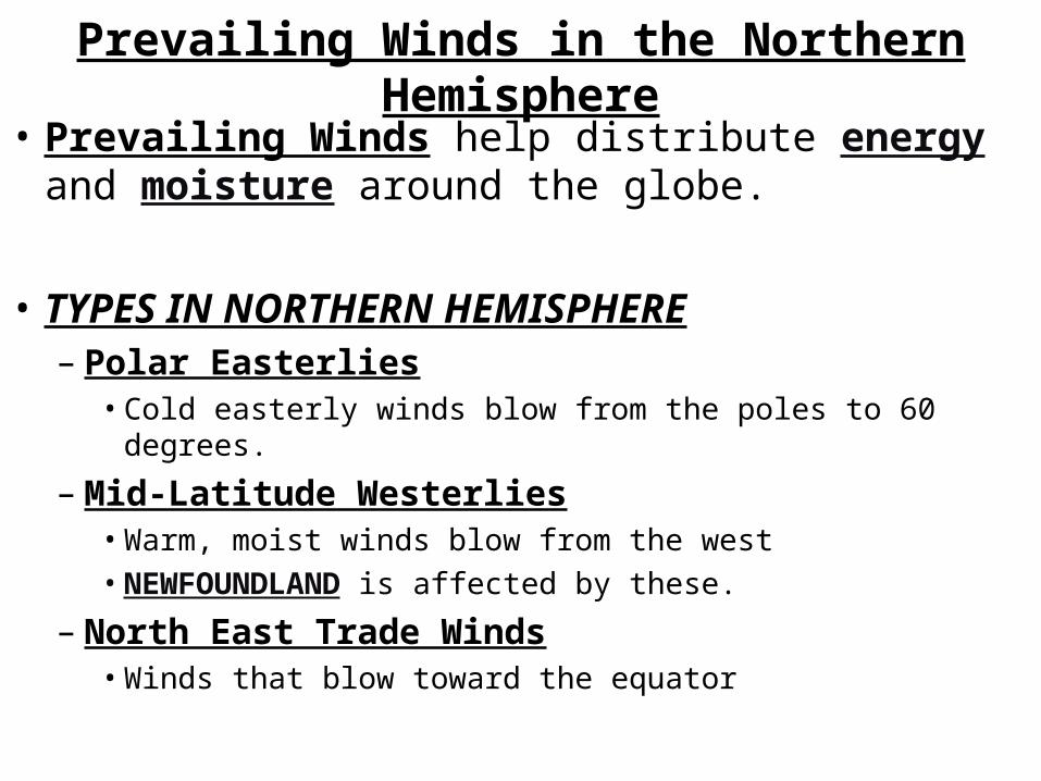
Prevailing Winds in the Northern Hemisphere• Prevailing Winds help distribute energy and
moisture around the globe.
• TYPES IN NORTHERN HEMISPHERE– Polar Easterlies
• Cold easterly winds blow from the poles to 60 degrees.
– Mid-Latitude Westerlies• Warm, moist winds blow from the west• NEWFOUNDLAND is affected by these.
– North East Trade Winds• Winds that blow toward the equator
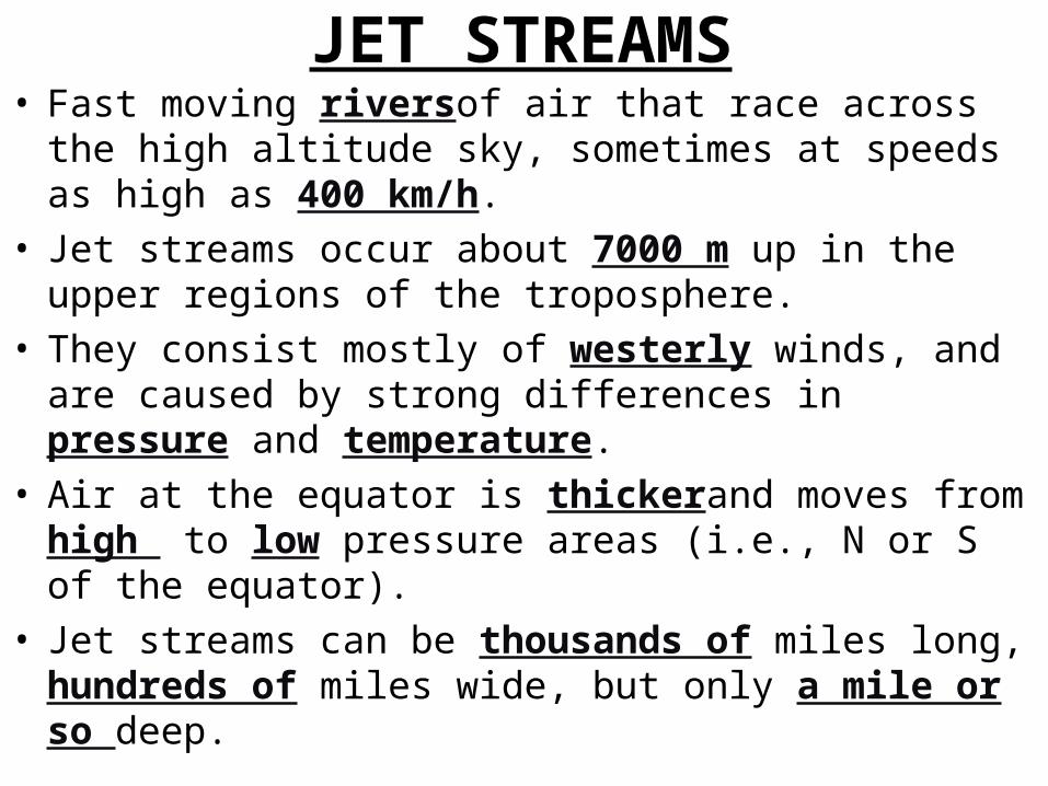
JET STREAMS• Fast moving riversof air that race across the high altitude
sky, sometimes at speeds as high as 400 km/h.• Jet streams occur about 7000 m up in the upper regions of
the troposphere.• They consist mostly of westerly winds, and are caused by
strong differences in pressure and temperature.• Air at the equator is thickerand moves from high to low
pressure areas (i.e., N or S of the equator).• Jet streams can be thousands of miles long, hundreds of
miles wide, but only a mile or so deep.

JET STREAMS• Pilots can reduce flight time by hitching a ride on a jet
stream.• Long lines of clouds often indicate the presence of a jet
stream.

THE HYDROSPHERE• Water covers 70 % of the Earth’s surface, or
320 million cubic miles.• The hydrosphere is all the water that exists on
the planet. It includes water in:– Oceans– Rivers– Lakes– Aquifers– Glaciers/ice– Atmosphere

WATER DISTRIBUTION• 97.5% is salt water, 2.5% is fresh water.• Most of our fresh water supply is trapped in polar ice caps
(87.3%).• Canada is rich in fresh water resources, having 10% of the
total world supply.

THE HYDROLOGICAL CYCLE• Water is cycled through air, land, and water bodies.• Important processes that occur in the water cycle
include:– EVAPORATION: liquid to gas– CONDENSATION: gas to liquid– TRANSPIRATION: evaporation from leaves– SUBLIMATION: solid to gas– DEPOSITION: gas to solid– INFILTRATION: seep into ground– PRECIPITATION: rain, snow, hail, sleet

THE HYDROLOGICAL CYCLE

MAJOR OCEAN CURRENTS• Oceans have a HUGE effect on weather
patterns. Here are just a few of the ways water is significant in this regard: – Oceans are heat sinks since most of the sun’s
direct rays hit water.– If water is warm, air above it is warm, meaning
lots of moisture. If water is cold, air above it is cold.
– Warm water is constantly moving from the equator to the poles.
– Cold water is constantly moving from the poles to the equator.
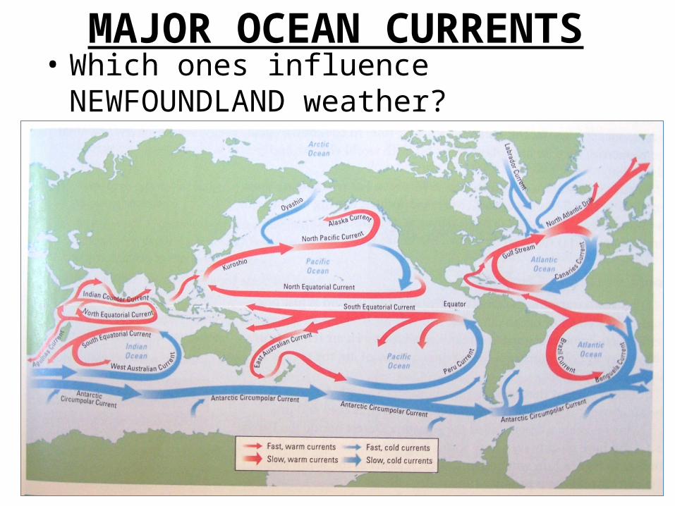
MAJOR OCEAN CURRENTS• Which ones influence NEWFOUNDLAND
weather? __________________________

NEWFOUNDLAND AND LABRADOR

WHAT CAUSES OCEAN CURRENTS?
• Convection currents• Winds across oceans• Earth’s rotation• Shape of continents• Heat capacity of Water• Amount of salt in oceans

FYI – Just for FUN• In 1992 a container ship in the middle of the Pacific Ocean
lost 29 000 bath tub toys over the side. Rubber duckies started washing ashore all over the west coast of North America.
• In 1990 in a similar type accident 80,000 pairs of Nike shoes were swept off a Korean ship headed for the United states. Nike shoes started showing up from Hawaii to Oregon and as far north as Alaska.
• These two accidents provided valuable information to oceanographers regarding ocean currents


HOMEWORK!!!• P. 524, # 3,4,5• P. 527, # 1, 4, 6

CLOUDS• Clouds are a collection of water droplets that
has become dense enough to be visible. Water evaporates and cools as it rises, and condenses into clouds.
• They are important indicators of weather patterns.
• Clouds can be grouped according to how they form, how they are shaped, whether or not they will lead to precipitation, and how high they are.

3 TYPES OF CLOUD FORMATION
• 1. CONVECTION CLOUDS
• 2. OROGRAPHIC CLOUDS
• 3. FRONTAL CLOUDS
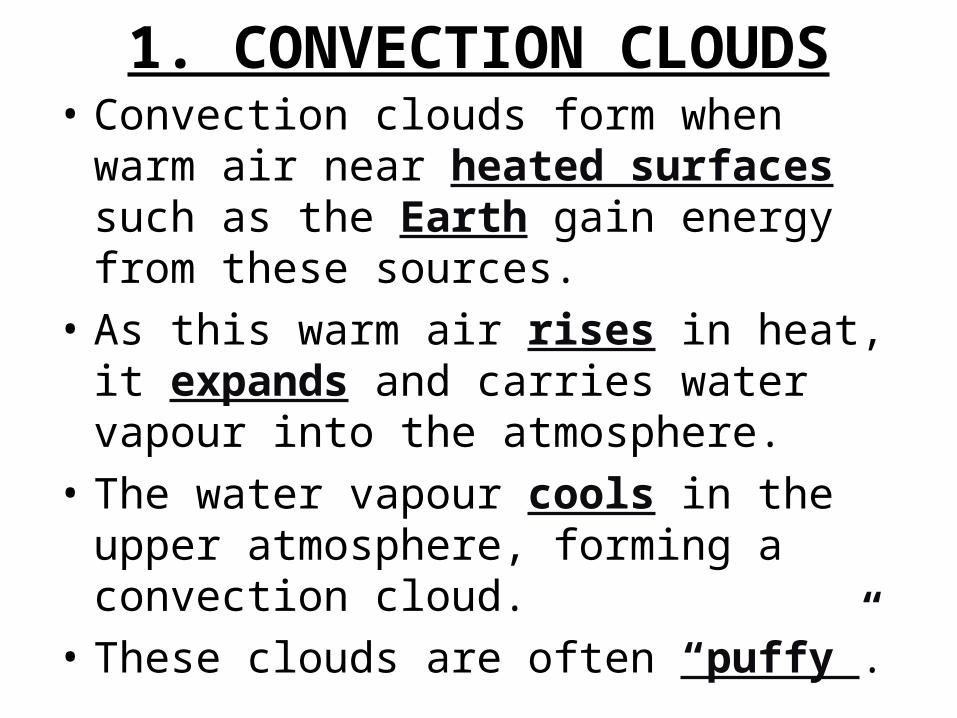
1. CONVECTION CLOUDS• Convection clouds form when warm air near
heated surfaces such as the Earth gain energy from these sources.
• As this warm air rises in heat, it expands and carries water vapour into the atmosphere.
• The water vapour cools in the upper atmosphere, forming a convection cloud.
• These clouds are often “puffy”.

1. CONVECTION CLOUDS
Something else puffy!

2. OROGRAPHIC CLOUDS
• Orographic clouds result from warm, moist air ascending up a mountain, forming clouds on the upwind slope as the temperature decreases
• Thus, the near side of the mountain has precipitation, and the far side of the mountain is often dry.

2. OROGRAPHIC CLOUDS
• http://www.pbs.org/wgbh/nova/kilimanjaro/weather.html

3. FRONTAL CLOUDS• Frontal clouds form when two air masses of
different temperatures meet. • Warm air masses generally are less dense and
contain more moisture than cold air masses, thus rising over, or being pushed upward and over, cold air.
• The rising air cools and condenses forming a frontal cloud.
• Where the two air masses meet, this leading edge is called a FRONT.

3. FRONTAL CLOUDS

3. FRONTAL CLOUDS

GROUPS OF CLOUDS• BASED ON SHAPE– CUMULUS clouds, from a term meaning “pile” or “heap”, referring
to a TALL CLOUD– STRATUS clouds, from “stratum,” or layer, referring to low-level
layered clouds.
• BASED ON PRECIPITATION– NIMBUS clouds, from a term meaning “rain”, referring to rain-
bearing clouds
• BASED ON ALTITUDE– LOW LEVEL: NO PREFIX (0 – 2000 m)– MEDIUM LEVEL: ALTO (2000-5000 m)– HIGH LEVEL: CIRRUS (5000 + m)

CUMULUS CLOUD VS. STRATUS CLOUD

CLOUDS
Cumulonimbus

FOG• Fog is a cloud that forms near the
ground.• Although there are many different types of fog, it
basically forms such that water vapour, as it condenses, attaches itself to little particles such as dust specks.
• Some types of conditions that cause fog include heat rising from the Earth’s surface and cooling rapidly, warm air passing over snow, and warm ocean air meeting cold ocean air.

FOG
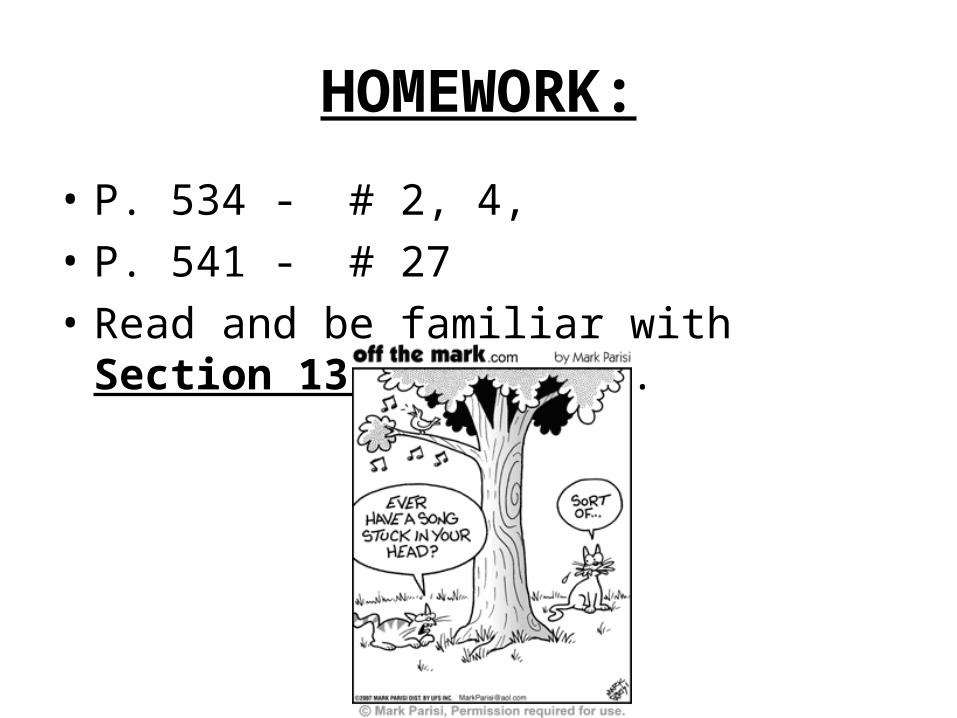
HOMEWORK:
• P. 534 - # 2, 4, • P. 541 - # 27• Read and be familiar with Section 13.13, p.
536.

WHAT WOULD HAPPEN IF:
• http://www.pbs.org/wgbh/nova/elnino/anatomy/earthsweather.html

AND THAT’S ALL FOLKS!!! Fine Print: Now study for your exam!


![Skaffold - storage.googleapis.com · [getting-started getting-started] Hello world! [getting-started getting-started] Hello world! [getting-started getting-started] Hello world! 5.](https://static.fdocuments.in/doc/165x107/5ec939f2a76a033f091c5ac7/skaffold-getting-started-getting-started-hello-world-getting-started-getting-started.jpg)