UNIT 10 Plate Tectonics Study Guide - Del Mar...
16
1 UNIT 10 Plate Tectonics Study Guide Chapters 1, 2, 9, and most of book (Revised 7/12) UNIT 10 HOMEWORK WEB HIT HOMEWORK - part 1: ONE WRITTEN PARAGRAPH from any selected unit web hit site VIDEO WEB HIT HOMEWORK – part 2: ONE WRITTEN PARAGRAPH from any selected unit video site For any Unit Web Hits and Unit Web Videos, go to the “DMC HOME” website; in Search box –type “Geology”, select “Vernon Kramer”, scroll down to GEOL 1303, select “Syllabus”, select “Web Hit Links”, later then the select “Video Web Hits”, click on icon of interest for web sites OR: go to DMC Home website, select “Degrees, Certificates, Courses”, scroll down to Natural Sciences and select “Geology”, select “Faculty Listings”, select “Walter Vernon Kramer”, find “Geol 1303”, select “Syllabus”, and there you can find the” web hit links” click on icon of interest for web sites and then to “Web video hits”, click on icon of interest for video site [IF NONE OF THE WEB SITES COME UP, YOUR COMPUTER PROBABLY NEEDS TO BE REBOOTED (RESTARTED) General -Tectonics : the branch of geology that studies regional and global structural features on Earth -Plate tectonics : the unifying theory of global dynamics. The lithosphere is believed to be broken into individual plates that move in response to convection within the Earth’s upper mantle. -Plate tectonics theory explains the interrelationships of volcanoes, earthquakes, climate, mountains, and even evolution. Historical Studies of the Ocean Floor -Evidence for tall mountains under the Mid-Atlantic Ocean was presented in the 1850s. -The laying of the transatlantic telegraph cable 1860s proved that there was a mountain range in the middle of the Atlantic Ocean. 1850 map 1908 map FYI In 1878, Wyville Thompson compiled ocean depth data from the scientific sailing ship (the HMS Challenger) and collected samples of rock (basalt) from these deep-underwater mountains. Thirty years later in 1908, this data was compiled and the results further implied an extensive mid-Atlantic mountain range (which was largely ignored). By the 1940s several” lines” of sonar mapping across the Atlantic Basin further demonstrated that the (underwater) mid-oceanic mountain range was very extensive. Continental Drift Theory Introduction -Alfred Wegener was a German scientist (geologist) who authored a book in which he carefully and systematically presented evidence for continental drift (1915). -Continental drift : A theory proposed by Alfred Wegener, in which he tried to demonstrate that the Earth’s continents actually “move” in relation to one another.
Transcript of UNIT 10 Plate Tectonics Study Guide - Del Mar...

1
UNIT 10 Plate Tectonics Study Guide Chapters 1, 2, 9, and most of book
(Revised 7/12) UNIT 10 HOMEWORK WEB HIT HOMEWORK - part 1: ONE WRITTEN PARAGRAPH from any selected unit web hit site VIDEO WEB HIT HOMEWORK – part 2: ONE WRITTEN PARAGRAPH from any selected unit video site For any Unit Web Hits and Unit Web Videos, go to the “DMC HOME” website; in Search box –type “Geology”, select “Vernon Kramer”, scroll down to GEOL 1303, select “Syllabus”, select “Web Hit Links”, later then the select “Video Web Hits”, click on icon of interest for web sites OR: go to DMC Home website, select “Degrees, Certificates, Courses”, scroll down to Natural Sciences and select “Geology”, select “Faculty Listings”, select “Walter Vernon Kramer”, find “Geol 1303”, select “Syllabus”, and there you can find the” web hit links” click on icon of interest for web sites and then to “Web video hits”, click on icon of interest for video site [IF NONE OF THE WEB SITES COME UP, YOUR COMPUTER PROBABLY NEEDS TO BE REBOOTED (RESTARTED) General -Tectonics: the branch of geology that studies regional and global structural features on Earth -Plate tectonics: the unifying theory of global dynamics. The lithosphere is believed to be broken into
individual plates that move in response to convection within the Earth’s upper mantle. -Plate tectonics theory explains the interrelationships of volcanoes, earthquakes, climate, mountains,
and even evolution. Historical Studies of the Ocean Floor -Evidence for tall mountains under the Mid-Atlantic Ocean was presented in the 1850s. -The laying of the transatlantic telegraph cable 1860s proved that there was a mountain range in the
middle of the Atlantic Ocean.
1850 map 1908 map FYI In 1878, Wyville Thompson compiled ocean depth data from the scientific sailing ship (the HMS Challenger) and collected samples of rock (basalt) from these deep-underwater mountains. Thirty years later in 1908, this data was compiled and the results further implied an extensive mid-Atlantic mountain range (which was largely ignored). By the 1940s several” lines” of sonar mapping across the Atlantic Basin further demonstrated that the (underwater) mid-oceanic mountain range was very extensive. Continental Drift Theory Introduction -Alfred Wegener was a German scientist (geologist) who authored a book in which he carefully and
systematically presented evidence for continental drift (1915). -Continental drift: A theory proposed by Alfred Wegener, in which he tried to demonstrate that the
Earth’s continents actually “move” in relation to one another.
2
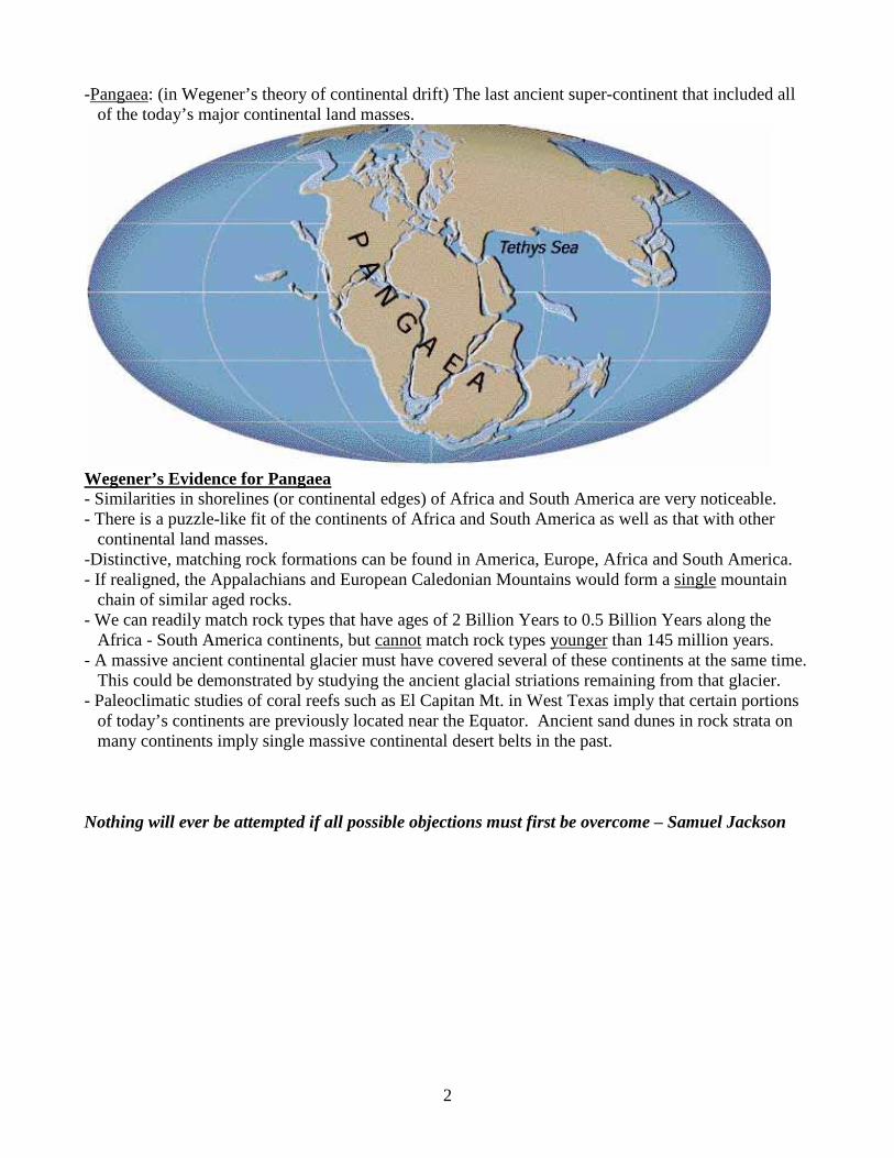
-Pangaea: (in Wegener’s theory of continental drift) The last ancient super-continent that included all of the today’s major continental land masses.
Wegener’s Evidence for Pangaea - Similarities in shorelines (or continental edges) of Africa and South America are very noticeable. - There is a puzzle-like fit of the continents of Africa and South America as well as that with other
continental land masses. -Distinctive, matching rock formations can be found in America, Europe, Africa and South America. - If realigned, the Appalachians and European Caledonian Mountains would form a single mountain
chain of similar aged rocks. - We can readily match rock types that have ages of 2 Billion Years to 0.5 Billion Years along the
Africa - South America continents, but cannot match rock types younger than 145 million years. - A massive ancient continental glacier must have covered several of these continents at the same time.
This could be demonstrated by studying the ancient glacial striations remaining from that glacier. - Paleoclimatic studies of coral reefs such as El Capitan Mt. in West Texas imply that certain portions
of today’s continents are previously located near the Equator. Ancient sand dunes in rock strata on many continents imply single massive continental desert belts in the past.
Nothing will ever be attempted if all possible objections must first be overcome – Samuel Jackson

3
-Distinctive, matching species of fossil plants, amphibian fossils and reptile fossils found in Africa,
South America, India, Australia and Antarctica imply a single continent because of very low biodiversity of the various species.
- Biodiversity Similar plant and animal species within one large ecosystem will become rapidly
become dissimilar from previously identical species when their ecosystem becomes isolated ecosystem from the large system. (This is true especially if those ecosystems are separated by land masses or oceans. For example only those monkey species from South America have prehensile tails as compared to those monkey species found in the rest of the world.)
- Similarities of plant fossils and reptile fossils suggested a continuous landmass before 145 million
years but afterwards there is a noticeable difference between “similar” fossil species. - Coal and reptile fossils in Antarctica imply that this land mass had been warm at one time. Thus
Antarctica had been “drifting” from an area of warm climates to its current position.
- “Continental drift” theory was rejected because there was no acceptable method to move the continents. If you state that continents move, you must present an acceptable mechanism that can “move” these continents over the globe!
FYI: Geophysics in the early 1900s had already established that the Earth’s sphere consisted of a crust, mantle, outer liquid iron core and a solid iron core. In 1929, A. Holmes declared that the Earth’s mantle had convection cells that could move the Earth’s crust (ignored by most scientists). Knowing is not enough, we must apply that knowledge Willing is not enough, we must do. – Wolfgang von Goethe
4
Earth’s Physical Interior (Review from Unit 1): 1) The word lithosphere means a rocky sphere. Earth’s lithosphere is the solid, strong and
somewhat rigid outer layer that includes the both the oceanic crustal rocks and the continental crustal rocks with a thin layer of mantle rock material this is “frozen” onto both of the (upper) visible crusts.
2) The asthenosphere represents a plastic-like zone of partially-melted upper mantle rocks. 3) The Mesosphere Lower Mantle is that rocky zone between the asthenosphere and the liquid
outer iron core. Earth’s internal heat (largely generated by radioactive decay) is transferred from the core, through the mantle, to the asthenosphere.
4) We have a core that has 2 components: a) Liquid outer iron core: (FYI: 1300 mi) a mass of liquid iron (with minor amounts of other metals and rocks) b) Solid iron core (FYI: 720 mi. thickness) There are lots of theories as to the exact chemical composition of Earth’s solid iron core. Drawing of Earth’s interior
Earth’s Magnetic Shield - The rotation rate of Earth’s interior solid iron core spins faster than Earth’s liquid iron core. - The solid iron core has been found to spin at a rate [2/3 second] faster than the rest of the planet.
This spin difference generates a magnetic field or magnetic shield that encompasses the Earth. - Earth’s magnetic field creates a Magnetic North Pole (over Canada) and a Magnetic South Pole that
we all can easily detect with a compass. - It is the magnetic shield that protects life on Earth from the effect of deadly radiation and cosmic rays
that is generated by our sun and other stars. Without this shield, most life on Earth would disappear within a year.
- Visible evidence of Earth’s magnetic shield is with the Northern Lights or the Aurora Borealis. A wise person makes more opportunities than he finds – Frances Bacon

5
Earth’s Magnetic shield Magnetic Poles - The “exact Magnetic North Pole” location wanders within a small area near the True North Pole. - Averaged over time, the Magnetic North Pole can be considered to be at the same location as the
True North Pole (axis of rotation). Magnetism and Magnetite -. Magnetite: an iron oxide mineral that can maintain a magnetic field as it forms. - Most magnetite grains found within cooling basalt magmas can “align” themselves to the north and
south magnetic poles that is present at the time of the grain formation. - Magnetite grains in some types of sandstone and in oceanic sediments can also “align” themselves to
the north as the grains are settling during deposition. -FYI Most animals that migrate long distances have been shown to have tiny magnetite grains within
their brain (missing in most human males – ha ha). Thus most animal migration routes follow Earth’s “magnetic field lines”.
Using Magnetic Fields to Study Geology - Paleomagnetism is the study of ancient magnetic fields, as preserved in the magnetic properties of
certain rocks that contain magnetite. - A magnetometer is an instrument used to measure magnetic fields. - The paleomagnetic study of basalts on several continents gives supporting evidence that today’s
continents have moved over time to different global positions than they now occupy.
Paleomagnetic studies

6
Some Magnetic Properties - Magnetic reversal is a complete 180 degree reversal of the polarity of Earth’s magnetic field (North
becomes South and visa versa). - Magnetic reversals may occur at any time. For example, these reversals have occurred more than 171
times on the Earth during the last 76 million years. - Intervals of shorter magnetic reversals are termed polarity events. - Geomagnetic time scale represents a time scale that relates these patterns of magnetic reversals to the
various geologic ages of the Earth. - Sunspots are “cool dark spots” on the sun that represent concentrated magnetic fields. - These spots on our Sun show reverse polarity (N-S) (or magnetic reversals) at 11 year cycles. Descriptions of the Seafloor - The seafloor was mapped in detail by many nations during the 1960s because of national security
concerns. Most used using sonar (underwater sound waves) and magnetometer instruments to bring out the detail of the Earth’s ocean floors.
Mountains on sea floor - These massive seafloor surveys discovered:
1) The sea floor is divided by a large ridge (mountain) system that extends almost 40,000 miles in length and is about 900 miles wide.
2) This ridge system is continuous around Earth’s entire globe. 3) The mountains at the center of the ocean are much higher than the distant abyssal plain found
toward the continents. 4) There is low-elevation “rift valley” within the central zone of this high mountain ridge. 5) Deep trenches are found alongside continents and island arcs and not in the middle of the
oceans.

7
Theory of Seafloor Spreading
- H. H. Hess, a geology professor at Princeton proposed (1960) the theory of seafloor spreading. - Seafloor Spreading is a theory that the seafloor is spreading apart, propelled by convection currents in
the mantle, and that the seafloor is moving symmetrically away from an oceanic ridge. - H. H. Hess’s seafloor spreading thesis proposed: 1) Mantle convection currents (caused by Earth’s internal heat) will “carry” the seafloor crust
symmetrically away from the mid-oceanic ridge. 2) This seafloor crust will be pushed toward deep sea trenches or subduction zones where this
crust eventually “descends” into the mantle zone. 3) In this manner the entire ocean floor crust should be regenerated every 200 million years
(thus you should not find oceanic crust on the seafloor that is older). Magnetic Stripes on the Seafloor (Testing of the Seafloor Spreading Theory)
Seafloor Magnetic stripes - Vine and Mathews tested Hess’s hypothesis (1963) by using paleomagnetism studies of the mid-
oceanic ridge near Iceland that was acquired by underwater and aerial magnetometer surveys. - They discovered a pattern of magnetic polarity stripes found within the oceanic crust that formed
“parallel lines of polarity” as they surveyed up and down the length of this ridge. 1) Each of these polarity lines or stripes (N-S) were found to have an identical polarity stripe on
both sides of the ridge thus these stripes are symmetrical on each side of the oceanic ridge. 2) These patterns of the polarity stripes can be used in conjunction with geomagnetic time scales,
which in turn can give an estimated age of the seafloor basalt. 3) It was discovered that the age of the seafloor basalt becomes older on both sides of the ridge, as
one moves away from the ridge toward the continents.

8
- The symmetry always shows the youngest rocks are always found at the center of the ridge (a divergent zone).
Subduction Zones - How do we create a subduction zone as part of Dr. Hess’s theory? - In 1960, J. Tuzo Wilson published a method of creating a subduction zone that would assist
convection cells and sea floor spreading. - a) Near the continental edges, erosion of the continent would dump huge quantities of sediment onto
a cold dense oceanic crust - b) The weight of this sediment and seawater would overcome the buoyancy of the oceanic crust - c) With the sea floor spreading pushing on the opposite side, the oceanic crust would finally break
and would be pushed into the mantle - Thus the deepest seafloor (+25,000 feet deep) are found alongside island and continent edges – not in
the middle of the oceans. - A subduction zone expresses itself as a submarine trench.
Submarine Trench: a very deep, elongated depression on the seafloor (adjacent to a subduction zone) Mariana Trench: Earth’s deepest trench at more than 36,000 feet depth (about 7 miles) Age-Dating Seafloor Rocks and Sediment (Testing of the Seafloor Spreading Theory)
Ages of seafloor crust - The drilling ship Glomar Challenger recovered core from throughout the world’s ocean basins.

9
- Radioactive age-dating of the oceanic basalt rock core was found to be youngest at the ocean’s mountainous center and no more than 200 million years old at the ocean edges near the continents.
- The oldest deep oceanic sediments, called “oozes” are no more than 200 million years old. (It is estimated that this ooze generally accumulates at rate of 3 mm/1,000 years).
- The continental crust rocks can be billions of years old while the oldest oceanic crust is less than 200 million years old.
- This huge age difference can be explained only if Earth’s oceanic crust is constantly being destroyed (by subduction) and renewed (at divergent zones).
Plate Tectonics and Continental Drift Theories - Plate tectonics have been well documented and “proven” as an acceptable mechanism for the
“movement” of various continents over the surface of the Earth. - We no longer use the term continental drift because all continents are attached to lithospheric plates
which in turn are composed of both of oceanic crust and continental crust. - Lithospheric plates of all sizes on the surface of the Earth all move at different speeds and different
directions relative to each other. Great spirits like you will always encounter opposition from mediocre minds – Albert Einstein Lithospheric Plates
Earth’s current plates - Earth’s lithosphere is divided into many large and small individual plates.
1) Plate boundaries are based on structural features, not land or ocean shorelines. 2) Plates are outlined by ridges, trenches and young mountain belts (caused by convergent
zones and divergent zones). 3) Most major plates contain both continental and oceanic crust (like the N. American plate). 4) Plates are not permanent features over geologic time. They can collide and join with other
plates or they can split apart and form “new” plates that move about the Earth. 5) There are 7 major plates and approximately 8-20 minor plates (depending upon any study).
Plate Boundaries - Introduction - Plate boundaries are classified as three types:
1) Divergent plate boundaries or spreading centers or rift zones (forces of expansion or tension) 2) Convergent plate boundaries or subduction zones (forces of compression or shearing) 3) Transform plate boundaries (forces of sliding past one another)
10
Divergent Boundary (Zone) - Divergent Zone is a boundary where lithospheric plates move apart, in opposite directions (2 types):
- Mid-oceanic ridge or spreading center (sometimes called the central oceanic rift zone) are terms that are directly associated with divergent boundaries found with seafloors.
- Rift Valley (zone) is a term that generally used for divergent zones found on land and on continental masses.
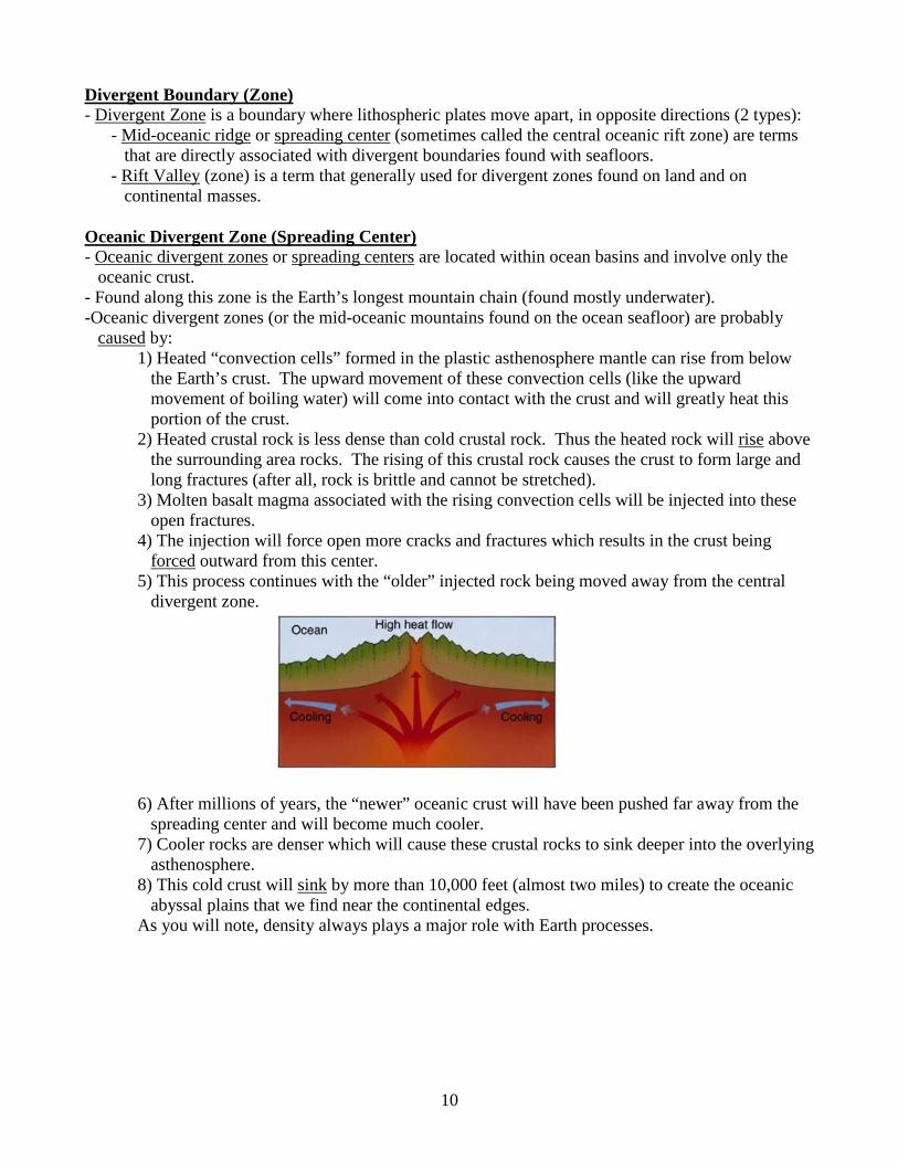
Oceanic Divergent Zone (Spreading Center) - Oceanic divergent zones or spreading centers are located within ocean basins and involve only the
oceanic crust. - Found along this zone is the Earth’s longest mountain chain (found mostly underwater). -Oceanic divergent zones (or the mid-oceanic mountains found on the ocean seafloor) are probably
caused by: 1) Heated “convection cells” formed in the plastic asthenosphere mantle can rise from below
the Earth’s crust. The upward movement of these convection cells (like the upward movement of boiling water) will come into contact with the crust and will greatly heat this portion of the crust.
2) Heated crustal rock is less dense than cold crustal rock. Thus the heated rock will rise above the surrounding area rocks. The rising of this crustal rock causes the crust to form large and long fractures (after all, rock is brittle and cannot be stretched).
3) Molten basalt magma associated with the rising convection cells will be injected into these open fractures.
4) The injection will force open more cracks and fractures which results in the crust being forced outward from this center.
5) This process continues with the “older” injected rock being moved away from the central divergent zone.
6) After millions of years, the “newer” oceanic crust will have been pushed far away from the
spreading center and will become much cooler. 7) Cooler rocks are denser which will cause these crustal rocks to sink deeper into the overlying
asthenosphere. 8) This cold crust will sink by more than 10,000 feet (almost two miles) to create the oceanic
abyssal plains that we find near the continental edges. As you will note, density always plays a major role with Earth processes.

11
Drawing a seafloor divergent zone We are what we repeatedly do, so do great things - Aristotle Black Smokers - Black smokers are very hot, juvenile-water “jets” that are being expelled along the mid-oceanic ridge. - Dissolved minerals (mostly sulfides) make the water black. - These smokers are hosts to large, exotic ecosystems that can exist without the effect of sunlight. - Some have speculated that the Jupiter moon of Europa may also have black smokers similar to that
on Earth. (Could there be life associated with possible black smokers on Europa?) Continental Divergent Zone or Rift Zones
Rift zone - Iceland is a landmass located directly over the mid-Atlantic spreading center. - Remember that a rift zone is a divergent zone under a landmass. - Continental rift zones are examples of “block faulting” that is caused by the stretching (extension and
faulting) of the Earth’s brittle continental crust. 1) The crust is arched upwards, extended and pulled apart into fault blocks. 2) Rift zones actually make continents wider.
- The Rio Grande Rift of New Mexico is a good example of a continental rift (that over time could become an oceanic basin).
- KEEP IN MIND, THAT THE ATLANTIC OCEAN BASIN STARTED OUT AS A RIFT VALLEY ON PANGAEA
12
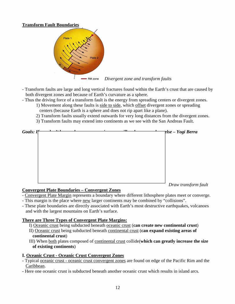
Transform Fault Boundaries
Divergent zone and transform faults - Transform faults are large and long vertical fractures found within the Earth’s crust that are caused by
both divergent zones and because of Earth’s curvature as a sphere. - Thus the driving force of a transform fault is the energy from spreading centers or divergent zones.
1) Movement along these faults is side to side, which offset divergent zones or spreading centers (because Earth is a sphere and does not rip apart like a plane).
2) Transform faults usually extend outwards for very long distances from the divergent zones. 3) Transform faults may extend into continents as we see with the San Andreas Fault.
Goals: If you don’t know where you are going, you will end up somewhere else – Yogi Berra Draw transform fault
Convergent Plate Boundaries – Convergent Zones - Convergent Plate Margin represents a boundary where different lithosphere plates meet or converge. - This margin is the place where new larger continents may be combined by “collisions”. - These plate boundaries are directly associated with Earth’s most destructive earthquakes, volcanoes
and with the largest mountains on Earth’s surface. There are Three Types of Convergent Plate Margins:
I) Oceanic crust being subducted beneath oceanic crust (can create new continental crust) II) Oceanic crust being subducted beneath continental crust (can expand existing areas of
continental crust) III) When both plates composed of continental crust collide(which can greatly increase the size
of existing continents) I. Oceanic Crust - Oceanic Crust Convergent Zones - Typical oceanic crust - oceanic crust convergent zones are found on edge of the Pacific Rim and the
Caribbean. - Here one oceanic crust is subducted beneath another oceanic crust which results in island arcs.
13
- Island arcs are chains of volcanic islands (Japan, Philippines, Caribbean Islands, etc,) found on top of the ocean plate that is not being subducted at the convergent zone.
Island arc - Characteristics of these oceanic-oceanic zones include:
1) Deep-sea trenches directly associated with the subduction zone. 2) Violent volcanoes are located on the oceanic plate above the subduction zone. 3) The colliding plates here create island arcs which will become future continental crust. 4) Violent earthquakes are associated with the subducting plate.
II. Oceanic Crust - Continental Crust Convergent Zones - Oceanic crust - continental crust convergence zones are found along edges of continents where the
more dense oceanic crust is subducted beneath a less dense continental crust. - Characteristics of this type of convergent zone include:
1) Deep sea trenches found just offshore from the continents. 2) Violent volcanoes and earthquakes are located above and within this subduction zone. 3) Here continents can grow by acquiring “accreted terrains”.
Oceanic-continental crusts converging
- Accreted terrain or accretionary wedge: seafloor, island arcs and ocean sediment that is “scraped off” onto a continent as the oceanic crust is being subducted into the mantle (This can make continents larger).
- A large portion of the Eastern US (Appalachian Mts.) and Western US (most of Alaska) land masses are the direct result of ancient accretion events.

14
Accreted terrains III. Continental Crust - Continental Crust Convergence Zones - Continental crust - continental crust convergence zone occur when two less-dense continental masses
collide together. - Since continental crusts are less dense than the mantle, continental crusts cannot be subducted deep
into the mantle. - When these crusts collide, one crust overrides another or “stacks up” to create enormous-sized
mountains. - Tall, present day products of colliding continental crusts include the Alps and the Himalayas. - The past land mass movement of India can be traced on the floor of the Indian Ocean.
India and Asia colliding Products of Convergent Zones - Since convergent zones involve compression, metamorphic rocks are common along these zones. - Violent volcanoes are common along these zones (Called the “ring of fire” along the Pacific plate.). - Violent earthquakes are common along these zones. Plate Motion - Plate motion across the Earth’s surface is a relatively slow, complicated process - Tectonic plates are rigid curved plates which move over the surface of a sphere, thus the movements
of these plates will be very complex.

15
- The most common reference for rates of plate motion is relative velocity or the movement of one plate relative to another plate.
- Plates move at relative rates of 1 to 20 cm (8 inches) per year.
Relative plate motions Methods of Moving Tectonic Plates - Tectonic mechanism includes energy forces that can actually make the plate move over the Earth’s
surface. Not everyone agrees to each proposed “force”. - Some favor energy forces exerted by mantle convection along while others favor energy forces that
include mantle convection along the gravity force of the subducting plate. Without clearly defined goals, we become loyal to performing daily acts of trivia - Unknown Tectonic Plate Movements (Passive Plate Theory) (Energy forces) - The passive plate theory states the convection of heat from the core and mantle drives plate
movement. 1) Convection cells will bring new material (basalt) to the surface. 2) Old crust is pushed away from ridges by convection. 3) Descending convection at subduction zone will carry cooler crust into the mantle. 4) The size of the cell determines the size of the plate. (UP TO THIS POINT - WE HAD ASSUMED THAT ONLY CONVECTION WAS THE DRIVING FORCE – NOW LET’S EXAMINE ANOTHER POSSIBILITY.)

16
Passive plate theory Tectonic Plate Movements (Slab Pull Theory) (Energy forces) - The slab pull theory states that oceanic slabs sink into the mantle under its own weight (density).
1. Cold oceanic crust can become too dense to float. An edge of the crust will break off and sink to create a subduction zone.
2. The sinking subducting plate will actually cause the plate at the mid-oceanic ridge to break faster.
3. Only the continental crustal edge (friction) and the “solid” mantle (resistance) slow down this process.
Plate Mechanisms (slab pull) Here the weight of the slab sinking into the mantle is causing the divergent zone. Plate movement is slowed down by the friction at the continental margin, friction at the asthenosphere and by the “resistance” of penetrating into the solid mantle rock.
Supercontinent Cycle – J. Tuzo Wilson - A supercontinent cycle states that approximately every 500 million years, most of the Earth’s plates
collide together to form a massive continent. - Later the supercontinent will then split apart. - Pangaea was only the latest supercontinent. (If you don’t like the shape of your continent – wait a
few million years – it will change!)