Unit 02a : Advanced Hydrogeology Aquifer Characterization.
33
Unit 02a : Advanced Hydrogeology Aquifer Characterization
-
Upload
roger-sydney-robinson -
Category
Documents
-
view
234 -
download
7
Transcript of Unit 02a : Advanced Hydrogeology Aquifer Characterization.
Unit 02a : Advanced Hydrogeology
Aquifer Characterization
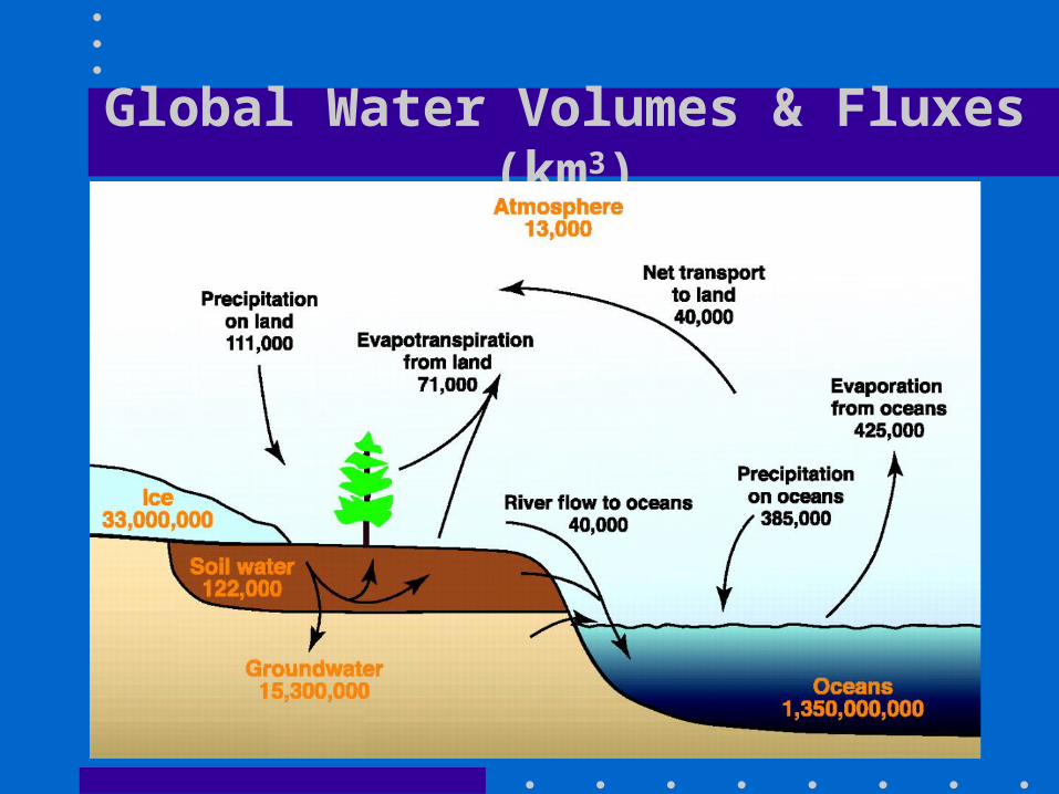
Global Water Volumes & Fluxes (km3)
Aquifer Definitions
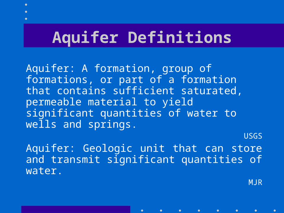
Aquifer: A formation, group of formations, or part of a formation that contains sufficient saturated, permeable material to yield significant quantities of water to wells and springs.
USGS
Aquifer: Geologic unit that can store and transmit significant quantities of water.
MJR

Aquifers• Aquifers are geologic units that can store and
transmit significant quantities of water:• Continental Deposits • Marine Deposits• Volcanics
• Aquifer characteristics derive from both primary depositional features and secondary modification by geologic processes:• Burial & Diagenesis• Uplift & Erosion• Tectonism & Fracturing

Principal Aquifer Rock Types
Unconsolidated Semi-consolidated
Sandstone Carbonate
Volcanic Plutonic
Unconsolidated Aquifers
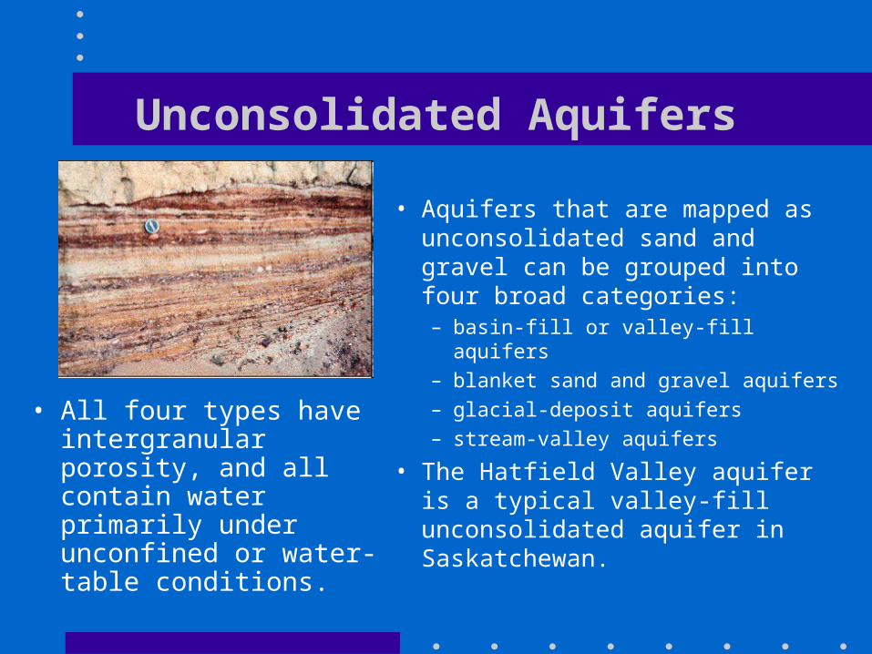
• All four types have intergranular porosity, and all contain water primarily under unconfined or water-table conditions.
• Aquifers that are mapped as unconsolidated sand and gravel can be grouped into four broad categories: – basin-fill or valley-fill aquifers– blanket sand and gravel aquifers – glacial-deposit aquifers – stream-valley aquifers
• The Hatfield Valley aquifer is a typical valley-fill unconsolidated aquifer in Saskatchewan.
Unconsolidated Aquifer Properties
• The hydraulic conductivity of unconsolidated aquifers is variable, depending on the sorting of aquifer materials and the amount of silt and clay present, but generally it is high.
• Aquifer thickness ranges from a few meters or tens of meters in the blanket sands to several hundred meters in the basin-fill aquifers.
• Unconsolidated sand and gravel aquifers are susceptible to contamination because of their generally high hydraulic conductivity.

Unconsolidated Aquifer Flow Systems
• Ground water in unconsolidated aquifers flows along relatively short flow paths typical of local flow systems
• Basin-fill aquifers typically have intermediate flow systems
• Thick basin-fill aquifers may support regional flow system.
• Likewise, the thick blanket sands aquifers and alluvial aquifers can represent regional flow systems.

Semi-consolidated Aquifers
• Semi-consolidated aquifers consist of sand interbedded with silt, clay, and minor carbonate.
• The aquifers are typically of fluvial, deltaic, and shallow marine origin.
• The varied depositional environments of these sediments have caused complex interbedding of fine and coarse-grained materials.
• Accordingly, some aquifers are thin and local whereas others are thick and may extend over hundreds of square kilometres.
• The Ravenscrag Formation is a Saskatchewan example of a semi-consolidated aquifer.
Semi-consolidated Aquifer Properties
• Porosity is intergranular, and the hydraulic conductivity of the aquifers is moderate to high.
• The aquifers form thick extensive wedges of sediment.
• Wedges tend to dip away from topographically high erosional source areas.
• Aquifer thicknesses can reach several hundred metres.
Semi-consolidated Aquifer Flow Systems
• Numerous local aquifers can be grouped into a few regional aquifer systems that contain groundwater flow systems of local, intermediate, and regional scale.
• In topographically high recharge areas aquifers are unconfined but become confined in the downdip direction.
• Discharge is by upward leakage to shallower aquifers or to saltwater bodies in coastal areas.
• Because flow is sluggish near the ends of regional flow paths, the aquifers commonly contain unflushed saline water in their deeply buried, downdip extremities.
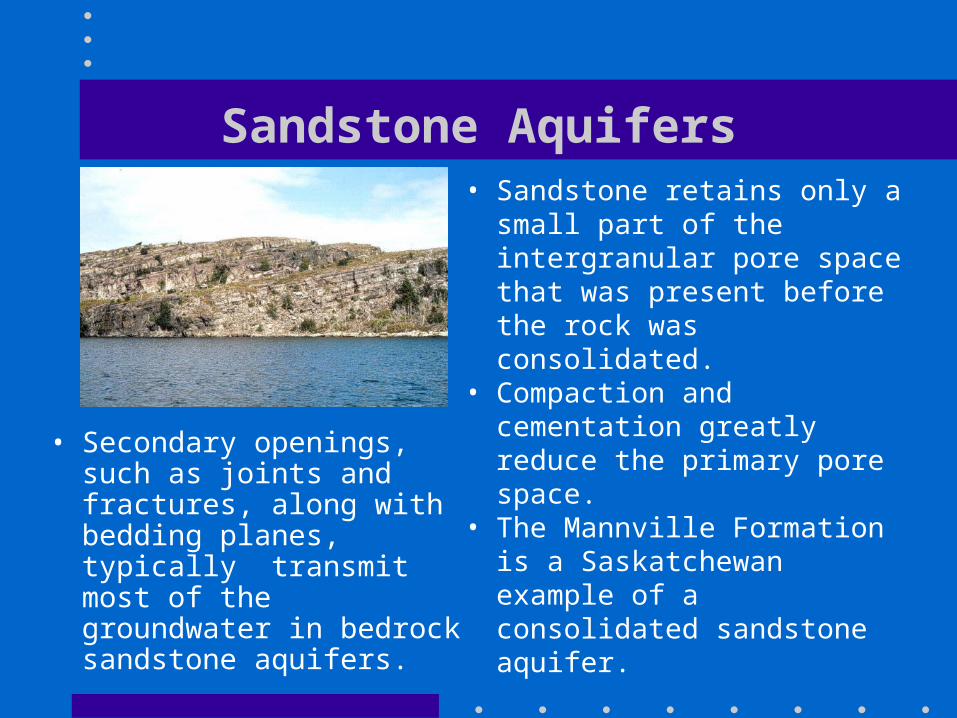
Sandstone Aquifers
• Secondary openings, such as joints and fractures, along with bedding planes, typically transmit most of the groundwater in bedrock sandstone aquifers.
• Sandstone retains only a small part of the intergranular pore space that was present before the rock was consolidated.
• Compaction and cementation greatly reduce the primary pore space.
• The Mannville Formation is a Saskatchewan example of a consolidated sandstone aquifer.

Sandstone Aquifer Properties
• The hydraulic conductivity of cemented sandstone aquifers is low to moderate.
• Transmission is primarily through fractures although primary porosity may continue to contribute to storage.
• Because bedrock sandstones extend over large areas, these aquifers can often provide large amounts of water.

Sandstone Aquifer Flow Systems
• Sandstone aquifers in the Prairies are horizontal to gently dipping.
• Because they are commonly interbedded with siltstone or shale, most of the water in these aquifers is under confined conditions.
• Groundwater flow systems in relatively thin sandstone aquifers are local to intermediate.
• Regional, intermediate, and local flow are present in the sandstone aquifers western Canada.
• Many extensive sandstone aquifers contain highly mineralized water at depths of only a few hundred metres.

Carbonate Aquifers
• The ultimate properties of carbonate rocks vary widely; some are considered to be confining units, whereas others are among the most productive aquifers known.
• Most of the carbonate-rock aquifers consist of limestone, but dolomite and marble locally yield water.
• Carbonate rocks originate as sedimentary deposits in marine environments.
• Compaction, cementation, and dolomitization processes act on the deposits as they undergo lithification and greatly change their porosity and permeability.
Carbonate Aquifer Properties
• The principal post-depositional change in carbonate rocks is the dissolution of part of the rock by circulating, slightly acidic groundwater.
• Solution openings in carbonate rocks range from small tubes and widened joints to caverns that may be tens of meters wide and hundreds to thousands of meters in length.
• Where they are saturated, carbonate rocks with well-connected networks of solution openings yield large amounts of water to wells that penetrate the openings
• The undissolved rock between the large openings may be almost impermeable.

Carbonate Aquifer Flow Systems
• Because water enters the carbonate rocks rapidly through sinkholes and other large openings, any contaminants in the water can spread rapidly through the aquifers.
• Regional, intermediate, and local ground- water flow systems are present in carbonate aquifers but most near-surface carbonates tend to provide only local and intermediate systems.
• Where carbonate rocks are exposed at land surface, solution creates karst topography, characterized by little surface drainage, sinkholes, blind valleys, sinking streams, and karst towers (mogotes).

Hydraulic Conductivities
Unconsolidated
Deposits
Max Median Min
(m/s) (m/s) (m/s)
Gravel 3 x 10⁻² 3 x 10⁻³ 3 x 10⁻⁴
Sand 6 x 10⁻³ 3 x 10⁻⁵ 2 x 10⁻⁷
Silt / Loess 2 x 10⁻⁵ 2 x 10⁻⁷ 2 x 10⁻⁹
Fractured Till 2 x 10⁻⁵ 6 x 10⁻⁸ 2 x 10⁻¹⁰
Unfractured Till 2 x 10⁻⁶ 2 x 10⁻⁹ 2 x 10-12
Lacustrine Clay 5 x 10⁻⁹ 7 x 10⁻¹⁰ 1 x 10-12
Marine Clay 2 x 10⁻⁹ 4 x 10-11 8 x 10-13Overall range is more than10 orders of magnitude
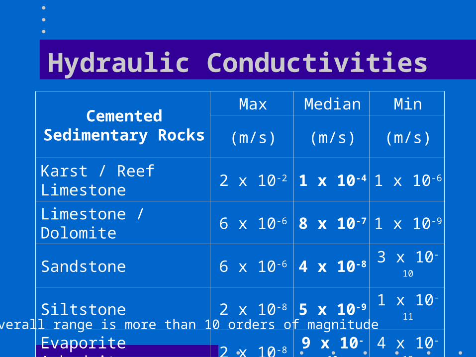
Hydraulic Conductivities
Cemented Sedimentary Rocks
Max Median Min
(m/s) (m/s) (m/s)
Karst / Reef Limestone 2 x 10⁻² 1 x 10⁻⁴ 1 x 10⁻⁶
Limestone / Dolomite 6 x 10⁻⁶ 8 x 10⁻⁷ 1 x 10⁻⁹
Sandstone 6 x 10⁻⁶ 4 x 10⁻⁸ 3 x 10⁻¹⁰
Siltstone 2 x 10⁻⁸ 5 x 10⁻⁹ 1 x 10-11
Evaporite Anhydrite 2 x 10⁻⁸ 9 x 10⁻¹⁰ 4 x 10-13
Shale / Mudstone 3 x 10⁻⁹ 2 x 10-11 1 x 10-13
Evaporite Salt 1 x 10⁻¹⁰ 1 x 10-11 1 x 10-12
Overall range is more than 10 orders of magnitude
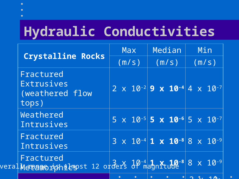
Hydraulic Conductivities
Crystalline RocksMax Median Min
(m/s) (m/s) (m/s)
Fractured Extrusives (weathered flow tops)
2 x 10⁻² 9 x 10⁻⁴ 4 x 10⁻⁷
Weathered Intrusives 5 x 10⁻⁵ 5 x 10⁻⁶ 5 x 10⁻⁷
Fractured Intrusives 3 x 10⁻⁴ 1 x 10⁻⁸ 8 x 10⁻⁹
Fractured Metamorphics 3 x 10⁻⁴ 1 x 10⁻⁸ 8 x 10⁻⁹
Massive Extrusives 4 x 10⁻⁷ 3 x 10⁻⁹ 2 x 10-11
Massive Intrusives 2 x 10⁻¹⁰ 2 x 10-12 3 x 10-14
Massive Metamorphics 2 x 10⁻¹⁰ 2 x 10-12 3 x 10-14
Overall range is almost 12 orders of magnitude

Hydraulic Conductivity Distributions
• Hydraulic conductivity is almost always log-normally distributed• Ranges of 4 or 5 orders of magnitude for the same geologic unit are commonplace
Hydraulic Conductivity (m/s) Log Hydraulic Conductivity0.0 0.5 1.0 1.5 2.0 -9 -8 -7 -6 -5
Fre
que
ncy
Fre
que
ncy
x 10-6

Anisotropy
• Most rocks have a directional dependence in their properties as a result of their geologic origins.– metamorphic foliation, schistosity and banding– sedimentary layering – extrusive flow tops and cooling cracks– till weathered tops and desiccation cracks
• Typically Kh > Kv with ratios in the range 2-10
• Evaporites tend to display isotropic properties
• A few materials can show Kh < Kv including fractures lava flows (basalts) and fractured tills
Flow Properties and Scale
• Material properties like porosity and permeability tend to be strongly scale-dependent
• At the microscopic scale it is obvious that a small sample volume could lie entirely within a mineral grain or entirely within a pore
• At the mesoscopic and macroscopic scales it becomes possible to define sample volumes for which material properties are relatively constant
• As scale increases, at the megascopic scale changes in local depositional environments, jointing and faulting can lead to less consistent material properties for large sample volumes
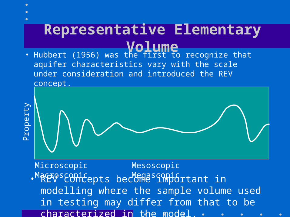
Representative Elementary Volume• Hubbert (1956) was the first to recognize that aquifer
characteristics vary with the scale under consideration and introduced the REV concept.
Microscopic Mesoscopic Macroscopic Megascopic
Pro
pert
y
• REV concepts become important in modelling where the sample volume used in testing may differ from that to be characterized in the model.

Groundwater in Canada• In Canada, 7.9 million people, or 26% of the
population, rely on groundwater for domestic use.• Approximately two thirds, or five million, of these
users live in rural areas. In many areas, wells produce more reliable and less expensive water supplies than those obtained from nearby lakes, rivers and streams.
• The remaining two million users are located primarily in smaller municipalities where groundwater provides the primary source for their water supply systems.
• About 45% of the Saskatchewan population relies on groundwater for domestic and municipal use.

Provincial Reliance on Groundwater

Objectives of Aquifer Classification
• There is a need for a generic aquifer classification model that can be universally applied
• Most existing schemes are tied to local legislation or regulations
• The primary objectives of aquifer classification include:– Provision of a framework for mapping and assessment– Provision of a resource inventory– Prioritization of management, protection and remedial efforts– Expansion of knowledge and understanding of groundwater
resources

Aquifer Classification• Generic aquifer classification schemes rank aquifers and
groundwater resources based on criteria such as:
– Productivity – typical well yields– Size – aquifer surface are and volume– Vulnerability – potential for contamination– Demand – total volume requirements– Type of use – domestic, municipal, industrial, agricultural– Health Risks – any specific biological or chemical issues– Reliability – ability to maintain production
• In Canada, the government of British Columbia aquifer classification scheme is a typical example, Kreye et al. (1998)

BC Scheme Components
• The BC scheme has two components:– Classification Component based on:
• Level of Development• Vulnerability
– Ranking Component based on:• Hydrologic criteria (productivity, size, reliability)• Usage criteria (demand, type of use, quality)

BC Aquifer Sub-Classes

BC Aquifer Classes
• The scheme results in nine aquifer classes from IA to IIIC
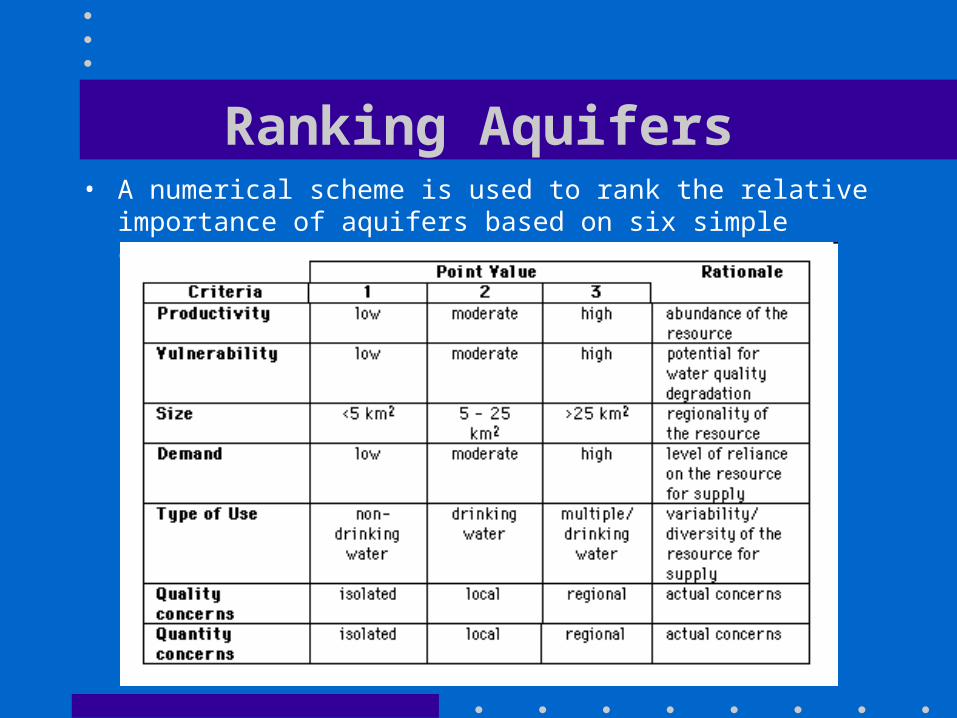
Ranking Aquifers• A numerical scheme is used to rank the relative importance of
aquifers based on six simple criteria rated from 1 to 3

Application and Use• The classification scheme identifies aquifers
where more detailed assessments are justified.
• IA aquifers are generally those at highest risk with high demands relative to productivity. They are generally shallow unconsolidated sands and gravels.
• IA aquifers with the highest ranking scores can be targeted for detailed study.
• IIIC aquifers are low risk, low demand and are typically deeper bedrock aquifers.