Unimak NWR Wilderness Character Monitoring Report … NWR Wildernes… · TABLE OF CONTENTS...
41
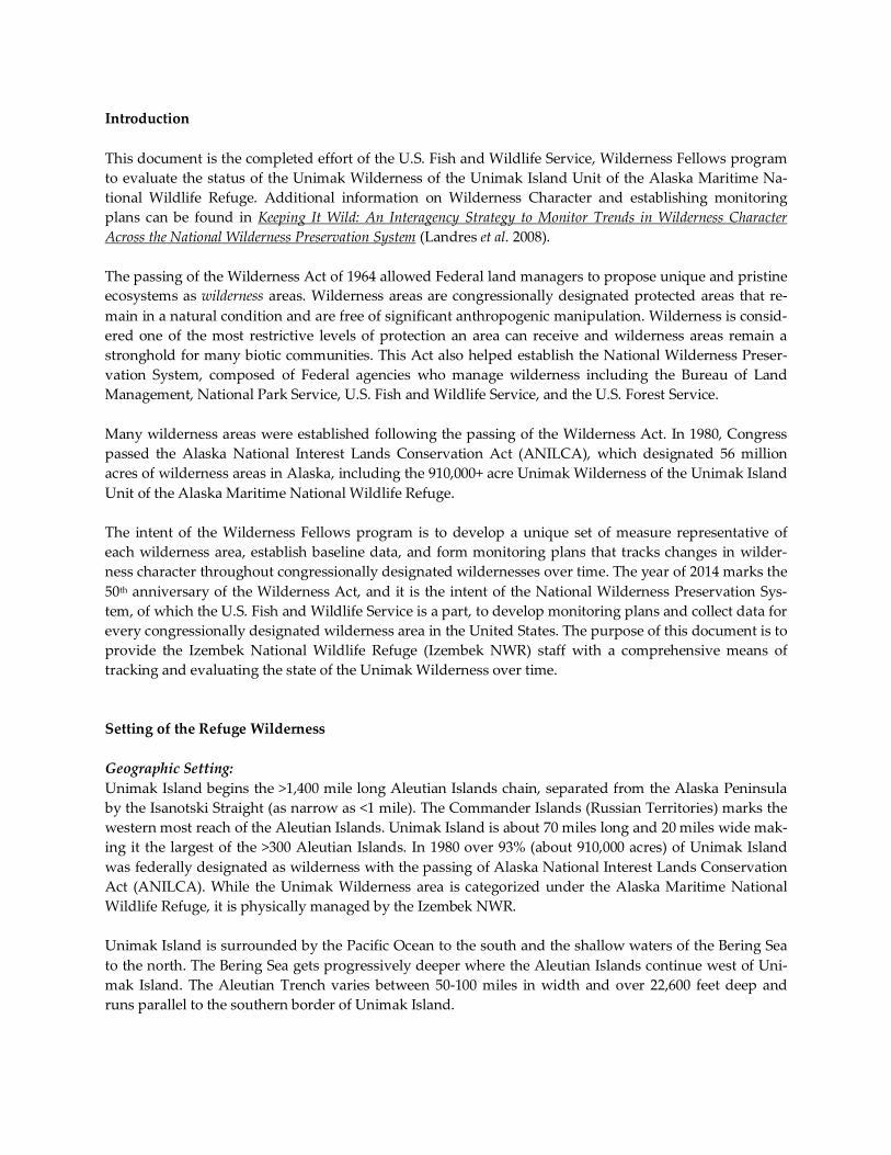
FWS National Wildlife Refuge System: Wilderness Fellows Report on Wilderness Character Monitoring Mount Shishaldin, A Smoldering Stratovolcano on Unimak Island – Photo Credit © Corey Anco 2011 UNIMAK WILDERNESS Alaska Maritime National Wildlife Refuge Prepared by Corey Anco Date: November 2011
Transcript of Unimak NWR Wilderness Character Monitoring Report … NWR Wildernes… · TABLE OF CONTENTS...

FWS National Wildlife Refuge System: Wilderness Fellows
Report on Wilderness Character Monitoring
Mount Shishaldin, A Smoldering Stratovolcano on Unimak Island – Photo Credit © Corey Anco 2011
UNIMAK WILDERNESS
Alaska Maritime National Wildlife Refuge
Prepared by Corey Anco
Date: November 2011
Wilderness.net Webmaster
This document is part of the Wilderness Character Toolbox on http://www.wilderness.net/toolboxes/

TABLE OF CONTENTS
Introduction
Setting of the Refuge Wilderness
Geographic Setting
Ecological Setting
History of Establishing the Wilderness
Refuge Purposes
Documents Consulted
Staff Consulted
Process used for identifying measures
Measures used
Description
Context
Relevance of measure
Data Source
Process
Determining Trends
Data Adequacy
Measures not used
Reasoning for discarding measures
Priority ranking if assigned
Conclusions
Appendices
Measure prioritization worksheet
Breakdown of measure development effort
Detailed description of data sources and how the data were gathered
Map of Unimak Wilderness
Introduction
This document is the completed effort of the U.S. Fish and Wildlife Service, Wilderness Fellows program
to evaluate the status of the Unimak Wilderness of the Unimak Island Unit of the Alaska Maritime Na-
tional Wildlife Refuge. Additional information on Wilderness Character and establishing monitoring
plans can be found in Keeping It Wild: An Interagency Strategy to Monitor Trends in Wilderness Character
Across the National Wilderness Preservation System (Landres et al. 2008).
The passing of the Wilderness Act of 1964 allowed Federal land managers to propose unique and pristine
ecosystems as wilderness areas. Wilderness areas are congressionally designated protected areas that re-
main in a natural condition and are free of significant anthropogenic manipulation. Wilderness is consid-
ered one of the most restrictive levels of protection an area can receive and wilderness areas remain a
stronghold for many biotic communities. This Act also helped establish the National Wilderness Preser-
vation System, composed of Federal agencies who manage wilderness including the Bureau of Land
Management, National Park Service, U.S. Fish and Wildlife Service, and the U.S. Forest Service.
Many wilderness areas were established following the passing of the Wilderness Act. In 1980, Congress
passed the Alaska National Interest Lands Conservation Act (ANILCA), which designated 56 million
acres of wilderness areas in Alaska, including the 910,000+ acre Unimak Wilderness of the Unimak Island
Unit of the Alaska Maritime National Wildlife Refuge.
The intent of the Wilderness Fellows program is to develop a unique set of measure representative of
each wilderness area, establish baseline data, and form monitoring plans that tracks changes in wilder-
ness character throughout congressionally designated wildernesses over time. The year of 2014 marks the
50th anniversary of the Wilderness Act, and it is the intent of the National Wilderness Preservation Sys-
tem, of which the U.S. Fish and Wildlife Service is a part, to develop monitoring plans and collect data for
every congressionally designated wilderness area in the United States. The purpose of this document is to
provide the Izembek National Wildlife Refuge (Izembek NWR) staff with a comprehensive means of
tracking and evaluating the state of the Unimak Wilderness over time.
Setting of the Refuge Wilderness
Geographic Setting:
Unimak Island begins the >1,400 mile long Aleutian Islands chain, separated from the Alaska Peninsula
by the Isanotski Straight (as narrow as <1 mile). The Commander Islands (Russian Territories) marks the
western most reach of the Aleutian Islands. Unimak Island is about 70 miles long and 20 miles wide mak-
ing it the largest of the >300 Aleutian Islands. In 1980 over 93% (about 910,000 acres) of Unimak Island
was federally designated as wilderness with the passing of Alaska National Interest Lands Conservation
Act (ANILCA). While the Unimak Wilderness area is categorized under the Alaska Maritime National
Wildlife Refuge, it is physically managed by the Izembek NWR.
Unimak Island is surrounded by the Pacific Ocean to the south and the shallow waters of the Bering Sea
to the north. The Bering Sea gets progressively deeper where the Aleutian Islands continue west of Uni-
mak Island. The Aleutian Trench varies between 50-100 miles in width and over 22,600 feet deep and
runs parallel to the southern border of Unimak Island.

The maritime climate of Unimak Island is considered to be very similar to the climate shared with the rest
of the Aleutian Islands chain. Due to converging weather systems of the Pacific and Bering water bodies,
strong winds (with gusts >50 m.p.h.), persistent precipitation, and cloudy skies are common characteris-
tics on Unimak Island. Winds in this region are highly variable and constantly shift the local weather of
the island. Heavy fog can turn into rainfall, and then part to clear skies in a matter of minutes or hours.
The temperature is characteristic of maritime climates and is cool (~40°F) but not severe. The winter
months typically bring severe cyclonic storms stemming from the Siberian high pressure system. The
weather during the summer months is subject to the Pacific high pressure system and storms are com-
mon in summer as well, but typically are not as severe.
The oceans, fierce winds, and winter ice continuously erode the landscape in the Aleutian Islands and
Unimak Island. Active volcanoes outline Unimak Island and most others in the Aleutian Island chain.
Active tectonics below the earth’s surface are responsible for the volcanism and seismic activities com-
mon to Unimak Island as the Pacific plate descends to the northwest along the Aleutian Trench, which
runs parallel to the Aleutian Islands chain. This combination of natural geological features has made the
Aleutian Islands one of the most seismically active regions in the world.
Most of the volcanoes on Unimak Island are stratovolcanoes. A stratovolcano consists of many layers that
are layered on top of one another over time. Volcanic discharge such as pumice, lava, ash, and tephra
make up the many layers of stratovolcanoes. There are four notable stratovolcanoes on Unimak Island,
Roundtop, Isanotski, Shishaldin, and Fisher volcanoes. The Fisher volcano was an andesitic stratovolcano
that erupted and collapsed upon itself and filled to form the robin-egg-blue colored Fisher Caldera. The
peak of the Shishaldin stratovolcano marks the highest point (9,373 feet) on Unimak Island and in the
entire Aleutian Islands chain. Shishaldin volcano is the only currently active stratovolcano on the island;
Roundtop and Isanotski have since gone dormant and have gradually eroded over time.
Shield volcanoes are another type of volcano on Unimak Island worth mentioning. The name refers to the
shape the volcano takes as low viscosity basaltic lava flows more outward than downward across subtle
slopes (typically 2-3 degrees). Shield volcanoes can become impressive in width reaching diameters 20
times their heights. Their morphology is due to effusive eruptions characteristic of shield volcanoes.
There are three shield volcanoes on Unimak Island: Westdahl Peak, Faris Peak, and Pogromni volcano.
The base of Westdahl Peak is over 11 miles wide, reaching an elevation of 5,118 feet. The Pogromni and
Faris Peak volcanoes are smaller shield volcanoes and reside in relative proximity to Westdahl Peak. Geo-
thermal heat from the Pogromni volcano insulates the hot marshes and springs near the volcano.
In addition to volcanism, Unimak Island has an active glacial history. Glaciers have shaped the terrain of
the island and are responsible for moraines and outwash, till, and alluvium deposits on top of bedrock.
The stratovolcanoes: Shishaldin, Isanotski, and Roundtop all have glaciers present on their slops. The re-
sulting Cenozoic basalt and andesitic lava flows have created the foundational bedrock and helped to
shape soil composition on the island. Volcanic deposits such as ash, pumice, and cinders litter the land-
scape. Soil type ranges from being gravelly in composition to loamy, dependent on the proximity of vol-
canoes and slope of the surrounding terrain.
Ecological Setting:
Given the relative proximity to the Alaska Peninsula, the landscape of Unimak Island shares many simi-
larities with its mainland neighbor. Maritime tundra is the predominant landscape type, though higher
elevations and steep slopes support alpine species and lichens and mosses. Maritime tundra consists pri-
marily of Arctic-Alpine species including grasses, sedges, crowberry, and lichens that flourish in tall-

growing herbaceous meadows. In riparian zones and more sheltered locations woody-vegetation such as
willow, dwarf birch, and alders are more common. Willow and alder shrubs are the largest growing
woody-vegetation species on the island. Grass hummocks are characteristic along the island’s beaches
and tidal flats. Different combinations of these species make up 3 major plant communities: beaches and
costal lands, lowland tundra communities, and upland tundra communities.
Low temperatures and limited growing seasons restrict trees from becoming established in the tundra.
Some species have been able to adapt and flourish in the harsh conditions of the tundra. Alder shrubs
have a symbiotic relationship with an actinomycete filamentous bacterium that resides in the alder’s root
system. The nitrogen-fixing bacterium provides the alder shrub with an ample supply of nitrogen, ex-
tracted from the surrounding air, while the alder shrub synthesizes carbon, an element critical for the bac-
terium. This symbiotic relationship is not only mutually beneficial for these two species but for the sur-
rounding biotic communities as well. The nitrogen-enriched soil is then used by other shrubs, grasses,
and various species of herbaceous plants making the alder-bacterium symbiosis an important addition to
the botanic community on the island.
Wild rye outlines the sandy shoreline of coastal communities, while further inland Alpine heath and
meadow are more common. Cow parsnip, a robust plant, grows in abundance throughout the island. Ex-
tensive seaweed communities take advantage of the rocky shoreline habitat, while eelgrass beds flourish
in the Peterson and Christianson Lagoons found along the northern coast of the island in Urilia Bay. The
lagoons and several major river tributaries are also the source for salmon species found in Unimak Island.
All five species of Pacific salmon are native and commercially harvested on Unimak Island: Chinook
(King), Sockeye (Red), Coho (Silver), Humpback (Pink), and Chum (Dog). Halibut and Pacific cod are
also noteworthy fish species that are harvested in the surrounding island’s waters. Unimak Island is part
of the Aleutian Islands Unit and is a major sanctuary, providing nesting and breeding grounds for mil-
lions of migratory birds, including seabirds, shorebirds, passerines, and waterfowl. In total there are more
than 240 species, including several endangered species, migrating from all parts of the globe to winter,
feed, and breed on the habitat provided on the island. Several marine mammals inhabit the bays and
coasts surrounding the island including sea otters, harbor seals, northern fur seals, Stellers sea lions, wal-
ruses, killer (orca) whales, and gray whales.
Aside from being the largest of the Aleutian Islands, Unimak Island is also the only island to have a self-
sustaining, fully functional ecosystem. It is the only island in Aleutian Islands chain where natural popu-
lations of weasel, least weasel, wolverine, brown bear, and grey wolf exist. Caribou, red fox, land otters,
and ground squirrels are other mammalian species known to inhabit the island. Over 400 brown bears
reside on the island and inhabit nearly every type of habitat from the coastal flatlands to mountainous
slopes in higher elevations. The Unimak Caribou Herd, consisting of migrants from the Alaska Peninsula,
has declined in recent years and currently numbers around 400 individuals. There are an estimated 15-25
gray wolves thought to be on the island as well. While no estimated population is given for fox, weasels,
or squirrels, the populations of these species are stable and thriving off resources provided on the island.
History of Establishing the Wilderness:
Human occupancy of Unimak Island can be traced as far back as 10,000-12,000 years ago, when a land
mass connected the North American continent to Asia. It is believed people of the Aleut tribe were the
first to arrive to the Aleutian Islands and were known as the native inhabitants to Russian explorers dur-
ing the 18th century. The Aleut tribe is genetically very similar to the Eskimo tribe, both of which are de-
scendants of the mongoloid Arctic race. Russian explorers used Aleut natives throughout the 18th and 19th

centuries to harvest animals for the Russian Fur Trade. Russian rule over the Aleuts ceased in the 1860s
when the United States purchased the territory of Alaska from Russia. Shishaldin volcano has been rec-
ognized as a National Historic Landmark because of its significance and importance as a guide for sea-
men including Aleut natives and Russian explorers.
Protected status of Unimak Island first came following an executive order signed by President Taft in
March of 1913. The document officially established the Aleutian Islands Reservation, a roughly 3-million
acre preserve including the 1,008,697-acre Unimak Island land mass. The intention of creating the Aleu-
tian Islands Reserve was to protect the “breeding grounds for native birds, for the propagation of rein-
deer and furbearing animals, and for the encouragement and development of the fisheries.”
Governance of the Aleutian Islands Reserve and Unimak Island were transferred in 1980 with the passing
of the Alaska National Interest Lands Conservation Act. This legislative document re-designated the
Aleutian Islands Reserve (including Unimak Island) as the Aleutian Island Units, a network of protected
federal lands under management by the Alaska Maritime National Wildlife Refuge (NWR). This act,
passed by Congress, also reclassified Unimak Island, designating 910,000-acres (93% of the Refuge) as
wilderness. Although the wilderness of the Unimak Island unit is classified under the jurisdiction of the
Alaska Maritime NWR, the wilderness area has been and is currently still managed locally by the
Izembek NWR. The Unimak Wilderness will eventually be conveyed to the Izembek NWR but it current-
ly remains as a unit of the Alaska Maritime NWR.
Refuge Purposes:
Unimak Island is an important sanctuary for many natural wildlife populations. Federal land managers
recognized the island’s significance and took action to ensure protection of the island’s natural resources
and maintain the high quality habitat critical to the survival of native wildlife.
The primary refuge purpose as defined by President Taft’s March 1913 Executive Order No. 1733: “…to set apart as a preserve and breeding ground for native birds, for the propagation of reindeer and
fur bearing animals, and for the encouragement and development of the fisheries.”
The primary refuge purposes as defined by ANILCA, Section 303(1)(B):
(i) To conserve fish and wildlife populations and habitats in their natural diversity including, but
not limited to marine mammals, marine birds, and other migratory birds, the marine resources
upon which the rely bears, caribou and other mammals;
(ii) To fulfill the international treaty obligations of the United States with respect to fish and wildlife
and their habitats;
(iii) To provide, in a manner consistent with the purposes set forth in subparagraphs (i) and (ii), the
opportunity for continued subsistence use by local residents;
(iv) To provide, in a manner consistent with subparagraphs (i) and (ii), a program of national and in-
ternational scientific research on marine resources; and
(v) To ensure, to the maximum extent practicable and in a manner consistent with the purposes set
forth in subparagraph (i), water quality and necessary water quantity within the refuge.
The refuge purpose of congressionally designated wilderness as defined by the Wilderness Act of 1964
(16 U.S.C. 1131-1136), Section 2.(a):

“For this purpose there is hereby established a National Wilderness Preservation System to be composed
of federally owned areas designated by the Congress as “wilderness areas,” and these shall be adminis-
tered for the use and enjoyment of the American people in such manner as will leave them unimpaired
for future use and enjoyment as wilderness, and so as to provide for the protection of these areas, the
preservation of their wilderness character, and for the gathering and dissemination of information re-
garding their use and enjoyment as wilderness…”
Documents Consulted
Alaska National Interest Lands Conservation Act: Citizen’s Guide, 2001
Alaska’s National Parks, Refuges and Other Conservation System Units: ANILCA – A Training Curriculum for
Land Managers, Staff, Inholders and Neighbors, 2004
ANILCA: Alaska Natural Interest Lands Conservation Act, 1980
Annual Narrative: Reports from 1980 to 1985
Izembek NWR CCP/EIS/WR: Comprehensive Conservation Plan / Environmental Impact Statement / Wil-
derness Review, 1985
Alaska Maritime CCP/EIS/WR: Comprehensive Conservation Plan / Environmental Impact Statement /
Wilderness Review, 1988
Keeping It Wild: An Interagency Approach to Monitor Trends in Wilderness Character Across the National
Wilderness Preservation System, 2008
Local Climatological Data: Annual Summaries with Comparative Data from 1986 to 2010
North Alaska Peninsula Salmon Annual Management Report, 2010: Fishery Management Report, 2010
South Alaska Peninsula Salmon Annual Management Report, 2010: Fishery Management Report, 2010
Technical Guide for Monitoring Selected Conditions Related to Wilderness Character, 2009
The Wilderness Act of 1964, 1964
Contaminated Sites Program – Contaminated Sites Searchable Database: Alaska Department of Environmental
Conservation, Division of Spill Prevention and Response, 2011
Unimak Island Wilderness Proposal *
Supporting Actions: Unimak Wilderness Record *
Unimak Island Wilderness Study – Wilderness Study Report *
Unimak Island Wilderness Record: Volume I * * = Dates unknown for documents. Information entered after leaving refuge.
Staff Consulted
Nancy Hoffman – Refuge Manager, USFWS Izembek NWR
Leticia Melendez – Deputy Refuge Manager, USFWS Izembek NWR
Chris Peterson – Wildlife Biologist, USFWS Izembek NWR
Trent Liebich – Ecologist, USFWS Izembek NWR
Franz Muller – Pilot, USFWS Izembek NWR
Douglas Campbell – Chief of Realty Operations, USFWS Region 7 Regional Office
Kevin Fox – Law Enforcement Officer / Pilot, USFWS Region 7
Matthew Keyse – Assistant Area Management Biologist, Alaska Department of Fish and Game
Process used for identifying measures

The text in Keeping It Wild and the Alaska Maritime NWR CCP/EIS/WR were pivotal tools in the initial
stages and throughout the development of identifying and modifying measures for the Unimak Wilder-
ness. I used the measures I created for the Izembek Wilderness as a foundation for the basis of the Uni-
mak Wilderness plan. I developed a list of measures in a word document identifying the title of the
measure, potential sources to obtain data, a brief description of the measure, and an example of an action
that would be classified under the measure. I then distributed this document amongst the consulted staff
(see above). The next step was to identify more specific measures that keyed in on issues and topics that
were more specific to the Unimak Wilderness. The intent was to develop a simple, yet comprehensive
way for staff to identify and monitor potential and major impacts to the wilderness year after year while
minimizing additional work for staff.
I set up a meeting with refuge management (Refuge Manager and Deputy Refuge Manager) and the bio-
logical staff (Wildlife Biologist and Ecologist) and evaluated how we can make each measure specifically
relevant to the wilderness area. Using notes and feedback I gathered from the meeting, I went back to the
word document I distributed out to the staff and modified it to create a more detailed list of measures
that were unique to the conditions of Unimak Island. I repeated the process with the Ecologist and used
input from other Wilderness Fellows during conference calls to create another revision of the word doc-
ument. Some measures were developed through field work with refuge staff. I had an opportunity to
spend 3 nights in the wilderness area and assist with data collection of caribou feeding habits. Spending
some time in the wilderness area helped me to gain a better understanding of and greater appreciation
for the wilderness area.
After the second revision, I felt created a list of measures that was both comprehensive of the features and
representative of the challenges within the wilderness area as a whole. I reviewed my work to make sure
I adequately covered each of the four qualities of wilderness character. I took the opportunity during a
monthly staff meeting to ask the Refuge Manager, Ecologist, and Wildlife Biologist to each meet with me
individually to provide feedback and any final changes or adjustment on each of the new measures. I
compiled feedback and changes and sent out the final revised list of measures as a word document. I also
put the list of measures into a spreadsheet form to mimic the matrices seen in previous examples of wil-
derness character monitoring plans. These matrices and word documents were made available to staff
throughout the development process.
Without any significant changes required I then started collecting data using information from the CCP,
Alaska Department of Fish and Game, Annual Narratives, USGS, NOAA, and personal communication
with the staff. Data was compiled within the matrix spreadsheet created to illustrate the wilderness char-
acter monitoring plan for the matrix.
Measures used
There are 30 distinct measures that make up the Unimak Wilderness Character Monitoring Plan. Each
measure is preceded by the notation M#, where M refers to “measure” and “#” corresponds to the order
in which it appears in the monitoring plan.
UNTRAMMELED QUALITY The Wilderness Act states that wilderness should be “...an area where the earth and its community of life are
untrammeled by man…[and]…generally appears to have been affected primarily the forces of nature.” An un-

trammeled wilderness is protected and unhindered from anthropogenic actions that would seek to con-
trol or manipulate the conditions within the wilderness.
Indicator 1: Actions authorized by the USFWS that manipulate the biophysical environment of the wilderness.
Measures under this indicator are monitored annually. M1 – Number of (indigenous or nonindigenous) plant/animal control projects inside the wilderness. Description: All projects authorized or conducted by the U.S. Fish and Wildlife Service that directly inter-
act with plant and animal species entirely or partially within wilderness. This does not include projects
involving plants/animals conducted outside of wilderness.
Context: Unimak Island is a fully functional ecosystem and an important site for many species of plants
and animals. The wilderness area encompasses 93% of the island, indicating any research study taking
place on the island is likely taking place within the wilderness area. Since so many different species de-
pend on the quality of the resources on the island it is important for land managers to have a well-rooted
understanding of the plant and wildlife populations inhabiting the island. Currently there are three pro-
jects within the wilderness authorized the U.S. Fish and Wildlife Service.
Relevance: Wilderness by definition is land that has been unaltered and remains in a natural state. The
biological control or manipulation of plants and animals by humans within wilderness disturbs the una-
dulterated state of the wilderness and therefore mandates monitoring. However, refuge staff and partner
agencies are unable to adequately assess the needs and health of various plant and animal populations
within wilderness in the absence of such monitoring projects and therefore warrant a necessity of plant
and animal projects within wilderness.
Data Source: Inter-Refuge Collaboration with Becharof NWR, Annual Narratives, Biological Staff
Process: Annual narratives record the number and status of projects conducted by refuge staff. The biolog-
ical staff also keeps track of the location and number of ongoing research and monitoring projects author-
ized within the wilderness area.
Determining Significant Change: There were 3 projects within wilderness in 2011 authorized by the U.S.
Fish and Wildlife Service. This is the baseline recording for the wilderness character monitoring plan.
Any increase in the number of authorized projects within wilderness results in a decrease in the trend for
this measure and a decrease in Wilderness Character.
Data Adequacy: The quality of the data was collected with a high degree of confidence and is representa-
tive of the number of authorized control projects within wilderness.
M2 – “Number of acres of habitat restoration inside the wilderness.” Description: Amount of land within wilderness that is being restored to natural or pre-existing conditions
consistent with the conditions of surrounding wilderness.
Context: The 910,000-acre wilderness of Unimak Island is as a functional and intact natural ecosystem,
free from invasive and non-indigenous species. Currently there are 0-acres of land being restored and no
immediate plans to begin any restoration projects within the wilderness area.
Relevance: While restoration projects have a positive intention of restoring altered habitats back to natural
conditions the methods used often caused negative effects on the surrounding vegetation, (e.g., herbicide
use may non-selectively kill non-target plant species) and requires monitoring. In the event of the estab-
lishment of a non-native or non-indigenous species within the wilderness, it is likely in the best interest of
the wilderness to have invasive and non-indigenous species removed. The potential for establishment of
invasive species within or surrounding the wilderness exists and has warranted including this measure
into the monitoring plan.
Data Source: Annual Narratives, Biological Staff, Refuge Management

Process: Consultation with the biological staff and refuge management to determine the estimated area (in
acres) of any restoration project or site within wilderness.
Determining Significant Change: Any increase in the number of acres from restoration projects results in a
decrease in the trend for this measure and a decrease in Wilderness Character.
Data Adequacy: The quality of the data was collected with a high degree of confidence that there are 0-
acres of habitat being restored within wilderness.
M3 – “Number of research projects and studies conducted inside wilderness.” Description: Projects counted under this measure may overlap with projects in M1, but also includes the
number research projects and studies that monitor conditions, soils, and other factors of the abiotic com-
munity within wilderness in addition to plants and animals.
Context: As stated earlier, Unimak Island is a biological hotspot for maritime species and attracts a lot of
attention from groups with research interests. In addition to the U.S. Fish and Wildlife Service, other
groups and agencies such as the University of Alaska – Anchorage and Fairbanks, Alaska Department of
Fish and Game, and Alaska Volcano Observatory have all expressed interest and conducted research
within the wilderness area. In 2011 there were 4 research projects and monitoring studies identified to be
currently operating within the wilderness.
Relevance: Monitoring and research have many positive implications and often lead to improved man-
agement practices. However, due to the remoteness of the island and the rugged conditions of the wil-
derness, research groups often set up camps for extended periods or alter the landscapes near their
campsites. Some research projects require the installation of mechanical units as is the case with Alaska
Volcano Observatory and there seismic stations and webicorders. The potential impacts can be directly
correlated with the number of projects and therefore warrants monitoring.
Data Source: Annual Narratives, Refuge Management, Biological Staff, Special Use Permits
Process: The refuge issues Special Use Permits (SUPs) to groups that wish to conduct research within the
wilderness. The biological staff and refuge management are also very in tune with the number of research
groups and agencies operating within the wilderness at any given time.
Determining Significant Change: Any increase in the number of research projects and studies results in a
decrease in the trend for this measure and a decrease in Wilderness Character.
Data Adequacy: The quality of the data was collected with a high degree of confidence with regard to the
number of research projects and studies within wilderness.
Indicator 2: Actions NOT authorized by the Federal land manager that manipulated the biophysical environment.
Measures under this indicator are monitored annually. M4 – “Number of unauthorized actions by agencies, citizen groups or individuals that affect plants, ani-
mals, and abiotic factors of the environment inside the wilderness.” Description: Actions taken by individuals or groups without authorization from U.S. Fish and Wildlife
Service that impact plants, animals, and abiotic components of the wilderness. Examples of actions in-
clude, collecting animal remains (e.g., sheds), poaching/trapping of endangered species, or stocking a
lake within wilderness. This includes incidents and actions that are observed but not reported to or rec-
orded by Law Enforcement personnel.
Context: The only means of reaching the Unimak Wilderness area is by aircraft, boat, or a vehicle from the
village of False Pass. Due to the relative remoteness of the refuge and the small surrounding community
(<150 people), there are not many unauthorized actions or activity within the wilderness. There were two
unauthorized actions (shed collection within wilderness, removal of nutrients) by individuals in 2011 that
affected the natural environment.

Relevance: When actions are permitted within wilderness, there is usually a meaningful purpose behind
them (e.g., gaining knowledge and insight or accomplishing management goals). Unauthorized actions
typically are indicative of harmful or reckless actions such as off-road driving (destroying natural vegeta-
tion), or hunting of a protected species and have adverse effects on the biophysical environment.
Data Source: Annual Narratives, Law Enforcement Records, Biological Staff, Leads from the Public
Process: Law Enforcement personnel keep track of violations using citations. Other instances observed or
reported to the refuge are noted in annual narratives, and refuge staff may be aware of other situations
from public leads.
Determining Significant Change: There were two unauthorized actions reported in 2011. This is the baseline
recording for the wilderness character monitoring plan. Any increase in the number of unauthorized ac-
tions within wilderness results in a decrease in the trend for this measure and a decrease in Wilderness
Character.
Data Adequacy: The quality of the data was collected with a moderate degree of confidence. Due to the
limited staff size and lack of a permanent Law Enforcement officer, the refuge is unlikely able to count
every instance of unauthorized actions within the wilderness area. However, given the small resident
population and remoteness of the area the actual number of actions is likely to be very similar to the rec-
orded number of actions.
NATURAL QUALITY The Wilderness Act states that wilderness “...is protected and managed so as to preserve its natural conditions.”
A natural ecosystem is substantially free from the effects of modern anthropogenic civilization.
Indicator 3: Plant and animal species and communities. Measures under this indicator are monitored every 5
years. M5 – “Status of species of particular concern or interest to the wilderness area.” Description: A rating of the population conditions of plant and animal species that the refuge has an in-
vested interest in protecting and managing for the health of the ecosystem. The rating is derived from an
index value system described below. Only species that utilize the wilderness area are included.
Context: The Unimak Wilderness is a sanctuary for migratory waterfowl and several distinct groups of
mammals. Izembek (the administering refuge) closely monitors the population trends of 7 species: cari-
bou (below management goals), emperor goose (below management goals), black brant (below manage-
ment goals), Stellers eider (below management goals), tundra swans (below historic numbers), brown
bears (stable), grey wolves (stable). As of 2011, 5 of the 7 species were considered to be below stable pop-
ulation levels and the measure received an indexed value score of 5.
Relevance: Protection of wildlife is a major reason for establishing the Unimak Wilderness; therefore, it is
important that the refuge monitor and conserve the species that depend on the refuge to exist. Brown
bear, grey wolves, and caribou are all species that have important ecological roles and can be important
for subsistence users. A decline in the brown bear or grey wolf population would indicate a loss or de-
cline in natural regulatory predators, which would have substantial impacts on multiple prey popula-
tions and degrade the natural quality of the wilderness.
Data Source: Annual Narratives, Management Goal Plans, Biological Staff, State Agencies and ongoing
projects (I&M reports)
Process: Annual narratives record the conditions and statuses of monitored species. The biological staff
also keeps track of plant and wildlife populations, and is typically involved with any ongoing research
and monitoring studies within wilderness.

Determining Significant Change: Any increase in the indexed value score from the last date of measurement
indicates a decrease in the trend for this measure and a decrease in Wilderness Character.
Data Adequacy: The quality of the data was collected with a high degree of confidence and is representa-
tive of the wilderness as a whole.
Index Description: A species is given a score from 0-1 representing the population status of the species.
When a species or exceeds or meets the population goal, historical level, or becomes stable it receives a
score of 0. When all species meet or exceed management goals or historical levels the total (summed)
score is 0 and is considered the best case scenario. Species that do not meet the population goal, historical
numbers, or are not stable receive a score of 1. The scores of all species are summed and recorded as one
figure. The maximum indexed value score = 1(X), where “X” = the number of species. The minimum in-
dexed value score = 0 (When all species meet or exceed stable population numbers).
Indicator 4: Physical resources. Measures under this indicator are monitored annually. M6 – “Sockeye salmon abundance estimates for Christianson Lagoon: Low commercial harvest-pressure
system.” Description: An assessment of sockeye salmon escapement in the Christianson Lagoon system, deter-
mined locally by expert correspondence.
Context: Christianson Lagoon is one of two lagoons in the Urilia Bay area where large numbers of sockeye
salmon congregate every year during their annual migration. Commercial fishing, specifically for sockeye
salmon is a significant source of income, particularly in coastal communities. The Alaska Department of
Fish and Game office in Cold Bay was consulted to assess sockeye salmon escapement in Christianson
Lagoon following the 2011 harvest.
Relevance: Salmon are important resources for a variety of wildlife and they provide the riparian ecosys-
tem with vital nutrients following the completion of their life cycle. A reduction in salmon escapement
could have serious implications for the plants and animals of that stream system and affects the amount
of nutrients and resources available to that ecosystem.
Data Source: Annual Narratives, Alaska Department of Fish and Game, Biological Staff
Process: Alaska Department of Fish and Game conducts annual surveys of specific stream systems and
lagoon complexes. The established goal for sockeye salmon escapement in the Christianson Lagoon sys-
tem is between 25,000-50,000 salmon. Sockeye escapement in the Christianson Lagoon system met this
goal in 2011 and was considered good by the Alaska Department of Fish and Game.
Determining Significant Change: A decrease in the sockeye salmon escapement estimate value below the
baseline results in a decrease in the trend for this measure and a decrease in wilderness character.
Data Adequacy: Data collected for this measure are indexed values representative of the sockeye salmon
escapement health for that system. The quality of the data was collected with a high degree of confidence. Index Value Scores:
Poor: Did not meet minimum indexed estimate goal.
Fair: Did not meet minimum indexed estimate goal, but within 10% of the minimum.
Good: Met the minimum indexed estimate goal.
M7 – “Sockeye salmon abundance estimates for Peterson Lagoon: Low commercial harvest-pressure sys-
tem.” Description: An assessment of sockeye salmon escapement in the Peterson Lagoon system, determined
locally by expert correspondence.

Context: Peterson Lagoon is one of two lagoons in the Urilia Bay area where large numbers of sockeye
salmon congregate every year during their annual migration. Commercial fishing, specifically for sockeye
salmon is a significant source of income, particularly in coastal communities. The Alaska Department of
Fish and Game office in Cold Bay was consulted to assess sockeye salmon escapement in Peterson La-
goon following the 2011 harvest.
Relevance: Salmon are important resources for a variety of wildlife and they provide the riparian ecosys-
tem with vital nutrients following the completion of their life cycle. A reduction in salmon escapement
could have serious implications for the plants and animals of that stream system and affects the amount
of nutrients and resources available to that ecosystem.
Data Source: Annual Narratives, Alaska Department of Fish and Game, Biological Staff
Process: Alaska Department of Fish and Game conducts annual surveys of specific stream systems and
lagoon complexes. The established goal for sockeye salmon escapement in the Peterson Lagoon system is
between 1,600-3,200 salmon. Sockeye escapement in the Peterson Lagoon system met this goal in 2011
and was considered good by the Alaska Department of Fish and Game.
Determining Significant Change: A decrease in the sockeye salmon escapement estimate value below the
baseline results in a decrease in the trend for this measure and a decrease in wilderness character.
Data Adequacy: Data collected for this measure are indexed values representative of the sockeye salmon
escapement health for that system. The quality of the data was collected with a high degree of confidence. Index Value Scores:
Poor: Did not meet minimum indexed estimate goal.
Fair: Did not meet minimum indexed estimate goal, but within 10% of the minimum.
Good: Met the minimum indexed estimate goal.
Indicator 5: Biophysical resources. Measures under this indicator are monitored every five years. M8 – “Change in mean annual temperature (MAT) of wilderness.” Description: Monitoring of temperature conditions averaged over a 5-year period.
Context: The Unimak Wilderness does not have a Remote Area Weather Station (R.A.W.S.) but weather
conditions are very similar to temperatures recorded for the Izembek wilderness area, which is situated
in relative proximity to the weather monitoring station in Cold Bay operated by the National Oceanic and
Atmospheric Administration (N.O.A.A.). The weather data recorded here tracks the temperature data
pertinent for this measure.
Relevance: Temperature fluctuation is one side-effect of global climate change and should be monitored
given the readily available data. While changes in temperature may not be immediately apparent over
the span of 20 years, it will be useful to have a record in the event the temperature does drastically
change over in future years. The species have learned to thrive in the maritime climate and temperatures
common to the Izembek wilderness. If the temperature was to change over time most likely the species
composition and biophysical environment would as well.
Data Source: Annual Narratives and National Weather Service Station Monthly Data Reports
Process: The MAT is calculated by recording the mean annual temperature at 5 year intervals (the aver-
age temperature for every year in 5 year intervals). For example, mean annual temperature recorded for
the 2010 measurement would include the average annual temperature for 2006-2010. The next date to be
recorded would be 2015 and would include average temperatures for the years 2011-2015. The MAT is
obtained by adding the Mean Daily Maximum for the Year plus the Mean Daily Minimum for the Year and
then dividing that number by 2. These values are calculated for each annual report for the monitoring
period (i.e. 2006-2010) and then the MAT is calculated for the recording period by summing calculated
means per year and dividing by number of years (i.e. 5).

Determining Significant Change: The mean annual temperature is likely to fluctuate by several degrees
every monitoring period. A significant change value is not as important as tracking temperature values to
see if the overall mean annual temperature is increasing or decreasing in the region.
Data Adequacy: Data are collected with a high degree of confidence from N.O.A.A. and is representative
of the wilderness area as a whole.
Temperature values are found at the following url:
www7.ncdc.noaa.gov/IPS/lcd/lcd.html;jsessionid=D2F27CBAF5C9DFED7353CD463F456DDE?_page=1&s
tate=AK&stationID=25624&_target2=Next+%3E
M9 – “Change in average amount of precipitation in wilderness.” Description: A measure to track changes in the total inches of precipitation within the wilderness.
Context: The Unimak Wilderness does not have a Remote Area Weather Station (R.A.W.S.) but weather
conditions are very similar to temperatures recorded for the Izembek wilderness area, which is situated
in relative proximity to the weather monitoring station in Cold Bay operated by the National Oceanic and
Atmospheric Administration (N.O.A.A.). The weather data recorded here tracks the precipitation data
pertinent for this measure.
Relevance: Precipitation is one environmental factor affected by global climate change and should be mon-
itored given the data are readily available to do so. Precipitation affects the quantity of water available to
organisms in and around ponds and lakes that are not connected to springs and rivers. Precipitation also
affects wetland ecosystems and flood plains. If the precipitation was to change over time most likely the
species composition and biophysical environment would as well.
Data Source: Annual Narratives and National Weather Service Station Monthly Data Reports
Process: The average precipitation within wilderness is calculated by recording the total inches of precipi-
tation at 5 year intervals (the total precipitation [in inches] for every year in 5 year intervals) and then di-
viding the total number of inches by the sample period. For example, the average amount of precipitation
recorded for 2010 would include the precipitation measurements for 2006-2010. The next date to be rec-
orded would be 2015 and would include precipitation measurements for the years 2011-2015. The aver-
age amount of precipitation is obtained by summing the Total (IN.) of Precipitation for the Year for each
annual report for the monitoring period (i.e. 2006-2010) and then dividing by number of years (i.e. 5).
Determining Significant Change: The average amount of precipitation is likely to fluctuate by several de-
grees every monitoring period. A significant change value is not as important as tracking precipitation
values to see if the overall amount of precipitation is increasing or decreasing in the region.
Data Adequacy: Data are collected with a high degree of confidence from N.O.A.A. and is representative of
the wilderness area as a whole.
Precipitation values are found at the following url:
www7.ncdc.noaa.gov/IPS/lcd/lcd.html;jsessionid=D2F27CBAF5C9DFED7353CD463F456DDE?_page=1&s
tate=AK&stationID=25624&_target2=Next+%3E
M10 – “Water level changes in pools or lakes within wilderness.” Description: Changes in the water level of water bodies within wilderness not fed by springs or rivers.
Context: The Izembek refuge staff does a lot of aerial monitoring and surveys of the Unimak Wilderness
via aircraft. Refuge pilots and staff are able to repeatedly capture aerial photos of isolated water bodies by
marking them with GPS points. Staff can then determine the amount of water level change from previous
photos.
Relevance: Many small bodies of water, such as these, are important resources for many organisms. For
larger organisms, such as bears, caribou, foxes, and wolves the ponds and lakes are watering holes used

for rehydration. For smaller species and many microinvertebrate species, the ponds and lakes are vast
environments, microcosms in which their whole life cycle takes place. In turn, the microinvertebrate spe-
cies are an important food source for some bird species.
Data Source: Aerial photographs, refuge pilot, researchers
Process: The methodology to be determined by refuge staff. Refuge pilot will take photographs of isolated
water bodies and biological staff will determine whether there is a significant change in the water level.
Determining Significant Change: A similar study is being conducted for the Izembek wilderness part of the
I&M Plan. Significant changes for Unimak Wilderness water bodies can be adapted from this plan.
Data Adequacy: The quality of the data will likely be able to be collected with a high level of confidence
and accurately represent water level changes in ponds and lakes throughout the wilderness area.
M11 – “Change in phenology of vegetation greening within wilderness.” Description: Detection of temporal changes in the overall length of the greening period and changes in
length of stages throughout the greening period.
Context: The greening period refers to the season(s) where vegetation emerges from a dormant state and
germinates new seedlings, flowers, reproduces, and sets seed, before returning to a state of dormancy.
Data for this measure have never been recorded previously within the Unimak Wilderness.
Relevance: Many wildlife species, both resident and migratory depend on the availability of green vegeta-
tion for survival. Studying the phenology of vegetation greening will determine whether or not the avail-
ability of vegetation is or will become a substantial limiting factor inhibiting sensitive wildlife popula-
tions. A shorter greening period could have major implications on the biophysical environment.
Data Source: Photopoints, Annual narratives, Biological Staff, UCH Study
Process: Detecting changes in phenology involves establishing ground photopoint locations with a GPS
where good visibility of greening vegetation can be observed. The photos should be taken at same loca-
tion(s) and three times annually. Ground photopoints should be structured to measure the dates when 1)
vegetation starts to green up, 2) vegetation greening is at its peak, and 3) vegetation begins to go
dormant. Ground photopoints will provide refuge with data that assesses the length of the greening sea-
son as well as the period of each stage. The time between the three photopoints will give the length of
each period and the summed time between the photos will give the total length of the greening period.
Determining Significant Change: This would be a new project for the biological staff at Izembek and there-
fore a baseline has not been established for 2011.
Data Adequacy: Given the relative simplicity of the data collection methodology, quality data would likely
be able to be collected with a moderate to high level of confidence and be representative of greening peri-
ods throughout the wilderness area.
UNDEVELOPED QUALITY
The Wilderness Act states that wilderness is “...an area of undeveloped Federal land…without permanent im-
provement or human habitation [and] …where man himself is a visitor who does not remain.” In this sense, wil-
derness that is undeveloped retains its primeval character and influence, and is not subject to permanent
manipulation, improvement, or human occupancy.
Indicator 6: Non-recreational structures, installations, and developments. Measures under this indicator are
monitored every five years. M12 – “Number of authorized physical structures, installations, or developments.”
Description: The number of physical structures, installations, or developments authorized or created by
the U.S. Fish and Wildlife Service that are non-recreational, including: earthen or concrete dams, log or
metal cabins, buildings, administrative trails, roads to access inholdings, fixed instrumentation sites, etc…
Context: Refuge personnel have not constructed any permanent units within the wilderness area.
Relevance: Authorized units constructed within wilderness often require the need for equipment or ma-
chinery to install or build signs, shelters, stations, and so forth. The tools degrade the wilderness and the
units they install decrease the need for self-reliance from visitors.
Data Source: Annual Narratives, Local data entry by Refuge Manager
Process: Determining the number of authorized physical structures involves a simple numerical count of
the number of U.S. Fish and Wildlife authorized or created structures within wilderness. This count
would include structures within wilderness built prior to designation. Personal communication with the
biological staff indicated that as of 2011, there were no U.S. Fish and Wildlife authorized structures, in-
stallations, or developments identified within wilderness.
Determining Significant Change: Any increase in the number of authorized physical structures, installa-
tions, or developments beyond the baseline value results in a decrease in the trend for this measure and a
decrease in Wilderness Character.
Data Adequacy: The quality of the data was collected with a high degree of confidence and is representa-
tive of the wilderness area as a whole.
M13 – “Number of cabins built and remaining in wilderness.” Description: The number of cabins that have been constructed and currently remain standing and/or in
use within the wilderness area.
Context: Unimak Island has been used historically by many groups of people including Aleut natives,
Russian explorers, commercial fishermen, coast guard personnel, and hunting/fishing outfitters. Individ-
uals from some of these groups have constructed cabins within the wilderness area. A section in the
Unimak Island Wilderness Records (circa 1980’s) noted ~12 cabins present within the Unimak Wilderness
boundary as of 1972. Several of these cabins have since dilapidated, washed away, or been deconstructed.
A survey by law enforcement personnel earlier in 2011 indicated only one cabin near Whale Back Ridge is
known to be remaining within wilderness.
Relevance: Cabin construction is destructive to the natural environment and is intrusive upon the natural
scenery of the wilderness. Additionally, cabin construction requires the use of tools and machinery that
further impact the wilderness character and they are permanent structures (unless physically removed)
that remain as a sign of man’s presence within the wilderness area.
Data Source: Law Enforcement Personnel
Process: A simple numerical count of the number of cabins, as determined by aerial surveys and explora-
tion of former cabin sites and locations.
Determining Significant Change: There were 12 cabins noted within wilderness at the time of designation in
1980. This is the baseline recording for this measure. The number of cabins has since decreased and now 1
cabin remains in wilderness. The reduction in the number of cabins has improved Wilderness Character.
Any increase in the number of cabins within wilderness above 1 will decrease the trend for this measure
and decrease Wilderness Character.
Data Adequacy: The quality of the data was collected with a high degree of confidence and is representa-
tive of the wilderness area as a whole.
M14 – “Number of unauthorized (user-created) physical structures, installations, or developments.” Description: The number of user-created physical structures, installations, or developments excluding U.S.
Fish and Wildlife Service constructs that are non-recreational in nature. User-created constructs include,

but are not limited to, fences, trails or roads used to access stream and water diversions, remnants of mili-
tary occupancy, Quonsets, tanks and drums, power poles, etc…
Context: Refuge personnel reported 1 user-constructed unit (Bear platform for hunting) within the wil-
derness area.
Relevance: Unauthorized units constructed within wilderness often require the need for equipment or ma-
chinery not allowed within wilderness. The tools and actions degrade the wilderness and the units they
install decrease the need for self-reliance from visitors.
Data Source: Record Cards from staff & volunteers for unauthorized structures & developments, Aerial
photopoints, Law Enforcement Personnel
Process: Determining the number of unauthorized physical structures involves a simple numerical count
of the number of user-created structures within wilderness. This count would include structures within
wilderness built prior to designation. Personal communication with the biological staff indicated that as
of 2011, there was 1 user-created structure, installation, or development identified within wilderness.
Determining Significant Change: Any increase in the number of unauthorized user-created physical struc-
tures, installations, or developments beyond the baseline value results in a decrease in the trend for this
measure and a decrease in Wilderness Character.
Data Adequacy: The quality of the data was collected with a high degree of confidence and is representa-
tive of the wilderness area as a whole.
M15 – “Number of illegal trails from Urilia Bay extending into wilderness.” Description: Tracks the number of illegal two-track trails from the Urilia Bay coast extending into wilder-
ness. Two-track trails are created by mechanized vehicles, and are most likely the result of ATV/UTV use
in restricted areas within wilderness and therefore require monitoring.
Context: ATVs/UTVs are used to create illegal access routes to remote locations within the wilderness by
driving off of previously established or designated trails, such as those well-traveled and used by subsist-
ence users. ATVs/UTVs are common means of transportation on the refuge and numerous illegal trails
are known to have been created in previous years. The precise number of illegal trails is unknown and
data has not been collected for the 2011 baseline.
Relevance: Illegal trails have several adverse impacts on wilderness character. Trails destroy vegetation
and habitat and they can also be potential pathways for invasive species into wilderness.
Data Source: Refuge Pilot, Biological Staff, Law Enforcement Officer
Process: To determine the number of illegal trails biological staff will conduct aerial surveys to determine
the number of illegal two-track trails extending from Urilia Bay into wilderness. A “trail” consists of any
area with disturbed vegetation created by two-parallel lines (considered two-track) extending >50 feet in
length and is separate from the designate and pre-existing two-track trail.
Determining Significant Change: Baseline data for this measure was not collected for 2011, however, once
the baseline is established, any increase in the number of illegal two-track trails within wilderness results
in a decrease in the trend for this measure and a decrease in Wilderness Character.
Data Adequacy: The quality of the data is suspected to be collected with a moderate to high degree of
confidence. Given the size of the wilderness area it is likely the number of illegal two-track trails identi-
fied will be representative of the wilderness as a whole, but it is possible that not every illegal two-track
trail will be identified.
Indicator 7: Inholdings. Measures under this indicator are monitored every five years. M16 – “Area of inholdings inside wilderness.”

Description: Acreage of land within wilderness not governed by U.S. Fish and Wildlife Service. This in-
cludes lands adjacent to or partially within wilderness as well.
Context: As of 2011, there are currently no inholdings and the total acreage inside wilderness is zero. This
is the baseline recording value it is not expected to change anytime in the near or distant future.
Relevance: Inholdings can have significant impacts on the surrounding wilderness as inholders travel to
and from the inholding, usually through mechanical means, or construct buildings within the inholding.
Data Source: Annual narratives, Local data entry by Refuge Manager
Process: Data for this measure are collected by using a simple numerical count of the area (in number of
acres) of the inholding(s) within wilderness.
Determining Significant Change: An inholding or an increase in the number of acres, of private land
within wilderness beyond the baseline results in a decrease in the trend for this measure and a decrease
in Wilderness Character.
Data Adequacy: The quality of the data was collected with a high degree of confidence.
Indicator 8: Use of motor vehicles, motorized equipment, or mechanical transport. Measures under this indica-
tor are monitored annually. M17 – “Number of user days of administrative (U.S. Fish and Wildlife Service) use of motorized trans-
portation, motorized equipment, or mechanical transport.” Description: The number of days U.S. Fish and Wildlife spent inside the wilderness area with motorized
vehicles, motorized equipment, or mechanical transportation. Examples include: vehicles used to rescue
people or transport materials in and out of wilderness, emergency response, or chainsaws.
Context: Due to the pristine quality of the wilderness area, refuge personnel spend relatively no time at all
using mechanical equipment and motorized transportation within wilderness. As of 2011, there were 15
user-days of administrative use of motorized transportation, motorized equipment, or mechanized
transport within wilderness. This is the baseline recording for the wilderness character monitoring plan.
Relevance: Federal law prohibits the use of motorized transportation, motorized equipment, or mechanical
transport within wilderness areas except where allowed under Section 4(c) of The Wilderness Act and
therefore warrants monitoring. If the action is authorized by U.S. Fish and Wildlife, a minimum tool
analysis should document the tool and length of use. Motorized equipment and mechanized transporta-
tion can disturb vegetation, impact the natural soundscape and alter the biophysical environment.
Data Source: Annual Narratives, Local data entry by Refuge Staff
Process: Correspondence with refuge management to determine the number of days each administrative-
user used motorized transportation, motorized equipment, or mechanical transport within wilderness.
Determining Significant Change: An increase in the number of administrative (U.S. Fish and Wildlife Ser-
vice) user days above the baseline within wilderness results in a decrease in the trend for this measure
and a decrease in Wilderness Character.
Data Adequacy: The quality of the data was collected with a high degree of confidence and is representa-
tive of the wilderness area as a whole.
M18 – “Number of user days of emergency use of motorized transportation, motorized equipment, or me-
chanical transport.” Description: The number of emergency response user days within wilderness. To differentiate between
administrative and non-administrative emergency response a second measure was created specifically for
U.S. Coast Guard, the other agency that may respond to emergency rescue calls with wilderness. Exam-
ples include, but are not limited to U.S. Coast Guard rescue planes and helicopters, and ATVs/UTVs.

Context: As of 2011, there were zero user-days of emergency response requiring motorized transportation,
motorized equipment, or mechanized transport within wilderness.
Relevance: Federal law prohibits the use of motorized transportation, motorized equipment, or mechanical
transport within wilderness areas except where allowed under Section 4(c) of The Wilderness Act and
therefore warrants monitoring. Despite the cause for using the motorized transportation or mechanical
equipment, there is still a negative impact upon the wilderness area that must be monitored.
Data Source: Annual Narratives, Local data entry by Refuge Manager
Process: Correspondence with refuge management to determine the number of days each individual used
motorized transportation, motorized equipment, or mechanical transport within wilderness for emergen-
cies. Baseline data were collected from personal communication with refuge management.
Determining Significant Change: Any increase in the number of emergency response user days above the
baseline results in a decrease in the trend for this measure and a decrease in Wilderness Character.
Data Adequacy: The quality of the data was collected with a high degree of confidence and is representa-
tive of the wilderness area as a whole.
M19 – “Number of user days of guide and private (non-commercial and non-administrative) aircraft and
helicopter landings.” Description: The number of days used by guides and private individuals to operate and land aircraft and
helicopters within the wilderness area.
Context: Unimak Island is a popular location for many Alaska Big Game hunters, because of relatively
low pressure on the animal populations due to the remoteness of the island. There are a couple commer-
cial operations that operate within the wilderness area and use aircrafts and helicopters to gain access to
the island. As of 2011, there were 130 recorded days of guide and private aircraft and helicopter landing
days within wilderness. This is the baseline recording for the wilderness character monitoring plan.
Relevance: Federal law prohibits the use of motorized transportation, motorized equipment, or mechanical
transport within wilderness areas except where allowed under Section 4(c) of The Wilderness Act and
therefore warrants monitoring. Aircraft and helicopter landings can cause disturbances in the natural
soundscape and detract from the natural surroundings and visual quality of the wilderness area.
Data Source: Annual Narratives, Local data entry by Refuge Manager, Special Use Permits
Process: Baseline data for this measure were collected from personal communication with refuge man-
agement. Data collected for this measure are simple numerical counts of the number of days of aircraft
and helicopter landings within wilderness from commercial and private users.
Determining Significant Change: An increase in the number of user days of motorized transportation, mo-
torized equipment, or mechanical transport for commercial or private use above the baseline within wil-
derness results in a decrease in the trend for this measure and a decrease in Wilderness Character.
Data Adequacy: The quality of the data was collected with a moderate to high degree of confidence and is
representative of the wilderness area as a whole.
Indicator 9: Loss of statutorily protected cultural resources inside wilderness. This indicator was not included
in the wilderness character monitoring plan for the Izembek Wilderness. Statutorily protected resources
are listed under Section 106 of the National Historic Preservation Act. There were no sites listed under
Section 106 in the Unimak Wilderness. Additional reasons for excluding the indicator and further details
are provided below in the excluded measures section.
SOLITUDE OR PRIMITIVE AND UNCONFINED RECREATION QUALITY

The Wilderness Act states that wilderness “...has outstanding opportunities for solitude or a primitive and un-
confined type of recreation.” This is an important quality of wilderness. Wilderness areas are intended to
offer visitors a sense remoteness and independence from modern developments while presenting oppor-
tunities for personal challenges through primitive and unconfined recreation.
Indicator 10: Remoteness from sights and sounds of people inside the wilderness. Measures under this indicator
are monitored annually. M20 – “Number of user days of visitor use.” Description: This measure tracks trends in visitor use to the wilderness area.
Context: In comparison to more accessible locations, the Unimak Wilderness does not receive a large vol-
ume of visitors annually. Most visitors are clients for commercial hunting guides. As of 2011, there were
approximately 150 visitor user days within the wilderness.
Relevance: Part of Wilderness Character is the feeling of remoteness one feels when they are alone and
removed from all the noise of urbanization, vehicles, crowds as well as the sights of urbanization. Track-
ing visitor use within wilderness is important to monitor because the number of visitors within wilder-
ness determines the likelihood of one visitor or a group encountering or hearing noise from another visi-
tor or group during their visit to the wilderness area.
Data Source: Annual Narratives, Local data entry by Refuge Management, Biological Staff, Law Enforce-
ment Personnel
Process: Data collected for this measure are simple numerical counts of the number of visitors in wilder-
ness. The number recorded reflects the number of days each visitor spent within wilderness. The total
user days for visitors is calculated by summing the user days scores for values of the measures under the
previous indicator (Use of motor vehicles, motorized equipment, or mechanical transport) with additional user
days of backpackers, adventurers, and other individuals who visit the wilderness area for reasons other
than those stated above. The value 165 for the 2011 baseline came from: administrative motorized visits
(15) + Emergency motorized visits (0) + Commercial and private use (134) + miscellaneous visits (16) = 165
visitor user days.
Determining Significant Change: An increase in the number of user days of visitors above the baseline value
results in a decrease in the trend for this measure and a decrease in Wilderness Character.
Data Adequacy: The quality of the data was collected with a moderate to high degree of confidence and is
representative of the wilderness area as a whole. Due to difficulty of monitoring, however, it is possible
that not all visitor user days are documented. The recorded number of visitor user days is likely repre-
sentative of the actual number of visitor user days.
M21 – “Amount of buoys and sea-cargo litter within and surrounding wilderness.” Description: A determination of the degree of sea-cargo litter present in and around the wilderness area.
Context: Coastlines are the recipients and often the terminus for oceanic debris and sea-litter. As the larg-
est of the Aleutian Islands, Unimak is no exception. Waves wash in all sorts of trash and debris that litter
the coastlines of the island and tides carry trash further inland via stream systems. The degree of debris
and litter along the wilderness coastline is unknown and surveys were not conducted for 2011.
Relevance: Trash, litter, and debris along a coastline can have major effects not only one’s wilderness expe-
rience but to the plants and animals that inhabit the area. Debris can bring chemicals or foreign elements
into the environment and wildlife could consume and be poisoned.
Data Source: Aerial Photopoints, Refuge Pilot, Biological Staff

Process: Consultation with the biological staff to standardize and visually assess the amount of sea-cargo
litter within and surrounding wilderness. Degree of coastline litter is given an indexed value score (de-
scribed below) ranging between 1-5.
Determining Significant Change: An increase in the amount of buoy and sea-cargo litter recorded after the
initial survey results in a decrease in the trend for this measure and a decrease in Wilderness Character.
Data Adequacy: The quality of the data is suspected to be collected with a moderate to high degree of con-
fidence and will be representative of the wilderness area as a whole. Index Value Scores
1 = Very Low; 2 = Low; 3 = Moderate; 4 = High; 5 = Very High
M22 – “Number of Alaska Volcano Observatory (AVO) structures inside Unimak wilderness***.” Description: A numerical count of the number of AVO-installed structures within wilderness.
Context: Unimak Island is part of the Aleutian Islands archipelago and the “Ring of Fire.” It is also one of
the most seismically active regions of the world and has attracted the attention of many researchers inter-
ested in studying the volcanic and tectonic activity common to this region. The Alaska Volcano Observa-
tory (AVO) has been studying volcanic and seismic activity in the Aleutian Island archipelago for dec-
ades and has installed stations and cameras to monitor activity on Unimak Island. There are 15 AVO-
installed units (13 Seismic Stations and 2 Webicorders) on the island as of 2011.
Relevance: Physical structures and units have a visual impact on and take away from the natural sur-
roundings and habitat of the wilderness.
Data Source: Special Use Permit for AVO Structures, AVO website: http://www.avo.alaska.edu/map/
Process: A simple numerical count of the number of AVO-installed stations and units within wilderness.
Determining Significant Change: An increase in the number of AVO-installed structures results in a de-
crease in the trend for this measure and a decrease in Wilderness Character.
Data Adequacy: The quality of the data was collected with a high degree of confidence and is representa-
tive of the number of AVO-installed structures within the wilderness area as a whole.
***NOTE*** This measure is monitored once every five year unlike the other measures under this indicator.
M23 – “Number of commercial hunting guides.” Description: The number of commercial hunting guides operating within the wilderness area.
Context: The wilderness area of Unimak Island provides amazing habitat for many big game species in-
cluding, brown bear, caribou, and wolves. A competitive process, many commercial guides apply for
permits granting them permission to operate within the wilderness area. Personal communication with
refuge management reveled that as of 2011, there were 2 commercial guides operating within the Unimak
Wilderness. This is the baseline value for the wilderness character monitoring plan. It is not expected that
the number of commercial guides operating within wilderness will increase in the near future.
Relevance: Hunting guides often set up camps and use motorized equipment, such as vehicles, to locate
game and wildlife for hunting. These actions can impact another visitor’s experience to the wilderness
and must be monitored. The greater the number of commercial hunting groups the greater the chance of
someone else encountering their camps or the guide and clients within the wilderness.
Data Source: Local data entry by Refuge Manager, Wilderness Registration Permits, Website Registration,
Special Use Permits, Record Cards from hunters
Process: The numerical value for this measure is calculated by counting the number of commercial guides
or special use permits issued to commercial guides operating within wilderness.
Determining Significant Change: An increase in the number of commercial guides above the baseline results
in a decrease in the trend for this measure and a decrease in Wilderness Character.

Data Adequacy: The quality of the data was collected with a high degree of confidence and is representa-
tive of the wilderness area as a whole.
Indicator 11: Remoteness from occupied and modified areas outside the wilderness. Measures under this indica-
tor are monitored every five years. M24 – “Night sky visibility average over the wilderness.” Description: Degree of night sky visibility most commonly affected by light pollution. This measure also
tracks the visibility of the night sky for purposes of stargazing or aurora borealis viewing.
Context: A baseline value for night sky visibility in the Unimak Wilderness has not been determined for
2011. Special equipment, the “Sky Quality Meter” (SQM), has been purchased by the refuge and the qual-
ity of the night sky is to be surveyed in the following year(s). The maritime climate of this region often
brings dense cloud cover that hinders night sky visibility as well but clear nights can be seen.
Relevance: Scenery is very important and highly valued by many visitors of wilderness areas. Nighttime
scenery via stargazing is activity where people look up at the stars. Stargazing or aurora borealis viewing
can be excellent additions to a visitor’s wilderness experience but can potentially be hindered or threat-
ened by light pollution from increasing development.
Data Source: Sky Quality Meter, Biological Staff
Process: Data is to be collected using the handheld SQM during winter months (December through
March) when clear skies are more common or likely and skies are darker for longer periods of time. To
gain an accurate representation of the night sky visibility of the wilderness, a minimum of 25 readings
per year should be recorded and then averaged (unless the SQM manual directs otherwise), to ensure mini-
mal error or skewing when averaging. Data should be collected annually and then average over the 5
years for recording within the wilderness character monitoring plan.
Determining Significant Change: Once the baseline value is established, a decrease in night sky visibility
results in a decrease in the trend for this measure and a decrease in Wilderness Character.
Data Adequacy: The quality of the data is suspected able to be collected with a high degree of confidence
and representative of the night sky visibility throughout the wilderness.
M25 – “Index of intrusions on the natural soundscape.” Description: Anthropogenic noise penetration into the natural soundscape. For example, sounds generated
from automobiles, ATVs/UTVs, boats, and horns travel further from the source.
Context: The remote and difficult to access nature of the Unimak Wilderness means fewer visitors to the
island. The village of False Pass (on the eastern shoreline of the island) is the only human-inhabited set-
tlement on the island. There is no established road system within wilderness, and noise emitted from ve-
hicles is unlikely to travel into wilderness. There is ferry that stops at the village of False Pass and travels
along the wilderness coastline that may emit noise into the wilderness. The ferry schedule runs from May
through September twice a week, every other week (or 20 times a year). As of 2011, noise emission into
the wilderness was attributed to the ferry and counted in user days (20 user days a year).
Relevance: Some visitors venture into wilderness to escape not only the sight of development but the
sounds of civilization as well. Unfortunately, sound carries and in some instances it can be carried sub-
stantial distances. For this reason it is important to monitor the impact of those sounds on the natural
soundscape. Values for this measure are recorded and entered once every 5 years.
Data Source: Annual Narratives, Local data entry by Biological Staff, Refuge Management, Refuge Pilot
Process: The value for this measure is determined using an index, described below. Annual narratives and
personal communication with the biological staff and refuge management were consulted as data sources
for this measure. The index is a scoring system used to determine the impact of intrusions on the natural

soundscape. Since some sounds have more impact than others, and scores or weightings will be adjusted
accordingly.
Determining Significant Change: An increase in the number of user days of intrusions upon the natural
soundscape above the baseline value results in a decrease in the trend for this measure and a decrease in
Wilderness Character.
Data Adequacy: The quality of the data was collected with a moderate to high degree of confidence. Unfor-
tunately there is no means of detecting every individual anthropogenic sound within wilderness but suf-
ficient representations of amount of noise penetration can be discerned by identifying the major sources
of anthropogenic noise pollution. Index Value Scores
The intent of the index is to effectively weigh the impact of sounds relative to one another and the envi-
ronment since the sound level from some objects is higher than others. Mechanized transportation of
large vehicles such as trucks, ATVs/UTVs, and hovercrafts will be given a score of 1 for each instance.
Smaller units of mechanization such as bikes and portable/personal generators receive a score of 1 for
every 2 instances because the sound transmitted from these objects is likely localized and has a minimal
impact on the natural soundscape.
*Note* all scores should be rounded down in uneven instances. For example, if there are 3 generators,
bikes, or other small units, the score should be 1 (3/2 = 1.5 rounded down to 1).
*Note* Airplanes were excluded from this measure due to the surrounding geography and climate of the
area. Strong winds and dense cloud cover up most sounds from aircrafts in addition to making them vir-
tually invisible. Furthermore, the airport runway is over 5 miles from the nearest (western) wilderness
boundary, which disperses aircraft sound with gaining altitude. Lastly, nearly every plane entering and
exiting the runway come from the east or the north directions where detection from within the wilderness
would be highly unlikely. Lastly, including the number of flights over the course of the year (greater than
500) would trump all other data values, making a decrease in ferry trips, for example, almost completely
negligible/insignificant, when in fact a decrease in ferry trips may have more of positive impact on the
surrounding soundscape than a decrease in the number of overhead flights.
M26 – “Status of Coast Guard deconstruction site and contaminant cleanup.” Description: Deconstruction of vacant Coast Guard stations and restoration of vegetation along coast of
Unimak Island adjacent to wilderness boundary.
Context: Unimak Island was used as a deployment station and fuel storage site by the U.S. Coast Guard.
There are a total of 3 sites in two different locations. The first site is the Cape Sarichef LORAN & Light-
house. A site assessment revealed abandoned fuel tanks, landfill, and petroleum and contaminated soils.
The second site is a “White Alice Site” also located on Cape Sarichef and contains contaminated fuels,
asbestos, lead-based paint, PCBs, USTs (Universal Storage Tanks), fuel tanks, a septic system, buildings,
contaminated soils, and a runway. The third site is located on Scotch Cap and contains several USTs, a
couple fuel tanks, petroleum contaminated soil, landfill, and building debris. The U.S. Coast Guard has
made plans to remediate and restore the contaminated sites before turning over the land to the U.S. Fish
and Wildlife Service. As of 2011, the 3 contaminated sites remain under U.S. Coast Guard jurisdiction and
have not been remediated to a sufficient degree to relinquish to the U.S. Fish and Wildlife Service.
Relevance: Facilities and operations adjacent to wilderness can have adverse impacts extending into the
wilderness area. Contaminants can leach into the water system and the remnants of old or dilapidated
U.S. Coast Guard buildings serve as a reminder of humankind’s occupancy and permanence. The sites of
abandoned facilities have negative visual impacts on visitors seeking a wilderness experience free from
the signs of anthropogenic development and alteration of natural environments.
Data Source: Alaska Department of Environmental Conservation: Contaminated Sites Database.
Process: The U.S. Fish and Wildlife Service – Region 7, Office of Realty keep track of land parcel exchanges
and conveyances. All exchanges, conveyances, and purchases of refuge lands are process by the U.S. Fish
and Wildlife Service the Office of Realty. An update on the Unimak Island sites can be provided by con-
tacting the U.S. Fish and Wildlife Service the Office of Realty.
Determining Significant Change: Currently there are 3 contaminated sites on Unimak Island. The number of
sites will not increase beyond the current number. Any decrease in the number of contaminated sites re-
sults in an increase in the trend for this measure and an increase in Wilderness Character.
Data Adequacy: The quality of the data was collected with a high degree of confidence and is representa-
tive of the wilderness area as a whole.
M27 – “Impact of Isanotski Corporation Lands on surrounding wilderness boundary lands.” Description: An assessment of the level of impact from the Isanotski Corporation Lands adjacent to the
northeast wilderness boundary.
Context: About 93% of the island is congressionally designated wilderness. The remaining 7% of the is-
land is owned by the state of Alaska, the U.S. Coast Guard, or in private/native ownership such as the
Isanotski Corporation Lands (ICL). The ICL on Unimak Island stretches from the Gulf of Alaska to the
Bering Sea. The Isanotski Corporation is a for-profit business that belongs to the Native American people
of the False Pass village. There has not been development outside of the False Pass community but the
land has the potential to become developed, which could affect the adjacent wilderness area. There is ev-
idence of ATV/UTV use on the Corporation lands, and some tracks may lead into the wilderness area.
The level of impact is based on an indexed value system (see below). As of 2011 refuge management de-
termine the level of impact from the ICL to the wilderness area to be low.
Relevance: The activities and actions on private land parcels in close proximity to wilderness can have im-
pact or alter the biophysical environment on border areas and extend into wilderness.
Data Source: Aerial Photopoints, Refuge Manager, Refuge Pilot
Process: Refuge Pilot can take aerial photopoints of the boundary area between the Unimak wilderness
area and the ICL. The Biological Staff can then determine the level of impact to the wilderness area and
boundary and see how it has changed from previous photographs and monitoring dates.
Determining Significant Change: An increase in the level of impact from the ICL on the adjacent wilderness
boundaries results in a decrease in the trend for this measure and a decrease in Wilderness Character.
Data Adequacy: The quality of the data was collected with a high degree of confidence and is representa-
tive of the wilderness area as a whole. Indexed Value Scores
0 – No Impact; 1 – Low Impact; 2 – Medium Impact; 3 – High Impact
Indicator 12: Facilities that decrease self-reliant recreation. Measures under this indicator are monitored eve-
ry five years. M28 – “Number of U.S. Fish and Wildlife Service installations of physical structures.” Description: The number of structures and facilities installed by the U.S. Fish and Wildlife. Installed struc-
tures and facilities includes any unit or objected created, set in place, erected, built, or positioned by U.S.
Fish and Wildlife. Examples of installations or structures include, but are not limited to signs, markers,
shelters, water stations, latrines, picnic tables, bear boxes and poles, corrals, bridges, Quonsets, etc...
Context: The administrative authority (Izembek NWR) manages the Unimak wilderness as an intact wil-
derness ecosystem to ensure longevity and survival of the plants and animals inhabiting the wilderness.
The refuge minimizes any necessary actions taken that impact the natural environment and conditions
and as of 2011, the refuge itself has not installed any permanent structures within wilderness.
Relevance: Installations and structures not only increase dependency they are also unsightly and often re-
quire mechanical and motorized equipment to install further degrading wilderness.
Data Source: Annual Narratives, Local data entry by Refuge Manager, Biological Staff
Process: Data collected for this measure are from simple numerical counts of the number of physical in-
stallations including any unit or object created, set in place, erected, built, or positioned by U.S. Fish and
Wildlife within wilderness.
Determining Significant Change: An increase in the number of installations of physical structures within
wilderness by U.S. Fish and Wildlife above the baseline results in a decrease in the trend for this measure
and a decrease in Wilderness Character.
Data Adequacy: The quality of the data was collected with a high degree of confidence and is representa-
tive of the number of administrative installations and structures within the wilderness area.
M29 – “Number of user-created (non-administrative) recreation installations.” Description: The number of user-created recreational structures within wilderness. Examples of user-
created structures within wilderness include, but are not limited to bridges, cabins, campsites, markers,
signs, latrines, or anything else constructed by non-administrative visitors of the wilderness area.
Context: Recreational use of the wilderness is primarily limited to hunters and occasional backpackers.
While most of these visitors are careful to leave no trace, construction of user-built structures should not
be ruled out. As of 2011, there was 1 user-created recreational installation within the wilderness area. The
structure was a wood platform associated with commercial hunting / brown bear activity.
Relevance: The Wilderness Act seeks to preserve land in its natural, undeveloped and wild state. Hiking,
backpacking, and visiting within wilderness is intended to be without modern accommodations and rely-
ing more on the capabilities of one’s abilities and opportunities for self-exploration.
Data Source: Annual Narratives, Local data entry by Refuge Manager, Biological Staff
Process: Data collected for this measure are from simple numerical counts of the number of recreation fa-
cilities or installations that decrease the need for self-reliance within the wilderness and were not created
or authorized by U.S. Fish and Wildlife. Baseline data for this measure were collected after corresponding
with the biological staff and refuge management.
Determining Significant Change: An increase in the number of user-created recreation installations above
the baseline results in a decrease in the trend for this measure and a decrease in Wilderness Character.
Data Adequacy: The quality of the data was collected with a high degree of confidence and is representa-
tive of the wilderness area as a whole.
Indicator 13: Management restrictions on visitor behavior. Measures under this indicator are monitored eve-
ry five years. M30 – “Number of management restrictions.” Description: The number of regulations, restrictions, or limitations on visitor behavior within wilderness.
Context: There may be management restrictions for the Alaska Maritime National Wildlife Refuge but the
wilderness area does not impose any management restrictions upon visitors that are unique to the wil-
derness. As of 2011, correspondence with refuge management indicated that there were no management
restrictions on visitor behavior unique to the wilderness area. Management restrictions have multiple
purposes. For example, allowing tents only in designated campsites may restrict the backpackers options
for camping and reliance on nature, but it will prevent additional user-created camping sites in other sec-
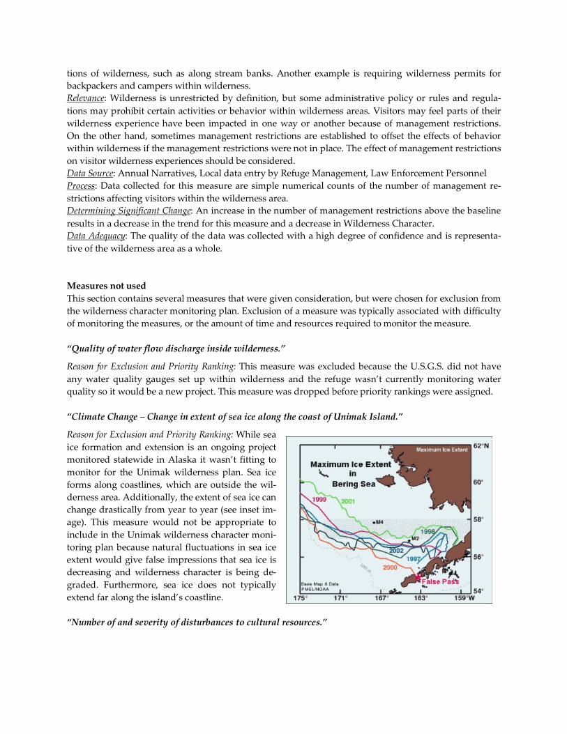
tions of wilderness, such as along stream banks. Another example is requiring wilderness permits for
backpackers and campers within wilderness.
Relevance: Wilderness is unrestricted by definition, but some administrative policy or rules and regula-
tions may prohibit certain activities or behavior within wilderness areas. Visitors may feel parts of their
wilderness experience have been impacted in one way or another because of management restrictions.
On the other hand, sometimes management restrictions are established to offset the effects of behavior
within wilderness if the management restrictions were not in place. The effect of management restrictions
on visitor wilderness experiences should be considered.
Data Source: Annual Narratives, Local data entry by Refuge Management, Law Enforcement Personnel
Process: Data collected for this measure are simple numerical counts of the number of management re-
strictions affecting visitors within the wilderness area.
Determining Significant Change: An increase in the number of management restrictions above the baseline
results in a decrease in the trend for this measure and a decrease in Wilderness Character.
Data Adequacy: The quality of the data was collected with a high degree of confidence and is representa-
tive of the wilderness area as a whole.
Measures not used
This section contains several measures that were given consideration, but were chosen for exclusion from
the wilderness character monitoring plan. Exclusion of a measure was typically associated with difficulty
of monitoring the measures, or the amount of time and resources required to monitor the measure.
“Quality of water flow discharge inside wilderness.” Reason for Exclusion and Priority Ranking: This measure was excluded because the U.S.G.S. did not have
any water quality gauges set up within wilderness and the refuge wasn’t currently monitoring water
quality so it would be a new project. This measure was dropped before priority rankings were assigned.
“Climate Change – Change in extent of sea ice along the coast of Unimak Island.” Reason for Exclusion and Priority Ranking: While sea
ice formation and extension is an ongoing project
monitored statewide in Alaska it wasn’t fitting to
monitor for the Unimak wilderness plan. Sea ice
forms along coastlines, which are outside the wil-
derness area. Additionally, the extent of sea ice can
change drastically from year to year (see inset im-
age). This measure would not be appropriate to
include in the Unimak wilderness character moni-
toring plan because natural fluctuations in sea ice
extent would give false impressions that sea ice is
decreasing and wilderness character is being de-
graded. Furthermore, sea ice does not typically
extend far along the island’s coastline.
“Number of and severity of disturbances to cultural resources.”

Reason for Exclusion and Priority Ranking: This measure was excluded from the monitoring plan because
there are currently no sites within wilderness that are listed as federally protected under Section 106 of
the Natural Historical Preservation Act. This measure was dropped before priorities were assigned.
“Presence of shotgun and bullet casings and litter within wilderness.” Reason for Exclusion and Priority Ranking: The wilderness area of Unimak Island is 910,000-acres and there
are no established trails or a road system within wilderness. Most hunts are commercially guided and
clientele are flown via floatplane or helicopter into the interior of the wilderness to hunt. This makes con-
ducting surveys for expended cartridges and litter within wilderness difficult since there are not desig-
nated hunting areas or locations that repeatedly receive a lot of hunting pressure. This measure was
dropped before priorities were assigned.
“Sediment content of glacial streams (Urilia Bay Creek) flowing out of wilderness.” Reason for Exclusion and Priority Ranking: This measure was excluded because water quality can be diffi-
cult to determine from aerial photographs. A stream system might naturally contain a large amount of
sedimentation or suspended particles. Stream turbidity can be attributed to multiple factors some of them
being natural occurrences and processes. Natural occurrences in the wilderness are not supposed to be
included as a degrading wilderness character. This measure was dropped before priorities were assigned.
“Glacial retreat or advancement on or near Shishaldin Volcano and Isanotski Peaks.” Reason for Exclusion and Priority Ranking: Monitoring glacial retreat would have been a brand new project
to begin and monitor. As stated previously, the Izembek NWR staff (7 Permanent Employees) manage
the Unimak Wilderness in addition to the Izembek unit. Resources were not available to justify including
this measure. This measure was dropped before priorities were assigned.
“Index of intrusions on the natural soundscape.” – Using National Park Service Soundscape Software Reason for Exclusion and Priority Ranking: Measuring anthropogenic influence on the natural soundscape
with the National Park Service soundscape software was an excellent idea, however, the costs associated
with the project outweighed the monitoring benefit. Unimak Island is a remote wilderness, the only way
into the interior is by air or an extensive trek from the coastline. Installing the soundscape software in the
wilderness would be more intrusive and detrimental to the wilderness character than any sounds emitted
from planes or vehicles on the rare occasion they enter the wilderness area. Furthermore, this measure
requires someone to be trained in using the software and have the time to dedicate to monitoring trends
in biotic vs. anthropogenic sounds. This measure was dropped before priorities were assigned.
Conclusions
The Unimak Wilderness has a lot of the same characteristics and qualities of the Izembek Wilderness.
Given their relative proximity, they can and essentially are managed as one large wilderness unit. Since
both wildernesses are administered by the same refuge, there is a lot of overlap between the two monitor-
ing plans. The conclusions drawn after completing the Unimak Wilderness plan closely mirror the con-
clusions documented in the Izembek Wilderness report.
This document has attempted to identify the major management challenges associated with the wilder-
ness area. It is intended to be a reference source for readers interested in understanding more about the
wilderness area and the impacts that threaten the state of the wilderness character. Wilderness character
can be improved as specific measures are targeted, allowing refuge staff to prioritize management objec-
tives as an added benefit. This allows management within the wilderness to be performed on a localized-
level, minimizing the amount of refuge resources required to make a positive impact to improve wilder-
ness character.
In developing this monitoring plan, all available resources were considered to cover as much as possible.
However, actions and conditions surrounding the wilderness are subject to change in the future and the
monitoring plan may need to be updated or adapted to meet the needs or management concerns of future
challenges. There is also the struggle of capturing the intangible. The essence and meaning of wilderness
character is difficult to quantify and put into specific measures. This monitoring plan tries to find a suffi-
cient medium to combine adequate and meaningful monitoring methods while capturing the complexity
and in essence the philosophy of what wilderness truly is. Additionally, this document only identifies
potential impacts to wilderness and suggests a means of monitoring them, but it will be up to refuge per-
sonnel to proceed with data monitoring and actions.
It is also important to note that there are issues and conditions present within the Unimak Wilderness
and most likely all wilderness areas that refuge and management actions will not be able to remediate,
resolve, or change (such as climate change or sea-cargo litter). This presents a potential problem but it is
important to note that the wilderness character monitoring plan is not intended to be an assessment of
refuge or management performance but instead is intended to provide refuge staff with an understand-
ing of what is interacting and affecting the wilderness and how is the wilderness responding.
Nearly the entire 910,000-acres of the Unimak Wilderness have been completely untouched or manipulat-
ed by human hands. Guided hunts are the primary activity on the island and account for the bulk of visi-
tors to the island. Commercial hunting guides are permitted to operate within the wilderness area but the
number of guides is currently restricted to 2. The refuge could deny renewal of the special use permits
permitting hunting within the wilderness, and wilderness character would improve. However, continu-
ing to allow commercial hunting guides to operate within wilderness is not considered to be a misuse of
the wilderness area and has not permanently degraded any of the qualities of wilderness character and
will therefore likely continue to be permitted to operate within the wilderness area.
There are several additional measures that could benefit and supplement other measures within the wil-
derness character monitoring plan. A comprehensive health and population survey of predator and un-
gulate populations, chemical analyses and soil composition tests near remediation sites, and water quali-
ty tests are just three such measures that would be beneficial to understanding the ecosystem components
of the wilderness. As echoed in the Izembek wilderness character monitoring plan report, the addition of
an archaeologist would likely be a useful addition to the refuge staff. The Aleut tribe of Native Alaskans
inhabited the Aleutian Islands archipelago long before the Russian explorations of the 1700’s. It is highly
likely that there are still native artifacts and villages remaining along the islands coast and possibly inte-
rior. Additionally, fossilized remains of prehistoric plants and animals are likely buried beneath the soil.
Prehistoric remains and native artifacts would enrich the culture and history of the wilderness.
Since salmon is such an important resource for both wildlife and residents in the area, it would be valua-
ble to have an additional staff member who focused solely on ichthyology. An ichthyologist would be
able to conduct comprehensive assessments via weir counts on specific salmon streams that the Alaska
Department of Fish and Game may only have general knowledge about. In addition the ichthyologist
would be able to evaluate salmon health and determine the presence of diseases. Law enforcement is not
much of an issue within the Unimak Wilderness because there is only one community (False Pass) on the
eastern border of the island containing fewer than 60 residents.
Unfortunately, due to the limited number of staff and in particular the limited federal budget available, it
is not feasible to assess and monitor every component of the wilderness area. The Izembek NWR staff (7-
full time employees) administers the Izembek NWR and wilderness area (498,000-acres), the Unimak
Wilderness (910,000-acres), and the Pavlof (1,447,246-acre) and North Creek (8,452-acres) units of the
Alaska Peninsula NWR. This is a combined total of over 2,800,000-acres. Needless to say, staff and re-
source availability is scarce for new projects and monitoring efforts. Even with 2.8-million acres to man-
age, the Izembek NWR staff has managed to keep the Unimak Wilderness in superb condition with min-
imal impact to its wilderness character.
The only serious impending issue that could drastically reduce wilderness character and likely degrade
the trend in all qualities would be the decision to proceed with the predator control program encouraged
by the Alaska Department of Fish and Game (ADFG). In response to the declining population of the
Unimak Caribou Herd (UCH), the ADFG has proposed a predator control program that would destroy
up to 50% of the wolf population on within the wilderness area. As of the summer of 2011, that proposal
has been put on hold and the ADFG has not been permitted to proceed with their plan to increase the
UCH. However, if wolves are physically destroyed/removed from the wilderness by the preferred meth-
od (aerial gunning) there would be major implications and severe negative impacts to every quality of
wilderness character. Overhead flights would cause noise within wilderness, bullet casings and debris
would be scattered across wilderness, a natural population of predators would be destroyed and would
create another imbalance in the ecosystem. Not to mention the increase in mesocarnivore populations and
likely the population of brown bears without any guarantee that the wolf removal would result in a long
lasting or permanent increase in the UCH.
After spending 3-months researching, observing, and spending time within the wilderness I can say with
a high degree of confidence that the 910,000+ acre wilderness area of Unimak Island is in excellent condi-
tion. The refuge staff is essentially dealing with an intact wilderness ecosystem that has been nearly un-
touched entirely by humankind. For this reason there are few to no projects that physically require man-
agement, restoration, or improvement by the refuge staff. In most cases, the refuge is collecting data for
observation rather than direct management. I suspect that the quality of the Unimak Wilderness will not
degrade significantly in the immediate or near distant future. It is more likely that several small-scale ac-
tions taken by the refuge staff after the implementation of the wilderness character monitoring plan will
result in the improvement of wilderness character. If no action is taken following the establishment of this
plan the state of the wilderness would likely remain stable for a while, but would eventually begin to de-
grade in quality over time as administrative and various non-administrative agencies, groups, and indi-
viduals use the wilderness area.
It has been both a pleasure and an honor to work with the Izembek National Wildlife Refuge Staff to de-
velop a monitoring plan for the Unimak Wilderness. I want to express my utmost and sincere gratitude to
Izembek NWR staff, for without their honest and extensive feedback this project would not have been
possible.

APPENDIX 1 – WORKSHEET: PRIORITIZING MEASURES OF WILDERNESS CHARACTER
UNIMAK WILDERNESS – COMPLETED OCTOBER 2011
Appendix 1 of 3, Page 30
In each row, write the indicator and potential measure in the left column. Use the following criteria and ranking guide to create an overall score for each meas-
ure. Those measures with the highest overall scores should be the highest priority for assessing trends in wilderness character.
A. Level of importance (the measure is highly relevant to the quality and
indicator of wilderness character, and is highly useful for managing the wil-
derness):
High = 3 points, Medium = 2 points, Low = 1 point
B. Level of vulnerability (measures an attribute of wilderness character that
currently is at risk, or might likely be at risk over 10-15 years):
High = 3 points, Medium = 2 points, Low = 1 point
C. Degree of reliability (the measure can be monitored accurately with a
high degree of confidence, and would yield the same result if measured by
different people at different times):
High = 3 points, Medium = 2 points, Low = 1 point
D. Degree of reasonableness (the measure is related to an existing effort or
could be monitored without significant additional effort):
High = 1 point, Low = 0 point
Criteria for Prioritizing Potential Measures
Potential Measure
A. Importance B. Vulnerability C. Reliability D. Reasonableness OVERALL
SCORE
UNTRAMMELED
Indicator: Actions authorized by the USFWS that manipulate the biophysical en-
vironment of the wilderness
Measure: Number of (indigenous or nonindigenous) plant / animal control pro-
jects inside the wilderness
3
2
3
1
9
Indicator: Actions authorized by the USFWS that manipulate the biophysical en-
vironment of the wilderness
Measure: Number of acres of habitat restoration inside the wilderness
1
1
2
Indicator: Actions authorized by the USFWS that manipulate the biophysical en-
vironment of the wilderness
Measure: Number of research projects and studies conducted inside wilderness
3
3
3
1
10
Indicator: Actions NOT authorized by the USFWS that manipulate the biophysical
environment of the wilderness
Measure: Number of unauthorized actions by agencies, citizen groups or indi-
viduals that affect plants, animals, and abiotic factors of the environment inside
2
2
2
1
7
STOP!
If A + B ≤
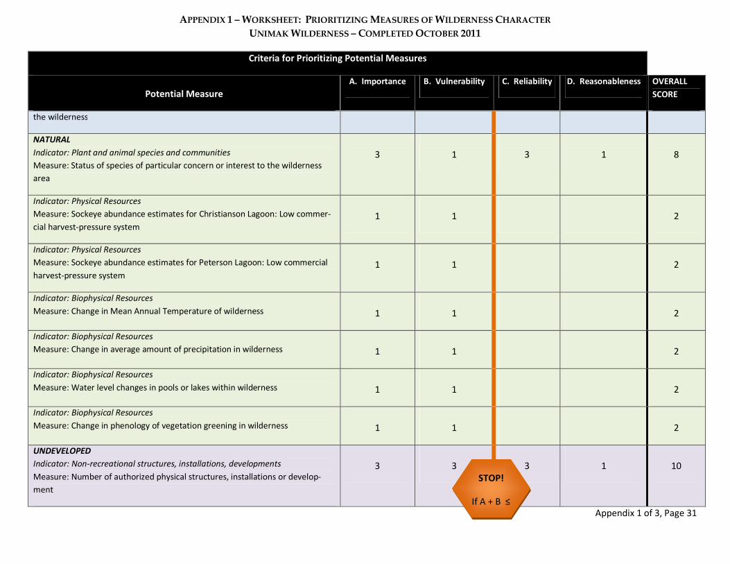
APPENDIX 1 – WORKSHEET: PRIORITIZING MEASURES OF WILDERNESS CHARACTER
UNIMAK WILDERNESS – COMPLETED OCTOBER 2011
Appendix 1 of 3, Page 31
Criteria for Prioritizing Potential Measures
Potential Measure
A. Importance B. Vulnerability C. Reliability D. Reasonableness OVERALL
SCORE
the wilderness
NATURAL
Indicator: Plant and animal species and communities
Measure: Status of species of particular concern or interest to the wilderness
area
3
1
3
1
8
Indicator: Physical Resources
Measure: Sockeye abundance estimates for Christianson Lagoon: Low commer-
cial harvest-pressure system
1
1
2
Indicator: Physical Resources
Measure: Sockeye abundance estimates for Peterson Lagoon: Low commercial
harvest-pressure system
1
1
2
Indicator: Biophysical Resources
Measure: Change in Mean Annual Temperature of wilderness
1
1
2
Indicator: Biophysical Resources
Measure: Change in average amount of precipitation in wilderness
1
1
2
Indicator: Biophysical Resources
Measure: Water level changes in pools or lakes within wilderness
1
1
2
Indicator: Biophysical Resources
Measure: Change in phenology of vegetation greening in wilderness
1
1
2
UNDEVELOPED
Indicator: Non-recreational structures, installations, developments
Measure: Number of authorized physical structures, installations or develop-
ment
3
3
3
1
10
STOP!
If A + B ≤

APPENDIX 1 – WORKSHEET: PRIORITIZING MEASURES OF WILDERNESS CHARACTER
UNIMAK WILDERNESS – COMPLETED OCTOBER 2011
Appendix 1 of 3, Page 32
Criteria for Prioritizing Potential Measures
Potential Measure
A. Importance B. Vulnerability C. Reliability D. Reasonableness OVERALL
SCORE
Indicator: Non-recreational structures, installations, developments
Measure: Numbers of cabins built and remaining in wilderness
2 1 2 1 6
Indicator: Non-recreational structures, installations, developments
Measure: Number of unauthorized (user-created) physical structures, installa-
tions or development
3
1
1
0
5
Indicator: Non-recreational structures, installations, developments
Measure: Number of illegal trails from Urilia Bay extending into wilderness
2 3 1 0 6
Indicator: Inholdings
Measure: Area of inholdings inside wilderness
1 1 2
Indicator: Use of motor vehicles, motorized equipment, or mechanical transport
Measure: Number of user days of administrative (USFWS) use of motorized
transportation, motorized equipment, or mechanical transport
3
3
3
1
10
Indicator: Use of motor vehicles, motorized equipment, or mechanical transport
Measure: Number of user days of emergency use of motorized transportation,
motorized equipment, or mechanical transport
1
1
2
Indicator: Use of motor vehicles, motorized equipment, or mechanical transport
Measure: Number of user days of guide and private (non-commercial and non-
administrative) aircraft and helicopter landings
2
2
2
1
7
SOLITUDE OR PRIMITIVE AND UNCONFINED RECREATION
Indicator: Remoteness from sights and sounds of people inside the wilderness
Measure: Number of user days of visitor use
2
2
2
0
6
Indicator: Remoteness from sights and sounds of people inside the wilderness
Measure: Amount of buoys and sea-cargo litter within and surrounding wilder-
2
2
3
0
7
STOP!
If A + B ≤

APPENDIX 1 – WORKSHEET: PRIORITIZING MEASURES OF WILDERNESS CHARACTER
UNIMAK WILDERNESS – COMPLETED OCTOBER 2011
Appendix 1 of 3, Page 33
Criteria for Prioritizing Potential Measures
Potential Measure
A. Importance B. Vulnerability C. Reliability D. Reasonableness OVERALL
SCORE
ness
Indicator: Remoteness from sights and sounds of people inside the wilderness
Measure: Number of Alaska Volcano Observatory (AVO) structures inside Uni-
mak wilderness
3
3
3
1
10
Indicator: Remoteness from sights and sounds of people inside the wilderness
Measure: Number of commercial hunting guides
2 1 3 1 7
Indicator: Remoteness from occupied and modified areas outside wilderness
Measure: Night sky visibility averaged over the wilderness
1 1 2
Indicator: Remoteness from occupied and modified areas outside wilderness
Measure: Index of intrusions on the natural soundscape
2 2 2 0 6
Indicator: Remoteness from occupied and modified areas outside wilderness
Measure: Status of Coast Guard deconstruction site and contaminant cleanup
2 1 3 1 7
Indicator: Remoteness from occupied and modified areas outside wilderness
Measure: Impact of Isanotski Corporation Lands on surrounding wilderness
boundary lands
2
1
2
1
6
Indicator: Facilities that decrease self-reliant recreation
Measure: Number of USFWS installations of physical structure
3 1 3 1 8
Indicator: Facilities that decrease self-reliant recreation
Measure: Number of user-created (non-administrative) recreation installations
1 2 3 1 7
Indicator: Management restrictions on visitor behavior
Measure: Number of management restrictions
1 1 2
Names of team members filling out this worksheet: Trent Liebech, Chris Peterson, Nancy Hoffman
STOP!
If A + B ≤
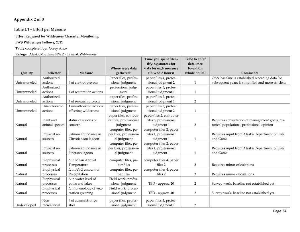
Page 34
Appendix 2 of 3
Table 2.1 – Effort per Measure
Effort Required for Wilderness Character Monitoring
FWS Wilderness Fellows, 2011
Table completed by: Corey Anco
Refuge: Alaska Maritime NWR - Unimak Wilderness
Quality Indicator Measure
Where were data
gathered?
Time you spent iden-
tifying sources for
data for each measure
(in whole hours)
Time to enter
data once
found (in
whole hours) Comments
Untrammeled
Authorized
actions # of control projects
Paper files, profes-
sional judgment
paper files 4, profes-
sional judgment 2 1
Once baseline is established recording data for
subsequent years is simplified and more efficient
Untrammeled
Authorized
actions # of restoration actions
professional judg-
ment
paper files 3, profes-
sional judgment 1 1
Untrammeled
Authorized
actions # of research projects
paper files, profes-
sional judgment
paper files 2, profes-
sional judgment 1 2
Untrammeled
Unauthorized
actions
# unauthorized actions
affecting wilderness
paper files, profes-
sional judgment
paper files 3, profes-
sional judgment 2 1
Natural
Plant and
animal species
status of species of
concern
paper files, comput-
er files, professional
judgment
paper files 2, computer
files 5, professional
judgment 1 2
Requires consultation of management goals, his-
torical populations, professional opinion
Natural
Physical re-
sources
Salmon abundance in
Christianson lagoon
computer files, pa-
per files, profession-
al judgment
computer files 2, paper
files 1, professional
judgment 1 1
Requires input from Alaska Department of Fish
and Game
Natural
Physical re-
sources
Salmon abundance in
Peterson lagoon
computer files, pa-
per files, profession-
al judgment
computer files 2, paper
files 1, professional
judgment 1 1
Requires input from Alaska Department of Fish
and Game
Natural
Biophysical
processes
∆ in Mean Annual
Temperature
computer files, pa-
per files
computer files 4, paper
files 2 2 Requires minor calculations
Natural
Biophysical
processes
∆ in AVG amount of
Precipitation
computer files, pa-
per files
computer files 4, paper
files 2 3 Requires minor calculations
Natural
Biophysical
processes
∆ in water level of
pools and lakes
Field work, profes-
sional judgment TBD - approx. 20 2 Survey work, baseline not established yet
Natural
Biophysical
processes
∆ in phenology of veg-
etation greening
Field work, profes-
sional judgment TBD - approx. 40 2 Survey work, baseline not established yet
Undeveloped
Non-
recreational
# of administrative
sties
paper files, profes-
sional judgment
paper files 4, profes-
sional judgment 1 2
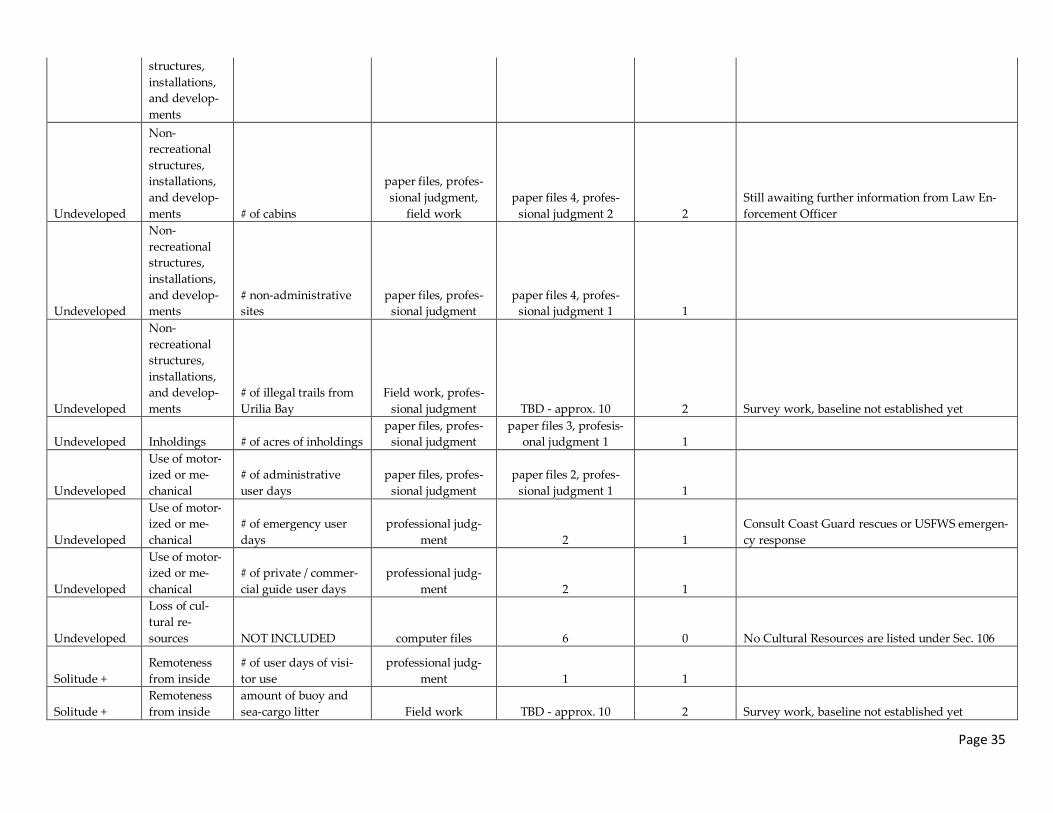
Page 35
structures,
installations,
and develop-
ments
Undeveloped
Non-
recreational
structures,
installations,
and develop-
ments # of cabins
paper files, profes-
sional judgment,
field work
paper files 4, profes-
sional judgment 2 2
Still awaiting further information from Law En-
forcement Officer
Undeveloped
Non-
recreational
structures,
installations,
and develop-
ments
# non-administrative
sites
paper files, profes-
sional judgment
paper files 4, profes-
sional judgment 1 1
Undeveloped
Non-
recreational
structures,
installations,
and develop-
ments
# of illegal trails from
Urilia Bay
Field work, profes-
sional judgment TBD - approx. 10 2 Survey work, baseline not established yet
Undeveloped Inholdings # of acres of inholdings
paper files, profes-
sional judgment
paper files 3, profesis-
onal judgment 1 1
Undeveloped
Use of motor-
ized or me-
chanical
# of administrative
user days
paper files, profes-
sional judgment
paper files 2, profes-
sional judgment 1 1
Undeveloped
Use of motor-
ized or me-
chanical
# of emergency user
days
professional judg-
ment 2 1
Consult Coast Guard rescues or USFWS emergen-
cy response
Undeveloped
Use of motor-
ized or me-
chanical
# of private / commer-
cial guide user days
professional judg-
ment 2 1
Undeveloped
Loss of cul-
tural re-
sources NOT INCLUDED computer files 6 0 No Cultural Resources are listed under Sec. 106
Solitude +
Remoteness
from inside
# of user days of visi-
tor use
professional judg-
ment 1 1
Solitude +
Remoteness
from inside
amount of buoy and
sea-cargo litter Field work TBD - approx. 10 2 Survey work, baseline not established yet
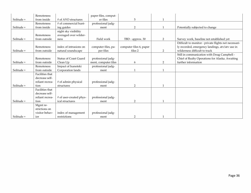
Page 36
Solitude +
Remoteness
from inside # of AVO structures
paper files, comput-
er files 5 1
Solitude +
Remoteness
from inside
# of commercial hunt-
ing guides
professional judg-
ment 2 1 Potentially subjected to change
Solitude +
Remoteness
from outside
night sky visibility
averaged over wilder-
ness Field work TBD - approx. 30 2 Survey work, baseline not established yet
Solitude +
Remoteness
from outside
index of intrusions on
natural soundscape
computer files, pa-
per files
computer files 6, paper
files 2 2
Difficult to monitor - private flights not necessari-
ly recorded, emergency landings, atv/utv use in
wilderness difficult to track
Solitude +
Remoteness
from outside
Status of Coast Guard
Clean Up
professional judg-
ment, computer files 6 2
Still in communication with Doug Campbell -
Chief of Realty Operations for Alaska. Awaiting
further information
Solitude +
Remoteness
from outside
Impact of Isanotski
Corporation lands
professional judg-
ment 1 1
Solitude +
Facilities that
decrease self-
reliant recrea-
tion
# of admin physical
structures
professional judg-
ment 2 1
Solitude +
Facilities that
decrease self-
reliant recrea-
tion
# of user-created phys-
ical structures
professional judg-
ment 2 1
Solitude +
Mgmt re-
strictions on
visitor behav-
ior
index of management
restrictions
professional judg-
ment 2 1
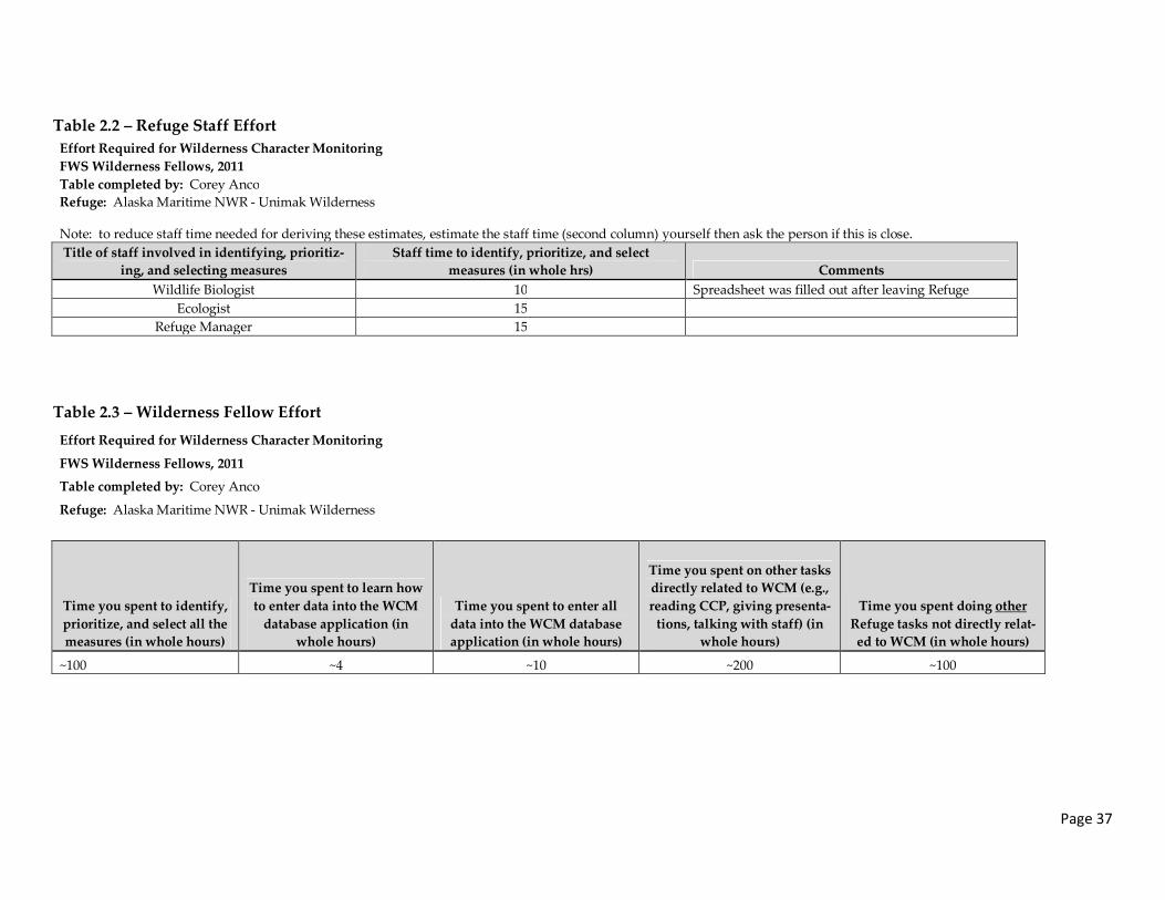
Page 37
Table 2.2 – Refuge Staff Effort
Effort Required for Wilderness Character Monitoring
FWS Wilderness Fellows, 2011
Table completed by: Corey Anco
Refuge: Alaska Maritime NWR - Unimak Wilderness
Note: to reduce staff time needed for deriving these estimates, estimate the staff time (second column) yourself then ask the person if this is close.
Title of staff involved in identifying, prioritiz-
ing, and selecting measures
Staff time to identify, prioritize, and select
measures (in whole hrs) Comments
Wildlife Biologist 10 Spreadsheet was filled out after leaving Refuge
Ecologist 15
Refuge Manager 15
Table 2.3 – Wilderness Fellow Effort
Effort Required for Wilderness Character Monitoring
FWS Wilderness Fellows, 2011
Table completed by: Corey Anco
Refuge: Alaska Maritime NWR - Unimak Wilderness
Time you spent to identify,
prioritize, and select all the
measures (in whole hours)
Time you spent to learn how
to enter data into the WCM
database application (in
whole hours)
Time you spent to enter all
data into the WCM database
application (in whole hours)
Time you spent on other tasks
directly related to WCM (e.g.,
reading CCP, giving presenta-
tions, talking with staff) (in
whole hours)
Time you spent doing other
Refuge tasks not directly relat-
ed to WCM (in whole hours)
~100 ~4 ~10 ~200 ~100
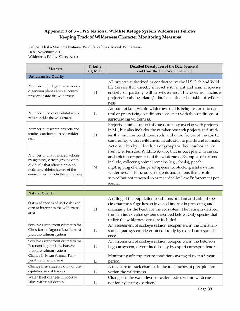
Page 38
Appendix 3 of 3 – FWS National Wildlife Refuge System Wilderness Fellows
Keeping Track of Wilderness Character Monitoring Measures
Refuge: Alaska Maritime National Wildlife Refuge (Unimak Wilderness)
Date: November 2011
Wilderness Fellow: Corey Anco
Measure Priority
(H, M, L)
Detailed Description of the Data Source(s)
and How the Data Were Gathered
Untrammeled Quality
Number of (indigenous or nonin-
digenous) plant / animal control
projects inside the wilderness
H
All projects authorized or conducted by the U.S. Fish and Wild-
life Service that directly interact with plant and animal species
entirely or partially within wilderness. This does not include
projects involving plants/animals conducted outside of wilder-
ness.
Number of acres of habitat resto-
ration inside the wilderness
L
Amount of land within wilderness that is being restored to nat-
ural or pre-existing conditions consistent with the conditions of
surrounding wilderness.
Number of research projects and
studies conducted inside wilder-
ness
H
Projects counted under this measure may overlap with projects
in M1, but also includes the number research projects and stud-
ies that monitor conditions, soils, and other factors of the abiotic
community within wilderness in addition to plants and animals.
Number of unauthorized actions
by agencies, citizen groups or in-
dividuals that affect plants, ani-
mals, and abiotic factors of the
environment inside the wilderness
M
Actions taken by individuals or groups without authorization
from U.S. Fish and Wildlife Service that impact plants, animals,
and abiotic components of the wilderness. Examples of actions
include, collecting animal remains (e.g., sheds), poach-
ing/trapping of endangered species, or stocking a lake within
wilderness. This includes incidents and actions that are ob-
served but not reported to or recorded by Law Enforcement per-
sonnel.
Natural Quality
Status of species of particular con-
cern or interest to the wilderness
area
H
A rating of the population conditions of plant and animal spe-
cies that the refuge has an invested interest in protecting and
managing for the health of the ecosystem. The rating is derived
from an index value system described below. Only species that
utilize the wilderness area are included.
Sockeye escapement estimates for
Christianson lagoon: Low harvest-
pressure salmon system
L
An assessment of sockeye salmon escapement in the Christian-
son Lagoon system, determined locally by expert correspond-
ence.
Sockeye escapement estimates for
Peterson lagoon: Low harvest-
pressure salmon system
L
An assessment of sockeye salmon escapement in the Peterson
Lagoon system, determined locally by expert correspondence.
Change in Mean Annual Tem-
perature of wilderness
L
Monitoring of temperature conditions averaged over a 5-year
period.
Change in average amount of pre-
cipitation in wilderness
L
A measure to track changes in the total inches of precipitation
within the wilderness.
Water level changes in pools or
lakes within wilderness
L
Changes in the water level of water bodies within wilderness
not fed by springs or rivers.

Page 39
Change in phenology of vegeta-
tion greening in wilderness
L
Detection of temporal changes in the overall length of the green-
ing period and changes in length of stages throughout the
greening period.
Undeveloped Quality
Number of authorized physical
structures, installations or devel-
opments
H
The number of physical structures, installations, or develop-
ments authorized or created by the U.S. Fish and Wildlife Ser-
vice that are non-recreational, including: earthen or concrete
dams, log or metal cabins, buildings, administrative trails, roads
to access inholdings, fixed instrumentation sites, etc…
Numbers of cabins built and re-
maining in wilderness
M
The number of cabins that have been constructed and currently
remain standing and/or in use within the wilderness area.
Number of unauthorized (user-
created) physical structures, in-
stallations or development
M
The number of user-created physical structures, installations, or
developments excluding U.S. Fish and Wildlife Service con-
structs that are non-recreational in nature. User-created con-
structs include, but are not limited to, fences, trails or roads used
to access stream and water diversions, remnants of military oc-
cupancy, Quonsets, tanks and drums, power poles, etc…
Number of illegal trails from
Urilia Bay extending into wilder-
ness
M
Tracks the number of illegal two-track trails from the Urilia Bay
coast extending into wilderness. Two-track trails are created by
mechanized vehicles, and are most likely the result of ATV/UTV
use in restricted areas within wilderness and therefore require
monitoring.
Area of inholdings inside wilder-
ness
L
Acreage of land within wilderness not governed by U.S. Fish
and Wildlife Service. This includes lands adjacent to or partially
within wilderness as well.
Number of user days of adminis-
trative (USFWS) use of motorized
transportation, motorized equip-
ment, or mechanical transport
H
The number of days U.S. Fish and Wildlife spent inside the wil-
derness area with motorized vehicles, motorized equipment, or
mechanical transportation. Examples include: vehicles used to
rescue people or transport materials in and out of wilderness,
emergency response, or chainsaws.
Number of user days of emergen-
cy use of motorized transporta-
tion, motorized equipment, or
mechanical transport
L
The number of emergency response user days within wilder-
ness. To differentiate between administrative and non-
administrative emergency response a second measure was cre-
ated specifically for U.S. Coast Guard, the other agency that may
respond to emergency rescue calls with wilderness. Examples
include, but are not limited to U.S. Coast Guard rescue planes
and helicopters, and ATVs/UTVs.
Number of user days of guide and
private (non-commercial and non-
administrative) aircraft and heli-
copter landings
M
The number of days used by guides and private individuals to
operate and land aircraft and helicopters within the wilderness
area.
Solitude or Primitive and Unconfined Quality
Number of user days of visitor use M This measure tracks trends in visitor use to the wilderness area.
Amount of buoys and sea-cargo
litter within and surrounding wil-
derness
M
A determination of the degree of sea-cargo litter present in and
around the wilderness area.
Number of Alaska Volcano Ob- A numerical count of the number of AVO-installed structures

Page 40
servatory (AVO) structures inside
Unimak wilderness H within wilderness.
Number of commercial hunting
guides M The number of commercial hunting guides operating within the
wilderness area.
Night sky visibility averaged over
the wilderness
L
Degree of night sky visibility most commonly affected by light
pollution. This measure also tracks the visibility of the night sky
for purposes of stargazing or aurora borealis viewing.
Index of intrusions on the natural
soundscape M Anthropogenic noise penetration into the natural soundscape.
For example, sounds generated from automobiles, ATVs/UTVs,
boats, and horns travel further from the source.
Status of Coast Guard deconstruc-
tion site and contaminant cleanup
M
Deconstruction of vacant Coast Guard stations and restoration
of vegetation along coast of Unimak Island adjacent to wilder-
ness boundary.
Impact of Isanotski Corporation
Lands on surrounding wilderness
boundary lands
M
An assessment of the level of impact from the Isanotski Corpo-
ration Lands adjacent to the northeast wilderness boundary.
Number of USFWS installations of
physical structure
H
The number of structures and facilities installed by the U.S. Fish
and Wildlife. Installed structures and facilities includes any unit
or objected created, set in place, erected, built, or positioned by
U.S. Fish and Wildlife. Examples of installations or structures
include, but are not limited to signs, markers, shelters, water
stations, latrines, picnic tables, bear boxes and poles, corrals,
bridges, Quonsets, etc...
Number of user-created (non-
administrative) recreation installa-
tions
M
The number of user-created recreational structures within wil-
derness. Examples of user-created structures within wilderness
include, but are not limited to bridges, cabins, campsites, mark-
ers, signs, latrines, or anything else constructed by non-
administrative visitors of the wilderness area.
Number of management re-
strictions L The number of regulations, restrictions, or limitations on visitor
behavior within wilderness.

Page 41
Map of Unimak Wilderness – Adapted from FWS Office of Realty, Region 7 – Alaska