UNGGIM Americas Workgroup Disasters
79
A survey on “Geospatial Information Management in the context of Disaster Risk Management” was completed in 2018 by 35 countries in the Americas. Answers are presented and a gap analysis follows that aims to assess how far countries are from meeting the Global Strategic Framework on Geospatial Information and Services for Disasters. The survey identified that floods and hurricanes are the main disasters affecting the Americas. It also confirmed the existence of challenges when it comes to the management of geospatial information as well as collaboration, coordination and communication issues among all the stakeholders and partners involved in the response to disasters. UNGGIM Americas Workgroup Disasters Capacity Building Action Plan Diagnosis and Gap Analysis - Report 1 of 2 Louis Brown, Sint Maarten (VROMI) Yves Moisan, Canada (CCMEO) Nouri Sabo, Canada (CCMEO) July 2019
Transcript of UNGGIM Americas Workgroup Disasters

Last Updated: October 2, 2018
i
A survey on “Geospatial Information Management in the context of Disaster Risk Management” was completed in 2018 by 35 countries in the Americas. Answers are presented and a gap analysis follows that aims to assess how far countries are from meeting the Global Strategic Framework on Geospatial Information and Services for Disasters. The survey identified that floods and
hurricanes are the main disasters affecting the Americas. It also confirmed the existence of challenges when it comes to the management of geospatial information as well as collaboration, coordination and communication issues among all the stakeholders and partners involved in the response to disasters.
UNGGIM Americas Workgroup Disasters
Capacity Building Action Plan Diagnosis and Gap Analysis - Report 1 of 2
Louis Brown, Sint Maarten (VROMI) Yves Moisan, Canada (CCMEO)
Nouri Sabo, Canada (CCMEO)
July 2019

Last Updated: 2020-04-23 6:21 PM
ii

Last Updated: 2020-04-23 6:21 PM
iii
Executive Summary
This report presents the analysis performed by means of a survey completed by 35 member states in the Americas relative to Geospatial Information Management in the context of Disaster Risk Management (DRM). The survey, finalized in 2018, was designed to identify readiness and gaps in the use of geospatial information for DRM, as per United Nations General Assembly Resolution 59/12 stated in the United Nations Global Geospatial Information Management Global Strategic Framework on Geospatial Information and Services for Disasters (GSF). The report is part of an overall initiative to achieve the Sendai framework’s outcome: “the substantial reduction of disaster risk and losses in lives, livelihoods and health and in the economic, physical, social, cultural and environmental assets of persons, businesses, communities and countries” as well as the GSF’s outcome: “the human, socioeconomic and environmental risks and impacts of disasters are prevented or reduced through the use of geospatial information and services”. The survey identified that floods and hurricanes are the main disasters affecting the Americas. Countries expect those, as well as other types of disasters like costal erosion, landslides and wildfires to be
compounded by the effects of Climate Change. The survey also confirmed the existence of challenges and gaps when it comes to the management of geospatial information as well as collaboration, coordination and communication issues among all the stakeholders and partners involved in the response to disasters. Both the survey results analysis and the gap analysis were grouped into four sub-regions (North America, Central America, the Caribbean and South America) to identify regional similarities potentially at the expense of inter-country differences. Despite these groupings, gaps still differ from country to country, so they are presented as actions, although these actions may not be relevant in some countries. Table 1 shows the level of importance of gaps per sub-region along the five priority areas listed in the Global Strategic Framework: Governance and Policies; Awareness Raising and Capacity Building; Data Management; Common Infrastructure and Services and Resource Mobilization.
Table 1 – Summary of Gaps per Sub-Region per GSF Priority Areas
GSF priority areas for action North America
Caribbean Central America
South America
Governance and Policies Low High High Average
Awareness Raising and Capacity Building Average High High High
Data Management Low Average Average Average
Common Infrastructure and Services Average High Average Average
Resource Mobilization Average High High High
Following this report, the next step is to propose a capacity building strategy to fill the identified gaps.

Last Updated: 2020-04-23 6:21 PM
iv
Table of Contents
Executive Summary ...................................................................................................................................... iii
Table of Contents ......................................................................................................................................... iv
List of Figures ................................................................................................................................................ v
List of Tables ................................................................................................................................................ vi
List of Abbreviations ................................................................................................................................... vii
1. Introduction .......................................................................................................................................... 8
1.1 Background ................................................................................................................................... 8
1.2 The Americas Region ................................................................................................................... 10
2. Survey Findings and Diagnosis ............................................................................................................ 13
2.1 Survey Objectives ........................................................................................................................ 13
2.2 Respondents ............................................................................................................................... 14
2.3 Data Preparation ......................................................................................................................... 14
2.4 Analysis of Survey Results ........................................................................................................... 15
2.4.1 Involvement in Previous Disaster Event ............................................................................. 15
2.4.2 Institutional Aspects ........................................................................................................... 18
2.4.3 Information ......................................................................................................................... 25
2.4.4 Resources ............................................................................................................................ 28
2.4.5 Climate Change ................................................................................................................... 29
2.4.6 Other Comments ................................................................................................................. 31
3. Gap Analysis ........................................................................................................................................ 32
3.1 Governance and Policies ............................................................................................................. 32
3.1.1 Governance Actions ............................................................................................................ 32
3.1.2 Policies Actions ................................................................................................................... 33
3.2 Awareness Raising and Capacity Building ................................................................................... 33
3.3 Data Management ...................................................................................................................... 34
3.4 Common Infrastructure and Services ......................................................................................... 34
3.5 Resource Mobilization ................................................................................................................ 35
3.6 Summary of Gaps ........................................................................................................................ 35
Appendix 1: Involvement in Previous Disaster Events ................................................................................ 37
Appendix 2: Institutional aspects ................................................................................................................ 45
Appendix 3: Information ............................................................................................................................. 54
Appendix 4: Resources ................................................................................................................................ 69
Appendix 5: Climate Change ....................................................................................................................... 75

Last Updated: 2020-04-23 6:21 PM
v
List of Figures
Figure 1. North America countries: Canada, USA, Mexico (N = 3) ............................................................. 11 Figure 2. Central America Countries: Belize, Guatemala, El Salvador, Honduras, Nicaragua, Costa Rica, Panama (N = 7) ............................................................................................................................................ 11 Figure 3. Caribbean countries: Cuba, The Bahamas, Jamaica, Haiti, Dominican Republic, Sint Maarten, Antigua and Barbuda, Dominica, Saint Lucia, Barbados, Saint Vincent and the Grenadines, Grenada, Trinidad and Tobago (N = 13) ..................................................................................................................... 12 Figure 4. South America: Venezuela, Guyana, Suriname, Colombia, Ecuador, Bolivia, Peru, Brazil, Uruguay, Paraguay, Chile, Argentina (N = 12) ............................................................................................ 12 Figure 5. Level of importance - floods ....................................................................................................... 16 Figure 6. Level of importance - hurricanes ............................................................................................... 16 Figure 7. Risks and disasters incorporated in NSDI .................................................................................... 17 Figure 8. Administrative act regulating DRM ............................................................................................. 18 Figure 9. Authority responsible for DRM ................................................................................................... 19 Figure 10. Office risk management tool ..................................................................................................... 19 Figure 11. Geoportal viewer for DRM ........................................................................................................ 19 Figure 12. Monitoring of risk in municipalities .......................................................................................... 20 Figure 13. Percent municipalities with up-to-date information ................................................................ 20 Figure 14. Financial model for RM information ......................................................................................... 20 Figure 15. Geodetic network (CORS) in country ........................................................................................ 21 Figure 16. Open access to geospatial DM information .............................................................................. 21 Figure 17. Ease in allocating staff - internal ............................................................................................... 21 Figure 18. Ease in allocating staff - external .............................................................................................. 22 Figure 19. Ease in allocating funds ............................................................................................................. 22 Figure 20. Ease in allocating new imagery ................................................................................................. 22 Figure 21. Hurricanes: details of emergency plans vs perceived importance ........................................... 23 Figure 22. Floods: details of emergency plans vs perceived importance .................................................. 24

Last Updated: October 2, 2018
vi
List of Tables
Table 1 – Summary of Gaps per Sub-Region per GSF Priority Areas ........................................................... iii Table 2. Importance of specific disaster types for all countries ................................................................. 17 Table 3. Level of preparedness per disaster type ...................................................................................... 24 Table 4. Challenges regarding access to GI in the context of DRM ........................................................... 25 Table 5. Challenges regarding usage to GI in the context of DRM ............................................................ 26 Table 6. Challenges regarding sharing of GI in the context of DRM .......................................................... 26 Table 7. Preferred way to share information ............................................................................................. 27 Table 8. Level of preparedness of IT systems and software with respect to DRM .................................... 28 Table 9. Level of expertise with respect to DRM ....................................................................................... 28 Table 10. Status of HR profiles necessary for DRM .................................................................................... 29 Table 11. Potential impact of climate change on disasters ....................................................................... 29 Table 12. Emergency plans readiness per disaster type ............................................................................ 30 Table 13. Preparedness level for the impacts of climate change .............................................................. 30 Table 14 – Summary of Gaps per Sub-region per GSF Priority Areas ......................................................... 36

Last Updated: 2020-04-23 6:21 PM
vii
List of Abbreviations
CCMEO Canada Center for Mapping and Earth Observation DRM Disaster Risk Management DRR Disaster Risk Reduction UNGGIM United Nations Global Geospatial Information Management GI Geospatial Information GIM Geospatial Information Management GSF Global Strategic Framework (on Geospatial Information and Services for Disasters) NSDI National Spatial Data Infrastructure UN United Nations VROMI Volkshuisvesting, Ruimtelijke Ordening, Milieu & Infrastructuur
(Ministry of Public Housing, spatial planning, environment and infrastructure)

Last Updated: 2020-04-23 6:21 PM
8
1. Introduction
This report comprises an analysis of the 2018 survey completed by member states in the Americas relative to Geospatial Information Management (GIM) in the context of Disaster Risk Management (DRM). The survey was designed to identify geospatial information gaps in DRM, as per United Nations (UN) General Assembly Resolution 59/12 stated in the UNGGIM Global Strategic Framework (GSF) on Geospatial Information and Services for Disasters. “… UN GA Resolution 59/12 … calls upon Member States, the United Nations and other key stakeholders to assist in addressing knowledge gaps in DRM by improving systems and networks for the collection and analysis of information on disasters, vulnerabilities and disaster risks to facilitate informed decision-making.” (bold ours) The expected outcome of the GSF is to ensure “quality geospatial information and services are available and accessible in a timely and coordinated way to support decision-making and operation within and across all sectors and phases of the emergency cycle.” This in turn “requires Member States to be in the position to develop, maintain and provide the necessary geospatial information and services”. Section 2 of this report provides some background and presents survey results. Then Section 3 is focused on gap analysis understood as identifying where DRM systems and networks do not allow meeting the main GSF outcome stated above.
1.1 Background
Today, no part of the planet escapes the risks of natural disasters. The Americas region including the Caribbean are particularly vulnerable to disasters, such as flooding that affect the majority of the continent and region, as well as droughts, forest fires, earthquakes, landslides, tsunamis, tropical storms and extreme volcanic activities. With climate change, these risks are rising rapidly to the point of endangering the lives of many people in this region and jeopardizing the economies of many countries. In order to mitigate these risks, countries and their citizens need to make informed decisions based on reliable information. For this, information in general and geospatial information in particular is paramount. Quality geospatial information is essential for all aspects and phases of disaster risk management (preparedness, prevention, mitigation, response and restoration, and support for the transition to development). Even though this region of the world faces several forms of disaster, it will be obvious in this report that in several countries, the use of geospatial information for disaster reduction is marginal. The UN-GGIM Americas Regional Working group on Access and Use of Geospatial Information for Disaster Risk Reduction and Climate Change (Working Group on Disasters) has the objective of promoting the use of geospatial information in the Americas region in relation to policies, programs and projects for disaster risk reduction and climate change. To avoid or minimize disaster impacts, a coordinated ability to understand changing conditions, efficiently deploy resources, and gain maximum value from multiple levels and types of responders requires effective coordination policies and practices as well as current and often near real time data of known quality – much of which is location-based or geospatially-enabled information from a range of sources.

Last Updated: 2020-04-23 6:21 PM
9
The objective of the Regional Working Group on Disasters is in line with the Global Strategic Framework on Geospatial Information and Services for Disasters, which was adopted by the Committee of Experts on Global Geospatial Information Management on August, 4 2017 and by the United Nations Economic and Social Council (ECOSOC) on July, 2 2018 (Resolution E/RES/2018/14). The goal of the Global Strategic Framework (GSF) is to ensure that quality geospatial information and services are available in a timely and coordinated manner to support decision-making in all phases of an emergency event, in a bid to mitigate adverse effects on populations, economies and the environment. The GSF is intended as a guide for UN Member States to adopt and implement in order to ensure the availability and accessibility of quality geospatial information and services across all phases of disaster risk reduction and management The GSF identifies 5 priority areas for action:
1. Governance and Policies; 2. Awareness Raising and Capacity Building; 3. Data Management; 4. Common Infrastructure and Services; 5. Resource Mobilization.
A main theme in the GSF, aimed at the preparedness of member states in the area of GIM to reduce and manage the risks of disasters, is that of capacities and capacity building of the member states. The adoption and implementation of the GSF for disasters is the responsibility of the respective individual member states. As the regional committee with the objective to foster the continued development of GIM among member countries, UNGGIM Americas, through the Regional Working Group on Disasters, aims to promote the use of GI for disaster risk reduction. While it may not be possible to address all priority areas of the GSF simultaneously and because it is necessary to prioritize activities, the Working Group on Disasters developed a Work Plan 2018 – 2021. The work plan’s intention is to assess areas wherein it will be possible to devise rational and achievable capacity building interventions that can be conducted on a regional level, within that period. The 2018 Work Plan identifies three broad objectives, the first of these is the “Capacity Building Action Plan”. It comprises three activities:
1) Diagnosis of countries’ capacities: human resources, data and information tools (technology,
norms, policies);
2) Gap analysis based on the diagnosis of capacities;
3) Capacity building strategy proposal to be implemented to fill identified gaps;
For activity #1 above a survey was completed in June 2018, by a total of 35 of the 36 country representatives (‘geo-officials’) that are represented within the UN-GGIM Americas Regional Committee. The 2018 survey follows the path set by the original 2015 survey, part of which was updated in 2016. The questions were formulated so as to:

Last Updated: 2020-04-23 6:21 PM
10
• gain perspective on types of disasters that affect member states, mainly through documenting involvement of stakeholders in previous disaster events;
• understand institutional aspects – such as existence of policies on open data - that may have a bearing on DRM;
• identify information issues in terms of access to and availability geospatial data;
• identify potential gaps in availability of various types of human resources in the context of DRM. A final set of questions was also added to understand how the effects of Climate Change are perceived to potentially affect disasters by member states. This report summarizes the findings revealed by the survey and also addresses the gap analysis (item #2 above). Item #3 will be addressed in a subsequent report.
1.2 The Americas Region
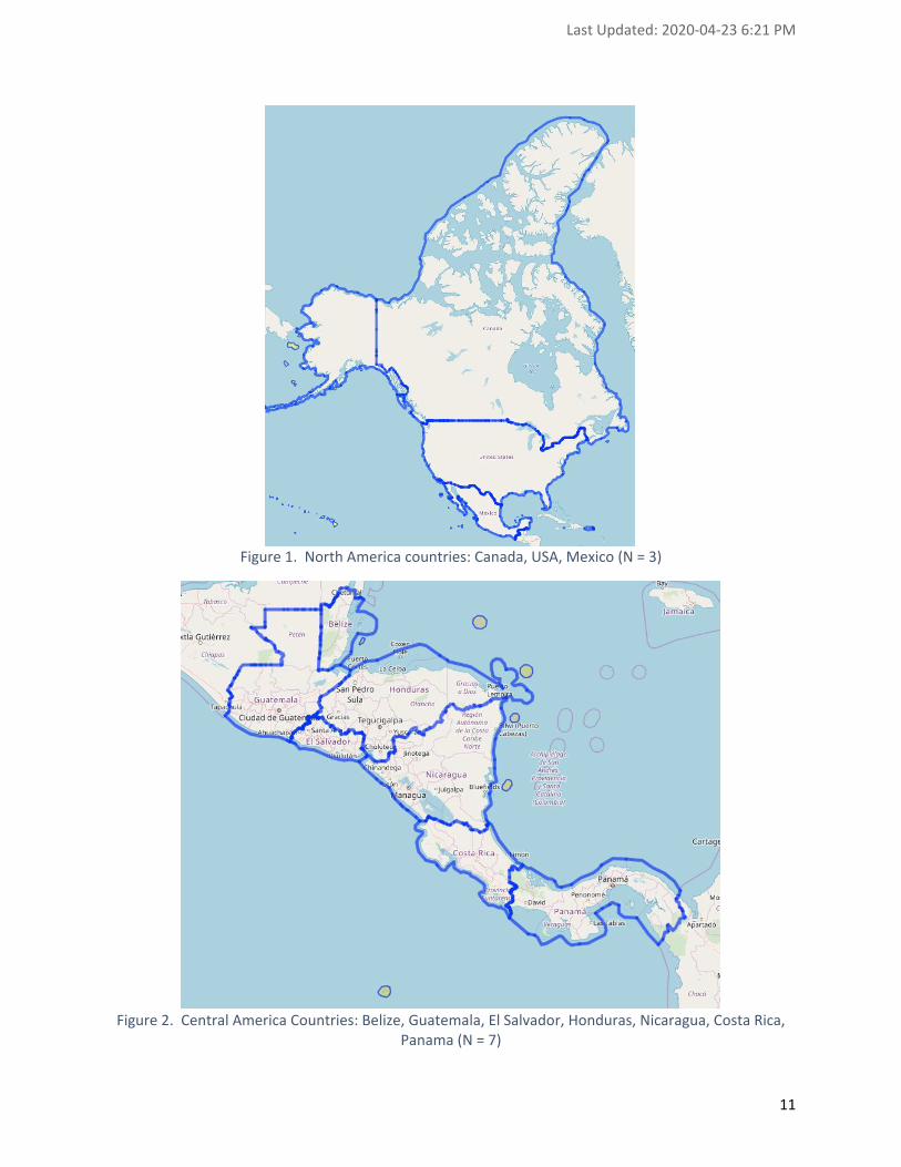
The Americas is a vast region with a large number of distinct countries and territories. The region comprises North-, Central- and South-America, and the Caribbean; it spans 2 hemispheres, from the North to the South poles with varying landscapes and has a total population approximating 1 billion persons. There are a total of 35 independent countries in the Americas region, as well as 3 groups of countries and territories that fall under the rule of certain European countries (former colonies), especially within the Caribbean. These include the United Kingdom (Anguilla, Bermuda, British Virgin Islands, Cayman Islands & Turks and Caicos Islands), The Kingdom of the Netherlands (Aruba, Curacao and Sint Maarten (dependent countries), and Bonaire, Saba and Sint Eustatius (territories)), France (Guadeloupe, Guiana, Martinique, Saint Barthelemy, Saint Martin). Furthermore, the USA also has territories situated within the Caribbean (US Virgin Islands and Puerto Rico). The representation of countries within the UNGGIM Americas Regional Committee is high. All 35 independent countries, as well as 1 dependent country (Sint Maarten) (total 36 countries) are represented with geo-officials within the Regional Committee. Aside from Sint Maarten, other dependent countries within the Americas region currently are not represented within the Regional Working Group, as a result of which the survey does not capture the full measure of preparedness in the use of GIM for disaster risk reduction within the region. However, it is a good starting point to establish the nature of the GIM landscape in the Americas. Considering the vastness of the Americas region, for the purposes of some sub-regional comparisons of the survey results, with the knowledge that there may distinctions (i.e. scale, climate, affluence) among the sub-regions that can be relevant for the analysis that may influence the level of GIM development in the respective countries, the survey results have been categorized by the sub-regions of North, Central and South Americas and the Caribbean. Figures 1 to 4 below show the 35 countries of the Americas that answered the 2018 survey: North America (N = 3), Central America (N = 7), the Caribbean (N = 13) and South America (N = 12).
Last Updated: 2020-04-23 6:21 PM
11
Figure 1. North America countries: Canada, USA, Mexico (N = 3)
Figure 2. Central America Countries: Belize, Guatemala, El Salvador, Honduras, Nicaragua, Costa Rica,
Panama (N = 7)

Last Updated: 2020-04-23 6:21 PM
12
Figure 3. Caribbean countries: Cuba, The Bahamas, Jamaica, Haiti, Dominican Republic, Sint Maarten,
Antigua and Barbuda, Dominica, Saint Lucia, Barbados, Saint Vincent and the Grenadines, Grenada, Trinidad and Tobago (N = 13)
Figure 4. South America: Venezuela, Guyana, Suriname, Colombia, Ecuador, Bolivia, Peru, Brazil,
Uruguay, Paraguay, Chile, Argentina (N = 12)

Last Updated: 2020-04-23 6:21 PM
13
2. Survey Findings and Diagnosis
This section covers the findings related to the 2018 survey sent to “geo-officials” of UN-GGIM Americas member countries.
2.1 Survey Objectives
In an effort to determine the gaps among member countries, in development and capacities in the area of GIM for DRM, the survey poses questions to participating country representatives in various areas. The questions are intended to get an understanding of:
• the roles and involvement of the respondent organizations in disaster events;
• the institutional aspects that influence the functioning of the respective GIM organizations in DRR and DRM;
• the manner in which the countries deal with the access, use and sharing of information in DRM;
• the level of resources available to the respective organizations; and
• the potential impacts of Climate Change on natural disasters the countries confront and the response operations in this regard.
The questions are further explained below. 1. Involvement in Previous Disaster Events
This set of questions (Q 9 - 16) aimed to ascertain, in the opinion of the respondents, the scaled level of importance (Low/Average/High) of most prevalent types of disasters (i.e. hurricanes, floods, wildfires, earthquakes, landslides, disease outbreaks) within the respective countries. Furthermore, it aims to form an understanding of the types of roles (responsible, support, advice, none) the respective respondents or GIM organizations have been involved in (preparedness, response, recovery) with respect to various types of DRM events.
2. Institutional Aspects The first set of questions in the survey (Q 1 – 8) are aimed to get a general understanding of the institutional landscape of the respective countries, as it relates to the legal, technical and financial frameworks related to GIM for DRM. The questions (Q 17 – 20) also address some of the respective in-country institutional aspects related to DRM. These questions try to ascertain if there are legislative policies that allow open access to geospatial information for DRM in the respective countries1, as well as the state of play as pertains to access to additional resources (staff, funds, new data), in the event of disasters. The questions also try to ascertain if all necessary stakeholders (i.e. health, transportation, municipalities, communications, media) are involved in the DRM organization. Furthermore, the survey tries to ascertain for which types of disaster events, countries have documented emergency plans.
3. Information This list of questions (Q 21 – 24) is aimed at gaining an understanding of the types of challenges (i.e.: none, not available, source unknown or not authoritative, sources conflicting, access restrictions, no access standards, other) the respective respondent entities may have, in terms of being able to access, use and share GI in the context of DRM.
1 Open access is defined as the ability to use the information without restrictions for Disaster Management.

Last Updated: 2020-04-23 6:21 PM
14
Furthermore, the survey aims to ascertain (through ranking) the preferred method (door-to-door, mailing list, newspaper, radio, social media, television) to share information with the affected communities and stakeholders, in the context of DRM.
4. Resources The questions (Q 25 – 27) aim to gain perspective on the degree (meet the needs, absent, to-be-improved) to which the respondent entities have access to various tools and systems that are necessary or useful within the context GIM for DR reduction and management. These tools and systems include: office software, GIS tools, databases, spatial databases, internet access, internet bandwidth, as well as applications for: common operation picture, vulnerability identification, risk mitigation, damage assessment, collaboration, routing, mobile use, social media and other applications. Furthermore, these questions also aim to assess the degree to which the expertise (human resources) required in the context of DRM in various applications (i.e. spreadsheets, GIS, data-integration, database management) is available within the respondent country GIM organizations. Lastly, the questions aim to assess the degree to which the respondent GIM organizations avail of the various levels of staff (technician, professional, administrative) that may be needed in the context of DRM.
5. Climate Change The questions in the area of Climate Change (Q 28 – 30) are aimed to get impressions, in the opinion of the respondents, concerning the level of impact (low/average/high) that Climate Change has on the various types of natural disasters (hurricanes, floods, wildfires, coastal erosion, landslides) that may occur in the respective countries. The questions also aim to ascertain the level of preparedness (yes/in-progress/no) of the respective countries, in terms of DRM operations, for the impacts of Climate Change on the mentioned types of disasters. Lastly, these questions aim to assess the level of preparedness of the respective countries, for the impacts of Climate Change on the methodologies to plan, build and inspect infrastructure (Roads, Building, Power lines, Communication, Transportation).
6. Other Comments The question in the last section (Q 31 – 34) were open questions, intended to obtain some qualitative thoughts of the respondents, such as other actions that could be initiated to enable more effective use of GI for DRM, indication of reference material, such as relevant best practices, and useful thoughts for the purpose of the survey.
2.2 Respondents
Of the 36 countries represented in the UNGGIM Americas Regional Committee, 35 (97%) answered the 2018 survey.
2.3 Data Preparation
The data received from the survey questions was prepared for analysis, partly using traditional plots applied on most of the individual survey questions. However, some of the analysis required data repurposing, using for example pivot tables and combining categorical variables, to be able to represent regional trends.

Last Updated: 2020-04-23 6:21 PM
15
2.4 Analysis of Survey Results
This section provides analyses on what are considered to be highlights of the survey exercise as far as disaster management is concerned. Survey questions are grouped in subsections according to the 5 topics outlined in section “Survey objectives” above. All of the survey questions are included in the appendices of this report and the responses are illustrated in plots per sub region wherein the respective countries are located. Note: the numbering of questions in the survey does not necessarily match the order chosen for the five subsections.
2.4.1 Involvement in Previous Disaster Event
The questions in this Section (Appendix 1: Q 9 – 16) are intended to get an impression of the most prevalent types of disasters that member countries face, and to ascertain the roles and responsibilities of the GIM organizations within the respective countries have in the various stages of, and with respect to various types of DRM events. First of all, country representatives were asked (Q 9) to assess the level of importance of various types of disasters in their own countries, using the following list of possible (natural) disasters: hurricanes, floods, wildfires, earthquakes, landslides and disease outbreaks. Questions related to disaster types are indicative of their perceived level of threat for each country. As shown in the relevant plots – and as expected – disaster types are perceived at different levels of importance depending on their occurrence and severity. Somewhat expectably, the takeaway from the survey is that irrespective of disaster type, the combined count of average to high importance outweighs that of low importance and or no reply. That is, disasters are generally issues of concern. The plots relative to question 9 highlight the importance of all disaster types summarized by regions. Each individual plot shows the count of countries (y axis) as a function of perceived importance (x axis) with sub regions stacked in separate color bars. The sum of counts for all plots amounts to N = 35, the total number of countries surveyed. The figures below show a subset of the Appendix 1 plots corresponding to floods and hurricanes. Floods are considered by a vast majority of countries (89%) as being highly important. In contrast to hurricanes, none of the countries surveyed rated the importance of floods as either “Low” or “Not apply”.

Last Updated: 2020-04-23 6:21 PM
16
Figure 5. Level of importance - floods
Figure 6. Level of importance - hurricanes
The second most highly rated disaster event, based on the survey results, is that of hurricanes. 55% of all survey participants rated hurricanes as high in importance. As can be expected for several types of (natural) disaster occurrences, location matters. Hurricanes for example are most prevalent in the tropical regions that are close to the sea. This is evident by the fact that all Caribbean countries rated hurricanes as highly important disaster events. Based on the survey results, it can be ascertained that Earthquakes are the third most highly rated disaster events, with 50% of the surveyed countries rating this disaster as high in importance. Also, the prevalence of earthquakes is very much dependent on location, in relation to the proximity of countries to the divisions of tectonic plates. The plots in Appendix 1 under question 9 give a more complete overview of the survey responses to the question of the importance of disaster types per region. The table below provides an overview of the total results among the countries.

Last Updated: 2020-04-23 6:21 PM
17
Table 2. Importance of specific disaster types for all countries
Disaster High+Ave. (%) High (%) Average (%) Low+No Apply (%)
Floods 100 88 12 0
Hurricanes 70 55 15 30
Wildfires 82 41 41 18
Earthquakes 70.5 50 20.5 29.5
Landslides 73.5 38.2 35.3 26.5
Disease outbreaks
82.3 35.3 47 17.7
It should be noted that after the fact it is observed that 2 important potential types of natural phenomena that may cause disasters to human populations, namely droughts and snow storms, were not included in the survey. This is considered a shortcoming that will need to be incorporated in future iterations of the survey. To the question (Q 10) as to whether the themes of Risk and Disasters are incorporated into the Geospatial Data Infrastructure of the respective countries, less than half (49%) of the surveyed countries have indicated that they are. However, it is interesting to note that the 3 North American countries answered that they do not have risk and disaster incorporated in their NSDI. Again, the answer to that question brings the related question of whether every country has a NSDI. While the responses may be
surprising or puzzling, there may be more simple reasons at play, which needs to be investigated. For example, the North American countries, while among the more affluent in the region, are also the largest, with several layers of Government (national, states/provinces, municipalities/counties, cities), with varying levels of autonomy and resources available. It should be noted that especially the national levels have been surveyed, while it is possible that the themes of Risk and Disaster may be incorporated in more local NSDI. Furthermore, this question could test the value of the hypothesis relating to the importance of incorporating these themes in a NSDI, compared to the value of having an open data policy on a national level, which enables local governments to be more responsive and effective in managing GI. for DRM.
The following questions in this section (Q 11 – 16) attempt to understand the role of the respective respondents and respondent agencies (i.e. Responsible, Support, Advice, No-Role) in the event of the various types of disasters. Also, in this case, not surprisingly the role of participants is dependent on the perceived importance of the particular types of disasters for the country (not all types of disasters are important to all countries); the more important the disaster is perceived, the more prominent the role.
Figure 7. Risks and disasters incorporated in NSDI

Last Updated: 2020-04-23 6:21 PM
18
For example, in the event of floods, being the most prominent disaster type, 85% of respondents indicate that their agency plays a role in response to such disasters. As an illustration, below are the types of disasters where some agencies do not have a role in the response (generally mirrors the perceived importance of the disaster for the country/agency):
• Floods: 15% no role;
• Hurricanes: 29.4% no role;
• Wildfires: 47% no role;
• Earthquakes: 32% no role;
• Landslides: 35% no role;
• Disease outbreaks: 44% no role. In general, when a disaster event is perceived as important, then the GIM agencies generally have a role of “Advice” or “Support” in the response to such events, while a very small minority of agencies that responded have indicated to have a role of “Responsible” in response to disasters. A caveat to the responses indicated may be that the responses are dependent on the type of agency, as there are varying types of agencies designated as country GI officials within UN GGIM Americas.
2.4.2 Institutional Aspects
This section (Q 1 – 8, 17 – 20) covers aspects such as legislations, policies and open data in relation to DRM. Hypotheses for this section include that there exists various levels of data access and legislative/regulatory differences, potentially among regions of the Americas.
To the first question (Q 1): if there is an administrative act (Law, Decree, etc.) that regulates the management of risks and disasters in the respective countries, the vast majority of countries (91%) answered they did have regulations for disaster management, as shown in the figure on the left. Merely 3 countries, namely 2 Caribbean and 1 South American country surveyed indicated that they do not have such a law in place.
Figure 8. Administrative act regulating DRM

Last Updated: 2020-04-23 6:21 PM
19
To the question (Q 2): Which entity or entities exercise the authority in risk and disaster management in the country, a majority of countries (54%) mentioned there were no authorities responsible for disaster management in their jurisdictions. Answers to this question in the survey were free form, so we grouped countries that mentioned the name of their authorities as having a “National level” authority, as pictured in the relevant plot. It is interesting to note that all the Central American and the vast majority of South American countries mentioned that there were no authorities responsible for disaster management. Furthermore, to the question (Q 3): if the Spatial Data Infrastructure of your country an official tool to manage information related to risks and attention to disasters, a majority (63%) of countries, including all 3 countries of North America, answered that their NSDI was not an official tool for information related to DRM . It is not known at this point whether countries that answered “no” did so because their NSDI was not an official tool or because there was no NSDI altogether. Considering the results shown in the following paragraph to the effect that a majority of countries do not have a geoportal viewer, it may be surmised that some countries lack a NSDI altogether. In similar pattern, to the question (Q 4): if there is a geospatial resource (geoportal, viewer, etc.) that manages risk and disaster information in the respective country, a majority of countries (57%) answered they had no geoportal or viewer. It is noted that especially the Caribbean countries trail significantly in this respect, while also the sub region of South America demonstrates a slight majority of countries lacking this resource.
Figure 9. Authority responsible for DRM
Figure 10. Office risk management tool
Figure 11. Geoportal viewer for DRM

Last Updated: 2020-04-23 6:21 PM
20
In response to the question (Q 5): if there is a mechanism for monitoring the production of information related to risks and disasters in the municipalities, an overwhelming majority (89%) of countries answered “Yes” with only four South American countries answering “No”.
However, in response to the question (Q 6) relating to the percentage of municipalities have updated risk and disaster information, overall, not many countries say they have more than 50 % of their cities or municipalities having updated risk and disaster information. A vast majority of Caribbean countries, as well as a small majority of South American countries report having less than 25 % of their municipalities with updated risk and disaster information.
In response to the question (Q 7): if there is a financial model for the continuous production of useful information for risk management, less than half of the countries (46%) report they do have a financial model for this purpose. However, Caribbean countries - and in a lesser proportion South American countries – are lagging in this area the most. This may be attributed to the scale (population and economic base) of these respective countries, which is a matter that may need to be looked into in greater detail.
Figure 12. Monitoring of risk in municipalities
Figure 13. Percent municipalities with up-to-date information
Figure 14. Financial model for RM information
Last Updated: 2020-04-23 6:21 PM
21
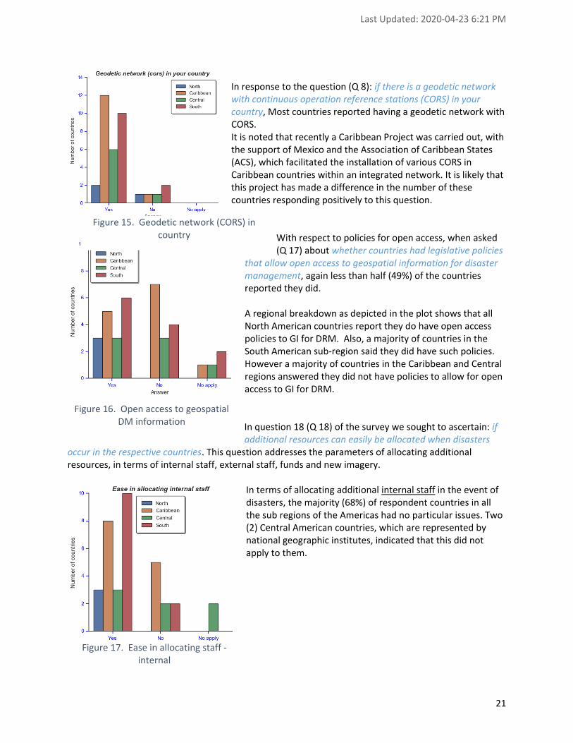
In response to the question (Q 8): if there is a geodetic network with continuous operation reference stations (CORS) in your country, Most countries reported having a geodetic network with CORS. It is noted that recently a Caribbean Project was carried out, with the support of Mexico and the Association of Caribbean States (ACS), which facilitated the installation of various CORS in Caribbean countries within an integrated network. It is likely that this project has made a difference in the number of these countries responding positively to this question.
With respect to policies for open access, when asked (Q 17) about whether countries had legislative policies
that allow open access to geospatial information for disaster management, again less than half (49%) of the countries reported they did. A regional breakdown as depicted in the plot shows that all North American countries report they do have open access policies to GI for DRM. Also, a majority of countries in the South American sub-region said they did have such policies. However a majority of countries in the Caribbean and Central regions answered they did not have policies to allow for open access to GI for DRM. In question 18 (Q 18) of the survey we sought to ascertain: if additional resources can easily be allocated when disasters
occur in the respective countries. This question addresses the parameters of allocating additional resources, in terms of internal staff, external staff, funds and new imagery.
In terms of allocating additional internal staff in the event of disasters, the majority (68%) of respondent countries in all the sub regions of the Americas had no particular issues. Two (2) Central American countries, which are represented by national geographic institutes, indicated that this did not apply to them.
Figure 15. Geodetic network (CORS) in country
Figure 16. Open access to geospatial DM information
Figure 17. Ease in allocating staff - internal

Last Updated: 2020-04-23 6:21 PM
22
In terms of allocating external staff to support in the event of disasters, a minority (47%) of respondents indicated that this additional resource can easily be allocated when needed. In this respect, only one country in Central America indicated this resource to be easily allocated, while three (3) respondents from Central America and one (1) from the Caribbean indicated that this resource did not apply to them.
In terms of allocating additional funds to support in the event of disasters, a relative majority (68%) of respondents indicated that this was not a problem in their country. Allocating new imagery in the event of disasters seems for
some countries more challenging, as a minority (47%) of countries regarded this as easy. It is noted in this respect that a majority of Caribbean countries and a significant amount of countries from South America faced this difficulty when disasters occur.
The takeaway for this series of questions is that globally, regions do not have much problem allocating extra human resources. However, funds and especially new imagery is listed by many Caribbean countries as being hard to obtain.
Figure 18. Ease in allocating staff - external
Figure 19. Ease in allocating funds
Figure 20. Ease in allocating new imagery

Last Updated: 2020-04-23 6:21 PM
23
Also in an attempt to further ascertain the level of preparedness of countries for disaster management, question 19 (Q 19) seeks to establish: if there are any stakeholders missing, that should be involved in disasters management in the respective countries. The questions paid special attention to the fields of health, transportation, municipalities, television stations and radio stations. Overall, as, shown in Appendix 2, a majority (75% – 80%) of these stakeholders are present and involved in response to disasters in the countries of the region:
• For the health sector, about 20% of countries indicated these stakeholder to be missing.
• For transportation, about 26% of countries indicated these stakeholders to be missing.
• For municipalities, about 23% of countries indicated these stakeholders to be missing.
• In the cases of both television and radio stations, surprisingly about 20% of countries indicated that these stakeholders are missing or not involved in disaster management efforts in the countries.
Question 20 (Q 20) seeks to ascertain the level of preparedness for disasters of countries in the region, with the question: for which disaster events there are documented emergency plans in the respective countries. In this regard, the issue of location and the perceived probability of a particular type of disaster play a role in the responses of the countries. A vast majority of countries, either has detailed or informal plans for all disaster types, however countries with a higher perceived probability of the occurrence of a particular type of disaster are more likely to have more detailed and documented emergency plans for those disasters. The figures below illustrate this point.
Figure 21. Hurricanes: details of emergency plans vs perceived importance

Last Updated: 2020-04-23 6:21 PM
24
Figure 22. Floods: details of emergency plans vs perceived importance
In the case of hurricanes, which are more prevalent in the Caribbean and Central America area, all Caribbean countries indicated that they have emergency plans for hurricanes, with a single (1) country of the Caribbean indicating that they have only informal plans for this disaster type. However, the majority of South American countries indicated that they do not have such plans because this disaster type does not apply to their country. Alternatively, for floods, which is a disaster type that affects all countries, all countries indicated that they have emergency plans for such events, with the majority of respondents in all sub regions indicating that these plans are documented. It is however noteworthy, that although floods were identified as a serious threat by almost all countries, many of them still have only an informal emergency plan for such an occurrence. The other disaster types show mixed results, as can be seen in the following table, which lists the level of preparedness in terms of having emergency plans for the respective countries.
Table 3. Level of preparedness per disaster type
Disaster Detailed plans (%) Informal plans (%) No plan (%) No apply (%)
Hurricanes 61.5 9 6 23.5
Floods 67.5 32 0 0
Wildfires 44 26.5 20.5 9
Earthquakes 53 26.5 11.5 9
Landslides 47 32 11.5 9
Disease outbreaks 56 29.5 11.5 3

Last Updated: 2020-04-23 6:21 PM
25
Interestingly, more than half (54%) of Caribbean countries indicated that they either have no plans to deal with wildfires, or that to have an emergency plan for such occurrence does not apply to them. Similarly, it is interesting to note that for the event of landslides and disease outbreaks, , Canada, indicated that having emergency plans for these disaster types does not apply.
2.4.3 Information
This section (Q 21 – 24) covers aspects of access and dissemination of GI related to disasters. The aim is to gain an understanding of the challenges of the respective countries in terms of being able to access, use and share GI in the context of DRM. Access to geospatial information The first question in this section (Q 21) is for respondents to: indicate the challenges they face regarding access to GI in the context of DRM. The categories of information that is being considered includes information about 15 separate variables as noted below. The possible multiple-choice responses in terms of challenges to each of the sections to this question are: 1) no issue, 2) not available, 3) source unknown (or not authoritative), 4) sources conflicting, 5) access restrictions (i.e. fees, security constraints), 6) no access standards and 7) other. The table below provides an overview of the responses (individual plots are found in Appendix 3).
Table 4. Challenges regarding access to GI in the context of DRM
Access (%) No-issue Not available Restrict. Source Many issues Other
Admin boundaries 67.5 3 11.5 6 9 3
EO Optical imagery 35 11.5 20.5 3 26.5 3
EO radar imagery 17.5 29.5 26.5 3 17.5 6
EO real time imagery 6 44 29.5 3 17.5 0
Terrain data (elev., slope, etc.) 56 14.5 11.5 9 3 6
Emergency resources 41 14.5 9 11.5 9 14.5
Hydrography 79.5 3 9 6 0 3
Hydrology 38 26.5 17.5 6 9 3
LiDAR Point Cloud 14.5 38 23.5 9 14.5 0
Persons affected 35 17.5 11.5 3 23.5 9
Public infrastructure 64.5 9 9 11.5 6 0
Transportation infrastructure 70.5 6 3 9 11.5 0
Utilities 47 11.5 11.5 14.5 11.5 3
Weathers actuals 67.5 9 6 9 9 0
Weather forecasts 70.5 14.5 6 6 3 0
The responses to the questions are varied and there are no (immediately) notable difference in the responses with respect to the sub regions of the Americas. For a point of reference a distinction has been made of the types of information for which less than half (50%) of the countries have no issues accessing. These items are highlighted in red in the table. Based on the responses, it is concluded that the most issues are found especially with respect to the access to information about EO imagery, hydrology, LiDAR Point Cloud and persons affected by disasters.

Last Updated: 2020-04-23 6:21 PM
26
Use of geospatial information The next question (Q 22) aims to understand: the challenges countries face with usage of geospatial information in the context of DRM.
Table 5. Challenges regarding usage to GI in the context of DRM
Access (%) No-issue Not available Restrict. Source Many issues Other
Admin boundaries 73.5 6 11.5 3 3 3
EO Optical imagery 35 14.5 38 3 9 0
EO radar imagery 23.5 35 26.5 3 11.5 0
EO real time imagery 14.5 38 35 3 9 0
Terrain data (elev., slope, etc.) 56 17.5 11.5 9 6 0
Emergency resources 50 20.5 6 9 11.5 3
Hydrography 82 3 6 9 0 0
Hydrology 47 17.5 14.5 9 11.5 0
Lidar Point Cloud 20.5 41 11.5 6 17.5 3
Persons affected 38 23.5 17.5 9 9 3
Public infrastructure 67.5 9 9 6 9 0
Transportation infrastructure 76.5 6 6 6 6 0
Utilities 56 9 11.5 14.5 9 0
Weathers actuals 70.5 9 6 11.5 3 0
Weather forecasts 76.5 9 6 6 3 0
Based on the responses submitted, as may be expected it is concluded that while there are some minor differences, the result with respect to the use of the information generally approximate the results with respect to access to the information. Sharing of geospatial information The following question (Q 23) aims to understand: the challenges countries face with sharing of geospatial information in the context of DRM.
Table 6. Challenges regarding sharing of GI in the context of DRM
Access (%) No-issue Not available Restrict. Source Many issues Other
Admin boundaries 70.5 3 11.5 6 6 3
EO Optical imagery 29.5 14.5 35 3 17.5 0
EO radar imagery 14.5 35 26.5 3 20.5 0
EO real time imagery 6 50 26.5 3 14.5 0
Terrain data (elev., slope, etc.) 61.5 17.5 9 11.5 0 0
Emergency resources 41 14.5 17.5 9 11.5 6
Hydrography 82 3 9 6 0 0
Hydrology 50 20.5 14.5 9 6 0
Lidar Point Cloud 23.5 47 11.5 3 14.5 0
Persons affected 32 20.5 20.5 9 14.5 3

Last Updated: 2020-04-23 6:21 PM
27
Public infrastructure 61.5 6 11.5 11.5 9 0
Transportation infrastructure 64.5 6 11.5 9 9 0
Utilities 53 6 14.5 11.5 14.5 0
Weathers actuals 73.5 6 9 11.5 0 0
Weather forecasts 76.5 6 9 6 3 0
Similarly to the results on the use of GI information for DRM, the results with respect to the sharing of information also generally reflect the similar results to the access of GI information in the context of DRM. Sharing of disaster risk information In the following question (Q 24) respondents were asked to: Rank from 1 to 5 (the preferred way to share information in your country in the context of Disaster Management. In this case, the sharing of information pertains to general public information, and not necessarily geospatial information. The ranking was to be done in decreasing order of importance from 1 to 5 among the following set of information sharing method:
• Door to door
• Mailing list
• Newspaper
• Radio
• Social media
• Television
Table 7. Preferred way to share information
Ranking of DR info Sharing method (%)
1 2 3 4 5
Door to door 20.5 29.5 11.5 9 29.5
Mailing list 11.5 23.5 29.5 11.5 23.5
Newspaper 20.5 38.5 20.5 14.5 6
Radio 64.5 11.5 9 11.5 3
Social Media 58.5 17.5 9 9 6
Television 64.5 11.5 9 9 6
The results, rounded off for convenience of interpretation, illustrate that the television and radio are still the most popular forms of sharing disaster risk information with the larger population, with social media competing in the top 3 in all sub regions of the Americas. One item of interest is that “door-to-door” has high importance for almost one-third of Caribbean countries. This may be as a result of the scale of many of the Caribbean countries. The plots in appendix 3 illustrate more specific details about the responses.

Last Updated: 2020-04-23 6:21 PM
28
2.4.4 Resources
The questions in this section (Q 25 – 27) address the matter of available resources within the respective countries, related to preparedness for DRM. Question 25 (Q 25) of the survey grouped a number of items, in terms of IT systems, on which countries were asked to: indicate the status (i.e. meets the needs (OK), needs upgrade, absent) for each type of (IT) system required in the context of DRM. The items included are indicated in the following table:
Table 8. Level of preparedness of IT systems and software with respect to DRM
Tools Ok % Need upgrade % Absent %
Office software 44 56 0
GIS Tools 38 56 6
Databases 20.5 70.5 9
Spatial Databases 20.5 65 14.5
Common Operational picture app. 9 56 35
Vulnerability identification app. 12 62 26
Risk mitigation app. 12 62 26
Damage assessment app. 17.5 65 17.5
Collaboration app 12 62 26
Routing app. 15 59 26
Mobile app. 12 59 29
Internet access 41 56 3
Internet bandwidth 32 68 0
The plots in Appendix 4 illustrate the results for each IT system, distinguished by sub region of the Americas. The overall picture, as illustrated in the table above is that a majority of countries, irrespective of region, consider that upgrades are needed in all areas surveyed. In question 26 (Q 26), country representatives were asked to: indicate the status (i.e. meets the needs (OK), needs upgrade, absent) for each type of expertise required in the context of DRM. The items included are indicated in the following table:
Table 9. Level of expertise with respect to DRM
Expertise required Ok % Needs upgrade % Absent %
Spreadsheets 47 50 3

Last Updated: 2020-04-23 6:21 PM
29
GIS 32 62 6
Data integration 17.5 76.5 6
Database management 14.5 76.5 9
The plots in Appendix 4 illustrate the results for each IT system, distinguished by sub region of the Americas. As illustrated in the table above, a majority of countries, irrespective of region, consider that upgrades are needed in all areas surveyed. The expertise to manipulate spreadsheets gets the highest score, relatively speaking, with North America surveyed as quite competent, and for a majority of South America countries also indicating to be relatively competent in this area. The big takeaway from this question however, is that Caribbean countries largely report they need improvement in expertise. With respect to Human Resources, question 27 (Q 27) of the survey grouped a number of HR profiles on which countries were asked to: indicate the status (i.e. meets the needs (OK), needs upgrade, absent) for each type of staff involved in the context of DRM. The items included are indicated in the following table:
Table 10. Status of HR profiles necessary for DRM
Staff involved Ok % Needs upgrade % Absent %
Technician 41 59 0
Professional 41 56 3
Administrative. 50 50 0
The responses to this question show that in general there is also room for improvement in this area, though not of great disparity in the amounts. The majority of countries from North America indicate that the competences in this area generally meet the needs. South and Central America sub regions show balanced results in this area, while a majority of Caribbean countries identify a need for improvement in all categories.
2.4.5 Climate Change
Although Climate Change does not have an impact on gap analysis per se, the survey sought to identify the perceived level of threat Climate Change has on disaster types and whether countries felt they had the necessary level of preparedness to cope. The specific plots per item are detailed in Appendix 5 of this report; the results are summarized in the following tables. Effect of climate change on disasters Question 28 (Q 28): rate as “Low”, “Average”, “High” or “No-apply” the potential impact of Climate Change regarding the following disasters in your country, sought to identify how countries view the impact of climate change on various types of disasters in the respective countries. As expected, a vast majority of countries believe climate change will have a high impact on disasters in general.
Table 11. Potential impact of climate change on disasters
Impact of Climate Change on (%) High Average Low No-apply
Hurricanes 67.5 6 12 14.5

Last Updated: 2020-04-23 6:21 PM
30
Floods 88 9 0 3
Wildfires 47 32 18 3
Coastal erosion 59 29 6 6
Landslides 61.5 20.5 12 6
The responses are, as expected, related to the perceived prevalence of the particular type of disaster within the respective countries. Emergency plans readiness The purpose of question 29 (Q 29): rate as “Yes”, “In progress”, “No” or “No-apply” your preparedness level for the impacts of Climate Change regarding the following disasters in your country, was to determine how ready countries are in terms of emergency plans for each type of disaster. Most countries report their plans are either ready or in progress, while ‘in-progress’ appears to be the most common answer. Also in this case, the responses are dependent on the prevalence of certain types of disasters within the respective countries, as obviously countries will be less inclined to have emergency plans ready for disasters that are rare in the country.
Table 12. Emergency plans readiness per disaster type
Preparedness for Impacts with Emergency Plans
Yes In progress No No-apply
Hurricanes 32.2 35.3 6 26.5
Floods 26.5 67.5 0 6
Wildfires 12 61.5 20.5 6
Coastal erosion 6 70 12 12
Landslides 14.5 59 12 14.5
Infrastructure preparedness Question 30 (Q 30): rate as “Yes”, “In progress”, “No” or “No-apply” your preparedness level for the impacts of Climate Change regarding the methodologies to plan, build and inspect your infrastructures, was formulated to determine the level of preparedness of countries in relation to the effects of climate change on their major infrastructure items: roads, buildings, power lines, communication and transportation. The table below shows that very few countries consider that they are “ready”, with a vast majority saying they are “in progress”. It is peculiar to note in Appendix 5 that the three countries in North America – again among the most developed of the Americas – mention they are not ready to cope with the effects of climate change on their infrastructure.
Table 13. Preparedness level for the impacts of climate change
Preparedness for Climate Change Impacts: Methodologies for Infra.
Yes In progress No No-apply
Roads 18 61.5 20.5 0
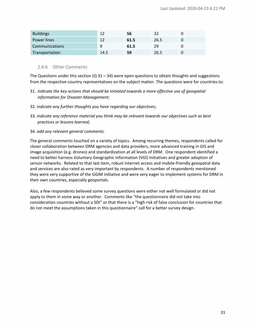
Last Updated: 2020-04-23 6:21 PM
31
Buildings 12 56 32 0
Power lines 12 61.5 26.5 0
Communications 9 61.5 29 0
Transportation 14.5 59 26.5 0
2.4.6 Other Comments
The Questions under this section (Q 31 – 34) were open questions to obtain thoughts and suggestions
from the respective country representatives on the subject matter. The questions were for countries to:
31. indicate the key actions that should be initiated towards a more effective use of geospatial
information for Disaster Management;
32. indicate any further thoughts you have regarding our objectives;
33. indicate any reference material you think may be relevant towards our objectives such as best
practices or lessons learned;
34. add any relevant general comments.
The general comments touched on a variety of topics. Among recurring themes, respondents called for closer collaboration between DRM agencies and data providers, more advanced training in GIS and image acquisition (e.g. drones) and standardization at all levels of DRM. One respondent identified a need to better harness Voluntary Geographic Information (VGI) initiatives and greater adoption of sensor networks. Related to that last item, robust internet access and mobile-friendly geospatial data and services are also rated as very important by respondents. A number of respondents mentioned they were very supportive of the GGIM initiative and were very eager to implement systems for DRM in their own countries, especially geoportals. Also, a few respondents believed some survey questions were either not well formulated or did not apply to them in some way or another. Comments like “the questionnaire did not take into consideration countries without a SDI” or that there is a “high risk of false conclusion for countries that do not meet the assumptions taken in this questionnaire“ call for a better survey design.

Last Updated: 2020-04-23 6:21 PM
32
3. Gap Analysis
Gap analysis involves comparing the current measured state with a desired target. In this report, the desired target is considered to be the five priority areas of the GSF which are slightly enhanced to include some of the recommendations of the Sendai Framework for Disaster Risk Reduction (DRR) and the evolution of technologies particularly in Priority 4: “Common Infrastructure and Services”. Gaps differ from country to country and even within sub-region. So, gaps are presented as required action items although they may not be relevant in some countries. The table at the end of this Section shows the level of importance of each gap per sub-region and as a function of the five priority areas for action of the GSF. Actions to fill the gaps are described in the following five sections, each of which begins with an excerpt from the GSF in italics to provide some context. Most of these actions apply in the three phases of disasters: Preparedness, Response and Recovery and will enhance resilience across the region. Countries should take into consideration their respective capacities, resources and priorities, as well as laws and regulations when implementing them. The proposed actions to fill the gaps should serve as a guide, and can be further customized by each country depending on their political, cultural and socio-economic situations.
3.1 Governance and Policies
The management of geospatial information and services for disasters shall be based on good governance and science-based policies. Such policies should collectively form part of other equally important policies on awareness raising and capacity building, data management, infrastructure and services, and resource mobilization. Specific activities shall include assessment and planning; institutional arrangements, collaboration and coordination and monitoring and evaluation. The status related to Governance and Policies is mainly described in the responses to questions 1 to 17 of the survey.
3.1.1 Governance Actions
1. A working group to address GI related to DRM is established. The working group oversees assessment and planning, institutional arrangements, collaboration and coordination and monitoring and evaluation of all aspects related to the efficient use of GIS related to DRM.
2. The working group is headed by the organization responsible for DRM if there is one. The National Mapping Agency is involved as technical advisor and as one of the main providers of GI, mainly imagery. The intent is to have a working group led by the business domain and supported by the technical experts and not the opposite; when no organization is responsible for DRM as is the case in a number of countries in Central and South America, Civil Defense should be considered.
3. The participants to the working group include agencies managing health, transportation, weather, the environment as well as representatives of local government.
4. The working group is instituted under the legislation related to DRM if there is one (only 3 countries do not have one), if not actions towards such a legislation should be part of its role, in particular as it is related to open access to GI for DRM.
5. The working group is included in the NSDI, if there is one to leverage and comply with existing work in that domain; or contribute to the establishment of such infrastructure if not

Last Updated: 2020-04-23 6:21 PM
33
yet in place . In some countries, this SDI may be at the state, provincial or other jurisdiction level.
6. Cooperation between working groups in countries facing the same challenges is promoted, such as the vulnerability and risk reduction to hurricanes in the Caribbean.
7. Cooperation between working groups in neighboring countries is promoted in order to respond efficiently to cross-border disasters.
3.1.2 Policies Actions
1. Policies on collaboration, coordination and sharing regarding geospatial information are established, issued, promoted, made publicly available and implemented.
2. Existing geospatial information (data and services) is documented and maintained, including characteristics related to collection, accessibility and use (metadata).
3. Roles and responsibilities are defined, in particular authoritative sources and custodians for this information at all levels (local to national) to prevent duplication and enhance usage.
4. The GI is strengthened as needed to meet requirements. 5. Emergency and related plans (risk reduction, disaster preparedness) are revised to integrate
the efficient use of GI and related tools, starting with the most relevant hazards (e.g. floods, hurricanes, earthquakes) in a given country.
6. Best practices and lessons learned in the use and sharing of GI are built, including the role of local governments and citizens. These can be adaptations of international or regional documents and are shared with local governments that often lack the resources to develop them.
7. Open access to GI for DRM is promoted and implemented, in particular in Central America and the Caribbean.
8. Existing standards related to metadata and exchange formats are adopted using existing national (NSDI) or international ones (ISO, OGC).
3.2 Awareness Raising and Capacity Building
Risks and impacts of disasters will be properly managed if Member States and other stakeholders are fully aware of their respective geospatial data and information holdings. This requires all entities to bring the necessary changes towards making available and accessible quality geospatial information and services across all phases of DRM. The status related to Awareness Raising and Capacity Building is mainly described in the responses to questions 26 and 27 of the survey.
1. Promote awareness of GI significance for DRM at all levels by creating communication
material (risk maps, videos) that is understandable by politicians and decision makers and/or by reusing material produced in other countries.
2. Promote awareness of GI significance for DRM, in formal and non-formal education, as well as in civic education at all levels, as well as in professional education and training.
3. Use radio and TV as well as social media to distribute GI, in particular during disaster response, taking into account specific audiences, their needs and their preferred way of communications.
4. Conduct capacity building at all levels and all areas (technical, standards, policies) related to information management including local governments, first responders and NGOs working in the country (Red Cross, UNESCO, UCHAT, etc.).

Last Updated: 2020-04-23 6:21 PM
34
5. Examine the capacities of entities (private sector, education institutions, etc.) to provide training and match them with inventories of existing skills among stakeholders and other key partners, and urge Member States to respond to identified gaps, in particular the use of spatial databases and data integration and management, including imagery. The training should address the technical, professional and administrative levels.
6. Education and communications capacities and mechanisms are built and strengthened, in particular in academia and research agencies. In particular, research agencies should be involved in the development of the science for vulnerability and risk reduction models at the national and sub-regional levels.
7. Education material in the use and sharing of GI is developed for government officials at all levels, civil society, communities and volunteers, as well as the private sector.
3.3 Data Management
A comprehensive method of managing geospatial data and information for their optimal utility by the Member States and other stakeholders is crucial in implementing the strategic framework. These include specific activities on data development, including collection; data standards and protocols; and data use guidelines. Modern, cost-effective and open source technologies may be used to improve data and information management. The status related to Data Management is mainly described in the responses to questions 21 to 24 of the survey.
1. Geospatial databases and information products are developed, maintained and updated based on common standards, protocols and processes as important tools in every decision-making process across all phases of disaster risk management.
2. Geospatial databases include data from local to national and sub-regional levels as interoperable features.
3. Geospatial databases include Common Operating Datasets, Fundamental Operating Datasets,2 thematic vulnerability, predictions and resources (first responder, pumps, boats).
4. When government sources are not adequate, countries should look at other providers, such as OpenStreetMap for the transportation network or the US for Digital Elevation Models.
5. During disaster response, relevant stakeholders (local governments, phone companies, NGO’s) contribute to provide information on persons affected by disasters so that it is available to all.
6. During disaster response, National Mapping Agency provides free imagery using access provided by International Charter Space and Major Disasters (https://disasterscharter.org/ ).
3.4 Common Infrastructure and Services
Institutionalizing geospatial information and services requires infrastructure support, such as a common operations center, facilitated by a dedicated team of experts and support staff. This should be complemented by hardware and software acquisitions, as well as application systems, which will serve as data distribution platforms. Interoperability of information will likewise require facilities and systems duly recognized and supported by Member States and other key stakeholders.
2 CODs, are authoritative reference datasets needed to support operations and decision-making for all actors in a humanitarian response. FODs are datasets that are specific to a particular sector or fall outside the CODs such as schools, flood plains, security incidents, wells, etc.

Last Updated: 2020-04-23 6:21 PM
35
The status related to common infrastructure and services is described in the responses to questions 4 and 25 of the survey.
1. Common geospatial information facilities and services are established for all key stakeholders to have a common operational picture of disaster events.
2. A common infrastructure is provided to support geospatial databases and tools. This infrastructure is preferably cloud based so that it can easily scale during disaster response and requires limited resources otherwise.
3. The common infrastructure is built on interoperable services that comply with de-jure or de-facto standards.
4. Countries with limited resources can share an infrastructure or use existing ones provided by UN agencies such as UNOCHA.
5. A preferred way to access GI is implemented for different kinds of users, such as citizens, local and national stakeholders, as well as regional partners (geoportal).
6. Mobile Web browsers must be supported to access the geoportals and the common infrastructure.
7. A Common Operating Picture application is provided to coordinate DRM. 8. Social networks such as Facebook, WhatsApp, Twitter are leveraged to publicize and share
resources (volunteers, material, etc.).
3.5 Resource Mobilization
In order to support the activities identified in this framework, an array of human resources, as well as technical, financial and other forms of logistical and administrative support is required among Member States and other stakeholders. The status related to resource mobilization is described in the responses to questions 18 to 20 of the survey.
1. Resources are made available to sustain all activities for the enhancement of the use of
geospatial information in disaster risk management. In particular, the mobilization of properly trained human resources, the ability to access imagery should not be an issue and inter agency agreements could facilitate the loan of human resources for short periods of time for the benefit of all.
2. Incentives are provided to stakeholders that take on a more important role in the management of GI for DRM.
3. Resources are shared nationally and within the region.
3.6 Summary of Gaps
The following table qualifies as Low, Average or High the magnitude of gaps per sub-region for the five priority areas for action defined in the Global Strategic Framework (GSF). Generalizing to sub-regions, as was also done in the Survey Findings and Diagnosis section of this report, implies potentially masking inter-country differences within a particular sub-region. However, we believe countries in a particular sub-region have more in common with respect to one another than with respect to countries in other sub-regions. Therefore, we feel it is important to cast this survey and related gap analysis as a function of sub-regions of the Americas.

Last Updated: 2020-04-23 6:21 PM
36
Gaps are qualified using information from all survey items that pertained to each of the five priority areas of the GSF. Results from specific questions as well as general comments that respondents were requested to provide in the survey were integrated in the gap qualification exercise. Future versions of the survey should follow items in the GSF more closely so as to both facilitate gap analysis and, more importantly, provide a stable comparison base for future iterations of the survey through the years. As a reminder:
1. Governance and Policies includes the definition of roles and responsibilities, integration of GI in DRM, information sharing policies and adoption of geospatial information standards.
2. Awareness Raising and Capacity Building includes items related to training and education, types of communications to all levels of the society, etc.
3. Data Management consists of efficient management of geospatial datastores at national levels as well as from other stakeholders such as municipalities, NGOs and access to imagery, etc.
4. Common Infrastructure and Services stresses the importance of geodata and services interoperability as well as the use of mobile and cloud technologies;
5. Resource Mobilization, as the name implies, pertains to the ease with which properly trained human resources and material and financial resources can be provided for DRM.
Table 14 – Summary of Gaps per Sub-region per GSF Priority Areas
GSF priority areas for action North America
Caribbean Central America
South America
Governance and Policies Low High High Average
Awareness Raising and Capacity Building Average High High High
Data Management Low Average Average Average
Common Infrastructure and Services Average High Average Average
Resource Mobilization Average High High High

Last Updated: 2020-04-23 6:21 PM
37
Appendix 1: Involvement in Previous Disaster Events
Question 9: Can you rate as “Low”, “Average” or “High” the level of importance the following disasters have in your Country?

Last Updated: 2020-04-23 6:21 PM
38
Question 10: Are the themes of Risk and Disasters incorporated into the Geospatial Data Infrastructure of your country?

Last Updated: 2020-04-23 6:21 PM
39
Question 11: Can you identify in which role as “Responsible”, “Support”, ”Advice”, or “No role” you or your agency, have been involved in Disaster Management (Preparedness, Response, Recovery) events for: hurricanes?

Last Updated: 2020-04-23 6:21 PM
40
Question 12: Can you identify in which role as “Responsible”, “Support”, ”Advice”, or “No role” you or your agency, have been involved in Disaster Management (Preparedness, Response, Recovery) events for: floods?

Last Updated: 2020-04-23 6:21 PM
41
Question 13: Can you identify in which role as “Responsible”, “Support”, ”Advice”, or “No role” you or your agency, have been involved in Disaster Management (Preparedness, Response, Recovery) events for: wildfires?

Last Updated: 2020-04-23 6:21 PM
42
Question 14: Can you identify in which role as “Responsible”, “Support”, ”Advice”, or “No role” you or your agency, have been involved in Disaster Management (Preparedness, Response, Recovery) events for: earthquakes?

Last Updated: 2020-04-23 6:21 PM
43
Question 15: Can you identify in which role as “Responsible”, “Support”, ”Advice”, or “No role” you or your agency, have been involved in Disaster Management (Preparedness, Response, Recovery) events for: landslides?

Last Updated: 2020-04-23 6:21 PM
44
Question 16: Can you identify in which role as “Responsible”, “Support”, ”Advice”, or “No role” you or your agency, have been involved in Disaster Management (Preparedness, Response, Recovery) events for: diseases outbreaks?
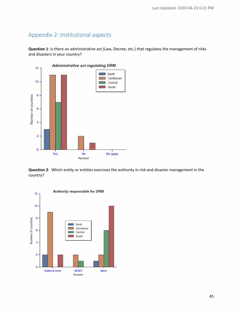
Last Updated: 2020-04-23 6:21 PM
45
Appendix 2: Institutional aspects
Question 1: Is there an administrative act (Law, Decree, etc.) that regulates the management of risks and disasters in your country?
Question 2: Which entity or entities exercises the authority in risk and disaster management in the country?

Last Updated: 2020-04-23 6:21 PM
46
Question 3: Is the Spatial Data Infrastructure of your country an official tool to manage information related to risks and attention to disasters?
Question 4: Is there a geospatial resource (geoportal, viewer, etc.) that manages risk and disaster information?

Last Updated: 2020-04-23 6:21 PM
47
Question 5: Is there a mechanism for monitoring the production of information related to risks and
disasters in the municipalities?
Question 6: What percentage of municipalities have updated risk and disaster information?

Last Updated: 2020-04-23 6:21 PM
48
Question 7: Is there a financial model for the continuous production of useful information for risk management?
Question 8: Is there a geodetic network with continuous operation reference stations (CORS) in your
country?

Last Updated: 2020-04-23 6:21 PM
49
Question 17. Indicate (Yes or No) if your have legislative policies that allows open access to geospatial information for Disaster Management in your country.
Question 18: Indicate (Yes or No) if additional resources can be easily allocated when disasters occur in
your Country.

Last Updated: 2020-04-23 6:21 PM
50
Question 19: Indicate (Yes or No) if there are any stakeholders missing involved in Disaster Management in your country
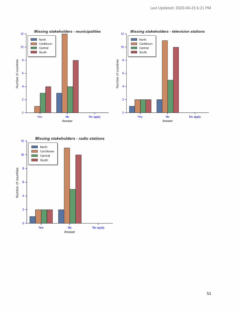
Last Updated: 2020-04-23 6:21 PM
51

Last Updated: 2020-04-23 6:21 PM
52
Question 20: Indicate for which Disaster events your have documented emergency plans in your country

Last Updated: 2020-04-23 6:21 PM
53

Last Updated: 2020-04-23 6:21 PM
54
Appendix 3: Information
Question 21: Indicate the challenges you have regarding access to geospatial information in the context of disaster management.

Last Updated: 2020-04-23 6:21 PM
55

Last Updated: 2020-04-23 6:21 PM
56

Last Updated: 2020-04-23 6:21 PM
57

Last Updated: 2020-04-23 6:21 PM
58
Question 22: Indicate the challenges you have regarding usage of geospatial information in the context of disaster management.

Last Updated: 2020-04-23 6:21 PM
59

Last Updated: 2020-04-23 6:21 PM
60

Last Updated: 2020-04-23 6:21 PM
61

Last Updated: 2020-04-23 6:21 PM
62
Question 23: Indicate the challenges you have regarding sharing of geospatial information in the context of disaster management.

Last Updated: 2020-04-23 6:21 PM
63

Last Updated: 2020-04-23 6:21 PM
64

Last Updated: 2020-04-23 6:21 PM
65

Last Updated: 2020-04-23 6:21 PM
66
Question 24: Rank from 1 to 5 (1 being the best way and 5 the worst way) the preferred way to share information in your country in the context of Disaster Management

Last Updated: 2020-04-23 6:21 PM
67

Last Updated: 2020-04-23 6:21 PM
68

Last Updated: 2020-04-23 6:21 PM
69
Appendix 4: Resources
Question 25: Indicate the status as “Meet the needs”, “Absent” or “To be improved” for each type of system required in the context of Disaster Management3
3 “Meet the needs”, “Absent” or “To be improved” changed for “OK”, “Absent” or “Needs upgrade”

Last Updated: 2020-04-23 6:21 PM
70

Last Updated: 2020-04-23 6:21 PM
71

Last Updated: 2020-04-23 6:21 PM
72
Question 26: Indicate the status as “Meet the needs”, “Absent” or “To be improved” for each type of expertise required in the context of Disaster Management

Last Updated: 2020-04-23 6:21 PM
73
Question 27: Indicate the status as “Meet the needs”, “Absent” or “To be improved” for each type of staff involved in the context of Disaster Management
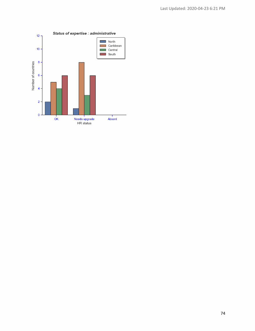
Last Updated: 2020-04-23 6:21 PM
74

Last Updated: 2020-04-23 6:21 PM
75
Appendix 5: Climate Change
Question 28: Rate as “Low”, “Average” or “High” the potential impact of Climate change regarding the following disasters in your Country

Last Updated: 2020-04-23 6:21 PM
76
Question 29: Rate as “Yes”, “In progress” or “No” your preparedness level for the impacts of Climate Change regarding the following disasters in your Country

Last Updated: 2020-04-23 6:21 PM
77
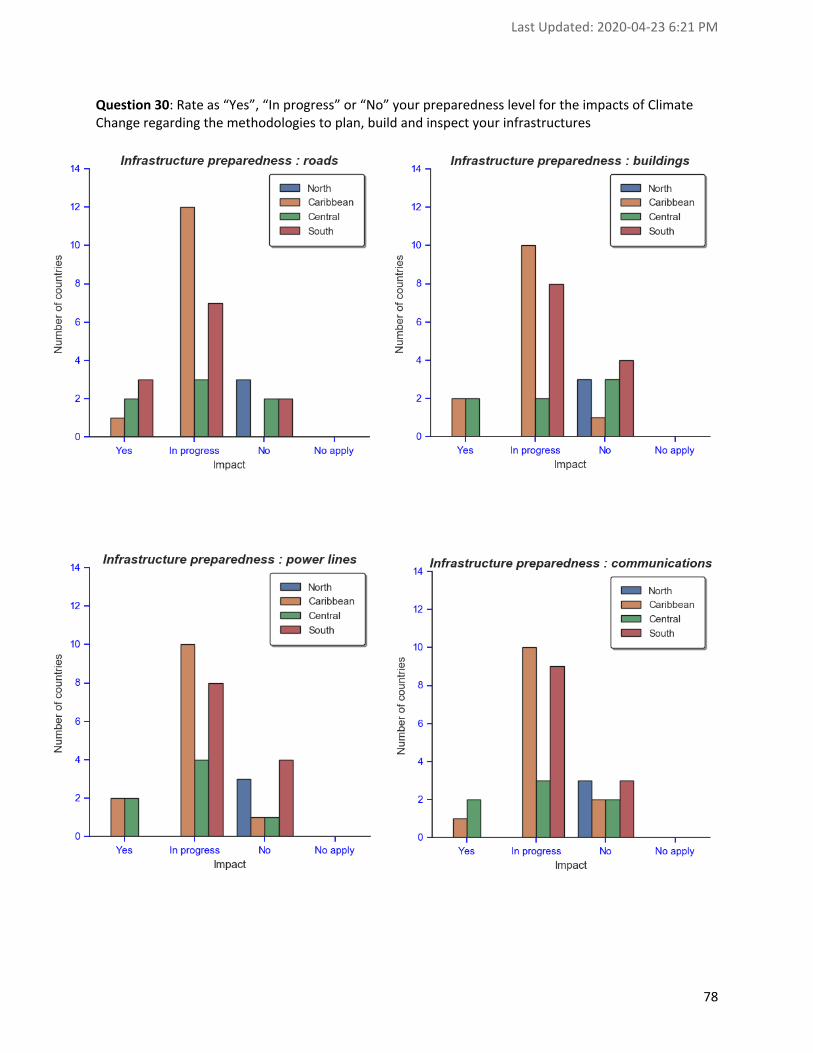
Last Updated: 2020-04-23 6:21 PM
78
Question 30: Rate as “Yes”, “In progress” or “No” your preparedness level for the impacts of Climate Change regarding the methodologies to plan, build and inspect your infrastructures

Last Updated: 2020-04-23 6:21 PM
79