UNDERSEA FEATURE NAME PROPOSAL - IHO · UNDERSEA FEATURE NAME PROPOSAL (See NOTE overleaf) Ocean or...
5
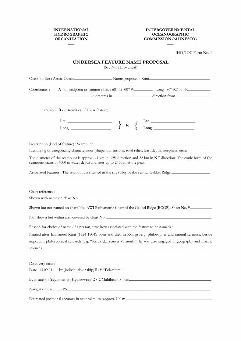
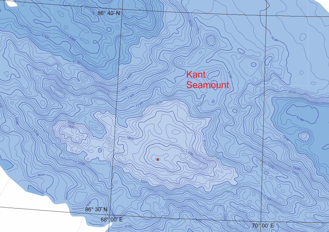
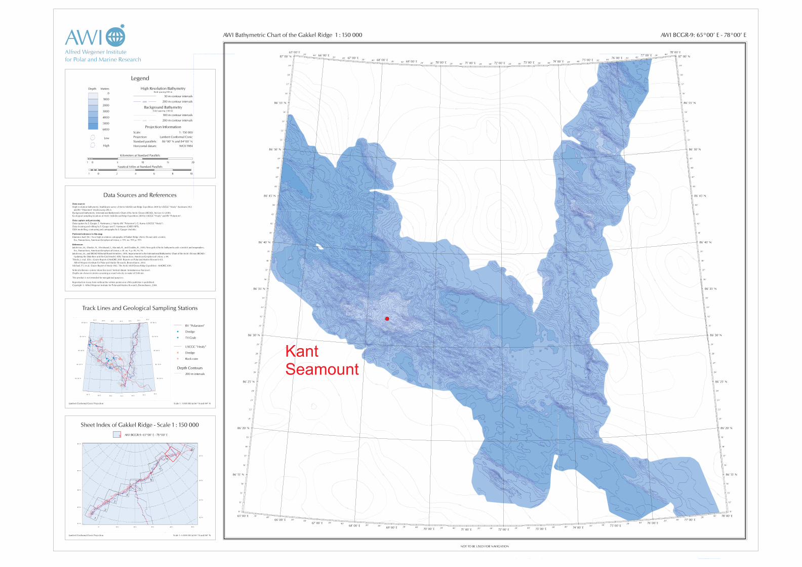
INTERNATIONAL HYDROGRAPHIC ORGANIZATION ___ INTERGOVERNMENTAL OCEANOGRAPHIC COMMISSION (of UNESCO) ___ IHO/IOC Form No. 1 UNDERSEA FEATURE NAME PROPOSAL (See NOTE overleaf) Ocean or Sea : Arctic Ocean___________________ Name proposed : Kant______________________________ Coordinates : A - of midpoint or summit : Lat. : 68° 32’ 00’’ W_________ , Long.: 86° 32’ 50’’ N___________ ________________ kilometres in ___________________ direction from _________________ and/or B - extremities (if linear feature) : Lat. ______________________ Long. ____________________ } to { Lat. ______________________ Long. ____________________ Description (kind of feature) : Seamount___________________________________________________________ Identifying or categorizing characteristics (shape, dimensions, total relief, least depth, steepness, etc.): The diameter of the seamount is approx. 41 km in NW direction and 22 km in NE direction. The conic form of the seamount starts at 4000 m water depth and rises up to 2450 m at the peak. Associated features : The seamount is situated in the rift valley of the central Gakkel Ridge.___________________ _____________________________________________________________________________________________ Chart reference : Shown with name on chart No. _________________________________________________________________ Shown but not named on chart No.: AWI Bathymetric Chart of the Gakkel Ridge (BCGR), Sheet No. 9___________ Not shown but within area covered by chart No. ____________________________________________________ Reason for choice of name (if a person, state how associated with the feature to be named) : ___________________ Named after Immanuel Kant (1724-1804), born and died in Königsberg, philosopher and natural scientist, beside important philosophical research (e.g. “Kritik der reinen Vernunft”) he was also engaged in geography and marine sciences. _____________________________________________________________________________________________ Discovery facts : Date : 13.09.01___ by (individuals or ship) R/V “Polarstern”_____________________________________________ By means of (equipment) : Hydrosweep DS-2 Multibeam Sonar_________________________________________ Navigation used : _GPS_______________________________________________________________________ Estimated positional accuracy in nautical miles : approx. 100 m___________________________________________
Transcript of UNDERSEA FEATURE NAME PROPOSAL - IHO · UNDERSEA FEATURE NAME PROPOSAL (See NOTE overleaf) Ocean or...
INTERNATIONAL HYDROGRAPHIC ORGANIZATION ___
INTERGOVERNMENTAL OCEANOGRAPHIC COMMISSION (of UNESCO) ___
IHO/IOC Form No. 1 UNDERSEA FEATURE NAME PROPOSAL (See NOTE overleaf) Ocean or Sea : Arctic Ocean___________________ Name proposed : Kant______________________________ Coordinates : A - of midpoint or summit : Lat. : 68° 32’ 00’’ W_________ , Long.: 86° 32’ 50’’ N___________
________________ kilometres in ___________________ direction from _________________
and/or B - extremities (if linear feature) :
Lat. ______________________
Long. ____________________ }
to {Lat. ______________________
Long. ____________________
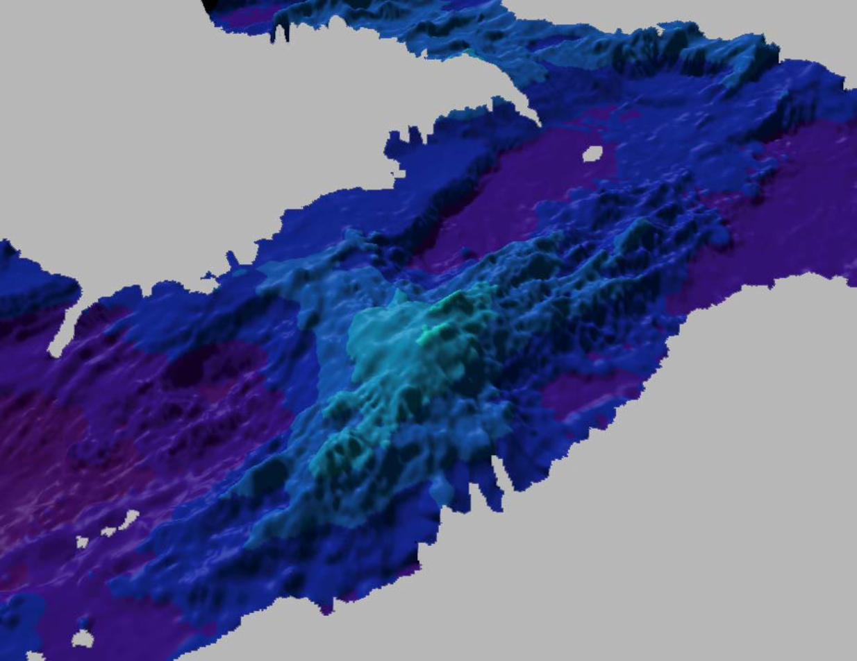
Description (kind of feature) : Seamount___________________________________________________________ Identifying or categorizing characteristics (shape, dimensions, total relief, least depth, steepness, etc.): The diameter of the seamount is approx. 41 km in NW direction and 22 km in NE direction. The conic form of the seamount starts at 4000 m water depth and rises up to 2450 m at the peak. Associated features : The seamount is situated in the rift valley of the central Gakkel Ridge.___________________ _____________________________________________________________________________________________ Chart reference : Shown with name on chart No. _________________________________________________________________ Shown but not named on chart No.: AWI Bathymetric Chart of the Gakkel Ridge (BCGR), Sheet No. 9___________ Not shown but within area covered by chart No. ____________________________________________________ Reason for choice of name (if a person, state how associated with the feature to be named) : ___________________ Named after Immanuel Kant (1724-1804), born and died in Königsberg, philosopher and natural scientist, beside
important philosophical research (e.g. “Kritik der reinen Vernunft”) he was also engaged in geography and marine
sciences. _____________________________________________________________________________________________ Discovery facts : Date : 13.09.01___ by (individuals or ship) R/V “Polarstern”_____________________________________________ By means of (equipment) : Hydrosweep DS-2 Multibeam Sonar_________________________________________ Navigation used : _GPS_______________________________________________________________________ Estimated positional accuracy in nautical miles : approx. 100 m___________________________________________
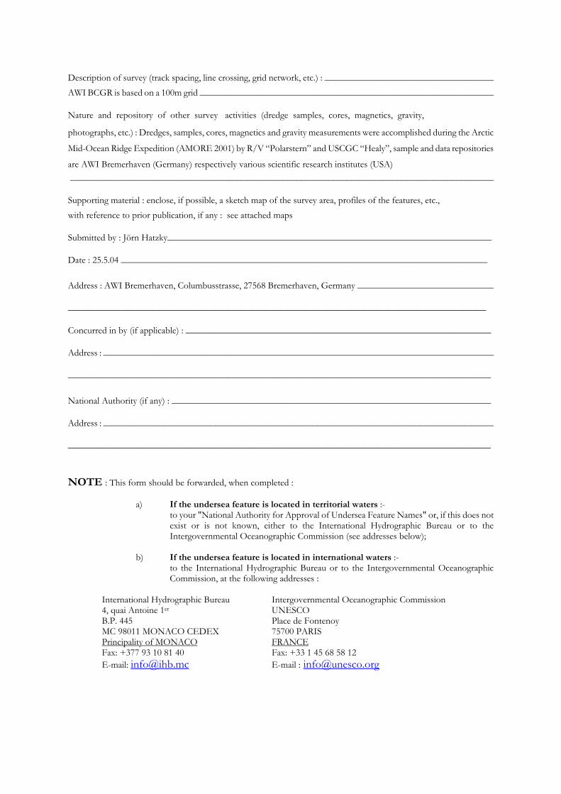
Description of survey (track spacing, line crossing, grid network, etc.) : ____________________________________ AWI BCGR is based on a 100m grid _______________________________________________________________ Nature and repository of other survey activities (dredge samples, cores, magnetics, gravity, photographs, etc.) : Dredges, samples, cores, magnetics and gravity measurements were accomplished during the Arctic
Mid-Ocean Ridge Expedition (AMORE 2001) by R/V “Polarstern” and USCGC “Healy”, sample and data repositories
are AWI Bremerhaven (Germany) respectively various scientific research institutes (USA) ____________________________________________________________________________________________ Supporting material : enclose, if possible, a sketch map of the survey area, profiles of the features, etc., with reference to prior publication, if any : see attached maps Submitted by : Jörn Hatzky_____________________________________________________________________ Date : 25.5.04 ______________________________________________________________________________ Address : AWI Bremerhaven, Columbusstrasse, 27568 Bremerhaven, Germany _____________________________
_________________________________________________________________________________________
Concurred in by (if applicable) : _________________________________________________________________ Address : ____________________________________________________________________________________
__________________________________________________________________________________________ National Authority (if any) : ____________________________________________________________________ Address : ____________________________________________________________________________________
__________________________________________________________________________________________
NOTE : This form should be forwarded, when completed :
a) If the undersea feature is located in territorial waters :- to your "National Authority for Approval of Undersea Feature Names" or, if this does not exist or is not known, either to the International Hydrographic Bureau or to the Intergovernmental Oceanographic Commission (see addresses below);
b) If the undersea feature is located in international waters :-
to the International Hydrographic Bureau or to the Intergovernmental Oceanographic Commission, at the following addresses :
International Hydrographic Bureau Intergovernmental Oceanographic Commission 4, quai Antoine 1er UNESCO B.P. 445 Place de Fontenoy MC 98011 MONACO CEDEX 75700 PARIS Principality of MONACO FRANCE
Fax: +377 93 10 81 40 Fax: +33 1 45 68 58 12 E-mail: [email protected] E-mail : [email protected]
Kant
Seamount
68° 00’ E
70° 00’ E
86° 30’ N
86° 40’ N
Kant
Seamount