UNCLASSIFIED Mapping and Charting Establishment · • ADM(IE) & Real Property ... Estb: 131 Mil +...
48
Mapping and Charting Establishment We Show The Way Ostendamus Viam UNCLASSIFIED UNCLASSIFIED Geospatial Capabilities Development Update Dave Rowlands Head Geo Cap Dev , MCE
-
Upload
nguyenthien -
Category
Documents
-
view
222 -
download
0
Transcript of UNCLASSIFIED Mapping and Charting Establishment · • ADM(IE) & Real Property ... Estb: 131 Mil +...

Mapping and Charting Establishment
We Show The Way
Ostendamus Viam
UNCLASSIFIED
UNCLASSIFIED
Geospatial Capabilities Development
Update
Dave Rowlands
Head Geo Cap Dev, MCE

• MCEs Gateway Services
• ADM(IE) & Real Property Spatial Data Warehouse
• MGCP4LCSS
• GGDM & NGIF
• .tpk for the CAF
• New maps and charts for the RCAF
Agenda

Who?, Where? Why? & How?
MCE ?

RSM
Security Orderly Room
Adjutant
HR Manager
Finance Operations Engineering
GeomaticsSupport Squadron
DigitalProduction Squadron Services Squadron
School of Military Mapping
CO MCE
DCO
Defence
Production
&
International
Co-Production
Geospatial Information &
Acquisition
&
Distribution
Geo Tech
Occupation
Training
Deployed
Support
&
Response
Work
MCE Organisational Structure
Estb: 131 Mil + 137 Civ = 268 Manning: 97 Mil (10) + 147 Civ (10) = 244

Western
CommandPacific
Command
Central
Command
Commandement
de l’estAtlantic
Command
Northern
Command
JTF(N) Yellowknife
1 x Geo Tech
(No change)
Geo Outstations 2014)
1CMBG Edmonton
2 x Geo Tech
(No change)
1 CER Edmonton
2 x Geo Tech
(12 x Geo Tech inc 3
x reservists)
JTF (P) Esquimalt
1 x Geo Tech
(No change)
1 CAD Winnipeg
1 x Geo Tech
(No change)
5 CMBG Valcartier
2 x Geo Tech
(No change)
5 RGC Valcartier
2 x Geo Tech
(12 x Geo Tech inc 3
x reservists)
4 ESR Gagetown
3 x Geo Tech
(No change)
Trinity
3 x Geo Tech
(No change)
2 CMBG Petawawa
2 x Geo Tech
(No change)
2 CER Petawawa
3 x Geo Tech
(9 x Geo Tech inc
2 x reservists)
DART Kingston
2 x Geo Tech
(No change)
CJIRU Trenton
2 x Geo Tech
(No change)
J2X DHTC
3 x Geo Tech
(No change)
Ottawa
8 x Geo Tech
(9 x Geo Tech)
UK
1 x Geo Tech
(No change)
Italy (Naples)
2 x Geo Tech
(No change)
US NGC
1 x Geo Tech
(No change)
CSOR Petawawa
2 x Geo Tech
(No change)
CFB Gagetown
2 x Geo Tech
(No change)
Inc C-IED cell and CFSME
TOTALS
2009 - 45 Geo Techs
2013 - 88 Geo Techs

To provide timely and accurate Geospatial
Information and Geomatics Support to the
Canadian Forces, the Department of National
Defence, and Other Government
Departments in accordance with
Canada’s national objectives.
Mission Statement

To provide Geomatics systems engineering &
support services and Geo equipment
program management services
We also coordinate/sponsor geo-related R&D
and test & evaluation activities within
MCE and CAF ICG (as req’d)
MCE Engineering Role

• MCEs Gateway Services
• ADM(IE) & Real Property Spatial Data Warehouse
• MGCP4LCSS
• GGDM & NGIF
• .tpk for the CAF
• New maps and charts for the RCAF
Agenda

10
MCE GWS Functionality
• Data searching & discovery
• Data exploitation (view/download/order)
• Data management
• Metadata management
• User profile management
• Inventory management
• Order/Client management

Application EvolutionCanadian Forces
Geospatial Information
Gateway
(CFGiG)
Geospatial Metadata &
Inventory System
(GeoMIS)
2005
2008
2010
2013

MCE Enterprise

• MCEs Gateway Services
• ADM(IE) & Real Property Spatial Data Warehouse
• MGCP4LCSS
• GGDM & NGIF
• .tpk for the CAF
• New maps and charts for the RCAF
Agenda

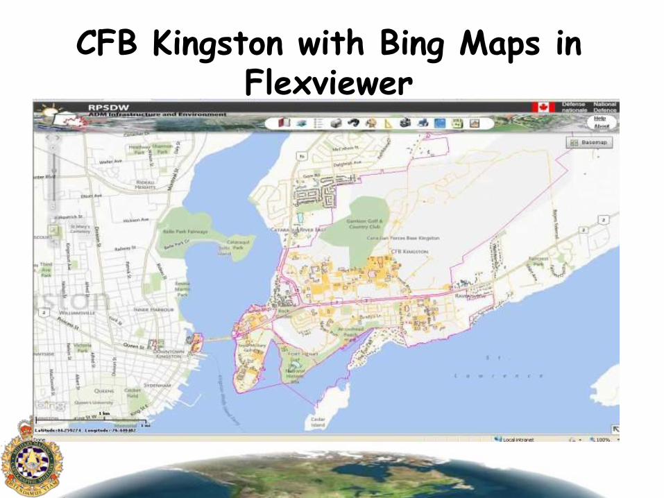
CFB Kingston with Bing Maps in Flexviewer
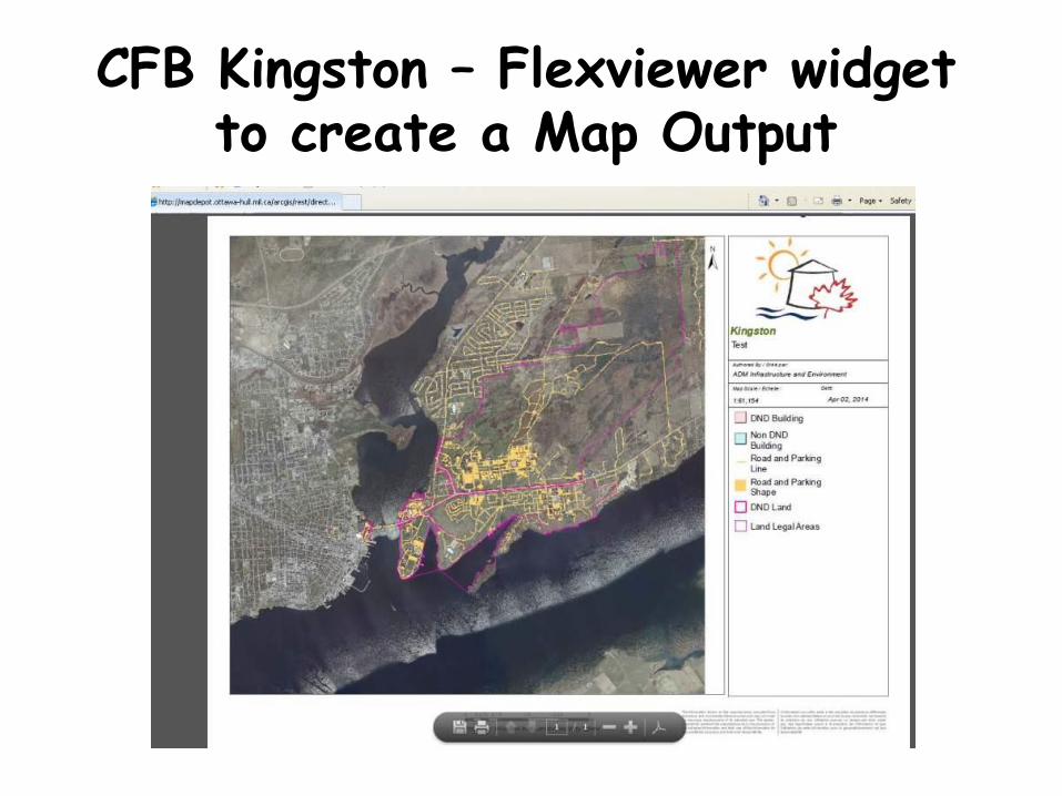
CFB Kingston – Flexviewer widget to create a Map Output

Flexviewer Example

Flexviewer Example


• MCEs Gateway Services
• ADM(IE) & Real Property Spatial Data Warehouse
• MGCP4LCSS
• GGDM & NGIF
• .tpk for the CAF
• New maps and charts for the RCAF
Agenda


23
MGCP4LCSS OVERVIEW
• MGCP4LCSS Schema:
– optimization for LCSS Web
– 150 of the 300 MGCP Features
– 4 scales Dependencies (GRLS Principle)
– ‘Human Readable’ names/attribution
– TLM Like Symbology
• ETL in ArcGIS 10.2 Data Interoperability
• Host on DGSS using Flexviewer

24
Blue is data conditioning team
Green is the Geo Field Teams
MCE Fixed Production Process
Input: MGCP Shapefiles
IGW
Filter Shapefiles & categorization
Pre-Conversion Check – QC/QA
Aggregate Features
Segregate Features Feature Description Symbology Coding Load & Calculate
FGDBBattleview
schema withrepresentations
FME 2013 FME 2013 FME 2013
FME 2013 FME 2013 FME 2013 Arc GIS 10.1
IMO/Chief Geo
Receives FGDB
DMAN Team Ingest/load on Geo Server
WFS Services built and tested
Live on LCSS in operational theatre

25
Future Work
• Build labels for MXD/FGDB.
• Train the data manager team on Data Interoperability workflows.
• Run a cold exercise to test workflow and workbenches
• Expose to user community and collect feedback

MGCP4LCC Example in Battleview Web
INFORMATION HUMAN READABLE
GROUPED BY THEMES
SYMBOLOGY IN REPRESENTATIONS


• MCEs Gateway Services
• ADM(IE) & Real Property Spatial Data Warehouse
• MGCP4LCSS
• GGDM & NGIF
• .tpk for the CAF
• New maps and charts for the RCAF
Agenda

GGDM (Ground Warfighter Geospatial Data Model)
VS NGIF
(NATO Geospatial Information Framework)• GGDM
– US Army data model – extension of NGA’s TDS. – “common” Geospatial Data across Army Programs – interoperability. – Vendor agnostic
• NGIF – NATO Geospatial data model– army, navy, air and joint operations – specifications for geospatial products– all levels of command (strategic through to tactical). – “fighting off the same map”– digital and on paper products – all scales and resolutions

GGDM MODEL

GGDM TESTING AT MCE
• Production/Defence Mapping tool to Convert a TAM Schema to GGDM
• Symbolized GGDM using TLM symbols.
• Web Map Services from the GGDM FGDB on the Deployable Workstation using Flexviewer.


• MCEs Gateway Services
• ADM(IE) & Real Property Spatial Data Warehouse
• MGCP4LCSS
• GGDM & NGIF
• .tpk for the CAF
• New maps and charts for the RCAF
Agenda

tpk
Large Scale
Small Scale
Imag
ery
or
‘sat
elli
te’
Map
s
• Left Ex:
– 2 TPK files
– Shows the scales of the Imagery and scales of the maps/vector
• Right Ex:
– visual example on the Android Application that runs off of ESRI app at runtime .
Android / Map Interface structure

Map Tile Package (TPK) Process in Arc 10.1/2
1. Define AOI extent and map projection 2. Data Mining 3. Data Processing ETL (ArcGIS Data
Interoperability)4. ArcMap Creation5. Tile Package (TPK) Creation6. Upload and Open TPK on Android in HHI
Application

Halifax Dockyard Example
Left: 1:24,000, - High Resolution satellite - Land Use - CanVec data - transparency levels.
Right: 1:3,000 -DND buildings -legal boundary-High Resolution satellite


• MCEs Gateway Services
• ADM(IE) & Real Property Spatial Data Warehouse
• MGCP4LCSS
• GGDM & NGIF
• .tpk for the CAF
• New maps and charts for the RCAF
Agenda


GLOBAL SMALL-SCALE LAYERS MID-SCALE LAYERS
LARGE-SCALE LAYERS
1024nm
1024nm
512nm
256nm
128nm
64nm
32nm
16nm
8nm
4nm
2nm
1nm
0.5nm
Top National
GNC Regional JNC ONC TPCVNC
JOGLFC
AppDep
Local Detail FineDetail
UltraDetail
1:15M 1:5M 1:2.5M 1:2M 1:1M 1:500K 1:250K 1:150K 1:50K 1:25K 1:10K 1:5K
0 4000 2000 1250 740 300 125 75 40 20 6 3 1
Prototype: scales

Prototype: Themes
VFR
IFR
Nautical
Radar

MCE - GI &S Sqn - GeoMIS
OtherCountries
Other OGDs
DGC
UKHO
NRCAN
Vendors
NGA
NGALO
Suppliers
WARP
IGW
DAFDD or
Jepperson
O:\Engineering\12 - Projects &
Tech Dev
Data
Acquisition QC/QA ok?Extract
metadata
Data
Conditioning
Geo data
store
MCE
Metadata, Clients,
suppliers and orders
repository
No
Yes
Discovery
&
Ordering
Use GeoMIS
to receive
and track the
order
ArcGISto
confirm
perimeters of
the order.
Geo data
store
MCE
Metadata, Clients,
suppliers and orders
repository
DR Site
GWS/GeoMIS/CFGiG
provides failover and
data security at DR Site
Use GeoMIS
to extract
metadata
and
catalogue
holdings
Technology already exists
RCAF
Production
Visualisation
Publish
Services &
Distribution

Current JNC 1:2,000,000

New JNC 1:2,000,000

Current TPC 1:500,000

New TPC 1:500,000

Current JOG 1:250,000

New JOG 1: 250,000

Dave RowlandsHead, Geomatics Capabilities Development
Mapping and Charting Establishment | Service de cartographie
National Defence | Défense nationaleOttawa, Canada K1A 0K2
David [email protected] | Téléphone: 613-944-3068
Facsimile | Télécopieur: 613-995-4359
Questions?