ULI Chicagouli.org/wp-content/uploads/ULI-Documents/Lakeshore-Report-WEB.pdf · jobs in the core...
34
The Lakeshore Industrial Heritage Corridor Infrastructure’s Role in Revitalizing Lake Michigan’s South Shore Communities The Lakeshore Industrial Heritage Corridor is an area in transition. Industry, although having lost its dominance, is still significant. But what is next? Leaders on both the Illinois and the Indiana sides of the state border have adopted a solid vision for the corridor’s future that embraces industry, nature, and people. Recognizing the important role of infrastructure, ULI Chicago’s Infrastructure Game Changers process identified 13 projects that can help propel the corridor toward achieving this vision. Infrastructure and the Lakeshore Industrial Heritage Corridor The Lakeshore Industrial Heritage Corridor begins in Chi- cago at the former site of the U.S. Steel South Works and follows the shoreline of Lake Michigan until it reaches the still-active U.S. Steel Gary Works. The corridor includes territory in Wards 7, 9, 10, and 34 in the city of Chicago, Illinois, and the cities of Hammond, Whiting, East Chi- cago, and parts of Gary in Lake County, Indiana. The area is a 20- to 40-minute drive from downtown Chicago. Over the last decade, the corridor has been the subject of several high-quality and exciting planning efforts. On the Chicago side, the Calumet Area Land Use Plan, adopted in 2002, recognized the area’s continuing industrial potential and the importance of the extensive wetland and prairie landscape. On the Indiana side, the Marquette Plan, pro- duced in 2005, was the culmination of a regional effort to create a lakeshore reinvestment strategy. Local communi- ties, government agencies, and site developers have taken these regional plans to heart as they have produced more detailed guides and programs for development. Taken together, the plans look forward to a corridor defined by healthy industry and revitalized neighborhoods of mixed-use, mixed-income development along Lake Michigan and the rail-transit lines. Local residents and visitors from across the Greater Chicago region—and beyond—enjoy miles of Lake Michigan shoreline and an open-space network of lakes, rivers, marshes, and prairies. The vision is in place; implementation is underway. The purpose of ULI’s Lakeshore Industrial Heritage Corridor ef- fort is to identify the projects and activities that are crucial to maintaining this forward momentum. They include the adoption of a bistate perspective on key infrastructure and catalytic development projects. Industry On both sides of the border, the area encompassing the Lakeshore Industrial Heritage Corridor has a long history ULI Chicago Infrastructure Initiative The Calumet Area Land Use Plan and the Marquette Plan, taken together, look forward to a corridor defined by healthy industry and revitalized neighborhoods of mixed-use, mixed-income development along Lake Michigan and the rail-transit lines. The Lakeshore Industrial Heritage Corridor 1
Transcript of ULI Chicagouli.org/wp-content/uploads/ULI-Documents/Lakeshore-Report-WEB.pdf · jobs in the core...

The Lakeshore Industrial Heritage CorridorInfrastructure’s Role in Revitalizing Lake Michigan’s South Shore CommunitiesThe Lakeshore Industrial Heritage Corridor is an area in transition. Industry, although
having lost its dominance, is still significant. But what is next? Leaders on both the
Illinois and the Indiana sides of the state border have adopted a solid vision for the
corridor’s future that embraces industry, nature, and people. Recognizing the important
role of infrastructure, ULI Chicago’s Infrastructure Game Changers process identified 13
projects that can help propel the corridor toward achieving this vision.
Infrastructure and the Lakeshore Industrial Heritage CorridorThe Lakeshore Industrial Heritage Corridor begins in Chi-cago at the former site of the U.S. Steel South Works and follows the shoreline of Lake Michigan until it reaches the still-active U.S. Steel Gary Works. The corridor includes territory in Wards 7, 9, 10, and 34 in the city of Chicago, Illinois, and the cities of Hammond, Whiting, East Chi-cago, and parts of Gary in Lake County, Indiana. The area is a 20- to 40-minute drive from downtown Chicago.
Over the last decade, the corridor has been the subject of several high-quality and exciting planning efforts. On the Chicago side, the Calumet Area Land Use Plan, adopted in 2002, recognized the area’s continuing industrial potential and the importance of the extensive wetland and prairie landscape. On the Indiana side, the Marquette Plan, pro-duced in 2005, was the culmination of a regional effort to create a lakeshore reinvestment strategy. Local communi-
ties, government agencies, and site developers have taken these regional plans to heart as they have produced more detailed guides and programs for development.
Taken together, the plans look forward to a corridor defined by healthy industry and revitalized neighborhoods of mixed-use, mixed-income development along Lake Michigan and the rail-transit lines. Local residents and visitors from across the Greater Chicago region—and beyond—enjoy miles of Lake Michigan shoreline and an open-space network of lakes, rivers, marshes, and prairies.
The vision is in place; implementation is underway. The purpose of ULI’s Lakeshore Industrial Heritage Corridor ef-fort is to identify the projects and activities that are crucial to maintaining this forward momentum. They include the adoption of a bistate perspective on key infrastructure and catalytic development projects.
IndustryOn both sides of the border, the area encompassing the Lakeshore Industrial Heritage Corridor has a long history
ULI ChicagoInfrastructure Initiative
The Calumet Area Land Use Plan and the Marquette Plan, taken together, look forward to a corridor defined by healthy industry and revitalized neighborhoods of mixed-use, mixed-income development along Lake Michigan and the rail-transit lines.
The Lakeshore Industrial Heritage Corridor 1

2 ULI Chicago Infrastructure Intitiative
as one of the industrial hubs of the world. As quickly becomes obvious to anyone driving through the corridor, however, the industrial footprint has been contracting for decades. There is no longer a need for the tens of thou-sands of workers that flocked to the factories, nor for the extensive infrastructure that moved people, raw materials, and goods to and from the lakeshore plants.
The corridor, however, still houses impressive industrial facilities for major regional, national, and international corporations and will continue to be an important hub for manufacturing, transportation, warehousing, and energy-related uses. Manufacturing in the United States is not dy-ing, rather it is transforming; longstanding trends confirm continued productivity improvements and output growth. Industry is not only part of the corridor’s heritage but also part of its future.
As manufacturing shed its need for massive labor forces, the corridor’s population went into a long slide that continues to the present. Although the population in the Greater Chicago region as a whole grew by 4.6 percent between 2000 and 2009, according to the U.S. Census Bureau’s Population Estimates, the cities in the Lakeshore Industrial Heritage Corridor, including the city of Chicago, experienced popula-tion declines. For Lake County, Indiana, the longstanding pattern of outward population growth continues. Whereas the population inhabiting Lake County’s lakeshore cities decreased, the population in the county as a whole increased during the same period.
The number of jobs in the counties of Northwest Indiana considered to be part of the Greater Chicago metropolitan area have stabilized. According to the U.S. Bureau of Labor Statistics, between 2000 and the onset of the most recent recession, jobs in Northwest Indiana grew even faster than jobs in the core Chicago counties. Since the downturn, job loss in Northwest Indiana is on a par with losses in the larger metropolitan region. On the Chicago side, the Ford Motor Company and the more than 135 companies with member-ship in the Calumet Area Industrial Commission illustrate the area’s economic commitment.
NatureBoth the Calumet Area Land Use Plan and the Marquette Plan recognize that nature is one of the corridor’s most important assets. From the stunning beauty of the Lake Michigan shoreline in its natural state, as exemplified by the nearby Indiana Dunes National Lakeshore, to the inland lakes, wetlands, prairies, and rivers that span the state border, the area is rich in natural amenities for both
humans and wildlife. The corridor will provide visitors and residents the unique experience of nature inhabiting not only urban settings but also, in many cases, urban industrial settings.
Plans and projects underway are designed to build on nature to provide an ambitious range of recreational uses. From hiking trails and bird-watching to marinas and amphitheaters, in settings from the sandy beaches of Lake Michigan to the favorite marshy fishing hole, the improved park and open spaces are designed to serve nearby com-munities and to attract visitors from throughout the Greater Chicago region and beyond. Bicycle and pedestrian trails will knit the area together and tie into the larger regional trail network. The restoration and reclamation work is set to clean up much of the history of land contamination and improve the area’s water quality.
PeopleDespite declining population, tens of thousands still call the neighborhoods within the corridor home. These neighborhoods are characterized by racial diversity and the remnants of working-class communities from the heyday of the industrial era. As is often typical of residential areas facing declining population, there are also many stories of economic hardship and difficult poverty. The capacity of civic institutions in some cases reflects this era of declin-ing resources.
The population loss has led to acres of underused residential land; some of the former industrial sites are also suitable for residential and commercial development. Many of the areas targeted for redevelopment to modern mixed-use, mixed-income neighborhoods are near the sites planned for the revitalized and restored recreational amenities or positioned near the expanding passenger-rail network. Redevelopment plans are striving to enhance Lake Michigan’s South Shore communities as places of choice for visitors and residents.
Recognizing the need for a stronger, regional approach to the area’s problems and opportunities, Indiana created the Northwest Indiana Regional Development Authority (RDA) in 2005. Governed by a board representing municipalities, counties, and state government, the RDA is charged with developing a comprehensive economic development strat-egy targeting greenway development along the shoreline and the area’s transportation infrastructure. Substantial funds contributed by the municipalities, counties, and state government give the RDA the means to shape the develop-ment of a range of infrastructure projects.
The infrastructure in the Lakeshore Industrial Heritage Corridor needs to be thought about in terms of its 21st-century uses: the corridor is now a multifaceted place of industry, nature, and people.

The Lakeshore Industrial Heritage Corridor 3
InfrastructureThe infrastructure of the Lakeshore Industrial Heritage Corridor was shaped by the area’s industrial past. The highways and rail lines focused on moving raw materi-als, goods, and workers to and from individual industrial plants, which were located for the most part on Lake Michigan or near Lake Calumet to gain access to water transportation. Access to and integration into the rest of the Greater Chicago region was of less importance. The decades since the industrial peak have also brought about a changing understanding of the importance of supporting
natural infrastructure to enhance water quality and provide important recreational amenities.
The corridor’s infrastructure needs to be thought about in terms of its 21st century uses: the corridor is now a multifaceted place of industry, nature, and people. Projects both planned and underway are developing a modern transportation system that provides residents high-quality access—by car, rail, and bicycle as well as on foot—to jobs, services, and recreation located both nearby and throughout the Greater Chicago region. This same transportation system—by water, air, and land—needs to
Project Summaries1
Chicago Transit Authority (CTA) Red Line Extension
Extension of CTA’s Red Line from 95th Street to 130th Street, with a possible connection to the South Shore rail service
2South Shore Line and Transit-Oriented Development
Focus on South Shore rail service, affecting passenger movement into Chicago and to Indiana destinations and offering opportunities for transit-oriented development
3Arterial Connecting Roads Linking Illinois and Indiana
Improvements to vehicle and freight movement between Illinois and Indiana focusing on U.S. 12, U.S. 20, U.S. 41, and S. Brainard Avenue and including connection to Indiana’s heavy-weight-truck highways
4 Cline Avenue RepurposingRepurposing the expressway, currently partly closed due to deterioration, to improve access and better connect communities in Northwest Indiana to the lakefront
5Gary Chicago International Airport
Expansion of the primary runway and associated facilities to support plans for increased scheduled and chartered passenger service
6High-Speed-Rail Terminal at Gary
Plans to route improved intercity passenger-rail service between Chicago-Detroit and Chicago-Cleveland through a new intermodal terminal at the Gary Chicago International Airport
7South Shore Lakefront Revitalization
Plans to open the shoreline shared by East Chicago and Gary for improved recreational use and increased development by relocating or consolidating railroad tracks and industrial utilities and rehabilitating the lakeshore
8North Harbor Revitalization Initiative
A package of infrastructure projects in East Chicago, including relocating a water filtration plant, building a new multimodal bridge to the lakeshore, and street and sewer upgrades, designed to help revitalize the North Harbor area
9 Whiting Lakefront
A package of infrastructure projects in Whiting, including significant improvements to the lakefront park and street improvements designed to reduce conflict with the freight railroads, aimed at increasing the attractiveness of Whiting and supporting infill development
10Hammond Lakes Area Project
A package of infrastructure projects in Hammond, including significant park and trail improvements that will serve residents and support Hammond’s tourism and visitor economic strategy
11South Works/Chicago Lakeside
A package of infrastructure projects, including relocation of an arterial, U.S. 41, and development of extensive new community infrastructure, to support redevelopment of the abandoned U.S. Steel South Works site on the Lake Michigan lakefront
12East 134th Street Redevelopment
A package of infrastructure projects, including protected wetlands, green space, trails, and community infrastructure, designed to support the development of a residential neighborhood of condominiums, townhomes, and houses
13Calumet Open Space Reserve
A 3,900-acre complex of wetlands, prairies, trails, and recreation lands in Chicago
1
2
3
4
5
6
7
8
9
10
11
12
13

4 ULI Chicago Infrastructure Intitiative
4
3
9
11
12
13
1
10

The Lakeshore Industrial Heritage Corridor 5
5
6
8
2
7

6 ULI Chicago Infrastructure Intitiative
encourage visitors, businesses, and workers to access the corridor’s assets. Within the corridor, updating and mod-ernizing the transportation, water, and utility infrastructure is part of the strategy to boost the area’s economic future and its quality of life. Finally, plans for modernizing the infrastructure, including the restored natural infrastruc-ture, need to be coordinated with plans for the revitalized business environment and for the expansion of mixed-use, mixed-income communities.
ULI Chicago’s Infrastructure Game ChangersAs part of ULI Chicago’s study of infrastructure and the Lake Michigan South Shore communities, ULI Chicago developed and tested the Infrastructure Game Changers analysis process. The Infrastructure Game Changers process is a national model for identifying significant infrastructure projects and their associated land uses, including catalytic development projects.
Designed to be led by a group situated outside of both government and the direct providers of infrastructure, the process includes
n A holistic approach to how infrastructure fits into a region’s long-term sustainability and economic health;
n The incorporation of the private, nonprofit, and public sector perspectives into infrastructure decision making; and
n An emphasis on implementation, through both its focus on planned infrastructure projects and the inclusion of finance and political support in the evaluation criteria.
Analysis ProcessStep 1: Select a region, subregion, or district.
Step 2: Scan planned infrastructure projects for the selected area. (This step may also include the identification of existing infrastructure resources that are underused or that present opportunities.)
Step 3: Evaluate projects according to a variety of criteria. ULI Chicago’s Infrastructure Committee chose the following criteria: economic competi-tiveness, opportunity, environmental sustainabil-ity, support, and funding and financial feasibility (see definitions below).
Step 4: Draft a working list of significant infrastructure projects and associated land use aspects.
Step 5: Test and build support for the working list through outreach to project partners and relevant communities and stakeholders.
Step 6: Document the final list of significant infrastruc-ture projects and their associated land use aspects.
After ULI Chicago identified Lake Michigan’s South Shore communities as the target region, the study conducted its initial scan and identified 65 planned infrastructure proj-ects. Using the evaluation criteria and also looking closely at projects that address the state border and that produce synergistic effects with other infrastructure or develop-ment projects, the study winnowed the list down to 16–20 candidate projects. At a workshop held July 16–17, 2009, ULI members reviewed the project analysis and selected 13 projects for additional outreach. Workshop participants also finalized the definition of the geographic area. Pre-sentations of the analysis results, in draft form, were then made to government leaders, planning officials, and other stakeholders throughout the region. After incorporating input from those events, the Lakeshore Industrial Heritage Corridor process was deemed ready for final documenta-tion in summer 2010.
A list of plans, studies, and other sources of information consulted for this study is available from ULI Chicago and from the project Web page: chicago.uli.org/Commu-nity%20Building/Curtis%20Infrastructure%20Initiative.aspx.

The Lakeshore Industrial Heritage Corridor 7
Evaluation CriteriaEconomic competitiveness: the extent to which the proposed project enhances the economic competitiveness of the entire Greater Chicago region (the tristate metropolitan area) by increasing the efficiency, productivity, or attractive-ness of the entire region. Examples include significantly reducing freight or passenger travel times, expanding freight capacity, removing significant infrastructure barriers to re-gional development, or developing significant amenities that boost the attractiveness of the region. Projects considered significant for economic competiveness have the potential to attract capital investment and jobs to, or to stem their loss from, the Greater Chicago region.
Opportunity: the extent to which the project provides economic or quality-of-life opportunities for the communi-ties or neighborhoods most directly affected by the project or for other underserved populations. Opportunity includes improved access to jobs and education.
Environmental sustainability: the extent to which the proposed project improves the quality of the environment, including but not limited to improving environmental quality by reducing carbon emissions, protecting identified natural areas, promoting the more efficient use of water resources, and reducing water or air pollution.
Support: the extent to which the project has support from elected officials, key agencies, major stakeholders, and perhaps even the general public.
Funding and financial feasibility: the extent to which funding sources have been identified to cover project costs and the potential for the project to attract private sector investment in the form of public/private partnerships.
The 13 Infrastructure ProjectsThe Infrastructure Game Changers process identified 13 projects for the Lakeshore Industrial Heritage Corridor. Project descriptions, including the land use and the as-sessment of evaluation criteria, are available in the project case studies for this report.
The 13 projects cover a range of types of infrastructure and time frames for development. In terms of land use, some of the projects present high levels of coordination—in-frastructure and land use are being developed jointly. In other projects, thinking about infrastructure needs is ahead of developing the land use response or vice versa. Few are isolated, one-off projects; they more often represent a package of infrastructure projects pulled together to
achieve an economic and land use objective. Some of the projects are well along in their planning—construction for the first phase of the project may already be underway. Other projects, however, are still in the concept develop-ment stage.
When taken as a whole, the 13 projects truly become catalytic and transformative. The numbering system in the project summaries and on the corridor map does not indicate priority. It shows how these projects build on and link to one another. As in the children’s game of “connect the dots,” following one project to the next on the map reveals how these projects outline, encompass, and define the corridor and its future.
Conclusion and Next StepsThe Lakeshore Industrial Heritage Corridor is a coherent subregion of Greater Chicago that happens to be in two states. Infrastructure and land use plans on both sides of the border support a compelling future defined by healthy industry, abundant recreational amenities, and attractive mixed-use, mixed-income communities. Elements of this vision are emerging, even during difficult economic times. The 13 projects identified in this report have the potential to be game changers for the corridor.
Infrastructure is what ties the corridor together; a bistate perspective that includes the city of Chicago and the com-munities of Northwest Indiana and that works to coordinate infrastructure and land use is one of the components for success. Targeted areas for bistate cooperation include passenger-rail service, arterial highways, and freight movement, and the Gary Chicago International Airport would benefit from consideration within the context of planning for the multiple-airport system that serves the entire Greater Chicago region. A corridorwide approach may also help facilitate transit-oriented development and lakeshore redevelopment, including environmental reme-diation and site preparation.
Next steps for stakeholders in the Lakeshore Industrial Heritage Corridor are to work together to develop mecha-nisms to deliver the benefits of a bistate perspective and to advance the 13 projects, while making the necessary coordination with land use, economic development and diversification, and infrastructure finance. This activity will involve engaging the private sector, including current land-owners and potential developers, and addressing issues related to sources of private sector debt and equity.
When taken as a whole, the 13 projects truly become catalytic and transformative. The numbering system in the project summaries and on the corridor map does not indicate priority. It shows how these projects build on and link to one another. As in the children’s game of “connect the dots,” following one project to the next on the map reveals how these projects outline, encompass, and define the corridor and its future.

8 ULI Chicago Infrastructure Intitiative
AcknowledgmentsThe Lakeshore Industrial Heritage Corridor, a product of ULI Chicago’s Infrastructure Committee and its Infrastruc-ture Initiative, was made possible through the support of countless hours from dedicated volunteers and the ULI/Curtis Regional Infrastructure Project. The Infrastructure Committee cochairs acknowledge the contributions of the project participants and are grateful for assistance received from the Chicago Metropolitan Agency for Planning, the
Chicago Department of Transportation, the City of Chicago Department of Zoning and Land Use Planning, the Metro-politan Planning Council, the Northwest Indiana Regional Development Authority, the Northwest Indiana Regional Planning Commission, S.B. Friedman and Company, and The Community Builders, Incorporated.
Stephen Friedman, Gregory Hummel, and Paul Shadle ULI Chicago Infrastructure Committee Cochairs
About the ULI Chicago Infrastructure Initiative: ULI Chicago’s Infrastructure Initiative is a multiyear effort led by ULI Chicago’s Infrastructure Committee. Its goals are to
n Address the relationship between infrastructure and land use;n Improve regional infrastructure decision-making; andn Develop national models of best practices.
To date, projects include the development of the Infrastructure Game Chang-ers analysis process, its application to the Lakeshore Industrial Heritage Cor-ridor and Regional Infrastructure in Northeastern Illinois, and investigation of infrastructure finance.
About the ULI/Curtis Regional Infrastructure Project: Supported by ULI trustee James J. Curtis, the ULI/Curtis Regional Infrastructure Project is a three-year initiative launched with the goal of better linking infrastruc-ture, land use, and sustainability at the regional level. The Curtis Project
emphasizes developing leadership and models of best practices. Selected by a competitive process and led by ULI’s Infrastructure Initiative, participants include the ULI District Councils in Chicago, Seattle, Florida, and Minnesota.
About ULI: The Urban Land Institute is a 501(c)(3) nonprofit research and education organization supported by its members. ULI provides leadership in the responsible use of land and in creating and sustaining thriving com-munities worldwide. Founded in 1936, ULI has nearly 30,000 members in 95 countries worldwide, representing the entire spectrum of land use and real estate development disciplines working in private enterprise and public service.
For more information on the Regional Infrastructure in Northeastern Illinois project or other ULI Chicago infrastructure programs, please contact Cindy McSherry, ULI Chicago executive director ([email protected] or 773-549-4972), or Christine Kolb, ULI Chicago director of community outreach ([email protected] or 773-549-2655).
Infrastructure Committee MembersBenjamin Ahring, Cowhey Gudmundson Leder, Ltd.Mark Angelini, Mercy Housing LakefrontJeffrey Arnold, Joseph Freed and Associates LLCMarySue Barrett, Metropolitan Planning CouncilDavid Bennett, Metropolitan Mayors CaucusLee Bey, Chicago Central Area CommitteeKathy Brown, Northwest Indiana Regional Development AuthoritySusan Campbell, University of ChicagoDenise Casalino, AECOMRobert Chodos, Colliers, Bennett & Kahnweiler, Inc.Robert Cowhey, Sr., Cowhey Gudmundson Leder, Ltd.Bob Dean, Chicago Metropolitan Agency for PlanningJon DeVries, Roosevelt UniversityCassandra Francis, Clayco Development and ConstructionStephen Friedman, S.B. Friedman & CompanyStephen Galler, The Habitat Company LLCDavid Galowich, Madison Realty Group, Inc.James Giblin, TranSystems, Inc.Carl Giometti, JTS ArchitectsJohn Green, Centrum Properties, Inc.Charles Hanlon, Land Vision, IncorporatedBill Hanna, Northwest Indiana Regional Development AuthorityGregory Hummel, Bryan Cave, LLPJeremiah James II, Edward R. James Partners, LLCLavon Johns, Pugh, Jones, Johnson & Quandt, PCDana Levenson, RBS Global Banking & MarketsDirk Lohan, Lohan Anderson ArchitectsMike Meagher, James McHugh Construction Co.David Meek, The Law Office of David Meek, LLC
Leigh Morris, Indiana Economic Development Corporation David Narefsky, Mayer Brown LLPMichael Pagano, University of Illinois at ChicagoEdward Paesel, South Suburban Mayors & Managers AssocStephen Park, The Alter Group, Ltd.Ronan Remandaban, Lee & Associates of Illinois, LLCDonald Resnick, Jenner & Block, LLPTina Rongers, Policy Analytics, LLCPaul Shadle, DLA Piper LLP (US)Craig Sklenar, City of EvanstonPeter Skosey, Metropolitan Planning CouncilGreg Spitzer, Paul, Hastings, Janofsky & Walker LLPFrank Transue, Walker Parking Consultants/EngineersRichard Wilson, Skidmore, Owings & Merrill LLPWilliam Woodley, The Community Builders, Inc.Ruth Wuorenma, Neighborhood Capital Institute
ULI StaffCynthia McSherry, ULI ChicagoChristine Kolb, ULI ChicagoSarah Jo Peterson, ULIMilo Aguilar, ULI Chicago InternMarge Malo, ULI Chicago InternDan Miodonski, ULI Chicago InternJason Saavedra, ULI Chicago InternJessica Simoncelli, ULI Chicago Intern
Production StaffJames A. Mulligan, Managing EditorLaura Glassman, Publications Professionals LLC, Manuscript EditorBetsy VanBuskirk, Creative Director
Copyright 2011 by the Urban Land Institute.
Kelley J. SmithULI Chicago, Chair ULI Chicago1700 West Irving Park RoadSuite 208Chicago, IL 60613Phone: 773-549-4972chicago.uli.org Patrick L. PhillipsChief Executive Officer Maureen McAveyExecutive Vice PresidentInitiatives Suzan YungnerSenior Vice PresidentDistrict Councils Rachel MacCleeryManaging DirectorInfrastructure Initiative Urban Land Institute1025 Thomas Jefferson St., N.W.Suite 500 WestWashington, DC 20007Phone: 202-624-7000www.uli.org

1Chicago Transit Authority Red Line Extension
n The project will extend the Red Line 5.5 miles south to 130th Street.
n Stops are planned at 103rd, 111th, and 115th streets and a new intermodal terminal including a major park-and-ride lot at 130th Street.
n The extension decreases travel time to downtown by 21 minutes.
n The Chicago Transit Authority (CTA) seeks funding for the $879 million project from federal and state sources.
n Vacant and underused land presents opportunities for transit-oriented development within walking distance of planned stations.
Project DescriptionThe CTA plans to extend the Red Line’s heavy-rail transit service 5.5 miles south along the Union Pacific corridor to 130th Street. Designed to relieve congestion at the current terminus at 95th Street and to bring rapid-transit service to a historically underserved area, the project includes three intermediate stops at 103rd, 111th, and 115th streets and a new intermodal terminal for local and regional buses at 130th Street. Parking will be available at all the new stations. A major park-and-ride lot, up to 2,300 spaces, is planned for the 130th Street terminus, located adjacent to Interstate-94 Bishop Ford Freeway. A medium-sized lot, up to 1,000 spaces, is planned for the 115th Street station, with smaller lots for the stations on 103rd and 111th streets.
For transit users in the corridor, the project decreases travel time to downtown by 21 minutes—from 62 to 41 minutes—and eliminates the need to transfer from a bus to the Red Line. The CTA also expects the larger park-and-ride lots to attract commuters from southern suburbs and Northwest In-diana. Riders will enjoy 24-hour service, with train frequency averaging every five minutes during peak periods. The CTA estimates ridership on the extension to reach 42,000 per weekday by 2030.
The planned route also provides the opportunity to connect the Red Line and the South Shore Line run by the Northern Indiana Commuter Transportation District (NICTD) in the vicinity of the 130th Street station. Although CTA and NICTD recognize this opportunity, cost estimates and current studies do not include the infrastructure needed for the connection (see Lakeshore Industrial Heritage Corridor Project 2).
The CTA estimates total capital costs for the project to be $879 million (2009 dollars), with annual operating and maintenance costs of $18.3 million (2009 dollars). It expects to raise 50 percent to 60 percent of the capital costs through the federal government’s New Starts grant program and seeks funding sources, assumed to be mostly from the state government, for the remainder.
The Lakeshore Industrial Heritage CorridorInfrastructure’s Role in Revitalizing Lake Michigan’s South Shore CommunitiesProject Case Studies
ULI ChicagoInfrastructure Initiative
Courtesy of CTA

Land UseLand uses in the corridor adjacent to the planned Red Line extension are predominantly residential, with commercial and services along the major streets adjacent to the stations. Although the 130th Street terminus is surrounded on three sides by transportation and industrial uses, it provides the opportunity to make an easy link to the Chicago Housing Authority’s Altgeld Gardens and Philip Murray Homes. The garden apartment community’s 2,000 public housing units are currently undergoing complete renovation.
Vacant or underused land within walking distance of the new stations presents opportunities for transit-oriented development. The new 115th Street station will serve part of the Roseland/Michigan Tax Increment Finance District, and the city has recently approved development plans for a new supermarket and commercial development in this area. Op-portunities for increased development also exist around the 103rd Street station.
This description represents the best available information as of October 2010.
EvaluationEconomic competitiveness
The Red Line extension advances the region’s economic com-petitiveness by increasing access to jobs. Travel time to work for residents of the area is over 20 percent higher than the average for Chicago residents and even less competitive when compared to commute times in the larger metropolitan region. For area residents and commuters from the suburbs to the south and in Northwest Indiana, the significant decrease in travel time and the addition of park-and-ride lots in the corridor will increase their ability to access the high concentration of jobs in central Chicago and reduce the number of transfers needed to reach other job centers in the region. Area residents show a high rate of transit use; for commuting to central Chicago, the transit mode share is nearly 60 percent.
Opportunity
The community served by the Red Line extension is predomi-nantly African American, and a large share of the population is also low income. The share of households without cars is double (24 percent) the regional average (12 percent). As the nearby industrial job base has declined, the area has suffered because of its relative isolation from the region’s other economic generators. The design and engineering of the stations, especially with regard to the 130th Street station and its relationship to Altgeld Gardens,
will affect the quality of access for existing residents. The vacant and underused land near stations, combined with the support for economic development, will bring the opportunity for additional community-oriented shopping and services.
Environmental sustainability
The improvement in rapid-transit service, including the park-and-ride lots, will encourage travelers to reduce automobile use, decreasing carbon emissions and other air pollutants.
Support
The corridor and station locations received overwhelming sup-port during the earlier stages of the public involvement process and were subsequently designated the “locally preferred alterna-tive” for the purposes of environmental review and federal fund-ing. Community support continues through visioning sessions for the station areas held in 2010. The Chicago Metropolitan Agency for Planning shows the project to be among the highest priorities in its program for transportation improvements in the region.
Funding and financial feasibility
The CTA plans to seek federal and state support for the project. Progress continues, but funding is not yet in place.
Copyright 2011 by the Urban Land Institute.

n The South Shore Line provides rail service between Millennium Station in downtown Chicago and the South Bend Airport in Indiana.
n Rush hour, weekday, and weekend service make this more than a typical commuter-rail line.
n Recent investment in capacity and new rail cars improves service.
n Support exists for transit-oriented development (TOD) in the vicinity of the stations at Hegewisch (Chicago) and Hammond, East Chicago, and Gary, Indiana.
Project DescriptionThe Northern Indiana Commuter Transportation District (NICTD) currently runs the South Shore Line passenger-rail service between the South Bend Airport and Millennium Station in downtown Chicago. Station stops within the Lake-shore Industrial Heritage Corridor (LIHC) include those at Kensington and Hegewisch in Chicago and in Hammond and East Chicago in Indiana. Service to the Gary Chicago Inter-national Airport (see LIHC Project 5) is a “flag stop” located about one mile from the airport. The NICTD is working to address bottlenecks on the line and to improve service, while the lakeshore communities are looking to the areas around the stations for TOD.
The South Shore Line connects the communities and recre-ational amenities along Lake Michigan in Indiana, including two additional station stops in Gary and station stops within the Indiana Dunes National Lakeshore. Seven trains arrive at
2South Shore Line and Transit-Oriented DevelopmentULI Chicago
Infrastructure Initiative
The Lakeshore Industrial Heritage CorridorInfrastructure’s Role in Revitalizing Lake Michigan’s South Shore CommunitiesProject Case Studies
The half-mile TOD area around the South Shore Line stations within the Lakeshore Industrial Heritage Corridor.Courtesy of S.B. Friedman and Company

Millennium Station between 6:30 a.m. and 9 a.m.; another seven trains leave Millennium Station between 4 p.m. and 6 p.m., but the South Shore Line offers much more than typical commuter-rail service. Trains run in both directions throughout the day and evening, including up to ten trips in each direction on weekends and holidays.
Ridership on the South Shore Line set records in the mid-2000s, increasing by 17.5 percent between 2000 and 2007. More recently, ridership has leveled off, reflecting the most recent recession’s effect on travel overall. Annual ridership exceeded 4 million trips during the last half of the decade.
The NICTD is in the process of improving service on the South Shore Line. After many years of negotiations, a second track through Kensington is set to begin construction in 2010. This $15 million bypass project will ease a critical bottleneck and improve travel times into downtown Chicago. The NICTD also brought 14 new double-decker cars into service in 2009.
With the extension of the Chicago Transportation Authority’s Red Line (see LIHC Project 1), the opportunity exists to create a transfer point with the South Shore Line at 130th Street, giving Indianans access to the “L” system without traveling into downtown Chicago, and vice versa.
Land UseSeveral studies and planning efforts have recently drawn attention to the potential for TOD in the vicinity of the South Shore Line stations. The comprehensive plan for East Chicago shows TOD, including commercial and residential uses, near the station in the Southside/Roxana neighborhood. Gary’s comprehensive plan also includes TOD in station areas, and studies confirm the potential for additional retail development in the vicinity of the Hegewisch station, serving the Chicago neighborhood and the adjacent village of Burn-ham. The 134th Street residential development project (see LIHC Project 12), although not within the half-mile walking distance of the Hegewisch station, would be a short bicycle ride or drive away. The NICTD’s board adopted a TOD policy in September 2009.
This description represents the best available information as of October 2010.
EvaluationEconomic competitiveness
The South Shore Line provides a critical, high-quality transit connection between Northwest Indiana and Chicago. Outside the New York metropolitan area, such a high level of transit service to the edges of a metropolitan area is rare, and it represents a definite competitive advantage for the Greater Chicago region.
Opportunity
The South Shore Line provides residents with affordable access to the higher-paying jobs in downtown Chicago. TOD would offer residents the opportunity to lower their combined costs of hous-ing and transportation.
Environmental sustainability
By improving transportation choices, increasing transit use decreases carbon emissions and the environmental footprint of the road system, compared to continued dependence solely on the automobile.
Support
Ridership levels show continued support for the South Shore Line, but the NICTD, like most transit providers, has suffered fare-box and funding setbacks traced to the current recession. Municipal comprehensive plans and other studies show local support for TOD near stations.
Funding and financial feasibility
Funding is in place for the current set of improvements to the South Shore Line; outstanding funding needs include those for the community infrastructure associated with TOD. Studies, including cost estimates, of a transfer point between the South Shore Line and the Red Line, are not included in the studies or cost estimates of the Red Line extension.
Copyright 2011 by the Urban Land Institute.

n I-90, U.S. 41, U.S. 12, U.S. 20, and S. Brainard Avenue/Gostlin Street are the main arterial connections that cross the state border.
n U.S. 41, U.S. 12, and U.S. 20 have an important role to play in integrating the communities of the South Shore into the Greater Chicago region and connecting visitors to the developing amenities.
n Bistate coordination on heavy-weight-truck movement can build on the Indiana extra-heavy-duty highway network and the road and rail improvements underway at Torrence and Brainard avenues.
Project DescriptionThe highway and street network in the Lakeshore Industrial Heritage Corridor (LIHC) provides few options for east-west movement across the state border. Geography limits increasing the number of arterial roadway links, emphasizing improvement of the existing highway and roadway network. Such projects should be designed to strengthen the con-nections between the lakeshore communities, including the lakefront redevelopment areas, and to reinforce the links between industrial uses on both sides of the border.
At the state border, Wolf Lake and Powder Horn Lake in Burn-ham Woods dominate the landscape, creating recreational destinations while complicating vehicle movement. In the approximately four-mile length of the border within the LIHC, the Interstate-90/Skyway/Indiana Interstate Toll Road pro-vides high-capacity expressway service. Although U.S. 41, U.S. 12, and U.S. 20 provide arterial connections, all three arterials cross the border adjacent to I-90. South Brainard Ave (Chicago)/Gostlin Street (Hammond) is the main arterial connection in the southern part of the corridor at the state border. Only three other local streets (E. 134th Street/E. 136th Street, E. 112th Street, and E. 108th Street) make the east-west link. Cline Avenue (State Route 912), while not crossing the border, is another key arterial connector in the corridor (see LIHC Project 4).
U.S. 41, U.S. 12, and U.S. 20 will continue to be important arterial routes for the corridor. The relocation of U.S. 41 to serve the new Chicago Lakeside Development (see LIHC Project 11) illustrates the importance of the arterial network to the revitalization and redevelopment of the lakeshore communities. In Indiana, U.S. 41 and U.S. 20 are major north-south routes, allowing movement from the southern
parts of Hammond and East Chicago to the lakefront. For U.S. 12, the Marquette Plan calls for considering a “scenic byway” designation, again linking the arterials and the goals for reinvesting in the lakeshore. U.S. 12 also runs adjacent to the Gary Chicago International Airport (see LIHC Project 5).
For the corridor’s industrial objectives, still in the concept development stage is a project that extends the Indiana extra-heavy-duty highway network across the border to the Lake Calumet industrial area via Brainard Avenue. The Indiana extra-heavy-duty highway network permits trucks up to 134,000 pounds gross vehicle weight, reducing truck transportation costs between the steel mills in Northwest Indiana and industrial users in northern Indiana and Michi-gan. The network comes within 1.12 miles of Illinois near the Brainard Avenue/Gostlin Street border crossing, but reaching Brainard Avenue requires bypassing several residential streets in Hammond. Roads under the jurisdiction of the city of Chicago can match the Indiana weight limits. To make the final connections to the Indiana extra-heavy-duty highways, however, would require travel on roads under the jurisdiction of the state of Illinois, which are currently limited to 120,000 pounds.
These improvements to Brainard Avenue and the Hammond bypass would build upon roadway improvements recently completed or underway in the vicinity of the Ford Motor Company Assembly Plant on Torrence Avenue. They include the $142 million project, scheduled to begin construction in fall 2010, to separate road, rail, and pedestrian traffic and realign the intersection of 130th Street/Torrence and Brainard avenues. Since 1999, city, state, and federal funding and con-tributions from the Ford Motor Company have poured $170 million into road and rail improvements in the area.
Land UseMaintaining high-quality arterial road networks can more fully integrate the communities of the South Shore into the Greater Chicago region, making it easier for residents to ac-cess jobs and services throughout the region and for visitors to enjoy the developing amenities. Arterial road networks are also crucial to industrial users and freight movement. At the same time, arterial roads often become too focused on mov-ing traffic quickly through an area, to the detriment of existing or potential residential and commercial development nearby. Arterials can disrupt pedestrian and bicycle networks, a side effect that should be addressed during the design process.
3Arterial Connecting Roads Linking Illinois and IndianaULI Chicago
Infrastructure Initiative
The Lakeshore Industrial Heritage CorridorInfrastructure’s Role in Revitalizing Lake Michigan’s South Shore CommunitiesProject Case Studies

This description represents the best available information as of October 2010.
EvaluationEconomic competitiveness
Maintaining a high-quality arterial network is important to both the corridor’s community revitalization and industrial develop-ment goals.
Opportunity
Achieving the corridor’s community revitalization and industrial development goals will support jobs for local residents and increase their access to regional services and amenities.
Environmental sustainability
Road improvements, especially to arterial networks, can favor driving over other modes of travel. The sidewalks and bike lanes on the relocated U.S. 41 (see LIHC Project 11) and the pedestrian bridge in Hammond (see LIHC Project 10) are examples of integrating arterials into a multimodal network.
Support
Connecting to the Indiana extra-heavy-duty highway network appears to require a change in Illinois state law.
Funding and financial feasibility
Because most of the visioning for the corridor’s arterial roads is still in the concept development stage, current cost estimates have not been established.
Copyright 2011 by the Urban Land Institute.

n Cline Avenue, an elevated expressway, both provides access to the Lake Michigan lakefront and acts as a barrier to it.
n Cline Avenue’s bridge over the Indiana Harbor Ship Canal in East Chicago has been closed since November 2009, requiring a near-term solution.
n Focus on the long-term vision for Cline Avenue should be an important part of the lakeshore revitalization strategy.
Project DescriptionThe east-west portion of Cline Avenue (State Route 912) in East Chicago is an elevated expressway designed to speed workers to the heavy industries along the lakefront. As indus-trial employment has decreased, the number of trips on Cline Avenue has fallen. Although a high-capacity expressway is no longer needed, the east-west part of the highway still acts as a barrier between the lakeshore and residential neighborhoods to the south. In November 2009, engineering inspections revealed that the Cline Avenue bridge over the Indiana Harbor Ship Canal in East Chicago no longer met safety standards. The Indiana Department of Transportation (INDOT) subse-quently announced the bridge’s closure and the study of alternatives, which range from rerouting State Route 912 on local streets to rebuilding the bridge.
While INDOT and the affected communities study and debate short-term solutions to the closed bridge, recognizing Cline
Avenue’s relationship to the long-term goals of the corridor is also important. The Marquette Plan calls for study of the feasibility of realigning and lowering Cline Avenue, a recom-mendation that is still in the concept development stage. Regardless of the alternative selected in the short term, Cline Avenue will remain an important connecting route (see Lake-shore Industrial Heritage Corridor [LIHC] Project 3), but one that needs to be balanced—or perhaps reimagined—along with the plans to redevelop the lakeshore and to revitalize neighborhoods in East Chicago and Gary (see LIHC Projects 7 and 8).
Land UseTraffic studies of Cline Avenue indicate that local traffic made up most of the 30,000–35,000 vehicles per day that had used the now-closed bridge. Assuming the bridge is not rebuilt, the redistribution of this local traffic may affect future land uses along the new routes. Removing the bridge would open up land for development, most likely for industrial or com-mercial uses.
Creating a long-term vision for Cline Avenue that resolves its dual nature—of both providing access and acting as a barrier to the lakefront—could boost lakeshore redevelop-ment and community revitalization. The Jeorse Park Overpass (see LIHC Project 8) is a proposed project designed to help overcome the Cline Avenue conundrum.
This description represents the best available information as of October 2010.
4Cline Avenue Repurposing
Courtesy of the Indiana Department of Transportation.
ULI ChicagoInfrastructure Initiative
The Lakeshore Industrial Heritage CorridorInfrastructure’s Role in Revitalizing Lake Michigan’s South Shore CommunitiesProject Case Studies

EvaluationEconomic competitiveness
Cline Avenue is an important arterial roadway with implications for connecting industrial users, attracting visitors, redeveloping the lakeshore, and providing access for local residents.
Opportunity
For local residents, a long-term vision for Cline Avenue that mitigates the barrier it poses while still providing economically vital access will support jobs, new mixed-use development, and access to the lakefront amenities.
Environmental sustainability
Improvements to an arterial roadway without careful consid-eration of their effects on adjacent land uses and other modes of travel can lead to a preference for driving and auto-oriented development. This outcome would be contrary to the goals of the community revitalization and lakeshore reinvestment efforts and should be addressed in the long-term vision for Cline Avenue.
Support
Currently, political controversy surrounds INDOT’s response to the bridge closure, mostly over whether the bridge should be re-built. A decision is expected in late 2010. Plans for the long-term vision of Cline Avenue are still in the concept development stage.
Funding and financial feasibility
INDOT will fund the emergency response to the Cline Avenue bridge closure. Because the long-term vision is not yet in place, cost estimates are not available.
Copyright 2011 by the Urban Land Institute.

n The airport currently supports general aviation, houses corporate jets, and hosts charter flights.
n It is capable of full-service passenger and cargo jet service.
n Funding, including federal funding, is in place to expand the primary runway to 8,900 feet.
n A recent business plan recommends pursuing low-frequency scheduled passenger-carrier and charter operations
n Vacant land within the airport property and underused industrial properties in the vicinity may be suitable for the development of light industrial, commercial, and even office uses.
Project DescriptionLocated 25 miles from downtown Chicago, the Gary Chicago International Airport is currently the focus of efforts to develop the airport and its environs into an economic asset important to the larger metropolitan region.
The airport provides general aviation; houses corporate jets, including the Boeing corporate fleet; and hosts charter jets to vacation destinations, but it is capable of full-service passenger and cargo jet service. The airport has two runways, a 7,000-foot primary runway and a 3,600-foot crosswind runway, plus a passenger terminal and 1,200 parking spaces. The airport is well connected to I-80, I-65, I-94, and I-90; ground transportation is on site; and the South Shore passenger rail service connecting South Bend to Chicago stops within 1.5 miles. Attempts in recent years to maintain scheduled passenger service, however, have fallen victim to the volatility of the airline industry.
The airport property is owned by the city of Gary and run by the Gary/Chicago International Airport Authority, whose board is appointed by the city of Gary’s mayor. The airport is also part of the Chicago/Gary Regional Airport Authority, which was formed by compact between the cities of Chicago and Gary in 1995 to support developing the airport in Gary as a reliever airport for Chicago’s O’Hare International and Midway International airports.
The airport is in the process of improving and extending the primary runway to 8,900 feet, bringing it in compliance with Federal Aviation Administration (FAA) standards and allow-ing it to serve larger jets and thus expanding the airport’s capacity for passenger service. Environmental studies have been completed, and funding has been secured from the FAA ($57.8 million) and the Northwest Indiana Regional Develop-ment Authority (RDA) ($20 million), but extending the runway requires the relocation of railroad tracks. Negotiations with the railroad are underway. The first phase of infrastructure upgrades also includes planned improvements to the terminal and access roads. First phase costs total $118 million (2007 dollars).
In conjunction with the plans for infrastructure improvements, the city of Gary and the Northwest Indiana RDA commis-sioned a business plan for the airport. Released in April 2010, the business plan recommends pursuing low-frequency
5Gary Chicago International Airport
Courtesy of the Gary Chicago International Airport and the Northwest Indiana Regional Development Authority
ULI ChicagoInfrastructure Initiative
The Lakeshore Industrial Heritage CorridorInfrastructure’s Role in Revitalizing Lake Michigan’s South Shore CommunitiesProject Case Studies

scheduled passenger-carrier and charter operations. Within the context of Greater Chicago’s aviation market, this market niche holds promise to return the airport to financial stability. The plan estimates 100,000–500,000 passengers a year. Extending the primary runway is crucial to this strategy. The business plan also recommends “regionalizing” the airport through branding and broadening representation on the airport’s board.
The long-term vision for the airport sees an opportunity for it to become a national airport serving Greater Chicago’s southern reaches and northern Indiana. Planning for this vi-sion incorporates investments in a new terminal and parking structure, plus roadway access and taxiway improvements. Expanding the crosswind runway could also be considered. Full expansion to a national airport would cost an additional $523 million (2007 dollars).
Land UseVacant land within the airport property and underused industrial properties in the vicinity may be suitable for the development of light industrial, commercial, and even office uses. Much of this land, however, faces environmental chal-lenges, including protected landscape types, wetlands, and contamination.
If the long-term vision of a national airport is realized, a significant increase in jobs, income, and residents in the counties surrounding the airport would likely accompany the changed mission of the airport.
This description represents the best available information as of October 2010.
EvaluationEconomic competitiveness
If successful, an additional national airport serving the Greater Chicago region would enhance the competitiveness of Northwest Indiana and potentially lower the cost of travel into the metropoli-tan area.
Opportunity
The airport is a source of jobs for local residents and a potential source of revenue for the city of Gary. Intensified development in the vicinity of the airport also has the potential to bring in diverse jobs.
Environmental sustainability
The immediate infrastructure project—the runway expansion and associated improvements—will improve environmental quality by moving noise away from currently affected populations and by remediating contaminated sites. Any intensified development on the airport property or in the vicinity also will have the potential to lead to the cleanup of contaminated sites. Intensified develop-ment is also likely to increase impervious surface areas and to interact with wetlands and protected landscapes, which will need to be addressed with best management practices.
Support
In Indiana, a diverse base of support, including local and state officials and members of Congress, backs plans to expand the airport. State government, acting through the Northwest Indiana RDA, has identified the airport as a priority for the economic de-velopment of Northwest Indiana. The city of Chicago, through the Chicago/Gary Regional Airport Authority, has provided ongoing financial support to the airport since 1995.
Funding and financial feasibility
From the FAA and the Northwest Indiana RDA, $77.8 million is in place for the runway expansion, although FAA funds must be spent by the end of 2013. Funding for the long-term plan for a national airport is not yet being actively pursued and will need to be coordinated with the more modest ambitions recommended in the recent business plan.
Copyright 2011 by the Urban Land Institute.

n Improved passenger-rail service, including high-speed rail, is planned to connect Chicago to Detroit and Cleveland.
n Gary Chicago International Airport provides an opportunity for an intermodal terminal that connects air, intercity rail, commuter rail, and transit services for the region.
n Plans are still in the concept development stage.
n Support exists from Indiana leaders.
Project DescriptionLong-term plans for high-speed rail in northern Indiana in-clude strong support for a multimodal transport center at the Gary Chicago International Airport (see Lakeshore Industrial Heritage Corridor [LIHC] Project 5). The plans envision a terminal that connects air travelers to high-speed passenger rail and the South Shore Line commuter-rail service (see LIHC Project 2).
Currently, only one Amtrak station lies within the LIHC. The Chicago–Michigan Services line stops at the Hammond-Whiting station along Lake Michigan. A second line, provid-
ing service from Chicago to Cleveland and on to Boston, runs through the corridor without stopping.
The Midwest Regional Rail System Plan, endorsed by the Federal Railroad Administration, Amtrak, and the governors of nine midwestern states in 2004, calls for a network of high-quality passenger-rail service throughout the Midwest, built out from a hub in Chicago. Two or three lines are anticipated to run through the corridor. The Chicago-to-Cleveland line anticipates true high-speed rail, with train speeds up to 220 miles per hour. The Chicago-to–Michigan Services is desig-nated to provide regional service at up to 110 miles per hour.
Federal funding of $111 million awarded in 2009 and 2010 for track improvements east of the Chicago–Michigan Ser-vices corridor will significantly reduce travel times. Indiana, jointly with Chicago and Ohio, has put together a package of improvements needed to bring the Chicago-to-Cleveland service up to 220-mile per hour standards. Cost estimates for track improvements are $2.4 billion (in 2010 dollars) and an additional $300 million for eight train sets. To date, the Chicago-to-Cleveland improvements have not been desig-nated to receive federal funding.
Improved passenger rail will need improved stations, and momentum exists beyond the concept of a multimodal
6High-Speed-Rail Terminal at Gary ULI Chicago
Infrastructure Initiative
The Lakeshore Industrial Heritage CorridorInfrastructure’s Role in Revitalizing Lake Michigan’s South Shore CommunitiesProject Case Studies

EvaluationEconomic competitiveness
For residents and businesses in the southern part of the Greater Chicago region, a multimodal transport center at the Gary Chica-go International Airport would increase access to the businesses and services in the midwestern metropolises east of Chicago.
Opportunity
Indiana estimates that the multimodal transport center would bring up to 600 permanent jobs to the area. Local residents and businesses would have increased access to the businesses and services in the midwestern metropolises east of Chicago.
Environmental sustainability
Rail travel typically provides transport at less impact on the environment when compared to air or automobile travel.
Support
The Indiana state government’s vision for intercity passenger-rail service, including its application for federal funds, includes a major station at the Gary Chicago International Airport.
Funding and financial feasibility
The federal government passed over the Chicago-to-Cleveland project when awarding the first $8 billion for high-speed rail improvements in 2010.
transport center at the Gary Chicago International Airport. Depending on route alignment decisions, the station could serve the Chicago-to-Michigan, Chicago-to-Cleveland, and Chicago-to-Indianapolis routes. Connections could also be made to the South Shore Line and regional and local bus service. Rail and air passengers could share parking and car rental facilities. This long-term plan is still in the concept development stage.
Land UseA high-speed-rail terminal allowing transfers to air, local rail, bus, and cars would boost Gary as a multimodal passenger hub, with implications for development in the vicinity of the airport. Current studies and plans assume the most viable potential land uses in the vicinity of the airport are light industrial, commercial, or office; they do not yet anticipate the attraction of a multimodal passenger terminal. Given the long time frame expected for the development of the high-speed-rail network, developing detailed land use plans at this point is probably premature. Once firmer rail plans and funding schemes begin to take shape, land use should become a big-ger part of the process.
This description represents the best available information as of October 2010.
Copyright 2011 by the Urban Land Institute.

n This project would recapture the lakefront that joins the city of East Chicago and the city of Gary.
n It addresses industrial infrastructure to provide additional recreational opportunities and sites for mixed-use development.
n Funding to date has supported preliminary studies and begun developing a lakefront “gateway” in East Chicago’s Jeorse Park.
n Considerable funding is still needed for relocating, removing, or minimizing lakefront rail infrastructure and utilities.
Project DescriptionThe South Shore Lakefront Revitalization is a joint project between the Indiana cities of East Chicago and Gary to restore and revitalize the shared Lake Michigan lakefront between the marina in East Chicago and Buffington Harbor in Gary. In addition to the marina, the area is currently home to East Chicago’s Ameristar Casino Hotel and Gary’s Majestic Star Casino and Hotel. Between the two casinos, the two cities share a one-mile stretch of beachfront. The South Shore Lakefront Revitalization project is designed to recapture the lakefront for additional recreational opportunities and mixed-use development by addressing the significant infrastructure obstacles on the site.
For the South Shore Lakefront to reach its recreational and development potential, much of the infrastructure dating to the area’s period of peak industrial production will need to be relocated, removed, or minimized. Active railroad lines and rail yards and surface parking lots associated with the casinos are currently located on land immediately adjacent to the lakeshore. The site is also encumbered by gas and high-
7South Shore Lakefront Revitalization
The South Shore Lakefront Revitalization area and the North Harbor Revitalization Initiative area (see LIHC Project 8).Courtesy of S.B. Friedman and Company
ULI ChicagoInfrastructure Initiative
The Lakeshore Industrial Heritage CorridorInfrastructure’s Role in Revitalizing Lake Michigan’s South Shore CommunitiesProject Case Studies

tension electric lines. Although the beaches in East Chicago and Gary are a stone’s throw from each other, visitors have no means of continuous access from one beach to the other.
Relocating the utilities and rail lines could add between 74 and 84 acres to the current 18.6 acres of usable lakefront. The Northwest Indiana Regional Development Authority (RDA) has allocated $1,150,000 to study the cost of removing bar-riers to redevelopment along the lakefront. Estimates indicate that the cost to address the existing industrial infrastructure and to prepare the area for recreation and development could be over $200 million.
To move forward on the lakefront plan, East Chicago re-opened Jeorse Park and beach to the public in 2006, using a combination of city and state funds for improvements includ-ing parking, erosion control, and native plantings. Plans call for transforming Jeorse Park into the “gateway” to the South Shore in East Chicago and Gary; the plans envision a region-al park and beach connected to the regional trail network. To date, the Northwest Indiana RDA has contributed $1.2 million for land assembly, remediation, and site preparation.
Land UseThe South Shore Lakeshore Revitalization project improves the recreational amenities along the mile-long beach and in-creases the amount of developable land. In their comprehen-sive plans, both cities expand public parks and open space on the lakefront, including additional trails, and seek mixed-use development between Cline Avenue and the beachfront park. East Chicago’s zoning code includes a Waterfront Development District designed to be flexible in the pursuit of economic growth and public benefits along the lakefront. Because the changes in land use hinge on the removal of significant infrastructure barriers, more detailed plans for the desired mix of uses have not yet been developed.
This description represents the best available information as of October 2010.
EvaluationEconomic competitiveness
This project is one of many park and open-space projects that, taken together, significantly increase the attractiveness of the Lakeshore Industrial Heritage Corridor (LIHC) as a residential and business location. These park and open-space amenities contribute to the environmental health and economic competi-tiveness of the Greater Chicago region.
Opportunity
This project, combined with the Jeorse Park Overpass described in the North Harbor Revitalization Initiative (see LIHC Project 8), will bring an additional mile of Lake Michigan beach within easy reach of the residents of East Chicago. It will boost the attractiveness of the casinos and their local jobs and, depending on the direction of the mixed-use development, offer additional opportunities for retail and tourist-related jobs.
Environmental sustainability
The project offers the opportunity to expand the regional trail network and restore beach landscapes in conjunction with mixed-use development.
Support
The South Shore Lakefront Revitalization project is a joint project of the cities of East Chicago and Gary and has the continuing support of the Northwest Indiana RDA. Stakeholders are being contacted as part of the ongoing study of barriers to lakefront development.
Funding and financial feasibility
The Northwest Indiana RDA has contributed $3.25 million to initial study and site preparation, and East Chicago has made a commitment to reopen and continue to operate Jeorse Park and beach. Significant funding, however, will be needed from both the public and private sectors to fulfill the project’s aims for a regional park and mixed-use development.
Copyright 2011 by the Urban Land Institute.

n The initiative seeks revitalization of East Chicago’s North Harbor area through renovating parks and cultural institutions, reconstructing streets, and updating utilities.
n Land use plans call for a mixed-income, pedestrian-oriented community with easy access to a revitalized Main Street commercial district, community parks, and the Lake Michigan shore.
n Relocation of a water filtration plant opened up ten acres for lakefront development.
n Infrastructure projects to date total nearly $110 million.
n Connection to the lakefront by a new Jeorse Park Overpass is estimated to cost an additional $35 million to $40 million.
Project Description The city of East Chicago, with support from the Northwest Indiana Regional Development Authority (RDA) and federal, state, and private funds, is taking a comprehensive approach to infrastructure investments and land use in its North
Harbor Revitalization Initiative. Renovating community parks and cultural facilities, improving connections, reconstruct-ing streets, and updating utilities are all being coordinated with concerted efforts to restore the traditional Main Street District, to provide new housing opportunities, and to link the revitalized communities with the Lake Michigan lakefront. Completed and planned infrastructure projects to date total nearly $110 million.
The North Harbor Revitalization Initiative began by targeting the neighborhood’s traditional Main Street district, defined by the intersection of Main and Broadway streets. Although pulling itself out of a period of decline, the Main Street district still includes the services and destinations that make up the heart of the community: small businesses and restaurants, a post office, a bank, a medical clinic, an elementary school, a community center, and two parks. The city has used its own funds, directed federal dollars, and attracted private donations to reconstruct both Nunez Park and Callahan Park, build a new police substation, and convert a former library into the Carnegie Performing Arts Center. New streetscapes, sewers, and water lines are upgrading key retail corridors.
The city also successfully leveraged state and Northwest Indiana RDA funding to relocate its water filtration plant away from the lakeshore. This $56 million project, including
8North Harbor Revitalization Initiative
A rendering of the North Harbor Revitalization Initiative including the Jeorse Park Overpass.Courtesy of East Chicago Department of Redevelopment
ULI ChicagoInfrastructure Initiative
The Lakeshore Industrial Heritage CorridorInfrastructure’s Role in Revitalizing Lake Michigan’s South Shore CommunitiesProject Case Studies

construction of the new plant and demolition of the old plant, frees up ten acres of developable land along the East Chicago Marina.
The Jeorse Park Overpass is essential to fulfilling the promise of the North Harbor Redevelopment Initiative. By bridging Cline Avenue (State Route 912) (see Lakeshore Industrial Heritage Corridor [LIHC] Project 4) and the adjacent railroad lines, the overpass will provide a direct pedestrian, bicycle, and vehicle connection between the revitalizing neighbor-hoods and the lakefront (see LIHC Project 7). Plans envision the overpass linking two important gateways: Jeorse Park with its Lake Michigan beach, and Callahan Park, the gateway to the Main Street district. Although the city has focused its resources on upgrading the parks, state and federal funds are integral to the strategy to build the overpass. The state has committed $7 million for what is estimated to be a $35 million to $40 million project.
Land UseThe infrastructure projects in the North Harbor Revitalization Initiative advance the vision of a mixed-income, pedestrian-oriented community with access to a revitalized Main Street district and to the amenities of the Lake Michigan lakefront. In partnership with The Community Builders, Inc., and the Hispanic Housing Development Corporation, the city of East Chicago has been working since 2005 to make this vision a reality. Part of the effort has included aligning city zoning and building codes to encourage pedestrian-oriented, mixed-use development.
Since then, vacant storefronts in the Main Street district are reopening, and 75 newly completed townhomes will soon be joined by 120 additional homes now under construction. The former industrial land at the site of the relocated water filtration plant is now planned for residential and commercial/retail mixed-use development. And the city, with the support of the Northwest Indiana RDA, is acquiring additional land that will support development around the two gateways to be connected by the Jeorse Park Overpass.
The city is also readying plans to redevelop 1,000 units of aging public housing located between the Main Street district and the lakefront into a sustainable, mixed-income community consistent with LEED-ND (Leadership in Energy and Environmental Design for Neighborhood Development) certification by the U.S. Green Building Council. The strategy for this ambitious effort requires federal participation.
This description represents the best available information as of October 2010.
EvaluationEconomic competitiveness
By enhancing access to the amenities of the lakefront and coordinating infrastructure and redevelopment, the North Harbor Redevelopment Initiative is implementing the Marquette Plan’s strategy for regional revitalization. Creating a community of choice in the North Harbor could dramatically affect the way fami-lies, businesses, employers, and investors look at East Chicago and Gary.
Opportunity
East Chicago and area residents will have access to new hous-ing opportunities, improved cultural and park amenities, and increased shopping and services in the revitalized Main Street district and expanded marina area.
Environmental sustainability
The initiative enhances park amenities, addresses vacant and underused lands, and encourages the development of pedestrian-oriented communities.
Support
The city of East Chicago has led the way in generating support for elements of the initiative from state, federal, and private sources.
Funding and financial feasibility
By courting federal, state, and private sources, the city has leveraged its own investments to bring about early success. Key pieces, including the Jeorse Park Overpass and continued redevelopment of the public housing, still need funding and financing.
Copyright 2011 by the Urban Land Institute.
New townhomes are part of the North Harbor Revitalization Initiative. Courtesy of The Community Builders, Inc., and Hispanic Housing Development Corporation

n Reconstruction of Whiting’s historic lakefront park is a strategy to take better advantage of the shoreline.
n It links park trails to a regional pedestrian and bicycle trail network.
n Revamped access streets strengthen connections between the lakeshore and downtown residential and commercial districts.
n The plan opens opportunities for infill development near the lakefront park.
Project DescriptionThe city of Whiting, Indiana, is using the reconstruction of its historic lakefront park as a strategy to take better advantage of a precious resource: the Lake Michigan shoreline and its stunning views of the Chicago skyline. In addition, enhancing the lakefront will improve opportunities for infill development between the city’s downtown and Lake Michigan.
The revitalized Whiting Lakefront Park is planned for year-round recreational activities and includes a lakefront promenade, a fishing pier, playgrounds, and gathering places for entertainment and socializing. Improvements include restoring the small boat launch at the adjacent Whihala Beach County Park and creating links to the regional pedestrian and bicycle trail network (see also Hammond Lakes, Lakeshore Industrial Heritage Corridor Project 10). The new ameni-ties are built on a package of basic infrastructure projects designed to modernize Whiting Lakefront Park by updating its road system, parking, and utilities and reconstructing its shoreline, including restoring a portion to natural beach and dune habitat.
Newly configured and revamped access streets will strengthen connections between the lakeshore and Whiting’s downtown residential districts and 119th Street, the city’s commercial main street. In addition, the road improvements will allow for a “quiet zone” at freight-rail crossings near the park, reducing disruptive train whistles.
9Whiting Lakefront
The city of Whiting and Whiting Lakefront Park.Courtesy of S.B. Friedman and Company
ULI ChicagoInfrastructure Initiative
The Lakeshore Industrial Heritage CorridorInfrastructure’s Role in Revitalizing Lake Michigan’s South Shore CommunitiesProject Case Studies

The improved roads and trail will also connect to the planned expansion of Standard Diamonds Park, designated for orga-nized recreation including tennis courts and baseball fields, and to the new facility for the Whiting-Robertsdale Historical Society Museum at the base of 119th Street.
Project costs are as follows:
Basic infrastructure: $16,956,725
Phase 1 park and recreation improvements: $41,893,000
Phase 2 park and recreation improvements: $ 10 million to $15 million
Total: $70 million to $75 million
The projects associated with the basic infrastructure are com-pleted or near completion, and construction has begun on the elements of Phase 1, with completion scheduled for 2012.
Land UseThis significant investment in parks and infrastructure cre-ates an amenity for the entire city of Whiting and will attract visitors from nearby communities as well. In addition, the strengthened connection between the city’s commercial main street and the expanded parks will improve the visibility of the businesses along 119th Street. The park and infrastructure improvements also increase the attractiveness of the land be-tween the freight-rail lines that border the lakefront park and the city’s traditional grid. The city’s master plan recognizes this development opportunity and proposes these areas for new residential development; new commercial development is proposed for where 119th Street intersects the gateway to the park, across from the site designated for the historical museum.
This description represents the best available information as of October 2010.
EvaluationEconomic competitiveness
This project is one of many park and open-space projects that, taken together, significantly increase the attractiveness of the Lakeshore Industrial Heritage Corridor as a residential and busi-ness location. These park and open-space amenities contribute to the environmental health and economic competitiveness of the Greater Chicago region.
Opportunity
The lakefront and sports-related parks are designed first for local residents, increasing their access to lakefront amenities and recreational opportunities.
Environmental sustainability
This project will link to the regional bicycle trail network and improve the safety of pedestrian connections to the lakefront park and beach. It includes the rehabilitation and environmental remediation of the lakeshore and the creation of natural beach and dune habitat.
Support
The project is part of the regional Marquette Plan and outlined in the Whiting Lakefront Master Plan, adopted by the city in September 2009.
Funding and financial feasibility
Basic infrastructure and Phase 1 projects have been funded through a mix of federal, state, municipal, and private sources. Through the use of tax increment financing and other sources, the city contributed 65 percent of the funding for the basic infrastructure and 43 percent of Phase 1 project funding. The Northwest Indiana Regional Development Authority has agreed to contribute $19,445,000 to Phase 1, in addition to funding a smaller amount of the earlier infrastructure improvements. Phase 2 is not yet funded.
Copyright 2011 by the Urban Land Institute.
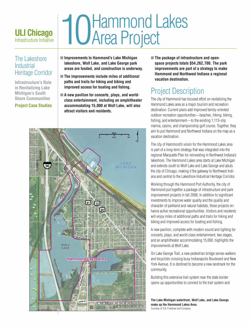
ULI ChicagoInfrastructure Initiative
The Lakeshore Industrial Heritage CorridorInfrastructure’s Role in Revitalizing Lake Michigan’s South Shore CommunitiesProject Case Studies
n Improvements to Hammond’s Lake Michigan lakeshore, Wolf Lake, and Lake George park areas are funded, and construction is underway.
n The improvements include miles of additional paths and trails for hiking and biking and improved access for boating and fishing.
n A new pavilion for concerts, plays, and world-class entertainment, including an amphitheater accommodating 15,000 at Wolf Lake, will also attract visitors and residents.
n The package of infrastructure and open-space projects totals $54,262,700. The park improvements are part of a strategy to make Hammond and Northwest Indiana a regional vacation destination.
Project DescriptionThe city of Hammond has focused effort on revitalizing the Hammond Lakes area as a major tourism and recreation destination. Current plans add improved family-oriented outdoor recreation opportunities—beaches, hiking, biking, fishing, and entertainment—to the existing 1,113-slip marina, casino, and championship golf course. Together, they aim to put Hammond and Northwest Indiana on the map as a vacation destination.
The city of Hammond’s vision for the Hammond Lakes area is part of a long-term strategy that was integrated into the regional Marquette Plan for reinvesting in Northwest Indiana’s lakeshore. The Hammond Lakes area starts at Lake Michigan and extends south to Wolf Lake and Lake George and abuts the city of Chicago, making it the gateway to Northwest Indi-ana and central to the Lakeshore Industrial Heritage Corridor.
Working through the Hammond Port Authority, the city of Hammond put together a package of infrastructure and park improvement projects in fall 2008. In addition to significant investments to improve water quality and the quality and character of parkland and natural habitats, these projects en-hance active recreational opportunities. Visitors and residents will enjoy miles of additional paths and trails for hiking and biking and improved access for boating and fishing.
A new pavilion, complete with modern sound and lighting for concerts, plays, and world-class entertainment, two stages, and an amphitheater accommodating 15,000, highlights the improvements at Wolf Lake.
On Lake George Trail, a new pedestrian bridge serves walkers and bicyclists crossing busy Indianapolis Boulevard and New York Avenue. It is destined to become a new landmark for the community.
Building this extensive trail system near the state border opens up opportunities to connect to the trail system and
10Hammond Lakes Area Project
The Lake Michigan waterfront, Wolf Lake, and Lake George make up the Hammond Lakes Area.Courtesy of S.B. Friedman and Company

recreation areas of Chicago, including the Wolf Lake Unit and the Grand Calumet River Unit of the Calumet Open Space Reserve Plan and the Burnham Greenway Trail System. The trail projects link to the regional system running through Hammond and Whiting and the Burnham Trail (see Lakeshore Industrial Heritage Corridor Projects 9 and 12).
The total cost of the current package of infrastructure and open-space projects is $54,262,700. These projects are funded and underway, with planned completion in 2011.
The city of Hammond has outlined additional projects still in need of funding, including continued investments in water-quality improvements and extensions of the trail system, and an additional pedestrian connection to the marina.
Land UseThe city anticipates that private commercial development will continue to support the growing numbers of tourists and visitors attracted by the enhanced recreational ameni-ties. In addition, the city expects opportunities for residential reinvestment and infill to appear as visitors impressed with Hammond’s amenities choose to stay.
This description represents the best available information as of October 2010.
EvaluationEconomic competitiveness
This project is one of many park and open-space projects that, taken together, significantly increase the attractiveness of the Lakeshore Industrial Heritage Corridor as a residential and busi-ness location. These park and open-space amenities contribute to the environmental health and economic competitiveness of the Greater Chicago region.
Opportunity
Increasing tourism and bringing in visitor dollars are a significant part of the city’s economic development strategy. For Hammond-area residents, this strategy creates jobs, encourages small business opportunities, and provides high-quality recreational and entertainment amenities.
Environmental sustainability
The significant expansion and improvement of pedestrian and bicycle infrastructure supports sustainable transportation. The project improves water quality and the quality and character of the landscape.
Support
Hammond’s long-range vision for the Hammond Lakes area has been incorporated in the Marquette Plan and refined through various studies and plans adopted by the city. Investments going back to 1990 in the infrastructure and amenities of the Hammond Lakes area total over $140 million.
Funding and financial feasibility
Funding for this phase of the Hammond Lakes Area Project is coming from a mix of municipal, port authority, federal, and state sources. The Northwest Indiana Regional Development Authority is contributing 58 percent ($31,480,000) of total project costs ($54,262,700).
Pavilion at Wolf Lake.Courtesy of the city of Hammond
Copyright 2011 by the Urban Land Institute.

ULI ChicagoInfrastructure Initiative
The Lakeshore Industrial Heritage CorridorInfrastructure’s Role in Revitalizing Lake Michigan’s South Shore CommunitiesProject Case Studies
n Plans are in place to redevelop the site of the former U.S. Steel South Works.
n Improvements include the relocation of U.S. 41, under construction as a four-lane, multimodal arterial.
n Community infrastructure includes utilities, miles of lakefront access, a marina, a new high school, bike paths, and transit service.
n The site is planned for nearly 14,000 new homes and 17,500,000 square feet of retail and commercial space.
Project DescriptionA massive area of the city of Chicago’s lakefront opened up for new purposes with the permanent closure of U.S. Steel’s South Works in 1992. Over the last decade, the pieces have been coming together to transform the area into a mixed-use development of nearly 14,000 new homes and 17,500,000 square feet of retail and commercial space.
U.S. Steel completed a voluntary effort to clean up the South Works site in 1997, receiving a determination from the Illinois Environmental Protection Agency that the site meets residential standards.
11South Works/ Chicago Lakeside
The site of the former U.S. Steel South Works is the focus of redevelopment.Courtesy of S.B. Friedman and Company

Key to redeveloping South Works is reworking the roads to better integrate the site, located ten miles south of downtown Chicago, into the region’s transportation network. A relocated U.S. 41 (an extension of South Shore Drive) will be the new community’s backbone. With a projected $67.6 million in funding from the federal government and state, city, and private sources, the first two phases of this four-lane arterial, including landscaped median, bicycle lanes, and sidewalks, are complete; the third and final phase of construction is ex-pected to begin in the summer of 2012. (See also Lakeshore Industrial Heritage Corridor Project 3.)
Additional infrastructure components are outlined in the Chicago Lakeside Development Master Plan prepared by the site developer and approved by the city in April 2010. To be constructed in six distinct phases over an estimated 25–45 years, at full buildout, the $4 billion redevelopment project envisions an estimated $450 million in public infrastructure, 125 acres of public land, miles of lakefront access, a 1,500-slip marina, a new high school, bike paths, and expansive transit service.
In July 2010, the city of Chicago approved tax increment finance assistance for Phase 1. The $96 million will assist with site preparation and infrastructure, including funding for streets, sewers, and utilities for 87 acres in the Lakeside De-velopment area’s northwest corner. Construction is scheduled to begin in 2012.
Land UseThe city of Chicago has approved a planned development ordinance in June 2010 for Phase 1 of the Chicago Lakeside Development Master Plan, consisting of a 76-acre parcel with 800,000 square feet of retail, restaurants, and entertainment uses plus residential development.
This description represents the best available information as of October 2010.
EvaluationEconomic competitiveness
To return such a large area of abandoned industrial land along the Lake Michigan lakefront to economically productive uses while incorporating it into the Greater Chicago region’s lakeshore park and trail system advances the city’s and the region’s eco-nomic health and quality of life. Success at Lakeside can be used as a catalyst to enhance the economy of the southern reaches of the Greater Chicago region.
Opportunity
Redeveloping South Works will bring jobs and new residential opportunities to the area. Phase 1 is estimated to generate 1,000 permanent jobs in the retail industry and more than 1,500 construction jobs.
Environmental sustainability
According to the project Web site, the Chicago Lakeside Devel-opment Master Plan is a LEED-ND (Leadership in Energy and Environmental Design for Neighborhood Development) certified
community from the U.S. Green Building Council for its compact, walkable neighborhoods, bike paths and green spaces, and access to public transit. Environmental cleanup has restored the site to residential standards.
Support
The project has support from the mayor’s office and local alder-men, and city leaders have identified the planned redevelopment as an “excellent example of a public/private partnership.”
Funding and financial feasibility
Funding for the new arterial road is in place, and the first tax increment finance district indicates that the city is willing to use a public/private partnership approach to the site’s community infrastructure. Market conditions will have a strong influence over the pace of plan implementation.
Copyright 2011 by the Urban Land Institute.

ULI ChicagoInfrastructure Initiative
The Lakeshore Industrial Heritage CorridorInfrastructure’s Role in Revitalizing Lake Michigan’s South Shore CommunitiesProject Case Studies
n Redevelopment of a mobile home park in Chicago’s Hegewisch neighborhood aims to take advantage of the area’s natural amenities and recreational improvements.
n The plan requires reworking the community infrastructure for the site.
n The use will be primarily residential with about 950 homes.
Project DescriptionMuch of the vacant or underused land in the Lakeshore Industrial Heritage Corridor (LIHC) will require investments in basic community infrastructure before it can be redeveloped
to attract additional residents and expand the community fabric. Like the Chicago Lakeside Development (see LIHC Project 11), but on a smaller scale, the development plans for East 134th Street in Chicago’s Hegewisch neighborhood take advantage of and augment the corridor’s investment in natural amenities and quality of life.
The 120-acre site is located between Wolf Lake and Powder Horn Lake (see LIHC Projects 10 and 13) and has been used as a mobile home park. In addition to basic community infrastructure, the site plan develops park space, protects wetlands, and builds a network of nature trails that connect to the adjacent William W. Powers State Recreation Area. The city of Chicago has designated a tax increment finance district to support community infrastructure.
12East 134th Street Redevelopment
The site at East 134th Street is planned for a new residential neighborhood.Courtesy of S.B. Friedman and Company

EvaluationEconomic competitiveness
The project is an example of the type of development that uses the natural amenities of the region to attract new residents to the area, which is key to the larger economic strategy for the Lakeshore Industrial Heritage Corridor.
Opportunity
The project is committed to providing a variety of owner- occupied housing, with prices ranging from $160,000 to $386,000. It does not anticipate rental housing or subsidized housing.
Environmental sustainability
The project is designed with the goal of preserving open space and using low-impact methods for urban stormwater. The project meets all legal requirements for the preservation of wetlands and other environmental standards and is providing additional measures to address unprotected wetlands on the site.
Support
The city of Chicago has designated a $26.5 million tax increment finance district to provide a source of funds to build the needed community infrastructure.
Funding and financial feasibility
Market conditions will have much to do with the viability of this project.
Land UseThe area is planned to be primarily residential, anticipating a total of about 950 condominium units, townhomes, and single-family houses. The plan designates locations for neighborhood retail and a clubhouse with swimming pool and a fitness center for residents only. The site is planned for 40 percent green space.
The timing of the project is market driven and expected to take up to 12 to 15 years.
This description represents the best available information as of October 2010.
Copyright 2011 by the Urban Land Institute.

ULI ChicagoInfrastructure Initiative
The Lakeshore Industrial Heritage CorridorInfrastructure’s Role in Revitalizing Lake Michigan’s South Shore CommunitiesProject Case Studies
n The reserve encompasses 3,900 acres of wetlands, wildlife habitat, recreational lands, and open space in southeast Chicago.
n Seventeen sites have been designated, most under public ownership.
n The plan includes trails for hiking and biking, and boating and fishing facilities.
n It aims to make the reserve a regional, national, and even international destination.
n The plan increases the attractiveness of the corridor for residential and business development.
Project DescriptionThe Calumet Open Space Reserve is a 3,900-acre area of wetlands, wildlife habitat, recreational lands, and open space spread throughout southeast Chicago. With the policies sup-porting the Lake Calumet industrial district, the reserve is a major component of the Calumet Area Land Use Plan adopted
by the Chicago Plan Commission in 2002. The plan identifies 17 sites that are environmentally significant or open-space lands that are integral to regional water quality and wildlife habitat; the sites are also well situated to be connected to the larger, regional bicycle and pedestrian trail network.
The plan delineates three types of open space: (a) preserva-tion for habitat, (b) recreation areas, and (c) reclamation of waste-management sites. At the time of the plan’s inception ten years ago, most of the 3,900 acres were already under public ownership; the plan envisions the Illinois Department of Natural Resources, the Forest Preserve District of Cook County, and the Chicago Park District sharing manage-ment responsibilities. In addition, the 435-acre Harborside International Golf Center, operated by the Illinois International Port District, contributes to the open-space reserve. The city of Chicago has since purchased much of the 1,000 acres originally in private ownership.
The city of Chicago is undertaking a series of planned steps to improve water quality, to reclaim contaminated lands, and to restore the natural ecosystems. Recreational improvements
13Calumet Open Space Reserve
Hegewisch Marsh in the Calumet Open Space ReserveCourtesy of the Museum of Science and Industry, Chicago

include trails for hiking, wildlife viewing areas, and boating and fishing facilities.
Building upon the planning efforts of the Calumet Open Space Reserve, the city of Chicago completed studies that resulted in the Calumet Hydrologic Master Plan, the Ecotoxi-cology Protocols, and the Ecological Management Strategy. These studies will direct future environmental restoration and cleanup of the Calumet Open Space Reserve sites. Outreach and education efforts include establishment of the Calumet Stewardship Initiative, Biannual Summits, and Bioblitz.
The city has incurred nearly $12 million in costs toward land acquisition, has spent $500,000 for environmental site investigation, and has received $15 million in restoration grant funds. Central to the plan is the development of the Ford Calumet Environmental Center, which is still targeted for future funding with an estimated buildout cost of $17 million.
Land UseThe city of Chicago recognizes the potential for the reserve to become a key regional, national, and even international destination. The integration of nature into an area defined by industry is a unique endeavor. By improving the environmen-tal quality of the area, the reserve increases the attractiveness of the area for residential and business development.
The Ford Calumet Environmental Center, a product of partner-ship between city and state government, is planned to be the locus of visitor activity in the reserve. Located within the 130-acre Hegewisch Marsh, the 27,000-square-foot learning center includes classrooms, exhibition areas, labs, offices, and an auditorium. Designed to host researchers and industry leaders as well as students and visitors, the facility is planned to host 100,000 visitors a year. The design for the $13.5 mil-lion, LEED (Leadership in Energy and Environmental Design) Platinum facility, developed through an international design competition, has already been heralded as a “milestone in 21st-century public architecture.”
This description represents the best available information as of November 2010.
EvaluationEconomic competitiveness
Taken together with the park and open-space projects that are part of the Marquette Plan, the Calumet Open Space Reserve sig-nificantly increases the attractiveness of the Lakeshore Industrial Heritage Corridor as a residential and business location. These park and open-space amenities contribute to the environmental health and economic competitiveness of the Greater Chicago region.
Opportunity
The reserve expands recreational lands and increases the quality of open space, providing amenities to nearby neighborhoods and buffers from existing industrial and transportation uses.
Environmental sustainability
Preserving and enhancing environmental quality for people and wildlife is a primary goal of the reserve.
Support
The reserve is part of officially adopted plans and the beneficiary of intergovernmental agreements among the city of Chicago, the state of Illinois, and the Forest Preserve District of Cook County.
Funding and financial feasibility
Investment to date has totaled nearly $17.5 million.
Copyright 2011 by the Urban Land Institute.