UC SANTA CRUZ MARINE SCIENCE CAMPUS AREA … SANTA CRUZ MARINE SCIENCE CAMPUS AREA PLAN December...
116
MARINE SCIENCE CAMPUS AREA PLAN UC SANTA CRUZ D e c e m b e r 2 0 0 8 Walker Macy Miller-Hull Interface Engineering
-
Upload
duonghuong -
Category
Documents
-
view
214 -
download
0
Transcript of UC SANTA CRUZ MARINE SCIENCE CAMPUS AREA … SANTA CRUZ MARINE SCIENCE CAMPUS AREA PLAN December...

MARINE SCIENCE CAMPUS
AREA PLAN
U C S A N T A C R U Z
D e c e m b e r 2 0 0 8
W a l k e r M a c yM i l l e r - H u l l
I n t e r f a c e E n g i n e e r i n g

We can never have enough of nature. We must be refreshed by the sight of inexhaustible vigor, vast and titanic features,
the sea-coast with its wrecks, the wilderness with its living and its decaying trees, the thunder-cloud, and the rain.
Henry Thoreau
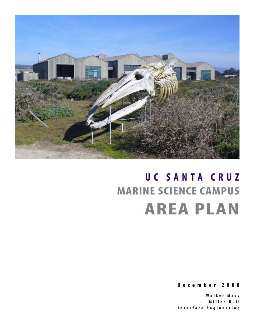
U C S A N T A C R U ZMARINE SCIENCE CAMPUS
AREA PLAN
D e c e m b e r 2 0 0 8
W a l k e r M a c yM i l l e r - H u l l
I n t e r f a c e E n g i n e e r i n g
4 UCSC Marine Science Campus | Area Plan
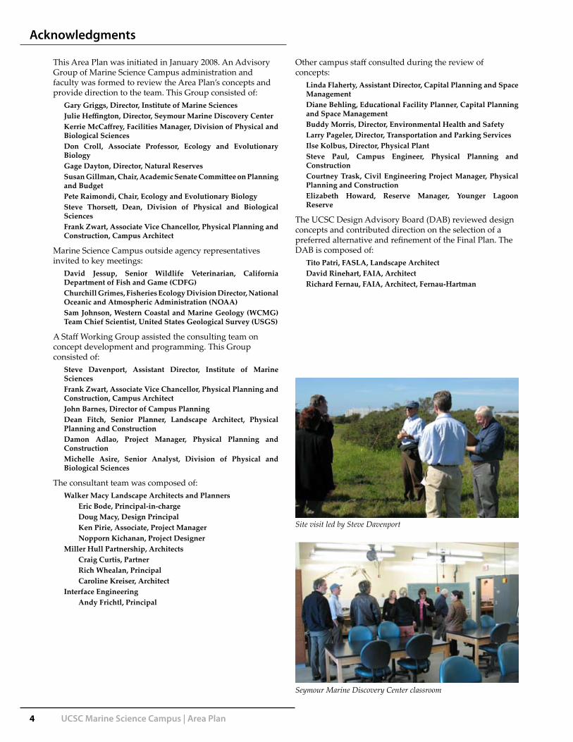
This Area Plan was initiated in January 2008. An Advisory Group of Marine Science Campus administration and faculty was formed to review the Area Plan’s concepts and provide direction to the team. This Group consisted of:
Gary Griggs, Director, Institute of Marine SciencesJulie Heffington, Director, Seymour Marine Discovery CenterKerrie McCaffrey, Facilities Manager, Division of Physical and Biological SciencesDon Croll, Associate Professor, Ecology and Evolutionary BiologyGage Dayton, Director, Natural ReservesSusan Gillman, Chair, Academic Senate Committee on Planning and BudgetPete Raimondi, Chair, Ecology and Evolutionary BiologySteve Thorsett, Dean, Division of Physical and Biological SciencesFrank Zwart, Associate Vice Chancellor, Physical Planning and Construction, Campus Architect
Marine Science Campus outside agency representatives invited to key meetings:
David Jessup, Senior Wildlife Veterinarian, California Department of Fish and Game (CDFG)Churchill Grimes, Fisheries Ecology Division Director, National Oceanic and Atmospheric Administration (NOAA)Sam Johnson, Western Coastal and Marine Geology (WCMG) Team Chief Scientist, United States Geological Survey (USGS)
A Staff Working Group assisted the consulting team on concept development and programming. This Group consisted of:
Steve Davenport, Assistant Director, Institute of Marine SciencesFrank Zwart, Associate Vice Chancellor, Physical Planning and Construction, Campus Architect John Barnes, Director of Campus PlanningDean Fitch, Senior Planner, Landscape Architect, Physical Planning and ConstructionDamon Adlao, Project Manager, Physical Planning and ConstructionMichelle Asire, Senior Analyst, Division of Physical and Biological Sciences
The consultant team was composed of:Walker Macy Landscape Architects and Planners
Eric Bode, Principal-in-chargeDoug Macy, Design PrincipalKen Pirie, Associate, Project ManagerNopporn Kichanan, Project Designer
Miller Hull Partnership, ArchitectsCraig Curtis, PartnerRich Whealan, PrincipalCaroline Kreiser, Architect
Interface EngineeringAndy Frichtl, Principal
Other campus staff consulted during the review of concepts:
Linda Flaherty, Assistant Director, Capital Planning and Space ManagementDiane Behling, Educational Facility Planner, Capital Planning and Space Management Buddy Morris, Director, Environmental Health and SafetyLarry Pageler, Director, Transportation and Parking ServicesIlse Kolbus, Director, Physical PlantSteve Paul, Campus Engineer, Physical Planning and ConstructionCourtney Trask, Civil Engineering Project Manager, Physical Planning and ConstructionElizabeth Howard, Reserve Manager, Younger Lagoon Reserve
The UCSC Design Advisory Board (DAB) reviewed design concepts and contributed direction on the selection of a preferred alternative and refinement of the Final Plan. The DAB is composed of:
Tito Patri, FASLA, Landscape ArchitectDavid Rinehart, FAIA, ArchitectRichard Fernau, FAIA, Architect, Fernau-Hartman
Acknowledgments
Site visit led by Steve Davenport
Seymour Marine Discovery Center classroom

UCSC Marine Science Campus | Area Plan 5
Contents
Executive Summary 7Background 15
Introduction 17Goals 18Review Process 19The Coastal Long Range Development Plan (CLRDP) 20The Site 21
Regional Context 21Local Context 21Climate 22Soils 22Geology 22Younger Lagoon 22Terrace Vegetation and Habitat 23Terrace Wetlands 23
Existing Architectural Character 24Site Constraints 24Program 26
Area Plan Concept 31Campus Concept 33Landscape Concept 35Middle Terrace Concept 38Prototypical Building Form 39
Subareas 41Subarea 1 (Upper Terrace) 43Subarea 2 (Upper Terrace) 44Subarea 3 (Middle Terrace) 45Subarea 4 (Middle Terrace) 46Subarea 5 (Middle Terrace) 47Subarea 6 (Middle Terrace) 48Subarea 7 (Middle Terrace) 50Subarea 8 (Middle Terrace) 51Subarea 9 (Middle Terrace) 52Subarea 10 (Middle Terrace) 53Subarea 11 (Lower Terrace) 54Subarea 12 (Lower Terrace) 55Subarea 13 (Lower Terrace) 56Subarea 14 (Lower Terrace) 57Subarea 15 (Lower Terrace) 58Subarea 16 (Entrance Zone) 60Summary Table 61
Phasing 63Phasing Concept 65Phase 1 67Phase 2 68Phase 3 69Phase 4 70
Stormwater Management 71Circulation & Public Access 79
Circulation Concept 81Transit 82Pedestrian 83Bicycle 85Service Access 86Fire and Emergency Access 87Parking 88Public Coastal Access Plan 90Circulation Phasing 92
Sustainable Design 93Guidelines 101
Building Design 103Landscape Concept Guidelines 104
Appendix: Meeting Notes 105
Younger Lagoon Reserve restoration
Blue Whale skeleton, Seymour Marine Discovery Center
Bluff at south end of Marine Science Campus
Dolphin research tank

xc
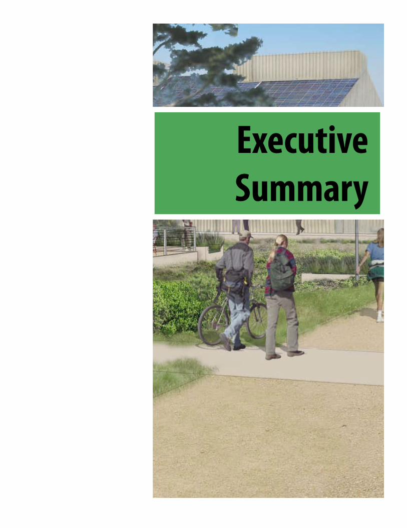
Executive Summary

xc

UCSC Marine Science Campus | Area Plan 9
Executive Summary
0 200 400Plan view of proposed Marine Science Campus layout at full build-out

10 UCSC Marine Science Campus | Area Plan
Executive Summary
This Marine Science Campus (MSC) Area Plan has been developed to bridge the gap in the development framework described in the 2008 Coastal Long Range Development Plan (CLRDP). The Area Plan lays out the CLRDP program with particular attention to the area in the “Middle Terrace,” where most new development would occur. This plan aims to reconcile CLRDP allowances for 323,000 gross square feet of new marine research buildings in 16 strictly defined development subareas with the accompanying detailed restrictions.
UCSC has expressed an institutional goal of creating a consolidated home for several inter-related, coastal-related disciplines on this campus, in particular the faculty of Ecology and Evolutionary Biology. The MSC location will greatly enhance research and teaching access to field study locations for these disciplines.
A key intent for this Marine Science Area Plan is to create a framework for the next 20 to 30 years of development and provide a flexible form for ordered campus growth. The Plan should be reviewed and updated as necessary on a regular basis, to ensure that it remains consistent with the CLRDP and the Marine Science Campus programs. Site development should be integrated with the restoration of native landscape and the surrounding open space as it evolves and matures through its restoration process.
The Vision
This plan takes an holistic approach to the integration of the MSC into the natural world that it studies, considering the buildings and systems as contributing elements, not as impacts to the local ecology. The vision for the MSC is thus a near-seamless integration of the coastal landscape with new development.
This Area Plan aims to achieve this integration in a pragmatic way that complements, restores and enhances the coastal ecosystems that are the subject of this campus’ research activities. The protection of this site’s water quality is an overriding theme for all activities proposed for the MSC.
This plan aims to create a memorable place for learning and research, featuring common spaces for impromptu encounters among faculty and students, contributing to an atmosphere of intellectual exchange. The concept for the Middle Terrace envisions a central, pedestrian-oriented axis, the Middle Terrace Walk, flanked by a compact arrangement of 2-story structures oriented in an east-west grain. Minor pedestrian cross-axes intersect with the Middle Terrace Walk. The buildings are interspersed with fingers of native plantings that weave the language of the surrounding natural areas into the core of the Middle Terrace.
Artist’s rendering of the Middle Terrace Walk

UCSC Marine Science Campus | Area Plan 11
The Middle Terrace Walk serves as the social and circulation spine of campus, a place that encourages unstructured casual interaction among faculty, staff and students. American colleges have traditionally featured central common open spaces, often expressed as quads or greens framed by buildings. The Middle Terrace Walk, vegetated drainage basins and adjacent building courts will in effect become the central ‘quad’ or heart of the Marine Science Campus—an evocative space for the research community, expressing the spirit of this setting in a fitting way for the important work that is conducted here.
Architecture
The existing buildings on the MSC site have for the most part established an aesthetic language that builds on the rural context. This language takes its cues from vernacular coastal barn forms which feature low building masses, gabled and shed roofs, wood cladding and muted colors that blend with the landscape. The Area Plan is a direct response to the restrained simplicity of these buildings in the landscape, with the intent of allowing the land and the distant views to remain as the dominant visual experience.
This Area Plan proposes a flexible, universal building module that reflects contemporary research and academic space realities. A simple pattern is established as the driving architectural concept for the expanded campus. For the Middle Terrace, most of the buildings
align along an east-west axis to take advantage of sun angles. Passive solar strategies, such as overhangs to block out midday sun, are particularly effective in this orientation. The roof gables on an east-west axis also promise good exposure for photovoltaic panels. The research buildings will still serve to block out strong westerly winds by creating intimate courtyards on the eastern sides of buildings. The offset arrangement also extends the interior work space and shelters outdoor break areas.
The siting and orientation of the buildings recognizes the progression from public to private zones. McAllister Way provides a subtle division between the public campus buildings to the east and the animal research areas to the west which demand privacy and security. The Plan thus reflects the desire for expanded mammal research tanks to be isolated from public view, while aligning with the existing animal facilities at the Lower Terrace and Fish and Game Building.
With respect to form and finishes, the new buildings will lean on the architectural example set by the Seymour Marine Discovery Center and other existing buildings. The scale of each building is minimized by giving the impression that it is composed of a series of long sheds attached to each other. In a few locations a planted roof may be appropriate. A planted roof will demonstrate stormwater ‘best management’ techniques and expand on the connection of the buildings and the landscape.
Executive Summary
The Middle Terrace Walk

12 UCSC Marine Science Campus | Area Plan
Executive Summary
Phasing
The Marine Science Campus will be developed according to programmatic requirements and subsequent funding availability, either from the State, collaborating agency resources, or private donors. This Area Plan should therefore be considered a dynamic document that is flexible enough to allow the campus to respond to new programs or building opportunities as well as new information on the site’s constraints. The phased development should occur in a logical increment of development but there are certain facilities that could be built at any time.
Circulation
The circulation concept for this Area Plan is simple. The existing main access road, the continuation of Delaware Avenue, will be re-routed. The new, gracefully curving road will separate the Middle Terrace development from existing functional uses such as the CDFG and future research areas in Subarea 6. By placing the road to the west of the core of the Middle Terrace, a pedestrian-oriented campus can be developed to the east, centered on the main pedestrian spine and related stormwater treatment basins. The road will be as unobtrusive as possible in the landscape.
Existing transit use to this campus is minimal. An enhanced shuttle service will play an important role in reducing private vehicle usage on campus as it develops. The shuttle will follow the main entry road to the Seymour Marine Discovery Center.
With overall UCSC campus goals of reducing private automobile use and specific goals of creating a walkable Marine Science campus, this Area Plan provides a comprehensive network of sidewalks, walks and trails. The primary bicycle access for visitors and MSC users will be routed separate from cars and transit to the southeast of the Middle Terrace. There will be numerous bicycle parking spaces on campus, to meet aggressive goals for alternative transportation.
Recent growth at the MSC has created a difficult parking situation, particularly for public use of the Seymour Center. To accommodate dramatic increases in development, the campus proposes an aggressive ‘mode-split’ that assumes 60% of future trips to the campus will be by carpool, transit, bicycle or on foot (the main UCSC campus achieves 55-60%.) This Area Plan proposes a total of 445 new and reconfigured parking spaces, which includes 33 ADA-accessible stalls.
Public Access
As an educational resource of great value to the people of Santa Cruz and California, the facilities of the Marine Science Campus are required to include a measure of public access. This continues the provision of generous access to the walking paths on the campus as well as public visitation to the Seymour Marine Discovery Center, which is an important source of revenue supporting the MSC as well as a venue for valuable public information about the MSC’s important research efforts. New overlooks will be sensitively placed in the Younger Lagoon landscape and designed to evoke the architectural language of the MSC while appearing unobtrusive to observers elsewhere in the Reserve.
Stormwater
The CLRDP requires that storm water runoff be managed entirely on the site, so that the quantity and quality of the runoff flowing to the site’s wetlands and to Younger Lagoon Reserve are not altered. In this Area Plan, stormwater is treated in basins adjacent to the Middle Terrace Walk, which are integrated into the built environment buildings as open space. Stormwater treatment takes place in a series of vegetated basins and channels that flow gradually to the south for eventual dispersal in a naturalistic basin. This is a simple way to treat the stormwater entirely naturally, without structures or engineered treatment. The system is also visible and central to campus, so that it can provide an educational, interpretive function.
Artist’s rendering of Area Plan: Aerial view SW across Middle Terrace

UCSC Marine Science Campus | Area Plan 13
Sustainability Vision
The Marine Science Campus is engaged in critically important research activity for the protection of marine and coastal habitat and ecosystems worldwide with a particular focus on Monterey Bay. It is imperative that the campus be developed in as sensitive a manner as possible. The site’s inherent climatic setting and the existing infrastructure presents opportunities to incorporate green design in its planning and ultimate construction.
Solar Power
The vernacular ‘coastal barn’ roof forms and building profiles described in the CLRDP Design Guidelines would still be applicable to the shifted orientation and would in fact lend themselves well to the installation of photovoltaic panels on south facing roof planes.
Wind Energy
Conceptually, a bank of wind turbines could be installed along the western edge of portions of the MSC site. Given the adjacent Younger Lagoon’s function as active avian habitat, such turbines will need to be designed and installed carefully. New models of ‘vertical-axis’ wind turbines have been tested to minimize or eliminate bird kills. These models are also well-suited to variable wind direction and offer easier maintenance access. It is estimated that if a bank of at least thirty 5kW wind turbines were installed along the western edge of Subarea 7, 1.3 million KWH/year of electricity could be generated.
Seawater System
The MSC utilizes seawater for research experiments and in holding tanks for marine wildlife. The system is a rare and valuable resource for research activities, as it would be extremely difficult from a regulatory perspective to build a new system along the California coastline. The MSC discharges all of the seawater back into the ocean after use. There is a significant opportunity to generate renewable micro-hydro power by rerouting the discharge down the NOAA caisson to develop head pressure to spin a micro-hydro turbine. As the seawater is directed into new buildings, excess temperature could be captured by geothermal heat pumps, which would then warm the buildings with a fraction of the energy of the current operation.
Executive Summary

14 UCSC Marine Science Campus | Area Plan
Executive Summary
Sustainability Opportunities for the Marine Science Campus
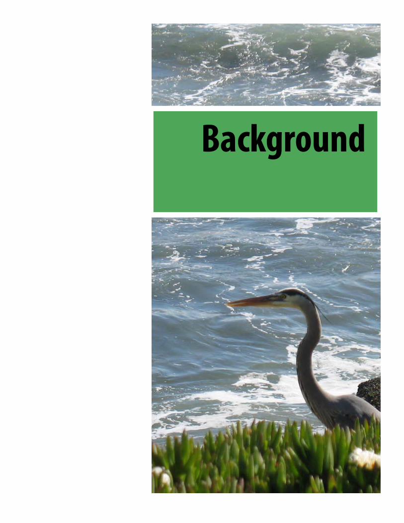
Background

xc

UCSC Marine Science Campus | Area Plan 17
Introduction
This Area Plan for the UC Santa Cruz Marine Science Campus (MSC) will guide specific development for the entire 97.96-acre site, inspired by its natural setting and informed by the Coastal Long Range Development Plan (CLRDP). The CLRDP was initiated following UCSC’s purchase of additional land adjacent to the original Long Marine Lab and after 8 years of planning, was adopted in June 2008. The CLRDP serves as an essential document for developing the Marine Science Campus.
This Area Plan is the physical master plan to be implemented over time and has been developed to bridge the gap between the development framework described in the CLRDP and individual capital projects.
This campus can be considered a microcosm of the very ecosystems this institution strives to protect. From the smallest mollusk to the blue whale, the coastal marine environment is a deeply inter-related system, sensitive to outside influence and yet ever-resilient and adaptable. One can broadly apply this description to the Marine Science Campus. From the smallest cell of a single laboratory experiment to the overarching goals of UC Santa Cruz, this campus should be a flexible and adaptable place encouraging the intermingling of different ideas, people and processes with the ongoing restoration of the site, Younger Lagoon and of Monterey Bay beyond.

18 UCSC Marine Science Campus | Area Plan
Goals
The Coastal Long Range Development Plan (CLRDP) establishes the following mission and vision for the Marine Science Campus at UC Santa Cruz:
We have an obligation to the people of the region and the state, as well as to the (Monterey) bay, the Sanctuary and the world’s oceans to optimize our capabilities and our resources in order to do all we can to fully understand the oceans and anthropogenic change they are experiencing, to solve the problems we have created, and to share the knowledge we have developed with the public and those who make decisions which affect the oceans and how we use them. To do any less would be a loss of an exceptional location, capabilities and opportunities. Our challenge is to plan for optimal use of our site for marine research and education while respecting the important sensitive natural areas.
The CLRDP includes specific Planning Objectives (Chapter 4), which include:
Develop a world-class marine research, education, ocean health, and public service campus with the scope, diversity, and excellence in program and facilities necessary to respond to the growing need for marine science, to establish the University’s leadership in the field, and to attract sustained funding. Create...opportunities for new marine research, education, and ocean health activities that:
(1) are proximate to the ocean environment and thereby allow the keeping of marine plants and animals in an environment that approximates their natural setting, (2) can be undertaken adjacent to existing facilities on the Campus to promote interaction and collaboration, (3) complement and broaden existing research, education, and ocean health activities, (4) have access to large volumes of fresh seawater, and (5) are provided sufficient expansion area
The specific charge for this Area Plan was that the final document should:
…describe the programmatic and physical attributes of a creative, sustainable and integrated campus design suited to the unique environment of the site, the constraints of a public institution, the flexibility to accommodate innovative development solutions and adaptability to adjust to change over time. The report should articulate the program and propose a physical master plan that presents potential development alternatives in a clear and creative manner consistent with the CLRDP.
Another key intent for this Marine Science Area Plan is to create a flexible development framework for the next 20 to 30 years. Campus planning and development is typically a fluid, dynamic process with changing objectives, new program requirements, unforeseen opportunities and physical site conditions. The Plan should be reviewed and updated as necessary on a regular basis, to ensure that it remains consistent with the CLRDP, Marine Science programs and with the evolving surrounding ecosystem.

UCSC Marine Science Campus | Area Plan 19
The review process for the Area Plan was linear, with iterative feedback loops helping to shape the direction of successive drafts of the final master plan scheme. The consultant team consulted with and made a series of presentations to campus staff working and advisory groups.
The consultant team, hired in early January, first analyzed the CLRDP then established an initial program in preparation for Workshop 1 (February 7-8th). This Workshop included:
A site tour• Kickoff meeting with Staff Working Group• Stakeholder meetings with Younger Lagoon Reserve • staff, campus engineering staff and Winzler-KellyAdvisory Group meeting (February 8th), a visioning • session for site layout and confirmation of CLRDP programming
Returning to campus on March 4th and 5th for Workshop 2, the consultant team:
Reviewed parking and circulation concepts• Convened a Design Advisory Board meeting• Reviewed preliminary concepts for the site in an • interactive work session with Staff Working Group and Advisory GroupConvened a campus-wide Open House to solicit • comments on the program and site concepts.
Review Process
Workshop 3 on April 22nd aimed to establish a preferred concept from four schemes presented. The schemes were accompanied by a stormwater treatment concept that could be applied universally. The Design Advisory Board and Advisory Group reviewed the schemes and selected a preferred alternative for the team to refine.
Workshop 4, held May 27th, presented the refined, preferred scheme for the MSC. Through a series of work sessions, the details of circulation, landscape, stormwater and programming for this scheme were further refined. A second campus Open House was held in the Seymour Marine Discovery Center on May 28th, for staff and students to review and comment on the refined scheme.
A final Workshop 5 was convened on June 24th to present the Final Area Plan, building program and stormwater concept to the DAB and the Advisory Group.
Area Plan schedule

20 UCSC Marine Science Campus | Area Plan
Coastal Long Range Development Plan (CLRDP)
The Coastal Long Range Development Plan (CLRDP)
The CLRDP is a general plan for the physical development of the site and the protection of the coastal environment. It is a thorough study of the physical and regulatory context of the Marine Science Campus and it details requirements for future development on the site as well as a set of program options. The CLRDP was initiated following the University’s purchase of 57 acres adjacent to its previous holdings, which included the Long Marine Lab and the adjacent Natural Reserve System Younger Lagoon Reserve. It was prepared over a period of approximately 8 years. As the document states:
The CLRDP is not intended, however, as a commitment to any specific building project, building construction schedule, or building funding priority. Within the parameters established by this CLRDP, individual buildings and improvements will be approved on a case-by-case basis and will be accompanied by additional environmental analysis and public review, if necessary, to comply with CEQA and/or the California Coastal Act.
Campus staff and consultants reviewing this Area Plan should refer to the CLRDP for a full description of the regulatory and urban planning context that shapes that document and this Area Plan. The CLRDP is an essential, overarching companion document to this Area Plan and must be consulted by future building programmers and designers. This Plan refers to appropriate chapters of the CLRDP and provides direct excerpts but it is not intended to revise any of the CLRDP’s provisions. Any such changes to the CLRDP, or projects out of conformance with the CLRDP would require approval of the California Coastal Commission.
This Area Plan primarily serves to provide a detailed, buildable plan as a complement to much of Chapter 7 of the CLRDP (“Illustrative Campus Buildout Site Plan and Preliminary Designs.”)
M A R I N E SCIENCE CAMPUS SCIENCE CAMPUS SCIENCE CAMPUS
Coastal Long Range Development Plan
July 2007
UC Santa Cruz
California Fish & Game Marine Wildlife Center

UCSC Marine Science Campus | Area Plan 21
Regional Context
The following is excerpted from the CLRDP’s description of the MSC’s context:
The UC Santa Cruz Marine Science Campus is situated on the central California coast, near the center of the Monterey Bay National Marine Sanctuary. The Campus is approximately 65 miles south of San Francisco, in the coastal zone at the western edge of the City of Santa Cruz. Younger Lagoon Reserve, a wetland-terrestrial system that is part of the University of California Natural Reserve System (UC NRS), is located on the western portion of the site. Agricultural land stretches to the west and northwest of the site. The Campus coastline is characterized primarily by a low cliff that drops to a rock shelf, and partially by the larger pocket beach fronting the Younger Lagoon area. The Campus shoreline provides for views of the ocean and a dramatic placement at the transition point between Santa Cruz County’s rural North Coast area and the urbanized City of Santa Cruz.The California coastline provides an iconic setting that is valued by residents and visitors alike. The protection of agricultural uses (primarily Brussels sprouts, strawberry and artichoke fields) is a prime policy objective of the California Coastal Act and…these protections assure a unique and picturesque visual environment directly west of Long Marine Lab.
Local Context The residential area directly adjacent to the east of the campus is De Anza Mobile Home Park, a private development where mobile home lots are on long-term leases…enclosed by a perimeter masonry block wall that runs along the east side of the Campus. Recent redevelopment area activities have focused on attracting high-tech (and)…other industrial uses along Delaware Avenue includ(ing) biotechnology, fiberglass manufacturing of surfboards and windsurfing boards, and sailing-related light industrial uses. The area is now characterized as a mixed-use industrial zone of high tech and local light industrial uses among the formerly industrial sites.
ContextC o n t e x t
CLRDP Chapter 2 Page 4 of 24
(from 2008 CLRDP)
Beach at Younger Lagoon

22 UCSC Marine Science Campus | Area Plan
The CLRDP includes a detailed physical inventory of the Marine Science Campus site and context. Key excerpts are provided below:
ClimateThe Santa Cruz area enjoys a Mediterranean climate. Summers are dry and warm, although 30% to 40% of days are foggy, primarily in the night and early morning. Summer winds are generally from the west. Winters are cool and wet. Total precipitation averages approximately 30 inches per year. Storm winds in the winter are generally from the southwest. The site also is exposed to salt spray from the ocean. Strong winds, cool temperatures, and salt spray limit development on the site by creating the need for wider setbacks from agricultural fields to the west, by creating the need for wind protected areas, and by limiting landscaping and habitat restoration plant lists.
SoilsThe coastal terrace that includes the site is underlain by the Santa Cruz Mudstone geologic formation, which is overlain with soils of varying thickness and texture. Watsonville Loam is predominant on the southern and northern portions of the site, while Elkhorn Sandy Loam is found on the central portion. On-site wetlands are found on both soil types. The terrace portion of the campus was formerly under cultivation for brussel sprouts, but has lain fallow since 1987. Soil conditions on the terrace portion of site may constrain development on the Marine Science Campus by affecting the design of surface retention features for the drainage system.
GeologyThe City of Santa Cruz General Plan identifies the coastline adjacent to the site as being at “moderate risk” of cliff erosion. In this case, according to geotechnical analysis, the average long-term rate of retreat at the site is estimated to be less than 0.5 feet/year…the analysis recommends a 100-year setback of 50 feet from the top edge of the terrace deposit to account for... erosion. Based on the estimated rate of long term retreat, a setback of 100 feet would provide protection for an estimated 200 years.
Terrace WetlandsTen wetland areas comprising approximately 7.44 acres have been delineated on the terrace portion of the site based on the wetland definition contained in the Coastal Act and the Coastal Commission’s Regulations. The wetlands were identified as wetlands W1 through W10, and were located as follows: wetlands W1, W2, W3, and W6, which act as a wetland complex, are located north and west of the Campus access road; wetlands W8 and W9, which appear to be hydrologically isolated from the W1-W6 wetland complex during most years, are located south of the Campus access road; wetland W4 is located near the center of the terrace adjacent to the De Anza Mobile Home Park; wetland W5, a large seasonal pond, is located between the NOAA facility and LML proper; wetland W7 is located near the northeast corner of the Campus; and wetland W10 is a small wetland located on the eastern perimeter of the Campus south of wetland W4.
The diagram on page 24 includes the wetland numbers listed above.
The Site

UCSC Marine Science Campus | Area Plan 23
The Site
Younger LagoonThe 25-acre Younger Lagoon Reserve (YLR)…is jointly managed by UCSC and the UC Natural Reserve System for teaching and research uses. Most of YLR qualifies as Environmentally Sensitive Habitat Area (ESHA) by Coastal Act standards.One of the few relatively undisturbed wetlands remaining on the California Central Coast, the Younger Lagoon Reserve encompasses a remnant Y-shaped lagoon on the open coast just north of Monterey Bay. Most of the time, the lagoon is cut off from the ocean by a barrier sand and rock bar. Infrequently, the mouth of Younger Lagoon opens to ocean waters. The lagoon system provides protected habitat for 100 resident and migratory bird species. Approximately 25 species of water and land birds breed atYLR, while more than 60 migratory bird species overwinter or stop there to rest and feed. Opossums, weasels, brush rabbits, and harvest mice are known to occupy the lagoon; gray and also red foxes and bobcats have been sighted. Reserve habitats include salt and freshwater marsh, backdune pickleweed flat, steep bluffs with dense coastal scrub, pocket beach, grassland, and dense willow thickets.
Interviews with YLR staff revealed that the reserve is significantly degraded due to erosion. There are many invasive species, such as poison hemlock, which YLR is removing and replacing with coastal vegetation.
Terrace Vegetation and Habitat
The CLRDP describes the range of MSC habitat:Seven distinct habitat types exist on the terrace portion of the site that are not associated with human activity or recent heavy or repeated human disturbance. These include non-native grassland, coyote brush scrub-grassland, coastal bluff community (with two phases: mixed and ice plant), seasonal pond, freshwater marsh/coastal terrace, herb community dominated by willow-herb and Baccharis douglasii, and moist meadow. Three additional habitat types on the site are associated with human activity and intensive disturbance: ruderal, developed/ruderal, and planted berm. Non-native grassland and coyote brush scrub-grassland occupy most of the site. The coastal bluff community occurs only in a very narrow zone along the edge of the bluff at the south end of the site. The seasonal pond occurs south of the NOAA facility in the central portion of the site. Three small freshwater marsh habitat complexes occur on the site: one just north of the CDFG Wildlife Center, one just north of the access road near the western boundary of the site, and one along the northern boundary of the site near the northwestern corner. The herb community habitat type is a specialized wetland assemblage that occurs only in a small patch within the grassland in the east-central portion of the site.
See the CLRDP, Chapter 3.7 for more description of the site’s biotic resources.

24 UCSC Marine Science Campus | Area Plan
Existing Architectural Character
The existing buildings on the MSC site have for the most part established an aesthetic language that builds on the rural forms described above. This language takes its cues from vernacular coastal barn forms which feature low building masses, gabled and shed roofs, wood cladding and muted colors that blend with the landscape.
The original Long Marine Lab buildings are functional, single-story research buildings located in a perimeter around holding tanks and cages. Subsequent buildings such as the Seymour Marine Discovery Center and the Center for Ocean Health established a north-south site plan ‘grain’, and feature consistent peaked and shed roofs with distinct fume hood stacks, vertical board and batten wood cladding and simple window patterns.
Site Constraints
The site’s natural constraints include the Younger Lagoon Reserve, which is an Environmentally Sensitive Habitat Area (ESHA) with a CLRDP-set buffer of variable width along its eastern edge. The wetlands on the terrace portion of the MSC site are also ESHAs (except for W7 in the far northern portion of the site) and the CLRDP includes 100’ setbacks from these features. There is also a 100’ setback from the top edge of the Lower Terrace cliff for coastal geological stability. Wildlife connection corridors are required to connect habitat on the campus to Wilder Creek Lagoon along the Union Pacific RR and to Antonelli Pond underneath Shaffer Road. The diagram on the facing page (Site Constraints Composite) describes the overlapping regulatory restrictions on this site.
An additional layer of constraints is imposed upon the site based on surrounding uses. To the west, the CLRDP requires buffers from active agricultural fields and associated pesticide use. Occupied buildings (except ancillary research structures such as greenhouses) must be located outside a 200’ setback from the western property line and at least 300’ from the established crop line. Long-term accommodations such as caretaker cottages cannot be located within 500’ of the western property line. In addition, a series of view corridors have been established across the site from locations around the MSC’s perimeter, including the main entry off Delaware and Highway 1.
The Site
S i t e P l a n n i n g C o n s i d e r a t i o n s
CLRDP Chapter 3 Page 20 of 28
W1
W8
W6
W7
W2 W3
W9
W4
W10
W5
(from 2008 CLRDP)

UCSC Marine Science Campus | Area Plan 25
PROPERTY LINE
AGRICULTURAL SETBACK - 200' SETBACK FROM THE PROPERTY LINE OR300' SETBACK FROM ESTABLISHED CROP LINE (WHICHEVER IS GREATER) FOR OTHERTHAN CARETAKER ACCOMMODATIONS.
500' AGRICULTURAL SETBACK FOR CARETAKERACCOMMODATIONS.
DRAINAGE BASIN BOUNDARY
VIEW CORRIDOR PERIMETER
SETBACK FOR GEOLOGIC INSTABILITY
WILDLIFE CORRIDOR
ENVIRONMENTALLY SENSITIVE HABITAT AREA - (ESHB)
ESHB BUFFER
RESEARCH & EDUCATION MIXED USE
OPEN SPACE
DEVELOPMENT SUBAREAS
x 67.1
x 45.2
x 47.3
x 48.7
x 51.1
x 49.3
x 49.4
x 48.9
x 46.0
x 45.8
x 41.0
x 43.6
x 43.6
x44.1
x 47.3
x 44.0
x 46.9
x 47.2
x 45.1
x 47.2
x 44.3
x42.8
x44.7
x 43.1
x 45.7
x 49.2
x 52.9
x56.7
x59.1
x 60.8
x54.9
x 51.5
x 49.8x 47.2
x44.7
x48.3
x 50.1
x 49.9
x49.7
x 49.1
x 49.2 x 50.1
x 49.7
x45.5
x46.4
x48.5
x 49.4
x 49.5
x 49.9
x 49.4
x 49.6
x 49.5
x 51.3
x 53.4
x 52.6
x 53.8
x 54.6
x 53.3
x51.7x 51.6
x 52.5
x49.3
x51.2
x 51.8
x 50.7
x 49.6
x 49.3
x 48.7
x 46.8
x48.8
x54.9
x56.9
x 58.8
x61.4
x 64.8
x 61.6
x 60.5
x 60.3
x 59.0
x 56.8
x 57.6
x 59.3
x 59.0
x 55.5
x 54.6
x 55.0
x 53.6
x 53.7
x 54.4
x 52.2
x 49.9
x 60.2
x66.9x 66.9
x 66.8
x 67.3x 65.9
x 62.7
x59.9
x 55.1
x 45.8
x 45.5
x40.2
x 47.1
x 46.1
x42.9
x42.2
x37.8
x 37.4
x 37.1
x 42.7
x44.2
x 44.8
x 45.4
x 44.9 x 46.9
x 47.6
x 43.1
x 46.1
x 44.3
x48.5
x 47.7 x 46.9
x 35.4
x37.1
x38.1
x 39.8
x 37.2
x 39.7x 39.9
x 40.9
x 42.3
x 44.2
x 41.1
x 37.5
x38.8
x 40.5
x 43.3
x 45.7x 43.1
x 4.4
x 4.8
x 8.3
x 37.8
x 39.9
x10.8
x 13.2
x12.9
x 9.4
x 10.5
x8.9
x 43.8
x 43.4
x 42.5
x 40.5
x 37.3
x35.9
x37.1
x 37.1
x37.8
x36.4
x 37.8
x 39.1
x 38.6
x 43.9 x 42.7
x 39.1
x 36.8
x 35.6
x36.1
x 35.7
x 54.9
x 45.2
x 50.8
x 48.7
x 37.4
x 37.7
x 38.5
x40.3
x 39.1
x 39.5
x 41.1
x 42.5
x 40.9
x 45.1
x 44.6
x 36.5
x 39.0
x 43.9
x42.1
x44.8
x44.8
x40.8
x38.1
x41.5
x 41.6
x 39.2
x 42.4
x 40.9
x 43.9
x 44.0x 44.0
x 45.4
x46.2
x 46.2
x 44.5
x 45.5
x 42.7
x 44.3
x45.3
x 45.5x 45.6
x 60.5
x46.5
x 45.9
x 45.1
x 28.5
Gate
60
60
50
5050
50
20
304040
30
50
3040
3040
40
40
10
10
40
40
30 20
10 30 20
40
30
20
50
40
102030
40
30
2010
20
30 40
20
20
20
UNION PACIFIC RAILROAD
SHAF
FER
RO
AD
DELAWARE AVENUE
McA
LLIS
TER
WA
Y
CA
SC
AD
E A
VE
NU
E
McC
ALL
ISTE
R W
AY
Gate
Gate
Marine Science Campus
CLRDP Site Analysis0 50 100 20025
Walker Macy Miller-Hull Interface Engineering
August, 2008
UC Santa Cruz
The Site
Site Constraints Composite

26 UCSC Marine Science Campus | Area Plan
Program
Existing Facilities
Facility Size (GSF)UCSC Long Marine Laboratory:
Research Support Building 6,200Younger Building 3,700Service Building 2,300Temporary Trailers 3,000Seymour Marine Discovery Center 20,000Ocean Health Building 23,000Avian Facility 2,160Temporary Caretaker Units 1,400Seawater Facility 5,000Subtotal 66,760
Fish and Game Marine Wildlife Center 20,000Subtotal 86,760
NOAA Fisheries Laboratory 53,400TOTAL 140,160
(from CLRDP, Figure 2.12)
The Marine Science Campus Program
The researchers, faculty and students at UCSC’s Marine Science Campus are engaged in critical study of the world’s oceans. Oceanography and marine science is an evolving, interdisciplinary field and has become increasingly important as ocean issues and concerns have become more pressing. But scientists working alone in isolation cannot solve complex ecological problems. Consortiums of marine institutions such as the relationships found at the MSC will be increasingly necessary to deal with these global problems and their policy implications.
The Institute of Marine Sciences and Long Marine Laboratory (LML) recognize that there are many benefits and opportunities available by working with state and federal agencies to develop cooperative programs and co-located facilities. Partnerships with NOAA, USGS, CDFG and the Nature Conservancy have brought new programs, scientists, funding, facilities and capabilities to the region. These strengthened programs expand UCSC and society’s collective ability to study and resolve important questions and problems about the ocean. These partners have significantly increased the University’s capabilities and ability to undertake broad scale marine research and also train the next generation of scientists.
Overlooking the nation’s largest National Marine Sanctuary oceanfront site, with access to high quality seawater ,the MSC has the foundation and the potential to become a world-class marine research and education center. The presence of a strong core of internationally recognized marine scientists, a cadre of intelligent and motivated graduate students, as well as all the funding and support of a major research university have become magnets to which others continue to be drawn.
The University’s group of marine scientists will grow and expand its capabilities and as the campus reaches build-out under its pre-CLRDP master plan, they will need additional office, teaching and research facilities. In 2001, the UCSC Division of Natural Sciences, the department that oversees both the Institute for Marine Sciences and the Younger Lagoon Natural Reserve, completed a strategic plan that projects growth and program development for the department to 2011. According to the strategic plan, marine sciences faculty will continue to play a major role in the research and educational mission of the campus and are projected to increase four-fold over the plan period (for a total of 21 faculty members). This 57% increase in faculty would be accompanied by a similar level of growth in graduate students, post-doctoral students, researchers, and lab assistants.
The University envisions the need for up to 254,500 square feet of additional marine research and education facilities on the Marine Science Campus under the CLRDP. This projection is sufficient to accommodate future growth in UCSC and affiliated programs consistent with the need to provide open space and protect natural resources on the Marine Science Campus.
Education is a critical component in raising public awareness of the challenges to ocean health. There are already more requests by school groups for public education than can be accommodated, indicating a need to plan for future growth in public programs at the MSC, specifically at the Seymour Marine Discovery Center.
Existing Uses
The Marine Science Campus is now home to a range of uses and academic programs. These existing facilities are summarized below.

UCSC Marine Science Campus | Area Plan 27
Program
Support Facilities
An effective marine science and education program requires support facilities where scientists, faculty, and students can meet with their peers to discuss ideas, debate policy, and set agendas for future research. The CLRDP projected the need for a small seminar auditorium, meeting rooms, and food service. The auditorium will be suitable for lectures and presentations, and will enhance the ability of the MSC to conduct meetings and workshops of a state, national or international scope, internal academic seminars and lectures, and community education activities. Meeting rooms will be included to complement the auditorium and will facilitate small conferences and symposia that can be conducted in smaller, seminar-type space accommodating 50 to 75 people each. Finally, a small dining hall will provide food service for seminars and lectures and to reduce the need for on site researchers, staff and students to leave the campus for meals.
Short-Term Accommodations
The CLRDP notes the following planning objective:Create a campus that promotes round-the-clock immersion in the research environment and extends interaction and collaboration among scientists, students, and administrators beyond formal work settings by providing short-term accommodations for researchers, educators, students, caretakers, and visitors that are adjacent to coastal-dependent activities.
Those who would benefit from such facilities include scientists and degree candidates whose research effectiveness could be optimized by their ready access to laboratories, classrooms, aquaria, and marine mammal pools at all hours; students and K-12 teachers involved in immersion research and education programs; visiting scientists; young people attending short-term educational programs; and certain other students, researchers, and faculty.
The University projects the need to provide limited short-term accommodations consisting of up to 30 researcher housing rooms and 10 visitor accommodation rooms. This projection represents a small fraction of the total accommodations required for the people who will work and study on the Marine Science Campus at buildout, but is consistent with competing needs to provide open space and protect natural resources on the Marine Science Campus.
The University also envisions the need for up to two caretaker housing units that are integrated into the Campus aesthetic.
Equipment Storage and Maintenance
The CLRDP projects the need for up to 37,500 square feet of centralized warehouse and storage facilities and 70,000 square feet of open laydown yard. The equipment storage and maintenance function will not replace facilities occupied by the University and others at boat harbors, where larger vessels are stored and many vessels are launched.
Seawater System
The primary reason for establishing Long Marine Laboratory at this site in the late 1970s was to develop a facility where marine research that required large volumes of high quality seawater could be carried out adjacent to an uncontaminated source. The seawater system has been continuously upgraded and improved to meet expanding quantity and quality needs that have resulted from ongoing development of the campus.
The Seymour Marine Discovery Center has a significant seawater supply and distribution system to provide seawater for the large aquariums, the wet classroom, and also the University wet teaching laboratory and student research area. The CDFG Marine Wildlife Center requires large volumes of seawater to maintain the tanks and pools for both sea otters and birds during an oil spill (the facility has been used for multiple spills already) and also for related research projects involving marine animals that are held in seawater pools. CDFG also built its own seawater storage tanks and disinfection system. The University envisions a need for up to 6,000 gallons per minute of seawater capacity at buildout.
The following pages outline specific locational criteria found in the CLRDP and a subarea planning arrangement for the MSC. These criteria and subarea constraints have directly shaped the form of the Area Plan and must continue to be consulted as the campus develops.

28 UCSC Marine Science Campus | Area Plan
Program
L o n g R a n g e L a n d U s e D e v e l o p m e n t P l a n
CLRDP Chapter 5 Page 12 of 67
Fig. 5.3 Locational Restrictions for Building Program (see Figure 5.4 for subarea locations)
ProgramElement
Lower Terrace Development Zone
Middle Terrace Development Zone
Upper Terrace Development
Zone
Campus Entrance
DevelopmentZone
Marine Research and Education
--------------------------No locational restrictions------------------------- Not allowed
Outdoor ResearchArea
Limited to existing facilities, plus a combined total
maximum of 10,000 square feet of additional outdoor research area
Limited to existing facilities, plus a combined total maximum of 60,000 square feet of additional outdoor research area in
the Middle and Upper Terrace development zones together
Not allowed
Support Facilities
Limited to existing facilities
Not allowed in Subareas No. 6, 7, or 10
Not allowed Not allowed
Short-term Accom-modations
Researcher Not allowed Not allowed in Subareas
No. 2 or 7 Not allowed Not allowed
Overnight Not allowed Not allowed in Subareas No. 2, 6, 7, or 10
Not allowed
CaretakerAccom-modations
Not allowed in Subareas No. 2, 6, 7, 10 or 14
Not allowed Not allowed
Equipment Storage and Maintenance Facilities
Limited to existing facilities, plus new
facilities ancillary to allowed uses
Not allowed in Subareas No. 4, 5, 6, 7, 9, or 10
Not allowed
Public Access and Rec. Fac.
-------------------------------------No locational restrictions-------------------------------------
SeawaterSystem
-------------------------------------No locational restrictions-------------------------------------
Parking Fac. -------------------------------------No locational restrictions-------------------------------------
Campus Entrance Fac. -------------------------------------Not Allowed-------------------------------
No locational restrictions
Note: Fig. 5.3 does not supersede other CLRDP provisions that provide additional detail on where certain types of development and uses are allowed. Other CLRDP provisions remain in effect and must be understood in tandem with the locational restrictions identified here.
The CLRDP Land Use diagram (Figure 5.2, below) synthesizes a variety of site constraints, coastal regulations and design principles and proposes land use designations. The land use diagram establishes a zone for “Research and Education Mixed Use” to which development must be limited. This Area Plan does not deviate from the CLRDP Land Use diagram.
L o n g R a n g e L a n d U s e D e v e l o p m e n t P l a n
CLRDP Chapter 5 Page 11 of 67
(from 2008 CLRDP)
(from 2008 CLRDP)
The program for growth at the MSC is organized within development zones, referred to in the CLRDP as Lower Terrace, Middle Terrace, Upper Terrace, and Campus Entrance development zones. Each development zone is intended to include a mix of marine research and education uses, except for the Campus Entrance zone, which is intended for more general support facilities such as parking and an entrance kiosk. Short-term accommodations are limited to certain development areas. The table below (CLRDP Fig. 5.3) summarizes locational constraints imposed on future MSC development.
By combining site constraints, an initial concept design and preliminary road and utility corridor locations, the CLRDP established a set of development zones and subareas, to serve as a framework for the organization and regulation of future development. The CLRDP’s Figure 5.4 (facing page) outlines these subareas.
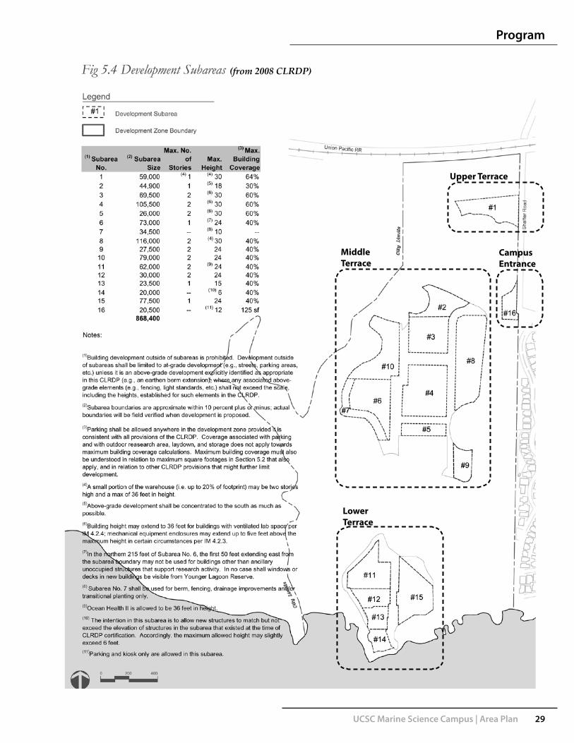
UCSC Marine Science Campus | Area Plan 29
Program
Upper Terrace
CampusEntrance
MiddleTerrace
LowerTerrace
(from 2008 CLRDP)

Area Plan Concept

xc

UCSC Marine Science Campus | Area Plan 33
Concept
Aerial view looking SW over Marine Science Campus
Aerial view looking NE over Marine Science Campus Middle Terrace
Campus Concept
The vision for the MSC is near-seamless integration of the coastal landscape with new development. This Area Plan aims to achieve this integration in a visionary yet pragmatic way that complements, restores and enhances the coastal ecosystems that are the subject of this campus’ research activities and which imbue this site with its strong sense of place. The fully-built campus will also honor its cultural and historic setting by subtly incorporating architectural and landscape cues that root the campus in its context. This plan crafts contemporary responses to demands for research programs, circulation of people and vehicles, stormwater treatment and energy efficiency. A memorable place for learning and research will be created, featuring common spaces for impromptu encounters among faculty and students that contribute to an atmosphere of intellectual exchange.
The CLRDP forms the basis for major planning decisions on this site. With the central Middle Terrace area outlined as likely to receive most development and the team’s decision to orient buildings east-west for energy-efficiency and to maximize daylighting, a site planning concept evolved.

34 UCSC Marine Science Campus | Area Plan
Concept
Concept for east-west arrangement of new Middle Terrace buildings
Seymour Marine Discovery Center
Influenced by the existing collection of structures at the Lower Terrace and the simple orthogonal geometry of agrarian buildings, a simple pattern is established as the driving architectural concept for the expanded campus. A strong sense of north-south orientation was established at the Seymour Marine Discovery Center, emphasized by repetitive narrow-span gable roof forms. This concept is repeated at the Center for Ocean Health complex, further strengthening the north-south “grain” at the Lower Terrace. The Area Plan is a direct response to the restrained simplicity of these buildings in the landscape, with the intent of allowing the land and the distant views to remain as the dominant visual experience.
For the Middle Terrace, most of the buildings align along an east-west axis to take advantage of sun angles. Passive solar strategies, such as overhangs to block out midday sun, are particularly effective in this orientation. The roof gables on an east-west axis also promise good exposure for photovoltaic panels. The research buildings will still serve to block out strong westerly winds by creating intimate courtyards on the eastern sides of buildings. The offset arrangement also extends interior work spaces and offers outdoor break areas.
The siting and orientation of the buildings also recognizes the progression from public to private zones. McAllister Way provides a subtle division between the public campus buildings to the east and the animal research areas to the west which demand privacy and security. The Area Plan reflects the desire for expanded mammal research tanks to be isolated from public view, while aligning with the existing animal facilities at the Lower Terrace and Fish and Game Building.
With respect to form and finishes the new buildings will lean on the architectural example set by the Seymour Marine Discovery Center and other existing buildings. The scale of each building is minimized by giving the impression that it is composed of a series of long sheds attached to each other. The end façade of each shed is staggered from the next in order to break the overall mass of the building into smaller components.
Exterior finishes will generally match the current use of wood siding and shingle roofing. Where buildings abut concrete stormwater planters, a concrete building base may be desirable as a transitional detail. The roofs may be articulated with ventilation and light monitors or roof-top equipment screens in accordance with the CLRDP requirements. In a few locations a planted roof may be appropriate. A planted roof will demonstrate stormwater ‘best management’ techniques and expand on the connection of the buildings and the landscape.

UCSC Marine Science Campus | Area Plan 35
ConceptP l a n n i n g O b j e c t i v e s , P r o g r a m O v e r v i e w ,
D e s i g n P r i n c i p l e s , a n d P l a n C o n c e p t s
CLRDP Chapter 4 Page 25 of 30
Natural Resource Protection Areas and Buffers
Resource protection areas located on the Marine Science Campus include the Younger Lagoon Reserve, various seasonal wetlands in the terrace portion of the site, and the cliff face and intertidal area at the ocean. With the exception of the portions in which trail and ocean access are provided for through this CLRDP, these habitat areas are permanently protected and managed in their natural states, and a buffer is provided for each to separate the habitat from development. Wildlife corridors facilitate movement across the Campus between Younger Lagoon, Moore Creek/Antonelli Pond, and Wilder Creek/Lagoon. Specific management regimes and design criteria will assure that impacts are minimized and resources protected. The natural resource protection concept is shown in Figure 4.19.
Seymour Marine Discovery Center
Landscape Concept
The primary goal of the CLRDP for the Younger Lagoon Natural Reserve (YLR) is to ensure its continued ecological function by protecting it from future MSC development while encouraging intensive ecological restoration and related research efforts. The Restoration Management Plan for the Terrace Open Space is detailed in Appendix A of the CLRDP.
The CLRDP’s Natural Resource Protection Concept outlines a conceptual design vision for this campus. This vision incorporates the protected wetlands on the campus and large areas of upland grassland and coastal scrub surrounding the wetlands and development zones into an expanded YLR. The overall aim is for the MSC to become integrated into the ‘culture of place’ established by the YLR and this site’s coastal location.
This has implications for the landscape character of this Area Plan, as development subareas are directly adjacent to future Reserve restoration areas. The design of areas internal to the MSC campus, in particular the Middle Terrace, should aim to blend with the ‘fingers’ of the YLR Resource Protection areas reaching into the MSC. The interface will be expressed mainly through the naturalistic stormwater treatment system woven through the center of the Middle Terrace. Also important for this intermediate zone will be foundation plantings featuring unobtrusive, place-appropriate native plants surrounding buildings and screening service and road areas.
The areas of campus outside foundation plantings, the stormwater treatment areas, or protected natural landscape should be designed as informal spaces. Some may include small panels of climate-appropriate turf which encourages student gatherings and informal recreation. Adjacent to these could be grassy areas that are potentially left to grow tall in winter. These grasses would become thatched and uneven, but if mowed infrequently, could retain a somewhat informal character that still allows for students to gather when the soil is dry.(from 2008 CLRDP)

36 UCSC Marine Science Campus | Area Plan
Concept
Area Plan Landscape Concept0 200 400
Trees
Shrubs
Informal Open Space
Stormwater Planters
Transitional Landscape

UCSC Marine Science Campus | Area Plan 37
Concept
Where the CLRDP detailed a distinct difference between transition and ornamental landscape on the campus, this Area Plan proposes that the two categories be merged as one and that ornamental landscape, which typically describes higher-maintenance, often flowering plants, be eliminated from consideration for the campus.
It is particularly important that landscape beds along the foundation lines of new buildings include larger shrubs to mask building bulk. As the CLRDP notes;
Many buildings that would otherwise appear large are diminished in scale through plantings of large shrubs and small trees that reduce the apparent height and bulk of a building from the ground up. This is particularly noticeable and effective in areas where building groupings are surrounded by open agriculture or grasslands.
The pervasive wind-thrown salt spray on this site, particularly at the Lower Terrace, limits plant selections. These shrubs could be selected from approved restoration plant lists prepared for YLR to ensure climate and site-appropriateness.
The character of building courtyard surfaces is also an important component of the campus landscape. The courtyard enclosed on the south façade of the COH is a good precedent for future buildings to emulate. Future courtyards should use materials similar to this simple tan-colored decomposed granite, either loose or with a stabilizer to avoid displacement of granules. The sound of footsteps across decomposed granite provides a memorable aural impression. The surface also accommodates a range of activities in such courtyards, from simple gathering around fire pits, to organization of research experiments. Furnishings in these courtyards should be simple and informal benches or pieces such as the Adirondack chairs at COH.
Given the open landscape character of the coastal scrub community, it is not appropriate to plant extensive tracts of trees. In addition, CLRDP concepts for several long, parallel linear alignments of Monterey Cypress as windbreaks and screens across the Middle Terrace have been softened in this Area Plan. This plan instead proposes scattered groves of iconic coastal Monterey Cypress trees that will serve as placemaking elements, landmarks and portals once they have matured. These still evoke the rural, coastal character of the region and can still provide some amount of wind protection.

38 UCSC Marine Science Campus | Area Plan
Concept
Concept for Middle Terrace Walk
Artist’s rendering of concept for Middle Terrace Walk
Middle Terrace Concept
The concept for the Middle Terrace envisions a central, pedestrian-oriented axis, the Middle Terrace Walk, flanked by a compact arrangement of two-story structures oriented in an east-west grain. Minor pedestrian cross-axes intersect with the Middle Terrace Walk. The buildings are interspersed with fingers of native plantings that weave the language of the surrounding natural areas into the core of the Middle Terrace. On the west side of the Walk, buildings in Subarea 4 will feature open courtyards providing sheltered space for informal experiments, minor research gear storage and maintenance, and social interaction.
The Middle Terrace Walk serves as the social and circulation spine of campus, a place that encourages unstructured casual interaction and impromptu meetings among faculty, staff and students. American colleges have traditionally featured central common open spaces, often expressed as quads or greens framed by buildings. At the MSC, the Middle Terrace Walk, vegetated drainage basins and adjacent building yards will become in effect, the central ‘quad’ or heart of the Marine Science Campus. This heart is essentially what creates the ‘campus’—an evocative space for the research community, expressing the spirit of this setting in a fitting way for the important work that is conducted here.
The Middle Terrace Walk provides access to each building via narrower perpendicular walks. The Walk also serves as the fulcrum for gradual development of the campus, a backbone with new buildings added on as programmatic needs evolve. The Middle Terrace Walk terminates to the south with an informal overlook with views of the natural reserve, the lower campus, and the Monterey Bay beyond. At this terminus a trail continues along the protected wetland, connecting the middle and lower terraces. The Walk is a feature designed to augment the interconnections between people, the campus, the natural spaces, and the greater setting.

UCSC Marine Science Campus | Area Plan 39
Prototypical Building Form for MSC Middle Terrace (Lab option top and Classroom option below)
Prototypical Building Form
Until detailed programming is initiated for new buildings on this campus, it is difficult to precisely define building footprints within subareas. This Area Plan proposes a flexible, universal building module that reflects contemporary research and academic space realities. Future architects can use this module as a starting point together with the architectural guidelines in this document and the CLRDP. The prototype footprint is 50’ wide, which allows for a 10’ wide central corridor flanked on one side by 30’ deep lab rooms or classrooms. The other side of the corridor accesses 10’ deep offices. The 50’ width could also accommodate single auditoriums or large classrooms without corridors.
The footprints are drawn as east-west-oriented ‘bars’, which in some cases are stacked, which allows for corridors between the bars and for smaller structures that serve to bridge the longer bars, creating spaces for entry areas, gathering spaces or even open ‘breezeway’ connectors. The east-west orientation or ‘grain’ is more appropriate for maximizing a building’s solar orientation than the existing footprints on site.
UCSC has expressed an institutional goal of creating a consolidated home for several inter-related, coastal-related, disciplines on this campus, in particular the faculty of Ecology and Evolutionary Biology. Small-scale labs in this single location will encourage interdisciplinary communications and idea-sharing that does not occur when students and researchers are separated by the four miles between the MSC and UCSC Main Campus. Additionally, the MSC location will greatly enhance research and teaching access to field study locations for these coastal-related disciplines.
Concept

40 UCSC Marine Science Campus | Area Plan
Marine Science Campus Area Plan0 200 400
Concept
Key
Proposed BuildingExisting BuildingSubarea BoundaryPedestrian & Bicycle Circulation

Subareas

xc

UCSC Marine Science Campus | Area Plan 43
Subarea 1 (Upper Terrace)
This area is envisioned as an outdoor storage/laydown yard for marine research equipment and vehicles. The subarea will be accessed via Shaffer Road, which will be widened per the CLRDP. A single-story boat storage shed oriented north-south will face Shaffer Road. A long, open low warehouse structure will be aligned along the north edge of the Subarea. There is potential to install photovoltaic panels on this long roof line. The outdoor vehicle maneuvering and storage yard will be surfaced with decomposed granite or a similar material. A low (three-foot) planted berm should be built around the SW perimeter of the yard to screen vehicles and machinery from sightlines across the campus from a realigned McAllister Way. The structures should be designed in the same basic architectural language as other buildings on the MSC, given their visibility from the main access to campus. Wildlife passage will be provided under Shaffer Road generally to the north and south of this subarea, avoiding entrances to the subarea off Shaffer.
Subareas
DEVELOPMENT ZONE: UPPER TERRACESubarea: #1
Subarea per CLRDP
subarea size 59,000 sfmax stories 1 *max bldg height 30 *ftmax bldg footprint 37,500 sfmax bldg coverage 64 %max bldg size 45,000 sfmax development 45,000 sf
Existing Development Building Outdoorno existing developmentTotal EXISTING 0 sf 0
Sea
wat
er S
yste
m
New Buildings Outdoor Development
Mar
ine
Res
earc
h &
Edu
catio
n
Sho
rt-Te
rm A
ccom
odat
ions
Car
etak
er A
ccom
odat
ions
Cam
pus
Ent
ranc
e Fa
cilit
ies
Equ
ip S
tora
ge &
Mai
nten
ance
Out
door
Res
earc
h
Equ
ip S
tora
ge &
Mai
nten
ance
Proposed - MasterplanShared Warehouse 24,000 sf 24,000Shared Lay-Down Area sf 24,360 24,360Boat Storage 4,200 sf 4,200
Total NEW 28,200 sf 24,360 28,200 24,360
Total Building Footprint 28,200 sf 28,200 24,360Total Building Coverage 47.8%Total Outdoor Development sf 24,360 check 52,560delta MAX 16,800 sf 52,560
* A small portion of the warehouse (i.e. up to 20% of footprint) may be two stories high and a max of 36' in height.

44 UCSC Marine Science Campus | Area Plan
Subarea 2 (Upper Terrace)
This area will be dedicated to campus utilities, primarily stand-by generators (up to ten can be placed here) for standby power mounted on concrete pads. These pads are grouped in this single location for ease of access and maintenance and to consolidate stand-by generators. A small structure can be located in this subarea, for storage or to house mechanical and electrical equipment related to the generators. In addition to general ‘corp yard’ space, an additional 18’x15’ propane storage area would also be needed.
Screening from the McAllister Way entry road will be important here, given the utilitarian nature of the uses proposed. This screening should include an eight-foot-tall solid wood fence, with planting, with the potential for one or two Monterey Cypress trees along the road. Chapter 6.8.3 of the CLRDP outlines guidelines for fencing. A small portion of the subarea to the NW can be restored to natural vegetation, adjacent to a small wetland.
Subareas
DEVELOPMENT ZONE: MIDDLE TERRACESubarea: #2
Subarea per CLRDP
subarea size 44,900 sfmax stories 1max bldg height 18 *ftmax bldg footprint 12,900 sfmax bldg coverage 30 %max bldg size 12,900 sfmax development 12,900 sf
Existing Development Building Outdoorno existing developmentTotal EXISTING 0 sf 0
Proposed - Masterplan
Sea
wat
er S
yste
m
New Buildings Outdoor Development
Mar
ine
Res
earc
h &
Edu
catio
n
Sho
rt-Te
rm A
ccom
odat
ions
Car
etak
er A
ccom
odat
ions
Cam
pus
Ent
ranc
e Fa
cilit
ies
Equ
ip S
tora
ge &
Mai
nten
ance
Out
door
Res
earc
h
Equ
ip S
tora
ge &
Mai
nten
ance
p pOutdoor Equip/Maintenance sf 3,300 0 3,300
Total NEW 0 sf 3,300 0 0 3,300
Total Building Footprint 0 sf 0 0 3,300Total Building Coverage 0.0%Total Outdoor Development sf 3,300delta MAX 12,900 sf
* Above-grade development shall be concentrated to the south as much as possible.
Storage
Pads

UCSC Marine Science Campus | Area Plan 45
Subarea 3 (Middle Terrace)
This area, along with Subarea 8, will accommodate a parking lot (Lot B) aligned with the curve of the main McAllister Way entry road through campus. This lot, with 113 spaces, is part of a careful distribution of parking across several lots on the campus to minimize the need for any one large central lot. The design of this parking lot will follow CLRDP guidelines, with pervious parking areas and paved circulation aisles. Between the parking lot and the Research 3 building, a small landscaped area with a welcome kiosk may be placed at the northern terminus of the Middle Terrace Walk.
The two-story Research 3 building will occupy this subarea. The CLRDP restricts the size of a single building in this subarea to 40,000gsf but makes provisions for an additional 10% to be permitted if necessary. The footprint shown here is 44,300 gsf. A larger building can be considered as multiple potential building masses that are aggregated together to break down their massing. The main entry to this structure will be accessed from the parking lot. A small plaza at this entry should be included in the eventual design. Service access to this facility will occur at the southern end of the parking lot, combining part of its service drive with the future Research 4a building to the south in Subarea 4. DEVELOPMENT ZONE: MIDDLE TERRACE
Subarea: #3
Subarea per CLRDP
subarea size 69,500 sfmax stories 2max bldg height 30 *ftmax bldg footprint 41,700 sfmax bldg coverage 60 %max bldg size 83,400 sfmax development 83,400 sf
Existing Development Building Outdoorno existing developmentTotal EXISTING 0 sf 0
Sea
wat
er S
yste
m
Buildings Outdoor Development
Mar
ine
Res
earc
h &
Edu
catio
n
Sho
rt-Te
rm A
ccom
odat
ions
Equ
ip S
tora
ge &
Mai
nten
ance
Car
etak
er A
ccom
odat
ions
Cam
pus
Ent
ranc
e Fa
cilit
ies
Out
door
Res
earc
h
Equ
ip S
tora
ge &
Mai
nten
ance
Proposed - MasterplanResearch 3 42,500 sf 3,000 42,500 3,000Future Welcome Shelter 1,800 1,800
Total NEW 44,300 sf 3,000 44,300
Total Building Footprint 23,050 sf 44,300 3,000Total Building Coverage 33.2%Total Outdoor Development 3,000 check 47,300delta MAX 39,100 sf 47,300
* Building height may extend to 36 feet for buildings with ventilated lab space per IM 4.2.4; mechanical equipment enclosures may extend up to five feet above the maximum height in certain circumstances per IM 4.2.3.
Along the southern edge of this building, a small addition with a shed roof could include a planted roof to slightly reduce impervious area and insulate that part of the building. The CLRDP clearly states that flat roofs shall be prohibited (Implementation Measure 4.2.3.) This Area Plan’s interpretation of this measure is that green roofs can be designed into a future building, but because they are predominantly flat (or gently sloping) their installation should be minimized and subordinate to the primary sloping profile of adjacent buildings.
The Research 3 building will surround a small outdoor yard, where experiments can be prepared and small equipment stored. This yard could also be used as an informal common space for the facility, accessed from the Middle Terrace Walk across a stormwater treatment bioswale.
Research
3
Subareas

46 UCSC Marine Science Campus | Area Plan
Subarea 4 (Middle Terrace)
This area, over two acres, along with the nearly three acres in Subarea 8, will accommodate much of the new building area proposed for the MSC’s Middle Terrace. Two major structures are proposed, Research 4b and 4c, consisting of several building modules arranged to form east-facing intimately-scaled informal courtyards framed by two-story buildings, with a total of 99,150 gsf. Along the northern edge of Research 4b, a planted roof is proposed for a narrow shed form. This shed form is intended mainly as a prototypical location, not a prescriptive footprint, to show the potential for smaller green roof opportunities.
Parking for this subarea is apportioned between parking lots B and D. Service access to Research 4b and 4a is conceptually shown to the north side of the building, sharing an access drive with Research 3. Future detailed programming will refine this location (and potentially allow the service yard to be eliminated if not needed). Service to Research 4c will be routed from the entrance to parking lot D. The primary transit stops for this campus will be located west of Subarea 4.
The CLRDP restricts the size of a single building in this subarea to 40,000gsf but makes provisions for
an additional 10% to be permitted if necessary. The footprint shown here is 44,300 gsf. A larger building can be considered as multiple potential building masses that are aggregated together to break down their massing.
A fire lane will separate the two buildings and will also separate Research 3 from Research 4a and 4b. The arrangement of building mass in Research 4c will require a short stub of a fire lane to be extended north from parking lot D to ensure fire hose coverage for the entire east façade.
The eastern edge of this subarea will be reserved for stormwater treatment. DEVELOPMENT ZONE: MIDDLE TERRACE
Subarea: #4
Subarea per CLRDP
subarea size 105,500 sfmax stories 2max bldg height 30 *ftmax bldg footprint 63,300 sfmax bldg coverage 60 %max bldg size 126,600 sfmax development 126,600 sf
E i ti D l t B ildi O td
Cam
pus
Ent
ranc
e Fa
cilit
ies
Equ
ip S
tora
ge &
Mai
nten
ance
Out
door
Res
earc
h
Equ
ip S
tora
ge &
Mai
nten
ance
Sea
wat
er S
yste
m
New Buildings Outdoor Development
Mar
ine
Res
earc
h &
Edu
catio
n
Sho
rt-Te
rm A
ccom
odat
ions
Car
etak
er A
ccom
odat
ions
Existing Development Building Outdoorno existing developmentTotal EXISTING 0 sf 0
Proposed - MasterplanResearch 4a 9,150 sf 9,150Research 4b 47,000 sf 5,000 47,000 5,000Research 4c 43,000 sf 3,750 43,000 3,750
Total NEW 99,150 sf 8,750 99,150 8,750
Total Building Footprint 49,575 sf 99,150 8,750Total Building Coverage 47.0%Total Outdoor Development 8,750 check 107,900delta MAX 27,450 sf 107,900
* Building height may extend to 36 feet for buildings with ventilated lab space per IM 4.2.4; mechanical equipment enclosures may extend up to five feet above the maximum height in certain circumstances per IM 4.2.3.
4c
4a
4b
Subareas

UCSC Marine Science Campus | Area Plan 47
Subarea 5 (Middle Terrace)
This small subarea is flanked to its south by the Fisheries Laboratory of the National Oceanic and Atmospheric Administration (NOAA). NOAA occupies a 2.5-acre in-holding and has the potential for one additional wing to be appended to the footprint of their building, which was built in 1999. NOAA is not subject to the requirements of the CLRDP, but will use the CLRDP as a guide to review future projects.
Because of this subarea’s small size and its adjacency to NOAA’s parking lot, which must remain as unaltered as possible, only surface parking is proposed, which allows the campus to consolidate internal parking lot circulation and to focus treatment of the stormwater from the parking. In addition, the CLRDP Capital Improvement Program (CIP) requires that the campus remove the existing informal parking lot along McAllister Way south of NOAA and relocate it to a temporary parking lot in Subarea 5.
DEVELOPMENT ZONE: MIDDLE TERRACESubarea: #5
Subarea per CLRDP
subarea size 26,000 sfmax stories 2max bldg height 30 *ftmax bldg footprint 15,600 sfmax bldg coverage 60 %max bldg size 31,200 sfmax development 31,200 sf
Existing Development Building Outdoorno existing developmentTotal EXISTING 0 sf 0
Proposed - Masterplanno development proposed sf
Sea
wat
er S
yste
m
New Buildings Outdoor Development
Mar
ine
Res
earc
h &
Edu
catio
n
Sho
rt-Te
rm A
ccom
odat
ions
Car
etak
er A
ccom
odat
ions
Cam
pus
Ent
ranc
e Fa
cilit
ies
Equ
ip S
tora
ge &
Mai
nten
ance
Out
door
Res
earc
h
Equ
ip S
tora
ge &
Mai
nten
ance
p p pno development proposed sfTotal NEW 0 sf 0
Total Building Footprint 0 sf 0Total Building Coverage 0.0%Total Outdoor Development 0delta MAX 31,200 sf
check 0
* Building height may extend to 36 feet for buildings with ventilated lab space per IM 4.2.4; mechanical equipment enclosures may extend up to five feet above the maximum height in certain circumstances per IM 4.2.3.
The entry to NOAA’s lot will be rerouted to curve in from the north. A gate may be placed on this entry drive, at the southern edge of Subarea 5. The design of this parking lot will follow CLRDP guidelines, with pervious parking areas and paved circulation aisles. The overall design goal is to maintain a casual, informal setting similar to the Seymour Marine Discovery Center’s parking lot, without continuous curbs and with larger Monterey Cypress in select, clustered locations rather than linear plantings of shade trees.
Subareas
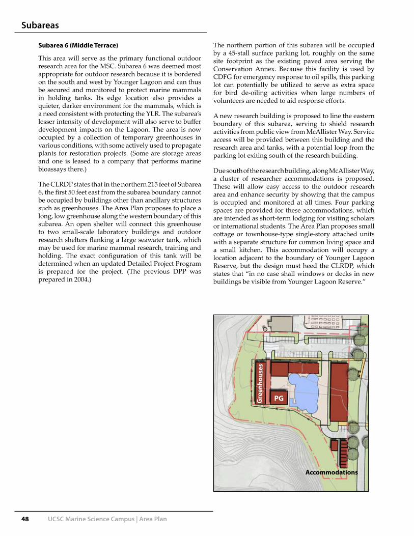
48 UCSC Marine Science Campus | Area Plan
Subarea 6 (Middle Terrace)
This area will serve as the primary functional outdoor research area for the MSC. Subarea 6 was deemed most appropriate for outdoor research because it is bordered on the south and west by Younger Lagoon and can thus be secured and monitored to protect marine mammals in holding tanks. Its edge location also provides a quieter, darker environment for the mammals, which is a need consistent with protecting the YLR. The subarea’s lesser intensity of development will also serve to buffer development impacts on the Lagoon. The area is now occupied by a collection of temporary greenhouses in various conditions, with some actively used to propagate plants for restoration projects. (Some are storage areas and one is leased to a company that performs marine bioassays there.)
The CLRDP states that in the northern 215 feet of Subarea 6, the first 50 feet east from the subarea boundary cannot be occupied by buildings other than ancillary structures such as greenhouses. The Area Plan proposes to place a long, low greenhouse along the western boundary of this subarea. An open shelter will connect this greenhouse to two small-scale laboratory buildings and outdoor research shelters flanking a large seawater tank, which may be used for marine mammal research, training and holding. The exact configuration of this tank will be determined when an updated Detailed Project Program is prepared for the project. (The previous DPP was prepared in 2004.)
The northern portion of this subarea will be occupied by a 45-stall surface parking lot, roughly on the same site footprint as the existing paved area serving the Conservation Annex. Because this facility is used by CDFG for emergency response to oil spills, this parking lot can potentially be utilized to serve as extra space for bird de-oiling activities when large numbers of volunteers are needed to aid response efforts.
A new research building is proposed to line the eastern boundary of this subarea, serving to shield research activities from public view from McAllister Way. Service access will be provided between this building and the research area and tanks, with a potential loop from the parking lot exiting south of the research building.
Due south of the research building, along McAllister Way, a cluster of researcher accommodations is proposed. These will allow easy access to the outdoor research area and enhance security by showing that the campus is occupied and monitored at all times. Four parking spaces are provided for these accommodations, which are intended as short-term lodging for visiting scholars or international students. The Area Plan proposes small cottage or townhouse-type single-story attached units with a separate structure for common living space and a small kitchen. This accommodation will occupy a location adjacent to the boundary of Younger Lagoon Reserve, but the design must heed the CLRDP, which states that “in no case shall windows or decks in new buildings be visible from Younger Lagoon Reserve.”
PG
Accommodations
Gre
enho
uses
Subareas

UCSC Marine Science Campus | Area Plan 49
DEVELOPMENT ZONE: MIDDLE TERRACESubarea: #6
Subarea per CLRDP
subarea size 73,000 sfmax stories 1max bldg height 24 *ftmax bldg footprint 29,200 sfmax bldg coverage 40 %max bldg size 29,200 sfmax development 29,200 sf
E i ti D l t B ildi O td
Car
etak
er A
ccom
odat
ions
Cam
pus
Ent
ranc
e Fa
cilit
ies
Equ
ip S
tora
ge &
Mai
nten
ance
Out
door
Res
earc
h
Equ
ip S
tora
ge &
Mai
nten
ance
New Buildings Outdoor Development
Mar
ine
Res
earc
h &
Edu
catio
n
Sho
rt-Te
rm A
ccom
odat
ions
Sea
wat
er S
yste
m
Existing Development Building OutdoorGH Toxscan 1,500 sf 0 sf 0GH Organic PP 13,464 sf 0 sf 0
Total EXISTING 0 sf 0 0
Proposed - MasterplanResearch 6 8,500 sf 8,500Researcher Accom. (8-10) 2,200 sf 2,200Outdoor Research sf 4,874 4,874Seawater Training sf 7,843 7,843Lab/PG 6,700 sf 6,700New Greenhouses 5,556 sf 5,556
Total NEW 22,956 sf 12,717 20,756 2,200 0 12,717
Total Building Footprint 22,956 sf 20,756 2,200 0 12,717Total Building Coverage 31.4%Total Outdoor Development 12,717 check 35,673delta MAX 6,244 sf 35,673
* In the northern 215 feet of subarea #6, the first 50 feet extending east from the subarea boundary may not be used for buildings other than ancillary unoccuped structures that support research activity. In no case shall windows or decks in new buildings be visible from Younger Lagoon Reserve.
Subarea 6 (Middle Terrace) continued
Subareas

50 UCSC Marine Science Campus | Area Plan
Subarea 7 (Middle Terrace)
Buffering Subarea 6 from the Younger Lagoon Reserve, this subarea will remain untouched by building development. As the CLRDP states, this subarea will be “used for berm, fencing, drainage improvements and/or transitional plantings only.” As such, this is an ideal area for stormwater drainage improvements that can be incorporated into buffering vegetation.
DEVELOPMENT ZONE: MIDDLE TERRACESubarea: #7
Subarea per CLRDP
subarea size 34,500 sfmax stories 0max bldg height 10 ftmax bldg footprint 0 sfmax bldg coverage 0 %max bldg size 0 sfmax development 0 sf
E i ti D l t B ildi O td
New Buildings Outdoor Development
Car
etak
er A
ccom
odat
ions
Cam
pus
Ent
ranc
e Fa
cilit
ies
Equ
ip S
tora
ge &
Mai
nten
ance
Out
door
Res
earc
h
Equ
ip S
tora
ge &
Mai
nten
ance
Sea
wat
er S
yste
m
Mar
ine
Res
earc
h &
Edu
catio
n
Sho
rt-Te
rm A
ccom
odat
ions
Existing Development Building Outdoorno existing developmentTotal EXISTING 0 sf 0
Proposed - Masterplanno proposed developmentTotal NEW 0 sf 0
Total Building Footprint 0 sfTotal Building Coverage 0.0%Total Outdoor Development 0delta MAX 0 sf
* Subarea #7 shall be used for berm, fencing, drainage improvements and/or transitional planting only.
Subarea 6
Subarea 7
Subareas

UCSC Marine Science Campus | Area Plan 51
Subarea 8 (Middle Terrace)
Along with Subarea 4, the nearly three acres of this area are slated to be developed with 81,150 gsf of two-story research buildings (8a, 8b, and 8c). Compared to the U-shaped structures sheltering courtyards in Subareas 3 and 4, the three buildings in this subarea will follow the 50’-wide development module outlined earlier in this document. When stacked as planned in Research 8b and 8c, these buildings can be internally configured to include atria or classroom spaces that occupy parts of both building ‘bars.’
Service to these buildings is provided along the eastern edge of the subarea, on a narrow lane that doubles as fire access. This lane will be visually buffered from the main pedestrian/bicycle route into campus that curves past the subarea to the east. Research 8a and 8b will share a service yard. ADA-accessible parking can be provided in each service yard if necessary. A fire lane will extend between Research 8a and 8b, as well as southeast of 8c, creating a loop from the service lane to the Middle Terrace Walk. Service vehicles will be prohibited from using the Walk.
Along the western edge of this subarea, the central stormwater treatment system will be installed incrementally as the research buildings are programmed and constructed.
DEVELOPMENT ZONE: MIDDLE TERRACESubarea: #8
Subarea per CLRDP
subarea size 116,000 sfmax stories 2max bldg height 30 *ft
bld f t i t 46 400 f com
odat
ions
emmod
atio
ns
ce F
acilit
ies
& M
aint
enan
ce
rch
& M
aint
enan
ce
Buildings Outdoor Development
ch &
Edu
catio
n
max bldg footprint 46,400 sfmax bldg coverage 40 %max bldg size 92,800 sfmax development 92,800 sf
Existing Development Building Outdoorno existing developmentTotal EXISTING 0 sf 0
Proposed per MasterplanResearch Building 8a 34,000 sf 0 34,000 0Research Building 8b 25,000 2,400 25,000 2,400Research Building 8c 22,150 sf 22,150
Total NEW 81,150 sf 2,400 81,150 0 2,400
Total Building Footprint 40,575 sf 81,150 0 0 2,400 0Total Building Coverage 35.0%Total Outdoor Development 2,400delta MAX 11,650 sf check 83,550
check 83,550
Sho
rt-Te
rm A
cc
Sea
wat
er S
yste
* A small portion of the warehouse (i.e. up to 20% of footprint) may be two stories high and a max of 36' in height.
Car
etak
er A
ccom
Cam
pus
Ent
ran
Equ
ip S
tora
ge &
Out
door
Res
ear
Equ
ip S
tora
ge &
Mar
ine
Res
earc
8a
8b
8c
Subareas

52 UCSC Marine Science Campus | Area Plan
Subarea 9 (Middle Terrace)
This area is somewhat isolated from the rest of the Middle Terrace but sits in a prominent location at the terminus of the Middle Terrace Walk. A new 9,650 gsf structure will house common and support functions for campus, including food service, meeting rooms and a small auditorium. There could also be space set aside for researcher accommodations, but these are typically preferred close to laboratory space. This building will have a low, one-story west wing, potentially for dining, glazed to feature open views to the wetlands of the Lower Terrace and the ocean beyond. In the courtyard formed by this L-shaped building, a common terrace will provide gathering and social space visible from much of the Middle Terrace. The CLRDP requires that two sports courts be provided on campus for informal public use, (e.g., basketball and volleyball). This subarea is proposed as a good location for these courts, which will take up about 8,000 sf of space.
DEVELOPMENT ZONE: MIDDLE TERRACESubarea: #9
Subarea per CLRDP
subarea size 27,500 sfmax stories 2max bldg height 24 ftmax bldg footprint 11,000 sfmax bldg coverage 40 %max bldg size 22,000 sfmax development 22,000 sf
Existing Development Building Outdoorno existing developmentTotal EXISTING 0 sf 0
Car
etak
er A
ccom
odat
ions
Cam
pus
Ent
ranc
e Fa
cilit
ies
Equ
ip S
tora
ge &
Mai
nten
ance
Out
door
Res
earc
h
Equ
ip S
tora
ge &
Mai
nten
ance
Sea
wat
er S
yste
m
Mar
ine
Res
earc
h &
Edu
catio
n
Sho
rt-Te
rm A
ccom
odat
ions
New Buildings Outdoor Development
Proposed - MasterplanSupport Facilities 9,650 sf 9,650not used sf 0
Total NEW 9,650 sf 0 9,650
Total Building Footprint 4,825 sf 0 9,650Total Building Coverage 17.5%Total Outdoor Development 0delta MAX 12,350 sf
check 9,650
Support Facilities: Food Service, Meeting Rooms, Seminar Auditorium, Researcher Accomodations
SportsCourts
Subareas
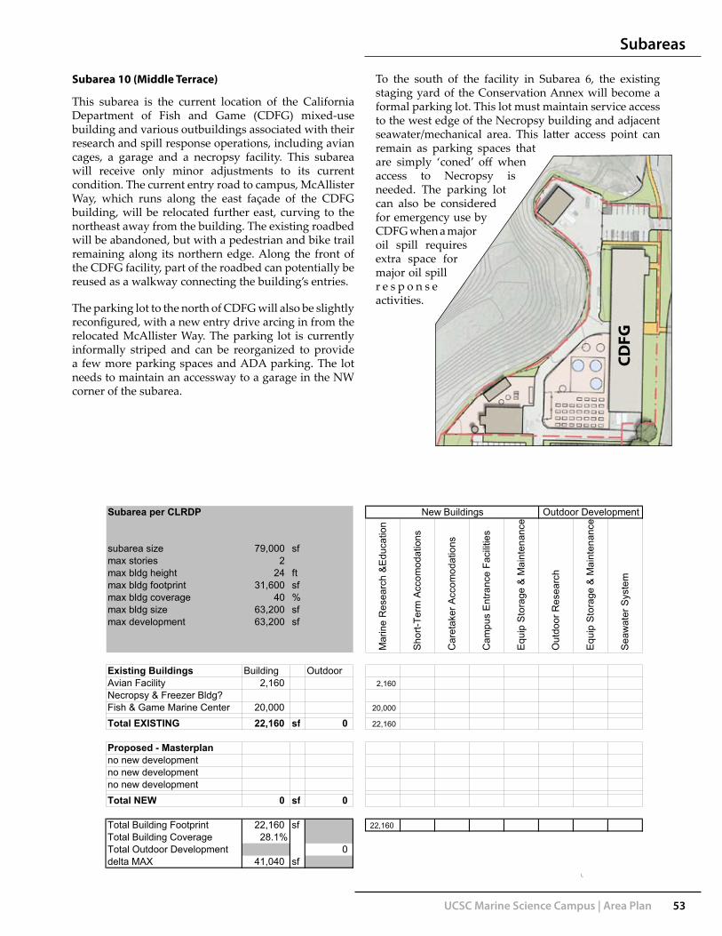
UCSC Marine Science Campus | Area Plan 53
Subarea 10 (Middle Terrace)
This subarea is the current location of the California Department of Fish and Game (CDFG) mixed-use building and various outbuildings associated with their research and spill response operations, including avian cages, a garage and a necropsy facility. This subarea will receive only minor adjustments to its current condition. The current entry road to campus, McAllister Way, which runs along the east façade of the CDFG building, will be relocated further east, curving to the northeast away from the building. The existing roadbed will be abandoned, but with a pedestrian and bike trail remaining along its northern edge. Along the front of the CDFG facility, part of the roadbed can potentially be reused as a walkway connecting the building’s entries.
The parking lot to the north of CDFG will also be slightly reconfigured, with a new entry drive arcing in from the relocated McAllister Way. The parking lot is currently informally striped and can be reorganized to provide a few more parking spaces and ADA parking. The lot needs to maintain an accessway to a garage in the NW corner of the subarea.
To the south of the facility in Subarea 6, the existing staging yard of the Conservation Annex will become a formal parking lot. This lot must maintain service access to the west edge of the Necropsy building and adjacent seawater/mechanical area. This latter access point can remain as parking spaces that are simply ‘coned’ off when access to Necropsy is needed. The parking lot can also be considered for emergency use by CDFG when a major oil spill requires extra space for major oil spill r e s p o n s e activities.
DEVELOPMENT ZONE: MIDDLE TERRACESubarea: #10
Subarea per CLRDP
subarea size 79,000 sfmax stories 2max bldg height 24 ftmax bldg footprint 31,600 sfmax bldg coverage 40 %max bldg size 63,200 sfmax development 63,200 sf
New Buildings Outdoor Development
Mar
ine
Res
earc
h &
Edu
catio
n
Sho
rt-Te
rm A
ccom
odat
ions
Sea
wat
er S
yste
m
Car
etak
er A
ccom
odat
ions
Cam
pus
Ent
ranc
e Fa
cilit
ies
Equ
ip S
tora
ge &
Mai
nten
ance
Out
door
Res
earc
h
Equ
ip S
tora
ge &
Mai
nten
ance
Existing Buildings Building OutdoorAvian Facility 2,160 2,160Necropsy & Freezer Bldg?Fish & Game Marine Center 20,000 20,000
Total EXISTING 22,160 sf 0 22,160
Proposed - Masterplanno new developmentno new developmentno new developmentTotal NEW 0 sf 0
Total Building Footprint 22,160 sf 22,160Total Building Coverage 28.1%Total Outdoor Development 0delta MAX 41,040 sf
check 22,160
CDFG
Subareas

54 UCSC Marine Science Campus | Area Plan
Subarea 11 (Lower Terrace)
The current Center for Ocean Health (COH) in this subarea, completed in 2001, will be enlarged with a new western wing, displacing four small modular office units and reducing area for the boat parking, storage sheds and shipping containers currently found along the west edge of the building. This new wing will further enclose and shelter the existing courtyard space, which provides a popular, informal gathering place for Long Marine Lab faculty, staff and students. This new wing in particular should be designed to be consistent or complementary with the existing COH design.
The parking lot to the north of COH will be reconfigured. There are currently eleven head-in parking spaces along McAllister Way which will be removed to enhance the
aesthetic experience of arriving at the Seymour Marine Discovery Center. The rest of the parking lot will remain as it is. The existing service access lane north of this parking lot alongside the Younger Lagoon could
DEVELOPMENT ZONE: LOWER TERRACESubarea: #11
Subarea per CLRDP
subarea size 62,000 sfmax stories 2max bldg height 24 *ftmax bldg footprint 24,800 sfmax bldg coverage 40 %max bldg size 49,600 sfmax development 49,600 sf
Existing Buildings Building OutdoorOcean Health Bldg (2-story) 23,000 sf 23,000Service Building 2,300 sf 2,300T T il 0
Sea
wat
er S
yste
m
New Buildings Outdoor Development
Mar
ine
Res
earc
h &
Edu
catio
n
Sho
rt-Te
rm A
ccom
odat
ions
Car
etak
er A
ccom
odat
ions
Cam
pus
Ent
ranc
e Fa
cilit
ies
Equ
ip S
tora
ge &
Mai
nten
ance
Out
door
Res
earc
h
Equ
ip S
tora
ge &
Mai
nten
ance
Temporary Trailers 0Service/Boat Yard sf 14,000 0 14,000
Total Existing 25,300 sf 14,000 23,000 0 0 0 2,300 0 14,000 0
Proposed - MasterplanResearch Building 11 16,000 sf 2,500 16,000 2,500not usedTotal NEW 16,000 sf 2,500 16,000 0 0 0 0 0 2,500 0
Total Building Footprint 21,800 sf 39,000 0 0 0 2,300 0 16,500 0Total Building Coverage 35.2%Total Outdoor Development 16,500 check 57,800delta MAX 8,300 sf 57,800
* Ocean Health Building allowed to be 36' tallNote: maximum size building is 20,000 gsf (Ch. 5, implementation measure 4.2.5), applies to new construction only.
be narrowed, removing the temptation for overflow parking along its west edge. A more formal gate to the service area should be installed, in conjunction with an improved path crossing from COH’s front door to Overlook D on the Lagoon.
COH
Overlook D
Subareas

UCSC Marine Science Campus | Area Plan 55
Subarea 12 (Lower Terrace)
The research space for the original Long Marine Lab, including the Younger Building and the Doyle Building, will be unchanged under this Area Plan, although as programs shift within the campus with new construction, the internal space planning for this yard and buildings could be reconfigured.
DEVELOPMENT ZONE: LOWER TERRACESubarea: #12
Subarea per CLRDP
subarea size 30,000 sfmax stories 2max bldg height 24 ftmax bldg footprint 12,000 sfmax bldg coverage 40 %max bldg size 24,000 sfmax development 24,000 sf
Existing Development Building OutdoorResearch Support (w/ loft) 8,217 8,217Younger Building 3,700Outdoor Research Yard 17,000 3,700 17,000
Total EXISTING 11,917 sf 17,000 11,917 0 0 0 0 17,000 0 0
Car
etak
er A
ccom
odat
ions
Cam
pus
Ent
ranc
e Fa
cilit
ies
Equ
ip S
tora
ge &
Mai
nten
ance
Out
door
Res
earc
h
Equ
ip S
tora
ge &
Mai
nten
ance
New Buildings Outdoor Development
Mar
ine
Res
earc
h &
Edu
catio
n
Sho
rt-Te
rm A
ccom
odat
ions
Sea
wat
er S
yste
m
Proposed - Masterplanno development proposedTotal NEW 0 sf 0
Total Building Footprint 11,917 sf 11,917 0 0 0 0 17,000 0 0Total Building Coverage 39.7%Total Outdoor Development 17,000delta MAX 12,083 sf
Doyle Younger
Subareas
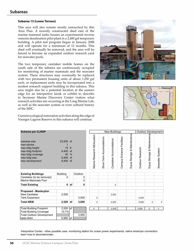
56 UCSC Marine Science Campus | Area Plan
Subarea 13 (Lower Terrace)
This area will also remain mostly untouched by this Area Plan. A recently constructed shed east of the marine mammal tanks houses an experimental reverse osmosis desalination pilot plant in a 2,400 gsf temporary building. A pilot test program began in January 2008 and will operate for a minimum of 12 months. This shed will eventually be removed, and the area will be fenced to become an expanded outdoor research yard for seawater pools.
The two temporary caretaker mobile homes on the south side of the subarea are continuously occupied for monitoring of marine mammals and the seawater system. These structures may eventually be replaced with two permanent housing units of about 1,250 gsf each, or replacement units may be incorporated into a modest research support building in this subarea. This area might also be a potential location at the eastern edge for an interpretive kiosk or exhibit to describe to Seymour Marine Discovery Center visitors what research activities are occurring at the Long Marine Lab, as well as the seawater system or even cultural history of the MSC.
Current ecological restoration activities along the edge of Younger Lagoon Reserve in this subarea will continue.
DEVELOPMENT ZONE: LOWER TERRACESubarea: #13
Subarea per CLRDP
subarea size 23,500 sfmax stories 1max bldg height 15 ftmax bldg footprint 9,400 sfmax bldg coverage 40 %max bldg size 9,400 sfmax development 9,400 sf
Existing Buildings Building OutdoorCaretaker (to be removed) 0 0Marine Mammals Pool 0Total Existing 0 sf 0 0
Proposed - Masterplan
New Buildings Outdoor Development
Car
etak
er A
ccom
odat
ions
Cam
pus
Ent
ranc
e Fa
cilit
ies
Equ
ip S
tora
ge &
Mai
nten
ance
Out
door
Res
earc
h
Equ
ip S
tora
ge &
Mai
nten
ance
Sea
wat
er S
yste
m
Mar
ine
Res
earc
h &
Edu
catio
n
Sho
rt-Te
rm A
ccom
odat
ions
p pNew Caretaker 2,520 2,520Tank Expansion 3,000 0 3,000
Total NEW 2,520 sf 3,000 0 2,520 3,000 0 0
Total Building Footprint 2,520 sf 0 2,520 3,000 0 0Total Building Coverage 10.7%Total Outdoor Development 3,000delta MAX 6,880 sf
check 5,520
Interpretive Center - other possible uses: monitoring station for ocean power experiments; native american connection; learn how to decontaminate;
Subareas

UCSC Marine Science Campus | Area Plan 57
Subarea 14 (Lower Terrace)
The southernmost subarea atop the bluff, with an existing seawater system facility covering a site of approximately 5000 square feet, will remain essentially unchanged. Ecological restoration will proceed on the disturbed areas surrounding the newest seawater caisson. There is room to expand this system, including an additional caisson (up to 6000 gsf) in this subarea. If the campus decides to proceed with the installation of a micro-hydropower turbine as part of the outfall and intake for the seawater system, this should not entail major site disturbance or reconfiguration.
The informal bluff-top trails that lead west to the sandy beach at the mouth of Younger Lagoon will be formalized as one path with an access control fence and gate. Trespassers currently use the bluff-top trails, and as restoration activity proceeds, the Reserve will seek to better control such access.
The terminus of McAllister Way to the east of this subarea will be improved to reduce its width and introduce a more natural/organic routing for a public path and intermittent service drive. Additional marine mammal skeletons or interpretive exhibits could be added along this path to complement the two existing whale skeletons.
DEVELOPMENT ZONE: LOWER TERRACESubarea: #14
Subarea per CLRDP
subarea size 20,000 sfmax stories 0max bldg height 6* ftmax bldg footprint 0 sfmax bldg coverage 0 %max bldg size 0 sfmax development 0 sf
Existing Development Building OutdoorSeawater 5,000 5,000need infoTotal EXISTING 0 sf 5,000 0 5,000
Proposed - Masterplan
Car
etak
er A
ccom
odat
ions
Cam
pus
Ent
ranc
e Fa
cilit
ies
Equ
ip S
tora
ge &
Mai
nten
ance
Out
door
Res
earc
h
Equ
ip S
tora
ge &
Mai
nten
ance
Sea
wat
er S
yste
m
Mar
ine
Res
earc
h &
Edu
catio
n
Sho
rt-Te
rm A
ccom
odat
ions
New Buildings Outdoor Development
p pSeawater Facility Expansion 6,000 6,000
Total NEW 0 sf 6,000 0 6,000
Total Building Footprint 0 sf 0 11,000Total Building Coverage 0.0%Total Outdoor Development 11,000delta MAX 0 sf 0
check 11,000
* The intention in this subarea is to allow new structures to match but not exceed the elevation of sructures in the subarea that existed at the time of CLRDP certification. Accordingly, the maximum allowed height may slightly exceed 6 feet.
Subareas

58 UCSC Marine Science Campus | Area Plan
Subarea 15 (Lower Terrace)
The Seymour Marine Discovery Center is an important facility for public outreach and education, but it also includes classroom space for UCSC and a campus gathering place and conference room, the La Feliz Room. This facility could be enlarged by 4,000 gsf, logically on its NE corner, to create a larger meeting facility, adding a kitchen and storage for the Seymour Center’s bookstore. This addition should include an outdoor patio as spill-out space for events in the public rooms, replacing the existing patio and outdoor picnic area.
The existing Seymour Center parking lot will be enlarged to meet the critical needs for event parking. The parking lot should retain its existing informal character, with stormwater treatment swales between parking aisles.
The existing head-in spaces along McAllister Way (fourteen spaces) will be removed and replaced with a portion of the main public access path to the Seymour Center and ocean overlook. As a pedestrian approaches the Seymour Center, the path could shift to introduce subtly-changing views of the blue whale skeleton and the ocean beyond.
DEVELOPMENT ZONE: LOWER TERRACESubarea: #15
Subarea per CLRDP
subarea size 77,500 sfmax stories 1max bldg height 24 ftmax bldg footprint 31,000 sfmax bldg coverage 40 %max bldg size 31,000 sfmax development 31,000 sf
New Buildings Outdoor Development
aret
aker
Acc
omod
atio
ns
ampu
s E
ntra
nce
Faci
litie
s
quip
Sto
rage
& M
aint
enan
ce
Out
door
Res
earc
h
quip
Sto
rage
& M
aint
enan
ce
eaw
ater
Sys
tem
Mar
ine
Res
earc
h &
Edu
catio
n
hort-
Term
Acc
omod
atio
ns
Existing Development Building OutdoorSeymour Marine Discovery 20,000 sf 20,000need infoTotal EXISTING 20,000 sf 0 20,000
Proposed - MasterplanResearch Building 15 4,020 sf 4,020
Total NEW 4,020 sf 0 4,020
Total Building Footprint 24,020 sf 24,020Total Building Coverage 31.0%Total Outdoor Development 0delta MAX 6,980 sf
* The intention in this subarea is to allow new structures to match but not exceed the elevation of sructures in the subarea that existed at the time of CLRDP certification. Accordingly, the maximum allowed height may slightly exceed 6 feet.
Ca
Ca
Eq
O Eq
Se
M Sh
A bus drop-off should be formally established in front of the Seymour Center for school and metro buses. To the NE of the parking lot school groups and other visitors can gather at a new picnic area overlook and interpretive shelter (example at left), which can be screened with low shrubs, allowing southerly views to the ocean and northerly views to the restored wetlands.
SeymourCenter
Subareas

UCSC Marine Science Campus | Area Plan 59
Conceptual Elevation and Floorplan for Seymour Center Addition
Seymour Center from bluff-top trail
Subareas

60 UCSC Marine Science Campus | Area Plan
Subarea 16 (Entrance Zone)
This subarea is dedicated as a gateway to the MSC. The CLRDP requires fifteen visitor parking spaces to be located here. The plan proposes a simple double-bay parking lot accessed from the main campus access road before an entrance gate/kiosk. The parking lot will be screened from the MSC site to the west with a few trees or a berm with low shrubs.
The existing entry to campus will be reconfigured, although cars will enter the site in approximately the same location on the east property line. Along the north edge of the former alignment of Delaware Road/McAllister Way, which will be abandoned between the entry and the California Department of Fish and Game facility, a multi-use path will be delineated. The remainder of the road will not be maintained and the roadbed may eventually be removed and restored to natural vegetation.
At the current entry to campus, access is not restricted other than with signage and an intermittently-closed gate. Such access is required for the Seymour Marine Discovery Center. The new entry to campus may include a kiosk so that at eventual build-out, an attendant can control access and provide info and parking permits.
The entry is configured with two lanes, to allow regular campus users with access passes to enter without contact with the attendant, while visitors queue for parking permits. The exit from campus will also pass by the kiosk, but with only one lane.
The array of above-grade water valves and stand pipes to the south of the existing entry to campus will be relocated with infrastructure upgrades.
DEVELOPMENT ZONE: CAMPUS ENTRANCESubarea: #16
Subarea per CLRDP
subarea size 20,500 sfmax stories -max bldg height 12 ftmax bldg footprint 125 sfmax bldg coverage - %max bldg size 125 sfmax development 125 sf
Existing Buildings Building Outdoorneed infoneed infoTotal Existing 0 sf 0
Car
etak
er A
ccom
odat
ions
Cam
pus
Ent
ranc
e Fa
cilit
ies
Equ
ip S
tora
ge &
Mai
nten
ance
Out
door
Res
earc
h
Equ
ip S
tora
ge &
Mai
nten
ance
New Buildings Outdoor Development
Mar
ine
Res
earc
h &
Edu
catio
n
Sho
rt-Te
rm A
ccom
odat
ions
Sea
wat
er S
yste
m
g
MAX New - CLRDP* 125 sf
Proposed - MasterplanEntry Kiosk 125 125
Total NEW 125 sf 0 125
Total Building Footprint 125 sf 125Total Building Coverage 0.6%Total Outdoor Development sf 0delta MAX 0 0
check 125
* Parking and kiosk only are allowed in this subarea.
Subareas

UCSC Marine Science Campus | Area Plan 61
SUM
MAR
YLO
NG
MA
RIN
E LA
B
Tota
lTo
tal
delta
Exis
ting
New
Suba
rea
New
Bld
gEx
istin
gM
AXO
utdo
orO
utdo
or
1 (u
pper
)28
,200
016
,800
024
,360
28,2
0024
,360
37,5
00n/
a9,
300
n/a
2 (m
iddl
e)0
012
,900
03,
300
00
3,30
03
(mid
dle)
44,3
000
39,1
000
3,00
044
,300
3,00
04
(mid
dle)
99,1
500
27,4
500
8,75
099
,150
8,75
05
(mid
dle)
00
31,2
000
06
(mid
dle)
22,9
560
6,24
40
12,7
1720
,756
2,20
00
12,7
170
7 (m
iddl
e)0
00
00
8 (m
iddl
e)81
,150
011
,650
02,
400
81,1
500
02,
400
09
(mid
dle)
*9,
650
012
,350
00
09,
650
10 (m
iddl
e)0
22,1
6041
,040
00
22,1
6011
(low
er)
16,0
0025
,300
8,30
014
,000
2,50
016
,000
02,
500
23,0
002,
300
14,0
0012
(low
er)
011
,917
12,0
8317
,000
011
,917
17,0
0013
(low
er)
2,52
00
6,88
00
3,00
00
2,52
03,
000
0
Seawater System
Exis
ting
Build
ings
Ex O
utdo
or D
ev
Marine Research &Education
Short-Term Accomodations
Caretaker Accomodations
Campus Entrance Facilities
Equip Storage & Maintenance
Outdoor Research
MAX
for S
ubar
ea 1
delta
to a
llow
able
upda
ted:
Jun
e 23
, 200
8
Equip Storage & Maintenance
Seawater System
Outdoor Research
New
Bui
ldin
gsN
ew O
utdo
or D
ev
Marine Research &Education
Short-Term Accomodations
Caretaker Accomodations
Campus Entrance Facilities
Equip Storage & Maintenance
Equip Storage & Maintenance
14 (l
ower
)0
00
5,00
06,
000
6,00
05,
000
15 (l
ower
)4,
020
20,0
006,
980
00
4,02
020
,000
16 (e
ntra
nce)
125
00
00
125
SU
BTO
TAL
279,
871
79,3
7723
2,97
736
,000
66,0
2726
5,37
611
,850
2,52
012
528
,200
29,8
6730
,160
6,00
077
,077
00
02,
300
17,0
0014
,000
5,00
0
285,
325
152,
000
chec
k30
8,07
1ch
eck
66,0
27ch
eck
79,3
77
chec
k36
,000
1.
9%5,
454
85,9
73
TOTA
L30
8,07
1ne
w P
RO
POSE
D
90,3
8714
,754
delta
to a
llow
able
61,6
13
Dev
elop
men
t Den
sity
: Pro
pose
d &
Allo
wab
le F
ootp
rint
* B
uild
ings
in s
ubar
ea #
9 ar
e co
nsid
ered
Sup
port
Faci
litie
s.
NO
TES
:
Sub
area
128
,200
9,
300
Sub
area
20
12,9
00
Sub
area
323
,050
18
,650
S
ubar
ea 4
49,5
75
13,7
25
Sub
area
50
15,6
00
Sub
area
622
,956
6,
244
Sub
area
70
0 S
ubar
ea 8
40,5
755,
825
> O
utdo
or R
esea
rch
Dev
elop
men
t in
Low
er T
erra
ce: l
imite
d to
exi
stin
g pl
us 1
0,00
0 sf
new
.S
ubar
ea 9
4,82
511
,000
> O
utdo
or R
esea
rch
Dev
elop
men
t in
Mid
dle
Terr
ace
and
Upp
er T
erra
ce: l
imite
d to
exi
stin
g pl
us 6
0,00
0 sf
new
.S
ubar
ea 1
022
,160
9,44
0>
Sho
rt-te
rm A
ccom
odat
ions
onl
y al
low
ed in
sub
area
s #3
, 4, 5
, 8, a
nd 9
. Res
earc
her a
cc. a
lso
allo
wed
in s
ubar
eas
#6, 1
0.S
ubar
ea 1
121
,800
3,00
0>
Equ
ipm
ent S
tora
ge a
nd M
aint
enan
ce F
acili
ties
in L
ower
Ter
race
: lim
ited
to a
ncill
ary
faci
litie
s to
allo
wed
use
s.S
ubar
ea 1
211
,917
12,8
83>
This
type
of d
evel
opm
ent i
s no
t allo
wed
in th
is s
ubar
ea.
Sub
area
13
2,52
09,
400
Sub
area
14
00
> Lo
wer
Ter
race
: max
imum
siz
e bu
ildin
g is
20,
000
gsf (
Cha
pter
5, i
mpl
emen
tatio
n m
easu
re 4
.2.5
)S
ubar
ea 1
524
,020
6,98
0>
Mid
dle
Terr
ace:
max
imum
siz
e bu
ildin
g is
40,
000
gsf (
Cha
pter
5, i
mpl
emen
tatio
n m
easu
re 4
.2.5
)S
ubar
ea 1
612
512
5>
Upp
er T
erra
ce: m
axim
um s
ize
build
ing
is 3
7,50
0 gs
f (C
hapt
er 5
, im
plem
enta
tion
mea
sure
4.2
.5)
foot
ages
in S
ectio
n 5.
2 th
at a
lso
appl
y, a
nd in
rela
tion
to o
ther
CLR
DP
pro
visi
ons
that
mig
ht fu
rther
lim
it de
velo
pmen
t.ca
lcul
atio
ns.
Max
imum
bui
ldin
g fo
otpr
int a
nd m
axim
um b
uild
ing
cove
rage
mus
t als
o be
und
erst
ood
in re
latio
n to
max
imum
squ
are
asso
ciat
ed p
arki
ng a
nd w
ith o
utdo
or re
sear
ch a
rea,
layd
own,
and
sto
rage
doe
s no
t app
ly to
war
ds m
axim
um b
uild
ing
cove
rage
>
Par
king
sha
ll be
allo
wed
any
whe
re in
the
deve
lopm
ent z
one
prov
ided
it is
con
sist
ent w
ith a
ll pr
ovis
ions
of t
he C
LRD
P.
Cov
erag
e
> S
ubar
ea b
ound
arie
s ar
e ap
prox
imat
e w
ithin
10
perc
ent p
lus
or m
inus
; act
ual b
ound
arie
s w
ill b
e fie
ld v
erifi
ed w
hen
deve
lopm
ent i
spr
opos
ed.
new
MA
X p
er C
LRD
Pde
lta to
allo
wab
le
> B
uild
ing
deve
lopm
ent o
utsi
de o
f sub
area
s is
pro
hibi
ted.
Dev
elop
men
t out
side
of s
ubar
eas
shal
l be
limite
d to
at-g
rade
dev
elop
men
t
0 10
,000
20
,000
30
,000
40
,000
50
,000
60
,000
70
,000
Sub
area
1
Sub
area
2
Sub
area
3
Sub
area
4
Sub
area
5
Sub
area
6
Sub
area
7
Sub
area
8
Sub
area
9
Sub
area
10
Sub
area
11
Sub
area
12
Sub
area
13
Sub
area
14
Sub
area
15
Sub
area
16
Subareas

blank

Phasing

xc

UCSC Marine Science Campus | Area Plan 65
The Marine Science Campus will be developed according to programmatic requirements and subsequent funding availability, either from the State, collaborating agency resources, or private donors.
This Area Plan should therefore also be considered a dynamic document that is flexible enough to allow the campus to respond to new programs or building opportunities as well as new information on the site’s constraints. The phased development should occur in a logical increment of development but there are certain facilities, listed below and shown in the diagram at lower left, that could be built independent of major building phasing:
Independent Campus FacilitiesStorage Yard and warehouse in Subarea 11. Research Facilities in Subarea 62. Researcher Accommodations in Subarea 63. Entry Facilities in Subarea 164. Addition to Seymour Discovery Center5. Addition to Center for Ocean Health6. Structure in Subarea 9, although this requires initial 7. development of the parking in Subarea 5 and the first portion of the central pedestrian walk.The set of infrastructural improvements outlined in • the CLRDP’s Capital Improvement Program.The improvements outlined in Infrastructure III.•
Phasing Concept
The following pages describe one scenario for a phased development of the Middle Terrace. There is a logical progression of development, starting from Subarea 4, due north of NOAA. Development can thus use the main entry road as a spine, taking advantage of efficiencies in infrastructure provision. The first buildings in Subarea 4 can also use a reconfigured parking lot D, potentially combined with NOAA’s parking lot. Buildings can also be placed in Subarea 4 without major modifications to the entry road (although the campus may seek to build the realigned entry road early).
This scenario is adaptable, if new programmatic requirements demand that development should occur differently. Buildings within each subarea and phase can proceed as additional phases; for example, a research building in Subarea 4 could be built as a single ‘bar’ to begin and additional space could be ‘stacked’ as needed to the initial module.
Phasing
The CLRDP includes the following discussion of the document’s planning horizon, which is anticipated for 2020:
This is only intended to establish a planning target to provide a finite project description for analytical build-out purposes. It neither commits the University to achieve the projected level of development by 2020 nor does the CLRDP expire at this time. Rather, this CLRDP will remain in effect indefinitely, subject to periodic update through amendments (subject again to Coastal Commission certification). The actual rate of development is subject to forecasting uncertainty and actual development may be either faster or slower than anticipated. In the event that development occurs more quickly than anticipated, an update to the CLRDP (and the EIR) may be needed before the horizon year. Conversely, in the event that campus development occurs more slowly than anticipated, either because of funding availability, changes in academic program needs, natural disasters, or other unforeseen circumstances, the horizon year for the building program under this CLRDP may extend beyond 2020.
1
2
3
4
5
6
7

66 UCSC Marine Science Campus | Area Plan
Phasing
Middle Terrace
0 200 400
Key
Proposed BuildingExisting BuildingSubarea BoundaryPedestrian & Bicycle Circulation

UCSC Marine Science Campus | Area Plan 67
Middle Terrace Phasing
Phase 1
The development of the Middle Terrace should proceed systematically from south to north, beginning with an initial building in Subarea 4 north of NOAA, Research 4c, which is tentatively slated as a new home for the Department of Ecology and Evolutionary Biology, currently utilizing space at the existing Long Marine Lab facilities. The parking lot proposed for Subarea 5, shared with the existing NOAA parking, could be established to meet CLRDP Capital Improvement Program timing requirements but could also serve as construction laydown space while the first building is constructed. The realigned McAllister Way would be constructed in this early phase.
In this phase, an initial stormwater treatment pond would be built to treat water from the new building. The first stage of the central walkway could be graded to minimize future disruption to the stormwater facility when future portions are built.
Phase 10 150 300

68 UCSC Marine Science Campus | Area Plan
Phase 2
An additional research building (4b) in Subarea 4 would be built in this phase, to the north of Phase 1’s development. The two buildings would be separated by a public walk doubling as a fire/emergency access lane. Construction lay-down space could be to the north of the future building in Subarea 3, preparing for eventual development of that parcel. That lay-down area could be used as a temporary surface parking lot until development of subarea 3. Another segment of the central stormwater treatment facility would be built alongside this phase of building.
Middle Terrace Phasing
Phase 2 0 150 300

UCSC Marine Science Campus | Area Plan 69
Phase 3
This phase will see the construction of the large structure in Subarea 3 (or one or more ‘bars’ within the structure “Research 3”). Service access to this building will be placed at its southern edge, combined with a service drive to Research 4b. The stormwater treatment associated with this building will complete much of the treatment ‘train’, which can begin to work as an integrated system, instead of individual detention ponds. At this stage, the formal walkway down the campus central spine could be completed and paved, with special lighting and furnishings.
The large curving parking lot in Subarea 3 would be built in this phase. The parking lot area would serve as a construction laydown space while the building in Subarea 3 is completed. If there is no immediate need for a large amount of parking, it is also possible that only half of this parking lot could be constructed initially, with access via the entry across from Subarea 2.
Middle Terrace Phasing
Phase 30 150 300

70 UCSC Marine Science Campus | Area Plan
Phase 4 (Full Build-out)
This final phase will occur long enough after this Area Plan’s publication that there may be a plan revision in place before the phase is implemented. This phase may see the construction of the first structure in the southern portion of Subarea 8 along with the eastern half of the main curving parking lot B. (The first buildings of Subarea 8 could also be built in Phase 3.) Subsequent phases will see development of the remaining structures in Subarea 8 and the service drive that accesses them.
Middle Terrace Phasing
Phase 4: Full Build-Out 0 150 300

StormwaterManagement

xc

UCSC Marine Science Campus | Area Plan 73
Background
To maintain the existing hydrologic balance, the considerable amount of new development proposed will require special efforts to manage stormwater surges, treat stormwater to improve its quality and detain it to filter into the soil. The MSC site is relatively flat, with 14 feet of elevation difference between the north edge of the site (51’ Above Mean Sea Level) and the cliff-top (37’ AMSL) and a gentle 1-2% slope. The site currently receives an average of 30” of rainfall annually, with most of the rain occurring between October and April.
The CLRDP states that the hydrologic balance of the site shall be maintained and that stormwater will be filtered or infiltrated before it reaches sensitive natural resources. Currently, rainwater falling on the site either percolates into the soil, or runs off existing buildings and is treated in swales or small catch basin filters. There is an arrangement of smaller ‘basins’ or watersheds on the site, directing water into wetlands, off the site, or into Younger Lagoon. The structure of the larger landscape reflects a common drainage pattern that flows down from upland coastal grasslands and agricultural areas.
Appendix B of the CLRDP details the MSC’s hydrology (see map of campus drainage basins on following page) and proposes a preliminary strategy to treat stormwater on the site through a set of natural Best Management Practices such as filter strips, swales and detention basins with pre-treatment ‘forebays.’ Green infrastructure can retain, infiltrate or evapotranspirate over 90% of of rain from storms with less than 1” of precipitation and it is within this first inch that most pollutants are ‘flushed’. Cleansed runoff can percolate through the soil or be directed to recharge wetlands on site. This strategy notes that only the northernmost area of the campus can use wetland buffers for stormwater treatment. Parking lots are required to be pervious but main drives are not.
Stormwater Treatment
MSC HydrologyThe terrace portion of the Marine Science Campus appears to be largely a closed drainage system with only limited off-site flows entering the site. The northwestern portion of the site contains a small north-south drainage (and a wetland area just east of it), which channels upland drainage. This upland drainage includes that coming from a culvert located under the railroad tracks (emanating from the Raytek and City of Santa Cruz sites immediately north of the Campus and the railroad right-of-way, and from the undeveloped hillsides of the Moore Creek Preserve beyond). This watercourse also drains adjacent agricultural fields west of the site. Water from this system flows directly to Younger Lagoon Reserve and is an important source of water for the lagoon. In addition to the northwestern watercourse area, stormwater also flows through the site from rainfall in the winter months. Rainfall leaves the site primarily through evaporation, evapo-transpiration, and groundwater that flows to De Anza Mobile Home Park, the ocean cliffs, and to the steep slopes above Younger Lagoon Reserve. According to field studies…after precipitation, water descends through the soil column at varying rates based on local soil conditions (i.e., permeability, depth to bedrock). The water continues to move vertically until it hits bedrock, upon which it moves laterally.Hydrological conditions on the terrace portion of the site impact development on the Marine Science Campus by requiring the creation of a drainage system that maintains clean stormwater flows to Younger Lagoon Reserve and the terrace wetlands, assures clean water, and recharges groundwater flows to the maximum extent practicable to sustain wetlands on the terrace portion of the site and in Younger Lagoon Reserve. (2008 CLRDP)
Stormwater filtration planter, Lewis and Clark College,
Portland, Oregon

74 UCSC Marine Science Campus | Area Plan
A p p e n d i x B – D r a i n a g e C o n c e p t P l a n
CLRDP Appendix B Page 6 of 50
Stormwater Treatment
(from 2008 CLRDP)

UCSC Marine Science Campus | Area Plan 75
An Integrated Approach
This Area Plan proposes an innovative response to the stormwater treatment requirements essential for this sensitive site, building on the technical basis of the CLRDP and incorporating treatment and detention as integral components of the campus open space. This approach can minimize the size of detention basins downstream of the Middle Terrace and create a more natural, less engineered aesthetic to stormwater treatment, which may ultimately be a more affordable solution.
Rain on parking lot stalls and service areas can percolate through pervious paving. Some rain will be absorbed by green roofs and return to the skies with evapotranspiration. Rain on other rooftops will be directed to gutters, then downspouts, then into a storm filter runnel (concrete channel) that extends along the base of buildings.
Once in the runnels, the water will make its way along a slowly descending course through aggregates and plants, all the while shedding any pollutants that it had acquired from the roof. The filter extends from the building into a large vegetated area with shallow, ponded water (see examples at right).
This pond water has either arrived directly from rain or has flowed there from other runnels and from slightly higher ponds. As the water’s surface rises with each new drop of water, some of the pond’s contents infiltrate into
the soil beneath; some flows slowly southward into a subsequent pond and the rest remains, to be returned to the sky via plants or via direct evaporation.
Essentially, storm drainage features adjacent to new buildings and circulation will serve to improve water quality. The open space proposed will then accept this cleaner water and detain it while it evaporates or percolates, preventing sudden floods and associated erosion. This is a simple but deliberate approach that will require more study as each new building is proposed on campus. It allows for an incremental installation of stormwater treatment with independent parts that can function fully as each new building is added, while also functioning as part of the greater system.
Stormwater Treatment
Proposed Stormwater Treatment system
Concrete Stormwater runnels

76 UCSC Marine Science Campus | Area Plan
Stormwater Treatment
Winzler-Kelly plan of existing stormwater treatment facilities

UCSC Marine Science Campus | Area Plan 77
Stormwater TreatmentStormwater Phasing
The CLRDP outlines three specific stormwater drainage system improvements and notes that:
“...all specified drainage system improvements shall be undertaken concurrent with any new development in the Middle Terrace development zone of the Marine Science Campus or within three years of CLRDP certification, whichever comes first.”
The three improvements are:Repair/replace the 24-inch drainage pipe from • Wetland W4 to the De Anza Mobile Home Park.Improve the stormwater outfall directing discharge • toward Younger Lagoon Reserve west of the NOAA Fisheries facility.Improve the percolation trench and berm directing • Middle Terrace development zone discharge toward Younger Lagoon Reserve.
Beyond these initial improvements, there is a logical progression envisioned for the phasing of stormwater improvements. Following the phasing outlined earlier in this document, the diagram at right displays one way that stormwater treatment facilities could be implemented in conjunction with new buildings. These facilities would be built in a successive way that complements the treatment train in previous phases, incrementally creating an integrated system. Optionally, all detention basins could be built first and planted, with successive buildings adding their stormwater as phasing proceeds.
The diagram assumes that development to the east of the Middle Terrace Walk will occur in a future phase. If this assumption changes, a similar train of treatment could still be achieved as development proceeds northward from Subarea 4.
Conceptual stormwater treatment phasing
(Integrated Approach)
A water quality planter adjacent to a campus walk, Hillsboro, OR
FuturePhase

78 UCSC Marine Science Campus | Area Plan
Stormwater Treatment
Conventional Stormwater Drainage Strategy
In the event that the campus determines that a more conventional engineered stormwater treatment approach is desired, Winzler-Kelly Engineers studied the proposed CLRDP development square footage and outlined the following system for the core Middle Terrace area, Watershed 4.
A proposed stormwater detention basin will be constructed of an earthen berm with 3:1 side slopes, 8” higher at the downstream end of the Middle Terrace. The berm will be vegetated to minimize aesthetic impact. The increased height downstream is proposed in order to minimize the footprint of the detention basin, minimize site grading, and to allow for a sloped bottom (minimum 0.25%) that conveys the 85th percentile storm to wetland W4.
The required surface area of the detention basin is estimated at 35,000 square feet if configured as one, continuous basin. The size of the detention basin will be refined when more detailed calculations of upstream low impact development features are performed. Additionally, the sizing will be refined as projects are developed and more detail pertaining to the site layout (actual building footprint, for example) is known.
The detention basin outfall sized for this study consists of an approximately 2.2-ft long weir located approximately 0.75 ft above the bottom of the detention basin. A low flow outlet must be incorporated into the design of the outfall in order to pass the 85th percentile storm. Additionally, protection of the weir overflow and outlet area must be provided, and an energy-dissipating structure must be designed to reduce the energy of discharge and to spread it out under the proposed bike path and into wetland W4. Flooding of the bike path during the 25-year storm might be considered as a method of last resort, as there is only a 4% chance of this storm occurring in a given year.
The detention basin sized as described above will meet the requirements put forth by the CLRDP and is sized as one, continuous basin. Note that the use of check dams will likely decrease the efficiency of detention and may require additional surface area.
Upstream LID measures are also necessary for the system to meet design criteria. The required total surface area of these measures is approximately 16,700 square feet. A depth of 24 inches was assumed and is considered to be conservative. If further exploration into the soil, groundwater, and bedrock conditions indicates that these measures can function at a greater depth, then the size of the downstream detention basin may be reduced. Poor adjacent soil conditions will necessitate the need for a discharge pipe to be located at the bottom of these measures. This pipe can either daylight downstream or terminate underground where soil is well drained. These details can be addressed at a later phase.
The total required surface area for drainage facilities for sub-areas 2, 3, 4, and 8 is driven by the downstream, at-surface, discharge point. The downstream stormwater detention was designed with a minimum depth in order to discharge overland to the existing wetland, which yields a facility with a large surface area. Also, the existing terrain, which is described in the CLRDP as being scattered with holes from rodent activity as well as small surface depressions, infiltrates more runoff than would be typical for a site with its soil type and coverage. Converting this porous area to an impervious surface has an exaggerated impact on the overall increase in runoff which resulted in larger drainage facilities to handle this delta.
The Winzler-Kelly Concept Report indicates an estimated drainage facility surface area to watershed area ratio of 7.3% for subareas 2, 3, 4, and 8. The ratio prescribed by this Area Plan equals 12%. In addition to reasons cited above, this is due to conservative assumptions pertaining to the allowable depth of upstream LID elements, driven by unknown soil, groundwater, and bedrock conditions. If the depth can be increased from 2-ft to 3-ft, for example, then the overall required surface area of drainage facilities will decrease. Finally, for the purpose of this Area Plan, the downstream basin is sized strictly for detention. If site conditions indicate that infiltration will occur, then the basin may be downsized.
Examples of ‘LID’ measures; a roof downspout and water quality planter (right) and a parking lot featuring pervious pavement (below.)

Circulation & Public Access

xc

UCSC Marine Science Campus | Area Plan 81
Circulation Concept
The circulation concept for this Area Plan is simple. The existing main access road, the continuation of Delaware Avenue into McAllister Way, will be re-routed 200’ to the south between Subareas 2 and 8. The new, gracefully curving road will separate the Middle Terrace development from existing functional uses such as the CDFG and future research areas in Subarea 6. By placing the road to the west of the core of the Middle Terrace, a pedestrian-oriented campus can be developed to the east, centered on the main pedestrian spine and related stormwater treatment basins.
The new road alignment will join the existing McAllister Way immediately after it passes the south end of the CDFG facility. This main campus access will lead south to the Seymour Marine Discovery Center parking lot, with access restricted south of the Blue Whale skeleton.
The new 2-way road will be built according to CLRDP standards, 22’ wide with no curbs and soft shoulders. The road will be as unobtrusive as possible in the landscape. The road will include a stormwater treatment swale along both sides. Any fencing along the roadway to protect adjacent resource areas will meet CLRDP standards of wood posts connected with cables. Surface markings should be minimized, as well as signage or safety barriers. The road surface could potentially be pervious asphalt to reduce stormwater runoff. One section of the roadway between Subareas 4 and 6 will be reinforced with concrete to accommodate a transit stop for the Middle Terrace.
The CLRDP describes existing access to this site:The north edge of the Marine Science Campus site is located about one-quarter mile directly south of Highway 1. The primary access to the Marine Science Campus is provided at the western terminus of Delaware Avenue where it intersects Shaffer Road. Existing public access to the campus is provided via the existing City street system and via the public access trail from the De Anza Mobile Home Park that intersects the Campus near the coastal bluffs.
Circulation
Existing character of McAllister Way.
CLRDP concept for roadway fencing
Proposed main access road cross-section (McAllister Way) not to scale

82 UCSC Marine Science Campus | Area Plan
Transit
UCSC Transportation and Parking Services (TAPS) operates the UCSC Long Marine Lab Shuttle during the academic year. The shuttle stops at all westbound Metro stops on the main UCSC campus. Currently, the shuttle then stops in front of the University Business Park on the north side of the Mission Street Extension then only once on the MSC, in front of the Seymour Marine Discovery Center. The shuttle does not transport bicycles on the trip down and does not operate during summer quarter or on holidays. Shuttle use varies from term to term, but currently there is very low ridership. An enhanced shuttle service will play an important role in reducing private vehicle usage on campus as it develops. The shuttle should follow the main entry road proposed, with two stops, one between Subarea 6 and Subarea 4 and another at the Seymour Center. The roadway should be reinforced at these locations to support a heavy transit vehicle. Transit shelters should be constructed at these stops, complementing the MSC architectural vocabulary.
Circulation
Proposed MSC Transit systemProposed MSC Transit shelter

UCSC Marine Science Campus | Area Plan 83
Pedestrian
With overall UCSC campus goals of reducing private automobile use and specific goals of creating a walkable Marine Science Campus, this Area Plan provides a comprehensive network of sidewalks, walks and trails, with minor variations on CLRDP proposals, mainly to avoid impacts to wetlands and natural areas. Each of these paths will be at least 6’ wide. Path surfaces will be primarily decomposed granite or bare earth, with asphalt used for the main shared bicycle-pedestrian corridor curving through the site.
McAllister Way, service drives and parking lots should all be designed for low speeds (under 25 mph) so pedestrians and cyclists can feel reasonably comfortable sharing these areas. Low-speed design features could include landscaped ‘bulbs’ or bump-outs to shorten crossing distances, narrower travel lanes, raised crosswalks and rough-textured paving. West of McAllister Way, informal naturally surfaced paths will allow docent-guided access to overlooks of the Younger Lagoon Reserve. Two major pedestrian paths should be made ADA-accessible, the main path curving SW from the entrance, as well as the central Middle Terrace Walk it intersects.
Circulation
Existing informal walk along MSC’s eastern boundary
Section of proposed Middle Terrace Walk
Aerial perspective of proposed Middle Terrace Walk
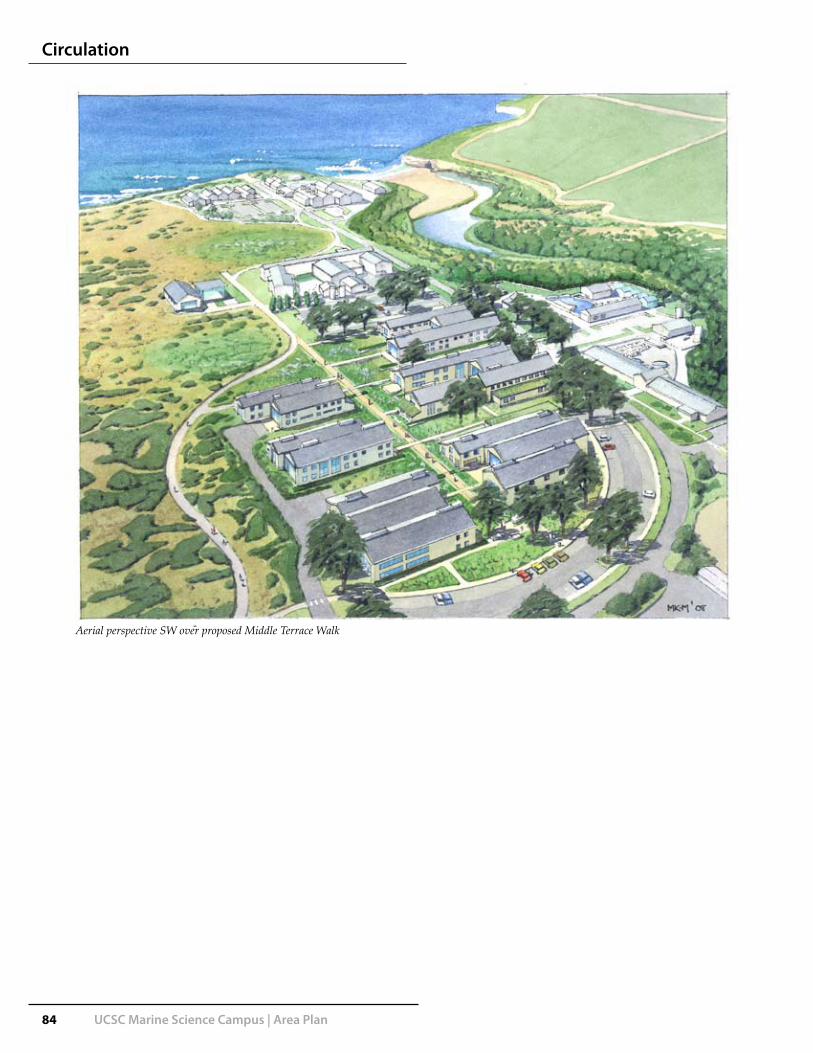
84 UCSC Marine Science Campus | Area Plan
Circulation
Aerial perspective SW over proposed Middle Terrace Walk
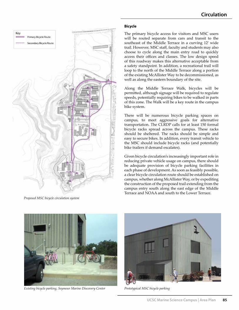
UCSC Marine Science Campus | Area Plan 85
Bicycle
The primary bicycle access for visitors and MSC users will be routed separate from cars and transit to the southeast of the Middle Terrace in a curving 12’ wide trail. However, MSC staff, faculty and students may also choose to cycle along the main entry road to quickly access their offices and classes. The low design speed of this roadway makes this alternative acceptable from a safety standpoint. In addition, a recreational trail will loop to the north of the Middle Terrace along a portion of the existing McAllister Way to be decommissioned, as well as along the eastern boundary of the site.
Along the Middle Terrace Walk, bicycles will be permitted, although signage will be required to regulate speeds, potentially requiring bikes to be walked in parts of this zone. The Walk will be a key route in the campus bike system.
There will be numerous bicycle parking spaces on campus, to meet aggressive goals for alternative transportation. The CLRDP calls for at least 150 formal bicycle racks spread across the campus. These racks should be sheltered. The racks should be simple and easy to secure bikes. In addition, every transit vehicle to the MSC should include bicycle racks (and potentially bike trailers if demand escalates).
Given bicycle circulation’s increasingly important role in reducing private vehicle usage on campus, there should be adequate provision of bicycle parking facilities in each phase of development. As soon as feasibly possible, a clear bicycle circulation route should be established on campus, whether along McAllister Way, or by expediting the construction of the proposed trail extending from the campus entry south along the east edge of the Middle Terrace and NOAA and south to the Lower Terrace.
Circulation
Proposed MSC bicycle circulation system
Existing bicycle parking, Seymour Marine Discovery Center Prototypical MSC bicycle parking

86 UCSC Marine Science Campus | Area Plan
Circulation
Service Access
Most of the new buildings proposed for the MSC will require direct service access in some form. Basic service such as mail and office supply delivery, along with garbage and recycling collection can typically be accomplished on a campus with small vehicles based at a central service plant. Due to the limited building area and sensitive site, it is not likely that such a central plant will be established at the MSC. Some buildings may only require that supply and refuse trucks make brief stops outside the building, without entering a service yard. Buildings with laboratory space will require chemical delivery transfers. For the purposes of this Area Plan, a service drive and yard is provided for each building with adequate space for vehicle turnaround. Certain adjacent buildings may share such a yard.
Providing such a yard in unobtrusive areas of building clusters also provides space for the placement of building-specific utilities such as chillers and generators (or future ‘green’ elements such as inverters or rainwater harvesting barrels). The service area for UCSC’s new Digital Arts building (below) demonstrates a prototypical arrangement for the footprints of these utilities adjacent to a service court.
Proposed MSC service system
Proposed service area for UCSC Digital Arts facility Current service access to COH; forklift unloading a truck parked on McAllister Way.

UCSC Marine Science Campus | Area Plan 87
Fire and Emergency Access
Each building on the MSC will require fire and emergency access. For single-story structures, the maximum hose length permitted, or distance to a portion of a building from a parked fire truck, is 150 feet. For a 2-story structure, this distance is 120’. Fire lanes are thus needed across the MSC, but these can be used as pedestrian ways, paved in a pervious ‘grass-pave’ block to minimize the visual impression. However, where these fire lanes meet regular roads or other fire lanes, a turning radius is required to accommodate fire response vehicles--28’ inside the turn and 48’ outside. Mitigating these large turning radii on major pedestrian ways requires minimizing the visual impression of the curving radius line, which can be achieved by ‘squaring’ these intersections with large, informal public plazas that disguise the radius line within seatwalls or shrubs. Alternatively, the radius line can be minimized through the use of vegetated pervious paving and a softening of the edge’s transition to stormwater treatment areas. In addition, fire hydrants will be required every 300’ along these fire lanes and major roadways.
Firelane combined with pedestrian and bicycle path
Fire
lane
Firelane turning radius disguised through use of grass-pave
Firelane--grass-pave blocks encourage pedestrian use
Circulation
Proposed MSC fire and emergency access routes

88 UCSC Marine Science Campus | Area Plan
Circulation
UCSC Marine Science CampusParking Summary
CLRDP Maximum 795 604 additional spaces
Existing Parking Notes Area Plan (May 2008) Parking Incl. ADA Incl. Visitor/Coastal Access
Seymour Center 72 see CLRDP Section 2 33 Seymour Center 100 4 10Seymour Center 72 see CLRDP Section 2.33 Seymour Center 100 4 10
Lower Terrace South 15 Lower Terrace South 14 4
NOAA 52 NOAA 44 3 5
CDFG 11 CDFG 13 2
Conservation Annex 7 Cons. Annex parking replaced by Lot COcean Health 33 Ocean Health 22 2
Total 190 193 15 15
Spaces along McCallister Way (not counted in total) 24 Spaces along McCallister removed
Needed Parking (commuters)Proposed New Commuter and Visitor Parking Incl. ADA Incl. Visitor/Coastal Access
Total Population Proposed 1280 Lot A 15 Visitors Only
Less Visitors 200 Lot B 113 4
Total Commuter Population 1080 Lot C 45 2
Ratio of Cars to Commuters (mode-split) 40% Assumes 60% will use alternatives Lot D 67 4 5
Commuter Parking Needed 432 Lot E 2 2Existing available to commuters (see above) 190 Misc. spaces in service areas 10 6
New Commuter Parking Needed 242 Total New Parking 252 18 20
Required Parking (visitors) (CLRDP requirement)
Dual Use Seymour and Coastal Access 40 Assume visitors will occupy any available space
Strict Coastal Access (Entrance) 15 see CLRDP Ch 5 pp 42-3
Strict Coastal Access (Middle Terrace) 5 see CLRDP Ch 5 pp 42-3
Strict Coastal Access (Lower Terrace) 10
Total Required Coastal Access 30
Total Needed/Required New Parking for MSC 272Total Existing Parking 190
Grand Total 462 Grand Total Provided in Area Plan 445 33 31*ADA and Coastal Visitors included in total
Parking
Recent growth at the MSC, such as the Center for Ocean Health Building, has created a difficult parking situation at the MSC, particularly for public use of the Seymour Marine Discovery Center. As described earlier, transit use to this campus is minimal. To accommodate dramatic increases in development, the campus proposes an aggressive ‘mode-split’ that assumes 60% of future trips to the campus will be by carpool, transit, bicycle or on foot (the main UCSC campus achieves 55-60%). The CLRDP assumed a mode-split of 40% and permitted a maximum of 795 spaces, which includes some of the existing 191 parking spaces. The CLRDP also stated that the campus must accommodate 100% of its parking needs, avoiding spillover onto Delaware Avenue. This Area Plan proposes a total of 445 new and reconfigured parking spaces, which includes 33 ADA-accessible stalls.
The CLRDP’s Capital Improvement Plan and Implementation Measures specify the number of visitor parking spaces that must be provided. A new 15-space visitor parking lot (Lot A) will occupy most of Subarea 16, while other visitor spaces are apportioned to be distributed within other lots on campus.
Most parking for the Middle Terrace will be located on its north and south edges in parking lots B and D. This will create two common entries to campus, a source for casual interaction amongst researchers. The Middle Terrace Walk serves to connect these two parking areas.
An additional lot (Lot C) will be provided north of Subarea 6’s outdoor research yard. Existing parking for CDFG and NOAA will be substantially maintained. The 52 spaces in NOAA’s existing lot will be slightly reduced to accomplish wider campus goals of consolidating parking circulation and reducing visual impacts from the Middle Terrace to the sea. The incorporation of NOAA and Fish & Game’s existing parking lot into the MSC’s Area Plan will require subsequent and continued cooperation with these agencies.
On the Lower Terrace, the existing COH and Seymour Center parking lots will be reconfigured to remove head-in parking from McAllister Way and replace it with natural landscape to enhance the arrival experience for visitors (and MSC staff and students). The Seymour Center’s parking lot will be expanded north to the boundaries of the development zone. This will result in 28 additional spaces, which are much needed for Seymour Center events. Long Marine Lab parking seaward of the blue whale skeleton will be limited to university and service vehicles.
There are other transportation demand measures that can be undertaken. There is currently no charge for parking on campus or on surrounding city streets and there is an understanding on campus that charging even a token amount for parking through a pay station or entry kiosk could reduce single-occupant car travel to campus, especially if there is a cost reduction for carpooling.

UCSC Marine Science Campus | Area Plan 89
Circulation
0 200 400
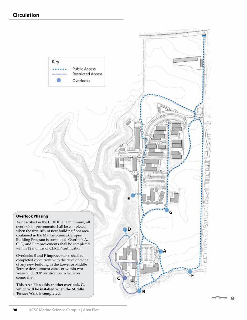
90 UCSC Marine Science Campus | Area Plan
Overlook Phasing As described in the CLRDP, at a minimum, all overlook improvements shall be completed when the first 10% of new building floor area contained in the Marine Science Campus Building Program is completed. Overlook A, C, D, and E improvements shall be completed within 12 months of CLRDP certification.
Overlooks B and F improvements shall be completed concurrent with the development of any new building in the Lower or Middle Terrace development zones or within two years of CLRDP certification, whichever comes first.
This Area Plan adds another overlook, G, which will be installed when the Middle Terrace Walk is completed.
Circulation
G
E
D
C
B
F
A

UCSC Marine Science Campus | Area Plan 91
Circulation
Public Coastal Access Plan
As an educational resource of great value to the people of Santa Cruz and California, the facilities of the Marine Science Campus are required to include a measure of public access. This continues the provision of generous access to the walking paths on the campus as well as public visitation to the Seymour Marine Discovery Center, which is an important source of revenue supporting the MSC as well as a venue for valuable public information about their important research efforts.
The CLRDP outlines a broad public access plan (CLRDP Figs. 5.6 and 9.1) which this Area Plan does not substantially alter. The general concept for this site’s public access is to permit independent access during daylight hours for pedestrians to the pathway that hugs the eastern boundary of the site. Access to this trail is gained from the main entry, which will eventually include 15 visitor parking spaces. There is also a minor gate at the south end of this trail, leading to Horizon Drive in the De Anza mobile home park, allowing the public to walk from Natural Bridges State Park to the MSC (and perhaps Wilder Ranch State Park to the west in the future).
Another important public pathway is a proposed 12’ trail which will curve gently from the site entry to the southwest, passing the Middle Terrace on the west before joining the linear Middle Terrace Walk for over 400’ then curving away to the west and paralleling McAllister Way before reaching the Seymour Marine Discovery Center.
The Public Access Plan details the loop that this new trail can form with the existing eastern boundary trail and the bluff-top path, as well as additional minor connecting trails. With this Plan’s goals of enhancing the ecological restoration of the site’s wetlands, new trails crossing the designated open space to the east of the Middle Terrace and NOAA to connect to the eastern boundary trail are not recommended.
West of McAllister Way, new trails are proposed in conjunction with restoration efforts but public access to these will continue to be restricted and will only be staff or docent-led. These trails will lead to new overlooks, sensitively placed in the Younger Lagoon landscape and designed to evoke the architectural language of the MSC while appearing unobtrusive to observers elsewhere in the Reserve.
Conceptual Younger Lagoon Reserve overlook
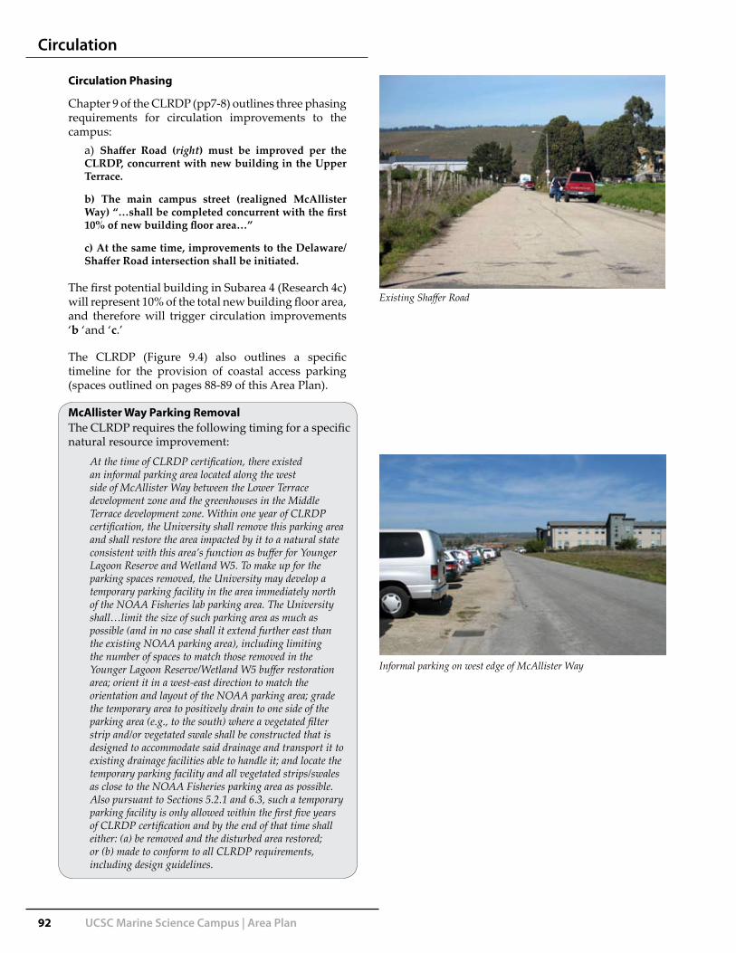
92 UCSC Marine Science Campus | Area Plan
The CLRDP requires the following timing for a specific natural resource improvement:
At the time of CLRDP certification, there existed an informal parking area located along the west side of McAllister Way between the Lower Terrace development zone and the greenhouses in the Middle Terrace development zone. Within one year of CLRDP certification, the University shall remove this parking area and shall restore the area impacted by it to a natural state consistent with this area’s function as buffer for Younger Lagoon Reserve and Wetland W5. To make up for the parking spaces removed, the University may develop a temporary parking facility in the area immediately north of the NOAA Fisheries lab parking area. The University shall…limit the size of such parking area as much as possible (and in no case shall it extend further east than the existing NOAA parking area), including limiting the number of spaces to match those removed in the Younger Lagoon Reserve/Wetland W5 buffer restoration area; orient it in a west-east direction to match the orientation and layout of the NOAA parking area; grade the temporary area to positively drain to one side of the parking area (e.g., to the south) where a vegetated filter strip and/or vegetated swale shall be constructed that is designed to accommodate said drainage and transport it to existing drainage facilities able to handle it; and locate the temporary parking facility and all vegetated strips/swales as close to the NOAA Fisheries parking area as possible. Also pursuant to Sections 5.2.1 and 6.3, such a temporary parking facility is only allowed within the first five years of CLRDP certification and by the end of that time shall either: (a) be removed and the disturbed area restored; or (b) made to conform to all CLRDP requirements, including design guidelines.
Circulation
Circulation Phasing
Chapter 9 of the CLRDP (pp7-8) outlines three phasing requirements for circulation improvements to the campus:
a) Shaffer Road (right) must be improved per the CLRDP, concurrent with new building in the Upper Terrace.
b) The main campus street (realigned McAllister Way) “…shall be completed concurrent with the first 10% of new building floor area…”
c) At the same time, improvements to the Delaware/Shaffer Road intersection shall be initiated.
The first potential building in Subarea 4 (Research 4c) will represent 10% of the total new building floor area, and therefore will trigger circulation improvements ‘b ‘and ‘c.’
The CLRDP (Figure 9.4) also outlines a specific timeline for the provision of coastal access parking (spaces outlined on pages 88-89 of this Area Plan).
McAllister Way Parking Removal
Existing Shaffer Road
Informal parking on west edge of McAllister Way

SustainableDesign

xc

UCSC Marine Science Campus | Area Plan 95
Sustainable Design
Sustainability Vision
The Marine Science Campus is engaged in critically important research activity for the protection of marine habitat and ecosystems worldwide with a particular focus on Monterey Bay. The CLRDP and University of California policy requires new construction to be ‘green’ (equivalent to at least a LEED Certified rating, with LEED Silver strongly encouraged). It is imperative that the MSC be developed in as sensitive a manner as possible. The site’s climate, context and existing infrastructure present opportunities to incorporate green design in the planning and ultimate construction of this campus.
With further study, future mechanical and electrical systems and infrastructure could be configured to achieve ‘net-zero’ energy usage, whereupon the campus would produce as much energy as it consumes and could generate its own and perhaps even sell a surplus. Another potential but aggressive measure that the campus can aim for is ‘carbon-neutrality’, where its carbon output is reduced to zero, even with increasing development. The energy-generation and efficiency measures described below can help the campus achieve this goal.
R

NWINTER SUN ANGLE
SUMMER SUN ANGLE
SE
W
N
96 UCSC Marine Science Campus | Area Plan
Site Plan
Many of the existing buildings on the campus are arranged in a north-south orientation. This has been the architectural response over the past fifteen years to the site’s prevailing westerly winds, which average up to 20mph between March and October. Architects for the initial Long Marine Lab sought to mitigate these strong winds with long building blocks and protected spaces in the leeward side of the buildings. Larger structures such as the Seymour Marine Discovery Center were designed as clusters of these north-south blocks, staggered to provide the protected lee spaces and to subtly respond to coastal and rural vernacular forms.
There have been a few problems associated with this arrangement of buildings, notably that it exposes long stretches of lab or office space to direct wind pressure, leading to a reluctance to utilize operable windows (due to resulting scattered papers) and to damage from pressure changes on west facade exit doors.
With advances in sustainable design and study it has been determined that the optimal placement of buildings for energy-efficiency is on an east-west axis, at least in the higher latitudes of the northern hemisphere (see diagram at right). Such an orientation allows for the greatest
Sustainable Design
exposure of a building’s façade to natural light which can then in turn reduce the need for artificial lighting. In addition, an east-west axis shelters most programmable space from the stronger sunlight of early morning and late afternoon. Although southern facades will receive direct sunlight, allowing passive heating during winter days, this can be mitigated in warmer months with shading devices and placement of appropriate uses on southern facades. Northern facades can be reserved for offices or classrooms that benefit from the softer, more uniform indirect lighting.
The CLRDP mandates protection of existing habitat corridors through the MSC site. This Area Plan ensures links between Younger Lagoon and the campus and surrounding natural features. The central stormwater feature integrated into the Middle Terrace may also serve as a habitat corridor through the campus.
Proposed east-west pattern of building orientation for the Middle Terrace0 100 200

UCSC Marine Science Campus | Area Plan 97
Solar Power
The vernacular coastal barn roof forms and building profiles described in the CLRDP Design Guidelines could still be reflected in buildings on an east-west orientation and would in fact lend themselves well to the installation of photovoltaic panels on south-facing roofs. Larger windows on southern facades could also incorporate integrated PV film or solar wall screens. Other strategies include built-up or “off the shelf” double wall envelopes to generate heated air on southern facades for ventilation and lab makeup air. Evacuated tube collectors can be integrated into the building to provide renewable hot water for heating and domestic hot water.
Wind Power
The strong prevailing winds on this site remain a concern for site planning. The CLRDP concept of clustered building forms creating sheltered spaces is still valid but under this Area Plan would be configured differently to create a series of U-shaped b u i l d i n g s with flexible c o u r t y a r d s sheltered from the wind.
The strong winds can potentially be harnessed to achieve another component of alternative energy production. Conceptually, a bank of wind turbines could be installed along the western edge of portions of the MSC site. Given the adjacent Younger Lagoon’s function as active avian habitat, such turbines will need to be designed and installed carefully. New models of ‘vertical-axis’ wind turbines have been tested to minimize or eliminate bird kills. These models are also well-suited to variable wind direction and offer easier maintenance access.
It is estimated that if a bank of at least thirty 5kW wind turbines were installed along the western edge of Subarea 7, 1.3 million KWH/year of electricity could be generated. Each turbine costs approximately $40,000 (installed) and will each require a concrete footprint of about 20sf, associated inverters and electrical metering, connection and distribution infrastructure. The turbines, ranging from 1ft to 4ft in rotor diameter, could be installed in conjunction with site berms that create a venturi effect, focusing the wind speed at key locations to maximize efficiency. Vertical-axis turbines could also be installed along roof lines of certain MSC buildings, taking care not to compromise the language of the roof forms with mechanical clutter. Future detailed design issues such as this will need to be discussed with the Design Advisory Board.
P l a n n i n g O b j e c t i v e s , P r o g r a m O v e r v i e w ,D e s i g n P r i n c i p l e s , a n d P l a n C o n c e p t s
CLRDP Chapter 4 Page 19 of 30
Compact Development Patterns
Within each development zone, buildings are arranged in compact clusters. This arrangement of uses creates a predominantly open space transition zone between the continuous urban development of the city directly to the north and east of the site, and the open agricultural areas to the west. It also helps protect site visitors, employees, and residents from frequently strong westerly winds.
Sheltered Outdoor Space
Photovoltaic panels, Opal Creek Ancient Forest Center, Oregon
(from 2008 CLRDP)
Vertical-axis wind turbine
Sustainable Design

98 UCSC Marine Science Campus | Area Plan
Seawater System
The MSC utilizes seawater for research experiments and in holding tanks for marine wildlife. The system is a rare and valuable resource for research activities, as it would be extremely difficult from a regulatory perspective to build a new system along the California coastline. The University recognizes the value of this system to marine research and this is a primary reason for focusing such research development at the MSC site.
The system consists of two intake systems, each with a caisson which houses pumps and piping. All of the seawater is utilized fully on campus. It is distributed in a corridor underneath McAllister Way. The current seawater system is not ready to accommodate an increased demand for seawater. With modest modifications, there is enough capacity in the system for seawater use to increase. New seawater distribution lines could be added to the utility corridor underneath the central spine of the site plan.
The MSC discharges all of the seawater back into the ocean after use. There is a significant opportunity to generate renewable micro-hydro power by rerouting the discharge down the NOAA caisson to develop head pressure to spin a micro-hydro turbine.
The movement of seawater through pumps adds approximately 0.1 degrees Fahrenheit to the seawater temperature. Due to the large volume of water, this heat added to the geothermal heat pump cycle is enough to heat the buildings. (The sheer volume of water, warmed up only by a fraction of a degree, is enough to warm the lower volume of much lighter air for the buildings.) The geothermal heatpumps still have an electrical input, but are highly efficient at these temperatures, and don’t run continously, cycling on and off during the heating season to maintain the space temperatures.
Emergency Generation
A key consideration for the use of solar and other alternative energy is the variability of solar access or wind speed. There will be certain functions on the MSC that require a constant, reliable source of electricity. Natural gas currently powers emergency generators and requires an additional propane backup. This backup function will be located in Subarea 2.
Lower Terrace seawater outfall vault
MSC seawater system and sustainability opportunities
Sustainable Design

UCSC Marine Science Campus | Area Plan 99
Additional Sustainability Opportunities
The following range or ‘toolbox’, of opportunities are not specifically studied or recommended in this Area Plan but can be considered for further study.
Green buildings
This Area Plan recommends that future buildings on campus strive to exceed the minimum standards for green building, which will change over the life of the plan. LEED Gold certification should be achievable presently for the first MSC buildings. Beyond LEED, there is increasing consideration of ‘Living Buildings’, producing their own energy and dealing with as much of their own waste as possible, as a more intensive standard for sustainability. The new generation of green buildings also incorporate and embody natural processes, which is referred to commonly as Biophilic Design or Biomimicry. The origin and composition of building materials is given greater consideration and structures are intended for longer life-cycles, in recognition of their inherent embodied energy.
Sewage Treatment on-site
This campus is currently linked to city sewer facilities. As part of an overall goal to reduce water use as well as the energy required for pumps, the campus could consider an on-site sewage treatment facility (or membrane bioreactor) to treat all sewage on site. The effluent water from the plant is typically very clean and can be re-used to flush toilets or irrigate landscape. The resulting sludge could be composted but also potentially burned in a co-generation facility.
Such a facility could also be designed as a Living Machine, with a smaller footprint and perhaps more educational, visible functions, incorporating elements of natural processes from wetlands and aquatic organisms to clean the sewage. This Area Plan does not currently include space for such a facility, which is still considered an emerging technology.
Rainwater harvesting
Much of this site’s rainwater will infiltrate through undeveloped soil. Some will be routed from buildings and parking lots to bioswales and the central stormwater treatment facility. New campus buildings could also incorporate discrete rainwater collection cisterns or small barrels which could then be connected to building toilets and to irrigation systems.
Plug-ins for electric cars
These will likely be incorporated in MSC parking lots at the direction of UCSC TAPS, when (or if) there are a sufficient number of electric vehicles owned by campus staff, faculty or students to warrant their installation.
Solar shelter for parking areas
The two large parking lots in Subareas 3 and 5 represent a large surface area that could be covered, or partially covered over stalls only, with structured photovoltaic panels, which would also provide shade to cars beneath. If this were studied as an option, the panels would need to be designed to allow for continued health of any parking lot bioswales or shade trees. California Coastal Commission review and approval would also likely be required.
Desalinization
The existing desalinization demonstration plant on campus, if successful, could be retained to treat seawater perhaps for small-scale Marine Science Campus usage only but the scale of the plant is unlikely to produce any substantial amounts of potable water.
Sustainable Design

xc

Guidelines


UCSC Marine Science Campus | Area Plan 103
Principles
The CLRDP outlines design principles which have shaped the creation of this Area Plan and are worth repeating for the guidance of future architects, landscape architects, planners and engineers:
The model for design of the Marine Science Campus is the rural, open space, and agricultural coastal landscape of Northern California. Located in the zone of transition from urban development to rural and open space land uses, the campus should echo characteristics of both natural and man-made elements which comprise the rural, open space, State Park, and agricultural landscape extending upcoast to the west. The rural-agricultural landscape yields several key principles which will guide design of the campus:
Buildings (e.g., agricultural complexes) are often tightly • clustered and surrounded by broad open or forested areas, where natural landforms are undisturbed. Roof profiles are shallow.Buildings may contain components that are quite tall, • such as silos, lighthouses, and water towers; such tall elements, however, are seldom bulky and are usually subordinate to the character of the setting.Plant communities and their resulting visual patterns • are strong and simple, often with large areas that give the appearance of a single prominent species.Windbreaks and hedgerows of large trees provide • structure at a large scale in the landscape. Generally, these are associated with building clusters to provide weather shelter and visual/habitat screening. They are usually perpendicular to the coast and tend to screen building complexes from view resulting in a much more naturalistic looking scene.Many buildings that would otherwise appear large • are diminished in scale through plantings of large shrubs and small trees that reduce the apparent height and bulk of a building from the ground up. This is particularly noticeable and effective in areas where building groupings are surrounded by open agriculture or grasslands.Roadside drainage swales and other seasonally wet • areas also provide the rural landscape with a strong, simple pattern of plant materials.The structure of the larger landscape is provided • through interplay of topography, natural and man-made vegetation patterns. A dendritic drainage pattern is reinforced by vegetation that flows down from upland coastal grasslands and agricultural areas, culminating in incised canyons and gullies on the coastal edge. Layered onto this are the man-made structural landscape elements of hedgerows and windrows.The appearance of buildings is visually compatible • with the character of the surrounding areas. The color, material, and style of buildings reflect the natural elements of the landscape. Common elements are earth tones colors, natural wood sidings, and low roof lines.Site fencing is minimal, purpose-driven, and constructed • out of natural materials that are visually compatible with natural elements in the landscape and the coastal/agricultural architecture.Site signage is constructed out of natural materials that • are visually compatible with natural elements in the landscape and the coastal/agricultural architecture.Buildings are designed to avoid impacts to ecological • areas in terms of noise, lights, and other visual impacts.
Guidelines
The Design Guidelines outlined in Chapter 6 of the CLRDP must be followed by new development proposed for the Marine Science Campus. Following the concept established for this Area Plan, a few minor enhancements to the Design Guidelines are suggested. (Any alterations to the Guidelines are subject to California Coastal Commission review.) The following are three provisions proposed for addition to the existing structure of the Building Design Guidelines:
6.1 Building Design
6.1.2 Building Design Guidelines
Building Arrangements – Middle TerraceThis Area Plan suggests an arrangement of linear buildings with a primary axis in an east-west orientation. This is a preferred orientation to minimize solar heat gain from the west and maximize the opportunity for natural day-lighting for the program areas located along the north face of the building. Joining several linear buildings can form small clusters of shared uses and define outdoor common spaces unique to each cluster and adaptable by the building occupants.
An exception to this arrangement of buildings should be considered along the west side of McAllister Way, where a north-south orientation may provide a more secure perimeter for the outdoor research areas in Subarea 6, and screen the west wind. Generally, where there are narrow sites, such a north-south orientation is still acceptable.
In the Middle Terrace, the arrangement of buildings shall enhance the functionality and efficiency of the surface stormwater system.
Building Arrangements – Lower TerraceAt the Lower Terrace, it is important that additions to existing structures continue the north-south orientation established by the existing Seymour Marine Discovery Center and the Center for Ocean Health buildings.
Materials and Color:Exposed ConcreteAn exposed concrete surface, poured-in-place or split face, may be proposed beyond the dimensions of a building’s foundaton to tie the structure visually with concrete stormwater planters extending from the building’s base to nearby water quality basins.
Vertical SidingThe simple vertical board and batten pattern of the cladding found on existing buildings should be continued on new buildings, regardless of the building type. This pattern provides a strong visual continuity with existing buildings and the coastal agricultural context.
Guidelines

104 UCSC Marine Science Campus | Area Plan
Landscape Concept Guidelines
The primary goal of the CLRDP for the Younger Lagoon Natural Reserve (YLR) is to ensure its continued ecological function by protecting it from future MSC development while encouraging intensive ecological restoration and related research efforts.
This has implications for the landscape character of this Area Plan, as development subareas are directly adjacent to future Reserve restoration areas. The design of areas internal to the MSC campus, in particular the Middle Terrace, should aim to blend with the ‘fingers’ of the YLR Resource Protection areas reaching into the MSC. The interface will be expressed mainly through the naturalistic stormwater treatment system woven through the center of the Middle Terrace. Also important for this intermediate zone will be foundation plantings featuring unobtrusive, place-appropriate native plants surrounding buildings and screening service and road areas.
The areas of campus outside foundation plantings, the stormwater treatment areas, or protected natural landscape should be designed as informal spaces. Some may include small panels of climate-appropriate turf which encourages student gatherings and informal recreation. Adjacent to these could be grassy areas that are potentially left to grow tall in winter. These grasses would become thatched and uneven, but if mowed infrequently, could retain a somewhat informal character that still allows for students to gather when the soil is dry.
Where the CLRDP detailed a distinct difference between transition and ornamental landscape on the campus, this Area Plan proposes that the two categories be merged as one and that the term ornamental landscape, which typically describes higher-maintenance, often flowering plants, be eliminated from consideration for the campus.
It is particularly important that landscape beds along the foundation lines of new buildings include larger shrubs to mask building bulk. As the CLRDP notes;
Many buildings that would otherwise appear large are diminished in scale through plantings of large shrubs and small trees that reduce the apparent height and bulk of a building from the ground up. This is particularly noticeable and effective in areas where building groupings are surrounded by open agriculture or grasslands.
The pervasive wind-thrown salt spray on this site, particularly the Lower Terrace limits plant selections. These shrubs could be selected from approved restoration plant lists prepared for YLR to ensure climate and site-appropriateness.
Guidelines
The character of building courtyard surfaces is also an important component of the campus landscape. The courtyard enclosed on the south façade of the COH is a good precedent for future buildings to emulate. Future courtyards should use materials similar to this simple tan-colored decomposed granite, either loose or with a stabilizer to avoid displacement of granules. The sound of footsteps across such surfaces provides a memorable aural impression. The surface can also support a range of activities in such courtyards, from simple gathering around fire pits, to organization of research experiments. Furnishings in these courtyards should be simple and informal benches or pieces such as the Adirondack chairs at COH.
Given the open landscape character of the coastal scrub community, it is not appropriate to plant extensive tracts of trees. In addition, CLRDP concepts for several long, parallel linear alignments of Monterey Cypress as windbreaks and screens across the Middle Terrace have been softened in this Area Plan. This plan instead proposes scattered iconic coastal Monterey Cypress trees that will serve as placemaking elements, landmarks and portals once they have matured. These still evoke the rural, coastal character of the region and can still provide some amount of wind protection.
The following are two minor provisions proposed for addition to the existing structure of the CLRDP Landscape Design Guidelines:
6.5.2 Planting Design Guidelines
Stormwater Basins, Swales and Filter StripsNew development in the Middle Terrace of the Campus must follow the stormwater treatment train described in this Area Plan.
Ornamental LandscapeThis section is proposed for deletion from the Guidelines.
The following CLRDP guideline sections all work well with the Area Plan and don’t require more detail for the Area Plan concept to function.
Campus Street Design • Parking Design• Trail Design• Lighting Design• Signage Design• Fencing/Barrier Design•

Appendix: Meeting Notes

xc

UCSC Marine Science Campus | Area Plan 107
Workshop #1Introductory SessionThursday, February 7, 2008 9.30am
Attendees:Steve DavenportBeth HowardDamon AdlaoMaeve DaughertyLarry PagelerDiane BehlingCourtney TraskMichelle AsireRandolph SkrovanEric Bode, Doug Macy, Ken Pirie (Walker Macy)Rich Whealan (Miller-Hull)
GoalsMeet needs of campus program• Meet community needs and site limits• Create an Area Plan (similar to a Master Plan)• Area plan has traditional campus aspect, but with interesting •
interface with CLRDPSustainability is key. Create a model that is light on the land• CLRDP• The CLRDP passed CCC in December • This project will be high profile and contentious• The CLRDP won’t get realized within the 2020 timeframe. •
This is a 30-40 year endeavor.Development is restricted in sub-areas• Steve Davenport thought that developable area will only •
shrinkIncorporate undevelopable areas into Younger Lagoon and •
guarantee that it remains protected in perpetuityInfrastructure• Infrastructure study is just mainlines, no laterals. Buildings •
pay for attaching to main Avoid tearing up landscape • On main campus, utility conduits are full, but with efficiency, •
can create spaceBase infrastructure should be sized for flexibility and evolving •
technologyDistribution system is adaptable for future use of hydrogen• Plan for other, future utilities, like wastewater, using purple •
pipeWinzler Kelly is collecting data, doing assessment of in-•
ground utilitiesElectrical is all PGE with separate meters and end loads at •
each siteSewer, water, sea, power down middle of street• Sanitary sewer needs two pumps to get up to City system• They will develop utility concepts to serve buildings • Not a lot of detail, using CLRDP as a starting point• Incorporate flexibility to accommodate this parallel project• Seawater system• Dual corridor up McAllister. Seawater could be added to •
utility corridorAverage temp. of seawater is 10-17 celsius range•
650 gpm base flow seawater. It’s all used• If could get 2000 gpm, would need to send back 2000gpm• 1996 Concrete caisson’s face reinforced--battered by waves • 1999 Steel caisson. Anti corrosion, in excellent condition• 240 HP centrifugal pumps from surf zone through steel screens• 16x16x10’ pump room• 8’ diameter 55’ deep caisson steel wet sump• Two10” stainless steel inlets• Caretakers are most important to monitor/fix seawater system• They are woken 80 nights/year – usually storms overload filters•
CirculationEntire road is chip sealed. Parking lots are paved• Shuttle use varies from term to term, but very low ridership, •
sometimes only 2 people per week! Often only 3 people/dayThere is no charge for parking, or controls• Steve Davenport believes that fairly recent growth such as the •
Center for Ocean Heath is what’s causing tough parkingLarry Pageler stated that UCSC has never invested a dime, •
transportation-wise, at the MSC. Fees pay for infrastructure improvements. He will soon stripe lanes.
Bike rack is full• Events at Seymour are always full. At beginning or end of day, •
all arrive by carSteve D asked if we could share space with 2300 Delaware• Visitation: •
10-12,000 schoolkids/year• Most carpool, come during day. Almost no schoolbuses, too $$• 55,000 visitors/year to Seymour (or 110,000) • Parking not so limited on weekends• Public access west of road is docent-led. East of road open to public•
Younger LagoonSite is degraded• Lot of invasives like poison hemlock, remove and replace with •
coastal vegetationStormwater management plan in place• CLRDP will require regular guided tours into Younger Lagoon• Reserve will increase in size with CLRDP• Want Reserve to be part of ‘culture of place’• The responsibility of the institution to Reserve is a metaphor •
for Research and pedagogical function preserving larger ecosystem
Past attempts to ‘wall off’ lagoon from bad activities• A green future campus will transcend this boundary. Think of •
it as a “whole site” Stormwater
Most water from MSC drains to Lagoon• Only north area can use buffers for stormwater treatment• The more infiltration near buildings, the better• Clean/infiltrate before it reaches Reserve and ocean habitat• Parking lots are required to be pervious but main drives not• Filterra ‘tree in hole’ raised as one tool; campus is trying to get •
one at biomed building, but w/ pervious concrete (not asphalt)There are great new pervious concrete solutions – pavers are •
up for discussion, need to deal with sediment saturation (Walker Macy discussed solutions)
Other AgenciesNOAA has one wing for possible expansion within footprint• NOAA maintains huge warehouse in Tiburon• Strictly speaking, NOAA not subject to CLRDP- but they will •
use CLRDP as guide to reviewMix of outside agencies attracted to co-locate here with non •
UCSC programsUSGS are potential partners• Very active collaboration between UCSC and Feds co-funding •
a researcher/professorship. Came out of NOAA/LML interactionUtilities for other agencies
Anyone who needs seawater will be compelled to come here, • it’s very difficult to get new seawater withdrawal permit. The process to expand far less cumbersome
Not every building connected to seawater (COH is dry but • may add seawater)
Steve D.—we need to distribute seawater throughout site. A • looped system is probably most cost-effective. Loop it around North of NOAA from CDFG, then South to avoid wetland.
Makes sense to have a main under roadway• NOAA in ’99 extended lines N and E to Shaffer.• Lift station by NOAA (trying not to use it). Short ‘300’ lift N. • Lower terrace lift station takes sewage up to NOAA• Manhole at property corner where it goes to gravity• Set up new gravity-flow sewers up north of NOAA• Nobody is maintaining the system•

108 UCSC Marine Science Campus | Area Plan
Parking795 total parking spaces allowed in CLRDP. What is required?• Surface parking can be replaced with buildings• Some parking needed quickly for first phase• UCSC req’d by CLRDP within 1 year to remove roadside parking• Potential gravel temp lot at NOAA? Could be staging area for •
first buildings
ProgramRich Whealan presented initial program analysis• Program sensitivity for ‘classrooms.’ Don’t use this term. They •
are controlled by registrar and can be used for general campus.Instead, they should be called Instructional Class Labs• Steve noted that MSC couldn’t even have registrar-controlled •
classes on site because subjects need to be marine-relatedLaydown vs. outdoor research•
Boats parked on trailers• NOAA needs space to lay out big fishing nets, USGS lays out core •
samplesNew campus can use as much service and laydown as possible •
but it can be remoteNever displace ‘gem’ of yard behind COH• Boats will always stay on site. Go out to sea every day• Specialty or broken boats can go to remote yard• Covered yards needed only to prevent runoff of oil and grease •
and to cover inflatables (sun degrades them)Shipping containers used to store motors•
ClimateOn-site weather station• Prevailing winds due west. Some Easterlies• Mar-Oct. westerlies are 20 mph constant• Berm created to provide windlift and get site down in profile, •
provide visual separator to Lagoon.
Team and UCSC Staff toured site after introductory meeting.
Sustainability BrainstormThursday, February 7, 2008, 1-2.30pm
Attendees:Steve DavenportDamon AdlaoDiane BehlingCourtney TraskRandolph SkrovanMaeve Daugherty, Winzler-KellyPeter Young, Winzler-KellyEric Bode, Doug Macy, Ken Pirie (Walker Macy)Rich Whealan (Miller-Hull)Andy Frichtl (Interface Engineering)
Andy Frichtl presented ideas:Seawater is perfect temperature for geothermal• It’s cheap because it’s already there• Water furnace gets 6 units of energy out for 1 unit of energy in• Put a heat exchanger in each building• Heat can be transferred with radiant heat vs. forced air• Not a lot of domestic hot water needed, new hot water will be •
more efficientSolar hot water heating tubes are 2x or 3x more cost effective •
per BTU vs. PV (but consider the high cost of copper). See LA Audubon Center example
Natural Ventilation and operable windows an easy option• Steve Davenport stated that it is 10 degrees F cooler at MSC •
than main campusHis office is on W. side natural light is great until 2:30pm • Windy west side- one open window or door will blast the whole •
interior building. Doors are broken by wind. Wind breaks neededMain entries should orient out of wind•
Building scale and orientation: 45-65’ wide building and E-W • orientation ideal
Put stairs, toilets at E and W facades• Access to views N and South are best views• Main campus Earth & Marine Science south façade blasted by sun• Put research labs on North – these need most light (don’t need •
shades) North side is best quality light.Offices, non windowed, get south side• Use corridor to ventilate• Need louvers or blinds on south – an overhang works half/year• Vertical louvers on E & W façade• Use lighting controls and occupancy sensors•
Double envelope buildings• Micro-Hydro•
High head ion-flow is ideal. Get 1-2/kwH• 2x30 hp distribution pumps could get 700 gpm•
Wind turbines• 15-16 mpg average annually• Make use of venturi effects• Are turbines included in total building height restrictions, or •
over? Are they restricted in view corridorsResearch for bird impacts• Integrate with site lighting, use LEDs. No trenching needed. •
Already trenched conduit could take power from existing poles with turbines atop
Power outages in storms results in mammal impacts in tanks• Storms have wind—why not use wind driven water pumps? •
Curtail diesel generation•
Funding:Infrastructure project is state-funded. No lifecycle cost •
allowance, but there’s mandate for sustainable buildingShowcase as highly sustainable as possible, within cost limits• Funding options:•
$4.5 million is infrastructure budget • PGE Cost rebates• Savings by Design• Energy-Efficient Partnership can fund up to 60%• PPG needs to state cost efficiency• State pass-thru partners? Donor pays for PV’s gets tax break, or •
pay back donation with energy savingsUC Irvine contracted with private company to install huge PV •
panels, sell energy back to UCI below market cost3rd party development growing but carefully monitored• UCSC buys 100% green power- students pay differential• Air modeling done for dispersion of toxic emissions at MSC• Patrick Testoni is campus energy manager, talk to him• Solar panels are potential teaching element•
Bus shelters w/ PVs or Boat Yard• Personal Solar chargers?• PV over parking lot might mean less oil and grease runoff• Typically electrical systems over-designed – 1/3 peak (30%) • Prove actual use to utility (to avoid infrastructure upgrades) •
State is revising Title 24•

UCSC Marine Science Campus | Area Plan 109
ProgrammingThursday,February 7, 2008, 2.30-4.30pm
Attendees:Steve DavenportDiane BehlingRandolph SkrovarGary GriggsPeter RaimondiLinda FlahertyMichelle AsireKen PirieRich WhealanPeter Young
There have been 4 LRDPs and Master Plans in a project • by project evolution of MSC. SRG did a concept plan, EHDD General Plan for CLRDP
It has taken 8 years to get through CA Coastal Commission• Land use areas are mittens not gloves• Area Plan should flesh out inside and outdoor space needs•
Phase 1 projects:Plan might simply have to accommodate chronology of •
building. There will be almost organic growth, incremental, starting from south? Or from center?
Definite next building is a support building (to include large • lecture hall)
Privately funded wing to Center for Ocean Health (Phase 2)• Coastal Ecology Building, 2012 move-in, will start when there •
is moneyUSGS is currently in Wrigley factory. Would love to have them •
on campus, but they can’t afford a building. 10-15 year horizonUSGS wants to coalesce into a single space in Santa Cruz• Winzler-Kelly studied feasibility for GSA of moving USGS to •
this campus from GSA-owned facility in Menlo ParkWhen Menlo Park property costs “tip” balance, it might make •
sense to moveSeawater is minor piece of what USGS wants. They’re looking •
at the synergy of campus and cross-pollination of ideasSupport Building should be pushed up on schedule• May be areas for other agencies- UC vs non-UC area•
Building Design:CLRDP says no flat roofs (in Design Guidelines, so not •
mandated, but breaking Guidelines needs good explanation)Consider edges of buildable zones, massing and locating •
2-story buildings at centerEvery building here is non-regents funding• CLRDP doesn’t distinguish uses• Area plan process should detail how proposed buildings are •
to be usedJohn Barnes asked team to consider creating a ‘place’ with •
quads of common space between buildingsUnderground Building potential is limited. Bedrock is only •
4-10’ deep. There is also Groundwater issue on this marine terrace.
Also a budget reality; may be too expensive• Can’t do area plan on assumptions that later drive cost up• NMPS building went down to bedrock tamped it grouted •
gravel columns, saying there was potential for liquification? But this was “categorically untrue”
Issues of lab vibration- rather than upgrade building, put labs • on first floor with dampener table
Parking and Circulation:Is it possible to do parking structure? John Barnes states that •
there needs to be a conversation about transportation planningNeed better way to get students between campuses and get a •
parking model for this campus795 parking spaces allowed in CLRDP. But is that 550 •
additional? 400? It depends on ratio used. There are 52 existing spaces in NOAA.
Plan should strive to make campus less suburban (driving to • front door and parking)
Consider ‘degrees of access’• Shuttle between upper site parking and Seymour is feasible• Short walk is fine to propose• Way easier to get here for upper divisions (live off campus)• “Yellow bike” program on this campus? • Have one year (until July 2009) to relocate 24 cars from road• Have to improve all of Shaffer Road to build the Corp. Yard to •
north in five years
Existing Program Conditions:Conference Room at COH not meant as classroom, but it is •
often used as such.Big room at Seymour is used a lot• Need to accommodate small conferences for 50-200 people, •
with something to eatDifficult to schedule 3-day workshops, now use area hotels• “Massive growth” in undergrads. 2nd largest major in division• Desire to eventually teach 100-150 students-upper division •
mostly24 students in lab class• Easier to take 150-person class in evolution then walk down •
street to 24-person wet lab. Get here and be set for dayCampus maintains COH.• A new wing for Ocean Health is easier funding draw than a •
“support building”Greenhouses will be removed by 2013, but there is a conflict. •
Some want GreenhousesSteve Davenport stated that CLRDP used way bigger numbers •
than neededOutdoor Research vs. Laydown distinction: Laydown is “space •
to put crap in” (storage)70,000 GSF of outdoor research• Need long term storage• This campus works: commingling of Undergrads, Grads, •
Research and Public. Seamless education and researchBoats need to be on campus• Carpentry shop on Main Campus stores IMS stuff – open •
oceanographyAvian facility•
Restoring natural predators• No birds there, just trailers. No coastal dependency• Don’t worry too much about them, or plan as permanent facility•
Island Studies and Nature Conservancy will be relocated to • Coastal Policy
Nothing in works for CDFG. Lots of shared research with • NOAA, not so much with CDFG
Researcher rooms and overnight rooms• . For sabbaticals, summer classes, instead of coming daily from upper campus.
Bodega Marine Lab excellent example, or OIMB, Charleston, OR•
LandscapePermeable parking• Accommodate stormwater forebays• Detain on green roofs• You can ‘lose things’ with not much vegetation. Can we plant •
windrows in this soil? Yes, cypress imported in mulch has quickly grown 20’
Restoration biology? Research plots? Where is it permitted? • 3 phases of restoration with CLRDP, working with terrestrial ecologists

110 UCSC Marine Science Campus | Area Plan
Younger Lagoon and StormwaterThursday, February 7, 2008, 2.30-4.30pm
Attendees:Steve DavenportDamon AdlaoDiane BehlingBeth HowardGage DaytonCourtney TraskMaeve Daugherty, (Winzler-Kelly)Peter Young, (Winzler-Kelly)Eric Bode, Doug Macy, (Walker Macy)
StormwaterRate and qty. of stormwater in cannot be exceeded by flow out• Basin 1 should accommodate adjacent agricultural ditch water• Potential constructed wetland at Basin 2• Parking stalls only will be pervious, don’t need detention• A 25-year rain event means 0.95” of rain in a 24-hour period• Basin 8 drains to Lagoon and there is erosion•
Younger LagoonRestoring lagoon, removing weeds, mowing, raking, burning• Greenhouse needed for this work--on-site restoration facility• 2000 sf with 1000sf outdoor propagation area• This is a coastal prairie; scrub vegetation and low trees near •
buildings appropriateGreen roofs will need to be native plants• Incorporate public access as part of the plan• There are 2 docent-led tours/month to the Lagoon beach• Will ADA access be required into Reserve?• Reserve ‘name’ will expand to include the ESHA and open •
space areasConnectivity of habitat, security and views are primary factors• Avoid light pollution into Reserve•
Work Session—Parking and Electrical EngineeringFriday, February 8, 2008, 9.30am-Noon
Attendees: Steve DavenportDamon AdlaoJohn BarnesDiane BehlingLarry PlagelerRhonda Trammel, Campus Electrical EngineerMaeve Daugherty (Winzler-Kelly)Peter Young (Winzler-Kelly)Eric Bode, Doug Macy, Ken Pirie (Walker Macy)Rich Whealan (Miller-Hull)
Electrical Engineering issuesTalk to Steve Paul re: radiant heat he ‘loves geothermal’• Radiant heat is going onto biomedical, but it was a fight. Labs •
21 fought for it“Micro-grids” and distributed generation- share with 2300 •
Delaware1200 kw for grid reliability• 30% max for outside uses• 1.4 to 1.6MW potential at build-out, but more likely 0.8 mw• Net metering allowed but PGE doesn’t necessarily like many •
generatorsCleaner than PGE source.• Campus does not want to put a power plan in for PGE•
Power instability on campus—don’t want another substation. • UCSC wants to stabilize grid, ability to “island” to keep grid up, •
if PGE goes down
Need controls to avoid feeding a short circuit into system• Conduit between MSC and 2300 Delaware? Or simply duct bank. •
Get state to pay.Computers at 2300 Delaware• “Dark fiber” brings fiber optics from Sunnyvale by Aug. 2009•
Only place for wind turbines would be at Subarea 1, but it’s a • wildlife corridor
Consider PV on roofs and issues of maintenance• Well on site (capped) could be reopened for building use? •
(Under COH)Needed City water for fire flow and building site was over •
well, so it was cappedOld well on Wells Fargo land. Right place for well would be •
up in NE cornerDesalinization plant likely as next local source in Santa Cruz. •
Experimental desal at MSC300’ depth to Santa Margarita formation•
Parking & Transportation40% mode split (NOT TDM) • Without on-street parking, local parking ratio is 0.26/person •
(excluding coastal access spaces)15 spaces for service and fleet• 175people currently using 70 sp. (on par with campus ratio)• 24 spaces going away for road (part of CLRDP conditions)• Campus would like to charge for parking• Conference and event parking overlaps with daily needs for •
staff and studentsConferences want interdisciplinary activity with lab •
research-- is this possible?No capacity at 2300 Delaware for daytime parking• Motivation is to have an entire facility here• Parking cash-out programs? (enforcement difficult) Stanford •
does thisAppropriate parking ratio? Does every campus user need a •
parking space?Campus population is 1280 with Seymour, 1000 without• At 40%, this is 400 commuter users.• With 195 existing spaces, does this imply that 205 new spaces •
are needed? 40 spaces will be dual use for Seymour and coastal access •
(plus 10sp strictly coastal access)City concerned about bigger picture, not just site. City’s •
obligation to do on-street parking management to placate neighbors
Could the campus have attendant remote parking? (like valet • parking)
Stacked parking is not so good for events, needs lots of staff• Design parking lots as efficient as possible with compact •
spaces (to campus standards)This plan needs to determine a balance of program and •
parkingAnother approach- car-free (park at entry). Get commuters •
out of lower terrace. Visitors still can access the Seymour Center.Design of streets (22’ max width) will minimize speed•
TransitCurrent shuttle is a ‘joke’ – 11users/day average and it costs •
$40K-60K/yearLower division (fresh and soph. students) more likely to use •
shuttle--cannot have carsShuttle paid for by student transit fees• Area plan should determine bus stops and bike access• Metro public bus extension into MSC? • Bus parking? Perimeter of Seymour lot• Can move northern edge of Seymour parking to increase •
corner radius and allow truck turnaroundBicycles
Need aggressive bike circulation program. Flat topography • will help
Phase 1 needs much more bike parking• Bike parking: 1 per 10 campus population•

UCSC Marine Science Campus | Area Plan 111
Service AccessNo loading dock down here. Deliveries via forklift• Problematic to have just one loading dock. Maybe one/terrace? • Pallet deliveries from a ‘good-sized’ truck once per week• Pump delivery frequency for hazardous materials?• Outdoor Research vs Laydown• Need to break down laydown vs. outdoor research• Not necessary 70,000gsf research. 70,000 maybe not enough •
for laydownCLRDP picked a big number, it was not well defined, could be •
much lowerNeed marine mammal space (see concept plan for Marine •
Mammal Study) Need multi-function for efficiency, i.e., spreading out nets •
doesn’t happen all the timeArea 1 could accommodate all storage and a small warehouse •
(10,000gsf) driven by USGS need. 37,500 for USGS not really enough for them, but all we could cram on Subarea 1
But USGS may be OK w/ Wrigley factory, which is a • ‘cavernous’ warehouse space
ProgramCLRDP shows building in front of Seymour? Only ff Parking •
can go elsewhere but consider it in plan3rd Party development won’t necessarily need separate plots •
of landFish & Game leases land, and it’s fenced• Phase 1•
Coastal policy 12K• Support 6K• Ocean Health wing 16K• Placeholder for USGS? 78K gsf, 50K for future buildings • They want seawater for biological resources group•
CCC and CLRDPCLRDP subarea limits are ‘ironclad’• Questions for CCC (go back for consultation):•
Can Subareas 4 & 5 be combined? Changing subareas generally?• Do we have to do distributed, small parking lots? Road locations? •
Advisory GroupFriday, February 8, 2008, 3-4.30pm
Attendees:Frank ZwartSteve DavenportDamon AdlaoJohn BarnesDiane BehlingKerrie McCaffreyDon CrollGage DaytonSteve ThornsettIlse KolbusGary GriggsPeter RaimondiChurchill GrimesSteve MillerMaeve Daugherty, Peter Young (Winzler-Kelly)Eric Bode, Doug Macy, Ken Pirie (Walker Macy)Rich Whealan (Miller-Hull)
This Area Plan will delve into more detail than CLRDP: How • this campus functions and should function
It is the art of striking balance between what’s known or • projected and allowing for opportunistic flexibility
Housing component once in CLRDP is now out• Term “marine’ will make people ‘berserk’, don’t want to lose •
their identity. Maybe ‘coastal’ is better? All marine research is already here, new programs won’t be marine-related.
Broaden terms, not narrow to include potential tenants• This campus is about the Ocean and its interface with land• Younger Lagoon is a big experiment, theoretically over in 25 •
years’ but some believe it should be always open to experimentsIntegration of NGOs, agencies, and UC makes this place unique• Middle terrace development next to NOAA is a good idea. •
NOAA synergy with UCSC is a “win-win”Aim for academic and infrastructural integration• Tight site contributes to interaction• Walkability depends on weather (1/2 mile from entry to Seymour) • Shuttles scheduled around students--doesn’t reflect composition •
of student body (upper division. Buses (metro) from downtown will make a difference
Easier for students to get here. Surges in classes overload • parking. Control overflow parking.
Food on site would save a lot of driving- taco truck on campus? • Survey office users to determine optimal building orientation• Do an open house session to invite all campus users• Show drawings people can react to• Will we always serve MSC remotely from main campus physical •
plant or set up satellite? Depends on SF threshold. 2300 Delaware may make sense for central delivery/receiving – has loading dock.
Talk to groups slated to come down here• Phasing is key consideration. Plan has to be flexible with •
building modulesNo space to do all stormwater detention in developed areas. •
Forebays maybe, with detention basins outside.Each building can contribute to minimizing storm flow. Avoid •
having each building deal with stormwater separatelyDon’t think of reserve as open space. This is consistent with •
mission of reserves. Include other space for common, gathering places. Blur boundaries of reserve, with some restoration and naturalistic landscape in developed areas
Pathways define boundaries of inclusion, Active vs. off-limits • parts of reserve
At next meeting, bring diagram of paths and public access, • entries and exits
112 UCSC Marine Science Campus | Area Plan
Workshop #2Introductory SessionTuesday, March 4, 2008, 9.30amAttendees:
Steve DavenportJohn BarnesDamon AdlaoLarry PagelerMaeve Daugherty (Winzler-Kelly)Eric Bode, Doug Macy, Nopporn Kichanan (Walker Macy)Craig Curtis (Miller-Hull)
Transportation and ParkingParking at entrance needs 15 spots (for coastal access) • 40% of trips to campus to be accommodated by alternative •
transportationNeeds to be higher percentage (55-60?). Consider charging for •
parking with cost reduction for carpoolingMay not be enough parking fee in future to support a kiosk, •
but maybe a pay station. Ideally, UCSC should find a way to afford a person at the gate.
Strive to do as well (mode split) as rest of the campus (55-60%) • CLRDP: Campus must accommodate 100% of parking needs • Existing parking available to commuters and visitors• What is the bus route for schemes? Show clearly• Scheme B might ask bus to drive through parking lot?• Perhaps the shuttle can use the coastal access road?• People may begin to park on Delaware. CCC is concerned •
with controlling public parking. City may not want to restrict parking on Delaware because of CCC
Commuters more likely to park off campus, because they’re • there all day. Students not there as long. What about coastal access timing?
Only 1 bus route comes out here, twice an hour. 3 bus stops: • Entrance/Middle/Seymour Center
Metro bus stop right outside the entrance. Mobile home • people use that bus as do some students
Better to have bus stop outside entrance. Electric shuttle won’t • leave gate
Van pool is great option to reduce car travel. Typically 10% of • cost of operating car
On-site shuttle would ideally be small, light, & electric• Designate car pool/van pool parking for prime real estate•
Site Plan AlternativesSchemes that look over lagoon may not work because CLRDP •
needs visual/light protection for lagoonWind rows, berms, fence to block lagoon view. There could be •
viewpoint
UtilitiesNatural Gas provides emergency power• Switching to gravity flow will require replacement of main •
along McCallister Way Can dig deeper than 18”, but can’t berm up higher than 18”• Plan for stormwater management within the development •
zone, with basins outside zonesHandling stormwater outside the development zone better for •
fundingAlso gives architects more flexibility• With funding from state stormwater management/restoration •
might be done upfront Basins would be installed very early in the project. Schemes •
suggest this is happening in the open space Stormwater basin in the north can run in the buffer • Basin 4 is most useful for handling runoff from Lower Terrace •
development zoneWhat is the possibility of raising grade in the development •
zone? (1-2 feet) Initial basins should handle all water with treatment facilities •
around buildings adding to the cleanliness
Design Advisory BoardTuesday, March 4, 2008, 11.00am
Attendees:Tito Patri, Landscape Architect, Tito Patri and AssociatesDavid Reinhart, ArchitectTara Lamont, Assistant Director of Design and Construction Services, UC Office of the PresidentJohn BarnesDean SchmidtFrank ZwartDamon AdlaoMaeve Daugherty (Winzler-Kelly)Eric Bode, Doug Macy, Nopporn Kichanan (Walker Macy)Craig Curtis (Miller-Hull)
Two types of social spaces: • More intimate (yard) – for people who use a group of buildings• Public social/open space• What is the heart of the campus?•
Tito: Philosophical question—is this campus inward looking • or engaged with the surroundings? A major component is the natural features.
David: More important than circulation is the existing • character of the surrounding. What are the real elements of the site? Cardinal directions? Rectangles? Something else? Perhaps other things more important?
John: • Concerned that numbers for building footprints are very high • But building envelope is actually larger than actual building• Parking and perhaps yard space needs to be pared down• Spacing between buildings and yard is too consistent, there •
should be a hierarchy of scale. The area plan needs to have a clear concept. A clear main idea • We need to look at all the transportation nodes. • Schemes are not drawn like they are integrated to the site yet. • Plan also talks about wind break scheme. Don’t just focus on •
roads, buildings, yards, but other major features.Perhaps bring more of the restoration into the development. • Should the road be a boundary between development and •
restoration or should the road be in the interior to allow restoration to intermingle with development? Maybe the road is the social spine?
The corridor could be a combined parkway- cars, ped., bike, • stormwater.
Back up again to look at the qualitative aspects again- hierarchy • of spaces
David: Explore different building block types. • Tito: What is driving the site plan? Unique qualities or the •
realities of providing ‘40Ksf’ program space?Step back. Divide campus into social zones, etc. see what that •
does to the circulation. Turn it over on its head a little. Frank: Craig’s diagram talks about a cluster which is perhaps •
not easily expanded.

UCSC Marine Science Campus | Area Plan 113
Advisory GroupTuesday, March 4, 2008, 2pm
Attendees:Advisory GroupJohn BarnesDean SchmidtFrank ZwartDamon AdlaoMaeve Daugherty (Winzler-Kelly)Eric Bode, Doug Macy, Nopporn Kichanan (Walker Macy)Craig Curtis (Miller-Hull)
Area plan needs to start accommodating transportation now. • It is an integral part of this project.
We need to think about the interface between public access • trail and the facilities.
Don’t need to design tanks into these courtyards. Find a • dedicated, separate area for tanks and greenhouses. It does not have to be adjacent to the human uses, probably not even legal to co-locate.
Segregate tanks and associated buildings in discreet areas. • Research areas need to be controlled- isolated- secured. • Seawater systems are problematic. Usually separated from •
some buildings. Offices should face south. Labs face north. • “We do not want to turn around trucks and park boats in the •
courtyards.” The courtyard to the Ocean Health Center is a model- it does •
not include the tanks. “We are more concerned about quality human interaction.” • All academic buildings need is a loading dock. • Making a space flexible will make it more vibrant. • First goal should be maximize buildings--not parking, or yard. • Must incorporate wind row (trees, tall buildings, etc.) • Berms & windrows are more effective than just windrows. • It never gets too warm here. •
Seymour Center55,000 visitors - will expand. • People cannot find it. • The road must lead clearly to the Seymour Center. • Parking is a huge issue. They work till late at night, post •
public transportation. Would like outdoor picnic, eating space next to the Seymour •
Center (bus-load) perhaps at overlook NE of parking lot.
Paths/TrailsFrom a surface standpoint, what is accessible? • All overlooks identified in CLRDP are required. • The wetlands south of NOAA will be interpretive, used by •
docents. Path alignment is flexible. It needs to be ‘pleasant’ and •
convenientCan’t be too circuitous or people will cut across•
ProgramTeam needs schematic for Department of Ecology and •
Evolutionary Sciences building.Additional Building: •
Will be an office building (Coastal Policy) 20K sf.• Auditorium: seating 150• Up to 350 people and meeting rooms/‘Conference Center.’• Does not have to be in Subarea 9•
1st bldg needs teaching lab, 1200 sf. Seawater would be great.• Dept. of Ecology and Evolutionary Sciences Dept. will ask •
questions- they are sensitive about moving down here. They want to hear they can have green houses.
Paths need clear diagram• Raised, decomposed granite• Be aware of drainage patterns. •
Allowable uses in buffer zone? Infrastructure, road, trail•
Comments from the Younger Lagoon Reserve (Gage Dayton, Beth Howard)
Seymour Center needs sheltered picnic.• Lagoon is more private• Separate bike path (from road) is preferred.• Need signage around reserve to inform people of expected •
conduct in a ReserveBarriers along path: dense planting, rope barrier.• Remove paths from interior of Reserve.• Prefer one trail wide enough for bike and person to pass.• Densely planted berms along path to give cues to people so •
they do not deviateFence between lagoon and the wetland 5 may be a barrier to •
wildlife migration. (coyotes, bobcats, etc.)Trails west of McCallister are controlled access.• Overlook D will be a bird blind• Hoping beach access does not have to be ADA.• Need several access points into reserve for heavy equipment.•
Campus ForumMarch 5th, 2008, EveningForum Sign-In Sheet:
Randolph Skrovan - LML Facilities- [email protected] Lonhart - NOAA- [email protected] Choy - LML- [email protected]
Comments“New potential seawater users were not depicted clearly on •
the printed schematics- after some discussion it seems seawater use has the potential to increase significantly. The current seawater system is not ready to accommodate an increased demand for seawater. Many of the new buildings suggested have potential seawater use. Please fix the seawater system prior to bringing new seawater supply from those users online, and consider isolating the Seymour Center’s seawater supply from those users up the road. This will decrease the seawater outages for the Center that would otherwise be determined by work on the system up the road at neighboring buildings.”
“I prefer scheme ‘C.’ It allows the most direct, simple access • to the existing Lab and Seymour Center. It also allows for a pedestrian campus, instead of pedestrians crossing traffic, weaving through the buildings.”
“Expand Seymour Center’s La Feliz conference room to • accommodate at least 400 people (make as large as possible.) Plan for addition of picnic tables and outdoor exhibits around Seymour Center and new buildings near NMFS. Outdoor shark pool anyone?!? Plan for caretaker/LML core control over seawater delivery. Caretakers should be able to shut off/reduce seawater flow during emergencies.”
“Parking and transportation to/from the marine campus • needs to be addressed! Waving your arms in the air saying these issues will work themselves out (be forced to work themselves out) will not help the success of the lab. ‘Scheme C’ looks like it has the most direct traffic flow through Terrace Pt. area. Allow development for city bus access!”
“1.) Remove UC classroom from Seymour Center and • incorporate into another building. 2.) Start from scratch and make signage (regulatory, directional, labeling) cohesive, attractive and readable. 3.) Add a second access gate on the road, beyond the classrooms thereby restricting access to mammal pools, Younger Lagoon, etc. as access is increased overall to the marine science campus. 4.) LARGE auditorium needed in middle terrace (~300 person capacity). 5.) The road and build-out plan in Scheme B seems best for access overall, especially for Seymour Center, and by-passes CDFG Building. 6.) More parking needed!! Alternative transportation is great, but not a reality for SMDC visitors, and facility rental (ie., weddings and events) consider parking garage/multi level parking. 7.) Road needs to accommodate city busses/bus stops. Many years down the road could there be a city metro/light rail system?)”

114 UCSC Marine Science Campus | Area Plan
Public Forum Comments (cont.)
“Need a straight road to the Seymour Center--being the place • with the highest traffic it is important to have easy clear direction. Possible expansion of our parking lot, and painted lines to make space for our visitors. Scheme ‘C’ seems the best. Clean smooth roads are very important!!! Also a plan for where to put all the UCSC students needs to be addressed. They take up all of our parking leaving to room for our visitors making new classrooms away from Seymour Center or providing parking away from us.”
“I like the overall plan of “C” – because of more direct, • clear route down to COH and Seymour Center. Like the option of parking close to entrance (for students, etc.) Keep in mind making an outdoor covered shelter for visitors, school groups near Seymour Center = HUGE HELP. I feel classrooms should be kept as much as possible to front half of property so as to keep student parking away from the visitors’ lot at Seymour Center. Better transportation/shuttle service needs to be addressed for community and students. It’s already a big problem right now- we get daily complaints from paying visitors about access.”
“Please keep in mind that the Seymour Center needs a covered • picnic area for school groups and visitors. This does not need to be a small building, but instead something similar to a “bird blind.” Low-impact, blends in, yet protects from rain and wind. Thank you! Also- please consider the most straightforward, direct road system to LML/Seymour Center. Visitors already have enough trouble finding us. Let’s not make it more difficult for them.”
“Thank you for holding this open house. Important points for • me: 1.) Covered picnic area for groups at Seymour Center – 40-60 people capacity. 2.) Limited parking or shuttling for all users- UC folks, volunteers, visitors. Also be sure to plan a very clear driving route to SMDC for visitors. Good luck!”
“All 3 of the basic designs appear to be an improvement over • existing traffic, circulation, drainage issues. The opportunity exists to reduce the need to drive between facilities. The site drainage problems are obvious and need to be addressed. The current road encourages people to drive way too fast, is one way in and one way out and is poorly designed and maintained. It needs to be fixed ASAP. Need to make this campus more pedestrian, bike, and electric vehicle friendly.”
“I prefer Scheme ‘C’ for the main road from Delaware to • COH & SMDC. It would be nice to have an event center in the heart of the marine science campus with nice portable seating (nicer than bleachers with backrests that can be stored away.) for more utilization of space for different events (i.e., lectures, auction, and other fundraisers, workshops, conferences, etc.) In addition, it’d be ideal to have outside patio space to expand the event center space to accommodate larger groups. Facility should accommodate at least 400 people or more…the bigger the better. We might be able to generate external income as a rental facility when not in use by us. Would like to have a nice kitchen to accommodate the event center, which may be used as an eating facility sometime down the road. Addition to COH: would like to preserve offices on 1st floor so as not to block the windows.”
Workshop #3Introductory SessionTuesday, April 22nd, 2008, 9.30amAttendees:
Steve DavenportJohn BarnesDamon AdlaoLarry PagelerPeter Young, Maeve Daugherty (Winzler-Kelly)Eric Bode, Ken Pirie (Walker Macy)Craig Curtis (Miller-Hull)
Transportation and ParkingMiddle pedestrian spine must accommodate fire access• Subarea 8 service drive looks like it interrupts ‘fingers of •
green’ extending into site? Bike path on old McCallister is 12’ wide in Winzler-Kelly’s •
construction estimateFire trucks have to be able to come in, turn around, and •
get out and the truck drivers prefer to drive through--not turnaround or back up
Additional parking to West of Seymour would be nice – but • CLRDP requires restricting this cover area to be university staff and service only
Larry Pageler believes this campus could get 60% alternative • mode split with high-occupancy parking and carpools
May need to shuttle to Lower Terrace• Maybe only staff parking in Seymour lot•
Start showing bike parking (120 sp.). How far do bikes • penetrate pedestrian zones?
Bike space needs• Commuter bikers – not in buildings• Students here for afternoon – covered• Visitors- open racks, short term• Some grad students put bikes in cars• Bike rooms? Lockers or chain link• Lockers inefficient – but they protect against saltwater•
Walker Macy should do a ‘mini-parking analysis’• OK to let aesthetics drive parking•
LandscapeEarly morning light good here, cool mornings, calm winds•
Screening along east of Subarea 8 service drive may impede nice • morning light
Do hedgerows have to be trees?• Monterey Cypress canopy might allow you to reduce amount of trees• Trees on plan should be more staggered. In groups of 3• Cypress around NOAA planted 5 years ago, they grow quickly•
Subarea 2, Generators and Alternative EnergyWill propane tanks and other elements cluster in subarea 16?• Generator for emergency lighting for 10 seconds • Natural gas needs propane backup• Standby power in central location (natural gas and propane). •
For freezers, etc. if power goes offSubarea 2 central location to have turbines plugged into grid • Micro-hydro is not reliable for emergency• Could wind be used to bypass some generators?• COH has 250 kva diesel, Seymour 150 kva (kilovolt amps)• You want minimum to cover what generators provide• Alternative energy needs switches to tie to the system• W-K will identify basic specs for Subarea 2 generators• Alternative energy tied to primary, not secondary/standby (its •
complicated) Some buildings have different standby needs• Separations, screening, switch gears in stainless steel enclosures• Small structure – not a building•
Propane tanks not necessary at each building but generator is • Alt. energy would be an enhancement to infrastructure •
budget. It uses a different pot of moneyBodega Lab features effluent seawater captured in plastic •
vaults. Gravity-fed, super easy to clean vs. a pressurized intakePhasing of alternative energy: Net-meter with PGE at Lower •
Terrace to start. Start with 5-10 turbines

UCSC Marine Science Campus | Area Plan 115
Program/BuildingsConvert de-salinization building space into an outdoor pool •
yard with same footprint, add a wooden fenceTank in parking lot of Subarea 6 tank is temporary • Caretakers must be close to Lower Terrace seawater system •
and marine mammalsOK to preserve additional caretaker in Subarea 6 but keep •
originals, made permanent on Lower terrace, not trailers but permanent dwellings
NOAA Building foundation was vibrated-gravel injection on • entire site, penetrated 12’ to bedrock
CDFG had 90’ x 3’ concrete piers penetrated into bedrock• Old alluvial channels through site from shallow marine •
terrace. This drove foundation designStormwater
No detention basins allowed outside development zone• Help maximize pervious space (ie, infiltrate) to help minimize •
other treatmentOpen, grated trenches can cross central roadway• Construct utility spine, leave it as meadow, then pave later •
unless it’s part of access loopFoundation heights must be carefully considered if •
stormwater flooding occursFore bays are last thing before detention. Settle out fines to not •
gum up detention basin. Need backhoe periodically to remove accumulated sediment
Fore bays just settle out sediments. We will want access to • them
But a long, narrow forebay doesn’t work. It needs more • footprint to drop out sediments.
Could it be more architectural? A 3:1 sideslope is required • according to CLRDP
Swales & strips will shrink ultimate size of basin• Plug in swales as you phase in development, building by •
buildingMake maintenance as easy as possible•
Depth of stormwater basins are only limited outside • development zones
Plan should add finish floor elevations, especially if retention • is within spine, charging water table then detention is spitting it out at end
Concrete planter boxes could protect foundations. •
Design Advisory BoardTuesday, April 22nd, 2008 11am-1pmAttendees:
Tito Patri, Landscape Architect, Tito Patri and AssociatesDavid Reinhart, ArchitectDean SchmidtFrank Zwart, Campus ArchitectSteve DavenportJohn BarnesDamon AdlaoLarry PagelerMaeve Daugherty (Winzler-Kelly)Eric Bode, Ken Pirie (Walker Macy)Craig Curtis (Miller-Hull)
David Reinhart: Walked around for hour to get sense of site’s scale. • The NOAA building jumps out on drawing but not in person. You can ‘feel the sea’ quite far back.
Tito Patri: Why not have trails all along rim of lagoon? • Could buildings identify architectural differences?• The schemes look to be embracing natural resources, there has been •
good progress. Biggest concern is that the budget for things outside buildings often not there
Green energy is a ‘red herring’, let’s leave it out. • Consider blurring transition of building to its environment• John Barnes: “Daylighting” stormwater may be cheaper• Frank Zwart: It’s as much infrastructure system as it is pipe• TP: Would E-W buildings cause a Venturi effect? • TP: Symbolically long, formal tree row is the wrong thing to do. •
Drop trees in ‘delicately’. “Straight-line stuff” seems ‘plopped’ Wind might hinder plant growth• This plan needs to show more integration with the landscape• It is ‘disturbing’ that this feels like an island, plunked onto site. The •
orientation E-W seems random. Schemes start to overwhelm the sense of place.
JB: Have buildings ‘talking to each other’ across spine• DAB asked Steve Davenport what he liked about Scheme 1:•
Peds and bikes E of road• Subarea 9 not isolated• Clear programmatic distinction• NOAA integrated• The road location in Scheme 2 was a ‘dam’ to habitat• Scheme 1 consolidates stormwater•
Inner spine can be more informal• JB: A question about detention basins being immediately adjacent to •
pedestrians: What if ponded water is not aesthetically pleasing? Should this function really be at the heart of campus?
RF: I have an issue with restaurant at Subarea 9. Will have nice view, • but seems off in corner--should be a bridge between campus functions. Subarea 9 will hold events, but what if blinds are drawn? Shouldn’t it be in center, by all pedestrian activity? TP disagrees, actually seems very central
David Reinhart: Likes road being simple, straight. But there seems to • be little relationship between buildings and the road?
Why are buildings on a 90 degree grid? • Maybe only have rigidity at road, let buildings scatter a bit, be more •
relaxedTP: Could you create a dominant heart, or hierarchy of space in •
Subarea 4? CC: So what you are saying “Fit buildings to road on W and break •
down buildings as they meet a staggered spine without straight trees.”DAB Conclusions:
DAB likes Scheme 1• Provide variation in building ‘bars’• Vegetation should support habitat and buildings; no long formal tree •
plantingsFind a ‘cousin’ to the current open space/meadow. Provide a clear •
hierarchy.Protect the landscape budget and put stormwater treatment in •
building budgets
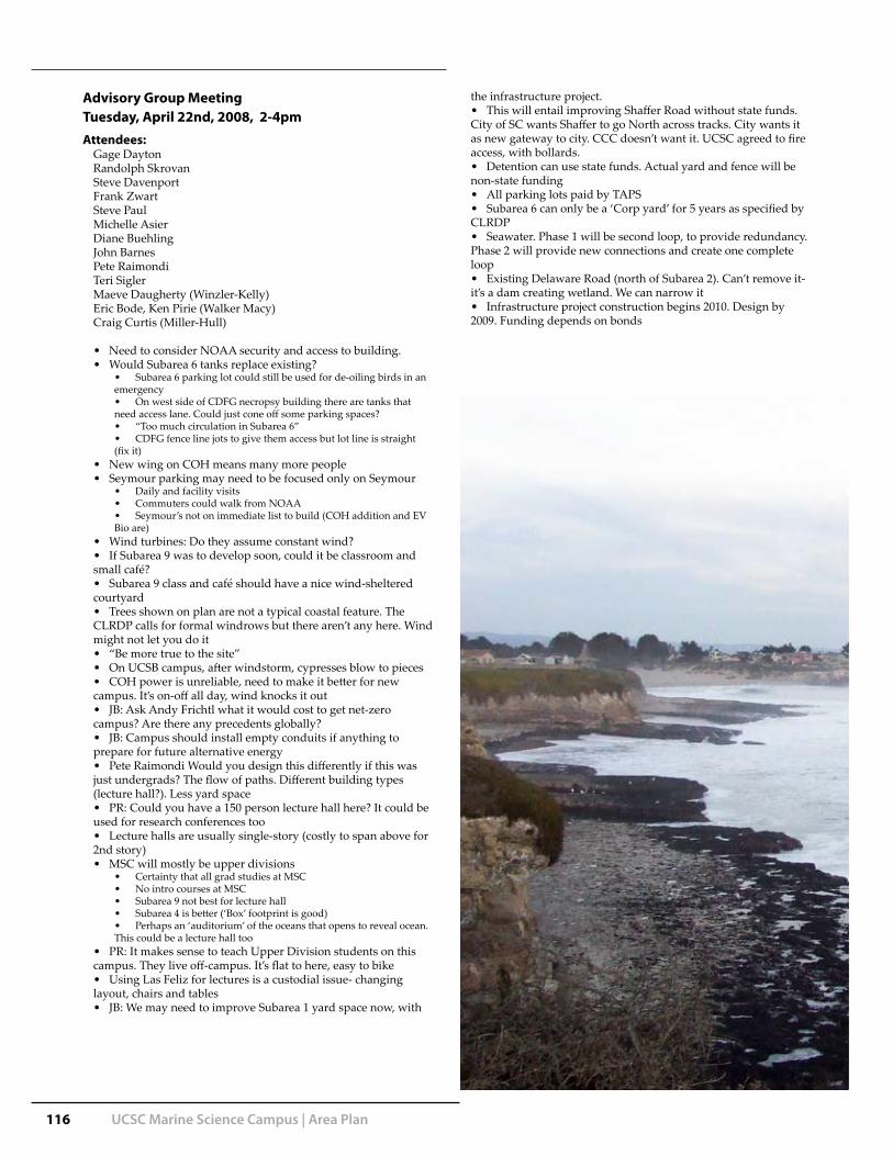
116 UCSC Marine Science Campus | Area Plan
Advisory Group MeetingTuesday, April 22nd, 2008, 2-4pmAttendees:
Gage DaytonRandolph SkrovanSteve DavenportFrank ZwartSteve Paul Michelle AsierDiane Buehling John BarnesPete RaimondiTeri SiglerMaeve Daugherty (Winzler-Kelly)Eric Bode, Ken Pirie (Walker Macy)Craig Curtis (Miller-Hull)
Need to consider NOAA security and access to building. • Would Subarea 6 tanks replace existing? •
Subarea 6 parking lot could still be used for de-oiling birds in an • emergency
On west side of CDFG necropsy building there are tanks that • need access lane. Could just cone off some parking spaces?
“Too much circulation in Subarea 6” • CDFG fence line jots to give them access but lot line is straight •
(fix it)New wing on COH means many more people• Seymour parking may need to be focused only on Seymour•
Daily and facility visits• Commuters could walk from NOAA• Seymour’s not on immediate list to build (COH addition and EV •
Bio are)Wind turbines: Do they assume constant wind? • If Subarea 9 was to develop soon, could it be classroom and •
small café? Subarea 9 class and café should have a nice wind-sheltered •
courtyardTrees shown on plan are not a typical coastal feature. The •
CLRDP calls for formal windrows but there aren’t any here. Wind might not let you do it
“Be more true to the site” • On UCSB campus, after windstorm, cypresses blow to pieces• COH power is unreliable, need to make it better for new •
campus. It’s on-off all day, wind knocks it outJB: Ask Andy Frichtl what it would cost to get net-zero •
campus? Are there any precedents globally?JB: Campus should install empty conduits if anything to •
prepare for future alternative energyPete Raimondi Would you design this differently if this was •
just undergrads? The flow of paths. Different building types (lecture hall?). Less yard space
PR: Could you have a 150 person lecture hall here? It could be • used for research conferences too
Lecture halls are usually single-story (costly to span above for • 2nd story)
MSC will mostly be upper divisions • Certainty that all grad studies at MSC • No intro courses at MSC• Subarea 9 not best for lecture hall• Subarea 4 is better (‘Box’ footprint is good) • Perhaps an ‘auditorium’ of the oceans that opens to reveal ocean. •
This could be a lecture hall tooPR: It makes sense to teach Upper Division students on this •
campus. They live off-campus. It’s flat to here, easy to bikeUsing Las Feliz for lectures is a custodial issue- changing •
layout, chairs and tablesJB: We may need to improve Subarea 1 yard space now, with •
the infrastructure project.This will entail improving Shaffer Road without state funds. •
City of SC wants Shaffer to go North across tracks. City wants it as new gateway to city. CCC doesn’t want it. UCSC agreed to fire access, with bollards.
Detention can use state funds. Actual yard and fence will be • non-state funding
All parking lots paid by TAPS• Subarea 6 can only be a ‘Corp yard’ for 5 years as specified by •
CLRDPSeawater. Phase 1 will be second loop, to provide redundancy. •
Phase 2 will provide new connections and create one complete loop
Existing Delaware Road (north of Subarea 2). Can’t remove it- • it’s a dam creating wetland. We can narrow it
Infrastructure project construction begins 2010. Design by • 2009. Funding depends on bonds