UAV Surveying II - cdn.ymaws.com · More Recent (relevant) History 2003 FEMA Appendix A: Guidance...
52
UAV Surveying II Precision. Accuracy. Reliability
Transcript of UAV Surveying II - cdn.ymaws.com · More Recent (relevant) History 2003 FEMA Appendix A: Guidance...

UAV Surveying II
Precision. Accuracy. Reliability

Part One:
Project Lifecycle
Deliverables
Part Two:
Evaluation of UAV Data Accuracy
and Examples of Error
Part Three:
Review of Results
Examples of Range of Applications
AGENDA

ProcessProcess
Collect
Deliver

UAV MAPPING OVERVIEW
Imagery
Video
Orthos
Point Cloud*
DSM
DEM
Planimetrics
Analytics
3D Objects
Point Cloud*
Obliques

Level 0 Level 1 Level 2 Level 3 Level 4
UAV MAPPING OVERVIEW
Raw Images
GPS Log
Camera Orientation
Automated Processing
QC Checks
Flight Validation
Ground Control
Ortho- control
RTK -in air
Mapping Products
Analysis Products

Level Description What Do you Get? Data Quality Triangle
Level 0 Flight Operations
Raw Data
GPS Log File
Flight Line Log
Outline of Area
Geotag Imagery
Repeatability
Level 1 Automated Processing
(cloud based services)
Image mosaic
Point cloud
Initial Surface Model (DSM)
3D Mesh
Precision
Level 2 Ground Controlled Survey Grade
Integrated control with
known accuracy
Accuracy
Level 3 Topographic Data Point Cloud Classification
Bare Earth Elevation models
Contours
Surface Constraints/Breaklines
DSM/DEM
Stitching multiple Flights
Manual Tie Points
Quality Control
Level 4 Analytics Planimetrics
Volumes
Change detection
Habitat mapping
Drainage
Land Cover/Vegetation/Impervious
Feature Extraction

Data Processing


NSSDA and NMAS
NMAS- 1947 Paper Map produced at a certain scale
Not appropriate to use for digital data
“2 foot accuracy” and “1 foot accuracy” terms are still WIDELY used
NSSDA – 1998 Applies to raster, point or vector data
Must compare your data against a “reference”
Reference must be 3x more accurate
RMSE vs 95% Accuracy
Standards

More Recent (relevant) History2003 FEMA Appendix A: Guidance for Aerial Mapping and Surveying of the
Guidelines and Specifications for Flood Hazard Mapping Partners
2004 NDEP Guidelines for Digital Elevation Data
2004 ASPRS Guidelines: Vertical Accuracy Reporting for LiDAR
2009 USGS Base Lidar Specification for projects funded under ARRA
2010 Procedure Memorandum No. 61 – Standards for Lidar and Other High Quality Digital Topography
2012 USGS LiDAR Base Specification Version 1.0 (NGP)
2012 USGS National Enhanced Elevation Data Assessment
2014 ASPRS Accuracy Standards for Digital Geospatial Data
Standards

Standards

NSSDA vs NMAS
NMAS Contour Interval = 3.2898*RMSE(z)
NMAS Contour Interval = Accuracy(z)/0.5958
Note that Accuracy ( z) is based on 95% CI, a statistical calculation.
The fourth column in this table refers to the NSSDA Accuracy required for
Reference Data or Checkpoints to be used in assessing data Accuracy
Standards

Standards

Surface Modeling from Point Clouds FEMA- NPS should be equal to or less than the DEM post spacing
(resolution) required
1-meter DEM for 1ft contours
2-meter DEM for 2ft contours
5-meter DEM for 5ft contours
Airborne LiDAR: 0.7 NPS -> 2ppsm ->1m DEM -> 1ft contours (QL 2)
Airborne LiDAR: 1.4 NPS -> 1ppsm ->2m DEM -> 2 ft contours (QL 3)
UAV: 0.02 NPS->2500ppsm
Note: Higher density data may still fail vertical RMSE test
Lower density data may meet higher accuracy tests.
Accuracy is tested from a sample of points against the surface model
Standards

What is this?

ERROR

ERROR
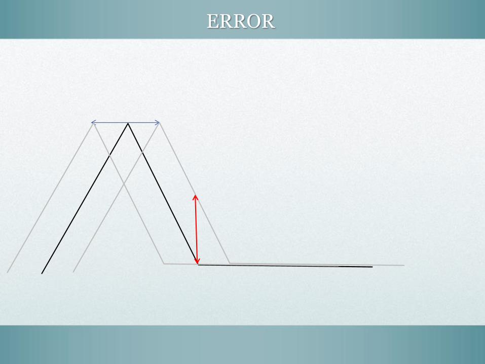
ERROR

ERROR
• Horizontal and Vertical Error translate to
VOLUMETRIC ERROR- even when within specs
• Change detection can only be done within the
accuracy limits of the sensor.
• Fly the same site twice in the same day with
the same control. Check the difference.

WHAT YOU DON’T WANT TO SEE


PART 3- The Results
• Screen Shots of Tepper Quad Case Study
WHAT YOU DOWANT TO SEE


Magnetometer


Thanks!
Geodata from sUAVsMatt Mercurio, GISP
GTO, Spatial Analytix