U. S. Domestic Scan Program: Best Practices in Right-of...
80
NCHRP Project 20-68 U. S. Domestic Scan Program: Best Practices in Right-of-Way Acquisition and Utility Relocation FINAL SCAN-TOUR REPORT Prepared for National Cooperative Highway Research Program Transportation Research Board of The National Academies Cambridge Systematics, Inc. Cambridge, Massachusetts December 2006
Transcript of U. S. Domestic Scan Program: Best Practices in Right-of...

NCHRP Project 20-68
U. S. Domestic Scan Program: Best Practices in Right-of-Way Acquisition
and Utility Relocation
FINAL SCAN-TOUR REPORT
Prepared for National Cooperative Highway Research Program
Transportation Research Board of
The National Academies
Cambridge Systematics, Inc. Cambridge, Massachusetts
December 2006

ACKNOWLEDGMENT
This work was sponsored by the American Association of State Highway and Transportation Officials (AASHTO) and the Federal Highway Administration (FHWA), and was conducted in the National Cooperative Highway Research Program (NCHRP), which is administered by the Transportation Research Board (TRB) of the National Academies.
This report was prepared by Cambridge Systematics, Inc., with James Ware, consultant. Participants in the scan tour contributed to the ideas and concepts contained in the report Any errors or omissions, however, are the fault of the authors alone. The authors gratefully acknowledge the participa-tion of the host agencies, including the Florida, Minnesota, and Texas Departments of Transportation, who made the scan tour possible.
COPYRIGHT PERMISSION
Authors herein are responsible for the authenticity of their materials and for obtaining written permissions from publishers or persons who own the copyright to any previously published or copyrighted material used herein.
Cooperative Research Programs (CRP) grants permission to reproduce material in this publication for classroom and not-for-profit purposes. Per-mission is given with the understanding that none of the material will be used to imply TRB, AASHTO, FAA, FHWA, FMCSA, FTA, Transit Development Corporation, or AOC endorsement of a particular product, method, or practice. It is expected that those reproducing the material in this document for educational and not-for-profit uses will give appropriate acknowledgment of the source of any reprinted or reproduced material. For other uses of the material, request permission from CRP.
DISCLAIMER
The opinion and conclusions expressed or implied in the report are those of the research agency. They are not necessarily those of the TRB, the National Research Council, AASHTO, or the U.S. Government. The Transportation Research Board, the National Research Council, the Federal Highway Administration, the American Association of State Highway and Transportation Officials, and the individual states participating in the National Cooperative Highway Research Program do not endorse products or manufacturers. Trade or manufacturers’ names may appear herein solely because they are essential to the clarity and completeness of the project reporting.
This report has not been edited by TRB.
NCHRP 20-68, Domestic Scan Pilot Program Best Practices in Right-of-Way Acquisition and Utility Relocation
Table of Contents
1.0 Overview of Pilot Scan Program and Tour.............................................................. 1-1 1.1 Program and Scan Tour Objectives .................................................................... 1-1 1.2 Scan Approach....................................................................................................... 1-2 1.3 Scan Participants ................................................................................................... 1-2 1.4 Federal Regulatory Framework .......................................................................... 1-4
2.0 Recent Research, Best Practices Guidelines, and Emerging Issues .................... 2-1 2.1 Recent Research and Best Practice Guidance.................................................... 2-1 2.2 Ongoing Research and Pilot Program Efforts ................................................... 2-7 2.3 Current Issues Identified by State DOTs ........................................................... 2-9 2.4 Overview of Scan Findings.................................................................................. 2-11
3.0 Florida............................................................................................................................. 3-1 3.1 Project Context....................................................................................................... 3-1 3.2 Policy Context........................................................................................................ 3-3 3.3 Innovations............................................................................................................. 3-4 3.4 Benefits.................................................................................................................... 3-18 3.5 Resources................................................................................................................ 3-19
4.0 Texas ............................................................................................................................... 4-1 4.1 Project Context....................................................................................................... 4-1 4.2 Policy Context........................................................................................................ 4-4 4.3 Innovations............................................................................................................. 4-4 4.4 Benefits.................................................................................................................... 4-11 4.5 Resources................................................................................................................ 4-12
5.0 Minnesota ...................................................................................................................... 5-1 5.1 Project Context....................................................................................................... 5-1 5.2 Policy Context........................................................................................................ 5-3 5.3 Innovations............................................................................................................. 5-6 5.4 Benefits.................................................................................................................... 5-14 5.5 Resources................................................................................................................ 5-15
6.0 Cross-Cutting Findings and Innovative Tools........................................................ 6-1 6.1 Supportive Institutional Environment ............................................................... 6-1 6.2 Focus on Process.................................................................................................... 6-2 6.3 Technical Tools ...................................................................................................... 6-3 6.4 Other Techniques .................................................................................................. 6-4
Cambridge Systematics, Inc. i

NCHRP 20-68, Domestic Scan Pilot Program Best Practices in Right-of-Way Acquisition and Utility Relocation
Table of Contents (continued)
6.5 Special Considerations for Design-Build Projects and Public-Private Partnerships ................................................................................. 6-6
6.6 Federal Support ..................................................................................................... 6-7 6.7 Benefits of Improved Practices............................................................................ 6-8
7.0 Implementing the Scan’s Findings ........................................................................... 7-1 7.1 Implementation Activities ................................................................................... 7-1 7.2 Barriers to Innovation........................................................................................... 7-1 7.3 Keys to Successful Implementation of Innovative Processes.......................... 7-2
Appendix A Site Visit Agendas
Cambridge Systematics, Inc. ii
NCHRP 20-68, Domestic Scan Pilot Program Best Practices in Right-of-Way Acquisition and Utility Relocation
1.0 Overview of Pilot Scan Program and Tour
1.1 Program and Scan Tour Objectives
In 2006, The National Cooperative Highway Research Program (NCHRP), through NCHRP Project 20-68, initiated a Domestic Scan Pilot Program modeled after the International Technology Scanning Program sponsored by the American Association of State Highway and Transportation Officials (AASHTO) and the Federal Highway Administration (FHWA). The purpose of the domestic scan program is to identify, review, document, and disseminate innovative practices by transportation agencies throughout the United States. Two “pilot” scans were initially funded – one on best prac-tices in right-of-way (ROW) acquisition and utility relocation to expedite project devel-opment, and one on best practices in transportation asset management. The right-of-way acquisition and utility relocation scan also was supported by FHWA’s Office of Real Estate Services. Based on the experience and success of these pilot scans, NCHRP expects to continue the domestic scan program in future years.
This report documents the findings of the first pilot scan, Best Practices in Right-of-Way Acquisition and Utility Relocation, conducted in July 2006. The focus of the scan was on identifying, documenting, and disseminating innovative state practices in right-of-way acquisition and utility relocation to support the delivery of projects in a timely and cost-effective manner.
In many areas transportation agencies as well as the public have grown tired of watching needed transportation improvements delayed for years as a result of lack of funding or a slow moving construction process. As a result, the previous five or six years have been a period of unparalleled examination of the transportation project development process. This is particularly true of the right-of-way acquisition/relocation process performed by state, local agencies, and right-of-way consultants. Completion of the ROW function is the last stage before construction commences and there is often a perception that the ROW stage is delaying advertising and construction of the project. The utility relocation and adjustment process also has been identified as a critical element in project development. A variety of factors such as rising real estate values, rapid property development in planned project corridors, complications with the relocation of utilities, and private prop-erty rights concerns have led to additional delays in implementing transportation projects in many corridors.
Federal and state policy establishes important protections for the rights of property own-ers, tenants, and public and private sector utilities. Transportation agencies are increasingly
Cambridge Systematics, Inc. 1-1

NCHRP 20-68, Domestic Scan Pilot Program Best Practices in Right-of-Way Acquisition and Utility Relocation
realizing that they can expedite ROW acquisition and utility relocation while ensuring that these protections remain in place. Improvements to the ROW and utility processes are therefore increasingly seen as a fundamental component of an overall approach to expedite project development and ensure that transportation projects needed to improve mobility and safety are built in a timely manner.
1.2 Scan Approach
As an initial step in the scan project, a “desk scan” was conducted to review and docu-ment literature relating to best practices and innovative efforts. The findings of the desk scan are summarized in Sections 2.0 and 3.0 of this report. The desk scan identified a number of states to be considered for a scan visit. The three hosts that were ultimately selected included:
• The Florida Department of Transportation (FDOT) District 5 Office in central Florida;
• The Texas DOT (TxDOT) Texas Turnpike Project Office in Austin; and
• The Minnesota DOT (Mn/DOT) central office in Minneapolis-St. Paul.
Particularly noteworthy practices also were identified in California and Washington State, which served as alternate locations for the scan tour.
The scan tour was conducted between Sunday, July 9 and Saturday, July 15, 2006. Frank and open discussions were held in each state regarding best and innovative practices, les-sons learned, and how processes would be modified for future projects. In addition to the scan tour participants, between 20 and 30 state personnel in each state participated in the presentations and discussions, along with representatives from FHWA Division offices. Field visits in each of the three states included a tour of one or more projects to examine specific ROW and utilities issues. These projects included the widening of State Road 50 in Orlando, Florida; construction of initial segments of the Central Texas Turnpike in Austin; and reconstruction and widening of I-394, I-494, Highway 62, and I-35 in Minneapolis.
1.3 Scan Participants
Fifteen transportation professionals participated in the scan, including nine state DOT staff from right-of-way and utilities offices, four FHWA staff, and two consultants who facilitated the scan. Tour participants were selected by the scan co-chairs, in consultation with NCHRP staff and the AASHTO Subcommittee on Right-of-Way and Utilities. High-level officials were selected with the interest, ability, and commitment to implement findings from the scan within their own agencies as well as to share them with colleagues at a state, regional, and national level.
Cambridge Systematics, Inc. 1-2

NCHRP 20-68, Domestic Scan Pilot Program Best Practices in Right-of-Way Acquisition and Utility Relocation
The scan management and leadership team included:
• Susan Lauffer (Scan Co-chair) Director, Office of Real Estate Services, FHWA;
• John Campbell (Scan Co-chair) Director, Right-of-Way Division, Texas DOT;
• James Ware (Subject Matter Expert), Consultant; and
• Christopher Porter (Scan Manager), Senior Associate, Cambridge Systematics, Inc.
Other state participants included:
• Richard Allen, Rights-of-Way Administrator, Connecticut DOT;
• John Ewald, Staff Attorney, Right-of-Way Division, Texas DOT;
• Raymond Lorello, Utility and ROW Program Manager, Ohio DOT;
• George Lovett, District General Counsel and ROW Manager, Florida DOT District 5;
• Donald Nelson, Director of Environmental and Engineering Programs, Washington State DOT;
• Bimla Rhinehart, Chief, Division of ROW and Land Surveys, California Department of Transportation (Caltrans);
• John Sherman, Lands Management Administrator, Wyoming DOT; and
• Kevin Stout, Assistant Chief, Right-of-Way, Oklahoma DOT.
Other Federal participants included:
• Donald Jackson, Value Engineer and Utility Program Coordinator, FHWA Office of Infrastructure;
• James Cheatham, Division Administrator, FHWA Pennsylvania Division; and
• Daniel Mathis, Division Administrator, FHWA Washington Division.
Each of the three host states designated an individual with primary responsibility to coor-dinate and plan discussions of best practices and innovative solutions which have been successful. Local host presentations and field visits were coordinated by George Lovett (Florida DOT District 5), Donald Toner (Right-of-Way Administrator, Texas DOT Austin District), and Marilyn Remer (Utilities Engineer, Minnesota DOT). Copies of the agenda for each state are presented in Appendix A of this report. The authors of this report are greatly indebted to these officials and their colleagues at each host agency for coordinating presentations and providing additional input into the report.
Cambridge Systematics, Inc. 1-3

NCHRP 20-68, Domestic Scan Pilot Program Best Practices in Right-of-Way Acquisition and Utility Relocation
Scan Participants (St. Paul, Minnesota) Front row: Jim Cheatham, Bimla Rinehart, Dan Mathis. Standing: Kevin Stout, Chris Porter, Jim Ware, John Campbell, Susan Lauffer, J.D. Ewald, Don Nelson,
Rich Allen, George Lovett, John Sherman, Ray Lorello, Don Jackson. Photo by Bill Lohr, FHWA Minnesota Division, in front of the Minnesota State Capitol, St. Paul, Minnesota.
1.4 Federal Regulatory Framework
Right-of-Way Acquisition
The Uniform Relocation Assistance and Real Property Acquisition Policies Act of 1970 (Uniform Act) provides important protections and assistance for people affected by Federally funded projects.1 This law was enacted by Congress to ensure that people whose real property is acquired, or who move as a result of projects receiving Federal funds, will be treated fairly and equitably, and will receive assistance in moving from the property they occupy. The Surface Transportation and Uniform Relocation Assistance Act of 1987 designated the U.S. Department of Transportation as the Federal Lead Agency for the Uniform Act. This responsibility has been delegated to the FHWA and is carried out by the Office of Real Estate Services.
1 The Uniform Act is contained in Title 42 U.S.C. 4601-4655. The regulations implementing the law
are contained in 49 CFR Part 24.
Cambridge Systematics, Inc. 1-4

NCHRP 20-68, Domestic Scan Pilot Program Best Practices in Right-of-Way Acquisition and Utility Relocation
Prior to January 2000, a somewhat rigid set of regulatory requirements dictated a number of specific procedures that were required to be followed on projects receiving any Federal-aid funding. Right-of-way regulations had been developed over the years to discourage types of waste, fraud, and abuse which had been encountered. Ultimately it was recognized that the costs in terms of time and money of overly stringent requirements were greater than the average risk of loss. The need to relax administrative controls was impeded by a set of regulatory requirements which were very specific in a number of pro-gram areas. A significant revision to 23 CFR 710 was published in December 21, 1999 and became effective in January 20, 2000.2 This revision provides the rationale for changing the regulations, including advantages, disadvantages, and concerns. The revision of the regulations helped to set the stage to develop alternative methods of meeting Federal requirements.
A further clarification of Federal regulations was issued on March 20, 2002 with the publi-cation in the Federal Register to confirm that states were allowed to pay greater relocation benefits than specified in 49 CFR Part 24. This clarification of 23 CFR 710.203 took effect on April 19, 2002.3 This regulatory revision enhanced the ability of state and local public agencies to utilize innovative incentive payments to aid in the prompt and efficient relo-cation of individuals, families and businesses.
This trend has been continued with the publication of revised relocation regulations for the relocation function and appraisal requirements. The regulations implementing the Uniform Act were revised on January 4, 2005 with an effective date of February 3, 2005.4
At the present time, there is a major thrust to shorten all aspects of transportation devel-opment and completion process. Fortunately, in recent years a critical examination has begun to determine whether various steps can be completed more quickly or whether they need to be completed at all. A simple example is the need for a title search before prop-erty is acquired. At one time the standard in some states was to perform a 40-year title search, which took time and cost money. Many states now acknowledge that for very low-value properties there is little risk associated with simply paying the owner of record. FHWA agreed to share the risks by confirming that if a payment were made and a second claim resulted in a second payment, Federal funds could be used in both payments since the overall result is less costly and a good business practice. Recent ROW pilot projects also have explored modification of appraisal and appraisal review practices for low-value, uncomplicated properties. The time savings and cost reductions are well documented in some of the previously completed and ongoing pilot projects.
2 The evolution of these regulations and the publication of the final rule can be viewed at
http://dms.dot.gov/. (Select “simple search” and docket 4315.) 3 http://frwebgate1.access.gpo.gov/cgi-bin/waisgate.cgi?WAISdocID=79637873076+0+0+0&
WAISaction=retrieve. 4 49 CFR Part 24. See: http://ecfr.gpoaccess.gov/cgi/t/text/text-idx?c=ecfr&sid=4b130c71709cf
33dd27a942ac4e391be&rgn=div5&view=text&node=49:1.0.1.1.17&idno=49.
Cambridge Systematics, Inc. 1-5
NCHRP 20-68, Domestic Scan Pilot Program Best Practices in Right-of-Way Acquisition and Utility Relocation
Complete information about Federal requirements for real estate acquisition for transpor-tation projects is available through the FHWA Office of Real Estate Services web site, http://www.fhwa.dot.gov/realestate/index.htm.
Utilities
States decide if they want utilities on highway right-of-way, including freeways, and if so to what extent and under what conditions. Whatever they decide must be documented in an FHWA-approved utility accommodation policy. A state may permit certain utilities and exclude others. Fees charged for utility use are at a state’s discretion and may be used as the state sees fit. If a state so chooses, it can prohibit any longitudinal utility installations.
State highway authorities have developed policies and practices which govern when and how utilities may use public highway right-of-way, and under what conditions public funds may be used to relocate utility facilities to accommodate highway construction. Utility relocation work is eligible for Federal-aid participation as a construction cost item to the extent the state was obligated to pay for such work. Many states allow reimburse-ment of utilities only under special circumstances, such as on Interstate highways or for municipal utilities.
Present FHWA regulations, policies, and practices dealing with utility relocation and accommodation matters have evolved from basic principles established decades ago, with many of the policies remaining unchanged. Practices are evolving, however, on emerging issues such as the leasing of public rights-of-way for fiber optics services by private tele-communications providers. Complete information about Federal regulations, policies, and guidance is available on the FHWA Utilities Program web site, http://www.fhwa.dot.gov/programadmin/utility.html.
Cambridge Systematics, Inc. 1-6

NCHRP 20-68, Domestic Scan Pilot Program Best Practices in Right-of-Way Acquisition and Utility Relocation
2.0 Recent Research, Best Practices Guidelines, and Emerging Issues
A number of research and demonstration efforts have been undertaken in recent years by state and Federal agencies in the United States on the topics of ROW acquisition and util-ity relocation. These efforts, and their findings, are summarized below. Issues of current interest to state DOTs also are identified, as they serve as the basis for the topics discussed in this scan.
2.1 Recent Research and Best Practice Guidance
NCHRP Synthesis 292: Innovative Practices to Reduce Delivery Time for Right-of-Way in Project Development
NCHRP Synthesis 292: Innovative Practices to Reduce Delivery Time for Right-of-Way in Project Development was developed in 2000 and is available from the Transportation Research Board.5 This report summarizes project practices which were in use at that time or were being developed to improve project delivery. The report includes the results of surveys taken by canvassing state transportation agencies regarding their current prac-tices and plans for changing practices.
The report was based in part on a survey of right-of-way managers, who identified several factors which help to assure success in expediting delivery of the ROW phase of the pro-jects. These suggestions involve participation in a “system” approach to project develop-ment. Some of the specific recommendations of the report include:
• Include right-of-way in setting and revising project schedules;
• Perform right-of-way activity as much as possible in parallel with other functions, rather than wait for a “hand-off” from an upstream function;
5 http://www.nationalacademies.org/trb/bookstore.
Cambridge Systematics, Inc. 2-1

NCHRP 20-68, Domestic Scan Pilot Program Best Practices in Right-of-Way Acquisition and Utility Relocation
• Delegate authority for project decisions to project personnel, rather than retaining authority at a more remote level;
• Encourage a collaborative atmosphere, where actions that affect more than one disci-pline would receive full consideration from all affected parties; and
• Train staff in new project development roles and relationships that extend beyond their traditional core job competencies.
The successful use of project management teams was reported in California, Utah, Florida, Iowa, and Washington State. These project management teams were typically created in the mid to late 1990s. Best practices developed as part of the process typically included either appraisal waivers for property with an estimated value under $10,000 or reduced documentation and approval steps for low-valued property. Most states reported that the team approach worked well in improving communication among various disciplines. Of particular benefit was the recognition that delays in upstream efforts such as delayed design plans will adversely impact acquisition, relocation, and property clearance functions.
FHWA – European Right-of-Way and Utilities Best Practices Scan
This scan, conducted in 2000, included visits with transportation officials in Oslo, As, and Moss, Norway; Bonn, Germany; The Hague, Netherlands; and London, England. The report, published in 2002, is available on the FHWA Office of International Programs web site.6
The scan provided some interesting insights. For example, the team concluded that in all the countries visited the sense of community welfare resulted in transportation decisions not limited to bottom line costs. One example was the construction of a bridge to allow access to a farm when it would have been less expensive to purchase the farm. Early involvement of property owners in the design process and extensive interviews with property owners also was recognized as a positive influence on project acceptance. Limited use of appraisal review was noted along with the appraisal and negotiation func-tion being performed by the same person. Prompt payment once negotiations are completed also was noted as a useful technique.
One significant solution involved the subject of land consolidation. Land consolidation is an effort made to eliminate the damage to owners and their communities when road pro-jects divide property, leaving portions on each side of a road. Land consolidation pools and redistributes the land, helping to assure viable ownerships. These concepts are most important for agricultural lands when major access control projects are initiated.
In many countries visited, utilities are often located underground for safety and landscape aesthetics.
6 http://international.fhwa.dot.gov/eurorightofway/.
Cambridge Systematics, Inc. 2-2

NCHRP 20-68, Domestic Scan Pilot Program Best Practices in Right-of-Way Acquisition and Utility Relocation
FHWA – Right-of-Way and Utilities Pilot Project Summary and Evaluation
Following the field visit phase of the European Right-of-Way and Utilities Best Practices scan, an implementation team was formed to encourage states to pilot the procedures identified through the scan tour. Several states initiated pilot projects in 2001 which included completed evaluations of the process and a “lessons learned” analysis. The pilots covered: waiver of appraisals, modified appraisal reviews, acquisition and relocation incentive payments, conflict of interest, land consolidation, and preliminary engineering cost reimbursement for utilities. Summary reports on these pilot projects describe the procedures followed, method of evaluation, results, implementation methods, cost savings, and the current status.7 Pilot states and projects included:
• California: Conflict of Interest;
• Florida: Appraisal Review Modification;
• Florida: Incentive Offer;
• Florida: Incentive Offer Procedures;
• Florida: Appraisal Waiver;
• Michigan: Appraisal Review Modification;
• Mississippi: Land Consolidation;
• North Carolina: Appraisal Waiver;
• South Florida Water Management Acquisition/Relocation Incentive;
• Virginia: Preliminary Engineering Cost Reimbursement;
• Virginia: Relocation Incentive;
• Washington State: Appraisal Review Modification; and
• Wisconsin: Appraisal Review Modification.
A brief review of these pilot projects confirms that benefits can be derived from adopting alternative methods of conducting project functions, although findings on some methods were inconclusive. The “conflict of interest” waiver in California evaluated allowing the same right-of-way agent to appraise and acquire parcels valued up to $25,000. While in theory this technique could save time and money, the evaluation of the project did not document savings in either category.
7 The summary results of these pilot projects, along with state and FHWA contacts, may be
reviewed at http://fhwa.dot.gov/realestate/pilotsum04.htm.
Cambridge Systematics, Inc. 2-3

NCHRP 20-68, Domestic Scan Pilot Program Best Practices in Right-of-Way Acquisition and Utility Relocation
Florida initiated a pilot incentive program which offered property owners additional com-pensation to sell property to the State without proceeding to costly and time-consuming liti-gation. The initial conclusions are that the incentive offer program decreases project costs and shortens the time required to acquire the property. Customer surveys concluded that property owners were satisfied with the level of customer service as well.
Appraisal waivers and/or appraisal review modifications were tested in Florida, Michigan, North Carolina, Wisconsin, and Washington for property valuations that do not meet a certain dollar value threshold. For example, in lieu of formal appraisals Florida implemented a provision for the use of an Agent’s Price Estimate (APE). Use of this tech-nique produced significant time savings and a relatively high rate of settlement (avoid-ance of condemnation). Additionally costs savings associated with the elimination of the appraisal and modification of appraisal review process exceeded $2 million. Florida also noted good success with waiver of technical review and use instead of a computer generated statistical process control program. Modification of review for small appraisals also demonstrated time and/or cost savings in Michigan, North Carolina, and Wisconsin.
Virginia had good success with reimbursing utility companies for 100 percent of their preliminary engineering cost in an effort to accelerate development of utility plans and cost estimates. Virginia also piloted a relocation move incentive payment to encourage timely tenant relocations. This program was highly successful and resulted in the reloca-tion of over 400 tenants in eight months. The additional cost of $1.2 million was offset by construction-related savings of $6 million.
Mississippi initiated a pilot project relating to land consolidation following the European model. The State held numerous public hearings offering to broker land exchanges on the I-69 corridor. The evaluation found that that no one to date has taken advantage of land consolidation, and suggested that new ideas often take years to fully develop.8
Some of these techniques were discussed in greater detail as part of the current scan tour, and their applications and benefits are described later in this report.
FHWA – Geographic Information System Implementation of State Department of Transportation Right-of-Way Functional Areas
In 2004, FHWA published a report on the use of Geographic information systems (GIS) as a right-of-way decision support tool. This report, based on the case study of eight state DOTs, documents the extent to which GIS technology is used in the various ROW func-tional areas, and the pros and cons associated with such endeavors. The report found that although the use of GIS technology is still very much localized and in its infancy, state DOTs are aware of the opportunities GIS presents in streamlining the implementation
8 For a broad framework for land consolidation, see: http://www.fhwa.dot.gov/realestate/
rowi69lc.htm.
Cambridge Systematics, Inc. 2-4

NCHRP 20-68, Domestic Scan Pilot Program Best Practices in Right-of-Way Acquisition and Utility Relocation
processes of right-of-way programs. Currently, GIS application in ROW largely involves mapping and inventory activities. A frequently cited hindrance to large-scale GIS appli-cation in the state DOTs is the lack of time and personnel resources. The report also documents best practice methods of GIS implementation for the ROW functional areas most likely targeted for GIS application.9
AASHTO – Right-of-Way and Utilities Guidelines and Best Practices
The AASHTO Subcommittee on Right-of-Way and Utilities prepared recommended guidelines and best practices for the major functional activities for right-of-way and utili-ties. Right-of-Way and Utilities Guidelines and Best Practices, published in 2004, is a major source of guidelines and best practices.10 The report is the result of an assignment of the AASHTO Standing Committee on Highways (SCOH) Strategic Plan. Strategy 4-4 of that plan requires the subcommittee to take primary responsibility to “Develop and advocate guidelines and best practices to assure timely procurement, clearance of rights-of-way and adjustment of utilities.”
AASHTO – Accelerating Project Delivery: It’s About Time
In 2005, AASHTO published a report entitled, “Accelerating Project Delivery: It’s About Time.”11 The report summarizes some of the previously noted methods that may be considered to speed up the ROW acquisition process, including:
• Signing bonuses;
• Raising nominal dollar thresholds for low-cost parcels;
• Allowing negotiators to offer above fair market offers; and
• Letting the landowner select the appraiser from an approved list.
The report highlights California’s “Project-Acceleration Toolbox” which lists steps that Caltrans has taken to speed up the process. These steps include designating a single agent to negotiate the acquisition and relocation. California also uses multifunctional teams of designers, planners, and engineers to take charge of all aspects of construction from inception to construction. Taxpayers can track project status on a program data base.
9 Saka, Anthony A (2004). Geographic Information System Implementation of State Department of
Transportation Right-of-Way Functional Areas. Prepared for FHWA by Institute for Transportation, Morgan State University, Baltimore, Maryland. http://www.fhwa.dot.gov/realestate/rowsurvjuly04.htm.
10 The report may be viewed at: http://rightofway.transportation.org/. (Select “documents” and Strategy 4-4.)
11 http://bookstore.transportation.org.
Cambridge Systematics, Inc. 2-5

NCHRP 20-68, Domestic Scan Pilot Program Best Practices in Right-of-Way Acquisition and Utility Relocation
Washington State will be preparing for the Olympics in 2010 across the border in Whistler, British Columbia using design build techniques. This is a high-visibility project where design build techniques are expected to shave five years from the project’s target opening date.
In the past two years, FHWA and AASHTO’s Technology Implementation Group have sponsored 15 Accelerated Construction Technology Transfer (ACTT) workshops. As a result of these workshops most participants have found ways to reduce construction time by 30 percent.
FHWA – 2006 Future Needs of Public Sector Real Estate
In 2006, FHWA published an assessment of expected future operational needs of public sector real estate, specifically as they relate to transportation projects, through the year 2035.12 The goal was to identify what new ideas, concepts, and technologies can be utilized to meet present and future needs of public sector real estate. The assessment was based on an on-line stakeholder survey as well as a focused brainstorming session. The assessment resulted in a number of recommendations for FHWA and state DOT actions, technical assistance and training support, and changes to legislation, regulation, and pol-icy. Recommendations for state DOTs specifically included:
• DOTs need to integrate the right-of-way function early in the project development process, elevate the importance of the right-of-way process with upper engineering management, encourage long-range planning and coordination with metropolitan planning organizations and local public agencies in the preservation of future right-of-way, and provide the necessary experts for the project development process.
• DOTs need to implement partnering from the top down, gain “buy-in” and under-standing from engineering management of the priority of right-of-way in the project development process, and be responsible for providing the necessary resources to ele-vate training and education within their organizations. ROW managers also need to create a “grass roots” effort and form informal networks between attorneys, engineering management, planners, environmental, and ROW staff.
• DOTs need to create a public-private partnership between agencies and consultants to provide cross training that builds stronger experience levels and aids in the utilization and retention of institutional knowledge on both sides.
• DOT ROW managers should work with public relations experts and be present at public meetings early in the project development process to answer questions and address the public’s concerns regarding right-of-way impacts. Landowners and the surrounding
12 Federal Highway Administration (2006). FHWA Office of Real Estate Services Research Results: 2006
Future Needs of Public Sector Real Estate. http://www.fhwa.dot.gov/realestate/publicat.htm#research.
Cambridge Systematics, Inc. 2-6

NCHRP 20-68, Domestic Scan Pilot Program Best Practices in Right-of-Way Acquisition and Utility Relocation
community also need to be informed and involved from the beginning and throughout the project development process.
• DOTs need to utilize alternative technologies such as GIS to develop a more efficient and effective program.
Examples of recommendations for FHWA include: promoting flexibility in the law to allow states more authority regarding administration of their right-of-way programs; advocating for integrating the right-of-way function early in the planning, project development, environmental, and final design phases of projects; and advocating for development of the right-of-way profession as a career path, including developing part-nerships with educational institutions.
2.2 Ongoing Research and Pilot Program Efforts
A number of states have taken advantage of the flexibility allowed by current Federal regulations and encouraged by FHWA. Pilot projects have been initiated since 2001 to explore a variety of techniques to expedite the ROW acquisition and relocation process while continuing to provide constitutionally guaranteed benefits to property owners and tenants. Some of the initiatives are aimed at reducing costs by eliminating unnecessary and/or redundant activities, while others may increase ROW acquisition costs while shaving time off the process with resulting cost savings associated with earlier construc-tion completion. In addition, FHWA continues to undertake its own research on specific topics.
Incentive Offer
The Florida DOT initiated an incentive offer pilot project in November 2001. The purpose of this pilot was to assess the potential to reduce overall project costs, expedite ROW acquisition, and produce early settlements while reducing condemnation and litigation expenses. The incentive offer program provides for an additional payment over and above the fair market value if the property owner agrees to a settlement. When a settle-ment cannot be reached, property is condemned based on the fair market value without the incentive payment. Recent follow-up reviews by the FDOT have confirmed that the incentive offer program is working and should be continued on selected pilot projects.
Team Approach to Project Management
California uses multifunctional teams made up of various disciplines to take charge of a project from the beginning of the project to the construction. Under this approach all functional areas have a place at the table and the use of teams assures that everyone understands the issues of the other members of the team.
Cambridge Systematics, Inc. 2-7

NCHRP 20-68, Domestic Scan Pilot Program Best Practices in Right-of-Way Acquisition and Utility Relocation
Appraisal Waivers
This FHWA study will identify and evaluate if the appraisal waiver is accomplishing the intended goals of minimizing administrative costs and expediting the acquisition of real property. The study also will determine which proportion of each state DOTs’ acquisi-tions are valued with the appraisal waiver process, and what the associated DOT organ-izational consequences of the use of the appraisal waiver may be, including the impact on the DOTs’ appraisal capabilities.
Mortgage Interest Differential Payment (MIDP)
An FHWA research study is underway to look at various types of mortgages available today, including reverse, pick-a-pay, and adjustable rate mortgage plans. This study explores various methods of determining the mortgage interest differential payment using a simple Excel spreadsheet format. Information from the study will be used to develop guidance that will be posted on the FHWA Office of Real Estate Services web site.
Innovative GIS Corridor Assessment and Land Acquisition Management Tools
Phase 1 of this FHWA study is complete. A prototype tool was developed to create a GIS-based linkage between environmental hazard analysis and land acquisition estimates for transportation projects. The tool is compatible with existing geospatial, imagery, and analysis tools. The initial phase of the research explored development of a system to assist transportation decision-making by incorporating comparative right-of-way land values and natural hazard risk assessment data. A second phase of the research is being considered to produce effective analytical tools and processes that are tied to right-of-way decision-making needs.
Turbo Expert Electronic Relocation System
The objective of the Turbo Expert Electronic Relocation System project is to provide a tool to the state DOTs, FHWA divisions, and other Federal agencies that will help ensure that relocation calculations are accurate, in accordance with current regulations, and completed in a uniform manner. This system will help to ensure that those relocated for Federally aided programs or projects are receiving proper relocation benefits in a timely manner. This system is being developed by FHWA.
Additional FHWA Resources
Comprehensive information on FHWA right-of-way and utilities programs, requirements, guidance, and research can be located on the respective FHWA program office web sites:
Cambridge Systematics, Inc. 2-8

NCHRP 20-68, Domestic Scan Pilot Program Best Practices in Right-of-Way Acquisition and Utility Relocation
• FHWA Office of Real Estate Services – http://www.fhwa.dot.gov/realestate/; and
• FHWA Utilities Program – http://www.fhwa.dot.gov/utilities/.
2.3 Current Issues Identified by State DOTs
While an increasing number of resources are available on best practices in right-of-way acquisition and utility relocation, these topics are still viewed by many states as critical areas needing further development. In response to a 2005 request from AASHTO for domestic scan topics, three separate proposals were received related to ROW acquisition and utility relocation, demonstrating the depth and breadth of interest in these topics. These proposals served as the basis for the current scan described in this report. The topic proposals included:
• Best management practices in utility and right-of-way clearances – Specific items suggested for review included incorporating utility relocation services in the con-struction contract, the long-range planning and coordination of projects between the states and utilities, and use of Subsurface Utility Engineering. Delaware, Indiana, Florida, California, Texas, and Washington, D.C. were mentioned as having addressed some or all of these issues. The need to address accelerated negotiation and relocation processes for ROW acquisition also was noted.
• Integration of the Right-of-Way and Design processes to decrease right-of-way costs and length of time to purchase right-of-way – This proposal identified the need to address improper coordination between ROW and design which can result in increased costs and delays to projects.
• Integrating project delivery to meet accelerated project delivery schedules – Issues identified in this proposal include: Integrating the project delivery process, improving multidisciplinary coordination throughout all stages of the planning and project devel-opment process, balancing timely acquisition with the rights of property owners, accomplishing expeditious coordination of utility relocation, securing adequate staff resources to meet accelerated schedules, and addressing the advantages and disadvan-tages of utilizing design-build to meet accelerated schedules. Suggestions for states to examine included Arizona, Louisiana, Oklahoma, Oregon, South Carolina, and Utah.
An especially important emerging topic involves evolving project delivery practices, including design-build contracting and public-private partnerships (PPP). Many states are beginning these practices to take advantages of inherent opportunities and incentives for time and cost savings, as well as to leverage dwindling resources through innovative finance techniques. Design-build contracting techniques are being applied in many states on major contracts to speed the project development and delivery process. More states also are experimenting with PPPs in order to engage the private sector not only in the development and construction but also in the finance, maintenance, and operations of transportation projects. An important question is how to revise ROW and utilities prac-tices to ensure that these new arrangements can be utilized to their maximum advantage.
Cambridge Systematics, Inc. 2-9

NCHRP 20-68, Domestic Scan Pilot Program Best Practices in Right-of-Way Acquisition and Utility Relocation
Design-Build Projects
“Design-build” is a method of project delivery in which the design and construction phases of a project are combined into one contract, usually awarded on either a low bid or best-value basis. This is in contrast to the more traditional design-bid-build (D-B-B) approach used in transportation agencies that outsource project design work, in which two different contracting efforts must be undertaken in sequence to procure architecture/engineering services on a negotiated-price basis and construction services on a lowest-responsible bid price basis. Design-build for major transportation projects has become an increasingly popular approach since it was first authorized by FHWA on an experimental basis in 1990, with the primary benefit being the achievement of time savings in project delivery.a This approach allows some tasks to be undertaken in an overlapping rather than sequential manner and provides incen-tives for the contractor to incorporate alternative technical concepts at the design and con-struction phases to more efficiently deliver projects and provide cost savings. While not all states have adopted the statutory authority for design-build, the majority of states have adopted such authority and undertaken one or more design-build projects.
The treatment of ROW in design-build projects varies. Federal regulations require completion of the National Environmental Policy Act (NEPA) environmental clearance process prior to the release of the final request for proposals. In most states, ROW has been acquired by the state before letting the design-build contract, ensuring that major environmental clearances are obtained and reducing the potential risk incurred by the contractor in ROW acquisition. How-ever, some states, including Arizona and Texas, are now tasking the design-build contractor with ROW acquisition. While this second approach allows ROW acquisition to benefit from the efficiencies and incentives built into design-build contracting, it also requires that NEPA environmental clearances be obtained in advance of ROW acquisition, and furthermore that state policies related to ROW acquisition provide some level of certainty regarding acquisition authority and timeframe.b
At the current time a unique aspect of the design-build process is that Federal regulations allow for construction clearance approvals on a parcel-by-parcel basis. A 2006 report by FHWA rec-ommends that regulations be changed in the future to allow this provision for all projects.
a FHWA Design-Build Effectiveness Study, January 2006. http://www.fhwa.dot.gov/reports/designbuild/designbuild.htm FHWA’s Design-Build Contracting Final Rule was published in the Federal Register on December 10, 2002 (Volume 67, No. 237, pages 75902-75935) and became effective on January 9, 2003.
b For a full discussion and case studies of the relationship between design-build and the environmental permitting process, see: Louis Berger Group, Inc. (2005). Design-Build Environmental Compliance Process and Level of Detail: Eight Case Studies. Prepared for AASHTO Standing Committee on the Environment, NCHRP 25-25 Task 12. http://www4.nationalacademies.org/trb/crp.nsf/All+Projects/NCHRP+25-25#12.
Cambridge Systematics, Inc. 2-10

NCHRP 20-68, Domestic Scan Pilot Program Best Practices in Right-of-Way Acquisition and Utility Relocation
Public-Private Partnerships (PPP)
FHWA’s Special Experimental Program No. 15 (SEP-15) permits experimentation in the project development process. One goal is to attract private investment leading to more innovation, improved efficiency, and more timely implementation.c A successful PPP project, Pocahontas Parkway in Virginia, was previously visited as part of the FHWA Domestic Scan on Advance Acquisition and Corridor Preservation. The project was delivered at a cost of $314 million with only $27 million of public funds. The majority of the funding was raised through the sale of private bonds to be repaid with tolls. The project was projected to take 75 months to complete but was actually completed in 48 months. Florida DOT, the Florida Turnpike Enterprise, and Texas DOT also are considered to be PPP leaders nationwide.
c FHWA’s PPP web site provides resource information on public-private partnerships. See: www.fhwa.dot.gov/ppp/.
2.4 Overview of Scan Findings
Before drawing cross-cutting findings and conclusions, the next three sections of this report provide a detailed review of the scan’s findings in each of the three states visited. While every state has a different legislative and statutory framework, different internal organizational structures, and unique transportation issues, they all share some common traits which led to their selection for inclusion in the scan. In particular, each state has chosen to leave the familiar path in one or more areas and abandoned the tried and true method of conducting business to explore new, innovative, creative, and collaborative methods of acquiring ROW, advancing construction completion, and facilitating utility relocation or avoidance. The states have each approached the issues in a somewhat differ-ent manner, depending upon their own unique circumstances.
Cambridge Systematics, Inc. 2-11

NCHRP 20-68, Domestic Scan Pilot Program Best Practices in Right-of-Way Acquisition and Utility Relocation
3.0 Florida
3.1 Project Context
Over the years Florida has tested and applied many innovative practices in an effort to accelerate project completion. Such approaches are critical to meeting Florida’s transporta-tion needs since the State’s population is increasing rapidly. Over 1,000 new residents enter Florida each day. Between the year 2000 and 2004 Flagler County (in Florida DOT’s District 5) was the second fastest growing county in the country with a 38 percent popula-tion increase. The rapid population expansion creates continual demands for transportation improvements to accommodate permanent residents and vacation travelers.
Florida’s District 5 (north central) office,13 which includes Flagler County as well as Orlando, Daytona Beach, and other fast-growing areas, has been especially innovative in applying procedures to expedite ROW acquisition and relocation within state policy con-straints, as well as to expedite the utility relocation and adjustment process. This area of the State is plagued with accelerating transportation demands which have made the capacity of many local roads insufficient to handle current and future traffic volumes.
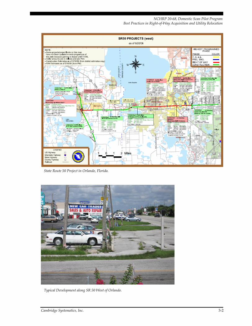
While meeting with Florida DOT District 5 and headquarters staff in Orlando, the scan group specifically reviewed the State Road 50 (SR 50) widening project in west suburban Orlando. This project is one of many in the District but was selected as representative of how the project development process in District 5 works. SR 50 is a highly developed urban arterial on which FDOT has undertaken a series of six contiguous design projects to widen the road from four to six lanes. The project corridor is lined primarily with strip development of commercial enterprises. Project improvements to increase capacity are for the most part limited to increasing the number of lanes, some modification of access, and improving intersection turning radii. Safety also is a serious concern; portions of SR 50 in Orange County have been determined to be the nation’s 12th deadliest road and the sec-ond deadliest for pedestrians, with 144 deaths in 7 years. The project affects about 250 properties, although only a handful require displacements.
13 http://www.dot.state.fl.us/publicinformationoffice/district5pio/counties.orange.htm.
Cambridge Systematics, Inc. 3-1
NCHRP 20-68, Domestic Scan Pilot Program Best Practices in Right-of-Way Acquisition and Utility Relocation
State Route 50 Project in Orlando, Florida.
Typical Development along SR 50 West of Orlando.
Cambridge Systematics, Inc. 3-2

NCHRP 20-68, Domestic Scan Pilot Program Best Practices in Right-of-Way Acquisition and Utility Relocation
A unique problem is that the water table in this area of Florida is very near the surface, approximately eight feet. The State of Florida is in general a low-lying area and ranks with Louisiana as the second most low-lying state in the nation, just after Delaware. In any land development or transportation project along the corridor, removal and manage-ment of this water along with surface water run-off are major considerations. Construc-tion and reconstruction of roadways includes finding locations to impound water and or channel it to approved disposal sites. Water management needs create unique require-ments as well as opportunities for ROW acquisition. Water management is accomplished in a variety of ways, including creation of ponds by the State, purchase of appropriate rights to use ponds created by others, and the exchange of excess capacity from others in the project area. The State also may enlarge or deepen existing ponds and raise outlet weirs to increase pond volume levels. Pond development is not a casual undertaking in Florida but requires regulatory review and appropriate permitting by regulatory agencies.
Another challenge is that over the years, the areas adjacent to SR 50 have been intensely developed with commercial enterprises so that any proposed construction impacts the frontage of these properties and may impact access, landscaping, and water retention areas. Great care must be exercised to mitigate detrimental impacts to the businesses while retaining and improving the integrity of the transportation system. As with many roadways that have been in place for a number of years, encroachment creep is apparent. Car lots and other businesses routinely park vehicles on the state ROW, sometimes believing that is privately owned property. Demonstrating the extent of public ROW is a critical starting point for negotiations along these roadways.
A retention pond along SR 50 with excess capacity and potential to mitigate state impacts on adjacent commercial properties.
3.2 Policy Context
Under Florida’s right-of-way acquisition procedures, all affected owners initially receive a written notice explaining the Department’s need for the property. This notice also explains the acquisition process as well as the owner’s rights. The Department has the land appraised, then begins the negotiation process with a written offer to purchase the required property based on the appraisal. After a period of negotiations, if a mutually acceptable agreement can be reached, a real estate closing occurs. At the closing, the owner receives the agreed payment in exchange for the property needed for the public transportation use. If an eminent domain lawsuit is required, a jury decides on the price and terms for the property. A defendant has 120 days after the lawsuit is issued to file an
Cambridge Systematics, Inc. 3-3

NCHRP 20-68, Domestic Scan Pilot Program Best Practices in Right-of-Way Acquisition and Utility Relocation
answer to settle claims. Affected owners may be eligible to claim business damages if their business has been in operation for at least five years immediately prior to the Department’s acquisition and the acquisition is for only a part of the land on which the business is located.14
Florida has unique condemnation legislation which allows property owners to be reimbursed for reasonable legal and expert witness costs when the acquisition proceeds to court. With this type of legislation, property owners have little incentive to accept state offers of compensation and in the past have readily sought compensation through court action. The end result is that courts are overburdened with just compensation litigation, costs are greatly increased, and acquisition timeframes are increased.
In accordance with state policy, FDOT cannot under most circumstances reimburse utili-ties for costs associated with relocation on state-owned ROW. Exceptions can be made, however, under four circumstances: 1) where it is determined that the utility is located in an economically depressed area; 2) on Federal-aid Interstate projects; and 3) if the utility work is completed by the highway contractor and the utility bid is more than 110 percent of the State’s official estimate for the work, the State can participate in costs beyond this level; and 4) if the utility agrees to relocate in advance of the project construction, FDOT will pay for the clearing and grubbing. The State of Florida can condemn ROW if neces-sary in the name of the State and turn that ROW over to the utility company so that the utility relocation can be accomplished.
On other utility-related issues, state statutes provide very limited guidance. They address only permitted utility facilities already on the roadway ROW, and specifically make pro-visions for the State’s rights and responsibilities if the utility is interfering with a trans-portation project and no agreement can be reached between the State and utility. In this situation, the State must provide 30 days notice of what actions the utility must take to remove the interference. If the utility does not respond, the State sends a second notice and can take over the work and demand reimbursement from the utility or place a lien and assume ownership if not paid. In reality, FDOT considers this a “fallback” situation and prefers to reach agreements through negotiation.
3.3 Innovations
As noted in Section 2.0, Florida DOT has piloted a number of ROW innovations, including incentive payments and appraisal waivers. In Florida, District offices function in a decentralized manner and are allowed a great deal of autonomy. District 5’s ROW and utilities processes are further distinguished by a comprehensive approach that facilitates continuous innovation and improvement. This approach is characterized by a focus on 14Florida Department of Transportation (2006). The Real Estate Acquisition Process. http://www.
dot. state.fl.us/rightofway/.
Cambridge Systematics, Inc. 3-4
NCHRP 20-68, Domestic Scan Pilot Program Best Practices in Right-of-Way Acquisition and Utility Relocation
team building and cross-disciplinary collaboration, early involvement of external stake-holders, clearly defined processes, performance measurement, and training and capacity-building. Noteworthy aspects of District 5’s approach are described below.
Creation of Professional Teams
The District 5 office has developed a team concept to enhance the completion of projects. The success of the team process was evident in the enthusiasm and pride of ownership expressed by various members of the acquisition team. The successful team approach has required specific and continuing efforts to facilitate communication among all team mem-bers and throughout the District. Full and open communication is encouraged, and any team member has the authority to approach an official at any level to seek information, make observations, or ask for help in reaching the common goals. The environment is non-hierarchical – team members are not required to go through a formal chain of com-mand, but may go directly to whomever is necessary to answer their question or address their issue. The resulting efficiency in communication helps to keep projects on track.
The team approach includes a clear definition of the common goal. The goal is not just to complete an individual’s assigned task, but to have the ROW available to construct the project on the scheduled date. Team members know that when project materials come to them late or behind schedule it is their job to find ways to expedite the process and to successfully complete all ROW acquisition activities and functions to make the prop-erty available for construction.
Development of competent, cohesive teams did not occur overnight. Initially meetings were held weekly to discuss issues, including what is working well, what needs improve-ment, and what should be changed. Formal recognition of those who had discovered alternative methods of completing tasks helped to assure the continued development of team members.
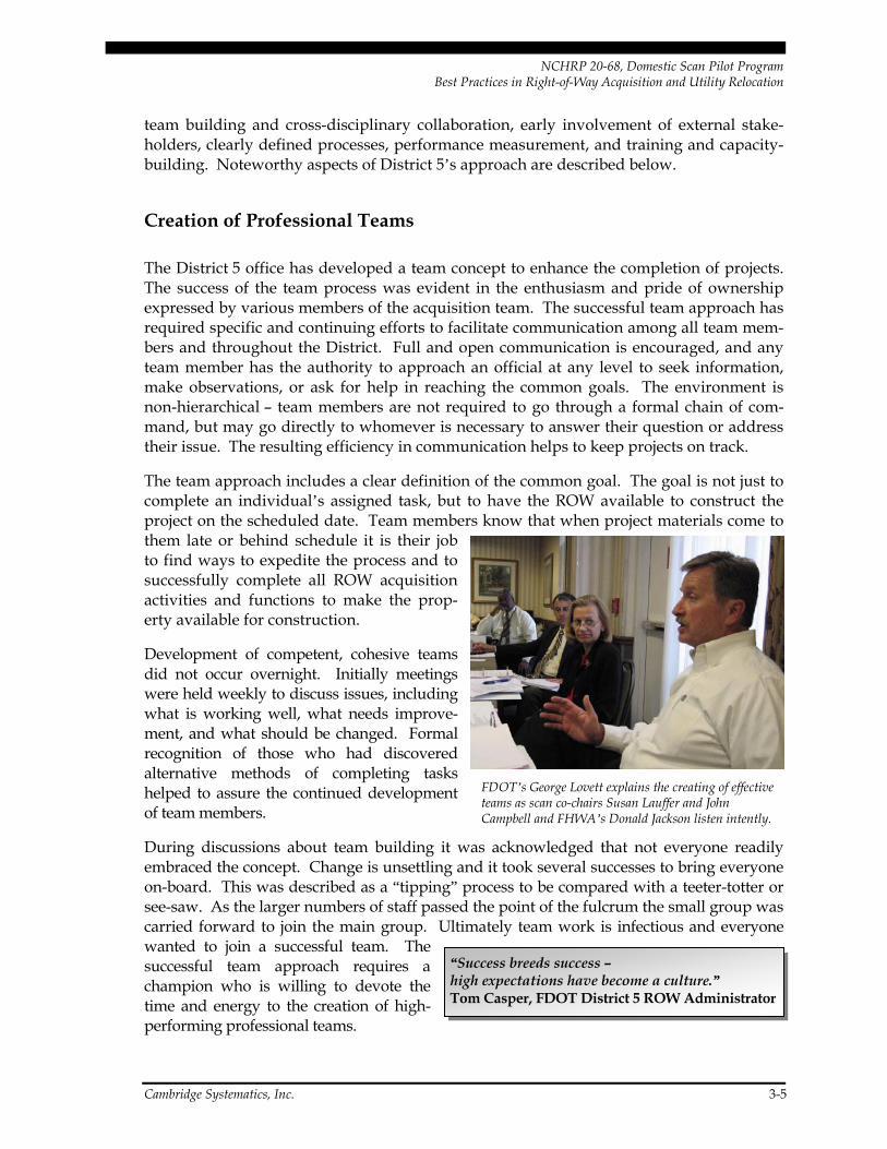
FDOT’s George Lovett explains the creating of effective teams as scan co-chairs Susan Lauffer and John Campbell and FHWA’s Donald Jackson listen intently.
During discussions about team building it wembraced the concept. Change is unsettling and it took several successes to bring everyone on-board. This was described as a “tipping” process to be compared with a teeter-totter or see-saw. As the larger numbers of staff passed the point of the fulcrum the small group was carried forward to join the main group. Ultimately team work is infectious and everyone wanted to join a successful team. The successful team approach requires a champion who is willing to devote the time and energy to the creation of high-performing professional teams.
as acknowledged that not everyone readily
“Success breeds success – high expectations have become a culture.” Tom Casper, FDOT District 5 ROW Administrator
Cambridge Systematics, Inc. 3-5
NCHRP 20-68, Domestic Scan Pilot Program Best Practices in Right-of-Way Acquisition and Utility Relocation
Formal Coordination Meetings and Continuous Involvement
cross a variety
ini-
n of properties at the time of appraisal. sers visit the property at the same time.
erty Owners and the Public
nd can
Much of the District’s success has resulted from holding regular meetings aof disciplines to assure early recognition of problems and to seek early resolution. While holding meetings just for the sake of holding meetings is not recommended, the District’s team meetings are conducted with clearly established objectives and a predefined agenda. FDOT’s standard project approach includes formal coordination meetings for each project at design project milestones. These meetings include a parcel by parcel meeting and a meeting at the final design stage. A significant milestone is the post-construction meeting with the contractor which includes debriefing reviews on change orders, design changes, and other issues. This discussion captures the contractor’s views as to what worked well and what action can the State take to make the next project advance more smoothly.
A key element of the team approach is coordination among different departments and functional areas. For example, project development and design staff are present at antial meeting of the project ROW team to debrief the team on the project and any issues of which they are aware, such as permitting status, contacts already made with property owners, potential roadblocks, and any agreements that have been established.
Team Interaction at the Appraisal Level
A unique team approach involves the inspectioThe review appraiser, the agent, and fee appraiThis field visit allows each party to observe the property and paves the way for expedi-tious review and negotiation follow-through. Fee appraisers develop a “data” or compa-rable sales book which includes pertinent property sale transactions to be used in valuing properties in the project area. Agents and review appraisers attend a meeting where the data books are presented and reviewed. This approach gives the agents a good under-standing of the market conditions in the area and helps to facilitate negotiations. In some areas along the routes reviewed property values have escalated 40 percent in one year, making knowledge of current property values critical.
Early and Ongoing Communication With Prop
Florida District 5 has found that a project’s success in achieving ROW agreements can be enhanced by establishing and maintaining forthright communications with those expected to be impacted by the project, beginning at the early stages of the project. The state per-sonnel clearly understand their responsibility to include keeping businesses in business and easing the impact on owners and tenants, and work to earn the public’s trust.
District staff meet with abutters and other interested stakeholders early in the project process to assure that owners and tenants are fully aware of planned projects aprovide their input. This process greatly reduces the level of detrimental rumors and misinformation which often accompany transportation improvements. These early
Cambridge Systematics, Inc. 3-6

NCHRP 20-68, Domestic Scan Pilot Program Best Practices in Right-of-Way Acquisition and Utility Relocation
meetings allow owner input at an early stage and eliminate the surprise element involved in later public meetings. Owners often have worthwhile sugges-tions and comments and can provide valuable input.
Clear provision of information also
“Landowners have been surprised to find out that we care what they think.” Ed Barfield, ROW Special Projects Coordinator, FDOT District 5
is important. Property owners are provided a detailed description of the acquisition process in the form of a brochure which lays out the rights
t is used in Florida wherein the same agent handles the acquisi-tion, relocation, property management, and clearing of the improvements for construction.
Consistent Staff Assignment
d to each project, one with appraisal background and one with an acquisition background. These staff members track the project from
is the development of working relationships with utilities. Private utilities as well as local governments are invited to
and options available during the acquisition process. This brochure confirms that if the owner requests it, the State will provide copies of the appraisal, the right-of-way maps, or construction plans within 15 business days of the request. The brochure describes the property owner’s eligibility for attorney fees and appraiser fees both in the event of a negotiated settlement and in the case of condemnation. The brochure also outlines the general conditions under which a business where a partial taking has occurred may be eli-gible for a business damage claim. These businesses must have been in business for at least five years immediately prior to the acquisition and must be able to demonstrate that the losses are a direct result of the loss of a portion of the property.
One Agent Concept
A true one agent concep
The agent is involved from the initial team meeting at the initiation of the project until final settlement including mediation or court trial. The use of a single agent helps to ensure that owners and tenants receive consistent information regarding state procedures, and property owners always know whom to contact and are not shuffled from one state agent to another. The use of a single agent also avoids the problem of property owners indicating that an earlier agent made promises which are not being honored.
Two ROW staff members are assigne
beginning to end and are critical to the identification and resolution of ROW issues in the early design stages. Their involvement often results in advance acquisitions and quick settlements with willing sellers, and helps to produce high-quality appraisal reports.
Early and Ongoing Coordination with Utilities
Equally important to relationships with property owners
participate as early as the initial scope of services design team meetings. This has been successful at obtaining early information from utilities on the locations of their assets.
Cambridge Systematics, Inc. 3-7
NCHRP 20-68, Domestic Scan Pilot Program Best Practices in Right-of-Way Acquisition and Utility Relocation
Early coordination with utilities can pose challenges, however. FDOT staff note that while utilities like the concept of coordination, it nevertheless represents an expense for them, and at the early stages there may be very few project details to work with. District 5’s solution as been to hold advance meetings with utility companies at the “line and grade” design stage, when it is still early enough to make design changes but there are enough details for utilities to be able to assess potential impacts. This allows the utility to evaluate the anticipated impact of the project on their utility facility and to plan accordingly.
While FDOT has established “master agreements” and standard procedures with respect to the utility coordination process, use of these agreements and processes has varied by
n land for ROW needed for utility relocation as a result of a transportation project (Chapter 73
Finalization of ROW and Utilities Needs at the 60 Percent Design Stage
es occurring once property maps are completed and ROW acquisition has commenced. The
Avoiding last-minute design changes is considered important enough that District 5 has established a tracking system to record all changes after the 60 percent design stage. Any
district as a result of the agency’s decentralized approach. Nevertheless, the agency is aware that a consistent approach is especially important to statewide/regional utilities. To facilitate consistency, air issues of concern, and build relationships, FDOT hosts quar-terly statewide meetings to which all utilities in the State are invited. These meetings last a week and include general meetings, open forums, and specific issue workgroups.
Condemnation Authority for Right-of-Way Required by Utilities
Florida statutes provide the State with the authority to purchase and condem
Section 015). FDOT will condemn the land in the name of the State and transfer it to the utility. While condemned land cannot normally be transferred to private interests, an exception is made if it is transferred for public uses such as utility relocation for transpor-tation facilities, water retention areas, or drainage facilities.
A common problem faced by many state DOTs is that of ongoing design chang
design changes require acquisition functions to be redone often several times and create delays in completion of ROW acquisition. District 5 has initiated a process whereby Design and ROW work hand-in-hand to formulate a good design which considers the physical construction needs of the project along with the needs of adjacent property own-ers. State ROW personnel work to reduce detrimental impacts on adjacent property to lessen business damages and to integrate the project into the existing and future land uses. Final ROW requirements are delineated at the 60 percent design stage and a parcel-by-parcel meeting with all disciplines is provided to consider one last opportunity to make changes. All subsequent changes must be evaluated to determine if they are clearly warranted or if construction can proceed without the change.
Tracking of Right-of-Way Requirement Changes
Cambridge Systematics, Inc. 3-8

NCHRP 20-68, Domestic Scan Pilot Program Best Practices in Right-of-Way Acquisition and Utility Relocation
changes proposed after this milestone require a special ROW and Design meeting to discuss the proposed changes and to make a recommendation for or against the change. Any change requires management approval. District 5 staff note that they have seen significant reductions in late changes – and resulting delays – as a result of the coordination process between Design and ROW as well as the tracking system, and are gathering data to quantify these benefits.
Florida DOT Procedures: Tracking Right-of-Way Requirement Changes
“The minute we put tracking in place, everyone started talking to each other.” Frank Hickson, Project Management Supervisor, FDOT District 5
(Excerpted from the FDOT Utilities Manual)
ed after the vements in
the Department’s overall critical path process from the identification of right-of-way require-a obtained is expected to better define the coordi-
nation efforts required between Design, Surveying and Mapping and Right-of-Way Legal
Purpose: To obtain data on the causes for right-of-way requirements being changapproval of 60 percent (Phase II) Plans for identification of potential needed impro
ments to right-of-way certified clear. The dat
Administration; identify the timeframe(s) where required resources need to be aligned; and ultimately to eliminate duplication of work being done by both Design and Surveying and Mapping. It is critical that all disciplines work together in educating each other as to what it takes to define right-of-way requirements, as to what stage (or stages) this is accomplished, and what are the impacts to the overall production schedule when requirements are changed.
Reasons for Change (Code number for tracking form):
• 01 Design Change to Scope (i.e., typical section, drainage design);
• 10 Tweaking of Design Due to Final Geometry Calcs on Property Lines;
• 02 Variance or Exception Granted; • 11 Avoid Impacts to Real Estate Improvements;
• 03 Permitting Issue; • 12 Reduce Damages to Remainder Property;
• 04 • 13 Utility Design Issue; Development of the Property;
• 05 Local Agency (JPA) Delay or Default; • 14 Real Estate Costs;
• tion versus ROW s slope easement);
• 06 Design AccommodaTake (i.e., wall versu
15 Real Estate Interest Change (i.e., fee to easement);
• 07 Design Mistake; • 16 Property Owner’s Request;
• 08 Survey Mistake; • 17 Uneconomic Remnant; and
• 09 Property Changes Resulting from Complete Title Work (i.e., property split);
• 18 Other.
Cambridge Systematics, Inc. 3-9

NCHRP 20-68, Domestic Scan Pilot Program Best Practices in Right-of-Way Acquisition and Utility Relocation
Performance Measure: Projects Advance to Construction on Schedule
oject the
project available so that construction can begin on time. The team approach requires that
ition process for a
nd
years (may add 2 years beyond the date of initiation of
2 -of schedule helps to keep projects on track since it is easy to see where the project progress
the torch” meeting is held with ROW agents, consultants, l-by-parcel review is made of the project and all commit-
ments are shown on the plans. These items might include saving trees, modifying drive-
One of FDOT’s performance measures on a project is the year and month that the pris available for construction. This measure ties in with the agency’s goal of having
all steps be taken as necessary to reach the goal. Projects are continuously monitored to determine whether they are ahead of schedule or behind schedule. Project and parcel tracking are an integral part of the process and the team knows that if some phase begins to slip the team will need to find a way to accelerate project activities.
An example of this approach is presented in the FDOT Project Management Handbook. The length of time necessary to complete a ROW project varies based on the size and complexity of the project. A base starting point is that the ROW acquistypical project takes anywhere from 18 to 24 months. A schedule outlines the steps from the completion of ROW plans to the certification that all ROW is available for the con-tractor. The completion of the condemnation portion of the eminent domain process may require an additional two years. The estimated time requirements for ROW acquisition steps are as follows:
• Appraisal – 6 to 10 months;
• Negotiation – 6 to 8 months;
• Relocation – 0 to 9 months;
• Property Management – 1 to 4 months; a
• Eminent Domain – at least 2condemnation).
Since some phases may overlap, the process can generally be completed within the 18 to 4 month timeframe, with the exception of eminent domain proceedings. Use of this type
is slipping.
Pass the Torch Hand-Off
Once ROW is available, a “passand project managers. A parce
ways, revising slopes, saving trees, replacing landscaping, or adding fencing. This critical step eliminates the problem of disagreements between property owners and the contractor over actual or claimed construction adjustment commitments made by the State.
Cambridge Systematics, Inc. 3-10

NCHRP 20-68, Domestic Scan Pilot Program Best Practices in Right-of-Way Acquisition and Utility Relocation
Florida DOT “Pass the Torch” Meeting Agenda
PASS THE TORCH MEETING
Attendees: R/W Project Team Project Manager Design Engineer Utilities
Construction (The construction representative should become familiar with the R/W map, and bring a copy to the meeting to mark up. This will ease Parcel #/Station discussion.)
AGENDA: Parcel by Parcel Discussion Construction Commitments
Cures Encroachments
Improvements ODA issues Owner names/addresses/concerns Negotiation/Litigation status Access issues Driveways Right of entries Plan notes Construction issues Specific parcel Utility issues Specific Parcel Demolition status Specific Parcel environmental/contamination Issues Fences and Livestock control
Transfer of hard copy documents (commitment sheet on each parcel, right of entries, deeds with special conditions, easements, final judgments, aerial photos).
R/W contact person(s) for each parcel.
Customer satisfaction survey
Transfer copies of aerial photos, commitment sheets on each parcel, right of entries, final judgments
UTILITIES Update on utility relocation status Joint Project Agreements
NON UTILITY JOINT PARTICIPATION AGREEMENTS Like hardscaping, landscaping, street lighting
EOR POST DESIGN SERVICES AVAILABILITY Methods for dealing with RFIs
ENVIRONMENTAL CONCERNS Review the Environmental permits with the EOR Discuss implementation of the Erosion Control Plan
Cambridge Systematics, Inc. 3-11

NCHRP 20-68, Domestic Scan Pilot Program Best Practices in Right-of-Way Acquisition and Utility Relocation
Extinguish the Torch
Once the project is constructed an “extinguish the torch” meeting is held with the con-tractor to perform a final project analysis. This meeting with the contractor reviews plans and how well they worked for the intended purpose. Project time and cost overruns are examined to determine what steps can be taken in the future to improve the project. The in-depth review, which includes all change orders and supplements, examines whether good decisions were made during the progress of the project and plan development. The contractor outlines what elements worked well and what might be improved for future projects. For projects in excess of $10 million a special review is made in an effort to find ways to do things better, and a review of plans for constructability is completed. Mainte-nance personnel also attend the “extinguish the torch” meeting since the next step involves their function.
Definition of Market Value
District 5 believes that it is imperative that property owners have a high level of confi-dence in the values determined by the State and the offers of fair market value that are made for their properties. The State seeks to obtain high-quality appraisals that reflect the “highest supportable value” of the property. While this approach may have the appear-ance of increasing acquisition costs, it has led to greater efficiencies in the process by reducing condemnation and related lawsuits. As property owners come to understand that the State’s approach is to consistently provide a favorable offer, they are more willing to settle amicably rather than bringing the process to court.
Incentive Offer – Acquisition Pilot
A successful incentive offer pilot project has been used on some projects in Florida. The acquisition incentive offer pilot allows the State to offer in excess of the appraisal value to secure a settlement. Pilot projects were in the past approved by FHWA on a state by state basis and were limited in scope. The approval authority has now been delegated to the FHWA Division Offices. The current pilot has a schedule of incentive payments, capped at 30 percent of the appraisal value with a ceiling of $150,000. Florida would like to see the incentive offer program expanded so that it is available for use on any project, without the need to establish a pilot project. The State is seeking to obtain a settlement rate of 80 to 90 percent. The incentive offer is particularly significant in Florida where property own-ers are entitled to reasonable legal fees and special expert witness fees. The concept of incentive payments has been successfully used in other states as well, for both acquisition and relocation.
Cambridge Systematics, Inc. 3-12

NCHRP 20-68, Domestic Scan Pilot Program Best Practices in Right-of-Way Acquisition and Utility Relocation
Appraisal Waiver
Appraisal waivers have been successfully used by Florida DOT. The State has found that significant time and money can be saved by using both appraisal waivers and modifica-tion of appraisal review techniques. Appraisal waivers currently are limited to $25,000. The State would like to see an increase in the limit at which appraisal waivers can be applied. Other states have indicated that a high percentage of their case load is at or below the $25,000 level and accordingly do not see the need for a higher limit.
Performance Measure: Negotiated Settlement Rate
A key performance measure applied by FDOT for the ROW process is the negotiated set-tlement rate. FDOT staff feel that it is critically important to focus on positive outcomes – rather than negatives such as the condemnation rate – and seeks to minimize the applica-tion of eminent domain. District 5’s negotiated settlement rate currently is in the 75 to 80 percent range as a result of the various tools and approaches described above, such as early contact with property owners and incentive payments. Staff are hoping to further increase this rate to 80 to 90 percent.
Maps Based on Aerial Photography With Superimposed Computer Graphics
FDOT develops maps that help to keep track of project activity and serve as an educa-tional tool. Aerial photographs are taken of the projects including the existing roadway system. Existing and proposed ROW lines are superimposed on the photo using com-puter graphics, at a cost of roughly $10,000 per mile. These maps are a great aid in showing property owners the existing ROW limits and their property lines along with proposed design. The maps are particularly pertinent when dealing with highly developed urban properties. Over the years many businesses have used the ROW for parking and for traffic movement adjacent to property improvements. Parking on the ROW and other encroachments continue to be a major challenge and the maps are valu-able in illustrating the limits of state-owned ROW.
Since commercial use of the ROW is a crime, one approach has been to hire off-duty highway patrol to suggest that encroachments be cleared or a fine will be imposed. The fee for use of these enforcement officers is approximately $30 per hour.
Cambridge Systematics, Inc. 3-13
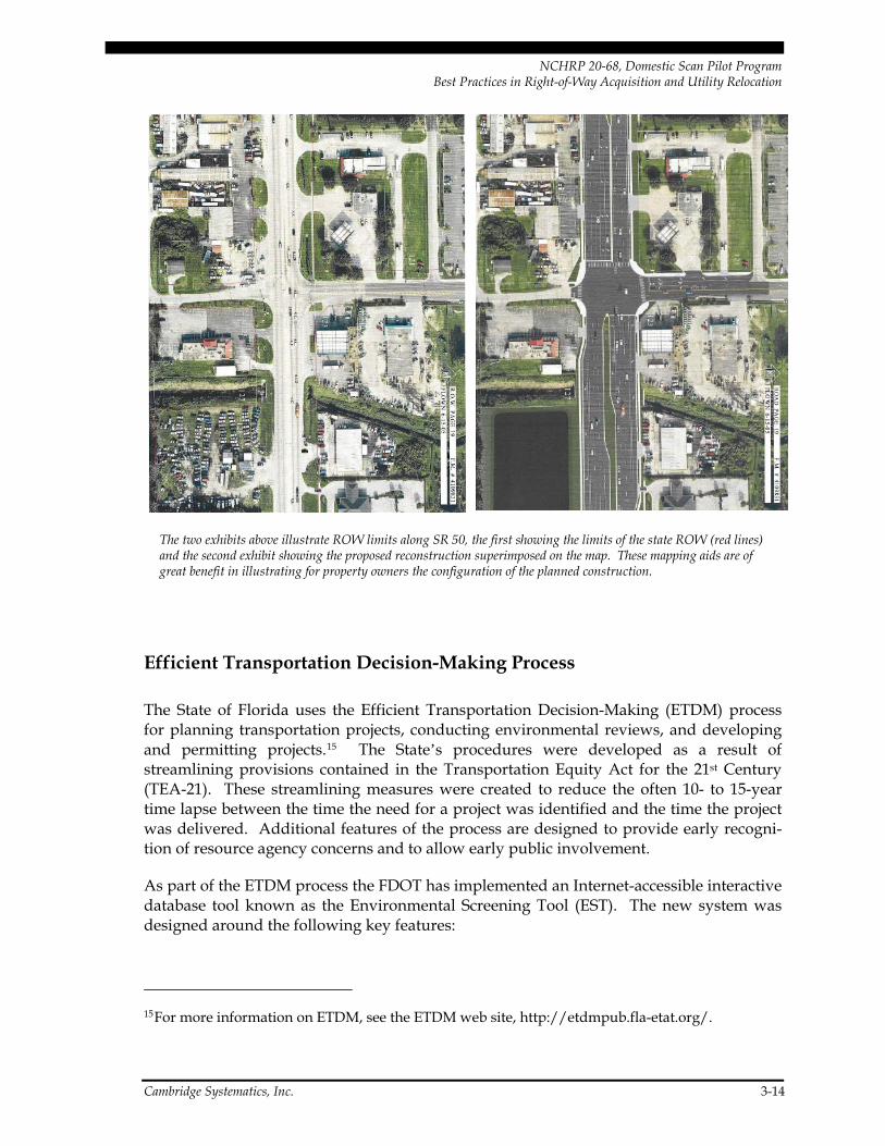
NCHRP 20-68, Domestic Scan Pilot Program Best Practices in Right-of-Way Acquisition and Utility Relocation
The two exhibits above illustrate ROW limits along SR 50, the first showing the limits of the state ROW (red lines) and the second exhibit showing the proposed reconstruction superimposed on the map. These mapping aids are of great benefit in illustrating for property owners the configuration of the planned construction.
Efficient Transportation Decision-Making Process
The State of Florida uses the Efficient Transportation Decision-Making (ETDM) process for planning transportation projects, conducting environmental reviews, and developing and permitting projects.15 The State’s procedures were developed as a result of streamlining provisions contained in the Transportation Equity Act for the 21st Century (TEA-21). These streamlining measures were created to reduce the often 10- to 15-year time lapse between the time the need for a project was identified and the time the project was delivered. Additional features of the process are designed to provide early recogni-tion of resource agency concerns and to allow early public involvement.
As part of the ETDM process the FDOT has implemented an Internet-accessible interactive database tool known as the Environmental Screening Tool (EST). The new system was designed around the following key features:
15 For more information on ETDM, see the ETDM web site, http://etdmpub.fla-etat.org/.
Cambridge Systematics, Inc. 3-14

NCHRP 20-68, Domestic Scan Pilot Program Best Practices in Right-of-Way Acquisition and Utility Relocation
• Early and continuous agency involvement;
• Good data upon which to base decisions; and
• Feedback about how agency participation resulted in better transportation decisions.
A significant benefit of the ETDM process is that projects with fatal flaws that prevent their construction will be identified at an early planning stage before valuable and limited resources have been expended in their study and preliminary design. The use of ETDM also accelerates the process by facilitating early involvement by all parties. As the project advances toward the project development and design phase, use is made of GIS data layers. These data layers provide elements that are significant to various agencies. These web-based tools offer all agencies the opportunity to comment before the project goes into the State’s work plan. During the resolution phase, alternate alignments and other relevant matters are available for review and comments by the state and Federal resource agencies. Once the process is out of the draft stage it is available for public view on the web site.
Agencies have opportunities to comment at two different stages under the web ETDM process and to take the appropriate action on the appropriate electronic screen. E-mail notification is sent to all parties to alert them that a new project posting is available requiring their review.
The benefits of ETDM extend not only to Federal and state resource agencies and decision-makers, but also to utility companies who are spared the task of reviewing planned pro-jects which are ultimately doomed because of environmental flaws. The utility companies can thus concentrate on projects which are most likely successful candidates for comple-tion. The utility companies also are in a position to comment on planned projects and their impacts on important utility facilities.
Much of the success, to date, of the ETDM process is credited to its creation. It began with a multiagency working group to study and redefine how projects would be planned, reviewed, and subsequently permitted. Beginning with a blank sheet and allowing agen-cies to provide input the process was designed to meet the needs of all parties while at the same time greatly accelerating the process.
Joint State – Local Projects
Reflecting interest in local economic development, Florida statutes have expanded over time to allow the State to undertake special projects jointly with local governments. The state legislature has established programs for local road development, including the Small County Road Program (SCRP), Local Aid Program (LAP), and Transportation Regional Incentive (TRIP) program. As FDOT is involved in administering and participating in costs for these projects, it has needed to develop guidance and procedures to address some of the specific challenges with these projects, including those associated with ROW and utilities. The Department’s procedures include a checklist of items to be included in
Cambridge Systematics, Inc. 3-15

NCHRP 20-68, Domestic Scan Pilot Program Best Practices in Right-of-Way Acquisition and Utility Relocation
the agreement with the local entity for completion of the project and a schedule of neces-sary actions to complete the project on schedule.16 The State assembles a team to address regional needs and an “intake” form to gather information to program the project. A project manager is assigned to each special project and a core group is established to evaluate the project.
One of the continuing challenges with joint state-local projects is the rapid turnover of staff at the local level. When individuals who have initiated a project leave, there is often a void that must be filled by the State in outlining the steps that must be taken at the local level to successfully complete the project. The State also is concerned with the treatment of utilities and wants to ensure that all utilities are treated in a uniform manner at both the state and local level. Especially where Federal funds are involved, the local entities often do not understand the rules. The State has found that an educational process is required to make local jurisdictions aware of state procedures and their importance. In some cases, the State has found it easier to undertake certain aspects of the project (such as ROW acquisition) rather than training local employees.
Constraints Due to Local Planning and Zoning Ordinances
Minor acquisitions can reduce the size of properties below the minimum size allowed by zoning, creating a nonconforming use. If a variance cannot be obtained, the highest and best use of the property may be reduced and the State may be required to acquire the entire property. Setback requirements and landscape buffers also can create acquisition complications. Local entities may either approve or disapprove reduced setbacks and/or reduced landscape buffers.
FDOT has found that this is another challenge for which establishing early coordination and ongoing relationships – in this case, with local governments – can pay dividends. Most municipalities have been willing to work on nonconformity issues, for example, by approving variances for preexisting properties, but it helps to raise these issues before they occur rather than after the fact. As another innovative approach, the State will con-sider the use of easements rather than fee acquisitions to avoid reducing land areas below the minimum required by zoning, thereby avoiding setback and nonconformity problems.
Empowerment, Innovation, and Risk Taking
District 5 has concluded that the most effective management results in the highest level of authority delegated to the lowest practical level of the organization. Those who are actu-ally doing the work are in the best position to be creative in finding solutions and exploring innovation. Risk-benefit analysis can be an important decision-making tool. Transportation organizations often pursue a zero risk tolerance policy which increases
16See: http://www.dot.state.fl.us/planning/trip/jpas.htm.
Cambridge Systematics, Inc. 3-16

NCHRP 20-68, Domestic Scan Pilot Program Best Practices in Right-of-Way Acquisition and Utility Relocation
costs and lengthens the transportation improvement process. In contrast, the risk-benefit approach recognizes that where the risks of an action are small or inconsequential compared to its potential benefits, then the action should be taken.
Examples of innovations suggested by state agents include:
• Suggesting to landowners that building improvements be developed on the rear of the property rather than the front which will be impacted by a roadway widening. This proactive approach results in less disruption to the business operation as a result of the transportation improvement;
• Encouraging developers to locate necessary retention ponds on the front of the prop-erty with parking in the rear. The State can then easily deal with surface water by piping the water into the State’s drainage system and disposing of it off the commer-cial property;
• Proposing mitigation measures such as the construction of retaining walls to avoid impacts to on-site traffic patterns and lessen impacts on parking; and
• Using excess state-owned property to create retention ponds and the management of properties that retain drainage rights as part of the property rights, in order to augment additional property purchases that would otherwise be required to handle drainage.
Statewide Training Program
A number of states have noted that hiring and retaining staff with right-of-way and utili-ties expertise has been an increasing challenge, since older staff are retiring and few younger people have been trained in this field. District 5 alone has 85 in-house right-of-way and legal staff. To maintain a competent and knowledgeable staff, FDOT has implemented an extensive internal training program that includes two years of agent training and three years of appraiser training. The program was developed working with the International Right-of-Way Association and is continually being updated. The pro-gram not only builds in-house expertise but also qualifies in-house employees to oversee private sector work.
The benefits of consistent training programs are demonstrated historically by an intensive statewide training effort undertaken in Florida in the 1970s on eminent domain appraisal. This effort led to many people becoming established in the business and gaining consider-able expertise. Some are still working for the DOT, either as employees or consultants.
FDOT’s emphasis on formalized policies and procedures, such as schedules and agendas for interdisciplinary meetings, also supports the training and development of new staff. New project managers can quickly be brought “up to speed,” and proven practices can be sustained even in the face of staff turnover.
Cambridge Systematics, Inc. 3-17

NCHRP 20-68, Domestic Scan Pilot Program Best Practices in Right-of-Way Acquisition and Utility Relocation
Innovative Financing
The advancement of the SR 50 project was accomplished in part through the use of inno-vative financing techniques. The State Infrastructure Bank (SIB) provided a loan to the District office of $105 million to be disbursed when needed for various phases of the pro-jects. Orange County provided an additional loan of $10 million. Use of innovative financing allowed for these projects to move forward years ahead of the normal schedule.
Funding is a critical first step in the acquisition of ROW and relocation of utilities. Most states cannot make any financial commitments until project funding is in place. Where normal state revenue is insufficient to advance all needed projects, innovative financing can help to close the gap. Innovative financing allows ROW acquisition and utility relo-cation to commence. Without the use of innovative financing on the this project no activ-ity would have occurred for several years. Early completion of projects can pay dividend in terms of reduced congestion and crashes and by reducing costs which would otherwise escalate as a result of inflation of material and labor costs.
3.4 Benefits
Florida DOT District 5 notes numerous benefits from their focus on a team approach, early involvement of external stakeholders, clearly defined processes, performance measure-ment, and a focus on innovation and experimentation. Examples include:
• The initial meeting with consultant and utilities facilitates expeditious resolution of issues;
• Quarterly meetings with utilities continue coordination efforts and help to eliminate bottlenecks;
• Early interaction with owners and businesses leads to innovative solutions, thereby accelerating amicable settlements; and
• The team approach has produced success in advancing projects since the team “owns” the problems and collective minds solve problems.
Florida’s emphasis on performance measurement and tracking has provided some data to demonstrate benefits, such as the negotiated settlement rate of 75 to 80 percent. On the SR 50 project in Orlando, the agency notes that it has achieved very good results in avoiding late changes to ROW, incorporating early landowner input into design, avoiding unneces-sary impacts to businesses, and designing the most economical project possible. Previous pilot studies also have helped quantify the benefits of techniques such as incentive pay-ments and acquisition waivers. In the future, as additional data are collected, more infor-mation should be available to further demonstrate the benefits of Florida’s approach.
Cambridge Systematics, Inc. 3-18

NCHRP 20-68, Domestic Scan Pilot Program Best Practices in Right-of-Way Acquisition and Utility Relocation
3.5 Resources
Web sites:
• Florida DOT Right-of-Way Program Web Site – http://www.dot.state.fl.us/rightofway/default.htm; and
• Florida DOT Utilities Web Site – http://www.dot.state.fl.us/rddesign/utilities/files/utilities.htm.
Documents:
• Florida DOT (February 2004). Utility User’s Guide. http://www.dot.state.fl.us/rddesign/utilities/files/utilities.htm; and
• Florida DOT (January 2006) Right-of-Way Procedures Manual. http://www.dot.state.fl.us/rightofway/documents/ROWmanual/toc.htm.
Contacts:
• George Lovett, Director Of Transportation Development,17 Florida DOT District 5, (386) 943-5478, [email protected];
• Right-of-Way: Shirley Martin, Assistant Right-of-Way Manager, Florida DOT District 5, (386) 943-5478, [email protected]; and
• Utilities: Fred Loose, Staff Attorney, Florida DOT, (386) 943-5492, [email protected].
17 Formerly District General Counsel and Right-of-Way Manager.
Cambridge Systematics, Inc. 3-19
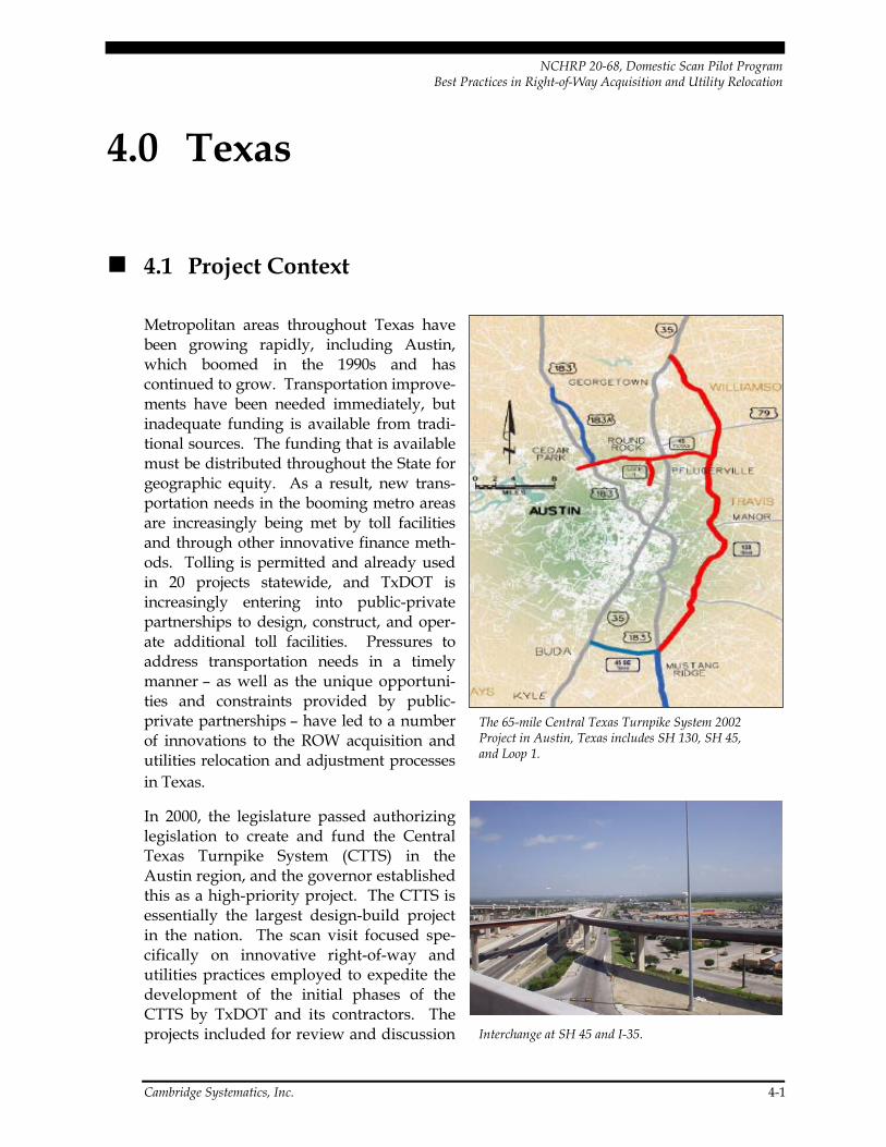
NCHRP 20-68, Domestic Scan Pilot Program Best Practices in Right-of-Way Acquisition and Utility Relocation
4.0 Texas
4.1 Project Context
Metropolitan areas throughout Texas have been growing rapidly, including Austin, which boomed in the 1990s and has continued to grow. Transportation improve-ments have been needed immediately, but inadequate funding is available from tradi-tional sources. The funding that is available must be distributed throughout the State for geographic equity. As a result, new trans-portation needs in the booming metro areas are increasingly being met by toll facilities and through other innovative finance meth-ods. Tolling is permitted and already used in 20 projects statewide, and TxDOT is increasingly entering into public-private partnerships to design, construct, and oper-ate additional toll facilities. Pressures to address transportation needs in a timely manner – as well as the unique opportuni-ties and constraints provided by public-private partnerships – have led to a number of innovations to the ROW acquisition and utilities relocation and adjustment processes in Texas.
The 65-mile Central Texas Turnpike System 2002 Project in Austin, Texas includes SH 130, SH 45, and Loop 1.
In 2000, the legislature passed authorizing legislation to create and fund the Central Texas Turnpike System (CTTS) in the Austin region, and the governor established this as a high-priority project. The CTTS is essentially the largest design-build project in the nation. The scan visit focused spe-cifically on innovative right-of-way and utilities practices employed to expedite the development of the initial phases of the CTTS by TxDOT and its contractors. The projects included for review and discussion Interchange at SH 45 and I-35.
Cambridge Systematics, Inc. 4-1

NCHRP 20-68, Domestic Scan Pilot Program Best Practices in Right-of-Way Acquisition and Utility Relocation
are located in TxDOT’s Austin District and include State Highway (SH) 130, Loop 45, and Loop 1 in Austin and its suburbs, which together comprise the CTTS 2002 Project.
The CTTS 2002 Project includes segments 1 through 4 of SH 130, which will be a new 49-mile tollway located east of I-35 through Williamson and Travis counties, extending from I-35 north of Georgetown to U.S. 183 southeast of Austin. Together with SH 45 North and the Loop 1 Extension into Austin, the entire CTTS 2002 Project includes a total of 65 miles of new roadway. Initially, SH 130 will be a four-lane divided facility with five major interchanges. Ulti-mately, SH 130 may become a six-lane facility. Construction of SH 130 involves 30 million cubic yards of earthwork, 2.7 mil-lion square yards of concrete pavement, 1.7 million tons of asphalt pavement, 590,000 square feet of retaining walls, 123 bridges, four mainline toll plazas, and 30 ramp toll plazas. The toll plazas contain as many as 22 lanes and are located on 1,000-foot width right-of-way, allows for the installation of utilities as well as accommodation of future transportation options such as rail. SH 130 looking southeast from its interchange with I-35.
The SH 130 project is being developed and constructed under an Exclusive Development Agreement (EDA), signed with the devel-oper in June 2002. This type of project in the future will carry the nomenclature of Comprehensive Development Agreement (CDA). These terms are the Texas equivalent of design-build. Under a CDA utilizing the “concession” model, the private partner secures their own financing in exchange for the right to collect tolls for 50 years. For the CTTS 2002 Project, TxDOT contracted with a private team known as the “developer” to finance, design, build, and operate the toll road system.18 The CTTS development contract included three fundamental principles: 1) the product is a state highway that is owned by the State; 2) the developer must comply with all Federal and state requirements; and 3) the Texas Attorney General is responsible for eminent domain proceedings.19
18 In retrospect, TxDOT observes that referring to the private partner as the “developer” created
confusion especially in the ROW process because of the term’s association with real estate developers. The agency plans to apply a different term in the future.
19 Eminent domain proceedings were required on about 20 to 30 percent of parcels for the CTTS 2002 Project.
Cambridge Systematics, Inc. 4-2

NCHRP 20-68, Domestic Scan Pilot Program Best Practices in Right-of-Way Acquisition and Utility Relocation
In addition to the developer team, TxDOT contracted with a general engineering contractor to provide independent oversight, design review services, administrative support, and other functions. The contractor’s scope included ROW and utilities support. This contractor team was considered an extension of TxDOT and was colocated with TxDOT offices.
Construction of the 65 miles of new toll roads will cost approximately $2.9 billion, including ROW acquisition, utility adjustments, design, and construction. ROW costs rep-resent approximately $575 million of this amount. With the addition of required reserve funds, interest, insurance and issu-ance costs, the total estimated project costs are $3.6 billion. Innovative financing solu-tions include a $2 billion toll bond package and a $900 million Transportation Infrastructure Finance and Innovation Act (TIFIA) loan. State and local funds also are contributing to the project. Loans and bonds will be repaid from toll revenues. Tolls will be set by the Texas Transportation Commission and are expected to fall in the $0.11 to $0.18 per mile range.
A 22-lane toll plaza on Loop 1 in Austin. This facility will allow high-speed toll collection with the use of TxPass electronic toll collection.
The first notice to proceed was issued in July 2002. Construction of the CTTS 2002 Project began in October 2003 and the entire project is expected to be open to traffic by December 2007. The financing techniques, coupled with the Exclusive Development Agreement, are expected to accelerate completion of SH 130 by as much as 25 years, compared to what would have been possible with public financing only. On June 8, 2006 Texas Governor Rick Perry and the U.S. Secretary of Transportation announced the early opening of por-tions of the CTTS. According to TxDOT, the completed portion of the project is one year ahead of schedule and $400 million under budget.20
SH 130 also represents an initial segment of the proposed Trans-Texas Corridor system, a network of transportation facilities that would span the State. Similar to the CTTS system, the Trans-Texas Corridors would be designed and built through public-private partner-ships. TxDOT’s experience with ROW and utilities through the CTTS project should pro-vide valuable information and lessons learned to support further development of the Trans-Texas Corridors.
20 www.sh130.com.
Cambridge Systematics, Inc. 4-3

NCHRP 20-68, Domestic Scan Pilot Program Best Practices in Right-of-Way Acquisition and Utility Relocation
4.2 Policy Context
With respect to ROW acquisition, Texas is a “single-offer” state. Property owners are made an offer based on an assessment of the property’s fair market value. The owner has the option to accept the offer or propose a counteroffer. If an agreed purchase price can-not be reached, condemnation proceedings are initiated to determine a fair value through the court system. As soon as the State deposits the amount of the award with the court, it takes possession of the property and can commence construction. The State’s ownership of the property and determination of the final purchase price are then resolved through the eminent domain court process. More details on Texas’ ROW acquisition process are provided in the sidebar.
Policies with respect to utility adjustments were established by the state legislature that are unique to toll projects. The legislature included a provision for the CTTS that allowed for 100 percent reimbursement of costs to utilities for adjustments. This was a special case authorized by the legislature for toll roads only, which established that “utilities shall move at the direction of the (Turnpike) Authority.” Utilities that do not move in accor-dance with a specified date may be held liable for adjustment costs. If necessary, the State may perform the adjustment work and even take over the utility’s assets.
Treatment of ROW and utilities within the design-build contracting approach varies by state. In some states, the state acquires the ROW needed for a transportation project before awarding the design-build contract. In others, the state may choose to place the responsibility on the contractor to acquire right-of-way and make utilities adjustments. In TxDOT’s CTTS 2002 Project, the department included ROW acquisition and relocation services, as well as utility adjustments, in its contract with the private toll road developer.
4.3 Innovations
The high visibility and political support for the CTTS project provided strong incentives to develop innovative solutions and complete the project in a timely manner. In some respects, TxDOT’s ROW and utilities innovations have much in common with FDOT District 5’s approach: a focus on teamwork, cross-disciplinary collaboration, direct communication, clearly defined processes, tracking systems, and early stakeholder involvement. In other respects, TxDOT’s tools and methods reflect the Texas statutory envi-ronment as well as the CTTS project’s design-build and public-private partnership context.
Cambridge Systematics, Inc. 4-4

NCHRP 20-68, Domestic Scan Pilot Program Best Practices in Right-of-Way Acquisition and Utility Relocation
TxDOT Right-of-Way Acquisition and Relocation Assistance
Right-of-Way Determination and Identification of Property Owner After the general alignment of the project is determined, surveys are conducted and specific property needs are determined. A title report, property description, and land/parcel maps are created. Property owners are identified based on this information.
Right-of-Way Appraisal and Offer Affected property owners are sent a letter identifying the need for their property. The letter introduces the consultant who will handle the acquisition and relocation process on behalf of TxDOT.
Next, the appraiser contacts the property owner to request permission to enter the property to conduct an appraisal. The appraisal is the basis for determining the property’s fair market value. The property owner may accompany the appraiser on the property inspection.
After TxDOT’s review and approval of the appraisal, the property owner will be provided with a written offer in the amount of the approved value as well as a copy of the appraisal report. If the property owner disagrees with the appraisal value, a written counteroffer may be submitted. It should include a specific dollar amount with information supporting the counteroffer. Only one counteroffer may be submitted. The counteroffer will be reviewed by TxDOT and the property owner will be notified of the decision.
Purchase or Condemnation of Right-of-Way If a property owner accepts the offer by TxDOT, or if TxDOT accepts the counteroffer, pur-chase documents are prepared and payment is issued. If an agreed purchase price cannot be reached, condemnation proceedings are initiated.
In condemnation hearings, the court will appoint three disinterested landowners to serve as special commissioners and a hearing will be held to determine the value of the property being acquired. During the hearing, the property owner and the State will present docu-mentation supporting the value of the property. The commissioners will determine the value of the property and file their decision with the court.
As soon as the State deposits the amount of the award with the court, it takes possession of the property.
If either party is dissatisfied with the amount, objections must be filed within the time limits prescribed by law and the case is tried in the same manner as other civil cases. The basic issue decided in eminent domain cases is just compensation for the property being acquired.
Relocation Assistance For those affected by the project, TxDOT provides payment and services to aid in the move to a new location. Relocation assistance is available to families, businesses, farmers, ranchers, and nonprofit organizations displaced as a result of the project. This applies to tenants as well as owners occupying the property.
Before a person or organization is required to move, they will be given adequate time to find other housing or business accommodations. Each of those affected will be given writ-ten notice and a date to vacate. Property owners will be given at least 90 days written notice of the date by which they must move.
Property owners eligible for relocation benefit will be provided with a relocation assistance booklet. Those eligible for relocation benefits should not move until they have been contacted by a relocation assistance counselor and have established eligibility for possible relocation benefits. Moving prematurely may result in forfeiture of these benefits.
Texas Department of Transportation
October 17, 2002
a http://www.texastollways.com/tta/row.asp, accessed July 2006.
Cambridge Systematics, Inc. 4-5

NCHRP 20-68, Domestic Scan Pilot Program Best Practices in Right-of-Way Acquisition and Utility Relocation
Incentives and Risk Management in the Design-Build and Public-Private Partnership Process
TxDOT has found that the design-build concept is very effective in accelerating project completion. Under TxDOT’s development agreements, the developer has the financial incentive to complete ROW acquisition and utility relocation in as timely a manner as pos-sible. TxDOT’s contract with the developer on the SH 130 project provided incentives for meeting “guaranteed completion” milestones of $7,500 to $10,000 per day, as well as disin-centives of $35,000 to $50,000 per day for failure to meet these milestones.
Under the SH 130 development agreement the toll road developer was responsible for all utility-related costs, providing an incentive for creative design solutions. For example, a 138 kilovolt electrical transmission line on a private easement that needed to be moved was relocated to TxDOT right-of-way, since opportunities to relocate back onto the private easement were limited due to platting of adjacent property into residential and commer-cial lots as well as historical properties in the area.
Limiting the developer’s risk was a critical part of making the design-build approach pos-sible. For the SH 130 project, TxDOT’s risk management approach for ROW and utilities costs was as follows:
• The developer bids on ROW ser-vices but not the acquisition cost;
• The developer bears the risk of the first 300 days of delays due to con-demnation, but TxDOT bears the risk thereafter;21
• TxDOT provides a $50,000 “deductible” for unidentified utilities; and
• The government bears the risk of any endangered species listings.
Early Coordination With Utility Companies
The utility partnering process began early both to alert utilities to the project and to pro-vide potential developers with the information they needed to submit a bid. All utility companies were invited to an informational meeting about the project and TxDOT established nonbinding memoranda of understanding (MOU) with about 70 percent of the utilities prior to the bid/contract activities. The MOUs served to alert the utilities that bidders would be contacting the utility and requesting information, and also that the
“We were buying property weeks, or even days, before the bulldozers came.” Don Toner, TxDOT
21 On the CTTS 2002 Project condemnation delays never came close to exceeding the 300-day limit,
but usually fell in the range of 90 to 120 days. TxDOT is considering shortening the 300-day limit in future agreements.
Cambridge Systematics, Inc. 4-6

NCHRP 20-68, Domestic Scan Pilot Program Best Practices in Right-of-Way Acquisition and Utility Relocation
private partner would be the primary point of contact. TxDOT believes the MOUs were an important step in establishing communication, and notes that they never had to refer back to the MOUs during subsequent work with utilities. Utility strip maps and a utility summary were provided to potential bidders. All bidders were instructed to verify the information provided by TxDOT and allowed access to utilities located on private property.
100 Percent Reimbursement of Utility Costs
TxDOT notes that the 100 percent reimbursement strategy, as was applied to the CTTS 2002 project, can be an effective way to expedite utility relocation. To be most effective, however, it must be tied to a specific project schedule, as well as to a requirement that utilities meet this schedule, as was provided in this case by the state legislature. TxDOT notes that they never had to apply their authority to take over the utility’s assets. (They also note that the high-profile/high-visibility nature of this particular project was an important and per-haps somewhat unique factor in achieving timely action by utilities.)
In preparing their bids, potential developers were instructed to meet utility owner stan-dards, pay for the costs of adjustments but not betterments, and to seek goals of first avoiding adjustments, or alternatively minimizing associated costs and delays. The project developer was responsible for drafting, negotiating, and executing all adjustment agreements, and for ensuring that adjustments were made, whether by the utility or by the developer. TxDOT played an important oversight role, approving all agreements and occasionally threatening to invoke their ability to move the utility’s assets if the utility was reluctant to do so. TxDOT also worked to protect the interests of the utilities, acting as an arbitrator to ensure that they were given fair treat-ment and compensation by the developer.
Project Management and Coordination Structure
Given the multiple parties and stakeholders involved in undertaking, reviewing, and approving ROW actions, TxDOT realized that a streamlined management and coordina-tion structure was needed in order to ensure efficient and timely decision-making. TxDOT’s general engineering contractor oversight team was at the center of this manage-ment and coordination structure. Key elements of the structure included:
In some cases, utility adjustments were still being negotiated and completed while construction was underway, as was the case with this utility pole that needed to be moved from the highway median.
Cambridge Systematics, Inc. 4-7

NCHRP 20-68, Domestic Scan Pilot Program Best Practices in Right-of-Way Acquisition and Utility Relocation
• A ROW liaison/coordinator on the TxDOT project management/oversight consultant team;
• Colocation of TxDOT, consultants, and FHWA staff;
• Flow charts and manuals that clearly established timelines, decision points, and action responsibilities;
• An electronic tracking system to monitor and report progress on tasks; and
• Delegation of decision-making to the lowest possible level and an “escalation ladder” process to resolve conflicts.
ROW Liaison to Coordinate Among Project Partners
Although the project developer was responsible for ROW acquisition, TxDOT’s project oversight consultants as well as FHWA needed to review each proposed acquisition pack-age to ensure that it met state and Federal requirements. The developer was initially uncomfortable with the idea of direct communication between TxDOT and the oversight consultant, and instead wanted to be the middleman. From TxDOT’s viewpoint, how-ever, this would have produced unacceptable delays and miscommunications. The solu-tion was to appoint a consultant liaison on the project oversight team with appropriate qualifications.
The ROW liaison on the TxDOT consultant team was charged with overseeing the ROW coordination process. A true team structure was utilized, with subconsultant team mem-bers being integrated as opposed to having a specific scope and deliverable. TxDOT staff and consultants were all referred to as part of the “Turnpike Team,” and the liaison was authorized to bring in subconsultants on an as-needed basis. Responsibilities of the liai-son included being highly familiar with the contract with the developer and developing a process for resolving disputes and promoting partnering. The liaison also was responsible for developing a checklist for each of the pertinent functions and obtaining signatures from responsible state and consultant personnel of their concurrence in the process.
Formal “partnering meetings” were held on a monthly basis. These meetings set goals and identified milestones and potential stumbling blocks. Survey forms were sent to employees at all levels to allow them to identify problems and make suggestions for improving the process. Management teams reviewed the survey results to identify problems and seek solutions. In order to avoid setbacks due to the loss of key personnel, TxDOT included a provision in the management consultant’s contract for a $50,000 pen-alty if key staff left prior to the conclusion of the project.
Cambridge Systematics, Inc. 4-8

NCHRP 20-68, Domestic Scan Pilot Program Best Practices in Right-of-Way Acquisition and Utility Relocation
Colocation
Texas confirmed the importance of colocating staff in order to successfully complete design-build projects. For the CTTS project, the project oversight consultants were located directly across a parking lot from the TxDOT project office and FHWA officials were placed on-site. Having state staff, consultants, and FHWA staff located in close proximity was critical to making timely decisions on each ROW acquisition package and keeping the project moving without delay. The State estimates that $120 million was saved in staff and consultant travel time alone, as a result of the colocation.
Functional Area Flow Charts
To assist project managers and staff with keeping the project on schedule, TxDOT developed process flow charts and manuals for every process with strict turnaround schedules and tracking. The flow charts identify the various steps in each process and include references to Federal law and regulations, state laws, and guidance manuals. The flow chart includes a brief summary of the chronological actions required and approval actions. The charts are color coded and include “hold points,” which are areas that require review and approval before advancing to the next step.
TxDOT’s Don Toner demonstrates a flow chart showing the complete right-of-way process for the CTTS 2002 Project.
To the extent possible, critical activities wereprocess as feasible. For example, title commitments were ordered during design phase and appraisers gathered preliminary data during this phase as well. The appraisal, offer letter, deed, survey, and Endangered Species Act clearance were approved together in one package. On a case-by-case basis, the developer was approved to make a payment before reimbursement by TxDOT.
scheduled in parallel and as early in the
Every action was structured with a time limit. For example, a “10-day turn-around” rule was established to ensure that each ROW acquisition package was approved within 10 days of submission by the developer. Similarly, administrative settlements were approved or rejected within 10 days from receipt. To avoid returning unacceptable items and commencing another 10-day turn-around period, a process of informal correspon-dence was developed so that items viewed as deficient or incomplete could be quickly returned to the responsible party, rather than being passed through a hierarchy. As a result, most approval actions were completed in two or three days.
Cambridge Systematics, Inc. 4-9

NCHRP 20-68, Domestic Scan Pilot Program Best Practices in Right-of-Way Acquisition and Utility Relocation
Electronic Tracking System
A GIS-based electronic tracking database was established to track the status of ROW acquisition on the project. The database includes parcel numbers, owner names, easements, right-of-entries, special commis-sioner assignment, review status (e.g., date received, date approved), acquisition cost, and other information. Maps were used to track the progress of acquisition, with dif-ferent status (e.g., negotiation, acquired) represented in different colors.
The database tracking system was crucial to keeping project tasks on schedule. The system tracked the status of individual actions (e.g., approval of acquisition offers for each parcel) and compared actual to scheduled status. For example, the system would issue automatic alerts when two days were left in the 10-day response period for an acqui-sition package. The database also provided summary reports such as the number of par-cel acquisitions, condemnations, relocations and possession and use agreements, and the total cost of acquisitions and replacement housing payments.
Color-coded maps show the status of property negotiation and acquisition for parcels in Segment 1 of the SH 130 corridor.
Details of individual agreements were carefully tracked. As various required documents were presented to the property owner they were signed for so that the required docu-ments could go into the completed file. For example, the owner signed for the appraisal and relocation package, offer letter, title report, parcel sketch, any curative plan, and relo-cation brochure. As the documents enter the state system they were entered on a checklist to assure that no function was overlooked. Separate checklists were developed for four different packages, including an acquisition package, relocation package, payment pack-age, and eminent domain package. Once the checklist was complete, the final check-off was for the retirement file, indicating the completion of all active steps.
Decision-Making Authority and Conflict Resolution Procedures (Escalation Ladder)
Another key to efficient and timely decision-making is to allow decisions to be made at the lowest possible level. Those working at the operating level need full authority to make those decisions, while at the same time a procedure is required to address conflicts or differences of opinion that may arise. TxDOT found that one particularly effective tool is the “escalation ladder,” which specifies the levels of personnel to which conflicts should be successively brought if they are not immediately resolved. This process requires each of the parties to develop a white paper in which they spell out the problem from their point of view and provide a series of possible solutions. In the process of developing the
Cambridge Systematics, Inc. 4-10
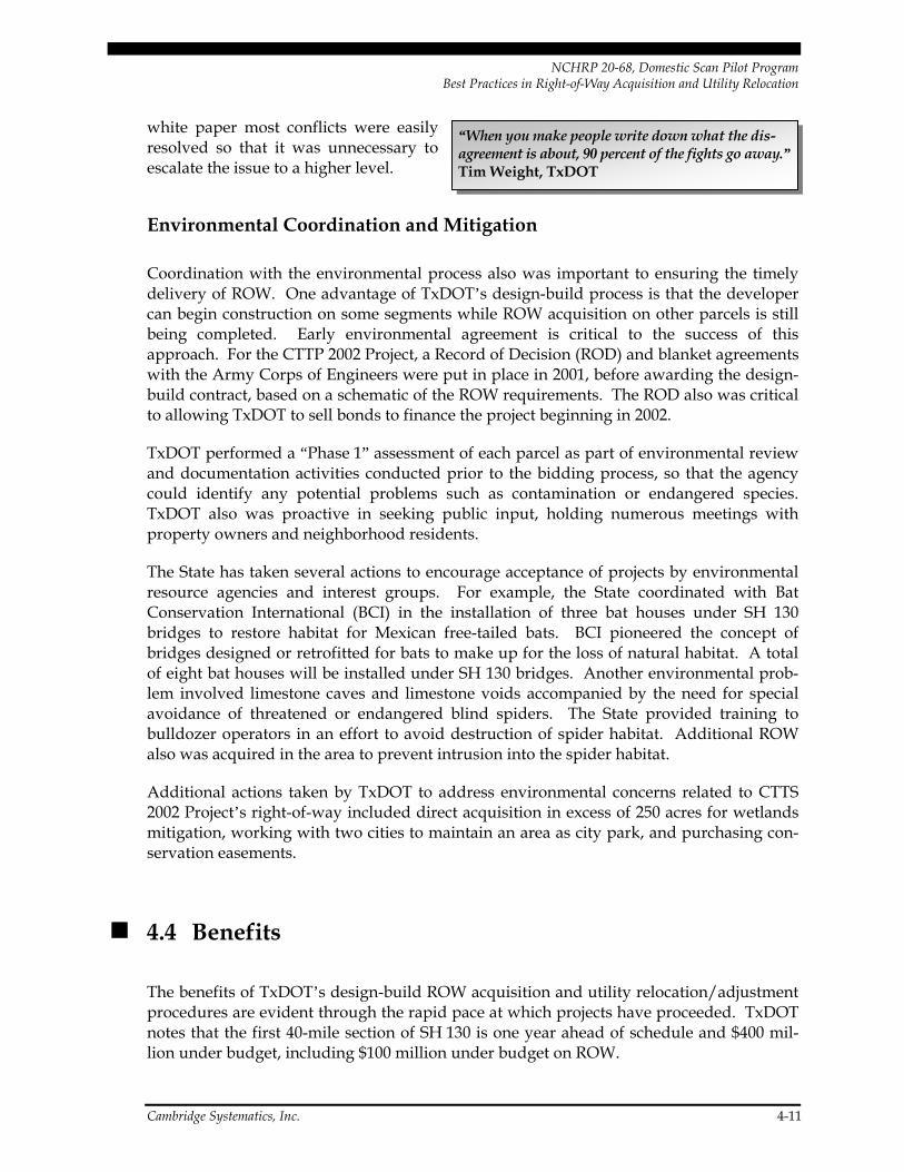
NCHRP 20-68, Domestic Scan Pilot Program Best Practices in Right-of-Way Acquisition and Utility Relocation
white paper most conflicts were easily resolved so that it was unnecessary to escalate the issue to a higher level.
“When you make people write down what the dis-agreement is about, 90 percent of the fights go away.” Tim Weight, TxDOT
Environmental Coordination and Mitigation
Coordination with the environmental process also was important to ensuring the timely delivery of ROW. One advantage of TxDOT’s design-build process is that the developer can begin construction on some segments while ROW acquisition on other parcels is still being completed. Early environmental agreement is critical to the success of this approach. For the CTTP 2002 Project, a Record of Decision (ROD) and blanket agreements with the Army Corps of Engineers were put in place in 2001, before awarding the design-build contract, based on a schematic of the ROW requirements. The ROD also was critical to allowing TxDOT to sell bonds to finance the project beginning in 2002.
TxDOT performed a “Phase 1” assessment of each parcel as part of environmental review and documentation activities conducted prior to the bidding process, so that the agency could identify any potential problems such as contamination or endangered species. TxDOT also was proactive in seeking public input, holding numerous meetings with property owners and neighborhood residents.
The State has taken several actions to encourage acceptance of projects by environmental resource agencies and interest groups. For example, the State coordinated with Bat Conservation International (BCI) in the installation of three bat houses under SH 130 bridges to restore habitat for Mexican free-tailed bats. BCI pioneered the concept of bridges designed or retrofitted for bats to make up for the loss of natural habitat. A total of eight bat houses will be installed under SH 130 bridges. Another environmental prob-lem involved limestone caves and limestone voids accompanied by the need for special avoidance of threatened or endangered blind spiders. The State provided training to bulldozer operators in an effort to avoid destruction of spider habitat. Additional ROW also was acquired in the area to prevent intrusion into the spider habitat.
Additional actions taken by TxDOT to address environmental concerns related to CTTS 2002 Project’s right-of-way included direct acquisition in excess of 250 acres for wetlands mitigation, working with two cities to maintain an area as city park, and purchasing con-servation easements.
4.4 Benefits
The benefits of TxDOT’s design-build ROW acquisition and utility relocation/adjustment procedures are evident through the rapid pace at which projects have proceeded. TxDOT notes that the first 40-mile section of SH 130 is one year ahead of schedule and $400 mil-lion under budget, including $100 million under budget on ROW.
Cambridge Systematics, Inc. 4-11

NCHRP 20-68, Domestic Scan Pilot Program Best Practices in Right-of-Way Acquisition and Utility Relocation
Neither ROW acquisition nor utility relocation have impeded the critical path on the CTTS projects. Four years after the first notice to proceed was issued, the projects are well on their way to completion. The SH 45/Loop 1 project had a 14-month acquisition schedule, during which all 259 parcels were made available for construction in timely manner. On the SH 130 project, the first survey was received in April 2003; 367of 427 total parcels were available for construction as of June 2006, and construction had in fact been commenced or even completed on many of these parcels. Utility adjustments also proceeded on sched-ule; for the SH 45/Loop 1 project, as of June 2006, 51 of 55 utility adjustments had been completed with no delays to construction.
4.5 Resources
Web Sites:
• State Highway 130 Project – http://www/sh130.com/com/project/;
• Central Texas Turnpike System – http://www.centraltexasturnpike.org/; and
• Texas Tollways – http://www.texastollways.com/.
Contacts:
• Right-of-Way: Don Toner, Right-of-Way Administrator, TxDOT Austin District Office, (512) 225-1361, [email protected].
• Utilities: John Breed, Right-of-Way Manager TxDOT Austin District Office, (512) 225-1362, [email protected].
Cambridge Systematics, Inc. 4-12
NCHRP 20-68, Domestic Scan Pilot Program Best Practices in Right-of-Way Acquisition and Utility Relocation
5.0 Minnesota
5.1 Project Context
The site visit to Minnesota focused especially on the technology and processes that Mn/DOT has been developing to support ROW acquisition and utilities relocation and adjustment activities. These technologies and processes have been implemented not for the needs of any one particular project, but rather to improve overall agency efficiency and stakeholder communications. They also are serving as protection against the loss of institutional knowledge as many employees approach retirement age – a challenge com-mon to many state transportation agencies.
A number of projects in the Twin Cities (Minneapolis-St. Paul) region were used to high-light Mn/DOT’s applications, including the I-494 Phase 2 reconstruction in the southwest portion of the region, the I-35W/State Highway 62 (Crosstown Commons) reconstruction south of Minneapolis, and the construction of I-394 west of Minneapolis.
The I-494 Phase 2 reconstruction was named ‘2005 Roadway Project of the Year’ by Roads & Bridges Magazine. This $136 million project involves the reconstruction of I-494 for a length of 7.8 miles, including widening from 4 to 6 lanes to accommodate average daily traffic volumes of 90,000 vehicles. In addition to roadway renovations, the project includes reconstruction of two major interchanges, four miles of soundwall construction, creation of new storm drainage ponds, and major utility relocation work. The project is located primarily in suburban residential areas and as a result, minimization of ROW acquisitions was a high priority. A total of eight parcels were acquired for the project. The project was undertaken through a design-build contract with a 28-month duration; the contract was let in May 2004 and the road opened to traffic in September 2006. The design-build contract was awarded on a combination of cost and technical factors.
Reconstruction of the Crosstown Commons (the interchange of Highway 62 and I-35W) south of Minneapolis similarly involved strict right-of-way constraints, as it is located in an older suburban neighborhood. This section of highway, where the two heavily traveled freeways overlap, has notoriously been a congestion bottleneck as well as a high-crash location due to complex weaving patterns. The $250 million project involves recon-struction to improve capacity and safety as well as the addition of high-occupancy vehicle (HOV) lanes connecting with adjacent segments of I-35W. As with the I-494 project, this project was bid as a design-build project. As a result of earlier financial shortfalls and bidding complications, the lead time for ROW acquisition was a short eight months. The design-build consultant completed the ROW plats, mapping, appraisals, and direct pur-chase of the properties with Mn/DOT oversight. ROW takings were minimized to the
Cambridge Systematics, Inc. 5-1

NCHRP 20-68, Domestic Scan Pilot Program Best Practices in Right-of-Way Acquisition and Utility Relocation
extent possible though the use of retaining walls and other design features. Construction began in summer 2006 and is scheduled for completion in fall 2009.
Construction of I-394 through Minneapolis’ western suburbs is an older project that was completed in the late 1980s and early 1990s. This project is noteworthy because of a busi-ness impact study that Mn/DOT undertook to examine the impacts of the project on busi-nesses along the corridor. Before construction of the freeway, this highly developed commercial corridor was served by an arterial, U.S. 12. Businesses along the corridor feared a loss of business due to the new access restrictions posed by the freeway and to other ROW-related issues such as reduced visibility, and in some cases filed compensation claims that reflected an anticipated loss in the value of their business. The study was undertaken to determine whether these concerns were valid in retrospect and to inform future projects that required the taking of ROW or reduction access in conjunction with construction or expansion of a limited access highway.
Downtown Minneapolis
Crosstown Commons
I-394
I-494 Phase 2
Location of projects in the Minneapolis-St. Paul region.
Cambridge Systematics, Inc. 5-2

NCHRP 20-68, Domestic Scan Pilot Program Best Practices in Right-of-Way Acquisition and Utility Relocation
I-494 Phase 2 reconstruction in Minneapolis’ western suburbs.
5.2 Policy Context
Minnesota’s right-of-way requirements are generally favorable towards landowners. With a “Loss of Going Concern” provision in state law, the burden is on Mn/DOT to prove that a landowner does not deserve compensation. New legislation passed in 2005 and 2006 further increased protections for landowners by providing for displacement compensation for businesses as well as other reforms to the use of eminent domain (see sidebar).
While Minnesota law allows for design-build contracting, the treatment of ROW within this process is different than in Texas. In particular, the State must acquire the ROW needed for the project prior to letting the design-build contract. Any final changes to design that would impact ROW needs would then be addressed during the design-build process.
Cambridge Systematics, Inc. 5-3

NCHRP 20-68, Domestic Scan Pilot Program Best Practices in Right-of-Way Acquisition and Utility Relocation
Minnesota’s Property Acquisition Process
Mn/DOT’s standard ROW acquisition process specifies a 16-month timeframe for acquisition, once construction limits are received from design. The first step in the process is to meet with the various engineering disciplines to determine ROW acquisition needs and lay out the ROW. The process then involves multiple one-on-one contacts with property owners. The actions associated with each contact are as follows:
• First one-on-one contact with property owner:
− Prepare detailed relocation plan; − Complete filed title report; − Review proposed ROW acquisition; − Verify property title opinions; − Make modifications, if appropriate, to the proposed acquisition.
This process ensures that the State has correct title information concerning ownership of the property, who currently is in possession of the property, composition of families, and property owner input into the proposed design layout.
• Second one-on-one contact with property owner:
− Prepare appraisal for acquisition to determine recommended offer amount; − Review and certify the appraisal to establish offer amount; − Determine replacement housing supplement.
• Third one-on-one contact with property owner:
− Mail offer letter package by certified mail, including appraisal and relocation benefits; − All affected properties receive the offer packages at the same time; − Owners have the opportunity to review the offer, discuss with family members and
neighbors or legal representatives prior to the negotiation personal contact; − Meet with property owner to discuss offer.
The approach of mailing the offer letter package in advance saves travel by the state agent and allows owners to be prepared to seriously discuss the offer.
Condemnation is not initiated for a minimum of 30 days after the offer of purchase has been made. The State continues to negotiate in an effort to reach a settlement until the date of the hearing on petition. Total negotiating time can be up to 180 days, including 30 days to update the attorney’s title opinions, 60 days to establish a court date and send out notices, and 60 days to continue to negotiate direct purchase until the date of the hearing on the petition.
Cambridge Systematics, Inc. 5-4
NCHRP 20-68, Domestic Scan Pilot Program Best Practices in Right-of-Way Acquisition and Utility Relocation
2006 Eminent Domain Reform Legislation in Minnesota
In part reflecting the nationwide reaction to the 2005 Kelo vs. New London decision, the 2006 legislature mandated some changes in the handling of eminent domain in Minnesota and in elements of compensation. The changes provide additional property owner protections and benefits. However, they are expected to increase the costs of ROW acquisition and pose addi-tional challenges to Mn/DOT. Key changes include:
• All appraisals obtained by the State must be given to the property owners (states are typi-cally reluctant to provide appraisals that are considered to be deficient, defective, unsupported, or in other ways fail to meet state standards);
• Reimbursement maximums are increased for owner-obtained appraisals;
• An exchange of appraisals is required prior to the commissioner’s hearing;
• Landowners’ legal fees may be reimbursed under some situations;
• A new benefit was established for “Loss of Going Concern” if the State’s acquisition destroys the business;
• A nonresidential fee owner displaced by a taking is entitled to a separate payment to the owner to purchase a comparable property in the community;
• State authority for reimbursement of reestablishment expenses is reduced from $50,000 to $10,000 on Federally funded projects and the maximum is extended to state only projects; and
• Payment provisions are established for a revenue loss due to a loss of driveway access.
Minnesota law requires utilities to obtain a permit to place utilities on Minnesota trunk highway right-of-way. Mn/DOT’s Procedures for Accommodation of Utilities on Highway Right-of-Way (revised November 2005) contain requirements for location, structure, design, construction, and other factors. The manual contains numerous updates to the previous procedures, issued in 1990, and also reflects recent legislative changes. In 2004, the legislature authorized two primary changes to projects involving excavation: 1) quality level based on subsurface utility engineering (SUE); and 2) preliminary design and preconstruction meetings. Additional rule changes in 2005 included a positive response requirement, increased accuracy requirements for mapping and locating, emer-gency excavation notices, and new requirements for meets and service laterals.
Minnesota allows for reimbursement of the costs of moving utilities required by trans-portation construction only under three conditions: 1) on Interstate highways; 2) municipal relocations that qualify as “first move” (i.e., the facility was within the limits of a municipal street when taken over by the State as a trunk highway); and 3) where util-ity owners have property rights.
Cambridge Systematics, Inc. 5-5

NCHRP 20-68, Domestic Scan Pilot Program Best Practices in Right-of-Way Acquisition and Utility Relocation
5.3 Innovations
Mn/DOT’s innovations especially include the use of advanced technology and integration of this technology into information systems to support the ROW acquisition and utility relocation and adjustment processes. Mn/DOT also has worked to update its procedures and practices to facilitate timely relocation of utilities as well as right-of-way acquisition. A focus on best management practices has provided an important complement to these technological and process advancements. Mn/DOT emphasizes a team approach, internal and external stakeholder involvement, and comprehensive training. Introduction of new procedures and technologies is treated as a change management process. The agency emphasizes close coordination with stakeholders in order to ensure that new procedures and applications will be valued, effective, and widely used.
New Utility Coordination Process and Utilities Manual
In 2003, recognizing that its utility procedures needed to be updated, Mn/DOT collaborated with private sector and university consultants to develop a new utility coor-dination process. The new process, finalized and documented in a new Utilities Manual in 2006, promotes communication and strengthens relationships among all parties whose work impacts utility coordination. The process also meets new statutory requirements established in 2004 and 2005. The end result of this effort was the creation of a 15-step process designed to minimize delays, construction costs and contractor claims while maximizing the numbers of utility relocations that can be completed before construction commences.
The key elements of Mn/DOT’s new utility coordination process include:
• Emphasizing accurate identification and early coordination of utilities;
• Starting earlier in the design process to identify utility interests;
• Involving construction and design personnel at an earlier stage of the process;
• Requiring consistent and uniform application of the process on all Mn/DOT, consult-ant, and state aid projects; and
• Tying the utility coordination timeline to the project development timeline.
The new policy requires utilities to submit relocation plans just after the 60 percent design stage, rather than the previous deadline of 30 days before project letting. This critical change allows the utility relocation plan to be included in the project construction contract.
Minnesota state law requires utility coordination meetings. In accordance with this law, Mn/DOT policy requires two utility coordination meetings. The first is when the design plans are at about the 20 to 45 percent stage. A subsequent meeting is held when the
Cambridge Systematics, Inc. 5-6

NCHRP 20-68, Domestic Scan Pilot Program Best Practices in Right-of-Way Acquisition and Utility Relocation
plans are in the 60 to 75 percent stage to discuss how the project will impact the utility and to explore possible ways to mitigate or minimize the impact. Mn/DOT seeks relocation of utilities before construction begins whenever feasible, with relocation agreements executed a minimum of 45 days before letting. Design and construction work together with the utilities to determine a relocation completion date.
Implementation Through Training and Stakeholder Outreach
Mn/DOT notes that certain implementation factors contribute to the success of any initia-tive, including proactive and ongoing stakeholder communication, management commit-ment, training, and technical support. The agency has undertaken initial training efforts on its new utilities manual and processes, reaching 280 stakeholders between August 2005 and May 2006. The training program was directed at a wide audience, including not only Mn/DOT utility staff but also construction and design staff, consultants, cities, counties, contractors, utility owners. Each training session started with a welcome and direction from upper-level man-agement to reinforce the importance of the new process.
An implementation team is developing an implementation process that emphasizes stake-holder communication and addresses barriers to implementation. Team membership includes representatives of utility owners, consultants, and city and county agencies, as well as the Mn/DOT central office, district offices, and FHWA. The team has conducted surveys of project managers to determine the use of the new process and any problems encountered, and will use the feedback to fine-tune implementation. By the spring of 2007, Mn/DOT expects to be using the new process on all of its projects.
The team is developing dispute resolution procedures that will define points of utility owner involvement in the 15-step process, specify what happens at each point if a utility owner does not respond or cooperate, identify roles and responsible parties, and clarify consequences.
“It’s not just about rewriting the manual, it’s about instituting change.” Marilyn Remer, Mn/DOT
Cambridge Systematics, Inc. 5-7

NCHRP 20-68, Domestic Scan Pilot Program Best Practices in Right-of-Way Acquisition and Utility Relocation
Mn/DOT’s Utilities Manual: Process Steps
The 15 steps of Mn/DOT’s utilities coordination process, as outlined in its manual, include:
1. Utility identification;
2. Initial utility contact for coordination;
3. Utility information meeting;
4. Review of information from utility owners;
5. Utility design meeting;
6. Request for utility relocation plans;
7. Utility coordination follow-up;
8. Utility design change meeting;
9. Gopher State One Call utility verification;a
10. Utility relocation plan and schedule review;
11. Utility agreements and reimbursement;
12. Permits for construction projects;
13. Utility information in contract documents;
14. Construction; and
15. Close out.
a Operated by the Department of Public Safety, Gopher State One Call (GSOC) is the statewide one-call notification system for underground utilities.
Scan participants and Mn/DOT staff discuss utility relocation procedures.
Cambridge Systematics, Inc. 5-8

NCHRP 20-68, Domestic Scan Pilot Program Best Practices in Right-of-Way Acquisition and Utility Relocation
Design-build contractors on the I-494 Phase 2 Reconstruction as well as other projects wanted legislation requiring all utilities to relocate before construction. As a compromise, in the absence of such legislation, Mn/DOT agreed to do a study report for the legislature, recommending improvements to the process. Meetings with utility owners and local agencies provided valuable feedback on issues that had held up projects in the past and should be addressed in the future.
Utility Agreements and Permits Web Site and Tracking System
Utility owners submit permits either as part of a highway construction project that requires utility relocation or to accommodate changes or additions to their facilities. A utility owner receives a permit application from Mn/DOT when a highway project neces-sitates a relocation of its facilities. The utility owner must contact Mn/DOT for a permit application or access a permit application on-line when it wants to make changes to its own facilities that are within Mn/DOT right-of-way and are not related to highway pro-jects. Utility agreements are used when utility relocation costs are reimbursable, such as for work on an Interstate highway.
Mn/DOT has established a web site that contains a comprehensive set of information and forms related to utility agreements and permits. To facilitate and expedite the utility permitting process, Mn/DOT developed the Utility and Municipal Agreements Reporting and Tracking (UMART) system. UMART is an on-line system that manages and tracks data pertaining to the agreements entered into by the State with municipalities and utility vendors related to road construction. UMART tracks project information, location and type of agreement, vendor information, fulfillment of requirements, dates, and billing and payment information. UMART allows users to generate standard and ad hoc reports for the whole department or by district offices. UMART links to the statewide accounting data in the State of Minnesota Accounting and Payroll System (MAPS).
Master Utility Agreements and the Design-Build Process
Master Utility Agreements (MUA) were successfully used in the I-494 design-build process. The MUA was a three-party agreement among Mn/DOT, the utility, and the contractor that established a framework for the relocation process. The project contractor was responsible for certain relocations as specified under state law – in general, public utilities only. For other utilities, the contractor was given the decision of relocation and was given direction by Mn/DOT to make reasonable efforts to avoid relocation. As previously noted, state statutes require reimbursement to utilities for relocations required on Interstate highways.
Twenty-three utilities were found on the I-494 Phase 2 project and the total costs for the utility work on the project was approximately $2.5 million, of which approximately $170,000 was for betterments paid by the utility. Value engineering was encouraged under the design-build contract, and savings due to avoided relocations were split between Mn/DOT and the contractor. Other creative solutions also were implemented. For example, in one
Cambridge Systematics, Inc. 5-9
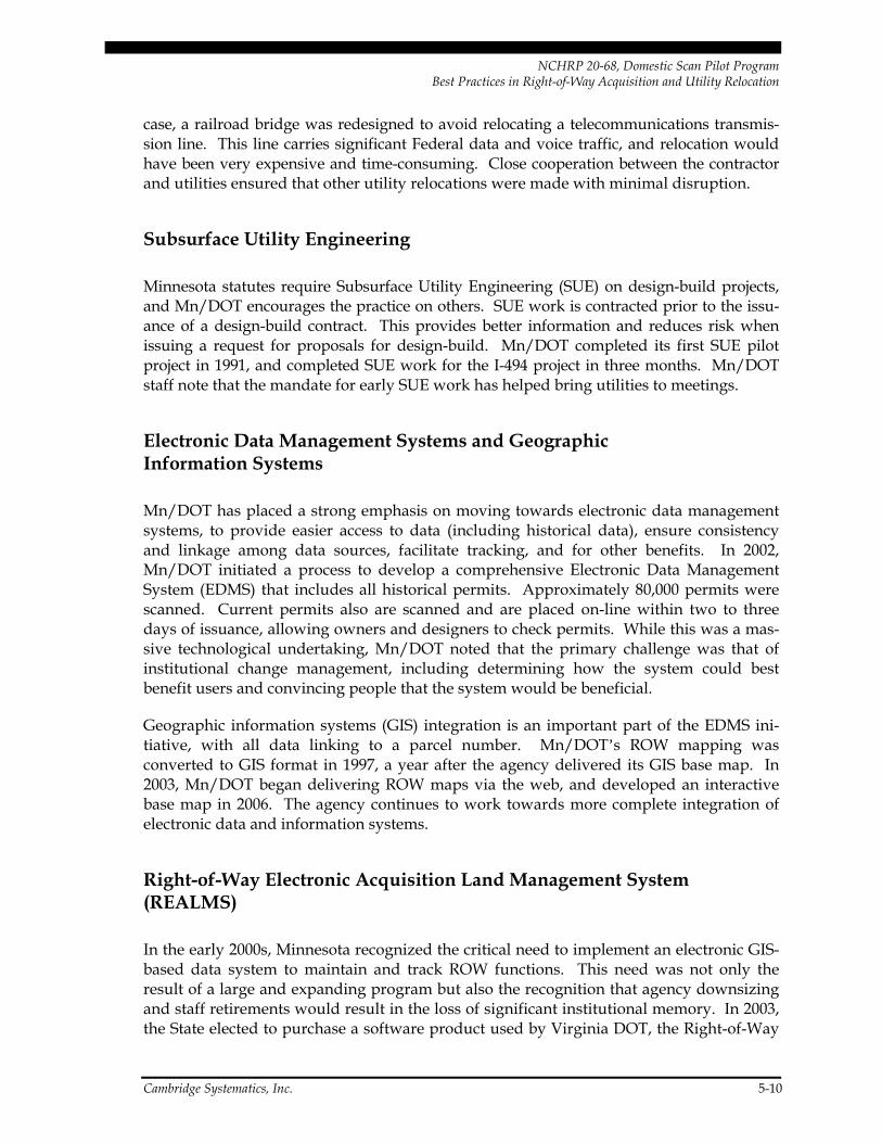
NCHRP 20-68, Domestic Scan Pilot Program Best Practices in Right-of-Way Acquisition and Utility Relocation
case, a railroad bridge was redesigned to avoid relocating a telecommunications transmis-sion line. This line carries significant Federal data and voice traffic, and relocation would have been very expensive and time-consuming. Close cooperation between the contractor and utilities ensured that other utility relocations were made with minimal disruption.
Subsurface Utility Engineering
Minnesota statutes require Subsurface Utility Engineering (SUE) on design-build projects, and Mn/DOT encourages the practice on others. SUE work is contracted prior to the issu-ance of a design-build contract. This provides better information and reduces risk when issuing a request for proposals for design-build. Mn/DOT completed its first SUE pilot project in 1991, and completed SUE work for the I-494 project in three months. Mn/DOT staff note that the mandate for early SUE work has helped bring utilities to meetings.
Electronic Data Management Systems and Geographic Information Systems
Mn/DOT has placed a strong emphasis on moving towards electronic data management systems, to provide easier access to data (including historical data), ensure consistency and linkage among data sources, facilitate tracking, and for other benefits. In 2002, Mn/DOT initiated a process to develop a comprehensive Electronic Data Management System (EDMS) that includes all historical permits. Approximately 80,000 permits were scanned. Current permits also are scanned and are placed on-line within two to three days of issuance, allowing owners and designers to check permits. While this was a mas-sive technological undertaking, Mn/DOT noted that the primary challenge was that of institutional change management, including determining how the system could best benefit users and convincing people that the system would be beneficial.
Geographic information systems (GIS) integration is an important part of the EDMS ini-tiative, with all data linking to a parcel number. Mn/DOT’s ROW mapping was converted to GIS format in 1997, a year after the agency delivered its GIS base map. In 2003, Mn/DOT began delivering ROW maps via the web, and developed an interactive base map in 2006. The agency continues to work towards more complete integration of electronic data and information systems.
Right-of-Way Electronic Acquisition Land Management System (REALMS)
In the early 2000s, Minnesota recognized the critical need to implement an electronic GIS-based data system to maintain and track ROW functions. This need was not only the result of a large and expanding program but also the recognition that agency downsizing and staff retirements would result in the loss of significant institutional memory. In 2003, the State elected to purchase a software product used by Virginia DOT, the Right-of-Way
Cambridge Systematics, Inc. 5-10

NCHRP 20-68, Domestic Scan Pilot Program Best Practices in Right-of-Way Acquisition and Utility Relocation
and Utilities Management System (iRUMS) software, and to use it as a starting point to develop their own application. Mn/DOT estimates that starting with an existing product and vigorous vendor negotiations saved the State $500,000 in product investment, system design work, and internal resource time. The State implemented the first phase of REALMS in September 2005. Mn/DOT intends to require its use by all consultants, resulting in better pricing since consultants will not have to use their own database.
In implementing REALMS, the State anticipated the following uses and benefits:
• Linkage to other Mn/DOT databases to populate REALMS;
• Sharing and use of consistent data both among internal staff statewide (eight district offices and the central offices) and with consultants, providing a single authoritative source for all ROW information;
• Increased ability to process more ROW projects simultaneously;
• Ability to use the database as an improved cost comparison tool and to improve pro-ject resources forecasting;
• Provision of real-time ROW project information at the customer’s desktop; and
• Savings of 30,000 transit days per year.
REALMS Maps
Building on the REALMS system, REALMS Maps is an application that is available to the public via the Mn/DOT Office of Land Management web site. The system allows users to locate specific maps that are part of the State’s mapping records. A mark-up feature allows drawing on the maps to illustrate current features or proposed modifications. These mark-up sessions do not change the permanent map residing in the state system. The availability of these official maps ends a problem long plaguing many states where the first critical step is to ensure that the State has the correct and latest map rendition before taking the next step.
Cambridge Systematics, Inc. 5-11
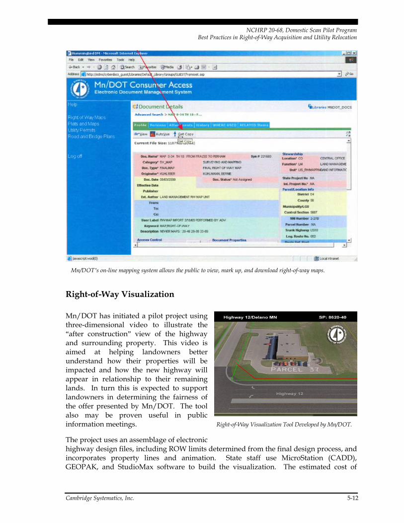
NCHRP 20-68, Domestic Scan Pilot Program Best Practices in Right-of-Way Acquisition and Utility Relocation
Cambridge Systematics, Inc. 5-12
Mn/DOT’s on-line mapping system allows the public to view, mark up, and download right-of-way maps.
Right-of-Way Visualization
Right-of-Way Visualization Tool Developed by Mn/DOT.
Mn/DOT has initiated a pilot project using three-dimensional video to illustrate the “after construction” view of the highway and surrounding property. This video is aimed at helping landowners better understand how their properties will be impacted and how the new highway will appear in relationship to their remaining lands. In turn this is expected to support landowners in determining the fairness of the offer presented by Mn/DOT. The tool also may be proven useful in public information meetings.
The project uses an assemblage of electronic highway design files, including ROW limits determined from the final design process, and incorporates property lines and animation. State staff use MicroStation (CADD), GEOPAK, and StudioMax software to build the visualization. The estimated cost of

NCHRP 20-68, Domestic Scan Pilot Program Best Practices in Right-of-Way Acquisition and Utility Relocation
completing the work is approximately $477 per parcel, exclusive of software costs. For a small project of 1.5 miles the State estimates that approximately six weeks are required to create the three-dimensional model.
While initial landowner reaction has been very positive, the State will complete an analy-sis of the effectiveness of this tool in the fall of 2007. The criteria will include the number of negotiated settlements and the time required to reach settlement. An effort also will be made to evaluate subjective factors such as public relations, faith, trust, view of agency legitimacy, and technological requirements.
Professional Right-of-Way Training Workshop
Minnesota is a leader in the area of professional training. Mn/DOT’s Office of Land Management held its 14th annual Right-of-Way Professional Workshop in the fall of 2006. The workshop focus is on property valuation, regulations, technology, and procedural issues. The audience includes appraisers, real estate professionals, attorneys, engineers, and professionals engaged in property management activities related to ROW. These training sessions are typically attended by 300 participants. Applications will be made this year to the State Department of Commerce for 15 appraisal and real estate credits, and to the State Board of Continuing Legal Education for 15 legal credits. The workshop training is open to public and private participants, including consultants, to assure the ongoing development of both public and private sector personnel. FHWA awarded the 2006 Excellence in ROW Award for Stewardship to Mn/DOT for this program.
Special Advance Acquisition Fund
The Minnesota legislature established a special advance acquisition fund to be used in the seven-county Twin Cities metropolitan area, known as the Right-of-Way Acquisition Loan Fund (RALF). The fund is sustained through tax levies. Under the RALF program, local government agencies can apply for loans to be used to make early acquisitions of proper-ties required for future transportation projects. These purchases are limited to hardship and protective buying, i.e., where imminent development is anticipated.
A significant element of this program involves public hearings to adopt an official map of planned projects. The official map is recorded and filed in the Office of County Recorder. This allows for appropriate notification of pending property development. All acquisi-tions are on a voluntary basis and condemnation powers are not used. Loans are paid back at the time the property is purchased by the State for a transportation project. The purchase price is for the amount that was paid for the property purchased by the local government agency under the RALF program. This program permits some corridor pro-tection and reduces the problem of the local agency not being in a fiscal position to other-wise acquire property at an early stage.
Cambridge Systematics, Inc. 5-13

NCHRP 20-68, Domestic Scan Pilot Program Best Practices in Right-of-Way Acquisition and Utility Relocation
Business Impact Study – I-394
Business owners in Minnesota often suggest that any change in the access to their prop-erty and/or alteration of the existing street network will result in detrimental and adverse impacts on the value and viability of their property. In Minnesota these purported losses have often taken the form of reduction in property value, reduction in retail sales, or even failure of their business.
Studies of highway impacts on adjoining property values and other business impacts have been made over the years in several locations. None of these studies were local, however, and accordingly a challenge could be made that the earlier studies were not applicable to Minnesota. The Mn/DOT project development, access management, and right-of-way staff decided to fill the information gap by conducting a comprehensive and systematic analysis of economic impacts at the local level for the I-394 construction project. This pro-ject was selected because it represents a major urban freeway construction (10 miles at a cost of $300 million) with ROW acquisition of 400 parcels at a cost of $125 million. This project, undertaken in the late 1980s and early 1990s, involved the conversion of U.S. Highway 12, a heavily developed suburban commercial corridor, to an Interstate-standard limited-access highway. The project involved a substantial reduction in access, from 100 intersections and slip ramps to 10 interchanges. Some owners in the corridor did not incur physical takings from their properties but had nevertheless brought “mandamus” actions against the State seeking compensation for alteration in general road access.
The study was completed 10 to 12 years after completion of the I-394 project and involved a sample of 22 properties and nine business types. Contrary to earlier business expecta-tions, the study did not find a negative impact on corridor businesses. Instead, the study found that employment in the corridor had increased, land values increased, business turnover was less than average in the State, and development trends are positive. Auto dealers, restaurants, and specialty retail businesses in particular had a very low turnover rate. The study concluded that changes in roadway access appear to have less influence on business vitality than either regional/national economics or the skill of the individual business owner. The study also concluded that even though direct physical access to properties might be reduced, businesses benefited from increased traffic volumes and reduced congestion along the corridor, which allowed customers to travel from farther distances to access the businesses. State personnel noted that several property owners who believed that their properties would be irreparably damaged are thriving.
5.4 Benefits
Mn/DOT notes the following benefits of its ROW and utilities process and technological innovations:
Cambridge Systematics, Inc. 5-14

NCHRP 20-68, Domestic Scan Pilot Program Best Practices in Right-of-Way Acquisition and Utility Relocation
• Utility coordination is improved and made more efficient through on-line agreements, permits, and maps;
• Construction innovation is encouraged by the design-build contract, including avoiding utility adjustments through redesign strategies;
• The I-494 design-build project is maintaining schedule and budget; and
• Visualization and animation techniques clearly illustrate to property owners the expected impacts of a project, thereby improving relationships with the public and making it easier to reach settlements.
5.5 Resources
Web Sites:
• Mn/DOT home page: http://www.dot.state.mn.us/;
• Utility home page: http://www.dot.state.mn.us/tecsup/utility/index.html;
• Land Management home page, including ROW workshops: http://www.olmweb.dot.state.mn.us/;
• I-494 project page: http://projects.dot.state.mn.us/gcinc/494/;
• ROW maps: http://dotapp3.dot.state.mn.us/cyberdocs_guest; and
• I-394 Business Impact Study presentation: http://www.accessmanagement.gov/AM2006/TRB_I-394/export/index.html.
Document References:
• Minnesota DOT (November 2005). Procedures for Accommodation of Utilities on Highway Right-of-way. http://www.dot.state.mn.us/tecsup/utility/files/pdf/appendix-b.pdf.
Contacts:
• Utilities: Marilyn Remer, Mn/DOT Utilities Engineer, (651) 296-7018, [email protected]; and
• Right-of-Way: Mike Stensberg, Assistant Director, Mn/DOT Office of Land Management, (651) 296-1133, [email protected].
Cambridge Systematics, Inc. 5-15

NCHRP 20-68, Domestic Scan Pilot Program Best Practices in Right-of-Way Acquisition and Utility Relocation
6.0 Cross-Cutting Findings and Innovative Tools
The scan team found that while each state visited has experienced considerable success in improving their right-of-way acquisition and utility relocation processes, there is no single “silver bullet” that can be applied throughout the country. Instead, a range of tools and techniques exist that may be applied in different statutory, political, cultural, and geo-graphic contexts. The team did find, however, that all three states shared common traits, including:
• A commitment to creating a supportive institutional environment;
• A focus on process;
• Investment in technical tools; and
• A willingness to make use of other incentives and techniques as appropriate.
6.1 Supportive Institutional Environment
First and foremost, the team found that a supportive institutional environment was com-mon to all of the states and agencies visited, and was in fact critical for achieving innova-tions and process improvements. Characteristics of a supportive environment include:
• A team approach – The right-of-way and utilities staff the scan came in contact with in all three states demonstrated a sense of pride and a team feel to their tasks. A team approach encourages staff and consultants to collectively take ownership of the project and navigate around problems. This team approach was supported by a formal proc-ess in Florida defining how different disciplines, including right-of-way, utilities, design, construction, and environmental, would work together.
• Upper management support – In each state, upper management provided the author-ity along with the responsibility and financial resources to accomplish the assigned tasks. Management support was critical to creating a “can-do” attitude where team members were committed to reaching a common goal.
• Willingness to innovate and take risks – Right-of-way and utilities staff in all three states were given the freedom to try new techniques and develop new processes out-side the norm, rather than adhering to established procedures and practices.
Cambridge Systematics, Inc. 6-1
NCHRP 20-68, Domestic Scan Pilot Program Best Practices in Right-of-Way Acquisition and Utility Relocation
• Provision of adequate resources – Each state demonstrated a commitment to providing the resources, including highly qualified staff, advanced technical tools, and financial resources, required to conduct and continuously improve their right-of-way acquisition and utility relocation processes. These agencies have realized that up-front investment in resources can pay dividends in the long run through reduced project costs and delays.
• Commitment to monitor and improve performance – Each state has developed tools and procedures to track and monitor the status of actions and make adjustments as necessary. Measures such as meeting critical acquisition deadlines and achieving suc-cess in negotiations provide important feedback to staff and help to identify areas where improvements are needed. Post project evaluation can identify ways to improve the process for its next application. In Florida and Minnesota, these monitoring and evaluation activities reflect and support a broader agencywide commitment to performance monitoring and performance-based management.
6.2 Focus on Process
A clear, well-defined, yet flexible process is critical to keeping project development, including right-of-way acquisition and utility relocation, on track. A number of process characteristics and innovations were demonstrated in the states visited.
• Cross-disciplinary approach – All states made explicit efforts to have different disci-plines, including design/engineering, right-of-way, utilities, environmental, and con-struction, work together beginning with the earliest stage of project development. This approach helps to identify and address critical issues early in the design process rather than creating delays or increased expenses when they are discovered later. It also creates a team atmosphere in which everyone feels responsible for making the project a success.
• Early involvement of stakeholders – Similarly, each agency made efforts to involve external stakeholders as early as practical, including local communities, utilities, busi-ness owners, impacted property owners, and resource agencies. Early involvement alerts stakeholders to the need for the project and its potential impacts, helps establish trust, and helps the DOT identify design solutions to minimize impacts.
• Explicit, written procedures – Florida DOT in particular noted the importance of having well-defined written procedures in place; for example, to specify the timing, participation, and agenda of team meetings. Minnesota DOT has established a formalized agreement with utilities describing how coordination will take place. Written procedures and documentation also are important for capturing institutional knowledge before mass retirements of an aging workforce, a concern of many agencies.
Cambridge Systematics, Inc. 6-2

NCHRP 20-68, Domestic Scan Pilot Program Best Practices in Right-of-Way Acquisition and Utility Relocation
• Incentives to maintain staff continuity – Especially for complex and high-visibility projects, it is helpful to have the same individuals follow the project process from beginning to end. Texas established incentives and disincentives with its consultant team to retain key project managers for the life of the Texas Turnpike SH 130 project.
• Delegated decision-making authority – Decision-making occurs more quickly if it is made at the lowest level possible. States noted that avoiding the need to run routine decisions through a hierarchical chain of command was a key to keeping acquisition and relocation activities on schedule.
• Conflict resolution – Similarly, conflicts (whether internal or with outside partners) are most efficiently addressed at the lowest level possible. Development of an “esca-lation ladder” to elevate disagreements and disharmony can be extremely effective in resolving disputes. A related technique is the “white paper” in which each party out-lines the problem and their proposed solution. Staff who had tried this approach noted that simply explaining the perceived conflict in writing went a long way towards resolving it.
• Colocation of major participants – Colocation of state agency staff, the design build consultant, right-of-way staff, and an FHWA representative with decision-making authority, has proven to be effective in fostering communication and reducing time delays.
• Focus on schedule adherence – Florida DOT District 5 staff noted that they set and maintain strict schedules. If delays occur in one stage of the process, other members of the team work to make up the delays. The agency also has established dates beyond which design changes must be justified and approved by a committee.
• Design-build – If permitted by state law, design-build can be an extremely effective tool for accelerating project development and completion. The design-build contract may be structured to include right-of-way acquisition, saving time by allowing con-struction to commence before all acquisitions are complete.
6.3 Technical Tools
Technical tools are important to supporting an effective process. The electronic age has made possible the use of a large number of electronic tools to manage and share informa-tion to support project development and monitoring. Each state demonstrated a compre-hensive set of technical tools to support functions such as project management, property and utilities management, and providing information to the public. Some examples of these tools include:
• Property management systems – GIS-based tools to track the status of individual properties, including a color coded mapping system such as used in Texas and Minnesota, can be an effective way to easily ascertain the status of individual parcel
Cambridge Systematics, Inc. 6-3

NCHRP 20-68, Domestic Scan Pilot Program Best Practices in Right-of-Way Acquisition and Utility Relocation
acquisitions. The cross reference of GIS, property maps, and property owner names is an aid not only during the acquisition process but also for future property manage-ment and disposal of excess land.
• Document and information management systems – Effective pursuit of innovative processes requires agency “investment” in terms of personnel, document management systems, equipment, electronic monitoring, and training. Document management systems become more critical as knowledgeable employees leave, taking the institu-tional history with them. Mn/DOT invested significant resources in turning old ROW maps and utility permits into electronic format but feels that this investment will pay off by making data-gathering more efficient and effective in the future.
• Electronic field data entry – Electronic data management systems require investment of resources but can save time in the long run. This is especially true with the use of a single entry concept so that once original data is entered in the field it can be seam-lessly transferred to the states electronic data system.
• Visualization and animation technology can illustrate existing and proposed high-way development in relation to buildings, property lines, and access impacts on adja-cent property. This has proven to be a very effective tool for public involvement and for presentation to property owners. Mn/DOT has found three-dimensional flyover/animation techniques to be a particularly effective educational tool which can be used at public meetings and public hearings.
• Web sites that provide information to stakeholders and the public, such as Mn/DOT’s on-line real estate mapping systems, and FDOT and Mn/DOT’s on-line utility infor-mation and permit applications, can make the ROW and utilities processes more effi-cient by improving communication with affected utilities and property owners and allowing speedy submission and retrieval of documents.
• Environmental management systems – Identification and resolution of environmental issues is an important part of the ROW acquisition process, and close coordination is required between ROW, environmental, and project design staff. Florida’s Efficient Transportation Decision-making program represents a technical tool as well as a proc-ess that consolidates environmental databases and makes them available for stake-holder use. Such tools can help ROW and design staff identify potential environmental issues and address them in advance.
6.4 Other Techniques
A variety of other techniques are available, some of which may be applied in any state and others which may be applicable to specific contexts.
• Incentive acquisition and relocation payments were effectively used in Florida to accelerate right-of-way clearance. Even where so-called incentive payments cannot be
Cambridge Systematics, Inc. 6-4

NCHRP 20-68, Domestic Scan Pilot Program Best Practices in Right-of-Way Acquisition and Utility Relocation
used, offering the highest supportable value to the property owner – rather than a minimum value – can expedite the acquisition process.
• Advance acquisition payments have been used in Minnesota, through a fund established by the State, to assist local governments in making property acquisitions from willing sellers years in advance of the project.
• Appraisal waiver and appraisal review modification – States including Florida have found the use of the appraisal waiver to be a highly effective method of reducing administrative costs and time associated with the development of an estimate of value as a basis for commencing negotiations for acquisition of real property needed for transportation purposes. These techniques are particularly useful in states with large numbers of acquisitions per year and an active real estate market where current sales provide a good measure of value trends.
• Utility reimbursements – This technique may be appropriate and effective in some situations to facilitate active cooperation with utilities. For example, Florida uses this technique to expedite relocations in small and economically depressed communities, for which paying relocation costs would be a hardship. In Texas, 100 percent utility reimbursements were effectively used to expedite construction of the first phase of the Central Texas Turnpike System. To be most effective, the authority to reimburse utili-ties also must include the authority to hold utilities to a defined time schedule for completing this work. While utility reimbursements represent an additional cost associated with the project, it is possible that under many circumstances the benefits of a shorter development process, as well as earlier realization of public benefits (e.g., congestion relief and safety), may outweigh the additional costs.
• Employment of subsurface utility engineering (SUE) early in the design process can identify potential utility conflicts and help address them either through project design or utility relocation strategies. Minnesota and Texas have mandated SUE work prior to the letting of design-build contracts in order to assist the contractor in bidding and manage the risk to the contractor.
• Design mitigation strategies and value engineering – Property takings and utility relocation impacts often can be mitigated or avoided altogether through creative design strategies. Texas and Minnesota structured design-build contracts to encourage contractors to seek innovative solutions to avoid takings and utility impacts. Systems can be established to share costs savings with the contractor. Minnesota and Florida apply value engineering techniques in a pre-parcel meeting with design, right-of-way, and survey staff to assess the necessity of various design features.
Cambridge Systematics, Inc. 6-5

NCHRP 20-68, Domestic Scan Pilot Program Best Practices in Right-of-Way Acquisition and Utility Relocation
6.5 Special Considerations for Design-Build Projects and Public-Private Partnerships
The design-build approach has in many cases proven to be a successful method of accelerating project completion, allowing activities to overlap that otherwise would have been undertaken sequentially. The inherent time savings may under some circumstances include ROW acquisition and utility relocation activities, especially if it is not necessary for the state agency to acquire ROW before letting the design-build contract, and if con-struction activities can proceed on some parcels before other parcels have been acquired. Design-build projects have the ability to bring a large personnel force to the project for the time necessary to complete the project and consultants have been successful in both the advance planning and in the tracking and delivery of needed ROW. Cost savings also can result if contractors are provided with incentives to identify less costly solutions.
Some states also are finding public-private partnerships (PPP) to be an effective tool for expediting project delivery. PPPs bring private sector resources to bear not only to design and construct the project, but also to finance, operate, and maintain it. PPPs are being used especially to expedite projects in high-growth or high-demand locations where toll revenues have the potential to cover the costs of the project.
To take full advantage of the benefits of design-build and PPPs for ROW and utilities processes, particular attention is required to the following elements:
• Identification and addressing of potential ROW and utilities issues, through environ-mental permitting and subsurface utilities engineering, prior to letting the design-build contract;
• Contract provisions for risk management, in case additional unanticipated stumbling blocks are discovered;
• Contract provisions and oversight procedures by the state and FHWA to ensure that property owners and utilities are treated and compensated fairly and in accordance with Federal and state regulations;
• Communication channels and work flow processes to ensure timely review and approval of contractor or developer actions, including ROW parcel acquisition and utility relocation agreements, by state and Federal agencies; and
• Data management and tracking systems to monitor the status of ROW acquisition and clearance.
Cambridge Systematics, Inc. 6-6

NCHRP 20-68, Domestic Scan Pilot Program Best Practices in Right-of-Way Acquisition and Utility Relocation
6.6 Federal Support
In the course of the discussions, scan leaders asked for suggestions as to how FHWA could support states in their efforts to expedite ROW acquisition and utility relocation. Both Florida and Texas DOT staff noted that for the most part, efforts to expedite right-of-way acquisition and utility relocation were limited not by Federal regulations and policy, but rather by their departments’ own internal creativity and actions. However, partici-pants and hosts did suggest some additional ways in which FHWA might assist states, either through policy and regulatory changes, or through changes to how existing policies and regulations are implemented and interpreted at a national as well as state level.22 Some specific suggestions from Florida DOT staff included:
• Provide states with additional freedom to use incentive offers and raise caps allowing a state Agent Price Estimate beyond $25,000;23
• Remove or raise other caps established under the Uniform Relocation Act;
• Provide states with additional freedom to experiment with other innovative practices as appropriate to their context, such as acquisition and relocation incentives; and
• Defer to state-recognized bidding procedures if Federally required low-bid procedures do not yield any responses for small jobs – for example, for utility jobs contracted by a city or county.
Suggestions from Texas DOT staff included:
• Allow greater flexibility in advancing construction on regular projects before all right-of-way has been acquired. This could be particularly appropriate for multiyear pro-jects where the first phase of construction is completion of bridges. It also could bene-fit utility relocation as well as right-of-way acquisition;
• Develop a Comprehensive Development Authority (design/build) and concession agreement policy for handling utility adjustments. Concession agreement projects
22 The concepts presented in this section are simply a reporting of ideas mentioned by scan
participants and hosts, and are not intended to serve as a policy recommendation. They are presented here without consideration of the feasibility or desirability of their implementation. In some cases, FHWA may already be undertaking or studying the value of the suggested actions. A recent FHWA report presents a set of recommendations for FHWA and state DOT actions, including technical assistance, training support, and changes to legislation, regulation, and policy. See: Federal Highway Administration (2006). FHWA Office of Real Estate Services Research Results: 2006 Future Needs of Public Sector Real Estate. http://www.fhwa.dot.gov/realestate/publicat.htm#research.
23 FHWA is working on a statewide program on incentive offers and authority has been delegated to state Division offices.
Cambridge Systematics, Inc. 6-7

NCHRP 20-68, Domestic Scan Pilot Program Best Practices in Right-of-Way Acquisition and Utility Relocation
have the potential to be large in scope for future transportation projects. Without a policy, the default approach is a traditional policy that is not designed for a compressed construction schedule.
Scan participants also suggested that FHWA and/or AASHTO might provide resources that include examples of state statutory and policy language. Examples of specific topics of interest include:
• Authority to condemn and transfer land for utility relocation;
• Authority to reimburse for utilities based on schedule and provision of incentives or disincentives for utility relocation based on schedule adherence;
• Standard easements that can be used in place of fee acquisition; and
• Early memoranda of understanding with utilities.
6.7 Benefits of Improved Practices
The most significant benefits of improved ROW acquisition and utility relocation proc-esses have included shorter project delivery time and/or lower costs. In Florida and Texas, benefits have been clearly demonstrated through projects that are being delivered on time and under budget. In Texas, in particular, the agency has been able to move the large-scale and high-profile SH 130 project rapidly, from letting of the design-build con-tract in 2002 to completion of initial segments in 2006.
In some cases, direct cost savings have resulted – for example, through Mn/DOT’s “value engineering” activities that have reduced property impacts and utility relocation require-ments. In other cases, procedures may appear to increase costs – for example, higher incentive payments to property owners, or reimbursement of utilities – but can result in lower costs in the long run due to shorter project development schedules, lower court fees, avoiding possibility of high eminent domain awards, etc. In design-build situations where the contractor is responsible for property acquisition, the contractor often has a direct financial incentive to meet or beat deadlines, and may be willing to acquire some critical properties at higher values in order to reduce acquisition delays. Shorter project development also results in earlier realization of significant public benefits such as reduced congestion and improved safety.
Agencies anecdotally report other benefits as well. For example, all three states reported that early involvement of stakeholders, especially property owners and utilities, has led to less animosity and better relationships with these stakeholders and with the public in gen-eral. Internally, staff have enjoyed the challenge of developing and implementing inno-vative practices and appreciate the team working environment.
Cambridge Systematics, Inc. 6-8

NCHRP 20-68, Domestic Scan Pilot Program Best Practices in Right-of-Way Acquisition and Utility Relocation
7.0 Implementing the Scan’s Findings
7.1 Implementation Activities
All of the scan participants as well as staff at the three host agencies noted that they found the scan to be extremely valuable in learning about successful practices. In addition to disseminating findings through this summary and final report, scan participants are actively working to adopt innovative practices and lessons learned from the scan within their own agencies, as well as communicate findings and lessons learned from the scan to their peers at professional meetings and conferences. A follow-up evaluation will exam-ine to the extent to which scan participants have been successful in introducing these practices within their own agencies.
7.2 Barriers to Innovation
An important aspect of the scan visits was not only to explore successful processes and tools, but also to identify barriers to innovation, and ways in which those barriers might be overcome. In many cases, barriers can be addressed through agency actions such as advocating for legislative changes, changing agency policies, or implementing other inter-nal strategies. Some examples of barriers include:
• State laws prohibiting alternative methods, such as lack of authority to pursue design-build;
• Lack of a champion to promote exploration of different methods of accomplishing the goal;
• Institutional inertia, where staff prefer to stick with the “tried and true” approach – related to a high level of risk avoidance, and therefore an unwillingness to experiment or innovate;
Cambridge Systematics, Inc. 7-1

NCHRP 20-68, Domestic Scan Pilot Program Best Practices in Right-of-Way Acquisition and Utility Relocation
• Failure to do a risk-reward analysis. For example, if a 100-year title report takes a lot of time and carries high-cost perhaps an abbreviated title report for low-value proper-ties could be justified to save time and money; and
• Lack of resources, including adequate personnel, appropriate databases, equipment, and training.
7.3 Keys to Successful Implementation of Innovative Processes
Some barriers may be beyond the control of any individual person or agency. There are many others, though, that may be surmountable. For example, state DOT officials can propose and advocate for legislative changes, such as providing design-build authority, or allowing the use of incentive payments. Strong leadership, good management, and sup-port from the highest levels of the agency can help overcome institutional inertia. FHWA and AASHTO can help states overcome barriers by continuing to sponsor research, develop training materials, and examine Federal policy and regulations as well as their implementation at a Federal and state level.
Success in implementing change comes only at the expense of taking risks and deviating from the orderly and safe processes of the past. A particularly successful approach was demonstrated by the Florida DOT where the goal is to have the project delivered on schedule. Where any portion of the process slips it is everyone’s responsibility to get things back on schedule. It seems to be more than a coincidence that teamwork is mentioned in each of the scan locations as a technique which serves to improve overall performance. Throughout the discussion it is obvious that the team approach involves more than a couple of training sessions and meetings outlining the team process. Creation of successful teams require time, commitment and nurturing. The end results have produced effective teams who are justly proud of their accomplishments.
Development of teams demands commitment by management as well, and team creation requires a champion who will use effective communication skills to create self motivated teams. This observation is as critical to improving right-of-way and utilities practices as it is for improving any aspect of transportation planning, project development, and delivery.
Cambridge Systematics, Inc. 7-2

Appendix A Site Visit Agendas

Rev 6/30/06 kas
AGENDA Texas
of TransportatioDepartment
NCHRP Right of Way & Utility Scan Tour &
Central Texas Turnpike Project Tour
July 12, 2006 (9:00 AM – 5:00 PM)
9:15 AM A. Welcome: Robert Stuard, Deputy District Engineer
B. 2002 Turnpike Project Overview: Tim Weight, P.E. C. SH 45, Loop1 and SH 130 Project Tour
D. Tour of the Toll System Customer Service Center (Loop 1) 12:30 PM Lunch at CTTP
E. Right of Way Presentation: Don Toner, ROW Administrator, Austin District F. Utility Discussion: John Breed, Turnpike Project Utility Manager G. Environmental Issues on SH 130 Don Toner
4:30 PM H. CLOSE
July 13, 2006 (9:00 AM – 2:30 PM) 9:15AM A. Greetings
B. Consultant & GEC Perspective Teri Morgan C. Next Step - Comprehensive Development Agreement J.D. Ewald and Don Toner D. Panel Discussion Session
12:00 Noon Lunch at CTTP 1:15PM A. Open Session (if Needed)
B. Close 2:30PM C. Depart for Airport

Agenda – Minnesota DOT July 14, 2006
AASHTO US Domestic R/W & Utilities Scan
1. 8:30 am to 9:00 am Welcome and Introductions Richard Stehr FHWA–Robin Schroeder 2. 9:00 am to 9:40 am Mn/DOT’s Utility Process Marilyn Remer 3. 9:45 am to 10:20 am Mn/DOT’s R/W Process Axel Ridel Mike Stensberg 4. 10:20 am to 10:30 am Crosstown Animation John Griffith 10:30 am to 10:45 am BREAK
5. 10:45 am to 12:00 pm Crosstown Project Tour John Griffith on Bus I-494 Design-Build Project Tour Kevin Anderson Project Utility Issues Anjani Milkert Project R/W Issues Rebecca Parzyck 6. 12:00 pm to 1:00 pm Lunch - Project Partnering Kevin Anderson Sub-Surface Utility Engineering Anjani Milkert Master Utility Agreements Co-Location Dispute Resolution 7. 1:00 pm to 2:00 pm I – 394 Business Impact Study Ron Lambert on Bus Twins Stadium, Northstar Line Daryl Anderson 2:00 pm to 2:15 pm BREAK 8. 2:15 pm to 3:00 pm REALMS Presentation Kevin Leonard Jim Magoon 9. 3:00 pm to 3:45 pm Utility Permits/UMART Ann Driver
EDMS Nancy Melvin REALMS Maps John Larson
10. 3:45 pm to 4:30 pm 3-D Visualization Jamie Hukriede GIS and R/W Applications Ron Allen, Keith Crocker Jay Krafthefer Mn/DOT Training Cheryl Hunstock 11. Mn/DOT Closing Remarks Joe Pignato