Ramiro Debbe Physics Department Brookhaven National Laboratory

U. S. DEPARTMENT OF ENERGY
BROOKHAVEN NATIONAL LABORATORY
OPERABLE UNIT IV
RECORD OF DECISION
March 14, 1996
Prepared by:
Office of Environmental Restoration Brookhaven National Laboratory
Building 51 Brookhaven Avenue
Upton, NY 11973
Brookhaven Area Office U.S. Department of Energy
Building 464 Bell Avenue
Upton, NY 11973

i
U. S. DEPARTMENT OF ENERGY
BROOKHAVEN NATIONAL LABORATORY
OPERABLE UNIT IV
I. DECLARATION OF THE RECORD OF DECISION

ii
DECLARATION OF THE RECORD OF DECISION
OPERABLE UNIT IV BROOKHAVEN NATIONAL LABORATORY
UPTON, NY
STATEMENT OF BASIS AND PURPOSE
This decision document presents the selected remedial action for Operable Unit (OU) IV of the Brookhaven National Laboratory (BNL) site in Upton, New York. Operable Unit IV includes the Central Steam Facility (CSF), the Reclamation Facility Building 650 Sump and Sump Outfall, leaking sewer lines, Recharge Basin HO, and associated environmental media.
This remedial action was selected in accordance with the Comprehensive Environmental Response, Compensation and Liability Act (CERCLA) as amended by Superfund Amendments and Reauthorization Act of 1986 (SARA) (hereinafter jointly referred to as CERCLA), and is consistent, to the extent practicable, with the National Oil and Hazardous Substances Pollution Contingency Plan (NCP). This decision is based on the Administrative Record for the BNL site.
The U.S. Environmental Protection Agency (EPA) and the State of New York concur with the selected remedial action.
ASSESSMENT OF THE SITE
Actual or threatened releases of hazardous substances from this Site, if not addressed by implementing the response action selected in this Record of Decision (ROD), may present a potential threat to public health, welfare, or the environment.

iii
DESCRIPTION OF THE SELECTED REMEDY
Operable Unit IV is the first of the five operable units at the site for which remedies will
be selected in individual RODs. The purpose of this remedy is to address contamination associated with a 1977 oil/solvent spill and a fuel unloading area near BNL's CSF and with the Reclamation Facility Building 650 Sump and Sump Outfall area. The OU IV remedy consists of a combination of treatment and institutional controls.
The selected remedy consists of the following major components:
· Treatment of chemically contaminated soil using a soil vapor extraction system to collect organic contaminants in the vadose zone of the 1977 oil/solvent spill area and a fuel unloading area at the CSF.
· Fencing around the radiologically contaminated soil at the Building 650 Sump
and the Sump Outfall area with institutional controls and monitoring.
· Treatment of groundwater contaminated with organic compounds at the most contaminated portion or "hot spot" of the 1977 oil/solvent spill plume area using a combination of soil vapor extraction and air sparging technologies.
· An engineering enhancement option for groundwater contaminated with organic
constituents may be implemented if it is decided by the DOE, EPA, and NYSDEC, based on the performance and monitoring data, that soil vapor extraction and air sparging alone will not achieve the desired performance levels. The performance levels will be defined during the remedial design phase. The engineering enhancement option consists of groundwater extraction, enhanced biodegradation, and re-injection of the groundwater and would be used in combination with soil vapor extraction and air sparging.
The components of the selected remedy for contaminated groundwater, in combination
with the engineering enhancement option, and for the chemically contaminated soils, are final response actions. The component of the selected remedy that addresses radiologically contaminated soil is considered an interim action. This interim action is necessary to reduce the risk posed by potential exposure to radiologically contaminated soil at OU IV. Final remediation of these soils will be evaluated in the OU I Feasibility Study (FS) and documented in the OU I ROD, based upon OU I FS conclusions, future land use, and public comment.

iv

v
TABLE OF CONTENTS I. Declaration........................................................................................................i
Site Name and Location ...................................................................................i
Statement of Basis and Purpose........................................................................i
Assessment of the Site ......................................................................................i
Description of the Selected Remedy .............................................................. ii
Declaration..................................................................................................... iii
List of Acronyms ............................................................................................ix II. Decision Summary...........................................................................................1 1. Site Name, Location, and Description.............................................................1 2. Site History and Enforcement Activities .........................................................2
2.1 Site History............................................................................................2 2.2 Enforcement Activities..........................................................................7
3. Highlights of Community Participation ......................................................... 8 4. Scope and Role of Operable Unit and Response Action...............................10 5. Summary of Site Characteristics ...................................................................10
5.1 Soil Investigations ...............................................................................12 5.2 Groundwater Investigations ................................................................15
6. Summary of Site Risks ..................................................................................17
6.1 Human Health Risks............................................................................17 6.1.1 Identification of Contaminants of Concern ..............................17 6.1.2 Exposure Assessment................................................................18

vi
6.1.3 Toxicity Assessment .................................................................19 6.1.4 Risk Characterization................................................................19
6.2 Ecological Risk Assessment................................................................21 6.3 Basis for Response/Remedial Action Objectives................................21
7. Description of Alternatives............................................................................23
7.1 Soil Cleanup Alternatives (Chemical).................................................23 7.2 Soil Cleanup Alternatives (Radiological) ...........................................25 7.3 Groundwater Alternatives ...................................................................28
8. Summary of Comparative Analysis of Alternatives......................................30
8.1 Threshold Criteria................................................................................31 8.1.1 Overall Protection of Human Health and the Environment......31 8.1.2 Compliance with ARARs..........................................................31
8.2 Balancing Criteria................................................................................32 8.2.1 Long Term Effectiveness ..........................................................32 8.2.2 Reduction of Toxicity, Mobility, or Volume ............................33 8.2.3 Short-Term Effectiveness..........................................................33 8.2.4 Implementability ......................................................................34 8.2.5 Cost............................................................................................34
8.3 Modifying Criteria...............................................................................35 8.3.1 State Acceptance .......................................................................35 8.3.2 Community Acceptance............................................................35
9. Selected Remedy............................................................................................35 10. Statutory Determinations ...............................................................................37
10.1 Protection of Human Health and the Environment ............................37 10.2 Compliance with ARARS ...................................................................37
10.2.1 Chemical Specific ARARs........................................................37 10.2.2 Location-Specific ARARs ........................................................38 10.2.3 Action-Specific ARARs............................................................38 10.2.4 To be Considered ......................................................................38
10.3 Cost Effectiveness ...............................................................................39 10.4 Use of Permanent Solutions and Alternative Treatment Technologies to the Maximum Extent Practicable .............................................................39 10.5 Preference for Treatment as a Principal Element ...............................39
vii
10.6 Five Year Review................................................................................39
III. Responsiveness Summary .............................................................................40 A. Introduction....................................................................................................41
B. Responsiveness Summary Overview.............................................................44 C. Background on Community Involvement and Concerns ..............................47 D. Comprehensive Summary of Major Questions, Comments, Concerns,
Responses ......................................................................................................51 IV. References......................................................................................................70 V. Tables VI. Figures
viii
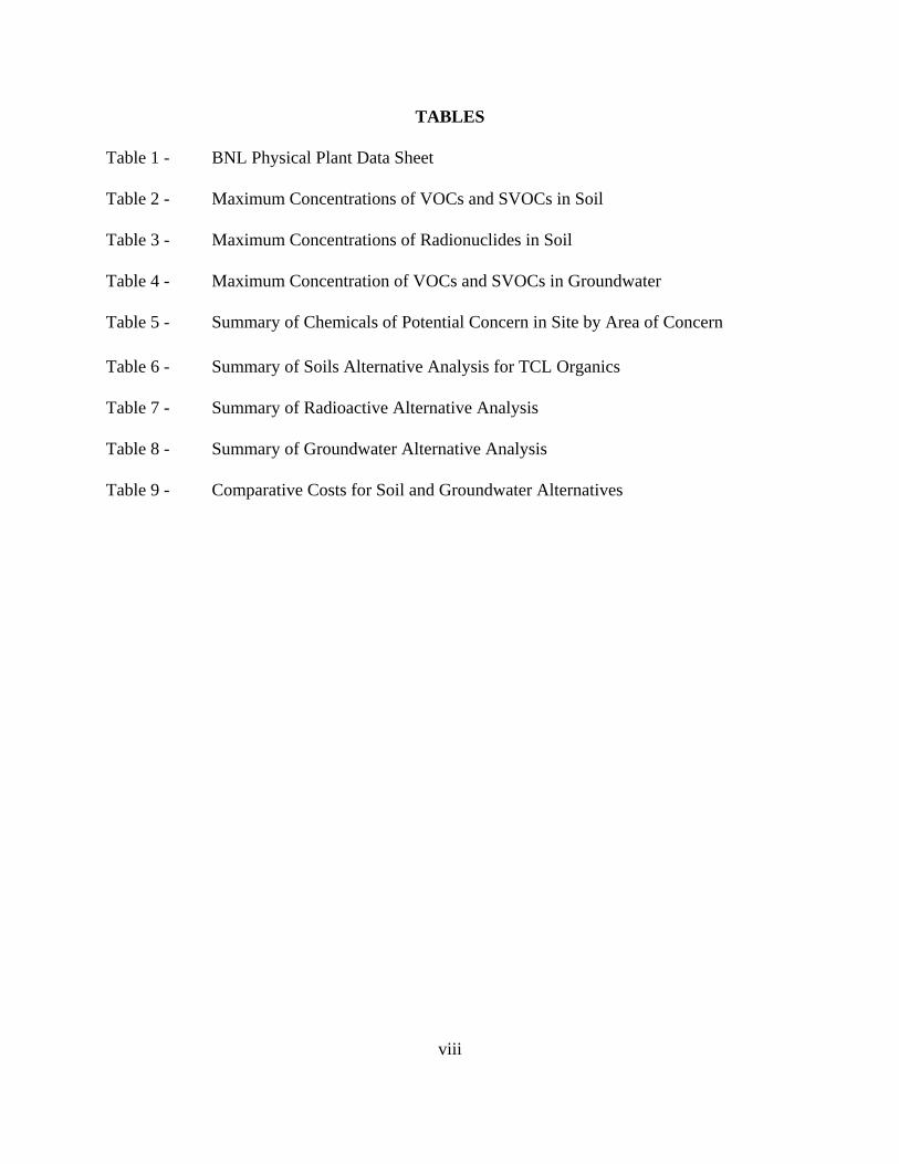
TABLES Table 1 - BNL Physical Plant Data Sheet Table 2 - Maximum Concentrations of VOCs and SVOCs in Soil Table 3 - Maximum Concentrations of Radionuclides in Soil Table 4 - Maximum Concentration of VOCs and SVOCs in Groundwater Table 5 - Summary of Chemicals of Potential Concern in Site by Area of Concern Table 6 - Summary of Soils Alternative Analysis for TCL Organics Table 7 - Summary of Radioactive Alternative Analysis Table 8 - Summary of Groundwater Alternative Analysis Table 9 - Comparative Costs for Soil and Groundwater Alternatives
ix
FIGURES Figure 1 - Current Land Use Map Figure 2 - BNL Locations of Operable Units Figure 3 - Operable Unit IV, Areas of Concern (AOCs) Figure 4 - Areal Extent of Soils Contaminated with VOCs Figure 5 - Maximum Areal Extent of Soil and Groundwater Remediation for VOCs
Under OU IV Figure 6 - Operable Unit IV, Extent of Radiological Contaminated Soils Figure 7 - Approximate Locations of Air Sparging and Soil Vapor
Extraction Wells

x
LIST OF ACRONYMS AGS Alternating Gradient Synchrotron AOC Area of Concern ARAR Applicable or Relevant and Appropriate Requirement AUI Associated Universities, Inc. BNL Brookhaven National Laboratory BTEX Benzene, Toluene, Ethylbenzene, Xylene CERCLA Comprehensive Environmental Response Compensation & Liability Act CSF Central Steam Facility DOE United States Department of Energy DOT Department of Transportation EPA United States Environmental Protection Agency FS Feasibility Study GPR Ground Penetrating Radar HEAST Health Effects Assessment Summary Tables HFBR High Flux Beam Reactor IAG Interagency Agreement IRIS Integrated Risk Information System LLW Low Level Radioactive Waste MCL Maximum Contaminant Level NCP National Oil and Hazardous Substances Pollution Contingency Plan NEPA National Environmental Policy Act NPL National Priorities List NYSDEC New York State Department of Environmental Conservation OU Operable Unit PAH Polynuclear Aromatic Hydrocarbon pCi/gram Picocuries per gram ppb Parts per billion ppm Parts per million PRAP Proposed Remedial Action Plan PVC Polyvinyl Chloride RA Risk Assessment RAGS Risk Assessment Guidance for Superfund RESRAD Residual Radioactive Material Guideline Computer Code RfD Reference Dose RI Remedial Investigation RI/FS Remedial Investigation/Feasibility Study RI/RA Remedial Investigation/Risk Assessment ROD Record of Decision RSD Response Strategy Document SARA Superfund Amendments and Reauthorization Act of 1986 SCDHS Suffolk County Division of Health Services SPDES State Pollutant Discharge Elimination System STP Sewage Treatment Plant SVE Soil Vapor Extraction SVOC Semi-Volatile Organic Compound

ξ
TAGM NYSDEC Technical Assistance Guidance Memorandum TBC To Be Considered TIC Tentatively Identified Compound USGS United States Geological Survey UST Underground Storage Tank VOC Volatile Organic Compound WCF Waste Concentration Facility

U. S. DEPARTMENT OF ENERGY
BROOKHAVEN NATIONAL LABORATORY
OPERABLE UNIT IV
II. DECISION SUMMARY
DECISION SUMMARY
2
1. SITE NAME, LOCATION, AND DESCRIPTION
Brookhaven National Laboratory is a federal facility owned by the Department of Energy (DOE) and operated by the Associated Universities, Inc. (AUI), a not-for-profit consortium of nine universities. The mission of BNL is to provide exceptional research facilities for training and research in the diverse fields of science, and to meet the appropriate needs and interests of the educational, governmental, and industrial research institutions. Brookhaven National Laboratory has three major functions. The first is the design, construction, and operation of large research facilities, such as particle accelerators, nuclear reactors, and synchrotron storage rings. The second major function is the support of the research staff in its efforts to carry out long-term programs in the basic sciences which have potential long-term payoffs. The third major function involves the contribution by the staff to the technology base of the nation. To carry out this mission, BNL has been or is maintained by a full staff of 3,300 to 4,000 research and support personnel. In addition, about 1,500 other personnel participate each year in research on short-term projects as collaborators, consultants, or students.
Located about 60 miles east of New York City, BNL is in Upton, Suffolk County, New York, near the geographic center of Long Island. Distances to neighboring communities from BNL are: Patchogue 10 miles WSW, Bellport 8 miles SW, Center Moriches 7 miles SE, Riverhead 13 miles due east, Wading River 7 miles NNE, and Port Jefferson 11 miles NW. The BNL site, formerly Camp Upton, was occupied by the U.S. Army during World Wars I and II. Between the wars, the site was operated by the Civilian Conservation Corps. The site was transferred to the Atomic Energy Commission in 1947, to the Energy Research and Development Administration in 1975, and to DOE in 1977.
The BNL property is an irregular polygon that is roughly square, and each side is approximately 2.5 miles long. A current land use map of the BNL site is provided as Figure 1. The site consists of 5,321 acres. The developed portion includes the principal facilities located near the center of the site, on relatively high ground. These facilities are contained in an area of approximately 900 acres, 500 acres of which were originally developed for Army use. The remaining 400 acres are occupied for the most part by various large research machine facilities. Outlying facilities occupy approximately 550 acres and include an apartment area, biology field, Hazardous Waste Management Area, Sewage Treatment Plant (STP), fire breaks, and the Landfill Area. The site terrain is gently rolling, with elevations varying between 40 to 120 feet above sea level. The land lies on the western rim of the shallow Peconic River watershed, with a tributary of the river rising in marshy areas in the northern section of the tract. Table 1 provides a summary of the physical plant information, including population, physical data, and utilitities.
The aquifer beneath BNL is comprised of three water bearing units: the moraine and outwash deposits, the Magothy Formation, and the Lloyd Sand Member of the Raritan Formation. These units are hydraulically connected and make up a single zone of saturation with varying physical properties extending from a depth of 45 to 1,500 feet below the land surface. These three water bearing units are designated as a "sole source aquifer" by the EPA and serve

3
as the primary drinking water source for Nassau and Suffolk Counties.
To allow effective management of the BNL site, the 28 Areas of Concern (AOCs) have been divided into discrete groups called Operable Units (OUs) and Removal Action AOCs. The criteria used for OU groupings are: relative proximity of AOCs, similarity of site problems, similar geology and hydrology, similar phases of action or sets of actions to be performed during Remedial Investigation/Feasibility Study (RI/FS), and the absence of interferences with future actions at other AOCs or OUs. The BNL site is divided into five OUs and eight Removal Actions. Operable Unit IV is one of the first OUs studied at the site.
Operable Unit IV is located on the east-central edge of the developed portion of the site (Figure 2). Figure 3 shows the extent of OU IV, which encompasses the CSF, otherwise known as AOC 5, Reclamation Facility Building 650 Sump and Reclamation Facility Building 650 Sump Outfall (AOC 6), Leaking Sewer Lines (AOC 21), and Recharge Basin HO (AOC 24-D). The CSF is located between North Sixth Street, Seventh Road, Brookhaven Avenue, and Cornell Street, and consists of approximately 13 acres, divided equally between developed and undeveloped land. The Building 650 Sump is approximately 100 feet north of Cornell Avenue. The Building 650 Sump Outfall area is located approximately 800 feet northeast of Building 650 and consists of a natural depression, approximately 90 feet x 90 feet, bounded by dirt roads. The leaking sewer lines are located south of Building 610; Recharge Basin HO is located approximately 250 feet to the northeast of the Building 650 Sump Outfall area. 2. SITE HISTORY AND ENFORCEMENT ACTIVITIES
2.1 Site History
A brief history of each AOC within OU IV is provided below:
AOC 5 - Central Steam Facility
The CSF supplies heating and cooling to all major BNL facilities. It consists of a network of 21 aboveground receiving and mixing fuel tanks, which are connected via aboveground and underground pipelines to the boiler building (Building 610) located near the corner of Sixth Street and Cornell Avenue. The tanks are registered with the Suffolk County Department of Health Services (SCDHS), and have a Major Petroleum Facility License from the NYSDEC Division of Water Resources.
AOC 5 has several subAOCs as described below:
1977 Oil/Solvent Spill

4
On November 25, 1977, approximately 23,000 to 25,000 gallons of waste oil and solvent were released from a ruptured pipe located southeast of the CSF and west of North Sixth Street. The mixture was composed of 60 percent Number 6 fuel oil and 40 percent mineral spirits. The pipe ruptured when a nearby empty 5,000 gallon underground storage tank (UST), which was enclosed in a concrete structure, rose off its mount as a result of water accumulating beneath the tank, shearing the connecting lines.
The spill, which covered an estimated area of 1.2 acres, was contained with sand berms and free product was recovered with portable pumps. The cleanup activities were coordinated with EPA and the steps taken were considered at that time to be appropriate by EPA. The total amount of the soil/solvent mixture that was recovered is unknown.
Former Leaching Pit
On November 6, 1989, excavation began at a location south of Building 610 to install a 1,000 gallon underground propane tank. Although the current utilities maps showed that there were no underground utility lines at this location, the backhoe encountered an eight inch vitreous tile pipe approximately 3 to 4 feet below grade. A review of design drawings of Building 610, dating back to the 1950s, showed that the pipe had been connected to a Leaching Pit.
The Leaching Pit was located approximately 100 feet south of the southwest corner of Building 610. The pit was installed sometime in the 1950s or 1960s to receive waste oil and washwater from equipment cleaned inside Building 610. Further excavation revealed that the vitreous tile pipe led to a sand trap, and eventually to Building 610.
The Leaching Pit had an outside diameter of approximately 9 feet and was about 11 feet deep. Its walls were constructed of concrete cinder blocks, and the cover was a 12 inch thick concrete slab. The cover was located approximately 1 foot below grade.
The Leaching Pit contained approximately 53 inches of a thick, black, tar material similar in appearance to Number 6 fuel oil. Excavation proceeded by removing the oil-stained concrete blocks and surrounding soil, in addition to the sand filter and piping connecting the Leaching Pit to Building 610. The estimated dimensions of the excavation were 20 feet deep by 20 feet in diameter. Clean sand and soil were placed into the hole. The soil, construction material, and tarry residue excavated from the Leaching Pit were classified as non-hazardous. Currently, an underground propane tank is located at the excavation site. The excavation and cleanup of the Leaching Pit was coordinated with the IAG agencies and was performed with oversight by the NYSDEC Region III Oil Spill Division.
5
Former Underground Gasoline Storage Tank
In May 1990, an abandoned 550-gallon underground gasoline tank was discovered under the asphalt on the west side of Building 610. Brookhaven National Laboratory records show that the tank was in operation from 1948 until approximately 1963. Excavation and inspection of the tank revealed several large rusted-out holes. Soil from beneath the tank smelled of petroleum. The contaminated soil was excavated until the organic vapor content of the remaining soil was less than 50 ppm. The depth and lateral extent of the excavation were not documented; however, approximately 12 cubic yards of soil were excavated. The hole was backfilled with clean soil under authorization from SCDHS.
CSF Fuel Unloading Areas
Fuel is unloaded at eight places around the storage tanks. The unloading areas are approximately 4 square feet and are constructed of pavement, bluestone, and concrete. The secondary containments are concrete boxes. Brookhaven National Laboratory has documented several small (1 to 10 gallons) surface spills of fuel oil. On three separate occasions, in 1988, 1990, and 1993, surface spills of about 60 gallons of Number 6 fuel oil were reported.
CSF Underground Piping
Four receiving tanks (1, 2, 3, and 4) are located to the west of Building 610. The tanks have a combined capacity of 1.1 million gallons. The majority of the pipelines are aboveground, and have had no history of leaking. However, there are three sections of piping leading to Building 610 that are below ground. One section is a 12 inch diameter pipe that carries Number 6 fuel oil from Tank 3 to Building 610, a distance of approximately 150 feet. Another section of pipe carries Number 6 fuel oil from Tank 1 to Building 610. The third section of underground piping connects Building 633 to both Building 610 and Tank 1. There are no documented releases from the pipes.
Drainage Area East of CSF
In September 1977, a tank truck was unloading fuel at a fuel-transfer pipe station; apparently, the valve was in the "closed" position. As a result, approximately 250 to 500 gallons of fuel were spilled. The fuel, believed to be Number 6 "Bunker C oil," caused excessive back pressure in the pipeline and ruptured it. The fuel spilled onto the ground and entered an adjacent catch basin, with an outlet in the woods east of Building 610. The oil reportedly flowed east along a small drainage ditch to a fence which marks the "Gamma Field." The oil ponded in the low area, and subsequently was collected with recovery pumps. A bulldozer was used to limit the spread of the oil.

6
AOC 6 - Reclamation Facility Building 650 Sump and Sump Outfall Area
The Reclamation Facility (Building 650) was constructed for decontamination of radiologically contaminated clothing and heavy equipment. As a result, Building 650 was designed to perform wash operations both outside and inside the building. These operations date back to at least 1959, with the construction of USTs #650-1 and -2, in 1962 and Tanks 650-3 and -4 in 1972. The structural integrity of the tanks had never been tested. At present, Building 650 is not used as a decontamination facility, but is still used by BNL as a laundry facility.
In the past, all soiled laundry from BNL was delivered to Building 650, where potentially radioactive laundry was segregated from routine laundry. Contaminated laundry was cleaned with dedicated equipment and the residual washwater remained in two 2,000 gallon USTs (#650-1 and -2) until its radioactivity could be monitored. These tanks were located on the north side of the building. The contents of the tanks were classified as D-waste, defined by BNL as waste with a gross beta concentration greater than 90 pico Curies/milliliter (pCi/ml). The liquid waste was emptied from the tanks about three times a year and taken to the Waste Concentration Facility (WCF) by a tank truck. Approximately six drums of sludge were removed from the tanks in 1983.
Building 650 also served as a decontamination facility for equipment contaminated with radioactivity. Equipment was steam-cleaned on a 30 foot by 30 foot concrete pad behind the north side of the building. This decontamination pad was in use by 1959, but the date of its initial operation is not known. Contaminated water ran down into a drum in the middle of a sloping pad, known as the Building 650 Sump. It was presumed that the effluent was piped into the sanitary sewer system or into holding tanks. Rinse water that was deemed to be excessively contaminated was supposed to be routed to two 2,000 gallon USTs (#650-1 and -2), designated for D-waste. Typically, however, the water was deemed clean enough to be routed to two 3,000 gallon USTs (#650-3 and -4), adjacent to Tanks 1 and 2, and designed for F-waste containment. Brookhaven National Laboratory defines F-waste as waste with a gross beta concentration less than 90 pCi/ml. The contents of these tanks were emptied about twice a year; the waste was discharged to the STP. The laundry facility and the decontamination pad area are the only known sources of D and F waste delivered to the four tanks at Building 650.
The USTs (#650-1, -2, -3, and -4) are included under AOC 12 and were removed under Removal Action II, the UST Removal Action, during the summer of 1994.
Building 650 and the Sump Outfall Area were identified during aerial radiological surveys of BNL conducted in 1980, 1983, and 1990. Thus, Building 650 is also included as subAOC 16 under the Aerial Radioactive Monitoring System Results and was inadvertently included under OU II/VII. The investigations under OU IV satisfy all IAG activities for this AOC.

7
In late 1969, five curies of tritium were accidentally released into the sanitary sewer
system, via the Building 650 Sump. However, this tritium was not detected at the STP. An investigation into the incident revealed that the drainage pipe from the outdoor concrete pad behind Building 650 led to a natural depression in a wooded area about 800 feet northeast of Building 650, rather than to either the sanitary sewer system or to a waste holding tank, as had been assumed. The practice of washing radioactive equipment on the concrete pad was discontinued after the 1969 incident. The natural wooded depression is referred to as the Building 650 Sump Outfall Area; the area of radiological soil contamination is approximately 90 feet by 90 feet.
AOC 21 - Sanitary and Storm Sewer Lines
The sanitary and storm sewer lines at BNL date back as far as 1917. Major repairs were made in 1940. Additional modifications have extended the sewer system to 31 miles. Many of the sewer and storm lines are composed of vitrified clay tile pipe and have undoubtedly developed cracks. In the region containing the 1977 Oil/Solvent Spill and Leaching Pit, there are approximately 1,300 feet of sanitary sewer line.
The sanitary sewer main (a 20 inch diameter tile line) transports effluent to the STP located to the north of OU IV. Lines carrying storm water in the vicinity of the CSF (south of Temple Place) discharge into a wooded area east of the CSF. The main 20 inch sanitary sewer line divides into two lines approximately 80 feet south of Tank 3. The 20 inch tile sewer line connects with Building 610, passing beneath the valve house and pumping house and then continues east along the south side of Building 610. A large 21 inch diameter line, constructed of polyvinylchloride (PVC), runs east for approximately 100 feet off the sewer main, and then continues to the northeast, passing between the locations of the Former Leaching Pit and the 1977 Oil/Solvent Spill. A third line, 6 inches in diameter, is connected to the main line at the point of division and serves Building 529.
A single sewer line runs east-west between Cornell Avenue and Building 650; it is an 8 inch line, constructed of tile. It connects to the 20 inch main east of the CSF near Building 528.
Storm water from Cornell Avenue and water from several outlets at Building 650, as well as the Building 650 decontamination pad, are directed to the Building 650 Sump Outfall area, via a 15-inch line. The structural integrity of the sanitary sewer lines is known to be compromised by fractures and slippage along joints in portions of the line beneath OU IV. To address the type and extent of damage, a video camera survey of the sanitary sewer main was made in 1988. The structural integrity of the 15-inch diameter storm sewer line connecting the Building 650 Sump to the Building 650 Sump Outfall Area was not known before the remedial investigation for OU IV.

8
Sub-AOC 24D - Basin HO
Basin HO is located approximately 250 feet northeast of the Reclamation Building 650 Sump Outfall. Basin HO is the largest of five recharge basins at BNL, discharging to the water table aquifer approximately 48 percent or 1,530,000 gallons daily of all of the water that BNL uses for non-contact cooling and related purposes. Basin HO actually is two adjacent basins constructed of native material (sand and gravel) on 3.9 acres.
Since 1958, most of the water discharged to Basin HO, approximately 1,374,000 gallons per day, is single-use, non-contact cooling and process water from the Alternating Gradient Synchrotron (AGS). Water from the High Flux Beam Reactor (HFBR) also has been discharged to Basin HO since 1978. The remainder of the water (approximately 156,000 gallons per day) is multi-cycle blowdown water from the HFBR's secondary cooling system. These discharges are permitted by NYSDEC under BNL's State Pollutant Discharge Elimination System (SPDES) permit.
Water used for cooling and related processes is derived from process/potable supply wells for the entire operation of Basin HO. Poly-electrolytes and dispersant is added to the AGS cooling and process water to keep the ambient iron in solution. To control corrosion and deposition of precipitant, water at the HFBR towers was treated with inorganic polyphosphate (PO4) and benzotriazole before 1982. Since then, the HFBR water has been treated with mercaptobenzothiozene.
Environmental monitoring at Basin HO consisted of sampling the surface water at the Basin HO Outfall 003 from 1985 to 1989. No sediment, soil, or groundwater samples were ever collected in Basin HO before the remedial investigation for OU IV.
2.2 Enforcement Activities
In 1980, the BNL site was placed on NYSDEC’s Inactive Hazardous Waste Sites. On December 21, 1989, the BNL site was included on the EPA's National Priorities List (NPL). Inclusion on the NPL reflects the relative importance placed by the federal government on ensuring the expedient completion of environmental investigations and resulting cleanup activities. Subsequently, the EPA, NYSDEC, and DOE entered into a Federal Facilities Agreement (herein referred to as the IAG) that became effective in May 1992 (Administrative Docket Number: II-CERCLA-FFA-00201). The IAG identified AOCs that were grouped into the five OUs to be evaluated for response actions at the BNL site. The IAG requires the conduct of a RI/FS for OU IV, pursuant to 42 U.S.C. 9601 et. seq., to meet CERCLA requirements. The IAG also requires the conduct of cleanup actions to address identified concerns.
In accordance with the June 1994 DOE Secretarial policy on National Environmental Policy Act (NEPA), this CERCLA document incorporates NEPA values such as analysis of cumulative, off-site and ecological impacts to the maximum extent practicable. In particular, the IAG is intended to ensure that environmental impacts associated with past and present activities at BNL are thoroughly and adequately investigated so that appropriate response actions can be formulated, assessed, and implemented.
The IAG identified AOC 5, CSF, for a RI/FS and provided a schedule for near-term

9
work. A BNL Response Strategy Document (RSD) was written pursuant to the IAG which grouped AOC 5 with AOCs 6, 15, 21, and 24-D and prioritized OU IV as the first OU for RI/FS.
Remediation at the BNL site will be conducted under CERCLA, as amended by the SARA, and the NCP, 40 CFR Part 300.
Following the issuance of the ROD for the last of the five OUs, the necessity of a final assessment from a site-wide perspective will be determined to ensure that ongoing or planned remedial actions identified in the ROD for the five OUs will provide a comprehensive remedy for the BNL site which is protective of human health and the environment. 3. HIGHLIGHTS OF COMMUNITY PARTICIPATION
A Community Relations Plan was finalized for the BNL site in September 1991. In accordance with this plan and CERCLA Section 113 (k) (2)(B)(I-v) and 117, the community relations program focused on public information and involvement. A variety of activities were used to provide information and to seek public participation. The activities included: compilation of a stakeholders mailing list, community meetings, availability sessions, site tours and the development of fact sheets. An Administrative Record, documenting the basis for the selection of removal and remedial actions at the BNL site, has been established and is maintained at the local libraries listed below. The libraries also maintain site reports, press releases, and fact sheets. The libraries are:
Longwood Public Library 800 Middle Country Road Middle Island, NY 11953
Mastic-Moriches-Shirley Library 301 William Floyd Parkway Shirley, NY 11967
Brookhaven National Laboratory Research Library Bldg. 477A Upton, NY 11973
The Administrative Record is also maintained at the EPA's Region II Administrative
Records Room at 290 Broadway, New York, New York, 10001-1866.
A chronological summary of the significant community participation activities to date for OU IV is provided below:
September 26, 1991: A Site Specific Plan and 5-Year Plan informational meeting was

10
held at BNL where the OU IV draft RI/FS Work Plan was also presented to the public. Presentation handouts on the draft Work Plan were provided to community members at that time. Although the community was informed by a press release to the local newspapers, attendance at this meeting was low. A question and answer period was held at the end of the meeting.
February 17, 1992: A public notice was published in two local newspapers (Newsday and Suffolk Life) announcing the availability of the OU IV RI/FS Work Plan at local repositories. The comment period began on February 17, 1992 and concluded on March 17, 1992. One community member commented by letter in April and was responded to by BNL.
August 3, 1994: A public notice was published in two local newspapers (Newsday and Suffolk Life) announcing availability of an Engineering Evaluation Report and Action Memorandum at local repositories for an OU IV soil interim removal action. An informational letter, with public notice attached, was sent to the community mailing list. Two phone calls from community members were received concerning the disposal of soils.
January 17, 1995: A public notice was featured in local newspapers announcing the availability of OU IV Remedial Investigation/Risk Assessment (RI/RA) Report at local repositories. The comment period began on January 18, 1995 and concluded on February 20, 1995.
January 25, 1995: An informational letter was sent to community members on the mailing list concerning the OU RI/RA Report. A civic association requested an extension to the comment period. Comments were received in April 1995, which focused primarily on groundwater concerns. A meeting to discuss these concerns with the civic association was held on June 5, 1995. A written response to the civic association comments was provided by DOE.
November 18, 1995: An informational letter was sent to community members on the mailing list announcing the OU IV FS/Proposed Remedial Action Plan (PRAP) public meeting. A public notice, meeting invitation/PRAP fact sheet, and site tour invitation was attached.
November 22, 1995: A public notice was published in Newsday and Suffolk Life (on November 29, 1995) announcing the availability of the FS/PRAP at local repositories for review and comment. A 30-day public comment period was held beginning November 22, 1995.
December 6, 1995: A public meeting was held at BNL for the OU IV FS/PRAP along with an afternoon site tour of OU IV. At this meeting, representatives from EPA, NYSDEC, BNL, and DOE answered questions and accepted comments on the remedial alternatives under consideration for OU IV. A response to comments received during the public comment period is included in the Responsiveness Summary, which is part of this ROD. This decision document presents the selected remedial action for OU IV at the BNL site in Upton, New York, chosen in accordance with CERCLA, and to the extent practicable, the NCP.
December 22, 1995: Seven community members provided written comments.

11
In addition to traditional public involvement activities at CERCLA sites, DOE worked with stakeholders in identifying a range of future use options for the BNL site. Final Draft of the Future Land Use Report was presented to the public in August, 1995. The Final Report was prepared in September, 1995. Stakeholder preferred future uses identified in this report will assist with the establishment of acceptable risk and remediation levels for the entire BNL site. 4. SCOPE AND ROLE OF OPERABLE UNIT AND RESPONSE ACTION
In order to adequately evaluate BNL's existing and potential environmental problems,
and to group these problems for such a large site into workable units that could be properly scheduled and funded, the 28 AOCs have been grouped into five OUs and eight Removal Actions. This grouping was performed under an RSD based on the six criteria: (1) relative proximity of AOCs, (2) similar site problems, (3) similar phases of action or sets of actions, (4) simultaneous actions, (5) absence of interference with future actions, and (6) similar geology and hydrology.
The RSD assigned OU IV the first priority based on a preliminary risk assessment and since an OU IV RI/FS was already underway. Operable Unit IV is the first OU to undergo a RI/FS. Pursuant to the findings documented in the RI/RA Report, FS Report, and the PRAP, OU IV addresses remediation of soil contaminated with Volatile Organic Compounds (VOCs) and Semi-Volatile Organic Compounds (SVOCs) at AOC 5 (1977 oil/solvent spill area), soil contaminated with radionuclides at AOC 6, and groundwater contaminated with VOCs and SVOCs from AOC 5 (1977 oil/solvent spill). Conducting this remedial action under OU IV is part of the overall BNL response strategy and is expected to be consistent with any planned future actions.
The other OUs are currently in different phases of RI/FS. The nature, magnitude, and extent of contamination as well as associated risks will be evaluated and the appropriate response actions will be implemented under the respective OU. 5. SUMMARY OF SITE CHARACTERISTICS
The RI was conducted in accordance with the approved OU IV RI/FS Project Plans. The main purposes of the RI were to determine the nature, magnitude, and extent of contamination due to the AOCs included in OU IV, and to characterize the potential health risks and environmental impacts of any contaminants present. The RI included: (1) video camera survey of a pipeline from Building 650 to the Sump Outfall area, (2) geophysical survey, including magnetic and Ground Penetrating Radar (GPR) around several buildings within OU IV, (3) soil-vapor survey of the CSF area, (4) soil borings/soil sampling, (5) monitoring well installation and two rounds of groundwater sampling, (6) sediment sampling in the Recharge Basin HO, (7) aquifer testing in the form of slug tests, (8) analysis of soil and groundwater samples for various chemical and radiological constituents, and (9) additional radiological surface soil sampling and survey (1994) of AOC 6. The video camera survey and geophysical surveys were conducted in
12
July 1992. Fifty-seven soil borings and 23 monitoring wells were installed during the RI for OU IV.
Classification of the nature and extent of soil and groundwater contamination was based on the following Applicable or Relevant and Appropriate Requirements (ARARs), such as those for groundwater, or guidance/criteria To Be Considered (TBC), such as cleanup goals for soils:
(1) Since the groundwater is a federally designated sole source aquifer and is classified as a source of potable water by New York State, the most restrictive of the state and federal Maximum Contaminant Levels (MCLs) were selected as ARARs.
(2) The soil cleanup goals for protection of groundwater contained in the NYSDEC
Technical Assistance Guidance Memorandum (TAGM) HWR-92-4046 entitled "NYSDEC Soil Cleanup Objectives and Cleanup Levels," November 1992, were selected for organic compounds found in groundwater.
(3) The cleanup goal selected for radiologically contaminated soils, with the
exception of Radium-226, is the annual dose rate of 10 millirem above background, contained in the NYSDEC TAGM 4003 entitled "NYSDEC Soil Cleanup Guidelines for Radioactive Materials", September 1993. This goal, along with the assumption of a future industrial land use and an institutional control period of 50 years, was used to develop soil cleanup guidelines using the DOE Residual Radioactivity (RESRAD) computer model.
(4) Radium-226 concentrations were compared to the 5 pCi/gram generic cleanup
guideline contained in DOE Order 5400.5.
Tables 2, 3, and 4 show the selected ARARs or cleanup goals and the maximum concentrations of VOCs and SVOCs in soil, radionuclides in soil, and VOCs and SVOCs in groundwater, respectively.

13
5.1 Soil Investigations
The findings of RI and Risk Assessment (RA) are detailed in the RI/RA Report. A summary of the findings of the soil investigations and determinations on remedial actions are discussed next.
AOC 5 - Central Steam Facility:
1977 Oil/Solvent Spill
Elevated levels of VOCs and SVOCs are present in the soils in the area adjacent to the Oil/Solvent UST, down gradient of the UST, and in the area known to be covered by the 1977 Oil/Solvent spill. Figure 4 shows the areal extent of soils contaminated with VOCs and SVOCs. VOC levels are highest near the Oil/Solvent UST. The VOCs and SVOCs were detected throughout the vadose zone, and are present at elevated concentrations at the water table. The most common VOCs detected include tetrachloroethylene and petroleum-related compounds, such as toluene, ethylbenzene, benzene, and xylenes. The most common SVOCs detected include a variety of Polynuclear Aromatic Hydrocarbons (PAHs) and phthalates.
As an interim action, and with the concurrence of the IAG agencies, the Oil/Solvent UST and associated piping were removed in October 1993, along with visibly contaminated soil. The excavated soil was stockpiled near the UST location, and soil samples from the piles were analyzed in February 1994 to determine disposal options. The results showed that while numerous VOCs and SVOCs were present in the stockpiled soil above the cleanup goals, the soil was non-hazardous. On June 10, 1994, BNL disposed of the excavated soils at the Town of Brookhaven Landfill after having obtained permission from both the town and the regional NYSDEC office. Thirty-four truckloads of contaminated soil and debris totaling 1,413 tons were transported to the Town Landfill. Each truckload was screened through BNL's radiological vehicle monitor before leaving the site and no radioactivity was detected.
The vadose zone in the Oil/Solvent UST and spill area will require further remediation due to the presence of VOCs and SVOCs above cleanup goals.
Former Leaching Pit
Low levels of VOCs and SVOCs are present in the soils adjacent to the Former Leaching Pit. They most likely represent residual materials discharged into the pit from Building 610. The low levels of tetrachloroethylene may have resulted from the 1977 Oil/Solvent Spill, since that compound is commonly associated with the spill. The Former Leaching Pit and the Sand Filter Trap area do not require further remediation since concentrations are below cleanup goals.

14
Former Gasoline UST Location
Low levels of petroleum-related VOCs and SVOCs are present in the soils at approximately the subsurface level, i.e., 8 to 10 feet deep, of the Former UST. They represent residual compounds from the UST. When the UST was removed, approximately 12 cubic yards of soil were excavated, until the organic-vapor content was less than 50 parts per million. No VOCs or SVOCs were detected in soil samples collected from below 16 feet, indicating that the small amount of residual organics in the subsurface soil is not migrating deeper into the vadose zone. The Former Gasoline UST will not require further remediation since concentrations are below cleanup goals.
CSF Fuel Unloading Areas
The VOCs and SVOCs are present in soils adjacent to six of the eight CSF Fuel Unloading areas, generally in the shallower portion of the vadose zone. The presence of these compounds indicates that minor spills occurred as the fuel was transferred from tank trucks to the CSF tanks. Most of these compounds are in the upper portion of the vadose zone, indicating that such spills probably were small and have not penetrated far through the unsaturated zone into the water table and groundwater. Elevated levels of VOCs and/or SVOCs above soil cleanup goals were detected near one of the eight Fuel Unloading areas. Contaminated soils will need to be remediated at this Fuel Unloading Area (see Figure 4).
Underground Pipes
Very low levels of VOCs in soil samples at the bottom invert of the fuel pipelines indicate that leakage from the pipes adjacent to the boring locations is minimal; none of the organic compounds exceed cleanup goals. The analyses show that the soils adjacent to the pipes will not require remediation.
Drainage Area
Acetone was the only VOC and phthalate was the only SVOC detected in soil samples from the Drainage Area; both were below cleanup goals. The vadose-zone soils along the pipeline and downgradient of the concrete headwall will not require remediation.
AOC 6 - Reclamation Facility Building 650 and Sump Outfall Reclamation Building 650 Sump
Acetone was the primary VOC detected in the soil samples in the Sump/Decontamination
Pad area behind Building 650. The concentrations are below the cleanup goals. Several chlorinated solvents were detected in soil borings SB38, located on the west side of the decontamination pad. Polynuclear Aromatic Hydrocarbons were the primary SVOCs detected in the soil samples below cleanup goals. Inorganic contamination was found above background levels, primarily in surface soil samples. No remediation will be required for inorganics based

15
on the risk assessment, as described in Section 6 of this report. While the 0 to 2 foot composite samples did not show radionuclide contamination above the cleanup goals, the 0 to 6 inch surface soil samples in this area indicate that there is shallow radiological surface soil contamination. The contaminant concentrations in this area exceed the soil cleanup goals for Cesium-137, Europium-152, and Europium-154. Therefore, radiologically contaminated surface soils will need to be evaluated further.
Reclamation Building 650 Sump Outfall
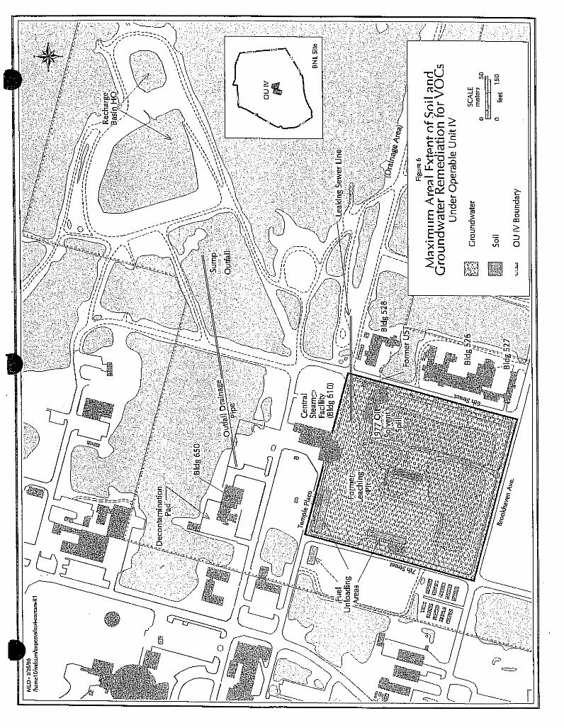
Acetone was the only VOC detected in soil samples at the Sump Outfall and was below the soil cleanup goal. A wide variety of PAHs were the primary SVOCs detected; they were present primarily in the surface soil. Inorganic contamination was found above background levels, primarily in surface soil samples. No remediation will be required for inorganics based on the risk assessment. Two borings (SB48 and SB49) closest to the pipe headwall, had the highest levels in surface samples from the Outfall Area. Gross alpha, and gross beta radiation was detected in many samples from the Sump Outfall area; both were present in all five surface-soil samples. Cesium-137, Strontium-90, Europium- 152 and 154, Radium-226, and Plutonium-239 and -240, were found at levels above the RESRAD cleanup guidelines. In addition, the gamma radiation level within the sump produces a potential risk that exceeds EPA's target risk level; therefore, the vadose soils in the sump outfall also require remediation. Figure 5 shows the areal extent of radiologically contaminated soils in the Sump Outfall area.
Because the Storm Sewer connecting Building 650 and the Sump Outfall was leaking (video camera survey), the pipeline and the surrounding soil will require remediation.
AOC 21 Leaking Sewer Line
Low levels of chloroform and SVOCs were detected in soil samples adjacent to the sewer line (SB53). This boring is located at the western end of the sewer line and close to the 1977 Oil/Solvent UST Spill. It is likely that this contamination is related to the spill. Since levels are below cleanup goals and groundwater has not been impacted, the soils around SB53 will not be remediated.
SUB-AOC 24D Recharge Basin HO
No VOCs, SVOCs, Tentatively Identified Compounds (TICs), or Pesticides/PCBs were detected in the sediment samples from Basin HO, and no inorganic analytes exceeded cleanup goals. No remediation will be required.
16
5.2 Groundwater Investigations
The findings of RI and RA are detailed in the RI/RA Report. A summary of the findings of the groundwater investigations and determination of remedial actions is discussed next.
Data from two rounds of groundwater sampling indicates that there were two primary sources of VOCs: the 1977 Oil/Solvent Spill and UST, and the decontamination pad behind Building 650. The VOC plume emanating from the northern side of Building 650 is composed primarily of 1,1,1- trichloroethane at 5.10 ppb and 8.5 (estimated) ppb in the second round of sampling, only slightly above the NYSDEC MCL of 5 ppb. The plume associated with the 1977 Oil/Solvent Spill and UST is composed of numerous VOCs and SVOCs which are predominantly hydrocarbon-related, such as benzene, toluene, ethylbenzene, xylene (BTEX) compounds, chlorinated VOCs, and PAHs. The center of the plume is near the UST, with the highest levels of VOCs and SVOCs in monitoring wells immediately downgradient. The contaminants that exceed the selected cleanup goals are listed in Table 4. The highest levels were observed in the vicinity of the UST. The farthest downgradient wells in the ballfields contained only 4 ug/l of tetrachloroethylene in the second round of sampling, which is below the MCL. Several of these wells contained low levels of TICs, indicating either that the plume is very diluted and degraded at the downgradient end of OU IV, or that the plume travels preferentially between the monitoring well clusters at the southern end of OU IV. Tentatively Identified Compounds were identified at all levels of the Upper Glacial aquifer, suggesting that there are no hydraulic barriers or clay layers within the glacial aquifer in OU IV. Based on site-specific flow, it is estimated that it would take about 7.8 years for 1,2 dichloroethane (the most mobile of the organic contaminants) to reach the downgradient wells, located at approximately 1,800 feet, while the duration for tetrachloroethylene to travel this distance is calculated as 11.2 years. Using the hydraulic conductivity value estimated by the U.S. Geological Survey (USGS), travel times for tetrachloroethylene and 1,2-dichloroethane are 2.1 years and 3 years, respectively.
The results of inorganic analyses show that no primary MCLs were exceeded for inorganic compounds in groundwater beneath OU IV. Two radiological parameters exceeded MCLs for groundwater. In the first round, the monitoring action level for gross beta of 50 pCi/l was exceeded in monitoring wells 76-09I (88 pCi/l) and 76-20S (120 pCi/l); neither exceeded 50 pCi/l in the second round. In the second round, Strontium-90 exceeded the federal MCL of 8 pCi/l in Well 66-19S (53 pCi/l). In the first round, the Strontium-90 value of 5.2 pCi/l did not exceed the MCL. The monitoring action level for gross beta was exceeded in the second round in Monitoring Well 66-20S (110 pCi/l).
While isolated spots of radionuclide contamination in groundwater have been observed, the data for two rounds of sampling and analysis do not indicate any consistent MCL violations, and therefore, no groundwater remediation for radiological contamination will be required under OU IV. In addition, there were localized exceedances of secondary MCLs for iron, manganese, sodium, and aluminum. The inorganic contamination appears to be localized and stationary. The contamination is primarily due to VOCs and SVOCs. Groundwater cleanup

17
will be required for VOCs and SVOCs for the most contaminated portion of the 1977 oil/solvent spill plume shown in Figure 6. Groundwater monitoring for radionuclides, organics, and inorganics will be required.
The following is a summary of findings of the OU IV RI described in Sections 5.1 and 5.2.
Soil Groundwater Remediation
Remediation Area of Concern Required Required
AOC-5: Central Steam Facility
- 1977 Oil/Solvent Spill Yes Yes - Former Leaching Pit No No - Former Gasoline UST Location No No - CSF Fuel Unloading Areas Yes* No - Underground Pipes No No - Drainage Area No No
AOC-6: Reclamation Facility Building 650
and Sump Outfall
- Building 650 Sump Area ** ** - Sump Outfall Area ** **
AOC-21: Leaking Sewer Lines No No
AOC-24D: Recharge Basin HO No No
*Only one of the eight fuel unloading areas will require soil remediation. **Further evaluation is required.
Tables 2, 3, and 4 provide a summary of the types of contaminants, their maximum concentration, and their locations. Figures 4 and 5 show the areal extent of chemical and radiological contamination, respectively, above soil cleanup goals.

18
6. SUMMARY OF SITE RISKS
As part of the OU IV RI, an analysis was conducted to estimate the human health risks that could result from exposure to OU IV areas if no remediation is performed beyond that accomplished to date. This analysis is referred to as a baseline risk assessment. The human health risk assessment evaluated both present and future potential exposures to contaminants. Findings of the risk assessment are documented in the OU IV RI/RA Report (Volume II), dated December 7, 1994.
6.1 Human Health Risks
The reasonable maximum human exposure was evaluated. A four-step process was used for assessing OU IV-related human-health risks for a reasonable maximum-exposure scenario: Hazard Identification - identifies the contaminants of concern at the site based on several factors such as toxicity, frequency of occurrence, and concentration. Exposure Assessment - estimates the magnitude of actual and/or potential human exposures, the frequency and duration of these exposures, and the pathways (e.g., contaminated well water) by which humans potentially are exposed. Toxicity Assessment - determines the types of adverse health effects associated with chemical exposures, and the relationship between magnitude of exposure (dose) and severity of adverse effects (response). Risk Characterization - combines the outputs of the exposure and toxicity assessments to provide a quantitative (e.g., one-in-one-million excess cancer risk) assessment of OU IV-related risks.
The EPA uses a reference dose (RfD) and a slope factor, respectively, to calculate the non-carcinogenic and carcinogenic risk attributable to a particular contaminant. An RfD is an estimate of a daily exposure level that is unlikely to cause any appreciable risk from deleterious effects during a person's lifetime. A slope factor establishes the relationship between the dose of a chemical and the response, and is commonly expressed as a probability of a response per unit intake of a chemical over a human life span.
To assess the overall potential for carcinogenic effects, EPA calculates excess cancer risk. Excess cancer risk is the incremental probability of an individual developing cancer over a lifetime from exposure to the potential carcinogen. Current federal guidelines for acceptable exposure are an excess carcinogenic risk ranging from approximately one-in-ten-thousand to one-in-one-million (1E-04 to 1E-06).
6.1.1 Identification of Contaminants of Concern
Chemicals of potential concern were selected based on procedures specified in EPA's Risk Assessment Guidance for Superfund (RAGS), Part A and professional judgment, where appropriate. The primary consideration for selection or elimination were frequency of detection in analyzed medium, historical site information/activities, chemical concentration, sample chemical detections relative to blank chemical detections, chemical toxicity (potential

19
carcinogenic and non-carcinogenic effects), chemical properties, and significant exposure routes. Table 5 provides a summary of chemicals of potential concern at this site by AOC.
6.1.2 Exposure Assessment
As part of the risk assessment, present and potential future-use scenarios were quantitatively evaluated for the following receptor populations:
· Area residents (trespassers) · Residents · Site Workers · Construction workers.
The AOCs evaluated included:
· Sump Outfall · Drainage area · Central Steam Facility · Building 650 area.
The environmental matrices evaluated in the risk assessment included:
· Surface soil · Subsurface soil · Groundwater
Present-use scenarios: Under present site conditions, area residents (trespassers) in the
Sump Outfall, site workers in the CSF, and Building 650 area, and construction workers at the CSF were quantitatively evaluated for surface soil exposure. The exposure routes selected for evaluation included ingestion, dermal contact, and inhalation of suspended particulates.
Additional present-use scenarios included site worker (employee) and construction worker exposures to subsurface soil exposure. The exposure routes selected for evaluation included ingestion, dermal contact, and inhalation of suspended particulates.
20
No groundwater scenarios were selected for quantitative evaluation under present site conditions since the water supply is obtained from the potable water system.
Future-use scenarios: Under potential future site conditions, residents in the Sump Outfall, Drainage area, CSF, and Building 650 area were quantitatively evaluated for surface soil and subsurface soil exposures. The exposure routes selected for evaluation included ingestion, dermal contact, and inhalation of suspended particulates. Site workers and construction workers in the CSF and Building 650 area were quantitatively evaluated for surface soil and subsurface soil exposures. The ingestion, dermal contact, and inhalation of suspended particulate routes of exposure were selected for evaluation. The only groundwater scenarios quantitatively evaluated included residential ingestion and inhalation of VOCs exposure.
Only Sump Outfall surface soil and CSF subsurface soil could be quantitatively evaluated for dermal contact exposure in the risk assessment. These AOCs/matrices included PCBs and cadmium as chemicals of potential concern, the only chemicals within OU IV with established dermal absorption factors.
6.1.3 Toxicity Assessment
The toxicity assessment consisted of presenting toxicological properties of the selected chemicals of potential concern using the most current toxicological human health effects data. Toxicity profiles for each of the chemicals of potential concern are presented in Appendix I-2 of the RI/RA Report. Many carcinogenic slope factors and reference doses used in this assessment were obtained from EPA's Integrated Risk Information System (IRIS) data base. Slope factors and reference doses/concentrations not available on IRIS were obtained from EPA's second most current source of toxicity information, Health Effects Assessment Summary Tables (HEAST). The determination of the potential health hazards associated with exposure to non-carcinogens was made by comparing the estimated chronic or subchronic daily intake of a chemical with the RfD. Numerous VOCs, SVOCs, pesticides, and inorganics could not be quantitatively evaluated in this risk assessment due to the lack of established toxicity values. These were qualitatively evaluated. Uncertainty related to the chemical toxicity data was addressed.
6.1.4 Risk Characterization
Chemical Risks
Present and/or potential future area residents (trespassers) in the Sump Outfall Area, residents (adults and children) in the Sump Outfall, Drainage Area, CSF, and Building 650 area, and site workers (employees) and construction workers in the CSF and Building 650 area were evaluated for their exposure to surface soil via ingestion, dermal contact, and inhalation. All estimates of carcinogenic risk fell within or outside and below the EPA target risk ranges of one-in-ten-thousand to one-in-one-million (1E-04 to 1E-06). All non-carcinogenic hazard-index values fell below the target level of one.

21
Present and/or potential future area residents (adults and children) in the Sump Outfall, Drainage Area, CSF, and Building 650 area, and site workers (employees) and construction workers in the CSF and Building 650 area were quantitatively evaluated for exposure to surface soil via ingestion, dermal contact, and inhalation routes. All estimates of carcinogenic risk fell within or outside and below the EPA target risk ranges of one-in-ten-thousand to one-in-one-million (1E-04 to 1E-06). All non-carcinogenic hazard-index values fell below the target level of one.
Potential future exposures of residents to groundwater ingestion and inhalation of VOCs (shower model) were quantitatively evaluated for OU IV as a whole, assuming that a residential well could be installed in any AOC in the future. All estimates of carcinogenic risk fell within or outside and below the EPA target risk range of one-in-ten-thousand to one-in-one-million (1E-04 to 1E-06). Only the hazard-index value of 1.3 for children exposed by drinking the groundwater slightly exceeded EPA's target level of one. The exceedance were almost entirely due to manganese. While potential future exposure due to manganese contamination in groundwater only slightly exceeds the hazard index target level, groundwater data show that the manganese contamination is localized and stationary, therefore, no remediation will be required.
Radiological Risks
Present area residents (trespassers) and potential future residents in the Sump Outfall and potential future residents, present and future site workers (employees) and potential future construction workers in the Building 650 area were quantitatively evaluated for exposures to surface soil. The risk estimates for potential future residents in both areas exceeded the EPA target risk level. The highest risks were for the future residents in the Sump Outfall Area with a total combined (adult and child) carcinogenic risk of 1 in 10 to 1 in 100, when the results from the 1994 sampling are included. The major contributor to the risk was from the external gamma-radiation pathway. The risk estimate for present site workers in the Building 650 area also exceeds the EPA target risk level with a risk of 4 in 1,000. However, the exposures are within the occupational exposure standards. All other carcinogenic risk estimates fell within the EPA target risk range of one-in-ten-thousand to one-in-one-million (1E-04 to 1E-06).
Potential future residents in the Sump Outfall and Building 650 areas and present and potential future site workers (employees) and construction workers in the Building 650 area were quantitatively evaluated for exposure to subsurface soil via the ingestion, inhalation, and external gamma-radiation pathways. All carcinogenic risk estimates fell within or below the EPA target risk range of one-in-ten-thousand to one-in-one-million (1E-04 to 1E-06). The highest risk, 8 in 100,000 or 1 in 10,000 occurred for future residents in the Sump Outfall Area. Again, the external gamma-radiation exposure was the pathway with the predominant radiological risk, and the major contributor was Cesium-137.
Potential future residents sitewide were quantitatively evaluated for exposure to groundwater via ingestion. The carcinogenic risk estimate was within the EPA target risk range of one-in-ten-thousand to one-in-one-million (1E-04 to 1E-06).
6.2 Ecological Risk Assessment

22
The reasonable maximum environmental exposure was evaluated. A four-step process
was used for assessing OU IV-related ecological risks for a reasonable maximum exposure scenario: Problem Formulation - a qualitative evaluation of a contaminant's release, migration, and fate; identification of contaminants of concern, receptors, exposure pathways, and known ecological effects of the contaminants; and selection of endpoints for further study. Exposure Assessment - a quantitative evaluation of the release, migration, and fate of the contaminant; characterization of exposure pathways and receptors; and measurement or estimation of exposure point concentrations. Ecological Effects Assessment - literature reviews, field studies, and toxicity tests, linking contaminant concentrations to effects on ecological receptors. Risk Characterization - measurement or estimation of both current and future adverse effects. Unlike assessments of human-health risk, assessments of ecological risk focus on the wildlife population and ecosystem levels. Because there is little toxicity data relevant to wildlife, it is difficult to draw inferences at the population and ecosystems level. Thus, this ecological assessment is largely qualitative.
The ecological risk assessment indicated that there are no natural wetlands, threatened, protected or endangered species, or habitats of special concern within the boundaries of OU IV. Although wetlands and areas which may support species of concern occur within the two-mile radius of OU IV, these areas are not affected by contamination confined within the OU IV area. The preliminary toxicological screening suggests that contamination in OU IV is not having a significant adverse impact on receptors identified during the site surveys. During the four site visits, no visible signs of adverse ecological effects were observed.
6.3 Basis for Response/Remedial Action Objectives
Actual or threatened releases of hazardous substances from OU IV, if not addressed by implementing the response actions selected in this ROD, may present an imminent and substantial endangerment to public health, welfare, or the environment. The following is a summary of the remedial action objectives:
The objectives of remedial action are specific goals that protect human health and the environment; they specify the contaminants of concern, the exposure routes, receptors, and acceptable levels of contaminant for each exposure route. These objectives are based on available information and standards, such as ARARs and TBCs established in the risk assessment.
As indicated by the RI/RA, there is no risk posed by the surface and subsurface soil contamination due to organics and inorganics within OU IV above the acceptable range. Since the primary concern is the protection of the sole source aquifer which underlies OU IV, soil remediation of VOCs and SVOCs will be addressed using the Cleanup Goals contained in NYSDEC Soil Cleanup Objectives and Cleanup Levels, NYSDEC TAGM HWR-92-4046, November 1992, which are designed to be protective of groundwater. NYSDEC TAGMs are not promulgated standards but are TBCs.
23
The radiological risk is primarily from possible direct exposure to gamma-radionuclides
emitting in soil of Building 650 and Sump Outfall areas. Cleanup goals are contained in the NYSDEC TAGM 4003 (TBC), NYSDEC Soil Cleanup Guidelines for Radioactive Materials, September 1993.
There are no current unacceptable risks due to groundwater contamination at OU IV because the groundwater is not being used. However, the aquifer is designated as a sole source aquifer under the Safe Drinking Water Act and classified by the New York State as GA, i.e., groundwater whose best use is as a potable water supply. The overall objective of the groundwater remediation is to preserve the aquifer as a future drinking water resource and prevent exposures due to future use. As such, the goals selected for groundwater remediation are the most restrictive of the federal and state MCLs. The proposed remediation will focus on the "hot spot," i.e., the most heavily contaminated portion of the groundwater associated with the 1977 oil/solvent spill.
The following objectives for remedial action were established for OU IV:
· Prevent/minimize the leaching of chemical and radiological contaminants from the vadose zone soils into the underlying sole-source aquifer (Upper Glacial aquifer) due to the infiltration of precipitation.
· Restore the water quality of the part of the Upper Glacial aquifer at the most
contaminated portion of the AOC 5 plume within the OU IV boundaries to MCLs or background levels, as appropriate.
· Prevent/minimize the volatilization of chemical and radiological contaminants from
surface soils into the ambient air.
· Prevent/minimize the migration of chemical and radiological contaminants from the surface soils via surface runoff and windblown dusts.
· Prevent/minimize human exposure, including ingestion, inhalation, and dermal
contact for present and future residents (trespassers), site workers (employees), and construction workers, and environmental exposure to chemical and radiological contaminants in the surface and subsurface soils and groundwater.
· Prevent/minimize the uptake by plants and animals of chemical and radiological
contaminants present in the soils and/or groundwater.
Comprehensive Environmental Response Compensation & Liability Act requires that each selected site remedy protects human health and the environment, is cost effective, complies

24
with other statutory laws, and uses permanent solutions, alternative treatment technologies, and resource recovery alternatives as fully as practicable. 7. DESCRIPTION OF ALTERNATIVES
A detailed description of soil cleanup alternatives and groundwater cleanup alternatives is provided in the OU IV FS Report. The following is a summary of these alternatives.
Section 121 of CERCLA requires that each selected site remedy protects human health and the environment, is cost effective, complies with other statutory laws, and uses permanent solutions, alternative treatment technologies, and resource recovery alternatives as fully as practicable. In addition, the statute includes a preference for treatment as a principal element for reducing the toxicity, mobility, or volume of the hazardous substances.
The OU IV FS Report evaluates, in detail, five remedial alternatives for addressing the chemical contamination in soil, four radiological soil cleanup alternatives for the soil, and six OU IV cleanup alternatives for groundwater. The numbering of alternatives in this ROD corresponds to the numbering in the FS Report.
Alternatives retained for comparative analysis in the OU IV FS Report are:
7.1 Soil Cleanup Alternatives (Chemical)
The alternatives discussed below were developed to address the leaching of contaminants from the vadose zone soils into the underlying sole-source aquifer due to infiltration by rainwater. The present cost includes the 5-Year review cost for all alternatives.
Alternative S-1: No Further Action:
Estimated Capital Cost: $0 Estimated Annual O&M Costs $46,400 Estimated 5-Year Review Cost: $15,000 Estimated Present Worth Cost: $36,400 Estimated Construction Time: N/A
The CERCLA and NCP require the evaluation of a "No Action" alternative to compare
with other remedial-action alternatives. The "No Action" alternative for the OU IV chemically contaminated soil consists of a single sampling event which includes soil-vapor survey and groundwater sampling and analysis for TCL compounds and a review of site conditions at the end of five years to determine whether the contamination in the vadose zone has spread horizontally and vertically.
Alternative S-2: Limited Action
Estimated Capital Cost: $0
25
Estimated Annual O&M Costs: $ 33,200 Estimated 5-Year Review Cost: $ 15,000 Estimated Present Worth Cost: $511,000 Estimated Construction Time: 1 month
This alternative includes an annual sampling consisting of a soil-vapor survey and
groundwater sampling to conduct a monitoring program which would track the migration of the contaminant into the aquifer for at least 30 years. The samples would be collected annually at the same locations as in Alternative S-1. Groundwater samples would be collected from four shallow monitoring wells within or immediately downgradient of the contaminated soil. All samples would be analyzed for TCL organics.
Alternative S-3: No Excavation - Soil Vapor Extraction
Estimated Capital Cost: $373,700 Estimated Annual O&M Costs: $141,900 Estimated 5-Year Review Cost: $ 15,000 Estimated Present Worth Cost: $638,000 Estimated Construction Time: 3 months
This remedial alternative consists of installation and operation of a soil-vapor extraction
(SVE) system. The SVE component is expected to operate for approximately two years. The SVE would remove most of the volatile organics present in the soil.
Alternative S-4: Total Excavation - On-Site Treatment or On-Site/Off-Site Disposal of Excavated Soils
Estimated Capital Cost:
Option S-4A: $2,574,500 Option S-4D: $4,864,600
Estimated Annual O&M Costs: $0 (Options A&D)
Estimated 5-Year Review Cost: $0 Estimated Present Worth Cost:
Option S-4A: $2,570,000 Option S-4D: $4,860,000
Estimated Construction Time: 6 Months (Options A&D)
The major features of this remedial alternative are the complete excavation of 6,770 cubic yards of contaminated vadose-zone soils, followed by on-site treatment or off-site disposal of those soils. On-site treatment consists of low-temperature thermal desorption in Option S-4A.

26
Option S-4D consists of disposal of non-hazardous soils at the off-site landfill, such as the Town of Brookhaven.
Alternative S-5: Partial Excavation/Soil Vapor Extraction
Estimated Capital Cost: Option S-5A: $1,798,600 Option S-5D: $2,757,400
Estimated Annual O&M Costs: $ 70,000 (Options A& D)
Estimated 5-Year Review Cost: $ 9,000 Estimated Present Worth Cost:
Option S-5A: $1,930,000 Option S-5D: $2,890,000
Estimated Construction Time: 6 months
The major features of this remedial alternative include the partial excavation of 3,290 cubic yards of contaminated vadose-zone soils down to a maximum depth of 16 feet, followed by their on-site treatment or off-site disposal. The unexcavated deeper soils will undergo treatment with SVE. The SVE system will be similar to the one in Alternative S-3 but considerably smaller. The excavated soils are either treated on site or disposed of off site, exactly as in Alternative S-4. On-site treatment for Alternative S-5 consists of low-temperature thermal desorption in Option S-5A. Option S-5D consists of disposal of non-hazardous soils at the off-site landfill such as the Town of Brookhaven.
7.2 Soil Cleanup Alternatives (Radiological)
The alternatives described below are developed to prevent and minimize radiological exposure from surface and subsurface soils contaminated with radionuclides within AOC 6.
Alternative R-1: No Further Action
Estimated Capital Cost: $39,215 Estimated Annual O&M Costs: $49,500 Estimated 5-Year Review Cost: $15,000 Estimated Present Worth Cost: $78,000 Estimated Construction Time: N/A
Under the "No Action" alternative, no remedial action would be taken and AOC 6 would
continue in its current state. A single sampling and a review of site conditions would be made after five years to determine whether contamination has spread. The sampling event would consist of alpha, beta/gamma, and gamma radiation survey, and groundwater sampling. Groundwater monitoring would be conducted for radiological parameters.
Alternative R-2: Limited Action

27
Estimated Capital Cost: $ 76,300 Estimated Annual O&M Costs: $ 37,950 Estimated 5-Year Review Cost: $ 15,000 Estimated Present Worth Cost: $769,000 Estimated Construction Time: 1 month
This alternative includes installing a fence to prevent access to the sites, and annual
sampling (same as Alternative R-1) to determine whether radiation levels have decreased with time and to track migration of the contaminant into the groundwater. Institutional controls consisting of restrictions on construction and personnel access at the sites would be instituted. Eight existing and two new monitoring wells from and downgradient of the Sump Outfall will be monitored semi-annually for radiological parameters. The natural decay of radionuclides and migration of contaminants would be assessed and reports would be written every five years using the data collected during annual monitoring.
Alternative R-3: Total Excavation - On-Site Storage/Off-Site Disposal of Excavated Soils
Estimated Capital Cost:
Option R-3A: $ 3,205,630 Option R-3B: $33,632,850
Estimated Annual O&M Costs: $ 33,600 Estimated 5-Year Review Cost: $ 15,000 Estimated Present Worth Cost:
Option R-3A: $ 3,820,000 Option R-3B: $34,200,000
Estimated Construction Time: 6 months
The major features of this remedial alternative include the excavation of 6,510 cubic yards of soil in AOC 6 with radionuclides above the selected action levels, followed by on-site storage/off-site disposal of this contaminated soil. This alternative also includes excavating contaminated debris, including the concrete decontamination pad at Building 650, the Storm Sewer pipe, and the concrete Storm Sewer pipe headwall at the outfall area. For the on-site storage option (Option R-3A), soil and debris contaminated with radionuclides excavated from these areas would be placed into a temporary storage structure consisting of a steel frame and a concrete base. The structure would store contaminated soil and debris pending the selection of remedial alternatives for the other OUs at BNL. The purpose of storing these soils on site is to combine all radiologically contaminated soils at BNL into one sitewide remedial action. The off-site disposal option (Option R-3B) consists of transporting excavated soils in approved containers to the DOE Hanford facility for disposal as low-level radioactive waste (LLW).
Groundwater monitoring of 10 wells would be conducted semi-annually for the first 20 years and every 5 years thereafter. Radiological surveys would be conducted on the same schedule. The data would be summarized in a report every five years.

28
Alternative R-4: Partial Excavation - On-Site Storage/Off-Site Disposal Excavated Soils and Capping
Estimated Capital Cost:
Option R-4A: $ 2,737,900 Option R-4B: $18,210,370
Estimated Annual O&M Costs: $ 37,354 (Options A&B)
Estimated 5-Year Review Cost: $ 15,000 Estimated Present Worth Cost:
Option R-3A: $ 3,420,000 Option R-3B: $18,900,000
Estimated Construction Time: 6 months
The major features of this alternative include the excavation of 3,320 cubic yards of the most significantly radiologically contaminated soil, followed by on-site storage/off-site disposal. This alternative also includes excavating contaminated debris, including the concrete decontamination pad at Building 650, the Storm Sewer pipe, and the concrete Storm Sewer pipe headwall at the outfall area. The soils would be excavated from the Building 650 area and the Storm Sewer Outfall to a depth of 2 feet, and from the Storm Sewer at the elevation of the buried pipe down to 4 feet below the bottom of the pipe. The excavated areas would be filled with clean soil to grade, and a single layer cap would be constructed for Building 650 and Storm Sewer Outfall area. Run-on/run-off water from the Storm Sewer Outfall cap would be diverted to a concrete pipe that would be connected to the sewer line at Cornell Avenue and North Sixth Street. Control of runon/runoff will not be necessary at the Building 650 area since there already is an adequate stormwater diversion system. A cap would not be placed over the excavated Storm Sewer pipe because the area is too narrow.
Options R-4A with on-site storage and R-4B with disposal at the Hanford facility conceptually are the same as Options R-3A and R-3B. 7.3 Groundwater Alternatives
The alternatives described below are developed to meet the remedial objectives described above with a focus on hot spot remediation of the most contaminated portion of the AOC 5 plume.
Alternative GW-1: No Further Action

29
Estimated Capital Cost: $0 Estimated Annual O&M Costs: $52,100 Estimated 5-Year Review Cost: $15,000 Estimated Present Worth Cost: $40,900 Estimated Construction Time: N/A
This alternative includes a single sampling event and a review of site conditions at the
end of five years to determine whether the contamination has spread. For the Former Oil/Solvent UST area, samples would be collected from monitoring wells. All samples would be analyzed for TCL organics.
Alternative GW-2: Limited Action
Estimated Capital Cost: $ 59,500 Estimated Annual O&M Costs: $ 39,500 Estimated 5-Year Review Cost: $ 15,000 Estimated Present Worth Cost: $667,000 Estimated Construction Time: N/A
This alternative includes an annual long-term groundwater monitoring program which
would track the migration of the contamination in the aquifer for at least 30 years. Every five years a report would be prepared to assess the migration and contaminant concentrations in the plume.
Alternative GW-3A: Chemical Precipitation, Air Stripping, and Polishing with Activated Carbon - Infiltration Through Recharge Basins
Estimated Capital Cost:
Option GW-3A: $2,074,500 Estimated Annual O&M Costs :
Option GW-3A: $ 541,950 Estimated 5-Year Review Cost: $ 15,000 Estimated Present Worth Cost:
Option GW-3A: $6,070,000 Estimated Construction Time: 1 year
The major features of this remedial alternative include extracting the groundwater from
the AOC 5 plume, pretreatment to remove metals from groundwater, treating it to MCLs or natural background as appropriate discharging the treated water, and undertaking a performance-monitoring program which would include the AOC 6 plume. It is expected that a series of pumping tests will be conducted during the remedial design stage to verify withdrawal and recharge rates prior to actual engineering design of the extraction system.

30
Treating the extracted groundwater would consist of chemical precipitation to remove inorganics; this would be followed by air-stripping to remove VOCs. The final treatment step includes polishing with activated carbon to remove SVOCs. Treated groundwater would be discharged to a new recharge basin (Option GW-3A).
Alternative GW-4A: Chemical Precipitation and Chemical Oxidation Enhanced with UV Photolysis - Infiltration Through Recharge Basins
Estimated Capital Cost: $2,264,470 Estimated Annual O&M Costs: $ 599,450 Estimated 5-Year Review Cost: $ 15,000 Estimated Present Worth Cost:
Option GW-4A: $6,670,000 Estimated Construction Time: 1 year
The major features of this remedial alternative include extracting groundwater from the
AOC 5 plume, treating the groundwater to MCLs or natural background, as appropriate, discharging the treated water, and setting up a performance-monitoring program which would include the AOC 6 plume.
Treating the extracted groundwater would consist of chemical precipitation to remove inorganics, followed by chemical oxidation enhanced with UV photolysis to remove VOCs and SVOCs. Treated groundwater would be discharged to a new recharge basin (Option GW4A).
Alternative GW-5A: Chemical Precipitation and Carbon Adsorption - Infiltration Through Recharge Basins
Estimated Capital Cost:
Option GW-5A: $2,028,200 Estimated Annual O&M Costs: $ 558,000 Estimated 5-Year Review Cost: $ 15,000 Estimated Present Worth Cost:
Option GW-5A: $6,140,000 Estimated Construction Time: 1 year
The major features of this remedial alternative include extracting the groundwater
(pumping and collection) from the AOC 5 plume, treating it to MCLs or natural background, as appropriate, and discharging the treated water, and a performance-monitoring program would be adopted which would include the AOC 6 plume.
Treating the extracted groundwater would consist of chemical precipitation to remove inorganics, followed by carbon adsorption to remove VOCs and SVOCs. The discharge of treated groundwater would be infiltration through a new recharge basin (GW-5A).

31
Alternative GW-6: Air Sparging (AS) and Soil Vapor Extraction (SVE)
Estimated Capital Cost: $ 886,000 Estimated Annual O&M Costs: $ 427,000 Estimated 5-Year Review Cost: $ 15,000 Estimated Present Worth Cost: $1,062,000 Estimated Construction Time: 1 year
The major features of this alternative include in-situ groundwater treatment using a
combination of AS and SVE.
The VOCs in the groundwater plume would be transferred into the vadose zone using air sparging, where they would be captured by the SVE wells and treated as appropriate before discharge to air.
Upon review of the performance and monitoring data, if it is decided by DOE, EPA and NYSDEC, that SVE and air sparging alone will not achieve desired performance levels, Enhanced Biodegradation may be implemented along with the SVE/AS system as an engineering enhancement option. The desired performance levels will be defined during the remedial design phase. The engineering enhancement option consists of: groundwater extraction using extraction wells located downgradient of the VOC plume, addition of nutrients, and reinjection into the saturated zone using injection wells and/or recharge basins located upgradient of the Oil/Solvent Spill area. This option would promote the in-situ biodegradation of organic compounds. The present worth cost of SVE/AS with the engineering enhancement option is $3,110,000. 8. SUMMARY OF COMPARATIVE ANALYSIS OF ALTERNATIVES
The CERCLA guidance requires that each remedial alternative be compared according to nine criteria. Those criteria are subdivided into three categories: (a) threshold criteria that relate directly to statutory findings and must be satisfied by each chosen alternative; (b) primary balancing criteria that include long- and short-term effectiveness, implementability, reduction of toxicity, mobility, volume, and cost; and (c) modifying criteria that measure the acceptability of the alternatives to state agencies and the community. The following sections summarize the evaluation of the candidate remedial alternatives according to these criteria.
A detailed comparative analysis of all alternatives is provided in Chapter 5 of the FS Report. Tables 6, 7, and 8 provide a summary of comparative alternative analysis for soil and groundwater alternatives. A summary of comparative analysis of alternatives, based upon the evaluation criteria noted above, is given below.
8.1 Threshold Criteria
The remedial alternatives were evaluated in relation to the threshold criteria: overall protection of human health and the environment and compliance with ARARs. The threshold
32
criteria must be met by the remedial alternatives for further consideration as potential remedies for the ROD.
8.1.1 Overall Protection of Human Health and the Environment
Alternatives S-1 and S-2 rely on natural processes of biological reactions and washing by infiltration of rainwater to restore quality. In the long term, there is potential risk of exposure to future residents from the groundwater which has a potential to be contaminated by the chemically contaminated soils. Alternatives S-3, S-4, and S-5 would eliminate the toxicity and the exposure pathways from excavation/treatment of soils. Since Alternatives S-4 and S-5 rely on land disposal of untreated soils, they could adversely affect the environment.
Alternative R-1 relies on natural dispersion and decay processes to improve soil contamination levels, does not meet cleanup goals and would not be effective in reducing potential risks to human health and the environment since the contaminated soil would continue to be a source of groundwater contamination. Alternative R-2 reduces risks to the public health by eliminating access and exposure to the contaminated soils. However, Alternative R-2 is less certain in the longer term since the contaminated soils would remain in place. Alternatives R-3 and R-4 are protective of human health and the environment.
Alternatives GW-1 and GW-2 rely on natural processes of dilution and biological reactions to restore groundwater quality, therefore, have a longer restoration time frame than the other alternatives. All of the groundwater alternatives fully protect human health and the environment because the groundwater quality is restored to MCLs.
8.1.2 Compliance with ARARs
There are no federal or state ARARs that contain specific soil cleanup levels for chemical and radiological contaminants. The NYSDEC TAGM cleanup goals are not promulgated standards and are classified as TBCs under CERCLA. These NYSDEC TAGMs are therefore utilized as cleanup goals for chemically and radiologically contaminated soil.
Alternatives S-1 and S-2 would not meet the organic, chemical-specific TAGM cleanup goals for the soils over a very long time and would continue to be a source of groundwater contamination. Alternative S-4 would achieve the organic chemical-specific, state cleanup goals in months. Alternatives S-3 and S-5 are expected to achieve the organic chemical-specific state cleanup goals in about two years. Alternatives S-4 and S-5 would comply with ARARs and TBCs for disposal of contaminated soils.
Alternative R-1 would not meet the soil cleanup goal of NYSDEC TAGM (TBC).
Alternative R-2 would meet the cleanup goal by restricting access to the soil by fencing and institutional control. Alternative R-3 would meet the soil cleanup goal and allow

33
industrial use of the area after 50 years. Alternative R-4 would meet the cleanup goal by a combination of soil removal, capping, and institutional controls.
Alternatives GW-1 and GW-2 have a longer restoration timeframe. All other
groundwater alternatives are expected to achieve the federal and state MCLs. Alternatives GW-3, GW-4, and GW-5 would comply with ARARs for disposal of filter-cake wastes from the treatment processes.
8.2 Balancing Criteria
Once an alternative satisfies the threshold criteria, five balancing criteria are used to
evaluate other aspects of the potential remedial alternatives. Each alternative is evaluated using each of the balancing criteria. The balancing criteria are used in refining the selection of the candidate alternatives for the site. The five balancing criteria are: (1) long-term effectiveness and permanence; (2) reduction of toxicity, mobility, or volume through treatment; (3) short-term effectiveness; (4) implementability; and (5) cost.
8.2.1 Long Term Effectiveness
Alternatives S-1 and S-2 provide the fewest controls for protection of human health
and the environment, and no physical control of the contaminated soils, including any type of land-use restrictions. Alternatives S-3, S-4, and S-5 would restore the soils to organic chemical-specific state cleanup goals and eliminate the long-term risks to future residents from contaminants leaching into the groundwater from the soils.
Alternative R-1, "No Action", would not be protective in the long term, since the
baseline risk assessment indicates that the no action for radiologically contaminated soil under current site conditions would not, in the long term, be protective of human health and the environment. Alternative R-2 provides protection to site workers and public health by fencing and implementing institutional controls. Alternative R-3 relies on removal of radiologically contaminated soil above the radiological cleanup goals and would be effective in the long-term. Alternative R-4 relies on a combination of soil removal, capping and institutional controls which also would be reliable in the long term. Short-term risk for R-3B and R-4B would be higher for the off-site disposal component due to the increased risk of transportation accidents.
All of the groundwater alternatives would ensure long-term protectiveness to human health and the environment through restoration of groundwater quality.
8.2.2 Reduction of Toxicity, Mobility, or Volume
Alternatives S-1 and S-2 rely on biological processes and washing of the soils by
infiltration of rainwater to reduce their toxicity; they do not reduce the mobility of the contaminants. Neither alternative reduces the volume of the contaminated soil. Alternatives S-3 and S-5 would reduce mobility by removing organic contaminants from
34
the soil, thereby reducing migration of contaminants to the sole source aquifer. Alternative S-4 provides the most assurance of eliminating toxicity, and organic contaminants; however, Alternatives S-3 and S-5 also achieve the organic, chemical-specific state cleanup goals.
None of the alternatives for the radiologically contaminated soil reduce the
toxicity, mobility, or volume since they do not include treatment. Alternatives R-3 and R-4 would isolate the contaminated soil from the environment through excavation and disposal at an off-site location.
Alternatives GW-1 and GW-2 rely on biological processes and dilution to reduce
the toxicity of the groundwater; they do not reduce the mobility of the contaminants. Neither alternative reduces the volume of the contaminated groundwater. Alternatives GW-3, GW-4, GW-5, and GW-6 eliminate the toxicity and volume of contamination from the organic compounds when remediation is completed. The mobility of the contaminants is controlled by Alternatives GW-3, GW-4, and GW-5.
8.2.3 Short-Term Effectiveness
Alternatives S-1 and S-2 do not pose risk during implementation. Alternatives S-
2, S-4, and S-5 pose a low-level risk of exposure to site workers during construction; however, this risk can be managed by appropriate health and safety measures.
Alternatives R-1 and R-2 offer no short-term risks to the community during the
remedial action and minimal risks to workers during remedial action. Alternatives R-3 and R-4 offer minimal risk to the community and workers during the remedial action. The risks to workers during implementation can be managed by appropriate health and safety measures.
All the alternatives are effective in the short term in protecting site workers and
neighboring communities. Alternatives GW-3, GW-4, and GW-5 pose a low-level risk to site workers during construction; however, this risk can be managed by appropriate health and safety measures. Alternative GW-6 uses an innovative technology (air sparging) which is being used at several sites.
8.2.4 Implementability
Alternatives S-1 through S-5 are technically and administratively feasible and all
services needed to implement the alternatives are available.
Alternatives R-1 and R-2 are technically feasible and all services needed to implement the alternatives are available. Administratively, R-3 and R-4 would require additional coordination with and approval from federal, state, and local agencies.

35
Alternatives R-3B and R-4B may not be implementable due to the potential unavailability of the off-site facility for soil disposal.
All groundwater alternatives are technically and administratively feasible and all
the services needed to implement the alternatives are available. However, alternatives GW-3, GW-4, and GW-5 contain a metals-recovery system that makes them more complex than alternative GW-6 which does not require metals treatment. Alternatives GW-3, GW-4, and GW-5 require the most services since they involve operating a recovery unit for the metals and arranging to dispose of the filter cake. Alternative GW-6 is readily implementable, however, pilot tests are necessary to determine effectiveness and design parameters.
8.2.5 Cost
A summary of estimated capital, O&M, 5-year review, and present worth costs is
provided in the Summary of Remedial Alternatives Section of this ROD. Table 9 provides a summary of the capital, O&M, and present worth costs. A detailed cost breakdown for each alternative is provided in Chapter 4 of the FS Report.
The present worth costs associated with groundwater alternatives range from
$40,900 for Alternative GW-1 to $6,670,000 for Alternative GW-4A. For chemically contaminated soil, the present worth cost range from $36,400 for Alternative S-1 to $4,860,000 associated with Alternative S-4. For the radiologically contaminated soil, the costs range from $78,000 for Alternative R-1 to a cost of $34,200,000 for excavation and disposal in Alternative R-3. There is a high cost associated with excavation and storage of radiologically contaminated soil from OU IV and uncertainty in disposal options.
Alternatives S-3, R-2, and GW-6 are the most cost-effective remedies for soil and
groundwater, while also meeting the remediation objectives.
8.3 Modifying Criteria
The modifying criteria are used in the final evaluation of remedial alternatives. The two modifying criteria are state and community acceptance. For both of these criteria, the factors that are considered include the elements of the alternatives that are supported, the elements of the alternatives that are not supported, and the elements of the alternatives that have strong opposition.
8.3.1 State Acceptance
New York State, based on its review of the FS and Proposed Plan, has concurred
with the preferred alternatives.
36
8.3.2 Community Acceptance
Written and verbal comments received from the community during the public
comment period and at the public meeting held on December 6, 1996 have been evaluated. The Responsiveness Summary Section of the ROD contains the comments from the community and the appropriate responses.
9. SELECTED REMEDY
The selected remedy consists of three major components: a final action for the soils contaminated with chemicals (S-3), an interim action (R-2) for radiologically contaminated soils, and a final remedy with a contingency option (GW-6) for groundwater contaminated with VOCs and SVOCs. Alternative R-2 is an interim action because the radiologically contaminated soils will be evaluated in a BNL-wide context as part of OU I. The following is a brief description of the selected remedy: For Soils:
For dealing with organic chemical contamination in soils, an SVE system will be installed to collect VOCs and some SVOCs in the vadose zone soils in two areas: (1) the 1977 Oil/Solvent Spill Area, particularly in the vicinity of the UST location, and (2) one fuel unloading area. The SVE wells will be located in the hatched areas shown in Figure 4. After operating for about one year, the concentration of the organic contaminants in the vapor extracted from the vadose zone would be expected to stabilize at a very low value.
To address the radiological contamination of soils at Building 650 and the Sump Outfall area, as an interim remedy, fencing, institutional control, radiological surveys, and groundwater monitoring will be performed. Fencing of radiologically contaminated soil areas around Building 650 and at the Sump Outfall area has been completed in the Summer of 1995 due to risk from external gamma radiation. Fencing will not be required for the storm sewer pipe. Figure 5 shows the extent of old and new fencing.
The selected remedy R-2 proposes a potential groundwater monitoring program. However, radiological groundwater contamination from the Sump Outfall area will further be characterized using geoprobe in FY-96 under OU I. The final monitoring program will be designed by DOE in consultation with EPA and NYSDEC, using all data.
The volume of radiologically contaminated soils to be managed under OU IV is relatively small when compared to estimated soil volumes from OU I at BNL. To be cost effective, final remedy for these soils will be evaluated in the OU I FS and ROD, which concerns large volumes of radiologically contaminated soils. In the interim, fencing, institutional controls, and monitoring (R-2) will be implemented and will be protective of human health.
Figure 6 shows the maximum areal extent of soil remediation for VOCs.

37
For Groundwater:
To deal with the volatile and semi-volatile contaminants in groundwater, SVE, and air sparging would be used. Air sparging would strip volatile and some semi-volatile contaminants from the groundwater into their vapor phase. The SVE will collect both the sparged air and volatile organics from the vadose zone.
Upon review of the performance and monitoring data, if it is decided by DOE, EPA, and NYSDEC, that SVE and air sparging alone will not achieve desired performance levels, Enhanced Biodegradation may be implemented along with the SVE/AS system as an engineering enhancement option. The desired performance levels will be defined during the remedial design phase. The engineering enhancement option consists of: groundwater extraction using extraction wells located downgradient of the VOC plume, addition of nutrients, and reinjection into the saturated zone using injection wells and/or recharge basins located upgradient of the Oil/Solvent Spill area. This option would promote the in-situ biodegradation of organic compounds.
Figure 6 shows the maximum areal extent of groundwater remediation for volatile organic compounds. Figure 7 shows the approximate locations of AS and SVE wells. Extraction and reinjection wells shown in Figure 7 will not be installed unless required as an engineering enhancement to the AS/SVE system. The final number and locations of AS/SVE wells will be specified in the OU IV remedial design.
If monitoring indicates that continued operation of the components of the selected remedy is not producing significant further reductions in the concentrations of contaminants in soils and groundwater, in accordance with the NCP, DOE, NYSDEC, and EPA will evaluate whether discontinuance of the remedy is warranted. The criteria for discontinuation will include an evaluation of the operating conditions and parameters as well as a determination that the remedy has attained the feasible limit of contaminant reduction and that further reductions would be impracticable. 10. STATUTORY DETERMINATIONS
Remedy selection is based on CERCLA, as amended by SARA, and the regulations contained in the NCP. All remedies must meet the threshold criteria established in the NCP: protection of human health and the environment, and compliance with ARARs. The CERCLA also requires that the remedy use permanent solutions and alternative treatment technologies to the maximum extent practicable and that the implemented action must be cost effective. Finally, the statute includes a preference for remedies that employ treatment that permanently and significantly reduces the volume, toxicity, or mobility of hazardous wastes as their principal element. The following sections discuss how the selected remedy meets these statutory requirements.
10.1 Protection of Human Health and the Environment
38
The selected remedy satisfies the criterion of overall protection of human health and the environment by preventing/minimizing the risk of potential contaminant migration. As determined by the RA, there is no risk posed by the surface and subsurface soil contamination due to organics and inorganics within OU IV above the acceptable range. The NYSDEC TAGM cleanup goals which are designed to be protective of groundwater will be met in AOC 5 by extraction of VOCs from the soil by a SVE system (S-3). The interim remedy of fencing, institutional controls, and monitoring (R-2) will be effective in reducing risks to humans and environmental receptors by controlling the significant direct exposure and ingestion/inhalation pathways. The remediation of radiologically contaminated soils will be evaluated as part of OU I ROD. Potential future risks to human health and the environment due to contaminated groundwater will be eliminated through air sparging of the groundwater and extraction of the volatile organics by SVE.
No unacceptable short term risks or cross-media impacts will be caused by implementation of the remedy.
10.2 Compliance with ARARs
The NCP Section 300.430 (P) (5) (ii) (B) requires that the selected remedy attains the federal and state ARARs or obtain a waiver of an ARAR.
10.2.1 Chemical-Specific ARARs
The chemical-specific ARARs that the selected remedy will meet are listed below:
1. Groundwater:
A. Safe Drinking Water Act, Public Law 95-523, as amended by Public Law 96502, 22 USC 300 et. seq. This requirement is applicable to the component GW-6 of the selected remedy. This ARAR sets limits to the MCLs.
B. New York Water Quality Standards, 6 NYCRR Part 703. This applicable requirement establishes standards of quality and purity for groundwaters of the state.
2. Air
C. 6 NYCRR Part 212, General Process Emission Sources. This state regulation
will be used to establish the need for air emission control equipment for the SVE (S-3) and air sparging (GW-6) portions of the selected remedy.
10.2.2 Location-Specific ARARs
No location-specific ARARs have been identified.

39
10.2.3 Action-Specific ARARs
10 CFR 835. This regulation establishes requirements for controlling and managing radiologically contaminated areas. Compliance with this regulation is required as of January 1996.
10.2.4 To Be Considered Guidance
In implementing the selected remedy, the following significant guidances which are not promulgated, therefore not legally binding, will be considered:
1. NYSDEC Soil Cleanup Objectives and Cleanup Levels, NYSDEC TAGM
HWR-92-4046. The soil cleanup goals based on groundwater protection contained in this TAGM were selected for organic compounds that were found in the groundwater for the SVE (S-3) component of the selected remedy.
2. NYSDEC Soil Cleanup Guidelines for Radioactive Materials, NYSDEC
TAGM 4003. The institutional controls and access restrictions contained in component R-2 of the selected remedy will meet this guidance by eliminating exposure pathways to the radiologically contaminated soil.
3. NYSDEC Division of Air Guidelines for Control of Toxic Ambient Air
Contaminants, Air Guide 1. This guide will be used to evaluate the impacts of air emissions from the SVE (S-3) and air sparging (GW-6) portions of the selected remedy and to assist with the evaluation of the need for air emissions control equipment.
10.3 Cost Effectiveness Based on the expected performance standards, the selected remedy (S-3, R-2 and GW-6) has been determined to be most cost-effective because it would provide overall protection of human health and the environment, long- and short-term effectiveness, and compliance with ARARs, at the least cost.
Table 9 provides a comparison of capital, O&M, and present worth costs for all soil and groundwater alternatives.
10.4 Use of Permanent Solutions and Alternative Treatment Technologies to the Maximum Extent Practicable
The NCP prefers a permanent solution whenever possible. Components S-3 and GW-6
of the selected remedy are final actions which utilize permanent solutions to the maximum extent

40
practicable for OU IV. Component R-2 is an interim action and is not designed or expected to be a final action. These components, however, provide the best balance of tradeoffs with respect to this criteria, given the limited scope of these actions. Because of the large volume of low concentration VOCs and SVOCs in soil and groundwater that can be treated in place, in-situ remedies (air sparging, SVE) and alternative treatment technologies (air sparging) are selected. Final remedial decisions for the radiologically contaminated soil will be addressed in the final decision document for OU I.
10.5 Preference for Treatment as a Principal Element
Components S-3 and GW-6 of the selected remedy are final actions and satisfy the statutory preference for treatment as a principal element. Soil in the 1977 Oil/Solvent Spill Area near the UST location and a fuel unloading area contaminated with VOCs and SVOCs will be treated with SVE. Groundwater at the most contaminated portion of the oil/solvent spill plume area will be remediated using a combination of soil vapor extraction and air sparging technologies. Component R-2 is an interim action. For the interim action component of the selected remedy, the preference for treatment as a principal element will be addressed in the final decision document for OU I.
10.6 Five Year Review
The selected remedy for the radiologically contaminated soils is an interim remedy. The final remedy for these soils will be selected under the OU I ROD. Therefore, the need for a five-year review will depend on the selected remedy and will be addressed in the OU I ROD.
The selected remedial actions for VOCs in soil and groundwater will meet the desired performance levels within five years from the initiation of the selected remedy under OU IV. Therefore, a five-year review is not required because the remedy will not leave hazardous substances on-site above health-based levels.
U. S. DEPARTMENT OF ENERGY
BROOKHAVEN NATIONAL LABORATORY

OPERABLE UNIT IV
III. RESPONSIVENESS SUMMARY
RESPONSIVENESS SUMMARY OPERABLE UNIT IV
BROOKHAVEN NATIONAL LABORATORY SITE UPTON, NEW YORK
A. INTRODUCTION:
The Responsiveness Summary Section of the Record of Decision (ROD) summarizes the public comments and concerns and the Department of Energy’s (DOE) responses to comments/concerns which address the Feasibility Study Report (FS) and the Proposed Remedial Action Plan (PRAP) for Operable Unit (OU) IV.
The DOE's preferred remedial alternatives for OU IV are as follows:

42
For Soils:
(1) Treatment of organic contamination in sub-surface soils using soil vapor extraction/treatment.
(2) As an interim measure, use of fencing and institutional controls to prevent exposure to
radiologically contaminated soil until such time as a final remedy is evaluated and implemented under OU I. As a preventive action, the U. S. Department of Energy (DOE) has completed fencing and posting of the radiologically contaminated soil areas in July, 1995. Groundwater monitoring will also be performed during this interim period.
For Groundwater:
(3) To address volatile and semi-volatile contaminants in groundwater, Air Sparging (AS) and Soil Vapor Extraction (SVE) treatment will be used.Air sparging would strip volatile and some semi-volatile contaminants from the groundwater into their vapor phase, further promoting bioremediation.
An engineering enhancement system consisting of groundwater extraction, nutrient addition, and reinjection may also be implemented, if it is determined by the DOE, U. S. Environmental Protection Agency (EPA), and New York State Department of Environmental Conservation (NYSDEC), based on system performance and groundwater monitoring data, that AS/SVE alone would not achieve the cleanup goals.
A public comment period for the review of OU IV PRAP and the FS Report began on
November 22, 1995 and ended on January 10, 1996. A public meeting was held on December 6, 1995 at 7:30 p.m. in the Hamilton Conference Room located in Brookhaven National Laboratory's (BNL's) Chemistry Building. Approximately 140 people attended the meeting. The DOE distributed copies of the PRAP and other related informational material. Copies of the PRAP were provided at the following locations for public review: Administrative Record/Information Repositories:
(1) USEPA - Region II, Administrative Records Room (2) Longwood Public Library, Middle Island (3) BNL Research Library, Upton (4) Mastic-Moriches-Shirley Library, Shirley
Based on the comments received during the public meeting and comment period, the DOE
believes that the EPA, NYSDEC, BNL, local government officials, and the residents were responsive to the PRAP and generally support DOE's preferred remedial alternatives. At the public meeting, some citizens commented that contaminated soils should be excavated.One letter received during the public comment period recommended that a clay or a concrete cap be installed at the Sump Outfall Area during the interim period, before the fate of the radiologically

43
contaminated soils is decided in Operable Unit I. The interim measure of fencing, institutional controls, and groundwater monitoring is protective of human health. No other major objections to the DOE's preferred alternatives were raised by the attendees. Responses to all comments that pertained to OU IV PRAP have been summarized in Section III of this Responsiveness Summary.
Citizens asked several other questions at the public meeting which were not related to the OU IV PRAP. These questions were related to: disposal of radiological wastes generated under other removal action projects; the reasons for delay in cleanup under CERCLA; extent of fencing around the BNL site boundary; pollution prevention and waste minimization measures that have been taken to avoid recurrences of environmental releases; releases of biological contaminants at the BNL site; nature and extent of groundwater contamination off-site, rate of groundwater flow, horizontal and vertical extent of known groundwater contamination farthest from BNL, off-site groundwater sampling and analysis, off-site public health risks, and DOE's remedy for off-site groundwater contamination; and affiliation of personnel who served on the panel at the public meeting. The panel members provided responses to these questions. A transcript of the December 6, 1995 public meeting is available for review in the Administrative Record and the information repositories.
The NYSDEC, based on its review of the FS and the PRAP, has concurred with the preferred alternatives.
The Responsiveness Summary is divided into the following sections: B. RESPONSIVENESS SUMMARY OVERVIEW: This section briefly describes the site
background and DOE's preferred remedial alternatives. C. BACKGROUND ON COMMUNITY INVOLVEMENT AND CONCERNS: This
section provides the history of community concerns and describes community involvement in the process of selecting a remedy for Operable Unit IV.
D. COMPREHENSIVE SUMMARY OF MAJOR QUESTIONS, COMMENTS,
CONCERNS AND RESPONSES: This section summarizes the comments DOE received during the public comment period. Oral comments received at the public meeting and written comments received during the public meeting and public comment period, are included with the appropriate DOE responses. A transcript of the proceedings of the public meeting is available in the Administrative Record and the information repositories.

44
B. RESPONSIVENESS SUMMARY OVERVIEW:
Site History
Brookhaven National Laboratory (BNL) is a federal facility operated for the DOE by Associated Universities, Inc. (AUI), a not-for-profit consortium of nine universities. The mission of BNL is to provide research facilities for training and research in the diverse fields of science and to meet the appropriate needs and interests of the educational, governmental, and industrial research institutions. Brookhaven National Laboratory has three major functions. The first is the design, construction, and operation of large research facilities, such as particle accelerators, nuclear reactors, and synchrotron storage rings. The second major function is the support of the research staff in its efforts to carry out long-term programs in the basic sciences which have potential long-term payoffs. The third major function involves the contribution by the staff to the technology base of the nation. To carry out this mission, BNL has a staff of 3,300 to 4,000 research and support personnel. In addition, about 1,500 other personnel participate each year in research on short-term projects as collaborators, consultants, or students.
Located about 60 miles east of New York City, BNL is in Upton, Suffolk County, New York, near the geographic center of Long Island. Distances to neighboring communities from BNL are: Patchogue 10 miles WSW, Bellport 8 miles SW, Center Moriches 7 miles SE, Riverhead 13 miles due east, Wading River 7 miles NNE, and Port Jefferson 11 miles NW. The BNL site, formerly Camp Upton, was occupied by the U.S. Army during World Wars I and II. Between the wars, the site was operated by the Civilian Conservation Corps. The site was transferred to the Atomic Energy Commission in 1947, to the Energy Research and Development Administration in 1975, and to DOE in 1977.
The BNL property is an irregular polygon that is roughly square, and each side is approximately 2.5 miles long. The site consists of 5,321 acres. The developed portion includes the principal facilities located on relatively high ground near the site. These facilities are contained in an area of approximately 900 acres, 500 acres of which were originally developed for Army use. The remaining 400 acres are occupied for the most part by various large research machine facilities. Outlying facilities occupy approximately 550 acres and include an apartment area, biology field, Hazardous Waste Management Area, Sewage Treatment Plant (STP), fire breaks, and the Landfill Area. The site terrain is gently rolling, with elevations varying between 40 to 120 feet above sea level. The land lies on the western rim of the shallow Peconic River watershed, with a tributary of the river rising in marshy areas in the northern section of the tract.
The aquifer beneath BNL is comprised of three water bearing units: the moraine and outwash deposits, the Magothy Formation, and the Lloyd Sand Member of the Raritan Formation. These units are hydraulically connected and make up a single zone of saturation with varying physical properties extending from a depth of 45 feet to 1,500 feet below the land surface. These three water-bearing units are designated as a "sole source aquifer" by the EPA and serve as the primary drinking water source for Nassau and Suffolk Counties.
In 1980, the BNL site was placed on the NYSDEC's list of Inactive Hazardous Waste Sites. In 1989, it was included on the EPA's National Priorities List under the Comprehensive

45
Environmental Response, Compensation, and Liability Act (CERCLA), otherwise known as the Superfund Law. Environmental restoration at the BNL site is being conducted under CERCLA in accordance with a May 1992 Interagency Agreement among DOE, EPA, and the NYSDEC.
To allow effective management of the BNL site, the 28 Areas of Concern (AOCs) have been divided into discrete groups called Operable Units (OUs) and Removal Actions. The criteria used for OU groupings are: relative proximity of AOCs, similarity in nature of contamination, similar geology and hydrology, similar phases of action or sets of actions to be performed during Remedial Investigation/Feasibility Study (RI/FS), and the absence of interferences with future actions at other AOCs or OUs. The BNL site is divided into five OUs and eight Removal Actions. Operable Unit IV is one of the first OUs studied at the site.
Operable Unit IV is located on the east-central edge of the developed portion of the site. OU IV encompasses the Central Steam Facility (CSF), otherwise known as AOC 5, Reclamation Facility Building 650 Sump and Reclamation Facility Building 650 Sump Outfall (AOC 6), Leaking Sewer Lines (AOC 21), and Recharge Basin HO (AOC 24-D). The CSF is located between North Sixth Street, Seventh Road, Brookhaven Avenue, and Cornell Street, and consists of approximately 13 acres, divided equally between developed and undeveloped land. The Building 650 Sump is approximately 100 feet north of Cornell Avenue. The Building 650 Sump Outfall area is located approximately 800 feet northeast of Building 650 and consists of a natural depression, approximately 90 feet x 90 feet, bounded by dirt roads. The leaking sewer lines are located south of Building 610; Recharge Basin HO is located approximately 250 feet to the northeast of the Building 650 Sump Outfall area. Remediation of Operable Unit IV
The selected remedy consists of three major components: a final action for the soils contaminated with chemicals (S-3), an interim action (R-2) for radiologically contaminated soils, and a final remedy with a contingency option (GW-6) for groundwater contaminated with Volatile Organic Compounds (VOCs) and Semi-volatile Organic Compounds (SVOCs). Alternative R-2 is an interim action and the fate of radiologically contaminated soils will be evaluated under OU I. The following is a brief description of the selected remedy: For Soils:
For dealing with organic chemical contamination in soils, an SVE system will be installed to collect VOCs and some SVOCs in the vadose zone soils in two areas: (1) the 1977 Oil/Solvent Spill Area, particularly in the vicinity of the Underground Storage Tank (UST) location, and (2) one fuel unloading area. After operating for about one year, the concentration of the organic contaminants in the vapor extracted from the vadose zone would be expected to stabilize at a very low value.
An interim measure of fencing and institutional controls, radiological surveys, and groundwater monitoring has been selected to address the radiological contamination of soils at Building 650 and the Sump Outfall Area. Fencing of Building 650 and Sump Outfall areas was

46
completed in the Summer of 1995 to mitigate the risk from external gamma radiation. Fencing will not be required for the storm sewer pipe.
The selected remedy R-2 proposes a potential groundwater program. However, radiological groundwater contamination from the Sump Outfall area will be further characterized using geoprobe in FY-96 under OU I. The final monitoring program will be designed by DOE in consultation with EPA and NYSDEC, using all data.
The volume of radiologically contaminated soils to be managed under OU IV is relatively small when compared to estimated soil volumes from OU I. To be cost effective, final remediation of these soils will be evaluated in the OU I FS and ROD. In the interim, fencing, institutional controls, and monitoring (R-2) will be implemented. This interim action will be protective of human health. For Groundwater:
To deal with the volatile and semi-volatile contaminants in groundwater, SVE, and AS will be used. Air Sparging will strip volatile and some semi-volatile contaminants from the groundwater into their vapor phase. Soil Vapor Extraction will collect both the sparged air and volatile organics from the vadose zone.
The desired performance levels will be defined during the remedial design phase. Upon review of the performance and monitoring data, if it is decided by the DOE, EPA, and NYSDEC that SVE and AS alone will not achieve desired performance levels, Enhanced Biodegradation may be implemented along with the SVE/AS system as an engineering enhancement option. The engineering enhancement option consists of: groundwater extraction using extraction wells located downgradient of the VOC plume; addition of nutrients; and reinjection into the saturated zone using injection wells and/or recharge basins located upgradient of the Oil/Solvent Spill area. This option would promote the in situ biodegradation of organic compounds.
When monitoring indicates that continued operation of the components of the selected remedy is not producing significant further reductions in the concentrations of contaminants in soils and groundwater, in accordance with the National Contingency Plan (NCP), DOE, and the EPA will evaluate whether discontinuance of the remedy is warranted. The criteria for discontinuation will include an evaluation of the operating conditions and parameters as well as a determination that the remedy has attained the feasible limit of contaminant reduction and that further reductions would be impracticable. C. BACKGROUND ON COMMUNITY INVOLVEMENT AND CONCERNS
Community Profile:

47
Brookhaven National Laboratory is located in Brookhaven Town at the geographic center of Suffolk County, which encompasses the central and eastern part of Long Island. Brookhaven Town accounts for almost a third of Long Island’s 1.3 million residents with a population of 408,000.
Suffolk County is operated by a County Executive and an 18-member legislature, while the town employs a Town Council and a Supervisor. Both county and town governments maintain professional planning, development and environment departments, in addition to planning boards.
Many hamlets dot Brookhaven Town’s 428 square kilometers (260 square miles). Located within a 5-mile radius of BNL are the unincorporated communities of Yaphank, Middle Island, Ridge, East Shoreham, Wading River, Calverton, Manorville, Center Moriches, Moriches, Mastic, and Shirley. Most of these villages or hamlets have citizen-run civic or taxpayers organizations with large and active memberships. Their goal is to benefit their community. Most organizations join one or both of the area’s two umbrella civic groups, Affiliated Brookhaven Civic Organizations and the Longwood Alliance. These same communities support Rotary and other service clubs, which represent the business people and other aligned interests within the community.
The town of Riverhead is another Suffolk County town where BNL activities generate interest. The town of Riverhead, located to the east of BNL beyond the Town of Brookhaven, has a population of about 23,457 and an area of just over 108 square kilometers (about 60 square miles of which 62 percent is farmed). Riverhead employs a supervisor-town council government which maintains professional planning, development and environment departments, plus a planning board. History of Community Involvement
Historically, public involvement in BNL’s environmental restoration activities has been low, but after the establishment of a Community Relations program in 1991, public interest and contact with BNL has increased. Community attendance at public meetings has increased from a handful in 1991 to over 100 attendees at the OU IV meeting in December 1995. Each week, more than 50 calls from civic leaders, school officials, or citizens are received, each wanting to know something about environmental restoration activities. The focus of the Community Relations program for the last four years has been the following:
· To develop relationships with on-site personnel, community members and leaders, and community health-safety activists.
· To expand the mailing list.
· To attend regular monthly civic meetings to gain awareness of citizen issues and concerns.

48
· To increase communication with interested individuals by newsletters, public meetings, home page on the Internet, and maintaining the Administrative Record at local libraries.
A Community Relations Plan was finalized for the BNL site in September 1991. In
accordance with this plan and CERCLA Section 113 (k) (2)(B)(I-v) and 117, the community relations program focused on public information and involvement. A variety of activities were used to provide information and to seek public participation. The activities included:compilation of a stakeholders mailing list, community meetings, availability sessions, site tours and the development of fact sheets. An Administrative Record, documenting the basis for the selection of removal and remedial actions at the BNL site, has been established and is maintained at the local libraries listed below. The libraries also maintain site reports, press releases, and fact sheets. The libraries are:
Longwood Public Library 800 Middle Country Road Middle Island, NY 11953
Mastic-Moriches-Shirley Library 301 William Floyd Parkway Shirley, NY 11967
Brookhaven National Laboratory Research Library Bldg. 477A Upton, NY 11973
The Administrative Record is also maintained at the EPA's Region II Administrative Records
Room at 290 Broadway, New York, New York, 10001-1866. Summary of Community Participation Activities for OU IV
A chronological summary of the significant community participation activities to date for OU IV is provided below:
September 26, 1991: A Site Specific Plan and 5-Year Plan informational meeting was held at BNL where the OU IV draft RI/FS Work Plan was also presented to the public. Presentation handouts on the draft Work Plan were provided to community members at that time. Although the community was informed by a press release to the local newspapers, attendance at this meeting was low. A question and answer period was held at the end of the meeting.
February 17, 1992: A public notice was published in two local newspapers (Newsday and Suffolk Life) announcing the availability of the OU IV RI/FS Work Plan at local repositories.The comment period began on February 17, 1992 and concluded on March 17, 1992. One community member commented by letter in April and was responded to by BNL.

49
August 3, 1994: A public notice was published in two local newspapers (Newsday and Suffolk Life) announcing the availability of an Engineering Evaluation Report and Action Memorandum at local repositories for an OU IV soil interim removal action. An informational letter, with public notice attached, was sent to the community mailing list. Two phone calls from community members were received concerning the disposal of soils.
January 17, 1995: A public notice was featured in local newspapers announcing the availability of the OU IV Remedial Investigation/Risk Assessment (RI/RA) Report at local repositories. The comment period began on January 18 ,1995 and concluded on February 20, 1995.
January 25, 1995: An informational letter was sent to community members on the mailing list concerning the OU RI/RA Report. A civic association requested and was granted an extension to the comment period. Comments were received from the civic association in April 1995, which focused primarily on groundwater concerns. A meeting to discuss these concerns with the civic association was held on June 5, 1995 and DOE provided a written response thereafter.
November 18, 1995: An informational letter was sent to community members on the mailing list announcing the OU IV FS/PRAP public meeting. A public notice, meeting invitation/PRAP fact sheet, and site tour invitation was attached.
November 22, 1995: A public notice was published in Newsday and Suffolk Life (on November 29, 1995) announcing the availability of the FS/PRAP at local repositories for review and comment. A 30-day public comment period was initiated on November 22, 1995.
December 6, 1995: A public meeting was held at BNL for the OU IV FS/PRAP along with an afternoon-site tour of OU IV. The public meeting was attended by over 100 people. At this meeting, representatives from the EPA, NYSDEC, BNL, and DOE answered questions and accepted comments on the remedial alternatives under consideration for OU IV. A response to comments received during the public comment period is included in Section III of this Responsiveness Summary.
January 10, 1996: Community members provided written comments.
In addition to traditional public involvement activities at CERCLA sites, the DOE worked with stakeholders in identifying a range of future use options for the BNL site. The Final Draft of the Future Land Use Report was presented to the public in August, 1995. The Final Report was prepared in September, 1995. Preferred future uses identified in this report will help determine the acceptable risk and remediation levels for the entire BNL site.
Highlights of other significant community relations activities are attached at the end of this Responsiveness Summary.
50
D. COMPREHENSIVE SUMMARY OF MAJOR QUESTIONS, COMMENTS CONCERNS AND RESPONSES
Public comments on the FS and Proposed Plan submitted during the public comment period
are summarized and addressed below. These comments are presented in the following three categories:
1. Summary of Questions and Responses from the Public Meeting Concerning Operable Unit IV: Oral questions and comments received during the public meeting held on December 6, 1995 are summarized in this section by the following topics:
· Site History · Flow of Groundwater at BNL · Extent of Contamination · Site Risks · Comparative Analysis of Alternatives · Preferred Remedy · Compliance with ARARs · Community Participation and Acceptance
Similar comments and responses on a topic were consolidated to avoid redundancies.
2. Responses to Written Public Comments Received on Comment Cards at the Public Meeting: The DOE responses to the written public comments received at the Public Meeting on December 6, 1995 are provided in this section.
3. Responses to Written Comments Received During the Public Comment Period: The
DOE responses to written comments from the community are provided in this section. 1. SUMMARY OF QUESTIONS AND RESPONSES FROM THE PUBLIC MEETING
CONCERNING OPERABLE UNIT IV
SITE HISTORY
A citizen asked whether BNL has found any contamination in the clean backfill material which was placed in the area where contaminated soil was removed. Response: Historically, when contaminated soil was excavated at OU IV spill sites, BNL/DOE, with concurrence from the regulatory agency (NYSDEC), ensured that the soil at the bottom of an excavation was determined to be "clean" based on the prevailing standards. After this determination was made, the pit was backfilled with clean sand. The results of subsequent soil investigations did not indicate contamination of the clean backfill material from the original spill.

51
A citizen inquired about the source of the cooling water discharged to the Recharge Basin HO. Response: The cooling water that is discharged to the Recharge Basin HO is primarily non-contact cooling water that is used to cool large research facilities and equipment at BNL. Citizens inquired about the OU IV interim soil removal action, requested documentation, and expressed concern over disposal of the soil at the Town of Brookhaven Landfill. DOE Response: In 1993, during the remedial investigation, the underground storage tank which was the subject of the 1977 oil/solvent spill was found abandoned in the ground. Evidence of soil contamination from the 1977 oil/solvent spill was also observed. The tank was removed. Visually stained soil underneath the tank and around the associated piping was also removed. Treatment/disposal alternatives for the excavated soil including incineration and on-site thermal treatment, were studied in the Engineering Evaluation of Soil Piles Near Former Oil/Solvent UST. This study report and an Action Memorandum, which are part of the Administrative Record, were made available for public comments. The NYSDEC and the Town of Brookhaven were also provided the study report and the analytical data. Upon receipt of written concurrence from the Town of Brookhaven and NYSDEC in 1994, 1,413 tons of soil and debris were disposed of at the Town of Brookhaven Landfill. A written response was provided to the commenter with regard to the request for documentation.
FLOW OF GROUNDWATER AT BNL
A citizen inquired whether the Suffolk County had groundwater flow maps around the BNL site and whether such a map could be obtained.
Response: Groundwater contour maps are available. They vary in detail. Some are limited to the BNL site, and others are regional groundwater flow maps. The Suffolk County Water Authority clarified that the Suffolk County Division of Health Services (SCDHS) produces groundwater contour maps on an annual basis based on its network of monitoring wells. These maps are available to the public. Brookhaven National Laboratory has produced more detailed maps which are based on several BNL monitoring wells on-site and outside the BNL site boundary. These maps can be obtained by the public from the DOE or BNL.
EXTENT OF CONTAMINATION

52
A citizen asked about the impact of remedial actions, such as installation of wells and air sparging, on increasing the extent of groundwater contamination. Response: The contamination is not likely to spread during the implementation of the remedial action due to the nature of the given aquifer media, sand and gravel. During air sparging, localized mounding and the potential for creation of preferential pathways due to improper design or operation of the air injection system exists, but will be avoided. Necessary design and operational monitoring measures will be taken to ensure that this will not occur.
A citizen asked exactly what is being done to determine the extent of off-site contamination from the 1977 oil/solvent spill.
Response: Additional groundwater modeling is being performed to determine the areal extent of groundwater contamination and to guide placement of additional monitoring wells as part of Operable Unit I. These wells will also be used to track the 1977 plume. Off-site residential wells are also being sampled south and east of BNL in cooperation with the Suffolk County Department of Health Services. SITE RISKS
A citizen asked what would happen to the chemically and radiologically contaminated soil in the event of a major flood; would it be displaced off-site. Response: It is not likely that the residual contaminated soil from OU IV will be transported off-site in the event of a major flood, since the runoff is minimal on-site, even after a major storm event. The interim measure of fencing, institutional controls, and groundwater monitoring for the radiologically contaminated soil is currently protective of human health. A final remedy for these radiologically contaminated soils is expected within a year. A citizen inquired about the impact of future potential wildfires on the spread of radiological contamination from the Building 650 Sump Outfall Area. The citizen recommended that such a contingency be included in the safety planning during the implementation of the interim measure for this area. Response: There are several trees in the Building 650 Sump Outfall area. While the dust from a potential fire may contain small amounts of radiological activity, it would be in concentrations that will not be of concern from the standpoint of health impacts or risks. However, the impacts of such a contingency will be evaluated, and appropriate preventive measures will be taken during the implementation of the interim measure.

53
COMPARATIVE ANALYSIS OF ALTERNATIVES
A citizen asked for assistance in visualizing 7,000 cubic yards of soil. DOE Response: It is approximately a large 10 foot high room, 150 feet long, and 125 feet wide. Alternately, it is the quantity of soil that would fill about 700 ten-wheeler dump trucks.
PREFERRED REMEDY A. Preferred Alternatives for Soil
A citizen inquired about how long it will take for the Soil Vapor Extraction system to meet the soil cleanup standards and for that area to become safe.
Response: The SVE is expected to take about two years before the OU IV area is restored to the New York State standards.
A citizen asked how the interim measure (of fencing) for radiologically contaminated soils will prevent runoff from the Sump Outfall Area, in case of a flood, to reach the Recharge Basin HO which is designed to recharge to the aquifer.
Response: The layout of the Sump Outfall area is such that the runoff from this area will not contaminate the Recharge Basin HO. Also, due to the localized mounding of the groundwater at the Recharge Basin, the ground water flow is radially away from and eventually downgradient of the Basin HO.
A citizen inquired about the frequency of groundwater monitoring of the Building 650 Sump Outfall Area.
Response: Groundwater will be monitored semi-annually during the interim action period. A final remedy for the radiologically contaminated soils is being studied and a proposed remedy is expected within a year. This final remedy will address long-term monitoring at the Building 650 Sump Outfall Area.
B. Cost of Preferred Alternatives for Soil
A citizen inquired about how the costs for the preferred alternatives for chemically contaminated soils and groundwater were computed.
54
Response: These costs reflect the present worth of the remedial action costs. A rate of 5% has been used for the 30-year life of the proposed remedy. Costs of long-term monitoring are also reflected in these costs.
C. Cost Effectiveness
Citizens inquired if there is actually a limitation under the Superfund Law, or has DOE set any restrictions in terms of money that can be spent for cleanup. Citizens also asked why not excavate all contaminated soils, regardless of the price, in the interest of long-term safety.
Response: Cost is one of nine criteria that is used in the detailed evaluation of remedial alternatives. Eight other criteria are used in the remedy selection process. Cost alone is not an index of protectiveness of human health and the environment. The cleanup is performed with the use of taxpayer money. Therefore, efficient use of these funds in the cleanup process is warranted. A remedy which meets the cleanup objectives at the lowest cost is preferred. A table at the end of the PRAP was cited to illustrate that the cheapest remedy is not necessarily proposed as DOE's preferred remedy.
From both a technical and cost effectiveness point of view, the SVE would be effective in the remediation of the chemically contaminated soils. This technology has been tested at numerous sites across New York State and has been determined to be effective. It is a proven technology and will remediate this site to the cleanup standards.
A citizen requested that someone on the panel compare the 1977 oil/solvent spill with the gasoline spill at the Northville gasoline spill site in Long Island.
Response: The Northville spill was significantly larger in volume and extent, and was all gasoline. None of the Northville spill was recovered by soil excavation. More than a million gallons of gasoline went into the ground and contaminated the groundwater.
The OU IV spill was closer to the surface. Soil contaminated with the oil was excavated. Air Sparging is now a proven technology, it is being used around the country, and is effective in cleanup of such spills.
COMPLIANCE WITH ARARs
A citizen inquired about how the cleanup standards are derived.
Response: Cleanup standards are selected based upon a review of federal and state regulations and guidance. The groundwater cleanup standards are selected based on a

55
comparison of Federal and State Drinking Water Standards. The most stringent of the Federal and State standards are selected. Guidance on soil cleanup goals has been developed by the NYSDEC and is based upon an analysis of potential exposure routes, i.e., ingestion, inhalation, or impacts on groundwater that might one day be consumed.
A citizen expressed concern over applicability of the drinking water standard set about 10 years ago.
Response: Drinking water quality standards are established based on known health effects and other technical data obtained over time. These standards are reviewed regularly by the EPA and updated as new information becomes available.
COMMUNITY PARTICIPATION AND ACCEPTANCE
A citizen inquired if citizens could observe sampling of the wells and related field work being performed by BNL/DOE.
Response: It was stated that BNL/DOE has not received such requests in the past, but would be glad to show the citizens how this work is done. However, there are safety protocols associated with each field activity which need to be followed. Citizens can call BNL's Community Relations Coordinator to set up an appointment.
2. Responses to Written Comments Received on Comment Cards at the Public
Meeting
Comment: Specifically, what authority does the County have over this [cleanup program]?
Response: Environmental restoration work at BNL is performed under an
Interagency Agreement (IAG) among the DOE, EPA, and NYSDEC. The DOE is required by the IAG to consult with and obtain the review of the EPA and NYSDEC during various stages of the clean-up, with EPA having the final decision regarding the cleanup remedy in case of disagreement. Suffolk County has the right to participate in the process of determining the appropriate action to be taken regarding remediation and is provided the opportunity to review and comment on reports. Suffolk County representatives also inspect work and obtain split samples for analysis at their own laboratories. The County is cooperating with DOE and BNL regarding groundwater sampling and public water supply, and other aspects of the environmental restoration program.
Comment: When you sent contaminants to Hanford did they go through:

56
(A) Manhattan?
Response: No.
(B) On the Orient Ferry?
Response: No.
(C) Across the Triboro Bridge?
Response: No.
We believe that you are referring to the low level radioactive waste shipments. Applicable Department of Transportation routing, shipping and packaging requirements were followed when these low level radioactive wastes were transported to Hanford.
Comment:
(A) Whose wells have you sampled?
Response: Only on-site monitoring wells were sampled during the OU IV remedial
investigation. Off-site wells were sampled as a part of Operable Unit V, Removal Action V, and Operable Unit III.
(B) How far from BNL property have you sampled?
Response: To the North-East: Residential wells as far as David Terry Street to the
North-East of BNL have been sampled.
To the South-East: Residential wells as far as Wading River Road to the South-East of BNL have been sampled.
To the South: Residential wells as far as Flower Hill Drive to the South of BNL have been sampled.
To the South-West: Residential wells as far as River Road on the South-West of BNL have been sampled.
Comment: How much "Superfund" money do you have?
Response: Environmental Restoration work under CERCLA (Superfund Law) is
being performed with funds provided by the U.S. Department of Energy to

57
BNL. The EPA's "Superfund money" is generally not available for use by federal facilities such as BNL.
Comment: How can you, with a straight face, make such a big fuss about a plan
to build an ordinary fence?
Response: Based on the results of remedial investigation and risk assessment, it has been determined that the primary pathway of exposure is via direct exposure. To prevent exposure from this, the most significant pathway, and as an interim measure, fences have been installed.Radiological surveys and groundwater monitoring will also be performed in the interim period until the final remedy for the radiologically contaminated soil areas is selected under the Operable Unit I FS.
Comment: It seems that the responsibility for this radiological contamination of
the soil and the chemical contamination of the groundwater is Brookhaven Labs. I feel you're taking the cheapest way out. A fence can't control all routes of exposure - example - inhalation, and what about direct contact by animals who leave the area? This is unacceptable. Also, doesn't groundwater need to be cleaned or removed? Groundwater travels and so do these dangerous chemicals. The Mastic Shirley areas have been through enough pollution of their drinking water and hopefully will fight this pollution once again.
I don't feel you have done enough on the local level to make people aware of this meeting or these problems and proposals. I myself only found out from an article in Suffolk Life that was delivered today. Thank you.
Response: The fence was installed only as an interim measure. The fence is, as an
interim measure, effective in preventing exposure to humans and animals. The primary route of exposure is from direct exposure, not from ingestion or inhalation. The final remedy for the radiologically contaminated soil areas will be further studied and addressed by a Feasibility Study being conducted under OU I. The final proposal for this area will be available for your comments by February, 1997. Cost is one of the nine criteria that is used in the detailed evaluation of remedial alternatives. Eight other criteria are used in the remedy selection process. Cost is not an index of protectiveness of human health and the environment. To be cost effective, a remedy which meets the cleanup objectives at a lower cost is preferred.
Any contaminated groundwater which may potentially be migrating off-site is being addressed under other BNL projects (OU I, III, and V).

58
Efforts to better inform the community of the environmental restoration activities at BNL, such as, expanding mailing list and newsletters, are being initiated.
3. Responses to Written Comments Received During the Public Comment Period: Letter from Cancers Cure Questions/Comments Regarding the 1977 Oil/Solvent Spill: Comment: The tank floated and ruptured, giving reason to believe that groundwater
contamination was occurring with each rainfall (specially record rainfall early nineties), what was stopping soil from 1977 to 1993 from being contaminated (see Question 4A)? How did you come up with the 25,000 gallon amount?
Response: In November 1977, BNL's Plant Engineering (PE) used sand berms to contain the
spread of oil and used portable pumps to retrieve the oil. Test borings performed at that time at several locations within the spill area revealed a heavy clay layer approximately 0.25 to 0.3 meters below the topsoil. Sampling of the soil at different depths conducted by BNL's Safety and Environmental Protection Division (S&EP) indicated that the oil had not reached the clay layer but was confined to the top 0.3 meters. Some oil soaked soil was removed, but the location or amount of the soil was not documented. Clean top soil was added to this area, followed by fertilization and tilling. In a December 1977 meeting with EPA, EPA expressed satisfaction that the steps taken were appropriate. Thus, the soil contamination was thought to be confined.
As a condition of the New York State Major Petroleum Storage Facility Permit and CSF expansion, BNL installed soil borings in the spill area. The results of soil borings indicated presence of chemical odor. Following this finding, a soil and groundwater investigation was initiated by BNL. Monitoring wells were installed in the spill area and were sampled. Residual oil/solvent contamination from the 1977 spill was found in the soil at the spill area, and an oil sheen was observed on a water table soil sample. Based on these follow-up studies, it was determined that soil contamination was not confined to the top 0.3 meters below the topsoil.
The 25,000 gallon spill amount was estimated from observations made before and after the spill on the level gauges on the large storage Tank #4 which was feeding the 5,000 gallon underground storage tank.
Comment: Are there photographs of the spill which covered 1.2 acres (before and after
sand berms)?
59
Response: Photographs taken by BNL personnel at the time of the spill are available and
were sent to the commenter. Comment: In cleanup coordinated with EPA, who else participated with the cleanup
(other agencies such as DEC and other companies such as Marine Pollution Control)?
Response: BNL Divisions performed the cleanup with the approval of EPA. The New York
State Department of Transportation (NYSDOT) also was informed, since they administered the oil spill program for the New York State in 1977.
Comment: Why is the amount of oil and solvent recovered by portable pumps
unknown? Response: The recovered amount is unknown because there is conflicting documentation of
recovery. One document indicated that about 2,900 gallons were recovered and the other indicated that about 20,000 gallons were recovered.
Comment: In the interim action taken by DOE with the EPA and NYSDEC approval: A. Why did DOE wait until October 1993 to remove visibly-contaminated soil? Response: Until 1987, it was believed that the oil had not reached the clay layer but was
confined to the top 0.3 meters above the clay layer (See Response to first comment). It was not visible at the surface. As of 1987, further investigations were required to determine the extent of contamination prior to initiation of any further response actions. In 1987, at the request of BNL, IT Corporation (ITC) conducted an investigation of the extent of soil and groundwater contamination. IT Corporation developed a conceptual remediation plan in 1989. On December 21, 1989, the BNL site was placed on the National Priority List under Section 120 of CERCLA (Superfund Law).
Subsequently, an IAG addressing the environmental contamination and restoration at BNL was negotiated by the DOE, EPA, and NYSDEC. The IAG was finalized in February 1992 and became effective in May 1992. The IAG established that the OU IV, which contains the subject spill, be subject to a RI/FS process. Planning for the OU IV RI/FS was initiated in 1991. Only during the excavation of the 5,000 gallon UST, an interim removal action, and associated piping in 1993, visibly stained soils were found around the tank and associated piping. These soils were excavated with the approval of the IAG agencies.
B. Where was the soil until June 1994, when after sampling and analysis and
with approval of DEC and Brookhaven Town, the soil was disposed of in the Town of Brookhaven Landfill.

60
Response: The excavated soils and debris were stored on-site in piles. The piles were placed on top of a liner and were securely covered with tarpaulins just west of North Sixth Street. The soil piles remained in place until June of 1994. Alternate treatment/disposal options were studied by Camp Dresser & McGee (CDM), at the request of BNL. Upon written concurrence from NYSDEC and the Town of Brookhaven, a total of 1,413 tons of excavated soil and debris were disposed of at the Town of Brookhaven Landfill.
C. Where in the Landfill was soil deposited and how much was deposited?
Response: Brookhaven National Laboratory hired a NYSDEC licensed contractor to
transport the soil/debris to the Town of Brookhaven Landfill. Disposal was performed by the contractor per direction from the Town of Brookhaven Landfill officials. We are not aware of the exact location in the Landfill where this soil is deposited. The exact location may be obtained from the Town of Brookhaven. The amount deposited was 1,413 tons of soil and debris.
D. I would also like to know who performed the excavation process, and who performed the analysis of the above mentioned soil.
Response: The excavation was performed by BNL personnel. The sampling was conducted
by CDM and the analysis was performed by PACE Laboratories, under a contract with CDM.
Questions/Comments Regarding the Former Leaching Pit: Comment: For how long was wastewater and waste oil from equipment cleaned inside
Building 610 sent into this leaching pit? Response: The leaching pit received wastewater from equipment cleaning operations inside
Building 610 from 1948 to 1980. Comment: Was the entire pit covered with 53 inches of tar-like substance? Response: The bottom of the pit was covered with 53 inches of tarry sludge material. Comment: Where was this waste and surrounding soil taken? (DEC Region 1 Oil
Division documentation would be sufficient). Response: Approximately 100 cubic yards of soil and debris was excavated from the pit, was
transported, and disposed of at the Town of Brookhaven Landfill. Clean sand was placed into the excavated area.

61
Questions/Comments Regarding Former Underground Gasoline Storage Tank: Comment: Who from SCDHS gave authorization for removal? Response: Both the NYSDEC Spill Unit in Stony Brook and the SCDHS in Farmingville
were notified of the discovery of the abandoned underground storage tank by BNL personnel on April 9, 1990. A representative of SCDHS, Mr. D. Obrig, came to BNL to inspect the tank and examine the excavation on April 11, 1990. SCDHS authorization was not required for removal of the tank.
Comment: Where can documentation regarding the soil and tank be retrieved for
viewing or photocopying? Response: The abandoned tank and surrounding area were remediated using the services of a
local contractor. A representative sample was collected from the excavated soil and analyzed for the hazardous waste characteristic test of ignitability and the extraction procedure toxicity test for lead. The analytical results indicate that the soils were not hazardous for the parameters tested. The documentation can be obtained from the Administrative Record and information repositories. Based on these results, approval was obtained from the Town of Brookhaven and the NYSDEC to dispose of the soils at the Town of Brookhaven Landfill. This was performed by the contractor in May, 1990. The tank was removed from BNL and disposed as scrap by the contractor.
Questions/Comments Regarding Fuel Unloading Areas: Comment: I would like to obtain documentation of spills, what action was taken, what
agency documented these spills, and what action has been taken as far as groundwater contamination.
Response: Several spills have occurred during the unloading of fuel at the CSF. The spills
documented on BNL’s Chemical and Oil Spill Reporting Forms, prior to the remedial investigation, indicate that six spills have occurred during the delivery of fuel. The spills range in size from 2 to 60 gallons and were, in the most part, No. 6 fuel oil, with one instance of No. 2 fuel oil and incident of gasoline spillage.All of the spills were remediated using absorbents and where the volume was sufficient, fuel was recovered by pumping into storage tanks.
Reportable spills that occurred after the NYSDEC started administering the oil spill program are documented with the NYSDEC Spill Unit in Stony Brook.
During the RI, one soil boring was installed at each of the eight unloading areas. The purpose of the borings was to determine if soil contamination was present in

62
the vadose zone. Additional monitoring wells were also installed south of the CSF tank farm area to detect any groundwater contamination from this area.
Questions/Comments Regarding Drainage Area: Comment: Where was oil (No. 6 fuel oil, 250-500 gallons) taken after collection, and by
whom was it collected? Response: The spill amount was estimated to be 250-500 gallons. The oil ponded in the low
area was collected by BNL with recovery pumps. A BNL bulldozer was used to limit the spread of the oil. The recovered oil was placed back in an oil storage tank.
Questions/Comments Regarding Reclamation Facility Building 650 Sump and Outfall Area: Comment: Wastewater drained into two of four underground storage tanks. What was
the purpose of the two remaining tanks? Response: Wastewater from the laundry operation inside Building 650 was contained in two
2,000 gallon underground storage tanks (#650, 1 and 2) until it could be monitored for radioactivity. Rinse water from the decontamination pad that was deemed excessively contaminated (liquid with gross beta concentration greater than 90 picoCuries per milliliter, otherwise called "D" waste) was also supposed to be routed to these tanks with the use of appropriate valves.
Tanks 3 and 4, designated as "F" waste tanks, were used to contain liquids from the decontamination pad operation having gross beta concentration less than 90 pCi/ml. Typically, rinse water from the decontamination pad, was deemed clean enough to be routed to these two 3,000 gallon underground storage tanks (#650, 3 and 4), located adjacent to Tanks 1 and 2.
Comment: Contents of clothing decontamination tanks were regularly transferred by
truck to BNL's Waste Concentration Facility.
A. What was done with contaminated clothes? (Please provide information as to who wore these clothes, in writing if possible. If Freedom of Information needed for this, please inform me).
Response: Clothing received at this facility was first washed. After washing, clothes were
monitored for contamination. If it was determined that the clothes were contaminated, they were sent back for a rewash. If these clothes after rewash were determined to still be contaminated, they were disposed of as low level radioactive waste. The clean clothes were reused by personnel working in

63
radiologically controlled areas. It would be inappropriate to identify such personnel by name.
B. What is BNL's Waste Concentration Facility (WCF)? Where is it located?
What else is brought there from BNL and any other waste from anywhere else.
Response: Aqueous radioactive wastes are received and were processed at the WCF, located
at Building 811 for volume reduction prior to disposal off-site. Above ground holding Tanks D-1, D-2, and D-3 were used to store the waste between 1952 and 1987. Since 1987, generated "D" Waste (defined previously) is stored in two new tanks located north of the "D" waste tanks. Only BNL waste is received and processed at this facility.
C. Are contents discharged from Building 650 to the Sewage Treatment Plant,
and then discharged into the Peconic River? Response: Contents of the "F" waste tanks (Tanks 3 and 4) described previously were
emptied about twice a year and were discharged to the Sewage Treatment Plant.
D. In 1969, five curies of tritium were released, supposedly, in BNL's sanitary sewer system. However, an investigation followed and revealed that the drainage pipe from Building 650 Sump discharged into a natural depression into a wooded area 800 feet northeast of Building 650. ( I'm lead to believe that this discharge was into the ground, not into four tanks, is this true?)
Response: The discharge was into a natural depression, an area called the "Sump Outfall
Area" which was addressed in the remedial investigation for OU IV. A valve, if correctly operated, would have directed the liquids to the "F" waste tanks. The valve was positioned, at the time of this release, to direct the liquids to a storm sewer line which discharged into the Sump Outfall Area.
E. In the Summer of 1994, Building 650 Sump's four underground storage
tanks were removed and determined to have not leaked. What was done with these radioactive tanks? Who disposed of them?
Response: The underground storage tanks (#650-1, -2, -3, and -4) were no longer in use. In
the Summer of 1994, as part of the UST Removal Action, the tanks and associated piping were removed, and upon determining that the tanks had not leaked, the holes were filled with clean sand. The tanks were cut up as a part of Removal Action I ("D" Tanks Removal Action), packaged in approved containers, and disposed of by DOE at its facility in Hanford, WA.
Questions/Comments Regarding Leaking Sewer Lines:
64
Comment: All decontamination of contents of the equipment decontamination tanks
were discharged into these sewer lines. This was radioactive material. Are there any tests from the leaky sewer lines? Please send any material you can send me (Please send separate comments not references in catalog of data. References would be appreciated from specific people responsible for each area).
Response: The liquids from the Building 650 decontamination pad area which discharged via
a storm sewer line to the Sump Outfall Area. During the Remedial Investigation, a video camera survey of this storm sewer line was performed. The survey results were utilized to locate four soil borings along the pipeline. Soil boring samples collected along this storm sewer pipeline indicated no contamination above the cleanup goals.
Soil borings were also installed along the section of the sanitary sewer line included in OU IV which was known to have leaked. The results of soil testing indicated that there was no contamination above the New York State standards. The requested material was provided to the commenter.
Questions/Comments Regarding Recharge Basin HO: Comment: Why was sediment not tested? All contamination would presumably settle to
bottom sediment. I don't understand why, if you are looking for contamination, why you would not test where the final products of contamination would be?
Response: Primarily, non-contact cooling water was discharged to the basin and the water
was sampled periodically. Since there was no testing done on the sediment previously, six sediment samples were collected during the 1993 Remedial Investigation in the Recharge Basin HO (two basins). A composite sediment sample was analyzed for organics, inorganic pesticides/PCBs, and radionuclides.
Results of the soil analysis indicate that the soil cleanup goals for the respective compounds were not exceeded.
Letter From Suffolk County Water Authority Comment: The SCWA made the following comment on the preferred alternative of
fencing and using institutional controls to monitor access to the radiologically contaminated soil areas, identified in the Proposed Remedial Action Plan (PRAP). "Recognizing the nature of the contamination in the area of concern, we recommend that in addition to fencing in the area, a layer of solid clay or concrete be placed over the area. This will act as a cap and

65
minimize the potential for water percolating through the area from becoming contaminated and reaching the aquifers underlying the site. This interim action is a cost effective method of reducing the risk this area poses to the aquifer and allows you time to formulate a more complete course of remedial action as part of the final action to be implemented under Operable Unit I remediation (as noted on Page 12 of the PRAP)."
Response: As an alternative, installation of a solid clay or concrete cap over the radiologically
contaminated areas, in addition to the fencing, is being studied under the OU I FS. The Proposed Plan for this area is expected to be available for public comment by February, 1997. Considering that a final remedy for this area is in process, that the human health and environmental risks from direct exposure are, in the interim, eliminated by installation of the fence, and that groundwater contamination from this source area is further being evaluated, we believe that these steps are responsive and will be protective of human health.
Should a clay or concrete cap be installed within the next few months, and should the final remedy selected under Operable Unit I be excavation and treatment/ disposal, the cost of installation and dismantlement of the cap as well as characterization and treatment/disposal of additional radiological wastes would not be justified.
Letter From Ridge Civic Association Comment: "Considering potential costs and risks, the preferred alternatives for the
cleanup operations that are specified on Page 12 and 13 of the PRAP seem reasonable over the short term. It is important, however, that serious consideration be given to eventual removal of radiologically contaminated soil, as is mentioned on Page 12.

In addition, it should be taken into account that a substantial number of homes to the north, the south, and the west of BNL receive their water through private wells. There remains the risk that contaminants that have already escaped into the groundwater system will have an impact upon these wells. The area to the west of BNL will soon be receiving a HUD block grant that will provide access to public water. The recent proposal by DOE to provide public water hookups to the area south of BNL will help address concerns in that area. However, the residential area to the north of BNL and south of Middle Country Road also contains a number of homes with private wells. While groundwater issuing from OU IV is of the greatest concern to the community to the south of BNL, OU IV is considerably closer to the residential area to the north. Although the process of evaluating cleanup alternatives for OU IV has not yet officially commenced, the present might be an opportune time to consider providing public water to the area north of BNL.
While providing access to public water will address some of the concerns regarding contaminants released into the environment at BNL, the Ridge Civic Association is committed to the protection of the natural environment as well. Even after residential areas adjacent to BNL have been granted access to public water, proposals for preventive and remedial action should continue to consider the protection of the Peconic River, Peconic Bay, and other natural areas to be high priority".
Response: As recommended, excavation and removal of these soils is an alternative being
evaluated as a part of a FS under OU I. The OU I FS Report will be prepared by BNL/DOE and reviewed by EPA and NYSDEC. Upon concurrence from these agencies, we expect to propose a final remedy for these soils by February, 1997 for public review.
The groundwater flow at BNL is generally from north to south. Ridge is located north of BNL site. There is no evidence or potential for any groundwater contamination in Ridge from BNL. Any potential groundwater contamination from BNL will travel towards the south. Therefore, providing public water to areas north of the BNL site could not be justified as part of this remediation project.
It is the intent of DOE to address both human health and environmental risks through environmental restoration activities that are being planned. Brookhaven National Laboratory & DOE are committed to seeking public involvement in the environmental restoration process and addressing community concerns.


REFERENCES CDM Federal Programs Corporation. 1993. Final Report Engineering Evaluation Oil/Solvent Underground Storage Tank, Brookhaven National Laboratory, OU IV, October 29. Ecology and Environment, Incorporated. 1993a. Video Camera Survey of Drainpipe Between Building 650 and Building 650 Sump Outfall Area, OU IV, Brookhaven National Laboratory. April. Prepared for Brookhaven National Laboratory. Ecology and Environment, Incorporated. 1993b. Geophysical Survey, OU IV, Brookhaven National Laboratory. April. Prepared for Brookhaven National Laboratory. IT Corporation. 1991a. Remedial Investigation/Feasibility Study Work Plan, OU IV, Brookhaven National Laboratory, Upton, Long Island, New York. Prepared for Brookhaven National Laboratory. IT Corporation. 1991b. Remedial Investigation/Feasibility Study Sampling and Analysis Plan. OU IV, Brookhaven National Laboratory, Upton, Long Island, New York. Prepared for Brookhaven National Laboratory. New York State Department of Environmental Conservation (NYSDEC). 1992. Division Technical and Administrative Guidance Memorandum: Determination of Soil Cleanup Objectives and Cleanup Levels at hazardous Waste Sites. New York State Department of Environmental Conservation (NYSDEC). 1993. Division of Hazardous Substances Regulation Technical and Administrative Guidance Memorandum: Cleanup Guidelines for Soil Contaminated with Radioactive Materials. CDM FEDERAL PROGRAMS CORPORATION. 1994. Draft FS Report, Brookhaven National Laboratory, OU IV, December 27. OERR/USEPA. 1989. Interim Final Guidance on Preparing Superfund Decision Documents. Office of Emergency and Remedial Response June. CDM FEDERAL PROGRAMS CORPORATION. 1994. Final Remedial Investigation/Risk Assessment Report, OU IV, December 7. BROOKHAVEN NATIONAL LABORATORY. 1995. Operable Unit IV, Proposed Remedial Action Plan, November, 1995. BROOKHAVEN NATIONAL LABORATORY. 1995. Transcript OU IV Public Meeting for FS/PRAP, December 6, 1995.

TABLES


Table 2
Operable Unit IV
Maximum Concentration of VOCs and SVOCs in Soil
(ug/Kg)
Compound
NYS Guideline (TAGM)
Cleanup Goal
Maximum Detected Level*
AOC-5 Location
Detected TCL VOCs Acetone Benzene Tetrachloroethene Toluene Ethylbenzene Xylenes (total) Detected TCL SVOCs Phenol Chrysene Benzo(b)fluoranthene Benzo(a)pyrene
200 60
1,400 1,500 5,500 1,200
330** 400
1,100 330**
200 60
1,400 1,500 5,500 1,200
330** 400
1,100 330**
730 2,100 4,300
180,000 64,000
330,000
610 2,200 2,900 1,800
1977 Spill 1977 Spill 1977 Spill 1977 Spill 1977 Spill 1977 Spill 1977 Spill 1977 Spill 1977 Spill 1977 Spill
TAGM: New York State Technical and Administrative Guidance Memorandum, 1/24/94. Given TAGM levels assume a soil organic carbon content of 1%. *Maximum Detected Levels among all soil borings in this area. **Contract Required Quantitation Limit (CRQL).

Table 3
Operable Unit IV Maximum Concentrations of Radionuclides in Soil (pCi/g)
Compound Selected Cleanup
Guidelines*
Maximum Detected
Level
AOC-6
Location Plutonium 239/240 Strontium - 90 Cesium - 137
60 42 31
170 140
1,800
Sump Outfall Sump Outfall Sump Outfall
Europium - 152 Europium - 154 Radium - 226
70 260 5
580 350 63
Sump Outfall Sump Outfall Sump Outfall
*Above Background

Table 4 Operable Unit IV Maximum Concentrations of VOCs and SVOCs in Groundwater (ug/l) Compound
Federal Standard or Guideline MCL
NYS Standard or Guideline MCL
Selected Cleanup Goal
Maximum* Detected Level
Well** No.
Detected TCL VOCs 1,2-Dichloroethene 1,1,1-Trichloroethane Trichloroethene Tetrachloroethene Toluene Ethylbenzene Xylenes (total)
70 (cis) 100 (trans) 200 5 5 1000 700 10000
5 5 5 5 5 5 5
5 5 5 5 5 5 5
64 14 20 43 2700 590 2200
76-04 76-04 76-04 76-04 76-04 76-04
Detected TCL SVOCs 1,2-Dichlrobenzene
600
5
5
12
76-04
GA: Class GA Groundwater Quality Standard. MCL: Maximum Contaminant Level. *Maximum Detected Level among all shallow wells which were monitored. **Well locations are shown in Figure 7.