TxDOT ITS Strategic Plan 2013 - static.tti.tamu.edu · Report 0-6672-2-Vol-2 . Project 0-6672 ....
70
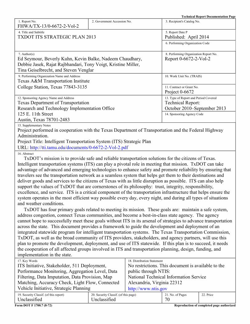
Technical Report Documentation Page 1. Report No. FHWA/TX-13/0-6672-2-Vol-2 2. Government Accession No. 3. Recipient's Catalog No. 4. Title and Subtitle TXDOT ITS STRATEGIC PLAN 2013 5. Report Date P Published: April 2014 6. Performing Organization Code 7. Author(s) Ed Seymour, Beverly Kuhn, Kevin Balke, Nadeem Chaudhary, Debbie Jasek, Rajat Rajbhandari, Tony Voigt, Kristine Miller, Tina Geiselbrecht, and Steven Venglar 8. Performing Organization Report No. Report 0-6672-2-Vol-2 9. Performing Organization Name and Address Texas A&M Transportation Institute College Station, Texas 77843-3135 10. Work Unit No. (TRAIS) 11. Contract or Grant No. Project 0-6672 12. Sponsoring Agency Name and Address Texas Department of Transportation Research and Technology Implementation Office 125 E. 11th Street Austin, Texas 78701-2483 13. Type of Report and Period Covered Technical Report: October 2010–September 2013 14. Sponsoring Agency Code 15. Supplementary Notes Project performed in cooperation with the Texas Department of Transportation and the Federal Highway Administration. Project Title: Intelligent Transportation System (ITS) Strategic Plan URL: http://tti.tamu.edu/documents/0-6672-2-Vol-2.pdf 16. Abstract TxDOT’s mission is to provide safe and reliable transportation solutions for the citizens of Texas. Intelligent transportation systems (ITS) can play a pivotal role in meeting that mission. TxDOT can take advantage of advanced and emerging technologies to enhance safety and promote reliability by ensuring that travelers see the transportation network as a seamless system that helps get them to their destinations and deliver goods and services to the citizens of Texas with as little disruption as possible. ITS can also help support the values of TxDOT that are cornerstones of its philosophy: trust, integrity, responsibility, excellence, and service. ITS is a critical component of the transportation infrastructure that helps ensure the system operates in the most efficient way possible every day, every night, and during all types of situations and weather conditions. TxDOT has four primary goals related to meeting its mission. These goals are: maintain a safe system, address congestion, connect Texas communities, and become a best-in-class state agency. The agency cannot hope to successfully meet these goals without ITS in its arsenal of strategies to advance transportation across the state. This document provides a framework to guide the development and deployment of an integrated statewide program for intelligent transportation systems. The Texas Transportation Commission, TxDOT, as well as the broad community of ITS providers, stakeholders, and agency partners, will use this plan to promote the development, deployment, and use of ITS statewide. If this plan is to succeed, it needs the cooperation of all affected groups involved in ITS and transportation planning, design, funding, and implementation in the state. 17. Key Words ITS Initiative, Stakeholder, 511 Deployment, Performance Monitoring, Aggregation Level, Data Filtering, Data Imputation, Data Provision, Map Matching, Accuracy Check, Light Flow, Connected Vehicle Initiative, Strategic Planning 18. Distribution Statement No restrictions. This document is available to the public through NTIS: National Technical Information Service Alexandria, Virginia 22312 http://www.ntis.gov 19. Security Classif. (of this report) Unclassified 20. Security Classif. (of this page) Unclassified 21. No. of Pages 70 22. Price Form DOT F 1700.7 (8-72) Reproduction of completed page authorized
Transcript of TxDOT ITS Strategic Plan 2013 - static.tti.tamu.edu · Report 0-6672-2-Vol-2 . Project 0-6672 ....
Technical Report Documentation Page 1. Report No. FHWA/TX-13/0-6672-2-Vol-2
2. Government Accession No.
3. Recipient's Catalog No.
4. Title and Subtitle TXDOT ITS STRATEGIC PLAN 2013
5. Report Date PPublished: April 2014 6. Performing Organization Code
7. Author(s) Ed Seymour, Beverly Kuhn, Kevin Balke, Nadeem Chaudhary, Debbie Jasek, Rajat Rajbhandari, Tony Voigt, Kristine Miller, Tina Geiselbrecht, and Steven Venglar
8. Performing Organization Report No. Report 0-6672-2-Vol-2
9. Performing Organization Name and Address Texas A&M Transportation Institute College Station, Texas 77843-3135
10. Work Unit No. (TRAIS) 11. Contract or Grant No. Project 0-6672
12. Sponsoring Agency Name and Address Texas Department of Transportation Research and Technology Implementation Office 125 E. 11th Street Austin, Texas 78701-2483
13. Type of Report and Period Covered Technical Report: October 2010–September 2013 14. Sponsoring Agency Code
15. Supplementary Notes Project performed in cooperation with the Texas Department of Transportation and the Federal Highway Administration. Project Title: Intelligent Transportation System (ITS) Strategic Plan URL: http://tti.tamu.edu/documents/0-6672-2-Vol-2.pdf 16. Abstract
TxDOT’s mission is to provide safe and reliable transportation solutions for the citizens of Texas. Intelligent transportation systems (ITS) can play a pivotal role in meeting that mission. TxDOT can take advantage of advanced and emerging technologies to enhance safety and promote reliability by ensuring that travelers see the transportation network as a seamless system that helps get them to their destinations and deliver goods and services to the citizens of Texas with as little disruption as possible. ITS can also help support the values of TxDOT that are cornerstones of its philosophy: trust, integrity, responsibility, excellence, and service. ITS is a critical component of the transportation infrastructure that helps ensure the system operates in the most efficient way possible every day, every night, and during all types of situations and weather conditions.
TxDOT has four primary goals related to meeting its mission. These goals are: maintain a safe system, address congestion, connect Texas communities, and become a best-in-class state agency. The agency cannot hope to successfully meet these goals without ITS in its arsenal of strategies to advance transportation across the state. This document provides a framework to guide the development and deployment of an integrated statewide program for intelligent transportation systems. The Texas Transportation Commission, TxDOT, as well as the broad community of ITS providers, stakeholders, and agency partners, will use this plan to promote the development, deployment, and use of ITS statewide. If this plan is to succeed, it needs the cooperation of all affected groups involved in ITS and transportation planning, design, funding, and implementation in the state. 17. Key Words ITS Initiative, Stakeholder, 511 Deployment, Performance Monitoring, Aggregation Level, Data Filtering, Data Imputation, Data Provision, Map Matching, Accuracy Check, Light Flow, Connected Vehicle Initiative, Strategic Planning
18. Distribution Statement No restrictions. This document is available to the public through NTIS: National Technical Information Service Alexandria, Virginia 22312 http://www.ntis.gov
19. Security Classif. (of this report) Unclassified
20. Security Classif. (of this page) Unclassified
21. No. of Pages 70
22. Price
Form DOT F 1700.7 (8-72) Reproduction of completed page authorized

TXDOT ITS STRATEGIC PLAN 2013
by
Ed Seymour, Ph.D., P.E.
Associate Director
Beverly Kuhn, Ph.D., P.E. Senior Research Engineer
Kevin Balke, Ph.D., P.E.
Research Engineer
Nadeem Chaudhary, Ph.D., P.E. Senior Research Engineer
Debbie Jasek
Research Specialist
Rajat Rajbhandari, Ph.D., P.E. Associate Research Engineer
Tony Voigt, P.E.
Research Engineer
Kristine Miller Associate Transportation Researcher
Tina Geiselbrecht
Associate Research Scientist
Steven Venglar, P.E. Research Engineer
Report 0-6672-2-Vol-2 Project 0-6672
Project Title: Intelligent Transportation System (ITS) Strategic Plan
Performed in cooperation with the Texas Department of Transportation
and the Federal Highway Administration
Published: April 2014
TEXAS A&M TRANSPORTATION INSTITUTE College Station, Texas 77843-3135

v
DISCLAIMER
This research was performed in cooperation with the Texas Department of Transportation
(TxDOT) and the Federal Highway Administration (FHWA). The contents of this report reflect
the views of the authors, who are responsible for the facts and the accuracy of the data presented
herein. The contents do not necessarily reflect the official view or policies of the FHWA or
TxDOT. This report does not constitute a standard, specification, or regulation.
The United States Government and the State of Texas do not endorse products or
manufacturers. Trade or manufacturers’ names appear herein solely because they are considered
essential to the object of this report.
vi
ACKNOWLEDGMENTS
This project was conducted in cooperation with TxDOT and FHWA. The authors
appreciate the guidance provided by the Project Director Carol Rawson and the Project
Monitoring Committee team: Natalie Bettger, Stuart Corder, Rick Cortez, Brian Fariello,
Charlie Farnham, Edgar Fino, Meg Moore, and Jack Whaley.
vii
TABLE OF CONTENTS
Page List of Figures ............................................................................................................................... ix List of Tables ................................................................................................................................. x Executive Summary ..................................................................................................................... xi Chapter 1: Introduction ............................................................................................................... 1
Statewide Mission and Values .................................................................................................. 1 Agency Goals ............................................................................................................................ 2 Agency Capabilities .................................................................................................................. 2 Document Purpose .................................................................................................................... 3
Chapter 2: ITS Strategic Plan Goals and Objectives ................................................................ 5 TxDOT ITS Strategic Plan Goals, Objectives, and Strategies .................................................. 5
Goal: Maintain a Safe System............................................................................................ 5 Goal: Address Congestion ................................................................................................. 6 Goal: Connect Texas Communities ................................................................................... 7 Goal: Become a Best-in-Class State Agency ..................................................................... 7
Relationship to TxDOT Agency Strategic Plan ........................................................................ 8 Chapter 3: ITS Priorities............................................................................................................ 13 Chapter 4: National Trends in ITS Strategies ......................................................................... 19
Connected Vehicles ................................................................................................................ 19 Time Frame ....................................................................................................................... 19 Public Agency Participation ............................................................................................. 20
511........................................................................................................................................... 20 Private Sector Data ................................................................................................................. 22 Funding, Procurement, and Partnerships ................................................................................ 24
State Funding .................................................................................................................... 24 Alternative Transportation Funding Sources .................................................................... 26 Alternative Contracting Mechanisms ............................................................................... 28 Alternative Funding Options............................................................................................. 30 ITS Asset Management ..................................................................................................... 31
Chapter 5: Status of Regional ITS in Texas ............................................................................. 33 Current ITS Deployment and Coordination ............................................................................ 33 Regional ITS Needs Summary ................................................................................................ 34
Traffic Signal Needs ......................................................................................................... 36 DMS Needs ....................................................................................................................... 38 Camera and Video Needs.................................................................................................. 38 Incident Management Needs ............................................................................................. 39 Traveler Information Needs .............................................................................................. 39 Institutional Needs ............................................................................................................ 40 Data Needs ........................................................................................................................ 41 Commercial Vehicle Needs .............................................................................................. 41 Private Data Needs ............................................................................................................ 41 Special Texas Border Needs ............................................................................................. 42 Future Leadership ............................................................................................................. 42
viii
Chapter 6: Anticipated ITS Services......................................................................................... 43 Using the National ITS Architecture ...................................................................................... 43 ITS Strategic Plan Goal: Maintain a Safe System ................................................................. 44 ITS Strategic Plan Goal: Address Congestion ....................................................................... 46 ITS Strategic Plan Goal: Connect Texas Communities ......................................................... 47 ITS Strategic Plan Goal: Become a Best-in-Class Agency ................................................... 47
Chapter 7: Candidate ITS Archetype ....................................................................................... 49 Concept of Operations ............................................................................................................ 49 Operations and Maintenance Personnel .................................................................................. 51 Role of the Traffic Operations Division ................................................................................. 52 Role of Districts ...................................................................................................................... 53 Role of Local Partners ............................................................................................................ 53
References .................................................................................................................................... 55
ix
LIST OF FIGURES
Page Figure 1. Current TxDOT ITS Implementation and Coordination. ............................................. 14 Figure 2. Potential TxDOT ITS Implementation and Coordination. ........................................... 15 Figure 3. States with 511 Deployments. ...................................................................................... 21 Figure 4. Distribution of ITS Need Types. .................................................................................. 37
x
LIST OF TABLES
Page Table 1. TxDOT Agency Safety Objectives and TxDOT ITS Safety Objectives. ........................ 9 Table 2. TxDOT Agency Congestion Objectives and TxDOT ITS Congestion
Objectives. .............................................................................................................................. 10 Table 3. TxDOT Agency Objectives and TxDOT ITS Objectives for Connecting Texas
Communities. .......................................................................................................................... 11 Table 4. TxDOT Agency Objectives and TxDOT ITS Objectives for Becoming a Best-
in-Class State Agency. ............................................................................................................ 12 Table 5. Summary of Data Provider Information. ....................................................................... 23 Table 6. Agency ITS Funding, Budget Trends in the U.S. by Agency Type, 2010 (15)............. 25 Table 7. Transportation Finance Mechanisms (17). .................................................................... 26 Table 8. Summary of ITS Deployment by Device/System. ......................................................... 34 Table 9. Needs Related to Traffic Signals. .................................................................................. 37 Table 10. DMS Needs. ................................................................................................................. 38 Table 11. Camera- and Video-Related Needs. ............................................................................. 38 Table 12. Incident Management Needs. ...................................................................................... 39 Table 13. Traveler Information Needs. ........................................................................................ 39 Table 14. Institutional Needs. ...................................................................................................... 40 Table 15. Identified Regional Data Needs. .................................................................................. 41 Table 16. Commercial Vehicle Needs. ........................................................................................ 41 Table 17. Needs for Private Data. ................................................................................................ 42 Table 18. Unique Needs of the Texas–Mexico Border. ............................................................... 42 Table 19. Alignment of National ITS Goals with TxDOT ITS Goals. ........................................ 44
xi
EXECUTIVE SUMMARY
TxDOT’s mission is to provide safe and reliable transportation solutions for the citizens
of Texas. Intelligent transportation systems (ITS) can play a pivotal role in meeting that mission.
TxDOT can take advantage of advanced and emerging technologies to enhance safety and
promote reliability by ensuring that travelers see the transportation network as a seamless system
that helps get them to their destinations and deliver goods and services to the citizens of Texas
with as little disruption as possible. ITS can also help support the values of TxDOT that are
cornerstones of its philosophy: trust, integrity, responsibility, excellence, and service. ITS are a
critical component of the transportation infrastructure that helps ensure the system operates in
the most efficient way possible every day, every night, and during all types of situations and
weather conditions.
TxDOT has four primary goals related to meeting its mission. These goals are: maintain
a safe system, address congestion, connect Texas communities, and become a best-in-class state
agency. The agency cannot hope to successfully meet these goals without ITS in its arsenal of
strategies to advance transportation across the state. This document provides a framework to
guide the development and deployment of an integrated statewide program for intelligent
transportation systems. The Texas Transportation Commission, TxDOT, as well as the broad
community of ITS providers, stakeholders, and agency partners will use this plan to promote the
development, deployment, and use of ITS statewide. If this plan is to succeed, it needs the
cooperation of all impacted groups involved in ITS and transportation planning, design, funding,
and implementation across the state. The TxDOT ITS Strategic Plan 2013:
• Provides concise ITS strategic plan goals and objectives for TxDOT.
• Highlights the ITS priorities from the regional and local perspective.
• Summarizes national trends in ITS strategies.
• Presents a status report on regional ITS in Texas.
• Introduces anticipated ITS services that TxDOT may need in the future.
• Presents a candidate ITS archetype as potential guidance for moving forward with ITS
across the state.

1
CHAPTER 1: INTRODUCTION
According to the Texas Department of Transportation (TxDOT) 2013–2017 Strategic
Plan, the State of Texas has as its mission to be “limited, efficient, and completely accountable”
(1). As part of that statewide mission, the state places a focus on critical priorities, of which
transportation and mobility for its citizens is one. This priority is a linchpin in the goal to foster
opportunity and economic prosperity. The following sections highlight how intelligent
transportation systems (ITS) fit within the overall framework of TxDOT’s Strategic Plan and how
this plan helps meet its statewide mission for Texas.
STATEWIDE MISSION AND VALUES
TxDOT’s mission is to provide safe and reliable transportation solutions for the citizens
of Texas (1). ITS can play a pivotal role in meeting that mission. TxDOT can take advantage of
advanced and emerging technologies to enhance safety and promote reliability by ensuring that
travelers see the transportation network as a seamless system that helps get them to their
destinations and deliver goods and services to the citizens of Texas with as little disruption as
possible. ITS can also help support the values of TxDOT that are cornerstones of its philosophy:
trust, integrity, responsibility, excellence, and service (1). ITS are a critical component of the
transportation infrastructure that helps ensure the system operates in the most efficient way
possible every day, every night, and during all types of situations and weather conditions. For
travelers, it:
• Helps them get to their destinations without getting lost.
• Alerts them to changing weather and traffic conditions that may impact their trip.
• Helps offer multimodal choices in congested corridors.
• Helps ensure a reliable trip.
• Even helps them evacuate in times of emergency.
Thus, ITS is an essential element of the TxDOT value system that needs to be sustainable
into the future to help TxDOT attain its overall mission and vision in a cost-effective manner.
2
AGENCY GOALS
TxDOT has four primary goals related to meeting its mission. These goals are: maintain
a safe system, address congestion, connect Texas communities, and become a best-in-class state
agency. The agency cannot hope to successfully meet these goals without ITS in its arsenal of
strategies to advance transportation across the state. For example, maintaining a safe system
translates into reducing crashes and fatalities, reducing the likelihood of crashes involving both
travelers and transportation workers, and helping facilitate safe evacuation efforts in the event of
emergencies. ITS in their various forms can help address these safety challenges. Congestion
continues to grow on Texas’ urban and suburban roadways. Regions can work to grapple with
this problem by deploying ITS solutions that help optimize the existing infrastructure and make
the most of every square foot of pavement and every installed device that help manage traffic.
Furthermore, ensuring that ITS are part of the connectivity between communities can help foster
collaboration and efficient use of the infrastructure along major corridors that serve key regions
of the state and beyond. Finally, incorporating ITS into every aspect of TxDOT’s traffic
management approach helps ensure that every tax dollar from the citizens of Texas is used to
optimize the valuable assets in the transportation system and help TxDOT be a forward-thinking
and proactive agency that promotes the development and deployment of innovative traffic
management concepts and technologies to take Texas into the future and meet the challenges and
demands of a growing population.
AGENCY CAPABILITIES
The trend in managing the transportation infrastructure is reflected in the AASHTO
Systems Operations and Management Guidance (2). This guidance reflects a set of strategies
that an agency can use to anticipate and manage traffic congestion while minimizing the other
unpredictable causes of service disruption, delay, and crashes (2). Related to this guidance is a
tool under development for the Federal Highway Administration (FHWA) that an agency can use
to determine its capability specifically related to traffic management (3). An agency that has
mature capabilities in the arena of traffic management exhibits various characteristics that
support this operational objective. Logically, ITS play a key role in developing these
capabilities.

3
The following presents a brief list of specific capabilities involving ITS that can help
TxDOT meet its vision.
• An agency’s traffic management operations and maintenance (O&M) budget that
includes ITS is one that is a performance-based, zero-based budgeting process to support
continuous traffic management operations and maintenance based on expected
performance outcomes.
• Traffic management capital improvement projects that include ITS are funded as an
integral part of all projects, regardless of origin and support. These resources are also
available for traffic management projects that do not involve major construction.
• Traffic management response plans are dynamically deployed and system-wide, 24/7
based on measured and predicted impacts, all of which are facilitated with ITS.
• Traffic management decisions are made using decision support systems relying on
real-time data with predictive capabilities that are made possible with ITS technologies.
• New advanced systems and technology are deployed and can integrate seamlessly into
existing systems.
• Deployed technological infrastructure is used to manage traffic, and system coverage is
comprehensive with high levels of automation.
• ITS regional architectures are fully utilized, routinely updated, and are used as guidance
in implementation.
• Measurement of traffic management performance is conducted on a continual and
automated basis, and data acquisition includes all sources of data, both in the private and
public sectors.
DOCUMENT PURPOSE
This document provides a framework to guide the development and deployment of an
integrated statewide program for ITS. The Texas Transportation Commission, TxDOT, as well
as the broad community of ITS providers, stakeholders, and agency partners, will use this plan to
promote the development, deployment, and use of ITS statewide. If this plan is to succeed, it
needs the cooperation of all affected groups involved in ITS and transportation planning, design,
funding, and implementation in the state.
4
The TxDOT ITS Strategic Plan 2013:
• Provides concise ITS strategic plan goals and objectives for TxDOT.
• Highlights the ITS priorities from the regional and local perspective.
• Summarizes national trends in ITS strategies.
• Presents a status report on regional ITS in Texas.
• Introduces anticipated ITS services that TxDOT may need in the future.
• Presents a candidate ITS archetype as potential guidance for moving forward with ITS
across the state.
5
CHAPTER 2: ITS STRATEGIC PLAN GOALS AND OBJECTIVES
The TxDOT ITS Strategic Plan supports the goals and objectives of the TxDOT agency
Strategic Plan. It has the same four goals as the TxDOT Strategic Plan:
• Maintain a safe system.
• Address congestion.
• Connect Texas communities.
• Become a best-in-class state agency (1).
For some ITS objectives, specific strategies have been identified to further describe the
objective.
The ITS Strategic Plan goals, objectives, and strategies are listed below. They have been
prepared with input from both TxDOT agency staff and from partner agencies throughout the
state.
TXDOT ITS STRATEGIC PLAN GOALS, OBJECTIVES, AND STRATEGIES
The following sections outline key objectives that fall under each of the four goals of the
ITS Strategic Plan. Each objective also has a list of strategies that, when implemented, help
TxDOT meet the higher objective and goal in support of the agency Strategic Plan.
Goal: Maintain a Safe System
The following objectives are integral to ITS playing a role in maintaining a safe system
for the citizens of Texas.
• Objective: Deploy and operate ITS technologies and services to reduce crashes and
fatalities.
o Strategy: Deploy and operate ITS services that provide incident management,
traffic control, emergency management, and other safety-related capabilities.
o Strategy: Use ITS in high-accident locations and areas of high congestion to
improve safety and increase traveler information.
6
o Strategy: Expand the use of ITS by TxDOT and their contractors in construction
zones to reduce the potential for crashes and improve worker safety.
o Strategy: Incorporate the use of ITS systems and services in major evacuation
efforts to both monitor events and share information with the public.
• Objective: Manage ITS infrastructure and services as an asset.
o Strategy: Use ITS for data collection to support safety performance measures.
o Strategy: Fill in critical gaps in ITS in TxDOT districts and along strategic routes
using TxDOT, partner, or private-sector resources.
Goal: Address Congestion
Two primary objectives listed below can enable TxDOT to address congestion within the
transportation network across the state.
• Objective: Deploy and operate ITS technologies and services to provide travel and traffic
management services.
o Strategy: Deploy and operate ITS services that provide pre-trip, en-route, and
travel-demand management capabilities through public- and/or private-sector
paths.
o Strategy: Deploy and operate ITS traffic management services to effectively
manage the capacity of the roadway system.
o Strategy: Provide active management of traffic and other progressive solutions
services that can improve travel reliability and predictability.
• Objective: Work cooperatively with regional partners to provide regional ITS solutions,
systems, and staffing.
o Strategy: Support ITS services that enable public transit.
o Strategy: Develop standard ITS operating procedures and systems that are
consistent with regional needs and that serve the TxDOT Strategic Plan.
o Strategy: Assign adequate staff and equipment resources to traffic management
and maintenance operations to provide effective working relationships and
performance outcomes.
7
Goal: Connect Texas Communities
TxDOT can meet the goal of connecting Texas communities by meeting the three
objectives described below.
• Objective: Deploy and operate strategic corridors and regions to enhance the economic
development, mobility, and safety.
o Strategy: Partner with private-sector, multimodal travel information providers to
effectively reach different users in these strategic corridors.
o Strategy: Provide interoperability of roadway toll revenue collections, including
parking, within the state and between neighboring states.
• Objective: Deploy ITS in a cost-effective and beneficial manner that includes innovative
services and technologies.
o Strategy: Deploy compatible ITS software and systems to make operations
seamless across district boundaries.
o Strategy: Locate computer control elements of ITS technologies in larger urban
centers that can provide supplemental staffing to rural districts.
o Strategy: Incorporate automated and semi-automated decision support systems
into the ITS software and systems.
• Objective: Deploy ITS systems and technologies that facilitate the efficient movement of
freight and goods along strategic, high-volume freight corridors, including border
crossings.
o Strategy: Understand and address the freight community’s needs for information.
o Strategy: Deploy ITS to provide more seamless information to the freight
community.
Goal: Become a Best-in-Class State Agency
To reach the goal of being a best-in-class state agency, TxDOT can work to achieve the
three key objectives that follow.
• Objective: Deploy equipment and staffing of ITS services in a cost-effective manner.
8
o Strategy: Continually evaluate the financial and service implications of
alternative business models for ITS, including private-sector ownership and
operations.
o Strategy: Provide dedicated funding for ITS so that operations and maintenance
can be planned and costs are identified.
o Strategy: Develop a consistent performance monitoring system that computes
operations, safety, and resource savings benefits of all TxDOT ITS deployments.
• Objective: Anticipate local and regional service needs and plan the services to
accommodate those needs.
o Strategy: Implement and operate communications systems that can be shared
with partner agencies and that meet the requirements of ITS services as the
marketplace develops.
o Strategy: Provide a forum at the state and/or regional level for TxDOT and
partner agency staff to share ITS knowledge, experience, and needs.
• Objective: Participate in connected vehicle and automated vehicle activities that will
improve economic competitiveness for Texas.
o Strategy: Participate in test beds, pilot programs, demonstration programs, and
other venues that will allow Texas to effectively prepare for and engage in these
transformational technologies.
o Strategy: Identify and address institutional and policy issues that can facilitate
successful ventures in the connected vehicle efforts.
RELATIONSHIP TO TXDOT AGENCY STRATEGIC PLAN
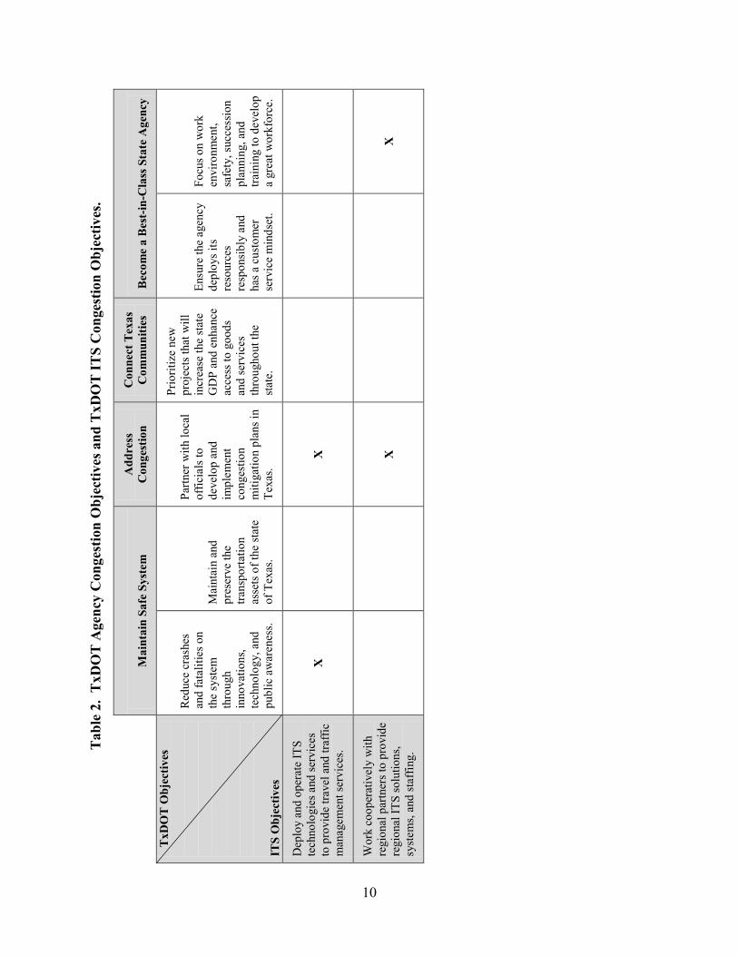
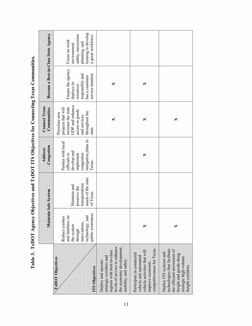
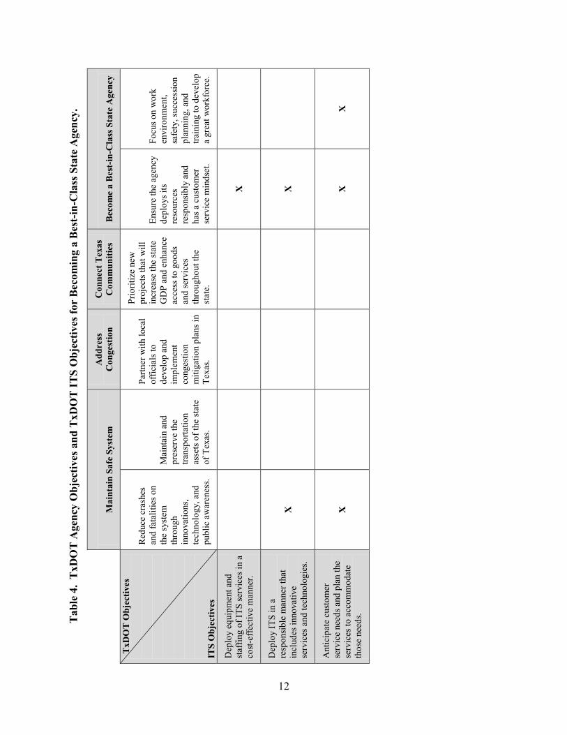
As noted earlier, the goals of the TxDOT ITS Strategic Plan are the same as the goals of
the TxDOT Strategic Plan. The following four tables cross-reference the objectives between the
two strategic plans (Table 1: safety objectives; Table 2: congestion objectives; Table 3:
objectives for connecting Texas communities; and Table 4: objectives for becoming a best-in-
class state agency).
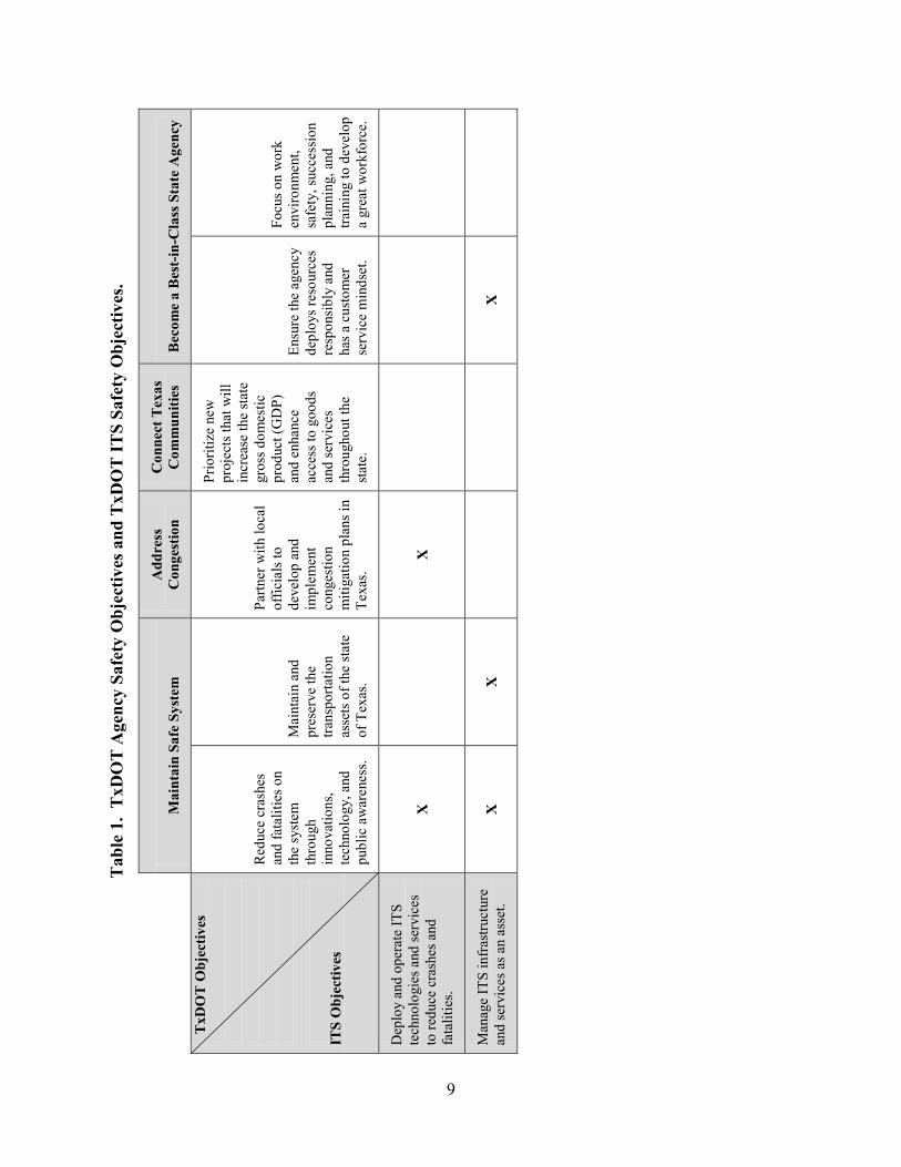
9
Tab
le 1
. T
xDO
T A
genc
y Sa
fety
Obj
ectiv
es a
nd T
xDO
T IT
S Sa
fety
Obj
ectiv
es.
M
aint
ain
Safe
Sys
tem
A
ddre
ss
Con
gest
ion
Con
nect
Tex
as
Com
mun
ities
B
ecom
e a
Bes
t-in
-Cla
ss S
tate
Age
ncy
T
xDO
T O
bjec
tives
IT
S O
bjec
tives
Red
uce
cras
hes
and
fata
litie
s on
the
syst
em
thro
ugh
inno
vatio
ns,
tech
nolo
gy, a
nd
publ
ic a
war
enes
s.
Mai
ntai
n an
d pr
eser
ve th
e tra
nspo
rtatio
n as
sets
of t
he st
ate
of T
exas
.
Partn
er w
ith lo
cal
offic
ials
to
deve
lop
and
impl
emen
t co
nges
tion
miti
gatio
n pl
ans i
n Te
xas.
Prio
ritiz
e ne
w
proj
ects
that
will
in
crea
se th
e st
ate
gros
s dom
estic
pr
oduc
t (G
DP)
an
d en
hanc
e ac
cess
to g
oods
an
d se
rvic
es
thro
ugho
ut th
e st
ate.
Ensu
re th
e ag
ency
de
ploy
s res
ourc
es
resp
onsi
bly
and
has a
cus
tom
er
serv
ice
min
dset
.
Focu
s on
wor
k en
viro
nmen
t, sa
fety
, suc
cess
ion
plan
ning
, and
tra
inin
g to
dev
elop
a
grea
t wor
kfor
ce.
Dep
loy
and
oper
ate
ITS
tech
nolo
gies
and
serv
ices
to
redu
ce c
rash
es a
nd
fata
litie
s.
X
X
Man
age
ITS
infr
astru
ctur
e an
d se
rvic
es a
s an
asse
t. X
X
X
10
Tab
le 2
. T
xDO
T A
genc
y C
onge
stio
n O
bjec
tives
and
TxD
OT
ITS
Con
gest
ion
Obj
ectiv
es.
M
aint
ain
Safe
Sys
tem
A
ddre
ss
Con
gest
ion
Con
nect
Tex
as
Com
mun
ities
B
ecom
e a
Bes
t-in
-Cla
ss S
tate
Age
ncy
T
xDO
T O
bjec
tives
IT
S O
bjec
tives
Red
uce
cras
hes
and
fata
litie
s on
the
syst
em
thro
ugh
inno
vatio
ns,
tech
nolo
gy, a
nd
publ
ic a
war
enes
s.
Mai
ntai
n an
d pr
eser
ve th
e tra
nspo
rtatio
n as
sets
of t
he st
ate
of T
exas
.
Partn
er w
ith lo
cal
offic
ials
to
deve
lop
and
impl
emen
t co
nges
tion
miti
gatio
n pl
ans i
n Te
xas.
Prio
ritiz
e ne
w
proj
ects
that
will
in
crea
se th
e st
ate
GD
P an
d en
hanc
e ac
cess
to g
oods
an
d se
rvic
es
thro
ugho
ut th
e st
ate.
Ensu
re th
e ag
ency
de
ploy
s its
re
sour
ces
resp
onsi
bly
and
has a
cus
tom
er
serv
ice
min
dset
.
Focu
s on
wor
k en
viro
nmen
t, sa
fety
, suc
cess
ion
plan
ning
, and
tra
inin
g to
dev
elop
a
grea
t wor
kfor
ce.
Dep
loy
and
oper
ate
ITS
tech
nolo
gies
and
serv
ices
to
pro
vide
trav
el a
nd tr
affic
m
anag
emen
t ser
vice
s.
X
X
Wor
k co
oper
ativ
ely
with
re
gion
al p
artn
ers t
o pr
ovid
e re
gion
al IT
S so
lutio
ns,
syst
ems,
and
staf
fing.
X
X
11
Tab
le 3
. T
xDO
T A
genc
y O
bjec
tives
and
TxD
OT
ITS
Obj
ectiv
es fo
r C
onne
ctin
g T
exas
Com
mun
ities
.
M
aint
ain
Safe
Sys
tem
A
ddre
ss
Con
gest
ion
Con
nect
Tex
as
Com
mun
ities
B
ecom
e a
Bes
t-in
-Cla
ss S
tate
Age
ncy
TxD
OT
Obj
ectiv
es
ITS
Obj
ectiv
es
Red
uce
cras
hes
and
fata
litie
s on
the
syst
em
thro
ugh
inno
vatio
ns,
tech
nolo
gy, a
nd
publ
ic a
war
enes
s.
Mai
ntai
n an
d pr
eser
ve th
e tra
nspo
rtatio
n as
sets
of t
he st
ate
of T
exas
.
Partn
er w
ith lo
cal
offic
ials
to
deve
lop
and
impl
emen
t co
nges
tion
miti
gatio
n pl
ans i
n Te
xas.
Prio
ritiz
e ne
w
proj
ects
that
will
in
crea
se th
e st
ate
GD
P an
d en
hanc
e ac
cess
to g
oods
an
d se
rvic
es
thro
ugho
ut th
e st
ate.
Ensu
re th
e ag
ency
de
ploy
s its
re
sour
ces
resp
onsi
bly
and
has a
cus
tom
er
serv
ice
min
dset
.
Focu
s on
wor
k en
viro
nmen
t, sa
fety
, suc
cess
ion
plan
ning
, and
tra
inin
g to
dev
elop
a
grea
t wor
kfor
ce.
Dep
loy
and
oper
ate
stra
tegi
c co
rrid
ors a
nd
regi
ons w
ith b
est-i
n-cl
ass
leve
ls o
f ser
vice
to e
nhan
ce
the
econ
omic
dev
elop
men
t, m
obili
ty, a
nd sa
fety
.
X
X
Parti
cipa
te in
con
nect
ed
vehi
cle
and
auto
mat
ed
vehi
cle
activ
ities
that
will
im
prov
e ec
onom
ic
com
petit
iven
ess f
or T
exas
.
X
X
X
X
Dep
loy
ITS
syst
ems a
nd
tech
nolo
gies
that
faci
litat
e th
e ef
ficie
nt m
ovem
ent o
f fr
eigh
t and
goo
ds a
long
st
rate
gic
high
-vol
ume
frei
ght c
orrid
ors.
X
X
12
Tab
le 4
. T
xDO
T A
genc
y O
bjec
tives
and
TxD
OT
ITS
Obj
ectiv
es fo
r B
ecom
ing
a B
est-i
n-C
lass
Sta
te A
genc
y.
M
aint
ain
Safe
Sys
tem
A
ddre
ss
Con
gest
ion
Con
nect
Tex
as
Com
mun
ities
B
ecom
e a
Bes
t-in
-Cla
ss S
tate
Age
ncy
TxD
OT
Obj
ectiv
es
ITS
Obj
ectiv
es
Red
uce
cras
hes
and
fata
litie
s on
the
syst
em
thro
ugh
inno
vatio
ns,
tech
nolo
gy, a
nd
publ
ic a
war
enes
s.
Mai
ntai
n an
d pr
eser
ve th
e tra
nspo
rtatio
n as
sets
of t
he st
ate
of T
exas
.
Partn
er w
ith lo
cal
offic
ials
to
deve
lop
and
impl
emen
t co
nges
tion
miti
gatio
n pl
ans i
n Te
xas.
Prio
ritiz
e ne
w
proj
ects
that
will
in
crea
se th
e st
ate
GD
P an
d en
hanc
e ac
cess
to g
oods
an
d se
rvic
es
thro
ugho
ut th
e st
ate.
Ensu
re th
e ag
ency
de
ploy
s its
re
sour
ces
resp
onsi
bly
and
has a
cus
tom
er
serv
ice
min
dset
.
Focu
s on
wor
k en
viro
nmen
t, sa
fety
, suc
cess
ion
plan
ning
, and
tra
inin
g to
dev
elop
a
grea
t wor
kfor
ce.
Dep
loy
equi
pmen
t and
st
affin
g of
ITS
serv
ices
in a
co
st-e
ffect
ive
man
ner.
X
Dep
loy
ITS
in a
re
spon
sibl
e m
anne
r tha
t in
clud
es in
nova
tive
serv
ices
and
tech
nolo
gies
.
X
X
Ant
icip
ate
cust
omer
se
rvic
e ne
eds a
nd p
lan
the
serv
ices
to a
ccom
mod
ate
thos
e ne
eds.
X
X
X

13
CHAPTER 3: ITS PRIORITIES
Researchers conducted initial and follow-up interviews with stakeholders in various
regions across the state, including:
• TxDOT district staff from Austin, Beaumont, Bryan, Corpus Christi, Dallas, El Paso, Fort
Worth, Laredo, Lufkin, Pharr, San Antonio, and Wichita Falls.
• City staff from Austin, Bryan, Kingsville, McAllen, San Antonio, Wichita Falls.
• Metropolitan Planning Organizations in Austin, Corpus Christi, Dallas-Fort Worth,
Harlingen-San Benito, and Wichita Falls.
• Transit agencies in College Station, McAllen, and San Antonio.
• Other agencies involved in transportation, including police and fire departments, public
works, DPS, and U.S. Customs and Border Protection.
During initial interviews, stakeholders were provided with maps showing current TxDOT
ITS implementation and coordination. The current ITS implementation and coordination map
shows four primary districts with full or partial Lonestar™ implementation, 11 other districts
supported by the primary districts, seven districts with ITS implementation, and three districts
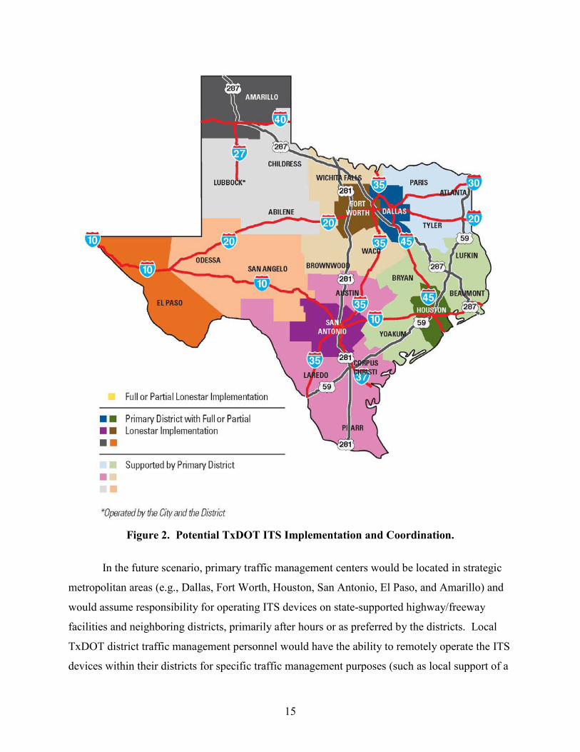
with no ITS implementation (see Figure 1). One candidate ITS scenario brought to stakeholders
for consideration during follow-up interviews was consolidation of the operations of core
TxDOT ITS functions into several primary traffic management centers (see Figure 2). This
scenario was intended to serve as a starting point for discussions regarding potential
regionalization of ITS across Texas.

14
Figure 1. Current TxDOT ITS Implementation and Coordination.
15
Figure 2. Potential TxDOT ITS Implementation and Coordination.
In the future scenario, primary traffic management centers would be located in strategic
metropolitan areas (e.g., Dallas, Fort Worth, Houston, San Antonio, El Paso, and Amarillo) and
would assume responsibility for operating ITS devices on state-supported highway/freeway
facilities and neighboring districts, primarily after hours or as preferred by the districts. Local
TxDOT district traffic management personnel would have the ability to remotely operate the ITS
devices within their districts for specific traffic management purposes (such as local support of a
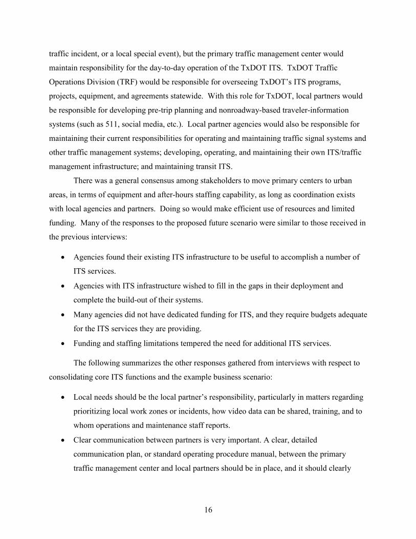
16
traffic incident, or a local special event), but the primary traffic management center would
maintain responsibility for the day-to-day operation of the TxDOT ITS. TxDOT Traffic
Operations Division (TRF) would be responsible for overseeing TxDOT’s ITS programs,
projects, equipment, and agreements statewide. With this role for TxDOT, local partners would
be responsible for developing pre-trip planning and nonroadway-based traveler-information
systems (such as 511, social media, etc.). Local partner agencies would also be responsible for
maintaining their current responsibilities for operating and maintaining traffic signal systems and
other traffic management systems; developing, operating, and maintaining their own ITS/traffic
management infrastructure; and maintaining transit ITS.
There was a general consensus among stakeholders to move primary centers to urban
areas, in terms of equipment and after-hours staffing capability, as long as coordination exists
with local agencies and partners. Doing so would make efficient use of resources and limited
funding. Many of the responses to the proposed future scenario were similar to those received in
the previous interviews:
• Agencies found their existing ITS infrastructure to be useful to accomplish a number of
ITS services.
• Agencies with ITS infrastructure wished to fill in the gaps in their deployment and
complete the build-out of their systems.
• Many agencies did not have dedicated funding for ITS, and they require budgets adequate
for the ITS services they are providing.
• Funding and staffing limitations tempered the need for additional ITS services.
The following summarizes the other responses gathered from interviews with respect to
consolidating core ITS functions and the example business scenario:
• Local needs should be the local partner’s responsibility, particularly in matters regarding
prioritizing local work zones or incidents, how video data can be shared, training, and to
whom operations and maintenance staff reports.
• Clear communication between partners is very important. A clear, detailed
communication plan, or standard operating procedure manual, between the primary
traffic management center and local partners should be in place, and it should clearly
17
define when and under what circumstances local staff will take “control” of ITS systems,
as well as agreements for two-way communication.
• The Traffic Operations Division must have enough staff in place if it plans to approve
and handle all ITS procurement activities.
Many stakeholders felt that regionalization made sense for their area/district because
there would be more consistency and potentially more cost savings, which would ultimately lead
to more funding for ITS. However, several stakeholders raised concerns and had questions about
the proposed regionalization, such as:
• Will there be the ability to “customize” systems for local needs?
• How will resource allocation remain equitable?
• How will the duplication of efforts be addressed (i.e., websites, etc.)?
• Will there be a centralized 511 system for the state?
• How will the distance from a primary TMC affect the supported districts?
• How will hurricane evacuation situations be handled?
• Will the proposed alignment be reviewed to consider local needs? For instance, San
Antonio would support Laredo and Austin. Austin has very different needs than Laredo,
and already operates a 24/7 TMC.
• How will different agencies work together?
• How will this affect the traveling public?
• How will regional centers be able to respond without knowledge of local
issues/roadways/networks, etc.?
• How will regionalization be handled if it does not make sense in my area?
During the interviews, researchers also asked stakeholders what additional ITS services
they would like if funding were not a concern. There was an overall willingness to consider
additional ITS services throughout the state, and many regions would like to expand their ITS
system. ITS “wish list” responses included:
• Dedicated funding for ITS implementation.
• Regional training and workshops for ITS implementation.
18
• Seamless ITS infrastructure throughout corridors, especially those identified as Routes of
Significance.
• Additional dynamic message signs (DMS).
• Upgrade and/or replace aging equipment.
• Expansion of video and camera monitoring area to provide full coverage.
• Addition of a high-speed communications network.
• Real-time transit monitoring system.
• Variable speed-limit system.
• Regional traffic signal management system.
• The ability to provide traveler information via mobile devices.
• Upgrade and reestablish the Highway Advisory Radio System.
• The ability to stream videos.
• Queue/congestion warning system in work zones to prevent secondary crashes.
• Full integration with other agencies, especially other local partners.
• Improve low-water crossing warning systems.
• Signal priority equipment.
• Co-locate agencies.
• Increase dedicated ITS staff.
19
CHAPTER 4: NATIONAL TRENDS IN ITS STRATEGIES
CONNECTED VEHICLES
Over the past few years, the U.S. Department of Transportation (U.S. DOT) Research and
Innovative Technology Administration (RITA) initiated a series of connected vehicle research
initiatives. These initiatives include technologies, applications, policy and institutional issues,
and communications. This initiative parallels the ITS structure that was launched in the 1990s
with similar categories of activities.
U.S. DOT developed an architecture for ITS that defined the services it provides (i.e.,
market packages). In the connected vehicle realm, RITA is currently defining connected vehicle
applications for safety, mobility, and environmental services. In the ITS architecture, a
communications layer identifies the communications technologies and systems that support
information exchange. For connected vehicles, dedicated short-range communications (DSRC)
technology is being examined for vehicle-to-vehicle and for vehicle-to-infrastructure
applications. In both cases, an emphasis on institutional issues and topics is important because
of the desire to mainstream the initiative. The current applications in RITA’s research portfolio
are as follows:
• Vehicle-to-vehicle safety.
• Vehicle-to-infrastructure safety.
• Real-time data capture.
• Dynamic mobility applications.
• Environment.
• Road weather (4).
Time Frame
Currently, the connected vehicle initiative is in the research stage and RITA is providing
guidance. The high-level roadmaps that describe these initiatives typically run from 2010 to the
beginning of 2015. For instance, the roadmap applications for the environment define
foundational analysis in calendar year (CY) 2010–2012 and candidate application evaluation from
CY 2012–2014. Each of the roadmaps has a similar structure and timeline. However, in the case
20
of the vehicle-to-vehicle initiative, the research will provide supporting data for a National
Highway Traffic Safety Administration (NHTSA) rule-making decision. NHTSA anticipates that
vehicle-to-vehicle communications will support a new generation of motor vehicle safety systems
(5). The potential rule may set requirements for inclusion of vehicle-to-vehicle communications
in new vehicles.
The connected vehicle initiative might also include requirements for communications
from the vehicle to the roadside—for instance, to include the current or forthcoming signal light
status of a traffic signal for a safety application. In the connected vehicle research program, the
Signal Phase and Timing (SPaT) research initiative focuses on communicating traffic signal
information to mobile devices (4). These types of applications provide a need to communicate
with publicly owned infrastructure. The objective is to improve safety. However, a consequence
with today’s typical transportation business delivery models is that public agencies must also
provide the funds for the additional roadside equipment capability.
Public Agency Participation
At this time, few states and operating agencies are participating in the connected vehicle
initiative. Some states with a historical involvement in the automotive industry are active
partners with the U.S. Department of Transportation (U.S. DOT) research program. For
instance, Michigan is hosting a connected vehicle test bed in Detroit (6). Florida, California, and
New York have also hosted some connected vehicle initiatives. In Texas, Harris County is
considering the addition of traffic signal priority capability that is consistent with connected
vehicle technologies. In general, public agencies are not yet involved in this technology except
through minor, focused installations or through federally sponsored research initiatives.
511
Many states are currently providing 511-based traveler information. The U.S. DOT
website (7) identifies the states that have deployed 511. Operation of a 511 website is a routine
part of the 511 deployment process, and this website contains links to those 511 sites for 43
locations. Figure 3 shows the states that have implemented 511.
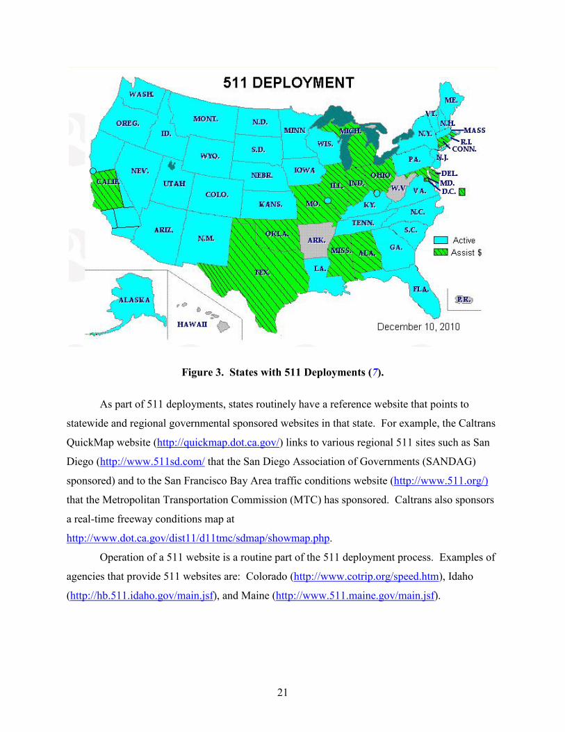
21
Figure 3. States with 511 Deployments (7).
As part of 511 deployments, states routinely have a reference website that points to
statewide and regional governmental sponsored websites in that state. For example, the Caltrans
QuickMap website (http://quickmap.dot.ca.gov/) links to various regional 511 sites such as San
Diego (http://www.511sd.com/ that the San Diego Association of Governments (SANDAG)
sponsored) and to the San Francisco Bay Area traffic conditions website (http://www.511.org/)
that the Metropolitan Transportation Commission (MTC) has sponsored. Caltrans also sponsors
a real-time freeway conditions map at
http://www.dot.ca.gov/dist11/d11tmc/sdmap/showmap.php.
Operation of a 511 website is a routine part of the 511 deployment process. Examples of
agencies that provide 511 websites are: Colorado (http://www.cotrip.org/speed.htm), Idaho
(http://hb.511.idaho.gov/main.jsf), and Maine (http://www.511.maine.gov/main.jsf).
22
PRIVATE SECTOR DATA
To effectively manage the use of transportation infrastructure and to inform travelers
about the existing and predicted roadway conditions, both infrastructure operators and travelers
require accurate and timely performance data. Traditionally, public agencies have deployed
vehicle sensors and cameras, and they have distributed this information to the public. The
business model has been as follows:
• Public-sector investment for performance monitoring and control.
• Public agencies distribute free information to travelers, other public agencies, and private
information providers.
This approach has been used since the late 1960s and 1970s when FHWA began investing
in the Urban Traffic Control System (UTCS) Project (8). However, private-sector companies
have recently begun to provide increasing amounts of data with increasing accuracy. For
example, INRIX® was spun out of Microsoft® research in 2004 (9), while NAVTEQ® began as a
privately held company in 1985 and became a publicly held company in 2004 (10). AirSage®
was founded in 2000 (11), and TomTom® was founded in 1991 (12).
Additionally, the growth of smart phones has provided an increasing number of
opportunities to monetize transportation information and ways to engage travelers in gathering
transportation information through social networking. The iPhone®, introduced in 2007, has
accelerated this environment (13). Many of the traffic applications for mobile devices are
supported on popular platforms including iPhone®, Android®, BlackBerry®, and others. For
example, INRIX Traffic is supported on the iPhone®, iPad®, and Android® (14).
In a recent study, the Texas A&M Transportation Institute, working under a Battelle
Technical Support and Assistance contract for FHWA’s Office of Transportation Operations,
developed a marketplace review of private-sector transportation service providers. In this study,
six private companies were surveyed, the results of which are presented in Table 5. Those
companies surveyed were AirSage, American Trucking Research Institute (ATRI)®, INRIX,
NAVTEQ, TomTom, and TrafficCast®.
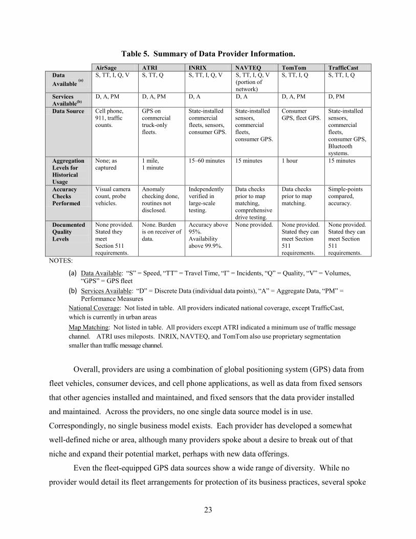
23
Table 5. Summary of Data Provider Information. AirSage ATRI INRIX NAVTEQ TomTom TrafficCast
Data Available
(a)
S, TT, I, Q, V S, TT, Q S, TT, I, Q, V S, TT, I, Q, V (portion of network)
S, TT, I, Q S, TT, I, Q
Services Available(b)
D, A, PM D, A, PM D, A D, A D, A, PM D, PM
Data Source Cell phone, 911, traffic counts.
GPS on commercial truck-only fleets.
State-installed commercial fleets, sensors, consumer GPS.
State-installed sensors, commercial fleets, consumer GPS.
Consumer GPS, fleet GPS.
State-installed sensors, commercial fleets, consumer GPS, Bluetooth systems.
Aggregation Levels for Historical Usage
None; as captured
1 mile, 1 minute
15–60 minutes 15 minutes 1 hour 15 minutes
Accuracy Checks Performed
Visual camera count, probe vehicles.
Anomaly checking done, routines not disclosed.
Independently verified in large-scale testing.
Data checks prior to map matching, comprehensive drive testing.
Data checks prior to map matching.
Simple-points compared, accuracy.
Documented Quality Levels
None provided. Stated they meet Section 511 requirements.
None. Burden is on receiver of data.
Accuracy above 95%. Availability above 99.9%.
None provided. None provided. Stated they can meet Section 511 requirements.
None provided. Stated they can meet Section 511 requirements.
NOTES:
(a) Data Available: “S” = Speed, “TT” = Travel Time, “I” = Incidents, “Q” = Quality, “V” = Volumes, “GPS” = GPS fleet
(b) Services Available: “D” = Discrete Data (individual data points), “A” = Aggregate Data, “PM” = Performance Measures
National Coverage: Not listed in table. All providers indicated national coverage, except TrafficCast, which is currently in urban areas Map Matching: Not listed in table. All providers except ATRI indicated a minimum use of traffic message channel. ATRI uses mileposts. INRIX, NAVTEQ, and TomTom also use proprietary segmentation smaller than traffic message channel.
Overall, providers are using a combination of global positioning system (GPS) data from
fleet vehicles, consumer devices, and cell phone applications, as well as data from fixed sensors
that other agencies installed and maintained, and fixed sensors that the data provider installed
and maintained. Across the providers, no one single data source model is in use.
Correspondingly, no single business model exists. Each provider has developed a somewhat
well-defined niche or area, although many providers spoke about a desire to break out of that
niche and expand their potential market, perhaps with new data offerings.
Even the fleet-equipped GPS data sources show a wide range of diversity. While no
provider would detail its fleet arrangements for protection of its business practices, several spoke
24
in general about the range of fleet types. From long-haul trucking to delivery vehicles to
taxicabs, providers have actively sought data from whatever fleets are available. Many spoke
about continuing to expand their fleet coverage as the best method of accessing additional data
points.
A number of providers spoke about the changing marketplace in terms of the amount of
data now available. While low availability of data used to be the paradigm a few years ago, the
new paradigm is the vast availability of data and the comparative richness of the sources. Some
providers spoke about past moves to change their models and business practices to actually
reduce the number of individual data sources, primarily migrating to consumer GPS information.
More than one provider spoke of receiving millions, if not billions, of individual data points per
day.
FUNDING, PROCUREMENT, AND PARTNERSHIPS
The ability for an agency to sufficiently fund projects is a changing landscape in today’s
economy. DOTs across the country are grappling with this question, and changes in existing
processes may be viable and/or new methods or improvements might need to be considered to
deliver more timely and nimble ITS deployment when there is a clear technological and
cost-effective advantage.
State Funding
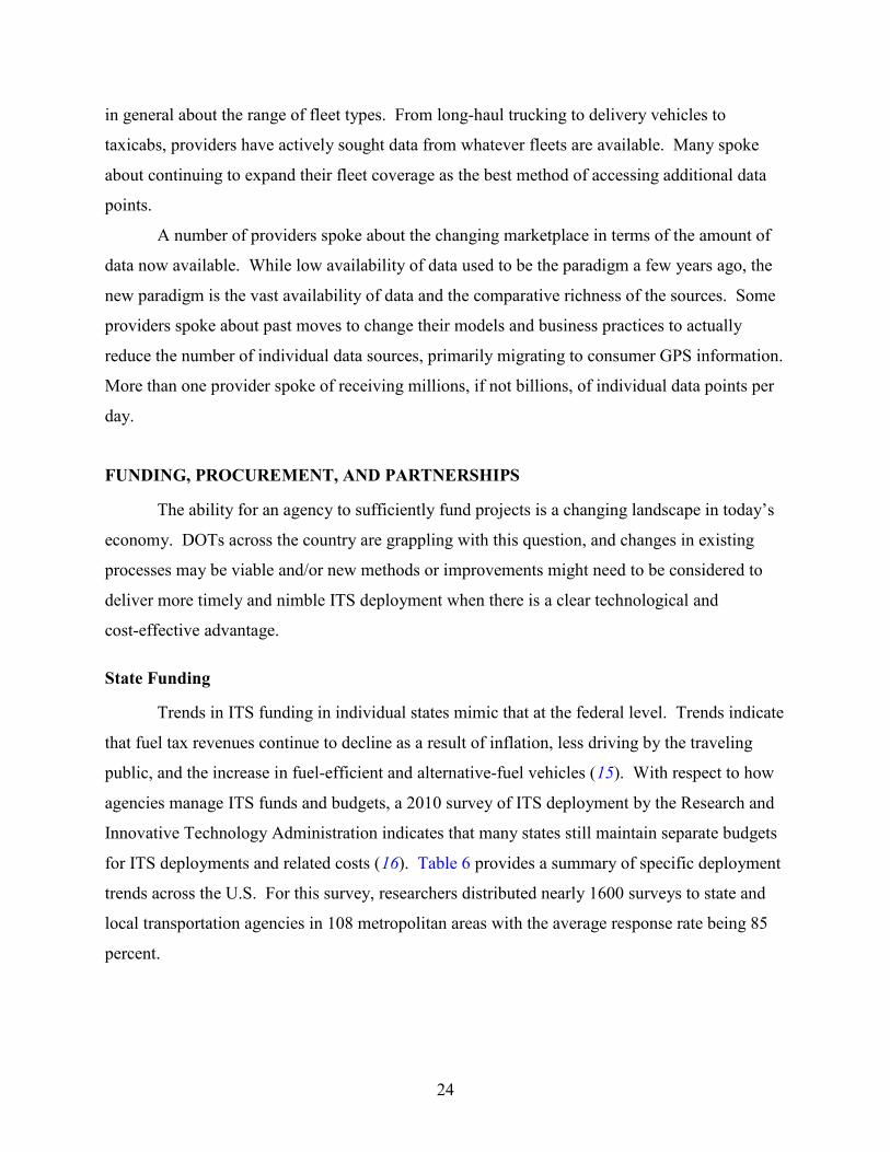
Trends in ITS funding in individual states mimic that at the federal level. Trends indicate
that fuel tax revenues continue to decline as a result of inflation, less driving by the traveling
public, and the increase in fuel-efficient and alternative-fuel vehicles (15). With respect to how
agencies manage ITS funds and budgets, a 2010 survey of ITS deployment by the Research and
Innovative Technology Administration indicates that many states still maintain separate budgets
for ITS deployments and related costs (16). Table 6 provides a summary of specific deployment
trends across the U.S. For this survey, researchers distributed nearly 1600 surveys to state and
local transportation agencies in 108 metropolitan areas with the average response rate being 85
percent.
25
Table 6. Agency ITS Funding, Budget Trends in the U.S. by Agency Type, 2010 (16).
Number of Agencies ITS Funding and Budget Practices
Freeway Management
Agencies
Toll Collection Agencies
Transportation Management
Centers
Arterial Management
Agencies
Transit Management
Agencies Separate Budget for ITS 83 39 134 76 26
Track Budget Separately for ITS Deployments
59 30 88 46 18
Track Budget Separately for ITS Operations and Maintenance
74 23 98 45 13
Track Budget Separately for Traffic Management or Operations Center
64 29 87 56 2
The National Conference on State Legislatures’ report on Transportation Funding and
Finance (15) highlights the following trends in funding and finance that impact an agency’s
ability to meet the demands of the transportation system:
• Revenues from fuel tax continue to decline for various reasons, including inflation, lower
VMs, and the increased use of fuel-efficient and alternative-fuel vehicles.
• States are more frequently considering general funds as a source of transportation
revenue.
• Some states are diverting transportation revenues to other budget categories to make up
for shortfalls.
• Tolling continues to increase in popularity as a source of revenue, with more than 30
states having some form of tolling on their transportation facilities.
• States are continuing to try and save money through more efficient project completion
and improved overall system performance.
• There is an increasing trend to borrow and leverage funds for transportation projects (15).
In recent years, local governments have stepped in to help with transportation funding as
states are finding their resources constrained. Local governments now are typically a major
source of transportation funding, providing about 30 percent of all highway funding (15). The
federal program continues to be uncertain. As of July 2012, federal surface transportation
26
programs have been reauthorized only for the next 27 months (17) and it is unclear what will
happen at the termination of Moving Ahead for Progress in the 21st Century (MAP-21).
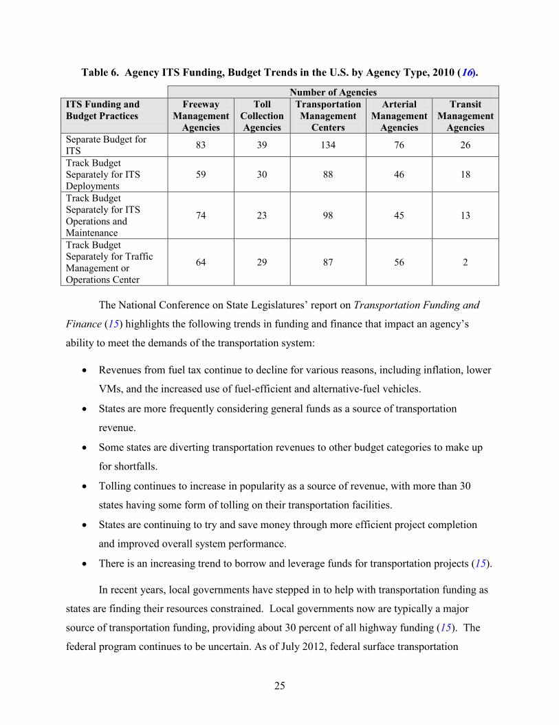
Alternative Transportation Funding Sources
A recent study of the National Conference of State Legislatures found that many states
are considering nontraditional sources of funding to meet their shortfalls in transportation. These
sources including leveraging revenues by issuing bonds, federal credit assistance, state
infrastructure banks, and public and private partnerships (18). Table 7 provides a summary of
the variety of mechanisms that agencies can and are using to leverage traditional funding sources
to meet shortfalls and accelerate transportation projects into reality.
Table 7. Transportation Finance Mechanisms (18).
Category Funding Mechanism State Bonding and Debt Instruments
Revenue Bonds General Obligation Bonds Hybrid Bonds
Public–Private Partnerships
Pass-Through Tolls/Shadow Tolling Availability Payments Design-Build-Finance-[Operate]-[Maintain] Delivery Models Build-[Own]-Operate-Transfer and Build-Transfer-Operate Delivery Models Long-Term Lease Concessions
Federal Debt Financing Tools
Grant Anticipation Revenue Vehicles (GARVEEs) Private Activity Bonds (PABs) Build America Bonds (BABs)
Federal Credit Assistance Tools
Transportation Infrastructure Finance and Innovation Act (TIFIA) State Infrastructure Banks (SIBs) Section 129 Loans
Federal-Aid Fund Management Tools
Advance Construction (AC) and Partial Conversion of Advance Construction (PCAC) Federal Aid Matching Strategies
Other Innovative Finance Mechanisms
Non-Federal Bonding and Debt Instruments Value Capture Arrangements such as Tax Increment Financing (TIF)
27
MAP-21 has a variety of provisions that directly impact these alternative funding sources
and can offer alternatives to TxDOT with respect to project funding and finance. These
measures include the following:
• Continue to provide the majority of federal-aid highway funds to the states through five
core programs:
o National Highway Performance Program.
o Transportation Mobility Program.
o National Freight Network Program.
o Congestion Mitigation and Air Quality Improvement Program (CMAQ).
o Highway Safety Improvement Program.
• Create a new title called America Fast Forward, which strengthens the TIFIA program to
leverage federal dollars farther than they have been stretched in the past.
• Remove barriers that previously limited states’ flexibility to invest in projects that fit
their specific needs and critical challenges.
• Establish an outcome-driven approach and improve the statewide and metropolitan
planning process to be performance-based and hold agencies accountable for improving
the condition and performance of their assets.
• Include reforms to help reduce project delivery time that include expanding the use of
innovative contracting methods (19).
In Texas in 2007, the 80th Legislative Session passed SB 1266. This bill allowed the
establishment of Transportation Reinvestment Zones (TRZs). Cities and counties are authorized
to designate TRZs to fund road projects. TRZs are not a tax increase; funding is captured from
increased property values within the designated TRZ. El Paso has used TRZs as a funding source
to complete projects recommended in the Comprehensive Mobility Plan.
Tax Increment Reinvestment Zones (TIRZs) are very similar to tax increment financing
and special assessment districts (SAD) in that special areas are created. As property values
increase in that area, the increased taxes are used exclusively in that area to fund improvements
to infrastructure. Districts can be designated to receive either partial or full portions of the
increased revenues.
28
As indicated in Table 7, states are gradually using a variety of public–private partnership
(PPP) mechanisms to finance transportation projects. These partnerships involve private-sector
financing, construction, maintenance, and/or operation of transportation projects. States have
increasingly turned to PPPs, which involve the private sector in project financing, construction,
maintenance, or operation. As of August 2012, 33 states and Puerto Rico have laws enabling
PPPs for highways and bridges (15).
The potential opportunities for utilizing PPPs exist in many areas within the
transportation program in general and can easily be expanded into the ITS realm. For example,
Section 1201 of SAFETEA-LU (Safe Accountable Flexible Efficient Transportation Equity Act:
A Legacy for Users) requires states to provide real-time system management information for
interstates by 2014 and other significant roadways by 2016 (20). Since a key component of this
provision involves data, it is possible that a PPP might be a logical approach to leveraging
private- and public-sector resources to meet the requirements and provide information to
agencies and the traveling public. Similar opportunities might exist within the purview of ITS as
agencies consider alternatives to providing the ITS infrastructure for the transportation system.
It is possible that many of these innovative finance mechanisms can be used to leverage
resources for ITS projects in Texas.
Alternative Contracting Mechanisms
With respect to ITS procurement, several alternative contracting mechanisms might offer
opportunities to optimize ITS operations in cost-effective ways. These mechanisms include job
order contracting, comprehensive development agreements, and public–private partnerships.
Job Order Contracting
Job order contracting allows the governing agency (city officials or TxDOT) to provide
the contractor with a contract that includes a negotiated and fixed price for the project. The
approach encourages contractors to bid on a project based on the required labor, material, and
procurement costs. The contractor receives work orders that include a specified completion date
in an effort to ensure all tasks are completed within a modest amount of time, keeping the project
on schedule (21). Currently, no major legal impediments exist with respect to job order
contracting as long as TxDOT adheres to other restrictions and regulations that may impact the
project. The following are best practices related to using this strategy:
29
• Utilize with projects that have high user costs during construction or will significantly
benefit users upon completion.
• Specifically define work restrictions in the contract that ensure regulations are followed.
• Assess the appropriateness of the technique prior to contract initiation.
• Ensure work schedule and incentives are in place to facilitate a successful project.
• Coordinate with multiple strategies if appropriate to optimize potential success (21).
Comprehensive Development Agreements
A comprehensive development agreement (CDA) allows a private company to perform
different combinations of design, development, finance, construction, maintenance, repair, and
operation. A CDA may be used for toll projects, improvement projects that include both tolled
and non-tolled lanes, improvement projects in which a private entity has an interest in the
project, or improvement projects financed wholly or partly with private activity bonds (22).
Public–Private Partnerships
States have increasingly used various public–private partnership mechanisms to finance
transportation projects. These partnerships involve private-sector financing, construction,
maintenance, and/or operation of transportation projects. As of August 2012, 33 states and
Puerto Rico have laws enabling PPPs for highways and bridges (Error! Bookmark not defined.).
The potential opportunities for utilizing PPPs exist in many areas within the
transportation program in general and can easily be expanded into the ITS realm. For example,
Section 1201 of SAFETEA-LU requires states to provide real-time system management
information for interstates by 2014 and other significant roadways by 2016 (20). Since a key
component of this provision involves data, it is possible that a PPP might be a logical approach
to leveraging private- and public-sector resources to meet the requirements and provide
information to agencies and the traveling public. There might be similar opportunities within the
purview of ITS as agencies consider alternatives to providing the ITS infrastructure for the
transportation system. It is possible that many of these innovative finance mechanisms can be
used to leverage resources for ITS projects in Texas.
30
Alternative Funding Options
The funding of operations and maintenance of ITS infrastructure and system is a
continual challenge for TxDOT. Aside from the aforementioned contracting mechanisms, a
variety of alternative funding options have potential to generate funding streams for ITS projects
and systems. The following sections discuss some of these strategies. Many of these options
would need to be approved prior to implementation to help maximize flexibility in financing
transportation and, specifically, ITS improvements in Texas.
• Driver license surcharge: an additional fee charged at the time of application or renewal
of a driver license dedicated solely to funding transportation (23).
• State sales tax on motor fuel: the application of the current state sales tax rate of
6.25 percent to gas and diesel purchases to be dedicated to transportation (24).
• Local option motor fuel tax: the levy of additional gas and diesel tax by local regions on
local fuels to be dedicated to transportation (25).
• Increased statewide motor fuels tax: an increase in the state fuel taxes specifically
dedicated to transportation (26).
• Index statewide motor fuels tax: the indexing of the state gas and diesel tax rate to either
the highway cost index or consumer price index to keep pace with the rate of inflation
and help meet funding shortfalls, which could be used to fund transportation (27).
• Increase state sales tax: an increase in the statewide sales tax dedicated to the highway
fund to support transportation (28).
• Tax increment financing: the establishment of a special district or region associated with
a roadway project where increases in property tax revenues are dedicated to service
bonds on the project (29).
• Local option vehicle registration: the levy of an additional vehicle registration fee that
would be collected and spent locally on transportation (30).
• Increase state vehicle registration: an increase in the state vehicle registration fee to be
spent on transportation (31).
31
• Motor vehicle sales tax: an increase in the dedication of the motor vehicle sales tax
dedicated to transportation (32).
• Vehicle miles traveled (VMT) fee: a fee charged to drivers based on the number of miles
each vehicle travels, directly related to road usage (33).
ITS Asset Management
Recent TxDOT research presents guidance for asset management, which could readily be
applied to ITS systems and equipment (34). The research presents a three-tiered structure to
capture the evolving management strategies that TxDOT considers critical to guiding future asset
management contractual activities. This structure can enhance the districts’ flexibility to manage
assets depending on the conditions and needs of each region. TxDOT’s proposed three-tiered
approach to asset management consists of:
• Total asset management for large urban areas encompassing multiple counties.
• Asset management of critical functions on a smaller regional scale.
• Asset management for specific types of assets.

33
CHAPTER 5: STATUS OF REGIONAL ITS IN TEXAS
This chapter presents a summary of the status of ITS and the inventory of devices in
various regions across the state. While the information does not provide extreme detail, it does
provide a picture of the state of ITS deployment in Texas in 2013.
CURRENT ITS DEPLOYMENT AND COORDINATION
The following is a list of ITS elements that stakeholders from across the state have
identified that are categorized as ITS. Table 8 further summarizes this device-related
information by listing those deployments present in three or more regions.
• Surveillance cameras of various types.
• Portable and permanent dynamic message signs.
• Detector (loops, microwave, video, Bluetooth, etc.).
• Weather stations.
• Flood, ice, and fog detection systems.
• Closed-loop, central, or adaptive signal control.
• Computer-aided dispatch for transit and emergency vehicles.
• Security cameras, automatic vehicle location (AVL) devices, data terminals, and GPS on
buses.
• Mobile data terminals and AVL on transit and emergency vehicles.
• Traffic signal preemption.
• Wired (including fiber) and wireless (Wi-Fi and radio-based) communications.
• Weigh-in-motion stations.
• Highway advisory radio.
• Warning systems (signal ahead, speed on curves, and school zones).
• Technology for information dissemination to users, including e-mail, text, and
reverse-911.
The information provided in Table 8 mostly reflects those deployments in rural and
smaller urban regions, though many of these devices are present in larger urban areas. CCTV
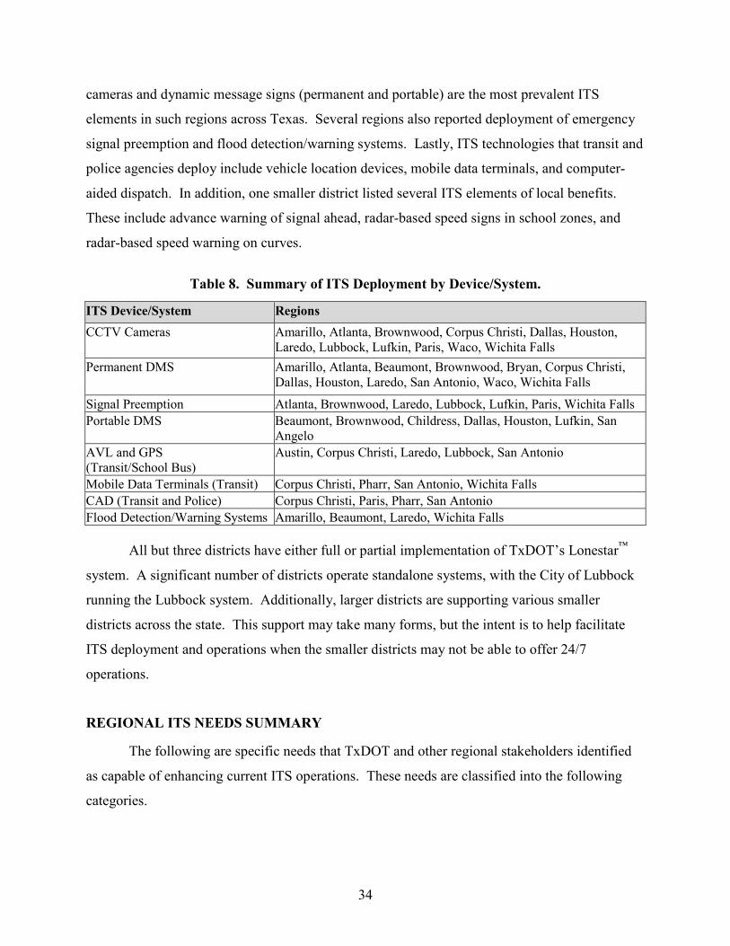
34
cameras and dynamic message signs (permanent and portable) are the most prevalent ITS
elements in such regions across Texas. Several regions also reported deployment of emergency
signal preemption and flood detection/warning systems. Lastly, ITS technologies that transit and
police agencies deploy include vehicle location devices, mobile data terminals, and computer-
aided dispatch. In addition, one smaller district listed several ITS elements of local benefits.
These include advance warning of signal ahead, radar-based speed signs in school zones, and
radar-based speed warning on curves.
Table 8. Summary of ITS Deployment by Device/System.
ITS Device/System Regions CCTV Cameras Amarillo, Atlanta, Brownwood, Corpus Christi, Dallas, Houston,
Laredo, Lubbock, Lufkin, Paris, Waco, Wichita Falls Permanent DMS Amarillo, Atlanta, Beaumont, Brownwood, Bryan, Corpus Christi,
Dallas, Houston, Laredo, San Antonio, Waco, Wichita Falls
Signal Preemption Atlanta, Brownwood, Laredo, Lubbock, Lufkin, Paris, Wichita Falls Portable DMS Beaumont, Brownwood, Childress, Dallas, Houston, Lufkin, San
Angelo AVL and GPS (Transit/School Bus)
Austin, Corpus Christi, Laredo, Lubbock, San Antonio
Mobile Data Terminals (Transit) Corpus Christi, Pharr, San Antonio, Wichita Falls CAD (Transit and Police) Corpus Christi, Paris, Pharr, San Antonio Flood Detection/Warning Systems Amarillo, Beaumont, Laredo, Wichita Falls
All but three districts have either full or partial implementation of TxDOT’s Lonestar™
system. A significant number of districts operate standalone systems, with the City of Lubbock
running the Lubbock system. Additionally, larger districts are supporting various smaller
districts across the state. This support may take many forms, but the intent is to help facilitate
ITS deployment and operations when the smaller districts may not be able to offer 24/7
operations.
REGIONAL ITS NEEDS SUMMARY
The following are specific needs that TxDOT and other regional stakeholders identified
as capable of enhancing current ITS operations. These needs are classified into the following
categories.
35
• Travel and traffic management.
• Institutional.
• Funding.
• Information management.
• Commercial vehicles.
• Other (communications, public transportation, etc.).
Types of needs in the Travel and Traffic Management category include:
• More cameras or DMS.
• Signal preemption.
• Access to cameras belonging to another agency.
• Improved information sharing between partner agencies.
• Faster incident identification and clearance.
• Improved information dissemination to work zone management.
• Data.
• Coordination of signals across jurisdictional boundaries.
Needs classified as Institutional include:
• Improved cooperation between regional stakeholders (including formal agreements).
• Regional architecture updating.
• Development of consistent policies.
• Improved communication between TxDOT division and districts.
• Improved communications between districts, especially those along key corridors.
• Improved processes for faster and more efficient ITS deployments.
Funding needs include additional and/or dedicated funding for deployment, operations,
and maintenance of ITS. Archived data needs were pooled under Information Management. The
needs such as truck weight and height enforcement were categorized as Commercial Vehicle
needs. Lastly, other needs included communications infrastructure, maintenance, emergency
management, and public transportation.
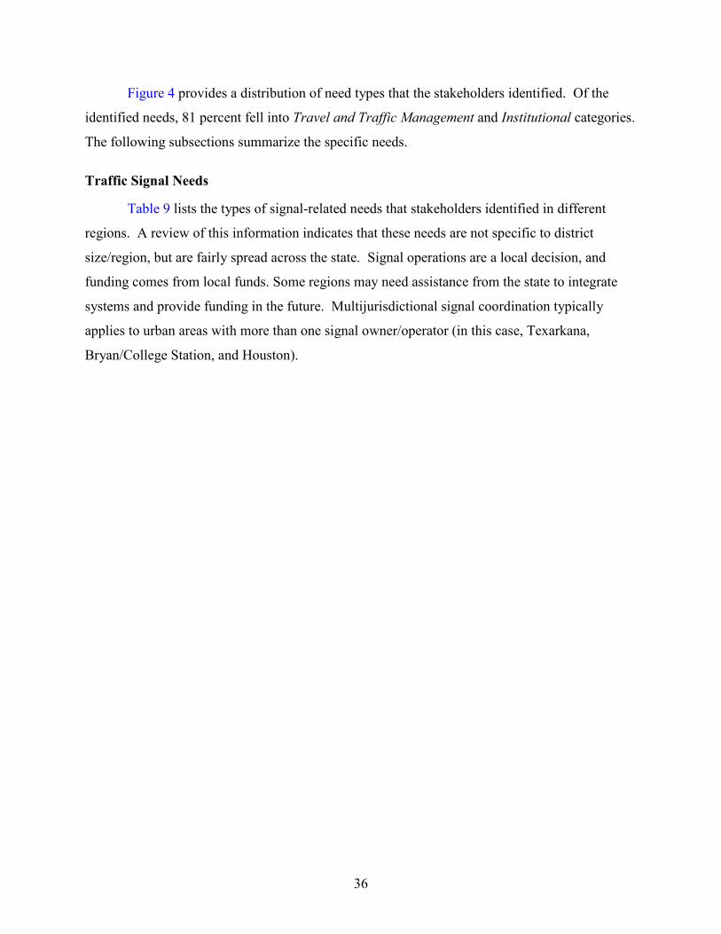
36
Figure 4 provides a distribution of need types that the stakeholders identified. Of the
identified needs, 81 percent fell into Travel and Traffic Management and Institutional categories.
The following subsections summarize the specific needs.
Traffic Signal Needs
Table 9 lists the types of signal-related needs that stakeholders identified in different
regions. A review of this information indicates that these needs are not specific to district
size/region, but are fairly spread across the state. Signal operations are a local decision, and
funding comes from local funds. Some regions may need assistance from the state to integrate
systems and provide funding in the future. Multijurisdictional signal coordination typically
applies to urban areas with more than one signal owner/operator (in this case, Texarkana,
Bryan/College Station, and Houston).
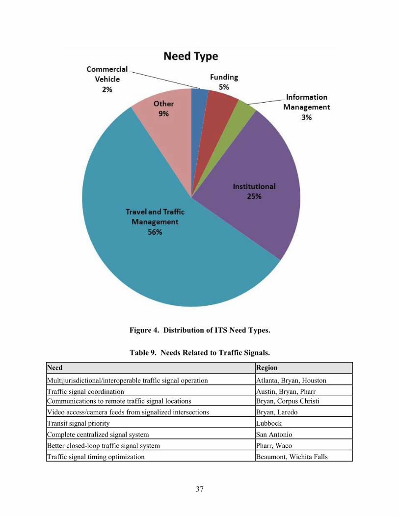
37
Figure 4. Distribution of ITS Need Types.
Table 9. Needs Related to Traffic Signals.
Need Region
Multijurisdictional/interoperable traffic signal operation Atlanta, Bryan, Houston Traffic signal coordination Austin, Bryan, Pharr Communications to remote traffic signal locations Bryan, Corpus Christi Video access/camera feeds from signalized intersections Bryan, Laredo Transit signal priority Lubbock Complete centralized signal system San Antonio Better closed-loop traffic signal system Pharr, Waco Traffic signal timing optimization Beaumont, Wichita Falls
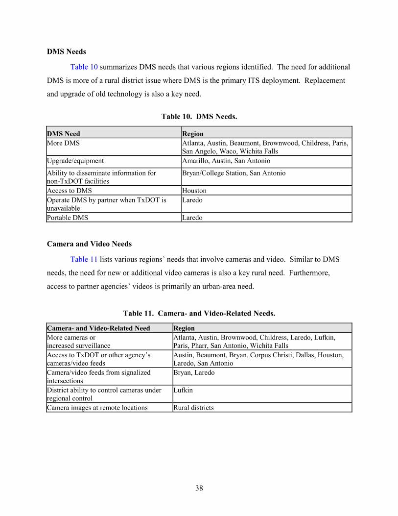
38
DMS Needs
Table 10 summarizes DMS needs that various regions identified. The need for additional
DMS is more of a rural district issue where DMS is the primary ITS deployment. Replacement
and upgrade of old technology is also a key need.
Table 10. DMS Needs.
DMS Need Region More DMS Atlanta, Austin, Beaumont, Brownwood, Childress, Paris,
San Angelo, Waco, Wichita Falls Upgrade/equipment Amarillo, Austin, San Antonio
Ability to disseminate information for non-TxDOT facilities
Bryan/College Station, San Antonio
Access to DMS Houston Operate DMS by partner when TxDOT is unavailable
Laredo
Portable DMS Laredo
Camera and Video Needs
Table 11 lists various regions’ needs that involve cameras and video. Similar to DMS
needs, the need for new or additional video cameras is also a key rural need. Furthermore,
access to partner agencies’ videos is primarily an urban-area need.
Table 11. Camera- and Video-Related Needs.
Camera- and Video-Related Need Region More cameras or increased surveillance
Atlanta, Austin, Brownwood, Childress, Laredo, Lufkin, Paris, Pharr, San Antonio, Wichita Falls
Access to TxDOT or other agency’s cameras/video feeds
Austin, Beaumont, Bryan, Corpus Christi, Dallas, Houston, Laredo, San Antonio
Camera/video feeds from signalized intersections
Bryan, Laredo
District ability to control cameras under regional control
Lufkin
Camera images at remote locations Rural districts
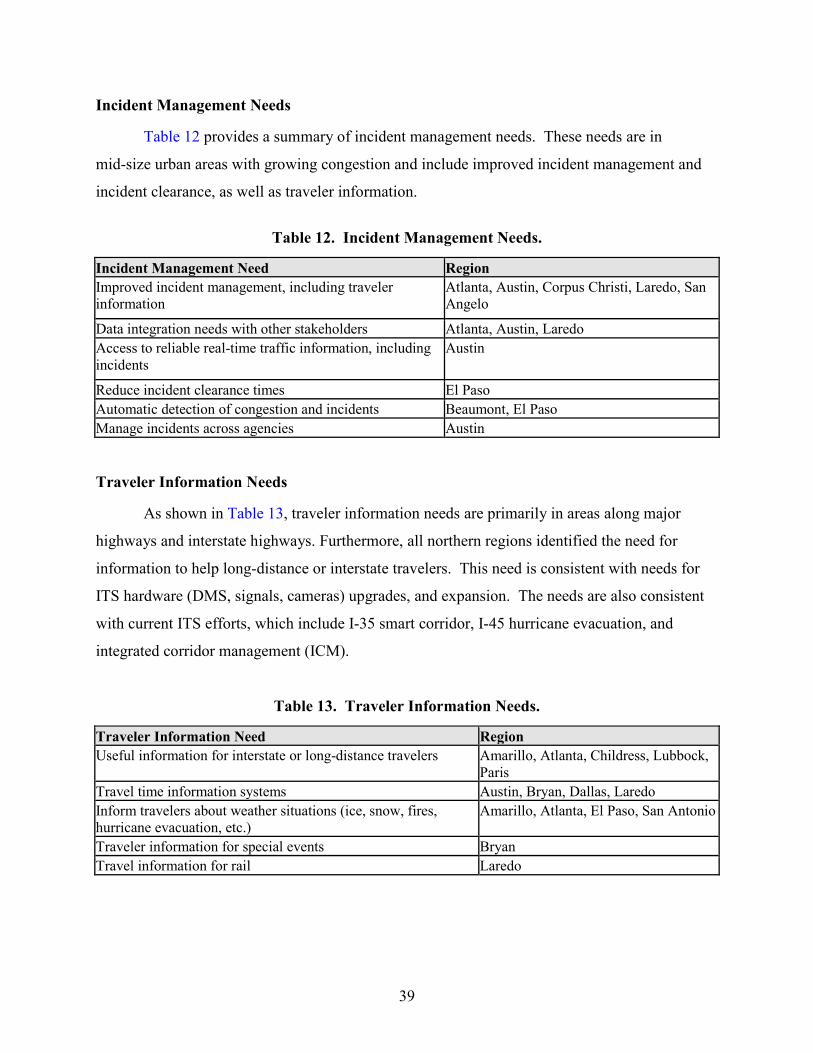
39
Incident Management Needs
Table 12 provides a summary of incident management needs. These needs are in
mid-size urban areas with growing congestion and include improved incident management and
incident clearance, as well as traveler information.
Table 12. Incident Management Needs.
Incident Management Need Region Improved incident management, including traveler information
Atlanta, Austin, Corpus Christi, Laredo, San Angelo
Data integration needs with other stakeholders Atlanta, Austin, Laredo Access to reliable real-time traffic information, including incidents
Austin
Reduce incident clearance times El Paso Automatic detection of congestion and incidents Beaumont, El Paso Manage incidents across agencies Austin
Traveler Information Needs
As shown in Table 13, traveler information needs are primarily in areas along major
highways and interstate highways. Furthermore, all northern regions identified the need for
information to help long-distance or interstate travelers. This need is consistent with needs for
ITS hardware (DMS, signals, cameras) upgrades, and expansion. The needs are also consistent
with current ITS efforts, which include I-35 smart corridor, I-45 hurricane evacuation, and
integrated corridor management (ICM).
Table 13. Traveler Information Needs.
Traveler Information Need Region Useful information for interstate or long-distance travelers Amarillo, Atlanta, Childress, Lubbock,
Paris Travel time information systems Austin, Bryan, Dallas, Laredo Inform travelers about weather situations (ice, snow, fires, hurricane evacuation, etc.)
Amarillo, Atlanta, El Paso, San Antonio
Traveler information for special events Bryan Travel information for rail Laredo
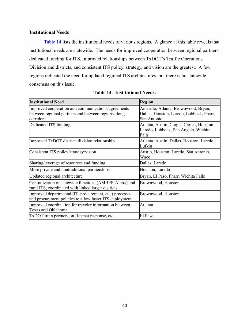
40
Institutional Needs
Table 14 lists the institutional needs of various regions. A glance at this table reveals that
institutional needs are statewide. The needs for improved cooperation between regional partners,
dedicated funding for ITS, improved relationships between TxDOT’s Traffic Operations
Division and districts, and consistent ITS policy, strategy, and vision are the greatest. A few
regions indicated the need for updated regional ITS architectures, but there is no statewide
consensus on this issue.
Table 14. Institutional Needs.
Institutional Need Region Improved cooperation and communications/agreements between regional partners and between regions along corridors.
Amarillo, Atlanta, Brownwood, Bryan, Dallas, Houston, Laredo, Lubbock, Pharr, San Antonio
Dedicated ITS funding Atlanta, Austin, Corpus Christi, Houston, Laredo, Lubbock, San Angelo, Wichita Falls
Improved TxDOT district–division relationship Atlanta, Austin, Dallas, Houston, Laredo, Lufkin
Consistent ITS policy/strategy/vision Austin, Houston, Laredo, San Antonio, Waco
Sharing/leverage of resources and funding Dallas, Laredo More private and nontraditional partnerships Houston, Laredo Updated regional architecture Bryan, El Paso, Pharr, Wichita Falls Centralization of statewide functions (AMBER Alerts) and rural ITS, coordinated with linked larger districts
Brownwood, Houston
Improved departmental (IT, procurement, etc.) processes, and procurement policies to allow faster ITS deployment.
Brownwood, Houston
Improved coordination for traveler information between Texas and Oklahoma
Atlanta
TxDOT train partners on Hazmat response, etc. El Paso
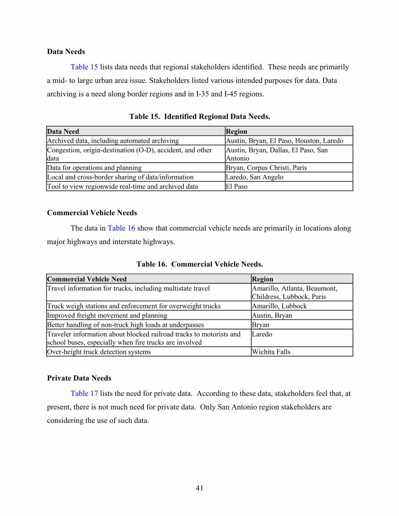
41
Data Needs
Table 15 lists data needs that regional stakeholders identified. These needs are primarily
a mid- to large urban area issue. Stakeholders listed various intended purposes for data. Data
archiving is a need along border regions and in I-35 and I-45 regions.
Table 15. Identified Regional Data Needs.
Data Need Region Archived data, including automated archiving Austin, Bryan, El Paso, Houston, Laredo Congestion, origin-destination (O-D), accident, and other data
Austin, Bryan, Dallas, El Paso, San Antonio
Data for operations and planning Bryan, Corpus Christi, Paris Local and cross-border sharing of data/information Laredo, San Angelo Tool to view regionwide real-time and archived data El Paso
Commercial Vehicle Needs
The data in Table 16 show that commercial vehicle needs are primarily in locations along
major highways and interstate highways.
Table 16. Commercial Vehicle Needs.
Commercial Vehicle Need Region Travel information for trucks, including multistate travel Amarillo, Atlanta, Beaumont,
Childress, Lubbock, Paris Truck weigh stations and enforcement for overweight trucks Amarillo, Lubbock Improved freight movement and planning Austin, Bryan Better handling of non-truck high loads at underpasses Bryan Traveler information about blocked railroad tracks to motorists and school buses, especially when fire trucks are involved
Laredo
Over-height truck detection systems Wichita Falls
Private Data Needs
Table 17 lists the need for private data. According to these data, stakeholders feel that, at
present, there is not much need for private data. Only San Antonio region stakeholders are
considering the use of such data.
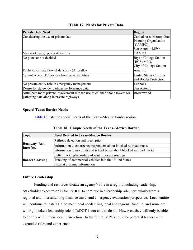
42
Table 17. Needs for Private Data.
Private Data Need Region Considering the use of private data Capital Area Metropolitan
Planning Organization (CAMPO), San Antonio MPO
May start charging private entities CAMPO No plans or not decided Bryan-College Station
(BCS) MPO, City of College Station
Public-to-private flow of data only (Amarillo) Amarillo Cannot accept ITS devices from private entities United States Customs
and Border Protection No private entity role in emergency management Lubbock Desire for statewide roadway performance data San Antonio Anticipate more private involvement like the use of cellular phone towers for gathering data along interstate highways
Brownwood
Special Texas Border Needs
Table 18 lists the special needs of the Texas–Mexico border region.
Table 18. Unique Needs of the Texas–Mexico Border.
Topic Need Related to Texas–Mexico Border
Roadway–Rail Interface
Railroad detection and preemption Information to emergency responders about blocked railroad tracks Information to motorists and school buses about blocked railroad tracks
Border Crossing Better tracking/recording of wait times at crossings Tracking of commercial vehicles into the United States Hazmat crossing information
Future Leadership
Funding and resources dictate an agency’s role in a region, including leadership.
Stakeholder expectation is for TxDOT to continue in a leadership role, particularly from a
regional and interstate/long-distance travel and emergency evacuation perspective. Local entities
will continue to install ITS to meet local needs using local and regional funding, and some are
willing to take a leadership role if TxDOT is not able to do so. However, they will only be able
to do this within their local jurisdiction. In the future, MPOs could be potential leaders with
expanded roles and experience.
43
CHAPTER 6: ANTICIPATED ITS SERVICES
Through the initiatives of the U.S. Department of Transportation, the ITS technical area
has developed a framework for describing ITS concepts including:
• The institutional considerations for ITS (e.g., institutions, policies, funding mechanisms,
and processes that are required for effective implementation, operation, and
maintenance).
• Transportation solution subsystems and interfaces.
• The communications required to exchange information between systems to support the
transportation solutions.
USING THE NATIONAL ITS ARCHITECTURE
The National ITS Architecture aligns very well with the goals of both the TxDOT
Strategic Plan and the TxDOT ITS Strategic Plan. The National ITS Architecture can be
approached from several starting points. One of those starting points is a planning perspective.
The National ITS Architecture website has a tab labeled “architecture use,” which has a
subordinate menu called “planning.” The planning page shows a graphic illustrating the use of
the National ITS Architecture in the transportation planning environment
(http://www.iteris.com/itsarch/html/archuse/planning.htm). Clicking on the “regional goals”
graphic element navigates to a page where planning goals are identified. See
http://www.iteris.com/itsarch/html/archuse/goals.htm. These National ITS Architecture goals
are very similar to the TxDOT ITS Strategic Plan goals as shown in the following table.
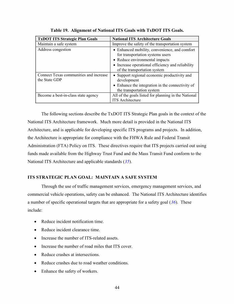
44
Table 19. Alignment of National ITS Goals with TxDOT ITS Goals.
TxDOT ITS Strategic Plan Goals National ITS Architecture Goals Maintain a safe system Improve the safety of the transportation system Address congestion
• Enhanced mobility, convenience, and comfort for transportation systems users
• Reduce environmental impacts • Increase operational efficiency and reliability
of the transportation system Connect Texas communities and increase the State GDP
• Support regional economic productivity and development
• Enhance the integration in the connectivity of the transportation system
Become a best-in-class state agency
All of the goals listed for planning in the National ITS Architecture
The following sections describe the TxDOT ITS Strategic Plan goals in the context of the
National ITS Architecture framework. Much more detail is provided in the National ITS
Architecture, and is applicable for developing specific ITS programs and projects. In addition,
the Architecture is appropriate for compliance with the FHWA Rule and Federal Transit
Administration (FTA) Policy on ITS. These directives require that ITS projects carried out using
funds made available from the Highway Trust Fund and the Mass Transit Fund conform to the
National ITS Architecture and applicable standards (35).
ITS STRATEGIC PLAN GOAL: MAINTAIN A SAFE SYSTEM
Through the use of traffic management services, emergency management services, and
commercial vehicle operations, safety can be enhanced. The National ITS Architecture identifies
a number of specific operational targets that are appropriate for a safety goal (36). These
include:
• Reduce incident notification time.
• Reduce incident clearance time.
• Increase the number of ITS-related assets.
• Increase the number of road miles that ITS cover.
• Reduce crashes at intersections.
• Reduce crashes due to road weather conditions.
• Enhance the safety of workers.
45
The TxDOT ITS Strategic Plan has two objectives that encompass these specific
operational outcomes, namely:
• Deploy and operate ITS technologies and services to reduce crashes and fatalities.
• Manage ITS infrastructure and services as an asset.
The National ITS Architecture identifies many service packages that TxDOT can pursue
to improve safety, including:
• ATMS08 Traffic Incident Management System.
• ATMS15 Railroad Operations Coordination.
• ATMS09 Transportation Decision Support and Demand Management.
• ATMS03 Traffic Signal Control.
• ATMS01 Network Surveillance (37).
As connected vehicle technologies mature, TxDOT will also be able to participate in the
infrastructure elements of the Intersection Collision Avoidance Service (AVSS10). In addition
to the traffic management services listed in the National ITS Architecture, Roadway Service
Patrols (National ITS Architecture Service EM04) can be added to assist with management of
incidents and reduce the likelihood of secondary crashes.
The effectiveness of TxDOT ITS for enhancing safety, mobility, and other needs are also
dependent on the extent of coverage within a region. Continuing to fill the gaps in field
equipment deployments such as CCTV cameras, sensors, and dynamic message signs can
enhance effectiveness.
For the widening of I-35 in Central Texas around Waco, TxDOT is using ITS technologies
to forecast travel time through construction zones and to warn about end-of-queues (38).
Expanded use of these technologies and of more conventional ITS construction services, such as
MC10 Maintenance and Construction Activity Coordination, are consistent with the TxDOT safety
goal.
The National ITS Architecture also has services that are appropriate for evacuation.
These include EM09 Evacuation and Reentry Management, and EM08 Disaster Response and
Recovery.

46
ITS STRATEGIC PLAN GOAL: ADDRESS CONGESTION
The National ITS Architecture identifies operational targets for addressing congestion
and increasing operational efficiency and reliability of the transportation system. These include:
• Decreasing the seconds of control delay per vehicle on arterial roads.
• Reducing delay associated with incidents.
• Reducing the time needed for responders to arrive on-scene after notification.
• Reducing the person hours (or vehicle hours) of delay associated with traffic incidents.
• Reducing carbon dioxide emissions.
• Ensuring that HOV lanes carry a targeted number of persons.
• Reducing the buffer index on the freeway system during peak and off-peak hours, etc.
The TxDOT ITS Strategic Plan has two objectives that encompass these specific
operational outcomes, namely:
• Deploy and operate ITS technologies and services to provide travel and traffic
management services.
• Work cooperatively with regional partners to provide regional ITS solutions, systems,
and staffing.
To achieve these operational targets, the National ITS Architecture identifies service
packages that TxDOT can pursue to improve congestion, including traveler information services
and traffic management services. These services include:
• ATIS01 Broadcast Traveler Information.
• ATIS02 Interactive Traveler Information.
• ATIS06 Transportation Operations Data Sharing.
• ATIS07 Travel Services Information and Reservation.
• ATIS08 Dynamic Ridesharing
• ATMS01 Network Surveillance.
• ATMS03 Traffic Signal Control.
• ATMS04 Traffic Metering.
• ATMS05 HOV Lane Management.
47
• ATMS07 Regional Traffic Management.
• ATMS08 Traffic Incident Management System.
• ATMS16 Parking Facility Management.
ITS STRATEGIC PLAN GOAL: CONNECT TEXAS COMMUNITIES
The National ITS Architecture identifies operational targets for connecting communities
to enhance economic vitality, increase accessibility and mobility of people and freight, and
enhance the connectivity of the transportation system. These include:
• Reducing the person hours (or vehicle hours) of delay.
• Providing freight operators with traveler alerts and alternate routes.
• Decreasing average crossing times at international borders.
• Reducing the average monetary cost of congestion per capita.
The TxDOT ITS Strategy has the following three goals that address these performance
targets:
• Deploy and operate strategic corridors and regions with best-in-class levels of service to
enhance the economic development, mobility, and safety.
• Participate in connected vehicle and automated vehicle activities that will improve
economic competitiveness for Texas.
• Deploy ITS systems and technologies that facilitate the efficient movement of freight and
goods along strategic, high-volume freight corridors.
ITS STRATEGIC PLAN GOAL: BECOME A BEST-IN-CLASS AGENCY
To become a best-in-class agency, the TxDOT ITS Strategic Plan emphasizes
• Setting up cost-effective performance targets for ITS.
• Using innovative services and technologies.
• Providing service that meets the needs and expectations of travelers.
48
The ITS Strategic Plan lists the following goals:
• Deploy equipment and staffing of ITS services in a cost-effective manner.
• Deploy ITS in a responsible manner that includes innovative services and technologies.
• Anticipate customer service needs and plan the services to accommodate those needs.
49
CHAPTER 7: CANDIDATE ITS ARCHETYPE
As TxDOT moves forward with securing the role of ITS as a critical element of
transportation operations, one possible enhancement to the current statewide approach is to
expand the concept of having primary traffic management centers in major metropolitan areas
supporting smaller districts. This concept assumes that at some point in the future, every district
will have some ITS implementation. The following sections highlight some of the major
concepts that might enable this archetype to become a reality. It is important to note that this is
just one way by which ITS can be managed in the future, and other archetypes could also be
developed that optimize resources and the overall network.
CONCEPT OF OPERATIONS
The concept of the archetype illustrated in Figure 2 is that TxDOT would consolidate the
operations of core ITS functions into several primary TMCs. These primary TMCs would
generally be located in strategic major metropolitan areas. These primary centers would assume
responsibility for operating ITS devices on state-supported highway/freeway facilities and
state-supported routes of significance in the major metropolitan areas, as well as the ITS devices
in neighboring TxDOT districts. Operation of neighboring districts would primarily be after-
hours or as preferred by the districts. TxDOT would operate these primary centers 24 hours per
day, seven days per week, and 365 days per year. These primary TMCs would support the
following core ITS functions:
• The operation of permanent DMS and other en-route traveler information systems.
• Freeway surveillance and traffic sensors systems.
• Traffic signal systems (if appropriate).
• Data archiving and performance measurement/reporting.
• Operation of dynamic traffic control devices, such as ramp meters and lane control
signals.
• Operation of active transportation and demand management (ATDM) technologies.
• Work-zone and construction-related ITS systems.
50
• Weather-responsive traffic management (such as winter weather events, or hurricane
evacuations).
• Coordination and potential sharing of assets (e.g., fiber).
• Implementation of pre-approved signal plans for local partners when appropriate.
• ITS performance monitoring and reporting.
At the local level, district traffic management personnel would have the ability to
remotely operate the ITS devices within their districts for specific traffic management purposes
(such as local support of a traffic incident, or a local special event), but the primary TMCs would
maintain responsibility for the day-to-day operation of the ITS systems. Each primary traffic
management center would work with local districts and local partners to develop traffic
management response plans and standard operating procedures for common traffic management
situations for the ITS systems within their area. To the extent possible, these response plans
would be consistent with policies and operating philosophies of individual districts and local
entities. Primary TMC operators would have override capability of locally implemented
responses to support high-priority regional or statewide traffic management objectives, unless the
local and primary centers (e.g., hurricane evacuation, major corridor incidents that span
jurisdictions) otherwise agreed.
Each primary traffic management center would be responsible for posting standard
messages for statewide alerts (e.g., AMBER, Silver, Blue) on dynamic message signs within
their purview. The operations of the state-managed dynamic message signs should follow usage
policies and standards established by the Traffic Operations Division. Each primary traffic
management center would also be responsible for providing traffic management support during
all traffic incidents on state-supported facilities in accordance with the agreed-upon traffic
management plan established by local districts and entities. They would also be responsible for
maintaining the ITS devices within their control.
Each primary management center would use the TxDOT statewide Lonestar™ Traffic
Management software system for the smaller districts within their region. Each primary center
would support a center-to-center connection with the TMCs of local entities to which they
connect within their region and maintain a center-to-center connection with neighboring
supported centers to ensure coordination of inter-regional or statewide traffic management
responses. Local entities would have the ability to share video to and from the primary TMCs.
51
These primary TMCs may establish policies on what TxDOT video can be shared with local
entities.
Each primary traffic management center would operate and maintain a regional data
warehouse for archiving ITS operation data or have an arrangement with a local agency to do so.
The data from each primary center would be made available to district and local entities to
support their long-range and operational planning activities. Local entities would develop their
own system to augment the data retained by the regions.
A statewide communication infrastructure would be developed for coordination between
primary TMCs and to support the installation of ITS devices and equipment along routes of
major significance. This would include rural interstates, major U.S. and state highways,
hurricane evacuation routes, etc. This infrastructure could also be used to support traffic signal
operations in local districts and transportation needs of local partners.
OPERATIONS AND MAINTENANCE PERSONNEL
Within the context of the candidate archetype, each primary TMC would have a person
responsible for regional TMC operations. Primary TMC directors would report to a designated
individual within the Traffic Operations Division. These primary TMC operations leaders would
be responsible for:
• Developing a staffing plan for operating and maintaining the ITS systems within the
region.
• Coordinating with district and local entity personnel to ensure that their ITS traffic
management needs are met.
• Coordinating the programming of capital projects for new system deployments or
expansions with area MPOs.
• Developing standard operating procedures and coordinated traffic management response
plans with local entities.
• Developing an operating and maintenance budget for ITS systems within the region,
including provisions for any leased communications services.
52
• Developing comprehensive replacement plans and a responsive and preventative
maintenance program for all the ITS devices supported by the primary center.
• Coordinating with local entities in the development of regional ITS architectures.
To ensure adequate staffing, some district personnel currently performing ITS operations and
maintenance functions would be transferred to the primary centers.
Primary centers would be housed administratively under TRF and would be responsible
for developing standard operating procedures for coordinating activities of local partners during
hurricane and other emergency events. These centers would coordinate the development of their
operating procedures with TRF, which would then have oversight responsibility during
evacuations and other emergencies of regional significance.
ROLE OF THE TRAFFIC OPERATIONS DIVISION
As part of the candidate archetype, TxDOT’s Traffic Operations Division (TRF) would
be responsible for overseeing TxDOT’s ITS programs, projects, equipment, and agreements
statewide as well as for developing and maintaining statewide ITS architecture governing the
design, deployment, operations, and maintenance of TxDOT’s primary TMCs. TRF would
develop, install, and maintain a communication infrastructure that permits regional centers to
share data and operations, and the communications network would be used to support center-to-
field communications with ITS device deployed on routes of significance throughout the state.
TRF would be responsible for developing, operating, and maintaining a centralized
website for disseminating regional and statewide traveler information, which would include a
whole host of information sources. Local agencies could continue to host and provide regional
websites that include the input of TxDOT. Furthermore, TRF would establish operation
performance standards for ITS devices and would be responsible for monitoring system
performance to ensure that devices conform to these operational standards.
TRF would manage a centralized ITS construction, maintenance, and operations budget
and would be responsible for the design, review, and approval of ITS plans, specifications, and
estimates (PS&E). However, districts would continue to be responsible for the construction of
highway projects with ITS elements and would coordinate submittals review and approval with
TRF. Construction of large-scale ITS deployment would continue to be supported through local
Surface Transportation Program (STP)/Congestion Mitigation and Air Quality Program funding
53
programs, and the participation of regional centers in model deployments would be coordinated
through TRF.
TRF would be responsible for developing and managing local operational and/or funding
agreements between the primary centers and local entities, and also provide administrative
support to each of the regions. It would be responsible for developing and maintaining an
inventory management/asset management system that the primary centers would use, and also
for providing a training program for ensuring that primary center staff members have the
knowledge, skills, and ability to perform their duties effectively. Finally, TRF would be
responsible for identifying and coordinating the development of new systems and system
modifications to address the needs of individual regions, and developing and implementing
policies related to sharing resources (including data, personnel, communications, and equipment)
with local partners.
ROLE OF DISTRICTS
Local districts have a role to play as well in the candidate archetype. They would work to
identify needs and operational issues that could potentially be addressed through ITS
deployments and coordinate with local partners to ensure that ITS projects are identified and
needs are addressed and then incorporated into the short-range (TIP) and long-range planning
processes. Local districts would incorporate ITS and communications infrastructure needs into
highway construction projects and continue to operate and maintain traffic signal systems and
other traffic management systems that the primary centers would manage.
ROLE OF LOCAL PARTNERS
Under this candidate archetype, local partners would be responsible for developing
pre-trip planning and nonroadway-based traveler information systems (such as 511, social media,
etc.). They would maintain their current responsibilities for operating and maintaining traffic
signal systems and other traffic management systems in accordance to current TxDOT policies,
and also be responsible for developing, operating, and maintaining their own ITS/traffic
management infrastructure. Local partners would also be encouraged to coordinate operations
and share information with regional centers.

55
REFERENCES
1. Texas Department of Transportation. 2013–2017 Strategic Plan. TxDOT Website. URL:
http://ftp.dot.state.tx.us/pub/txdot-info/oeo/strategic_plan2013.pdf. Accessed June 2013.
2. AASHTO. Systems Operations and Management Guidance. URL: http://aashtosomguidance.org/. Accessed June 2013.
3. FHWA. Traffic Management Capability Maturity Framework. To be published.
4. U.S. Department of Transportation, Federal Highway Administration, Research and Innovative Technology Administration. (2011). Intelligent Transportation Systems Joint Program Office. URL: http://www.its.dot.gov/, Accessed August 2013.
5. J. Harding. V2V. 2011. URL: http://www.nhtsa.gov/DOT/NHTSA/NRD/Multimedia/PDFs/Public%20Paper/Presentations/2009%20Meetings/Harding2009Hyundai.pdf, Accessed August 2013.
6. Krueger, G. VII Michigan Test Bed Program Concept of Operations. Lansing, MI: Michigan Department of Transportation, 2005. URL: http://www.michigan.gov/documents/MDOT_VII_Concept_of_Operations_139651_7.pdf. Accessed August 2013.
7. FHWA 511 Deployment Website. Federal Highway Administration, U.S. Depatment of Transportation. URL: http://www.fhwa.dot.gov/trafficinfo/511.htm, Accessed September 2013.
8. Gordon, R.L. and W. Tighe. Traffic Control Systems Handbook. Report No. FHWA-HOP-06-006. Washington, DC: Federal Highway Administration, U.S. Department of Transportation, 2005.
9. “INRIX Secures $10 Million in Oversubscribed Series B Round.” INRIX Press Release, May 2006. URL: http://www.inrix.com/pressrelease.asp?ID=9, Accessed August 2013.
10. “NAVTEQ History.” NAVTEQ Corporate Website. URL: http://corporate.navteq.com/company_history.htm. Accessed August 2013.
11. “AirSage Company Overview.” AirSage Corporate Website. URL: http://www.airsage.com/site/index.cfm?id_art=46580&actMenuItemID=22145&vsprache/EN/AIRSAGE___COMPANY_OVERVIEW__.cfm. Accessed August 2013.
12. “TomTom History.” TomTom Corporate Website. URL: http://corporate.tomtom.com/history.cfm. Accessed August 2013.
13. Ricknäs, M. “iPhone Timeline.” ITWorld Website, June 9, 2008. URL: http://www.itworld.com/iphone-timeline-080609. Accessed August 2013.
14. “INRIX Traffic for iPhone, iPad and Android.” INRIX Corporate Website. URL: http://www.inrixtraffic.com/. Accessed August 2013.
56
15. Transportation Funding and Finance. National Conference of State Legislatures,
Washington, D.C. 2012. URL: http://www.ncsl.org/issues-research.aspx?tabs=951,72,117#951. Accessed October 2012.
16. 2010 Deployment Tracking Survey Results. Intelligent Transportation Systems Website. Research and Innovative Technology Administration, U.S. Department of Transportation, Washington, D.C., URL: http://www.itsdeployment.its.dot.gov/. Accessed October 2012.
17. Moving Ahead for Progress in the 21st Century. MAP-21 Website. Federal Highway Administration, U.S. Department of Transportation, Washington, DC. URL: http://www.fhwa.dot.gov/map21/. Accessed October 2012.
18. Transportation Governance and Finance: A 50-State Review of State Legislatures and Departments of Transportation. National Conference of State Legislatures, Washington, DC. (2012). URL: http://www.ncsl.org/documents/transportation/FULL-REPORT.pdf. Accessed October 2012.
19. Summary of Moving Ahead for Progress in the 21st Century (MAP-21). U.S. Senate Committee on Environment and Public Works Website. URL: http://epw.senate.gov/public/index.cfm?FuseAction=Files.View&FileStore_id=6d1e2690-6bc7-4e13-9169-0e7bc2ca0098. Accessed October 25, 2012.
20. Real-Time System Management Information Program. Fact Sheets on Highway Provisions. Federal Highway Administration, U.S. Department of Transportation Website. http://www.fhwa.dot.gov/safetealu/factsheets/realtimesmi.htm. Accessed October 25, 2012.
21. Construction Contracting Options. College Station, TX: Texas A&M Transportation Institute. URL: http://mobility.tamu.edu/mip/strategies_pdfs/construction-improvements/technical-summary/construction-contracting-options-4-pg.pdf. Accessed November 2012.
22. Comprehensive Development Agreements (CDA). College Station, TX: Texas A&M Transportation Institute. URL: http://mobility.tamu.edu/mip/strategies_pdfs/financing/technical_summary/Comprehensive-Development-Agreement-2-Pg.pdf. Accessed November 2012.
23. Driver License Surcharge. College Station, TX: Texas A&M Transportation Institute. URL: http://mobility.tamu.edu/mip/strategies_pdfs/financing/technical_summary/Drivers-License-Surcharge-2-Pg.pdf. Accessed November 2012.
24. State Sales Tax on Motor Fuel. College Station, TX: Texas A&M Transportation Institute. URL: http://mobility.tamu.edu/mip/strategies_pdfs/financing/technical_summary/Fuel-Sales-Tax-2-Pg.pdf. Accessed November 2012.
25. Local Option Motor Fuel Tax. College Station, TX: Texas A&M Transportation Institute. URL: http://mobility.tamu.edu/mip/strategies_pdfs/financing/technical_summary/Fuel-Tax-Local-Option-2-Pg.pdf. Accessed November 2012.
57
26. Statewide Motor Fuels Tax. College Station, TX: Texas A&M Transportation Institute.
URL: http://mobility.tamu.edu/mip/strategies_pdfs/financing/technical_summary/Fuel-Tax-Statewide-2-Pg.pdf. Accessed November 2012.
27. Index Statewide Motor Fuels Tax. College Station, TX: Texas A&M Transportation Institute. URL: http://mobility.tamu.edu/mip/strategies_pdfs/financing/technical_summary/Indexed-Fuel-Tax-2-Pg.pdf. Accessed November 2012.
28. State Sales Tax. College Station, TX: Texas A&M Transportation Institute. URL: http://mobility.tamu.edu/mip/strategies_pdfs/financing/technical_summary/State-Sales-Tax-2-Pg.pdf. Accessed November 2012.
29. Tax Increment Financing. College Station, TX: Texas A&M Transportation Institute. URL: http://mobility.tamu.edu/mip/strategies_pdfs/financing/technical_summary/Tax-Increment-Financing-2-Pg.pdf. Accessed November 2012.
30. Local Option Vehicle Registration. Texas A&M Transportation Institute, College Station, TX. URL: http://mobility.tamu.edu/mip/strategies_pdfs/financing/technical_summary/Vehicle-Registration-Fees-Local-Option-2-Pg.pdf. Accessed November 2012.
31. State Vehicle Registration Fees. College Station, TX: Texas A&M Transportation Institute. URL: http://mobility.tamu.edu/mip/strategies_pdfs/financing/technical_summary/Vehicle-Registration-Fees-Statewide-2-Pg.pdf. Accessed November 2012.
32. Motor Vehicle Sales Tax. College Station, TX: Texas A&M Transportation Institute. URL: http://mobility.tamu.edu/mip/strategies_pdfs/financing/technical_summary/Vehicle-Sales-Tax-2-Pg.pdf. Accessed November 2012.
33. Vehicle Mileage (VM) Fee. College Station, TX: Texas A&M Transportation Institute. URL: http://mobility.tamu.edu/mip/strategies_pdfs/financing/technical_summary/VM-Fee-2-Pg.pdf. Accessed November 2012.
34. B. Kuhn, D. Jasek, J. Carson, L. Theiss, P. Songchitruksa, J. Perkins, Y. Yang, and J. Mwakalonge. Asset Management Guidebook for Safety and Operations. Report No. FHWA/TX-12/0-6390-P1. College Station, TX: Texas A&M Transportation Institute, July 2012.
35. FHWA Rule/ FTA Policy on ITS Architecture and Standards. URL: http://www.ops.fhwa.dot.gov/its_arch_imp/policy.htm. Accessed June 2013.
36. The National ITS Architecture 7.0. URL: http://www.iteris.com/itsarch/html/archuse/goal4.htm. Accessed, June 2013.
37. National ITS Architecture Service Packages. URL: http://www.iteris.com/itsarch/html/mp/mpindex.htm. Accessed June 2013.
38. The I-35 Expansion Project. Texas Transportation Researcher. College Station, TX: Texas A&M Transportation Institute. URL: http://tti.tamu.edu/2012/09/01/the-i35-expansion-project/. Accessed June 2013.
http://mobility.tamu.edu/mip/strategies_pdfs/financing/technical_summary/Fuel-Tax-Statewide-2-Pg.pdf