Two-dimensional numerical modellingofsurfacewind ... fileTwo-dimensional numerical...
12
Two-dimensional numerical modelling of surface wind velocity and associated snowdrift effects over complex mountainous topography Yves DURAND, Gilbert GUYOMARC’H, Laurent ME ¤ RINDOL, Javier G. CORRIPIO Centre d’Etudes de la Neige, Me¤ te¤ o-France, 1441 rue de la Piscine, 38406 Saint-Martin-d’He' res, France E-mail: [email protected] ABSTRACT . A new experimental software for blowing snow, SYTRON2, is pre- sented. It takes advantage of the previous limited realization SYTRON1 and of the entire real-time operational environment of the automatic chain SAFRAN^Crocus^ME ¤ PRA (SCM). It runs presently on a rectangular grid, with a mesh size of about 45 m, covering an area of 3:0 3:0 km 2 around the observation test site Col du Lac Blanc, French Alps (2700m a.s.l., near the Alpe d’Huez ski resort). SYTRON2 is initialized with a realistic snowpack representation derived from the SCM outputs and coupled to a wind field com- puted by the new SAMVER model. The final aim is to build a fully embedded tool, sui- table for representing snowdrift effects with a better resolution at different specific locations. The different tools and operators used are described, as well as the field valida- tion processes which are based on remote identification of the eroded and accumulated areas using digital pictures. 1. INTRODUCTION Snowdrift assessment is a difficult but important challenge. Its effects are various and have implications in many areas such as avalanche-hazard assessment (modification of the snow stability by large-scale redistribution or formation of wind slabs and cornices), snow resource management (ski resorts, water content) or snow defences (roads, buildings). One of the main problems in modelling snowdrift is that one has to work in a full range of scales, from the synoptic to the microtopographical, and one has to consider the permanent interaction between snow, meteorological conditions and local topography. These problems often exceed the present state of the art in different subjects: for example the air tur- bulent scheme or details of the different snow-transport mechanisms. However, these phenomena cannot be omitted from the framework of automatic snow modelling and ava- lanche-hazard forecasting. For about four winter seasons, the Centre d’E ¤ tudes de la Neige (CEN), Me¤ te¤ o-France, has run an operational pro- gramto determine snow redistribution due towind.This pro- gram, called SYTRON1and described in Durand and others (2001), is fully integrated into the automatic SAFRAN^Cro- cus^ME ¤ PRA (SCM) chain (Durand and others,1999), and has proven to give reliable results at the massif scale ( 500 km 2 Þ while showing the need to develop a new and sounder two-dimensional application for smaller scales. This new software, SYTRON2, is the main subject of this paper. It is a more thorough modelling attempt which runs at a finer horizontal scale (1km characteristic length divided in a mesh size of 45m) with a realistic topography at this resolution. It uses some of the SYTRON1 operators, such as the erosion scheme, in order to retain the benefit of the previous validation. The main feature of the new model is its ability to run quickly (in terms of computer time) and to be initialized with the SCM large-scale conditions. Firstly, we have developed a simple model for the near- surface wind velocity whose output is then modified accord- ing to topographic patterns (slope and curvature) at two different resolutions. These resolutions, which exceed the current accuracy of the automatic evaluation of wind and snow in mountainous terrain, must be considered carefully. For simplicity, the calculated (or estimated) wind is kept constant during every hourly time-step and there is no coupling with the snowpack characteristics. Secondly, we have developed some ‘‘downscaling operators’’ to initialize the local snowpack profiles from the SCM massif profiles. A snow profile up to 50 layers is interpolated at each grid- point before being subjected to the wind action. Once SYTRON2 is initialized with realistic conditions, the model can simulate the occurrence of blowing snow and estimate the total snow mass transport. The losses due to sublimation, as well as the modifications of density and crys- tal morphology, are considered.The centre of the modelled domain corresponds to our experimental observation site, Col du Lac Blanc, located in the French Alps at about 2700 m a.s.l., where drifting-snow events have been investi- gated for 10 years (Fig. 1a and b). The result is difficult to validate because we lack objec- tive tools to observe all the quantities involved. Tests are per- formed by using different snow-depth pole measurements (for flux calibration) and photographs of the test site in order to locate erosion and accumulation areas. 2. STATE OF THE ART The snow-modelling efforts of several laboratories have shown the necessity to undertake the numerical study and Annals of Glaciology 38 2004 # International Glaciological Society 59
Transcript of Two-dimensional numerical modellingofsurfacewind ... fileTwo-dimensional numerical...
Two-dimensional numerical modelling of surface windvelocity and associated snowdrift effects over complex
mountainous topography
Yves DURAND, Gilbert GUYOMARC’H, Laurent ME¤ RINDOL, Javier G. CORRIPIOCentre d’Etudes de la Neige, Me¤ te¤ o-France, 1441 rue de la Piscine, 38406 Saint-Martin-d’He' res, France
E-mail: [email protected]
ABSTRACT. A new experimental software for blowing snow, SYTRON2, is pre-sented. It takes advantage of the previous limited realization SYTRON1and of the entirereal-time operational environment of the automatic chain SAFRAN^Crocus^ME¤ PRA(SCM). It runs presently on a rectangular grid, with a mesh size of about 45m, coveringan area of 3:0! 3:0 km2 around the observation test site Col du Lac Blanc, French Alps(2700m a.s.l., near the Alpe d’Huez ski resort). SYTRON2 is initialized with a realisticsnowpack representation derived from the SCMoutputs and coupled to awind field com-puted by the new SAMVER model. The final aim is to build a fully embedded tool, sui-table for representing snowdrift effects with a better resolution at different specificlocations.The different tools and operators used are described, as well as the field valida-tion processes which are based on remote identification of the eroded and accumulatedareas using digital pictures.
1. INTRODUCTION
Snowdrift assessment is a difficult but important challenge.Its effects are various and have implications in many areassuch as avalanche-hazard assessment (modification of thesnow stability by large-scale redistribution or formation ofwind slabs and cornices), snow resource management (skiresorts, water content) or snow defences (roads, buildings).One of themain problems in modelling snowdrift is that onehas to work in a full range of scales, from the synoptic to themicrotopographical, and one has to consider the permanentinteraction between snow, meteorological conditions andlocal topography. These problems often exceed the presentstate of the art in different subjects: for example the air tur-bulent scheme or details of the different snow-transportmechanisms. However, these phenomena cannot be omittedfrom the framework of automatic snow modelling and ava-lanche-hazard forecasting.
For about four winter seasons, the Centre d’E¤ tudes de laNeige (CEN), Me¤ te¤ o-France, has run an operational pro-gramtodetermine snowredistributiondue towind.Thispro-gram, called SYTRON1anddescribed inDurandandothers(2001), is fully integrated into the automatic SAFRAN^Cro-cus^ME¤ PRA (SCM) chain (Durand and others, 1999), andhas proven to give reliable results at the massif scale("500 km2# while showing the need to develop a new andsounder two-dimensional application for smaller scales.
This new software, SYTRON2, is the main subject ofthis paper. It is a more thorough modelling attempt whichruns at a finer horizontal scale ("1km characteristic lengthdivided in a mesh size of 45m) with a realistic topographyat this resolution. It uses some of the SYTRON1 operators,such as the erosion scheme, in order to retain the benefit ofthe previous validation.The main feature of the new model
is its ability to run quickly (in terms of computer time) andto be initialized with the SCM large-scale conditions.
Firstly, we have developed a simple model for the near-surface wind velocity whose output is then modified accord-ing to topographic patterns (slope and curvature) at twodifferent resolutions. These resolutions, which exceed thecurrent accuracy of the automatic evaluation of wind andsnow in mountainous terrain, must be considered carefully.For simplicity, the calculated (or estimated) wind is keptconstant during every hourly time-step and there is nocoupling with the snowpack characteristics. Secondly, wehave developed some ‘‘downscaling operators’’ to initializethe local snowpack profiles from the SCM massif profiles.A snow profile up to 50 layers is interpolated at each grid-point before being subjected to the wind action.
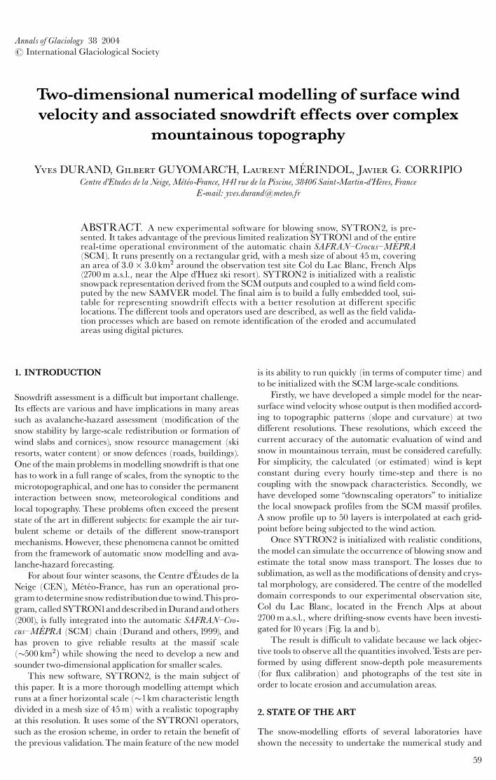
Once SYTRON2 is initialized with realistic conditions,the model can simulate the occurrence of blowing snow andestimate the total snow mass transport. The losses due tosublimation, as well as themodifications of density and crys-tal morphology, are considered.The centre of the modelleddomain corresponds to our experimental observation site,Col du Lac Blanc, located in the French Alps at about2700ma.s.l., where drifting-snow events have been investi-gated for 10 years (Fig.1a and b).
The result is difficult to validate because we lack objec-tive tools to observe all the quantities involved.Tests are per-formed by using different snow-depth pole measurements(for flux calibration) and photographs of the test site inorder to locate erosion and accumulation areas.
2. STATE OF THE ART
The snow-modelling efforts of several laboratories haveshown the necessity to undertake the numerical study and
Annals of Glaciology 38 2004# International Glaciological Society
59
the modelling of snowdrift phenomenawhose effects on ava-lanche hazards are well known. For many years, field obser-vation campaigns have been conducted and many authorshave described and investigated snowdrift (e.g. Mellor,1965; Takeuchi, 1980; F!ohn and Meister, 1983; Pomeroy andGray,1995). More recently, several numerical attempts havebeenmade. Some of themare based on sophisticatedmodels
of the different fluxes and the snow^atmosphere inter-actions (e.g. Gauer, 1998a, b, 2001) and are more suited fora precise treatment of specific wind-transport events. Otherrealizations are better designed to follow and simulatesnowdrift effects in particular locations for a long period(e.g. Liston and Sturm,1998), but with a limited treatmentof the snowpack characteristics. Other attempts are closer to
Fig.1. Partial views of the test site Col du Lac Blanc, French Alps (2700 m a.s.l.). (a) A southern view of the site showing parts ofthe instruments and the pole network.The surface state illustrates the important small-scale variability. (b) The snow surfaceaffected by snowdrift, the main transport mode (saltation) and some of the validation poles.
Durand and others: Snowdrift effects of surface wind velocity
60
the daily exploitation and can be linked to the daily opera-tional modelling (e.g. Fierz and Gauer, 1998; Lehning andothers, 2000a, 2002), with the possibility of taking into ac-count the modification of snow crystals.
3. EXISTING STARTINGTOOLS AT CEN
3.1.The SCM chain
Our present work is based on the SCM operational chain(Durand and others,1999), and aims at improving it for thecase of drifting-snow events. The present SCM workingscale is about 500 km2 and it is run daily for 23 Alpine and21 Pyrenean massifs over the whole year. It is used by theprofessional forecasters in charge of the avalanche-hazardestimation besides other information such as field obser-vations and direct contacts with mountain professionalsand users.
The SCM chain simulates the snowpack at differentelevations, in vertical steps of 300m, for different slope as-pects of the massifs studied. The results are obtainedhourly for three different slope inclinations (flat, 20‡ and40‡). This is only a rough approximation for the verticalslopes found in real mountain terrain and is one of themain weaknesses of the system, as it cannot take into ac-count small features due to the local effects of wind, topog-raphy or vegetation. No explicit parameterization of thesnowdrift is incorporated at present, but SCM provides anhourly set of both meteorological and snow conditions,which includes a detailed stratigraphy of all layers. Allthese quantities are mean values representative of largeslopes at different elevations and aspects.
3.2. SYTRON1
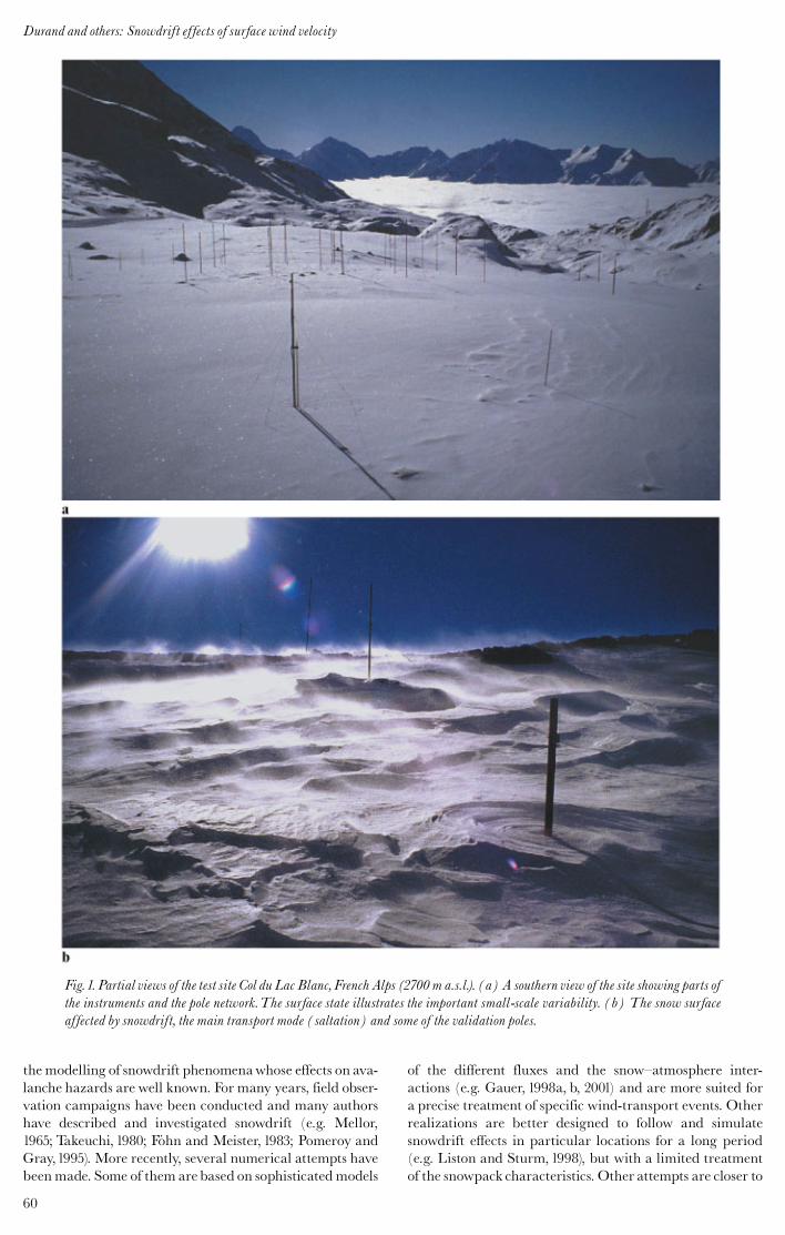
Unlike Gauer (1998a, b) or Liston and Sturm (1998),SYTRON1 does not perform a full three-dimensional esti-mation of the different transport fluxes over a real topog-raphy. The model aims only at simulating the effects of acrest between two opposite aspects at all the elevations ofSCM considered in steady-state conditions. It is describedin detail in Durand and others (2001) and Guyomarc’h andothers (2002). The basic assumption is a one-dimensionalchannelled flux forced by the regularly simulated wind.The output is an hourly estimation of the eroded amounton the windward aspect and of the deposited amount onthe lee aspect. This model can be considered as an opera-tional application of previous work (e.g. F˛hn and Meister,1983).The computations are done hourly over long periods,without any re-initialization, and are fully embedded inthe SCM operational suite which is monitored daily. Theevolution of the snow characteristics is determined at onceby the snow model Crocus (Brun and others,1989,1992) andby special operators for the modification of the blowingsnow. A flow chart of the operational running mode isshown in Figure 2.
4. PROBLEM DEFINITION
The goals of this new two-dimensional application are:
To compute an appropriate two-dimensional local windparameter (such as the shear velocity) in order to assessthe initiation and the intensity of the snow transport,through the use of the PROTE¤ ON (Pre¤ vision de l’Oc-
currence deTransport E¤ olien de la Neige) method pre-sented by Guyomarc’h and Me¤ rindol (1998), and inorder to force the wind advection scheme for the sus-pended snow at each time-step.
To define the occurrence of blowing snow as an inter-action between snow characteristics and this local wind,and to estimate the corresponding fluxes in a commonway with SYTRON1 in order to take advantage of itsdaily monitoring.
To adapt the scheme of crystal modification of thedrifted snow after deposition as in SYTRON1.
To define a new redeposition scheme and the corres-ponding rates.
To elaborate a validation process based on remote meas-urements.
All these points will be addressed below, while thedetailed formulation is given in Durand and others (2001)and Guyomarc’h and others (2002). Concerning the lastpoint, all the numerical simulations are performed aroundan experimental observation site where observations havebeen made for >10 years. During these years our teambecame very familiar with this site.The site as well as its cli-matology is described by Guyomarc’h and others (2001) andis shown in Figure1a and b. It is located at 2700ma.s.l. nearthe ski resort Alpe d’Huez in the Grandes Rousses massifand is characterized by significant snowdrift events. Severalsensors havebeen set up here and in the surrounding area, inorder to observe and quantify the amount of drifted snowboth in the air and on the ground. However, the large varia-bility of the local topography at very fine scales usuallymakes comparisons with the models difficult. Changes inthe shapes of the drifted crystals havebeen investigatedbothat the field site and in the cold laboratory.This allowed the
Fig. 2. Flow chart of the links between the different softwareemployed in the final SYTRON2 model.
61
Durand and others: Snowdrift effects of surface wind velocity
determination of empirical laws of crystal modificationswhich are used by SYTRON1 and SYTRON2. A brief re-view of some indications can be found in Guyomarc’h andothers (1991,1995).
5.WINDMODELLING
The non-hydrostatic weather model Meso-NH is developedin cooperation by the Centre National de RecherchesMe¤ te¤ orologiques, Me¤ te¤ o-France, and the Laboratoire d’Ae¤ r-ologie, Centre National de la Recherche Scientifique,France (Lafore and others,1998).This model allows numer-ical simulations of the fine atmospheric motions rangingfrom large meso-alpha scales down to the microscale, usinga comprehensive physical package.
For our application, we performed 20 runs for differentdates with snowdrift events or heavy winds at our test site.Every run consisted of a simulation with 12 km horizontalresolution. This run with a new set of physiographic data,namely horizon mask, topography, soil and vegetation char-acteristics, albedo and emissivity, provided the initial andlateral conditions for a second run at 1.2 km resolution. Athird run with 600m resolution and nested in the previousone, provided the wind field for the particular date (Me¤ rin-dol and others, 2000). Due to the complex and steep topog-raphy of our zone, it was not possible to achieve a finer meshwith the present version of the model. However, this limitedsample of meteorological data covers most of the typicalmeteorological situations over the French Alps and repre-sents a valuable dataset for tuning and validating simplermethods.
Besides these reference simulations, which cannot be runin real time, we have developed a simpler model suited forlocal application in an operational framework, covering therange 600^45m.The model, called SAMVER, is based onthe conservation of the potential vorticity and divergenceon isentropic surfaces close to our site of interest (Holton,1979). This model is initialized by the analyzed SAFRANoutputs (Durand and others, 1999) representative of themassif scale, and aims to adapt these large-scale fields to afiner topography of 45m resolution, using several knownsimplifying assumptions.The main advantage of the modelis its ability to deliver routinely (every hour) an approxima-tion of the relevant winds, which can be used for snowdriftcomputations. However, fine-mesh effects are oftensmoothed or under-evaluated.
We recognize the limitations of such a simplified ap-proach, hence the model output is statistically correctedafter running according to the topography used.
It is well known that topographic effects produce a turnin wind direction at small scales. Thus we have applied theformulation of wind deflectionproposedby Ryan (1977), andquoted andused by Purves and others (1998) for inclinations<45‡:
Fd $ %0:255sd sin 2&A% !#' (; &1#
where Fd is the wind diversion, sd is the inclination (%), Ais the slope aspect and ! is the wind direction.
The second set of corrections concerns the SAMVERwind velocity. The same approach as that of Liston andSturm (1998) is used but applying two ranges of scales,600m and 45m. These corrections are based on the topo-graphic variations at these two different scales, represented
by the topographic slopes "s and curvature "c in the winddirection, and are discretized as:
W $ 1:0) "s"s ) "c"c; &2#
where W is an empirical weighting factor for the windvelocity, and "s and "c are constant to define at different spa-tial scales, respectively.
The SAMVER velocity correction at the 600m scale isbased on comparisons with theMeso-NH results over the 20previously studied situations, where numerical results fromboth models are available. The Meso-NH wind fields areconsidered the best possible estimation at this scale for acomputational area of about 3! 3 km2 and are henceforthused as reference fields to compute the appropriated con-stants, "s and"c, at this scale. An indication of the initialperformance of bothmodels canbe givenby their respectivecomparisons with the observed wind velocity in the labora-tory, where Meso-NH exhibits a correlation factor, R, of 0.8(based on the 20 runs). The corresponding initial value forSAMVER is only 0.65 before correction.
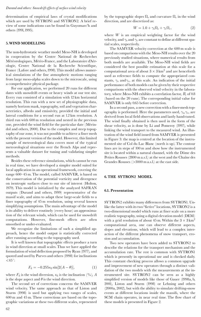
In a second pass, a new correctionwith a finer-mesh top-ography is performed. Here the parameters used, "s,"c, arederived from local field observations and lastly hand-tuned.The wind finally obtained is then used in the form of theshear velocity, as is done by Li and Pomeroy (1997), whilelinking the wind transport to the measured wind. An illus-tration of the wind field issued from SAMVER is presentedin Figure 3: the map is centred at the location of the instru-mented site of Col du Lac Blanc (north is up). The contourlines are in steps of 100m and show how the instrumentedsite is located within a natural channel, with the Do“ me desPetites Rousses (2800ma.s.l.) at the west and the Cha#ne desGrandes Rousses (>3000ma.s.l.) at the east side.
6.THE SYTRON2 MODEL
6.1. Presentation
SYTRON2 exhibits many differences from SYTRON1. Un-like the latter with its two‘‘fictive’’ locations, SYTRON2 is atwo-dimensional model which runs at finer scale on a morerealistic topography, using a digital elevationmodel (DEM)with a grid resolution of about 45m.Within the 3! 3km2
computational area, one can observe different aspects,slopes and elevations, which will lead to a complex inter-action of the different phenomena of snow transport, ero-sion and accumulation.
Two new operators have been added to STYRON2 todescribe the relations for the transport mechanism and theaccumulation rate. The rest is common with SYTRON1which is presently in operational use and is checked daily.This constant checking process allows a common upgradeand improvement of new operators through a distinct vali-dation of the two models with the measurements at the in-strumented site. SYTRON2 can be seen as a highlysimplified version of models like those of Gauer (1998a, b,2001), Liston and Sturm (1998) or Lehning and others(2000a, 2002), but with the ability to simulate drifting-snowevents at different locations inside the massifs, where theSCM chain operates, in near real time. The flow chart ofthese models is presented in Figure 2.
Durand and others: Snowdrift effects of surface wind velocity
62
6.2. Operators
As previously mentioned, an extreme simplification hasbeen chosen in the design of the model in order to be ableto produce results, at nearly real time and with a moderateamount of computer time. The only variable considered isthe averaged mass m (kg) of drifting snow in a mesh cell.This crude approach of one averaged layer does not allow adistinction to be made between the different transportmodes, saltation, creep or suspension. The temporal massevolution is treated by a classical mass-balance equationwhich guarantees the horizontal conservation of the driftedsnow mass by the transport operators and also involves theother variation operators for erosion and accumulation:
@m
@t$ % @mua
@x% @mva
@y% qacc ) qerr; &3#
where ua (m s%1# and va(m s%1# represent the horizontalparticle advection components, in the x and y direction,and qacc (kg s%1# and qerr (kg s%1# are the accumulationand the erosion rates, respectively. The operator qerr is thesame as used in SYTRON1 (for a complete description, seeDurand and others, 2001) and feeds the moving massm andthe losses by sublimation at once. As the mesh size is about45m, the corresponding time-step in the Eulerian numeri-cal scheme used is <2 s according to the Courant criteria.This formulation for the erosion does not take into accountany interaction between the individual drifted crystals norany turbulence effects, and only the horizontal advection is
treated without vertical influence. The wind-advectionscheme has to be representative of the particle velocities inthe different transport modes at different heights accordingto the respective concentrations, even if the main transportoccurs in saltation (see Fig.1b). Here, the advection velocitycan be considered almost constant (Pomeroy and Gray,1995).The wind advection used here is a vertically averagedquantity linked to the ambient meteorological conditions. Itis practically derived from the corrected-SAMVER velocity(u and v# field through the crude relationship:
ua $ ku; va $ kv &4#
with k = 0.35 derived from our field observations. A similarapproach, but restricted vertically to the saltation layer, hasbeen used by Gauer (2001) with k $ 0:58. A lower value of kis likely in our case, as we consider a larger vertical layerthan Gauer. Higher wind speed results from including thesuspension layer, yet most of the snow is transported withinthe saltation layer, so a lower value of k is a realistic assump-tion when considering the vertical distribution of snowdrift.
The accumulation operator qacc differs from those ofSYTRON1. As no explicit particle-settlement velocity canbe easily derived, it has been formulated in a probabilisticmanner in assuming that, from equilibrium conditions,95% of the drifted snow was redeposited after transportover a fetch distance, L, of about 1200m with a mean hori-zontal wind-transport velocity V of at least 15m s%1. Thesevalues are calculated following standard approaches in me-teorology for the deposition of advected scalars. The prob-
Fig. 3. Representation of the fine-mesh topography at the Col du Lac Blanc test site and the wind-field output from the SAMVERmodel. Axis units are gridcells, corresponding to a unit area of 45! 45m2 and a total area of 2700! 2700m2.
63
Durand and others: Snowdrift effects of surface wind velocity
abilistic formulation is similar to that used in other studiesof snowdrift, and the ratio V /L is in the range of valuesfound in the literature (Takeuchi, 1980; Liston and Sturm,1998; Essery and others,1999).The actual values used in thiswork are the best fit to previous, unpublished experimentalstudies using snow marked with colour tracers at the Col duLac Blanc test site. For lower wind values the fetch distanceis reduced proportionally. This fetch distance gives only amean composite instantaneous evaluation of the depositionrate for a given wind value and is thus characteristic of thedistance after which a crystal can no longer be mobilized bythe wind due to the changes undergone in shape anddensity:This formulation partly compensates for the lack ofvertical velocities in Equation (3). All the current numericalvalues are not finally fixed at the moment and still undergoa process of field validation.The presently used form is:
qacc $ #&1% $!#mwith
! $!!!!!!!!!!!!!!!u2a ) v2a
qsin&%# &5#
and
j$!j < 1;
where ! is a large-scale vertical topographic forcing factorwhose mean value along the fetch distance is assumed to bezero and % is the topographic slope in the flux direction. Asimilar formulation of the deposition governed by the shapeof the terrain can be found in Fo« hn and Meister (1983). # isestimated based on the previous redeposition hypothesis byintegrating a limited form of Equation (3) over the fetch dis-tance assuming a constant horizontal speed
dm
dt$ %qacc ) # $ % ln&1:0% 0:95#V
L; &6#
while the constant $ has been estimated to be 1.0 (sm%1#.Contrary to the Eulerian scheme used for the mass-
transport processes, a Lagrangian method is used to deter-mine the new morphological characteristics of the accumu-lated snow for each gridpoint at every time-step. It isperformed by identifying the starting point of the movingcrystals, then integrating the different features over the ap-propriate fetch distance and finally modifying these aver-aged characteristics. The algorithm aims at making a newdrifting crystal which is closer to a small rounded grain thanits previous shape. This transformation is not obtained inone time-step and can take some time. As described in Dur-and and others (2001), the dendricity of the fresh snow de-creases and the sphericity increases according to the windvelocity during the transport.When the crystal has under-gone some metamorphism, it will decrease in size and in-crease in sphericity, always as a function of the windvelocity during the transport.These operators are based onobservation of the drifted crystals, done at the instrumentedsite for many years, as well as on the densification mechan-isms presented in Durand and others (2001).
At each gridpoint and time-step, the deposited snow isthen added to the snow bed by aggregation to the first layer,or through a new layer if the amount is large enough. In caseof snowfall, fresh snow is simply added to the snow mass inmovement and treated as eroded snow.This allows a deposi-tion of the fresh snow suited to the wind and topographicconditions.
All these formulations have an implicit self-limitation:the transported snow is less subject to a new drifting effect
during the following hours because it underwent some crys-tal changes, which decrease the corresponding snow-drift-ability index and thus the transportability. Over an area of60! 60 gridpoints, 1 hour of numerical integration takesabout 2 min of computer time in an HP J282 UNIX work-station using a constant hourly velocity field.
6.3. Initializations and downscaling procedures
The only meteorological and snow conditions routinelyavailable are those provided by the SCMon an hourly basisand at the massif scale. As presented by Bouvet-Naaim andothers (2001), this information is not sufficient because snow-transport phenomena cover a larger range of spatial scales,including smaller scales, with complex interactions. Hence,the described models, SAMVER and SYTRON2, have tobe fed with appropriate small-scale information derivedfrom larger scales by suitable downscaling procedures,which are mainly issued from statistical^dynamical meth-ods and are always under evaluation.
SAMVER needs only an initial air temperature andwind field to start the run. The initial temperature valuesare derived by linear interpolation between the main SCMelevations and expositions at each gridpoint. Although thisassumption is adequate for the air temperature, it is insuffi-cient for thewind field. Presently, it is very difficult to obtaina realistic small-scale estimation of the wind field in moun-tainous conditions because it exceeds in many respects boththe computer capacities and the state of the art, especiallyregarding the turbulence formulation.Therefore, the initialvelocity field (two wind components) is obtained in twosteps: first, a projection on the gridpoints according to theirrelative exposition from the SCM wind-transport velocityand direction (noted Wt in Durand and others, 2001) is de-rived, and secondly, a global minimization of the diver-gence over the whole domain is applied. The previouslydescribed final corrections with fine topography canbe con-sidered as downscaling operators.
SYTRON2 initially needs a complete description of thesnow profile on each gridpoint in terms of stratigraphy, den-sity and temperature, which implies defining some interpo-lation operators between the available SCM profiles. Snowprofessionals all know how difficult a rigorous comparisonbetween two profiles is.The SCM profiles are firstly simpli-fied by aggregating coherent daily snow layers according tothe international classification (Colbeck and others,1990) inorder to better identify the corresponding homogeneouslayers between the different SCM profiles. In a second step,the different layers are interpolated at each gridpoint profileaccording to the exposition, aspect, elevation and a distancefunction of the grain types. This distance is the same oneused by Lehning and others (2001) for comparing differentsnow profiles. When the SCM profiles exhibit characteris-tics that are too different in terms of crystallography, severalsmall layers, representative of these inhomogeneous fea-tures, are superposed in the gridpoint profile.
6.4. Limitations of the model
The newapproach still has numerous limitations. Beside thesimplicity of the scheme, we should mention the constanthorizontal wind velocity during the 1 hour time-step andthe neglect of the turbulent entrainment of snow, which hasa stabilizing effect with subsequent damping of turbulence
Durand and others: Snowdrift effects of surface wind velocity
64
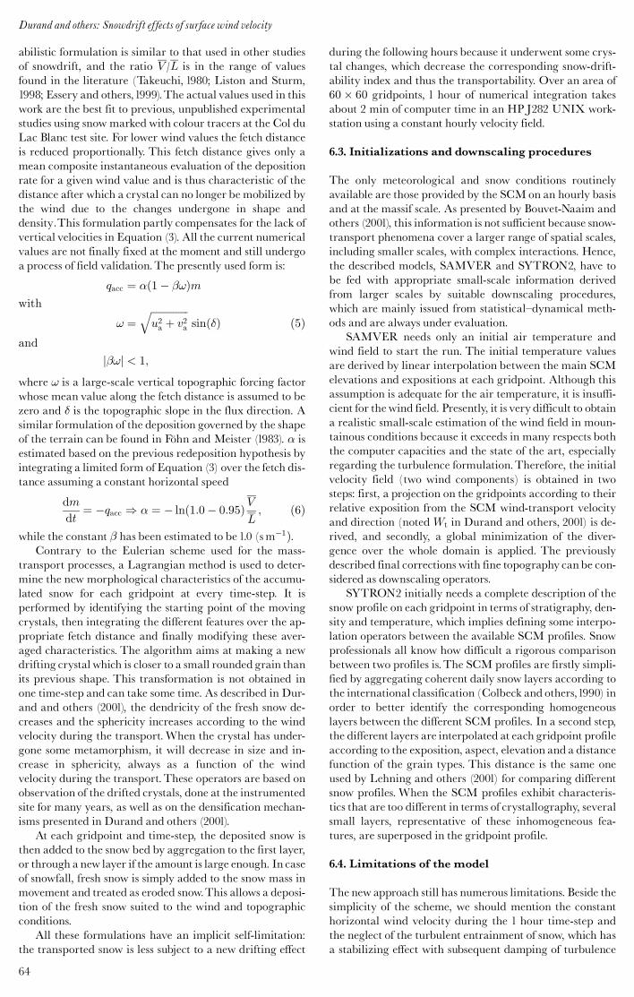
Fig. 4. Snow-depth field deduced from the SCM snow profile on 31 January 2002 at 06UTC and subjected to the effects of theSAMVER plotted wind field (darts) for several hours. (a) Variation of the snow depth during the drift event; (b) the finalcrystal shape of the first layer of the snowpack after this event.The figure shows the ability of the model to discern snow type and itsdriftability.To the west of the image, on the lower section below 2700 m, precipitation was heavy snow or rain, and no drift occurs.Only lighter snow at higher altitude has been transported.
65
Durand and others: Snowdrift effects of surface wind velocity
(Wamser and Lykossov, 1995; Bintanja, 1998; Galle¤ e andothers, 2000).
At present, one of the main limitations is the impossibil-ity of following drift events over the entire winter season. Itis also impossible to feed back the new profile informationavailable at the small-scale grid into the large-scale systemreferenced in terms of massif/elevation/slope/aspect.Thus, itis only possible to simulate a drift event without taking intoaccount any information from the previous drift events andusing only an initial state adapted from the larger scales.However, the main limitation remains the large simplifica-
tion of the scheme.We are fully aware of the need to improvethe mechanisms represented in parallel with a better initial-ization, since large discrepancies in the initial conditionscould imply unacceptable gaps even in amore sophisticatedmodel.
7. EXAMPLE OF MODELLING RESULTS: MORN-ING OF 31 JANUARY 2003
This date was characterized by a recent small snowfall(10 cm) under light winds, up to 6.5m s%1, and mild tem-
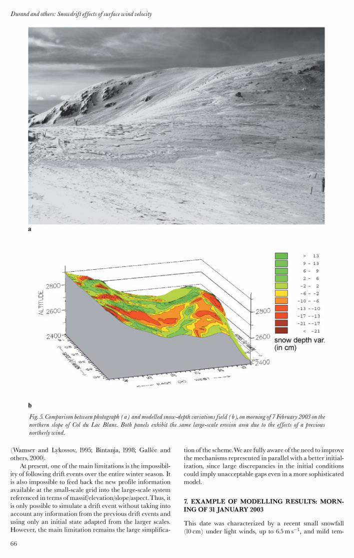
Fig. 5. Comparison between photograph (a) and modelled snow-depth variations field (b), on morning of 7 February 2003 on thenorthern slope of Col du Lac Blanc. Both panels exhibit the same large-scale erosion area due to the effects of a previousnortherly wind.
Durand and others: Snowdrift effects of surface wind velocity
66
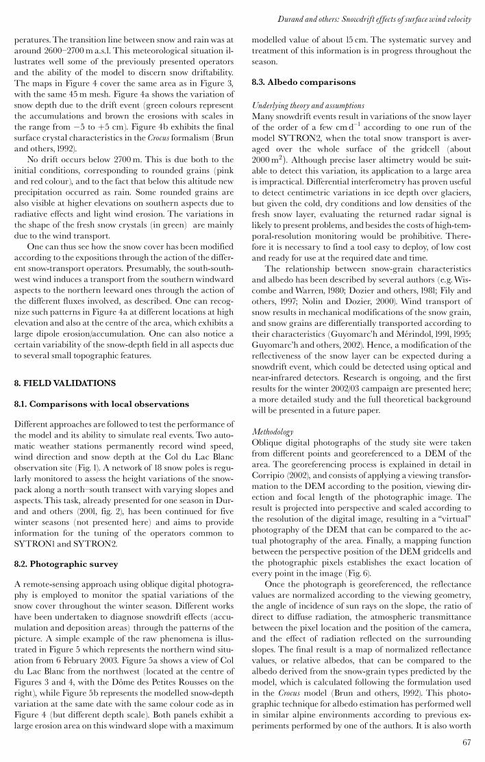
peratures.The transition line between snow and rain was ataround 2600^2700ma.s.l. This meteorological situation il-lustrates well some of the previously presented operatorsand the ability of the model to discern snow driftability.The maps in Figure 4 cover the same area as in Figure 3,with the same 45m mesh. Figure 4a shows the variation ofsnow depth due to the drift event (green colours representthe accumulations and brown the erosions with scales inthe range from %5 to )5 cm). Figure 4b exhibits the finalsurface crystal characteristics in the Crocus formalism (Brunand others,1992).
No drift occurs below 2700m. This is due both to theinitial conditions, corresponding to rounded grains (pinkand red colour), and to the fact that below this altitude newprecipitation occurred as rain. Some rounded grains arealso visible at higher elevations on southern aspects due toradiative effects and light wind erosion. The variations inthe shape of the fresh snow crystals (in green) are mainlydue to the wind transport.
One can thus see how the snow cover has been modifiedaccording to the expositions through the action of the differ-ent snow-transport operators. Presumably, the south-south-west wind induces a transport from the southern windwardaspects to the northern leeward ones through the action ofthe different fluxes involved, as described. One can recog-nize such patterns in Figure 4a at different locations at highelevation and also at the centre of the area, which exhibits alarge dipole erosion/accumulation. One can also notice acertain variability of the snow-depth field in all aspects dueto several small topographic features.
8. FIELDVALIDATIONS
8.1. Comparisons with local observations
Different approaches are followed to test the performance ofthe model and its ability to simulate real events. Two auto-matic weather stations permanently record wind speed,wind direction and snow depth at the Col du Lac Blancobservation site (Fig. 1). A network of 18 snow poles is regu-larly monitored to assess the height variations of the snow-pack along a north^south transect with varying slopes andaspects.This task, already presented for one season in Dur-and and others (2001, fig. 2), has been continued for fivewinter seasons (not presented here) and aims to provideinformation for the tuning of the operators common toSYTRON1and SYTRON2.
8.2. Photographic survey
A remote-sensing approach using oblique digital photogra-phy is employed to monitor the spatial variations of thesnow cover throughout the winter season. Different workshave been undertaken to diagnose snowdrift effects (accu-mulation and deposition areas) through the patterns of thepicture. A simple example of the raw phenomena is illus-trated in Figure 5 which represents the northern wind situ-ation from 6 February 2003. Figure 5a shows a view of Coldu Lac Blanc from the northwest (located at the centre ofFigures 3 and 4, with the Do“ me des Petites Rousses on theright), while Figure 5b represents the modelled snow-depthvariation at the same date with the same colour code as inFigure 4 (but different depth scale). Both panels exhibit alarge erosion area on this windward slope with a maximum
modelled value of about 15 cm. The systematic survey andtreatment of this information is in progress throughout theseason.
8.3. Albedo comparisons
Underlying theory and assumptionsMany snowdrift events result in variations of the snow layerof the order of a few cmd^1 according to one run of themodel SYTRON2, when the total snow transport is aver-aged over the whole surface of the gridcell (about2000m2#. Although precise laser altimetry would be suit-able to detect this variation, its application to a large areais impractical. Differential interferometry has proven usefulto detect centimetric variations in ice depth over glaciers,but given the cold, dry conditions and low densities of thefresh snow layer, evaluating the returned radar signal islikely to present problems, andbesides the costs of high-tem-poral-resolution monitoring would be prohibitive. There-fore it is necessary to find a tool easy to deploy, of low costand ready for use at the required date and time.
The relationship between snow-grain characteristicsand albedo has been described by several authors (e.g.Wis-combe andWarren, 1980; Dozier and others, 1981; Fily andothers, 1997; Nolin and Dozier, 2000). Wind transport ofsnow results in mechanical modifications of the snow grain,and snow grains are differentially transported according totheir characteristics (Guyomarc’h and Me¤ rindol,1991,1995;Guyomarc’h and others, 2002). Hence, a modification of thereflectiveness of the snow layer can be expected during asnowdrift event, which could be detected using optical andnear-infrared detectors. Research is ongoing, and the firstresults for the winter 2002/03 campaign are presented here;a more detailed study and the full theoretical backgroundwill be presented in a future paper.
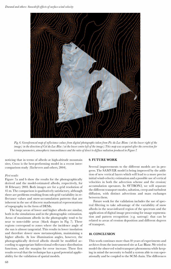
MethodologyOblique digital photographs of the study site were takenfrom different points and georeferenced to a DEM of thearea. The georeferencing process is explained in detail inCorripio (2002), and consists of applying a viewing transfor-mation to the DEM according to the position, viewing dir-ection and focal length of the photographic image. Theresult is projected into perspective and scaled according tothe resolution of the digital image, resulting in a ‘‘virtual’’photography of the DEM that can be compared to the ac-tual photography of the area. Finally, a mapping functionbetween the perspective position of the DEM gridcells andthe photographic pixels establishes the exact location ofevery point in the image (Fig. 6).
Once the photograph is georeferenced, the reflectancevalues are normalized according to the viewing geometry,the angle of incidence of sun rays on the slope, the ratio ofdirect to diffuse radiation, the atmospheric transmittancebetween the pixel location and the position of the camera,and the effect of radiation reflected on the surroundingslopes. The final result is a map of normalized reflectancevalues, or relative albedos, that can be compared to thealbedo derived from the snow-grain types predicted by themodel, which is calculated following the formulation usedin the Crocus model (Brun and others, 1992). This photo-graphic technique for albedo estimation has performedwellin similar alpine environments according to previous ex-periments performed by one of the authors. It is also worth
67
Durand and others: Snowdrift effects of surface wind velocity
noticing that in terms of albedo at high-altitude mountainsites, Crocus is the best-performing model in a recent inter-comparison study (Etchevers and others, 2004).
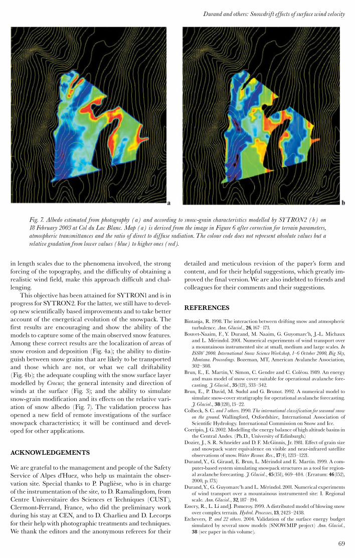
First resultsFigure 7a and b show the results for the photographicallyderived and the model-estimated albedo, respectively, for18 February 2003. Both images are for a grid resolution of45 m.The comparison is qualitatively satisfactory, althoughthere are problems resulting from sub-grid variability in re-flectance values and snow-accumulation patterns that areinherent in the use of discrete mathematical representationsof topography in the form of DEMs.
The large areas of lower and higher albedo are similar,both in the simulations and in the photographic estimation.Areas of maximum albedo in the photography tend to benear to non-visible areas (black shapes in Fig. 7). Theseregions correspond to zones where the incidence angle ofthe sun is almost tangential.This results in lower insolationand therefore slower snow metamorphism, maintaining ahigher albedo. At low illumination angles, however, thephotographically derived albedo should be modified ac-cording to appropriate bidirectional reflectance distributionfunctions, and the margins for error increase. These firstresults reveal that the technique has a good potential applic-ability for the validation of spatial models.
9. FUTUREWORK
Several improvements to the different models are in pro-gress.The SAMVER model is being improved by the addi-tion of new vertical layers which will lead to a more preciseinitial wind-velocity estimation and apossible use of verticalvelocities in both the advection scheme and the erosion/accumulation operators. In SYTRON2, we will separatethe different transportmodes, saltation, creep and turbulentdiffusion, with distinct advections and mass exchangesbetween them.
Future work for the validation includes the use of spec-tral filtering to take advantage of the variability of snowalbedo in the near-infrared region of the spectrum and theapplication of digital image processing for image segmenta-tion and pattern recognition (e.g. sastrugi) that can berelated to areas of erosion deposition and different degreesof transport.
10. CONCLUSION
This work continues more than10 years of experiments andarchives from the instrumented site at Lac Blanc.We tried tomodel the observed wind-transport phenomenawhile keep-ing in mind the necessity to build a system able to run oper-ationally and be coupled to the SCM chain.The differences
Fig. 6. Georeferenced map of reflectance values from digital photographs taken from Pic du Lac Blanc (at the lower right of theimage) in the direction of Col du Lac Blac (at the lower centre left of the image).This map was acquired after the correction forterrain parameters, atmospheric transmittances and the ratio of direct to diffuse radiation produced in Figure 7.
Durand and others: Snowdrift effects of surface wind velocity
68
in length scales due to the phenomena involved, the strongforcing of the topography, and the difficulty of obtaining arealistic wind field, make this approach difficult and chal-lenging.
This objective has been attained for SYTRON1and is inprogress for SYTRON2. For the latter, we still have to devel-op new scientifically based improvements and to take betteraccount of the energetical evolution of the snowpack. Thefirst results are encouraging and show the ability of themodels to capture some of the main observed snow features.Among these correct results are the localization of areas ofsnow erosion and deposition (Fig. 4a); the ability to distin-guish between snow grains that are likely to be transportedand those which are not, or what we call driftability(Fig. 4b); the adequate coupling with the snow surface layermodelled by Crocus; the general intensity and direction ofwinds at the surface (Fig. 3); and the ability to simulatesnow-grain modification and its effects on the relative vari-ation of snow albedo (Fig. 7). The validation process hasopened a new field of remote investigations of the surfacesnowpack characteristics; it will be continued and devel-oped for other applications.
ACKNOWLEDGEMENTS
We are grateful to the management and people of the SafetyService of Alpes d’Huez, who help us maintain the obser-vation site. Special thanks to P. Puglie' se, who is in chargeof the instrumentation of the site, to D. Ramalingdom, fromCentre Universitaire des Sciences et Techniques (CUST),Clermont-Ferrand, France, who did the preliminary workduring his stay at CEN, and to D. Charlieu and D. Lecorpsfor their help with photographic treatments and techniques.We thank the editors and the anonymous referees for their
detailed and meticulous revision of the paper’s form andcontent, and for their helpful suggestions, which greatly im-proved the final version.We are also indebted to friends andcolleagues for their comments and their suggestions.
REFERENCES
Bintanja, R. 1998. The interaction between drifting snow and atmosphericturbulence. Ann. Glaciol., 26,167^173.
Bouvet-Naaim, F., Y. Durand, M. Naaim, G. Guyomarc’h, J.-L. Michauxand L. Me¤ rindol. 2001. Numerical experiments of wind transport overa mountainous instrumented site at small, medium and large scales. InISSW 2000. International Snow ScienceWorkshop, 1^6 October 2000, Big Sky,Montana. Proceedings. Bozeman, MT, American Avalanche Association,302^308.
Brun, E., E. Martin,V. Simon, C. Gendre and C. Cole¤ ou. 1989. An energyand mass model of snow cover suitable for operational avalanche fore-casting. J. Glaciol., 35(121), 333^342.
Brun, E., P. David, M. Sudul and G. Brunot. 1992. A numerical model tosimulate snow-cover stratigraphy for operational avalanche forecasting.J. Glaciol., 38(128),13^22.
Colbeck, S. C. and 7 others. 1990.The international classification for seasonal snowon the ground. Wallingford, Oxfordshire, International Association ofScientific Hydrology. International Commission on Snow and Ice.
Corripio, J. G.2002.Modelling the energy balance of high altitude basins inthe Central Andes. (Ph.D., University of Edinburgh.)
Dozier, J., S. R. Schneider and D. F. McGinnis, Jr. 1981. Effect of grain sizeand snowpack water equivalence on visible and near-infrared satelliteobservations of snow.Water Resour. Res.,17(4),1213^1221.
Durand,Y., G. Giraud, E. Brun, L. Me¤ rindol and E. Martin. 1999. A com-puter-based system simulating snowpack structures as a tool for region-al avalanche forecasting. J. Glaciol., 45(151), 469^484. (Erratum: 46(152),2000, p.173.)
Durand,Y., G. Guyomarc’h and L. Me¤ rindol. 2001. Numerical experimentsof wind transport over a mountainous instrumented site: I. Regionalscale. Ann. Glaciol., 32,187^194.
Essery, R., L. Li andJ. Pomeroy.1999. A distributed model of blowing snowover complex terrain. Hydrol. Processes,13, 2423^2438.
Etchevers, P. and 22 others. 2004. Validation of the surface energy budgetsimulated by several snow models (SNOWMIP project) Ann. Glaciol.,38 (see paper in this volume).
Fig. 7. Albedo estimated from photography (a) and according to snow-grain characteristics modelled by SYTRON2 (b) on18 February 2003 at Col du Lac Blanc. Map (a) is derived from the image in Figure 6 after correction for terrain parameters,atmospheric transmittances and the ratio of direct to diffuse radiation.The colour code does not represent absolute values but arelative gradation from lower values (blue) to higher ones (red).
69
Durand and others: Snowdrift effects of surface wind velocity
Fierz, C. and P. Gauer. 1998. Snow cover evolution in complex alpine ter-rain: measurements and modeling including snow drift effects. InISSW’98. International Snow ScienceWorkshop, 27 September^1 October 1998,Sunriver, Oregon. Proceedings. Seattle,WA,Washington State Departmentof Transportation, 284^289.
Fily, M., B. Bourdelles, J.-P. Dedieu and C. Sergent.1997. Comparison of insitu and Landsat thematic mapper derived snow grain characteristics inthe Alps. Remote Sensing Environ., 59(3), 452^460.
Fo« hn, P.M. B. and R. Meister. 1983. Distribution of snow drifts on ridgeslopes: measurements and theoretical approximations. Ann. Glaciol., 4,52^57.
Galle¤ e, H., G. Guyomarc’h and E. Brun. 2000. Impact of snowdrift on theAntarctic Ice Sheet surface mass balance: possible sensitivity to snow-surface properties. Boundary-Layer Meteorol. 99,1^19.
Gauer, P. 1998a. Blowing and drifting snow in Alpine terrain: numericalsimulation and related field measurements. Ann. Glaciol., 26,174^178.
Gauer, P. 1998b. Numerical snow drift modeling in complex alpine terrainand comparisonwith field measurements. In ISSW’98. International SnowScienceWorkshop, 27 September^1 October 1998, Sunriver, Oregon. Proceedings.Seattle,WA,Washington State Department of Transportation, 60^66.
Gauer, P. 2001. Numerical modeling of blowing and drifting snow in Alpineterrain. J. Glaciol., 47(156), 97^110.
Guyomarc’h, G. and L. Me¤ rindol. 1991. E¤ tude du transport de la neige parle vent. In Brugnot, G., E. Brun, H. Gubler, H. Norem and L. Reynaud,eds. Symposium de Chamonix ANENA^CISA^IKAR. Les apports de la recherchescientifique a' la neige, glace et avalanches, 4^8 juin 1991, Chamonix, France. Actesdu Symposium. Grenoble, Association Nationale pour l’E¤ tude de la Neigeet des Avalanches (ANENA),77^82.
Guyomarc’h, G. and L. Me¤ rindol. 1995. PROTEON ! Vers une pre¤ visionlocale du transport de neige par le vent. In Sivardie' re, F., ed. Les apports dela recherche scientifique a' la se¤ curite¤ neige, glace et avalanche. Actes de Colloque,Chamonix 30 mai^3 juin 1995. Grenoble, Association Nationale pourl’E¤ tude de la Neige et des Avalanches (ANENA), 97^102.
Guyomarc’h, G. and L. Me¤ rindol. 1998. Validation of an application forforecasting blowing snow. Ann. Glaciol., 26,138^143.
Guyomarc’h, G.,Y. Durand, L. Me¤ rindol and F. Naaim-Bouvet. 2001. Cli-matology of an experimental mountainous location for studies on snow-drift. In ISSW 2000. International Snow ScienceWorkshop, 1^6 October 2000,Big Sky,Montana. Proceedings. Bozeman, MT, American AvalancheAsso-ciation, 296^301.
Guyomarc’h, G.,Y. Durand, L. Me¤ rindol and D. Lecorps. 2002. In-situ ob-servations and snowdrift modelling on alpine topography. In Stevens,J. R., ed. International Snow Science Workshop 2002, 29 September^4 October
2002, Penticton, British Columbia. Proceedings.Victoria, B.C., B.C. Ministryof Transportation. SnowAvalanche Programs.
Holton, J. R. 1979. An introduction to dynamic meteorology. Second edition. NewYork, Academic Press.
Lafore, J. P. and 12 others. 1998. The meso-NH atmospheric simulation sys-tem. Part I: Adiabatic formulation and control simulations. Ann.Geophysicae,16(1), 90^109.
Lehning, M., J. Doorschot and P. Bartelt. 2000. A snowdrift index based onSNOWPACKmodel calculations. Ann. Glaciol., 31, 382^386.
Lehning, M., C. Fierz and C. Lundy. 2001. An objective snow profilecomparison method. In ISSW 2000. International Snow Science Workshop,1^6 October 2000, Big Sky, Montana. Proceedings. Bozeman, MT, AmericanAvalanche Association, 440^446.
Lehning, M., J. Doorschot, C. Fierz and N. Raderschall. 2002. A 3Dmodelfor snow drift and snow cover development in steep alpine terrain. InStevens, J. R., ed. International Snow ScienceWorkshop 2002, 29 September^4 October 2002, Pentiction, British Columbia. Proceedings.Victoria, B.C., B.C.Ministry of Transportation. SnowAvalanche Programs.
Li, L. andJ.W. Pomeroy.1997. Estimates of threshold wind speeds for snowtransport using meteorological data. J. Appl. Meteorol., 36(3), 205^213.
Liston, G. E. andM. Sturm.1998. A snow-transport model for complex ter-rain. J. Glaciol., 44(148), 498^516.
Mellor, M.1965. Blowing snow. CRRELMonogr., Pt. III, Section A3c.Me¤ rindol, L.,Y. DurandandG. Guyomarc’h.2000. Simulation of snowdrift
over complex terrain. In ICAM 2000, Innsbruck, 11^15/9/2000. 26th Inter-national Conference on Alpine Meteorology.Vienna, Central Institutefor Meteorology and Geodynamics.
Nolin, A.W. andJ. Dozier. 2000. A hyperspectral method for remotely sens-ing the grain size of snow. Remote Sensing Environ., 74(2), 207^216.
Pomeroy, J.W. and D.M. Gray. 1995. Snowcover: accumulation, relocation andmanagement. Saskatoon, Sask., Environment Canada. National Hydrol-ogy Research Institute. (NHRI Science Report 7.)
Purves, R. S., J. S. Barton, W.A. Mackaness and D. E. Sugden. 1998. Thedevelopment of a rule-based spatial model of wind transport and de-position of snow. Ann. Glaciol., 26,197^202.
Ryan, B. C.1977. A mathematical model for diagnosis and prediction of sur-face winds in mountainous terrain. J. Appl. Meteorol.,16(6), 571^584.
Takeuchi, M. 1980. Vertical profile and horizontal increase of drift-snowtransport. J. Glaciol., 26(94), 481^492.
Wamser, C. andV.N. Lykossov. 1995. On the friction velocity during blow-ing snow. Contrib. Atmos. Phys., 68(1), 85^94.
Wiscombe,W. J. and S. G.Warren. 1980. A model for the spectral albedo ofsnow. I. Pure snow. J. Atmos. Sci., 37(12), 2712^2733.
Durand and others: Snowdrift effects of surface wind velocity
70


![A Parallel Compact Multi-dimensional Numerical … PARALLEL COMPACT MULTI-DIMENSIONAL NUMERICAL ALGORITHM WITH AEROACOUSTICS APPLICATIONS ALEX POVITSKY* AND PHILIP .]. MORRIS ¢ Abstract.](https://static.fdocuments.in/doc/165x107/5aeb54fa7f8b9ae5318d9568/a-parallel-compact-multi-dimensional-numerical-parallel-compact-multi-dimensional.jpg)