Twentieth Century Military Sites: Second World War and ... · Twentieth Century Military Sites:...
91
Twentieth Century Military Sites: Second World War and later Camps and Ranges Interim Report 2014-15: Carmarthenshire Desk-Based Assessment Ystrad Camp, Carmarthen, 1941 showing camouflaged huts around the perimeter (PRN 107372) Prepared by Dyfed Archaeological Trust For Cadw
Transcript of Twentieth Century Military Sites: Second World War and ... · Twentieth Century Military Sites:...

Twentieth Century Military Sites: Second World War and later
Camps and Ranges
Interim Report 2014-15: Carmarthenshire Desk-Based Assessment
Ystrad Camp, Carmarthen, 1941 showing camouflaged huts around the perimeter (PRN 107372)
Prepared by Dyfed Archaeological Trust
For Cadw

DYFED ARCHAEOLOGICAL TRUST
DAT Event Record No. 106667
Report No. 2015/16 Cadw Project No. DAT 115A
Mawrth 2015
March 2015
Second World War and later Camps and Ranges
Gan / By
Alice Pyper and Marion Page
The copyright of this report is held by Cadw and Dyfed Archaeological Trust Ltd.
The maps are based on Ordnance Survey mapping provided by the National Assembly for Wales with the
permission of the Controller of Her Majesty’s Stationary Office, Crown Copyright. All rights reserved.
Unauthorised reproduction infringes Crown Copyright and may lead to prosecution or civil proceedings. License No.: 100017916 (2014).
Historic mapping reproduced here is covered under Crown Copyright and Landmark Information Group.
All rights reserved. Dyfed Archaeological Trust Ltd. On behalf of Welsh Government 2014.
Scheduled Ancient Monument polygon data in this report is based on Cadw’s Historic Assets Data. Crown Copyright. Cadw.
The Trust is both a Limited Company (No. 1198990) and a Registered Charity (No. 504616)
CADEIRYDD CHAIRMAN: Prof. B C BURNHAM CYFARWYDDWR DIRECTOR: K MURPHY BA MIFA
Ymddiriedolaeth Archaeolegol Dyfed Cyf Neuadd y Sir, Stryd Caerfyrddin, Llandeilo, Sir
Gaerfyrddin SA19 6AF Ffon: Ymholiadau Cyffredinol 01558 823121
Ebost: [email protected] Gwefan: www.archaeolegdyfed.org.uk
Dyfed Archaeological Trust Limited The Shire Hall, Carmarthen Street, Llandeilo,
Carmarthenshire SA19 6AF Tel: General Enquiries 01558 823121 Email: [email protected]
Website: www.dyfedarchaeology.org.uk

Twentieth Century Military Sites: Second World War and later Camps and Ranges
3
TABLE OF CONTENTS
SUMMARY ......................................................................................................................................................... 4
INTRODUCTION ................................................................................................................................................. 4
PROJECTS AIMS AND OBJECTIVES ..................................................................................................................... 6
METHODOLOGY ................................................................................................................................................. 6
SITE DEFINITIONS ............................................................................................................................................... 7
RESULTS ............................................................................................................................................................. 8
DISCUSSION ..................................................................................................................................................... 15
REFERENCES..................................................................................................................................................... 17
ACKNOWLEDGEMENTS.................................................................................................................................... 18
GAZETTEER OF SITES ........................................................................................................................................ 19
TABLE OF FIGURES
Figure 1: Distribution of Sites across Carmarthenshire ...................................................................... 9 Figure 2: SD 559 ranges map, West and South Wales ..................................................................... 14

Twentieth Century Military Sites: Second World War and later Camps and Ranges
4
SUMMARY
Recent years have seen a series of projects to address the lack of understanding and knowledge of sites
in Wales which relate to the conflicts of the Twentieth Century. This report is the first assessment of
Camps and Ranges in Carmarthenshire which were established and in use during the Second World War
and succeeding years. This is the first phase, a desk-based assessment, gathering documentary sources
including primary and secondary sources to establish the number, type, location and extent of sites. A
range of site types have been considered and include; army camps (British and American), hospitals,
prisoner of war camps, depots and land army camps. Twelve sites were recorded in the HER at the
outset of the exercise, these have now been updated and a further 40 have been added to the record.
Where possible aerial photographs have been used to establish the extent of the camps or ranges and
have been mapped onto MapInfo GIS. The information from this assessment will contribute to our
understanding of the impact of the 20th century conflicts through its archaeology and surviving
structures. It will provide a basis for follow-up fieldwork to assess national or regional significance of
surviving archaeological remains and also provide information for heritage management and development
control purposes.
INTRODUCTION
Prior to the Second World War Carmarthenshire could not have been said to have a high military
presence, and since the widespread mustering and training of troops prior to and during the First World
War, the only permanent military base was the Barracks in Carmarthen (PRN 104). In the course of the
Second World War however significant military mobilisation took place across southwest Wales; not only
defensive measures needed to be constructed along the South Wales coast, identified as an area of high
risk of invasion and which required building and personnel to man it, but military exercises brought
troops in to Carmarthenshire to use the training ranges at Pendine and Pembrey (PRNs 30071, 30076)
and en route Pembrokeshire. With the build-up of the United States army to mount an invasion of the
continent numerous tented camps were established across the county and further buildings requisitioned.
Depots were established to support both the military and civilian realm to supply food, fuel, materials and
equipment and the county saw the establishment of three military hospital units. As the war progressed
and army units left for the continent vacant sites were reused as Prisoner of War camps.
This study of Camps and Ranges in Carmarthenshire forms part of a phased programme of work being
undertaken by the Welsh Archaeological Trusts, addressing the lack of information on the archaeology
and historic environment which stems from the conflicts of the twentieth century. Cadw have grant-aided
the investigation of various classes of site across Wales, and within Dyfed, Military Airfields and their
dispersed sites, crashed Military Aircraft sites and scoping exercises to investigate the archaeological
remains relating to the First World War have so far been addressed, (Cadw 2009, 4, Pyper 2012, 2013a &
b, 2014a & b). It also builds on the work carried out during the Defence of Britain programme, co-
ordinated by the Council for British Archaeology.

Twentieth Century Military Sites: Second World War and later Camps and Ranges
5
The project addresses several of the themes and sub-themes identified in the research agenda of Modern
Military Matters (Schofield et al, 2004, p14), where it is acknowledged that Camps are one of the least
studied categories of site, and in addition the difficulty of establishing overall figures for the numbers of
camps constructed. This assessment takes into consideration any military established base or range and
includes the army, air force and naval camps and ranges which vary in scale. Thus, the range of sites in
this class are vast including; military camps, ranges including training facilities for small arms or
weapons testing, smaller camps associated with searchlight or anti-aircraft batteries, hospitals, prisoner
of war camps, internment camps, resettlement camps, temporary camps for American troops prior to D-
Day and also those for Conscientious Objectors, Women’s Land Army etc. This report constitutes the first
stage, a desk-based assessment, to be followed by similar studies of Ceredigion and Pembrokeshire, and
to be followed by site visits to record surviving remains.
This study is not addressing camps established prior to, or during the First World War associated with the
Yeomanry and Territorial Forces, as this will be assessed through the on-going First World War project.
This report concentrates on the massive military expansion and mobilisation which took place
immediately preceding and during the Second World War, those which continued in use in post war years
and also sites in current military use. Many of these sites where temporary and rapidly constructed, and
many with only a basic infrastructure provided. In other cases existing buildings, often large houses,
were requisitioned to serve as headquarters with the personnel billeted in the house and other temporary
structures erected within the grounds.
Often there is a complicated history attached to each of the sites, with many different units moving
through, perhaps only for a short period of time, which is recorded through various unit War Diaries and
those of the Carmarthen Sub Area Headquarters (WO 166/6729 & 1270). This is further complicated by
the changing function and use of sites, often established as a British army camp initially, then reused by
the United States Army in the run up to D-Day, and then finally used to accommodate prisoners of war.
Some sites continued in use beyond the end of hostilities, many prisoner of war camps were not
decommissioned until the late 1940s (Hellen 1999, 191). Furthermore a couple of sites, the military
training ranges, continue in use to this day. The report addresses sites that are, or have been owned,
leased or licensed by the military, and not areas of private land which have been used for military
training (TOPL; Training Over Private Land).
The information collated in this report will contribute to our understanding of the impact of the 20th
century conflicts through its archaeology and surviving structures, provide a basis for follow-up fieldwork,
and not least provide information for heritage management and development control purposes.

Twentieth Century Military Sites: Second World War and later Camps and Ranges
6
PROJECTS AIMS AND OBJECTIVES
The overall aims of the project are:
an application of definition, classification, quantification and distribution of these sites in
Carmarthenshire,
an assessment of the archaeological significance of these sites in both a regional and national
perspective,
an assessment of the vulnerability of this element of the archaeological resource,
recommendations for scheduling and listing
These aims will be achieved following the fieldwork assessment in part two of the project.
The project’s objectives are:
To access and assess available primary and secondary sources for each of the camps and ranges
within Carmarthenshire,
To incorporate this information into the Dyfed Archaeological Trust’s Historic Environment Record
(HER), creating new sites or enhancing existing ones,
To create GIS polygons to be supplied for heritage management advice.
METHODOLOGY
The way in which this project has been approached mirrors that of previous threat related projects
undertaken by the Welsh Archaeological Trusts with grant-aid from Cadw. Maps, plans and aerial
photographs were consulted for each site. Records were created and new point and polygon-based GIS
data was compiled as a result of the research. This information was integrated into the regional Historic
Environment Record and is now available through the HER and through the Archwilio website.
The following methodology was adopted to achieve the project’s objectives:
An assessment of existing records within the HER
An assessment of existing records within the NMR / Coflein
An assessment of the records held in the Defence of Britain archive
A rapid overview of sources during a visit to the National Archives
An assessment of the digital records held at Fold3.com, a web-based collection of original US
military records, including many from the U.S. National Archives.
Assessment of data listed in secondary sources, on the internet or hard copy local histories and
memoirs
Assessment of wartime and later aerial photographs
Creation of new records and enhancement of existing records in the HER
Production of a short report including a gazetteer of sites.

Twentieth Century Military Sites: Second World War and later Camps and Ranges
7
Unfortunately the local Carmarthen Archives have been closed for the duration of the assessment and
preparation of this report, and this lack of local sources has severely disadvantaged the project, as none
of the records held within the Archives could be consulted. The National Archives were also visited to
consult primary sources, which was useful in some specific cases, however highlighted the need for
further documentary work to identify and locate sites in Carmarthenshire.
A number of key secondary sources were the basis for the assessment, including reports by John
Schofield (2006) England's Army Camps and Roger J C Thomas (2003) Prisoner of War Camps (1939-
1948). These provided a gazetteer of known sites throughout the UK based on previous desk-based
research at The National Archives.
Increasingly on-line sources are available with many groups or individuals publishing on the internet or
transcribing historic documents on websites or webpages. Whilst this increases the range of sources
available for consultation there are risks with such sources and each has to be assessed in terms of its
historical accuracy. Where these sources have been consulted they are referenced in the individual site
records with their corresponding Uniform Resource Locator (URL) to access the appropriate page on the
internet.
SITE DEFINITIONS
The primary focus for this assessment has been military installations where armed forces have been
established for a permanent or temporary base. Site types and their definitions are derived from the
Thesaurus of Monument Types for Wales, which is based on the Defence of Britain thesaurus definitions.
The key site types identified in this study have been:
Military Camp: a site where a body of troops is temporarily or permanently lodged, with or
without entrenchments and fortifications.
Firing Range: A piece of ground over which small arms or large artillery may be fired at targets.
Bombing Range: An area of land, with associated buildings and targets, used for practicing the
dropping of bombs and other aspects of air warfare.
Military Base: A building or group of buildings, often surrounded by a system of fortifications,
used as a residential and training site by members of an armed force.
Military Depot: A building or group of buildings, often enclosed by a system of fortifications, used
by an armed force for the storage and distribution of military equipment.
Military Hospital: a hospital for the medical and surgical treatment of military personnel and/or
their families.
Prisoner of War Camp: a prison site for the containment of servicemen captured in war.
Depot: a place of deposit for the storing of goods. May include a complex of structures.
Barracks: a building used to accommodate large numbers of individuals, often on a temporary
basis, in the armed forces or at industrial sites.

Twentieth Century Military Sites: Second World War and later Camps and Ranges
8
Military Headquarters: a building used as a command centre for a military operation.
Note: Currently there are no specific site types for establishments relating to the Women’s Land Army
(including the Women’s Timber Corps), but as a result of this assessment two new site types are being
proposed:
Women’s Land Army Hostel: A building used to provide accommodation for women working on
the land during the First or Second World Wars, also including Women’s Timber Corps.
Women’s Land Army Camp: A temporary settlement of tents or huts established to accommodate
women working on the land during the First or Second World Wars, also including Women’s
Timber Corps.
Sites could include existing buildings which were requisitioned, or the construction of new temporary or
permanent buildings, or canvas tents which were erected for the duration of hostilities.
Many of the sites identified have a complex history and it has not been possible to be absolutely sure of
different phases of activity during the scope of this project. Further desk based research in the local
archives or the National Archives may reveal their narrative histories.
In some instances installations have been identified from aerial photographs and at present no other
documentary sources have revealed their function. In other cases documentary sources – for instance
War Diaries or United States Army station lists - often associate military units by town or village but do
not provide location information – numerous military units are attributed to ‘Carmarthen’ and actually
marrying this information up to a physical location is challenging. Some documents record Cassini Grid
references though not usually to a greater accuracy than a four figure reference, which is not particularly
helpful especially where a number of sites are in close proximity or in an urban location.
Where function has been unassigned the site type ‘Military Base’ has been used.
RESULTS
Prior to the assessment being carried out 12 records for camps, ranges and military installations were
recorded within the HER:-
PRN Site Name Type NGR
104 BARRACKS THE Barracks SN40361992
30071 PENDINE RANGE Firing Range SN27900700
30076 PEMBREY RANGE Firing Range SN36500520
30084 LLANGUNNOR Firing Range SN42702060
30261 TREGLOG CAMP Military Camp SN59533499
30593 NO 102 LLANDDAROG CAMP Prisoner of War Camp SN4937816252
31411 TOWYN CAMP Military Camp SN39730374
Twentieth Century Military Sites: Second World War and later Camps and Ranges
9
33673 R.N. STORE DEPOT LLANGENNECH Military Depot SN55800200
50281 LLANDEILO ARMY CAMP Military Camp SN62762267
50282 NEWTON HOUSE Military Hospital SN61432253
50283 DINEFWR PARK Prisoner of War Camp SN61612242
50284 LLANDEILO LAND ARMY CAMP Army Camp SN62412298
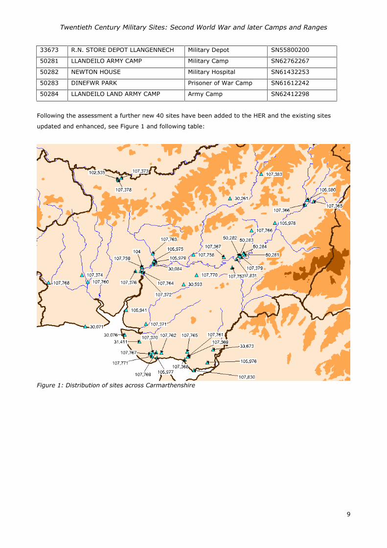
Following the assessment a further new 40 sites have been added to the HER and the existing sites
updated and enhanced, see Figure 1 and following table:
Figure 1: Distribution of sites across Carmarthenshire

Twentieth Century Military Sites: Second World War and later Camps and Ranges
10
Prn Site name Type Community NGR
104 BARRACKS THE BARRACKS;MAGAZINE Carmarthen SN40361992
30071
PENDINE RANGE; EXPERIMENTAL ESTABLISHMENT PENDINE FIRING RANGE
Laugharne Township SN27900700
30076 PEMBREY SANDS AIR WEAPONS RANGE BOMBING RANGE Cefn Sidan SN36500520
30084 LLANGUNNOR FIRING RANGE Llangunnor SN42702060
30261 TREGLOG CAMP MILITARY CAMP Llansawel SN59533499
30593 NO 102 LLANDDAROG CAMP
PRISONER OF WAR CAMP Llanddarog SN4937816252
31411 TOWYN CAMP MILITARY CAMP Cefn Sidan SN39730374
33673 R.N. STORE DEPOT LLANGENNECH MILITARY DEPOT Llangennech SN55800200
50281
MILITARY BASE Llandeilo SN62762267
50282 NEWTON HOUSE MILITARY HOSPITAL Llandeilo SN61432253
50283 DINEFWR PARK PRISONER OF WAR CAMP Llandeilo SN61612242
50284 LLANDEILO LAND ARMY CAMP ARMY CAMP Llandeilo SN62412298
102535 AIRFIELD AND CAMP AT DREFACH FELINDRE AIRFIELD Llangeler SN35013923
105941 FERRYSIDE MILITARY BASE St Ishmael SN36851062
105975
12th EVACUATION HOSPITAL; 232rd STATION HOSPITAL MILITARY HOSPITAL Carmarthen SN42862130
105976 BYNEA SALVAGE DEPOT DEPOT Llanelli SS54589920
105977 BURRY PORT MILITARY CAMP Burry Port SN43590018
105978 ABERMARLAIS CAMP MILITARY CAMP Llansadwrn SN69312961
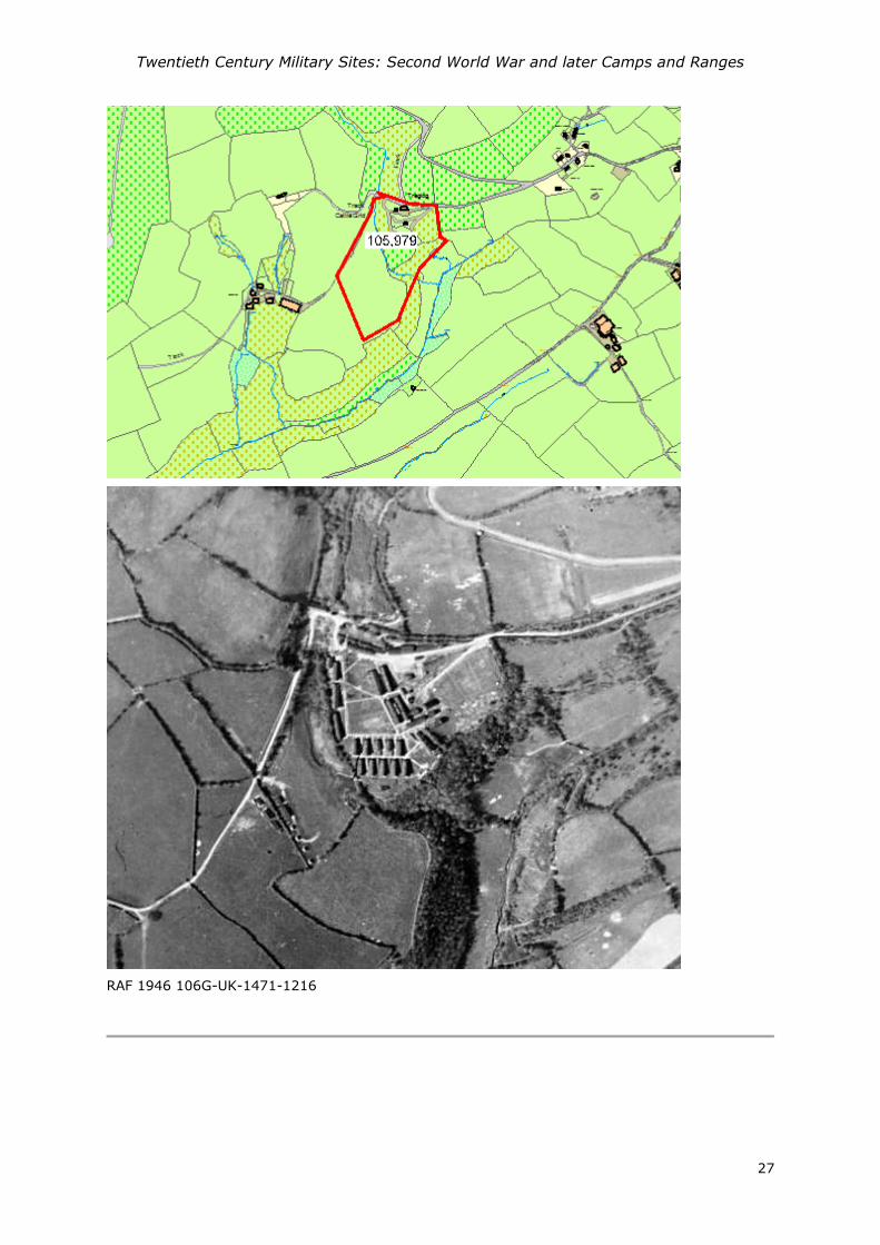
105979
DEPOT Abergwili SN43152111
105980
DEPOT Llandovery SN76373469
107365 ERWLON MILITARY CAMP Llandovery SN77762296
107366 LLWYNJACK MILITARY CAMP Llandovery SN75933360
107367 ABERGLASNEY HOUSE MILITARY CAMP Llangathen SN58172214
107368 LLANELLY NORTH DOCK MILITARY DEPOT Llanelli SS49609982
107369 LLANELLY PEOPLE'S PARK MILITARY BASE Llanelli SS50210041
107370 PEMBREY MILITARY CAMP Cefn Sidan SN426014
107371 BROOM HILL MILITARY HEADQUARTERS Kidwelly SN41170755
107372 YSTRAD CAMP MILITARY CAMP Carmarthen SN39941915
107373 DREFACH-FELINDRE MILITARY BASE Llangeler SN35733943
107374 PEN-Y-COED MILITARY BASE St Clears SN27141826

Twentieth Century Military Sites: Second World War and later Camps and Ranges
11
107375 NO 252 ABERGWILI HOSPITAL
PRISONER OF WAR CAMP Carmarthen SN42862130
107376 199 YSTRAD CAMP PRISONER OF WAR CAMP Carmarthen SN38891908
107378 DREFACH-FELINDRE MILITARY BASE Llangeler SN35093900
107379
SEWAGE WORKS Llandeilo SN61932216
107383
MILITARY DEPOT Cynwyl Gaeo SN66324028
107757 GOLDEN GROVE MILITARY CAMP Llanfihangel Aberbythych SN600199
107758 ALLT-Y-FERIN MILITARY HOSPITAL Llanegwad SN51542269
107759 BRON-Y-DRE MILITARY HEADQUARTERS Carmarthen SN4025819978
107760 ST CLEARS GARAGE CAMP MILITARY CAMP St Clears SN284168
107761 LLANELLY CAMP MILITARY CAMP Llanelli SN505005
107762 BRONHEULOG HOUSE MILITARY BASE Cefn Sidan SN445013
107763 CWMGWILI MILITARY BASE Bronwydd SN426230
107764 RHYD-Y-GORS MILITARY CAMP Carmarthen SN405189
107765 FURNACE CAMP MILITARY CAMP Llanelli SN502015
107766 TALIARIS MILITARY BASE Manordeilo and Salem SN642280
107767 PEMBREY BEACHES MILITARY BASE Cefn Sidan SN420011
107768 WHITLAND DISTRIBUTION POINT MILITARY DEPOT Whitland SN199166
107769 PEMBREY HOUSE MILITARY BASE Cefn Sidan SN43420141
107770 MIDDLETON HALL MILITARY BASE Llanarthney SN52181828
107771 ASHBURNHAM CAMP MILITARY CAMP Cefn Sidan SN425005
107830
FIRING RANGE Llanelli SS51679747
107831 DYNEVOR RIFLE RANGE FIRING RANGE Llandeilo SN60902172

Twentieth Century Military Sites: Second World War and later Camps and Ranges
12
The range of site types represented are recorded in the table below:-
Site Type No
Military Camp 15
Military Base 13
Firing Range 4
Prisoner of War Camp 4
Military Hospital 3
Depot 3
Military Depot 4
Military Headquarters 2
Women’s Land Army Camp 1
Bombing Range 1
Barracks 1
Sewage Works (Army Camp) 1
No Internment Camps or Resettlement Camps have been identified within Carmarthenshire.
Military Camps
Fifteen Military Camps have been identified within Carmarthenshire. In most cases they were established
by the British Army and were used by a variety of British, or sometimes Belgian units, as training
demands required, or to man the defences established in the earlier years of the war when fear of
invasion was at its greatest. The war diaries of Carmarthen Sub-Area and various unit diaries which have
been accessed give an impression of the tremendous movement of troops through the county
(WO166/1270 & 6729).
From late 1943 the massive build-up of United States forces in the UK began in preparation for the
invasion of the continent, code named Operation Bolero, and during this period many of the existing
camps were occupied by US forces.
For the purposes of recording the sites in the HER ‘Military Camp’ is assigned to all these sites, despite
their different phases of use, for their function remains the same. Histories, as far as research has
allowed at this stage, are described within each record description and are sourced within the individual
HER records. Many military camps became Prisoner of War camps, and have been recorded as a
separate site type. A classic example of this is Ystrad Camp in Carmarthen which had periods of use by
British, Belgian, and American troops before becoming a Prisoner of War Camp, PRNs 107372 and
107376.
Twentieth Century Military Sites: Second World War and later Camps and Ranges
13
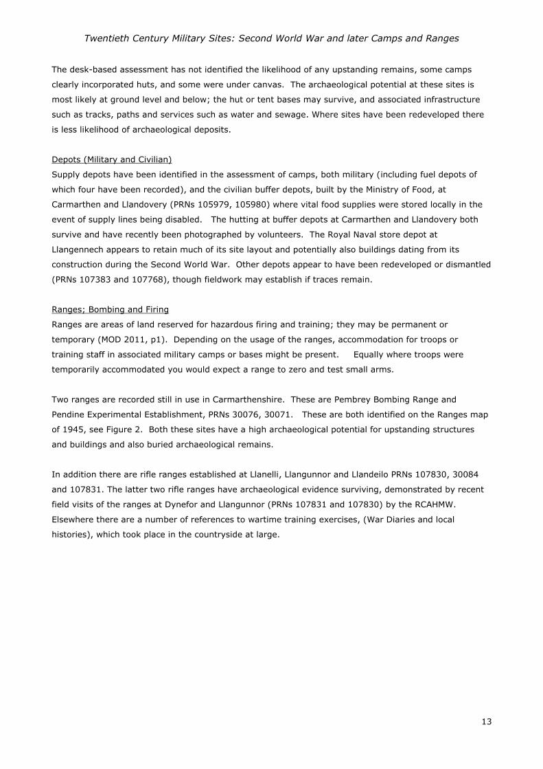
The desk-based assessment has not identified the likelihood of any upstanding remains, some camps
clearly incorporated huts, and some were under canvas. The archaeological potential at these sites is
most likely at ground level and below; the hut or tent bases may survive, and associated infrastructure
such as tracks, paths and services such as water and sewage. Where sites have been redeveloped there
is less likelihood of archaeological deposits.
Depots (Military and Civilian)
Supply depots have been identified in the assessment of camps, both military (including fuel depots of
which four have been recorded), and the civilian buffer depots, built by the Ministry of Food, at
Carmarthen and Llandovery (PRNs 105979, 105980) where vital food supplies were stored locally in the
event of supply lines being disabled. The hutting at buffer depots at Carmarthen and Llandovery both
survive and have recently been photographed by volunteers. The Royal Naval store depot at
Llangennech appears to retain much of its site layout and potentially also buildings dating from its
construction during the Second World War. Other depots appear to have been redeveloped or dismantled
(PRNs 107383 and 107768), though fieldwork may establish if traces remain.
Ranges; Bombing and Firing
Ranges are areas of land reserved for hazardous firing and training; they may be permanent or
temporary (MOD 2011, p1). Depending on the usage of the ranges, accommodation for troops or
training staff in associated military camps or bases might be present. Equally where troops were
temporarily accommodated you would expect a range to zero and test small arms.
Two ranges are recorded still in use in Carmarthenshire. These are Pembrey Bombing Range and
Pendine Experimental Establishment, PRNs 30076, 30071. These are both identified on the Ranges map
of 1945, see Figure 2. Both these sites have a high archaeological potential for upstanding structures
and buildings and also buried archaeological remains.
In addition there are rifle ranges established at Llanelli, Llangunnor and Llandeilo PRNs 107830, 30084
and 107831. The latter two rifle ranges have archaeological evidence surviving, demonstrated by recent
field visits of the ranges at Dynefor and Llangunnor (PRNs 107831 and 107830) by the RCAHMW.
Elsewhere there are a number of references to wartime training exercises, (War Diaries and local
histories), which took place in the countryside at large.

Twentieth Century Military Sites: Second World War and later Camps and Ranges
14
Figure 2: SD 559 ranges map (1945), West and South Wales
Military Hospitals
Three Military Hospitals have been identified, though information has been sparse with the exception of
the U.S. Abergwili Station Hospital (PRN 105975) which is significant in representing the experimental
establishment of a hospital under canvas on a virgin site prior to the invasion of the continent. Newton
House (PRN 50282) was a British Hospital with a satellite Infectious Diseases Hospital at Alltyferin (PRN
107758); both have been written about in the memoirs of Rhoda Campbell (1997).
Whilst the hospital at Abergwili (PRN 105975) has been completely redeveloped and now lies under West
Wales General Hospital and post war housing, at Newton House (PRN 50282) well defined parchmarks
have been recorded by the aerial reconnaissance officer at the RCAHMW (NPRN 266170), indicating a
high preservation of archaeological remains which relate to the hutted hospital.
Barracks
Only one barracks has been recorded existing in Carmarthenshire and this is the Carmarthen Barracks
(PRN 104). It was established in the 19th century and is in military use to this day as a recruiting centre
and as a regional centre for the Territorial Army.
Twentieth Century Military Sites: Second World War and later Camps and Ranges
15
Prisoner of War Camps
Three Prisoner of War Camps in Carmarthenshire have been listed in the report by Roger JC Thomas;
one base camp ‘199 Ystrad’ (PRN 107376), (one where POWs would be screened and ideologically
“graded” before being sent onto other camps (Hellen 1999, p193)), a German Working camp,‘102
Llanddarog’ (PRN 30593) and 252 Abergwili Hospital (PRN 105975). There are anecdotal references to
Newton House, Dinefwr (PRN 50283) being a POW camp but it is not listed in Thomas’s report and no
further documentary references have confirmed it. With the exception of Llanddarog the camps often
represent the reuse of earlier army camps vacated by British and US troops when they moved into
operations on the continent.
Documentary assessment of the former POW camps in the county suggest they have largely been
redeveloped and it is unlikely that significant archaeological evidence of their existence remains.
Military Headquarters
The Carmarthen Sub-Area headquarters were based in Bron-y-dre (PRN 107759), a semi-detached town
house opposite the Carmarthen barracks, (PRN 104). For a short period between March and May 1944
the American Army 38 Infantry Regiment Headquarters was established at Broomhill at Kidwelly (PRN
107371).
Both the houses which were headquarters still stand and are now in residential use. In the case of the
Carmarthen headquarters at Bron-y-dre there may be potential for archaeology relating to hut bases in
the back garden.
Military Base
In the Thesaurus of Monument Types for Wales ‘Military Base’ is a higher level classification than ‘Military
Camp’. In most instances this term has been used for a military establishment within an existing, usually
requisitioned building or series of buildings and may include a hutted or tented camp, such as Drefach
Felindre (PRNs 102535, 107373, 107378). It also includes sites where the nature of the installations are
unknown such as Pembrey Beaches (PRN 107767).
Women’s Land Army Camp
No primary sources for the Women’s Land Army have not be found, though a hostel at Llandeilo (PRN
50284) is known locally and from a biography of a land army veteran, M Harries, held at the Imperial
War Museum (Documents 1411). (http://www.iwm.org.uk/collections/item/object/1030000346) .
DISCUSSION
A range of documentary sources has been accessed for the project, with greater or lesser degree of
usefulness. Establishing the location of army camps has been more difficult than might have been
imagined given the recent nature of the subject and the rigorous record keeping of military institutions,
however finding suitable sources which identify allied military bases, either camps or depots has been

Twentieth Century Military Sites: Second World War and later Camps and Ranges
16
problematic. Further research in the National Archives would probably be fruitful, though the suggestion
is by Schofield that many papers may have been destroyed and that individual records of camps have
rarely been kept (Schofield 2006, p1). Schofield’s dataset produced from the documentary study of
construction and use of army camps in England, Scotland, Wales and Northern Ireland from 1858 -2000
identifies only 5 camps in Carmarthenshire, four of these are located by six figure grid references and
one (St Clears Garage Camp), has no grid reference at all. This project has clearly demonstrated that
this is not a complete picture of British army camps in Carmarthenshire in the Second World War.
In contrast to the UK, army records on US camps are relatively accessible. The official history, ‘Western
Base Section’, completed in 1947 provides a list of US army camps, available through the internet archive
service ‘Fold 3’ https://www.fold3.com/. In addition station lists have been transcribed and digitised by
Lt Col Philip C. Grinton; US Army (Retired) who has documented the lists month by month from
September 1943 to December 1944. However, locational details are limited to four figure Cassini grid
references, consequently there are a number of army sites for listed for Carmarthen town which are
almost impossible to locate. Unfortunately the closure of Carmarthen Archives has put any documents
held locally out of reach for the duration of this project and this has hampered further clarification on the
location of sites. Further research of the local newspapers might help with identifying locations; however
this has not been possible within the scope of this project.
Some transcriptions of war diaries have also been useful in providing a narrative history of various
camps, and in particular the 70th Infantry Brigade War Diary has been helpful in providing an insight into
the movement of service personnel through local camps. However this is not an exhaustive search and
only those war diaries easily accessible through websites have been sourced.
Using the Six inch Ordnance Survey maps 3rd revision available online through the National Library of
Scotland, (publishing date of 1953) has been helpful in some cases, particularly in identifying small arms
firing ranges, but temporary or tented camps do not appear on the maps, and neither do sensitive areas
such as RAF Pembrey airfield. The SSD 559 ranges map is a key source for showing ranges in operation
in 1945 which includes the experimental range at Pendine (PRN 30071).
One of the most important sources for this project has been the wartime and post war vertical aerial
photographs, supplied by the Central Register for Aerial Photography in Wales. The county does not
benefit from complete coverage but where it does exist it has enabled the extent and nature of the
installation to be identified, be it a winterised camp (with tent bases visible) or hutted camp.
This desk-based assessment provides a base line of information of camps and ranges within the county
and something which should be further enhanced through follow-up fieldwork. The archaeological
implications of the work suggest a surprisingly large number of sites which were in military use from the
Second World War and onwards and there is potential for archaeological remains throughout the county.

Twentieth Century Military Sites: Second World War and later Camps and Ranges
17
REFERENCES
Cadw, 2009. Caring for: Military Sites of the Twentieth Century. Cadw Cardiff
Cadw. 2011. Conservation Principles. Cadw Cardiff
Campbell, R 1997 Water Under the Bridge Brown and Sons Cowbridge and Bridgend
Jones, I. 2007. Airfields and Landing Grounds of Wales: West. Tempus Stroud
Hellen, A J, 1999. Temporary Settlements and Transient Populations the Legacy of Britain's Prisoner of
War Camps: 1940–1948 Erdkunde Bd. 53, H. 3 (Jul. - Sep., 1999), pp. 191-219
http://www.jstor.org/stable/25647172
Marble, S. 2013. Skilled and Resolute. A History of the 12th Evacuation Hospital and the 212th MASH,
1917–2006 Fort Sam Houston, Texas: Borden Institute.
MOD, 2011. Handbook of defence land ranges safety (JSP 403 volume 2)
https://www.gov.uk/government/publications/jsp-403-volume-2
Pyper, A. 2012. Twentieth Century Military Sites: Airfields Unpublished DAT Report No 2011/48
Pyper, A. 2013a. Military Aircraft Crash Sites in Southwest Wales Unpublished DAT Report No 2012/5
Pyper, A. 2013b. First World War Scoping Study - Pembrokeshire Unpublished DAT Report No
2012/69
Pyper, A. 2014a. Twentieth Century Military Sites: Airfields – Dispersed Sites and Defences
Unpublished DAT Report No 2014/21
Pyper, A. 2014b. First World War Scoping Study – Carmarthenshire and Ceredigion Unpublished
DAT Report No 2014/19
Pyper, A. 2014. Twentieth Century Military Sites: Airfields – Dispersed Sites and Defences Unpublished
DAT Report No 2014/21
Schofield J, Anderton A, Beavis J, Coad J, Cocroft W, Dobinson C, Foot W, Grove D, Holyoak V, Hunt D,
Johnson A, Lake J, Lawrence A, O’Neill J, Oxley I, Reid B, Saunders A & Thomas RJC. 2004. Modern
Military Matters English Heritage
Schofield J. 2006 England's Army Camps. York: Archaeology Data Service

Twentieth Century Military Sites: Second World War and later Camps and Ranges
18
Theophilus, T. undated. Village life in World War 2 Recollections of Tom Theophilus.
http://www.cilycwm.com/?page_id=1011 accessed March 2015
Thomas, R.J.C. 2003. Prisoner of War Camps (1939 – 1948) English Heritage Unpublished Report
Redfern N I. 1998. Twentieth Century Fortifications in the United Kingdom Volume I. Introduction and
Sources.
Redfern N I. 1998. Twentieth Century Fortifications in the United Kingdom Volume II. Site gazetteers:
Wales p48
WEBSITES
http://www.wartimememoriesproject.com/ww2/homefront/womenslandarmy.php?pagenum=9
http://70brigade.newmp.org.uk/wiki/Main_Page
Primary Sources
War Office Diaries (1942), Carmarthen Sub-Area WO166/6729
War Office Diaries (1940-41), Carmarthen Sub-Area WO166/1270
Schofield, 2nd Lt J K (1947) Western Base Section History, July 1942 – June 1944
Maps and Plans
Experimental Establishment Pendine and Surrounding Area
SD 559 ranges 1945, West & South Wales and Appendices
ACKNOWLEDGEMENTS
The Trust would like to gratefully acknowledge the funding of the project by Cadw. A number of
individuals have helped enormously in providing specialist knowledge and information and have been
most generous with their research, these include Phil Howells, Tony Jukes, Jon Berry (Cadw), David
Llewellyn and Roger JC Thomas (English Heritage). Derek Elliott of the Central Register for Aerial
Photography for Wales provided many of the aerial photographs in the report. Finally Tony Coombe a
volunteer of the Dyfed Archaeological Trust has been assisting in the compilation of the data.
Twentieth Century Military Sites: Second World War and later Camps and Ranges
19
GAZETTEER OF SITES
Marion Page, Historic Environment Record Manager
The gazetteer is listed in alpha numeric order. Where it has been possible to identify the extent of a site
then a polygon has been drawn around it and the map is included. Where applicable a corresponding
wartime or post War Aerial Photograph is also attached to the record.
Twentieth Century Military Sites: Second World War and later Camps and Ranges
20
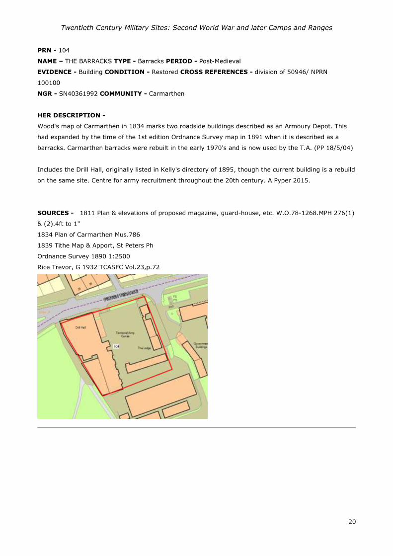
PRN - 104
NAME – THE BARRACKS TYPE - Barracks PERIOD - Post-Medieval
EVIDENCE - Building CONDITION - Restored CROSS REFERENCES - division of 50946/ NPRN
100100
NGR - SN40361992 COMMUNITY - Carmarthen
HER DESCRIPTION -
Wood's map of Carmarthen in 1834 marks two roadside buildings described as an Armoury Depot. This
had expanded by the time of the 1st edition Ordnance Survey map in 1891 when it is described as a
barracks. Carmarthen barracks were rebuilt in the early 1970's and is now used by the T.A. (PP 18/5/04)
Includes the Drill Hall, originally listed in Kelly's directory of 1895, though the current building is a rebuild
on the same site. Centre for army recruitment throughout the 20th century. A Pyper 2015.
SOURCES - 1811 Plan & elevations of proposed magazine, guard-house, etc. W.O.78-1268.MPH 276(1)
& (2).4ft to 1"
1834 Plan of Carmarthen Mus.786
1839 Tithe Map & Apport, St Peters Ph
Ordnance Survey 1890 1:2500
Rice Trevor, G 1932 TCASFC Vol.23,p.72

Twentieth Century Military Sites: Second World War and later Camps and Ranges
21
PRN - 30071
NAME - PENDINE RANGE; EXPERIMENTAL ESTABLISHMENT PENDINE
TYPE - Firing Range
PERIOD - Modern
EVIDENCE - DOCUMENTARY EVIDENCE
CONDITION - Not known
CROSS REFERENCES - division of 30108/ NPRN 128641
NGR - SN27900700
COMMUNITY - Laugharne Township
HER DESCRIPTION -
A weapons testing range was established at Pendine during the Second World War. The need for a
weapons testing establishment lead to the development of an 'Inter Service Small Arms Experimental
Establishment' based on an existing site at Hythe in Kent. However with the threat of invasion following
Dunkirk in 1940, other locations in the UK were sought and Pendine was chosen as a suitable site in
1940. Many of the staff from Hythe and Shoeburyness relocated to the Beach Hotel before developing a
new Headquarters at Llanmiloe House. Whilst it was initially established as a temporary range for
wartime use, a review by the Ministry of Defence after the war lead to Pendine becoming a permanent
site for the testing of a variety of weapons, not just small arms. Developments between 1951 and 1956
led to a 1500 metre test track to provide a site for testing dynamic missiles.
Currently MOD Pendine is the UK home of the NATO (North Atlantic Treaty Organisation) European
Regional Test Centre for Small Arms Ammunition (SAA). It is one of two Regional Test Centres (the other
in Philadelphia) for standardising weapons and equipment for NATO forces.
A plan of the site with amendments dated 1951 shows the beach landing strip towards the west end of
the range and the proposed location of new magazines. The main areas of accommodation at this time
were in huts which lie at the base of slope to the northeast and southwest of Llanmiloe House, in
subsequent years these have been consolidated into a formal housing accommodation.
A Pyper based on MOD Pendine- History accessed 23/12/2014
SOURCES - QinetiQ website History of MOD Pendine
1951 Experimental Establishment Pendine and Surrounding Area DRG No 557A1/D3/24
Gale, A 1995 Between Tides, A Coastal Survey of Carmarthen Bay: A Pilot Project

Twentieth Century Military Sites: Second World War and later Camps and Ranges
22
Twentieth Century Military Sites: Second World War and later Camps and Ranges
23
PRN - 30076
NAME – PEMBREY SANDS AIR WEAPONS RANGE
TYPE – BOMBING RANGE
PERIOD - Modern
EVIDENCE - DOCUMENTARY EVIDENCE
CONDITION - Not known
CROSS REFERENCES - division of 30108/ NPRN 128646
NGR - SN36500520
COMMUNITY - Cefn Sidan
HER DESCRIPTION -
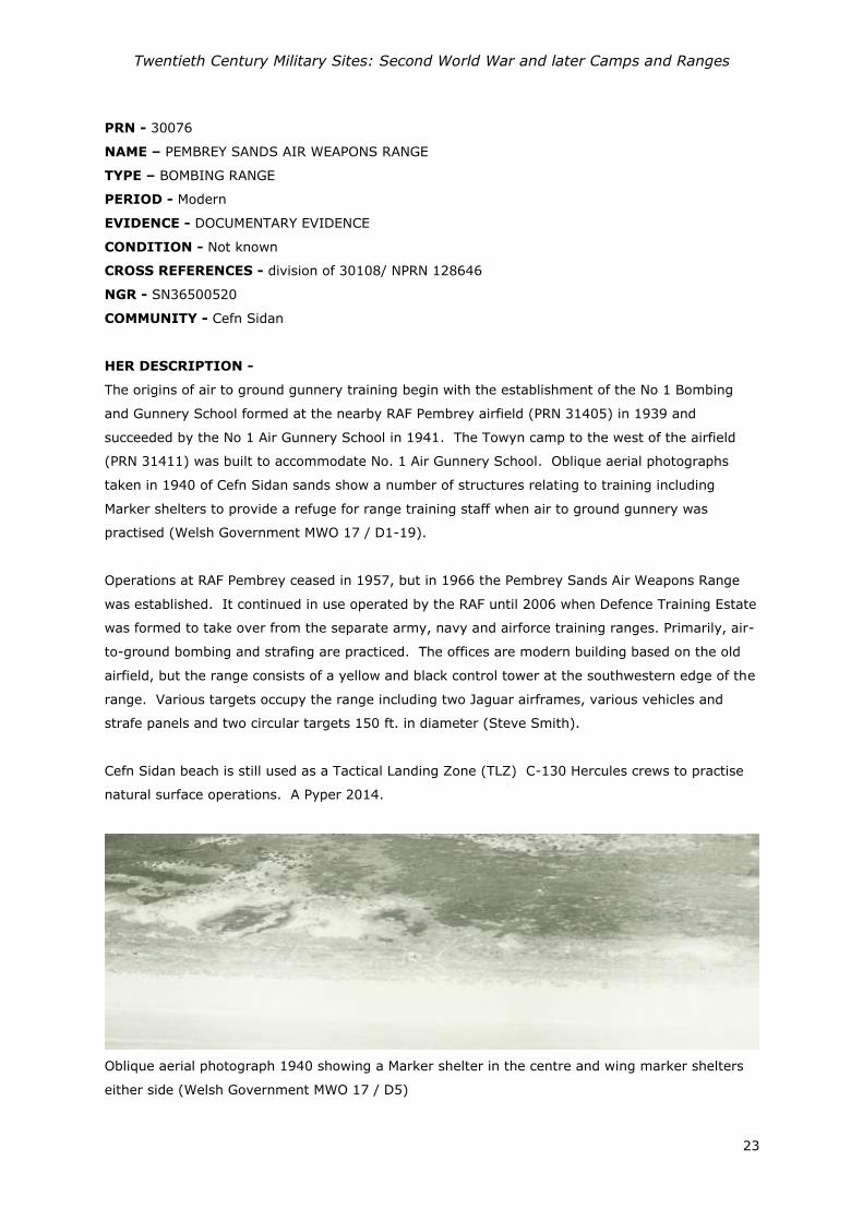
The origins of air to ground gunnery training begin with the establishment of the No 1 Bombing
and Gunnery School formed at the nearby RAF Pembrey airfield (PRN 31405) in 1939 and
succeeded by the No 1 Air Gunnery School in 1941. The Towyn camp to the west of the airfield
(PRN 31411) was built to accommodate No. 1 Air Gunnery School. Oblique aerial photographs
taken in 1940 of Cefn Sidan sands show a number of structures relating to training including
Marker shelters to provide a refuge for range training staff when air to ground gunnery was
practised (Welsh Government MWO 17 / D1-19).
Operations at RAF Pembrey ceased in 1957, but in 1966 the Pembrey Sands Air Weapons Range
was established. It continued in use operated by the RAF until 2006 when Defence Training Estate
was formed to take over from the separate army, navy and airforce training ranges. Primarily, air-
to-ground bombing and strafing are practiced. The offices are modern building based on the old
airfield, but the range consists of a yellow and black control tower at the southwestern edge of the
range. Various targets occupy the range including two Jaguar airframes, various vehicles and
strafe panels and two circular targets 150 ft. in diameter (Steve Smith).
Cefn Sidan beach is still used as a Tactical Landing Zone (TLZ) C-130 Hercules crews to practise
natural surface operations. A Pyper 2014.
Oblique aerial photograph 1940 showing a Marker shelter in the centre and wing marker shelters
either side (Welsh Government MWO 17 / D5)
Twentieth Century Military Sites: Second World War and later Camps and Ranges
24
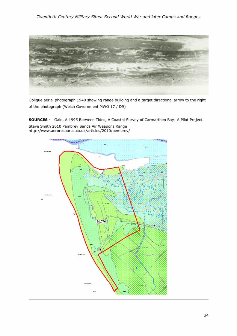
Oblique aerial photograph 1940 showing range building and a target directional arrow to the right
of the photograph (Welsh Government MWO 17 / D9)
SOURCES - Gale, A 1995 Between Tides, A Coastal Survey of Carmarthen Bay: A Pilot Project
Steve Smith 2010 Pembrey Sands Air Weapons Range http://www.aeroresource.co.uk/articles/2010/pembrey/

Twentieth Century Military Sites: Second World War and later Camps and Ranges
25
PRN - 30084
NAME – LLANGUNNOR RIFLE RANGE
TYPE – Firing Range
PERIOD – Post Medieval; Modern
EVIDENCE - Complex
CONDITION - Not Known
NGR – SN42702060
COMMUNITY - Llangunnor
HER DESCRIPTION - Rifle range marked on the Carmarthenshire 1886 map, located within a
meander of the Towy. To the northwest, firing positions include 600 yard on the west side of the
river, 500, 400, 300, 200 and 100 yard and marker's butts at the southeast end of the range. The
rifle range continues to be marked out on the 1952 (1948 revision) suggesting it use through the
two World Wars. A Pyper 2015
Extract of Ordnance Survey 1952 Carmarthenshire XXXIX.NE sheet (National Library of Scotland)
SOURCES –
Ordnance Survey 1952 Carmarthenshire XXXIX.NE
Twentieth Century Military Sites: Second World War and later Camps and Ranges
26
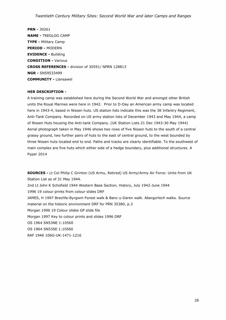
PRN - 30261
NAME - TREGLOG CAMP
TYPE - Military Camp
PERIOD - MODERN
EVIDENCE - Building
CONDITION - Various
CROSS REFERENCES - division of 30591/ NPRN 128813
NGR - SN59533499
COMMUNITY - Llansawel
HER DESCRIPTION -
A training camp was established here during the Second World War and amongst other British
units the Royal Marines were here in 1942. Prior to D-Day an American army camp was located
here in 1943-4, based in Nissen huts. US station lists indicate this was the 38 Infantry Regiment,
Anti-Tank Company. Recorded on US army station lists of December 1943 and May 1944, a camp
of Nissen Huts housing the Anti-tank Company. (UK Station Lists 21 Dec 1943-30 May 1944)
Aerial photograph taken in May 1946 shows two rows of five Nissen huts to the south of a central
grassy ground, two further pairs of huts to the east of central ground, to the west bounded by
three Nissen huts located end to end. Paths and tracks are clearly identifiable. To the southwest of
main complex are five huts which either side of a hedge boundary, plus additional structures. A
Pyper 2014
SOURCES - Lt Col Philip C Grinton (US Army, Retired) US Army/Army Air Force: Units from UK
Station List as of 31 May 1944.
2nd Lt John K Schofield 1944 Western Base Section, History, July 1942-June 1944
1996 19 colour prints from colour slides DRF
JAMES, H 1997 Brechfa-Byrgwm Forest walk & Banc-y-Daren walk. Abergorlech walks. Source
material on the historic environment DRF for PRN 35380, p.3
Morgan 1996 19 Colour slides GP slide file
Morgan 1997 Key to colour prints and slides 1996 DRF
OS 1964 SN53NE 1:10560
OS 1964 SN53SE 1:10560
RAF 1946 106G-UK-1471-1216
Twentieth Century Military Sites: Second World War and later Camps and Ranges
27
RAF 1946 106G-UK-1471-1216

Twentieth Century Military Sites: Second World War and later Camps and Ranges
28
PRN - 30593
NAME - NO 102 LLANDDAROG CAMP
TYPE - Prisoner of War Camp
PERIOD - Modern
EVIDENCE - Building
CONDITION - Near Destroyed/ NOT KNOWN
CROSS REFERENCES - NPRN 129073
NGR - SN4937816252
COMMUNITY - Llanddarog
HER DESCRIPTION -
A prisoner of war camp No 102, listed as a German base camp (Thomas, 2003). Housed Italian
and then German prisoners. Modern aerial photography (Next Perspectives 2009) suggests that it
has largely been built over by a housing estate. A Pyper 2014.
SOURCES - Thomas, RJC 2003 Twentieth Century Military Recording Project: Prisoner of War
Camps (1939-1948)
US 1944 US Aerial Photograph, Medmenham Series M1281;
Hodge,V 1994 The history of Llanddarog Village and Parish
OS 1964 SN41NE 1:10560

Twentieth Century Military Sites: Second World War and later Camps and Ranges
29
US 1944 US Aerial Photograph, Medmenham Series M1281; 1017

Twentieth Century Military Sites: Second World War and later Camps and Ranges
30
PRN - 31411
NAME - TOWYN CAMP
TYPE - Military Camp
PERIOD - Modern
EVIDENCE - Building
CONDITION - Destroyed/ DAMAGED
CROSS REFERENCES - NPRN 130093
NGR - SN39730374
COMMUNITY - Cefn Sidan
HER DESCRIPTION -
'Towyn Camp' was the RAF No 1 Air Gunners School associated with the airfield at Pembrey (PRN
31405) in use from 1939 to 1957. Located to the west of the airfield's main NE-SW runway, it was
a large camp with a parade ground at its centre, domestic accommodation, stores, classrooms,
machine shops, a turret stripping shop and turret instructional building and 200 yard moving
target range, headquarters building and guardhouse. No upstanding structures survived when
visited in 2013, but the concrete hut platforms do. A Pyper based on I Jones 2007.
SOURCES - Jones, Ivor 2007 Airfields and Landing Grounds of Wales: West
Air Ministry 1948 Pembrey Record Site Plan Dwg 3925/48
Medmenham collection M2267 1942
US 1944 US Aerial Photograph, Medmenham Series M1272;
RAF 1944 Air Ministry Record Plan

Twentieth Century Military Sites: Second World War and later Camps and Ranges
31
RAF 1946 106G UK 1400 (3044)

Twentieth Century Military Sites: Second World War and later Camps and Ranges
32
PRN - 33673
NAME - R.N. STORE DEPOT LLANGENNECH
TYPE – Military Depot
PERIOD - Modern
EVIDENCE - Complex
CONDITION - Various
CROSS REFERENCES - NPRN 130624
NGR - SN55800200
COMMUNITY - Llangennech
HER DESCRIPTION -
Royal Navy stores depot (Fleet Air Arm), Llangennech was built during the Second World War, it
incorporated test workshops and facilities. It was closed during MOD restructuring in the early
years of the 21st century. A Pyper 2015
SOURCES - RN 1948 General layout of R.N. store depot at Llangennech, Caerwent Works District
DRF
RAF Aerial Photograph 1946 106G/UK 1629 (5186)

Twentieth Century Military Sites: Second World War and later Camps and Ranges
33
RAF Aerial Photograph 1946 106G/UK 1629 (5186)

Twentieth Century Military Sites: Second World War and later Camps and Ranges
34
PRN - 50281
NAME -
TYPE – MILITARY BASE
PERIOD - Modern
EVIDENCE - Complex
CONDITION - Destroyed
CROSS REFERENCES - division of 50045
NGR - SN62762267
COMMUNITY - Llandeilo
HER DESCRIPTION -
During the Second World War there was a military presence in Llandeilo. The 70th Brigade
Advanced Divisional Headquarters and Divisional units were situated in and around the town (70th
Brigade War Diaries 1942)
In 1942 a unit of American soldiers (engineers) was billeted at the Dynevor Church Hall (PRN
50280). In the field adjacent to the hall, now built over by Dynevor Avenue, they had a field
kitchen and a large petrol dump. In the field at the end of Diana Road was a purpose built
ammunition store building. They also had a field laundry at the farmyard of Aberglasney. The
Thanksgiving Dinner for the company was served in November 1943, the turkeys having been
cooked overnight at the Crown Stores Bakery oven (now the Spar Shop in New Road). 3534
Ordnance Medium Auto Maintenance Company where based in Llandeilo during 1944. Aerial
photographs from that date show, American army trucks parked on the land now occupied by the
squash courts and the small car park adjacent to the fire station. Also trucks can be seen parked
to the east of the church hall. A Pyper 2014.
SOURCES - Hall, J & Sambrook, P 2004 Llandeilo Fawr Heritage Audit
US 1944 US Aerial Photograph, Medmenham Series M1272;
Schofield J, Foot W and Evans D. 2006 England's Army Camps [data-set]. York: Archaeology Data
Service [distributor] (doi:10.5284/1000269)
2nd Lt John K Schofield 1944 Western Base Section, History, July 1942-June1944
DAT 2004 Llandeilo Fawr Heritage Audit SMR

Twentieth Century Military Sites: Second World War and later Camps and Ranges
35
Composite Aerial Photograph 1944 M1272 3001-4003 showing US trucks parked up in bottom left
and top right of photograph.

Twentieth Century Military Sites: Second World War and later Camps and Ranges
36
PRN - 50282
NAME - NEWTON HOUSE
TYPE - Military Hospital
PERIOD - Modern
EVIDENCE - Complex
CONDITION - Various
CROSS REFERENCES - division of 50045
NGR - SN61432253
COMMUNITY - Llandeilo
HER DESCRIPTION -
Newton House was used a military hospital by the Royal Army Medical Corps and later the
American army during the Second World War, until mid-1944. The house itself was used and about
15 accompanying Nissan huts were built in the parkland to the east of the mansion. These later
became a Prisoner of War camp (PRN 50283).
SOURCES - Hall, J & Sambrook, P 2004 Llandeilo Fawr Heritage Audit
DAT 2004 Llandeilo Fawr Heritage Audit SMR

Twentieth Century Military Sites: Second World War and later Camps and Ranges
37
PRN - 50283
NAME - DINEFWR PARK
TYPE - Prisoner of War Camp
PERIOD - Modern
EVIDENCE - Complex
CONDITION - Near Destroyed
CROSS REFERENCES - division of 50045/ associated with PRN 107379
NGR - SN61612242
COMMUNITY - Llandeilo
HER DESCRIPTION -
A group of about 15 Nissen Huts stood in the parkland in front of Newton House during the Second
World War, originally provided as part of a military hospital. Towards the end of the war, these
were used as a Prisoner of War camp allegedly for high-ranking German officers. After the war, the
huts were used to house the homeless and the settlement was known as "Tin Town". Remains of
the hut camp are visible on the Meridian Airmaps of 1955, where a number of Nissen huts still
survive, perhaps as many as nine in total and bases for others still visible. A sewage plant is also
visible to the southeast; PRN 107379. A Pyper 2014.
POWs at Newton from 1944-5 until 1948. They were well liked. During the great snow of 1947, the
POWs cleared the length of The Walk (about 300m) and carved out snow houses in the drifts which
local children loved.
SOURCES - Hall, J & Sambrook, P 2004 Llandeilo Fawr Heritage Audit
Meridian Airmaps 1955 SN62SW
DAT 2004 Llandeilo Fawr Heritage Audit SMR
RAF Aerial Photograph 1946 106G/UK1625 2140

Twentieth Century Military Sites: Second World War and later Camps and Ranges
38
RAF Aerial Photograph 1946 106G/UK1625 2140

Twentieth Century Military Sites: Second World War and later Camps and Ranges
39
PRN - 50284
NAME - LLANDEILO LAND ARMY CAMP
TYPE - Army Camp
PERIOD - Modern
EVIDENCE - Complex
CONDITION - Not Known
CROSS REFERENCES - division of 50045
NGR - SN62412298
COMMUNITY - Llandeilo
HER DESCRIPTION -
A camp was built here in 1940 for the Women’s Land Army. After the Second World War it was
used to house the homeless.
SOURCES - Hall, J & Sambrook, P 2004 Llandeilo Fawr Heritage Audit
DAT 2004 Llandeilo Fawr Heritage Audit SMR
RAF Aerial Photograph 1946 106G/UK1625 2140
Harries M papers held at the IWM http://www.iwm.org.uk/collections/item/object/1030000346

Twentieth Century Military Sites: Second World War and later Camps and Ranges
40
RAF Aerial Photograph 1946 106G/UK1625 2140

Twentieth Century Military Sites: Second World War and later Camps and Ranges
41
PRN - 102535
NAME - DREFACH FELINDRE
TYPE – AIRFIELD;CAMP
PERIOD - Modern
EVIDENCE - Complex
CONDITION - Not known
CROSS REFERENCES - Associated with PRN 107373/ associated with PRN 107378
NGR - SN35013923
COMMUNITY - Llangeler
HER DESCRIPTION -
An airfield and base was established at Drefach and Felindre as the mills were commandeered by
the War Office to provide Army barracks. Various British units moved through and then in
late1943, with preparations for the invasion of Normandy came the US army field artillery and with
them the light aircraft 'Piper Cub' used for observation and communication for which a grass
airstrip field was established. The airstrip was based at Cryngae Farm. (A Pyper 2012 based on I
Jones 2007 p40-1)
SOURCES - Jones, Ivor 2007 Airfields and Landing Grounds of Wales: West
Pyper, A 2012 Twentieth century military sites: Airfields
Meridian Airmaps 1955 SN33NE
RAF 1946 106g uk 1471
Location of PRN 102535 in relation to the hutted camps at PRNs 107373 and 107378

Twentieth Century Military Sites: Second World War and later Camps and Ranges
42
1946 Aerial Photograph (106guk 1471 – 2253) showing the grass field airstrip PRN 102535
and two areas of hutted camps PRNs 107373 and 107378.
Twentieth Century Military Sites: Second World War and later Camps and Ranges
43
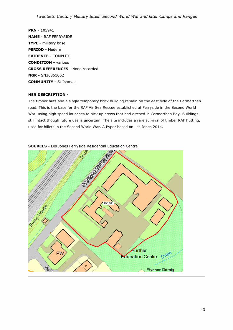
PRN - 105941
NAME - RAF FERRYSIDE
TYPE - military base
PERIOD - Modern
EVIDENCE - COMPLEX
CONDITION - various
CROSS REFERENCES - None recorded
NGR - SN36851062
COMMUNITY - St Ishmael
HER DESCRIPTION -
The timber huts and a single temporary brick building remain on the east side of the Carmarthen
road. This is the base for the RAF Air Sea Rescue established at Ferryside in the Second World
War, using high speed launches to pick up crews that had ditched in Carmarthen Bay. Buildings
still intact though future use is uncertain. The site includes a rare survival of timber RAF hutting,
used for billets in the Second World War. A Pyper based on Les Jones 2014.
SOURCES - Les Jones Ferryside Residential Education Centre

Twentieth Century Military Sites: Second World War and later Camps and Ranges
44
PRN - 105975
NAME - 12th EVACUATION HOSPITAL; 232rd STATION HOSPITAL
TYPE - Military Hospital
PERIOD - Modern
EVIDENCE - DOCUMENTARY EVIDENCE
CONDITION - NOT KNOWN
CROSS REFERENCES - associated with PRN 107375
NGR - SN42862130
COMMUNITY - Carmarthen
HER DESCRIPTION -
Site used as a US army hospital from October 1943 through to March 1945. Initially established by
the 12th Evacuation Hospital as an experiment in establishing station hospitals under canvas prior
to the invasion of the continent. It became the blueprint for Allied hospitals on the continent
following D-Day and as such it is an important example of research and development.
Contemporary photographs indicate that the site incorporated tents and Nissen huts. The main site
is now occupied by the West Wales General Hospital, but a camp also lined the west side of the
Newcastle Emlyn road. In October 1943 the 12th Evacuation Hospital arrived at an 'empty cow
pasture' near Carmarthen where they were tasked with setting up and establishing a station
hospital, first under canvas and gradually moving into Nissen huts as they were introduced.
(Marble 2013, p 22). On March 25th 1944 the facilities were handed over to the 232rd Station
Hospital, who were largely billeted in canvas tents which later became 'winterized' and the hospital
functions were carried out in Nissen huts. The hospital operated as Hospital Plant #4184. On the
12 March 1945 orders were received to disband and four days later the site was evacuated.
The site then became a Prisoner of War camp PRN 107375. It is now the site of West Wales
General Hospital. A Pyper 2014 based on various sources.
SOURCES - Marble, Sanders 2013 Skilled and Resolute A History of the 12th Evacuation Hospital
and the 212th MASH, 1917–2006
23rd Station Hospital, Unit History
US 1944 US Aerial Photograph, Medmenham Series M1272;
Meridian Airmaps 1955 SN42SW
2nd Lt John K Schofield 1944 Western Base Section, History, July 1942-June1944

Twentieth Century Military Sites: Second World War and later Camps and Ranges
45
Aerial Photograph Medmenham (1944) M1272_1018

Twentieth Century Military Sites: Second World War and later Camps and Ranges
46
Drawing after Marble, Sanders 2013 Skilled and Resolute A History of the 12th Evacuation Hospital
and the 212th MASH, 1917–2006

Twentieth Century Military Sites: Second World War and later Camps and Ranges
47
PRN - 105976
NAME - BYNEA SALVAGE DEPOT
TYPE - DEPOT
PERIOD - Modern
EVIDENCE - Documentary evidence
CONDITION - NOT KNOWN
CROSS REFERENCES - None recorded
NGR - SS54589920
COMMUNITY - Llanelli
HER DESCRIPTION -
1946 Aerial photographs show a salvage yard to the north of the railway with material dumped to
the north and one large pitched roof shed, smaller sheds to either side. Next Perspectives aerial
photos show a large building still present at the site. A Pyper 2015
SOURCES - US 1944 US Aerial Photograph, Medmenham Series M1281;
Next Perspectives 2009 Aerial Photograph Digital Aerial Photo mapping
RAF Aerial Photograph 1946:106 guk 1629

Twentieth Century Military Sites: Second World War and later Camps and Ranges
48
PRN - 105977
NAME - BURRY PORT
TYPE - Military Camp
PERIOD - Modern
EVIDENCE - Documentary evidence
CONDITION - NOT KNOWN
CROSS REFERENCES - None recorded
NGR - SN43590018
COMMUNITY - Burry Port
HER DESCRIPTION -
Previously a camp for the coastal artillery battery manned by the 402 Coast Battery Royal Artillery
(Defence of Britain database 1999, Cobb 2013). Built in 1940, described as a complex of
eighteen huts, a static water tank, a Battery Observation Post, a Coastal Artillery Searchlight and
two 4 inch gun houses. Following the removal of the guns from their mountings the camp served
other purposes and accommodated United States Army personnel during the Second World War
from Dec 1943 to 1944.
Listed on Station Lists for United States Army dated December 1943 and May 1944, a camp
accommodating 2 companies in Nissen Huts; 38 Infantry Regiment, Company 'K' and 'M' Infantry
Companys (Div).
1940 Aerial photography shows only the dock cottages built at the landward end of the pier. Later
Aerial Photographs (RAF 1946?) show around 20 Nissen huts clustered to the northwest of the
Dock cottages. Also around the perimeter to the northwest of the camp are pits, these are the
remains of the anti-tank mines which had been removed.
Next Perspectives aerial photography shows one possible concrete base present.
A Pyper based on DOB database, J Berry (pers. comm.), Aerial Photographs and pers. comm. P
Howells 2014.
SOURCES - 2nd Lt John K Schofield 1944 Western Base Section, History, July 1942-June1944
1940 Medmenham series M328
Council for British Archaeology (2006) Defence of Britain Archive [data-set]. York: Archaeology
Data Service [distributor]
RAF? 1946?
Lt Col Philip C Grinton (US Army, Retired) US Army/Army Air Force: Units from UK Station List as
of 31 May 1944.
Peter Cobb and the U.K.F.C: 2013: Coastal Defence Batteries of England, Wales, Scotland, Ireland
& Isle of Man in the Second World War.

Twentieth Century Military Sites: Second World War and later Camps and Ranges
49
RAF 1946 Aerial Photograph of Burry Port (4621_7120)

Twentieth Century Military Sites: Second World War and later Camps and Ranges
50
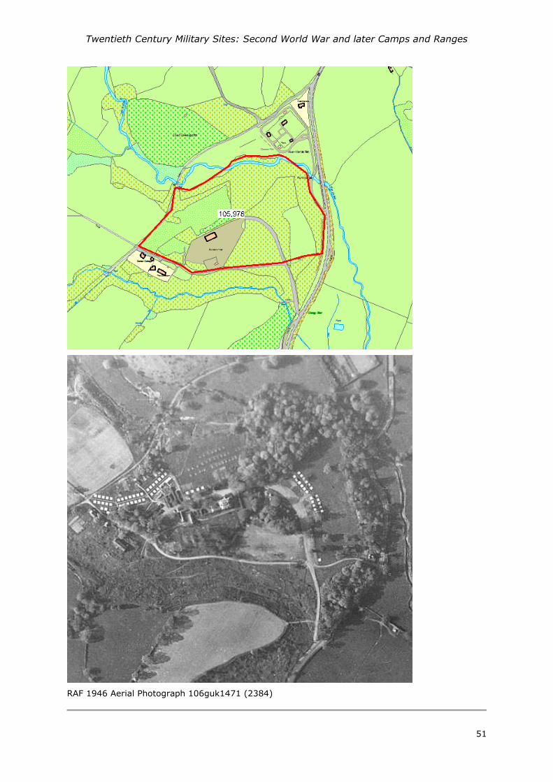
PRN - 105978
NAME - ABERMARLAIS CAMP
TYPE - Military Camp
PERIOD - Modern
EVIDENCE - DOCUMENTARY EVIDENCE
CONDITION - Not Known
CROSS REFERENCES - None recorded
NGR - SN69312961
COMMUNITY - Llansadwrn
HER DESCRIPTION -
An army camp occupied by the British Army Royal Army Service Corps, 70th Infantry Brigade in
January 1943 (70th Brigade War Diary). Recorded on Station Lists for United States Army dated
December 1943 and May 1944, a winter Camp for 103 Engineering Combat Battalion was based
within the grounds of the former mansion of Abermarlais, near Llangadog. It is recorded that 33
officers ad 772 enlisted men were stationed here (WBS History 1944). Post war (1946) aerial
photographs show in the region of 70 square concrete bases for tents. The paired locations are
located either side of interconnecting tracks. A crop-mark to the north-northwest of the former
house site indicates a further 3 rows of tent bases, though probably not concreted. A row of four
Nissen huts were located to the northwest of the former house site. A Pyper based on various
sources. 2014
SOURCES - 1946 106g uk 1471
2nd Lt John K Schofield 1944 Western Base Section, History, July 1942-June1944
Lt Col Philip C Grinton (US Army, Retired) US Army/Army Air Force: Units from UK Station List as
of 31 May 1944.
70th_Infantry_Brigade_War_Diary_January_1943. : http://70brigade.newmp.org.uk
Twentieth Century Military Sites: Second World War and later Camps and Ranges
51
RAF 1946 Aerial Photograph 106guk1471 (2384)

Twentieth Century Military Sites: Second World War and later Camps and Ranges
52
PRN - 105979
NAME -
TYPE - DEPOT
PERIOD - MODERN
EVIDENCE - DOCUMENTARY EVIDENCE
CONDITION - NOT KNOWN
CROSS REFERENCES - None recorded
NGR - SN43152111
COMMUNITY - Abergwili
HER DESCRIPTION -
A supply or buffer depot located between the railway (now disused) and Abergwili Road to the east
of Carmarthen. Built in 1940 by the Ministry of Food. Shown on the Meridian Airmaps of 1955
consisting of 8 curved corrugated iron huts and three parallel corrugated pitched roofed sheds.
Wartime Aerial photographs of 1944 suggest only one curved corruated hut was built at this time.
Similar depot in Llandovery PRN 105980. A Pyper 2014.
SOURCES - Meridian Airmaps 1955 SN42SW
US 1944 US Aerial Photograph, Medmenham Series M1272;

Twentieth Century Military Sites: Second World War and later Camps and Ranges
53
RAF 1946 Aerial Photograph 106guk1625 (4604_6132)
The buffer depot at Abergwili taken on 19th September 2012 (image courtesy of B A Jukes)

Twentieth Century Military Sites: Second World War and later Camps and Ranges
54
PRN - 105980
NAME -
TYPE - DEPOT
PERIOD - Modern
EVIDENCE - DOCUMENTARY EVIDENCE
CONDITION - Unknown
NGR - SN76373469
COMMUNITY - Llandovery
HER DESCRIPTION -
A supply or buffer depot located adjacent to and on the west side of the railway and north of Tywi
Avenue in Llandovery. Probably built during the Second World War by the Ministry of Food to store
foodstuffs. Consists of 4 Romney or Nissen corrugated iron huts and three parallel corrugated
pitched roofed sheds. Shown on the Meridian Airmaps of 1955. Similar depot in Carmarthen PRN
105979. A Pyper 2014.
SOURCES - Meridian Airmaps 1955 SN73SE

Twentieth Century Military Sites: Second World War and later Camps and Ranges
55
Meridian Airmaps Aerial Photograph 1955 SN73SE_29836
Buffer depot at Llandovery taken on 19th November 2014, (image courtesy of David Llewellyn).

Twentieth Century Military Sites: Second World War and later Camps and Ranges
56
PRN - 107365
NAME - ERWLON
TYPE - Military Camp
PERIOD - Modern
EVIDENCE - Documentary evidence
CONDITION - Unknown
CROSS REFERENCES - None recorded
NGR - SN77762296
COMMUNITY - Llandovery
HER DESCRIPTION -
Site of US Army Camp during the Second World War; 44 Engineer Combat Battalion, Company C.
Location cannot be further identified from post war aerial photographs as Meridian Airmaps (1955)
do not give any indication of location and extent and the camp was probably under canvas. A
reference to a camp for black soldiers 'near the current campsite' suggests a site at 'Erwlon'
(Theophilus) A Pyper based on Station Lists 2014
SOURCES - Lt Col Philip C Grinton (US Army, Retired) US Army/Army Air Force: Units from UK
Station List as of 31 May 1944.
Meridian Airmaps 1955 SN73SE
Tom Theophilus Childhood Memories of Village Life during World War Two in Rhandirmwyn and
Cilycwm

Twentieth Century Military Sites: Second World War and later Camps and Ranges
57
PRN - 107366
NAME - LLWYNJACK
TYPE - Military Camp
PERIOD - Modern
EVIDENCE - Documentary evidence
CONDITION - Unknown
CROSS REFERENCES - None recorded
NGR - SN759336
COMMUNITY - Llandovery
HER DESCRIPTION -
Site of US Army Camp during the Second World War; 116 Ordnance Medium Maintenance
Company. Location cannot be further identified from post war aerial photographs as Meridian
Airmaps (1955) do not give any indication of location and extent and the camp was probably under
canvas. A reference to a camp 'near Llandingat church for white soldiers' suggest somewhere
between the church and Llwynjack (Theophilus) A Pyper based on Station Lists 2014
SOURCES - Lt Col Philip C Grinton (US Army, Retired) US Army/Army Air Force: Units from UK
Station List as of 31 May 1944.
Meridian Airmaps 1955 SN73SE
Tom Theophilus Childhood Memories of Village Life during World War Two in Rhandirmwyn and
Cilycwm

Twentieth Century Military Sites: Second World War and later Camps and Ranges
58
PRN - 107367
NAME - ABERGLASNEY HOUSE
TYPE - MILITARY CAMP
PERIOD - Modern
EVIDENCE - Documentary evidence
CONDITION - Unknown
CROSS REFERENCES - None recorded
NGR - SN58172214
COMMUNITY - Llangathen
HER DESCRIPTION -
Aberglasney was requisitioned during the Second World War and the United States army 600
Quartermaster Laundry Company were stationed there. This was a black unit at a time of racial
segregation in the US army. It is recorded that 3 officers and 220 Enlisted Men were stationed
here (A. Pyper based on UK Station lists 21 Dec 1943 - 30 May 1944 and Western Base Section
History.)
SOURCES - 2nd Lt John K Schofield 1944 Western Base Section, History, July 1942-June1944
Lt Col Philip C Grinton (US Army, Retired) US Army/Army Air Force: Units from UK Station List as
of 31 March1944.
Lt Col Philip C Grinton (US Army, Retired) US Army/Army Air Force: Units from UK Station List as
of 30 April 1944.
Lt Col Philip C Grinton (US Army, Retired) US Army/Army Air Force: Units from UK Station List as
of 31 May 1944.
Lt Col Philip C Grinton (US Army, Retired) US Army/Army Air Force: Units from UK Station List as
of 30 June1944.

Twentieth Century Military Sites: Second World War and later Camps and Ranges
59
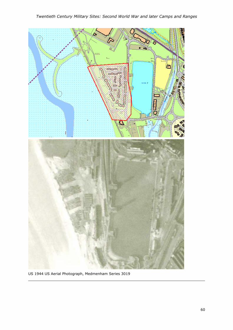
PRN - 107368
NAME - LLANELLY NORTH DOCK
TYPE - Military Depot
PERIOD - Modern
EVIDENCE - Documentary evidence
CONDITION - Unknown
CROSS REFERENCES - None recorded
NGR - SS49609982
COMMUNITY - Llanelli
HER DESCRIPTION -
By June 1940, 20 acres at Llanelli North Dock were leased to the National Oil Refineries as a petrol
dump. A German map of 1940 appears to have the dump identified, and it was bombed by the
Lufftwaffe in September 1940. Petrol storage ceased by November 1941 and the docks were used
for the import of and storage of iron and steel. With the build up of American forces for the
invasion of the continent in 1944, the site was used again as a petrol dump (Petrol Oil and
Lubricants, POL) which were used to fuel the post D-Day follow up, (based on Huw Morgan Lewis,
Llanelli Community Heritage).
Camouflaged, located to the west of North Dock, it is possible to observe the petrol dump from the
1944 Aerial Photograph. (M1281_3019).
(2014, A Pyper based on Aerial photos, station lists and articles by J. Simon and Huw Morgan
Lewis, Llanelli Community Heritage).
SOURCES - US 1944 US Aerial Photograph, Medmenham Series M1281;
Lt Col Philip C Grinton (US Army, Retired) US Army/Army Air Force: Units from UK Station List as
of 31 May 1944.
Huw Morgan Lewis, no date. Llanelli Docks and the Second World War
John Simon, 2012. A Memoir of the Llanelli Area during the War Years
Twentieth Century Military Sites: Second World War and later Camps and Ranges
60
US 1944 US Aerial Photograph, Medmenham Series 3019

Twentieth Century Military Sites: Second World War and later Camps and Ranges
61
PRN - 107369
NAME - LLANELLY PEOPLE'S PARK
TYPE - MILITARY BASE
PERIOD - Modern
EVIDENCE - DOCUMENTARY EVIDENCE
CONDITION - NOT KNOWN
CROSS REFERENCES - None recorded
NGR - SS50210041
COMMUNITY - Llanelli
HER DESCRIPTION -
During the Second World War the People's Park was a base for United States troops based and
billeted in Llanelli prior to the Normandy landings. In particular the 468, 470, 815,816, 822
Amphibious Truck Companies ( DUKWs) and the 174 Quartermaster Battalion. Local recollections
mention the six wheel drive amphibious vehicles used for transporting goods and troops over land
and water which were stationed in the park. Llanelli beach was apparently used as a practice area
for assault landings (Simon, J 2012) . A Pyper 2014 on various sources.
SOURCES - John Simon 2012 A Memoir of the Llanelli Area during the War Years
Lt Col Philip C Grinton (US Army, Retired) US Army/Army Air Force: Units from UK Station List as
of 31 May 1944.
Twentieth Century Military Sites: Second World War and later Camps and Ranges
62
PRN - 107370
NAME - PEMBREY
TYPE - Miltary Camp
PERIOD - Modern
EVIDENCE - DOCUMENTARY EVIDENCE
CONDITION - Unknown
CROSS REFERENCES - None recorded
NGR - SN426014
COMMUNITY - Cefn Sidan
HER DESCRIPTION -
During the Second World War the American Army were based at Pembrey, the 38 Infantry
Regiment, 3 Battalion, I and L Companies recorded in Nissen Huts at Pembrey, in April and May of
1944. Precise location unknown. A Pyper based on Station Lists.
SOURCES - Lt Col Philip C Grinton (US Army, Retired) US Army/Army Air Force: Units from UK
Station List as of 31 May 1944.
Lt Col Philip C Grinton (US Army, Retired) US Army/Army Air Force: Units from UK Station List as
of 30 April 1944.

Twentieth Century Military Sites: Second World War and later Camps and Ranges
63
PRN - 107371
NAME - BROOM HILL
TYPE - MILITARY HEADQUARTERS
PERIOD - Modern
EVIDENCE - DOCUMENTARY EVIDENCE
CONDITION - NOT KNOWN
CROSS REFERENCES - None recorded
NGR - SN41170755
COMMUNITY - Kidwelly
HER DESCRIPTION -
During the Second World War Broomhill House Kidwelly was requisitioned and the American Army
38 Infantry Regiment, 3 Battalion Headquarters was established there between March and May
1944. It is recorded that 12 officers and 150 enlisted men were stationed here. A Pyper 2014
based on Station Lists and Western Base Section History.
SOURCES - Lt Col Philip C Grinton (US Army, Retired) US Army/Army Air Force: Units from UK
Station List as of 31 May 1944.
Lt Col Philip C Grinton (US Army, Retired) US Army/Army Air Force: Units from UK Station List as
of 31 March1944.
Lt Col Philip C Grinton (US Army, Retired) US Army/Army Air Force: Units from UK Station List as
of 30 April 1944.
2nd Lt John K Schofield 1944 Western Base Section, History, July 1942-June1944
Twentieth Century Military Sites: Second World War and later Camps and Ranges
64
PRN - 107372
NAME - YSTRAD CAMP
TYPE - Military Camp
PERIOD - Modern
EVIDENCE - DOCUMENTARY EVIDENCE
CONDITION - NOT KNOWN
CROSS REFERENCES - None recorded
NGR - SN39941915
COMMUNITY - Carmarthen
HER DESCRIPTION -
Ystrad Camp was used as an army camp during the Second World War by the a Belgian Battalion
and by Royal Marines in 1942. (Perrett, 1992) In the preparation for D-Day the site was used as
Headquarters and a winter Camp for United States Army 38 Infantry Regiment, 2nd Battalion
Regimental Combat Troops. An aerial photograph of 1944 shows the camp located to the south of
the railway and to the west of the Laugharne road. To the north adjacent to the railway a row of
vehicles parked up. Clusters of Nissen type huts lie to the south and east of a open area which
may be a parade ground. A trackway appears to circuit the ground. A Pyper, 2014 based on
various sources.
SOURCES - US 1944 US Aerial Photograph, Medmenham Series M1272;
Lt Col Philip C Grinton (US Army, Retired) US Army/Army Air Force: Units from UK Station List as
of 31 May 1944.
Lt Col Philip C Grinton (US Army, Retired) US Army/Army Air Force: Units from UK Station List as
of 31 March1944.
Lt Col Philip C Grinton (US Army, Retired) US Army/Army Air Force: Units from UK Station List as
of 30 April 1944.
Schofield J, Foot W and Evans D. 2006 England's Army Camps [data-set]. York: Archaeology Data
Service [distributor] (doi:10.5284/1000269)
2nd Lt John K Schofield 1944 Western Base Section, History, July 1942-June1944
Perrett, Anthony J 1992 Special Publication No 14; The Royal Marines in Wales
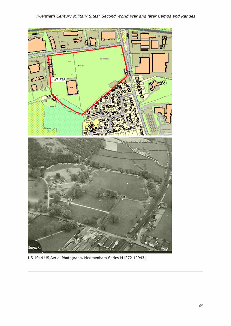
Twentieth Century Military Sites: Second World War and later Camps and Ranges
65
US 1944 US Aerial Photograph, Medmenham Series M1272 12943;
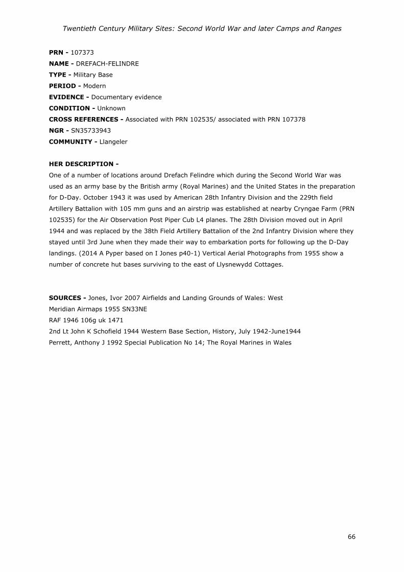
Twentieth Century Military Sites: Second World War and later Camps and Ranges
66
PRN - 107373
NAME - DREFACH-FELINDRE
TYPE - Military Base
PERIOD - Modern
EVIDENCE - Documentary evidence
CONDITION - Unknown
CROSS REFERENCES - Associated with PRN 102535/ associated with PRN 107378
NGR - SN35733943
COMMUNITY - Llangeler
HER DESCRIPTION -
One of a number of locations around Drefach Felindre which during the Second World War was
used as an army base by the British army (Royal Marines) and the United States in the preparation
for D-Day. October 1943 it was used by American 28th Infantry Division and the 229th field
Artillery Battalion with 105 mm guns and an airstrip was established at nearby Cryngae Farm (PRN
102535) for the Air Observation Post Piper Cub L4 planes. The 28th Division moved out in April
1944 and was replaced by the 38th Field Artillery Battalion of the 2nd Infantry Division where they
stayed until 3rd June when they made their way to embarkation ports for following up the D-Day
landings. (2014 A Pyper based on I Jones p40-1) Vertical Aerial Photographs from 1955 show a
number of concrete hut bases surviving to the east of Llysnewydd Cottages.
SOURCES - Jones, Ivor 2007 Airfields and Landing Grounds of Wales: West
Meridian Airmaps 1955 SN33NE
RAF 1946 106g uk 1471
2nd Lt John K Schofield 1944 Western Base Section, History, July 1942-June1944
Perrett, Anthony J 1992 Special Publication No 14; The Royal Marines in Wales

Twentieth Century Military Sites: Second World War and later Camps and Ranges
67
Location of PRN 102535 in relation to the hutted camps at PRNs 107373 and 107378
1946 Aerial Photograph 106guk 1471 - 2253 showing the grass field airstrip PRN 102535 and two
areas of hutted camps PRNs 107373 and 107378.

Twentieth Century Military Sites: Second World War and later Camps and Ranges
68
PRN - 107374
NAME - PEN-Y-COED
TYPE - MILITARY BASE
PERIOD - Modern
EVIDENCE - DOCUMENTARY EVIDENCE
CONDITION - Unknown
CROSS REFERENCES - None recorded
NGR - SN27141826
COMMUNITY - St Clears
HER DESCRIPTION -
During the Second World War Pen-y-coed house was requisitioned. Amongst other British units in
October 1942 it was used by the 222 Field Ambulance Royal Army Medical Corps (Perrett 1992)
and then 1944 the house used as a base for Reconnaissance Troops (Mechanized) in the United
States army. A Pyper based on Station Lists. Six officers and 132 enlisted men are recorded here
on the Western Base Section history. (1944)
SOURCES - Lt Col Philip C Grinton (US Army, Retired) US Army/Army Air Force: Units from UK
Station List as of 30 April 1944.
Lt Col Philip C Grinton (US Army, Retired) US Army/Army Air Force: Units from UK Station List as
of 31 May 1944.
2nd Lt John K Schofield 1944 Western Base Section, History, July 1942-June1944
Perrett, Anthony J 1992 Special Publication No 14; The Royal Marines in Wales

Twentieth Century Military Sites: Second World War and later Camps and Ranges
69
PRN - 107375
NAME - NO 252 ABERGWILI HOSPITAL
TYPE - Prisoner of War Camp
PERIOD - Modern
EVIDENCE - DOCUMENTARY EVIDENCE
CONDITION - NOT KNOWN
CROSS REFERENCES - None recorded
NGR - SN42862130
COMMUNITY - Carmarthen
HER DESCRIPTION -
No 252 Abergwili Hospital, listed as a Prisoner of War camp (Thomas, 2003). Following the
evacuation of the temporary hospital site in 1944 by the United States army the camp was used as
a prisoner of war camp. A Pyper based on RJC Thomas 2003.
SOURCES - Thomas, RJC 2003 Twentieth Century Military Recording Project: Prisoner of War
Camps (1939-1948)
Meridian Airmaps 1955 SN42SW
Aerial Photograph 1946 RAF 106G/UK1625 6132
Aerial Photograph 1946 RAF 106G/UK1625 6132

Twentieth Century Military Sites: Second World War and later Camps and Ranges
70
PRN - 107376
NAME - 199 YSTRAD CAMP
TYPE - Prisoner of War Camp
PERIOD - Modern
EVIDENCE - DOCUMENTARY EVIDENCE
CONDITION - NOT KNOWN
CROSS REFERENCES - None recorded
NGR - SN38891908
COMMUNITY - Carmarthen
HER DESCRIPTION -
A prisoner of war base camp established following the evacuation of the camp in 1944 by the
United States army. A Pyper based on RJC Thomas 2003.
SOURCES - Thomas, RJC 2003 Twentieth Century Military Recording Project: Prisoner of War
Camps (1939-1948)
US 1944 US Aerial Photograph, Medmenham Series M1272;
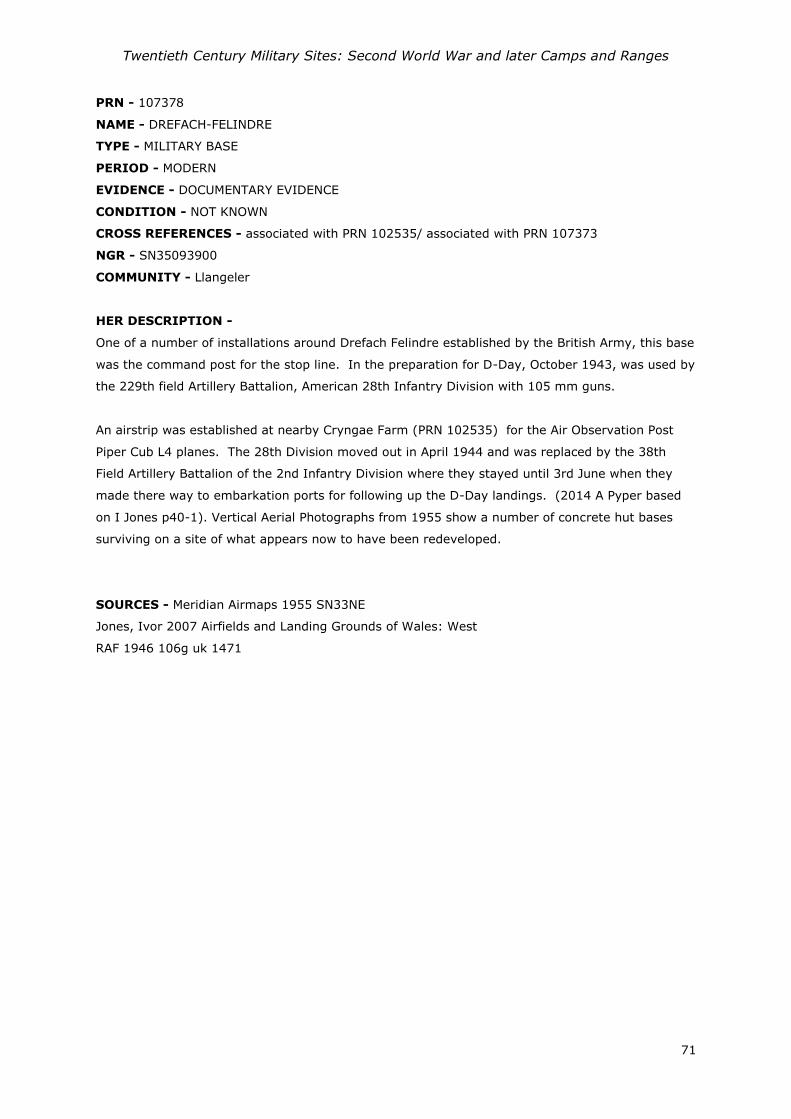
Twentieth Century Military Sites: Second World War and later Camps and Ranges
71
PRN - 107378
NAME - DREFACH-FELINDRE
TYPE - MILITARY BASE
PERIOD - MODERN
EVIDENCE - DOCUMENTARY EVIDENCE
CONDITION - NOT KNOWN
CROSS REFERENCES - associated with PRN 102535/ associated with PRN 107373
NGR - SN35093900
COMMUNITY - Llangeler
HER DESCRIPTION -
One of a number of installations around Drefach Felindre established by the British Army, this base
was the command post for the stop line. In the preparation for D-Day, October 1943, was used by
the 229th field Artillery Battalion, American 28th Infantry Division with 105 mm guns.
An airstrip was established at nearby Cryngae Farm (PRN 102535) for the Air Observation Post
Piper Cub L4 planes. The 28th Division moved out in April 1944 and was replaced by the 38th
Field Artillery Battalion of the 2nd Infantry Division where they stayed until 3rd June when they
made there way to embarkation ports for following up the D-Day landings. (2014 A Pyper based
on I Jones p40-1). Vertical Aerial Photographs from 1955 show a number of concrete hut bases
surviving on a site of what appears now to have been redeveloped.
SOURCES - Meridian Airmaps 1955 SN33NE
Jones, Ivor 2007 Airfields and Landing Grounds of Wales: West
RAF 1946 106g uk 1471

Twentieth Century Military Sites: Second World War and later Camps and Ranges
72
Location of PRN 102535 in relation to the hutted camps at PRNs 107373 and 107378
1946 Aerial Photograph 106guk 1471 - 2253 showing the grass field airstrip PRN 102535 and two
areas of hutted camps PRNs 107373 and 107378.

Twentieth Century Military Sites: Second World War and later Camps and Ranges
73
PRN - 107379
NAME -
TYPE - SEWAGE WORKS
PERIOD - C20th
EVIDENCE - DOCUMENTARY EVIDENCE
CONDITION - NOT KNOWN
CROSS REFERENCES - associated with PRN 50283
NGR - SN61932216
COMMUNITY - Llandeilo
HER DESCRIPTION -
A sewage plant visible on Meridian Airmaps of 1955, thought to be associated with the military
camp established during the Second World War. A Pyper 2014
SOURCES - Meridian Airmaps 1955 SN62SW

Twentieth Century Military Sites: Second World War and later Camps and Ranges
74
Meridian Airmaps 1955 SN62SW (30840)

Twentieth Century Military Sites: Second World War and later Camps and Ranges
75
PRN - 107383
NAME -
TYPE - MILITARY DEPOT
PERIOD - MODERN
EVIDENCE - DOCUMENTARY EVIDENCE
CONDITION - NOT KNOWN
CROSS REFERENCES - None recorded
NGR - SN66324028
COMMUNITY - Cynwyl Gaeo
HER DESCRIPTION -
Possible military depot; a large number of uniformly oriented Nissen(?) huts on site of Gold Mine
shown on the 1946 Aerial Photograph. A Pyper based on 1946 AP.
SOURCES - RAF 1946
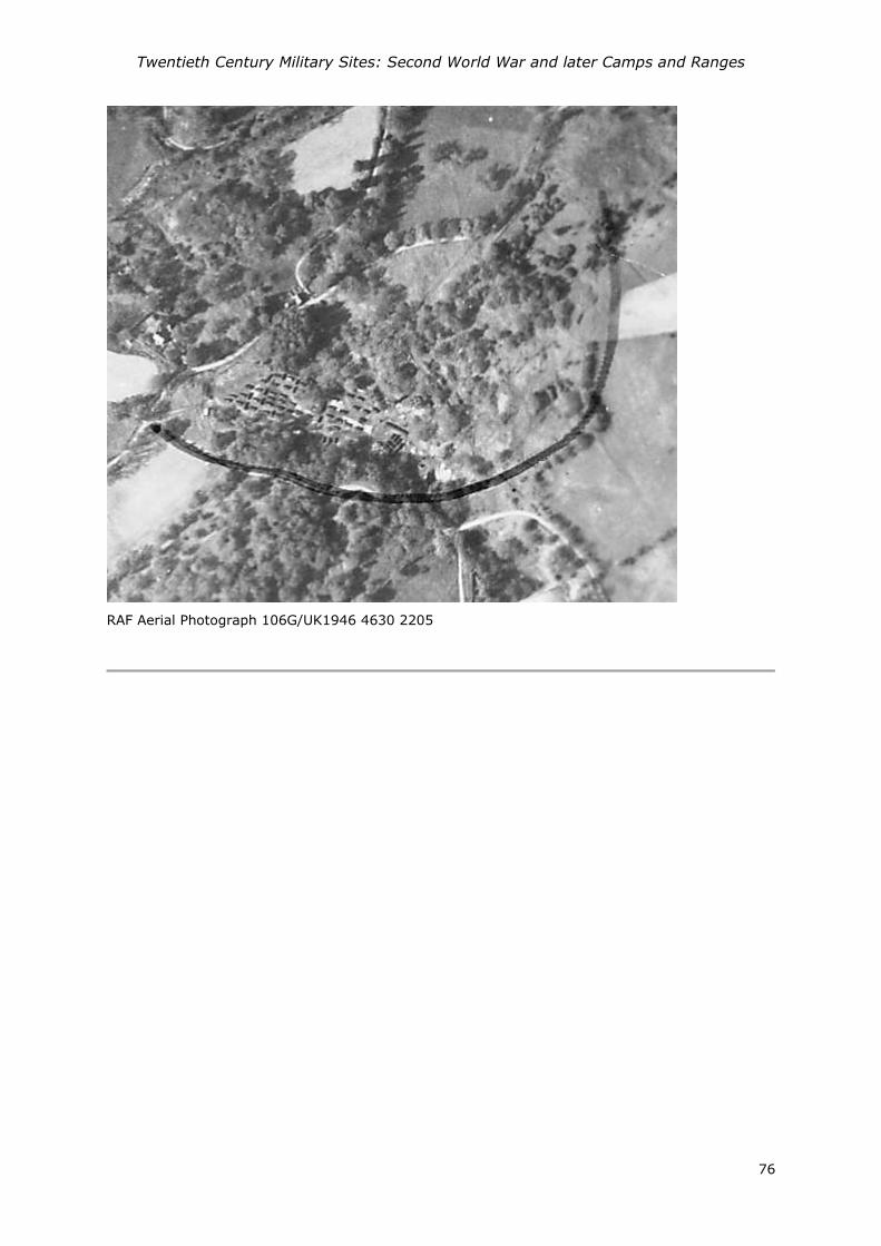
Twentieth Century Military Sites: Second World War and later Camps and Ranges
76
RAF Aerial Photograph 106G/UK1946 4630 2205

Twentieth Century Military Sites: Second World War and later Camps and Ranges
77
PRN - 107757
NAME - GOLDEN GROVE
TYPE - MILITARY CAMP
PERIOD - MODERN
EVIDENCE - DOCUMENTARY EVIDENCE
CONDITION - NOT KNOWN
CROSS REFERENCES - None recorded
NGR - SN600199
COMMUNITY - Llanfihangel Aberbythych
HER DESCRIPTION -
Military Camp established at Golden Grove Mansion during the Second World War. There is a
reference to 502 Field Company being stationed here in the Carmarthen Sub-Area War Diary 13th
September 1940. Local information indicates that the huts were to the E or NE of the mansion
house.
Also used by the 208 MU (Maintenance Unit) RAF from 1942, then from 1944 was a Rest and
Recuperation Centre for the United States Army Air Force.
A Pyper March 2015.
SOURCES - Commanding Officer; Col F. A. McCartney 1940 War Diary

Twentieth Century Military Sites: Second World War and later Camps and Ranges
78
PRN - 107758
NAME - ALLT-Y-FERIN
TYPE – MILITARY HOSPITAL
PERIOD - MODERN
EVIDENCE - DOCUMENTARY EVIDENCE
CONDITION - NOT KNOWN
CROSS REFERENCES - associated with PRN 21138
NGR - SN52222351
COMMUNITY - Llanegwad
HER DESCRIPTION -
A large gentry house which was requisition during the Second World War for use as hospital. It is
referenced in the Carmarthen Sub-Area Counter Invasion Scheme, appended to the War Diary of
1942 as an Infectious Diseases Hospital with 50 beds it was an annexe to the hospital at Newton
House, Llandeilo (PRN 50282). To the right of the drive there was tented camp of Indian soldiers,
all suffering from tuberculosis. (Cambell, 1997, p77)
A Pyper 2015.
SOURCES - The War Office 1942 Carmarthen Sub-Area Counter-Invasion Scheme.
Campbell, Rhoda : 1997 : Water under the Bridge

Twentieth Century Military Sites: Second World War and later Camps and Ranges
79
PRN - 107759
NAME - BRON-Y-DRE
TYPE - MILITARY HEADQUARTERS
PERIOD - MODERN
EVIDENCE - DOCUMENTARY EVIDENCE
CONDITION - NOT KNOWN
CROSS REFERENCES - None recorded
NGR - SN4025819978
COMMUNITY - Carmarthen
HER DESCRIPTION -
In the Second World War Bron-y-dre was the Sub-Area Headquarters responsible for
administrative and operational matters including training and defence scheme planning within
Dyfed. It was one of the most important military buildings in Dyfed. The HQs was responsible for
planning the defence of the most vulnerable coastline in Western Command (Carmarthen
Bay). The Commander would have had responsibility for all of the static troops in his command
area, excluding Anti-Aircraft and Searchlight sites which came under Air Defence of Great
Britain. This HQ was not responsible for the Auxiliary Units, which had a separate organisational
and command structure. A number of temporary huts were installed in the back garden and on
land to the north of the garden boundary, as depicted on contemporary Aerial Photographs. The
HQs staff would have been accommodated in properties nearby. (A Pyper based on J Berry pers.
comm. 2015)
SOURCES - The War Office 1942 Carmarthen Sub-Area Counter-Invasion Scheme.

Twentieth Century Military Sites: Second World War and later Camps and Ranges
80
PRN - 107760
NAME - ST CLEARS GARAGE CAMP
TYPE - MILITARY CAMP
PERIOD - MODERN
EVIDENCE - DOCUMENTARY EVIDENCE
CONDITION - NOT KNOWN
CROSS REFERENCES - None recorded
NGR - SN284168
COMMUNITY - St Clears
HER DESCRIPTION -
A British Army camp of 1941/1942 is listed in the database associated with the English Heritage
report on England's Army camps, John Schofield (2006). Called St Clears Garage Camp, with
Nissen huts. It's exact location is unconfirmed however the 1953 OS map suggest the formation of
a hutted camp on the east side Station Road. A Pyper 2015.
SOURCES - Schofield J, Foot W and Evans D. 2006 England's Army Camps [data-set]. York:
Archaeology Data Service [distributor]
Ordnance Survey 1:25000 : 1937-61
Twentieth Century Military Sites: Second World War and later Camps and Ranges
81
PRN - 107761
NAME - LLANELLY CAMP
TYPE - MILITARY CAMP
PERIOD - MODERN
EVIDENCE - DOCUMENTARY EVIDENCE
CONDITION - NOT KNOWN
CROSS REFERENCES - None recorded
NGR - SN505005
COMMUNITY - Llanelli
HER DESCRIPTION -
Llanelly Camp is described as a Reinforcement Camp for the 12 Battalion Worcester Regiment in
1941, mentioned in Schofield et al report 2006. Exact whereabouts unconfirmed. A Pyper 2015.
SOURCES - Schofield J, Foot W and Evans D. 2006 England's Army Camps [data-set]. York:
Archaeology Data Service [distributor] (doi:10.5284/1000269)
PRN - 107762
NAME - BRONHEULOG HOUSE
TYPE - MILITARY INSTALLATION
PERIOD - MODERN
EVIDENCE - DOCUMENTARY EVIDENCE
CONDITION - NOT KNOWN
CROSS REFERENCES - None recorded
NGR - SN445013
COMMUNITY - Cefn Sidan
HER DESCRIPTION -
Bronheulog House is listed as a United States Army installation during the Second World War. 80
Enlisted men were based here. A Pyper 2015 (based on the Western Base Section History 1944) .
SOURCES - 2nd Lt John K Schofield 1947 Western Base Section, History, July 1942-June1944

Twentieth Century Military Sites: Second World War and later Camps and Ranges
82
PRN - 107763
NAME - CWMGWILI
TYPE - MILITARY INSTALLATION
PERIOD - MODERN
EVIDENCE - DOCUMENTARY EVIDENCE
CONDITION - NOT KNOWN
CROSS REFERENCES - None recorded
NGR - SN426230
COMMUNITY - Bronwydd
HER DESCRIPTION -
Cwmgwili is recorded as a base for a United States army installation during the Second World War.
It is recorded that 2 officers and 90 enlisted men were stationed here. A Pyper 2015 (based on
Western Base Section History 1944)
SOURCES - 2nd Lt John K Schofield 1944 Western Base Section, History, July 1942-June1944

Twentieth Century Military Sites: Second World War and later Camps and Ranges
83
PRN - 107764
NAME - RHYD-Y-GORS
TYPE - MILITARY INSTALLATION
PERIOD - MODERN
EVIDENCE - DOCUMENTARY EVIDENCE
CONDITION - NOT KNOWN
CROSS REFERENCES - None recorded
NGR - SN405189
COMMUNITY - Carmarthen
HER DESCRIPTION -
A Second World War military camp Rhyd-y-Gors was under construction in February 1942 where 7
Nissen huts were erected, (70th Infantry Brigade War Diary February 1942.) It was used as 70th
Infantry Brigade Headquarters in 1943, (70th Infantry Brigade War Diary 1943).
It is then recorded as a United States army installation. 11 officers and 91 enlisted men are
recorded as being stationed here. A Pyper on the Western Base Section History 1944.
SOURCES - 2nd Lt John K Schofield 1944 Western Base Section, History, July 1942-June1944
http://70brigade.newmp.org.uk/wiki/70th_Infantry_Brigade_War_Diary_February_1942.
http://70brigade.newmp.org.uk/wiki/70th_Infantry_Brigade_War_Diary_January_1943.

Twentieth Century Military Sites: Second World War and later Camps and Ranges
84
PRN - 107765
NAME - FURNACE CAMP
TYPE - MILITARY INSTALLATION
PERIOD - MODERN
EVIDENCE - DOCUMENTARY EVIDENCE
CONDITION - NOT KNOWN
CROSS REFERENCES - None recorded
NGR - SN502015
COMMUNITY - Llanelli
HER DESCRIPTION -
Furnace Camp is recorded as a United States army installation during the Second World War. It is
recorded thae 37 officers and 952 enlisted men were based here. A Pyper (based on Western Base
Section History 1944)
SOURCES - 2nd Lt John K Schofield 1944 Western Base Section, History, July 1942-June1944
PRN - 107766
NAME - TALIARIS
TYPE - MILITARY BASE
PERIOD - MODERN
EVIDENCE - DOCUMENTARY EVIDENCE
CONDITION - NOT KNOWN
CROSS REFERENCES - None recorded
NGR - SN642280
COMMUNITY - Manordeilo and Salem
HER DESCRIPTION -
Used as a Military Base and it is recorded that it served as a Brigade Headquarters until 30th
January 1942 when they moved from Taliaris, Llandeilo to Ystrad Camp, Carmarthen. Recorded as
a United States army base during the Second World War. Six officers and 50 enlisted men are
recorded here. A Pyper 2015 based on Western Base Section History 1944.
SOURCES - 2nd Lt John K Schofield 1944 Western Base Section, History, July 1942-June1944

Twentieth Century Military Sites: Second World War and later Camps and Ranges
85
PRN - 107767
NAME - PEMBREY BEACHES
TYPE - MILITARY INSTALLATION
PERIOD - MODERN
EVIDENCE - DOCUMENTARY EVIDENCE
CONDITION - NOT KNOWN
CROSS REFERENCES - None recorded
NGR - SN420011
COMMUNITY - Cefn Sidan
HER DESCRIPTION -
There are records for British and American Army installations at Pembrey and Pembrey Beaches
Burry Port during the Second World War, although the precise location is unknown (70th brigade
War diary January 1943).
Recorded as a United States Army base with eighteen officers and 396 enlisted men in the
Western Base Section history of 1944. A Pyper 2015.
SOURCES - 2nd Lt John K Schofield 1944 Western Base Section, History, July 1942-June1944
70th Infantry Brigade War Diary January 1943. http://70brigade.newmp.org.uk
PRN - 107768
NAME - WHITLAND DISTRIBUTION POINT
TYPE - MILITARY DEPOT
PERIOD - MODERN
EVIDENCE - DOCUMENTARY EVIDENCE
CONDITION - NOT KNOWN
CROSS REFERENCES - None recorded
NGR - SN199166
COMMUNITY - Whitland
HER DESCRIPTION -
Whitland Distribution Point is recorded as a base for the United States army during the Second
World War. Two officers and 68 enlisted men are recorded in the Western Base Section history
(1944). Its precise location is unknown, though believed to be near the railway. A Pyper 2015.
SOURCES - 2nd Lt John K Schofield 1944 Western Base Section, History, July 1942-June1944
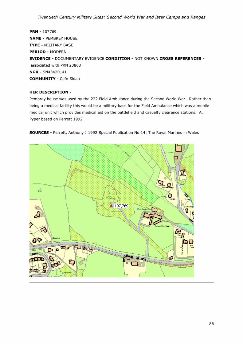
Twentieth Century Military Sites: Second World War and later Camps and Ranges
86
PRN - 107769
NAME - PEMBREY HOUSE
TYPE - MILITARY BASE
PERIOD - MODERN
EVIDENCE - DOCUMENTARY EVIDENCE CONDITION - NOT KNOWN CROSS REFERENCES -
associated with PRN 23863
NGR - SN43420141
COMMUNITY - Cefn Sidan
HER DESCRIPTION -
Pembrey house was used by the 222 Field Ambulance during the Second World War. Rather than
being a medical facility this would be a military base for the Field Ambulance which was a mobile
medical unit which provides medical aid on the battlefield and casualty clearance stations. A.
Pyper based on Perrett 1992
SOURCES - Perrett, Anthony J 1992 Special Publication No 14; The Royal Marines in Wales

Twentieth Century Military Sites: Second World War and later Camps and Ranges
87
PRN - 107770
NAME - MIDDLETON HALL
TYPE - MILITARY BASE
PERIOD - MODERN
EVIDENCE - DOCUMENTARY EVIDENCE
CONDITION - NOT KNOWN
CROSS REFERENCES - associated with PRN 6759
NGR - SN52181828
COMMUNITY - Llanarthney
HER DESCRIPTION -
Middleton Hall was used by the 222 Field Ambulance during the Second World War.
Rather than being a medical facility this would be a military base for the Field Ambulance which
was a mobile medical unit which provides medical aid on the battlefield and casualty clearance
stations. A. Pyper based on Perrett 1992
SOURCES - Perrett, Anthony J 1992 Special Publication No 14; The Royal Marines in Wales

Twentieth Century Military Sites: Second World War and later Camps and Ranges
88
PRN - 107771
NAME - ASHBURNHAM CAMP
TYPE - MILITARY CAMP
PERIOD - MODERN
EVIDENCE - DOCUMENTARY EVIDENCE
CONDITION - NOT KNOWN
CROSS REFERENCES - None recorded
NGR - SN435009
COMMUNITY - Cefn Sidan
HER DESCRIPTION -
Ashburnham Camp is recorded as a base for the Royal Marines MG (Machine Gun) Company, and it
is believed that it was located on the golf course. A. Pyper 2015 based on Perrett.
SOURCES - Perrett, Anthony J 1992 Special Publication No 14; The Royal Marines in Wales

Twentieth Century Military Sites: Second World War and later Camps and Ranges
89
PRN - 107830
NAME –
TYPE – FIRING RANGE
PERIOD – Post Medieval; Modern
EVIDENCE - Complex
CONDITION - Not Known
NGR – SS51679747
COMMUNITY - Llanelli
HER DESCRIPTION - A firing range located at Machynys, recorded on the first edition Ordnance
Survey map (1889) incorporating a target to the east of the peninsular and a shooting positions at
600, 500 and 400 yard to the west. A further 150 yard range and target lies to the southwest.
The first edition identifies various structures including Mantelet, Magazine, and Flagstaff (PRNs
31689, 31690, 31691, 31692, 31693, 31694, 31695).
Firing continued on the site with an additional 600 yard range on a northwest to southeast axis
recorded on the 1952 Ordnance Survey suggesting its continued use through the Second World
War. A Pyper 2015.
Extract of Ordnance Survey 1952 Carmarthenshire XLVIII.SE sheet (National Library of Scotland)
SOURCES –
Ordnance Survey 1891 Carmarthenshire XLVIII.SE
Ordnance Survey 1952 Carmarthenshire XLVIII.SE

Twentieth Century Military Sites: Second World War and later Camps and Ranges
90
PRN - 107831
NAME – DYNEVOR RIFLE RANGE
TYPE – FIRING RANGE
PERIOD – Post Medieval; Modern
EVIDENCE - Complex
CONDITION - Not Known
NGR – SN60902172
COMMUNITY - Llandeilo
HER DESCRIPTION - Dynefor Rifle Range is depicted on the Ordnance Survey editions from 1885
shown as two ranges; one northwest to southeast with 600, 500, 400, 300 yard firing positions
Marker's butt and Targets, plus ranges from the southwest with 300 and 200 yard positions. The
former 600 yard range continues to be shown on the OS in the 1953 edition, suggesting its use
during both the World Wars. A Pyper 2015
Extract of Ordnance Survey 1948 Carmarthenshire XXXIII.SE sheet (National Library of Scotland)
SOURCES –
Ordnance Survey 1891 Carmarthenshire XXXIII.SE
Ordnance Survey 1891 Carmarthenshire XXXIII.SW
Ordnance Survey 1948 Carmarthenshire XXXIII.SE
Ordnance Survey 1948 Carmarthenshire XXXIII.SW

Twentieth Century Military Sites: Second World War and later Camps and Ranges
91
Second World War and later Camps and Ranges REPORT NUMBER 2015/16
Mawrth 2015 March 2015
This report has been prepared by Alice Pyper
Position:
Signature Date
This report has been checked and approved by Ken Murphy on behalf of Dyfed Archaeological Trust Ltd. Position:
Signature Date
As part of our desire to provide a quality service we would welcome any comments you may have
on the content or presentation of this report