TUSTAN FORTRESS, UKRAINE: VIRTUAL REALITY...
14
24th GENERAL CONFERENCE OF ICOM - MUSEUMS AND CULTURAL LANDSCAPES 3-9 JULY | MILAN | ITALY TUSTAN FORTRESS, UKRAINE: VIRTUAL REALITY OF THE PAST, A CULTURAL LANDSCAPE FOR THE FUTURE Vasyl Rozhko Head of the Museum Department, Ministry of Culture of Ukraine Short Bio: Born: 8.10.1980. Education: Lviv Politechnic National University, 1998-2003, Master’s Degree in Architecture. PhD in Architecture, thesis “Methods of Research and Graphical Reconstruction of Log Cliff-side Architecture”. 2005-2014 – founder and director of the State Historical and Cultural Reserve “Tustan”, founder and director of the annual Ukrainian Medieval culture festival “Tu Stan!”. Manager of th e projects Virtual Tustan, graphical reconstruction of the fortress, archeological experiments, cooperation with the community. Since 2014 – head of the Museum Dept. at the Ministry of Culture of Ukraine. One of the initiators of creating the Maidan Museum.
-
Upload
trinhnguyet -
Category
Documents
-
view
220 -
download
0
Transcript of TUSTAN FORTRESS, UKRAINE: VIRTUAL REALITY...

24th GENERAL CONFERENCE OF ICOM - MUSEUMS AND CULTURAL LANDSCAPES 3-9 JULY | MILAN | ITALY
TUSTAN FORTRESS, UKRAINE: VIRTUAL REALITY OF THE PAST, A CULTURAL LANDSCAPE FOR THE FUTURE Vasyl Rozhko Head of the Museum Department, Ministry of Culture of Ukraine
Short Bio:
Born: 8.10.1980. Education: Lviv Politechnic National University, 1998-2003, Master’s Degree
in Architecture. PhD in Architecture, thesis “Methods of Research and Graphical Reconstruction
of Log Cliff-side Architecture”.
2005-2014 – founder and director of the State Historical and Cultural Reserve “Tustan”, founder
and director of the annual Ukrainian Medieval culture festival “Tu Stan!”. Manager of the
projects Virtual Tustan, graphical reconstruction of the fortress, archeological experiments,
cooperation with the community.
Since 2014 – head of the Museum Dept. at the Ministry of Culture of Ukraine. One of the
initiators of creating the Maidan Museum.
24th GENERAL CONFERENCE OF ICOM MUSEUMS AND CULTURAL LANDSCAPES
3-9 JULY | MILAN | ITALY
TUSTAN FORTRESS, UKRAINE:VIRTUAL REALITY OF THE PAST, Vasyl Rozhko A CULTURAL LANDSCAPE FOR THE FUTURE
2
Abstract The log cliff-side city and fortress of Tustan (9th-16th centuries) was defensive, customs and
administrative centre of Kyivan Rus and Galych-Volyn Kingdom in the Carpathian Mountains.
Nowadays its ruins are a national cultural monument and national reserve. We can now reconstruct
the fortress’ architecture thanks to thousands of cliff-side traces. The State Historical and Cultural
Reserve “Tustan” cares for the remains of the fortress, its natural and historical environment, cultural
landscape and traditional architecture of the village of Urych.
The Virtual Tustan information system is used for fortress’ graphical reconstruction, heritage
preservation and archaeological site management. It combines new technologies (3D modelling, a
geographical informational system, etc.) to organize data ranging from small museum items to cliffs
with traces, the village and the region. The 3D model of the fortress is a basis for augmented reality
applications and different ways for a realistic and non-destructive presentation of non-existing
medieval architecture.
The Reserve works on research and preservation of local heritage, village history, crafts, folklore and
traditions. Its priorities are heritage tourism and agritourism. Cooperation of the Reserve and the
local community is a key factor for successful development of the region, accelerated with the annual
“Tu Stan” Ukrainian medieval culture festival.
Core text The cliff-side city and fortress Tustan existed on the Urych rocks in the 9th-16th centuries as a
powerful defensive, customs and administrative center, which in its heyday controlled four of the
twelve Carpathian passes.
After its decline, the previously powerful Tustan turned into ruins. At the turn of the 18th-19th
centuries, it aroused scientific interest, but comprehensive scientific studies were conducted only in
1971-2004 by Mykhaylo Rozhko. There he researched the special method of medieval construction
using rocks – log cliff-side architecture. The log constructions are lost today. However, there are
their remains – cliff-side complexes with thousands of cuts in the rock used to support the logs that
trace the wooden construction. These cliff-side traces allow to recreate with high accuracy the lost
appearance of the medieval construction: not only the layout but also its vertical structure and
individual elements. Therefore, such type of monument is unique in the world history of architecture.
Today the Urych rocks are a complex monument of archaeology and nature of a national
significance. It has been under the care of the State Historical and Cultural Reserve “Tustan” since
2006. In addition to the cliff-side complexes with traces of the construction, the surrounding area
with the cultural layer, earth fortifications and the historical trade-route, the Reserve care for the
historic and natural environment of the monument, the traditional architecture and agricultural
landscapes of the adjacent village of Urych, the UPA bunkers, the monuments of nature, the museum
collection, the archive and intangible heritage (folklore, oral history). Tustan today is a well-known
and unique cliff-side fortress of Middle Ages, a landmark which is visited by 60-70 thousand people
yearly.
The article talks about the project Virtual Tustan aimed at research and management of the
monument as well as talking about the cultural landscape, preservation of the natural and historic

24th GENERAL CONFERENCE OF ICOM MUSEUMS AND CULTURAL LANDSCAPES
3-9 JULY | MILAN | ITALY
TUSTAN FORTRESS, UKRAINE:VIRTUAL REALITY OF THE PAST, Vasyl Rozhko A CULTURAL LANDSCAPE FOR THE FUTURE
3
environment, development of the territory and the community. Tustan combines authentic objects
and modern technologies, and the cultural heritage becomes a driver for development of the territory
and the community.
Virtual Tustan The State Historical and Cultural Reserve “Tustan” launched the project Virtual Tustan in 2007
having created a 3D model of the rocks for further computer modelling of architecture of the cliff-
side fortress Tustan. In the process, a need to organize information emerged in order to work with an
array of disparate data relating to different-scale objects, ranging from a museum object and rocks
with traces of the construction to the surrounding areas, the village and the region.
Creating the information system using the latest technology was not an end in itself but was caused
by the inability of traditional methods to solve the problems of research of rock monuments: the
difficult terrain, steep slopes (30-45° or more), the afforested surrounding area; length (up to 200 m),
height (up to 87 meters), irregular geometric shapes of rocks with complex spatial placement of
traces of the construction (about 4,000 traces); visually inaccessible parts of the rocks.
The findings of M. Rozhko are the basis for further research: the system of research and registering
of cliff-side monuments was developed and tested at Tustan and analogous sites in the 1970-80's, and
the graphical reconstruction of the cliff-side fortress was made (the complex of Kamin). However,
those methods are not optimal today. Architectural and geodesic measurements are difficult,
dangerous, long and incomplete. The result of surveying and reconstructions is a set of flat drawings
insufficient to describe the complex spatial object. The accumulated research materials do not
provide efficiency, flexibility and comprehensiveness in research work. The graphical
reconstructions cannot be fully verified, the justifications and history of modelling of each element
cannot be reviewed or revised.
A small staff and resources of the Reserve require an intelligent information system for complex
management of the monument, its research, presentation and promotion.
Tasks of the Tustan Information System The information system for data organization and processing has to solve the following types of
problems: 1) recording of the rocks with traces of the construction, monitoring of their destructions;
2) graphical reconstruction of the lost cliff-side construction, its public presentation; 3) the
integration of cartographic materials and spatial data on the “Tustan” Reserve and the Urych Valley,
and monument management; 4) a register of exhibits, a future virtual museum; 5) organization of
archival materials, a future digital archive.
The results of recording of the rocks with traces of the construction and destructions and the
surrounding area have to be sufficiently complete, accurate and detailed so that with the help of
special tools different forms of change of the rock surface (including man-made) could be identified
and the dynamics of these changes could be inventoried and monitored (including retroactively).
Graphical reconstruction is a subjective process based on facts and assumptions, so it allows many
versions, and therefore its process should be verified. The primary and detailed facts for graphical
reconstruction are cliff-side tracks of the construction that require an architectural analysis regarding
24th GENERAL CONFERENCE OF ICOM MUSEUMS AND CULTURAL LANDSCAPES
3-9 JULY | MILAN | ITALY
TUSTAN FORTRESS, UKRAINE:VIRTUAL REALITY OF THE PAST, Vasyl Rozhko A CULTURAL LANDSCAPE FOR THE FUTURE
4
their openness, spatial location and integration. The construction modelling is carried out with
structures (elements, planes, lines) and volumes in three stages: an accurate basis frame in
accordance with cliff-side tracks; a logically completed framework; a detailed hypothetical model of
the log cliff-side construction and the surrounding area according to periods and development
options, reproduced in accordance with the findings and analogous objects. Each reproduced element
(or group of elements) must be attached with information about the reasons for its reproduction,
evaluation of spatial, physical, functional and temporal certainty, a history of modelling and a period
of existence in the construction. There is a need for a capability to operate with all the variants of the
construction and its parts (stages, reconstructions, individual versions), to visually reflect the degree
of reliability of elements.
One modern platform should unite geodesic, land surveys, monument conservation, town planning
and cartographic materials, plans of organization and development of the monument territory and the
Reserve, historical maps and contemporary plans of the village. The platform would enable not only
spatial binding of data but also their temporal differentiation to trace the chronology of development.
It is also necessary to organize different types of archives: manuscripts, typescripts, drawings,
cartographic, photographic and video libraries. Museum collections, including archaeological
findings, require a modern accounting system with the possibility of integration into global Internet
resources and creation of a virtual museum.
The information system should ensure an ability to integrate all these elements and compatibility of
technology.
The Concept of the Tustan Information System
The above mentioned tasks and requirements determine a choice of further tools and technologies for
organizing the information system. Documentation has to be prepared immediately in a digital form.
Interconnected and, if necessary, compatible individual approaches are proposed for different types
of problems. The complex morphology of the rocks with traces of the construction and the adjacent
territory should be recorded by laser scanning and photogrammetry, represented and processed in a
computer 3D model. Parametric design systems based on the Building Information Modeling
technology should be used for a graphical reconstruction (3D modelling) of the lost architecture.
Also, there is a need of a system of electronic register of museum items of the Reserve. Archival
materials need to be digitized, then organized using database management systems. The method for
organizing spatial data in an intuitive form is a Geographic Information System (GIS) that can
provide users with fast access to necessary up-to-date data and ensure their understanding. A GIS is
also able to display time information, a status of objects of spatial environment in different periods of
their development.
Experience of Creation and Usage
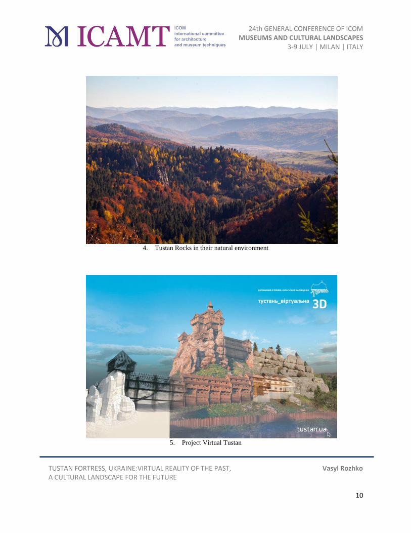
As of today, a number of works has been done within the framework of Virtual Tustan. A 3D model
of the rock complex Kamin with traces of the construction has been created by means of laser
scanning, and a topographic map and a digital model of the surroundings have been created with the
help of aerial photogrammetry. In the process of graphical reconstruction of the cliff-side city and
24th GENERAL CONFERENCE OF ICOM MUSEUMS AND CULTURAL LANDSCAPES
3-9 JULY | MILAN | ITALY
TUSTAN FORTRESS, UKRAINE:VIRTUAL REALITY OF THE PAST, Vasyl Rozhko A CULTURAL LANDSCAPE FOR THE FUTURE
5
fortress Tustan, with the means of 3D modeling, an artificial pond, multirow walls and ditches with
the trade route and treeless slopes of the surrounding area were recreated, models of each of the five
construction periods in accordance with the research by M. Rozhko were made. The geographic
information system of Tustan was created, which on the basis of aerial photography integrated
cartographic materials and spatial data from monument preserving documentation, spatial planning
and research materials.
Each of the created subsystems of the project Virtual Tustan (the 3D model of the rocks, the model of
the fortress, the GIS) has been used by the Reserve for planning restoration works and monument
preservation events, further research and integrated management of the monument.
The 3D model of the fortress gives great possibilities for its presentation and promotion, therefore it
is saved in different formats: a simplified interactive model of the fifth construction period for the
Reserve website; a .pdf format with different layers, stages of fortress’ construction and intersections;
a model for a virtual walk. Besides, the following things were created: a photorealistic and
chronological video animation about the architecture and construction stages of Tustan; synchronized
3D panoramas of the present day rocks and the medieval construction; an augmented reality
application for mobile devices to view the medieval fortress.
To record the current state of the traditional buildings of the village of Urych, buildings were
photographed and their 3D models were made by means of photogrammetry.
The methods and technologies of the information system that were proposed by the concept and
tested within Virtual Tustan is the best solution to the defined tasks. The created 3D model of the
rocks with traces of construction allows people to work with it as with a full virtual copy of the large,
inaccessible and geometrically complex object. The proposed design technologies enable creation
and study of versions and stages of the cliff-side architecture as well as implementation of its spatial,
logical and constructive analysis. The GIS organizes spatial data and research archives, enables
planning comprehensive management of the monument. Finally, the Tustan 3D model is the basis for
illustrative presentations of hypothetical reconstructions of different fortress’ periods without
rebuilding them on the rocks.
Cultural Landscape of the Village The evolution of social and economic life has a strong influence on settlements and their landscapes.
The development of settlements is essential for improvement of the quality of their territory, but
there should be a certain limit which would allow to maintain an ecological balance of nature and not
to lose cultural values. This is especially true of the Carpathians. Ironically, the degradation of the
Carpathians’ cultural landscape happens due to efforts to create a comfortable closed environment
without taking into consideration the external environment. Nowadays urbanization processes and
urban lifestyle actively change rural settlements. Under the influence of urban architecture, non-
traditional architectural forms with bright coloring appear in villages. As a result, a number of
buildings with urban “architectural façade” are growing in village landscapes. Old log houses are not
repaired, and in their places new ones are built, often not proportionate and not harmonious with the
environment. In most cases, these buildings do not have an organic unity with the landscape, look
vulgar in relation to traditional buildings and are strange in the mountainous landscape. In the case of
particularly valuable and cultural landscapes, a change in the way of housekeeping and farming, and

24th GENERAL CONFERENCE OF ICOM MUSEUMS AND CULTURAL LANDSCAPES
3-9 JULY | MILAN | ITALY
TUSTAN FORTRESS, UKRAINE:VIRTUAL REALITY OF THE PAST, Vasyl Rozhko A CULTURAL LANDSCAPE FOR THE FUTURE
6
an introduction of new planning and architectural approaches lead to a loss of landscape qualities
acquired during their traditional development.
As of today, there are no positive examples of registration, preservation and support of this type of
monuments in Ukraine.
The village of Urych is unique in terms of its organic combination of architecture and landscape. Its
cultural value is in land use and farming, planning and architecture. On the territory of European
states, the settlements which were laid according to the German (Magdeburg) law during the 14th-18th
centuries used the field system. A field was a constant measure of a land plot that was given to a
patriarchal family of 10-12 people and was the main measure of feudal obligations.
The distinctive feature of Urych planning is that fields of arable lands and grasslands were given on
the gentle north-eastern slopes of the valley whereas the steep south-western slopes were used for
pasture. Only later, due to lack of lands, some plots were terraced on the south-western slops for
arable land. Farmsteads were laid in the valley along the Urychanka River on one side of a street.
The field structure of Urych is fully preserved on the middle and lower levels, but was lost on top
levels due to afforestation. The village landscape looks regularly planned and divided into narrow
strips that are formed with arable lands and grasslands. Residential architecture is mostly one-story
and is located in the valley area.
A small part of the village falls into the preservation zone of the Tustan Reserve. The second part
remains much influenced by urbanization processes. Preservation of cultural landscape of Urych in
the part outside of the preservation zones should be done in several ways:
- Rational land use and sustainable use of nature;
- Development of planning and formation of architecture in traditional forms applying new design
methods and materials;
- Support for and investment into traditional forms of housekeeping and farming;
- Wide popularization of spiritual and cultural heritage of the village.
To realize the objectives of Urych cultural landscape preservation, local building rules and a general
development plan for the village are being developed. The next step could be adding the village as a
landmark of the agro-landscape typical for the Boyko Region to the State Register of Cultural
Heritage.
Tustan and the Community Tustan as a monument creates a single landscape complex with the territory of the village of Urych.
Place names, oral history and continuity of traditions of indigenous people are particularly important
due to the little knowledge about the period of Tustan development. The proximity of the monument
to the village has created mutual influences which gain a great importance during the growth of
scientific and tourist significance of Tustan. Effective management of the monument is sensitive to
beliefs, attitudes and priorities of the small village community. Therefore, cooperation between the
research expedition and now the State Historical and Cultural Reserve “Tustan” and the local
community has been a key factor in the successful development of this territory.
The Reserve works on research and preservation of folk traditions in the community (events
“Christmas Tustan” and “Easter Tustan”), local history (record of narratives, archival research,

24th GENERAL CONFERENCE OF ICOM MUSEUMS AND CULTURAL LANDSCAPES
3-9 JULY | MILAN | ITALY
TUSTAN FORTRESS, UKRAINE:VIRTUAL REALITY OF THE PAST, Vasyl Rozhko A CULTURAL LANDSCAPE FOR THE FUTURE
7
activities to key dates in community history), material heritage of the village (restoration of the
church, monumental public constructions, ethnographic expedition, inventory of valuable buildings).
Preservation of the prevailing cultural landscape of the village and promotion of agritourism as a
basis for community development are integral parts of preservation of Tustan (projects “The
Territory of Opportunities. Developing the Region Together”, “Log Architecture in the Cultural
landscape. Challenges of our Time”, installation of small public architectural forms in the traditional
style).
Communication tools of the Reserve with the community are the following: the periodical “Journal.
Tustan”, cultural community center “Khata u Hlubokim”, open personnel of the Tustan History
Museum, public accountability. The Reserve advocates the development of surrounding
infrastructure in the bodies of local government and executive power.
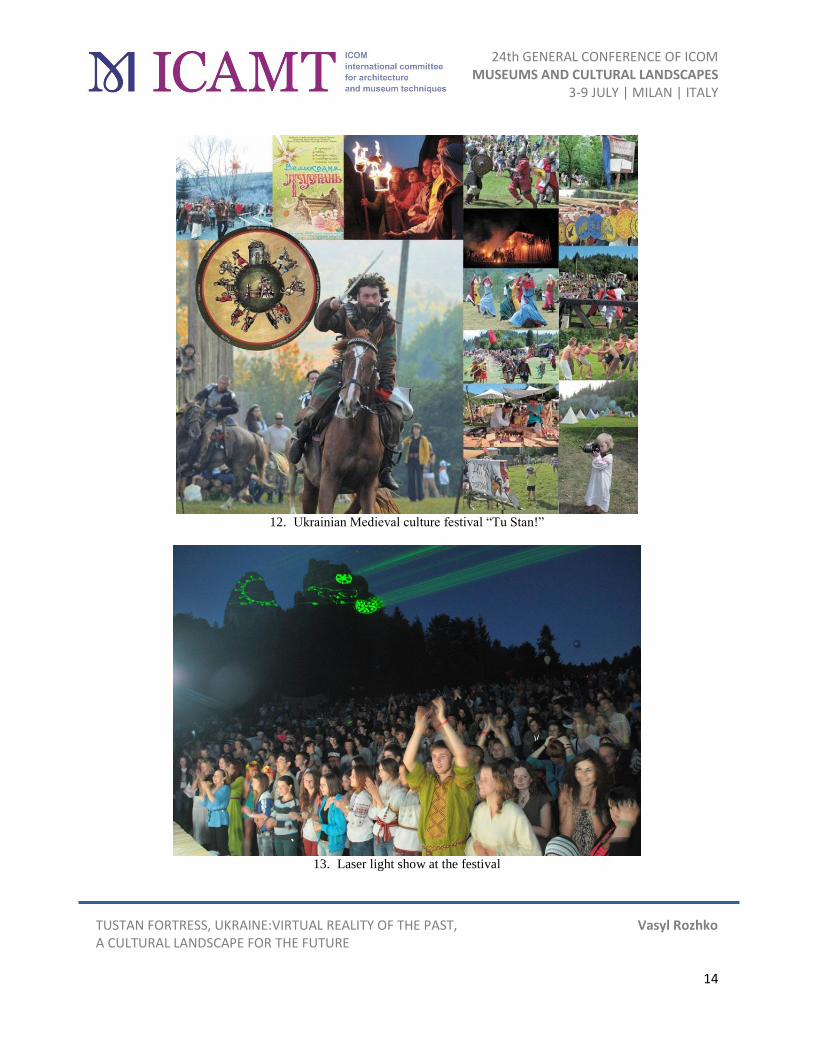
Festival as a Promoter of Development The annual festival of Ukrainian medieval culture “Tu Stan!” was launched simultaneously with the
State Historical and Cultural Reserve “Tustan” in 2006 aimed at reviving the unique monument and
making it known not only to individual scientists but the whole society.
The festival “Tu Stan!” integrally reproduces all the facets of life and customs in the heyday of the
Ukrainian state, Kyivan Rus, and creates an atmosphere of the Ukrainian Middle Ages. The main
components of the event are: fights, tourneys, a horse riding tournament, medieval dances, music
(heroic epics, folk, medieval music and their modern interpretation), a fire show, songs around a
bonfire, a cinema night. There are festival sites that are functioning constantly: a medieval camp,
playgrounds, artists and artisans, a fair, medieval cuisine, a theater lawn, a spiritual territory, Tustan
university, a literary stage, street musicians, archery and crossbows, a sling. Also, “Tu Stan!” has its
own unique creations, such as a night assault on the fortress, a laser show (picture animation on the
rock the fortress image and its legends with a laser beam), a theater of shadows on the rock, role play
“Become a knight” and “Imagine yourself...” to engage every visitor. To neutralize a possible
negative impact of a large number of visitors to the monument, the event is held at the foot of the
rocks, visitors move along equipped routes on raised wooden pathways.
The success of the festival, in our opinion, can be determined by its value for Tustan as a monument,
for the Reserve and the community and by its contribution to culture. Through reproduction of life of
the fortress involving hundreds of participants and thousands of visitors, the festival can be
considered as one of the forms of monument’s modern life as well as its best promotion. Tustan, the
formerly impregnable fortress, administrative, defense and customs center and now the rocks with
traces of preserved natural and historic environment, along with the Boyko village of Urych, thanks
to the festival becomes understandable and interesting to tens of thousands of people each year, and
along with it – the Medieval epoch. The resulting popularity ensures a greater public attention to the
problems of Tustan, including illegal actions of developers and officials who threaten its
preservation. The festival can also be considered an appropriate instrument for preserving intangible
cultural heritage.
“Tu Stan!” is traditionally a public presentation and report of a year-round work of the Reserve and
the Museum. Research within the framework of the festival is historical reconstruction, living
history, archaeological experiments: reconstruction of clothing items, customs, cuisine, music,

24th GENERAL CONFERENCE OF ICOM MUSEUMS AND CULTURAL LANDSCAPES
3-9 JULY | MILAN | ITALY
TUSTAN FORTRESS, UKRAINE:VIRTUAL REALITY OF THE PAST, Vasyl Rozhko A CULTURAL LANDSCAPE FOR THE FUTURE
8
dances, crafts, art of the Middle Ages; a working reproduction of a trebuchet, a ram and a medieval
oven; a framed full-scale reconstruction of a tower atop of Okremyi Kamin. It is also important that a
team of like-minded people is formed during the festival, youth environment of artists, scientists and
volunteers is shaped.
Residents of the villages of Urych, Pidhorodtsi and Sopit are involved in preparation and conducting
of the festival. One more focus is its attempt to revive traditional cuisine, folklore, handicraft and
artistic traditions of the region. “Tu Stan!” stimulates the growth of catering and trade sectors,
agritourism in Urych and the nearby villages. The festival brings about the gradual development of
infrastructure such as roads and bridges. On the other hand, the festival’s potential for the
development of the community and the region is used today very little.
Conclusions A Medieval fortress is “a fortified settlement with strong capital structures, a permanent garrison,
weapons and various supplies intended for long circular defense”. Metaphorically, nowadays it is the
Reserve.
Institutions may have different purposes: instead of the fortress as a defense, customs and
administrative settlement, today Tustan has become a cultural institution represented by the historical
and cultural reserve. The impregnable fortress has transformed into an open place, yet the
significance of Tustan for the region has remained: the fortress – the fortress proper, not the
settlement – was the center of the Medieval Volost, and the Reserve is a center of culture in the 21th
century.
Preservation of cultural heritage is a function of culture regarding the past, while creativity is for the
future. These two functions should be combined: culture develops while preserving, through
rethinking.
Tustan today combines the past and the future, man-made with natural, authentic with technological,
quietness and the whirlpool of events. The distinctive feature of the monument – the place of
collective memory – is its ability to unite people with different interests and statuses.
The past becomes the future here.
Links: 3D-model of Tustan fortress - https://www.youtube.com/watch?v=_hjHT5W5xtg
https://www.youtube.com/watch?v=wREueyWb9Q8
3D-modelling of
Traditional rural architecture: https://www.youtube.com/watch?v=zmZcZP7OUDk
Tu Stan! Medieval Festival https://www.youtube.com/watch?v=WAQ77oR5KXo
Aerial Video https://www.youtube.com/watch?v=I_nKuqDGjK0

24th GENERAL CONFERENCE OF ICOM MUSEUMS AND CULTURAL LANDSCAPES
3-9 JULY | MILAN | ITALY
TUSTAN FORTRESS, UKRAINE:VIRTUAL REALITY OF THE PAST, Vasyl Rozhko A CULTURAL LANDSCAPE FOR THE FUTURE
9
illustrations:
1. Tustan Fortress, the 5
th construction period, the graphical reconstruction of M. Rozhko
2. Urych Rocks, the site of the fortress
3.
24th GENERAL CONFERENCE OF ICOM MUSEUMS AND CULTURAL LANDSCAPES
3-9 JULY | MILAN | ITALY
TUSTAN FORTRESS, UKRAINE:VIRTUAL REALITY OF THE PAST, Vasyl Rozhko A CULTURAL LANDSCAPE FOR THE FUTURE
10
4. Tustan Rocks in their natural environment
5. Project Virtual Tustan

24th GENERAL CONFERENCE OF ICOM MUSEUMS AND CULTURAL LANDSCAPES
3-9 JULY | MILAN | ITALY
TUSTAN FORTRESS, UKRAINE:VIRTUAL REALITY OF THE PAST, Vasyl Rozhko A CULTURAL LANDSCAPE FOR THE FUTURE
11
6. Detailed 3D model with traces of the construction
7. Graphical reconstruction of the lost construction of Tustan: different variants and construction periods

24th GENERAL CONFERENCE OF ICOM MUSEUMS AND CULTURAL LANDSCAPES
3-9 JULY | MILAN | ITALY
TUSTAN FORTRESS, UKRAINE:VIRTUAL REALITY OF THE PAST, Vasyl Rozhko A CULTURAL LANDSCAPE FOR THE FUTURE
12
8. Augmented reality application
9. 3D model of a traditional Boyko cottage of the village of Urych

24th GENERAL CONFERENCE OF ICOM MUSEUMS AND CULTURAL LANDSCAPES
3-9 JULY | MILAN | ITALY
TUSTAN FORTRESS, UKRAINE:VIRTUAL REALITY OF THE PAST, Vasyl Rozhko A CULTURAL LANDSCAPE FOR THE FUTURE
13
10. Cultural landscape of the village of Urych
11. Project of preservation of the traditional architecture of the village of Urych
24th GENERAL CONFERENCE OF ICOM MUSEUMS AND CULTURAL LANDSCAPES
3-9 JULY | MILAN | ITALY
TUSTAN FORTRESS, UKRAINE:VIRTUAL REALITY OF THE PAST, Vasyl Rozhko A CULTURAL LANDSCAPE FOR THE FUTURE
14
12. Ukrainian Medieval culture festival “Tu Stan!”
13. Laser light show at the festival