Tusanami
12
Congressional Research Service ˜ The Library of Congress CRS Report for Congress Received through the CRS Web Order Code RL32739 Tsunamis: Monitoring, Detection, and Early Warning Systems January 24, 2005 Wayne A. Morrissey Science and Technology Information Analyst Resources, Science, and Industry Division
-
Upload
chitrachedu-dada-kalandar -
Category
Engineering
-
view
17 -
download
1
Transcript of Tusanami

Congressional Research Service ˜ The Library of Congress
CRS Report for CongressReceived through the CRS Web
Order Code RL32739
Tsunamis: Monitoring, Detection, and Early Warning Systems
January 24, 2005
Wayne A. MorrisseyScience and Technology Information Analyst
Resources, Science, and Industry Division

Tsunamis: Monitoring, Detection, and Early Warning Systems
Summary
Recently, some in Congress have become concerned about the possiblevulnerability of U.S. coastal areas to tsunamis, and about the adequacy of earlywarning for coastal areas of the western Atlantic Ocean. Those concerns stem fromthe December 26, 2004, tsunami that devastated many coastal areas around thenorthern Indian Ocean, where few tsunami early warning systems currently operate.Caused by a strong underwater earthquake off the coast of Sumatra, Indonesia, thetsunami disaster is estimated to have claimed at least 150,000 lives. Affectednations, assisted by others, are pursuing a multilateral effort to develop a detectionand warning network for the Indian Ocean. Also, some Members of Congress andthe Bush Administration have proposed a tsunami warning network for the U.S.Atlantic seaboard. Although instrumentation costs could run into the millions ofdollars, existing weather buoys and state and local coastal and ocean observationnetworks might serve as possible platforms for the instrumentation. The EuropeanUnion, Canada, and the United States may consider multilateral efforts to establishcoverage for the North Atlantic. This report will be updated as warranted.
Contents
Introduction . . . . . . . . . . . . . . . . . . . . . . . . . . . . . . . . . . . . . . . . . . . . . . . . . . 1Proposals for International Tsunami Early Warning Systems . . . . . . . . . . . . 2
Challenges . . . . . . . . . . . . . . . . . . . . . . . . . . . . . . . . . . . . . . . . . . . . . . . 2Proposals . . . . . . . . . . . . . . . . . . . . . . . . . . . . . . . . . . . . . . . . . . . . . . . . 2
U.S. Tsunami Programs . . . . . . . . . . . . . . . . . . . . . . . . . . . . . . . . . . . . . . . . . 5Tsunami Warnings . . . . . . . . . . . . . . . . . . . . . . . . . . . . . . . . . . . . . . . . . 5U.S. Operations and Research . . . . . . . . . . . . . . . . . . . . . . . . . . . . . . . . 5Related U.S. Programs . . . . . . . . . . . . . . . . . . . . . . . . . . . . . . . . . . . . . . 7
Conclusion . . . . . . . . . . . . . . . . . . . . . . . . . . . . . . . . . . . . . . . . . . . . . . . . . . . 8
List of Figures
Figure 1. U.S. Proposal for Tsunami Detection/Warning System . . . . . . . . . . . . 4Figure 2. NOAA DART Platform . . . . . . . . . . . . . . . . . . . . . . . . . . . . . . . . . . . . . 6

1Mw, the moment of magnitude, is a way to measure the force of an earthquake’s totalseismic energy released as a function of rock rigidity in the fault, the total area of contactwhere friction occurs, and the amount of slippage (or displacement). It is used forearthquakes greater than M8.2 on the Richter scale.2General David L. Johnson, “NOAA Tsunami and Natural Disaster Information,”presentation at House Science Committee briefing, Jan. 5, 2005. 3Statistics on deaths resulting from tsunamis were compiled by CRS from online sources,and include data from the Tsunami Laboratory of Novosibirsk, NOAA’s NationalGeophysical Data Center, the University of Southern California, Tsunami Research Group,
(continued...)
Tsunamis: Monitoring, Detection, and Early Warning Systems
Introduction
Recently, numerous congressional inquiries have asked about the possibility oftsunamis occurring in U.S. coastal areas; the extent to which these areas are currentlymonitored; how tsunamis can be detected; and whether there is a national capacityto issue evacuation warnings for tsunamis. These concerns stem from the December26, 2004, tsunami triggered by an underwater earthquake off the west coast ofnorthern Sumatra in Indonesia. That earthquake was measured at Mw 9.0.1 Theensuing tsunami devastated many coastal areas around the northern Indian Ocean,and caused loss of life and damages in other areas. International disaster agenciescurrently estimate that at least 150,000 people lost their lives to the tsunami.
The National Oceanic and Atmospheric Administration (NOAA) of theDepartment of Commerce and various international science agencies have indicatedthat there were few, if any, tsunami early warning systems monitoring the IndianOcean on December 26, 2004. However, nations bounded also by the Pacific Ocean,including Australia and Indonesia, had tsunami early warning systems monitoring thePacific shores where they perceived a threat.2 Because of the lack of infrastructureto receive tsunami warnings rapidly, some have pointed out that for people onIndonesia’s Indian Ocean shores, emergency communications were useless in manycases.
Although most deadly tsunamis have occurred historically in the western PacificOcean, there are examples of recoded events in the Atlantic. In 1692, a tsunamigenerated by massive landslides in the Atlantic Puerto Rican Trench reachedJamaica’s coast, causing an estimated 2,000 deaths. In 1775, a tsunami struck in theeastern Atlantic Ocean on the coast of Portugal, killing an estimated 60,000 people.More recently, in 1929, a tsunami generated in the Grand Banks region of Canada hitNova Scotia, killing 51. It was the third lethal tsunami for Canada’s Atlantic Coastwithin 150 years.3

CRS-2
3(...continued)and others. See [http://geology.about.com/library/bl/bltsunamideathtable.htm], visited Jan.11, 2005.4Presenters at that briefing included, David Applegate, Science Advisor for Earthquake andGeological Hazards at the USGS; General David Johnson, Assistant Director of NOAA’sNational Weather Service; Gregg Withee, Assistant Director for NOAA Satellite andInformation Services; and, Eddie Bernard, Associate Director of NOAA’s Pacific MarineEnvironmental Laboratory (teleconferencing from Seattle, WA).
On January 5, 2005, the House Science Committee, House Coastal Caucus, andHouse Oceans Caucus co-sponsored a briefing organized by the U.S. GeologicalSurvey (USGS) of the Department of the Interior. One purpose of the briefing wasto consider the possible implications of the Indian Ocean tsunami for the UnitedStates. Experts from USGS and NOAA delivered presentations on the circumstancessurrounding that tsunami disaster, and discussed current capabilities for monitoring,detection, and early warning around the globe.4
Proposals for International Tsunami Early Warning Systems
Currently, most experts agree that considerable challenges must be overcometo establish an extensive tsunami early warning network in the Indian Ocean.
Challenges. Few nations would question that development of such a system,including localized warnings, will require involving many nations with widelyvarying technological capabilities. Reports indicate that political leaders expect thatmost of the responsibility for paying for such a system will likely fall on thewealthiest nations. The costs of procuring, operating, and maintaining thoseinstruments and platforms, and the challenge of obtaining international cost sharing,are likely to be the most critical factors for sustaining a long-term international effortfor global tsunami detection and warning. International science agencies are callingfor an inventory of existing global capacity for tsunami monitoring, detection, andwarning systems to use as a baseline from which to determine what may still beneeded.
Some U.S. policy experts also have suggested that technological challenges andpossible national security issues may arise, including multinational sharing ofinternational telecommunication networks and international standardization fortsunami warning instrumentation on data platforms. Intelligence experts suggest thatsome data could be considered sensitive and perhaps compromising to U.S. or othernations’ intelligence-gathering operations. Gregg Withee, Assistant Director ofNOAA Satellite and Information Services, has noted that some nations, includingIndia, maintain proprietary rights to all of their real-time satellite data. Some of thesedata, he asserted, could be important for tsunami detection in the Indian Ocean.
Proposals. On January 6, 2005, the United Nations Environment Program(UNEP) announced an international effort to develop a tsunami early warningcapacity for nations bounding the Indian Ocean. The Australian governmentannounced it would develop and fund its own effort to guard its Indian Ocean
CRS-3
5Briefing for the House Science Committee by USGS and NOAA, Jan. 5, 2005.6Sen. Joseph Lieberman, “Lieberman Unveils Tsunami Early Warning Legislation, Senator’sBill Would Deploy 40-50 New Sensors and Fund System at $30 million,” news release, Jan.6, 2005.7For current NOAA tsunami-related funding, see U.S. Congress, House, “Conference Reporton H.R. 4818, the Consolidated Appropriations Act, 2005 (P.L.108-447),” H.Rept. 108-792,Title II, Commerce, Justice, State, and the Judiciary and Other Related AgenciesAppropriations Act, 2005, Congressional Record, Nov. 19, 2004: H10457. 8Associated Press, “Hill Eyes Tsunami Warning System — Lieberman calls for Global Net,”Washington Times, Jan. 7, 2005: A10.9Congressional Record, Jan. 4, 2005: H40. 10House Science Committee briefing, Jan. 5, 2005.11State of New Hampshire, “Disaster Plan 409,” Sect. II, Geological Hazards, SeismicHazards, at [http://www.nhoem.state.nh.us/mitigation/state_of_new_hampshire.asp], visitedJan. 11, 2005. See also “Is your Community Ready for the Next Tsunami,” NationalWeather Service Tsunami Ready program, at [http://tsunami.gov], visited Jan. 11, 2005.
coastlines.5 (For information on other types of foreign assistance for the areasaffected by the tsunami, see CRS Report RL32715, Indian Ocean Earthquake andTsunami: Humanitarian Assistance and Relief Operations.) With respect to Atlanticcoast vulnerabilities, possible approaches could include multilateral agreementsamong the United States, Canada, and European Union so as to establish morecomprehensive tsunami coverage for the North Atlantic.
Some Members of Congress have proposed a “global” tsunami detection/warning system in the aftermath of the Indian Ocean disaster. Senator Lieberman,for example, has called for expanding the U.S. tsunami early warning program in thePacific to include sites in the Indian and Atlantic Oceans.6 Based on the costs ofcurrent NOAA operations, the Senator estimates that the cost for expanding from theexisting six dedicated tsunami warning platforms in the Pacific Ocean to 50 globallywould be approximately $30 million for implementation, with operations andmaintenance costs an additional $8 million annually.7 These figures do not take intoaccount costs of an emergency management infrastructure to deliver regional tsunamiwarnings directly to the public in the wider region of the Indian Ocean, however.8
Representative Pallone called for establishing a tsunami detection and warningnetwork for the U.S. Atlantic coast, the Gulf of Mexico, and the Caribbean Sea.9
Others question whether the risks for tsunamis on the U.S. Atlantic coast wouldjustify such expenditures. NOAA reported that the Puerto Rican Trench, which isthe deepest point in the western Atlantic Ocean, is a great concern.10 As noted above,massive landslides and sloughing have occurred on the North American continentalshelf, generating deadly tsunamis. One U.S. Atlantic coast state, New Hampshire,already has an emergency contingency plan for tsunamis, and a clearinghouse forinformation about historical tsunami disasters.11
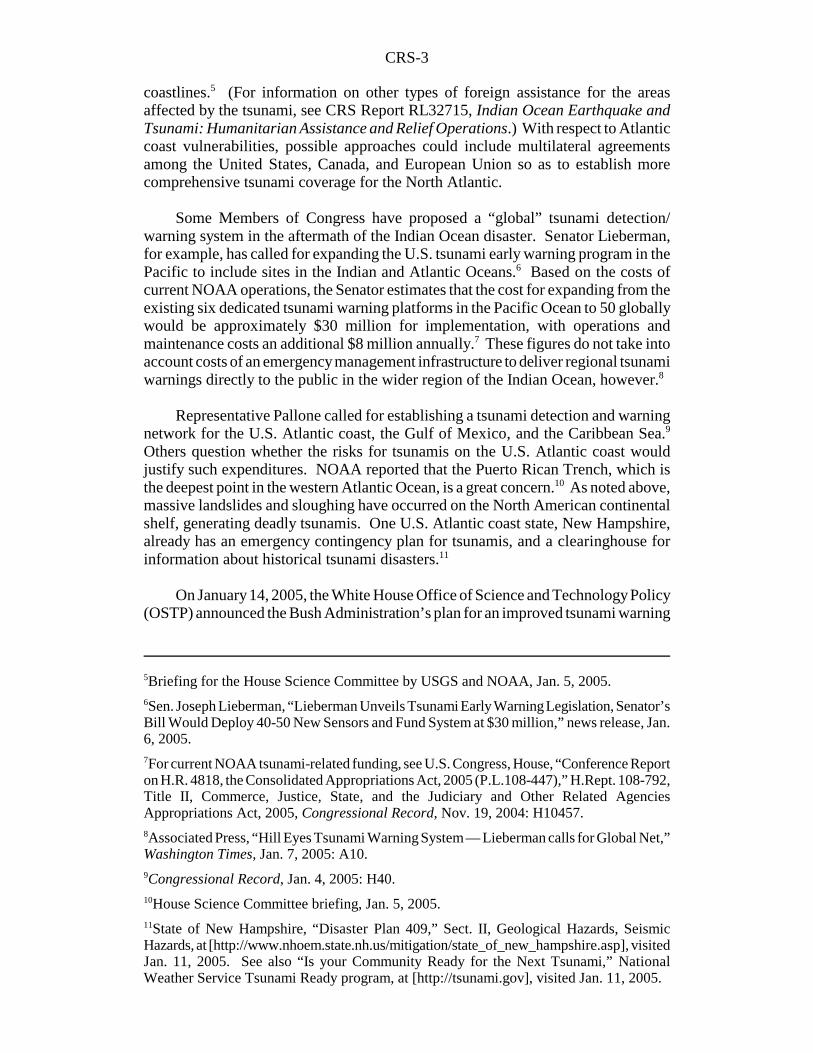
On January 14, 2005, the White House Office of Science and Technology Policy(OSTP) announced the Bush Administration’s plan for an improved tsunami warning
CRS-4
12U.S. Office of Science and Technology Policy, “U.S. Announces Plan for ImprovedTsunami Detection and Warning System,” press release, OSTP News, Jan. 14, 2005.
Figure 1. U.S. Proposal for Tsunami Detection/Warning System
and detection system for the United States.12 The plan initially includes deploying32 new dedicated tsunami warning and detection buoys by mid-2007 in the Pacificand Atlantic Oceans, Gulf of Mexico, and Caribbean Sea to protect U.S. coastalareas. (See Figure 1.) The President would commit $37.5 million over the next twoyears to implement the plan. The Director of OSTP noted that the system will“ultimately include the Indian Ocean.” Some question whether the risks for tsunamison the U.S. Atlantic coast would justify such expenditures.
Source: National Oceanic and Atmospheric Administration, from “U.S. Announces Plans for anImproved Tsunami Warning and Detection System” (modified by CRS for contrast), at [http://www.noaanews.noaa.gov/stories2005/s2369.htm], visited Jan. 18, 2005.
CRS-5
13Gen. David Johnson, House Science Committee briefing, Jan. 5, 2005.14Eddie Bernard of NOAA, House Science Committee briefing, Jan. 5, 2005. 15Hugh B. Milburn et al., “Real-Time Tsunami Reporting from the Deep Ocean,” NOAAPacific Marine Environmental Laboratory (1996), at [http://www.ndbc.noaa.gov/Dart/milburn_1996.shtml], visited Jan. 4, 2005.
The Director of NOAA’s National Weather Service (NWS) has emphasized thatin addition to needing the capacity to monitor and detect possible tsunamis, atelecommunications infrastructure for issuing tsunami warnings, such as thatpresently in place in the Pacific Ocean, would be critical for the Indian and AtlanticOceans operations. He noted that NOAA’s Administrator, Admiral Lautenbacher,has promoted the development of an international Global Earth Observing Systemof Systems (GEOSS). One component of the system would rely on existingplatforms and telecommunications capabilities of other observation systems currentlyoperating, including the International Global Ocean Observing System (IGOOS) andArgo (climate monitoring) floats, helping to achieve a global tsunami detection andwarning capacity.13
U.S. Tsunami Programs
Presently, NOAA has a national program to warn Pacific coastal areas oftsunamis, consisting of two regional U.S. tsunami warning centers in the PacificOcean, a cooperative program to reduce false tsunami alarm rates in the PacificOcean, monitoring and detection operations, and tsunami research activities.
Tsunami Warnings. The NWS operates the West Coast/Alaska TsunamiWarning Center (WC/AKTWC) at Palmer, AK, and the Pacific Tsunami WarningCenter (PTWC), at Ewa Beach, HI.
The PTWC monitors for tsunamis and issues warnings for the HawaiianIslands, the U.S. Pacific territories, and other U.S. and international interests in thePacific Basin. It was established in 1949, after a strong earthquake and massivelandslides off the coast of southwest Alaska caused a tsunami disaster in theHawaiian Islands hours later. The WC/AKTWC was established in 1967, after adevastating earthquake in Anchorage, AK, in 1964 caused localized tsunamidamages. This center is responsible for issuing warnings to emergency managers inAlaska, British Columbia, Washington, Oregon, and California. In addition, in 1992,NOAA launched a National Tsunami Hazard Mitigation Program to address Pacifictsunami warnings, which, at that time, were being issued with a 75% false alarm rate,causing significant social upheaval and economic disruption. This program alsofocused on the potential that a sizable earthquake in the Pacific Northwest CascadiaRegion could generate devastating tsunamis that would damage U.S. Pacific coastalregions.14
U.S. Operations and Research. NOAA currently has a network of sixdedicated tsunami detection and relay stations, operating as part of its Deep-OceanAssessment and Reporting of Tsunamis (DART) program.15 (See Figure 1, above,for their location, and Figure 2, below, for the components.) These are equipped for

CRS-6
16NOAA officials estimated the cost to produce the existing six experimental DARTplatforms, instrument them, provide a telecommunications capability, and maintain them atapproximately $125,000 each, but suggested there would be an economy of scale if theirproposed total of 23 platforms for the United States in the Pacific and Atlantic Oceans wereproduced.
Figure 2. NOAA DART Platform
an early warning capability, but their emergency communications are only effectiveif there are emergency managers to receive them and, in turn, alert the public.
Source: National Oceanic and Atmospheric Administration, from “U.S. Announces Plansfor an Improved Tsunami Warning and Detection System.” See [http://www.noaanews.noaa.gov/stories2005/s2369.htm], visited Jan. 18, 2005.
NOAA officials estimate that the cost of adding tsunami detection instrumentson Atlantic Ocean platforms, such as weather buoys, or building dedicated DARTplatforms, could vary depending upon the scale of the project — for example, thenumber of instruments to be included and the costs of operation and maintenance.16
At a minimum, NOAA anticipates that the cost for three new DART platforms it hasproposed for the western Atlantic Ocean and Gulf of Mexico/Caribbean Sea,

CRS-7
17This amount also includes funding for NOAA’s U.S. tsunami-related research activities.Annual funding requested for U.S. tsunami monitoring, early warning, and research is foundin the NWS budget under Operations and Research. Appropriations for these activities areprovided in Title II of the annual Commerce, Justice, State, Judiciary, and Related Agenciesappropriations acts.18Kenneth B. Allen, Director of the Partnership for Public Warning, “Letter to PresidentBush,”Jan. 3, 2005, at [http://www.partnershipforpublicwarning.org/ppw/], visited Jan. 21,2005.19Eddie Bernard, House Science Committee briefing, Jan. 5, 2005.20NOAA/Woods Hole Oceanographic Institute, Observing the Ocean in Real-Time: Argo,a Global Array of Profiling Floats to Understand and Forecast Climate, ed. Stan Wilson(1996). Funded in part by private academic institutions. 21Ibid.22On January 5, 2005, Representative Curt Weldon circulated a “Dear Colleague” letter
(continued...)
including costs of operation and maintenance, and construction of a new regionalcenter, would be comparable to annual funding for the two Pacific regional tsunamiearly warning operations centers — approximately $8 million for FY2005.17 (For aschematic of the DART buoy platform, see Figure 2.)
Related U.S. Programs. To reduce costs for a U.S. Atlantic coast tsunamiearly warning system, engineers at NOAA say that it is technologically possible tomodify weather and marine data buoys, such as those currently situated off theUnited States, to serve as platforms for mounting tsunami monitoring and detectioninstrumentation. Others suggest taking advantage of existing internationalcommunications networks for issuing tsunami warnings to local emergencymanagers.18
Hundreds of NWS weather buoys operating off the coasts of the United Statesalready record various meteorological data; while marine data buoys measure speedof ocean currents, temperature, salinity, and pressure change. Sea surface height (orsea level) also is measured by satellite-GPS (global positioning system) by NOAA’sNational Ocean Service tidal monitoring network, which is responsible for issuingwarnings.
All of these buoys are equipped to relay data and emergency communicationsfor navigational purposes.19 In addition, an array of 3,000 data buoys, known as Argofloats, currently deployed in the equatorial waters of the Pacific Ocean, are beingused to detect conditions for El Niños and La Niñas, which are three- to seven-yearclimate variations that affect global weather. Argo floats might also be consideredas possible platforms for situating tsunami detection instrumentation.20 These floatshave been advocated by NOAA as “the next step in global [Earth] observations.”21
In the Atlantic Ocean, other possible platforms for tsunami monitoring and detectioninclude a growing number of regional and local coastal and ocean monitoringnetworks in development along the coasts of Canada and the United States. Aproposal to use such systems for tsunami warning was introduced in the 108th
Congress.22
CRS-8
22(...continued)advocating the reintroduction of H.R. 5001 (108th Congress), the Ocean and CoastalObservation System Act, in the 109th Congress. This legislation promoted development ofan “Integrated Ocean Observation System,” to protect U.S. citizens in coastal communitiesfrom tsunamis.23U.S. Department of Commerce, NOAA, Office of the Federal Coordinator forMeteorology, “World Weather Program,” The Federal Plan for Meteorological Services andSupporting Research: Fiscal Year 2004, Report FCM P1-2003, Appendix B, p. 219(Washington, DC: Oct. 2003).24NOAA’s Satellite and Information Services, which operates the two U.S. WWW dataCenters, reviews weather satellite data, which has since provided valuable information aboutthe Indian Ocean tsunami. See “NOAA Scientists Able to Measure Tsunami Height fromSpace,” at [http://www.noaanews.noaa.gov/stories2005/s2365.htm], visited Jan. 11, 2005.25See NOAA Weather Radio (NWR) at [http://www.nws.noaa.gov/nwr/], visited Jan. 10,2005.
Additionally, NOAA and other international weather agencies issue warningsof meteorological conditions that primarily affect commercial air traffic, but whichalso might put human lives in danger and cause significant economic disruption forglobal nations. The U.N. World Weather Watch (WWW) is a cooperative programorganized and administered by the World Meteorological Organization (WMO).23
NOAA plays a leadership role in the WWW, representing the United States inscientific research, weather data collection and management, meteorological forecastand warning. The Department of State also plays an important role for achieving andmaintaining international agreements to sustain WWW operations globally. TheWWW has an established international telecommunications network for receivingand distributing weather data and warnings, including those for the United States andits trust territories. NOAA Satellite Services now manages two WWW data centersfor weather data analysis and forecasting.24
Currently, the U.S. Department of Homeland Security and the NWS aredeveloping a National All Hazards Warning Network using NWS’s NOAA WeatherRadio network as the initial infrastructure for communicating public warnings. In theUnited States, Congress has expanded NOAA Weather Radio so that this emergencytelecommunications infrastructure is able to provide adequate coverage of weatherservices and support local forecasting and warning of extreme weather. NOAA hasimproved technology of weather instrumentation to increase lead time of emergencywarnings; constructed transmission towers; added repeaters to expand ranges ofemergency notification; and distributed individual NOAA Weather Radio receiversto the public, particularly in rural areas, so as many U.S. citizens as possible canreceive disaster warnings and emergency communications.25
Conclusion
Decisions about whether and how to proceed with establishing an internationaltsunami early warning system for the Indian Ocean (and elsewhere) will likely becomplicated for a number of reasons. One reason is because of the number ofdifferent potential international parties that would be involved with the need tocoordinate data collection and warning dissemination, and a second is the funding
CRS-9
26The Washington Times, Jan. 7, 2005: A10.27See “Off W Coast of Northern Sumatra, Can It Happen in the United States?” See USGSE a r t h q u a k e H a z a r d s P r o g r a m : F A Q , J a n . 4 , 2 0 0 5 a t[http://earthquake.usgs.gov/eqinthenews/2004/usslav/canit.html], visited Jan. 5, 2005.
needed to establish a tsunami warning system in that region. A third is that nations,including some in the Indian Ocean, might charge for access to critical satellite datathat may help in warning potential victims. Senator Lieberman and others contendthat the costs of acquiring those data may be well worth it, in terms of lives saved.Others assert that the costs of accessing and using those proprietary data could beprohibitive. They are of the opinion that nations should provide free access to globalenvironmental data, especially when the United States and other nations areproviding disaster relief and plan on funding tsunami detection and warning activitiesfor the region.26
Still others foresee challenges to standardize instrumentation and other relatedtechnology. In addition, there are concerns about national security and compromisingU.S. intelligence-gathering operations if international telecommunications networksare used. Finally, some U.S. lawmakers question the risks of a tsunami hitting theU.S. Atlantic coast.27 They believe the probability is low, and assert that risk shouldbe an important factor for guiding development of and investment in a cooperativeearly tsunami warning system for the U.S. eastern seaboard.